Economic Development_June2011
37
Economic Development in 2030 In 2030, Huntersville will have a diverse and sustainable economic base built upon: 1. A commitment to help expand existing business and industry. 2. A proactive search for opportunities and encouragement of investment by new business and industry. 3. A spirit of cooperation between business, government, schools and the community. Commercial Development in 2030 In 2030, commercial development in Huntersville will exemplify the highest possible integration of land use and transportation planning. Commercial development will follow a “mixed-use” center land use pattern that, to the greatest extent possible, meets the demand for a variety of commercial services at identifiable nodes and centers. Commercial development will reflect the highest quality architectural Economic & Commercial Development: Huntersville 2030 Community Plan Page 70
-
Upload
bobby-williams -
Category
Documents
-
view
212 -
download
0
description
Commercial Development in 2030 In 2030, Huntersville will have a diverse and sustainable economic base built upon: 1. A commitment to help expand existing business and industry. 2. A proactive search for opportunities and encouragement of investment by new business and industry. 3. A spirit of cooperation between business, government, schools and the community. Economic & Commercial Development: Huntersville 2030 Community Plan Page 70
Transcript of Economic Development_June2011

Economic Development in 2030
In 2030, Huntersville will have a diverse and sustainable economic base built upon:
1. A commitment to help expand existing business and industry.2. A proactive search for opportunities and encouragement of
investment by new business and industry.3. A spirit of cooperation between business, government, schools
and the community.
Commercial Development in 2030
In 2030, commercial development in Huntersville will exemplify the highest possible integration of land use and
transportation planning. Commercial development will follow a “mixed-use” center land use pattern that, to the greatest extent possible, meets the demand for a variety of commercial services at identifiable nodes and centers. Commercial development will
reflect the highest quality architectural standards, consistent with the surrounding built and natural environment, and be located in areas where adequate public infrastructure exists to support this
development. Commercial development will be designed and function in the framework of a multi-modal integrated street
network, minimizing traffic impacts and promoting a sustainable land use pattern.
Economic & Commercial Development: Huntersville 2030 Community Plan Page 70

FOCUS AREA: ECONOMIC AND COMMERCIAL DEVELOPMENT
1.0 ECONOMIC DEVELOPMENT
1.1 Regional Economy & Demographics
Huntersville is a part of the Charlotte metropolitan region – one of the fastest growing areas in the U.S. Since 2000, Mecklenburg County has grown from a population of 695,454 to a total of 919,628 in 2010, representing an increase of approximately 32%. The NC State Demographic projections show that Mecklenburg County will continue its upward growth rate, with a projected 2030 population of 1,458,192.
The regional presence of Fortune 500 companies is a significant indicator of the area’s economic strength and stability. Mecklenburg County is home to seven Fortune 500 headquarters, ranking it 8th in the country.
The presence of these companies is indicative of the significant employment found within the banking, energy, manufacturing and auto racing-related business sectors.
1.2 Local Economy
Prior to 2003, Huntersville did not take an active role in promoting economic development. Job creation and development of business parks were the result of private sector investments. With Huntersville’s prime location just north of Charlotte along the I-77 corridor, that investment was substantial, most notably the Park Huntersville, a 400 plus acre business park owned by the Bank of America’s pension fund.
However, after completion of the Leak-Goforth study in 2002, sponsored by the Lake Norman Chamber of Commerce, the Towns of Huntersville, Cornelius and Davidson took a more active role in charting the economic future of North Mecklenburg. The study looked at economic development prospects and opportunities and recommended an action-oriented strategy to position the area as a viable location for business and industry. The most notable outcome of that study
Economic & Commercial Development: Huntersville 2030 Community Plan Page 71Source: Charlotte Chamber of Commerce
Table ED-1

was the creation in 2003 of the Lake Norman Regional Economic Development Corporation (LNREDC) in 2003.
Economic & Commercial Development: Huntersville 2030 Community Plan Page 72

LNREDC is funded by the three towns and private investors, and is tasked with expanding North Mecklenburg’s economic base.
In addition to recommending the establishment of an economic development organization, the Leak-Goforth Study identified several areas that were well suited for job creation but were zoned residential. To reserve these areas for future economic development, the Town of Huntersville rezoned just over 1,000 acres from Residential to Corporate Business in three large-scale rezoning requests. Map ED-1 shows the location of those three rezoning areas (R03-09; R06-07 and North Meck Industrial Park, now Commerce Station) as well as significant recently approved, yet un-built commercial and office development in Huntersville. Map ED-2 shows major employment areas in Huntersville.
It is important to note that some utilities are currently not available to all of the major employment areas noted on this map. Therefore, it is important that Huntersville work closely with Charlotte-Mecklenburg Utilities to time planned utility extensions with economic development projects within these areas.
In 2009, Forbes Magazine identified Huntersville as the number two most popular destination to move in the U.S. According to Forbes, this designation was due primarily to the presence of employment opportunities. Huntersville’s location immediately north of Charlotte places the town in a very advantageous position for those who wish to live near where they work.
Economic & Commercial Development: Huntersville 2030 Community Plan Page 73
Map ED-1: Large-Scale Re-zonings & Major Employment Areas

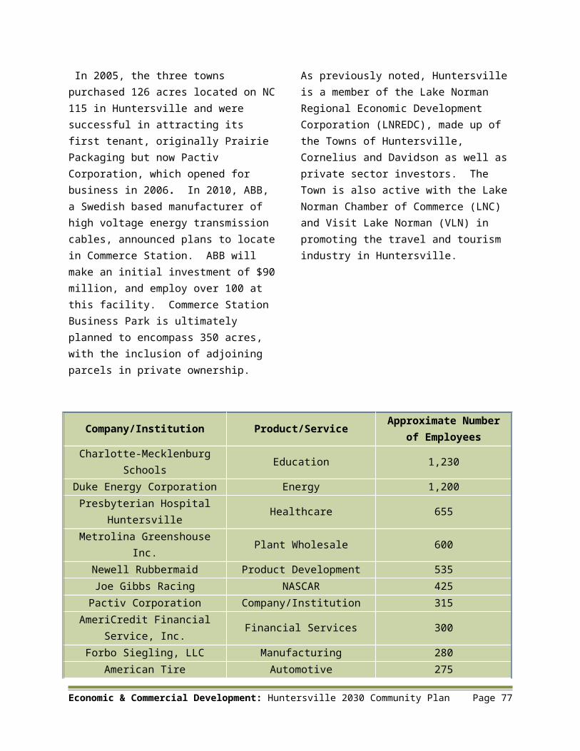
From an economic development standpoint, these factors have helped to draw a number of national and multi-national corporations to Huntersville since the early 1990’s. Table ED-2 lists some of the major employers within the Town as of May 2010.
Economic Development encompasses more than industries located in business parks. It includes the travel and tourism industry as well as large and small commercial and office areas located throughout the community. Since 1996, Huntersville has encouraged mixed-use development allowing people to live, work, shop and recreate in one location. Commercial development is discussed further in Section 6.0.
1.3 Regional Initiatives
The Town of Huntersville is an active participant in a number of regional initiatives that have resulted in a positive impact on the town’s local (and regional) economy. In 2005, the Towns of Huntersville, Cornelius and Davidson entered into a unique joint venture to develop an industrial park for light industrial tenants in order to maximize local employment opportunities and allow the sharing of the tax base between all three communities. Commerce Station, a master-planned industrial park, is the result of that joint venture.
Economic & Commercial Development: Huntersville 2030 Community Plan Page 74
Map ED- 2 - Major Employment Areas

In 2005, the three towns purchased 126 acres located on NC 115 in Huntersville and were successful in attracting its first tenant, originally Prairie Packaging but now Pactiv Corporation, which opened for business in 2006. In 2010, ABB, a Swedish based manufacturer of high voltage energy transmission cables, announced plans to locate in Commerce Station. ABB will make an initial investment of $90 million, and employ over 100 at this facility. Commerce Station Business Park is ultimately planned to encompass 350 acres, with the inclusion of adjoining parcels in private ownership.
As previously noted, Huntersville is a member of the Lake Norman Regional Economic Development Corporation (LNREDC), made up of the Towns of Huntersville, Cornelius and Davidson as well as private sector investors. The Town is also active with the Lake Norman Chamber of Commerce (LNC) and Visit Lake Norman (VLN) in promoting the travel and tourism industry in Huntersville.
Company/Institution Product/ServiceApproximate Number of Employees
Charlotte-Mecklenburg Schools Education 1,230
Duke Energy Corporation Energy 1,200Presbyterian Hospital
Huntersville Healthcare 655Metrolina Greenshouse Inc. Plant Wholesale 600
Newell Rubbermaid Product Development 535Joe Gibbs Racing NASCAR 425
Pactiv Corporation Company/Institution 315AmeriCredit Financial
Service, Inc. Financial Services 300Forbo Siegling, LLC Manufacturing 280
American Tire Distributors, Inc. Automotive Distribution 275
SABIC Innovative Plastics Plastics Manufacturing 150Town of Huntersville Government 145SAERTEX USA, LLC Manufacturing –
Composite Textiles 127Max Daetwyler Manufacturing 100
Economic & Commercial Development: Huntersville 2030 Community Plan Page 75
Source: Company Data

Another regional initiative that the Town is involved in is the Lake Norman Transportation Commission (LNTC). Formed in 2009, LNTC’s members include the towns of Huntersville, Cornelius, Davidson and Mooresville. LNTC’s mission is to promote transportation solutions for the Lake Norman area, a critical component to the success of recruiting new businesses and expanding existing businesses.
In 2010, LNTC sponsored an Urban Land Institute (ULI) Advisory Services Panel to assess and offer advice and recommendations regarding the economic development potential within the area encompassing the I-77 corridor and North Corridor commuter rail line. The report issued by the ULI Panel contained a number of recommendations, including the following:
Reiterate the validity of the Charlotte-Mecklenburg 2025 Transit/Land Use Plan for the region, which calls for focusing development in five corridors radiating out from Charlotte, including the North Corridor.
Ensure that transit supports the Transit/Land Use Plan’s strategy for mobility.
Understand and develop the potential for transit oriented development (TOD).
Engage with Charlotte and Mecklenburg County regarding the positive economic development that is possible in the Lake Norman area with and without the commuter rail.
Economic & Commercial Development: Huntersville 2030 Community Plan Page 76
Analyze, develop, and promote regional benefits of transportation capacity investments in the North Main Line.
Another example of regional cooperation to promote economic development is the construction of the Verhoeff Drive Bridge over NC 115. This $6.4 million project is a joint effort of the towns of Huntersville, Cornelius and Davidson and will provide direct access from Commerce Station to the regional road network, thereby enhancing the attractiveness of Commerce Station to prospective tenants. Regional cooperation will continue to be an essential strategy for the Town of Huntersville to follow as it plans for economic growth and development through 2030.
2.0 PREVIOUS PLANS & STUDIES
There have been several recent economic development related plans and studies undertaken which serve to frame the policies for economic growth and development for the Town of Huntersville. These plans are identified on the following page:
Economic & Commercial Development: Huntersville 2030 Community Plan Page 77

North Mecklenburg County – Economic Development Strategy (2002): Prepared by Leak-Goforth Company, LLC and Urbanomics, Inc.
Town of Cornelius and Huntersville and the Lake Norman Region Strategic Economic Development Plan (2003): Prepared by Sanford Holshouser Business Development Group, LLC and sponsored by ElectriCities for Cornelius and Huntersville.
NC 73 Land Use and Economic Development Small Area Plan (2005): Prepared by the Design Collective for Huntersville, Davidson, Concord, Kannapolis and Cabarrus County where the jurisdictions meet at the intersection of NC and Poplar Tent Road in the upper northeast quadrant of Huntersville.
3.0 FUTURE LAND USE
3.1 Strategic Economic Development Plan
The “North Mecklenburg County Economic Development Strategy” and the “Town of Cornelius and Huntersville and the Lake Norman Region Strategic Economic Development Plan” have provided the foundation for economic development activity in Huntersville since 2003. Since these plans focus on regional economic development, they do not address the specific economic development needs of Huntersville (e.g. type of development and uses Huntersville official’s would like to target). Therefore, the creation of a strategic economic development plan for Huntersville would allow the Town to better address its unique economic development needs and would also assist the Lake Norman Regional Economic Development Corporation in focusing on business recruitment and expansion appropriate for Huntersville.
A major component to any successful economic development program is the availability of suitable land. Previous studies have stressed the need to protect sites with characteristics suitable for business recruitment (significant acreage, easy access to major roads, relatively flat, etc.). Accordingly, Huntersville has rezoned several areas (encompassing over 1,000 acres) to Corporate Business (CB) for that purpose (see Map ED-1). However, the Town needs to continually assess opportunities for additional land, in response to changes in economic conditions.
Economic & Commercial Development: Huntersville 2030 Community Plan Page 78
Example of Office-Flex Spacein Huntersville

3.2 Utilities and Infrastructure
A well developed infrastructure and utility system is foundational to a thriving local economy. The provision of adequate infrastructure is essential to a sound economic development program for Huntersville. It is important to note that some utilities are currently not available to all of the rezoned areas noted on Map ED-1. Therefore, it is important that Huntersville work closely with Charlotte-Mecklenburg Utilities Department (CMUD) to time planned utility extensions with economic development projects within these areas.
3.3 Retention and Expansion of Existing Business
Promoting the retention and expansion of businesses currently located in Huntersville is a key to job growth. The LNREDC has a program to meet with existing businesses in order to determine what their needs are and what can be done to assist with their continued success and the expansion of their operations. In turn, the LNREDC informs agencies (i.e. town, county, NCDOT, etc.) about those needs and works proactively to address them where feasible.
To successfully compete against other locations in recruiting businesses, incentives can be an effective tool to assist in attracting new business and in retaining existing ones. Incentives can take many forms including tax rebates, streamlined permitting, job training, and infrastructure installation.
While quality of life is an important consideration for new businesses considering relocation, incentives can certainly play a role in this decision making process and should be carefully weighed in regard to the benefits that may result to the Town.
3.4 Workforce Development
The availability of a well trained work force is one of the most important considerations for businesses looking to relocate or expand. Huntersville is fortunate to have a Central Piedmont Community College (CPCC) campus within its jurisdiction. CPCC has a long history of providing training for industry, which will serve the community well in the future. Continued cooperation among the public, private and educational institutions will be essential to ensure that Huntersville maintains its reputation as a prime location for skilled workers.
3.5 Culture, Hospitality and Tourism
The tourism and hospitality industry is an important component of the local economy. Economic activity generated by visitors to Huntersville not only supports local business owners, but also enhances the local tax base. In addition, a vibrant local hospitality and tourism economy serves to improve the Town’s reputation regionally, nationally and internationally as a good place to live and do business.
Economic & Commercial Development: Huntersville 2030 Community Plan Page 79

4.0 ECONOMIC DEVELOPMENT POLICIES & ACTION ITEMS
Economic & Commercial Development: Huntersville 2030 Community Plan Page 80
Policy ED-1: Diversify Tax Base Continue to look for ways to expand and diversify the employment base in Huntersville.
Action ED-1.1: Strategic Economic Development (SED) Plan Prepare a “Strategic Economic Development (SED) Plan” for the Town of Huntersville using previous studies as a foundation. This plan should address the following elements:
Demographic & economic/market profile and analysis
Inventory and analysis of existing businesses and industry
Analysis of competitive advantage for Huntersville
Identification of target areas for new development
Strategies for increasing percentage of employees who live and work in Town
Downtown redevelopment strategy
Action ED-1.2: Economic Development Committee Consider creation of local economic development committee to oversee preparation of SED Plan for Huntersville.Policy ED-2: Preservation of Land Area for Non-Residential Development Preserve areas suitable for business and industrial development, along with a mixture of support uses, to ensure an adequate inventory of land for future growth and development, with increases to this inventory as required.
Action ED-2.1: Identify Land Area Suitable for Non-Residential Development Prepare GIS map displaying land area available and required for future office, commercial and industrial growth and development that is consistent with recommendations for targeted industry and business in SED Plan for Huntersville.
Policy ED-3: Economic Development Competitive Advantage Target recruitment of business and industry for which Huntersville has a “competitive advantage” as identified in a Town SED Plan or other applicable plan.
Policy ED-4: Growth Sector Business and Industry Support the attraction of business and industry as identified by NC Department of Commerce as emerging growth sectors (e.g. renewable energy, pharmaceutical and medical device manufacturing) for the Charlotte region.

Economic & Commercial Development: Huntersville 2030 Community Plan Page 81
Policy ED-5: North Corridor Commuter Rail Line Support development of the North Corridor Commuter Rail line as a tool to promote economic development.
Policy ED-6: Lake Norman Regional Economic Development Corporation (LNREDC) Continue participation with Lake Norman Regional Economic Development Corporation (LNREDC) and on joint economic development efforts with Cornelius
Policy ED-7: Regional Cooperation Develop closer working relationship with the City of Charlotte, Mecklenburg County and surrounding counties on areas of mutual interest, such as workforce development and training and North Corridor commuter rail line.
Policy ED-8: Lake Norman Transportation Commission (LNTC) Continue participation with Lake Norman Transportation Commission (LNTC) to promote regional transportation (roads & rail) improvements to the Lake Norman area.
Policy ED-9: Economic Development/Hospitality and Tourism The Town of Huntersville will promote economic development, hospitality and tourism initiatives and partner with other agencies, such as the Lake Norman Chamber of Commerce (LNC), visit Lake Norman (VLN) and the Huntersville Connection (HC).
Policy ED-10: Charlotte-Mecklenburg Utilities Department (CMUD) Continue to work closely with Charlotte-Mecklenburg Utilities (CMUD) in preparation of five and ten year Capital Improvement Programs (CIP) for water and sewer line extensions to serve new development, as well as existing development not currently served.
Action ED-10.1: Water and Sewer Lines Prepare map of proposed water and sewer line locations and line capacities to assist in strategic planning for business expansion and recruitment.
Action ED-10.2: Targeted Utility Needs Provide CMUD with annual list of targeted areas for needed water and sewer line extensions to assist in CIP process.
Policy ED-11: Utility and Transportation Infrastructure Continue to invest in utility and transportation infrastructure to serve and support targeted growth areas.
Action ED-11.1: I-77 Widening Work with the Federal Highway Administration (FHA), NCDOT, MUMPO, City of Charlotte, Mecklenburg County, and LNTC members to widen I-77 to exit 36.
Action ED-11.2: North Corridor Commuter Rail Line Continue to work with CATS, Charlotte, Cornelius, Davidson, Mooresville, Mecklenburg County, Iredell County, LNTC, LNREDC and other pertinent organizations to advance North Corridor commuter rail line.
Policy ED-12: Business Retention and Expansion (BRE) Support “Business Retention & Expansion (BRE)” program of LNREDC.
Action ED-12.1: Expand BRE Program Work with LNREDC to enhance BRE program, targeting business and industry either currently not being served or underserved.
Policy ED-13: Business Incentive Program Continue Business Incentive Program (BIP) for the creation of new jobs.
Action ED-13.1: Business Expansion Utilize BIP for existing business expansion.

4.0 COMMERCIAL DEVELOPMENT
Economic & Commercial Development: Huntersville 2030 Community Plan Page 82
Policy ED-14: Development Review Process Support efforts to improve efficiency and responsiveness of development review process for development proposals.
Action ED-14.1: County/Town Cooperation – Development Review Process Continue to work with Mecklenburg County Land Use and Environmental Services Administration (LUESA) and Department of Building Standards to streamline development review and approval process and to develop strategies to make process more user-friendly.
Policy ED-15: Workforce Training Support current efforts of Central Piedmont Community College (CPCC), Charlotte-Mecklenburg Schools (CMS) and others to train and develop skilled workforce to meet labor demands for local business and industry.
Action ED-15.1: Public/Private Partnerships – Workforce Training Convene roundtable meetings between LNREDC, NC Department of Commerce, CPCC, area universities, CMS, Mecklenburg County and local business leaders to enhance existing workforce training and identify new training strategies to serve local business and industry.
Action ED-15.2: Job Training/Retraining Work with State and County officials, LNC and LNREDC to identify resources to provide job training and education for residents who are either unemployed and/or who need to retrain for new jobs.
Policy ED-16: Tourism The Town will support local tourism efforts and partner with other agencies such as “Visit Lake Norman” and “Huntersville Connection,” as appropriate.
Action ED-16.1: Enhance Tourism Opportunities Identify new opportunities for tourism.
Policy ED-17: Recreation Tournaments/Events Support continued efforts of Parks & Recreation Department and Huntersville Family Fitness and Aquatics Center (HFFA) to attract national, state and regional amateur recreational and sports tournament and events.

4.1 Introduction
The rapid population growth that has occurred within the Town of Huntersville since 1990 has been matched by a similar pattern of commercial development which includes retail, service businesses and offices. Predictably, this commercial development has been focused at the Town’s two Interstate interchanges (Gilead Road/Exit 23 & Sam Furr/Exit 25) and along the Town’s major thoroughfares (e.g. US 21, NC 115, Gilead Road and NC 73). Map CD-1 identifies the location of commercial as well as manufacturing areas (shown in grey and purple color) located within Huntersville.
Major transportation routes have historically been location magnets for non-residential development, generating significant traffic impacts in the process.Since the adoption of revised land development regulations in 1996, commercial development in Huntersville has followed a mixed-use development pattern, focused at the intersection of major thoroughfares.
This development pattern has also been guided by a concerted effort to integrate land use and transportation planning. To this end, for almost 15 years, the Town of Huntersville has deliberately fostered development which encourages multi-modal travel, reducing the need for single occupant vehicles, yet facilitating that use when necessary by integrating land use and transportation.
Economic & Commercial Development: Huntersville 2030 Community Plan Page 83
Map CD-1 Commercial Areas

Economic & Commercial Development: Huntersville 2030 Community Plan Page 84

5.0 Land Use/Transportation Integration
The origin of integrated transportation and land use planning efforts in Huntersville can be traced back to 1994 and the formation of a committee of citizens to lead a strategic update of the 1989 Huntersville Community Plan. The committee completed its work in June 1995 with a plan that included a future vision statement for Huntersville and a series of strategies to implement the goals of the plan. Recommendations from the 1995 Community Plan set the stage for the complete re-writing of the Huntersville Zoning & Subdivision Ordinances, adopted in 1996, that reflect the principles and practices of “Traditional Town Planning.”
Unlike conventional zoning where land uses are separated into distinct districts and dimensional regulations (i.e. height, setbacks) govern the placement of buildings, Traditional Town Planning promotes a mixture of land uses (e.g. residential, commercial, office), the provision of functional open space, interconnected streets, and emphasizes the “form” of structures and how they integrate with one another.
By allowing a mixture of land uses and establishing a network of connected streets, it becomes possible to significantly increase the efficiency of the transportation network.
Acknowledging that streets are the most prevalent public spaces in Huntersville, the Zoning Ordinance requires they be inviting areas and integral components of community design. Key elements of the Ordinance are:
Streets are to be the focus of buildings and all buildings will generally front a public street.
Commercial on-site parking is to be located to the side and rear of buildings.
On street parking is desirable on public streets.
Streets will be lined on both sides with trees and sidewalks.
Streets are to be interconnected within developments and with adjoining development to form a network.
As the most prevalent public space, streets are scaled to the pedestrian.
6.0 A NEW COMMERCIAL DEVELOPMENT PATTERN
The revised ordinances dramatically changed the pattern of commercial development in Huntersville. The two most notable examples are Birkdale Village and Rosedale Shopping Center; both mixed-use developments that were designed under the post 1996 ordinance. Figure CD-1 below illustrates how Rosedale Shopping Center embodies the principles of Traditional Town Planning. Rosedale, along with Birkdale Village, serve as the new standard for commercial development in Huntersville.
Economic & Commercial Development: Huntersville 2030 Community Plan Page 85

Nothing has had a greater impact on changing the commercial development pattern within Huntersville than the requirement that buildings front a public street. Streets make shopping centers more pedestrian friendly, provide better access for public safety officials and allow redevelopment to occur more easily.
As a result, shopping centers can be modified to respond to challenges such as a changing economy, shifting demographics, changing consumer demands and additional competition. In the absence of an established public street system, shopping centers that become outdated (Figure CD-2), typically in a 15-30 year time span, face the prospect of a lengthy decline as one tenant after another leaves the center, creating a cascading effect, until eventually the shopping center is vacant.
Redevelopment of the entire shopping center is then required which is costly, time consuming and creates an abundance of legal complexities, particularly when multiple property owners are involved.
Conversely, where a public street system exists within a shopping center, changes can occur incrementally on a lot-by-lot or building-by-building basis, thereby allowing the shopping center operators to respond to changing market conditions in a timely manner.
Economic & Commercial Development: Huntersville 2030 Community Plan Page 86
Figure CD-1 Rosedale Shopping Center Key Design Features
Conventional declining shopping center.
Top – ExistingBottom - Proposed

In 2005, The Town retained a consultant to prepare a long-range land use and transportation plan for the area surrounding the I-77/NC 73 interchange. This plan, known as the “NC 73(Sam Furr Road)/US-21 Transportation and Land Use Vision Small Area Plan,” recommended “retrofitting” the existing Northcross Shopping Center (located in the northeast quadrant of the US 21/NC 73 intersection), developed prior to adoption of the 1996 codes, with a public street grid system. Figures CD-3 & CD-4 illustrate the recommendations for this street system. The plan recommends transforming the shopping center from one single super block to several smaller urban blocks, with commercial buildings fronting on each of these streets.
Economic & Commercial Development: Huntersville 2030 Community Plan Page 87
Figure CD-3Northcross Shopping Center with Streets
Aerial perspective of Northcross illustrating existing driveways and
circulation converting to public streets to maintain its
competitiveness while diversifying its offerings
Figure CD-4Aerial Perspective of Northcross
Shopping Center Retrofit
Top – Existing, Bottom - ProposedFigure CD-2
Conventional declining shopping center.

To date, the owner/developer of this shopping center, recognizing the value of such an investment, has worked with the Town to prepare revised plans to integrate such a street system into the site. Further improvements to the adjoining state roads (NC 73 & US 21) will complement these planned improvements.
A similar plan was prepared by the same consultant for the area surrounding the I-77/Gilead Road interchange, including the introduction of a public street system that would provide improved access to, from and within the site.
Several signature mixed-use developments have been built since 2000 (Birkdale Village and Rosedale Village). In addition to these mixed-use developments, the Town has also approved a number of commercial and office/employment developments since 2000. Map ED-2 shows the location of these approved but un-built and partially built commercial and office developments. Once built, these developments will contribute to the economic vitality and well-being of Huntersville.
7.0 PREVIOUS PLANS & STUDIES
In 1992, the greater Charlotte area began an intense examination of the growth of the metropolitan area and how that growth could best be accommodated.
In October 1994, the regional “Committee of 100” produced a visionary work that endorsed a “centers and corridors” strategy to focus development along five radial corridors emanating outward from central Charlotte along existing rail and highway routes. The Committee’s vision hinged on major transit investments in these corridors to help guide a mixed-use development pattern that better integrated land use and transportation. Further, the Committee encouraged local governments to produce their own plans built upon the centers and corridors framework.
In 1998, the seminal “2025 Transit/Land Use Plan” was produced. This plan laid out a detailed vision for each of five radial corridors extending out from Charlotte. The significance of this plan was based on the fact that, for the first time, a transit system was intended to reinforce a desired development pattern and community design for the Charlotte metro area.
Consistent with the 2025 Transit/Land Use Plan, a number of recent long-range studies in Huntersville have served both to define and reinforce the integration of land use and transportation, providing a solid foundation for the Town’s future development, as well as offering guidance for current planning efforts.
Economic & Commercial Development: Huntersville 2030 Community Plan Page 88

NC 73 Transportation and Land Use Corridor Plan
This is perhaps the signature plan for the Huntersville area in terms of setting forth a clear vision for the integration of land use and transportation planning. This plan was a landmark effort, involving three counties, five municipalities, three chambers of commerce, two metropolitan organizations, one rural planning organization and the North Carolina Department of Transportation and covered the entire 32 mile length of NC 73, a strategic NC highway, from Lincolnton in the west to Concord in the east. The plan was the first of its kind in North Carolina and created a vision for how this road should develop in a manner that addressed both land use and transportation issues.
The integration of land use and transportation planning are also reflected in the following long-range plans:
Beatties Ford Road Corridor Small Area Plan (Adopted September 2007)
Beatties Ford – Mt. Holly Huntersville Road Small Area Plan (Adopted October 2005)
Davidson – Concord Road/NC 73 Area Plan (Accepted December 2008)
Downtown Master Plan (Adopted February 2006)
East Huntersville Area Development Plan (Adopted April 2007)
Gilead Road/US 21 Small Area Plan (Approved December 2005)
NC 73 (Sam Furr Road)/US 21 Small Area Plan (Approved December 2005)
NC 73 Small Area Land Use & Economic Development Plan (Adopted June 2006)
8.0 KEY ISSUES
A number of key issues define the challenge for Huntersville as the town looks to promote commercial development that reflects the integration of land use and transportation planning. The extent to which the Town is successful in addressing these key issues will define the form and function of commercial development over the next 20 years.
Continued promotion of a “mixed-use” land development pattern. 74% of residents surveyed either agreed, or strongly agreed with the statement that the Town should “Encourage mixed-use centers (i.e. residential, commercial and employment) over ‘strip’ commercial areas.” Since adoption of the Town’s new Zoning and Subdivision Ordinances in 1996, Huntersville has been largely successful in avoiding strip commercial development within its borders. Continued adherence to the principles in these ordinances will enable the Town to continue this practice and build upon the successes already achieved (see Figure CD-5).
Economic & Commercial Development: Huntersville 2030 Community Plan Page 89

Focusing future development within mixed-use “nodes.” In the long-range land use and transportation plans adopted since 2004, the Town has embraced a “node-centric” mixed-use development pattern. Generally, this pattern of development calls for higher-intensity development at the center (or core) of the node, with decreasing intensity at its outer boundaries. A good example of this node pattern of development is found in the Beatties Ford Road Corridor Small Area Plan, where the plan calls for three Adherence to this node-centric pattern of development will be essential in reinforcing the mixed-use development pattern desired by Huntersville residents, and called for by the Town’s land development regulations.
Rezoning of future nodes. Consistent with the land development pattern outlined above, it is essential that future nodes should not be rezoned for mixed-use purposes unless:
1. A small area plan is prepared first allowing ample public input.
2. Development is truly of a mixed-use nature with commercial, residential, office and perhaps civic uses and not solely for commercial development.
3. The node is small in size with commercial serving local needs. Commercial floor area should generally not exceed 40,000 sq. ft. as there are numerous areas in close proximity to serve more regional shopping needs (i.e. 70,000 sq. ft. plus shopping areas).
4. Rezoning should not occur until the infrastructure is available to support the mixed use. It is not intended for rezoning to be speculative, but instead occur to serve an existing need.
Economic & Commercial Development: Huntersville 2030 Community Plan Page 90
Figure CD-5
Aerial photo of Birkdale Village illustrating mixed uses,
buildings addressing the street, and open space.
Figure CD-5

Reconcile “local” and “regional” functions of road corridors containing commercial development. Virtually every major road corridor within Huntersville is state maintained (Map CD-3). Roads such as NC 73, NC 115, US 21 and Gilead Road serve a regional transportation function and are also the location for much of the Town’s commercial development. The continuing challenge for managing each of these roads is how best to reconcile the regional function of these roads to move traffic, with the role of accommodating local transportation needs, particularly related to commercial activity.
Ongoing cooperation between the Town, State and Federal government will be required to ensure that both of these legitimate roles are addressed. Further, appropriate road design techniques, such as strategically placed vehicular access and interconnecting streets with surrounding properties, are essential in order to maximize the efficiency of existing road systems, where funding for future improvements is limited.
Economic & Commercial Development: Huntersville 2030 Community Plan Page 91
Map CD-2Mixed-Use Nodes

Identifying adequate sources for long-term maintenance and capital costs. The absence of direct control over the vast majority of existing and planned State roads within Huntersville represents a challenge to meet and manage local transportation demands. The projected growth of Huntersville by 32,000 residents between 2010 and 2030 will only exacerbate the need for local transportation improvement funding for both maintenance of existing transportation facilities and the construction of new ones. The absence of adequate funding sources for these improvements will require innovative approaches to ensure that corridors are adequate to meet traffic demand.
The Town’s Traffic Impact Analysis Ordinance (TIAO), which requires the mitigation of development related traffic impacts, offers one alternative for funding, but is not likely to fully address the need for funding existing or planned future roads. Other examples of innovative funding strategies are joint public/private partnerships for the widening of NC 73 from US 21 to NC 115 and between Huntersville, Mecklenburg County and private developers for road and rail improvements associated with the Bryton development located at the intersection of NC 115 and Alexanderana Road.
Economic & Commercial Development: Huntersville 2030 Community Plan Page 92
Map CD-3Town (Black) and
State (Red) Maintained Roads

Complete Streets. In June of 2009, the NCDOT Board of Transportation adopted a policy which embraces “Complete Streets” as the model for state roads. Complete streets are streets which adequately address the needs of all modes of transportation including autos, bicycles, pedestrians and mass transit and which reinforce the desired land development pattern along them. While many of the principles represented by the Complete Streets concept are reflected in the Town’s land development codes, continued adherence to this policy will be essential during the next 20 years.
Aesthetic Considerations. At their most basic level, roads serving commercial development must be designed to accommodate multi-modal transportation needs (see Figure CD-6). However, this basic function needs to be balanced against the need to build roads designed in a manner which reflects the community’s character and reinforce the desired land use pattern. Landscaping, lighting and signage are all important elements of a successful commercial development. Beyond simply aesthetic benefits, the sum total of these features can have a beneficial effect on traffic safety, as well as “place-making.”
The Town’s efforts in this regard since 1995 are notable and should serve as the model for future commercial development.
Economic & Commercial Development: Huntersville 2030 Community Plan Page 93
Figure CD-6
Office buildings in proximity to restaurants and shopping
with pedestrian access provided over a creek/greenway.

9.0 POLICIES & ACTION ITEMS
Economic & Commercial Development: Huntersville 2030 Community Plan Page 94
Policy CD-1: Land Use/Transportation IntegrationContinue the integration of land use and transportation elements for development that occurs within commercial corridors, nodes and centers. Consistency with the Town’s Zoning and Subdivision Ordinances and adopted long-range plans shall be the foundation for this development.
Policy CD-2: Commercial Development PatternPromote a mixed-use development pattern that focuses higher intensity development generally within two miles of the I-77/NC-115 core. Outside the core area, this more intense commercial development pattern shall be focused in identified nodes and centers.
Policy CD-3: Commercial Development PrinciplesEncourage mixed-use development pattern at key nodes as identified in Small Area Plans, ensuring an appropriate mix of residential, commercial and employment uses to maximize land use and transportation efficiencies, while minimizing environmental impacts.
Action CD-3.1: Small Area Plans Prepare Small Area Plans (if one does not exist) in sections of the community that are or will be experiencing development pressure.
Policy CD-4: Multi-Modal Transportation NetworkContinue to pursue development of a multi-modal integrated transportation system in a manner that facilitates the efficient movement of vehicles, bicyclists and pedestrians and is less reliant on single-occupant vehicles and single purpose trips, in support of a sustainable land development pattern.
Policy CD-5: InfrastructureContinue to require that adequate public infrastructure (roads, utilities, etc) either exist or will be made available to support all new development.
Policy CD-6: Architecture and Place Making Consistent with Zoning and Subdivision Ordinances (as well as “Town of Huntersville Design Manual”) maintain high design standards for development.
Policy CD-7: Corridor Landscaping & LightingContinue to promote corridor landscaping that enhances commercial development, consistent with Zoning and Subdivision Ordinances. Coordinate with NCDOT to ensure that landscaping and lighting is “context sensitive” for the location and adjoining uses.