Detection of ecological impact of fine sediment inputs Overview of studies & key findings

ORIGINAL ARTICLE
Ecological risk assessment of surficial sediment by heavy metalsfrom a submerged archaeology harbor, South Mediterranean Sea,Egypt
Maha Ahmed Mohamed Abdallah1• Ahmed Mohamed Badr-ElDin2
Received: 6 December 2018 / Revised: 13 March 2019 / Accepted: 8 April 2019 / Published online: 25 April 2019
� Science Press and Institute of Geochemistry, CAS and Springer-Verlag GmbH Germany, part of Springer Nature 2019
Abstract A protected semi-enclosed embayment, the
Eastern Harbor (EH), is situated in the central sector of the
Mediterranean coast of Alexandria, Egypt. It is a famous
fishing dock and water-sport center and its importance
arose after the discovery of the Ptolemaic royal quarter of
ancient Alexandria. To protect this national treasure and
improve its environmental health, the untreated anthro-
pogenic effluents, which continued for decades into the EH
since 1992, must be totally stopped. Accordingly, it is an
important issue to continually monitor and asses the envi-
ronmental status of the EH. The sediment texture, total
organic carbon, and the accumulation, distribution, and
ecological risks of Cd, Cr, Pb, As, Hg and Al were deter-
mined with a total of 14 surficial sediments samples col-
lected in the EH during 2010. Metal contents were
compared to the literature data to assess the pollution status
of sediments. Enrichment factors, Degree of contamination
(mCd) and potential ecological risk were calculated as a
criterion of possible contamination. Since mCd calculation
produces an overall average value for a range of pollutants,
in the present study the contamination factor that provides
a measure of the degree of overall contamination in the
surface layers in a particular sampling site may provide a
better indication of the state of pollution in the EH sedi-
ments than other indicators.
Keywords Heavy metals � Eastern harbor � Enrichment
factors � Degree of contamination � Potential ecological risk
1 Introduction
Alexandria is the largest city on the Mediterranean coast-
line of Egypt. It is the main commercial harbor, industrial
center and summer resort with a population of nearly 6.5
million inhabitants. Alexandria was one of the main centers
of Hellenistic civilization. It is celebrated for its unique
blend of Ancient Egyptian, Greek, Roman and Islamic
cultures. The eventful history of the city’s history has
resulted in a variety of archaeological relics, which remain.
This is due to the fact that the coastal region, where
Alexandria is situated in, has subsided since ancient times.
The straight coastline of Alexandria extends to about
80 km with slight undulations forming small embayments
(El-Wakeel and El-Sayed 1978). One of these embayments
was artificially transformed into the Eastern Harbor (EH).
The Harbor has a surface area of about 2.53 km2.
Accordingly, its volume is about 15.2 9 106 m3 (Abdallah
2007). The harbor is also one of the fishing docks and acts
as an important water-sporting center in Alexandria city.
The importance of the harbor was boosted after the exca-
vations of a historic site at the foot of Qait Bey Fort, which
discovered thousands of submerged archaeological artifacts
and part of the Ptolemaic royal quarter that represents a
significant era of ancient Alexandria (Goddio 1998). To
protect and conserve this historical human heritage, it was
proposed to implement an under-water museum in part of
the EH, yet the Harbor environmental health could limit the
success of this project.
The marine environment of the EH experienced about
25 years of receiving a considerable amount (20,000 m3/
& Maha Ahmed Mohamed Abdallah
1 Marine Pollution Lab, National Institute of Oceanography
and Fisheries, Alexandria, Egypt
2 Oceanography Department, Faculty of Science, Alexandria
University, Alexandria, Egypt
123
Acta Geochim (2020) 39(2):226–235
https://doi.org/10.1007/s11631-019-00340-2

day) of untreated sewage flow that was discharged directly
through several marine submerged minor sewage out falls
distributed along the Eastern Harbor coast or indirectly
from Qait Bey Sewage pumping station through El-Boug-
haz inlet (Abdallah 2017). Most of these outfalls were
originally made to serve as disposal sites only for storm
(rainy) waters of the seaside (Cornish) street during the
rainy season (in winter) as a fast solution to protect
Alexandria’s coast from drowning in the storm water. In
addition to raw sewage, the pollutants in the harbor include
wastes from various small industries such as: photo
development shops, car cleaning and repairing, foodstuff
plants, gas stations, small dairy plants and foundries (Ab-
dallah 2007, 2017). Currently, the EH receives anthro-
pogenic wastes from anchored fishing boats and the
shipyard situated at its western part. Beside these, and due
to local water circulation, the Harbor occasionally receives
an additional amount of untreated sewage wastes through
its two openings from two marine outfalls, one of them lies
at Qait Bey Outfall with a discharge rate about
150 9 103 m3/d and the other at El-Silsila Outfall with a
discharge rate about 50 9 103 m3/d (El-Rayis and Hinck-
ely 1999). Additionally, a continuous risk from the existing
oil and fuel related activities (fishing boats, bunker-
ing…etc.) is present. Therefore, the Harbor sediments were
highly affected by anthropogenic inputs and progressively
undergone several changes in character (Abdallah and
Mohamed 2015). These effluents had led to a considerable
increase in the level of nutrients and trace metals in the
Harbor waters and sediments (Abdallah 2007; Kremling
and Petersen 1981). It was believed that the best way to
protect these sites was to stop the discharges from land-
based sources so that sewage outfalls inside the EH were
partially closed since 1993. This work is one of many
studies that aim to continuously monitor and assess the
environmental conditions in the EH. The objectives of the
present work are to illustrate the distribution of trace metals
in the surficial sediments and their assessment by sediment
quality guideline as indicators to identify the present
degree of sediment contamination, to assess the potential
ecological risk of contamination and to predict sediment
toxicity in the EH.
2 Materials and methods
2.1 Sampling
A total of 14 surface sediment samples (0–5 cm) were
collected. The samples represented the whole area of the
Eastern Harbor (EH) during March 2010 (Fig. 1). Samples
were collected with a van Veen grab sampler and the upper
3–5 cm of sediment was removed with a PTFE spatula.
The samples were taken with a polyethylene spoon to avoid
contamination by the metallic parts of the sampler. Sam-
ples were then stored in plastic cups that were cleaned by
1:1 HCl and 1:1 HNO3 and were stored refrigerated at 4 �C
until analysis (American Society for Testing and Materials
(ASTM) 1991).
2.2 Textural and geochemical analyses
In the laboratory, samples were dried in an oven at 50 �C
for 3–4 days. Later, they were lightly ground in an agate
mortar for homogenization, sieved to pass \ 63 mm
(Morillo et al 2004) and prepared for analysis. Laser
technique for grain size analysis was performed using
SALD 3100 (Shimadzu-laser analyzer). The inclusive
graphic mean size (Mz U) was calculated according to Folk
and Ward (1957) in addition to the percentages of sand
(S%), silt (Z%) and clay (C%). Loss-on-ignition proce-
dures were applied for total carbon and total inorganic
carbon determination using TOC-SSM-5000 a solid sample
module, TOC-V CSH/CSN (Shimadzu-total organic carbon
analyzer) at 980 �C and 200 �C, respectively. Total organic
carbon (TOC%) was calculated as the difference of total
carbon and total inorganic carbon measurements.
For heavy metal analysis, the dried and powdered sed-
iments were digested in a mixture of HF-HClO4-HNO3
(Loring and Rantala 1992) and brought into solution in
0.5 M HCl (25 ml) using deionized double distilled water
(DDDW). All chemicals were supplied by MERK and
Prolabo Central Drug House (P) Ltd. Samples were ana-
lyzed using an ICP Mass Spectrometer (ELAN DRC-e,
Axial Field Technology, Perkin Elmer Sciex). Ultrapure
distilled water was used in all procedures of heavy metals
determination. The reagent blanks were included in each
batch of analysis and monitored throughout the analysis
and they were used to correct the analytical results. All
absorbance readings were made in triplicates. Calibration
standard runs were regularly performed to evaluate the
accuracy of the analytical method. The accuracy of the
analytical procedure was checked using a triplicate analysis
of the certified reference materials. The accuracy of the
analytical procedure was checked using a triplicate analysis
of certified reference material (MESS-3) from the National
Research Council of Canada (Table 1).
2.2.1 Degree of contamination (mCd)
According to the following equation that is proposed by
Hakanson (1980) based on the calculation for each pollu-
tant of a contamination factor (Cf):
Cf ¼ C0
Cn
Acta Geochim (2020) 39(2):226–235 227
123

where, C0 and Cn refer to the mean concentration of a
heavy metal in the contaminated sediments and the pre-
industrial ‘‘baseline’’ sediments, respectively. Hakanson’s
equation was used to calculate the modified degree of
contamination (mCd) for the five studied elements (Cd, Pb,
Cr, As and Hg). This modified method can therefore pro-
vide an integrated assessment of the overall enrichment and
impact of contamination of pollutant groups in sediments.
The modified equation for a generalized approach to
calculating the degree of contamination is given as:
mCd ¼Pn
i Cif
n
where, n is the number of analyzed heavy metals and Cif is
the contamination factor.
2.2.2 Potential ecological risk (PER)
The degree of heavy metal pollution in surface sediments
of the EH was assessed by calculating the Toxic Response
Factor (TRF), which depends on the sedimentological toxic
factor (STF) and the sedimentological sensitivity factor
(SSF). STF includes the toxicity variable, assigned by
Hakanson et al. (2003), which reflects the different toxic
effects of each metal in natural aquatic systems. The fol-
lowing metals were classified in decreasing order of
toxicity:
Hg ¼ 40 [ Cd ¼ 30 [ As ¼ 10 [ Pb ¼ 5 [ Cr ¼ 2:
Generally, the negative effect of metals tends to increase
with a decrease of the bio-production. For SSF estimation,
the bio-production ratio (BPR) was calculated. The best
responses were found using the ratio among total
Fig. 1 Sampling location in the
Eastern Harbor
Table 1 Metal extracted from
standard reference material
MESS-3 (n= 3)
Element Metal extracteda (mg Kg-1) Metals extractedb (mg Kg-1) Accuracy (%)
Cd 0.24 0.25 104.2
Pb 21.1 21.52 102.0
Cr 105.0 105.41 100.4
As 21.2 21.67 102.2
Hg 0.091 0.094 103.3
Al 85.9 86.81 101.1
aCertified values corresponding to the total extraction of metals from the standard reference material
MESS-3bValues of the metals extracted from the standard reference MESS-3 in this study
228 Acta Geochim (2020) 39(2):226–235
123

phosphorous and TOC%. Therefore, BPR was calculated as
follows:
SSF ¼ BPR ¼ TP in mg=gð Þ= TOC in %ð Þ½ � � 100
The Toxic Response Factor (TRF) is calculated for each
metal as follows:
Hg ¼ 40� 51=2=BPR1=2; Cd ¼ 30� 51=2=BPR1=2;
Pb ¼ 5� 51=2=BPR1=2;
Cr ¼ 2� 51=2=BPR1=2; As ¼ 10� 51=2=BPR1=2
Thus, the potential ecological risk for each metal was
calculated according to the equation:
PER ¼ TRF � Cf
3 Results and discussion
3.1 Texture and organic carbon
The mean grain size (MzA) and TOC % distribution in the
bottom sediments of the EH are given in Table 2. The
average grain size varied from - 1.13 to 3.43 A with an
average of 0.81 A. The results reveal wide variation in
textural composition observed in the EH sediments and
predominantly composed of sand silt clay at the majority of
the locations. The texture of the EH sediments were
dominated by coarse grained fractions ([ 64%) covering
the north west and south west areas, whereas the harbor
region contained medium grained fraction ([ 21%) to
clayey-silt ([ 14%). The variation of the grain size could
be attributed to the bottom configuration and the current
regime within the Harbor where the fine fractions were
deposited in the depression and the coarse fraction were
deposited on the nearly flat bottom.
Total organic carbon (TOC) is one of the most important
indicators of pollutants in marine sediments, and it gives a
clear idea about the source of runoff in any particular area.
TOC ranged from 0.04% to 3.69% with an average of
0.71%. The average organic carbon content, in the present
study, were generally lower than those recorded previously
in the EH. The TOC has had a steady decrease in level with
time probably due to closure of the outlets of the untreated
discharged domestic waste in the EH since 1993. TOC had
a moderate positive correlation with grain size (r2 = 0.47,
p \ 0.001), indicating that grain sizes control TOC distri-
bution to a certain extent in the EH surface sediments.
There is a general tendency for the finer sediment to have
high contents of TOC. Fine to very fine-grained sediments
tend to have relatively high TOC due to the high specific
surface area of the smaller particles (Horowitz and Elrick
1987). However, this fact is not clearly evident in the
present study because of the contamination of the coarser
sediments covering most of the EH with the allochthonous
organic matter from different land-based sources.
3.2 Elemental concentrations
The trace elements concentrations in the EH surficial sed-
iments are given in Table 3 and illustrated as contour maps
in Fig. 2. Since the sediments from different stations of the
EH are originated from the same environmental sources,
these sediments should have a similar texture and ele-
mental composition type. Recently, the sediments in the
EH are influenced and stressed by natural and anthro-
pogenic pressure (Alves et al. 2016). The most abundant
element in the EH sediments was Al at average concen-
trations [ 2160 lg/g. Pb and As follows Al in abundance
and have with average 81.1 and 78.2 lg/g. Low average
concentration (9.9 l/g) was observed for Cr. Lower con-
centrations were recorded for Cd and Hg (1.33 and
0.59 lg/g), respectively (Table 3). The mean concentra-
tions of elements are comparable to those in other impacted
Harbors elsewhere (Table 4). Aluminum typically displays
a uniform distribution and largely different from pollution-
derived elements (Fig. 2). This is expected, since soil-re-
lated elements such as Al exist in the alumino-silicate
matrix of sediments (Chen et al 2007; Kumar et al. 2001).
Significant correlation between Al concentrations and MzAwas observed (r2 = 0.62, p \ 0.001), indicating that Al
concentrations are mainly controlled by the grain size as a
result of natural weathering processes.
The remaining studied elements (As, Cr, Cd, Pb, Hg)
have exhibited similar patterns with maximal
Table 2 Mean grain size and TOC% of studied metals in surface
sediments from the Eastern Harbour
Site Grain size (U) TOC (%)
1 0.00 0.27
2 - 0.55 0.11
3 1.65 0.74
4 0.88 0.40
5 0.05 1.02
6 1.68 3.69
7 0.15 0.04
8 - 1.13 0.27
9 0.63 0.39
10 2.60 0.76
11 3.43 1.06
12 1.07 0.18
13 0.92 0.06
14 - 0.08 0.92
Mean 0.81 1.23
SD 0.71 0.93
Acta Geochim (2020) 39(2):226–235 229
123
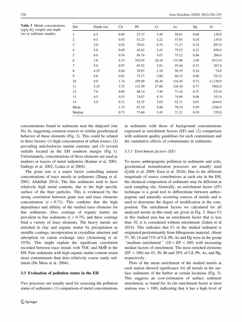
concentrations found in sediments near the shipyard (site
No. 6), suggesting common sources or similar geochemical
behavior of these elements (Fig. 2). This could be related
to three factors: (1) high concentration of urban wastes; (2)
prevailing anticlockwise marine currents; and (3) several
outfalls located in the EH southern margin (Fig. 1).
Unfortunately, concentrations of these elements are used as
markers or tracers of metal industries (Kumar et al. 2001;
Gallego et al. 2002; Loska et al 2004).
The grain size is a major factor controlling natural
concentrations of trace metals in sediments (Zhang et al.
2001; Abdallah 2014). The fine sediments tend to have
relatively high metal contents, due to the high specific
surface of the finer particles. This is evidenced by the
strong correlation between grain size and trace elements
concentration (r [ 0.73). This confirms that the high
dependence and affinity of the studied trace elements for
fine sediments. Also, coatings of organic matter are
prevalent in fine sediments (r [ 0.75), and these coatings
bind a variety of trace elements. The heavy metals are
enriched in clay and organic matter by precipitation as
metallic coatings, incorporation in crystalline structure and
adsorption on cation exchange sites (Armstrong et al.
1976). This might explain the significant correlation
recorded between trace metals with TOC and MzA in the
EH. Fine sediments with high organic matter content retain
more contaminants than does relatively coarse sandy sed-
iment (De Mora et al. 2004).
3.3 Evaluation of pollution status in the EH
Two processes are usually used for assessing the pollution
status of sediments: (1) comparison of metal concentrations
in sediments with those of background concentrations
expressed as enrichment factors (EF) and, (2) comparison
with sediment quality guidelines for each contaminant and
the cumulative effects of contaminants in sediments.
3.3.1 Enrichment factors (EF)
To assess anthropogenic pollution in sediments and soils,
geochemical normalization processes are usually used
(Celik et al. 2009; Esen et al. 2010). Due to the different
magnitude of source contributions at each site in the EH,
the chemical composition of sediments may be different at
each sampling site. Generally, an enrichment factor (EF)
technique is a good tool to differentiate between anthro-
pogenic and naturally occurring sources of metals and is
used to determine the degree of modification in the com-
position. The enrichment factors we calculated for all
analyzed metals in this study are given in Fig. 3. Since Cr
in this studied area has an enrichment factor that is less
than 10, it is considered without enrichment (Zahra et al
2014). This indicates that Cr in the studied sediment is
originated predominantly from lithogenous material. About
57, 50, 14 and 71% of Cd, Pb, As and Hg were in the group
‘‘medium enrichment’’ (10 \ EF \ 100) with increasing
median factors of enrichment. The most enriched elements
(EF [ 100) are 43, 50, 86 and 29% of Cd, Pb, As, and Hg,
respectively.
Plots of the mean enrichment of the studied metals at
each station showed significance for all metals in the sur-
face sediments of the harbor at certain locations (Fig. 3).
This suggests an over-estimation of surface sediment
enrichment, as found for As (its enrichment factor at most
stations was [ 100), indicating that it has a high level of
Table 3 Metals concentrations
(lg/g dry weight) and depth
(m) in sediment samples
Site Depth (m) Cd Pb Cr As Hg Al
1 6.5 0.69 57.37 3.49 58.91 0.09 139.0
2 9.5 0.93 41.23 4.22 57.93 0.19 135.0
3 2.0 0.52 70.63 8.74 71.27 0.74 897.0
4 5.0 0.69 45.82 3.43 75.23 0.23 856.0
5 6.0 0.76 88.79 5.07 75.12 0.88 268.0
6 7.0 5.23 192.94 28.18 132.90 2.40 9312.0
7 5.0 0.97 83.52 5.83 55.44 0.33 267.0
8 4.25 0.64 29.87 2.18 56.19 0.24 74.0
9 4.0 0.81 73.17 3.86 68.33 0.40 551.0
10 9.0 1.74 105.89 26.36 116.45 0.72 11,138.0
11 5.25 3.72 131.59 27.86 128.10 0.77 3982.0
12 7.0 0.69 88.14 7.49 71.16 0.37 523.0
13 6.5 0.53 74.07 8.74 74.89 0.08 351.0
14 4.0 0.71 52.35 2.65 52.71 0.83 1844.0
Mean 1.33 81.10 9.86 78.19 0.59 2166.9
Median 0.73 73.60 5.45 71.21 0.39 535.0
230 Acta Geochim (2020) 39(2):226–235
123

enrichment throughout the EH. Cadmium was highly
enriched at stations numbers 1, 2, 5 and 7 while Pb showed
highest levels of enrichment at 7 stations (representing
50% of all sampling stations). The enrichment plot for Hg
evidenced high enrichment factors in the sediments of
stations 2, 5, 7 and 8 this indicates that there are major
sources of pollution for As, Cd, Pb and Hg in the study
area. However, the high levels of enrichment were found in
Fig. 2 Spatial distribution of Cd, Pb, Cr, As, Hg and Al (mg/g) in surface sediments of the Eastern Harbor
Acta Geochim (2020) 39(2):226–235 231
123

Table 4 Average metal concentrations (lg/g) in sediments from different regions of the world
Region Cd Pb Cr As Hg Reference
Kaohsiung Harbor, Taiwan 0.1–6.8 9.5–470 0.2–900 – 0.1–8.5 Chen et al. (2007)
Montevideo harbor, Uruguay \ 1.0–1.6 44–128 79–253 – 0.6–1.3 Muniz et al. (2004)
Izmir Bay, Turkey 0.22–0.42 36–62 208–308 25–30 – Atgin et al. (2000)
Southern Bay, Brazil 0.07–0.11 42.0–43.5 11–25.1 18.1–56.2 – Da Silva et al. (1996)
Izmit Bay, Turkey 2.5–9.5 55.2–172 38.9–112.4 13.5–28.2 – Pekey (2006)
Eastern Harbour, Egypt 0.08–3.11 37.0–154.0 N.D–39.0 – – Abdallah (2007)
Abu Qir Bay, Egypt 17.21 56.05 63.99 – – Abdallah and Mohamed (2015)
Eastern Harbour, Egypt 0.52–5.23 29.8–192.9 2.2–28.4 52.7–132.9 0.08–2.40 Present study
0200400600800100012001400160018002000
1 2 3 4 5 6 7 8 9 10 11 12 13 14<100
>100
As
0
50
100
150
200
250
300
1 2 3 4 5 6 7 8 9 10 11 12 13 14
>100
<100
Cd
0306090120150180210240270
1 2 3 4 5 6 7 8 9 10 11 12 13 14
<100
>100
Pb
0
50
100
150
200
250
300
350
1 2 3 4 5 6 7 8 9 10 11 12 13 14
>100
<100
Hg
0102030405060708090100110
1 2 3 4 5 6 7 8 9 10 11 12 13 14
<100
>100Cr
Fig. 3 The mean enrichment value of studied metal in surface sediments of the EH
232 Acta Geochim (2020) 39(2):226–235
123

the sediments in the vicinity of small sewers which carry
mixed waste discharge from nearby small industries and
domestic sewage as well as in the vicinity of shipyards and
the anchorage of fishing boats, Cd and Pb are known as the
markers of paint industries (Lin et al. 2002). However, Cr
having enrichment factors less than 10, for all sites; fall in
the group of elements without enrichment in the study area.
According to Calmano et al. (1990), the difference in EF
values for the different studied metals in the harbor sedi-
ments may be due to the difference in the magnitude of
input for each metal in the sediment and/or the difference
in the removal rate of each metal from the sediment. When
observing changes in conditions as pH, redox potential,
ionic strength and the concentration of organic complexing
agents, the metals can be released with the water phase.
3.3.2 Degree of contamination (mCd)
For the classification and description of the mCd according
to Abrahim and Parker (2008), about 86% of the studied
sediments were in the range (8 B mCd \ 16) representing
a very high degree of contamination. The contamination
apparently comes from sewers that include industrial
wastes in addition to the outside source. The low move-
ment of sediments also contributed to the contamination.
Extremely high degree of contamination (16 B mCd \ 32)
were observed in about 14% of the EH sediments (at sta-
tions 10 and 11as shown in Fig. 4), which are located near
the shipyards and the outside source of the harbor and its
outlet. Moreover, the ultra-high degree of contamination
(mCd C 32) was recorded in the sediment of station num-
ber 6 which lies in the vicinity of shipyards and the
anchorage of fishing boats, which indicates very serious
anthropogenic pollution at this site (Fig. 4).
3.3.3 Assessment of potential ecological risk (PER)
Higher relative participation of Hg, Cd and As PER was
found for the EH. The harbor is considered a receptor of
industrial effluents. However, it receives significant
amounts of mixed wastes. There is a possibility of trans-
ference of metal contamination from external source
through the El Boghaze opening. Hence, the responsible
substances for sedimentological sensitivity factor (OM,
TP) and the considered metals have the same source or
interdependent sources such as domestic wastes without
treatment and wastes from shipyard installation. The con-
taminant bioavailability is reduced when there is an
increase in sediment anoxia and trophic state of water
column.
According to Hakanson et al. (2003), the sedimento-
logical sensitivity factor (SSF) is related to the trophic
status of the system, which influences the bioavailability of
metals. The EH was found to be a meso-to eutrophic bay,
this is usual for a confined inshore area, but it was not as
eutrophic as a polluted neighboring bay (El Mex Bay),
which receives huge amounts of agricultural drainage
waters contaminated by sewage at a rate of 6 million
m3/day (El-Rayis and Abdallah 2006). In eutrophic aquatic
eco-systems, metals are less bioavailable due to complex-
ation effects and to biological dilution (Hakanson et al.
2003).
About 43, 21 and 14% of the EH sediment has consid-
erable potential ecological risk for Hg, As, and Cd
respectively, in the same context as the high PER represent
14% of Cd and 7% for Hg in the harbor sediment (Fig. 5).
It is reasonable to envisage that Hg and Cd are the two
major ecological risks in the EH sediments.
4 Conclusion
The Eastern Harbor (EH) is one of the most popular tourist
site and fishing location in Alexandria City, Egypt. Iden-
tifying the degree of sediment contamination and assessing
the potential ecological risk of contamination is necessary
0
5
10
15
20
25
30
35
40
1 2 3 4 5 6 7 8 9 10 11 12 13 14 15
mC
d
Site
ultra-high
extremely high
very high
Fig. 4 Degree of contamination in each site of the EH sediments
0
50
100
150
200
250
300
350
1 2 3 4 5 6 7 8 9 10 11 12 13 14
PER
Site
High
Hg
Cd
As
Considerable
Moderate
Low
Fig. 5 Potential Ecological Risk (PER) of Hg, Cd and As in the EH
sediments
Acta Geochim (2020) 39(2):226–235 233
123

in order to assess the overall level of pollution. This project
studied the fine fraction of surficial sediments from 14
sites. The impact of anthropogenic heavy metal pollution
on EH was evaluated using Enrichment Factors (EF), as
well as modified degrees of contamination (mCd), and the
potential ecological risk (PER) for Cd, Cr, Pb, As and Hg.
Normalized enrichment factor (EF) values for heavy metals
were calculated for EH using the continental shale abun-
dance of Al. The results show that high average EF values
for Cd, Pb, As and Hg. The differences in EF values for the
studied metals may be due to the differences in inputs of
each metal to the sediments and/or the differences in the
removal rates of each metal from the sediments. For the
classification and description of the mCd, about 86% of the
studied sediments represent very high degrees of contam-
ination, which apparently come from sewers that include
industrial wastes. Additionally, extremely high degree of
contamination were observed near the shipyards and the
outside source of the harbor and its outlet. On the other
hand, the ultra-high degree of contamination was recorded
in the vicinity of shipyards and the anchorage of fishing
boats, which indicates very serious anthropogenic pollution
at this site. About 43%, 21%, and 14% of the EH sediments
have considerable potential ecological risks with Hg, As
and Cd, respectively. In the same context, the high PER
represent 14% of Cd and 7% for Hg in the harbor sedi-
ments. It is reasonable to envisage that Hg and Cd are the
two main ecological risks in the EH sediments.
Acknowledgements This study was accomplished as a part of a
fully-funded Grant of Matsumae International Foundation, Japan. We
would like to express our deepest thanks for Prof. Dr. Kimihiko Oki
and Prof. Dr. Takashi Tomiyasu for providing much help and advice.
We wish to thank all members of the Kagoshima University Museum
and Department of Earth and Environmental Sciences, Faculty of
Science, Kagoshima University for their help and support.
References
Abdallah MAM (2007) The distribution and accumulation of heavy
metals in sediments of semi-enclosed basin Southeastern
Mediterranean Sea, Egypt. Mediterr Mar Sci 8:31–40
Abdallah MAM (2014) The effect of grain size fractions on the
distribution of metals in sediments of Abu Qir Bay Southeast
Mediterranean Sea, Egypt. J Int Environ Appl Sci 9:223–230
Abdallah MAM (2017) Chemical speciation and contamination
assessment of Pb and V by sequential extraction in surface
sediment off Nile Delta, Egypt. Arab J Chem 10:68–75. https://
doi.org/10.1016/j.arabjc.2012.06.001
Abdallah MAM, Mohamed AA (2015) Assessment of heavy metals
by sediment quality guideline in surficial sediments of Abu Qir
bay Southeastern Mediterranean Sea, Egypt. Environ Earth Sci
73:3603–3609. https://doi.org/10.1007/s12665-014-3646-2
Abrahim GMS, Parker RJ (2008) Assessment of heavy metal
enrichment factors and the degree of contamination in marine
sediments from Tamaki Estuary, Auckland, New Zealand.
Environ Monit 136:227–238
Alves TM, Kokinou E, Zodiatis G, Lardner R (2016) Hindcast, GIS
and susceptibility modelling to assist oil spill clean-up and
mitigation on the southern coast of Cyprus (Eastern Mediter-
ranean). Deep Sea Res Part II 1:2. https://doi.org/10.1016/j.dsr2.
2015.07.017
American Society for Testing and Materials (ASTM) (1991) Standard
guide for collection, storage, characterization and manipulation
of sediments for toxicological testing. Publ. E. 1391-90,
Philadelphia. https://semspub.epa.gov/work/11/100000049
Armstrong PB, Hanson GM, Gaudette HE (1976) Minor elements in
sediments from Great Bay Estuary, New Hampshire. Environ
Geol 1:207–214
Atgın RS, El-Agha O, Zararsız A, Kocatas A, Parlak H, Tuncel G
(2000) Investigation of the sediment pollution in Izmir Bay:
trace elements. Spectrochim Acta B 55:1151–1164
Calmano W, Ahlf W, Forstner U (1990) Exchange of heavy metals
between sediments components and water. In: Brockaert JAC,
Gvear S, Adams F (eds) Metal speciation in the environment,
NATO ASI series G 23503
Celik S, Yucel E, Celik S, Gucel S, Ozturk M (2009) Carolina poplar
(Populusx Canadensis Moench) as a biomonitor of trace
elements in the West Black Sea region of Turkey. J Environ
Biol 31:225–232
Chen C, Kao C, Chen C, Dong C (2007) Distribution and
accumulation of heavy metals in the sediments of Kaohsiung
Harbor, Taiwan. Chemosphere 66:1431–1440
Da Silva MR, Lamotte M, Donard MOX, Soriano-Sierra EJ (1996)
Metal contamination in surface sediments of Mangroves,
Lagoons and Southern Bay in Florianopolis Island. Environ
Technol 17(10):1035–1046
De Mora S, Sheikholeslami MR, Wyse E, Azemard S, Cassi R (2004)
An assessment of metal contamination in coastal sediments of
the Caspian Sea. Mar Pollut Bull 48:61–77
El-Rayis O, Abdallah MAM (2006) Contribution of some trace
elements from an Egyptian huge drain to the mediterranean sea,
West of Alexandria. Med Mar Sci 7:79–86
El-Rayis O, Hinckely D (1999) Water and sediment quality of
Mediterranean Sea coastal area containing underwater archaeol-
ogy of ancient Alexandria, Egypt. In: Proceedings of the 9th
international conference on ‘‘Environmental protection must’’,
USPD, pp 20–32
El-Wakeel SK, El-Sayed MKh (1978) The texture, mineralogy and
beach sands from the Alexandria region, Egypt. Mar Geol
27:137–160
Esen E, Kucuksezgin F, Uluturhan E (2010) Assessment of trace
metal pollution in surface sediments of Nemrut Bay, Aegean
Sea. Environ Monit Assess 160:257–266
Folk RL, Ward WC (1957) Brazos river bar: a study in the
significance of grain size parameters. J Sediment Petrol 27:3–26
Gallego JLR, Ordonez A, Loredo J (2002) Investigation of trace
element sources from an industrialized area (Aviles, northern
Spain) using multivariate statistical methods. Environ Int
27:589–596
Goddio F (1998) Alexandria—the submerged Royal Quarters.
Publication of Periplus. Ltd., London
Hakanson L (1980) An ecological risk index aquatic pollution control.
A sedimentological approach. Water Res 14:975–1001
Hakanson L, Ostapenia A, Parparov A, Hambright KD, Boulion VV
(2003) Management criteria for lake ecosystems applied to case
studies of changes in nutrient loading and climate change. Lakes
Reserv Res Manag 8:141–155
Horowitz AJ, Elrick KA (1987) Sediment trace element chemistry:
interrelations with surface area, grain size, and geochemical
substrate. In: Lindberg S, Hutchinson T (eds) Proceedings of
heavy metals in the environment, New Orleans, vol 2,
pp 227–229
234 Acta Geochim (2020) 39(2):226–235
123

Kremling K, Petersen H (1981) The distribution of zinc, cadmium,
copper, manganese and iron in waters of the open Mediterranean
Sea. Meteor Forsch Ergeb 23:5–14
Kumar AV, Patil RS, Nambi KSV (2001) Source apportionment of
suspended particulate matter at two traffic junctions in Mumbai,
India. Atmos Environ 35:4245–4251
Lin YP, Teng TP, Chang TK (2002) Multivariate analysis of soil
heavy metal pollution and landscape pattern in Changhua
County in Taiwan. Landsc Urban Plan 62:19–35
Loring DH, Rantala RTT (1992) Manual for geochemical analysis.
Earth Sci Rev 32:235–283
Loska K, Wiechula D, Korus I (2004) Metal contamination of
farming soils affected by industry. Environ Int 30:159–165
Morillo J, Usero J, Gracia I (2004) Heavy metal distribution in marine
sediments from the southwest coast of Spain. Chemosphere
55:431–442
Muniz P, Venturini N, Gomez-Erache M (2004) Spatial distribution
of chromium and lead in the benthic environment of coastal
areas of the rıo de la plata estuary (Montevideo, Uruguay). Braz
J Biol 64(1):103–116
Pekey H (2006) The distribution and sources of heavy metals in Izmit
Bay surface sediments affected by a polluted stream. Mar Pollut
Bull 52:1197–1208
Zahra A, Zaffar Hashmi M, Malik NR, Ahmed Z (2014) Enrichment
and geo-accumulation of heavy metals and risk assessment of
sediments of the Kurang Nallah—feeding tributary of the Rawal
Lake Reservoir, Pakistan. Sci Total Environ 470–471:925–933
Zhang W, Yu L, Hutchinson SM, Xu S, Chen Z, Gao X (2001)
China’s yangtze estuary: I Geomorphic influence on heavy metal
accumulation in intertidal sediments. Geomorphology
41:195–205
Acta Geochim (2020) 39(2):226–235 235
123