ECOLOGICAL LANDSCAPE ANALYSIS EASTERN GRANITE …
39
Department of Lands and Forestry 2019 Update ECOLOGICAL LANDSCAPE ANALYSIS EASTERN GRANITE UPLANDS ECODISTRICT 430 ELA 2019-430 PART 1: Overview of Ecodistrict PART 2: Linking the Landscape to the Woodlot
Transcript of ECOLOGICAL LANDSCAPE ANALYSIS EASTERN GRANITE …

Department of Lands and Forestry
2019 Update
ECOLOGICAL LANDSCAPE ANALYSIS EASTERN GRANITE UPLANDS ECODISTRICT 430
ELA 2019-430
PART 1: Overview of EcodistrictPART 2: Linking the Landscape to the Woodlot

Ecological Landscape Analysis of Eastern Granite Uplands Ecodistrict 430 2
© Crown Copyright, Province of Nova Scotia, 2019.
Ecological Landscape Analysis, Ecodistrict 430: Eastern Granite Uplands 2019 Update for Part 1 and 2
Prepared by the Nova Scotia Department of Lands and Forestry Peter Bush and Courtney Baldo, Forestry Division
This report, one of 38 for the province, provides updated figures and tables to supplement the original Ecological Landscape Analysis documents.
Information sources and statistics (benchmark dates) include: • Crown Lands Forest Model landbase classification (2017v.1)
Note this geodatabase includes the latest Forest Inventory Databases (FID), forest disturbance information, forest harvesting information, crown land purchases and new protected area designations. Forest harvesting, silviculture, and fire disturbance (including satellite updates) are current as of end of 2015.
As revision and peer-reviewing of Natural Disturbance Regimes mapping in Nova Scotia becomes available, any major changes will be incorporated in future updates.
Selected updated Tables and Figures This document provides recalculated values for the following: Table 1 (Figures may vary slightly from 2015 ELA because of new Forest Inventory Databases and change in the base geodatabase)
Table 3 (Figures may vary slightly from 2015 ELA because of new Forest Inventory Databases and change in the base geodatabase)
Table 5a (Figures may vary slightly from 2015 ELA because of new Forest Inventory Databases and change in the base geodatabase)
Table 5b (Figures may vary slightly from 2015 ELA because of new Forest Inventory Databases and change in the base geodatabase)
Development Class Targets by Elements – Only major forest elements are reported in the update. Wetlands and Valley Corridors are not
reported in this update.
Table 2 was not updated as Integrated Resource Management Land Use Categories have not been updated.
Table 4 was not updated because the land capability for individual polygons has not changed since the original report. Land generally
still has that same capability rating now as it did previously, regardless of any management activities at the site.

Ecological Landscape Analysis of Eastern Granite Uplands Ecodistrict 430 3
Table of Contents – Parts 1 and 2
Ecodistrict Profile ........................................................................................................ 4
Forest Ecosystem Management for Eastern Granite Uplands Ecodistrict .............................. 6 Application ...................................................................................................... 6
Part 1: An Overview of the Eastern Granite Uplands Ecodistrict ............................... 7 – Learning About What Makes This Ecodistrict Distinctive
Ecodistrict Characteristics .................................................................................. 7 Land Area ........................................................................................................ 9 IRM Resource Classification for Provincial Crown Lands .......................................... 9 Forests ......................................................................................................... 10 Water Resources ............................................................................................ 11 Minerals, Energy and Geology .......................................................................... 12 Parks and Recreation / Protected Areas ............................................................. 14 Wildlife and Wildlife Habitat ............................................................................. 16
Part 2: Linking the Landscape to the Woodlot ........................................................ 18 – How Woodland Owners Can Apply Landscape Concepts to Their Woodland
Forest Disturbances and Succession ............................................................................ 18 Forest Disturbances ........................................................................................ 18 Natural Succession ......................................................................................... 19
Eastern Granite Uplands – Elements Defined ...................................................... 18 Map of Elements in Ecodistrict .......................................................................... 21 Forest Stands Within Elements ......................................................................... 22 Photos Illustrating Vegetation Types in Elements ................................................ 25
Landscape Composition and Objectives........................................................................ 28 Natural Disturbance Regimes ........................................................................... 28 Forest Composition ......................................................................................... 28 Forest Composition Objectives ......................................................................... 30 Development Class Targets by Element ............................................................. 31
Summary of Parts 1 and 2 ......................................................................................... 33 Glossary A: Terms in Parts 1 and 2 ............................................................................. 34
Tables
Table 1 Land Area by Ownership in the Eastern Granite Uplands Ecodistrict ............... 9
Table 2 IRM Land Use Categories for Provincial Crown Lands in Ecodistrict ................ 9
Table 3 Area Distribution by Land Category for All Owners .................................... 10
Table 4 Area of Forested Land by Land Capability Rating ....................................... 11
Table 5a Elements Within Eastern Granite Uplands ................................................. 23
Table 5b Forest Vegetation Types Within Elements in Eastern Granite Uplands ........... 25
Table 6 Landscape Composition Target Ranges .................................................... 30

Ecological Landscape Analysis of Eastern Granite Uplands Ecodistrict 430 4
Ecodistrict Profile Ecological Landscape Analysis Summary Ecodistrict 430: Eastern Granite Uplands
An objective of ecosystem-based management is to manage landscapes in as close to a natural state as possible. The intent of this approach is to promote biodiversity, sustain ecological processes and support the long-term production of goods and services. Each of the province’s 38 ecodistricts is an ecological landscape with distinctive patterns of physical features. (Definitions of underlined terms are included in the print and electronic glossary.)
This Ecological Landscape Analysis (ELA) provides detailed information on the forest and timber resources of the various landscape components of Eastern Granite Uplands Ecodistrict 430. The ELA also provides brief summaries of other land values, such as minerals, energy and geology, water resources, parks and protected areas, wildlife and wildlife habitat.
Eastern Granite Uplands is a narrow ridge about 80 kilometres long by 8 to 10 kilometres wide running east of Waverley to Sheet Harbour, with a total area of 60,220 hectares. The ecodistrict lies north of the coastal Eastern Shore Ecodistrict.
Rising sharply up to 100 metres above the adjacent coastal area, often with steep cliffs, this rocky ridge is dissected by narrow river gorges, the most notable being the Musquodoboit River. Also of note are long narrow lakes, such as Lake Charlotte and Porters Lake. Freshwater lakes and streams are abundant, representing 11% of the area.
The granite that underlies this ecodistrict is similar to the granite of the South Mountain Ecodistrict and other outcrops throughout the western and eastern ecoregions. Granite is highly resistant to erosion and most of the soils associated with this granite are coarse- textured and shallow.
Freshwater lakes account for 11% of the ecodistrict with Tangier Grand Lake as one
of the largest.
A NOVA SCOTIA DEPARTMENT OF NATURAL RESOURCES PUBLICATION

Ecological Landscape Analysis of Eastern Granite Uplands Ecodistrict 430 5
Many areas in this ecodistrict have exposed bedrock and are scattered with huge, sometimes house-size, granite boulders deposited by glaciers. It is estimated that approximately 15% of the ecodistrict is exposed bedrock.
Few bogs and fens are found in this ecodistrict, but there are several notable wetlands bordering the Musquodoboit River.
The forests of this ecodistrict are predominantly softwood, with red spruce stands on the better-drained and deeper soils associated with hummocky terrain. Elsewhere, the shallow soils give rise to forests of black spruce and white pine with scattered red pine indicating fire disturbances in the past.
Jack pines are found on the shallow soils of ridge tops. Shade-tolerant hardwoods are usually only found on the few scattered drumlins. Stands of hemlock occur on steep slopes of hills and hummocks alongside rivers and streams.
Private land ownership accounts for 21% of the ecodistrict area, with 68% under provincial Crown management.
Landscapes are large areas that function as ecological systems and respond to a variety of influences. Landscapes are composed of smaller ecosystems, known as elements. These elements are described by their physical features – such as soil and landform – and ecological features – such as climax forest type. These characteristics help determine vegetation development.
Granite cliffs, exposed bedrock and large surface boulders give
a rugged appearance to this ecodistrict.
Element descriptions promote an understanding of historical vegetation patterns and the effects of current disturbances. This landscape analysis identified and mapped six key landscape elements – one dominant matrix element, and five smaller patch elements, ‒ in Eastern Granite Uplands.
Spruce Hemlock Pine Hummocks and Hills is the matrix element, representing 43% of the area in the ecodistrict. Most of the element occurs as large hilly areas with a forest of red spruce and white pine. Hemlock will be found on soils with higher moisture and nutrient content. Drier and less fertile soils are dominated by black spruce, white pine, red pine, red oak, and red maple.
Spruce Pine Hummocks and Jack Pine Hummocks and Ridges are the two largest patch elements, representing a combined 53% of the area. Black spruce, white pine, jack pine, and hybrid red and black spruce are the most common species. The other patch elements, in order of size, are Tolerant Hardwood Drumlins and Hummocks, Spruce Pine Flats, and Wetlands.

Ecological Landscape Analysis of Eastern Granite Uplands Ecodistrict 430 6
Forest Ecosystem Management For Eastern Granite Uplands Ecodistrict
The primary ecological goals of ecosystem-based management are to maintain and conserve ecosystem biodiversity, productivity, and resilience. Integration of economic, ecological, and social values within a single planning process provides opportunities for creative solutions to meet the challenges of sustainable resource management. By maintaining their integrity, ecosystems can better adapt to environmental stressors such as extended cycles of climate change, atmospheric pollution, and changes in land use and vegetation cover.
This ELA provides detailed information on the resources and descriptions of various components of the landscape for Eastern Granite Uplands Ecodistrict 430. Resources and their components include the natural elements that make up the landscape and may affect functions like connectivity – how a landscape enables or impedes movement of resources, such as water and animals – as wellas conditions of forest composition, road density, and land use intensity.
Only brief summaries are presented for other land values, including minerals, energy and geology, water resources, parks and protected areas, wildlife and wildlife habitat. These summaries are included in the document to present the range of land values that must be balanced during the design stage of the land management process and are not intended to be exhaustive treatments of the respective land values. Where possible, the reader will be referred to additional sources for detailed information.
Application
The data in this ELA represent inventory based off the Forest Inventory Database (FID) current as of the end of 2015 and the Crown Land Forest Model (CLFM) current as of 2017. The update provides a reference to compare to the baseline conditions provided in the ELA 2015, which in the case of the Eastern Granite Uplands Ecodistrict was up to 2006. These baseline measurements can be used to assess trends through comparison with present and future inventories.
The ELA supports an approach to maintaining healthy ecosystems by mimicking natural conditions. The report describes the inherent natural structure and condition of landscapes based on enduring physical features, such as elements. It goes on to show how this structure may influence ecosystem functions, such as wildlife movement and connectivity. The ELA summarizes conditions of ecosystems such as forest composition, land use intensity, and road density at the time the report was written.
Finally, the relationship between inherent structure and existing conditions is used to guide future direction. The ELA is part of an ecosystem approach that will expand to encompass other initiatives of the Department of Lands and Forestry, such as The Path We Share: A Natural Resources Strategy for Nova Scotia 2011-2020 (see http://novascotia.ca/natr/strategy/pdf/Strategy_Strategy.pdf).
The intention is to describe important ecological characteristics to consider during resource planning – the ELA is not a plan in itself.

Ecological Landscape Analysis of Eastern Granite Uplands Ecodistrict 430 7
Part 1: An Overview of Eastern Granite Uplands – Learning About What Makes This Ecodistrict Distinctive
This first part of the report provides an overview of the ecodistrict for a broad readership. By reviewing several key topics, the reader will have a better understanding of the features that help give the area its character and set it apart as a distinct and unique ecodistrict.
Ecodistrict Characteristics
The total area of the Eastern Granite Uplands Ecodistrict is 602 square kilometres, or 9% of the Eastern Ecoregion.
The ecodistrict, a narrow ridge 80 kilometres long by 8 to 10 kilometres wide, lies north of the coastal Eastern Shore Ecodistrict 820.
The granite that underlies this ecodistrict is similar to the granite of the South Mountain Ecodistrict 720 and the Governor Lake Ecodistrict 440. The granite bedrock is resistant to weathering and erosion and most of the tills and soils in this ecodistrict are coarse-textured and shallow. Many areas have exposed bedrock. Huge granite boulders deposited by the glaciers are also found.
Narrow river gorges, such as those formed by the Musquodoboit River, and long narrow lakes, such as Lake Charlotte and Porters Lake, dissect the ecodistrict. This ecodistrict has one of the highest concentrations of freshwater lakes in the province, with 11% coverage.
About 76% of the Eastern Granite Uplands is forested. Among the softwoods, red spruce, black spruce, and white pine dominate. Among the hardwoods, red maple, grey birch, white birch, and aspen dominate.
The most common disturbance agents associated with the Eastern Granite Uplands are fire, wind, and hurricanes. The natural disturbance regime for the uplands is frequent, due to wind storms and hurricanes or a soil moisture deficit during the summer months that creates conditions favourable for forest fires.
See map on following page for overview of the Eastern Granite Uplands Ecodistrict, including adjacent ecodistricts, locations of area towns and villages, county boundaries, and major waterways.

Ecological Landscape Analysis of Eastern Granite Uplands Ecodistrict 430 8
A portion of the Eastern Granite Uplands Ecodistrict 430 covers part of Halifax County on the eastern mainland of Nova Scotia.
(From Ecodistricts of Nova Scotia map 2007)

Ecological Landscape Analysis of Eastern Granite Uplands Ecodistrict 430 9
Land Area In Eastern Granite Uplands, 68% of the land is under Crown ownership, which is a high percentage compared to most of the other ecodistricts in the province.
Private land ownership represents 21% of the area, with 11% in other uses.
IRM Resource Classification for Provincial Crown Lands
The Integrated Resource Management (IRM) classification for Crown lands was developed through a public consultation process during the strategic phase of IRM completed in 2002.
Table 2 provides a summary of Crown lands designated as either C1, General Resource Use; C2, Multiple and Adaptive Use (allows most uses, but special management may be required); or C3, Protected and Limited Use (such as beaches and sites of cultural and historic significance).
In Eastern Granite Uplands, C3 (59%) is the largest category, followed by C1 (36%), and C2 (5%).
Table 2 – IRM Land Use Categories for Provincial Crown Lands in Ecodistrict
IRM Land Use Category Hectares Percent of Crown Lands
C1 – General Resource Use 13,963 35.8
C2 – Multiple and Adaptive Use 1,968 5
C3 – Protected and Limited Use 23,043 59
Unclassified 74 0.2
Total 39,048 100
There are many camp leases in this ecodistrict. The tremendous number of lakes, along with good fishing and hunting, has historically drawn sportsmen into the area, resulting in the request for leases for recreational camps.
Table 1 – Land Area by Ownership in the Eastern Granite Uplands Ecodistrict*
Ownership Area (hectares)
Percent of Total Area
Provincial Crown land 40,714 67.6
Private 12,748 21.2
Federal 0 0
Aboriginal 0 0 Other (Includes inland water bodies and transportation corridors)
6,758 11.2
Total 60,220 100
*Note: Figures may vary slightly from table to table because of rounding, averaging, and overlapping of categories and other factors.

Ecological Landscape Analysis of Eastern Granite Uplands Ecodistrict 430 10
The western-most section of the ecodistrict, which includes the Waverley-Salmon River Long Lake Wilderness Area, contains no camps. However, the Porters Lake and Myra Road Wilderness Area Association has received a license for a short trail from the Department of Lands and Forestry. This trail starts on the Myra Road and runs west to the edge of the wilderness area.
The remainder of the ecodistrict contains about 45 camps, some inside the wilderness areas and some outside. Also, Department of Lands and Forestry has identified 15 so-called “replacement camp-sites” that will be offered to leaseholders who have camps within a wilderness area but may prefer a camp site outside the wilderness area. Camps within wilderness areas are administered by the Department of the Environment and have restrictions on off-highway vehicle use and trail building.
The Musquodoboit Trailways Association has several licenses to build and operate trails, including the abandoned railway north of Musquodoboit Harbour, and trails extending into White Lake Wilderness Area.
Forests
Forested land makes up 76% of the ecodistrict (Table 3).
The next largest category is for other uses, such as alders or brush, Christmas tree farms or beaver ponds, which accounts for 11% of the ecodistrict.
Categories that describe barrens and wetland, when combined, account for 12% of the ecodistrict.
The forests of this ecodistrict are primarily softwood (68%), followed by mixedwood (13%), and hardwood (11%), with the remaining 8% unclassified.
Red and black spruce forests are the most common forest community across the ecodistrict. Intolerant hardwood and spruce and fir stands are the next most common forest community type.
Scrubby forests consisting of black spruce and white pine with scattered red pine can be found throughout the ecodistrict on shallow, fire-barren soils.
Pure stands of tolerant hardwood are rare. However, yellow birch and sugar maple are present in hardwood stands growing on drumlins.
Table 3 ‒ Area Distribution by Land Category for All Owners
Category Hectares Percent
Forested 45,925 76.3
Wetland 3,009 5.0
Agriculture 0 0
Barrens 4,431 7.4
Urban 120 0.2
Road, Trail, Utility
61 0.1
Other 6,674 11.1
Total 60,220 100

Ecological Landscape Analysis of Eastern Granite Uplands Ecodistrict 430 11
Forests of white pine and red and black spruce are common in the ecodistrict
in areas such as Porters Lake. The average Land Capability (LC) of forested land in this ecodistrict is estimated to be 3.9 cubic metres per hectare per year (m3/ha/yr), based on the ratings in Table 4. The average forest LC for the province is 4.9 m3/ha/yr.
Some areas are not suitable for trees. These non-forested areas consist mainly of rock outcrops and barren lands.
Water Resources
Freshwater lakes and streams are abundant in this ecodistrict, with water resources accounting for 11% of Eastern Granite Uplands. Of note are the long narrow lakes that dissect the ecodistrict, such as Lake Charlotte and Porters Lake. The largest lakes within this area are Paces, Porters, and Tangier Grand.
Table 4 – Area of Forested Land by Land Capability Rating
Land Capability (LC) Rating (m3/ha/yr)*
Hectares Percent
2 or less 5,253 11.5
3 10,594 23.1
4 15,818 34.4
5 10,904 23.8
6 3,240 7.1
7 or more 69 0.1
Total 45,878 100
*Based on growth potential for softwood species.

Ecological Landscape Analysis of Eastern Granite Uplands Ecodistrict 430 12
The largest river in the ecodistrict is the Musquodoboit. Water is an important provincial resource that must be considered in the context of IRM in general, and specifically within individual ecosystems.
Squirrel Lake is one of the long, narrow lakes in the ecodistrict. The Environmental Goals and Economic Prosperity Act, which was enacted in early 2007, has committed the province to prepare a comprehensive water strategy. This strategy will include a high-level evaluation of water resources. Nova Scotia’s water strategy can be found at http://www.novascotia.ca/nse/water.strategy/docs/WaterStrategy_Water.Resources.Management .Strategy.pdf
Minerals, Energy and Geology The Eastern Granite Uplands Ecodistrict extends from Soldier Lake near Fall River to Grand Lake, a few kilometres west of Sheet Harbour.
The area is dominated by a large granitic intrusive body that has been exposed at the surface after millions of years of erosion. These rocks are up to 393 million years old.
There are numerous mineral occurrences in the Ship Harbour, Tangier Grand Lake, and the Taylor Bay and Long Lake areas. Almost all the occurrences contain tungsten with many containing

Ecological Landscape Analysis of Eastern Granite Uplands Ecodistrict 430 13
copper, iron, molybdenum, tin, zinc, and lead. The Dunbrack Mine/Prospect near Paces Lake contained lead, copper, zinc, and silver. The Mooseland Gold District borders the Eastern Granite Uplands Ecodistrict in the Mooseland area.
Overlying the bedrock in most parts of the ecodistrict are glacial deposits of ground moraine and streamlined drift along with recent sediments. These contribute to the development of soils, and have been used as a source of aggregate. A few drumlins and peat bogs occur in the eastern end of the ecodistrict. Along the Musquodoboit River, the spillway for an ancient glacial lake dissects the ecodistrict.
The bedrock geology is not particularly complex in this ecodistrict with only two major faults, running northwest and southeast, at Lake Major and Porters Lake.
Granite outcrops and erratics left behind from the last glaciation are found in the Eastern Granite Uplands Ecodistrict.
Meguma Group rocks, up to 544 million years old, cover approximately 5% of the ecodistrict. This group comprises the Goldenville Formation and overlying Halifax Formation that were metamorphosed and folded into a series of upright north to northeast and southwest plunging anticlines and synclines – upward or downward folds in rock layers – during the Acadian mountain-building period prior to the intrusion of the granitoid plutons.
The Goldenville Formation comprises varying amounts of metamorphosed sandstones and siltstones. Many of the gold districts in Nova Scotia are found in rocks from this formation.

Ecological Landscape Analysis of Eastern Granite Uplands Ecodistrict 430 14
The Halifax Formation consists mainly of black, grey, and rust-brown slates with areas of abundant pyrite, pyrrhotite, and arsenopyrite which can be acid generating.
Potential geohazards, such as abandoned mine openings, potential karst areas, flood risk areas, sulphide-bearing slates, and underground coal workings, can be viewed at the following web sites: http://gis4.natr.gov.ns.ca/website/nsgeomap/viewer.htm http://gis4.natr.gov.ns.ca/website/mrlu83/viewer.htm Please report any additional geohazards found on Crown lands to your nearest Natural Resources office.
Parks and Recreation / Protected Areas
For the parks and protected areas within your ecodistrict, please refer to the Park and Protected Areas website (http://novascotia.ca/parksandprotectedareas/plan/interactive-map/) and the Provincial Landscape Viewer, at the following url: https://nsgi.novascotia.ca/plv/.

Ecological Landscape Analysis of Eastern Granite Uplands Ecodistrict 430 15
The Tangier Grand Lake Wilderness Area, showing the Trout Lake addition, is one of
three wilderness areas in the Eastern Granite Uplands Ecodistrict.

Ecological Landscape Analysis of Eastern Granite Uplands Ecodistrict 430 16
Wildlife and Wildlife Habitat Wildlife in the Eastern Granite Uplands Ecodistrict includes relatively common species of plants, animals and other organisms, along with some species that are rare and/or at risk in Nova Scotia.
Wildlife information for Eastern Granite Uplands and other ecodistricts comes from a number of sources, including surveys, harvest statistics, hunter / trapper reports (abundance rankings), biological collections from harvested and road killed animals, and observations and reports from the public and Department of Lands and Forestry staff. Information on important sites is documented by Department of Lands and Forestry in the Significant Habitats Database and by the Atlantic Canada Conservation Data Centre in Sackville, New Brunswick.
Old forests are recognized as providing important wildlife habitat. The provincial goal is to have a minimum 8% for old forests on Provincial Crown land. Shade-tolerant hardwoods and softwoods may provide important wildlife structural components, such as cavity trees, and are encouraged across the landscape through appropriate silviculture systems.
Wildlife and Wildlife Habitat
Lakes and watercourses are abundant in the Eastern Granite Uplands Ecodistrict. Porters Lake, Lake Charlotte, and the Musquodoboit River act as corridors flowing north and south through the ecodistrict. The area is heavily used for outdoor recreation, especially fishing and to a lesser extent hunting and trapping.
Based on the various surveys and reports, it’s likely that the ecodistrict supports a broad diversity of healthy but small populations as a result of the shallow infertile soils and low land capability.
Old Forest designated stands are well represented with 41% being found within three wilderness areas: Waverley-Salmon River Long Lake, White Lake, and Tangier Grand Lake.
With the many lakes, loons are reasonably common as are breeding populations of waterfowl, such as American black duck and, to a lesser extent, common mergansers, ring necks, and wood ducks.
Canada geese are becoming more common and can be readily found in the Musquodoboit River and associated wetlands. Eagles, a species that prefers being close to water where fish are plentiful, are common with at least four known nests.
Several species at risk are noted within the ecodistrict. Moose, historically common, are occasionally reported scattered throughout but are usually found in small numbers within the Tangier Grand Lake Wilderness Area.
Canada geese are becoming more common in the Eastern Granite
Uplands Ecodistrict.

Ecological Landscape Analysis of Eastern Granite Uplands Ecodistrict 430 17
Salmon can still be found in several rivers, in particular the Musquodoboit and Tangier. Moose, historically common, are occasionally reported scattered throughout but are usually found in small numbers within the Tangier Grand Lake Wilderness Area. Atlantic salmon can still be found in several rivers, in particular the Musquodoboit and Tangier.
Rare lichens, including boreal felt lichen, have been identified in limited numbers, in the ecodistrict where the preferred habitat is reasonably common. Three concentrations of boreal felt lichen and/or other rare lichens are known to occur near Bear and Jacket lakes on the edges of the Tangier Grand Lake Wilderness Area, and near Webber Lake, west of Lake Charlotte.
Wood turtles are known to the Musquodoboit River system, although most sightings and habitat occur further upstream outside of the ecodistrict.
Mountain sandwort, a plant that prefers granitic ledges and gravel habitat, has been found in the Gibraltor Rock area.
For more detailed and current information on species at risk and species of conservation concern in this ecodistrict, refer to Appendix 3 and Map 6 in a separate Part 3 of this document. These species are important components of the landscape and are given priority attention in planning, management, and stewardship activities.
With much of the ecodistrict privately owned, effective wildlife management will to a great extent rely on active, informed stewardship by the many landowners. The Department of Lands and Forestry can assist private land stewardship by providing knowledge and information on various management strategies. Legislation such as the Wildlife Habitat and Watercourse Protection Regulations, the Endangered Species Act, and the Environment Act’s Activities Designation Regulations address species and habitat concerns within the forest and wetland ecosystems.

Ecological Landscape Analysis of Eastern Granite Uplands Ecodistrict 430 18
Part 2: Linking the Landscape to the Woodlot – How Woodland Owners Can Apply Landscape Concepts to Their Woodland This second part of the report provides information on how landscape concepts can be applied at the woodlot level. The starting point is an introduction to natural disturbances and succession to provide a foundation for better understanding forest ecosystems. The focus then shifts to elements that make up each ecodistrict and the forest groups and vegetation types at the stand level. This allows woodland owners to move between elements and stands to see how their woodland fits in with the larger landscape.
Forest Disturbances and Succession
Forest Disturbances A disturbance can be described as an event, either natural or human-induced, that causes a change in the existing condition of an ecological system.
Disturbance pattern controls forest development classes (establishment, young, mature, multi- aged / old forest) and their distribution over area and time.
Due to the coastal location of Nova Scotia and its Maritime climate, the extent, intensity, and frequency of natural disturbances is difficult, for the most part, to predict. Prior to European settlement, natural disturbances were only curtailed by natural barriers such as water, climate, topography, and vegetation change. After about 400 years of activity by European settlers, the frequency, intensity, and magnitude of these natural processes has been affected.
New disturbances have been introduced as a result of human activity and include:
• clearing of forests for agriculture • timber harvesting • urbanization and development • introduction of exotic animals, plants, and insects • disease-causing agents, such as viruses or bacteria • fire suppression in the forest • and changes in the chemical and physical characteristics of the atmosphere
Understanding how ecosystems respond to disturbances is critical to understanding how they function and can be managed. This will assist woodland owners and forest managers in:
i. assessing the potential for old forest stands and development class distributions
ii. determining appropriate patch sizes and species composition to emulate natural structures and processes

Ecological Landscape Analysis of Eastern Granite Uplands Ecodistrict 430 19
iii. prescribing the appropriate rotation age and development class structure across a forested landscape
iv. projecting future changes to the forest due to climate change and human disturbances v. maintaining and conserving biodiversity
Natural disturbances are agents that abruptly change existing conditions and initiate secondary succession to create new ecological communities.
By adapting forest management practices to create the structures and processes that emulate natural disturbances, woodland owners and forest managers can help shape forest landscapes.
One approach that closely mimics nature is to allow ecosystems to naturally develop without active management. This approach is particularly effective on lands with long-lived tree species, such as red spruce, white pine, hemlock, sugar maple, yellow birch, and beech. One of the roles of protected areas is to allow this to occur and also provide a model to compare with managed forests.
Natural Succession
Succession refers to the changes in vegetation types (communities) following disturbance which, over time, often leads to a climax stage. Most changes follow a course of vegetation community development (seral stages) for a particular disturbance regime.
Climax vegetation refers to vegetation communities that are relatively long-lasting and self-replacing. Three types of climax vegetation can be described as follows:
Climatic climax – Vegetation types that are mainly a function of regional climate conditions; these occur on sites with average (mesic) moisture and nutrient conditions.
Disturbance climax – Vegetation types which, due to frequency of disturbance, do not progress to the climatic climax.
Edaphic climax – Vegetation types that are mainly a function of soil and site conditions (i.e. low or excess moisture, low or high fertility) which do not progress to the climatic climax.
Eastern Granite Uplands – Elements Defined
Landscapes are large areas that function as ecological systems and respond to a variety of influences. Landscapes are composed of smaller ecosystems, known as elements. These elements
Another Definition of Succession
Succession, as defined by Odum (1971), is an orderly process of community development that involves changes in species structure and community processes with time; it is reasonably directional and, therefore, predictable.
Successional development generally proceeds through a number of distinct seral stages (e.g. early, middle, late) that replace one another in a predictable sequence and which culminates in a relatively stable and self-perpetuating community condition called a climax.
– From Part 1: Vegetation Types (2010) of Forest Ecosystem Classification for Nova Scotia http://www.gov.ns.ca/natr/forestry/veg-types

Ecological Landscape Analysis of Eastern Granite Uplands Ecodistrict 430 20
are described by their physical (e.g. soil, landform) and ecological features (e.g. climax forest type). These characteristics help determine vegetation development. Elements promote an understanding of historical vegetation patterns and present disturbances.
A landscape profile identified and mapped six distinctive elements in the Eastern Granite Uplands Ecodistrict – one matrix, and five patches (Table 5a). A matrix is the dominant community type. Patches are smaller yet still distinctive community types.
Spruce Hemlock Pine Hummocks and Hills is the matrix element, representing 43% of the area in the ecodistrict. Most of the element occurs as large hilly areas with a forest of red spruce and white pine. Hemlock will be found on soils with higher moisture and nutrient content. Drier and less fertile soils are dominated by black spruce, white pine, red pine, red oak, and red maple.
Spruce Pine Hummocks and Jack Pine Hummocks and Ridges are the two largest patch elements, representing a combined 53% of the area. Black spruce, white pine, jack pine, and hybrid red and black spruce are the most common species. The other patch elements, in order of size, are Tolerant Hardwood Drumlins and Hummocks, Spruce Pine Flats, and Wetlands.

Ecological Landscape Analysis of Eastern Granite Uplands Ecodistrict 430 21
Map of Elements in Ecodistrict

Ecological Landscape Analysis of Eastern Granite Uplands Ecodistrict 430 22
Forest Stands Within Elements Each element contains a number of forest stands that can be classified by vegetation, soil, and ecosites. The Department of Lands and Forestry publication Forest Ecosystem Classification for Nova Scotia, Part I: Vegetation Types (2010) (http://novascotia.ca/natr/forestry/veg-types/veg-navigation.asp) is helpful in identifying forest plant communities.
Viewed online or available in print through Department of Lands and Forestry, woodland owners can learn about the characteristics of a particular forest community. Refer to Table 5a for descriptions of elements and Table 5b for forest vegetation types that are likely to be found within elements.
Open woodlands and ericaceous woody shrubs grow near granite outcrops in many parts of Eastern Granite Uplands.

Ecological Landscape Analysis of Eastern Granite Uplands Ecodistrict 430 23
Table 5a – Elements Within Eastern Granite Uplands
Element Size (Hectares)
Element Description
Spruce Hemlock 23,099 This is the matrix element occurring primarily on hilly terrain with Pine Hummocks and Hills 43.2% well to rapidly drained soils of coarse texture derived from granite
tills. Most of the element occurs as large hilly areas with a forest of (Matrix) red spruce and white pine. Hemlock will be found on soils with higher
moisture and nutrient content, which are usually associated with lower slope positions. Drier and less fertile soils, often coarser in nature, support a forest dominated by black spruce, white pine, red pine and, in a mixedwood situation, red oak and red maple. On lower slopes and on level terrain with progressively poorer drainage, black spruce, red maple, and tamarack dominate the forest vegetation. Natural disturbances tend to be frequent and include fire, windthrow, and insects. Early successional forests include shade-intolerant hardwoods such as red maple, white birch, trembling aspen, and red oak and scattered red pine. In many areas soils are either shallow to bedrock or exposed bedrock, which may indicate impoverishment by repeated wildfires. Open woodland forest conditions exist with poorly stocked stands of black spruce, red oak, red pine, jack pine, and white pine. Where stands have avoided disturbance, old forest characteristics may develop.
Spruce Pine 15,515 The Spruce Pine Hummocks element occurs primarily on imperfectly Hummocks (Patch) 29.0% drained, coarse-textured, nutrient poor soils derived from granitic
glacial till. The inherent low soil fertility creates a forest of black spruce, white pine and the hybrid red/black spruce with a significant understory of woody ericaceous shrubs. This is a patch element and occurs on hummocky terrain. Where soils are better-drained and
less coarse, red spruce can form pure stands. With progressively poorer drainage, black spruce, tamarack, and red maple dominate the forest vegetation. White pine often forms a super canopy overtopping black spruce. The dominant natural disturbances are fire and windthrow. Due to the fuel nature of pine, spruce litter, and ericaceous vegetation, fires of severe intensity can have a significant negative impact on site productivity, especially those sites with high coverage to stones and boulders or with shallow soils over bedrock. Black spruce, a shallow rooting species, is also susceptible to windthrow on these moist sites.
Jack Pine 12,751 Soils on the curvilinear ridging caused by the folding of the underlying Hummocks and Ridges 23.8% granitic bedrock are typically coarse-textured, shallow and dry, which
leads to a forest of black spruce, jack pine, and red pine and a (Patch) significant understory of woody ericaceous shrubs. Where soils are
deeper, red spruce, red/black hybrid spruce, and white pine are more prevalent. Most sites have extensive coverage to large granite boulders and/or exposed bedrock. With progressively poorer drainage, which occurs between the ridges, black spruce, tamarack, and red maple dominate the forest vegetation. The dominant natural disturbance is fire due to the fuel nature of pine and spruce litter and the ericaceous vegetation associated with this element. Fires of severe intensity can have a significant negative impact on site productivity, especially those sites where soils are shallow over bedrock. Natural disturbances are frequent resulting in even-aged forests of early successional species such as red maple, white birch, and trembling aspen.

Ecological Landscape Analysis of Eastern Granite Uplands Ecodistrict 430 24
Table 5a – Elements Within Eastern Granite Uplands
Element Size (Hectares)
Element Description
Tolerant 1,179 This element occurs as a few small patches near Mooseland and East Hardwood Drumlins and 2.2% Taylor Bay Lake. The drumlins are more abundant in the adjacent
Eastern Interior Ecodistrict. The well-drained soils, with a higher Hummocks nutrient level than the surrounding granitic tills, support a forest of (Patch) sugar maple, red maple, yellow birch, and beech. Balsam fir, red
spruce, and yellow birch are more abundant on the moister lower slopes. Natural disturbances due to insects or disease, windthrow or storm breakage create small gaps and patches in the canopy. These tolerant hardwood forests can be uneven-aged and stands can develop old forest characteristics. Stand-level disturbance is rare and forest harvesting creates conditions for early successional species such as white birch and red maple. Red maple can also be prominent in late successional forests.
Spruce Pine 517 This patch element occurs on imperfectly drained coarse-textured Flats (Patch) 1.0% soils on level terrain associated with the larger streams flowing
through the granitic ridges near Paces Lake. The element consists of small embedded areas elsewhere in ridged and hilly granitic topography. Forests of black spruce, tamarack, and white pine are typical but on the better-drained soils red spruce with white pine is common. As soil drainage gets progressively poorer, wet forests of red maple, alders, false holly, winterberry, and other woody shrubs are common. Embedded within this element are wet open woodlands where stocking to tree species can be very poor. This element is frequently disturbed by windthrow, fire and/or natural senescence that limit the potential for old growth forests. Species’ composition of early successional forests will be similar to later stages.
Wetlands 439 Wetlands in this uplands ecodistrict are small and scattered and (Patch) 0.8% comprise freshwater bogs, fens, swamps, and poorly drained areas.
They can be small wetlands associated with rivers and lakes, as narrow linear communities associated with flow accumulations and small streams, as a community of hydrophytic vegetation (sedges, sphagnum moss, false holly, and winterberry) associated with level terrain where drainage is impeded or as a depression in the landscape where water remains in excess year-round. Smaller disjoint wetlands are often embedded within other elements. Wetlands are generally treeless or sparsely forested woodlands of black spruce, tamarack, and red maple. For the most part, sites are underlain by poorly drained mineral soils derived from granitic glacial tills or organic soils derived from peat (sphagnum mosses) or sedges.
Total 53,518* *Area is not the same as in Table 1 because water has not been included.

Ecological Landscape Analysis of Eastern Granite Uplands Ecodistrict 430 25
Table 5b – Forest Vegetation Types1 Within Elements in Eastern Granite Uplands
Element Seral Stage Early %* Middle % Late %
Jack Pine Hummocks and Ridges
OW1, OW2, SP1
5.8 SP4, SP6, SP7 25.2 SP5 47.4
Spruce Pine Flats SP7 5.6 SP6, SP7 14.6 SP4, SP5 47.2
Spruce Pine Hummocks
SH9, SP1 6.8 SP6, SP7 27.2 SP4, SP5, SP7 44.5
Spruce Hemlock Pine Hummocks and Hills
MW4, MW5 12.8 SH5, SH6, SH8, SH9
31.7 MW1, MW2, MW3, SH1, SH2, SH3, SH4
36.7
Tolerant Hardwood Drumlins and Hummocks
IH6 28.4 IH7, TH7 34.9 TH1, TH2, TH8 20.3
Wetlands WC1, WC2, WC5, WC6, WC7, WD1, WD2, WD3, WD6, WD7, WD8
View forest groups and vegetation types at http://novascotia.ca/natr/forestry/veg-types/veg-navigation.asp To help with identification of vegetation types, the 14 forest groups in Nova Scotia designated by Department of Lands and Forestry are: Cedar (CE), Coastal (CO), Flood Plain (FP), Highland (HL), Intolerant Hardwood (IH), Karst (KA), Mixedwood (MW), Old Field (OF), Open Woodland (OW), Spruce Hemlock (SH), Spruce Pine (SP), Tolerant Hardwood (TH), Wet Coniferous (WC), Wet Deciduous (WD) Bolded vegetation types indicate typical late successional community 1 Forest Ecosystem Classification for Nova Scotia (2010) *Percentage of element in each successional stage. Percentages may not total 100 due to unclassified lands (such as clearcuts and regenerating stands) not being included.
Photos Illustrating Vegetation Types in Elements The following photos show some of the vegetation types expected to be found within their respective elements.
Red Spruce – Balsam fir / Schreber’s Moss (SH5) is a mid-successional vegetation type found in the Spruce Hemlock Pine Hummocks and Hills matrix element.

Ecological Landscape Analysis of Eastern Granite Uplands Ecodistrict 430 26
Black spruce / Lambkill / Bracken (SP5) is a late successional vegetation type found in the
Spruce Pine Hummocks patch element.
Jack Pine / Huckleberry / Black crowberry / Reindeer lichen (OW1) is an early successional vegetation type found in the Jack Pine Hummocks and Ridges patch element.

Ecological Landscape Analysis of Eastern Granite Uplands Ecodistrict 430 27
Black spruce – Red maple / Bracken /
Sarsaparilla (SP6) is a mid-successional vegetation type found in the Spruce Pine
Flats patch element.
Red maple – Yellow birch / Striped maple (TH8) is a late successional vegetation type found in the Tolerant Hardwood Drumlins and
Hummocks patch element.
Red spruce – Balsam fir / Cinnamon fern / Sphagnum (WC5) is a vegetation type found
in the Wetlands element.

Ecological Landscape Analysis of Eastern Granite Uplands Ecodistrict 430 28
Landscape Composition and Objectives Landscapes contribute to the maintenance and conservation of native biodiversity. Managing landscapes for biodiversity requires a variety of planning approaches and tools. Sustaining forest composition diversity by reflecting natural patterns of disturbance and succession is one approach that Department of Lands and Forestry is employing to try and realize this objective. Department of Lands and Forestry is developing a number of additional approaches and planning tools which will be integrated with objectives defined in the ELA protocol.
Human activities, such as forest harvesting, can have a significant impact on the structure and composition of the forested landscape. Well-planned harvesting can provide a tool to achieve landscape composition goals.
Natural Disturbance Regimes
Three natural disturbance regimes dominate natural forests:
Frequent Stand Initiating – Disturbances usually occur more frequently than the average life span of the dominant species and are of sufficient intensity to kill most of the existing mature trees, thereby promoting the establishment of a new forest within a relatively short period. Some unharmed trees often survive the disturbance in pockets and/or as scattered individuals.
Infrequent Stand Initiating – The time between stand-initiating disturbances is usually longer than the average longevity of dominant species, thereby supporting processes of canopy gap formation and understory development in mature forests.
Gap Replacement – An absence of stand-initiating disturbances supports the development of a dominant overstory that is sustained through dynamic processes of canopy gap formation, understory development, and overstory recruitment. Gap formation ranges from individual tree mortality to the replacement of a small group of trees.
In the Eastern Granite Uplands Ecodistrict, frequent stand-initiating disturbances are the predominant natural disturbance shaping the diversity of forest ecosystems. These disturbances occur frequently enough such that there is a rapid mortality of an existing stand and quick establishment of a new stand of relatively even age. Fire and hurricanes are the main agents for these frequent disturbances.
These coarse-textured well-drained soils have a general forest succession that begins with red maple, white birch, and balsam fir as the early successional vegetation types to a late vegetation type consisting of black spruce and white pine or black spruce, red spruce, white pine, and scattered hemlock and yellow birch.
Forest Composition
Forest disturbances lead to forest renewal and the development of young forest habitats with characteristic successional patterns. Management of landscapes to conserve biodiversity requires

Ecological Landscape Analysis of Eastern Granite Uplands Ecodistrict 430 29
sustaining ecologically adequate representation of natural habitat diversity, among a number of other measures and planning approaches.
At a landscape planning scale, the variety of habitats can be broadly described in terms of the composition of development classes, seral stages, and covertypes.
Development Classes describe changes in structure and process as forests age and trees grow larger. For landscape management purposes, four development classes are recognized:
• forest establishment (0 to 6 m height)• young competing forest (7 to 11 m height)• mature forest (> 11 m height; including multi-aged and old forest)• multi-aged / old forest (multiple layered)
Within this simplified description there is considerable variation in the processes and structures that evolve in particular stands. When the current forest inventory is used to classify development classes, the height criterion is used. When forecasting future conditions using the Forest Model, the age criterion is preferred.
Harvesting and silviculture activities, such as planting and thinning, have been ongoing on Crown land since the 1940s.
Seral Stages describe changes in species composition of forest communities as succession progresses from domination of early seral “pioneer” species following disturbance, toward late seral communities dominated by long-lived, shade-tolerant “climax” species. Seral stage is dependent on the composition of tree species of a forest, irrespective of age. For landscape management purposes, three seral stages are recognized:
• early• mid• late
Early successional species are those that do well in direct sunlight and include white and grey birch, aspen, poplar, white spruce, tamarack, pin cherry, jack pine, and red pine. These species grow quickly, but are usually short-lived.
They are replaced by mid-successional species that can tolerate moderate amounts of shade, such as white ash and red oak.
Late successional species generally have a high shade tolerance and include hemlock, red spruce, sugar maple, and beech, as well as yellow birch and white pine. The species often develop slowly in shaded understories and can be long-lived and form old growth.
Covertypes descriptions further refine landscape composition by distinguishing forests of different community conditions. Management generally recognizes three forest covertypes:

Ecological Landscape Analysis of Eastern Granite Uplands Ecodistrict 430 30
• softwood (overstory cover of softwood species is 75% or more) • hardwood (overstory cover of hardwood species is 75% or more) • mixedwood (overstory cover of either softwood or hardwood is between 25% and 75%)
Forest Composition Objectives
Within ecodistricts, the forest composition should contain a range of conditions that sustain the inherent forest communities and dominant natural disturbance regimes. Table 6 provides target ranges for development class and seral stage composition appropriate for different disturbance regimes. These ranges have been derived from the professional judgment of Department of Lands and Forestry forest ecologists to guide composition objectives for large landscape areas. Woodland owners can use this guidance to assess how their holdings contribute to the overall ecodistrict structure by referring to the landscape element bar charts that illustrate where deficiencies exist. For example, landowners who have a large amount of mature forest in an element where this is in short supply can recognize the contribution of their holdings to the overall health of the landscape. Four hundred years of European settlement in the Acadian region has left insufficient natural landscape structure to confirm these ranges. Facing similar challenges, a comprehensive modeling approach was used by the Ontario Ministry of Natural Resources to support “range of variation” targets for natural disturbance regimes in the Great Lakes St. Lawrence region (Forest Management Guide for Great Lakes St. Lawrence Landscapes 2010). A full description of definitions and mapping of Nova Scotia’s disturbance regimes is contained in the report “Mapping Nova Scotia’s Natural Disturbance Regimes” available from the Department of Lands and Forestry website (http://novascotia.ca/natr/library/forestry/reports/NDRreport3.pdf).
Table 6 - Landscape Composition Target Ranges (by Development Class / Disturbance Regime)
Natural Disturbance Regime
Development Class
Forest Establishment
Young Competing
Forest
Mature Forest (including multi-
aged and old forest)
Multi-aged
and Old Forest
Frequent Stand Initiating
5 - 30% 5 - 30% >40%
early, mid, and late seral representation
>8%
Infrequent Stand Initiating
5 - 20% 5 - 20% >60%
most in mid and late seral stages
>16%
Gap Replacement 0 - 15% 0 - 15% >70%
most in late seral stage >24%
Table 6 indicates that for frequent stand initiating disturbances, both establishment and young development class forests would typically comprise between 5 and 30% of area, while mature forest – which includes multi-aged and old forest – would cover more than 40%. Mature forest should consist of a relatively even balance of early, mid and late successional stands. At least 8% of the mature forest should be in the multi-aged and old forest class. The targets for the other

Ecological Landscape Analysis of Eastern Granite Uplands Ecodistrict 430 31
disturbance regimes are shown in Table 6. Forest planning should strive to maintain composition within these targets, and identify corrective and mitigating measures when outside these ranges.
Development Class Targets by Element
The series of charts that follow combine data on development classes for each element with desired or target percentages, based on the type of natural disturbance regime. The target percentages (from Table 6) are represented by rectangles of broken green lines. The light brown bars show the percentage of each development class at the time the original data was gathered. The dotted area in the mature class shows the amount of multi-aged and old forest area included. The coloured portion of the small pie chart in the corner of the graphic shows the relative size of the element within the ecodistrict.
All non-forest elements, (e.g. Rockland, Wetland, Beach, Urban, Marshes/Grasslands, Salt marsh) and the Valley corridor element have not been measured or included in the 2019 update.
In the Spruce Hemlock Pine Hummocks and Hills matrix element, all classes are within their target ranges. Harvest regimes that extend rotation lengths or favour uneven-aged conditions will support mature forest targets and conserve connectivity. Favouring climax species will enhance future management options.
The forests of the Spruce Pine Hummocks patch element are frequently disturbed by fire or windthrow creating conditions for the renewal of an even-aged forest. Remnant trees that survived the disturbance such as pine provide seed and contribute to stand structure diversity. Old forest conditions can be enhanced by extending the rotation age but often stand health, especially in black spruce, may limit this option.

Ecological Landscape Analysis of Eastern Granite Uplands Ecodistrict 430 32
In the Jack Pine Hummocks and Ridges patch element, the composition of development classes are within target ranges. Maintaining jack pine ecosystems may be a challenge due to the species’ fire dependency and successional development towards climax black spruce. Silviculture to maintain and restore jack pine on the coarse- textured sandy soils will help.
In the Tolerant Hardwood Drumlins and Hummocks element, multi-aged and old forest class is below target, while other classes are within their ranges. Partial harvests, including retention of large old trees, will promote multi-aged forest, particularly in tolerant hardwood stands. Management of immature stands to favour climax species will provide future mature forest opportunities.
The Spruce Pine Flats element is dominated by establishment, with all other development classes within the expected ranges. Periodic stand-initiating events favour even-aged forests, often with a patchy structure due to variable site conditions. In the absence of disturbance, multi-aged stands of black spruce may develop through vegetative layering.

Ecological Landscape Analysis of Eastern Granite Uplands Ecodistrict 430 33
Summary of Parts 1 and 2
This ends the first two parts of this report, which are available online to anyone who wants to view them. The intent was for the first part to provide a general overview of the ecodistrict for members of the public. The second part was designed for woodland owners to show how landscape ideas, such as elements, can be applied at the woodlot level.
The third part of the report, which includes more detailed information, maps, appendices, glossary, and literature citations, is designed for forest planners, managers, ecologists, analysts, and interested woodland owners.

Ecological Landscape Analysis of Eastern Granite Uplands Ecodistrict 430 34
Glossary A: Terms in Parts 1 and 2
Biodiversity The diversity of plants, animals, and other living organisms, in all their forms and level of organization, including genes, species, ecosystems, and the evolutionary and functional process that link them.
Canopy The uppermost continuous layer of branches and foliage in a stand of trees.
Climax forest community
A relatively stable and self-perpetuating forest community condition that maintains itself (more or less) until stand-level disturbance causes a return to an earlier successional stage. The final stage of natural succession for its environment.
Climax vegetation
A forest or non-forest community that represents the final stage of natural succession for its environment.
Coarse filter approach
A habitat-based approach to conserving biodiversity by maintaining a natural diversity of structures within stands, and representation of ecosystems across landscapes. The intent is to meet the habitat requirements of most native species over time. Usually combined with a fine filter approach to conserve specific rare species and ecosystems.
Composition The proportion of biological components within a specified unit such as a stand or landscape: Stand or Species Composition. The proportion of each plant species in a community or stand. May be expressed as a percentage of the total number, basal area, or volume of all species in that community. Landscape Composition. The proportion of each community type within a landscape. Community type may be defined by vegetation type, covertype, seral stage, or development class (age).
Connectivity The way a landscape enables or impedes movement of resources, such as water and animals.
Converted Lands removed from a natural state (e.g. forest) and changed to other uses (e.g. agriculture, urban, settlement, road).
Corridor Corridors are natural linear communities or elements, such as river valleys, that link parts of the ecodistrict. They are a fundamental feature of the “matrix, patch, corridor” concept of landscape structure.

Ecological Landscape Analysis of Eastern Granite Uplands Ecodistrict 430 35
Crown land and Provincial Crown land
Used in these Ecological Landscape Analysis reports to include all land under the administration and control of the Minister of Natural Resources under the Forests Act, Section 3; as well as the lands under the administration and control of the Minister of Environment under the Wilderness Areas Protection Act. Also includes Federal Parks in the accounting of protected area representation.
Covertype Refers to the relative percentage of softwood versus hardwood species in the overstory of a stand. In this guide, covertype classes are: Softwood: softwood species compose 75% or more of overstory Hardwood: hardwood species compose 75% or more of overstory Mixedwood: softwood species composition is between 25% and 75%
Development class
The description of the structure of forests as they age and grow (e.g. establishment forest, young forest, mature forest, multi-aged / old forest).
Disturbance An event, either natural or human-induced, that causes a change in the existing condition of an ecological system.
Ecodistrict The third of five levels in the Ecological Land Classification for Nova Scotia Volume 1, and a subdivision of ecoregions. Characterized by distinctive assemblages of relief, geology, landform, and vegetation. Used to define the landscape unit for these Ecological Landscape Analysis reports.
Ecological land classification
A classification of lands from an ecological perspective based on factors such as climate, physiography and site conditions. The Ecological Land Classification for Nova Scotia Volume 1 delineates ecosystems at five hierarchical scales: ecozone, ecoregion, ecodistrict, ecosection, and ecosite.
Ecoregion The second level of the Ecological Land Classification for Nova Scotia Volume 1, and a subdivision of ecozone. Used to characterize distinctive regional climate as expressed by vegetation. There are nine ecoregions identified in Nova Scotia.
Ecosection The fourth of five levels in the Ecological Land Classification for Nova Scotia Volume 1, and a subdivision of ecodistricts. An ecological land unit with a repeating pattern of landform, soils, and vegetation throughout an ecodistrict.
Ecosite The fifth of five levels in the Ecological Land Classification for Nova Scotia Volume 1, and a subdivision of ecosections. Characterized by conditions of soil moisture and nutrient regimes. Although not mapped, the Acadian and Maritime Boreal ecosites of the province are fully described in the Forest Ecosystem Classification for Nova Scotia (2010).

Ecological Landscape Analysis of Eastern Granite Uplands Ecodistrict 430 36
Ecosystem A functional unit consisting of all the living organisms (plants, animals, and microbes) in a given area, and all the non-living physical and chemical factors of their environment, linked together through nutrient cycling and energy flow. An ecosystem can be of any size – a log, pond, field, forest, or the Earth's biosphere – but it always functions as a whole unit. Ecosystems are commonly described according to the major type of vegetation, such as a forest ecosystem, old-growth ecosystem, or range ecosystem. Can also refer to units mapped in the Department of Lands and Forestry Ecological Land Classification system.
Element A landscape ecosystem containing characteristic site conditions that support similar potential vegetation and successional processes. Elements were mapped by combining ecosections with similar climax vegetation and natural disturbance interpretations. Depending on their role in the ecosystem, elements may be described as matrix, patch, or corridor.
Endangered species
A wildlife species facing imminent extirpation or extinction. A species listed as endangered under the federal or Nova Scotia endangered species legislation (NS Endangered Species Act or federal Species at Risk Act).
Even-aged A forest, stand, or vegetation type in which relatively small age differences exist between individual trees. Typically results from stand-initiating disturbance.
Extinct species A species that no longer exists. A species declared extinct under federal or Nova Scotia endangered species legislation (NS Endangered Species Act or federal SARA).
Extirpated species
A species that no longer exists in the wild in Nova Scotia but exists in the wild outside the province. A species declared extirpated under federal or Nova Scotia endangered species legislation (Nova Scotia Species at Risk Act or federal SARA).
Forest management
The practical application of scientific, economic, and social principles to the administration and working of a forest for specified objectives. Particularly, that branch of forestry concerned with the overall administrative, economic, legal, and social aspects and with the essentially scientific and technical aspects, especially silviculture, protection, and forest regulation.
Frequent stand initiating
Disturbances usually occur more frequently than the average lifespan of the dominant species and are of sufficient intensity to destroy most of the existing trees, promoting a new forest within relatively short periods of time.

Ecological Landscape Analysis of Eastern Granite Uplands Ecodistrict 430 37
Gap replacement
An absence of stand-initiating disturbances supports the development of a dominant overstory that is sustained through dynamic processes of canopy gap formation, understory development and overstory recruitment. Gap formation ranges from individual tree mortality to periodic gap formation events that are rarely of a stand-initiating intensity.
Habitat The place where an organism lives and/or the conditions of that environment including the soil, vegetation, water, and food.
Impact assessment
A study of the potential future effects of resource development on other resources and on social, economic, and/or environmental conditions.
Infrequent stand initiating
The time between stand-initiating disturbances is usually longer than the average longevity of dominant species, thereby supporting processes of canopy gap formation and understory development in mature forests.
Inherent conditions
Refers to the natural condition of ecosystems based on their enduring physical features. This is the potential condition expected in the absence of human influence.
Integrated Resource Management (IRM)
A decision-making process whereby all resources are identified, assessed, and compared before land use or resource management decisions are made. The decisions themselves, whether to approve a plan or carry out an action on the ground, may be either multiple or single use in a given area. The application of integrated resource management results in a regional mosaic of land uses and resource priorities which reflect the optimal allocation and scheduling of resource uses.
Land capability (LC)
LC values represent the maximum potential stand productivity (m3/ha/yr) under natural conditions.
Landform A landscape unit that denotes origin and shape, such as a floodplain, river terrace, or drumlin.
Landscape An expanse of natural area, comprising landforms, land cover, habitats, and natural and human-made features that, taken together, form a composite. May range in scale from a few hectares to large tracts of many square kilometres in extent.
Matrix A widespread vegetation forest community which dominates the landscape and forms the background in which other smaller scale communities (patches) occur. The most connected or continuous vegetation type within the landscape, typically the dominant element. (Matrix is a fundamental feature of the “matrix, patch, corridor” concept of landscape structure.)

Ecological Landscape Analysis of Eastern Granite Uplands Ecodistrict 430 38
Mature forest A development class within the sequence of: 1) forest establishment; 2) young forest; 3) mature forest; and 4) multi-aged and old forest. Matureforests include multi-aged and old forest. Forests are typically taller than 11 metres, have an upper canopy fully differentiated into dominance classes and regularly produce seed crops. Mature forests may develop over long periods, transitioning from early competitive stages where canopy gaps from tree mortality soon close, to later stages where openings persist and understories develop to produce multi-aged and old forest.
Natural disturbance
A natural force that causes significant change in forest stand structure and/or composition such as fire, wind, flood, insect damage, or disease.
Natural disturbance regimes
The patterns (frequency, intensity, and extent) of fire, insects, wind, landslides, and other natural processes in an area. Natural disturbances inherently influence the arrangement of forested ecosystems and their biodiversity on a given landscape. Three disturbance regimes recognized in Nova Scotia are: Frequent: Disturbances which result in the rapid mortality of an existing stand and the establishment of a new stand of relatively even age. The time interval between stand-initiating events typically occurs more frequently than the longevity of the climax species that would occupy the site – therefore, evidence of gap dynamics and understory recruitment is usually absent. This regime results in the establishment and perpetuation of early to mid-successional vegetation types. Infrequent: Stand-initiating disturbances which result in the rapid mortality of an existing stand and the establishment of a new stand of relatively even-age, but the time interval between disturbance events is normally longer than the average longevity of the dominant species – allowing gap dynamics and understory recruitment to evolve and become evident (eventually creating uneven-aged stands). This regime generally leads to the establishment and/or perpetuation of mid to late successional vegetation types. Gap replacement: Stand-initiating disturbances are rare. Instead, disturbances are characterized by gap and small patch mortality, followed by understory recruitment, resulting in stands with multiple age classes. This regime generally leads to the establishment and/or perpetuation of late successional vegetation types.
Old growth Climax forests in the late stage of natural succession, the shifting mosaic phase, marked by mature canopy processes of gap formation and recruitment from a developed understory. Typical characteristics include a multi-layered canopy of climax species containing large old trees, decadent wolf trees, and abundant snags and coarse woody debris. In Nova Scotia, stands older than 125 years are classed as old growth.
Ecological Landscape Analysis of Eastern Granite Uplands Ecodistrict 430 39
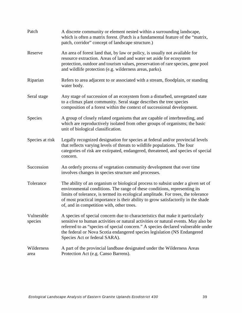
Patch A discrete community or element nested within a surrounding landscape, which is often a matrix forest. (Patch is a fundamental feature of the “matrix, patch, corridor” concept of landscape structure.)
Reserve An area of forest land that, by law or policy, is usually not available for resource extraction. Areas of land and water set aside for ecosystem protection, outdoor and tourism values, preservation of rare species, gene pool and wildlife protection (e.g. wilderness areas, parks).
Riparian Refers to area adjacent to or associated with a stream, floodplain, or standing water body.
Seral stage Any stage of succession of an ecosystem from a disturbed, unvegetated state to a climax plant community. Seral stage describes the tree species composition of a forest within the context of successional development.
Species A group of closely related organisms that are capable of interbreeding, and which are reproductively isolated from other groups of organisms; the basic unit of biological classification.
Species at risk Legally recognized designation for species at federal and/or provincial levels that reflects varying levels of threats to wildlife populations. The four categories of risk are extirpated, endangered, threatened, and species of special concern.
Succession An orderly process of vegetation community development that over time involves changes in species structure and processes.
Tolerance The ability of an organism or biological process to subsist under a given set of environmental conditions. The range of these conditions, representing its limits of tolerance, is termed its ecological amplitude. For trees, the tolerance of most practical importance is their ability to grow satisfactorily in the shade of, and in competition with, other trees.
Vulnerable species
A species of special concern due to characteristics that make it particularly sensitive to human activities or natural activities or natural events. May also be referred to as “species of special concern.” A species declared vulnerable under the federal or Nova Scotia endangered species legislation (NS Endangered Species Act or federal SARA).
Wilderness area
A part of the provincial landbase designated under the Wilderness Areas Protection Act (e.g. Canso Barrens).