Ecological Appraisal Part 2: Phase 2 Ecology Survey and ... - Phase 2 Ecology... · – Tufted hair...
100
Ecological Appraisal Part 2: Phase 2 Ecology Survey and Habitat Assessment Report Merseyside Environmental Advisory Service July 2014 Land at south Whiston and south of the M62, Cronton
Transcript of Ecological Appraisal Part 2: Phase 2 Ecology Survey and ... - Phase 2 Ecology... · – Tufted hair...

Ecological Appraisal Part 2: Phase 2 Ecology Survey and
Habitat Assessment Report
Merseyside Environmental Advisory Service July 2014
Land at south Whiston and south of the M62,
Cronton

2
Document Control Project: Ecological Appraisal Part 2: Phase 2 Ecology Survey Report
Prepared for: Knowsley Metropolitan Borough Council
File reference: 11/1/13
File Origin: G:\MerseysideEAS\Knowsley Core Strategy\Phase 2 Surveys\Reports\Phase 2 Ecology Report FINAL.docx
Document Checking:
Prepared by: Rosalind King MCIEEM Ecologist
Signed:
Checked by: Christine Bennett MCIEEM Ecology Team Leader
Signed: P Slinn pp C Bennett
Verified by: Christine Bennett MCIEEM Ecology Team Leader
Signed: P Slinn pp C Bennett
Issue Date Status
1 16 June 2014 Draft for internal review
2 25 June 2014 Draft for internal review
3 2 July 2014 Draft for internal review
4 8 July 2014 Draft for internal review
5 9 July 2014 Draft for internal review
Draft 9 July 2014 Draft for Client review
Final 16 July 2014 Final for internal review
Final 21 July 2014 Final for client

3
Contents
Abbreviations ............................................................................................................................ 4
1 Executive Summary ............................................................................................................ 6
2. Introduction ......................................................................................................................... 8
3. Methods .............................................................................................................................. 9
4. Survey Results and Assessment....................................................................................... 13
5. Evaluation ......................................................................................................................... 33
6. Recommendations ............................................................................................................ 37
7. Conclusion ........................................................................................................................ 38
8. Glossary of terms .............................................................................................................. 39
9. Appendices ....................................................................................................................... 41
Appendix 1 Map of Survey Areas ............................................................................................ 41
Appendix 2 Map of NVC Communities and Quadrat Locations ............................................... 42
Appendix 3 NVC Tables, TABLEFIT Analysis and Species lists .............................................. 44
Appendix 4 Full Site Species List ............................................................................................ 91
Appendix 5 Surveyors .............................................................................................................. 98
Appendix 6 Updated Merseyside BioBank Reports ................................................................. 99
Appendix 7 Phase 1 Habitat Survey Report .......................................................................... 100
4
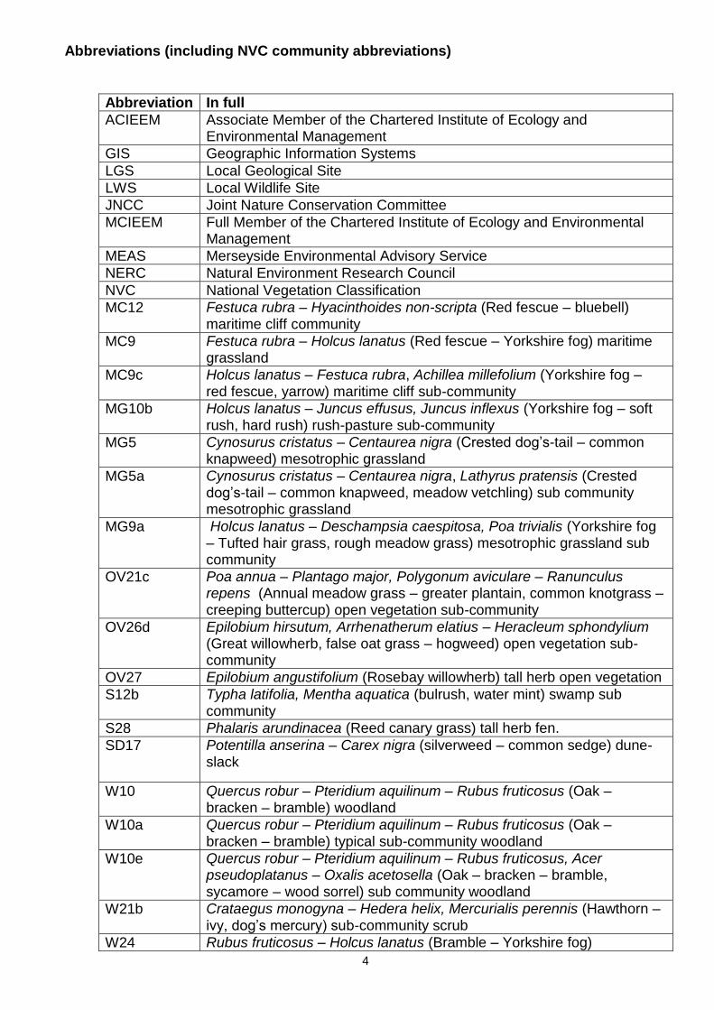
Abbreviations (including NVC community abbreviations)
Abbreviation In full
ACIEEM Associate Member of the Chartered Institute of Ecology and Environmental Management
GIS Geographic Information Systems
LGS Local Geological Site
LWS Local Wildlife Site
JNCC Joint Nature Conservation Committee
MCIEEM Full Member of the Chartered Institute of Ecology and Environmental Management
MEAS Merseyside Environmental Advisory Service
NERC Natural Environment Research Council
NVC National Vegetation Classification
MC12 Festuca rubra – Hyacinthoides non-scripta (Red fescue – bluebell) maritime cliff community
MC9 Festuca rubra – Holcus lanatus (Red fescue – Yorkshire fog) maritime grassland
MC9c Holcus lanatus – Festuca rubra, Achillea millefolium (Yorkshire fog – red fescue, yarrow) maritime cliff sub-community
MG10b Holcus lanatus – Juncus effusus, Juncus inflexus (Yorkshire fog – soft rush, hard rush) rush-pasture sub-community
MG5 Cynosurus cristatus – Centaurea nigra (Crested dog’s-tail – common knapweed) mesotrophic grassland
MG5a Cynosurus cristatus – Centaurea nigra, Lathyrus pratensis (Crested dog’s-tail – common knapweed, meadow vetchling) sub community mesotrophic grassland
MG9a Holcus lanatus – Deschampsia caespitosa, Poa trivialis (Yorkshire fog – Tufted hair grass, rough meadow grass) mesotrophic grassland sub community
OV21c Poa annua – Plantago major, Polygonum aviculare – Ranunculus repens (Annual meadow grass – greater plantain, common knotgrass – creeping buttercup) open vegetation sub-community
OV26d Epilobium hirsutum, Arrhenatherum elatius – Heracleum sphondylium (Great willowherb, false oat grass – hogweed) open vegetation sub-community
OV27 Epilobium angustifolium (Rosebay willowherb) tall herb open vegetation
S12b Typha latifolia, Mentha aquatica (bulrush, water mint) swamp sub community
S28 Phalaris arundinacea (Reed canary grass) tall herb fen.
SD17 Potentilla anserina – Carex nigra (silverweed – common sedge) dune-slack
W10 Quercus robur – Pteridium aquilinum – Rubus fruticosus (Oak – bracken – bramble) woodland
W10a Quercus robur – Pteridium aquilinum – Rubus fruticosus (Oak – bracken – bramble) typical sub-community woodland
W10e Quercus robur – Pteridium aquilinum – Rubus fruticosus, Acer pseudoplatanus – Oxalis acetosella (Oak – bracken – bramble, sycamore – wood sorrel) sub community woodland
W21b Crataegus monogyna – Hedera helix, Mercurialis perennis (Hawthorn – ivy, dog’s mercury) sub-community scrub
W24 Rubus fruticosus – Holcus lanatus (Bramble – Yorkshire fog)

5
underscrub
W6 Alnus glutinosa – Urtica dioica (Alder – nettle) woodland
W8 Fraxinus excelsior – Acer campestre – Mercurialis perennis (Ash – field maple – dog’s mercury) woodland
W8b Fraxinus excelsior – Acer campestre – Mercurialis perennis, Anemone nemorosa (Ash – field maple – dog’s mercury, wood anemone) sub-community woodland
W8e Fraxinus excelsior – Acer campestre – Mercurialis perennis, Geranium robertianum (Ash – field maple – dog’s mercury, herb robert) sub-community woodland
OS Ordnance Survey
SPD Supplementary Planning Document
SSSI Site of Special Scientific Interest
UDP Unitary Development Plan

6
1 Executive Summary
1.1. Ecology surveys were undertaken at land at south Whiston and south of the M62, Cronton (the Site) to inform the Knowsley Metropolitan Borough Council’s Local Plan evidence base and the proposed Master Plan Supplementary Planning Document (SPD) for the area.
1.2. The extended Phase 1 Habitat Survey was undertaken in October 2013 by Merseyside
Environmental Advisory Service (MEAS). The report was published in February 2014. From this, 14 areas (hereafter referred to as Areas) were identified for more detailed survey (Phase 2), to include National Vegetation Classification (NVC) survey of 12 areas; NVC survey and water vole survey of 1 area; and only water vole survey of 1 area. Phase 2 survey was undertaken by MEAS between 15 April and 11 June 2014 based on the recommendation of further survey1. Final recommendations on habitat retention, management, restoration and opportunities for enhancement are made based on the results of the both surveys. This report should be read together with the Phase 1 survey report1 (Appendix 7).
1.3. The communities surveyed generally did not fit well to specific NVC communities and this is likely due to the disturbed and modified environments being surveyed. Woodlands fitted best to W10 Oak – bracken-bramble or W8 Ash – field maple – dog’s mercury communities whilst the grasslands fitted best to mesotrophic grasslands (MG) MG5 Crested dog’s-tail – common knapweed and MG10 Yorkshire fog – soft rush rush-pasture. Communities on Cronton Colliery comprised a mosaic of grassland (MG5), tall herb (OV26d Great willowherb, false oat grass – hogweed), tall herb fen (S28 Reed canary grass) and maritime cliff (MC9c Yorkshire fog – red fescue, yarrow) communities.
1.4. Areas 1, 2, 3, 5, 8, 9, 10, 11, 13 and ‘14 Woodland’ are considered to be Lowland Mixed Deciduous Woodland Priority Habitats with ecological value ranging from national to local. Area 4 is considered to be Open Mosaic Habitats on Previously Developed Land Priority Habitat with ecological value at a district level. The southern margin of Area 7 is considered to be Lowland Meadow Priority Habitat, with ecological value within the zone of influence of the site. Areas 6, 12 and ‘14 grassland’ are not Priority Habitat and are valued within the zone of influence of the site. The water body within Area 14 has county ecological value. A summary of the results of community analysis and final habitat evaluation are presented in Table 2 for each Area. The Priority Habitats are a material consideration for the Local Authority when preparing their Local Plan and SPDs.
1.5. No evidence of water vole was found in Area 12 pond and it is considered unlikely that
water vole will colonise here in the future. A burrow and run was recorded at Area 14 pond and no other signs of water vole were recorded despite suitable habitat.
1.6. Outcome of the surveys and confirmation of Priority Habitat and ecological value
assessment inform the recommendations. Areas 1 and 13 are strongly recommended for retention as they are of national importance and are irreplaceable due to their age, size and/or complexity. Area 4 is also recommended for retention due to size, mosaic of habitats and difficulty in recreating this habitat type elsewhere within the Site. However, loss of small areas of habitat within the mosaic of Area 4 would be acceptable provided management of the area as a whole ensured retention of overall biodiversity value.
1.7. Habitats in Areas 2, 3, 8, 9, 10, 11, ‘Area 14 Pond’ and ‘Area 14 Wood’ are recommended to be retained as suitable mitigation or compensation for any loss is unlikely to be achievable through recreation. The habitats within areas 5, 6, 7, 12 and
1 Ecological Appraisal Part 1: Extended Phase 1 Habitat Survey Report. Land at south Whiston and south of the
M62, Cronton, (Merseyside Environmental Advisory Service, February 2014).

7
‘Area 14 grassland A and B’ could be lost to development provided suitable mitigation or compensation was secured within the Site or district.
1.8. Management is advised for retained Priority Habitats on Site. Improving connectivity
between retained habitats could also be considered. Control of invasive species is also advised. Updated surveys and ecological appraisal would be required to support future planning applications.
8
2. Introduction
2.1. Merseyside Environmental Advisory Service (MEAS) undertook an ecological appraisal of land at south Whiston and south of the M62, Cronton (the Site) on behalf of Knowsley Metropolitan Borough Council (the Council) to inform its Local Plan evidence base and Master Planning of the survey area
2.2. The Phase 1 Habitat Survey was completed in October 2013 and the Ecological
Appraisal Part 1 published in February 2014. For the purposes of the Phase 1 survey, the Site was split into 7 sub-sites. Full details of the Site and the wider landscape are presented in the Phase 1 report (pg 6-7)2. The Phase 1 report concluded that detailed Phase 2 surveys were required of 14 areas within the Site in order to fully evaluate these areas. Twelve areas were identified for vegetation surveys; 1 area was identified for both vegetation and water vole survey; and 1 area for only water vole survey. This level of survey was considered sufficient to support the Local Plan and SPDs for the area. However, other surveys may be required at planning application stage when more detailed layouts are known.
2.3. This report sets out the methods (section 3) and results (section 4) for the Phase 2
surveys including the determination of Priority Habitat and re-evaluation of habitat value based on new data. The results are evaluated against previous surveys, biological records and in the context of policy and legislation. Final recommendations for future habitat use and management are provided based on these results and in light of the conclusions drawn from the Phase 1 Habitat Survey Report. The Phase 2 and Phase 1 reports should be read in conjunction with each other.
2 Ibid. (footnote 1)

9
3. Methods
3.1. The Areas identified for Phase 2 surveys are presented in Appendix 1. Areas 1-11, 13 and 14 were subject to more detailed vegetation surveys adapted from NVC survey methods3,4. Water bodies within areas 12 and 14 were surveyed for water vole, following guidance detailed within Strachan5.
3.2. This survey scope is determined from the results of the Ecological Appraisal Part 12, Merseyside BioBank data and professional judgement and is sufficient for use evidence base to support the Local Plan. Further surveys may be required to inform detailed layout at the planning application stage.
3.3. The NVC system classifies habitats according to plant species composition within, and
frequency of occurrence between, defined survey quadrats (full definition in section 7 – Glossary). The NVC survey of the woodlands was undertaken between April and May 2014 and is a suitable time of year to record the early flowering ground flora before the canopy closes over around mid-May. The NVC survey for grasslands was undertaken from mid-May to June 2014 which is a suitable time of year for survey as the grasses and sedges are flowering making identification more reliable. The water vole survey was undertaken in June 2014. By this time the water vole population would be well established and signs of territory marking would be evident if water voles were present. Appendix 5 lists details of survey timing and surveyors.
3.4. Table 1 (section 4) presents details of weather conditions, survey dates and surveyors
for each of the areas. All surveys were carried out under suitable weather conditions for the types of survey.
Vegetation Surveys 3.5. Each Area was initially visually assessed to determine possible differences in community
type. Quadrats were sampled within each potential community type and were a representative sample of the community type. Percentage cover of each vascular plant species present within each quadrat was recorded to enable statistical analysis using TABLEFIT. For the woodland areas quadrats were 10mx10m for the canopy and understorey species with a 4mx4m quadrat sampled randomly within the 10mx10m quadrat for the ground (field layer) species. The canopy and understorey quadrats were 5mx20m for Area 9 due to the linear nature of this woodland. Percentage cover of vascular plant species were recorded in 2mx2m quadrats for the grassland areas. For woodland in Areas 13 and 14, only Domin scores (see Glossary) were recorded although this did not affect the conclusions as it is an acceptable method of NVC community determination using TABLEFIT6. For all sites the percentage cover scores were converted to Domin scores to enable comparison with the published floristic tables.
3.6. The methods were adapted from that within the NVC handbook4 and those used by
Rodwell when gathering field samples to differentiate communities3. NVC communities can be determined from species lists, however the closer the approach is to original NVC sampling method, the more robust the analysis of the data and the higher the certainty in the final community assessment. Bryophytes and lichens were not recorded as they are not essential for determining woodland or grassland NVC communities. In addition, canopy and understorey quadrats were 10mx10m and not 50mx50m as detailed within
3 British Plant Communities Volume 1 - Woodlands and scrub, Cambridge University Press (Rodwell, J. S. (ed.),
1991) 4 National Vegetation Classification: users’ handbook, JNCC (Rodwell, J. S., 2006)
5 Water Vole Conservation Handbook (third edition) WildCRu:Oxford (Strachan, R. Moorhouse, T. & Gelling, M., 2011)

10
the woodland NVC methods (pg 20). Smaller 10mx10m quadrats were chosen to allow at least 5 samples to be taken for most areas. A smaller number or size of samples can still enable vegetation to be fitted to a community and this is acceptable within NVC sampling methods. Quadrat locations and numbers for each Area are mapped (Appendix 2). NVC sampling method enables a small number of samples to be taken to identify a community type rather than full survey of the entire ‘site’.
3.7. NVC analysis was undertaken using TABLEFIT6 . Frequency and average percentage
cover data for the combined quadrats in each area was analysed using TABLEFIT. For Area 13 and Area 14, Domin scores for each quadrat sample were analysed, as Domin scores cannot be combined across quadrats for analysis using TABLEFIT.
3.8. Ninety-eight quadrats were recorded, with 5 quadrats taken for each community within
each area apart from Area 10 where 6 quadrats were sampled (this increase in sample size enables better comparison with floristic tables but was unable to be undertaken across the entire Site due to varying size of areas). In addition, ‘Area 2 Woodland Type 1’ and ‘Area 4 lower south’, ‘Area 4 lower north’ and ‘Area 4 mid section’ (See Plan, Appendix 2 for Area locations) had patchy vegetation cover or were too small to accommodate 5 quadrats, so 3 quadrats were sampled in each of these locations.
3.9. The data were entered into the TABLEFIT programme which produces an output of the
top five possible NVC communities along with a percentage of the ‘goodness-of-fit’ (see Glossary) of each of the potential communities (Appendix 3). The ‘goodness-of fit’ rating is used only as a guide and does not relate to the quality of habitat (e.g. a poor ‘goodness-of-fit’ rating does not mean the habitat quality is poor but rather the community composition does not match well with published floristic data for the NVC community specified). Instead the ‘goodness-of-fit’ rating is a tool to identify potential NVC community type as vegetation communities are on a continuum and are unlikely to match NVC communities exactly. Therefore, the floristic tables from each sample were also compared with published accounts and floristic tables of the relevant NVC community descriptions7 to enable the most likely NVC community to be identified; even then ‘exact’ matches are uncommon. These NVC communities were mapped and are presented in Appendix 2.
Water vole Surveys 3.10. Methods followed best practice guidelines8 and involved searching for signs of water vole
activity within 2 metres of the water’s edge. The survey was carried out on 9 June 2014 which is within the optimal period for water vole surveys. Signs searched for included:
Droppings and latrines;
Runs close to the water (often in the form of tunnels in the vegetation with ‘offshoots’ where an animal has accessed the water);
6 TABLEFIT, version 1.0 for identification of vegetation types. Huntingdon: Institute of Terrestrial Ecology (Hill, M.
O. and Centre for Ecology and Hydrology, 1996). 7British Plant Communities. Volume 1. Woodlands and scrub. Cambridge University Press (Rodwell, J.S. (ed.) 1991) British Plant Communities. Volume 2. Mires and heath. Cambridge University Press (Rodwell, J.S. (ed.), 1991) British Plant Communities. Volume 3. Grassland and montane communities. Cambridge University Press (Rodwell, J. S. (ed.), 1992) British Plant Communities. Volume 4. Aquatic communities, swamps and tall-herb fens. Cambridge University Press (Rodwell, J.S. (ed.), 1995) British plant communities. Volume 5. Maritime communities and vegetation of open habitats. Cambridge University Press (Rodwell, J.S. (ed.), 2000) 8 Ibid. (footnote 5)
11
Tracks;
Feeding remains and lawns where vegetation has been cropped short in discrete areas; and
Burrows.
3.11. The physical and ecological features of the habitat surrounding the water bodies were recorded to assess its suitability for water vole. These include:
Bank profile;
Bank type;
Depth;
Width;
Water current;
Type of water body;
Vegetation type and proximity to the water; and
Disturbance and pollution.
3.12. Digitisation and mapping was carried out using MapInfo Professional Version 12.0 GIS software. OS MasterMap data was used as a starting point to digitise the survey as this accurately maps fixed built features (e.g. buildings) and field boundaries which saved time during the digitisation process. Additional habitat features not mapped in OS MasterMap were captured over OS VectorMapLocal 1:10,000 base mapping using a process of ‘heads-up’ digitising.
Survey Limitations 3.13. The methods are consistent with national methods4,5,7 and in accordance with best
practice. However, the results and conclusions set out in this report should be considered within the context of the survey limitations which include:
Access – parts of the Site were not fully accessible as they included private gardens, or had dense vegetation or deep water bodies. These inaccessible areas were sufficiently small to not influence conclusions relating to habitat assessment;
Time of year – the surveys were undertaken at the optimal time of year for each habitat type according to NVC methods. Autumn or late flowering species were not visible or flowering at the time of survey and this influences the species recorded and their relative abundance within quadrats. However, relative abundance changes with season and this is accounted for within the NVC method. It is accepted within NVC survey method that not all species need to be present in order to determine community type;
Surveyor skills – the survey team comprised four suitably qualified Ecologists with good plant identification skills. These ecologists were not skilled in bryophyte or fungal identification and these were therefore not recorded to species level. However, NVC of the habitats present would not have been limited by this and the TABLEFIT programme takes into account samples where bryophyte and fungi were not recorded; and
Weather conditions – Overnight rainfall may have removed some water vole signs. However, other suitable latrine sites were present and sufficiently sheltered from any rainfall so this was not considered to have influenced the survey result.

12
Evaluation 3.14. The NVC communities of each Area, along with results of the Phase 1 survey were
compared with Priority Habitat descriptions9 to identify any Priority Habitat within the Site. Priority habitats are listed under the Natural Environment and Rural Communities Act (NERC) 2006. Policies CP2, ENV9 and ENV10 of The Knowsley Replacement Unitary Development Plan10 (UDP) together with the emerging Local Plan: Core Strategy11 policy CS8, relating to habitat and species protection, are relevant. National policy for nature conservation in planning related work is set out in the National Planning Policy Framework (NPPF)12.
3.15. Habitats across the Site were evaluated using the CIEEM guidance for Ecological Impact Assessment (EcIA) in the United Kingdom13 for the Phase 1 report. The areas surveyed for the Phase 2 report were re-evaluated in light of the additional information recorded. The level of value of specific ecological receptors is assigned using a geographical frame of reference, i.e. international value being most important then national, regional, county, district, local and lastly, within the immediate Zone of Influence (ZoI) of the sites. These value based terms are defined in the Glossary.
3.16. Value judgments are based on various characteristics that can be used to identify
ecological resources or features likely to be important in terms of biodiversity. These include site designations (e.g. Site of Special Scientific Interest (SSSI), Ancient Woodland, Local Wildlife Site(LWS) or for undesignated features, the size, conservation status (local, national or international), connectivity within the landscape and quality of the ecological resource. Quality can refer to habitats (for instance if they are particularly diverse, or a good example of a specific habitat type), other features (such as wildlife corridors or mosaics of habitats), species populations or assemblages.
3.17. The desktop study (Appendix 4, Phase 1 report) was also updated following consultation
with Merseyside BioBank and is presented in Appendix 6. The analysis and evaluation are informed by the Ecological Appraisal Part 1, data on NVC communities from surveys in 2003 on some parts of the Site14,15,16,17, the current surveys and the above legislation and policy.
9 UK Biodiversity Action Plan, Priority Habitat Descriptions. BRIG (Maddock A. (ed.), 2008. (Updated December
2011) 10
Knowsley Replacement Unitary Development Plan (Knowsley MBC, 2006) 11
Knowsley Local Plan: Core Strategy Submission Document (Knowsley MBC, July 2013) 12
National Planning Policy Framework, (Department for Communities and Local Government, 2012) 13
Guidelines for Ecological Impact Assessment in the United Kingdom (Institute of Ecology and Environmental Management, 2006) 14
Knowsley, St. Helens and Sefton Phase II Vegetation Survey 26. Cronton Colliery and Surrounds, Knowsley, REF: B601/Kn 26 (Young Associates, 1 January 2003) 15
Knowsley, St. Helens and Sefton Phase II Vegetation Survey 21. Fox’s Bank Brook, Knowsley, REF: B601/Kn 21 (Young Associates, 1 January 2003) 16
Knowsley, St. Helens and Sefton Phase II Vegetation Survey 15. Cronton Disused Railway, Knowsley, REF: B601/Kn 15 (Young Associates, 1 January 2003) 17
Knowsley, St. Helens and Sefton Phase II Vegetation Survey 22 Strettles Bog, Knowsley, REF: B601/Kn 22 (Young Associates, 1 January 2003)

13
4. Survey Results and Assessment
4.1. The Areas identified for the Phase 2 survey are mapped in Appendix 1. Quadrat locations are shown on the results map (Appendix 2) together with the NVC community. Species referred to below are a summary of the plant and animal species recorded in each area. Full NVC tables are presented in Appendix 3. These include a full species list for each area, species list and Domin scores for each quadrat and summarise the range of Domin scores and frequency of species occurrence within quadrats for each Area. Results of the TABLEFIT analysis are also presented here. A full species list for the Site is presented in Appendix 4. The Phase 1 survey report should be consulted for detailed species lists and target notes for all areas of the Site not covered in this report.
4.2. Incidental animal records are also presented in Appendix 3. Scientific plant names are
according to Stace18. 4.3. Weather conditions during the survey are set out in Table 1 and were suitable for this
type of survey. Dates of survey are also set out in Table 1. Surveyors and the Areas they surveyed are presented in Appendix 5.
Date (2014)
Area Temperature (°C)
Cloud cover
Wind (Beaufort Scale)
Conditions
15 April 10 14 2/8 F2 Dry, sunny
22 April 5,9,11 14 8/8 F2 Occasional light showers
23 April 3 (southern sector) 12 8/8 F2 Occasional light showers
30 April 1,2,8 11-16 7/8 F2 Hazy cloud, no rain
24 April 13, 14 (woodland
sector) NR 1/8 F1 Dry, sunny, mild
07 May 3 (northern sector) 15 8/8 F1 Occasional light showers
21 May 6,7 15 2/8 F2 Sunny
30 May 14 (grassland) NR 6/8 F1 Light cloud, mild
9 June 12, 14 (water
voles) 14 8/8 F3 Showers
11 June 4 16-21 4/8-2/8 F2-F3 Warm, increasing breeze. Thunder storms on 10.06.2014
Table 1: Weather conditions during survey (NR – not recorded). 4.4. The results of the NVC community analysis are presented in Table 2. For each Area, the
habitat is briefly described followed by a further discussion of the NVC community type and evaluation of Priority Habitat type based on survey outcome. The value of the habitats are also updated in light of the additional survey information. The results of the water vole survey are also presented and discussed. Evaluation of the results is presented in Section 5 and recommendations in Section 6.
18
New Flora of the British Isles 2nd
Edition, Cambridge University Press (Stace, C. E., 1997)
14
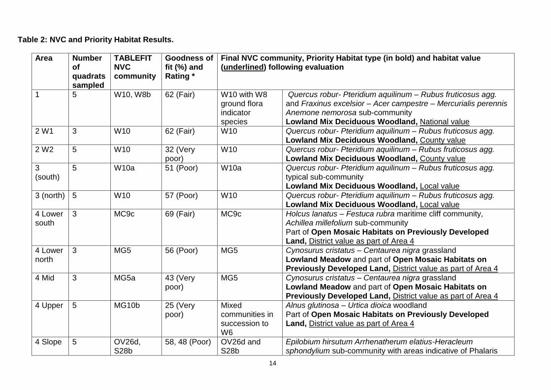
Table 2: NVC and Priority Habitat Results.
Area Number of quadrats sampled
TABLEFIT NVC community
Goodness of fit (%) and Rating *
Final NVC community, Priority Habitat type (in bold) and habitat value (underlined) following evaluation
1 5 W10, W8b 62 (Fair) W10 with W8 ground flora indicator species
Quercus robur- Pteridium aquilinum – Rubus fruticosus agg. and Fraxinus excelsior – Acer campestre – Mercurialis perennis Anemone nemorosa sub-community Lowland Mix Deciduous Woodland, National value
2 W1 3 W10 62 (Fair) W10 Quercus robur- Pteridium aquilinum – Rubus fruticosus agg. Lowland Mix Deciduous Woodland, County value
2 W2 5 W10 32 (Very poor)
W10 Quercus robur- Pteridium aquilinum – Rubus fruticosus agg. Lowland Mix Deciduous Woodland, County value
3 (south)
5 W10a 51 (Poor) W10a Quercus robur- Pteridium aquilinum – Rubus fruticosus agg. typical sub-community Lowland Mix Deciduous Woodland, Local value
3 (north) 5 W10 57 (Poor) W10 Quercus robur- Pteridium aquilinum – Rubus fruticosus agg. Lowland Mix Deciduous Woodland, Local value
4 Lower south
3 MC9c 69 (Fair) MC9c Holcus lanatus – Festuca rubra maritime cliff community, Achillea millefolium sub-community Part of Open Mosaic Habitats on Previously Developed Land, District value as part of Area 4
4 Lower north
3 MG5 56 (Poor) MG5 Cynosurus cristatus – Centaurea nigra grassland Lowland Meadow and part of Open Mosaic Habitats on Previously Developed Land, District value as part of Area 4
4 Mid 3 MG5a 43 (Very poor)
MG5 Cynosurus cristatus – Centaurea nigra grassland Lowland Meadow and part of Open Mosaic Habitats on Previously Developed Land, District value as part of Area 4
4 Upper 5 MG10b 25 (Very poor)
Mixed communities in succession to W6
Alnus glutinosa – Urtica dioica woodland Part of Open Mosaic Habitats on Previously Developed Land, District value as part of Area 4
4 Slope 5 OV26d, S28b
58, 48 (Poor) OV26d and S28b
Epilobium hirsutum Arrhenatherum elatius-Heracleum sphondylium sub-community with areas indicative of Phalaris

15
arundinacea Epilobium hirsutum – Urtica dioica sub-community Part of Open Mosaic Habitats on Previously Developed Land, District value as part of Area 4
5 5 W10e 33 (Very poor)
W10 succeeding to W10e
Quercus robur- Pteridium aquilinum – Rubus fruticosus agg. succeeding to the Acer pseudoplatanus – Oxalis acetosella sub community Lowland Mix Deciduous Woodland, Local value
6 5 MC9 37 (Very poor)
MG10 Holcus lanatus – Juncus effusus rush-pasture Not a Priority Habitat, Zone of Influence value
7 5 MC9, U 37, 38 (Very poor)
MG5 Cynosurus cristatus – Centaurea nigra grassland Lowland Meadow, Zone of Influence value
8 5 W8b 48 (Very poor)
W8b Fraxinus excelsior – Acer campestre – Mercurialis perennis, Anemone nemorosa sub-community Lowland Mix Deciduous Woodland, County value
9 5 W8e 60 (Fair) W8e Fraxinus excelsior – Acer campestre – Mercurialis perennis, Geranium robertianum sub-community Lowland Mix Deciduous Woodland, County value
10 6 W8e, W21b 32, 32 (Very poor)
W21 grading to W8 from west to east
Crataegus monogyna – Hedera helix scrub grading to Fraxinus excelsior – Acer campestre – Mercurialis perennis woodland Lowland Mix Deciduous Woodland, County value
11 5 W10 56 (Poor) W10 Quercus robur- Pteridium aquilinum – Rubus fruticosus agg. Lowland Mix Deciduous Woodland, County value
13 1 W24 61(Fair) W10a with W24 understorey
Quercus robur- Pteridium aquilinum – Rubus fruticosus agg. typical sub-community with a Rubus fruticosus agg. – Holcus lanatus underscrub community as understorey Lowland Mix Deciduous Woodland, National value
1 W24 83 (Very good
1 OV24 72 (Good)
1 W10a 51 (Poor)
1 W10a 86 (Very good)
14 (wood)
1 W10a 37 (Very poor)
W10a
Quercus robur- Pteridium aquilinum – Rubus fruticosus agg. typical sub-community Lowland Mix Deciduous Woodland, County value
1 OV27d 37 (Very poor)
1 W10a 60 (Fair)
1 W10a 66 (Fair)

16
1 MC12a 42 (Poor)
14 (grass A)
5 MG9a 26 (Very poor)
Mesotrophic grassland
Mesotrophic grassland, Not a Priority Habitat, Zone of Influence value
14 (grass B)
5 OV21c, MG9a
37, 35 (Very poor)
Mesotrophic grassland with open vegetation community
Mesotrophic grassland and open vegetation, Not a Priority Habitat, Zone of Influence value
* The ‘Rating’ is not an indicator of habitat quality but of how well the community sampled matches the defined NVC community. ‘Goodness-of-fit’ rating varies depending on sampling methods used and resolution of data obtained (e.g. percentage cover provides a higher data resolution than Domin scores). Computerised analysis of community types should be used in conjunction with published floristic tables and vegetation descriptions when determining community types to provide greater certainty in published NVC community type the sample corresponds best with.

17
Vegetation Survey Discussion Area 1 4.5. The Old Wood, south Local Wildlife Site (LWS) 52, is ancient woodland which was
assessed to be of national value in the Phase 1 report. The canopy is dominated by oak and sycamore with hazel dominating the understorey and showing evidence of coppicing in the past. A dense carpet of English bluebells occurs throughout the wood (Photo 1), although rhododendron are encroaching in places which are suppressing bluebell growth. Some hybrid or Spanish bluebells are also present. A number of ancient woodland indicator species are present and include wood anemone and opposite-leaved golden saxifrage19.
Photo 1: Area 1 Showing W8 woodland indicator species including wood anemone and English Bluebell
4.6. TABLEFIT output indicated a fair ‘goodness-of-fit’ rating to both W10 Oak-bracken-bramble woodland and W8b Ash-field maple-dog’s mercury, wood anemone sub-community types. This means that the woodland may be an intermediate between two community types or has the dominance of one type of community and the composition of another. The presence of bluebells in each sample is indicative of W10 Oak-bracken-bramble woodland where carpets of bluebell are more common. Likewise sycamore and a lack of ash in the canopy suggest W10 woodland. However, other ground flora species such as wood anemone, enchanter’s nightshade and greater dominance of other ferns compared to bracken are suggestive of more neutral soil conditions indicative of W8 Ash-field maple-dog’s mercury, wood anemone woodland.
4.7. Woodlands in the Knowsley area have been subject to human influences including
selective felling or planting in the past. This may have influenced species composition within the canopy in this woodland, which may explain the ‘goodness-of-fit’ results. This woodland best fits two communities; W10 Oak-bracken-bramble woodland with ground flora species that indicate W8b Ash-field maple-dog’s mercury, wood anemone sub-community. This NVC community means the woodland is a Lowland Mixed
19
Indicators of ancient woodland. The use of vascular plants in evaluating ancient woods for nature conservation. British Wildlife, (Rose, F., 1999)

18
Deciduous Woodland Priority Habitat as this priority habitat type includes W8a-c sub-communities and W10a-d sub communities. Area 1 woodland is of national ecological value as it is ancient woodland and also due to its size, rarity, biodiversity and connectivity with other habitats to the south. This habitat could not be re-created elsewhere as it is ancient woodland.
Area 2
4.8. This Area is known as Mine Waste Cronton LWS 19 and initial observations suggested two different woodland community types here. The north and east sector of Area 2 is a dense woodland with a stream running through the centre (Woodland Type 1 – WT1). It is dominated by oak and sycamore with hazel, rowan and hawthorn in the understorey. The ground flora is sparse, with mainly bare ground present and some English bluebell (Photo 2). The south west sector (Woodland Type 2 – WT2) has a dense canopy dominated by willow species. The understorey is also dense with hazel and hawthorn present. There is very little ground flora. The stream continues to flow south west in this area and Himalayan balsam is encroaching into the woodland from the stream banks. Five standing water bodies are present in Area 2.
Photo 2: Area 2, showing a typical bluebell carpet in W10 woodland
4.9. TABLEFIT output of WT1 assessed the woodland to most likely fit a W10 Oak-bracken-bramble woodland community, with a fair ‘goodness-of-fit’ rating. The species composition of WT2 also fitted to W10 woodland, but with a very poor ‘goodness-of-fit’ rating. It appeared that the north east section of Area 2 had been less disturbed in the past, allowing a community indicative of W10 Oak-bracken-bramble woodland to flourish. However, the south west sector (WT2) was disturbed, allowing willow to dominate the canopy as the woodland regenerates. The ground is uneven here, with a bank of soil possibly as a result of the works to realign Fox’s Bank Brook20. The use of this area for mine waste may also explain the dominance of willow in the canopy and a
20
Design and Access Statement, Application for open space and access improvements at Cronton Colliery Report Ref: 1478:009A (TEP, September 2007). Planning Application Ref: 07/00929/COU

19
relatively sparse ground flora compared to typical W10 Oak-bracken-bramble woodland. Area 2 best fits a W10 NVC community with potential for the disturbed area to fit better to W10 Oak-bracken-bramble woodland over the long term as the shorter lived mature willows die back. This NVC community means the woodland is a Lowland Mixed Deciduous Woodland Priority Habitat as this priority habitat type includes W10a-d sub communities. Area 2 is of county ecological value as it is designated as a LWS based on rarity, size, quality, biodiversity and connectivity. It would be difficult to create this habitat in the short term and elsewhere within the county.
Area 3 4.10. This narrow band of woodland extends from the south of Cronton Colliery, along the
eastern border and to the north. Two small pockets of woodland within Halsnead Farm were also included within site 3 but no formal quadrat samples were collected here due to access and/or size of woodland. Species that were observed in these areas are included in the tables for the Area 3 (Appendix 3).
4.11. The first woodland pocket is triangular shaped and within Halsnead Farm. It is dominated
by sycamore and pine in the canopy with a number of mature common elm. Elm is regenerating in the understory. Ground flora is a mix of English and hybrid/Spanish bluebells with red campion and some cultivated garden plant species. A row of poplars extends west from this woodland, but some have recently been felled following storm damage.
4.12. The second pocket of woodland curves north around residential properties and is
included within their gardens. This woodland is similar in appearance to the northern sector of Area 3 woodland (see below).
4.13. A narrow band of woodland is present between the mine waste spoil of Cronton Colliery
and Fox’s Bank Brook in the south sector of Area 3. This has been planted in the recent past (rabbit guards and tree stakes still present) and is dominated by dense birch and alder of uniform age. Birch, alder and sycamore seedlings and saplings are present. Ground flora was dense, dominated by bramble.
4.14. Area 3 was split into a north and south sector (“Area 3N” and “Area 3S”) as the woodland
appeared different following initial visual assessment. The northern sector has larger and more diverse canopy specimens than in the south. English bluebell, ivy, bramble and pignut are present in the ground flora of the northern sector. The southern sector was woodland dominated by oak with bramble and ivy as ground flora. Sycamore regeneration is evident with occasional hawthorn and hazel present as understorey. Sparse bluebells are present, most appearing to be Spanish or hybrid bluebell. Dog’s mercury is also present in small patches throughout the north and south sectors and is indicative of ancient woodland and neutral soil conditions.
4.15. TABLEFIT output indicates “Area 3N” as fitting a W10 Oak-bracken-bramble woodland,
with “Area 3S” most likely a W10a Oak-bracken-bramble typical sub-community. However, the ‘goodness-of-fit’ rating was poor. This again may be due to the dominance of sycamore in the canopy which can shade out ground flora and out-compete other woodland canopy species during regeneration. The other woodland types in the TABLEFIT output were sub-communities of W10 or scrub and underscrub communities that can include sycamore saplings and comprise species that would be found in W10 understorey and ground flora. The woodland best fits a W10 Oak-bracken-bramble woodland community. This NVC community means the woodland is assessed as Lowland Mixed Deciduous Woodland Priority Habitat as this priority habitat type includes W10 woodlands. Area 3 is of local ecological value in terms of rarity, size, quality,

20
biodiversity and connectivity. It would be difficult to create this habitat in the short term and within the Site.
Area 4 4.16. This covers a mix of grassland and wetland habitats developing on former colliery spoil.
Stony, bare ground occurs, particularly in the south east of this area, where only a species list was taken (included within Area 4 NVC tables). Willow, birch and alder scrub is encroaching in places across the Area and parts have been planted with woodland or grassland species14. There are large pools of standing water, dominated by reed in the south and east. Orchids, including early marsh orchid and bee orchid, are also present.
4.17. Area 4 was split into 5 sections according to possible community type from initial visual
assessment (Marked on plan – Appendix 2). Quadrats were sampled within each potential community type and were a representative sample of the community type (see methods paragraph 3.5 and 3.6). Moving anti-clockwise from the south east, the first sector is “Area 4 Lower south” (marked as Area 4LS on plan in Appendix 2) due to local topography and location. It comprises wet grassland surrounding reed dominated pools (Photo 3). Species richness increases moving northwards as reedbeds give way to larger grassland patches that included yellow wort and greater knapweed, species indicative of calcareous conditions. This northern area was termed “Area 4 Lower, north” (marked as Area 4 LN on plan in Appendix 2).
4.18. A steep hill “Area 4 Mid” (marked as Area 4 Mid on plan in Appendix 2) comprised species indicative of grassland meadow and led up to a plateau “Area 4 Upper” (marked as Area 4 Upper on plan in Appendix 2) running from east to west and surrounded by young woodland plantation. This plateau appears to be permanently inundated and is dominated by reed and moss with hard and soft rush present. Willow and alder scrub is encroaching with some specimens visually judged to be at least 10 years old. In the west, the plateau dropped down (marked as Area 4 Slope on plan in Appendix 2) and is dominated by reed canary grass and great willowherb, with rare red campion and foxglove present.
Area 4 Lower, South 4.19. TABLEFIT output in “Area 4 Lower, south” assessed the community to best fit a MC9c
maritime cliff Yorkshire fog-red fescue, yarrow sub-community with fair ‘goodness-of-fit’. A maritime community is unusual in inland areas. However, this community is on colliery spoil which may produce similar conditions to those that plants existing near the sea generally experience, such as difficulty in nutrient or water acquisition due to high concentrations of other substances in the soil or soil conditions. It is considered that soil conditions of this particular colliery spoil, along with previous seeding and current management along with grazing pressure from rabbits can allow a community similar to that of a MC9c maritime cliff Yorkshire fog-red fescue, yarrow sub-community to develop.

21
Photo 3: The Lower section of Area 4 South demonstrating the Open Mosaic Community on
Previously Developed Land Priority Habitat Area 4 Lower, North and Area 4 Mid 4.20. “Area 4 Lower, north” and “Area 4 mid” survey areas returned communities of MG5
Crested dog’s-tail – common knapweed mesotrophic grassland and MG5a Crested dog’s-tail – common knapweed, meadow vetchling mesotrophic grassland sub-community with a poor and very poor fit respectively. Cotton grass was recorded here in the Phase 1 surveys, although it occurred in patches and was not found within quadrats sampled in 2014. Cotton grass is indicative of acidic soil conditions whilst other species recorded here, such as yellow wort, indicate more base rich soil conditions.
4.21. This area was seeded with a meadow mix20 during restoration works and the mix may
not have been representative of any particular NVC community, or all species sown may not have established, which could explain the poor fit. In addition, soil conditions may have prevented some species establishing and it is likely that soil conditions vary within Area 4 due to differences within the colliery spoil.
Area 4 Upper 4.22. The plateau (“Area 4 Upper”) returned a very poor fit for MG10b Yorkshire fog-soft rush,
hard rush mesotrophic grassland sub-community. The mesotrophic grassland (MG) communities often develop as a result of grazing or mowing whereas this area has no management and only limited grazing pressure from rabbits. In addition, bryophytes were not recorded and this may have influenced the goodness of fit in a community where moss is common. Another community returned (with very poor fit) was SD17 (Potentilla anserina – Carex nigra silverweed – common sedge dune-slack community). Whilst this area is not dune slack, certain soil conditions on former colliery spoil may produce similar conditions to those experienced by maritime communities including difficulty in nutrient or water acquisition. This could result in maritime-like communities forming in areas away from the coast.
4.23. The community in this wetland is undergoing succession and is subjected to unusual
conditions as a result of forming on colliery spoil. NVC communities and descriptions are based on clear examples of particular types. The vegetation in this Area falls between communities and forms part of a vegetation continuum. The community here is therefore
22
a mix of mesotrophic grassland and dune slack communities, with the presence of alder suggesting succession to a W6 Alder – nettle wet woodland community.
Area 4 Slope 4.24. The slope in the west (Area 4 slope) was assessed as OV26d Great willowherb, false oat
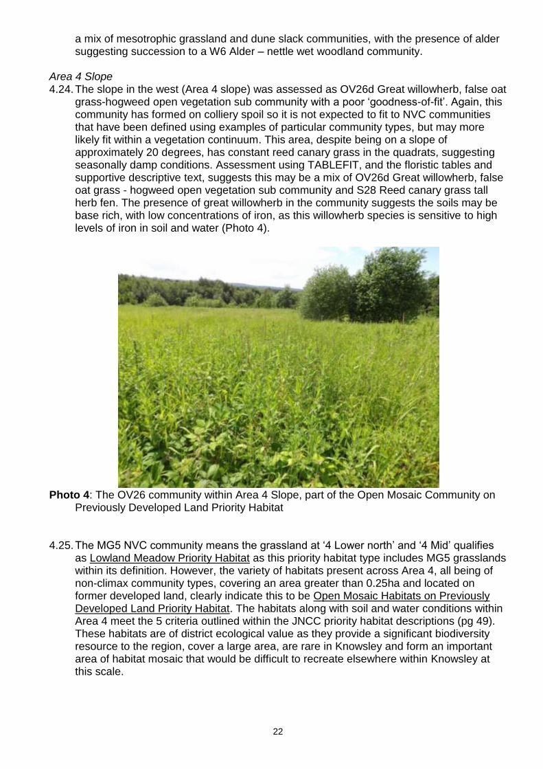
grass-hogweed open vegetation sub community with a poor ‘goodness-of-fit’. Again, this community has formed on colliery spoil so it is not expected to fit to NVC communities that have been defined using examples of particular community types, but may more likely fit within a vegetation continuum. This area, despite being on a slope of approximately 20 degrees, has constant reed canary grass in the quadrats, suggesting seasonally damp conditions. Assessment using TABLEFIT, and the floristic tables and supportive descriptive text, suggests this may be a mix of OV26d Great willowherb, false oat grass - hogweed open vegetation sub community and S28 Reed canary grass tall herb fen. The presence of great willowherb in the community suggests the soils may be base rich, with low concentrations of iron, as this willowherb species is sensitive to high levels of iron in soil and water (Photo 4).
Photo 4: The OV26 community within Area 4 Slope, part of the Open Mosaic Community on
Previously Developed Land Priority Habitat
4.25. The MG5 NVC community means the grassland at ‘4 Lower north’ and ‘4 Mid’ qualifies
as Lowland Meadow Priority Habitat as this priority habitat type includes MG5 grasslands within its definition. However, the variety of habitats present across Area 4, all being of non-climax community types, covering an area greater than 0.25ha and located on former developed land, clearly indicate this to be Open Mosaic Habitats on Previously Developed Land Priority Habitat. The habitats along with soil and water conditions within Area 4 meet the 5 criteria outlined within the JNCC priority habitat descriptions (pg 49). These habitats are of district ecological value as they provide a significant biodiversity resource to the region, cover a large area, are rare in Knowsley and form an important area of habitat mosaic that would be difficult to recreate elsewhere within Knowsley at this scale.

23
Area 5 4.26. This small, isolated area of woodland is Fox’s Clump and is located in the centre of an
arable field. The woodland is roughly circular, with a hawthorn and elm hedge forming a boundary. The canopy is open, dominated by oak and sycamore with an understorey dominated by elm. The ground flora is dominated by English bluebell with areas of Yorkshire fog locally dominant. Bracken is occasional within the ground flora.
4.27. The TABELFIT output indicates this is most likely a W10e Oak-bracken-bramble
woodland sycamore-wood sorrel sub-community. However, the ‘goodness-of-fit’ was very poor so in this instance each quadrat was analysed individually to determine if more intensive data analysis would clarify the poor fit. The results showed that 3 quadrats were of the typical sub-community (W10a), one was W10 and the other was W10e. This variation between quadrats indicates that this woodland is of a W10 Oak-bracken-bramble woodland type, with probable succession, if not managed, to a W10e community due to the presence of sycamore saplings within the understorey. This NVC community means the woodland is Lowland Mixed Deciduous Woodland Priority Habitat as this priority habitat type includes W10 woodlands. Area 5, despite being isolated, is of local ecological value as it is species rich and this type of broadleaved woodland, with a carpet of English bluebell, cannot be easily recreated.
Area 6 4.28. This is an area of tussocky marshy grassland with bramble, willow and birch
encroachment to the north. Young oak and rowan are also present. It lies adjacent to a field grazed by horses (Area 7), and is deeply rutted. Species here suggest damp conditions with soft rush, field horsetail and marsh orchid species present. Cut-leaved crane’s-bill was present outside quadrats. Invertebrates included grasshopper and spittle bug.
4.29. TABLEFIT output produced very poor ‘goodness-of-fit’ to any community, with MC9
Yorkshire fog – red fescue maritime cliff grassland being the most likely community. However, it is not considered that this is a maritime community due to its location and the very poor fit. The rutted nature of this area means that drier and wetter communities would be sampled within a 2mx2m quadrat, thereby reducing ability to detect subtleties in community composition due to localised variations in soil conditions. This may account for the poor fit with any particular community. Consultation with the floristic tables suggest it may be a MG10 Yorkshire fog – soft rush, rush-pasture community but with more dominance from red fescue in the drier ridges and soft rush restricted to the damper ‘ditches’. MG10 can typically occur in this type of environment. Oak, rowan and bramble are encroaching meaning this MG10 community may succeed to a scrub community under current the management practices. It is considered that Area 6 is an MG10 Yorkshire fog – soft rush typical rush-pasture community undergoing succession to scrub. This NVC community means the habitat in Area 6 is not Priority Habitat. This grassland is small, is not a species rich example of an MG10 community and is not connected to other similar habitats. It could be recreated elsewhere and is therefore of limited ecological value within the zone of influence of the site.
Area 7 4.30. Area 7 is a horse grazed field that was not accessed during Phase 1 surveys in October
2013. A species list (Appendix 3) was taken of the northern sector of the field as this was heavily grazed and it was considered NVC analysis of this sector would not add further to the results. The southern sector, adjacent to the caravan site had a more diverse grass sward with bird’s-foot trefoil and orchid species present. Yellow rattle, indicative of
24
unimproved grassland conditions, was recorded here in 2013 so this area was subject to more detailed vegetation surveys to determine the NVC community.
4.31. A stand of Japanese knotweed occurs along the southern field margin and a cinnabar
moth was noted here. A flock of approximately 20 starlings foraged here for over an hour within this southern sector of Area 7.
4.32. The TABLEFIT results returned a very poor fit for any community. This may be as a
result of horse grazing, removing selective species or making some species difficult to identify. Following comparison with floristic tables and text, the grassland is considered to be most like an MG5 Crested dog’s-tail – common knapweed mesotrophic grassland. This grassland would typically be present on grazed hay meadows with minimal or no fertilisation. Area 7 is likely to be grazed year round and not cut for hay which is why the species composition here does not result in a good fit to an MG5 community. However, with amended management, to include a reduction in grazing pressure, this area could become more akin to MG5 Crested dog’s-tail – common knapweed mesotrophic grassland. MG5 grassland is a Lowland Meadow Priority Habitat. However, Area 7 is small and not connected well to other similar habitats. Although more species rich than the surrounding grasslands, this habitat could be created elsewhere (for example within Area 4). The MG5 grassland within Area 7 is of limited ecological value within the zone of influence of the site.
Area 8 4.33. This is Strettles Bog LWS 18 and comprises mainly woodland habitat with a small area of
bog in the south west section. It is a sycamore dominated woodland with some large hawthorn and smaller elder. Occasional large oak are present along with hazel seedlings. Ground flora is dominated by English bluebell, however hybrid bluebell are also present (Photo 5). Some large crack willow occurs in the wetter area to the west. Near the M62/M57 junction in the west, the woodland opens out to bog; which is dominated by a species from the carrot family (Umbellifera) and Himalayan balsam. Reed canary grass and bulrush are also present occasionally in this area. Chapel Brook runs through the centre of the wood and species indicative of ancient woodland and neutral conditions are found to the east of the stream (Photo 6), namely dog’s mercury, opposite-leaved golden saxifrage and moschatel (town-hall clock). Hart’s tongue fern, also indicative of neutral soil conditions, occurs on the steep banks of stream. Himalayan balsam is encroaching here.
25
Photo 5: Area 8 with a W8 community including English bluebell
4.34. TABLEFIT output indicates the wood to be of a W8b Ash-field maple-dog’s mercury
wood anemone sub-community. The ‘goodness-of-fit’ was very poor though and this is likely due to the lack of ash and wood anemone within the samples. However, it is considered this woodland fits best to the W8b Ash-field maple-dog’s mercury wood anemone sub-community due to the constant presence of English bluebell along with the diversity of species in the ground flora. Dominance by sycamore may have inhibited ash regeneration or the ash may have been selectively felled from the area which may explain ash not being recorded commonly in the canopy. This NVC community means the woodland is assessed as Lowland Mixed Deciduous Woodland Priority Habitat as this priority habitat type includes W8 woodlands. Area 8 is of county ecological value as it is a LWS, based on its rarity, size, quality, biodiversity and connectivity to other habitats within Area 4 and 1. It would be difficult to create this habitat elsewhere.

26
Photo 6: The steep stream banks in Area 8 with species indicative of base rich soil conditions
and a W8 community such as hart’s tongue fern and opposite-leaved golden saxifrage
Area 9 4.35. This linear woodland is on the banks of a dismantled railway cutting, designated as
Cronton Mineral Line Local Geological Site (LGS) 85. The banks are gentle towards the south, becoming increasingly steep to form 3m high sandstone cliffs towards the north of the area. The ground flora varies, with rock exposures common in the steeper places. The canopy is dominated by ash and oak, often precariously rooted into sheer rock cliffs. Sycamore is also present within the canopy. The ground flora is sparse and localised with some English bluebell where the soil is not too shallow and ivy where sandstone exposures form cliffs.
4.36. TABLEFIT output indicates the wood is a W8e Ash-field maple-dog’s mercury, herb
robert sub-community woodland, with a fair ‘goodness-of-fit’. This is confirmed following comparison with the floristic tables as the presence of ash in the canopy, despite the dominance of sycamore, along with a low frequency and cover of English bluebell, constant elder and hawthorn and ground flora species such as cleavers, nettle and hart’s tongue fern are to be expected in a W8e Ash-field maple-dog’s mercury, herb robert sub-community woodland. The soil is free draining and shallow, derived from sandstone and with minimal ability to retain fallen leaf litter or water which is the most likely reason the woodland here is of the W8 Ash-field maple-dog’s mercury type. This NVC community means the woodland is assessed as Lowland Mixed Deciduous Woodland Priority Habitat as this priority habitat type includes W8 woodlands. Area 9 is a designated site and is of county ecological value as it is a priority habitat, provides connectivity with other habitats in the region and would be difficult to recreate elsewhere.
Area 10 4.37. Lickers Lane Wood LWS 13 is dominated by sycamore, with occasional ash and oak.
Some larger elm specimens are present, with abundant suckering in the western sector of this site. The dense elm, along with the dense stand of bramble and nettle in the west is also suggestive of nutrient enrichment, possibly from adjacent arable fields. Towards

27
the east the ground flora becomes less diverse, dominated by bluebell (English and hybrid) and with elder in the understorey. A clearing in the centre of the wood displays evidence of tree planting, but few have established successfully possibly due to dense bramble in this area.
4.38. The TABLEFIT results produced a very poor ‘goodness-of-fit’ to W8e Ash-field maple-
dog’s mercury, herb robert sub-community woodland (Photo 7) and W21b Hawthorn – ivy, dog’s mercury sub-community scrub (Photo 8). This is expected as this woodland is on the interface between urban development and arable fields and subject to disturbance from nutrient loading, vandalism, invasive species encroachment and tipping. Four small stems of Japanese knotweed are present south of the clearing.
Photo 7: The W8 woodland community at Area 10
4.39. Floristic tables for W8 and W21 woodland/scrub communities are similar and W21 often
develops within degraded woodland stands. It is likely, as tree cover establishes and shades the ground flora, this woodland will become more typical of a W8 Ash-field maple-dog’s mercury community. It is concluded that the western sector of this wood is most like a W21 Hawthorn – ivy scrub community with gradation to a W8 Ash-field maple-dog’s mercury woodland community in the east. The woodland has not been assigned to a sub-community due to the very poor ‘goodness-of-fit’. This W8 Ash-field maple-dog’s mercury NVC community means the woodland is assessed as Lowland Mixed Deciduous Woodland Priority Habitat as this priority habitat type includes W8 woodlands. Area 10 is a LWS and is of county ecological value for this reason and also as it is a priority habitat, provides connectivity with other habitats on Site and due to its size, biodiversity and rarity. It would be difficult to recreate elsewhere.

28
Photo 8: The W21 scrub community at Area 10
Area 11 4.40. This L-shaped woodland is Sandfield Park Wood LWS 14. The canopy is dominated by
mature oak, with sycamore also frequent. Large beech, sweet chestnut and yew are also present, the latter being indicative of more neutral soil conditions. These trees are likely to have been planted in the past, but as they naturally occur in W10 and W8 woodlands as a low proportion of the canopy, their presence is unlikely to have influenced the determination of NVC community type.
4.41. The understorey is also diverse, with good potential for recruitment of mixed species into
the tree canopy. Ground flora is diverse, with English bluebell and bramble as constants. However, rhododendron has been planted in areas and this may reduce the diversity of ground flora if not controlled in the future. There is evidence of rhododendron clearance in the past in some areas. A Japanese knotweed stand (5m x 20m) is present along the woodland boundary with the arable field in the south, although the Japanese knotweed had recently been cut at the time of survey. Footpaths and ponds are present and the site is used by walkers and dog walkers with some evidence of tipping and burning. The ponds are shallow, with little emergent vegetation.
4.42. TABLEFIT output returned a W10 Oak-bracken-bramble woodland type community.
Although the ‘goodness-of-fit’ was poor, the other possible communities were sub-communities of W10 so this is the most likely woodland type. Comparisons with the floristic tables suggest that the absence of birch and hazel and low frequency of bracken may explain the poor ‘goodness-of-fit’. As this woodland is not conclusively a specific sub-community, it is classified as W10 Oak-bracken-bramble woodland only. This NVC community means the woodland is assessed as Lowland Mixed Deciduous Woodland Priority Habitat as this priority habitat type includes W10 woodlands. Area 11 is a LWS and is of county ecological value as it is a priority habitat and provides connectivity with other habitats (Area 10) on Site. It would be difficult to recreate elsewhere.
Area 12 4.43. This is a fishing pond surrounded by a narrow band of broadleaved trees. It is not part of
a LWS. Vegetation on the banks comprises thistle, nettle, creeping bent, Yorkshire fog and cow parsley with small areas of marginal vegetation such as water forget-me-not, Bulrush and yellow iris. A full vegetation species list is in Appendix 4. Area 12 was

29
assessed for presence of water vole only as identified within the Ecological Appraisal Part 1. The pond is discussed in further detail within the water vole section below with assessment of priority habitat status and ecological value provided in context of the results of the water vole survey (paragraph 4.62 onwards).
Area 13 4.44. Old Wood north LWS 49 is a small, roughly circular ancient woodland occupying a v-
shaped valley with stream flowing south from Big Water. Sandstone cuttings are present adjacent to and west of the stream. The wood is dominated by sycamore with small amounts of oak, beech and lime. The woodland canopy is relatively open in many areas resulting in a more diverse ground flora where this is the case. The understorey is sparse (Photo 9), dominated by elder and sycamore saplings, with occasional hawthorn, yew and rhododendron. The ground flora is dominated by bramble, although occasional English bluebells are present along with some hybrid bluebells and fern species.
Photo 9: Sparse ground flora within Area 13, W10a community
4.45. TABLEFIT output returned variable results, with some quadrats having a fair and very
good ‘goodness-of-fit’ to W24 Bramble – Yorkshire fog scrub, whilst other quadrats had species compositions more suggestive of a W10a Oak-bracken-bramble typical sub-community woodland, with ‘goodness-of-fit’ ranging from poor to very good. These results are likely due to the poor canopy diversity, with oak being recorded in only one quadrat. Ground flora dominated by bramble and a lack of English bluebells may also contribute to the variable results. However, other species (such as lime, yew, beech and English bluebell) were recorded within the woodland, but outside the quadrats. These were therefore taken into account to conclude the woodland is of a W10a Oak-bracken-bramble woodland typical sub-community with ground flora indicative of a W24 Bramble – Yorkshire fog scrub community. This NVC community means the woodland meets the criteria for Lowland Mixed Deciduous Woodland Priority Habitat as this priority habitat type includes W10 woodlands. Area 13 is of national ecological value as it is ancient woodland and a priority habitat, provides connectivity with other habitats (Area 14) on Site and also due to its size. This habitat could not be re-created elsewhere.

30
Area 14 – Woodland 4.46. This woodland surrounds Big Water to the north and extends northwards. A portion of it
is included within Big Water and Big Water Wood LWS 16. The woodland is dominated by sycamore with occasional yew and mature oak. Rhododendron is locally dominant in the understorey and Japanese knotweed is also present towards the south of the woodland. English bluebells and hybrid bluebells are present in the ground flora, although this is dominated by bramble. Other species recorded outside quadrats include wild cherry, ash, elm and ramsons.
4.47. As for Area 13, TABLEFIT output varied between quadrats, although where oak or
bluebell were recorded a W10a Oak-bracken-bramble woodland typical sub-community was returned, with a fair ‘goodness-of-fit’. The presence of rhododendron and Japanese knotweed, along with the dominance of bramble would have reduced the diversity in the ground flora. This, together with the dominance of sycamore in the canopy may explain why two quadrats were considered to have OV27 Rosebay willowherb and MC12 Red fescue – bluebell maritime community. As these both had very poor ‘goodness-of-fit’ scores and were unlikely to be found within woodland in Knowsley, these results were discounted. It is considered the woodland is a W10a Oak-bracken-bramble woodland typical sub-community, with poor ground flora diversity due to encroachment by rhododendron and Japanese knotweed. This NVC community means the woodland is assessed as Lowland Mixed Deciduous Woodland Priority Habitat as this priority habitat type includes W10 woodlands. The woodland in Area 14 is of county ecological value as it is a LWS, a priority habitat and also due to its size. It provides connectivity with other habitats (Area 13) on Site. It would be difficult to recreate elsewhere.
Area 14 – Grassland 4.48. Area 14 also covers two fields. Initially, these were surveyed separately as it was
considered they were different communities. Grassland A lies to the north of Big Water and is surrounded by hawthorn hedge and woodland. Grassland B lies to the west of Big Water, similarly surrounded by hawthorn hedge and woodland. Both fields are disused agricultural fields and rabbit grazing is evident. There is evidence of seasonal inundation with water as hard rush and cuckoo flower are present and willow seedlings are establishing. However, vegetation in this area appeared to have been sprayed with herbicide or affected by soil contamination as plants were observed to be discoloured and stunted during Phase 1 survey in October 2013.
4.49. Species in Grassland A include rough meadow grass, Yorkshire fog, field horsetail,
creeping buttercup, marsh willowherb, mouse-ear and marsh orchids. Cut-leaved cranes-bill and forget-me-not are also present. Some areas are dominated by horsetail.
4.50. Species present in Grassland B include mouse-ear, ragwort, creeping buttercup,
willowherb, common vetch, marsh orchid, dandelion, barley, rough meadow grass, cuckoo flower, and Yorkshire fog with occasional spear thistle, willow scrub and hard rush.
4.51. TABLEFIT output showed a very poor ‘goodness-of-fit’ for both fields. Grassland A was
assessed as MG9a Yorkshire fog – Tufted hair grass, rough meadow grass mesotrophic grassland sub community, whilst Grassland B was assessed as OV21c Annual meadow grass – greater plantain, common knotgrass – creeping buttercup open vegetation sub-community. The next best fit for Grassland B was MG9a. The poor fit is likely due to alteration of the community by possible herbicide application or soil contamination, which would enable horsetail to establish whilst eradicating broad leaved species.

31
4.52. It is considered both fields are former mesotrophic grasslands, most likely an MG9a community, naturally undergoing succession but also being managed in a way that allows an open vegetation community to develop in areas. There is the potential that grassland in Area 14 could return to an MG9 Yorkshire fog – Tufted hair grass type community or a different mesotrophic grassland community with greater value in future should other management options be used. This NVC community means the habitat in Area 14 is not a Priority Habitat. However, it is an area that is relatively species rich compared with other grasslands on-site, and provides connectivity and compliments other habitats on Site (Area 13 and woodland and the pond at Area 14). Nevertheless, it is considered the grassland within Area 14 has limited ecological value within the zone of influence of the site.
Water vole Survey Discussion Area 12 4.53. This pool is approximately 125 metres long by 20 metres wide and is currently used as a
fishing pit. One large carp was observed during the survey. There was no water movement and the water quality was turbid as expected in a carp pit. There were large quantities of litter both within and around the water, mainly associated with the fishing activities.
4.54. The bank side vegetation consists primarily of thistle, nettle, creeping bent, Yorkshire fog
and cow parsley. There are small areas of marginal vegetation such as water forget-me-not, Bulrush and yellow iris but this was limited in extent due to the wooden, artificial bank which resulted in a steep drop to deep water directly from the land. A full vegetation species list is in Appendix 4. The pool is surrounded by mature trees with some semi-mature trees on the water’s edge overhanging the water. There are also mature trees and dense scrub on a single island to the west of the pool, species included hawthorn, sycamore, willow and ash. Amenity grassland borders the site to the north and beyond that and to the west is housing. The south side is bordered by a single track road beyond which is scrub habitat on a former plant nursery site. Beyond this is woodland which forms an ecological link to Area 14. To the east is a small number of houses and arable land.
4.55. A large proportion of the banks are reinforced with wooden panels but in many places
the bank sides have eroded behind these creating almost vertical sides. Large mats of creeping bent grass hang over the wooden panels sheltering the banks. Behind the grass mats and under the fishing pegs are many features that were deemed suitable for water vole latrines such as partially submerged paving slabs and bricks and floating or partially submerged large branches. The pond was considered to be subject to considerable human disturbance, and pollution with limited feeding habitat.
4.56. Despite the presence of potentially suitable latrine sites and some feeding habitat no
evidence of water vole was found within Area 12. Area 14 4.57. This pool is a part of Big Water and Big Water Wood LWS 16 approximately 115 metres
by 160 metres, irregular in shape and also used as a fishing pit. Water quality was semi-turbid but was not polluted by litter. There was also little evidence of litter in the immediate vicinity of the pool.
4.58. The vegetation consists of typical marginal plant communities including yellow iris,
bulrush, soft rush, great willowherb, water forget-me-not, water mint, reed and sedge species. Approximately 20% of the open water is covered by yellow water lily. Mature
32
trees are frequent around the water’s edge some with overhanging branches; species included hawthorn, rhododendron, oak, ash and birch. Approximately 80% of the bank edges are covered by marginal vegetation such as yellow iris, great willowherb and creeping bent grass. There is broad leaved woodland to the south west (Area 13) and north east (Area 14 Woodland (LWS 16)) of the pond, mesotrophic grassland to the north and west (Area 14 Grasslands A and B) and arable to the east.
4.59. The pond is surrounded by shallow earth banks although in some places these have
suffered from erosion and formed vertical sides. Vertical edges are also present under the metal fishing pegs. There are partially submerged features such as logs, flat stones and flat areas of bank that are deemed suitable as latrine sites (Photo 10) and much of the bank side vegetation is sheltered and provides undisturbed, suitable feeding habitat.
Photo 10: Potential latrine site for water vole, Big Water, Area 14.
4.60. A single run, forming a tunnel in the bank side vegetation was found running parallel to
and approximately 20cm from the water’s edge with a ‘slide’ where it appeared an animal had frequently entered the water from it. A single burrow was also recorded approximately 60cm from the water’s edge on the footpath. The burrow entrance was approximately 4cm wide and the tunnel in the vegetation was approximately 6cm wide.
4.61. The measurements for both the burrow entrance and tunnel were within the parameters
expected for water vole but as no other field signs were recorded such as feeding remains or latrines it is considered the tunnel and burrow were those of either a small rat or field vole, both previously recorded at the site (Merseyside BioBank) and therefore no evidence of water vole was found in Area 14.
Pond Habitat Assessment 4.62. As there was no record of water vole in either pond, and the ponds do not meet any of
the other criteria within the Priority Habitat descriptions, these water bodies do not qualify as a Priority Habitat. The pond at Area 12 is of local value due to its provision of stepping stone habitat and vegetation diversity. The pond in Area 14 (Big Water) is of county value as it is a LWS based on biodiversity and use as a stepping stone habitat. Big Water (Area 14) would be difficult to create elsewhere for the above reasons.

33
5. Evaluation
5.1. The habitats recorded included woodland and mesotrophic grassland with a mosaic of communities present on the Cronton Colliery Site. Ancient woodland indicators were recorded, along with orchid species and species indicative of less intensive farming practices. The plant communities recorded suggest neutral soil conditions over much of the Site. Priority Habitats were identified and all habitats were valued based on the updated survey results. The results are evaluated below and recommendations are based on the principals of the ‘avoid, reduce, mitigate, compensate’ hierarchy outlined within the National Planning Policy Framework (NPPF).
Previous Survey Comparison 5.2. The update of the desk study returned no new species records for the search area so the
conclusions drawn from the desk study in the Phase 1 report (pg 32) remain valid. The habitats have been reassessed in light of updated survey work, with the main change being an increase in number of different species recorded at each area. This is partly due to the survey season, with more species visible over spring and early summer than in autumn and also due to the increased survey effort as detailed vegetation samples were recorded in 2014.
5.3. The Knowsley NVC undertaken in 2002 covered Area 2, the southern section of Area 3,
Area 4 and Area 914-17. Area 3 has remained as a W10a community during this period. Area 2 was evaluated as W10 and W6 woodland in 2002. However, the W6 community was evaluated as a W10 community in the 2014 surveys and this may be as a result of succession to a more climax woodland and would explain the poor fit of community type obtained from the TABLEFIT analysis. Area 9 was evaluated as a W10e in 2002 and is assessed as a W8e community in 2014, with a ‘fair’ goodness of fit. However, analysis of Area 9 in 2002 was based on surveyor experience, and no quadrats were sampled in this area then. It is therefore more likely the woodland is W8e as this 2014 assessment is based on survey data and statistical assessment of quadrat samples, along with comparison against the published floristic data.
5.4. The communities that had changed the most since the 2002 NVC were those found
within Cronton Colliery (Area 4). In 2002, the majority of ‘Area 4 Lower South’ was bare spoil, with pockets of S12b bulrush, water mint sub-community swamp. ‘Area 4 Lower north’, ‘Mid’ and ‘Upper’ were considered to be MG1b False oat grass, nettle mesotrophic grassland, MG10 Yorkshire fog – soft rush mesotrophic grassland and MG9 Red fescue – Yorkshire fog mesotrophic grassland. These habitats have altered by 2014, with swamp like conditions establishing on the ‘Upper’ area and a more diverse, lowland meadow community developing on the ‘mid’ area and towards the bare spoil. The bare spoil has become vegetated over time, with a maritime cliff community forming. The only area not to have changed much since 2002 was ‘Area 4 Slope’, which was evaluated as S28 Reed canary grass tall herb fen in 2008, and still fits to this community in 2014, although it is becoming increasingly dominated by great willowherb. These changes of community types are expected as pioneer communities establish and proceed through succession on former developed land.

34
Priority Habitats and Habitat Value Woodlands 5.5. Following comparison with the Phase 1 and Phase 2 survey results Areas 1, 2, 3, 5, 8, 9,
10, 11, 13 and ‘14 Woodland’ are assessed as Lowland Mixed Deciduous Woodland Priority Habitats. The findings of the Phase 2 surveys also confirmed the initial valuation of these woodlands made during the Phase 1 surveys. As they are Priority Habitats (listed under section 41 of the NERC Act), they are a material consideration for the Local Authorities when preparing local plans and during planning applications as set out in the NPPF, the online Planning Practice Guidelines21 and within the government circular ODPM Circular 06/200522.
5.6. The ancient woodlands within Area 1 and 13 are irreplaceable and are a material
consideration for the Local Authority when preparing local plans. These woodlands are the most valuable within the Site, being of national ecological value and rare. Woodland 13 also has locally rare species, with moschatel being found in only 3 other sites within Knowsley. Woodlands in Area 1 and 13 are therefore strongly recommended to be retained within any future proposals.
5.7. Woodlands in Areas 2, 8, 9, 10 and 11 and 14 are of county ecological value and should
also be retained, with connectivity improved between these woodland parcels if possible. Improvement in habitat connectivity between these woodlands has the potential to form a diverse habitat corridor along the southern and central parts of the Site and could provide a link to offsite habitats.
5.8. Woodland in Areas 3 and 5 are of local ecological value. Woodland 3 provides a habitat
corridor along the east and south parts of the Site and could be linked with woodland in Area 2 to further improve connectivity in future. Woodland 3 is also covered by Tree Preservation Orders and is therefore recommended to be retained within any future proposals.
5.9. Woodland in Area 5 is small, isolated and not of high species diversity compared with
other habitats of its type in the area. There was also no evidence of use of the former sett by badgers during surveys in 2014. The woodland would benefit from improving connectivity to other woodlands and could form a focus green space point for any future developments. However, if lost to development, it would not be a significant loss to biodiversity in the area provided that habitat within other woodlands in the Site or district are improved to mitigate for any loss. It would be difficult to recreate this habitat in the short term elsewhere within the Site due to it being mature woodland.
Grasslands 5.10. The findings of the Phase 2 surveys updated the initial valuation of the grasslands with
all grasslands assessed as being of value within the zone of influence of the site. Phase 1 surveys initially assessed grasslands within Area 7 and 14 as potentially having higher ecological value.
5.11. The most valuable grassland within the Site was the southern margin of Area 7, which is
assessed as Lowland Meadow Priority Habitat and a material consideration as set out in the NPPF, the online Planning Practice Guidelines and within the government circular
21Planning Practice Guidance, Department for Communities and Local Government, Accessed online 08.07.2014 http://planningguidance.planningportal.gov.uk/blog/guidance/natural-environment/biodiversity-ecosystems-and-green-infrastructure/ 22
ODPM Circular 06/2005, Biodiversity and geological Conservation – statutory obligations and their impact within the planning system (Office of the Deputy Prime Minister, 2005)

35
ODPM Circular 06/2005. However, as this grassland is small, it is of value within the zone of influence of the Site only. It could be re-created elsewhere and its loss would not be significant provided other habitats of this type are retained within the Site, for example, Area 4. The northern and western sectors of Area 7 are of limited ecological value and could be lost to development with no significant biodiversity loss.
5.12. Area 6 is not Priority Habitat and is of ecological value within the zone of influence of the
Site only as it is small and not species rich. It is a habitat that could be created elsewhere and its loss would not be significant in biodiversity terms.
5.13. The grasslands within Area 14 are not of significant value or species diversity due to
current management practices. They are also not Priority Habitat. Orchid species are present, but this habitat could be created elsewhere, for example within Area 4, should development here be appropriate. Although loss of grassland within Area 14 would be acceptable within any future development plans, retention of some grassland within Area 14 to form a buffer to the woodland areas and provide greenspace for recreational activity, whilst retaining some biodiversity value, would be beneficial if appropriately managed.
Open Mosaic Habitats 5.14. Area 4 is assessed as Open Mosaic Habitats on Previously Developed Land Priority
Habitat and is therefore a material consideration. It is of district value ecologically as it is a unique and diverse mix of habitats with high biodiversity, covering a large area and is not found elsewhere in the district to this extent. This confirms the initial valuation of this area made during the Phase 1 survey.
5.15. This habitat is recommended to be retained within any future proposals for the above
reasons. Loss of small areas of habitat within the mosaic would be acceptable provided management of the area as a whole ensured retention of overall biodiversity value. Loss of all habitats within Area 4 is not advised as it would be impossible to recreate this range of habitats on this scale within Knowsley due to lack of suitable and appropriate soil conditions.
Water Bodies 5.16. Evidence of water vole was not found in Area 12 and it is considered unlikely that water
vole would colonise here in the future. A burrow and run was recorded at water body 14 (Big Water). However, no other signs of water vole were recorded despite habitat being suitable. It is recommended that further surveys for water vole should be undertaken if works are to occur within 5m of the banks of Big Water in the future.
5.17. Water bodies at Area 12 and 14 are not Priority Habitat. However, the water body in
Area 14 (Big Water) is of county value, is part of a LWS and would be difficult to create elsewhere due to size and biodiversity. The water body is recommended to be retained within any development.
5.18. The water body at Area 12 is of local ecological value. However, if not retained within
future proposals, the loss could be easily mitigated by habitat provision of this type elsewhere within the Site.

36
Summary 5.19. Areas 1, 2, 3, 5, 8, 9, 10, 11, 13 and ‘14 Woodland’ are considered to be Lowland Mixed
Deciduous Woodland Priority Habitats with ecological value ranging from national to local. Area 4 is considered to be Open Mosaic Habitats on Previously Developed Land Priority Habitat with ecological value at a district level. The southern margin of Area 7 is considered to be Lowland Meadow Priority Habitat, with ecological value within the zone of influence of the site. Areas 6, 12 and ‘14 grassland’ are not Priority Habitat and are valued within the zone of influence of the site. The water body within Area 14 has county ecological value. A summary of the results of community analysis and final habitat evaluation are presented in Table 2 for each Area. The Priority Habitats are a material consideration for the Local Authority when preparing their Local Plan and SPDs.
5.20. Outcome of the surveys and confirmation of Priority Habitat and ecological value assessment inform the recommendations. Areas 1 and 13 are strongly recommended for retention as they are of national importance and are irreplaceable due to their age, size and/or complexity. Area 4 is also recommended for retention due to size, mosaic of habitats and difficulty in recreating this habitat type elsewhere within the Site.
5.21. Habitats in Areas 2, 3, 8, 9, 10, 11, ‘Area 14 Pond’ and ‘Area 14 Wood’ are recommended to be retained as suitable mitigation or compensation for any loss is unlikely to be achievable through recreation. The habitats within areas 5, 6, 7, 12 and ‘Area 14 grassland A and B’ could be lost to development provided suitable mitigation or compensation was secured within the Site or district.
5.22. Management is advised for retained Priority Habitats on Site. Improving connectivity
between retained habitats could also be considered. Control of invasive species is also advised. Updated surveys and ecological appraisal would be required to support future planning applications.
37
6. Recommendations
6.1. At the heart of the NPPF is a presumption in favour of sustainable development. Core Planning Principles (paragraph 17, NPPF), to underpin plan making and decision taking, state that planning should:
“contribute to conserving and enhancing the natural environment and reducing pollution. Allocations of land for development should prefer land of lesser environmental value, where consistent with other policies in this Framework;
encourage the effective use of land by reusing land that has been previously developed (brownfield land), provided that it is not of high environmental value; and
promote mixed use developments, and encourage multiple benefits from the use of land in urban and rural areas, recognising that some open land can perform many functions (such as for wildlife, recreation, flood risk, mitigation, carbon storage, or food production)”
In order to meet the requirements of the above, the ‘avoid, reduce, mitigate, compensate’ hierarchy set out in NPPF paragraph 118 should be used to inform the emerging Master Plan SPD of the Site.
6.2. Future development proposals should consider the retention of all woodlands if possible.
Any loss of woodland would need appropriate mitigation and this should be secured through policy wording within the future Master Plan SPD for the Site. Management Plans for retained woodland should be encouraged, to include removal of invasive species (Japanese knotweed, Himalayan balsam and rhododendron), gradual reduction of sycamore dominance in the canopy, and improvement of diversity by replanting with locally sourced, native tree species. Improving connectivity between woodlands would provide a welcome habitat improvement to the Site.
6.3. Habitats within Area 4 are recommended to be retained wherever possible. To ensure
that biodiversity is integrated into the proposed Country Park use, in Area 4, a management plan should be considered. A Master Plan approach would be appropriate.
6.4. Although this report has focused on the ecological and biodiversity value of the habitats
within the Site, the woodlands, water bodies, streams and grasslands also provide green infrastructure. Ensuring that these features are integrated with development proposals has the potential to improve multi-functionality of the habitats to assist with climate change adaptation and resilience, improving sense of place, providing quality recreational settings and assisting in managing water quality and flood risk.
6.5. The Phase 2 survey focused on these areas requiring detailed survey. Where areas
have not been covered, the evaluation of sub-sites 1 to 7 within the Phase 1 survey (Appendix 7) should be referred to. The Phase 1 survey identified other habitats of value within the Site, including ponds, running water, marshy grassland, swamp and hedgerows. These habitats provide wildlife refuges, act as stepping stones or corridors between other habitat types and are an integral part of green infrastructure. They are recommended to be retained where possible and the Phase 1 Habitat survey map (Appendix 3 of the Phase 1 survey report) should be consulted when preparing the Master Plan SPD for the Site to inform location of these habitat types and enable retention wherever possible within any future schemes.

38
7. Conclusion
7.1. Priority Habitats with high ecological value exist on Site and should be considered for retention within the emerging Master Plan SPD in the south Whiston and south of the M62 Sites. Some of these Priority Habitats are irreplaceable, whilst it would be difficult to replace the majority of Priority Habitats elsewhere within on Site or within Knowsley. Other habitats with ecological value were identified during the Phase 1 survey and these should also be considered for retention as they can also act as green infrastructure whilst providing a biodiversity benefit to the area. The ‘avoid, reduce, mitigate, compensate’ hierarchy should be followed when preparing the emerging Master Plan SPD as set out in National Planning Guidance.
7.2. Management Plans could be considered for areas of Priority Habitat retained within
future proposals to ensure their biodiversity value is retained. These plans should include management of invasive species and can be secured through policies within the emerging Master Plan SPD.
7.3. The Phase 1 and Phase 2 surveys are a snapshot in time of habitats and species across
site. Update surveys, and surveys for bats, amphibian, invasive species, invertebrates and water vole would potentially be required at planning application stage where applicable when more detailed proposals are being considered. The submission of further survey work would be secured by policies within the emerging Knowsley Local Plan Core Strategy.

39
8. Glossary of terms
Term Definition
Beaufort Scale A scale of wind speed based on a visual estimation of the wind's effects, ranging from force 0 (less than 1 knot or 1 km/h, ‘calm’) to force 12 (64 knots or 118 km/h and above, ‘hurricane’).
County ecological value A site or priority habitat designated by a county or in Merseyside and Halton metropolitan borough, city or borough council for its ecological value. This includes Local Wildlife Sites and Local Geological Sites for example. These sites are of greater ecological value than sites of district ecological value.
District ecological value A priority habitat or site designated by a local planning authority for its ecological value. And includes area with Tree Preservation Orders (TPOs). The ecological value of TPOs should be assessed independently of the designation in accordance with CIEEM guidance for Ecological Impact Assessment (EcIA) in the United Kingdom (UK)23 and this has been done here as TPOs exist on-site (Area 3).
Domin The Domin system scores vegetation cover on a scale of 1-10 (where 1 = few individuals, 2 = several localised individuals, 3 = individuals scattered throughout sample, 4 = 4 - 10%, 5 = 11 - 25%, 6 = 26 - 33%, 7 = 34 - 50%, 8 = 51 - 75%, 9 = 76 - 90% and 10 = 91 -100% cover) and is used to determine NVC community types.
Extended Phase 1 Habitat Survey
Goes beyond mapping habitat type and location as with a basic Phase 1 Habitat Survey. An extended survey includes a report with appraisal of habitat and species information collected in the field and from desk top studies, which assesses nature conservation value and identifies protected species or signs of their presence as well as other notable features. The report will typically make recommendations and draw conclusions on necessary actions such as requirement for further survey (e.g. Phase 2 Habitat Survey).
Goodness-of-fit A ‘goodness-of-fit’ rating is used as a guide to determine how well a sample fits to an NVC community type. It is calculated as a percentage with 80-100% meaning there is a very good fit to the NVC community type, 70-79% a good fit, 60-69% a fair fit, 50-59% a poor fit and 0-49% a very poor fit. A poor fit does not mean the ecological quality of the habitat is poor but rather the community composition does not match well with the published floristic data for the NVC community specified.
Local ecological value A priority habitat under UK Biodiversity Action Plan and Section 41 of Natural Environment and Rural Communities Act 2006 or a habitat of notable biodiversity, size, rarity, quality, species assemblage or value as a wildlife corridor or stepping stone habitat. *Note that some priority habitats of greater ecological status (based on the factors mentioned above) can be valued as of district, county or national importance regardless of their designation or protection.
National ecological value
A Priority Habitat or site designated by a national body e.g. Natural England for its ecological value. This includes Ancient Woodland or National Nature Reserves for example.
National Vegetation Classification
The NVC is a detailed classification system, which assesses the full suite of vascular plant, bryophyte and macro-lichen species and enables the vegetation community to be assessed against the
23
Guidelines for Ecological Impact Assessment in the United Kingdom (Institute of Ecology and Environmental Management, 2006)

40
classification. The NVC comprises 286 community types subdivided amongst 12 major types of vegetation which are split over 5 published NVC volumes24.
Non-native invasive species
Species listed on Schedule 9 of the Wildlife and Countryside Act 1981.
Open Mosaic Habitats on Previously Developed Land
A habitat type that is defined within the UK BAP Priority Habitat Descriptions as meeting all of the following 5 criteria, namely: being least 0.25ha; having known history of disturbance; comprising some vegetation of early successional communities (including some stress tolerant species that may indicate low nutrient status or drought); having areas of unvegetated, loose bare substrate or pools; and having spatial variation forming a mosaic of one or more of the early successional communities plus bare substrate within 0.25ha.
Phase 2 Survey More detailed ecological survey of selected single or multi-habitat sites. The National Vegetation Classification (NVC) is the standard method used to carry out Phase 2 Vegetation Survey.
Priority Habitat These are Habitats of Principal Importance in England and are listed in Section 41 of the Natural Environment and Rural Communities Act 2008. The list includes UK Biodiversity Action Plan habitats.
Quadrat A rectangle in which plant species, along with their relative abundance or percentage cover are recorded. The dimensions and shape of the quadrat vary depending on habitat type with larger quadrats used for woodland canopy and understorey areas and smaller quadrats used for grassland areas.
TABLEFIT A computer programme used to identify vegetation types. A list of species, together with the abundance and frequency of occurrence of the species within the sample if possible, is used by the computer programme to calculate the five most likely NVC communities the data fits.
Zone of Influence Refers to the value of habitat within the immediate area of that habitat or site. This could relate to biodiversity, size, rarity, quality, species assemblage or value as a wildlife corridor or stepping stone habitat.
24 National Vegetation Classification (NVC) (Defra, 2014) http://jncc.defra.gov.uk/page-4259

41
9. Appendices
Appendix 1 Map of Survey Areas

42
Appendix 2 Map of NVC Communities and Quadrat Locations (including water bodies surveyed for water vole)

43
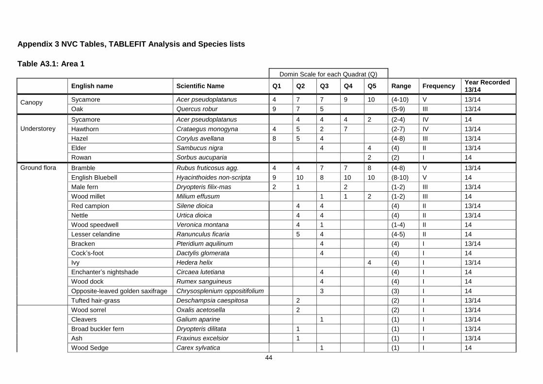
44
Appendix 3 NVC Tables, TABLEFIT Analysis and Species lists
Table A3.1: Area 1
Domin Scale for each Quadrat (Q)
English name Scientific Name Q1 Q2 Q3 Q4 Q5 Range Frequency Year Recorded 13/14
Canopy
Sycamore Acer pseudoplatanus 4 7 7 9 10 (4-10) V 13/14
Oak Quercus robur 9 7 5
(5-9) III 13/14
Understorey
Sycamore Acer pseudoplatanus
4 4 4 2 (2-4) IV 14
Hawthorn Crataegus monogyna 4 5 2 7
(2-7) IV 13/14
Hazel Corylus avellana 8 5 4
(4-8) III 13/14
Elder Sambucus nigra
4
4 (4) II 13/14
Rowan Sorbus aucuparia
2 (2) I 14
Ground flora
Bramble Rubus fruticosus agg. 4 4 7 7 8 (4-8) V 13/14
English Bluebell Hyacinthoides non-scripta 9 10 8 10 10 (8-10) V 14
Male fern Dryopteris filix-mas 2 1
2
(1-2) III 13/14
Wood millet Milium effusum
1 1 2 (1-2) III 14
Red campion Silene dioica
4 4
(4) II 13/14
Nettle Urtica dioica
4 4
(4) II 13/14
Wood speedwell Veronica montana
4 1
(1-4) II 14
Lesser celandine Ranunculus ficaria
5 4
(4-5) II 14
Bracken Pteridium aquilinum
4
(4) I 13/14
Cock’s-foot Dactylis glomerata
4
(4) I 14
Ivy Hedera helix
4 (4) I 13/14
Enchanter’s nightshade Circaea lutetiana
4
(4) I 14
Wood dock Rumex sanguineus
4
(4) I 14
Opposite-leaved golden saxifrage Chrysosplenium oppositifolium
3
(3) I 14
Tufted hair-grass Deschampsia caespitosa
2
(2) I 13/14
Wood sorrel Oxalis acetosella
2
(2) I 13/14
Cleavers Galium aparine
1
(1) I 13/14
Broad buckler fern Dryopteris dilitata
1
(1) I 13/14
Ash Fraxinus excelsior
1
(1) I 13/14
Wood Sedge Carex sylvatica
1
(1) I 14

45
Domin Scale for each Quadrat (Q)
English name Scientific Name Q1 Q2 Q3 Q4 Q5 Range Frequency Year Recorded 13/14
Moss sp. 2
(2) I 14
Species recorded outside quadrats or in 2013
Wood anemone Anemone nemorosa 14
Rhododendron Rhododendron ponticum 13/14
Bluebell (Hybrid) Hyacinthoides non-scripta x H. Hispanica (H. × massartiana) 14
Creeping soft grass Holcus mollis 13/14
Common alder Alnus glutinosa 13/14
Raspberry Rubus ideaus 13/14
Rosebay willowherb Chamerion angustifolium 13/14
Creeping buttercup Ranunculus repens 13/14
Common hemp nettle Galeopsis tetrahit 13/14
Speedwell Veronica sp. 13
Foxglove Digitalis purpurea 13
Redshank Polygonum persicaria 13
Wild basil Clinopodium vulgare 13
Soft rush Juncus effuses 13
Remote sedge Carex remota 13
Elm Ulmus sp. 13/14
Woodrush Luzula sp. 13
Fauna
White butterfly Pieridae sp 14
Speckled Wood butterfly Pararge aegeria 14
TABLEFIT RESULT Area 1 *100 Parameters = Nobryo Cover% Sp & c C41.21 W10 62 | 73 54 74 72| Que rob-Pte aqu-Rub fru C41.32 W 8b 62 | 67 66 67 78| Fra exc-Ace cam-Mer per Anemone nemoros C41.21 W10a 61 | 77 52 82 62| Que rob-Pte aqu-Rub fru Typical C41.21 W10e 53 | 73 61 49 71| Que rob-Pte aqu-Rub fru Ace pse-Oxa ace C41.32 W 8 50 | 62 64 52 67| Fra exc-Ace cam-Mer per (subcomms a-d) The TABLEFIT output shows best fit to W10 and W8b NVC communities, further interpretation confirms this.

46
Table A3.2: Area 2 Woodland Type 1
Domin Scale for each Quadrat (Q)
English name Scientific Name Q1 Q2 Q3 Range Frequency
Year Recorded 13/14*
Canopy
Oak Quercus robur 9 8 4 (4-9) V 13/14
Sycamore Acer pseudoplatanus 8 7 7 (7-8) V 13/14
Ash Fraxinus excelsior
7 (7) I 14
Understorey
Hazel Corylus avellana 4 7 5 (4-7) V 13/14
Hawthorn Crataegus monogyna 6 4 6 (4-6) V 13/14
Elder Sambucus nigra 4 4
(4) III 13/14
Sycamore Acer pseudoplatanus
4 4 (4) III 13/14
Holly Ilex aquifolium
7
(7) I 14
Oak Quercus robur
4 (4) I 14
Damson Prunus sp
4 (4) I 14
Ground flora
English Bluebell Hyacinthoides non-scripta 7 10 8 (8-10) V 14
Male fern Dryopteris filix-mas 4 4
(4) III 13/14
Broad Buckler Fern Dryopteris dilitata 4 4
(4) III 13/14
Bramble Rubus fruticosus agg. 4
7 (1-7) III 13/14
Lesser celandine Ranunculus ficaria
8 (8) I 14
Bare ground 7
(7) I 14
Bluebell (Hybrid) Hyacinthoides non-scripta x H. hispanica (H. × massartiana)
4 (4) I 14
Red campion Silene dioica
4 (4) I 14
Dandelion Taraxacum officinale 1
(1) I 14
Species recorded outside quadrats or in 2013
Rowan Sorbus aucuparia 13/14
Birch Betula pendula 13/14
Willow Salix sp. 13/14
Apple Malus sp. 13
Dog rose Rosa canina 13/14
Himalayan balsam Impatiens glandulifera 13/14
47
Moss 13/14
Wild carrot Daucus carota 13
Variable oysterling Crepidotus variabilis 13
White saddle cap Helvella crispa 13
Bracket fungus Ganoderma sp. 13
Hogweed species Heracleum sp. 13/14
Fauna Speckled Wood Pararge aegeria 14
TABLEFIT RESULT Area2 WT1 *100 Parameters = Nobryo Cover% Sp & c C41.21 W10 62 | 69 76 62 74| Que rob-Pte aqu-Rub fru C41.32 W 8b 56 | 64 98 54 69| Fra exc-Ace cam-Mer per Anemone nemoros C41.21 W10a 52 | 69 70 51 56| Que rob-Pte aqu-Rub fru Typical C41.32 W 8 50 | 60 96 43 75| Fra exc-Ace cam-Mer per (subcomms a-d) C41.21 W10e 49 | 67 81 36 73| Que rob-Pte aqu-Rub fru Ace pse-Oxa ace The TABLEFIT output shows best fit to either a W10 or W8 NVC community, further interpretation considers the woodland to fit W10. * The Phase 1 survey undertaken in 2013 covered Area 2WT1 and WT2 and this list details species recorded over the whole of Area 2 for 2013.
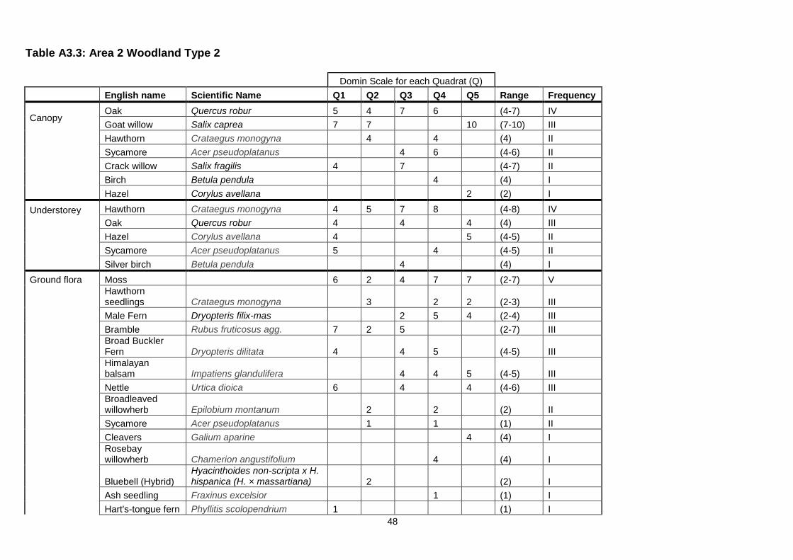
48
Table A3.3: Area 2 Woodland Type 2
Domin Scale for each Quadrat (Q)
English name Scientific Name Q1 Q2 Q3 Q4 Q5 Range Frequency
Canopy
Oak Quercus robur 5 4 7 6 (4-7) IV
Goat willow Salix caprea 7 7 10 (7-10) III
Hawthorn Crataegus monogyna 4 4 (4) II
Sycamore Acer pseudoplatanus 4 6 (4-6) II
Crack willow Salix fragilis 4 7 (4-7) II
Birch Betula pendula 4 (4) I
Hazel Corylus avellana 2 (2) I
Understorey
Hawthorn Crataegus monogyna 4 5 7 8 (4-8) IV
Oak Quercus robur 4 4 4 (4) III
Hazel Corylus avellana 4 5 (4-5) II
Sycamore Acer pseudoplatanus 5 4 (4-5) II
Silver birch Betula pendula 4 (4) I
Ground flora Moss 6 2 4 7 7 (2-7) V
Hawthorn seedlings Crataegus monogyna 3 2 2 (2-3) III
Male Fern Dryopteris filix-mas 2 5 4 (2-4) III
Bramble Rubus fruticosus agg. 7 2 5 (2-7) III
Broad Buckler Fern Dryopteris dilitata 4 4 5 (4-5) III
Himalayan balsam Impatiens glandulifera 4 4 5 (4-5) III
Nettle Urtica dioica 6 4 4 (4-6) III
Broadleaved willowherb Epilobium montanum 2 2 (2) II
Sycamore Acer pseudoplatanus 1 1 (1) II
Cleavers Galium aparine 4 (4) I
Rosebay willowherb Chamerion angustifolium 4 (4) I
Bluebell (Hybrid) Hyacinthoides non-scripta x H. hispanica (H. × massartiana) 2 (2) I
Ash seedling Fraxinus excelsior 1 (1) I
Hart's-tongue fern Phyllitis scolopendrium 1 (1) I
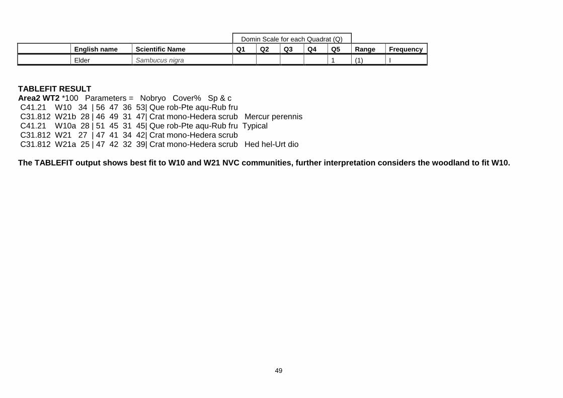
49
Domin Scale for each Quadrat (Q)
English name Scientific Name Q1 Q2 Q3 Q4 Q5 Range Frequency
Elder Sambucus nigra 1 (1) I
TABLEFIT RESULT Area2 WT2 *100 Parameters = Nobryo Cover% Sp & c C41.21 W10 34 | 56 47 36 53| Que rob-Pte aqu-Rub fru C31.812 W21b 28 | 46 49 31 47| Crat mono-Hedera scrub Mercur perennis C41.21 W10a 28 | 51 45 31 45| Que rob-Pte aqu-Rub fru Typical C31.812 W21 27 | 47 41 34 42| Crat mono-Hedera scrub C31.812 W21a 25 | 47 42 32 39| Crat mono-Hedera scrub Hed hel-Urt dio The TABLEFIT output shows best fit to W10 and W21 NVC communities, further interpretation considers the woodland to fit W10.

50
Table A3.4: Area 3 South Woodland
Domin Scale for each Quadrat (Q)
English name Scientific Name Q1 Q2 Q3 Q4 Q5 Range Frequency
Year Recorded 13/14
Canopy
Oak Quercus robur 9 10 7
(7-10) III 13/14
Sycamore Acer pseudoplatanus
7 7 9 (7-9) III 14
Birch Betula pendula
5
(5) I 14
Hawthorn Crataegus monogyna
4
(4) I 13/14
Understorey
Hawthorn Crataegus monogyna 5 1
4 (1-5) III 13/14
Oak Quercus robur
5 4 5 (4-5) III 14
Sycamore Acer pseudoplatanus 4 5
4 (4-5) III 14
Rowan Sorbus aucuparia
4
4 (4) II 14
Hazel Corylus avellana
5 4
(4-5) II 14
Honeysuckle Lonicera periclymenum
5
(5) I 14
Dog rose Rosa canina
4
(4) I 14
Ivy Hedera helix 4 4
(4) I 13/14
Birch Betula pendula
4
(4) I 14
Elder Sambucus nigra
1
(1) I 13/14
Wild cherry Prunus avium 1
(1) I 14
Cotoneaster sp. Cotoneaster sp.
1 (1) I 14
Ground Flora Bramble Rubus fruticosus agg. 9 6 5 7 8 (5-9) V 13/14
Ivy Hedera helix 9 4
9 (4-9) III 14
Rosebay Willowherb Chamerion angustifolium 1
1
(1) II 14
Reed canary grass Phalaris arundinacea 1
1 (1) II 14
Soft rush Juncus effusus 1
2 (1-2) II 14
Cleavers Galium aparine
1 3 (1-3) II 14
Yorkshire fog Holcus lanatus
9 1
(1-9) II 14
Himalayan Balsam Impatiens glandulifera
3 5 (3-5) II 14
Moss sp.
5 4
(4-5) II 14
Honeysuckle Lonicera periclymenum
9
(9) I 14
Dog’s mercury Mercurialis perennis
6 (6) I 14
Daffodil Narcissus sp
1
(1) I 14

51
Domin Scale for each Quadrat (Q)
English name Scientific Name Q1 Q2 Q3 Q4 Q5 Range Frequency
Year Recorded 13/14
Bluebell (Hybrid) Hyacinthoides non-scripta x H. hispanica (H. × massartiana)
4
(1) I 14
English bluebell Hyacinthoides non-scripta 1
(1) I 14
Broad leaved dock Rumex obtusifolius 1
(1) I 14
Yew Taxus baccata
1
(1) I 14
Broad Buckler Fern Dryopteris dilitata
1
(1) I 14
Red campion Silene dioica
1
(1) I 14
Species recorded outside quadrats or in 2013
Black bryony Tamus communis 13
Alder Alnus glutinosa 14
Rough meadow grass Poa trivialis 14
Holly Ilex aquifolium 13/14
Ash (mature and saplings) Fraxinus excelsior 13/14
Beech (mature and saplings) Fagus sylvatica 14
TABLEFIT RESULT Area3S *100 Parameters = Nobryo Cover% Sp & c C41.21 W10a 51 | 61 52 62 64| Que rob-Pte aqu-Rub fru Typical C41.21 W10 50 | 61 51 57 78| Que rob-Pte aqu-Rub fru C41.21 W10c 44 | 55 48 52 69| Que rob-Pte aqu-Rub fru Hedera helix C31.811 W24 40 | 49 53 64 42| Rub fr-Hol la underscb C31.812 W21a 40 | 58 52 50 42| Crat mono-Hedera scrub Hed hel-Urt dio The TABLEFIT output shows best fit to W10a and W10 NVC communities, further interpretation considers the woodland to fit W10a.

52
Table A3.5: Area 3 North Woodland
Domin Scale for each Quadrat (Q)
English name Scientific Name Q1 Q2 Q3 Q4 Q5 Range Frequency
Year Recorded 13/14
Canopy
Sycamore Acer pseudoplatanus 5 10 8 7 9 (5-10) V 13/14
Oak Quercus robur 9
6 5 (5-9) III 13/14
Crack willow Salix fragilis
5 5
(5) II 14
Ivy Hedera helix
4 4
(4) II 14
Ash Fraxinus excelsior
6
(6) I 13/14
Alder Alnus glutinosa
5
(5) I 14
Understorey
Elder Sambucus nigra 4
4
(4) II 13/14
Oak Quercus robur 4
5
(4-5) II 14
Hazel Corylus avellana
6
7 (6-7) II 13/14
Holly Ilex aquifolium 5
(5) I 13/14
Beech Fagus sylvatica
5 (5) I 13/14
Wild cherry Prunus avium
4
(4) I 14
Hawthorn Crataegus monogyna
4 (4) I 13/14
Cotoneaster sp. Cotoneaster sp.
4
(4) I 14
Rowan Sorbus aucuparia 4
(4) I 14
Sycamore Acer pseudoplatanus
4
(4) I 14
Ground flora
Ivy Hedera helix 5 5 9 8 7 (5-9) V 13/14
Bramble Rubus fruticosus agg. 6 9 6 9 7 (6-9) V 13/14
Broad Buckler Fern Dryopteris dilitata
4
5 4 (4-5) III 14
English bluebell Hyacinthoides non-scripta 8 9
9 (8-9) III 14
Red campion Silene dioica
1 4
(1-4) II 13/14
Nettle Urtica dioica
5
2 (2-5) II 13/14
Cleavers Galium aparine 4
5
(4-5) II 14
Moss sp.
4
9
(4-9) II 14
Ground elder Aegopodium podagraria
9
(9) I 14
Dog’s mercury Mercurialis perennis
6
(6) I 14

53
Domin Scale for each Quadrat (Q)
English name Scientific Name Q1 Q2 Q3 Q4 Q5 Range Frequency
Year Recorded 13/14
Broad leaved dock Rumex obtusifolius
5
(5) I 14
Ash seedling Fraxinus excelsior
4
(4) I 13/14
Bluebell (Hybrid) Hyacinthoides non-scripta x H. hispanica (H. × massartiana)
4
(4) I 13/14
Male fern Dryopteris filix-mas
3 (3) I 13/14
Hogweed Heracleum sphondylium
2 (2) I 13/14
Sycamore Acer pseudoplatanus 2
(2) I 14
Oak Quercus robur 1
(1) I 14
Species recorded outside quadrats or in 2013
Willow Salix sp. 13/14
Common Elm Ulmus sp. 13/14
Common Lime Tilia x europaea 14
Birch Betula pendula 13/14
Horse chestnut Aesculus hippocastanum 13/14
Pignut Conopodium majus 14
Foxglove Digitalis purpurea 13/14
Bracken Pteridium aquilinum 13/14
Scots Pine Pinus sylvestris 13/14
Cow parsley Anthriscus sylvestris 13/14
Yorkshire fog Holcus lanatus 13/14
Cock’s-foot Dactylis glomerata 13/14
Mugwort Artemisia vulgaris 14
Garlic mustard Alliaria petiolata 14
Montbretia Crocosmia sp. 14
Hart’s tongue fern Phyllitis scolopendrium 14
Sedum (garden escape) Sedum sp. 14
Forget-me-not (garden escape) Myosotis sp. 14

54
TABLEFIT RESULT Area3 N *100 Parameters = Nobryo Cover% Sp & c C41.21 W10 57 | 69 52 78 59| Que rob-Pte aqu-Rub fru C41.1311 W12a 54 | 69 63 59 56| Fagus syl-Merc per wood Mercur perennis C41.21 W10a 51 | 64 51 74 51| Que rob-Pte aqu-Rub fru Typical C31.812 W21b 50 | 68 61 53 55| Crat mono-Hedera scrub Mercur perennis C41.32 W 8 50 | 59 67 54 63| Fra exc-Ace cam-Mer per (subcomms a-d) The TABLEFIT output shows best fit to W10, W12, W21 and W8 NVC communities, further interpretation considers the woodland to fit W10.

55
Table A3.6: Area 4 Lower South
Domin Scale for each Quadrat (Q)
English name Scientific Name Q1 Q2 Q3 Range Frequency Year Recorded 13/14
Yorkshire Fog Holcus lanatus 8 8 8 8 III 14
Moss species 10 10 10 10 III 14
Common sorrel Rumex acetosa 4 7 4 4-7 III 13/14
Red fescue Festuca rubra 8 8 5 5-8 III 14
Yarrow Achillea millefolium 5 8 7 5-8 III 14
Bird's foot trefoil Lotus corniculatus 6 6 8 6-8 III 13/14
Soft rush Juncus effusus 5 4 4-5 II 13/14
Birch seedling Betula pendula 1 1 I 13/14
Common mouse-ear Cerastium fontanum 2 2 I 14
Creeping buttercup Ranunculus repens 2 2 I 14
Common fleabane Pulicaria dysenterica 4 4 I 14
Smooth tare Vicia tetrasperma 4 4 I 14
Rough meadow grass Poa trivialis 5 5 I 14
Cat’s ear Hypochaeris radicata 6 6 I 14
Creeping bent Agrostis stolonifera 6 6 I 14
Recorded outside quadrats or in 2013
Alder sapling Alnus glutinosa 14
Bramble Rubus fruticosus agg 14
Cock’s-foot Dactylis glomerata 14
Common centaury Centaurium erythraea 14
Creeping thistle Cirsium arvense 14
Common sorrel Rumex acetosa 14
Hard rush Juncus inflexus 13/14
Oak seedling Quercus sp. 14
Procumbent pearlwort Sagina procumbens 14
Reed Canary grass Phalaris arundinacea 14
Ribwort plantain Plantago lanceolata 14
Rosebay willowherb Chamerion angustifolium 14
White clover Trifolium repens 14

56
Domin Scale for each Quadrat (Q)
English name Scientific Name Q1 Q2 Q3 Range Frequency Year Recorded 13/14
Yellow flag iris Iris pseudacorus 14
Compact rush Juncus conglomeratus 14
Jointed rush Juncus articulatus 14
Common reed Phragmites australis 13/14
Willow sp. Salix sp. 13/14
Perforate St. Johns Wort Hypericum perforatum 13/14
Cotton grass Eriophorum angustifolium 13
Fauna
Buzzard Buteo buteo 14
Skylark Alauda arvensis 14
Common Blue butterfly Polyommatus icarus 14
Dragonfly species (x2) Odonata spp 14
Damselfly species Odonata spp 14
TABLEFIT RESULT A4LowS *100 Parameters = Nobryo Cover% Sp & c C18.2 MC 9c 69 | 55 85 85 85| Fest rubra-Holcu lanat Achill millef C18.2 MC 9 66 | 63 74 83 69| Fest rubra-Holcu lanat C18.21 MC 8d 62 | 75 61 78 59| Fest rubra-Armer marit Holcus lanatus C18.2 MC 9d 62 | 57 74 79 68| Fest rubra-Holcu lanat Primul vulgar C18.2 MC 9b 51 | 48 60 77 60| Fest rubra-Holcu lanat Dactyl glomer The TABLEFIT output shows best fit to a MC9c or MC9 NVC community, further interpretation considers the grassland to fit MC9c.

57
Table A3.7: Area 4 Lower North
Domin Scale for each Quadrat (Q)
English name Scientific Name Q1 Q2 Q3 Range Frequency Year Recorded 13/14
Yorkshire Fog Holcus lanatus 8 8 8 8 III 14
Crested dog’s-tail Cynosurus cristatus 5 5 4 4-5 III 14
Sweet vernal grass Anthoxanthum odoratum 5 5 4 4-5 III 14
Hard rush Juncus inflexus 6 5 4 4-6 III 13/14
Ribwort plantain Plantago lanceolata 4 4 6 4-6 III 14
Common knapweed Centaurea nigra 6 5 5 5-6 III 14
Creeping bent sp Agrostis stolonifera 5 4 8 4 – 8 III 14
Meadow buttercup Ranunculus acris 8 6 5 5-8 III 14
Bird’s foot trefoil Lotus corniculatus 4 9 10 4-10 III 13/14
Early Marsh orchid Dactylorhiza incarnata 4 4 4 II 14
False fox sedge Carex otrubae 4 4 4 II 14
Yarrow Achillea millefolium 4 5 4-5 II 14
Cat’s ear Hypochaeris radicata 5 5 I 14
Orchid sp. Dactylorhiza sp. 1 1 I 14
Yellow flag iris Iris pseudacorus 1 1 I 14
Yellow-wort Blackstonia perforata 2 2 I 14
Common mouse-ear Cerastium fontanum 3 3 I 14
Common reed Phragmites australis 4 4 I 13/14
Willow sp. Salix sp. 4 4 I 13/14
Recorded outside quadrats or in 2013
Greater knapweed Centaurea scabiosa 14
Red fescue Festuca rubra 13/14
Tufted hair grass Deschampsia caespitosa 13/14
Colt’s foot Tussilago farfara 13/14
Birch sapling Betula pendula 13/14
Michaelmas daisy Aster x salignus 13/14
Gorse Ulex europaeus 13/14
Perforate St. Johns Wort Hypericum perforatum 13/14
Soft rush Juncus effusus 13/14
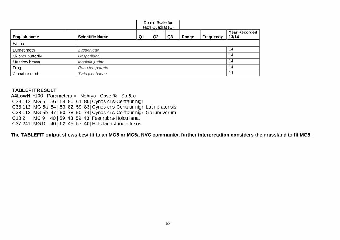
58
Domin Scale for each Quadrat (Q)
English name Scientific Name Q1 Q2 Q3 Range Frequency Year Recorded 13/14
Fauna
Burnet moth Zygaenidae 14
Skipper butterfly Hesperiidae. 14
Meadow brown Maniola jurtina 14
Frog Rana temporaria 14
Cinnabar moth Tyria jacobaeae 14
TABLEFIT RESULT A4LowN *100 Parameters = Nobryo Cover% Sp & c C38.112 MG 5 56 | 54 80 61 80| Cynos cris-Centaur nigr C38.112 MG 5a 54 | 53 82 59 83| Cynos cris-Centaur nigr Lath pratensis C38.112 MG 5b 47 | 50 78 50 74| Cynos cris-Centaur nigr Galium verum C18.2 MC 9 40 | 59 43 59 43| Fest rubra-Holcu lanat C37.241 MG10 40 | 62 45 57 40| Holc lana-Junc effusus The TABLEFIT output shows best fit to an MG5 or MC5a NVC community, further interpretation considers the grassland to fit MG5.
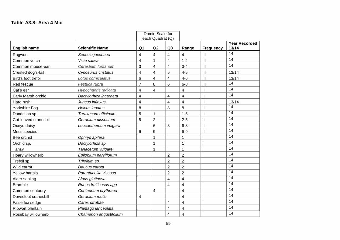
59
Table A3.8: Area 4 Mid
Domin Scale for each Quadrat (Q)
English name Scientific Name Q1 Q2 Q3 Range Frequency Year Recorded 13/14
Ragwort Senecio jacobaea 4 4 4 4 III 14
Common vetch Vicia sativa 4 1 4 1-4 III 14
Common mouse-ear Cerastium fontanum 3 4 4 3-4 III 14
Crested dog’s-tail Cynosurus cristatus 4 4 5 4-5 III 13/14
Bird's foot trefoil Lotus corniculatus 6 4 4 4-6 III 13/14
Red fescue Festuca rubra 7 8 6 6-8 III 14
Cat’s ear Hypochaeris radicata 4 4 4 II 14
Early Marsh orchid Dactylorhiza incarnata 4 4 4 II 14
Hard rush Juncus inflexus 4 4 4 II 13/14
Yorkshire Fog Holcus lanatus 8 8 8 II 14
Dandelion sp. Taraxacum officinale 5 1 1-5 II 14
Cut-leaved cranesbill Geranium dissectum 5 2 2-5 II 14
Oxeye daisy Leucanthemum vulgara 6 8 6-8 II 14
Moss species 6 9 6-9 II 14
Bee orchid Ophrys apifera 1 1 I 14
Orchid sp. Dactylorhiza sp. 1 1 I 14
Tansy Tanacetum vulgare 1 1 I 14
Hoary willowherb Epilobium parviflorum 2 2 I 14
Trefoil sp. Trifolium sp. 2 2 I 14
Wild carrot Daucus carota 2 2 I 14
Yellow bartsia Parentucellia viscosa 2 2 I 14
Alder sapling Alnus glutinosa 4 4 I 14
Bramble Rubus fruiticosus agg 4 4 I 14
Common centaury Centaurium erythraea 4 4 I 14
Dovesfoot cranesbill Geranium molle 4 4 I 14
False fox sedge Carex otrubae 4 4 I 14
Ribwort plantain Plantago lanceolata 4 4 I 14
Rosebay willowherb Chamerion angustifolium 4 4 I 14

60
Domin Scale for each Quadrat (Q)
English name Scientific Name Q1 Q2 Q3 Range Frequency Year Recorded 13/14
Smooth hawksbeard Crepis capillaris 4 4 I 14
Spear thistle Cirsium vulgara 4 4 I 14
White clover Trifolium repens 4 4 I 14
Perforated St. John's wort Hypericum perforatum 5 5 I 13/14
Cock’s-foot Dactylis glomerata 6 6 I 14
Field horsetail Equisetum arvense 7 7 I 14
Recorded outside quadrats or in 2013
Cotton grass Eriophorum angustifolium 13
Tall melilot Melilotus altissimus 13
Michaelmas daisy Aster x salignus 13/14
Tufted hair grass Deschampsia caespitosa 13/14
Colt’s foot Tussilago farfara 13/14
Soft rush Juncus effusus 13/14
Common reed Phragmites australis 13/14
Birch sapling Betula pendula 13/14
Willow sapling Salix sp. 13/14
Rabbit (grazing evidence)
14
TABLEFIT RESULT A4Mid *100 Parameters = Nobryo Cover% Sp & c C38.112 MG 5a 43 | 46 55 57 64| Cynos cris-Centaur nigr Lath pratensis C38.112 MG 5 42 | 46 52 57 61| Cynos cris-Centaur nigr C18.2 MC 9c 38 | 47 35 78 44| Fest rubra-Holcu lanat Achill millef C38.112 MG 5b 38 | 40 49 58 53| Cynos cris-Centaur nigr Galium verum C18.2 MC 9 37 | 57 33 69 42| Fest rubra-Holcu lanat The TABLEFIT output shows best fit to an MG5a or MC5 NVC community, further interpretation considers the grassland to fit MG5.
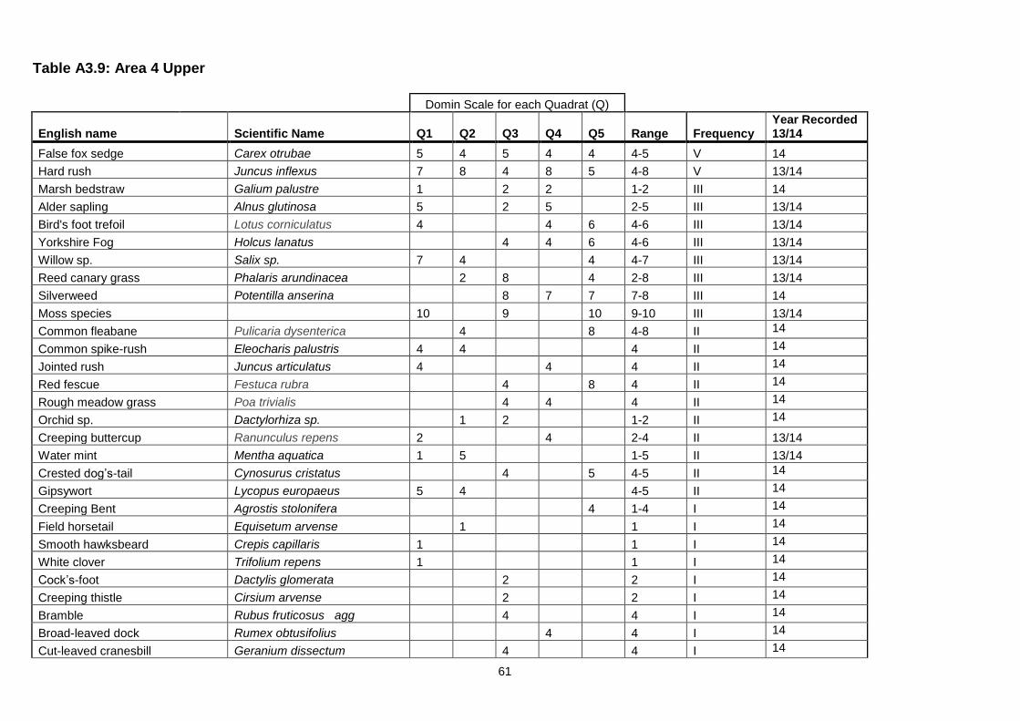
61
Table A3.9: Area 4 Upper
Domin Scale for each Quadrat (Q)
English name Scientific Name Q1 Q2 Q3 Q4 Q5 Range Frequency Year Recorded 13/14
False fox sedge Carex otrubae 5 4 5 4 4 4-5 V 14
Hard rush Juncus inflexus 7 8 4 8 5 4-8 V 13/14
Marsh bedstraw Galium palustre 1 2 2 1-2 III 14
Alder sapling Alnus glutinosa 5 2 5 2-5 III 13/14
Bird's foot trefoil Lotus corniculatus 4 4 6 4-6 III 13/14
Yorkshire Fog Holcus lanatus 4 4 6 4-6 III 13/14
Willow sp. Salix sp. 7 4 4 4-7 III 13/14
Reed canary grass Phalaris arundinacea 2 8 4 2-8 III 13/14
Silverweed Potentilla anserina 8 7 7 7-8 III 14
Moss species 10 9 10 9-10 III 13/14
Common fleabane Pulicaria dysenterica 4 8 4-8 II 14
Common spike-rush Eleocharis palustris 4 4 4 II 14
Jointed rush Juncus articulatus 4 4 4 II 14
Red fescue Festuca rubra 4 8 4 II 14
Rough meadow grass Poa trivialis 4 4 4 II 14
Orchid sp. Dactylorhiza sp. 1 2 1-2 II 14
Creeping buttercup Ranunculus repens 2 4 2-4 II 13/14
Water mint Mentha aquatica 1 5 1-5 II 13/14
Crested dog’s-tail Cynosurus cristatus 4 5 4-5 II 14
Gipsywort Lycopus europaeus 5 4 4-5 II 14
Creeping Bent Agrostis stolonifera 4 1-4 I 14
Field horsetail Equisetum arvense 1 1 I 14
Smooth hawksbeard Crepis capillaris 1 1 I 14
White clover Trifolium repens 1 1 I 14
Cock’s-foot Dactylis glomerata 2 2 I 14
Creeping thistle Cirsium arvense 2 2 I 14
Bramble Rubus fruticosus agg 4 4 I 14
Broad-leaved dock Rumex obtusifolius 4 4 I 14
Cut-leaved cranesbill Geranium dissectum 4 4 I 14

62
Domin Scale for each Quadrat (Q)
English name Scientific Name Q1 Q2 Q3 Q4 Q5 Range Frequency Year Recorded 13/14
Dandelion sp. Taraxacum officinale 4 4 I 14
Ragwort Senecio jacobaea 4 4 I 14
Yellow flag iris Iris pseudacorus 4 4 I 14
Common mouse-ear Cerastium fontanum 5 5 I 14
Soft rush Juncus effusus 5 5 I 13/14
Recorded outside quadrats or in 2013
Tufted vetch Vicia cracca 14
Birch Betula pendula 13/14
Common reed Phragmites australis 13/14
Bulrush Typha latifolia 13/14
Common fleabane Pulicaria dysenterica 13/14
Michaelmas daisy Aster x salignus 13/14
TABLEFIT RESULT A4Upper *100 Parameters = Nobryo Cover% Sp & c C37.241 MG10b 25 | 46 35 50 29| Holc lana-Junc effusus Junc inflexus C37.241 MG10 23 | 46 36 34 34| Holc lana-Junc effusus C37.242 MG11c 21 | 39 24 50 31| Fes rub-Agr sto-Pot ans Honken peploid C16.34 SD17 21 | 50 32 26 33| Poten anse-Carex nigra C37.242 MG11 20 | 43 21 47 30| Fes rub-Agr sto-Pot ans The TABLEFIT output shows best fit to MG10, MG11 or SD17 NVC communities, further interpretation considers the grassland to fit a mix of communities with succession to W6.
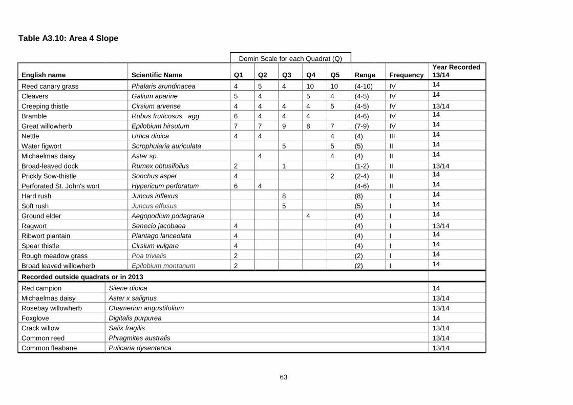
63
Table A3.10: Area 4 Slope
Domin Scale for each Quadrat (Q)
English name Scientific Name Q1 Q2 Q3 Q4 Q5 Range Frequency Year Recorded 13/14
Reed canary grass Phalaris arundinacea 4 5 4 10 10 (4-10) IV 14
Cleavers Galium aparine 5 4 5 4 (4-5) IV 14
Creeping thistle Cirsium arvense 4 4 4 4 5 (4-5) IV 13/14
Bramble Rubus fruticosus agg 6 4 4 4 (4-6) IV 14
Great willowherb Epilobium hirsutum 7 7 9 8 7 (7-9) IV 14
Nettle Urtica dioica 4 4 4 (4) III 14
Water figwort Scrophularia auriculata 5 5 (5) II 14
Michaelmas daisy Aster sp. 4 4 (4) II 14
Broad-leaved dock Rumex obtusifolius 2 1 (1-2) II 13/14
Prickly Sow-thistle Sonchus asper 4 2 (2-4) II 14
Perforated St. John's wort Hypericum perforatum 6 4 (4-6) II 14
Hard rush Juncus inflexus 8 (8) I 14
Soft rush Juncus effusus 5 (5) I 14
Ground elder Aegopodium podagraria 4 (4) I 14
Ragwort Senecio jacobaea 4 (4) I 13/14
Ribwort plantain Plantago lanceolata 4 (4) I 14
Spear thistle Cirsium vulgare 4 (4) I 14
Rough meadow grass Poa trivialis 2 (2) I 14
Broad leaved willowherb Epilobium montanum 2 (2) I 14
Recorded outside quadrats or in 2013
Red campion Silene dioica 14
Michaelmas daisy Aster x salignus 13/14
Rosebay willowherb Chamerion angustifolium 13/14
Foxglove Digitalis purpurea 14
Crack willow Salix fragilis 13/14
Common reed Phragmites australis 13/14
Common fleabane Pulicaria dysenterica 13/14
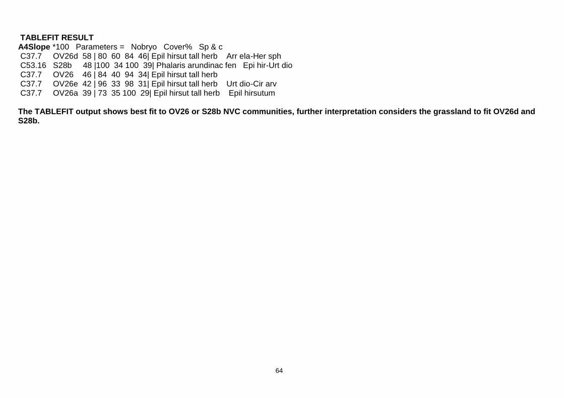
64
TABLEFIT RESULT A4Slope *100 Parameters = Nobryo Cover% Sp & c C37.7 OV26d 58 | 80 60 84 46| Epil hirsut tall herb Arr ela-Her sph C53.16 S28b 48 |100 34 100 39| Phalaris arundinac fen Epi hir-Urt dio C37.7 OV26 46 | 84 40 94 34| Epil hirsut tall herb C37.7 OV26e 42 | 96 33 98 31| Epil hirsut tall herb Urt dio-Cir arv C37.7 OV26a 39 | 73 35 100 29| Epil hirsut tall herb Epil hirsutum The TABLEFIT output shows best fit to OV26 or S28b NVC communities, further interpretation considers the grassland to fit OV26d and S28b.

65
Table A3.11: Area 5
Domin Scale for each Quadrat (Q)
English name Scientific Name Q1 Q2 Q3 Q4 Q5 Range Frequency
Year Recorded 13/14
Canopy
Sycamore Acer pseudoplatanus 8 8 6 10 10 (6-10) V 13/14
Oak Quercus robur
4 5
(4-5) II 13/14
Elm Ulmus procera 4
(4) I 14
Understorey
Rowan Sorbus aucuparia 2
4 4 (2-4) III 13/14
Elm Ulmus procera 8 5
4 (4-8) III 13/14
Elder Sambucus nigra
4 2 (2-4) II 13/14
Sycamore Acer pseudoplatanus
5 (5) I 14
Ground flora
Bluebell Hyacinthoides non-scripta 9 8 4 8 8 (4-9) V 13/14
Bramble Rubus fruticosus agg.
7 3 9 4 (3-9) IV 13/14
Broad Buckler Fern Dryopteris dilitata
3 2 1 (1-3) III 13/14
Hybrid Bluebell Hyacinthoides non-scripta x H. hispanica (H. × massartiana) 1
4
(1-4) II 13/14
Bracken Pteridium aquilinum
2 3
(2-3) II 13/14
Yorkshire fog Holcus lanatus
9
(9) I 14
Hawthorn Crataegus monogyna 1
(5) I 14
Bare ground/moss 5
(5) I 14
Moss sp
5 (5) I 14
Red campion Silene dioica
2
(2) I 13/14
Elm Ulmus procera 1
(1) I 14
Recorded outside quadrat or in 2013 Holly Ilex aquifolium
13/14
Hawthorn Crataegus monogyna
13/14
Chicken of the woods Laetiporus sulphureus
13
Best fit NVC community (TABLEFIT) W10 W10a W10a W10a W10e
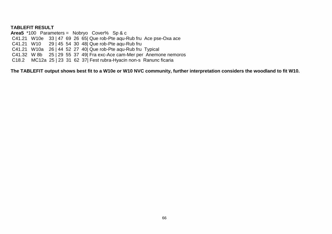
66
TABLEFIT RESULT Area5 *100 Parameters = Nobryo Cover% Sp & c C41.21 W10e 33 | 47 69 26 65| Que rob-Pte aqu-Rub fru Ace pse-Oxa ace C41.21 W10 29 | 45 54 30 48| Que rob-Pte aqu-Rub fru C41.21 W10a 26 | 44 52 27 40| Que rob-Pte aqu-Rub fru Typical C41.32 W 8b 25 | 29 55 37 49| Fra exc-Ace cam-Mer per Anemone nemoros C18.2 MC12a 25 | 23 31 62 37| Fest rubra-Hyacin non-s Ranunc ficaria The TABLEFIT output shows best fit to a W10e or W10 NVC community, further interpretation considers the woodland to fit W10.

67
Table A3.12: Area 6
Domin Scale for each Quadrat (Q)
English name Scientific Name Q1 Q2 Q3 Q4 Q5 Range Frequency Year Recorded 13/14
Yorkshire Fog Holcus lanatus 7 7 8 7 7 (7-8) V 14
Red fescue Festuca rubra 6 5 5 5 5 (5-6) V 14
Creeping buttercup Ranunculus repens 1 2 4 4 4 (1-4) V 14
Creeping Thistle Cirsium arvense 7 5 4
4 (4-7) IV 14
Early marsh orchid Dactylorhiza incarnata 5
4
4 (4-5) III 14
Bramble Rubus fruticosus agg. 2
4
4 (2-4) III 14
Smooth Tare Vicia tetrasperma 2 1
2
(1-2) III 14
Common vetch Vicia sativa
1 1
2 (1-2) III 14
Greater Willowherb Epilobium hirsutum
4
4 4 (4) III 14
Horsetail Equisetum arvense 2
6 (2-6) II 13/14
Dove’s-foot crane’s-bill Geranium molle
1
(1) I 14
Common sorrel Rumex acetosa 1
4 (1-4) II 14
Michaelmas daisy Aster x salignus
2 2
(2) II 14
Soft rush Juncus effusus 4 4
(4) II 14
Yarrow Achillea millefolium
7
(7) I 14
Rosebay Willowherb Chamerion angustifolium 4
(4) I 14
Broadleaved dock Rumex obtusifolius
4
(4) I 14
Sedge sp Carex sp.
4
(4) I 14
Common spotted or northern marsh orchid Dactylorhiza sp. 2
(2) I 13/14
Smooth meadow grass Poa pratensis
2
(2) I 14
Ragwort Senecio jacobaea
2
(2) I 14
Common sedge Carex nigra
2 8
(2-8) II 14
Meadow buttercup Ranunculus acris
2
(2) I 14
Dandelion Taraxacum officinale
2 (2) I 14
Hedge bindweed Calystegia sepium
2 (2) I 14
Yellow bartsia Parentacella viscosa
2 (2) I 14
White clover Trifolium repens
1
(1) I 14
Common mouse-ear Cerastium fontanum
1
(1) I 14

68
Domin Scale for each Quadrat (Q)
English name Scientific Name Q1 Q2 Q3 Q4 Q5 Range Frequency Year Recorded 13/14
Recorded outside quadrats or in 2013
Willow Salix sp. 13/14
Birch Betula pendula 13/14
Alder Alnus glutinosa 13/14
Rowan Sorbus aucuparia 14
Oak Quercus robur 14
Cut-leaved crane’s bill Geranium dissectum 14
Hard Rush Juncus inflexus 13/14
Fauna
Cinnabar moth Tyria jacobaeae 14
Spittlebug Cercopidae 14
Grasshopper Orthoptera 14
TABLEFIT RESULT Area 6 *100 Parameters = Nobryo Cover% Sp & c C18.2 MC 9 37 | 43 40 67 45| Fest rubra-Holcu lanat C18.21 MC 8d 33 | 52 33 59 39| Fest rubra-Armer marit Holcus lanatus C87.2 OV25a 32 | 41 36 69 37| Urtic-Cir arv tall herb Hol lan-Poa ann C31.811 W24a 32 | 53 50 36 42| Rub fr-Hol la underscb Cir arv-Cir vul C37.213 MG 9 31 | 58 49 27 45| Holc lana-Desch cespit The TABLEFIT output shows best fit to MC9, MC8, OV25, W24 or MG9 NVC communities, further interpretation considers the grassland to fit MG10.
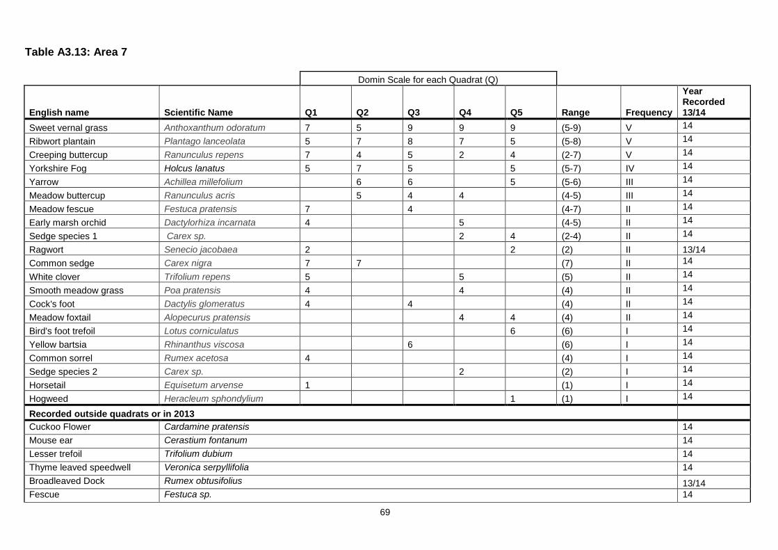
69
Table A3.13: Area 7
Domin Scale for each Quadrat (Q)
English name Scientific Name Q1 Q2 Q3 Q4 Q5 Range Frequency
Year Recorded 13/14
Sweet vernal grass Anthoxanthum odoratum 7 5 9 9 9 (5-9) V 14
Ribwort plantain Plantago lanceolata 5 7 8 7 5 (5-8) V 14
Creeping buttercup Ranunculus repens 7 4 5 2 4 (2-7) V 14
Yorkshire Fog Holcus lanatus 5 7 5
5 (5-7) IV 14
Yarrow Achillea millefolium
6 6
5 (5-6) III 14
Meadow buttercup Ranunculus acris
5 4 4
(4-5) III 14
Meadow fescue Festuca pratensis 7
4
(4-7) II 14
Early marsh orchid Dactylorhiza incarnata 4
5
(4-5) II 14
Sedge species 1 Carex sp.
2 4 (2-4) II 14
Ragwort Senecio jacobaea 2
2 (2) II 13/14
Common sedge Carex nigra 7 7
(7) II 14
White clover Trifolium repens 5
5
(5) II 14
Smooth meadow grass Poa pratensis 4
4
(4) II 14
Cock's foot Dactylis glomeratus 4
4
(4) II 14
Meadow foxtail Alopecurus pratensis
4 4 (4) II 14
Bird's foot trefoil Lotus corniculatus
6 (6) I 14
Yellow bartsia Rhinanthus viscosa
6
(6) I 14
Common sorrel Rumex acetosa 4
(4) I 14
Sedge species 2 Carex sp.
2
(2) I 14
Horsetail Equisetum arvense 1
(1) I 14
Hogweed Heracleum sphondylium
1 (1) I 14
Recorded outside quadrats or in 2013
Cuckoo Flower Cardamine pratensis 14
Mouse ear Cerastium fontanum 14
Lesser trefoil Trifolium dubium 14
Thyme leaved speedwell Veronica serpyllifolia 14
Broadleaved Dock Rumex obtusifolius 13/14
Fescue Festuca sp. 14
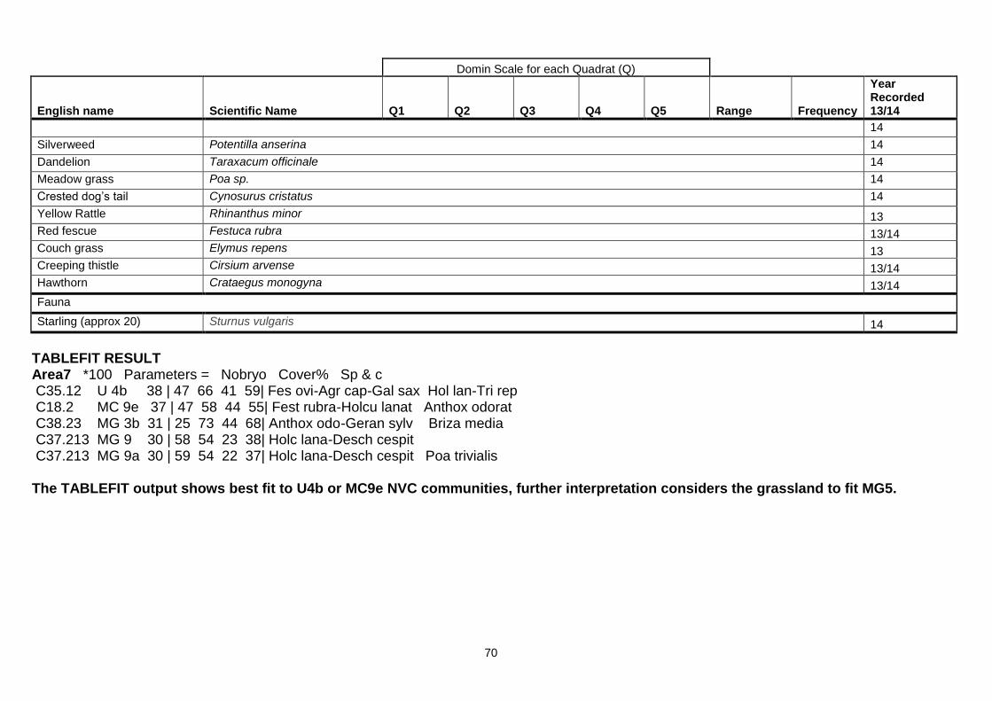
70
Domin Scale for each Quadrat (Q)
English name Scientific Name Q1 Q2 Q3 Q4 Q5 Range Frequency
Year Recorded 13/14
14
Silverweed Potentilla anserina 14
Dandelion Taraxacum officinale 14
Meadow grass Poa sp. 14
Crested dog’s tail Cynosurus cristatus 14
Yellow Rattle Rhinanthus minor 13
Red fescue Festuca rubra 13/14
Couch grass Elymus repens 13
Creeping thistle Cirsium arvense 13/14
Hawthorn Crataegus monogyna 13/14
Fauna
Starling (approx 20) Sturnus vulgaris 14
TABLEFIT RESULT Area7 *100 Parameters = Nobryo Cover% Sp & c C35.12 U 4b 38 | 47 66 41 59| Fes ovi-Agr cap-Gal sax Hol lan-Tri rep C18.2 MC 9e 37 | 47 58 44 55| Fest rubra-Holcu lanat Anthox odorat C38.23 MG 3b 31 | 25 73 44 68| Anthox odo-Geran sylv Briza media C37.213 MG 9 30 | 58 54 23 38| Holc lana-Desch cespit C37.213 MG 9a 30 | 59 54 22 37| Holc lana-Desch cespit Poa trivialis The TABLEFIT output shows best fit to U4b or MC9e NVC communities, further interpretation considers the grassland to fit MG5.

71
Table A3.14: Area 8
Domin Scale for each Quadrat (Q)
English name Scientific Name Q1 Q2 Q3 Q4 Q5 Range Frequency
Year Recorded 13/14
Canopy
Sycamore Acer pseudoplatanus 9 9 9 10 7 (7-10) V 14
Oak Quercus robur
5
8 (5-8) II 13/14
Understorey
Elder Sambucus nigra 4
5 5
(4-5) III 14
Hawthorn Crataegus monogyna
5 (5) I 13/14
Ash sapling Fraxinus excelsior
5 (5) I 13/14
Oak Quercus robur 4
(4) I 14
Hazel Corylus avellana
7 5 (5-7) I 13/14
Ground flora
English bluebell Hyacinthoides non-scripta 10 10 5 5 5 (5-10) V 14
Lesser celandine Ranunculus ficaria
4 1 5 (1-5) III 14
Sycamore (suckers/seedlings) Acer pseudoplatanus 4 5
2 (2-5) III 14
Dog’s Mercury Mercurialis perennis
8 5 7 (5-8) III 14
Bramble Rubus fruticosus agg. 4 2
4
(2-4) III 13/14
Enchanter’s nightshade Circaea lutetiana
2 4 2 (2-4) III 14
Nettle Urtica dioica
2
5 (2-5) II 14
Broad Buckler Fern Dryopteris dilitata
2 2
(2) II 13/14
Red campion Silene dioica
14
Moschatel (Town-hall clock) Adoxa moschatellina
7 (7) I 14
Wood speedwell Veronica montana
5 (5) I 14
Himalayan balsam Impatiens glandulifera
5 (5) I 13/14
Cock's foot Dactylis glomerata
4 (4) I 14
Male fern Dryopteris filix-mas
4 (4) I 14
Creeping buttercup Ranunculus repens
4 (4) I 14
Hogweed Heracleum sphondylium
4
(4) I 14
Wood dock Rumex sanguineus
4 (4) I 14
Ash seedling Fraxinus excelsior
4
(4) I 14
Bracken Pteridium aquilinum
2
(2) I 13/14
Cleavers Galium aparine
2 (2) I 14
Annual Meadow grass Poa annua
2
(2) I 14

72
Domin Scale for each Quadrat (Q)
English name Scientific Name Q1 Q2 Q3 Q4 Q5 Range Frequency
Year Recorded 13/14
Remote sedge Carex remota
2 (2) I
14
Recorded outside quadrats or in 2013
Hybrid Bluebell Hyacinthoides non-scripta x H. hispanica (H. × massartiana) 14
Crack willow Salix fragilis 13/14
Beech Fagus sylvatica 13/14
Common gorse Ulex europaeus 13/14
Canary reed grass Phalaris arundinacea 14
Bulrush Typha latifolia 14
Carrot family Umbellifera sp. 14
Stinking iris Iris foetidissima 13/14
Willowherb sp. Epilobium sp. 13/14
Opposite-leaved golden saxifrage Chrysosplenium oppositifolium 14
Hart’s tongue fern Phyllitis scolopendrium 14
TABLEFIT RESULT Area 8 *100 Parameters = Nobryo Cover% Sp & c C41.32 W 8b 48 | 55 61 59 61| Fra exc-Ace cam-Mer per Anemone nemoros C41.32 W 8 41 | 55 62 40 61| Fra exc-Ace cam-Mer per (subcomms a-d) C41.41 W 8e 39 | 52 59 42 60| Fra exc-Ace cam-Mer per Geranium robert C41.31 W 9a 36 | 37 64 44 66| Fra exc-Sor auc-Mer per Typical C41.21 W10e 34 | 57 50 32 56| Que rob-Pte aqu-Rub fru Ace pse-Oxa ace The TABLEFIT output shows best fit to a W8b NVC community, further interpretation confirms this.
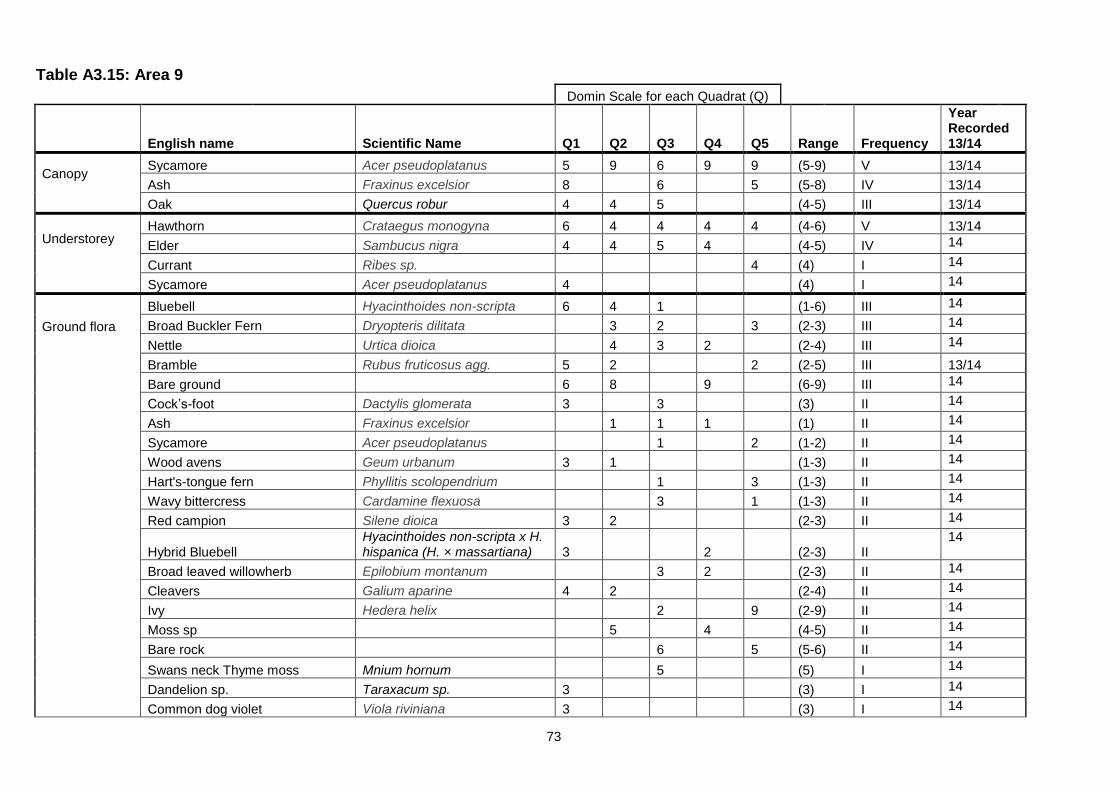
73
Table A3.15: Area 9
Domin Scale for each Quadrat (Q)
English name Scientific Name Q1 Q2 Q3 Q4 Q5 Range Frequency
Year Recorded 13/14
Canopy
Sycamore Acer pseudoplatanus 5 9 6 9 9 (5-9) V 13/14
Ash Fraxinus excelsior 8
6
5 (5-8) IV 13/14
Oak Quercus robur 4 4 5
(4-5) III 13/14
Understorey
Hawthorn Crataegus monogyna 6 4 4 4 4 (4-6) V 13/14
Elder Sambucus nigra 4 4 5 4
(4-5) IV 14
Currant Ribes sp.
4 (4) I 14
Sycamore Acer pseudoplatanus 4
(4) I 14
Ground flora
Bluebell Hyacinthoides non-scripta 6 4 1
(1-6) III 14
Broad Buckler Fern Dryopteris dilitata
3 2
3 (2-3) III 14
Nettle Urtica dioica
4 3 2
(2-4) III 14
Bramble Rubus fruticosus agg. 5 2
2 (2-5) III 13/14
Bare ground 6 8
9
(6-9) III 14
Cock’s-foot Dactylis glomerata 3
3
(3) II 14
Ash Fraxinus excelsior
1 1 1
(1) II 14
Sycamore Acer pseudoplatanus
1
2 (1-2) II 14
Wood avens Geum urbanum 3 1
(1-3) II 14
Hart's-tongue fern Phyllitis scolopendrium
1
3 (1-3) II 14
Wavy bittercress Cardamine flexuosa
3
1 (1-3) II 14
Red campion Silene dioica 3 2
(2-3) II 14
Hybrid Bluebell Hyacinthoides non-scripta x H. hispanica (H. × massartiana) 3
2
(2-3) II
14
Broad leaved willowherb Epilobium montanum
3 2
(2-3) II 14
Cleavers Galium aparine 4 2
(2-4) II 14
Ivy Hedera helix
2
9 (2-9) II 14
Moss sp
5
4
(4-5) II 14
Bare rock
6
5 (5-6) II 14
Swans neck Thyme moss Mnium hornum
5
(5) I 14
Dandelion sp. Taraxacum sp. 3
(3) I 14
Common dog violet Viola riviniana 3
(3) I 14

74
Domin Scale for each Quadrat (Q)
English name Scientific Name Q1 Q2 Q3 Q4 Q5 Range Frequency
Year Recorded 13/14
Dandelion Taraxacum officinale
3
(3) I 14
Hedge woundwort Stachys sylvatica 3 (3) I 14
Hawthorn Crataegus monogyna 2
(2) I 14
Norway Maple Acer platanoides
1
(1) I 14
Recorded outside quadrats or in 2013 Hazel Corylus avellana 13/14
TABLEFIT RESULT Area 9 *100 Parameters = Nobryo Cover% Sp & c C41.41 W 8e 60 | 70 72 57 81| Fra exc-Ace cam-Mer per Geranium robert C31.812 W21b 52 | 75 62 46 63| Crat mono-Hedera scrub Mercur perennis C41.32 W 8b 41 | 58 59 41 57| Fra exc-Ace cam-Mer per Anemone nemoros C41.32 W 8 40 | 57 60 37 58| Fra exc-Ace cam-Mer per (subcomms a-d) C41.21 W10e 39 | 65 52 33 61| Que rob-Pte aqu-Rub fru Ace pse-Oxa ace The TABLEFIT output shows best fit to a W8e NVC community, further interpretation confirms this.
75
Table A3.16: Area 10
Domin Scale for each Quadrat (Q)
English name Scientific Name Q1 Q2 Q3 Q4 Q5 Q6 Range Frequency
Year Recorded 13/14
Canopy Sycamore Acer pseudoplatanus 4 7 6 9 9 8 (4-9) V 13/14
Elm Ulmus procera 4
5
(4-5) II 13/14
Oak Quercus robur 8
(8) I 13/14
Ash Fraxinus excelsior
5
(5) I 13/14
Understorey Elm Ulmus procera
4 1
(1-4) II 14
Sycamore Acer pseudoplatanus 1
4 (1-4) II 13/14
Wild cherry Prunus avium
5
(5) I 13/14
Elder Sambucus nigra
5
(5) I 13/14
Rowan Sorbus aucuparia
4
4 (4) I 13/14
Hawthorn Crataegus monogyna
1 (1) I 13/14
Apple Malus domestica
1 (1) I 14
Ground flora Red campion Silene dioica 7 5 5 1 5 1 (1-7) V 13/14
Cleavers Galium aparine 4 8 1
4 (1-8) IV 13/14
Bramble Rubus fruticosus agg. 2
2 5
4 (2-5) IV 13/14
Cow parsley Anthriscus sylvestris 1 4
4
(1-4) III 13/14
Nettle Urtica dioica 9 4 4
(4-9) III 13/14
English Bluebell Hyacinthoides non-scripta
9 7 9 (7-9) III 14
Hybrid Bluebell
Hyacinthoides non-scripta x H. hispanica (H. × massartiana)
5 6 5 (5) II
14
Ground elder Aegopodium podagraria 4 4
(4) II 13/14
Broad leaved Dock Rumex obtusifolius 1
1
(1) II 13/14
Ivy Hedera helix
1
5
(1) II 13/14
Elder Sambucus nigra
1 1 (1) II 14
Yorkshire Fog Holcus lanatus
4 7
(4-7) II 14
Cock’s-foot Dactylis glomerata
6
(6) I 14
Raspberry Rubus ideaus 4
(4) I
Hedge woundwort Stachys sylvatica
4
(4) I 14
Ivy leaved speedwell Veronica hederifolia
4
(4) I 14

76
Domin Scale for each Quadrat (Q)
English name Scientific Name Q1 Q2 Q3 Q4 Q5 Q6 Range Frequency
Year Recorded 13/14
Dog rose Rosa canina
4
(4) I 14
Rosebay Willowherb Chamerion angustifolium 2
(2) I 14
Japanese knotweed Fallopia japonica
2
(2) I 14
Elm Ulmus procera
1
(1) I 14
Sycamore Acer pseudoplatanus
1
(1) I 14
Hawthorn Crataegus monogyna
1
(1) I 14
Holly Ilex aquifolium
1
(1) I 13/14
Hogweed Heracleum sphondylium
1
(1) I 14
Apple Malus domestica
1 (1) I 14
Dandelion Taraxacum officinale
1
(1) I 14
Recorded outside quadrats or in 2013
Silver birch Betula pendula 13/14
Scots pine Pinus sylvestris 13/14
Bracken Pteridium aquilinum 13/14
TABLEFIT RESULT Area10 *100 Parameters = Nobryo Cover% Sp & c C41.41 W 8e 32 | 48 52 33 56| Fra exc-Ace cam-Mer per Geranium robert C31.812 W21b 32 | 57 49 31 44| Crat mono-Hedera scrub Mercur perennis C31.811 W24 25 | 50 43 37 24| Rub fr-Hol la underscb C31.831 W25a 25 | 59 39 24 31| Pte aq-Rub fr underscb Hyacinth non-sc C31.87 OV27d 22 | 47 28 34 39| Epil/Cham ang tall herb Ace pse-Sam nig The TABLEFIT output shows best fit to a W8e and W21b NVC community, further interpretation considers the woodland to fit W21 grading to W8 towards the east of the woodland.
77
Table A3.17: Area 11
Domin Scale for each Quadrat (Q)
English name Scientific Name Q1 Q2 Q3 Q4 Q5 Range Frequency
Year Recorded 13/14
Canopy
Oak Quercus robur 9 9 4 4 7 (4-9) V 14
Sycamore Acer pseudoplatanus 5 5 7
7 (5-7) IV 13/14
Beech Fagus sylvatica
9
(9) I 13/14
Sweet chestnut Castanea sativa
5
(5) I 13/14
Yew Taxus baccata
4 (4) I 14
Understorey
Rowan Sorbus aucuparia 4 2 4
4 (2-4) IV 13/14
Rhododendron Rhododendron ponticum 6 2 8
7 (2-8) IV 13/14
Yew Taxus baccata 7 2
6 (2-7) III 13/14
Holly Ilex aquifolium
4
4 (4) II 13/14
Oak Quercus robur
5 (5) I 14
Hawthorn Crataegus monogyna 4
(4) I 14
Cotoneaster Cotoneaster sp
4 (4) I 14
Elder Sambucus nigra
4
(4) I 14
Beech Fagus sylvatica
2
(2) I 14
Ground flora
Bramble Rubus fruticosus agg. 4 2 4 4 4 (2-4) V 13/14
English bluebell Hyacinthoides non-scripta 7 4 5 5 4 (4-7) V 14
Rhododendron Rhododendron ponticum
5 5 7 (5-7) III 14
Rosebay Willowherb Chamerion angustifolium
2
(2) II 14
Bracken Pteridium aquilinum 4
7 (4-7) II 14
Yorkshire fog Holcus lanatus
9
4 (4-9) II 14
Leaf litter
9 8
(8-9) II 14
Ivy Hedera helix 5
7
(5-7) II 13/14
Daffodil Narcissus sp
5
(5) I 14
Beech sapling Fagus sylvatica
4
(4) I 14
Nettle Urtica dioica
2
(2) I 14
Cleavers Galium aparine 1
(1) I 14
Red campion Silene dioica 1
(1) I 14
Birch Betula pendula
1
(1) I 14
Sycamore Acer pseudoplatanus
1
(1) I 14

78
Domin Scale for each Quadrat (Q)
English name Scientific Name Q1 Q2 Q3 Q4 Q5 Range Frequency
Year Recorded 13/14
Yew Taxus baccata 1
(1) I 14
Broad Buckler Fern Dryopteris dilitata
1
(1) I 14
Elder Sambucus nigra
1
(1) I 14
Recorded outside quadrats or in 2013
Ash Fraxinus excelsior 13/14
Common lime Tilia x europaea 13/14
Snowberry Symphoricarpos albus 13/14
Japanese knotweed Fallopia japonica 14
TABLEFIT RESULT Area11 *100 Parameters = Nobryo Cover% Sp & c C41.21 W10 56 | 84 58 67 48| Que rob-Pte aqu-Rub fru C41.21 W10b 46 | 71 49 65 41| Que rob-Pte aqu-Rub fru Anemone nemoros C41.21 W10a 46 | 82 57 50 38| Que rob-Pte aqu-Rub fru Typical C41.21 W10c 36 | 64 45 43 38| Que rob-Pte aqu-Rub fru Hedera helix C41.21 W10e 34 | 58 49 40 38| Que rob-Pte aqu-Rub fru Ace pse-Oxa ace The TABLEFIT output shows best fit to a W10 NVC community, further interpretation confirms this.
79
Table A3.18: Area 12 Species list recorded within and around the pond (no NVC community assessment undertaken)
Common Name Scientific Name Year Recorded 13/14
Creeping buttercup Ranunculus repens 14
Nettle Urtica dioica 14
Thistle Cirsium arvense 14
Water forget-me-not Myosotis scorpioides 14
Yorkshire fog Holcus lanatus 14
Creeping bent grass Agrostis stolonifera 14
Bramble Rubus fruticosus agg. 14
Herb Robert Geranium robertianum 14
Cow parsley Anthriscus sylvestris 14
White clover Trifolium repens 14
Silverweed Potentilla anserina 14
Cock’s foot Dactylis glomerata 14
Hawthorn Crataegus monogyna 14
Sycamore Acer pseudoplatanus 14
Ash Fraxinus excelsior 14
Willow spp Salix spp 14
Bulrush Typha latifolia 14
Water-milfoil Myriophyllum sp. 13/14
Waterlily Nymphaea sp. 13/14
Blanketweed Cladophora sp. 13/14

80
Table A3.19: Area 13
Domin Scale for each Quadrat (Q)
English name Scientific Name Q1 Q2 Q3 Q4 Q5 Range Frequency
Year Recorded 13/14
Canopy
Sycamore Acer pseudoplatanus 10 5 6 8 8 (5-10) V 14
Oak Quercus robur
5 (5) I 13/14
Elder Sambucus nigra
4
(4) I 14
Understorey
Elder Sambucus nigra 2 1 4 2
(1-4) IV 14
Sycamore Acer pseudoplatanus
1 1 4
(1-4) III 14
Rhododendron Rhododendron ponticum 4
2 1
(1-4) III 13/14
Wild cherry Prunus avium
1
(1-4) I 13/14
Ground flora
Moss sp
8 8 4 6 (4-8) IV 13/14
Bramble Rubus fruticosus agg. 9 9
7 9 (7-9) IV 13/14
Wood Avens Geum urbanum 3 1
1 (1) III 13/14
Nettle Urtica dioica 6 8 8
(6-8) III 14
Meadow grass Poa annua
4 4
(4) II 14
Wood dock Rumex sanguineus 1
2
(1) II 14
Creeping buttercup Ranunculus repens
1 2
(1-2) II 14
Bracken Pteridium aquilinum
3 5 (3-5) II 14
Cleavers Galium aparine
3 8
(3-8) II 14
Rosebay Willowherb Chamerion angustifolium
5
(5) I 14
Red campion Silene dioica 4
(4) I 13/14
Rhododendron Rhododendron ponticum
4
(4) I 14
Broad Buckler Fern Dryopteris dilitata
2
(2) I 13/14
Bluebell (hybrid) Hyacinthoides non-scripta x H. hispanica (H. × massartiana) 1
(1) I 14
Hart's-tongue fern Phyllitis scolopendrium
1
(1) I 13/14
Ragwort Senecio jacobaea
1 (1) I 14
Wood speedwell Veronica montana
1
(1) I 14
Male fern Dryopteris filix-mas
1
(1) I 14
Elder Sambucus nigra 1
(1) I 14

81
Domin Scale for each Quadrat (Q)
English name Scientific Name Q1 Q2 Q3 Q4 Q5 Range Frequency
Year Recorded 13/14
Grass sp
1
(1) I 14
Recorded outside quadrats or in 2013
Beech Fagus sylvatica 13/14
Common Lime Tilia x europaea 13/14
Hawthorn Crataegus monogyna 14
Yew Taxus baccata 14
English bluebell Hyacinthoides non-scripta 14
Willow sp. Salix sp. 13/14
Ivy Hedera helix 13/14
Tufted hair grass Deschampsia caespitosa 13/14
TABLEFIT RESULTS Area 13Q1 Parameters = Nobryo Domin Cov on C31.811 W24 61 | 0 48 81 57| Rub fr-Hol la underscb C31.811 W24a 61 | 0 56 78 58| Rub fr-Hol la underscb Cir arv-Cir vul C41.C2 W 6d 55 | 0 72 63 65| Aln glut-Urtic dio wood Sambucus nigra C41.21 W10a 42 | 0 29 50 60| Que rob-Pte aqu-Rub fru Typical C44.911 W 6 41 | 0 45 56 48| Aln glut-Urtic dio wood Area13Q2 Parameters = Nobryo Domin Cov on C31.811 W24 83 | 0 46 88 82| Rub fr-Hol la underscb C31.811 W24a 79 | 0 47 83 78| Rub fr-Hol la underscb Cir arv-Cir vul C31.87 OV27d 65 | 0 45 89 57| Epil/Cham ang tall herb Ace pse-Sam nig C41.C2 W 6d 63 | 0 56 64 87| Aln glut-Urtic dio wood Sambucus nigra C87.2 OV24 60 | 0 30 90 51| Urtica-Gal ap tall herb

82
Area13Q3 Parameters = Nobryo Domin Cov on C87.2 OV24 72 | 0 31 90 65| Urtica-Gal ap tall herb C87.2 OV24a 69 | 0 27 100 56| Urtica-Gal ap tall herb Typical C87.2 OV24b 55 | 0 29 64 63| Urtica-Gal ap tall herb Arr ela-Rub fru C31.812 W21b 50 | 0 42 50 88| Crat mono-Hedera scrub Mercur perennis C44.911 W 6a 41 | 0 35 49 60| Aln glut-Urtic dio wood Typical Area13Q4 Parameters = Nobryo Domin Cov on C41.21 W10a 51 | 0 75 55 73| Que rob-Pte aqu-Rub fru Typical C31.811 W24 37 | 0 43 51 48| Rub fr-Hol la underscb C31.811 W24a 35 | 0 44 49 47| Rub fr-Hol la underscb Cir arv-Cir vul C31.87 OV27d 35 | 0 65 37 77| Epil/Cham ang tall herb Ace pse-Sam nig C41.21 W10 34 | 0 68 37 72| Que rob-Pte aqu-Rub fru Area13Q5 Parameters = Nobryo Domin Cov on C41.21 W10a 86 | 0 79 86 98| Que rob-Pte aqu-Rub fru Typical C41.21 W10 70 | 0 81 70 100| Que rob-Pte aqu-Rub fru C41.21 W10d 55 | 0 61 60 73| Que rob-Pte aqu-Rub fru Holcus lanatus C41.21 W10c 52 | 0 61 54 77| Que rob-Pte aqu-Rub fru Hedera helix C31.831 W25b 47 | 0 49 59 54| Pte aq-Rub fr underscb Teucr scorodon The TABLEFIT output shows best fit to W24, OV24 and W10 NVC communities, further interpretation considers the woodland to fit W10a with W24 understorey.

83
Table A3.20: Area 14 Woodland
Domin Scale for each Quadrat (Q)
English name Scientific Name Q1 Q2 Q3 Q4 Q5 Range Frequency
Year Recorded 13/14
Canopy
Sycamore Acer pseudoplatanus 10 10 10 8 8 (8-10) V 13/14
Oak Quercus robur
5
(5) I 13/14
Understorey
Sycamore Acer pseudoplatanus 2 4 4 4
(2-4) IV 14
Elder Sambucus nigra 1
1 2
(1-2) III 13/14
Holly Ilex aquifolium 1 1
(1) II 13/14
Hawthorn Crataegus monogyna 1
4
(1-4) II 13/14
Japanese knotweed Fallopia japonica
4
(4) I 14
Rhododendron Rhododendron ponticum
2
(2) I 13/14
Yew Taxus baccata 1
(1) I 13/14
Ground flora
Moss sp 3 5 10 8
(3-10) IV 14
Bramble Rubus fruticosus agg. 6 4 9 9
(4-9) IV 13/14
Bluebell (hybrid) Hyacinthoides non-scripta x H. hispanica (H. × massartiana)
9 2
4 (2-9) III 14
Broad Buckler Fern Dryopteris dilitata
1
4 (1-4) II 13/14
Red campion Silene dioica
1 5 (1-5) II 14
English bluebell Hyacinthoides non-scripta
4
10 (4-10) II 14
Hogweed Heracleum sphondylium
5 (5) I 14
Wood speedwell Veronica montana
4 (4) I 14
Male fern Dryopteris filix-mas
4 (4) I 13/14
Dandelion Taraxacum sp.
2 (2) I 14
Cleavers Galium aparine
2 (2) I 14
Creeping buttercup Ranunculus repens
2 (2) I 14
Elder Sambucus nigra
2 (2) I 14
Nettle Urtica dioica
2 (2) I 14
Lesser celandine Ranunculus ficaria
2
(2) I 14
Wood Avens Geum urbanum
2 (2) I 14
Ivy Hedera helix 1
(1) I 13/14
Recorded Hazel Corylus avellana 13/14

84
Domin Scale for each Quadrat (Q)
English name Scientific Name Q1 Q2 Q3 Q4 Q5 Range Frequency
Year Recorded 13/14
outside quadrats or in 2013
Rowan Sorbus aucuparia 13/14
Beech Fagus sylvatica 13/14
Wild cherry Prunus avium 13/14
Bracken Pteridium aquilinum 13/14
Birch Betula pendula 13/14
Ash Fraxinus excelsior 13/14
Rosebay willowherb Chamerion angustifolium 13/14
Michaelmas daisy Aster x salignus 13/14
Common gorse Ulex europaeus 13
Small-leaved lime Tilia cordata 13
Hart’s tongue fern Phyllitis scolopendrium 13/14
Honey fungus Armillaria sp. 13
Turkey tail Trametes versicolor 13
TABLEFIT RESULTS Area14 Woodland Q1 Parameters = Nobryo Domin Cov on C41.21 W10a 37 | 0 53 42 67| Que rob-Pte aqu-Rub fru Typical C31.87 OV27d 37 | 0 46 37 100| Epil/Cham ang tall herb Ace pse-Sam nig C31.811 W24 32 | 0 46 51 39| Rub fr-Hol la underscb C31.811 W24a 30 | 0 48 49 38| Rub fr-Hol la underscb Cir arv-Cir vul C41.21 W10 29 | 0 49 32 67| Que rob-Pte aqu-Rub fru Area14 Woodland Q2 Parameters = Nobryo Domin Cov on C31.87 OV27d 37 | 0 54 37 100| Epil/Cham ang tall herb Ace pse-Sam nig C41.41 W 8e 26 | 0 68 26 100| Fra exc-Ace cam-Mer per Geranium robert C41.31 W 9a 21 | 0 38 22 77| Fra exc-Sor auc-Mer per Typical C41.21 W10e 18 | 0 69 18 94| Que rob-Pte aqu-Rub fru Ace pse-Oxa ace C41.21 W10a 16 | 0 70 21 52| Que rob-Pte aqu-Rub fru Typical

85
Area14 Woodland Q3 Parameters = Nobryo Domin Cov on C41.21 W10a 60 | 0 75 61 86| Que rob-Pte aqu-Rub fru Typical C31.811 W24 43 | 0 43 51 59| Rub fr-Hol la underscb C41.21 W10 42 | 0 68 43 84| Que rob-Pte aqu-Rub fru C31.811 W24a 41 | 0 44 49 58| Rub fr-Hol la underscb Cir arv-Cir vul C31.87 OV27d 36 | 0 73 37 84| Epil/Cham ang tall herb Ace pse-Sam nig Area14 Woodland Q4 Parameters = Nobryo Domin Cov on C41.21 W10a 66 | 0 53 68 85| Que rob-Pte aqu-Rub fru Typical C41.21 W10 51 | 0 56 52 89| Que rob-Pte aqu-Rub fru C31.811 W24 44 | 0 38 51 62| Rub fr-Hol la underscb C31.811 W24a 41 | 0 48 49 60| Rub fr-Hol la underscb Cir arv-Cir vul C41.21 W10c 36 | 0 42 41 65| Que rob-Pte aqu-Rub fru Hedera helix Area14 Woodland Q5 Parameters = Nobryo Cover% Cov on C18.2 MC12a 42 | 0 17 61 44| Fest rubra-Hyacin non-s Ranunc ficaria C41.31 W 9a 29 | 0 59 32 67| Fra exc-Sor auc-Mer per Typical C41.21 W10e 27 | 0 34 32 64| Que rob-Pte aqu-Rub fru Ace pse-Oxa ace C18.2 MC12 27 | 0 14 42 41| Fest rubra-Hyacin non-s C41.32 W 8b 26 | 0 29 33 51| Fra exc-Ace cam-Mer per Anemone nemorosa The TABLEFIT output shows best fit to W10a, OV27 or MC12a NVC communities, further interpretation considers the woodland to fit W10a.

86
Table A3.21: Area 14 Grassland A
Domin Scale for each Quadrat (Q)
English name Scientific Name Q1 Q2 Q3 Q4 Q5 Range Frequency Year Recorded 13/14
Horsetail Equisetum arvense 10 8 8 9 8 (8-10) V 13/14
Rough meadow grass Poa trivialis 7 7 7 6 7 (6-7) V 14
Yorkshire Fog Holcus lanatus 4 5 5 5 5 (4-5) V 14
Marsh willowherb Epilobium palustre 4 5 4 5 (4-5) IV 14
Hoary Willowherb Epilobium parviflorum 2 4 4 2 (2-4) IV 14
Common mouse-ear Cerastium fontanum 4 4 2 2 (2-4) IV 14
Common vetch Vicia sativa 7 4 3 (3-7) III 14
Willow Salix sp 4 2 5 (2-5) III 13/14
Ragwort Senecio jacobaea 2 4 4 (2-4) III 14
Broadleaved dock Rumex obtusifolius 2 1 2 (1-2) III 14
Wood avens Geum urbanum 1 1 2 (1-2) III 14
Wavy bittercress Cardamine flexuosa 1 1 1 (1) III 14
Moss 8 8 8 (8) III 14
Creeping buttercup Ranunculus repens 5 5 (5) II 14
Bramble Rubus fruticosus agg. 2 4 (2-4) II 13/14
Dandelion Taraxacum officinale 2 4 (2-4) II 14
Annual meadow grass Poa annua 7 7 (7) II 14
White clover Trifolium repens 5 (5) I 14
Cut leaved cranes bill Geranium dissectum 4 (4) I 14
Bare ground 4 (4) I 14
Hard rush Juncus inflexus 4 (4) I 13/14
Cow parsley Anthriscus sylvestris 4 (4) I 14
Lesser trefoil Trifolium dubium 3 (3) I 14
Cat's-ear Hypochaeris radicata 2 2 (2) I 14
Prickly sow thistle Sonchus asper 2 (2) I 14
Creeping Thistle Cirsium arvensis 2 (2) I 14
Early marsh orchid Dactylorhiza incarnata 2 (2) I 14
Ribwort Plantain Plantago lanceolata 2 (2) I 14
Scarlet pimpernel Anagallis arvensis 1 (1) I 14

87
Domin Scale for each Quadrat (Q)
English name Scientific Name Q1 Q2 Q3 Q4 Q5 Range Frequency Year Recorded 13/14
Hogweed Heracleum sphondylium 1
(1) I 14
Recorded outside quadrats or in 2013
Elder Sambucus nigra 13/14
Wood avens Geum urbanum 13/14
Broad buckler fern Dryopteris dilitata 13/14
Ivy Hedera helix 13/14
Nettle Urtica dioica 13/14
Soft rush Juncus effusus 13/14
TABLEFIT RESULT Area14 Grassland A *100 Parameters = Nobryo Cover% Sp & c C37.213 MG 9a 26 | 55 38 31 36| Holc lana-Desch cespit Poa trivialis C37.241 MG10a 21 | 54 24 44 25| Holc lana-Junc effusus Typical C31.811 W24 19 | 46 32 33 21| Rub fr-Hol la underscb C37.213 MG 9 18 | 46 31 25 29| Holc lana-Desch cespit C81 MG 7b 18 | 45 28 29 31| Lolium perenne ley Lol per-Poa tri The TABLEFIT output shows best fit to MG9, MG10, W24 or MG7 NVC communities, further interpretation considers the grassland to fit mesotrophic grassland community type.

88
Table A3.22: Area 14 Grassland B
Domin Scale for each Quadrat (Q)
English name Scientific Name Q1 Q2 Q3 Q4 Q5 Range Frequency Year Recorded 13/14
Creeping buttercup Ranunculus repens 7 6 6 7 9 (6-9) V 14
Rough meadow grass Poa trivialis 7 8 6 8 8 (6-8) V 14
Yorkshire Fog Holcus lanatus 7 7 7 5 5 (5-7) V 14
Marsh willowherb Epilobium palustre 2 4 4 3 4 (2-4) V 14
Dandelion Taraxacum officinale 2 4 1 2 1 (1-4) V 14
Hoary Willowherb Epilobium parviflorum 1 2 2 3 2 (1-3) V 14
Moss sp. 8 8 6 9 (6-9) IV 14
Annual meadow grass Poa annua 6 7 5 8 (5-8) IV 14
Common mouse-ear Cerastium fontanum 2 4 4 5 (2-5) IV 14
Ragwort Senecio jacobaea 4 4 2 2 (2-4) IV 14
Common vetch Vicia sativa 5 4 4 (4-5) III 14
Square stalked willowherb Epilobium tetragonum 1 4 4 (1-4) III 14
Cat’s ear Hypochaeris radicata 1 2 2 (1-2) III 14
Willow Salix sp 2 4 (2-4) II 14
Broadleaved dock Rumex obtusifolius 1 1 (1) II 14
Hard rush Juncus inflexus 5 5 (5) II 14
Toad rush Juncus bufonius 4 4 (4) II 14
Cuckoo flower Cardamine pratensis 1 (1) II 14
Lesser trefoil Trifolium dubium 7 (7) I 14
Bare ground 4 (4) I 14
Compact rush Juncus conglomeratus 3 (3) I 14
Black knapweed Centaurea nigra 2 (2) I 14
Early marsh orchid Dactylorhiza incarnata 1 (1) I 14
Ribwort Plantain Plantago lanceolata 1 (1) I 14
Recorded outside quadrats or in 2013
Barley Hordeum vulgare L 14
Spear thistle Cirsium vulgare 14
Cuckoo flower Cardamine pratensis 14

89
TABLEFIT RESULT Area14 Grassland B *100 Parameters = Nobryo Cover% Sp & c C87.2 OV21c 37 | 50 35 64 46| Poa ann-Plant maj weed Pol avi-Ran rep C37.213 MG 9a 35 | 59 47 34 56| Holc lana-Desch cespit Poa trivialis C82.1 OV12a 34 | 41 32 57 54| Poa triv-Myos arve weed Typical C82.1 OV11b 31 | 36 44 56 41| Poa ann-Stach arve weed Cer fon-Pot tru C82.1 OV12b 31 | 35 34 52 57| Poa triv-Myos arve weed Dicr staph-Bryu The TABLEFIT output shows best fit to OV21, MG9, OV12 or OV11 NVC communities, further interpretation considers the grassland to fit mesotrophic grassland community type with areas of open vegetation.

90
Table A3.23: Area 14 Species list of vegetation within and around Big Water
Common Name Scientific Name Year recorded 13/14
Yellow iris Iris pseudacorus 14 Common sorrel Rumex acetosa 14 Cock’s-foot Dactylis glomerata 14 Creeping buttercup Ranunculus repens 14 Common spiked rush Eleocharis palustris 14 Sweet vernal grass Anthoxanthum odoratum 14 Bramble Rubus fruticosus agg. 14 Rhododendron Rhododendron ponticum 14 Soft rush Juncus effusus 13/14
Creeping thistle Cirsium arvense 14 Birch Betula pendula 14 Field horsetail Equisetum arvense 14 Herb Robert Geranium robertianum 14 Cuckoo flower Cardamine pratensis 14 Great willowherb Epilobium hirsutum 14 Yorkshire fog Holcus lanatus 14 Sycamore Acer pseuoplatanus 14 Hawthorn Crataegus monogyna 14 Oak Quercus robur 14 Ash Fraxinus excelsior 14 Willow sp Salix sp 14 Nettle Urtica dioica 14 Water lily Nuphar lutea 14 Ragwort Senecio jacobaea 14 Cow parsley Anthriscus sylvestris 14 Water forget–me-not Myosotis scorpioides 14 Reed Phragmites australis 14 Reed canary grass Phalaris arundinacea 14 Water plantain Alisma plantago-aquatica 14 Knotgrass Polygonum aviculare 14 Branched bur-reed Sparganium erectum 14 Perennial ryegrass Lolium perenne 13/14
Broad leaved dock Rumex obtusifolius 13/14
Brooklime Veronica beccabunga 13/14
Stinking Iris Iris foetidissima 13/14
Bulrush Typha latifolia 13/14
91
Appendix 4 – Full Site Species List
These lists include 231 plant and 25 animal species
English Common Name
Scientific Name Recorded in
2013 2014
Alder Alnus glutinosa
Annual meadow grass Poa annua
Apple Malus sp.
Ash Fraxinus excelsior
Bee orchid Ophrys apifera
Beech Fagus sylvatica
Bent Agrostis sp.
Birch Betula pendula
Bird’s-foot trefoil Lotus corniculatus
Black bryony Tamus communis
Blackthorn Prunus spinosa
Blanketweed Cladophora sp.
Bluebell Hyacinthoides sp.
Bracken Pteridium aquilinum
Bracket fungus Ganoderma sp.
Bramble Rubus fruticosus agg.
Branched bur-reed Sparganium erectum
Brassica Brassica sp
Broad buckler fern Dryopteris dilitata
Broad leaved willowherb
Epilobium montanum
Broadleaved dock Rumex obtusifolius
Brooklime Veronica beccabunga
Broom Cytisus scoparius
Bulrush Typha latifolia
Cat’s ear Hypochaeris radicata
Cherry Prunus avium
Chicken of the woods Laetiporus sulphureus
Cleavers Galium aparine
Clover Trifolium sp.
Clover Trifolium repens
Cock’s-foot Dactylis glomerata
Coltsfoot Tussilago farfara
Comfrey Symphytum officinale
Common bent Agrostis capillaris
Common centaury Centaurium erythraea
Common dog violet Viola riviniana
Common fleabane Pulicaria dysenterica

92
English Common Name
Scientific Name Recorded in
2013 2014
Common gorse Ulex europaeus
Common hemp nettle Galeopsis tetrahit
Common knapweed Centaurea nigra
Common osier Salix viminalis
Common reed Phragmites australis
Common sedge Carex nigra
Common self-heal Prunella vulgaris
Common sorrel Rumex acetosa
Common spike-rush Eleocharis palustris
Common vetch Vicia sativa
Compact rush Juncus conglomerates
Cotoneaster Cotoneaster sp.
Cotton grass Eriophorum angustifolium
Couch grass Elymus repens
Cow parsley Anthriscus sylvestris
Crack willow Salix fragilis
Creeping bent Agrostis stolonifera
Creeping buttercup Ranunculus repens
Creeping soft grass Holcus mollis
Creeping thistle Cirsium arvense
Crested dog’s-tail Cynosurus cristatus
Cuckoo flower Cardamine pratensis
Current Ribes sp
Cut-leaved cranesbill Geranium dissectum
Daffodil Narcissus sp
Daisy Bellis perennis
Damson Prunus sp
Dandelion Taraxacum officinale
Dog rose Rosa canina
Dog’s mercury Mercurialis perennis
Dogwood Cornus sanguinea
Dovesfoot cranesbill Geranium molle
Downy birch Betula pubescens
Duckweed Lemna minor
Early marsh orchid Dactylorhiza incarnata
Elder Sambucus nigra
Elm Ulmus sp.
Enchanter’s nightshade
Circaea lutetiana
English bluebell Hyacinthoides non-scripta
Evening primrose Oenothera sp.
False fox sedge Carex otrubae
Fescue Festuca sp.
93
English Common Name
Scientific Name Recorded in
2013 2014
Field bindweed Convolvulus arvensis
Field horsetail Equisetum arvense
Field maple Acer campestre Field pansy Viola arvensis
Fir Pseudotsuga sp.
Forget-me-not Myosotis sp
Foxglove Digitalis purpurea
Garden escapes
Garlic mustard Alliaria petiolata
Gipsywort Lycopus europaeus
Goat willow Salix caprea
Gorse Ulex europaeus
Grass (dead)
Great willowherb Epilobium hirsutum
Greater knapweed Centaurea scabiosa
Ground elder Aegopodium podagraria
Groundsel Senecio vulgaris
Hard rush Juncus inflexus
Hart’s tongue fern Phyllitis scolopendrium
Hawthorn Crataegus monogyna
Hazel Corylus avellana
Hedge bindweed Calystegia sepium
Hedge woundwort Stachys sylvatica
Herb robert Geranium robertianum
Himalayan balsam Impatiens glandulifera
Hoary willowherb Epilobium parviflorum
Hogweed Heracleum sphondylium
Hogweed species Heracleum
Holly Ilex aquifolium
Honey fungus Armillaria sp.
Honeysuckle Lonicera periclymenum
Horse chestnut Aesculus hippocastanum
Hybrid black poplar (mature and saplings)
Populus x Canadensis
Hybrid bluebell Hyacinthoides
Ivy Hedera helix
Ivy Leaved speedwell Veronica hederifolia
Japanese knotweed Fallopia japonica
Japanese rose Rosa rugosa
Jointed rush Juncus articulatus
Knotgrass Polygonum aviculare
Laurel Prunus laurocerasus
Lesser celandine Ranunculus ficaria

94
English Common Name
Scientific Name Recorded in
2013 2014
Lesser trefoil Trifolium dubium
Leyland cypress X Cupressocyparis leylandii
Lime Tilia x europaea
Liverwort Marchantiophyta
Lombardy poplar Populus nigra subsp. Betulifolia
Male fern Dryopteris filix-mas
Maple Acer sp.
Marsh bedstraw Galium palustre
Marsh willowherb Epilobium palustre
Meadow buttercup Ranunculus acris
Meadow grass Poa annua
Michaelmas daisy Aster x salignus
Montbretia Crocosmia sp
Moschatel Adoxa moschatellina
Moss Bryophyta sp.
Mouse ear Cerastium fontanum
Mugwort Artemisia vulgaris
Nettle Urtica dioica
Norway maple Acer platanoides
Oak Quercus robur
Opposite-leaved golden saxifrage
Chrysosplenium oppositifolium
Orchid sp. Dactylorhiza sp.
Ornamental spp.
Osier Salix viminalis
Oxeye daisy Leucanthemum vulgare
Pear Pyrus sp.
Perennial ryegrass Lolium perenne
Perforate St Johns wort
Hypericum perforatum
Pignut Conopodium majus
Pink Dianthus sp.
Prickly sowthistle Sonchus asper
Privet Ligustrum vulgare
Procumbent pearlwort Saginaw procumbens
Ragwort Senecio jacobaea
Raspberry Rubus ideaus
Red campion Silene dioica
Red clover Trifolium pratense
Red deadnettle Lamium purpureum
Red fescue Festuca rubra
Redshank Polygonum persicaria

95
English Common Name
Scientific Name Recorded in
2013 2014
Reed canary grass Phalaris arundinacea
Remote sedge Carex remote
Rhododendron Rhododendron ponticum
Ribwort plantain Plantago lanceolata
Rosebay willowherb Chamerion angustifolium
Rough meadow grass Poa trivialis
Rowan Sorbus aucuparia
Scarlet pimpernel Anagallis arvensis
Scentless mayweed Tripleurospermum inodorum
Scots pine Pinus sylvestris
Sedge sp. Carex sp.
Sedum Sedum sp
Silver birch Betula pendula
Silverweed Potentilla anserina
Small-leaved lime Tilia cordata
Smooth hawksbeard Crepis capillaris
Smooth meadow grass Poa pratensis
Smooth tare Vicia tetrasperma
Snowberry Symphoricarpos albus
Soft rush Juncus effusus
Spanish bluebell Hyacinthoides hispanica
Spear thistle Cirsium vulgare
Speedwell Veronica sp.
Square stalked willowherb
Epilobium tetragonum
Stinking Iris Iris foetidissima
Swans neck thyme moss
Mnium hornum
Sweet chestnut Castanea sativa
Sweet vernal grass Anthoxanthum odoratum
Sycamore (mature and sapling)
Acer pseudoplatanus
Tall melilot Melilotus altissimus
Tansy Tanacetum vulgare
Teasel Dipsacus fullonum
Thyme-leaved speedwell
Veronica serpyllifolia
Toad rush Juncus bufonius
Trefoil Trefoil sp.
Tufted hair-grass Deschampsia caespitosa
Tufted vetch Vicia cracca
Turkey tail Trametes versicolor
Variable oysterling Crepidotus variabilis
96
English Common Name
Scientific Name Recorded in
2013 2014
Water figwort Scrophularia auriculata
Water forget-me-not Myosotis scorpioides
Water lily Nymphaea sp.
Water mint Mentha aquatica
Water plantain Alisma plantago-aquatica
Water-milfoil Myriophyllum sp.
Wavy bittercress Cardamine flexuosa
White clover Trifolium repens
White saddle cap Helvella crispa
Wild basil Clinopodium vulgare Wild carrot Daucus carota
Wild cherry Prunus avium
Willow sp. Salix sp.
Willowherb Epilobium sp.
Wood anemone Anemone nemorosa
Wood avens Geum urbanum
Wood dock Rumex sanguineus
Wood millet Milium effusum
Wood rush Luzula sp Wood sedge Carex sylvatica
Wood sorrel Oxalis acetosella
Wood speedwell Veronica montana
Woody nightshade Solanum dulcamara
Yellow bartsia Rhinanthus viscosa
Yellow flag iris Iris pseudacorus
Yellow rattle Parentacella minor
Yellow vetch Vicia lutea
Yellow-wort Blackstonia perfoliata
Yew Taxus baccata
Yorkshire fog Holcus lanatus

97
Animal Species list
English Common Name Scientific Name Recorded in
2013 2014
7-spot ladybird Coccinella septempunctata
Abandoned badger sett
Burnet moth Zygaenidae
Cinnabar moth Tyria jacobaeae
Common blue butterfly Polyommatus icarus
Common buzzard Buteo buteo
Common chaffinch Fringilla coelebs
Common kestrel Falco tinnunculus
Dragonfly species (x2) Odonata spp.
Damselfly species Odonata sp.
Frog Rana temporaria
Grasshopper Orthoptera
Grey partridge Perdix perdix
Grey squirrel Sciurus carolinensis
Hedgehog (dead) (TN2) Erinaceus europaeus
Long-tailed tit Aegithalos caudatus
Magpie Pica pica
Mallard Anas platyrhynchos
Meadow Brown Maniola jurtina
Moorhen Gallinula tenebrosa
Rabbit (grazing evidence)
Skipper butterfly Hesperiidae
Skylark Alauda arvensis
Spittlebug Cercopidae
Starling Sturnus vulgaris

98
Appendix 5 – Surveyors
Surveys were undertaken by experienced ecologists Dr Rosalind King (MCIEEM), Rachael Rhodes (MCIEEM) and Sophie Leadsom (all MEAS).
Date (2014) Area Surveyors
15 April 10 RK
22 April 5,9,11 RK
23 April 3 (southern sector) RK, RR
30 April 1,2,8 RK, RR
24 April 13, 14 (woodland sector) RR
07 May 3 (northern sector) RR, RK
21 May 6,7 RK
30 May 14 (grassland) RR
9 June 12, 14 (water voles) SL
11 June 4 RK, RR
Table A5.1: Dates of Survey of each Area including those undertaking surveys (Surveyors: RK – Rosalind King, RR – Rachael Rhodes, SL – Sophie Leadsom)

99
Appendix 6 – Updated Merseyside BioBank Reports

100
Appendix 7 – Phase 1 Habitat Survey Report