Ecohydrological Study Of The Muskakoski Natural Area ... · Ecohydrological Study Of The Muskakoski...
28
Ecohydrological Study Of The Muskakoski Natural Area Ecohydrological Study Of The Muskakoski Natural Area, Edmonton, Alberta Paul R. Morton, P.Geol., EBA Sheldon Helbert, R.P.Bio., EBA Martin Fereday, P.Eng., The City of Edmonton
Transcript of Ecohydrological Study Of The Muskakoski Natural Area ... · Ecohydrological Study Of The Muskakoski...

Ecohydrological Study Of The Muskakoski Natural Area
Ecohydrological Study Of TheMuskakoski Natural Area, Edmonton, Alberta
Paul R. Morton, P.Geol., EBASheldon Helbert, R.P.Bio., EBAMartin Fereday, P.Eng., The City of Edmonton

Ecohydrological Study Of The Muskakoski Natural Area
Overview
• Brief study context:– municipal development and natural areas– Muskakoski Natural Area– transit-oriented development (TOD)
• Ecohydrological study objectives• Desktop study and field data collection• Data interpretation to-date• Interim findings

Ecohydrological Study Of The Muskakoski Natural Area
Study Context - Municipal Development and Natural Areas
• 1995 - Conservation of Natural Sites in Edmonton’s Table Lands (City Policy C-467)
• 2001 - Conserving Edmonton's Natural Areas: A Framework for Urban Conservation:– recommended long-term planning to conserve
Edmonton’s remaining natural areas– inventory identified 13 sites with high
conservation potential, including the MuskakoskiNatural Area

Ecohydrological Study Of The Muskakoski Natural Area
Study Context - Muskakoski Natural Area
• Western edge of Edmonton• Tamarack-black spruce fen wetland:
– area is ~7 ha– fen not a bog, as sustained by non-stagnant
water, compared to stagnant acidic waters found in bogs.

Ecohydrological Study Of The Muskakoski Natural Area
Study Context - Transit-oriented Development (TOD)
• Bus transit terminal with park-and-ride facility• Design charrette held in December 2008
4 m
etre
s

Ecohydrological Study Of The Muskakoski Natural Area
Study Context - EcohydrologicObjectives
• Overall objective - assist municipal planners to achieve balance between natural area protection and municipal development, involving:– characterizing water inputs, throughputs and
outputs currently influencing the Natural Area– identifying protective strategies for the
ecohydrology of the Natural Area– identifying potential constraints and
opportunities for integration with the TOD.

Ecohydrological Study Of The Muskakoski Natural Area
Study Context - Ecohydrologic Terms
• precipitation• surface runoff• evapotranspiration• infiltration• recharge• discharge• piezometric level• water table.
Wetland

Ecohydrological Study Of The Muskakoski Natural Area
Desktop Study - Site Local Setting

Ecohydrological Study Of The Muskakoski Natural Area
Desktop Study - Historical Changes (1949-2007)
• Changes in wetland area identified from aerial photographs, 60 year time scale
• 3 broad land categories - wetland, development and upland areas
• Wetland area was 13 ha in 1949, decreased to 7 ha by 2007 by development.

Ecohydrological Study Of The Muskakoski Natural Area
Data Collection - Peat Materials

Ecohydrological Study Of The Muskakoski Natural Area
Data Collection - Surface Water

Ecohydrological Study Of The Muskakoski Natural Area
Data Collection - Groundwater
• Groundwater monitoring wells, 1/2-inch ID with custom screened intake sections 5 cm long
• Water levels measured bi-weekly and monthly for:• horizontal hydraulic gradient, to identify wetland
inflows and outflows• vertical hydraulic gradients to identify wetland
discharge/recharge behaviour.
5 cm screen

Ecohydrological Study Of The Muskakoski Natural Area
Interpretation - Peat Materials
• Distribution and thickness of peaty organics• Saturated peat thickness versus time:
– for change in water storage– to determine the relative proportion of peat
water storage to wetland water balance.

Ecohydrological Study Of The Muskakoski Natural Area
Interpretation - Peat Materials

Ecohydrological Study Of The Muskakoski Natural Area
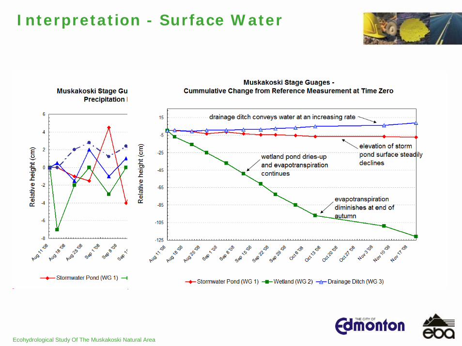
Interpretation - Surface Water
• Rain gauges (geo-referenced) located in:– wetland– local control 3 kms from study site
• Stage gauges (geo-referenced) located in:– wetland– storm water pond– drainage ditch.
Ecohydrological Study Of The Muskakoski Natural Area
Interpretation - Surface Water

Ecohydrological Study Of The Muskakoski Natural Area
Interpretation - Groundwater Horizontal Gradients
• Piezometric elevations in peat organics and siltyclay mineral soil interpolated to give horizontal groundwater gradients
• From these horizontal gradients interpreted:– peat groundwater direction is north and east– mineral soil groundwater direction is east and
south.

Ecohydrological Study Of The Muskakoski Natural Area
Interpretation - Groundwater Horizontal Gradients

Ecohydrological Study Of The Muskakoski Natural Area
Interpretation - Groundwater Horizontal Gradients

Ecohydrological Study Of The Muskakoski Natural Area
Interpretation - Groundwater Vertical Gradients
• From dual-level wells (peat and upper mineral soil) vertical gradients derived from piezometricelevations
• From these vertical gradients interpreted:– downwards (-ve) gradients north of wetland
indicating this is a recharge area– upwards (+ve) gradients across most of wetland
and area south indicating a discharge area.

Ecohydrological Study Of The Muskakoski Natural Area
Interpretation - Groundwater Vertical Gradients
negative gradients
negative gradients
positive gradients
positive gradients

Ecohydrological Study Of The Muskakoski Natural Area
Interpretation - Historical Water Balance

Ecohydrological Study Of The Muskakoski Natural Area
Summary
• Observed and determined that:– peat organics saturated thickness ranges from
0.5 to 2.5 m, with 1.5 m mean, so far– wetland surface went dry mid-September,
suggesting insufficient water inputs– some correlation between drainage ditch water
and wetland (ditch is dewatering wetland?) – slow decline of storm pond (evaporation only),
no water management transfers out, potential to dewater the south-east.
Ecohydrological Study Of The Muskakoski Natural Area
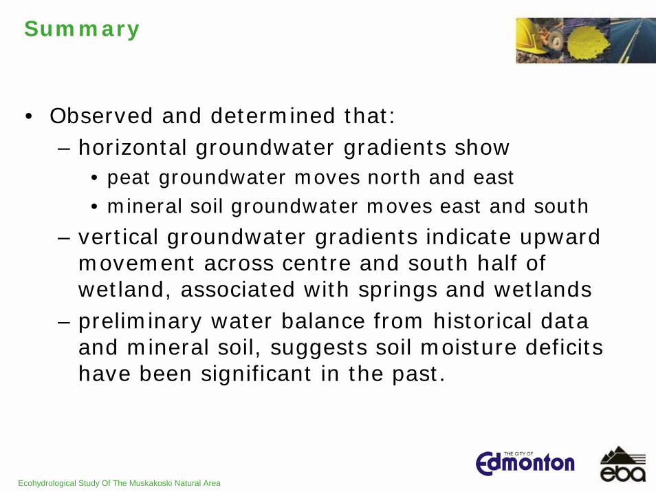
Summary
• Observed and determined that:– horizontal groundwater gradients show
• peat groundwater moves north and east• mineral soil groundwater moves east and south
– vertical groundwater gradients indicate upward movement across centre and south half of wetland, associated with springs and wetlands
– preliminary water balance from historical data and mineral soil, suggests soil moisture deficits have been significant in the past.
Ecohydrological Study Of The Muskakoski Natural Area
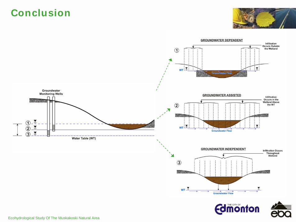
Conclusion
Ecohydrological Study Of The Muskakoski Natural Area
Conclusion
• Next steps include:– quantifying water storage volumes in peat
organics– monitoring surface water for natural and any
water management changes, including TOD construction dewatering
– continuing groundwater monitoring to define directions
– permeability testing (peat and silt clay) for groundwater travel time assessment
– wetland water balance July 2008 to June 2009– identifying if water deficit/surplus can be
mitigated by integration with TOD.
Ecohydrological Study Of The Muskakoski Natural Area
Thank You
Ecohydrological Study Of The Muskakoski Natural Area