East West route and Leatham Molesworth route guide
9
0B Introduction The East West route links the Clarence (Kahutara River in Ka Whata Tu o Rakihouia) Conservation Park with the Sedgemere Lakes area in the Molesworth Recreation Reserve. This route guide also describes the Leatham Molesworth route, which is a loop trip from Bottom Gordon Hut in the Leatham Conservation Area. These two unmarked routes are suitable for trampers who have a high degree of off-track experience and fitness. Trampers should allow at least 5-6 days to complete the East West route and 4-5 days to complete the Leatham Molesworth route. N.B: The 'true left' is the left bank of a river when looking downstream, and likewise, the ‘true right’ is the right bank of a river when looking downstream. 1BU East West route 2B How to get there The main access into the Clarence is over Blind Saddle Road. From Kaikoura, follow State Highway 1 (SH1) south 5 km to the Waiau/Mount Lyford turn-off and head inland to the car park at the Kahutara River bridge, 25 km from Kaikoura. There is a locked gate, restricting horse and vehicle access. Contact the Department of Conservation South Marlborough Area Office in Renwick for information on horse and vehicle access to the Clarence. 3B Walking the route Kahutara car park to Forbes Hut 9–10 hr (27 km) Follow the signposted 4WD track over Blind Saddle for 18 km to Warden Hut (standard hut, 12 bunks). It is a further 9 km via Seymour/Herring Stream to Forbes Hut (standard hut, 10 bunks). Forbes Hut to Lake McRae Hut 7–8 hr (15.5 km) From the Forbes Hut walk approximately 2 km upstream along the Clarence riverbed to a small unnamed stream (1631460E-5325794N) on the true left of the Clarence River. You may need to cross the river several times. When crossing the Clarence River care should be taken do not attempt in flood or high river flows. Head in a northerly direction up the true right of the unnamed stream. Watch carefully for a blazed trail through the briar (the trail is marked but can be is easily missed). East West route and Leatham Molesworth route (route guide) Molesworth Recreation Reserve
Transcript of East West route and Leatham Molesworth route guide

0BIntroduction The East West route links the Clarence (Kahutara River in Ka Whata Tu o Rakihouia) Conservation Park with the Sedgemere Lakes area in the Molesworth Recreation Reserve. This route guide also describes the Leatham Molesworth route, which is a loop trip from Bottom Gordon Hut in the Leatham Conservation Area. These two unmarked routes are suitable for trampers who have a high degree of off-track experience and fitness. Trampers should allow at least 5-6 days to complete the East West route and 4-5 days to complete the Leatham Molesworth route. N.B: The 'true left' is the left bank of a river when looking downstream, and likewise, the ‘true right’ is the right bank of a river when looking downstream.
1BUEast West route 2BHow to get there The main access into the Clarence is over Blind Saddle Road. From Kaikoura, follow State Highway 1 (SH1) south 5 km to the Waiau/Mount Lyford turn-off and head inland to the car park at the Kahutara River bridge, 25 km from Kaikoura. There is a locked gate, restricting horse and vehicle access. Contact the Department of Conservation South Marlborough Area Office in Renwick for information on horse and vehicle access to the Clarence.
3BWalking the route Kahutara car park to Forbes Hut 9–10 hr (27 km)
Follow the signposted 4WD track over Blind Saddle for 18 km to Warden Hut (standard hut, 12 bunks). It is a further 9 km via Seymour/Herring Stream to Forbes Hut (standard hut, 10 bunks).
Forbes Hut to Lake McRae Hut 7–8 hr (15.5 km) From the Forbes Hut walk approximately 2 km upstream along the Clarence riverbed to a small unnamed stream (1631460E-5325794N) on the true left of the Clarence River. You may need to cross the river several times. When crossing the Clarence River care should be taken do not attempt in flood or high river flows. Head in a northerly direction up the true right of the unnamed stream. Watch carefully for a blazed trail through the briar (the trail is marked but can be is easily missed).
East West route and Leatham Molesworth route (route guide) Molesworth Recreation Reserve


The trail opens out and continues upstream to a clear easy saddle. From the saddle continue north following a small stream down. Turn west into the main stream, following it down to the Elliott Stream. You can take advantage of the well worn stock trails and follow them down to the Elliott Stream Junction. Follow the Elliott Stream in an upstream direction through the willows and grassy clearings. The route is reasonably easy going, but has some muddy patches and fallen trees to negotiate. Follow the stock trails to the Elliott Bivvy, situated at 1631536E–5329078N by a side creek up an old bulldozer trail, 3 hr from the Forbes Hut. The Elliott Bivvy is in a stand of large poplars and elms. From the Elliott Bivvy return to the Elliott Stream, travelling upstream to the head of the Elliott Stream following the most practical route and utilising the stream bed and stock trails. At the headwaters, pick up the old bulldozer track; follow it over the rise to a view of Lake McRae. Walk along the northern edge of the lake, this is easy travelling when the lake level is low but could be hard travelling when the water level are high. From the northwest corner of the lake follow the old bulldozer track down a short distance to the Lake McRae Hut (standard hut, 6 bunks).
Lake McRae Hut to Molesworth Cob Cottage campground 6–7 hr (22 km) From Lake McRae Hut follow the old bulldozer track down the true right of the Tweed River for approximately 1.6 km then turn west and head up the true right of the side stream to a well-defined side spur. Climb the spur and follow a reasonably well-defined sidle westwards under high point marked 1193 m and the through to a saddle on the ridge. Follow this ridge up west north west for approximately 1 km, and then sidle through to an unnamed saddle. From here, sidle around under high point 1502 m to Robinson Saddle. From Robinson Saddle head north west down through the tussock and patches of scree on the true left of Robinson Creek. It is approximately 20 minutes to the creek bed from Robinson Saddle. Following Robinson Creek down it is easy going, staying mostly in the creek bed with some stock trails that you can follow on both sides of the creek. There is also an old bulldozer track that comes up the creek a fair way and this can be followed where it still exists. Once down in the lower reaches of the creek the bulldozer track can be followed on the true left out to the road where Robinson Creek meets the Awatere River. From there, follow the 4WD track downstream past the confluence of the Awatere River and Yeo Streams to where the 4WD track meets the main Molesworth Road. Turn right and follow the Molesworth Road for 700 m to the Molesworth Cob Cottage.
Molesworth Cob Cottage campground to Saxton Hut 5–6 hr (19 km) From the cob cottage head north down the Awatere Valley Road towards Blenheim for 800 m. Turn left onto the obvious 4WD vehicle track that follows the willow-lined Molesworth Stream. This track crosses the stream several times and gradually ascends to Saxton Pass, about 1 hr 30 min away. Keep following the vehicle track as it descends through Guide Gully to the Acheron River turn down stream to the Molesworth Road and the Acheron River Bridge. It takes about 1 hr from Saxton Pass to the Acheron River Bridge.
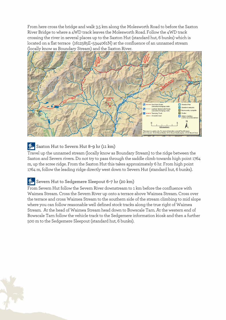
From here cross the bridge and walk 3.5 km along the Molesworth Road to before the Saxton River Bridge to where a 4WD track leaves the Molesworth Road. Follow the 4WD track crossing the river in several places up to the Saxton Hut (standard hut, 6 bunks) which is located on a flat terrace (1612585E–5344061N) at the confluence of an unnamed stream (locally know as Boundary Stream) and the Saxton River.
Saxton Hut to Severn Hut 8–9 hr (11 km)
Travel up the unnamed stream (locally know as Boundary Stream) to the ridge between the Saxton and Severn rivers. Do not try to pass through the saddle climb towards high point 1764 m, up the scree ridge. From the Saxton Hut this takes approximately 6 hr. From high point 1764 m, follow the leading ridge directly west down to Severn Hut (standard hut, 6 bunks).
Severn Hut to Sedgemere Sleepout 6–7 hr (20 km) From Severn Hut follow the Severn River downstream to 1 km before the confluence with Waimea Stream. Cross the Severn River up onto a terrace above Waimea Stream. Cross over the terrace and cross Waimea Stream to the southern side of the stream climbing to mid slope where you can follow reasonable well defined stock tracks along the true right of Waimea Stream. At the head of Waimea Stream head down to Bowscale Tarn. At the western end of Bowscale Tarn follow the vehicle track to the Sedgemere information kiosk and then a further 500 m to the Sedgemere Sleepout (standard hut, 6 bunks).

Photo: Lake McRae
4BULeatham Molesworth route 5BHow to get there Access to the start of this loop route is via Leatham Road, which is approximately 70 km from Blenheim on SH63 heading towards St Arnaud, and Bottom Gordon Hut (standard hut, 6 bunks) is located at the end of the Leatham 4WD road (38 km from SH 63).
6BWalking the route Bottom Gordon Hut to Top Leatham Hut 4 hr (7.4 km)
Follow an obvious old bull dozer track from Bottom Gordon Hut along the true left of the Leatham River. For the first 4 km the track criss-crosses the river to take advantage of some large, well terraced river flats. There are occasional slips to cross along the way, but the old bull dozer track is easily followed and mostly close to the river. At approximately the 4km mark the track drops down to a tributary on the true left Flat Stream. Cross the Leatham River here and follow the track through the pines. After approximately 1 km the track enters beech forest onto an undulating tramping track. After another kilometre cross the main river again and continue on the true left side and arrive at Top Leatham Hut (standard hut, 6 bunks). This track is marked with orange track markers.
Top Leatham Hut to Severn Hut 6–7 hr (13.6 km) The track starts directly behind the Top Leatham Hut. Follow the track markers to gradually climb 300 m to a creek confluence, about 1 hr away. Cross to an orange track marker on the true left and head up the spur into the beech forest. A steep 1 hr, 200 m climb up a visible track leads onto a tussock spur. Follow the poled route up a further 100 m to the open tussock and scree and across to the Severn Saddle (1500 m), which offers beautiful views down the Leatham valley on a clear day. There are no markers from the Severn Saddle heading into Severn Valley and Molesworth Recreation Reserve. Once at the Severn Saddle head down into the Severn River on the true left using the scree to sidle and drop. A descending sidle for at least 750 m will pass an 18 m waterfall; use height wisely, take care not to sidle too fast, and stay on the true left. Cattle graze the open river flats of Molesworth Station; there are good

cattle tracks to follow about 100 m away from the river on the true left—this also keeps you out of the odd swamp. Continue 8 km down the true left of the Severn River to the near new Severn Hut (standard hut, 6 bunks).
Severn Hut to Saxton Hut 8–9hr (11 km) Take the spur east of the hut on the true right of the creek to the high point marked 1764 m (1604617E–5342762N). It is a steep climb of about 2 hr 30 min. Once on top, head down the scree to the main unnamed stream (locally know as Boundary Stream). Follow the stream down to the confluence where it meets the Saxton River, this takes approximately 6 hr. The Saxton Hut (standard hut, 6 bunks) is situated on a river terrace at this confluence on the true right of the Saxton River.

Saxton Hut to Top Gordon Hut 7–9 hr (18.5 km)
Access to the Saxton River catchment has been negotiated between DOC, Landcorp and Muller Station. A DOC recreation permit is required for all access above the Saxton Hut from the 1st January to the 30th April each year. A condition of this access is that visitors only travel upstream to avoid moving stock out of the valley. From the 1st of May to the 31st December no permit is required for walking access. From the Saxton Hut head up the Saxton River at times you will have to cross the river and you will also have to negotiate a small gorge. At the 5 km mark you will pass the Team Hut (not for public accommodation). This hut is used by Molesworth and Muller staff and is situated on the true right. From the Team Hut the route is easy travelling along the Saxton River, using the stock trails. There are occasional briar plants and slips or tributary creeks (Oyster Creek) to negotiate, but the degree of difficulty is minimal. After about 4–5 hr the foot of the Saxton Saddle is reached—a rounded hill compared to the surrounding country. At 1617060E–5355247N head up the hill to Saxton Saddle, an approximately 1 hr climb. There is a DOC sign at the top of the saddle but no track markers. Sidle down Gordon Stream on the true left following the stream. There are track markers on the true left of Gordon Stream, follow these down into the beech forest; the route to the hut is well marked and signposted. Top Gordon Hut (standard hut, 6 bunks) is located on a sunny terrace on the true right of Gordon Stream.
Top Gordon Hut to Bottom Gordon Hut 3 hr (5.5 km) From the hut cross Gordon Stream and follow the sign and the marked track on the true left of Gordon Stream. Follow the track through beech forest for approximately 1 km where the track meets Gordon Stream. At this point the track is in the stream bed for a short time. Watch for the big orange marker on the true left, to climb back up into the beech forest and then undulates along a well formed track for 1.5 km to extensive river flats. Continue on the marked track through manuka and beech forest. After 1 km the track crosses to the true right of Gordon Stream and meanders comfortably along for another 1 km to another crossing. From here the track continues on the true left for the final section along some flats and across a swing bridge back to Bottom Gordon Hut.
7BFor your safety The East West route and Leatham Molesworth route are suitable for trampers who have high level of back country experience including navigation and map reading skills. Major sections of these routes are unmarked and follow natural features such as streams, rivers and ridges. Trampers will need to carry and know how to use a topographic map. The relevant 1:50,000 Topo50 maps are: BT26 Mount Clear, BS25 Severn, BS26 Mount Muller, BS27 Tapuae-o-Uenuku, BT27 Kaikoura, BT25 Mount Northampton.

Trampers should be well equipped, fit and self-sufficient. Poor visibility due to mist on the tops can make route finding and orientation difficult. The terrain is often rough. Rain and flooded streams can alter your plans and freezing conditions can occur at any time of year. We recommend that you leave your intentions with a friend or relative before you start your trip – remember to notify them when you have completed your trip. There is also a website Hwww.adventuresmart.org.nzH where outdoor intentions can be logged. We also advise you to carry a GPS and an emergency beacon (hire outlets are listed on Hwww.beacons.org.nzH). Remember: Your safety is your responsibility. To report any safety hazards in the outdoors call DOC HOTline 0800 362 468.
8BPlease remember To stay in the huts: Backcountry Hut Tickets or a Backcountry Pass entitles you to stay in DOC huts. Tickeks or a pass can be purchased at a DOC office and most i-SITEs. Get your tickets or pass before you start your trip. The huts described in this publication are:
• Standard: 1 Backcountry Hut Ticket per night.
Water: It is recommended you boil, filter, or treat drinking water collected in this area. UHazards: Wasps are a known hazard and are particularly common from December until April. Carry antihistamine if you are allergic to their stings. Avalanches occur in winter. Hunting and fishing: Each hunter must carry a hunting permit; each angler must carry a fishing licence. Environmental care: Minimise your impact on the environment by using a portable cooker. Use only dead wood in fireplaces at huts. There are no rubbish facilities in the backcountry. Carry out your own rubbish.
9BFor further information For more information about the East West route and Leatham Molesworth route contact: Department of Conservation South Marlborough Area Office Gee Street Renwick 7204 Ph: (03) 572 9100 Fax: (03) 572 8824 Email: [email protected]

Above: Matt Flynn above Severn Valley
Above:Severn Hut
Above: Saxton Hut Below: Lake McRae Hut