East and West Hanney Neighbourhood Plans. Evidence – A ...
13
Page | 1 East and West Hanney Neighbourhood Plans. Evidence – A strategic gap to prevent Coalescence (joining) of East and West Hanney. 12 February 2016 1 Neighourhood plan issue Should there be a policy to prevent coalescence (joining) of the villages of East Hanney and West Hanney? 2 Existing Parish Boundary The two villages are in separate parish’s called East Hanney and West Hanney. The boundary is shown in the map in figure 1 as a blue line. 3 Administrative boundaries 3.1 Parish Parishes existed for centuries as loosely defined groupings of manors, hamlets and other residences. Ancient parishes are often defined as ones which existed prior to the 1597 and 1601 Elizabethan Poor Law Acts.
Transcript of East and West Hanney Neighbourhood Plans. Evidence – A ...

Page | 1
East and West Hanney Neighbourhood Plans.
Evidence – A strategic gap to prevent Coalescence (joining) of East and West
Hanney.
12 February 2016
1 Neighourhood plan issue Should there be a policy to prevent coalescence (joining) of the villages of East Hanney and West
Hanney?
2 Existing Parish Boundary The two villages are in separate parish’s called East Hanney and West Hanney. The boundary is
shown in the map in figure 1 as a blue line.
3 Administrative boundaries
3.1 Parish Parishes existed for centuries as loosely defined groupings of manors, hamlets and other residences.
Ancient parishes are often defined as ones which existed prior to the 1597 and 1601 Elizabethan
Poor Law Acts.

Page | 2
Parishes were exclusively ecclesiastical until the 1866 Act defined the concept of civil parishes.
Civil parishes in their modern sense were established afresh in 1894 by the local Government Act.
The combination of the civil parishes of East Hanney and West Hanney make up the area of the
ecclesiastical parish of Hanney.
3.2 Ward The wards in the United Kingdom are electoral districts at sub-national level represented by one or
more councillors. The ward is the primary unit of English electoral geography for district councils.
3.3 County In 1974 the county boundary was moved and East and West Hanney changed from Berkshire to
Oxfordshire.
4 Village History Although a mere mile apart, East and West Hanney have always been physically very different
villages with few common historical bonds.
Even now, walking along the footpath beside the road between the two one gains a clear feeling
that these are two different settlements (which they are), separated by a clear expanse of distinctive
Vale. The distant Berkshire Downs rise to the south, while on the north side of the road you gain a
clear view of the Corallian ridge that runs beside the Thames valley between Faringdon and Oxford.
This is an ancient landscape, and we hope to increase our knowledge of the age of our settlements
by the use of archeology in the coming months.
The first written evidence of East Hanney lies in the Saxon boundary charters of 956AD and 968AD,
in which the Royal House of Wessex gives land to Abingdon Abbey. The boundaries of this land grant
virtually follow the parish boundaries of East Hanney as far as the Letcombe Brook. West Hanney
boundaries are defined partly by a Charter for Lyford in 1032AD.
The origin of the Ancient Ecclesistical Parish of West Hanney cannot be dated, but the church in
West Hanney, originally dedicated to St Mary, was sufficiently endowed financially with a priest and
hide of land to be mentioned in the Doomsday Book. Apart from West Hanney, the parish included
the Township of East Hanney, the Chapelry of Lyford and the tithings of North Denchworth and
Philliberts or Poffley. The latter is the long strip of land which is bordered by Cow Lane on one side
and the Letcombe Brook on the other. This was the important Manor of Philberts which also had its
own chapel, first mentioned in 1260. Later the land was included in East Hanney .The site of this
ancient chapel is uncertain but there is strong reason to believe it is close to the present day
Poughley Farm.
East Hanney had its own church of St James the Less, built in 1862. East Hanney residents were
married and christened there but buried in West Hanney graveyard. The church was cared for by the
people of East Hanney, and village craftsmen provided much of the woodwork and ironwork.
West Hanney and East Hanney both have their own distinctive centres, reflecting their separate
manorial pasts. West Hanney has the Church (now dedicated to St James the Great), the Rectory, the
Manor House (Prior's Court) and a large village Green, now divided into three parts, which is home
to the part-medieval village Cross. The pub – The Plough – is on the other side of Church Street from
St James' Church.

Page | 3
West Hanney probably had three manors. The main one belonged to New College Oxford for more
than 500 years. Manorial influence lasted longer in West Hanney than in East Hanney, reflecting the
unchanging attitude of New College towards land management.
East Hanney still retains the indications of several village centres. There were at least five manors,
and it seems they were held by changing Lords of the Manor. Unlike in West Hanney, in East Hanney
land passed more regularly to small resident farmers.
East Hanney's complicated history is reflected in its Enclosure Map of 1806. The village unusually
belongs to two different Hundreds – Wantage and Ock. In the National Archives East Hanney is
recorded for things such as taxation under each hundred. These are 14th-17th century documents, so
they have not all survived but they too appear to indicate that parts of the village have moved over
time. It is a very different picture from that of West Hanney.
Once manor courts had begun to disappear as a means of regulating village business, village vestries
took over. East and West Hanney had separate local parish government which dealt, for example,
with the state of the roads, and also raised a poor rate. Each village had its by-laws for governing
management of animals with a village pound for strays. Parish Councils for each village were
established in 1894.
Organisations such as the School, Hanney War Memorial Hall (previously the Victory Hut),the
Recreation fields and Playground and the Community Shop are used by both villages. They are all
built on what was land given in the 19th century for allotments by the Bouverie Pusey family. The
land they gave was within the Manor of Philberts but this became part of East Hanney land. The land
was given for allotments for the poor of both villages.
For centuries the villages were served by many narrow tracks and lanes. It is likely that Cow Lane
which crosses the East Hanney/West Hanney road at the School was the main north/south
thoroughfare from which you turned off it to either East Hanney or West Hanney. When the
Turnpike Road – now the A338 – was formed in 1776 by straightening and improving existing routes
the focus of access to the villages changed. Cow Lane to the north of the School, which was called
Radmore Lane on the document of sale, was sold to the landowner, and that route north
disappeared.
Other major changes impacted more especially on East Hanney. The building of the Berkshire Canal
in 1810 and the GWR in 1840 introduced outsiders to the village and developed its commercial
aspect, so that it had at least four pubs and several shops and businesses. Local investors became
more involved in providing poor quality overcrowded accommodation for agricultural families, who
often moved around seeking work.
Water has always played a major part in both villages. East Hanney, however, had the Letcombe
Brook running through the village and its attendant mills brought various additional trades to the
village such as silk production at Dandridge's Mill during the Napoleonic Wars. The village also had a
carefully–planned water system to provide the cottagers with water at the dipping holes along the
village streets and fill the ponds. The water was removed from the Brook at the south end of the
village and returned to the Brook at the bottom of Ebb's Lane. Both villages do share the use of
raised causeways, which, especially in West Hanney, give additional distinctiveness.
5 Doomesday entries A hundred was an administrative division and was first recorded in the laws of King Edmund 1 (939-
946). Until the introduction of districts by the local government act 1894 hundreds was a widely
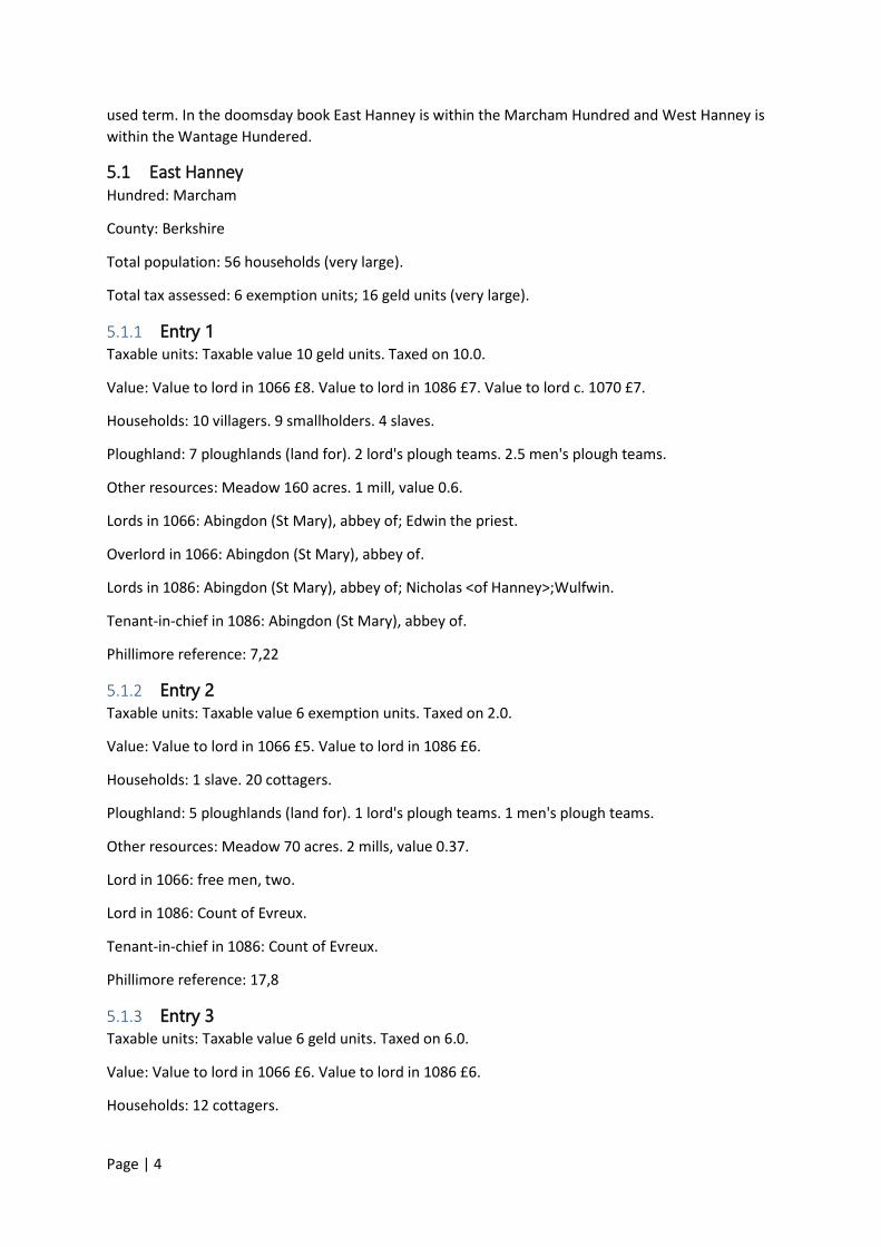
Page | 4
used term. In the doomsday book East Hanney is within the Marcham Hundred and West Hanney is
within the Wantage Hundered.
5.1 East Hanney Hundred: Marcham
County: Berkshire
Total population: 56 households (very large).
Total tax assessed: 6 exemption units; 16 geld units (very large).
5.1.1 Entry 1 Taxable units: Taxable value 10 geld units. Taxed on 10.0.
Value: Value to lord in 1066 £8. Value to lord in 1086 £7. Value to lord c. 1070 £7.
Households: 10 villagers. 9 smallholders. 4 slaves.
Ploughland: 7 ploughlands (land for). 2 lord's plough teams. 2.5 men's plough teams.
Other resources: Meadow 160 acres. 1 mill, value 0.6.
Lords in 1066: Abingdon (St Mary), abbey of; Edwin the priest.
Overlord in 1066: Abingdon (St Mary), abbey of.
Lords in 1086: Abingdon (St Mary), abbey of; Nicholas <of Hanney>;Wulfwin.
Tenant-in-chief in 1086: Abingdon (St Mary), abbey of.
Phillimore reference: 7,22
5.1.2 Entry 2 Taxable units: Taxable value 6 exemption units. Taxed on 2.0.
Value: Value to lord in 1066 £5. Value to lord in 1086 £6.
Households: 1 slave. 20 cottagers.
Ploughland: 5 ploughlands (land for). 1 lord's plough teams. 1 men's plough teams.
Other resources: Meadow 70 acres. 2 mills, value 0.37.
Lord in 1066: free men, two.
Lord in 1086: Count of Evreux.
Tenant-in-chief in 1086: Count of Evreux.
Phillimore reference: 17,8
5.1.3 Entry 3 Taxable units: Taxable value 6 geld units. Taxed on 6.0.
Value: Value to lord in 1066 £6. Value to lord in 1086 £6.
Households: 12 cottagers.

Page | 5
Ploughland: 3 ploughlands (land for). 2 lord's plough teams. 0.5 men's plough teams.
Other resources: Meadow 38 acres. 2 mills, value 1.5.
Lord in 1066: Godric.
Lord in 1086: Jocelyn.
Tenant-in-chief in 1086: Gilbert of Bretteville.
Phillimore reference: 36,2
5.2 West Hanney Hundred: Wantage
County: Berkshire
Total population: 37 households (very large).
Total tax assessed: 14 exemption units; 2 geld units (very large).
5.2.1 Entry 1 Taxable units: Taxable value 14 exemption units. Taxed on 7.0.
Value: Value to lord in 1066 £10. Value to lord in 1086 £14. Value to lord c. 1070 £8.
Households: 14 villagers. 4 slaves. 8 cottagers.
Ploughland: 8 ploughlands (land for). 2 lord's plough teams. 3 men's plough teams.
Other resources: 2 mills, value 1.0. 1 church.
Lord in 1066: Earl Tosti.
Lords in 1086: Turold the priest; Walter Giffard.
Tenant-in-chief in 1086: Walter Giffard.
Phillimore reference: 20,2
5.2.2 Entry 2 Taxable units: Taxable value 2 geld units. Taxed on 2.0.
Value: Value to lord in 1066 £2. Value to lord in 1086 £2.
Households: 11 cottagers.
Ploughland: 1 ploughland (land for).
Other resources: Meadow 24 acres.
Lord in 1066: Edwin, a free man.
Overlord in 1066: Edwin, a free man.
Lords in 1086: Osbern; Theodric.
Tenant-in-chief in 1086: Walter Giffard.
Phillimore reference: 20,1

Page | 6
6 Extract from A History of the County of Berkshire: Volume 4.
Originally published by Victoria County History, London, 1924. Hannei, Hanlei (xi cent.).
The parish of Hanney covers 4,300 acres in the Vale of the White Horse, and includes the townships
of West and East Hanney, the chapelry of Lyford, and part of the hamlet of North Denchworth, the
rest of which belongs to Denchworth parish.
The Enclosure Act of 1803 for East Hanney mentions a hamlet or tithing of Paufrey, which has
disappeared.
WEST HANNEY at the time of the Domesday Survey belonged to Walter Giffard, who had one estate
here in his own hands, while another was held of him by undertenants. Of these the former had
been held in the reign of Edward the Confessor by Earl Tosti. The second holding in West Hanney
was assessed in 1086 at 2 hides. It was held by two tenants, Osbern and Teodric, of Walter Giffard.
A part of EAST HANNEY, which in the 18th century had the alternative name of LONG HANNEY,
belonged from a very early date to the Abbots of Abingdon. In 956 King Edwy granted 20 hides at
Hanney to his kinsman Ælfric.
The second estate in East Hanney, which after the 16th century was known as PRIORS HANNEY,
belonged at the Domesday Survey to the Count of Evreux.
A third manor in EAST HANNEY had the alternative name of PHILIBERTS, from the family which held
it in the 14th century. It was assessed at 6 hides in the reign of Edward the Confessor, when it was
held by a freeman Godric. In 1086 it was in the hands of Gilbert de Breteville, and was held of him by
Gozelin. It had two mills and 38 acres of meadow

Page | 7
7 Old Maps
Enclosure Map of East Hanney 1806

Page | 8
Ordnance Survey Map 1888 – 1913
Ordnance Survey Map 1890-1920

Page | 9
Ordnance Survey Map 1937 - 1961
Ordnance Survey Map 1945-1947

Page | 10
Ordnance Survey Map 1955-1961
8 Conclusion The villages of East and West Hanney should be treated as separate villages for the following
reasons;
Historically they were in separate administrative Hundreds.
They have been treated as separate communities ever since the Doomsday book
They are in separate civil parishes
They have always been physically separated by open fields
Each village has its own sports fields
Each village has its own allotments
Each village used to have its own church. The church in East Hanney has now been
deconsecrated and is now a private dwelling.
9 Retention of identity To retain the separate identity of East and West Hanney and their setting within the surrounding
countryside a gap could be retained which would prevent coalescence between the two villages. This
gap would not be a green belt or a green corridor but would be the equivalent of a green wedge or
strategic gap. This strategic gap would be retained as open field to maintain the open countryside
setting. To maintain the visual appearance as a strategic gap it should be wide enough to give a
sense space and separation so a thin 20m boundary for example would not give this visual sense.
The aerial image bellows shows the gap between the two villages and the open countryside setting
of both villages.

Page | 11
10 UK Government Planning Portal definitions
10.1 Green Wedges Green Wedges comprise of open areas around and between parts of settlements, which maintain
the distinction between the countryside and built up areas, prevent the coalescence of adjacent
places. (Note some councils use the term strategic gaps)
10.2 Green corridors Green corridors can link housing areas to the national cycle network, town and city centres, places of
employment and community facilities. They help to promote environmentally sustainable forms of
transport such as walking and cycling within urban areas and can also act as vital linkages for wildlife
dispersal between wetlands and the countryside
10.3 Green Belt A designation for land around certain cities and large built-up areas, which aims to keep this land
permanently open or largely undeveloped. The purposes of the green belt is to:
check the unrestricted sprawl of large built up areas
prevent neighbouring towns from merging
safeguard the countryside from encroachment
preserve the setting and special character of historic towns
assist urban regeneration by encouraging the recycling of derelict and other urban land

Page | 12
Green Belts are defined in a local planning authority's development plan
11 Extract from www.planningresource.co.uk, 11 July 2014 An inspector has determined that a local plan policy adopted in 2006 which sought to prevent the
coalescence of settlements in Lincolnshire was not out of date and continued to serve a useful
planning purpose. In so concluding he dismissed an appeal for the erection of 74 dwellings on a four
hectare greenfield site.
12 Great Coxwell neighbourhood Plan The Great Coxwell Neighbourhood Plan has been passed the referendum and is now on proceeding
to adoption. The plan includes policy EDQ1 : Establish a green buffer to protect the village from
coalescence. This establishes that a Neighbourhood Plan that has a policy of creating green buffer to
prevent coalescence is an established principal.
13 Vale of White Horse District Council Policy NE10 IN THE URBAN FRINGES AND IMPORTANT OPEN GAPS BETWEEN SETTLEMENTS, AS SHOWN ON THE
PROPOSALS MAP, DEVELOPMENT OR CHANGES OF USE WHICH WOULD HARM THEIR ESSENTIALLY
OPEN OR RURAL CHARACTER WILL NOT BE PERMITTED.
14 Policy Proposal To prevent coalescence between East and West Hanney a strategic gap shall be retained which shall
not be built upon but retained as open fields. The size and location of this strategic gap shall be as
per the map below.

Page | 13
Figure 1 - Map of proposed strategic gap
Historic maps reproduced by kind permission of the National Library of Scotland and the National
Archive.
Strategic Gaps