Earthquake Triggered Landslides in...
17
Earthquake Triggered Landslides in California By Matt Drahnak
Transcript of Earthquake Triggered Landslides in...
Earthquake Triggered
Landslides in
California By Matt Drahnak
Table of Contents
Abstract 1
Introduction 1-3
Types of landslides 4-7
Geomorphology 8
Landslides triggered by earthquakes 8-10
Topographic relief 11-12
Landslide clustering 12-13
Conclusion 13-14
References 14-15
- 1 -
ABSTRACT
California’s geographic site and situation allow for landslides to occur much more often
than in other regions of the west. The state of California’s population is still growing
exponentially and large urban center such as Los Angeles are still expanding into the
mountainous regions nearby. Three factors will be analyzed to help better understand earthquake
induced landslides. First, geology including soil type, topography (degree of slope), and last, the
clustering of landslides. The case example to help analyze all of these factors will be the state of
California, and now this paper will now take an in -depth look at earthquake induced landslides
and how and why they occur.
INTRODUCTION
Known as mass movements, landslides can occur in many areas in the world and in all 50
states. Landslides cause billions in damage each year and as urban development moves into
mountainous regions, the threat of a landslide occurring increases. Landslides are secondary
disasters after earthquakes, heavy rainfall events, and wildfires. Landslides are caused when the
destabilizing forces acting on the earth of a hillside are greater than the stabilizing forces,
meaning that one force overrides the other. The term landslide encompasses the downward
lateral movement of earth materials due to gravity (Keefer, 1984). These earth materials consist
of rock and soil moving at very fast rates of speed. This soil can be broken down into fine
grained and coarse grained soils. These materials move downslope by falling, toppling, sliding,
spreading, or flowing (Girty, 2009). The volume of the material, length and width of the slide
and the speed of movement determine the magnitude of a landslide. (Goldberg, 2006).
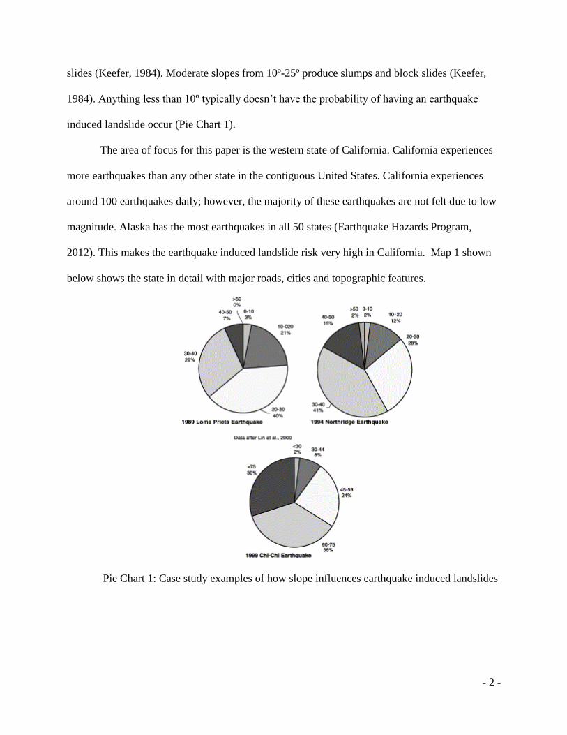
The degree of slope is what determines the type of landslide caused by earthquakes.
Steep slopes that are greater than 25º, most commonly fail by rock falls, rock slides, and debris
- 2 -
slides (Keefer, 1984). Moderate slopes from 10º-25º produce slumps and block slides (Keefer,
1984). Anything less than 10º typically doesn’t have the probability of having an earthquake
induced landslide occur (Pie Chart 1).
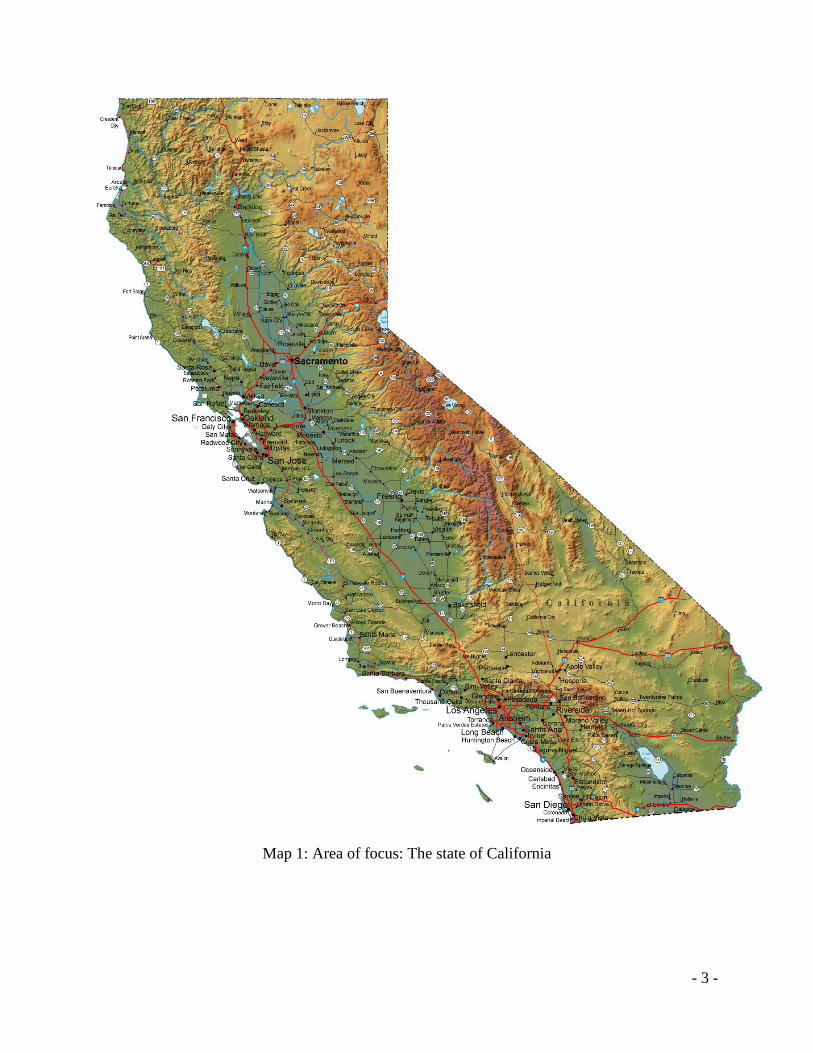
The area of focus for this paper is the western state of California. California experiences
more earthquakes than any other state in the contiguous United States. California experiences
around 100 earthquakes daily; however, the majority of these earthquakes are not felt due to low
magnitude. Alaska has the most earthquakes in all 50 states (Earthquake Hazards Program,
2012). This makes the earthquake induced landslide risk very high in California. Map 1 shown
below shows the state in detail with major roads, cities and topographic features.
Pie Chart 1: Case study examples of how slope influences earthquake induced landslides
- 3 -
Map 1: Area of focus: The state of California
- 4 -
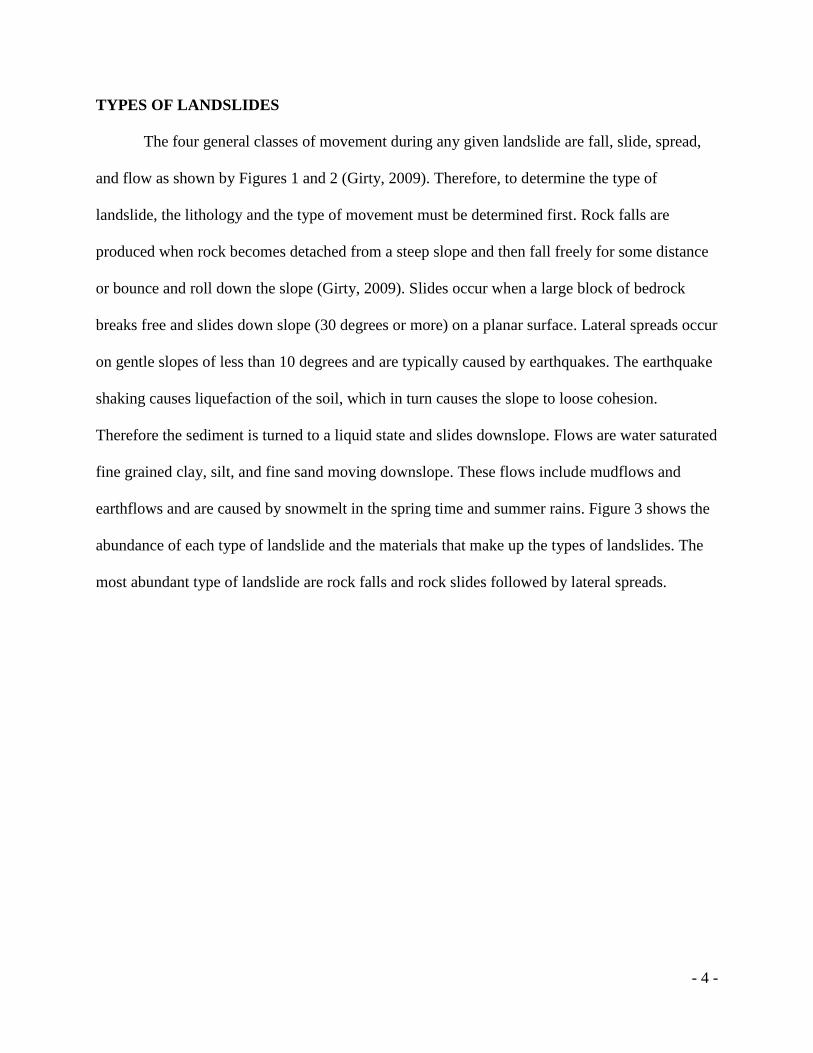
TYPES OF LANDSLIDES
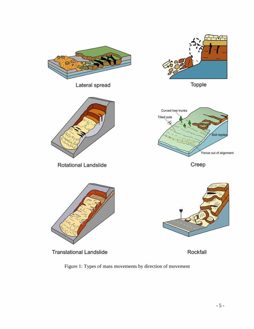
The four general classes of movement during any given landslide are fall, slide, spread,
and flow as shown by Figures 1 and 2 (Girty, 2009). Therefore, to determine the type of
landslide, the lithology and the type of movement must be determined first. Rock falls are
produced when rock becomes detached from a steep slope and then fall freely for some distance
or bounce and roll down the slope (Girty, 2009). Slides occur when a large block of bedrock
breaks free and slides down slope (30 degrees or more) on a planar surface. Lateral spreads occur
on gentle slopes of less than 10 degrees and are typically caused by earthquakes. The earthquake
shaking causes liquefaction of the soil, which in turn causes the slope to loose cohesion.
Therefore the sediment is turned to a liquid state and slides downslope. Flows are water saturated
fine grained clay, silt, and fine sand moving downslope. These flows include mudflows and
earthflows and are caused by snowmelt in the spring time and summer rains. Figure 3 shows the
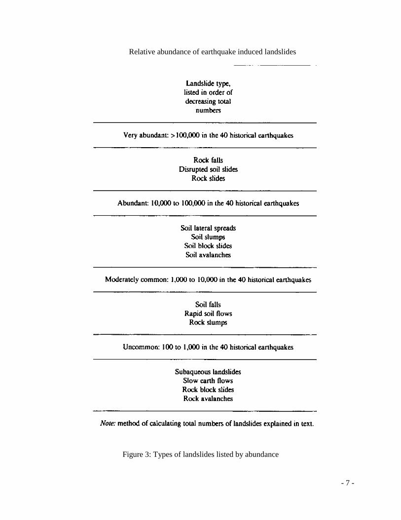
abundance of each type of landslide and the materials that make up the types of landslides. The
most abundant type of landslide are rock falls and rock slides followed by lateral spreads.
- 5 -
Figure 1: Types of mass movements by direction of movement
- 6 -
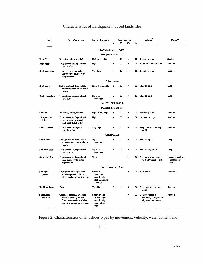
Characteristics of Earthquake induced landslides
Figure 2: Characteristics of landslides types by movement, velocity, water content and
depth
- 7 -
Relative abundance of earthquake induced landslides
Figure 3: Types of landslides listed by abundance
- 8 -
GEOMORPHOLOGY
The diverse geomorphology and complex geology of California was formed due to the
subduction of the Pacific and North American tectonic plates. This interaction between to the
two plates creates earthquakes thus creating landslides. The coastal mountain ranges along the
San Andreas Fault are one of the most susceptible geomorphic regions in the entire country due
to its geographic site. Additionally, the Sierra Nevada mountain range stretching from Northern
California to southern California, the transverse mountains ranges of southern California and the
southern Cascade ranges in Northern California are also susceptible. These provinces are most
susceptible because they are located on the North American plate boundary and on the San
Andreas strike slip fault boundary. The types of material most susceptible to earthquakes in the
state are weakly cemented rocks i.e. marine sedimentary rocks, volcanic soils containing clay,
and alluvial deposits (Keefer, 1984). These weakened rocks are underlain by soils that have been
weakened either by natural or human causes. Certain materials could have been weakened by
previous earthquakes in the region. Urban development of hillsides is one of the main causes that
allow soils to be weakened, thus being prone to earthquake induced landslides. California’s
Mediterranean climate also allows for there to be abundant precipitation in certain regions of the
state, where fault zones exist. Frequency and magnitude of earthquakes induced landslides are
influenced by slope and the geology of the region.
LANDLSIDES TRIGGERED BY EARTHQUAKES IN CALIFORNIA
Earthquakes are one of the main triggers that cause landslides. Earthquake induced
landslides have been documented from as early as 372 BC (Keefer, 1984) and have caused tens
of thousands of deaths and billions in economic losses (Keefer, 1984). Landslides have been a
product of 40 of 56 documented earthquakes in present times around the world (Keefer, 1984).
- 9 -
California experiences around 100 earthquakes daily; however, the majority of these earthquakes
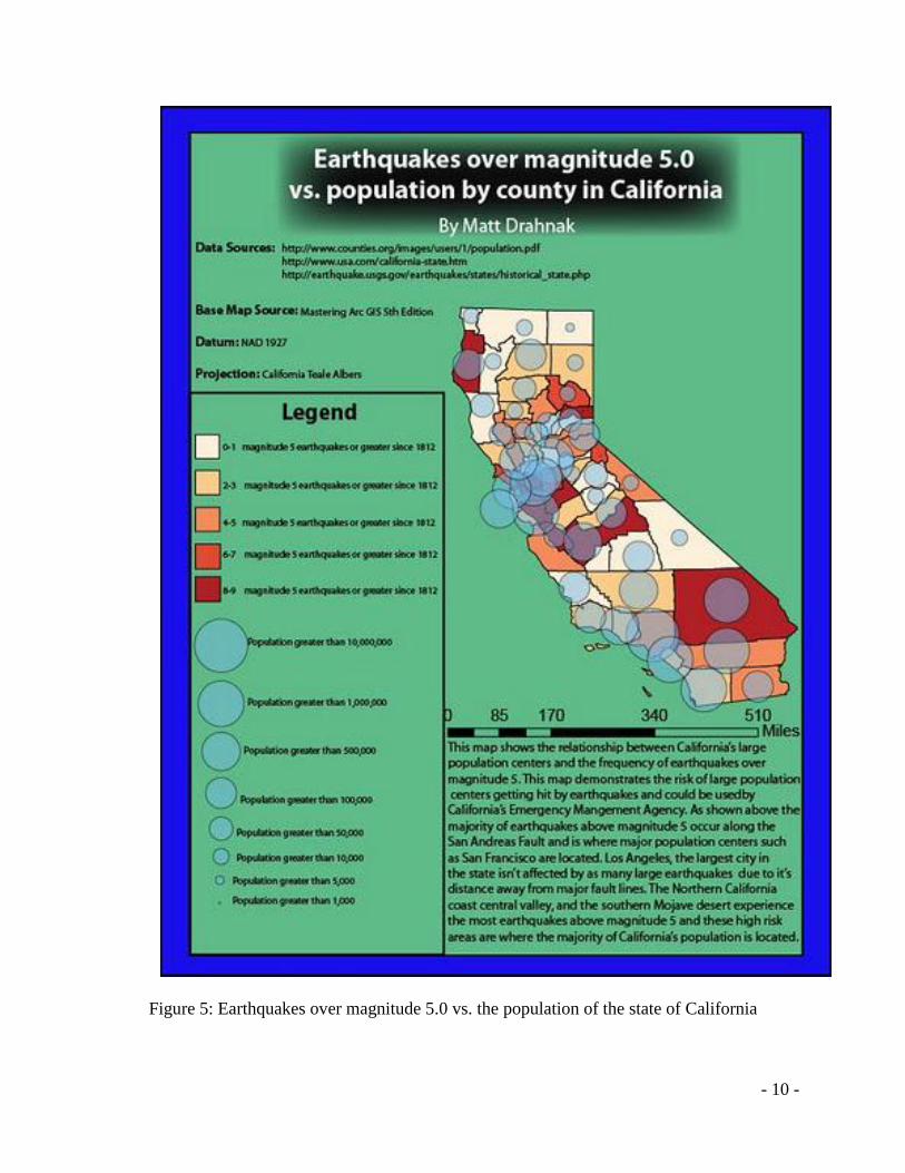
are not felt due to low magnitude. Figure 5 shows the distribution of these earthquakes over
magnitude 5.0 and how they relate to the population of California by county. Where landslides
occur is related to the location of the shaking or epicenter of these large earthquakes over
magnitude 5.0.
In California, large earthquakes such as San Francisco Earthquake caused the 1906
Devil’s Slide (cover image), 1971 San Fernando landslide, 1989 Loma Prieta landslide, and the
1994 Northridge landslide. These slides destroyed buildings and homes, blocked transportation
routes and injured hundreds of people (Slater et. al., 2002). California geographic site and
situation makes the state prone to earthquake induced landslides. The state is situated on
numerous fault lines including one of the most famous, the San Andreas Fault. Earthquake
induced landslides are the most prevalent in the transverse ranges (east-west oriented
mountains), and within the coastal ranges that stretch north and south throughout the state.
The map below (Figure 5) shows the relationship between California’s population and the
frequency of earthquakes over magnitude 5.0. This map demonstrates the risk of large population
centers getting hit by these earthquakes. This map shows that the majority of large earthquakes
are clustered along large faults such as the San Andreas Fault. By analyzing where these
earthquakes occur, scientists from the California Disaster Management Agency can have a better
understanding where landslides could occur too. The base map used to create this figure was
taken from the mastering ArcMap GIS 5th
edition. The datum used was the NAD 1927 and the
projection was California Teale Albers.
- 10 -
Figure 5: Earthquakes over magnitude 5.0 vs. the population of the state of California
- 11 -
TOPOGRAPHIC RELIEF
Topographic relief has an effect on the intensity of the waves propagating through the
ground. Seismic waves are made of primary, secondary, and surface waves. Surface waves are
the slowest type of wave but they cause landslides most often because they move particles in a
swaying motion. Waves are amplified due to topography as seismic waves enter the base of a
topographic ridge, are partially reflected back into the rock mass, and diffracted along the free
surface. Seismic waves are then focused upwards and the interference of their reflections and the
associated diffractions increases towards the ridge crest, giving rise to ground accelerations on
topographic high points (Meunier, et al., 2008). Landslides induced by the Northridge earthquake
are strongly clustered near ridge crests and 56% of the landslides caused by the earthquake were
on the tops of ridges (Meunier, et al., 2008).
The aspect (direction) of a slope also plays a role in where landslides occur when an
earthquake strikes. Mountain slopes facing away from the source of the earthquake are much
more prone to fail thus creating a landslide (Meunier, et al., 2008). Weathering and the direction
that the seismic waves hit the slope help induce failure. How slopes fail from seismic waves
hitting them is due to two factors. Seismic waves can cause loss of cohesion thus causing
liquefaction in softer soils such as clays and silts especially along thrusts faults on the hanging
wall of the fault block (Meunier, et al., 2008). The second cause for slope failure is from
gravitation acceleration of seismic waves. This is due to the topography, steeper slopes,
especially along ridgelines will cause seismic waves to travel faster. Additionally, the type of
bedrock and soil will also have a profound effect as waves travel differently through the type of
bedrock below the surface (Meunier et. al., 2008).
- 12 -
A case of where the topography and type of bedrock have affected seismic waves was the
Northridge earthquake in southern California in 1994. The earthquake occurred in the Santa
Susana Mountains; a transverse range located north of Los Angeles, and is composed of
sedimentary bedrock. Seventy-two people died as a result of the earthquake and many more
were injured (Godt, 2009). The earthquake occurred at a depth of about 19 km on a blind thrust
fault about 30 km northwest of Los Angeles and propagated northwest towards the ground
surface (Godt, 2009). The earthquake ended up triggering 11,000 landslides that day and caused
over 55 billion dollars in damage (Godt, 2009).
LANDSLIDE CLUSTERING
Another indicator that proves that earthquakes cause landslides is the clustering of
landslides. Landslide clustering occurs around earthquake epicenters on steep slopes. There was
a heavy amount of clustering of landslide activity during the Loma Prieta earthquake in 1989
(Keefer, 2000). Clustering of seismically-induced landslides is due to the property of the
landscape within which they occur. There are strong seismic patterns that indicate that clustering
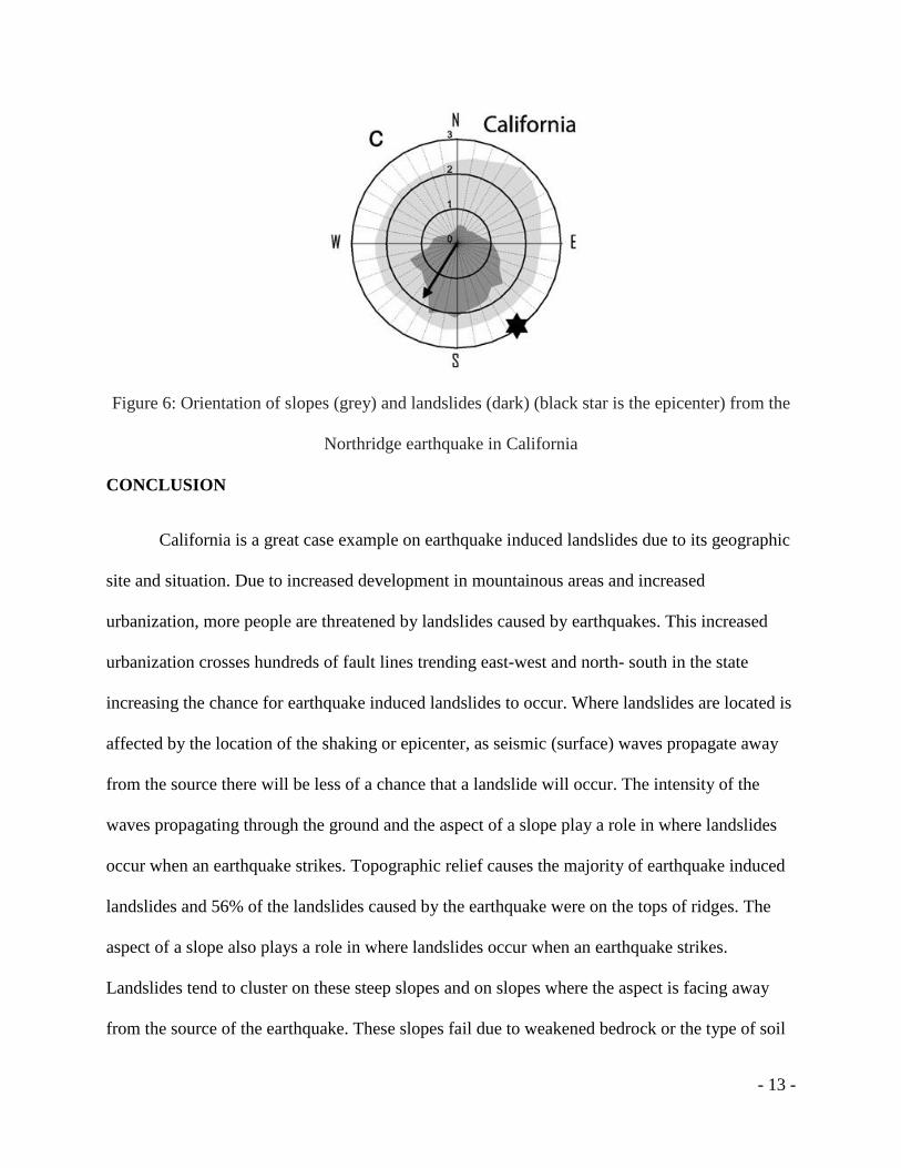
occurs on the tops of ridges (Meunier, et al., 2008). Figure 6 shows the orientation of slopes and
the orientation of landslides from the Northridge earthquake. The Northridge earthquake was due
to the south facing aspect of the ridge crest of the Santa Susana Mountains. The epicenter of the
earthquake was to the south as well which again proves that the propagation of seismic waves is
most intense on ridges (Meunier, et al., 2008).
- 13 -
Figure 6: Orientation of slopes (grey) and landslides (dark) (black star is the epicenter) from the
Northridge earthquake in California
CONCLUSION
California is a great case example on earthquake induced landslides due to its geographic
site and situation. Due to increased development in mountainous areas and increased
urbanization, more people are threatened by landslides caused by earthquakes. This increased
urbanization crosses hundreds of fault lines trending east-west and north- south in the state
increasing the chance for earthquake induced landslides to occur. Where landslides are located is
affected by the location of the shaking or epicenter, as seismic (surface) waves propagate away
from the source there will be less of a chance that a landslide will occur. The intensity of the
waves propagating through the ground and the aspect of a slope play a role in where landslides
occur when an earthquake strikes. Topographic relief causes the majority of earthquake induced
landslides and 56% of the landslides caused by the earthquake were on the tops of ridges. The
aspect of a slope also plays a role in where landslides occur when an earthquake strikes.
Landslides tend to cluster on these steep slopes and on slopes where the aspect is facing away
from the source of the earthquake. These slopes fail due to weakened bedrock or the type of soil
- 14 -
that is located on these ridges. Soils such as clay, silt and fine sand are the types of soils that are
most likely to fail. The state of California experiences all of these factors thus making it one of
the most earthquake induced landslide prone states in the country.
References
Girty, G.H., 2009, Landslides- Ch. 8. Perilous Earth: Understanding processes behind natural
disasters v. 1.0, p 1-17
Godt, J., Sener, B.,Verdin, K., Wald, D., Earle, P., Harp, E., Jibson, R., 2009, Rapid assessment
of earthquake- induced land sliding. p. 1-4
Goldberg, S., 2006, Falling into the Pacific: California landslides and land use controls. Review
of Law and Social Justice, v. 16.1, p. 1-67.
Idaho Geological Survey., 2008. Landslides:
http://www.idahogeology.org/DrawOnePage.asp?PageID=83 (December 9, 2012)
Keefer, D., 1984, Landslides caused by earthquakes, Geological society of America bulletin, v.
95, p. 406-421.
Keefer, D., 2000, Statistical analysis of an earthquake induced landslide distribution- the 1989
Loma Prieta, California event. Engineering Geology. v. 58, p. 231-249.
Kahzai, B., Sitar, N., 2004, Evaluation of factors controlling earthquake induced landslides
caused by the Chi-Chi earthquake and comparison with the Northridge and Loma Prieta events.
Department of Civil and Environmental Engineering. Engineering Geology. v. 71, p. 79-95.

- 15 -
Malamud, B, Turcotte, D., Guzzetti, F., Reichenbach, P., 2004, Landslides, earthquakes, and
erosion., Earth and Planetary Science Letters v. 229, p. 45-59
Muenier, P., Hovius, N., Haines, J., 2008,Topographic side effects and the location of earthquake
induced landslides., Earth and Planetary Science Letters v. 275, p. 221-232.
Slater, C., Wiegers, M., McCrink, T., 2002, Earthquake-Induced Landslide Zones in the
Cupertino 7.5-Minute Quadrangle, Santa Clara County, California., California Department of
Conservation California Geological Survey., p. 34-54.
USGS., November, 2012, Earthquake Hazards Program- Top Earthquake States:
http://earthquake.usgs.gov/earthquakes/states/top_states.php (December 10, 2012).