Earthquake-Induced Deep-Seated Landslide and Landscape ... Papers/Lo_70.00.pdf ·...
11
6 th International Conference on Earthquake Geotechnical Engineering 1-4 November 2015 Christchurch, New Zealand Earthquake-Induced Deep-Seated Landslide and Landscape Evolution Process at Hungtsaiping, Nantou County, Taiwan C. M. Lo 1 , W. K. Huang 2 , M.L. Lin 3 ABSTRACT The Chi-chi earthquake (magnitude of 7.6) on September 21, 1999 triggered numerous landslides in central Taiwan. A particularly large, deep-seated landslide event occurred at Hungtsaiping, 15 kilometers north of the epicenter. Field investigations and landscape evolution analysis revealed an irregular pattern of displacement vectors indicating that the failure mechanism was highly complex. This paper presents the results of site investigations in conjunction with simulation of landscape evolution associated with this landslide. Analysis of landscape evolution was based on topographic maps produced at seven different times as well as aerial photographs taken between 1966 and 2006. Landslide site investigation included field reconnaissance, geomorphologic analysis, geophysical exploration, borehole logs, and laboratory experiments. Comprehensive geologic investigation led us to conclude that the materials involved in the landslide are colluvial deposits. Landscape evolution involved at least three large landslide events, two previous rockslides ( the first triggered during the 1916 Nantou earthquake and another event occurring in 1934) as well as the 1999 colluvium slide (triggered during the Chi-chi earthquake). By taking into account the source of the collapsed mass, we were able to reproduce the three landslide events using a 3D discrete element model. Calibration of the parameters used in the numerical model was based on the strength characteristics of the rock mass as well as the morphology of the landslide deposits. Key Words: earthquake, deep-seated landslide, landscape evolution, discrete element model Introduction The Nantou earthquakes were a series of earthquakes which affected central Taiwan in 1916 and 1917, causing heavy damage and claiming 71 lives. The strongest quake registered at 6.8 ML and besides the loss of life caused widespread damage to agricultural and forestry industries in central Taiwan (Cheng and Yeh, 2001). The Chi-chi earthquake that struck Taiwan on September 21, 1999 (ML 7.3) triggered over 9,000 landslides in the mountains in the central region of the country, the most severe of which occurred in Chiufenerhshan, Tsaoling, Chiuchifeng, the Central Cross-Island Highway, the Dajia River, and the Da’an River (Liao, 2000). Township of Nantou county was the most seriously affected, where several fast and catastrophic landslides occurred, such as the Jiufengershan and the Tsaoling rockslide. On the other hand, a slow deep-seated landslide induced by the earthquake was noticed at Hungtsaiping in Nantou County (Lee et al., 2004; Wei and Lee, 2006). Deep-seated mass movements are not 1 Associate Professor, of Civil Engineering, Chienkuo Technology University, Changhua, Taiwan, [email protected] or [email protected] 2 Researcher, Disaster Prevention Technology Research Center, Sinotech Engineering Consultants, Inc., Taipei, Taiwan, [email protected] 3 Professor, Department of Civil Engineering, National Taiwan University, Taipei, Taiwan, [email protected]
Transcript of Earthquake-Induced Deep-Seated Landslide and Landscape ... Papers/Lo_70.00.pdf ·...

6th International Conference on Earthquake Geotechnical Engineering 1-4 November 2015 Christchurch, New Zealand
Earthquake-Induced Deep-Seated Landslide and Landscape Evolution
Process at Hungtsaiping, Nantou County, Taiwan
C. M. Lo 1, W. K. Huang 2, M.L. Lin3
ABSTRACT
The Chi-chi earthquake (magnitude of 7.6) on September 21, 1999 triggered numerous landslides in central Taiwan. A particularly large, deep-seated landslide event occurred at Hungtsaiping, 15 kilometers north of the epicenter. Field investigations and landscape evolution analysis revealed an irregular pattern of displacement vectors indicating that the failure mechanism was highly complex. This paper presents the results of site investigations in conjunction with simulation of landscape evolution associated with this landslide. Analysis of landscape evolution was based on topographic maps produced at seven different times as well as aerial photographs taken between 1966 and 2006. Landslide site investigation included field reconnaissance, geomorphologic analysis, geophysical exploration, borehole logs, and laboratory experiments. Comprehensive geologic investigation led us to conclude that the materials involved in the landslide are colluvial deposits. Landscape evolution involved at least three large landslide events, two previous rockslides ( the first triggered during the 1916 Nantou earthquake and another event occurring in 1934) as well as the 1999 colluvium slide (triggered during the Chi-chi earthquake). By taking into account the source of the collapsed mass, we were able to reproduce the three landslide events using a 3D discrete element model. Calibration of the parameters used in the numerical model was based on the strength characteristics of the rock mass as well as the morphology of the landslide deposits.
Key Words: earthquake, deep-seated landslide, landscape evolution, discrete element model
Introduction The Nantou earthquakes were a series of earthquakes which affected central Taiwan in 1916 and 1917, causing heavy damage and claiming 71 lives. The strongest quake registered at 6.8 ML and besides the loss of life caused widespread damage to agricultural and forestry industries in central Taiwan (Cheng and Yeh, 2001). The Chi-chi earthquake that struck Taiwan on September 21, 1999 (ML 7.3) triggered over 9,000 landslides in the mountains in the central region of the country, the most severe of which occurred in Chiufenerhshan, Tsaoling, Chiuchifeng, the Central Cross-Island Highway, the Dajia River, and the Da’an River (Liao, 2000). Township of Nantou county was the most seriously affected, where several fast and catastrophic landslides occurred, such as the Jiufengershan and the Tsaoling rockslide. On the other hand, a slow deep-seated landslide induced by the earthquake was noticed at Hungtsaiping in Nantou County (Lee et al., 2004; Wei and Lee, 2006). Deep-seated mass movements are not 1 Associate Professor, of Civil Engineering, Chienkuo Technology University, Changhua, Taiwan, [email protected] or [email protected] 2Researcher, Disaster Prevention Technology Research Center, Sinotech Engineering Consultants, Inc., Taipei, Taiwan, [email protected] 3Professor, Department of Civil Engineering, National Taiwan University, Taipei, Taiwan, [email protected]

well understood due to their large scale of deformation, limited applicability and the cost of ground surveys. However, several large gravitational failures cases have been described that highlight the landslide kinematics is important (Chang et al., 2005; Dong et al., 2009; Lo et al., 2011). The complex topographical evolution resulting from the large-scale landslide at Hungtsaiping required numerical simulations to aid in explanation. Describing the various changes that occur during landslide events could help to gain understanding into the complex mechanisms underlying landslides, assist in planning treatment projects, and facilitate predictions related to the future evolution of the site (Dong et al., 2009). Discrete element method has been widely applied in the simulation of landslides (Chang et al., 2005; Tang et al., 2009; Lo et al., 2011; Lo et al., 2014). Chang (2011) used a 2D discrete element model to reproduce the Hungtsaiping landslide caused by the Chi-chi earthquake. However, complex geology and structures, such as the distribution of anticlines and synclines, regulate the direction of landslide movement, such that using a 3D approach to reproduce this landslide is a more reasonable approach.
Summary of the above conclusions, we examined the history and topographical evolution at Hungtsaiping using topographic maps from various time periods to deal with the unique geological structures and complex kinematic mechanisms of this large-scale, deep-seated landslide. The use of PFC3D made it possible to recreate the landslides that occurred at Hungtsaiping in 1916 and 1999 in order to examine the landslide processes and mechanisms in detail. The primary objectives of this study are as follows:
(a) Investigating topographical changes and landslide mechanisms at Hungtsaiping over the last century;
(b) The application of 3-D discrete element method for the re-creation of earthquake-induced landslides at Hungtsaiping in 1916 and 1999.
Terrain of the Hungtsaiping Landslide
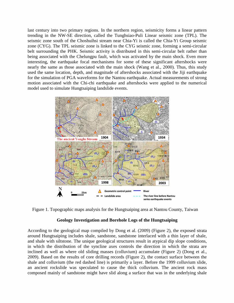
The evidence of the geomorphic features provided the activity of past landslides and potential unstable zones. Furthermore, topographic maps show the size, shape, and depiction of the landslide area. The orthographic topographic maps, at scales of 1:20000, 1:25000 and 1:50000 released in 1904, 1934, 1998, 2003 respectively, were used to interpret geomorphic features of landslide (Figure1). The Yonglu Stream played a crucial role in the study area. The Nantou series of earthquake events (1916-1917) caused the first landslide between 1904 to 1934. The sliding mass deflected the Yonglu Stream toward northwest. This event caused the toe of sliding mass III to daylight and that’s instability provided the conditions of the dip slope failure after 1934. Chi-chi earthquake caused sliding mass I and III slip displacements of about 28 meters in 1999 (Lee et al., 2004).
The Relationship of Past Seismicity and Nantou & Chi-Chi Earthquake of the
Hungtsaiping Although earthquake records in Taiwan begin in the 20th century, complete information on seismic waves and velocities were not included until after 1950. The records before this year contain only the scale of the earthquake and the location of the epicenters, which makes later analysis more difficult. Wang et al. (2000) divided earthquake activity in Western Taiwan in the
last century into two primary regions. In the northern region, seismicity forms a linear pattern trending in the NW-SE direction, called the Tunghsiao-Puli Linear seismic zone (TPL). The seismic zone south of the Choshuihsi stream near Chia-Yi is called the Chia-Yi Group seismic zone (CYG). The TPL seismic zone is linked to the CYG seismic zone, forming a semi-circular belt surrounding the PHK. Seismic activity is distributed in this semi-circular belt rather than being associated with the Chelungpu fault, which was activated by the main shock. Even more interesting, the earthquake focal mechanisms for some of these significant aftershocks were nearly the same as those associated with the main shock (Wang et al., 2000). Thus, this study used the same location, depth, and magnitude of aftershocks associated with the Jiji earthquake for the simulation of PGA waveforms for the Nantou earthquake. Actual measurements of strong motion associated with the Chi-chi earthquake and aftershocks were applied to the numerical model used to simulate Hungtsaiping landslide events.
Figure 1. Topographic maps analysis for the Hungtsaiping area at Nantou County, Taiwan
Geology Investigation and Borehole Logs of the Hungtsaiping According to the geological map compiled by Dong et al. (2009) (Figure 2), the exposed strata around Hungtsaiping includes shale, sandstone, sandstone interlaced with a thin layer of shale, and shale with siltstone. The unique geological structures result in atypical dip slope conditions, in which the distribution of the syncline axes controls the direction in which the strata are inclined as well as where old sliding masses (colluvium) accumulate (Figure 2) (Dong et al., 2009). Based on the results of core drilling records (Figure 2), the contact surface between the shale and colluvium (the red dashed line) is primarily a layer. Before the 1999 colluvium slide, an ancient rockslide was speculated to cause the thick colluvium. The ancient rock mass composed mainly of sandstone might have slid along a surface that was in the underlying shale

under certain unstable conditions, such as those caused by raining or earthquake (Chang et al., 2011). Comprehensive results of the geology investigation and borehole logs survey and mapping of the underlain strata of Hungtsaiping landslide are shown in Figure 2. The numerical modeling reconstructed the past landslide process during earthquake events based on the geological map, which was helpful to explain the effect of geological characteristics on the kinematics of the Hungtsaiping landslide.
Figure 2. (a) The geological map of the landslide area; (b) Profile AA-AA’ and BB-BB’ across the slide directions with resistivity survey lines; (c) Cross-sections A-A’, B-B’, C-C’, and D-
D’ show the topography, geological structures and underlain strata (Dong et al., 2009)
Numerical Simulation Concept The PFC (Particle Flow Code) is based on the theory of Newton’s 2nd law and discrete element method (Cundall and Strack, 1979). It is used to model the movement of spherical particles as well as their interactions and current position. Calculations related to contact between particles or particles and walls are detected automatically. Particles can be bonded to form various shapes comprising various quantities of elements. Bonding strength between two particles is in the form of a contact bond or parallel bond. Contact bonds transfer only force, whereas parallel bonds comprise a set of virtual springs with effects in the vertical as well as tangential directions, resulting in the transfer of stress as well as moment. These bonds tend to fracture gradually when the mass is under stress or moving, resulting in a separation into mutually independent masses. Displacement distance is free from any limits within the allowable range of the program (Tang et al, 2009). The above-mentioned dynamic behavior is represented numerically using a time stepping algorithm in which the velocities and accelerations are assumed to be constant within each time step. The use of an explicit (as opposed to an implicit) numerical scheme makes it possible to simulate nonlinear interactions among a large number of particles without the need for a large amount of memory or an iterative computation method (Itasca, 2002). Thus, the time step plays a critical role throughout the simulation, with a considerable effect on calculations and the resulting system performance. This study compared landslide simulations with different time steps as they pertain to the length and width of the landslide zone. These results led to the selection of a time step parameter of 0.005 (sec/step).
3D Numerical Model of the Hungtsaiping Landslide
The Discrete Element Method does not limit the scale of separation and displacement behaviors of elements, and the movement process of the mass from fracture to separation can be fully simulated, so it is very applicable to the simulation of landslides (Poisel and Roth, 2004; Poisel et al., 2005). Hence this paper used PFC3D to simulate and interpret the kinematic process of the Hungtsaiping landslide of three events. The elements of PFC model mainly include particles and walls, the sliding surface of the collapse area in the Hungtsaiping landslide model was constructed by 87,000 wall elements based on a 15×15m DEM from the mapping of underlain strata and geologic structure. An attempt to reconstruct the geological structure sliding surface before the 1904 Nantou series earthquake events is shown in Figure 3a. The total length from east to west was 3,765 m; the total width from south to north was 2,625m. The sliding mass of the Hungtsaiping landslide was constructed using 10,500 ball elements with a radius of 7.5 meters and divided into three blocks (Figure 3b, 4a); the total volume was about 33 million cubic meters (Figure 3 and Figure 4).
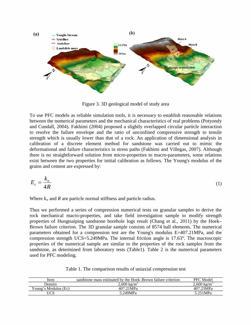
Figure 3. 3D geological model of study area
To use PFC models as reliable simulation tools, it is necessary to establish reasonable relations between the numerical parameters and the mechanical characteristics of real problems (Potyondy and Cundall, 2004). Fakhimi (2004) proposed a slightly overlapped circular particle interaction to resolve the failure envelope and the ratio of unconfined compressive strength to tensile strength which is usually lower than that of a rock. An application of dimensional analysis in calibration of a discrete element method for sandstone was carried out to mimic the deformational and failure characteristics in stress paths (Fakhimi and Villegas, 2007). Although there is no straightforward solution from micro-properties to macro-parameters, some relations exist between the two properties for initial calibration as follows. The Young's modulus of the grains and cement are expressed by:
RkE n
c 4= (1)
Where kn and R are particle normal stiffness and particle radius.
Thus we performed a series of compression numerical tests on granular samples to derive the rock mechanical macro-properties, and take field investigation sample to modify strength properties of Hungtsaiping sandstone borehole logs result (Chang et al., 2011) by the Hoek–Brown failure criterion. The 3D granular sample consists of 8574 ball elements. The numerical parameters obtained for a compression test are the Young's modulus E=407.21MPa, and the compression strength UCS=5.249MPa. The internal friction angle is 17.63°. The macroscopic properties of the numerical sample are similar to the properties of the rock samples from the sandstone, as determined from laboratory tests (Table1). Table 2 is the numerical parameters used for PFC modeling.
Table 1. The comparison results of uniaxial compression test
Item sandstone mass estimated by the Hoek–Brown failure criterion PFC Model Density 2,600 kg/m3 2,600 kg/m3
Young’s Modulus (Ec) 407.21MPa 407.23MPa UCS 5.249MPa 5.251MPa
Table 2. The numerical parameters of PFC modeling
The compression test model The landslide model Particle density (kg/m3) 2,600 2,600
Range of particle radius (m) 0.075-0.1 7.5 Normal stiffness (kN/m) 1.42e8 1.22e10 Shear stiffness (kN/m) 0.56e8 0.61e10
Friction coefficient 0.5 0.3 Normal stiffness of parallel bonds (kN/m3) 2.39e9 2.71e7 Shear stiffness of parallel bonds (kN/m3) 1.19e9 1.35e7 Normal strength of parallel bonds (Mpa) 5.2 5.2 Shear strength of parallel bonds (MPa) 2.6 2.6
The numerical models of Hungtsaiping landslide were reconstructed into three landslide events that explain as follows:
1. 1916 Nantou earthquake: The Nantou series of earthquake events caused the first rockslide at 1916, which possibly caused the massive sandstone exposed at the southeast of the slide area, where the current sandstone appears as scarps and steep slopes (mass A, B, and C). According to the simulation result, this triggered during the 1916 Nantou earthquake. In this case that gave the gravity to simulated landslide after earthquake events while the rock mass C movement, the mass B slide almost entirely collapsed, cause the thick colluviums that deflected the Yonglu Stream toward northwest (Figure 4b).
2. 1916-1917 Nantou earthquakes: During the Nantou series of earthquakes, the mass C moved northwest by ground motion, it undermined the support of masses A and B, thereby causing them to slide slightly to the northwest. (Figure 4c, d). Following the 1916-1917 Nantou earthquakes, the sliding masses temporarily stabilized; however, a significant quantity of unstable colluvial material still resided on the strata and syncline axis. This material eventually played a critical role in the Chi-chi earthquake.
3. Chi-chi earthquake event: Following the series of earthquakes in Nantou, the primary sliding masses at Hungtsaiping remained fairly stable for 82 years until the Chi-chi earthquake caused the old sliding masses to move once again. The main landslide involved the large colluvial deposit that had accumulated over the syncline axis. Small-scale movements in the large colluvial deposit occurred along the rock and soil interface, causing the ground surface to shift and deform. The strong motion records collected at the station TCU072 (Figure 5), which is 10 km away, is used for earthquake loading (Figure 4e). Using the ball elements of sliding mass to record sliding displacement, the maximum displacement is 25.6 m (Figure 6).

Figure 4. The numerical modeling of the Hungtsaiping landslide
Figure 5. Seismic records at TCU072
Figure 6(a). The monitoring location of numerical model

Figure 6(b). The results of the sliding mass displacement for each monitoring area
Discussion and Conclusions Discrete element numerical modeling of the three earthquake-caused landslides provided important physical constraints, which were compared with field observations. This led to adjustments in the reported characteristics of the events. Research into the series of earthquakes in Nantou, as well as studies on the Chi-chi earthquake (Lo et al., 2008; Chang et al., 2011; Lee et al., 1999) and earlier studies associated with those earthquakes provided abundant background information with which to investigate possible factors governing the kinematics of these large earthquake-induced landslides. A comparison of the simulation results related to the Chi-chi earthquake obtained using PFC3D with particle image velocimetry technology (PIV) (Lo et al., 2008) revealed that the boundaries and movement direction of colluvium were nearly a perfect match. We found evidence of a Syncline, i.e., M-symmetry minor folds of thin-bedded siltstone and sandstone layers within a massive shale (Tanliaoti Shale) outcrop on the river bank of Yonglu Stream, which appears to have played a crucial role in these events. Between 1904 to 1934, it played an important role in determining the direction of sliding (Fig.4b mass B and mass C) and deflected the direction of the Yonglu Stream toward the northwest. This exposed the toe of Sliding Mass A, which resulted in instability and eventual failure. The Chi-chi earthquake caused slip displacement in Sliding Masses A, B, and C of approximately 25.61 meters between 1998 and 2003. The conditions associated with phenomenon are worth discussing.
In the simulation, the areas surrounding ball IDs 2020 and 2037 presented large displacement of approximately 19.1 m. In comparison, the area surrounding ball IDs 7289 and 7756 on the lower slope had displacement of only 1.48 m. The conditions that led to such large differences in displacement may have caused deformations in the mass of the colluvium, resulting in the formation of tension cracks on the sliding surface.
In this study, discrete element method proved highly effective for the modeling of landslides with long runout, providing that the micro-parameters can be determined with a reasonable

degree of accuracy with regard to the mechanical behavior of the geo-materials on the slopes.
Acknowledgments The research is supported by the Ministry of Science and Technology of Taiwan, Grant no. MOST 103-2625-M-270-001 and MOST 104-2625-M-270-001.
References
Chang KJ, Taboada A, Chan YC. Geological and morphological study of the Jiufengershan landslide triggered by the Chi-Chi Taiwan earthquake. Geomorphology 2005; 71 (3-4):293-309.
Chang KT, Lai CC, Lin DG. Analyses of the Huntsaiping Landslide Induced by the Chichi Earthquake. Journal of Chinese Soil and Water Conservation 2008; 39 (3): 329-344 (in Chinese).
Chang KT, Lin ML, Dong JJ, Chien CH. The Hungtsaiping landslides: from ancient to recent. Landslides 2011; 1-10.
Cundall PA. A computer model for simulating progressive large scale movement in blocky rock systems. Proceedings of the Symposium of the International society of rock mechanics 1971; 1, Nancy, France, II-8.
Cundall PA, Strack OD. A discrete numerical model for granular assemblies. Geotechnique; 29: 47-65, 1979.
Dong JJ, Lee WR, Lin ML, Huang AB, Lee YL. Effects of seismic anisotropy and geological characteristics on the kinematics of the neighboring Jiufengershan and Hungtsaiping landslides during Chi-chi earthquake. Tectonophysics 2009; 466 (3-4):438-457.
Fakhimi A, Villegas T (2007) Application of dmensional anlysis in calibration of a discrete element model for rock deformation and fracture. Rock Mechanics and Rock Engineering; 40: 193-211.
Hoek, E., Carranza-Torres, C. and Corkum, B. Hoek-Brown Failure Criterion-2002 Edition. 5th North American Rock Mechanics Symposium and 17th Tunneling Association of Canada Conference 2002: 267-271.
Huang CY, Xia KY, Yuan PB, Chen PG. Structural evolution from Paleogene extension to Latest Miocene-Recent arc-continent collision offshore Taiwan. J. Asian Earth Sci 2001; 19: 619-639.
Itasca, Consulting Group Inc. PFC3D Particle Flow Code in 3 Dimensions. User's Guide. Minneapolis, 2002.
Lee JF, Wei CY, Huang CC. The study of Hungtsaiping landslide using digital photogrametric technique. Proceeding of International Symposium on Landslide and Debris Flow Hazard Assessment, 2004, Taiwan 2004; 5–1–5-9.
Lee Wang HK, Shin TC, Kuo KW, Chen KC, Wu CF. CWB free field strong-motion data from the 921 Chi-chi earthquake 1999: 1.
Liao HW. Landslides triggered by Chi-chi earthquake. Master's thesis, Institute of Geophysics, National Central University, 2000 (in Chinese).
Lo CM, Lin ML, Lee WC, Lee KC, Chien SY, Dong JJ, Chang KT, Huang AB. Landslide characterization and zonation of Hungtsaiping area based on topography, aerial photograph and PIV technology. The 3rd International Conference on Site Characterization, Taipei, Taiwan 2008; 467-472.
Lo, CM, Lin ML, Tang CL, Hu JC. A kinematic model of the Hsiaolin landslide calibrated to the morphology of the landslide deposit. Engineering Geology 2011; 123: 22-39.
Poisel R, Roth W. Runout models of rock slope failures. Felsbau 22: 46-50. Poisel R, Bednarik M, Holzer R, LIŠČÁK P (2005) Geomrchanics of Hazardous landslides. Journal of Mountain Science 2004; 2 (3): 211-217.
Potyondy D, Cundall P. A bonded-particle model for rock. International Journal of Rock Mechanics & Mining Sciences 2004; 41:1329-1364.
Steven N W, Simon D. Particulate kinematic simulations of debris avalanches: interpretation of deposits and

landslide seismic signals of Mount Saint Helens, 1980 May 18. International Journal of geophysics 2006; 167: 991-1004.
Tang CL, Hu JC, Lin ML, Angelier J, Lu CY, Chan YC, Chu HT. The Tsaoling landslide triggered by the Chi-chi earthquake, Taiwan: insights from a discrete element simulation. Engineering Geology 2009; 106:1–19.
Wang CY, Chang CH, Yen HY. An interpretation of the 1999 Chi-chi earthquake in Taiwan based on the thin-skinned thrust model. TAO 2000; 11: 609-630.
Wei CY, Lee JF, The application of digital aerial photography in the study of Hungtsaiping landslide, Chungliao, Nantou County. Bulletin of the Central Geological Survey 2006; 19: 39-59 (in Chinese).
Yoon J. Application of experimental design and optimization to PFC model calibration in uniaxial compression simulation. International Journal of Rock Mechanics & Mining Sciences 2007; 44:871-889.