Earth Science Regents Review #7ferrophysics.weebly.com/uploads/1/0/2/2/102257044/review_7.pdf · a)...
14
© K. Coder 2015 Earth Science Regents Review #7 Dynamic Crust Topics Reviewed: Earth’s Crust & Interior Plate Tectonics Plate Boundaries Volcanoes Tsunamis Earthquakes PLUS 25 Practice Regents Questions with Answers © Kaitlin Coder https://www.teacherspayteachers.com/Store/Nys-Earth-Science-And-Living-Environment-Regents
Transcript of Earth Science Regents Review #7ferrophysics.weebly.com/uploads/1/0/2/2/102257044/review_7.pdf · a)...

© K. Coder 2015
Earth Science Regents Review #7
Dynamic Crust
Topics Reviewed: Earth’s Crust & Interior
Plate Tectonics Plate Boundaries
Volcanoes Tsunamis
Earthquakes
PLUS 25 Practice Regents Questions with Answers
© Kaitlin Coder https://www.teacherspayteachers.com/Store/Nys-Earth-Science-And-Living-Environment-Regents

© K. Coder 2015
REGENT REVIEW #7 DYNAMIC CRUST
26) EARTH’S CRUST & INTERIOR (ESRT P 10)
a) Properties of Earth’s internal structure (crust, mantle, inner core, and outer core) can be inferred from the analysis of the behavior of seismic waves.
b) This analysis leads to the inference that Earth’s interior is composed of layers that differ in composition and states of matter.
27) PLATE TECTONICS
a) Evidence of plate tectonic
i) the fit of the continents;
ii) the rock, mineral and fossil correlation;
iii) evidence of ancient glaciers and tropical forests in areas with different current climates
iv) alignment of the North Pole with the magnetism of different ages of rock.
b) Plate boundaries
i) Convection currents in the mantle move the lithospheric plates.
(1) This creates 3 types of plate boundaries: convergent, divergent, and transform.
(2) Compared to continental crust, the ocean crust is thinner and denser. (ESRT p10)
(3) These plate boundaries are the sites of most earthquakes, volcanoes, and young mountain ranges.

© K. Coder 2015
c) Types of Plate Boundaries (ESRT p5)
i) Divergent: two plates move away from each other
(1) New ocean crust continues to form at mid-ocean ridges when magma rising from the ridge solidifies.
(2) Evidence of seafloor spreading:
(a) Pattern of magnetic polarity is a mirror image on either side of the ridge
(b) Age of oceanic crust increases as you move away from the mid-ocean ridge
ii) Convergent: two plates moving towards each other
(1) Common features: trenches, subduction zones, island arcs, mountain ranges (folded, faulted, and volcanic)

© K. Coder 2015
iii) Transform: one plate slides past another plate
(1) Causes shallow earthquakes
28) Geologic Hazards
a) Volcanoes: a vent through which molten magma erupts producing a mountain of the material
i) Hot spots: locations away from plate boundaries where volcanic activity occurs (example: Hawaii; Galapagos Islands)
b) Tsunamis: giant waves caused by undersea earthquakes which cause severe destruction to coastal areas
c) Earthquakes: vibrations or shaking of Earth’s crust caused by the rapid movement of rocks in the crust
i) Analysis of seismic waves allows the determination of the location of earthquake epicenters and the measurement of earthquake magnitude (ESRT p11)
ii) As seismic waves pass through different layers within Earth’s interior, they are refracted due to differences in density.
(1) Some areas on Earth surface only receive P-waves because S-waves cannot travel through the liquid outer core.
(2) Some areas on Earth’s surface will not receive any seismic waves because S-waves are absorbed by the liquid outer core and P-waves are refracted by the liquid outer core. This is the “shadow zone”.
d) Preparation: Earthquakes, tsunamis, and volcanoes present geologic hazards to humans. Loss of property, personal injury, and loss of life can be reduced by effective emergency preparedness.
© K. Coder 2015
REGENTS REVIEW #7 DYNAMIC CRUST PRACTICE REGENTS QUESTIONS 1. Compared to the oceanic crust, the continental crust is
(1) less dense and more basaltic (2) less dense and more felsic (3) more dense and more granitic (4) more dense and more mafic
2. Which landmass is moving northward with Australia as part of the same tectonic plate?
(1) India (2) Antarctica (3) North America (4) South America 3. Which New York State location has surface bedrock that has been subjected to very intense
regional metamorphism? (1) 41°00' N 72°15' W (3) 44°00' N 76°00' W (2) 42°30' N 75°00' W (4) 44°30' N 74°00' W
4. Earth’s internal heat is the primary source of energy that
(1) warms the lower troposphere (2) melts glacial ice at lower altitudes (3) moves the lithospheric plates (4) pollutes deep groundwater with radioactivity
5. The epicenter of an earthquake is located 6500 kilometers away from a seismic station. If the first
S-wave arrived at this seismic station at 1:30 p.m., at what time did the first P-wave arrive? (1) 1:20 p.m. (2) 1:22 p.m. (3) 1:38 p.m. (4) 1:40 p.m.
6. The arrival time of the first earthquake P-wave at a seismograph station was 10:11:20
(hours:minutes:seconds). If the epicenter of the earthquake is 8000 km away, what was the approximate arrival time of the first S-wave from this earthquake?
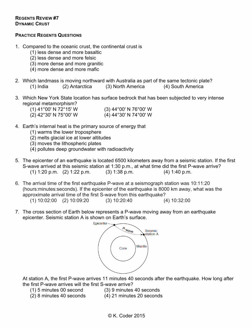
(1) 10:02:00 (2) 10:09:20 (3) 10:20:40 (4) 10:32:00 7. The cross section of Earth below represents a P-wave moving away from an earthquake
epicenter. Seismic station A is shown on Earth’s surface.
At station A, the first P-wave arrives 11 minutes 40 seconds after the earthquake. How long after the first P-wave arrives will the first S-wave arrive?
(1) 5 minutes 00 second (3) 9 minutes 40 seconds (2) 8 minutes 40 seconds (4) 21 minutes 20 seconds

© K. Coder 2015
8. The Aleutian Islands extend westward from southern Alaska to form the northern boundary of the Pacific Ocean. These volcanic islands were formed by the nearby
(1) subduction of a continental plate (2) subduction of an oceanic plate (3) divergence of a continental plate (4) divergence of an oceanic plate
9. The cross section below represents a pattern of magnetic field reversals preserved in the igneous bedrock of the oceanic crust east of the Mid-Atlantic ridge.
Which cross section best represents the magnetic field pattern west of the Mid-Atlantic ridge?
10. When the seafloor moves as a result of an underwater earthquake and a large tsunami develops,
what will most likely occur? (1) Deep-ocean sediments will be transported over great distances. (2) No destruction will occur near the origin of the earthquake. (3) The direction of the tsunami will be determined by the magnitude of the earthquake. (4) Severe destruction will occur in coastal areas.

© K. Coder 2015
11. The block diagram below, which shows a tectonic plate boundary.
Which tectonic plate boundary is best represented by this diagram? (1) Nazca Plate and Pacific Plate boundary (2) Scotia Plate and South American Plate boundary (3) Juan de Fuca Plate and North American Plate boundary (4) Antarctic Plate and Indian-Australian Plate boundary
12. The cross-sectional view of Earth below, which shows seismic waves traveling from the focus of
an earthquake. Points A and B are locations on Earth’s surface.
Which statement best explains why only one type of seismic wave was recorded at location B? (1) S-waves cannot travel through the liquid outer core. (2) S-waves cannot travel through the liquid inner core. (3) P-waves cannot travel through the solid outer core. (4) P-waves cannot travel through the solid inner core.
© K. Coder 2015
Base your answers to questions 13 through 14 on the passage below.
Crustal Activity at Mid-Ocean Ridges Mid-ocean ridges are found at one type of tectonic plate boundary. These ridges
consist of extensive underwater mountain ranges split by rift valleys. The rift valleys mark places where two crustal plates are pulling apart, widening the ocean basins, and allowing magma from the asthenosphere to move upward. In some cases, mid-ocean ridges have migrated toward nearby mantle hot spots. This explains why mid-ocean
ridges and mantle hot spots are found together at several locations.
13. Which type of tectonic plate boundary is located at mid-ocean ridges? (1) convergent (2) transform (3) divergent (4) complex
14. Which mantle hot spot is located closest to a mid-ocean ridge? (1) Canary Islands (2) Easter Island (3) Hawaii (4) Tasman
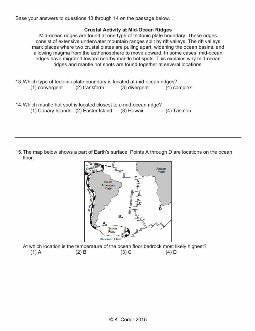
15. The map below shows a part of Earth’s surface. Points A through D are locations on the ocean
floor.
At which location is the temperature of the ocean floor bedrock most likely highest?
(1) A (2) B (3) C (4) D
© K. Coder 2015
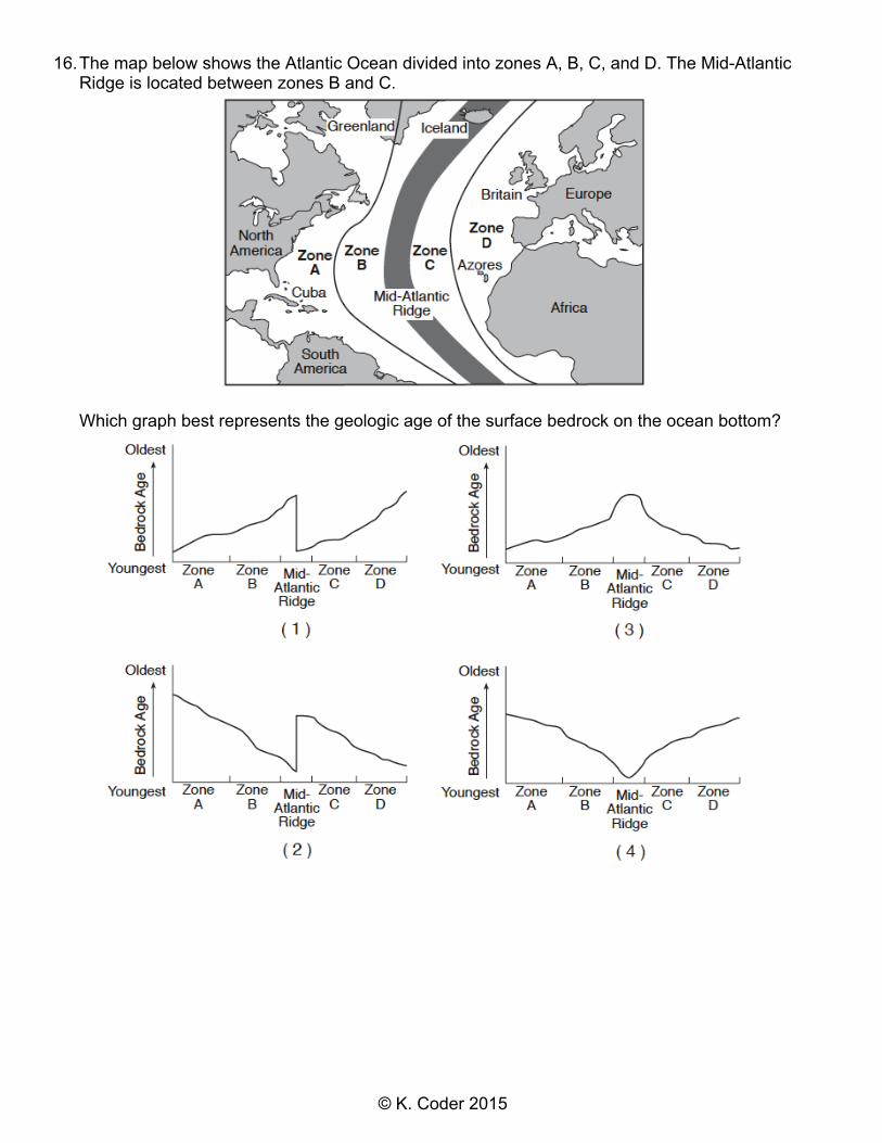
16. The map below shows the Atlantic Ocean divided into zones A, B, C, and D. The Mid-Atlantic Ridge is located between zones B and C.
Which graph best represents the geologic age of the surface bedrock on the ocean bottom?
© K. Coder 2015
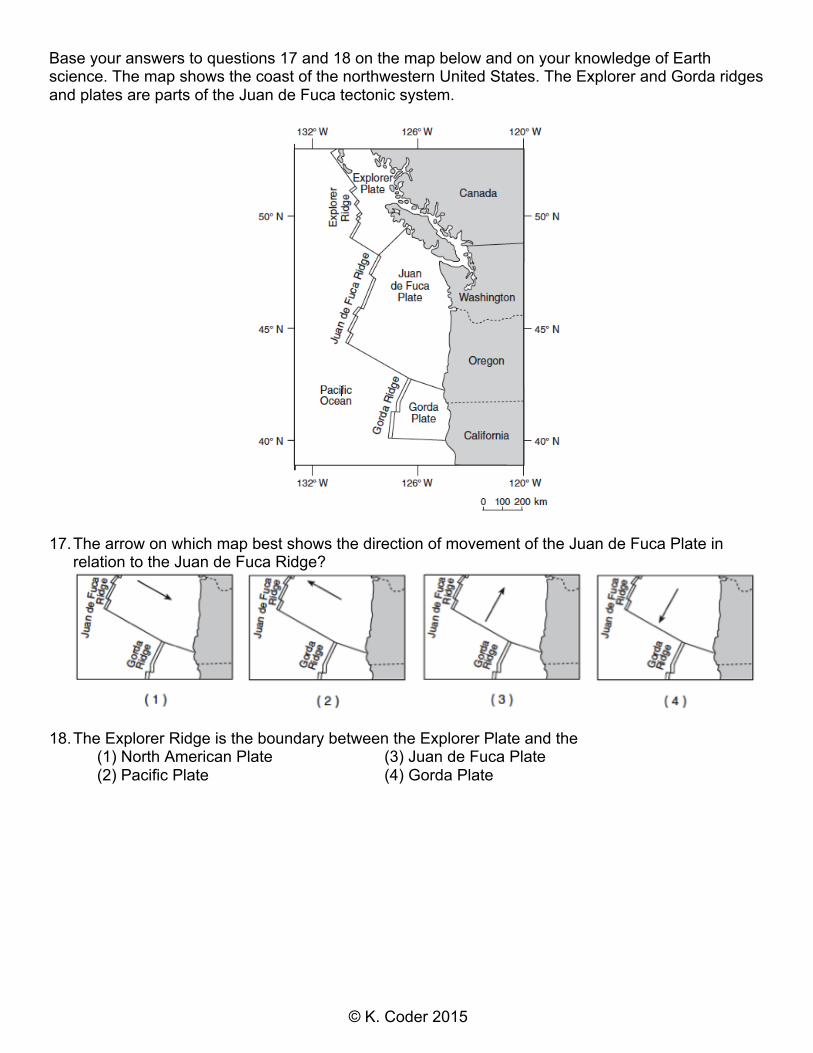
Base your answers to questions 17 and 18 on the map below and on your knowledge of Earth science. The map shows the coast of the northwestern United States. The Explorer and Gorda ridges and plates are parts of the Juan de Fuca tectonic system.
17. The arrow on which map best shows the direction of movement of the Juan de Fuca Plate in
relation to the Juan de Fuca Ridge?
18. The Explorer Ridge is the boundary between the Explorer Plate and the (1) North American Plate (3) Juan de Fuca Plate (2) Pacific Plate (4) Gorda Plate

© K. Coder 2015
Base your answers to questions 19 through 22 on the map below and on your knowledge of Earth science. The map shows the major islands in the Galapagos Island chain. These islands were formed by volcanic eruptions as the tectonic plate passed over the Galapagos Hot Spot. The age of the volcanic bedrock on certain islands is shown in millions of years (my).
19. Based on the age of the bedrock of the Galapagos Islands, in which direction does the tectonic
plate containing the islands appear to be moving away from the Galapagos Hot Spot? 20. The Galapagos Hot Spot is located closest to what type of tectonic plate boundary? 21. Describe what caused a vesicular texture in some of the volcanic rocks that formed when lava
cooled on these islands. 22. Some of the magma at the Galapagos Hot Spot is believed to originate 1000 kilometers below
Earth’s surface. What is the approximate temperature of Earth’s interior at that depth?

© K. Coder 2015
Base your answer to questions 23 through 25 on the information and map below. An earthquake occurred in the southwestern part of the United State. Mercalli-scale intensities were plotted for selected locations on a map, as shown below. (As the numerical value of Mercalli ratings increases, the damaging effects of the earthquake waves also increase.)
23. Using an interval of 2 Mercalli units and staring with an isoline representing 2 Mercalli units,
drawing an accurate isoline map of earthquake intensity. 24. State the name of the city that is closest to the earthquake epicenter. 25. Identify the most likely cause of earthquakes that occur in the area shown on the map.

© K. Coder 2015
REGENTS REVIEW #7 DYNAMIC CRUST PRACTICE REGENTS QUESTIONS – ANSWER KEY 1. 2 (See ESRT page 10 and ESRT page 6 – Igneous Rocks)
2. 1 (See ESRT page 5)
3. 4 (See ESRT page 3)
4. 3 (See Fact 27b)
5. 2 (See ESRT page 11)
6. 3 (See ESRT page 11)
7. 3 (See ESRT page 3)
8. 2 (See ESRT page 5)
9. 1 (See Fact 27c,i,2,a)
10. 4 (See Fact 28b)
11. 3 (See ESRT page 5)
12. 1 (See Fact 28c,ii,2)
13. 3 (See Reading and ESRT page 5)
14. 2 (See ESRT page 5)
15. 3 (See Fact 27c,i,1 and ESRT page 5)
16. 4 (See 27c,i,2,b)
17. 1 (See ESRT page 5)
18. 2 (See ESRT page 5)
19. Southeast
20. Divergent (See ESRT page 5)
21. Rapid cooling (See ESRT page 6 – Igneous Rocks)
22. 3100˚C (See ESRT page 10)

© K. Coder 2015
23. (See Fact 6b)
24. Pasadena (See Fact 28c,i)
25. Faulting (See Fact 27c,iii and ESRT page 5)