Earth Energy Lines and Indian Sacred Sites · Burial Mounds, Rock Cairns sites, Sacred Rock sites,...
9
1 Earth Energy Lines and Indian Sacred Sites Don & Diane Wells © 2017 INTRODUCTION Author Paul Devereux wrote a comprehensive paper in 1996 summarizing the knowledge base of “Ley Lines.” In his paper, he stated that Englishman Alfred Watkins in 1921 began his observational studies of what were later called “Ley Lines.” Devereux stated that, “Watkins saw that various prehistoric places, such as standing stones, earthen burial mounds, prehistoric earthwork hills, and other such features fell into straight lines for miles across the British countryside. Watkins spent many years studying such alignments on the ground and on maps. ” Watkins wrote books about the straight lines he was observing. His most important book The Old Straight Track was published in 1925. That book resulted in the formation of the Straight Track Club in which people all over Britain conducted field research looking for alignments of sites, and perhaps remnants of old straight tracks lying along them. Watkins research continued until 1935 when he died. Watkins named these “straight tracks” as Ley lines. The name is derived from the Anglo-Saxon word meaning “cleared strips of land.” Devereux pointed out that Watkins was not the first to observe these lines. He said that British, French, American and German researchers had observed similar phenomenon from at least the 18 th century. After Watkins death, research of the “ley lines” appeared to get off track with the New Agers focusing the research on alien influence and connections to flying saucers and UFO’s. It was not until the 1970’s that a group of researchers determined that these ley lines were composed of some type of earth energy and that they could be discovered using dowsing. Throughout the 1970’s and 1980’s, more researchers discovered these lines in Boliva, Peru (Nazca lines) and other locations around the world. In his 1996 paper, Devereux went on the point out that, “Archaeological evidence of the ancient practice of building spirit ways has survived best in the Americas. In Ohio, between 150 BC and 500 AD, the Hopewell Indians built geometrical earthworks covering many acres, along with straight linear features which seem to have been ceremonial roadways. In 1995, archaeologists announced the discovery of a 60-mile-long, dead straight Hopewell ritual road connecting earthworks at Newark with the Hopewell necropolis at Chillicothe.” More of these straight features were discovered in Utah, Colorado and Arizona. The most important of which was found in New Mexico at Chaco Canyon. There Chacoan roads stretch for 60 miles beyond the canyon, and possibly much further, linking Anasazi ceremonial "Great Houses", of which there are many dozens scattered throughout the desert area surrounding Chaco Canyon. A more recent effort regarding studying the ley lines was done by a group of researchers in Seattle, Washington. There, with a grant of $5,000, the group located the ley lines existing in the Seattle area and created a map of the lines. The map of these lines is shown on the next page.
Transcript of Earth Energy Lines and Indian Sacred Sites · Burial Mounds, Rock Cairns sites, Sacred Rock sites,...

1
Earth Energy Lines and Indian Sacred Sites Don & Diane Wells © 2017
INTRODUCTION
Author Paul Devereux wrote a comprehensive paper in 1996 summarizing the knowledge base of
“Ley Lines.” In his paper, he stated that Englishman Alfred Watkins in 1921 began his
observational studies of what were later called “Ley Lines.” Devereux stated that, “Watkins saw
that various prehistoric places, such as standing stones, earthen burial mounds, prehistoric
earthwork hills, and other such features fell into straight lines for miles across the British
countryside. Watkins spent many years studying such alignments on the ground and on maps.”
Watkins wrote books about the straight lines he was observing. His most important book The Old
Straight Track was published in 1925. That book resulted in the formation of the Straight Track
Club in which people all over Britain conducted field research looking for alignments of sites,
and perhaps remnants of old straight tracks lying along them.
Watkins research continued until 1935 when he died. Watkins named these “straight tracks” as
Ley lines. The name is derived from the Anglo-Saxon word meaning “cleared strips of land.”
Devereux pointed out that Watkins was not the first to observe these lines. He said that British,
French, American and German researchers had observed similar phenomenon from at least the
18th
century.
After Watkins death, research of the “ley lines” appeared to get off track with the New Agers
focusing the research on alien influence and connections to flying saucers and UFO’s. It was not
until the 1970’s that a group of researchers determined that these ley lines were composed of
some type of earth energy and that they could be discovered using dowsing. Throughout the
1970’s and 1980’s, more researchers discovered these lines in Boliva, Peru (Nazca lines) and
other locations around the world.
In his 1996 paper, Devereux went on the point out that, “Archaeological evidence of the ancient
practice of building spirit ways has survived best in the Americas. In Ohio, between 150 BC and
500 AD, the Hopewell Indians built geometrical earthworks covering many acres, along with
straight linear features which seem to have been ceremonial roadways. In 1995, archaeologists
announced the discovery of a 60-mile-long, dead straight Hopewell ritual road connecting
earthworks at Newark with the Hopewell necropolis at Chillicothe.” More of these straight
features were discovered in Utah, Colorado and Arizona. The most important of which was
found in New Mexico at Chaco Canyon. There Chacoan roads stretch for 60 miles beyond the
canyon, and possibly much further, linking Anasazi ceremonial "Great Houses", of which there
are many dozens scattered throughout the desert area surrounding Chaco Canyon.
A more recent effort regarding studying the ley lines was done by a group of researchers in
Seattle, Washington. There, with a grant of $5,000, the group located the ley lines existing in the
Seattle area and created a map of the lines. The map of these lines is shown on the next page.

2
Seattle Ley (Earth Energy) Lines
Source of Energy Lines
Some researchers considered
the ley (earth energy) lines to
be electromagnetic but more
recent studies by scientists
indicate that the earth’s heat
engine may be the cause of
the lines due to nuclear fission
of materials in the earth.
These materials when heated
to a molten state release their
radiation which travels
through the earth and may be
the source of more than half
the earth’s energy (Scientific
American report 2011).
In 2017, the Mountain
Stewards research teams
working to identify, locate
and document underground
streams of water under Indian
sacred sites, stumbled onto the
energy lines associated with
these same sites. The
underground water is located
using dowsing and the
dowsing rods react to the
water with the rods rotating
inwardly toward the
researcher to indicate the
water boundaries. While
researching these sites, it was
discovered that in some
locations the dowsing rods would rotate outwardly to form a 180 degree line. When the
researcher moved one more foot passed that location, the rods would rotate back to their normal
position of pointing in the direction of travel. After extensive research in the Pickens-Dawson
County area of GA and several other sites, these lines were determined to be Earth Energy Lines.
Initially, it was thought the lines were electromagnetic. A TriField 100 XE Electromagnetic
meter was purchased to measure the amount of energy of these lines. It was determined that even
in the lowest settings, no electromagnetic energy was measured. Upon further research, these
energy lines were determined to be nuclear and were caused by gamma radiation. A MAZUR
PRM-9000 Radiation meter was purchased which measures radiation to .001 millirems/hr. Using
this meter, the radiation levels of the energy lines were measured and found to be 0.016 to 0.017
millirems/hr and 0.02 to 0.022 millirems/hr at places where two or more lines junctioned. These

3
levels are very close to background radiation reading so they are difficult to measure. The meter
has to be held over the line for a short (5-10 minutes) period of time and an average reading
recorded due to the fluctuation of the gamma radiation.
SIMILAR CHARACTERISTICS OF INDIAN SACRED SITES
For over 20 years, David Johnson, has been helping indigenous peoples in Chile, Peru and Africa
located potable water for their communities using dowsing. In his efforts, he discovered that
some underground streams of water were directly under known sacred sites and it seemed that
some of these sites were linked with the underground streams. Since his initial findings, he has
also survey many indigenous sites in the United States and found similar results. David shared
his finding with the Mountain Stewards in 2015 and our research teams confirmed the same
findings. In two years of research in various locations in the US, the Mountain Stewards have
confirmed that there are underground streams of water under most if not all Indian Marker Trees,
Burial Mounds, Rock Cairns sites, Sacred Rock sites, Effigy Mound sites and other sacred sites.
Some of these sites are connected through multiple underground streams.
These findings appear to indicate that the indigenous people knew how to sense the location of
the underground water and placed their sacred sites directly over the stream. This seems to echo
what was occurring thousands of years ago in Stonehenge, with the Hopewell Indians and in
other sacred sites. The accumulation of all of these findings appears to indicate that there is a
spiritual connection between the underground water and the sacred sites. At present, we have
been unable to discuss this phenomenon with any tribal elders. We hope to remedy that soon so
that the elders will be to discuss with is if their ancestors had the ability to sense the underground
water in order to locate their sacred sites over it.
On August 13, 2015, Mexican experts using an electrical resistance survey technique discovered
that the main pyramid at Mexico's Mayan ruins of Chichen Itza was at least partially built atop a
subterranean river. Experts from Mexico's National Autonomous University say they found a
subterranean cavity about 20 meters (yards) deep below the pyramid of Kukulkan, also known as
El Castillo. Such underground rivers often connect the open "cenotes," or sinkhole lakes, that dot
Mexico's Yucatan peninsula. As more research is being conducted, it may result in finding
underground water under most if not all of the Indigenous sites worldwide.
ENERGY LINES AND SACRED SITES
Having discovered the underground water under many sacred sites, it was assumed that energy
lines might exist at these same sites. Not only were the lines found under sacred sites but it now
appears that these lines may connect several sacred sites just as the findings of Alfred Watkins
did almost one hundred years ago. Surveys are now underway to revisit as many sacred sites that
were previously documented as having water under them confirming them as possible sacred
sites. The new surveys will document the existence of energy lines if they exist. This effort will
determine if each sacred site not only has water under it but an energy line running through it as
well. Should that become a standard finding, then these two features surely have some spiritual
connection to Indigenous spiritual practices.
4
Rock Cairn site
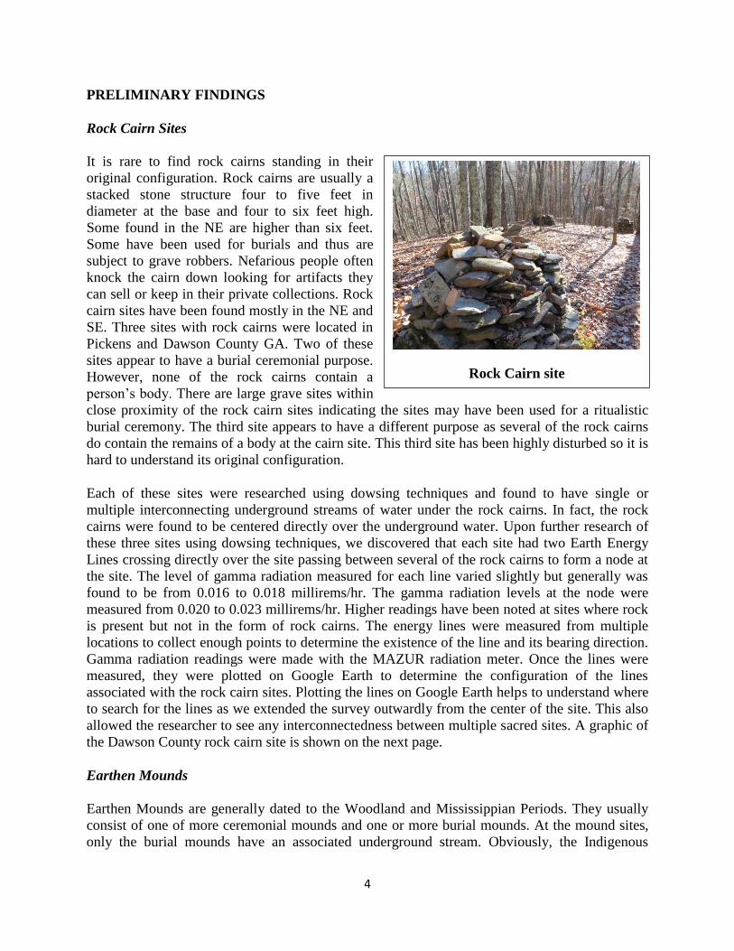
PRELIMINARY FINDINGS
Rock Cairn Sites
It is rare to find rock cairns standing in their
original configuration. Rock cairns are usually a
stacked stone structure four to five feet in
diameter at the base and four to six feet high.
Some found in the NE are higher than six feet.
Some have been used for burials and thus are
subject to grave robbers. Nefarious people often
knock the cairn down looking for artifacts they
can sell or keep in their private collections. Rock
cairn sites have been found mostly in the NE and
SE. Three sites with rock cairns were located in
Pickens and Dawson County GA. Two of these
sites appear to have a burial ceremonial purpose.
However, none of the rock cairns contain a
person’s body. There are large grave sites within
close proximity of the rock cairn sites indicating the sites may have been used for a ritualistic
burial ceremony. The third site appears to have a different purpose as several of the rock cairns
do contain the remains of a body at the cairn site. This third site has been highly disturbed so it is
hard to understand its original configuration.
Each of these sites were researched using dowsing techniques and found to have single or
multiple interconnecting underground streams of water under the rock cairns. In fact, the rock
cairns were found to be centered directly over the underground water. Upon further research of
these three sites using dowsing techniques, we discovered that each site had two Earth Energy
Lines crossing directly over the site passing between several of the rock cairns to form a node at
the site. The level of gamma radiation measured for each line varied slightly but generally was
found to be from 0.016 to 0.018 millirems/hr. The gamma radiation levels at the node were
measured from 0.020 to 0.023 millirems/hr. Higher readings have been noted at sites where rock
is present but not in the form of rock cairns. The energy lines were measured from multiple
locations to collect enough points to determine the existence of the line and its bearing direction.
Gamma radiation readings were made with the MAZUR radiation meter. Once the lines were
measured, they were plotted on Google Earth to determine the configuration of the lines
associated with the rock cairn sites. Plotting the lines on Google Earth helps to understand where
to search for the lines as we extended the survey outwardly from the center of the site. This also
allowed the researcher to see any interconnectedness between multiple sacred sites. A graphic of
the Dawson County rock cairn site is shown on the next page.
Earthen Mounds
Earthen Mounds are generally dated to the Woodland and Mississippian Periods. They usually
consist of one of more ceremonial mounds and one or more burial mounds. At the mound sites,
only the burial mounds have an associated underground stream. Obviously, the Indigenous

5
Dawson County GA Rock Cairn Site with 16 Cairns
people had to know that water existed at the Earthen Mound site and located the burial mound
over it. In the past few years, we have visited the Earthen Mounds in GA, AR and TN. In all
cases, water was found under the burial mounds in all three states. For this report, we have only
revisited the Earthen Mounds in GA but will return to the ones in other states as time permits.
Like the sacred rock cairn sites, the Earthen Mound sites have two or more Earth Energy Lines
located at the site. Although there is insufficient data to draw a conclusion about finding Earth
Energy Lines at every mound site, it is safe to say that most if not all sites have Earth Energy
Lines. Thus, it can be said that the Indigenous peoples must have sensed the existence of the
lines and placed their sacred mound sites to be coincident with the lines. Again, it is too early to
come to any specific conclusion but there appears to be some spiritual connection between
having the water and energy lines at these sites. More research will be done over the next few
years to learn more and elders will be consulted as to the spiritual nature of this phenomenon.
The three mound sites in GA that have been visited are Leake Mounds, Etowah Mounds and
Ocmulgee Mounds. All but the Leake Mounds still remain. The Leake Mound site unfortunately
was destroyed in 1940 by the GA Department of Transportation when they rerouted a highway.

6
Earth Energy Lines at Etowah and Leake Mound Sites in GA
The Leake Mound site was built before the Etowah Mounds. Both are within a mile of each
other.
Effigy Mounds
The majority of Effigy mounds are located in the North Central part of the US. Many of the
mounds found today are in Wisconsin; however there are two sites in GA – Rock Eagle and
Rock Hawk. Both of these sites are in Putnam County GA.
Archaeologists estimate it took as many as three years and the labor of hundreds of Indigenous
people to construct the bird-like structures at each mound. Considering there does not to be a
rock borrow area near either mound, the time frame for constructing the mounds may have been
longer than predicted. It seems odd that these two Effigy Mounds are found in GA when no
others have been found to date. Which Indigenous peoples built these sacred structures and their
purpose remains a mystery today. At least one grave was unearthed at the Rock Eagle site but it
may have been dated to a later time period than the mounds. Both of the Effigy Mounds were
previously researched and found to have an associated underground stream of water running
from the tail to the head of the bird-like figure.

7
Energy Lines at Rock Eagle Effigy Mound
Two Earth Energy Lines were measured at the Rock Eagle site. Only one Earth Energy Line was
measured at the Rock Hawk site. The gamma radiation levels of the lines at these sites were
higher than other sites measuring from 0.018 to 0.019 millirems/hr. A Google Earth graphic of
the energy lines at the Rock Eagle site are shown above.
Sacred Rock Structures
Many sacred sites have a specific rock or piles of rocks as the principal feature of the site. In the
SE, Judaculla Rock near Cullowhee, NC and Track Rock near Blairsville, GA are two of the
most sacred. Judaculla Rock is a soapstone rock about 20 feet in diameter containing 1,500
petroglyphs. This site is one of the most sacred sites to the Cherokee Indians. Track Rock also
has petroglyphs but these are on six rocks co-located together.
Other rock sites that have been located are the Stone Fort site in TN which is a solstice site, a
site in Upson County GA believed to have a solstice purpose, a circular rock site in Talbot
County GA of unknown purpose, a circular rock site in Hapersham County GA which may be a
ceremonial burial site and a large rock pile in Pickens County which is believed to have had a
healing purpose. All of these sites have been visited and determined to have Earth Energy Lines
associated with them as well as underground water located under the stone structures. The

8
Earth Energy Lines and Underground Streams at Judaculla Rock
Judaculla Rock
Judaculla Rock site is of particular interest in that the two Earth Energy lines and the two
underground streams cross directly through the Judaculla Rock at approximately a 90 degree
angle. How this rock was placed so precisely is beyond comprehension.
Sacred Ceremonial Sites
Some of the rock sites we mentioned are
ceremonial sites but there are many more,
most of which we cannot visit because of
their sacredness to the Indigenous People.
However a few of these sites have been
preserved as National Historic Places such
as Chaco Canyon, Bears Ears National
Park, Cahokia Mounds and many more. As
time permits, we intend to visit each site
and determine if there are Earth Energy
Lines associated with the site.

9
Cherokee Graves Located on Energy Lines
Indian Burials Associated with Energy Lines
In researching the Earth Energy Lines in Pickens and Dawson County, GA, it was discovered
that it seems to have been a common practice to bury the deceased adjacent to the energy lines.
We have not confirmed this practice beyond these two counties but will be alert to see if this
practice can be found in other parts of GA and across the nation. To date, we have discovered
well over a dozen graves of both Cherokee and Creek Indians who are buried adjacent to the
energy lines. Some of these burials were located near the crest of a mountain range in Pickens
County at an elevation of approximately 3,000 feet. The village sites were over 1,600 feet lower
in elevation so it would appear the bodies of the deceased had to be carried uphill a long ways in
order to be buried on the mountain. This seems impractical considering that energy lines exist
near the village sites. Perhaps, placing the body at the highest elevation gets it closer to the
spiritual connection of the Great Spirit. Further, it would appear that placing the body on an
energy line may have improved the means for the spirit to travel to the next world when it left
the body. This is a fascinating mortuary practice that needs a lot more research.