Early Medieval Archaeological Landscape of Assam (AD 600 ...
11
Ancient Asia Barman, B 2017 Early Medieval Archaeological Landscape of Assam (AD 600–AD 1200): Preliminary Survey in Western Assam, District Goalpara. Ancient Asia, 8: 4, pp. 1–11, DOI: https://doi.org/10.5334/aa.116 IoA, UCL, GB [email protected] RESEARCH PAPER Early Medieval Archaeological Landscape of Assam (AD 600–AD 1200): Preliminary Survey in Western Assam, District Goalpara Bratatee Barman A large number of religious monuments from this period are spread across the state (Choudhury 2013). However, nothing is known of firstly, the neighbouring habitation sites. Secondly, the regional net - work of such sites. Much of the archaeological research in Assam is mainly single-site oriented, and art historical methods are often used for to study such sites. As a result the early medieval struc- tures or monuments remain isolated features in the landscape sans context in regards to its immediate surroundings. Documentation of more settlements of this period and studying their characteristics and their connection to other neighbouring sites is the key to comprehensively understanding the early medieval history of Assam. Having felt such a need, this small scale, independent, surface survey project was carried out across nine modern villages around the archaeological site of Sri Surya Pahar (SSP) in Goalpara district, western Assam. The main aim of this project was to explore the immediate surroundings of Sri Surya Pahar site (SSP site) and document the visible archaeological features and examine the potential of this area for future projects. Keywords: landscape; assam archaeology; medieval assam; goalpara; sri Surya pahar; survey Introduction Early Medieval archaeology in India is a sluggishly developing branch (Chakrabarti 2006). Although a few general features are known of the archaeological settle- ments in India from this period, for instance, proliferation of religious monuments, intensification of political expan- sion and economic activities such as agriculture, and trade yet, our understanding of the regional characteristics of the settlements of this period is limited (Chakrabarti 2006). Assam is no exception. A large number of religious monuments from this period are spread across the state (Choudhury 2013). However, nothing is known of firstly, the neighbouring settlement/habitation sites. Secondly, the regional network of such sites. Much of the archaeo- logical research in Assam is mainly single-site oriented. As a result the early medieval structures or monuments remain isolated features in the landscape sans a context in regards to its immediate surroundings. Documentation of more settlements of this period and studying their characteristics and their connection to other neighbouring sites is the key to comprehensively understanding the early medieval history of Assam. Having felt such a need, this small scale, independent, surface survey project was carried out across nine modern villages that are surround- ing one of the most important archaeological sites in Assam, Sri Surya Pahar (SSP) in Goalpara district, western Assam. The main aim of this project was to explore the surroundings of Sri Surya Pahar site (SSP site) and document the visible archaeological features and examine the potential of this area for future projects. The objectives of the project were to explore the type of archaeological evidence found around the SSP site; to examine the distribution of the sites. Village-to-village survey was carried out for two weeks in January 2016. A handheld Geographical Positioning System (GPS) unit was used to mark the locations of the archaeological features. The data was used to create maps illustrating the geographical spread of the ancient sites in the landscape. The result of the exploration was discovery of undocu- mented settlement sites to the northeast, east, and south- east side of the Sri Surya Pahar archaeological site area (SSP site). Studying these sites is of utmost importance as parts of the sites are being annually eroded by the Rivers – Brahmaputra and Dudhnoi-Krishnai flooding during monsoon. Previous work The importance of the Sri Surya Pahar site lies in the fact that this is the only site in Assam that has remains of three major Indian religions – Buddhist, Hindu and Jain. There are several rock-cut, early historic stupa (monolithic)
Transcript of Early Medieval Archaeological Landscape of Assam (AD 600 ...

Ancient AsiaBarman, B 2017 Early Medieval Archaeological Landscape of Assam (AD 600–AD 1200): Preliminary Survey in Western Assam, District Goalpara. Ancient Asia, 8: 4, pp. 1–11, DOI: https://doi.org/10.5334/aa.116
IoA, UCL, [email protected]
RESEARCH PAPER
Early Medieval Archaeological Landscape of Assam (AD 600–AD 1200): Preliminary Survey in Western Assam, District GoalparaBratatee Barman
A large number of religious monuments from this period are spread across the state (Choudhury 2013). However, nothing is known of firstly, the neighbouring habitation sites. Secondly, the regional net-work of such sites. Much of the archaeological research in Assam is mainly single-site oriented, and art historical methods are often used for to study such sites. As a result the early medieval struc-tures or monuments remain isolated features in the landscape sans context in regards to its immediate surroundings. Documentation of more settlements of this period and studying their characteristics and their connection to other neighbouring sites is the key to comprehensively understanding the early medieval history of Assam. Having felt such a need, this small scale, independent, surface survey project was carried out across nine modern villages around the archaeological site of Sri Surya Pahar (SSP) in Goalpara district, western Assam. The main aim of this project was to explore the immediate surroundings of Sri Surya Pahar site (SSP site) and document the visible archaeological features and examine the potential of this area for future projects.
Keywords: landscape; assam archaeology; medieval assam; goalpara; sri Surya pahar; survey
IntroductionEarly Medieval archaeology in India is a sluggishly developing branch (Chakrabarti 2006). Although a few general features are known of the archaeological settle-ments in India from this period, for instance, proliferation of religious monuments, intensification of political expan-sion and economic activities such as agriculture, and trade yet, our understanding of the regional characteristics of the settlements of this period is limited (Chakrabarti 2006). Assam is no exception. A large number of religious monuments from this period are spread across the state (Choudhury 2013). However, nothing is known of firstly, the neighbouring settlement/habitation sites. Secondly, the regional network of such sites. Much of the archaeo-logical research in Assam is mainly single-site oriented. As a result the early medieval structures or monuments remain isolated features in the landscape sans a context in regards to its immediate surroundings. Documentation of more settlements of this period and studying their characteristics and their connection to other neighbouring sites is the key to comprehensively understanding the early medieval history of Assam. Having felt such a need, this small scale, independent, surface survey project was
carried out across nine modern villages that are surround-ing one of the most important archaeological sites in Assam, Sri Surya Pahar (SSP) in Goalpara district, western Assam. The main aim of this project was to explore the surroundings of Sri Surya Pahar site (SSP site) and document the visible archaeological features and examine the potential of this area for future projects.
The objectives of the project were to explore the type of archaeological evidence found around the SSP site; to examine the distribution of the sites. Village-to-village survey was carried out for two weeks in January 2016. A handheld Geographical Positioning System (GPS) unit was used to mark the locations of the archaeological features. The data was used to create maps illustrating the geographical spread of the ancient sites in the landscape. The result of the exploration was discovery of undocu-mented settlement sites to the northeast, east, and south-east side of the Sri Surya Pahar archaeological site area (SSP site). Studying these sites is of utmost importance as parts of the sites are being annually eroded by the Rivers – Brahmaputra and Dudhnoi-Krishnai flooding during monsoon.
Previous workThe importance of the Sri Surya Pahar site lies in the fact that this is the only site in Assam that has remains of three major Indian religions – Buddhist, Hindu and Jain. There are several rock-cut, early historic stupa (monolithic)

Barman: Early Medieval Archaeological Landscape of Assam (AD 600–AD 1200)Art. 4, page 2 of 11
dating back to 100BC–100AD (Choudhury 2013); rock-cut figures of Hindu deities – Surya, Vishnu, Ardhanarisvara on low relief and numerous rock cut Siva Lingams. There are miniature rock-cut caverns, rock-cut figures of Jain Tirthankara – Adinath and Neminath under a rock shelter; and there are remains of a brick temple, a stone temple, and a stone paved water stream known as Ganesh kunda. Previously, the Sri Surya Pahar site was excavated over nine seasons; a Buddhist monastic complex, a brick temple and the remains of a stone temple were unearthed (IAR 1995–’96; IAR 1997–’98; IAR 2000–2001). Chronologically, earliest period of habitation of the site dates back to 100BC–100AD (Choudhury 2013). The second phase is late historical period (sixth-seventh cen-tury); third phase is early medieval period – eighth- ninth century AD and tenth-twelfth century AD (IAR 2000–2001). The SSP was discovered by local people in the mid twen-tieth century. Since the 1960s the site has been under protection of the Archaeological Survey of India. The known historical and early medieval sites around Sri Surya Pahar site (SSP site) are Dekdhuwa Pahar, Mahadev Pahar, and multiple or several ancient tanks. These sites are all within 6 km radius of the Sri Surya Pahar site. The Mahadev pahar as well as the Dekdhua pahar are pro-tected by the Directorate of Archaeology, Assam. Mahadev pahar had remains of a brick temple and stone paved staircases until the nineteen seventies (Nath 1991). At present there is a modern temple and some dressed stones. Dekdhua pahar too has remains of brick structures, rock-cut Siva lingams, yoni pith, and miniature caves; there is also a rock-cut staircase that leads down to the Brahmaputra River (Chauley 2003). Another important site that has yielded similar bricks and antiquities like the SSP is Paglatek. Paglatek is situated right on the bank of the Brahmaputra River thirty kilometer west of the SSP. The Directorate of Archaeology excavated the site in 1997–’98 and 2004 (Choudhury 2013). Like the SSP, here too, terracotta plaque with Buddha image was discovered. The bricks are similar to the large sized bricks found during excavations at the SSP. In all the three sites there are remains of brick as well as stone structures, rock-cut sculptures of Hindu deities, Siva lingams and yoni piths. Paglatek in addition has monolithic votive stupas like the SSP. As these sites are already documented (Nath 1991; Chauley 2003; Choudhury 2013) they were excluded from the survey.
Survey areaSri Surya Pahar archaeological site is approximately twenty kilometers southeast of the Goalpara district head-quarters, and approximately 150 km west of the capital city of Assam – Guwahati. The site is spread across fifty four acres of land that covers parts of an Archaean granitic hill on the southern bank of the river Brahmaputra. The hill is locally known as the Satali pahar. The entire protected area was taken as one geographical unit and survey was carried out from the outer boundary of the area. This area was considered as a reference point and, 78.4 square km area around it was explored. The survey area falls within the flood zone of the Brahmaputra River.
Nine modern villages within the area were visited for survey. Village-to- village surface survey method was applied for gathering the field data for this project. The reason behind this decision was the lack of any information regarding any ancient settlements around the SSP. That need called for a preliminary exploration for examining the existence of archaeological settlements around the SSP (please refer to Maps I and II).
History of Survey archaeology in IndiaThe history of survey archaeology dates back to the nineteenth century. The colonial officers and businessmen such as James Fergusson and Alexander Cunningham and many more contributed to the development of extensive surveys in Indian archaeology (Paddayya 2002). The survey methodologies used during those surveys laid down the foundation for the village-to-village surface survey in India. Cunningham led surveys across the rural landscape of north and central India with a focus on discovering large scale historical sites which were men-tioned by a seventh century Buddhist monk, Huen Tsang. This method of extensive exploration or site survey still holds a prominent place in survey archaeology in India due to its efficiency in locating archaeological sites in the Indian landscape. The reasons for its success depend on several factors, for instance, the nature of archaeological records in India – due to the depth of history in India archaeological evidences are widely spread across the Indian landscape (Paddayya 2002). There is a tendency for modern settlements to be in the vicinity of ancient sites. In certain cases the villagers tend to bring ancient sculptures or objects back to their village’s social space (Shaw 2007) or, village temples or their domestic shrines redundant. Hence, visiting the villages and interviewing the villagers help in discovering sites which might not be otherwise on maps or satellite images especially, when they are small in size (Shaw 2007). Moreover, the latest developments in survey archaeology abroad has greatly influenced the methods used in India as well, for instance, use of Geographical Information System (GIS) for spatial data gathering, archiving and cartography; use of satellite images, and other freely available tools like Google earth (Smith 2013) have added a great deal of precision to the way surveys are carried out in the field. Combining these methods with the village-to-village walking helps to gather authentic data as the information found through the satellite images and others can be verified in the field.
Some of the important survey based archaeological studies in India have been carried out as settlement pattern studies on prehistoric, Chalcolithic, Harappan and early historical periods. To name a few select studies here – Makhan Lal’s (1984) study of the Protohistoric sites in the Ganga Yamuna doab; George Erdosy’s work on the early historical sites of Allhabad district in Uttar Pradesh (1988); studying the Chalcolithic period in Maharashtra (Shinde 1989), and Rajasthan (Hooja 1988); study of the Harappan settlements in Gujarat (Possehl 1980); systematic, intensive survey of the early historic fortified site of Sisupalgarh, in Orissa (Smith 2001–2002), the extensive survey research of the ancient Indian inter-regional trade

Barman: Early Medieval Archaeological Landscape of Assam (AD 600–AD 1200) Art. 4, page 3 of 11
Map I: Contour Map of the Study Area.
Map II: Villages in survey area, five kilometers radius from the outer boundary of the protected SSP area.
Barman: Early Medieval Archaeological Landscape of Assam (AD 600–AD 1200)Art. 4, page 4 of 11
routes stretching from the Ganga valley to the Deccan (Chakrabarti 2005); systematic, intensive survey of the early historic religious landscapes in Central India – Sanchi (Shaw 2007) and the religious landscape of the Chalukyan period Karnataka (Kadambi 2011). However, there are only a few surveys that focus on the medieval landscape in India. One such study that focuses on the medieval period is the Vijayanagara Metropolitan Survey project (Sinopoli et al 2007) which studies the settlement pattern of the Vijayanagara area and presents it in context of it regional history. This study has applied systematic inten-sive surface survey methods. This method is helpful in fine screening the area under survey. However, such methods require major economic resources and time and man power. Such kind of resources are scarcely available for archaeology students in India. Moreover, in Assam where archaeological research has been limited to single sites, large part of the area remains unexplored; and natural disasters (annual floods; earthquakes) and increase in population has led to loss of many archaeological sites in the state. Hence, there is an urgent need for discovering and documenting the archaeological sites in Assam.
MethodologyTo delineate the area of research, the entire protected area of the SSP site (refer to Maps III and IV) was considered as the reference point or datum point. An area starting from the outer boundary of the SSP area (54 acres) covering five kilometer radius was charted out. Nine modern villages were within this area and the exploration was limited to the valley alone and did not include any part of the protected site of the SSP or the hill areas. To mark the outer boundary of the survey area, natural features were considered. A tributary of the Brahmaputra River Dudhnai-Krishnai River formed the eastern boundary of the survey area. To the north it was the river Brahma-putra that marked the northern boundary. The western boundary was up to the Dubapara village and parts of the Dekdhua pahar. A water channel of a minor river known
as Jinari, was marked as the southern boundary of the sur-vey area (please refer to Map I).
For site surface survey the village paddy fields were explored as well. As it was dry season (November–February), post harvest period, the agricultural fields could be explored. However, as the land was not ploughed, we did not find any surface finds. Secondly, the village elders and local school teachers as well as, other village mem-bers were interviewed. In a few cases, many village elders pointed out to specific parts of land in the village where they recalled seeing terracotta ring wells and pottery fur-nace (Mornai village – Hirapapra, Uzanpara, Babupara) which do not exist anymore. On survey of the nearby area we could spot brick work and pottery scatter. Several households nearby were using bricks picked up from such places as stepping stones at their threshold or, platform for washing vessels. The bricks were flatter and wider as compared to the modern bricks. Third, the religious places in the villages were visited as well. A couple of Vaishnavite worship houses or namghors housed ancient sculptures and architectural parts. Fourth, the houses of a few villag-ers were visited to see their personal collections of ancient artefacts. The artefacts were only photographed and not recorded in detail due to time constraints. Permission for carrying out a preliminary survey of the research area was granted by the Archaeological Survey of India, Guwahati Circle. We however could not collect any finds due to lack of permission.
Villages (Please refer to Map II)Bhatipara gaon is spread across the northern part of the protected SSP area. Geographical coordinates of the northeastern part of Bhatipara is N26°06'59.9" E090°43'10.7". We visited four families in the village who had encountered bricks, antiquities, and pot sherds while digging a pond, a toilet and wells. A couple of the antiquities were shown to us one of which was a miniature bronze figurine (approximate 10 × 6 cm) of baby Krishna locally known as “larua Gopal”; the second one was a decorative
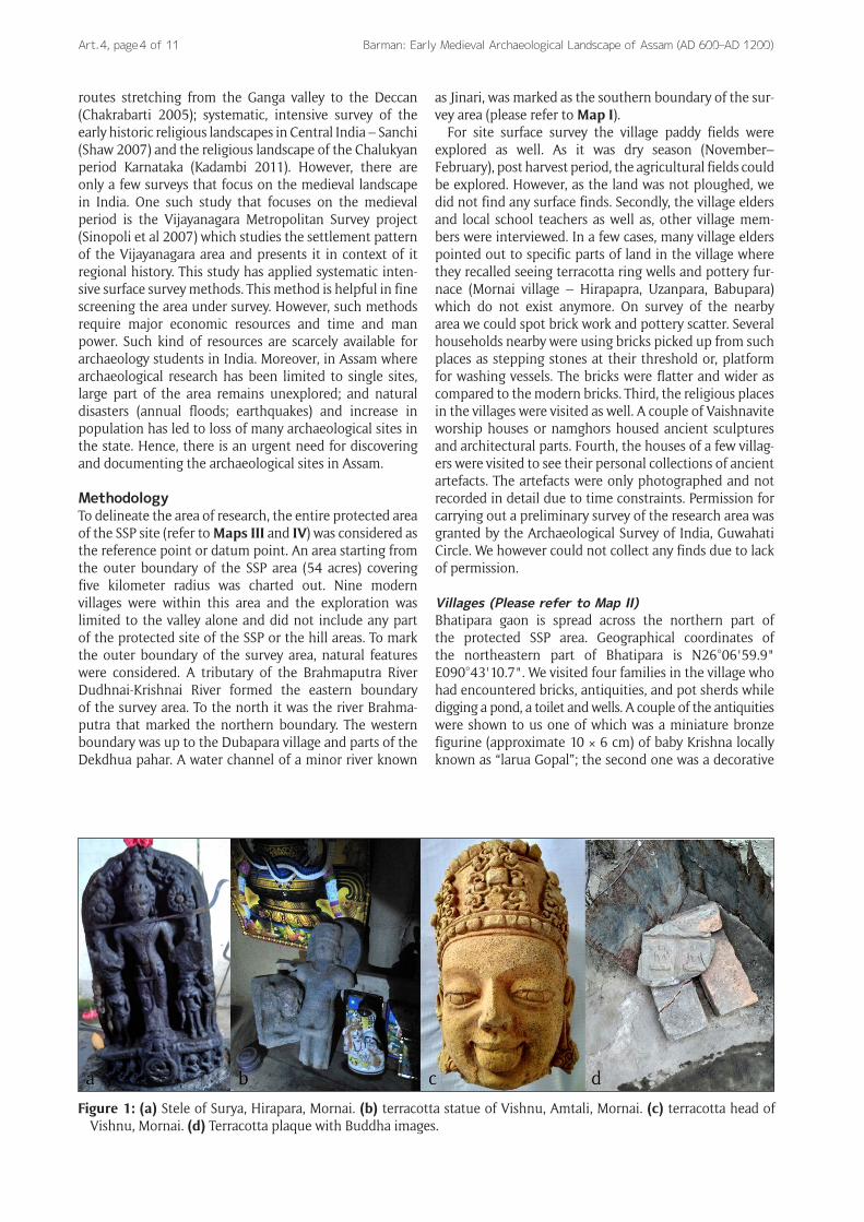
Figure 1: (a) Stele of Surya, Hirapara, Mornai. (b) terracotta statue of Vishnu, Amtali, Mornai. (c) terracotta head of Vishnu, Mornai. (d) Terracotta plaque with Buddha images.
Barman: Early Medieval Archaeological Landscape of Assam (AD 600–AD 1200) Art. 4, page 5 of 11
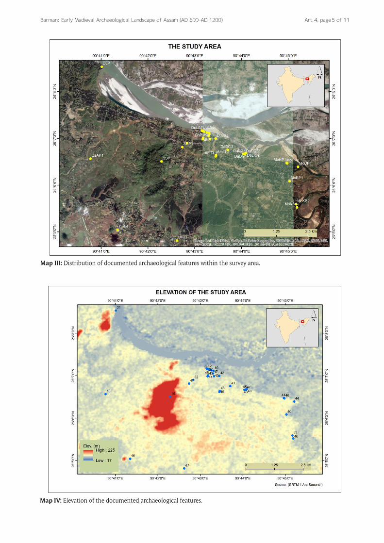
Map III: Distribution of documented archaeological features within the survey area.
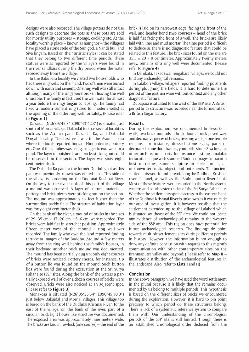
Map IV: Elevation of the documented archaeological features.

Barman: Early Medieval Archaeological Landscape of Assam (AD 600–AD 1200)Art. 4, page 6 of 11
brick with lotus motif. As one pond was being excavated during our visit, we were able to spot architectural parts (two pieces) and brickbats where the soil was being dumped. In order to figure out the archaeological stratum in the area we investigated the sections of dry ponds – these were shallow ponds a single habitation layer was documented in three different spots. The layers were twenty three, twenty seven and thirty four centimeters thick and each layer was twenty six cm, thirty nine cm and nineteen cm below the humus respectively. Pot sherds and brickbats were noticed on the section. Approximately a hundred meters south of this site, brickwork, prob-ably part of a brick paved platform, was documented. As there was no intact brick, only partial measurements of the bricks were recorded, the width and the breadth of the bricks were 15 × 6 centimeters. Diagonally opposite to this spot, approximately thirty meters southwest a sec-ond brickwork was noticed. One can see an outline of a brick formation which is eighteen feet wide and approxi-mately five feet high on the section of a mound; probably part of a thick wall or brick paved platform. These two features were separated by a mound. Both of these features are likely to be part of a same structure. (Please refer to Figure 2)
Dubapara Luptasar (N26°06'59.8" E090°43'26.8") is bordering Bhatipara village on the north and northeastern side. Luptasar is situated to the north of the SSP area. It is on the bank of the Brahmaputra River. On a section of a dry, unused pond, sixty centimeter thick habitation stratum was documented. Decorative brick pieces, pot shards and a triangular terracotta object were documented on the site. To the north of the village a couple of hundred meters from the last site, on the river bank, a hundred and seventeen centimeter thick habitation deposit was documented. The deposit continued along the river bank up to five hundred meters westward. The total extent could not be measured due to the slippery, steep bank of the river. The ancient settlement deposits in this village were so thick that the villagers were expressing their frustration over their failed attempts at digging ponds and wells in the area as they had to dig through ancient
bricks. Several spots not sites were abandoned by diggers due to the hard task of breaking through the bricks. The village elders also reported that they had to level a few mounds to create a flatter space for this village. The last of the remaining mounds, near the Luptasar village school was documented, which is approximately three feet above the present ground level at its lowest point.
Mornai (N26°06'05.2" E090°45'01.6") is one of the biggest villages in this region. It covers an area of one and half kilometer. There are several localities in the village which are inhabited by people from various ethnic and caste groups. Five such localities or paras were visited during the survey. The locality known as the Uzanpara is based on the bank of an oxbow lake or a dead river channel of Dudhnai Krishnai River. At the temple cam-pus there are numbers of dressed stones; yoni piths and Siva lingam. One can notice decorative parts of a stone door frame on the way to this locality. Most of the remains have been brought by villagers from around the village and kept at the temple compound. The Siva lingam or the temple deity was also brought from a nearby family who had discovered it while digging in their backyard. At another locality called Mornai Amtali, parts of a brick structure was observed on both side of the village road. Several courses of bricks were still intact. The road has been built by cutting through a mound. Villagers reported finds of decorative terracotta plaques while building the road.
Near the Hirapara locality of Mornai village, on the bank of Dudhnai Krishnai River, fifty eight centimeter thick habitation deposit containing potsherds and bricks were recorded. Pot sherds scatter were also seen along the bank. A few meters to the west of this spot, we documented brickwork, probably a wall of which only four courses of bricks were visible through the wild plants and shrubs. This locality is inhabited by a potter community who make pots without a wheel. They too discard a lot of broken pots near their houses. The difference between the new pottery debris and the old ones could be made out due to their make – the sherds found along the river bank near the bricks were wheel thrown. A few sherds with stamped
Figure 2: (a) Larua gopal/baby krishna, Bronze miniature, personal collection, Bhatipara. (b) Pottery with stamped design.
Barman: Early Medieval Archaeological Landscape of Assam (AD 600–AD 1200) Art. 4, page 7 of 11
designs were also recorded. The village potters do not use such designs to decorate the pots as these pots are sold for mostly utility purposes – storage, cooking etc. At the locality worship place – known as namghor – the villagers have placed a stone stele of the Sun god, a Nandi bull and Siva lingam. Based on their artistic styles it can be stated that they belong to two different time periods. These statues were as reported by the villagers were found in the river sandbars during the dry period when the water receded away from the village.
In the Babupara locality we visited two households who had three ring wells on their land. Two of them were buried down with earth and cement. One ring well was still intact although many of the rings were broken leaving the well unusable. The family in fact used the well water for almost a year before the rings began collapsing. The family had fixed a modern cement ring (used for modern wells) at the opening of the older ring well for safety. (Please refer to Figure 1)
Dakaidal (N26°06'45.3" E090°43'42.3") is situated just south of Mornai village. Dakaidal too has several localities such as the Asomia para, Dakaidal Ka, and Dakaidal Dargah locality. The first visit was to the Asomia para where the locals reported finds of Hindu deities, pottery etc. One of the families was using a digger to excavate for a pond. The layer of potsherds and bricks sticking out could be observed on the section. The layer was sixty eight centimeter thick.
The Dakaidal Ka para or the former Dulduli ghat as this para was previously known was visited next. This side of the village is bordering on the Dudhnai Krishnai River. On the way to the river bank of this part of the village a mound was observed. A layer of cultural material – pottery and brick pieces were sticking out on the section. The mound was approximately six feet higher than the surrounding paddy field. The stratum of habitation layer was forty eight centimeter thick.
On the bank of the river, a mound of bricks in the sizes of 29–35 cm × 17–20 cm × 5–6 cm. were recorded. The bricks were laid flat in stretcher position. Approximately fifteen meter west of the mound a ring well was recorded. The family who own the land reported finding terracotta images of the Buddha. Around a few meters away from the ring well behind the family’s houses, in their backyard another brick mound was documented. The mound has been partially dug up; only eight courses of bricks were noticed. Pottery sherds, for instance, tip of a button lid was found on the mound. Such button lids were found during the excavation at the Sri Surya Pahar site (SSP site). Along the bank of the waters a par-tially exposed wall of over a dozen courses of bricks were observed. Bricks were also noticed at an adjacent spot. (Please refer to Figure 3)
Monakosa is situated (N26°05'35.54" E090°45'10.0") just below Dakaidal and Mornai villages. This village too is based on the bank of the Dudhnai Krishnai River. To the east of the village, on the bank of the river, part of a circular, brick light house-like structure was documented. The exposed area was approximately nine meters wide. The bricks are laid in rowlock (one course) – the end of the
brick is laid on its narrowest edge, facing the front of the wall, and header bond (two courses) – head of the brick is laid flat facing the front of a wall. The bricks are likely laid with lime and mud mortar. The time period is difficult to deduce as there is no diagnostic feature that could be related to this feature. The brick sizes found on the site are 35.5 × 20 × 9 centimeter. Approximately twenty meters away, remains of a ring well were documented. (Please refer to Figure 4)
In Dahikata, Takadewa, Tengabarai villages we could not find any archaeological remains.
In Lalabori village, villagers reported finding potsherds during ploughing the fields. It is hard to determine the period of the earthen ware without context and any other diagnostic feature.
Dubapara is situated to the west of the SSP site. A British period brick structure was recorded near the former site of a British Sugar factory.
ResultsDuring the exploration, we documented brickworks – walls, two brick mounds, a brick floor, a brick paved way, and decorative pieces of bricks; five ring wells; stone temple remains, for instance, dressed stone slabs, parts of decorated stone door frames, yoni-pith, stone Siva lingam, other architectural parts for instance a stone amalaka; terracotta plaque with stamped Buddha images, terracotta bust of deities, stone sculpture in stele format, an unknown terracotta object, and pot sherds. The ancient settlements were found spread along the Dudhnai-Krishnai river channel, as well as the Brahmaputra River bank. Most of these features were recorded to the Northeastern, eastern and southeastern sides of the Sri Surya Pahar site. Whether the settlements spread across to the eastern bank of the Dudhnai Krishnai River is unknown as it was outside our area of investigation. It is however possible that the settlement extended up to the village of Lalabori which is situated southeast of the SSP area. We could not locate any evidence of archaeological remains to the western side of the SSP area. This region does have potential for future archaeological research. The findings do point towards multiple settlement sites during different periods in history. However, the information is not enough to draw any definite conclusion with regards to this region’s communication with other contemporary sites on the Brahmaputra valley and beyond. (Please refer to Map II – illustrates distribution of the archaeological features in the landscape. Also, refer to Lists I and II)
ConclusionIn the above paragraph, we have used the word settlement in the plural because it is likely that the remains docu-mented by us belong to multiple periods. This hypothesis is based on the different sizes of bricks we encountered during the exploration. However, it is hard to pin point precisely to which period do these structures belong. There is lack of a systematic reference system to compare them with. Our understanding of the chronological periods of the SSP site is still limited. Though there is an established chronological order deduced from the

Barman: Early Medieval Archaeological Landscape of Assam (AD 600–AD 1200)Art. 4, page 8 of 11
Figure 3: Outline of a TC ring (ring well), Dakaidal.
Figure 4: Brick wall from structure, Dakaidal.

Barman: Early Medieval Archaeological Landscape of Assam (AD 600–AD 1200) Art. 4, page 9 of 11
architectural, sculptural and iconographic details, yet, when it comes to the bricks, all the brick sizes found during the excavations at SSP site seem to have been used throughout all the periods (IAR, 1991–2001). In the same vein, there is no regional ceramic sequence in Assam. Hence, the pot sherds documented during the surface survey are of no help as there is no yardstick to compare them to. One can however, provide a preliminary hypothesis based on the nature of associated materials discovered from the site in Dakaidal village. The spots marked as DaDG on the map is a short form for Dakaidal Dulduli Ghat, the sculptural remains date back to the second habitation period of the SSP site – fifth to sixth century. Several terracotta Buddha images have been recovered from around this part of the village. This period at the SSP site is represented by a brick built, Buddhist monastic complex and terracotta Buddha image. The sites in Bhatipara and Mornai, Mornni-Amtali and parts of Dakaidal can be provisionally dated to the third habitation period of the SSP site – seventh–eighth century – with an overlap with the fourth habitation period, tenth–twelfth century. The third period (seventh–eighth century) at the SSP is signified by remains of brick temples, decorated terracotta plaques. Similar brick temples are also found in
the Hojai district of central Assam dating back to the same period. The fourth period at the SSP is distinguished by remains of stone temple and sculptures. The black basalt figure of Mahisasuramardini discovered during excavation at the Sri Surya Pahar site (IAR 2000–2001) is reminiscent of the six feet tall, Mahisasuramardini stele found during excavations at the site of Ambari, Guwahati city, datable to eleventh–twelfth century AD.
Archaeological research in Assam is still in the early stage of development. There is need for systematic ways to study the archaeological sites here, beginning with the basics, for instance, widespread archaeological explora-tions, emphasis on documentation of settlement sites and not only religious sites, morphology of the documented settlements and developing a regional ceramic sequence. Most importantly there is a need for a well defined regional cultural sequence. The second phase of the survey will be carried out in 2017 for a more detailed data gathering.
AppendixList I: Documented archaeological features and their geographical location
Archaeological Features Geographical Location
Village name Code name Latitude Longitude
Dakaidhal Asomia para (north) DaAP1 N26°06'33.9" E090°40'46.3"
Section of leveled high ground Dakaidhal (south) Dulduli ghat DaDG1 26°06'41.1" E090°44'04.8"
Ring well Dakaidhal dargah area DaDG3 26°06'45.3" E090°43'42.3"
Ring well, statues found here Dakaidhal (k) DaDG4 26°'06'40.0" E090°44'02.2"
Mound, pottery scatter Dakadhal (K) DaDG5 26°06'39.6" E090°44'04.2"
Habitation deposit Mornai Amtali 1 AmTL1 26°06'37.0 E090°43'26.9"
Part of a brickwall Mornai Aamtali 2 AmTL2 26°06'38.6" E090°43'27.4
Part of a brickwall Mornai, Hirapara 1 MoHP1 26°06'28.5" E090°44'57.9"
Bricks Mornai, Hirapara 2 MoHP2 26°06'28.0" E090°44'58.6"
Pottery scatter, bricks Mornai, Babupara MoBP1 26°06'05.2" E090°45'01.6"
Three ringwells Mornai, Uzanpara of Hirapara MoUP1 26°06'23.6" E090°45'12.5"
Architectural remains Bhatipara village (spot1) BhP1 26°06'59.0" E090°43'10.3"
Habitation deposit Bhatipara village (spot2) BhP2 26°06'59.9" E090°43'10.7"
Habitation deposit Bhatipara village (spot 3) BhP3 26°07'00.5" E090°43'11.0"
Habitation deposit Bhatipara (spot 4) BhP4 26°06'53.9" E090°42'50.1"
Brickwork Bhatipara SSP1 SSP1 26°06'48.9" E090°42'44.2"
Brickwork Dubapara, near old cinemahall DuP 26°08'32.1" E090°41'00.7"
Colonial brickworks Monakosa 1 MoKS1 26°05'31.5" E090°45'11.1"
Circular brick structure Monakosa2 MoKS2 26°05'35.54" E090°45'10.0"
Ring well Dubapara Luptasar (spot 1) DuLS1 26°06'59.2" E090°43'19.2"
Bricks, brickbats Dubapara Luptasar (spot 2) DuLS2 26°07'03.1" E090°43'17.9"
Pond section, habitation deposit Dubapara Luptasar (spot 3) DuLS3 26°06'59.8" E090°43'26.8"
Mound, pottery scatter, bricks Luptasar Dudhnoi Krishnai xuti DuLS4 26°07'06.8 E090°43'18.6"
Habitation deposit Luptasar Dudhnoi Krishnai xuti DuLS5 26°07'07.5 E090°43'15.6
Habitation deposit Luptasar Dudhnoi Krishnai xuti DuLS6 26°07'08.6" E090°43'12.0"
Habitation deposit Luptasar Dudhnoi Krishnai xuti DuLS7 26°07'09.3" E090°43'10.7"
Habitation deposit Luptasar Dudhnoi Krishnai xuti DuLS8 26°07'10.0 E090°43'09.1
Habitation deposit Lalaburi LaBR 26.084080° E90.689167°
None Dahikata DaKT 26.080262° E90.710326°
None Taka dewa TaDW N GPS problem
None Tengabari TaB – –

Barman: Early Medieval Archaeological Landscape of Assam (AD 600–AD 1200)Art. 4, page 10 of 11
List II: documented archaeological features and their measurements and dimensions (Note: features with similar measurements/dimensions have not been repeated in this list due to space constraint)Site nameArchaeological featureStratum thickness Dimensions. Brick measurment Dakaidal Asomia para (north) Habitation deposit 68 cm. N/A N/A Dakaidal (south) former Dulduli ghat Exposed brickwork 13 courses N/A 29 × 18.5 × 6 cm. Dakaidal (south) former Dulduli ghat loose brick single N/A 32× 20.5 × 8 cm. Dakaidal (south) former Dulduli ghat loose bricks 2 nos. N/A 35 × 17 × 5 cm.
Dakaidal (south) former Dulduli ghat Ringwell N/A.90 cm. Diameter N/A.
Dakaidal (k)Brick mound, pottery scatter 108 cm N/A N/A Dakadal (K) Habitation deposit 48 cm N/A N/A Mornai Amtali (1 & 2) Part of a brickwall N/A N/A N/A.
Mornai, Hirapara 1Partially exposed bricks N/A N/A N/A Mornai, Hirapara 2 Pottery scatter, bricks 58 cm N/A N/A Mornai, Babupara 2 ringwells closed N/A N/A N/A Mornai, Uzanpara of Hirapara Architectural remains N/A N/A N/A Bhatipara village (spot1) Habitation deposit 27 cm N/A N/A Bhatipara village (spot2) Habitation deposit 34 cm N/A N/A Bhatipara village (spot 3) Habitation deposit 23 cm. N/A N/A Bhatipara (spot 4) Brickwork 30 cm. N/A N/A Bhatipara SSP1 Brickwork 1.83 × 1.53 m N/A N/A Duba-para Colonial brickworks N/A N/A N/A Monakosa 1 Cir-cular brick N/A N/A 35.5 × 20 × 9 cm.
StructureMonakosa 2Broken piece of ring from ring well N/A 21.5 cm × 3 cm N/A Dubapara Luptasar (spot 1) Levelled mound 18 cm N/A N/A Dubapara Luptasar (spot 2) Dry pond section 60 cm. N/A N/A Luptasar Dudhnoi Krishnai xuti habita-tion deposits 117 cm. N/A N/A Lalaburi None N/A N/A N/A Dahikata None N/A N/A N/A Taka dewa None N/A N/A N/A Tengabari.
AcknowledgementsI am greatly thankful to the Geography department of the Gauhati University, especially professor Abani Bhagawati for the logistical support extended to me. I would also like to thank the ASI Guwahati circle, superintending archaeologist, Dr. Milan Chauley. I thank Mr. Nayan Das and Jone Kalita for their help throughout the exploration. My sincere thanks to Mr. Arnab Bormudoi for his help in creating the GIS based maps.
Competing InterestsThe author has no competing interests to declare.
ReferencesChakrabarti, D K 2005 The Archaeology of the Deccan
Routes: The Ancient Routes from the Ganga Plain to the Deccan. Delhi: Munshiram Manoharlal Publishers Private Limited.
Chakrabarti, D K 2006 The Oxford companion to Indian archaeology: The archaeological foundations of ancient India. Oxford: Oxford University Press.
Chauley, M K 2003 Suryapahar Monuments (A Monuments of Excellence in North-East). OM Publication, Delhi.
Choudhury, R D 2013 Art and Archaeology of the Brahmaputra Valley of Assam, Pre Ahom Period. Spectrum Publications. Guwahati, Assam.
Erdosy, G 1988 Urbanisation in Early Historic India. Oxford B.A.R. International Series 430.
Hooja, R 1988 The Ahar Culture and Beyond: Settlement and Frontier of ‘Mesolithic’ and Early Agricultural Sites in South-Eastern Rajasthan, c. 3rd–2nd Millenia B.C. Oxford. BAR.
Kadambi, H 2011 Sacred landscape in Early Medieval South India: The Chalukya State and Society (AD550–750). PhD thesis, Department of Anthropology, The University of Michigan.
Lal, M 1984 Settlement History and the Rise of Civilisation in the Ganga Yamuna Doab (from 1500BC–AD300). Delhi B.R. Publishing Corporation.
Nath, S 1991 Sri Suryapahar. Second edition, Goalpara, Srixurjja Prakasan.
Paddayya, K 2002 The new archaeology and aftermath: a view from outside the Anglo-American. In: Settar, S and Korisettar, R (Eds.) Indian Archaeology in Retrospect. Vol. IV: History, Theory and Methods. New Delhi, Manohar. ICHR, pp. 117–190.
Shaw, J 2007 Buddhist Landscape of Central India: Sanchi Hill and Religious Change, c. Third Century BC to Fifth Century AD. British Association for South Asian Studies, The British Academy.
Shinde, V S 1989 Land use Pattern During Chalcolithic Period in the Tapi Basin. Puratattva, 18: 54–60.
Sinopoli, C M and Morrison, C D 2007 Vijayanagara Metropolitan Survey. Museum of Anthropology. University of Michigan, USA.
Smith, M L 2001 Systematic Survey at the Early Historic Urban Site of Sisupalgarh, Orissa. In: Sengupta, G and Panja, S (Eds.) Archaeology of Eastern India: New Perspectives. Calcutta, Centre for Archaeological Studies and Training, East India, pp. 109–125.
Smith, M L et al 2013 Google Earth as an Archaeological Tool in the Developing World: An Example from India. SAA Archaeological Record, 13(1): 20–24.

Barman: Early Medieval Archaeological Landscape of Assam (AD 600–AD 1200) Art. 4, page 11 of 11
How to cite this article: Barman, B 2017 Early Medieval Archaeological Landscape of Assam (AD 600–AD 1200): Preliminary Survey in Western Assam, District Goalpara. Ancient Asia, 8: 4, pp. 1–11, DOI: https://doi.org/10.5334/aa.116
Published: 17 May 2017
Copyright: © 2017 The Author(s). This is an open-access article distributed under the terms of the Creative Commons Attribution 4.0 International License (CC-BY 4.0), which permits unrestricted use, distribution, and reproduction in any medium, provided the original author and source are credited. See http://creativecommons.org/licenses/by/4.0/.
OPEN ACCESS Ancient Asia is a peer-reviewed open access journal published by Ubiquity Press.