Early Hurricane Notes ATS 553. Hurricane Classification TROPICAL WAVE: –A trough or cyclonic...
48
Early Hurricane Notes ATS 553
-
Upload
elisabeth-strickland -
Category
Documents
-
view
218 -
download
2
Transcript of Early Hurricane Notes ATS 553. Hurricane Classification TROPICAL WAVE: –A trough or cyclonic...
Early Hurricane Notes
ATS 553

Hurricane Classification
• TROPICAL WAVE:– A trough or cyclonic curvature maximum in
the tradewinds

Hurricane Classification
• TROPICAL DISTURBANCE:– A discrete system of apparently organized
convection maintained for a day or more

Hurricane Classification
• TROPICAL STORM:– A warm core tropical cyclone with closed
isobars, rotary circulation, and winds between 34 and 64 knots.
– WHEN THEY GET THEIR “NAME”
Hurricane Classification
• HURRICANE/TYPHOON:– A warm core tropical cyclone with closed
isobars, rotary circulation, and winds of at least 64 knots.
– Does not necessarily have an eye, but often does.

Characteristics:
TD TS H
SFC winds <= 34 kt <= 64 kts > 64 kts
Avg. SFC P 1000mb 990mb 960mb
Vis. Features No eye/wall No eye/wall May have eye
Wind shear > 15 kts < 15 kts 0
Vortex Cyclonic throughout
Anticyclonic above 300mb
Active convection
< 1% 1% 4-5%
500mb T Colder than environment
Warmer than environment
Naming Hurricanes
• In the Atlantic:– A, B, C, D…– Alternate boy-girl– Rotate through six lists– Retire names for especially damaging storms


Eastern Pacific
• Very similar scheme as in the Atlantic

Western Pacific
• Just uses a long list
• In alphabetical order BY THE COUNTRY THAT SUBMITTED THE NAME
• Names can be retired, too.

Western Pacific typhoon names
Names in the five lists below are used sequentially from year to year
I II III IV V
Contributed by
Name Name Name Name Name
Cambodia Damrey Kong-rey Nakri Krovanh Sarika
China Longwang Yutu Fengshen Dujuan Haima
DPR Korea Kirogi Toraji Kalmaegi Maemi Meari
Hong Kong, China
Kai-tak Man-yi Fung-wong
Choi-wan Ma-on
Japan Tembin Usagi Kammuri Koppu Tokage
Lao PDR Bolaven Pabuk Phanfone Ketsana Nock-ten
Macau, China
Chanchu Wutip Vongfong Parma Muifa
Malaysia Jelawat Sepat Rusa Melor Merbok
Micronesia Ewiniar Fitow Sinlaku Nepartak Nanmadol
Philippines
Bilis Danas Hagupit Lupit Talas
RO Korea Kaemi Nari Changmi Sudal Noru
Thailand Prapiroon Vipa Megkhla Nida Kularb
U.S.A. Maria Francisco Higos Omais Roke
Viet Nam Saomai Lekima Bavi Conson Sonca
Cambodia Bopha Krosa Maysak Chanthu Nesat
China Wukong Haiyan Haishen Dianmu Haitang
DPR Korea Sonamu Podul Pongsona Mindulle Nalgae
Hong Kong, China
Shanshan Lingling Yanyan Tingting Banyan
Japan Yagi Kajiki Kujira Kompasu Washi
Lao PDR Xangsane Faxai Chan-hom Namtheun Matsa
Macau, China
Bebinca Vamei Linfa Malou Sanvu
Malaysia Rumbia Tapah Nangka Meranti Mawar
Micronesia Soulik Mitag Soudelor Rananim Guchol
Philippines
Cimaron Hagibis Imbudo Malakas Talim
RO Korea Chebi Noguri Koni Megi Nabi
Thailand Durian Ramasoon Hanuman Chaba Khanun
U.S.A. Utor Chataan Etau Kodo Vicente
Viet Nam Trami Halong Vamco Songda Saola

Western Pacific typhoon names
Names in the five lists below are used sequentially from year to year
I II III IV V
Contributed by
Name Name Name Name Name
Cambodia Damrey Kong-rey Nakri Krovanh Sarika
China Longwang Yutu Fengshen Dujuan Haima
DPR Korea Kirogi Toraji Kalmaegi Maemi Meari
Hong Kong, China
Kai-tak Man-yi Fung-wong Choi-wan Ma-on
Japan Tembin Usagi Kammuri Koppu Tokage
Lao PDR Bolaven Pabuk Phanfone Ketsana Nock-ten
Macau, China
Chanchu Wutip Vongfong Parma Muifa
Malaysia Jelawat Sepat Rusa Melor Merbok
Micronesia Ewiniar Fitow Sinlaku Nepartak Nanmadol
Philippines Bilis Danas Hagupit Lupit Talas
RO Korea Kaemi Nari Changmi Sudal Noru
Thailand Prapiroon Vipa Megkhla Nida Kularb
U.S.A. Maria Francisco Higos Omais Roke
Viet Nam Saomai Lekima Bavi Conson Sonca
Cambodia Bopha Krosa Maysak Chanthu Nesat
China Wukong Haiyan Haishen Dianmu Haitang
DPR Korea Sonamu Podul Pongsona Mindulle Nalgae
Hong Kong, China
Shanshan Lingling Yanyan Tingting Banyan
Japan Yagi Kajiki Kujira Kompasu Washi
Lao PDR Xangsane Faxai Chan-hom Namtheun Matsa
Macau, China
Bebinca Vamei Linfa Malou Sanvu
Malaysia Rumbia Tapah Nangka Meranti Mawar
Micronesia Soulik Mitag Soudelor Rananim Guchol
Philippines Cimaron Hagibis Imbudo Malakas Talim
RO Korea Chebi Noguri Koni Megi Nabi
Thailand Durian Ramasoon Hanuman Chaba Khanun
U.S.A. Utor Chataan Etau Kodo Vicente
Viet Nam Trami Halong Vamco Songda Saola

Other Basins
• Use other schemes
• Usually just short lists that they rotate through as needed

Historically:
• Prior to WWII, storms were named after the patron saint of the day.
• Post WWII, various schemes:– Phonetic alphabet (alpha, bravo, charlie..)– Animals (Antelope, Bear, Cat, Dog…)– Adjectives (Aggressive, Blusterly…)– All Female Names starting in the mid 1950s– Male names started in 1979
Tropical Cyclones vs. Midlatitude Cyclones
• Strongest Winds:– MC: Jet Stream– TC: Surface

Tropical Cyclones vs. Midlatitude Cyclones
• Core Temperature:– MC: Cold core (trough)– TC: Warm core (LHR in eyewall, subsidence
in eye)
Tropical Cyclones vs. Midlatitude Cyclones
• Structure:– MC: Asymmetric, fronts– TC: Symmetric, no fronts
Tropical Cyclones vs. Midlatitude Cyclones
• Scale:– MC: Synoptic scale– TC: Mesoscale in size, synoptic scale in
duration

Why Winds Decrease With Height In A Hurricane
ATS 553

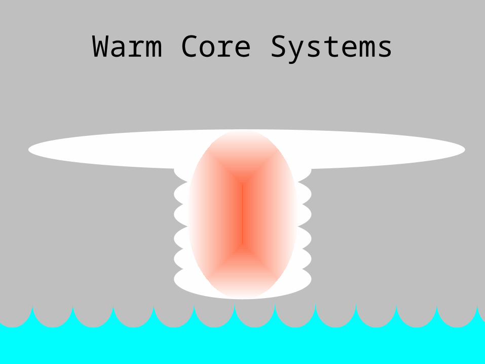
Warm Core Systems

Temperature Gradient!

From Above…

From Above…

From Above…
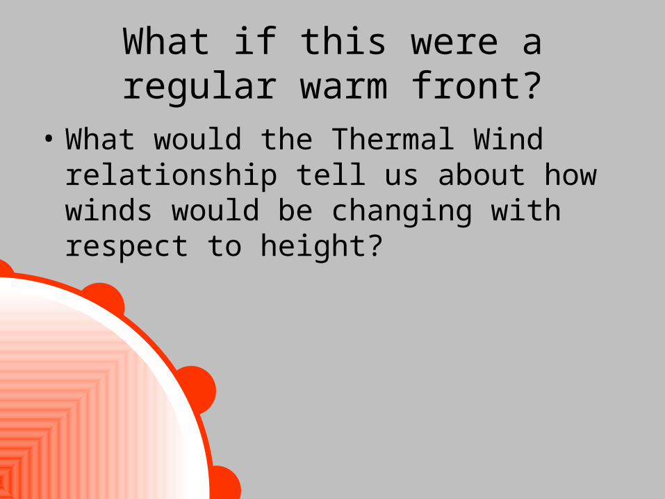
What if this were a regular warm front?
• What would the Thermal Wind relationship tell us about how winds would be changing with respect to height?

What if this were a regular warm front?
• Wind speeds at the surface would be weak.
• Aloft, there would be a Midlatitude Jet Stream!
Winds would be getting more positive with height!

What if this were a regular warm front?
Wind Speed
Hei
gh
t
0

But This Is NOT a Midlatitude Cyclone

But This Is NOT a Midlatitude Cyclone

Strong Surface Winds

With height, these winds DECREASE due to the Thermal
Wind Relationship!

Strong Surface Winds…

…get weaker with height…

…even reverse aloft..

…to create the upper-level anticyclone!

Wind Profile:
Wind Speed
Hei
gh
t
0
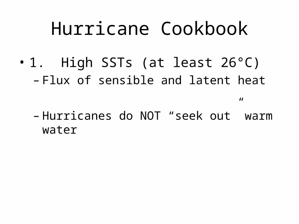
Hurricane Cookbook
• 1. High SSTs (at least 26°C)– Flux of sensible and latent heat
– Hurricanes do NOT “seek out” warm water

Hurricane Cookbook
• 2. Coriolis Force (at least 5° off of the equator)– Hurricanes are in CYCLOSTROPHIC
balance, not GEOSTROPHIC BALANCE– However, Coriolis Force keeps the winds from
just following directly into the region of low pressure when it first forms.
– Hurricanes don’t FORM at the equator.– Hurricanes don’t CROSS the equator!

Hurricane Cookbook
• 3. Instability– Rules out subtropical highs, which are regions
of sinking motion and high stability
– KNOW WHY SINKING MOTION IS ASSOCIATED WITH INCREASED STABILITY!

Hurricane Cookbook
• 4. No wind shear– Redistributes vertical profile of latent heat
release, setting up the wrong circulation patterns
– TUTT—Tropical Upper Tropospheric Trough
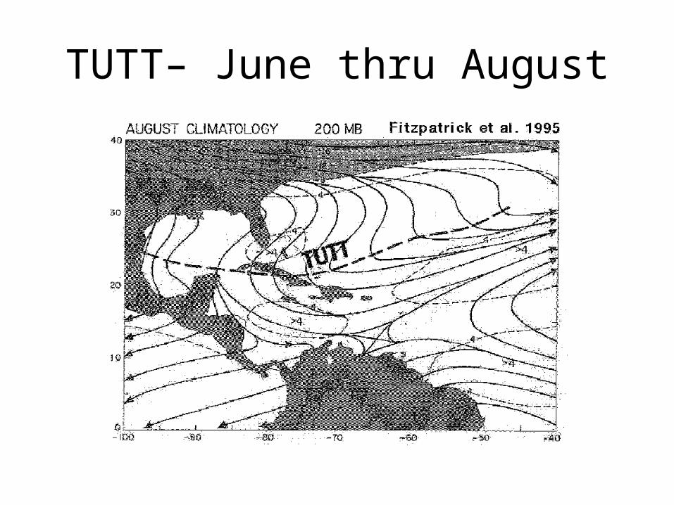
TUTT– June thru August

Hurricane Cookbook
• 5. High relative humidities through midlevels of the troposphere– Helps reduce the impact of entrainment.– Individual Cumulus towers are easily
destroyed by entrainment of dry air.

Hurricane Cookbook
• 6. An initial disturbance– Unorganized groups of thunderstorms
organize into tropical storms.
– Typically these are West African Squall Lines or other disturbances in the AEJ.

Saffir-Simpson Scale