Session II International and regional approaches to regulatory cooperation

E&
P R
egu
latory S
ession

E&P Regulatory Issues: What’s Next? Speakers: David R. Overstreet – Partner, K&L Gates, Pittsburgh John P. Englert – Partner, K&L Gates, Pittsburgh George A. Bibikos – Associate, K&L Gates, Harrisburg
April 27, 2012 Hilton Garden Inn Hotel – Southpointe/Pittsburgh

Contents “E&P Regulatory Issues: What’s Next?”
“Recent Developments in Air Regulation – The View from Pennsylvania and Ohio”................................................................. A “Wastewater Management & Recycling: Effect of the Youngstown Earthquakes on Disposal and Recycling of Produced Water”....... B “ESCGP-2 and Lessons from Hollywood: The Sequel is Never Quite as Good as the Original” ...................................................... C
Biographies ................................................................................................. D
David R. Overstreet John P. Englert George A. Bibikos
Appalachian Basin Oil & Gas Practice Brochure ........................................ E
Supplemental Information ........................................................................... F
Policy for Erosion and Sediment Control General Permit for Earth Disturbance Associated with Oil and Gas Exploration, Production, Processing or Treatment Operations or Transmission Facilities (E&S General Permit for Oil and Gas Activities) Instructions for a Notice of Intent (NOI) Authorization Package for Coverage under the Erosion and Sediment Control General Permit (ESCGP-2) Notice of Intent (NOI) for Coverage under the Erosion and Sediment Control General Permit (ESCGP-2)
Notice of Intent (NOI) Administrative Completeness Checklist Erosion and Sediment Control General Permit (ESCGP-2)
Authorization of Coverage under the ESCGP-2 (Permit)
K&L Gates LLP

A

Copyright © 2012 by K&L Gates LLP. All rights reserved.
Recent Developments in Air Regulation –The View from Pennsylvania and Ohio
David R. Overstreet
412.355.8263 [email protected]
This presentation is for informational purposes and does not contain or convey legal advice. The information herein should not be used or relied upon in regard to any particular facts or circumstances without first consulting a lawyer.
2
Topics
Scientific Studies
Federal Regulatory Initiatives
State Regulatory Initiatives
Pennsylvania
Ohio
Air Aggregation Update

3
Scientific Studies
Texas
July 13, 2010
“[T]he measured and estimated air pollution levels did not reach levels that have been observed to cause adverse health effects.”
4
Scientific Studies
Pennsylvania
PADEP Studies in 2010 and 2011
“Results of limited ambient air sampling initiative [in the NE, SW, and NC regions] did not identify concentrations of any compound that would likely trigger air-related health issues associated with Marcellus Shale drilling activities.”
Elevated methane levels detected at some sampling sites.

5
Scientific Studies
Colorado Study
Not yet published
Press release (March 19, 2012):
“Our results show that the non-cancer health impacts from air emissions due to natural gas development is greater for residents living closer to wells,”
“We also calculated higher cancer risks for residents living nearer to the wells as compared to those residing further [away],”
6
Federal
Regulatory
Initiatives
7
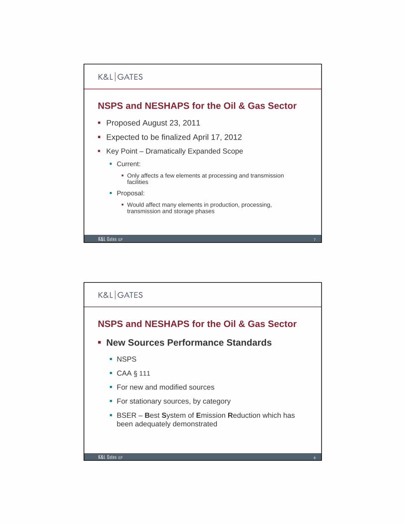
NSPS and NESHAPS for the Oil & Gas Sector
Proposed August 23, 2011
Expected to be finalized April 17, 2012
Key Point – Dramatically Expanded Scope
Current:
Only affects a few elements at processing and transmission facilities
Proposal:
Would affect many elements in production, processing, transmission and storage phases
8
NSPS and NESHAPS for the Oil & Gas Sector
New Sources Performance Standards
NSPS
CAA § 111
For new and modified sources
For stationary sources, by category
BSER – Best System of Emission Reduction which has been adequately demonstrated

9
NSPS and NESHAPS for the Oil & Gas Sector
National Emission Standards for Hazardous Air Pollutants
NESHAPs
CAA § 112
For existing and new sources sources
For stationary sources that emit HAPs, by category
MACT – Maximum Achievable Control Technology
10
NSPS and NESHAPS for the Oil & Gas Sector
Four Rules affected
NSPS for VOCs from NG Processing Plants
NSPS for SO2 from NG Processing Plants
NESHAP for O&G Production
NESHAP for NG Transmission and Storage.

11
NSPS and NESHAPS for the Oil & Gas Sector
The Old Rules:
NSPS for VOC’s from NG Processing Plants
Leaking components at processing plants
NSPS for SO2 from NG Processing Plants
Sweetening units at processing plants
O&G Production NESHAP
Glycol dehydrators, storage vessels, and equipment leaks at processing plants
NG Transmission and Storage NESHAP
Glycol dehydrators
12
NSPS and NESHAPS for the Oil & Gas Sector
The New Rules
NSPS for O&G Production, Transmission, and Distribution
40 C.F.R. Part 60 Subpart OOOO
NSPS for VOC’s
Would now cover production, processing, transmission and storagephases
Well completions, compressors, pneumatic controllers, storage vessels, and leaks from processing plants
NSPS for SO2 – strengthened
NESHAPs – strengthened, expanded to smaller glycol dehydrators

13
PSD for New Major Sources of GHGs
Preconstruction Permitting Requirements
PSD/NSR applies to:
new “major” sources
“major” modifications to existing sources
PSD v. NANSR
Prevention of Significant Deterioration
Attainment areas - BACT
Non-Attainment New Source Review
Non-attainment areas – LAER, offsets
There are no NAAQS for GHGs, so only PSD
14
PSD for New Major Sources of GHGs
Key EPA actions
GHG Endangerment Finding – December 7, 2009
Tailoring Rule – June 3, 2010
Proposed Step 3 Tailoring Rule – March 8, 2012
EPA’s actions are pending before the D.C. Circuit (oral arguments were in late February)

15
PSD for New Major Sources of GHGs
Tailoring Rule
Step 1 – January 2, 2011 – “Anyway” major sources
Step 2 – July 1, 2011
All major sources within elevated thresholds
New sources – 100,000 tpy CO2 e
Modifications – 75,000 tpy CO2 e
Step 3 – July 1, 2013
What thresholds will apply?
EPA proposal – maintain Step 2 thresholds
Note – thresholds can trigger Title V Operating Permit requirements, too.
16
GHG Reporting
EPA GHG Reporting Subpart W: Petroleum and Natural Gas Systems Eight Source Categories
Offshore Petroleum and NG Production Onshore Petroleum and NG Production Onshore NG Processing Onshore NG Transmission Compression Underground NG Storage LNG Storage LNG Import and Export Facilities NG Distribution
Generally Applies to facilities that emit 25,000 metric tons of CO2e / year
First Reports are Due September 28, 2012 One time Extension of Annual March 31 reporting deadline

17
State
Regulatory
Initiatives
18
Pennsylvania Minor Source Permitting
Overview of Key Regulatory Developments
GP-5 March 3, 2012 Proposal
GP-11
Air Quality Permit Exemptions Guidance
Air Emissions Reporting

19
Pennsylvania Minor Source Permitting
GP-5
Currently covers IC engines (100-1,500 bhp), glycol dehydrators, storage tanks, vents, and other associated equipment at NG processing facilities
Proposed Major Revisions to GP-5 Expands coverage to nearly all sources of air emissions at NG
production and processing facilities
Incorporates EPA’s proposed NSPS and NESHAPS
New state imposed limits representing BAT
Public Comment Period ends May 2, 2012.
20
Pennsylvania Minor Source Permitting
Air Quality Permit Exemptions Guidance
Plan Approval Exemptions
Exemption 38
Operating Permit Exemptions
Trivial Activity 61
Proposal anticipated in April
GP-11
For non-road engines
Dependent on alterations to the Exemptions Guidance

21
Pennsylvania Reporting Obligations
Pennsylvania Reporting for Conventional (Non-GHG) Pollutants
PADEP submission to EPA every 3 years
2011 – First year of reporting for 99 natural gas operators in Pennsylvania
First reports due on March 1, 2012, with a deadline extension available.
MSC Guidelines
22
Ohio Minor Source Permitting
Overview
GP-12
Exemptions

23
Ohio Minor Source Permitting
GP-12
General Permit for Production Operations at Shale Gas Well Sites
Issued February 2012
Regulates many well-site components that previously did not require coverage under a permit-to-install or permit-to-operate
24
Ohio Minor Source Permitting
Exemptions
OAC 3745-31-03 and 3745-15-05
Drilling and fracturing phases are exempt from permit requirements, need not obtain coverage under GP-12
Non-road diesel engines need not obtain permit coverage.

25
Air
Aggregation
Update
26
Air Aggregation
The Stakes: Regulation as a “major” source
PSD/ NA NSR,
Title V
The Debate: What constitutes a single source?
Same industrial grouping
Common control
Contiguous or adjacent

27
Air Aggregation
Latest EPA Guidance (Sept. 22, 2009)
McCarthy Memorandum
Adjacency: functional interdependence
Case by case evaluation
28
Air Aggregation
Pennsylvania
Guidance for Performing Single Stationary Source Determinations for Oil and Gas Industries
Issued Oct. 12, 2011
Adjacent: physical proximity
¼ mile rule of thumb
Ohio
OEPA has indicated that it will not aggregate multiple well-sites.
Will re-evaluate after resolution of pending litigation.
Summit Petroleum v. EPA (6th Cir.) (Oral Argument 4/17/12)

B
Copyright © 2012 by K&L Gates LLP. All rights reserved.
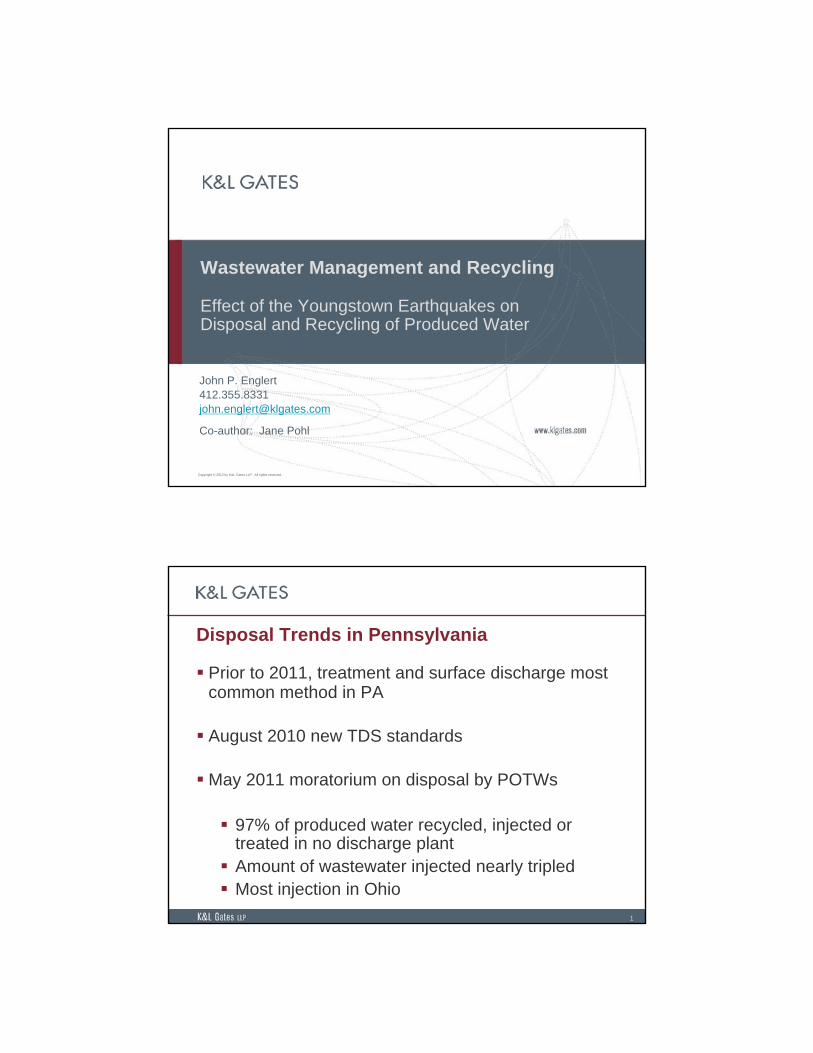
Wastewater Management and Recycling
Effect of the Youngstown Earthquakes on Disposal and Recycling of Produced Water
John P. Englert [email protected]
Co-author: Jane Pohl
1
Disposal Trends in Pennsylvania
Prior to 2011, treatment and surface discharge most common method in PA
August 2010 new TDS standards
May 2011 moratorium on disposal by POTWs
97% of produced water recycled, injected or treated in no discharge plant Amount of wastewater injected nearly tripled Most injection in Ohio

2
Class II Disposal Wells Approx. 150,000 Class II Injection Wells in U.S. Three types: enhanced recovery,
hydrocarbon storage and disposal Disposal wells = approximately 20% Majority located in TX, CA, OK
>90% of produced water is disposed via injection Prevents surface contamination Does not require pre-treatment Often a low-cost option
Source: EPA
3
Class II Disposal Wells in Pennsylvania and Ohio
Ohio State administered program
since 1983 Meets and exceeds USEPA
standards and regulations 94 Class II wells permitted in
41 counties 29 new permits issued in
2011, 13 permits pending > 200 million barrels
disposed since 1983
Pennsylvania Program administered by
US EPA 6 permitted Class II wells
currently in operation 2 additional permits issued
by EPA for wells in Warren County (appeal pending)

4
Source: Ohio Department of Natural Resources
5
Can Class II Disposal Wells Cause Earthquakes?
ODNR Report: properly located injection wells will not cause earthquakes
Conditions required for earthquake: Existing fault line Near-failure state of stress Path of communication between well and fault High injection pressure, long period of time
Only 6 Class II disposal wells have ever been linked to earthquakes

6
Seismic Events in Youngstown, Ohio
Pre 2011, no history of seismic activity Northstar 1 begins injection December 2010 12 earthquakes since March 2011 All 12 earthquakes clustered within less than a mile around the
well
Source: Preliminary Report on the Northstar 1 Class II Injection Well and the Seismic Events in the Youngstown, Ohio Area, Ohio Department of Natural Resources (March 2012)
7
Source: Preliminary Report on the Northstar 1 Class II Injection Well and the Seismic Events in the
Youngstown, Ohio Area, Ohio Department of Natural Resources (March 2012)

8
Seismic Events in Youngstown, OhioInvestigation April 26, 2011 – December 15, 2011
35 inspections: well operating within permitted injection pressure & volume
Testing inconclusive regarding fluid volume entering Precambrian layer
Precambrian section of Northstar 1 borehole plugged
December 1, 2011: Additional seismic monitoring equipment installed December 24, 2011: 2.7 magnitude earthquake recorded 2,454 feet
below the injection well December 30, 2011: Northstar 1 shut down December 31, 2011: 4.0 magnitude earthquake recorded - moratorium
placed on 3 nearby injection wells)
9
Seismic Events in Youngstown, Ohio
Conclusion: Circumstantial evidence indicates that the Youngstown earthquakes were induced.
Earthquakes started 3 months after Northstar 1 began injections
Earthquakes clustered around vicinity of wellbore
Geophysical logs show evidence of permeability within the Precambrian basement rock
Focal depths of events = 4,000 ft. laterally and 2,500 ft. vertically from wellbore terminus

10
Source: Preliminary Report on the Northstar 1 Class II Injection Well and
the Seismic Events in the Youngstown, Ohio Area, Ohio Department of Natural
Resources (March 2012)
11
Regulatory Changes In Response to Youngstown Earthquakes:
Review of geological data for known fault lines Geophysical logs, seismic surveys, step rate injection tests Prior to injection, operators must plug back with cement any well
drilled in Precambrian basement rock Permit applications must include 1) information about known
geological faults and 2) a plan for monitoring seismic activity Measurement of original downhole reservoir pressure must be
taken prior to initial injection Installation of a continuous pressure monitoring system, an
automatic shut-off system and an electronic data recording system (to track fluids brought for injection)
Changes will be implemented through specialized attached permit conditions or revisions to the Ohio Revised Code / Ohio Administrative Code.

12
Potential Effects on Wastewater Management
Increased development of Class II disposal wells in other states (such as Pennsylvania)
Increased utilization of alternate means of disposal
Encourage development of new treatment/recycling technologies.

C

Copyright © 2012 by K&L Gates LLP. All rights reserved.
ESCGP-2 and Lessons from Hollywood: The Sequel is Never Quite as Good as the Original
George A. [email protected]
This presentation is for informational purposes and does not contain or convey legal advice. The information herein should not be used or relied upon in regard to any particular facts or circumstances without first consulting a lawyer.
1
IntroductionRecap History of ESCGP-1 Evolution of DEP’s E&S Regulatory Policies Draft E&S Policy and Draft ESCGP-2
Key Issues Logistical Concerns Substantive Concerns Practical Implications

2
RecapESCGP-1 (April 2008) Expedited review for administrative completeness Conservation Districts not involved
Chesapeake Bay Foundation appeal (Fall 2009) Challenges to general permit approach Challenges to expedited/administrative review
Updated Chapter 102 rules (effective November 2010) Authorized the use of a general permit Updated technical requirements
CBF Appeal Settlement (July 2011) New ESCGP-2 and Policy to be proposed
3
Draft E&S Policy, ESCGP-2, and Related Forms
Issued January 2012 E&S Policy – 16 pages NOI Instructions and Appendices – 31 pages NOI – 15 Pages Checklist – 6 pages Draft ESCGP-2 – 15 pages
Public Participation 60-Day Comment Period ended March 21, 2012 Hundreds of Comments from Various Stakeholders Several Stakeholders’ Meetings with DEP Anticipated Final Drafts from DEP – Mid May Effective Date?
4
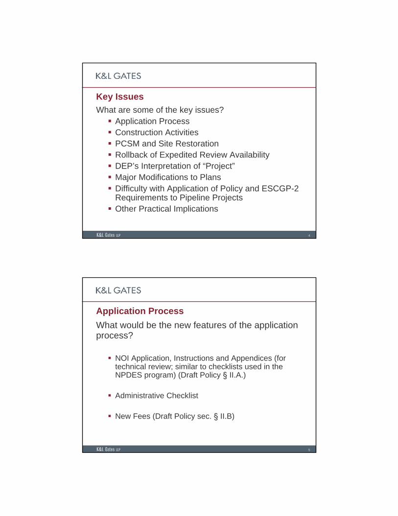
Key Issues
What are some of the key issues? Application Process Construction Activities PCSM and Site Restoration Rollback of Expedited Review Availability DEP’s Interpretation of “Project” Major Modifications to Plans Difficulty with Application of Policy and ESCGP-2
Requirements to Pipeline Projects Other Practical Implications
5
Application Process
What would be the new features of the application process?
NOI Application, Instructions and Appendices (for technical review; similar to checklists used in the NPDES program) (Draft Policy § II.A.)
Administrative Checklist
New Fees (Draft Policy sec. § II.B)

6
Application Process (cont.)
What would be the time frame for issuance?
Expedited Review: 14 Business Days (Draft Policy §II.A., at p. 3).
Other: 60 Calendar Days (Id.)
Potential processing delays for open violations (NOI Instructions and NOI)
Issue: DEP’s lack of diligence in closing out violations may affect issuance of permit even if violation is resolved and operator is in full compliance.
7
Application Process (cont.)
When would earth disturbance activities be authorized?
Date of authorization on the ESCGP-2 (Draft ESCGP-2, preamble)
Preconstruction Meetings (Draft Policy § II.D., at 6)
Issue: Must the operator wait for other pending approvals before commencing operations?

8
Construction Activities
What would apply during construction activities?
Perimeter BMPs: Before commencing the “bulk of earth disturbance activities,” notice to DEP and 3-day waiting period (Draft ESCGP-2 § 16(c))
Temporary Stabilization: Earth disturbance activities “cease” for four or more days (DEP considers activity “ceased” when “earth disturbance activity is no longer occurring on a project site inaccordance with the sequence of BMP installation and removal in the erosion and sedimentation control plan”) (Draft Policy §IV.A., at 9)
Permanent Stabilization: Stabilize area around wellhead (e.g., gravel) and achieve 70% cover of remaining area (Draft Policy §IV.B., at 10)
9
PCSM and Site Restoration
What are the requirements for PCSM and/or site restoration?
Policy drafted before Act 13 of 2012 (does not reflect possible extension up to two years if certain requirements are met) (Draft Policy §IV.C., at 10-11).
Policy is unclear as to timing and sequence of PCSM requirements and site restoration.

10
Expedited Review
What’s in? (Draft Policy § II.A., at 3-4)
Everything that’s not excluded (exclusions discussed later)
Eligible projects: NOIs must be “complete and acceptable”(undefined)
Sealed by licensed professionals trained by (consequences for “deficient NOIs”)
Potential processing delays for open violations
Issue: DEP’s diligence in closing out violations may affect issuance of permit even if violation is resolved and operator is in full compliance.
11
Expedited Review (cont.)
What’s out? (Draft Policy § II.A., at 3-4)
HQ/EV Streams based on Chapter 93 Designations Issue: Existing uses continuously change Streams may not have attained an existing use at time of
application. What happens if the stream is later designated?
Well Pads in Floodplains Flood Fringe and Flood Way Edge of pad; tanks
Transmission Facilities – Undefined
Act 2 areas

12
The “Project”How does the draft Policy define “the project” for purposes of requiring authorization under ESCGP-2? (Draft Policy §III.A., at 3-4)
“[S]ubstantially connected well sites, access roads, pipelines, other service lines, support facilities, and/or other oil and gas activities.”
Must the earth disturbance activities occur simultaneously to constitute one project? (Id.)
13
The “Project” (cont.)
What might this mean?
Potential that DEP will require single authorization for multiple projects sponsored by different persons
Potential that DEP will combine different projects sponsored by different persons to calculate the five-acre threshold under 25 Pa. Code sec. 102.5(c)
Potential for common responsibility under ESCGP-2 among different persons sponsoring different projects at different times and distances.
Potential for PNDI clearance for the entire project.

14
Potential “Project” Scenarios
15
The “Project” (cont.)
Is DEP’s proposed interpretation consistent with Chapter 102?
“A person proposing oil and gas activities that involve 5 acres (2 hectares) or more of earth disturbance over the life of the project shall obtain an E&S Permit under this chapter prior to commencing the earth disturbance activity”(emphasis added).

16
Major Modifications to E&S Plans
What is a “major” modification under the draft Policy?
“Major” modifications include, but are not necessarily limited to, a “new or additional earth disturbance activity and the creation of a new discharge location.” (Draft Policy § II.A., at 1).
“Minor” modifications include “adjustments to BMPs and locations within the permitted boundary to improve environmental performance within the scope of the approved E&S Plan, change in ownership or address, typographical errors and field adjustments on-site such as the addition or deletion of BMPs to address unforeseen circumstances.” (Id.)
17
Modifications (cont.)
What are the issues?
Unclear whether any other modifications will constitute “major” modifications.
Reviewer seems to maintain discretion to determine what is major and what is not.
Unclear when new NOI is required

18
Difficulty with Application to Pipeline Projects
Are the Policy and ESCGP-2 requirements consistent with construction of linear projects?
There are a number of requirements in the draft documents that are inconsistent with linear project construction phasing and methods.
19
Pipelines (cont.)
What are some examples of requirements that are inconsistent with pipeline projects?
Perimeter BMP construction required before engaging in the “bulk” of earth disturbance. However: Pipelines built in segments Is it practical to require installation of all perimeter BMPs for
the entire length of pipe?
The Policy requires PCSM to may require PCSM BMPs to offset any net increase in run-off. However: In the vast majority of cases, the disturbed area is fully
restored to pre-construction conditions after the pipeline is installed.
Installation and maintenance of post-construction BMPs would create more earth disturbance than the project itself.

20
Pipelines (cont.)
What are other implications for pipelines?
A well site remains “open” until DEP receives the site restoration report. (Draft Policy § III.A., at 8).
If DEP’s interpretation of “project” stands, it may mean that a pipeline project that is completed and the site restored remains “open” until the well site is restored.
21
Practical Implications
What might all this mean?
Delays in planning and project schedules
Increase in planning and implementation costs
Potential for large-scale coordination efforts among separate entities sponsoring different projects

22
Questions?
Thank you for your time.
George A. BibikosK&L Gates LLP [email protected](717) 231-4577

D

PITTSBURGH OFFICE
412.355.8263 TEL
412.355.6501 FAX
HARRISBURG OFFICE
717.231.4517 TEL
717.231.4501 FAX
David R. Overstreet
AREAS OF PRACTICE
Mr. Overstreet has been with K&L Gates since 1993 and has an administrative law and litigation practice spanning several substantive disciplines with an emphasis on energy and environmental matters. He assists clients in a variety of business sectors with permit applications and enforcement matters before state and federal regulatory agencies, including the Pennsylvania Department of Environmental Protection and the United States Environmental Protection Agency. Mr. Overstreet appears regularly before the Pennsylvania Environmental Hearing Board as well as state and federal courts in Pennsylvania and, in addition to being a member of the Pennsylvania bar, is admitted to practice before the United States Supreme Court and the United States Court of Appeals for the Third, Fifth and D.C. Circuits.
Mr. Overstreet also represents state and national trade associations in connection with administrative agency rulemakings and adjudications and judicial review of such actions. On behalf of national clients, he has appeared before, and litigated against, federal and state agencies throughout the United States and has successfully prosecuted civil actions brought against local and state government officials in federal courts in several states.
Mr. Overstreet is actively involved on behalf of a number of different clients in permitting, enforcement and litigation matters associated with the development of shale gas facilities in Pennsylvania. He represents natural gas development, collection and distribution companies with respect to gas well, air emission and water use permits, leasing and property rights disputes, administrative enforcement actions and related consent orders as well as third-party permit appeals. He also defends clients against civil actions alleging groundwater and surface contamination and personal injury allegedly associated with gas well development and, as part of his shale gas development practice, Mr. Overstreet has worked with leading experts in a variety of technical disciplines.
In addition to his work with natural gas development and distribution companies, Mr. Overstreet represents clients in the waste management, refining and power generation sectors. For more than fifteen years, he has advised clients with permitting, enforcement and litigation matters arising in connection with the development and operation of landfills, oil refineries, surface mines and natural gas power plants.
Mr. Overstreet also has a commercial litigation practice, as a complement to his regulatory and administrative litigation practice, and has served as lead counsel in jury and non-jury trials in state and federal courts. Mr. Overstreet has also represented witnesses and targets in grand jury proceedings and, on behalf of national clients, has lead confidential, internal investigations into allegations of alleged fraud and related statutory and regulatory violations. For several years prior to attending law school, Mr. Overstreet developed and managed a franchise and independent restaurant group that grew to include several
K&L Gates LLP

David R. Overstreet
K&L Gates LLP
restaurants with approximately one hundred and fifty employees.
BAR MEMBERSHIP
Pennsylvania
EDUCATION
J.D., Villanova University, 1993 (magna cum laude; Order of the Coif; Managing Editor, Villanova Law Review)
B.S. (Business Administration), Pennsylvania State University, 1982

PITTSBURGH OFFICE
412.355.8331 TEL
412.355.6501 FAX
John P. Englert
AREAS OF PRACTICE
John Englert is a partner in the Environmental, Land Use and Natural Resources Practice Group and works in the Pittsburgh office. Mr. Englert has over 25 years of environmental safety and health experience, and counsels corporate clients on regulatory compliance issues and related business risk management issues. Mr. Englert has represented companies before numerous state and federal administrative agencies and in state and federal courts.
PROFESSIONAL BACKGROUND
Since joining K&L Gates in 1994, Mr. Englert has advised numerous clients on a wide range of environmental matters. He has helped clients obtain necessary environmental permits and approvals, ranging from general stormwater discharge permits through complex PSD air permits and RCRA hazardous waste treatment permits. He has counseled oil and gas clients on regulatory compliance, permitting, hazardous material transportation, and environmental cleanup matters. Mr. Englert has also represented clients in administrative enforcement actions and in civil litigation concerning alleged violations, permit appeals, recovery of environmental cleanup costs and other matters. Prior to joining K&L, Mr. Englert was a consultant for over 13 years. During that time he gained extensive experience in environmental permitting and regulatory compliance, particularly in New York, where he was based for most of this period. Mr. Englert has published numerous articles on nuclear and environmental issues.
PRESENTATIONS
Include any presentations/speaking engagements.
PUBLICATIONS
Include any publications.
PROFESSIONAL/CIVIC ACTIVITIES
Allegheny County Bar Association - Environmental Law Section American Bar Association - Section of Environmental, Energy, and Resources Pennsylvania Bar Association - Environmental Law and Administrative Law
Sections
COURT ADMISSIONS
Supreme Court of New York Supreme Court of Pennsylvania U.S. District Court of the Western District of Pennsylvania U.S. Courts of Appeals for the 3rd and 6th Circuits
BAR MEMBERSHIP
Bar of New York
K&L Gates LLP

John P. Englert
K&L Gates LLP
Bar of Pennsylvania
EDUCATION
J.D., State University of New York at Buffalo Law School (1993) (magna cum laude) M.S., State University of New York at Buffalo (1980) B.A., State University of New York at Buffalo (1977) (cum laude)

HARRISBURG OFFICE
717.231.4577 TEL
717.231.4501 FAX
George A. Bibikos
AREAS OF PRACTICE
Mr. Bibikos has a litigation and regulatory practice that focuses on oil and gas law, energy and natural resource development, environmental litigation and regulatory counseling, public utility law, procurement matters, and administrative law. His areas of emphasis include: Oil and gas, with an emphasis on lease litigation, environmental litigation,
transactional advice, and regulatory compliance. Commercial litigation and appeals, with an emphasis on federal practice and
appellate advocacy, including representation of clients in state and federal trial courts, all Pennsylvania state appellate courts, the Third Circuit Court of Appeals, and the Supreme Court of the United States.
Administrative agency litigation, including representation of clients before the
Public Utility Commission, Environmental Hearing Board, various professional licensing agencies, and regional water management agencies such as the Susquehanna and Delaware River Basin Commissions.
Environmental counseling and compliance, including oil and gas well
permitting issues, well site development, well casing and cementing requirements, erosion and sedimentation controls, well site restoration, air quality, and water resource planning and management.
Public utility law, including jurisdictional disputes, extension of service disputes,
rate cases, compliance filings, and pipeline construction and safety requirements under federal and state law.
Procurement matters, with an emphasis on bid protest litigation in local and state
agencies and on appeal to the Commonwealth Court of Pennsylvania. In addition to his practice, Mr. Bibikos serves as Adjunct Professor of Oil and Gas Law at Widener University School of Law in Harrisburg, Pennsylvania.
PROFESSIONAL BACKGROUND
From 2003 to 2005, Mr. Bibikos served as a law clerk for the Honorable Dan Pellegrini of the Commonwealth Court of Pennsylvania.
PROFESSIONAL/CIVIC ACTIVITIES
Barrister, James S. Bowman American Inns of Court (2010) Council Member, Administrative Law Section, PBA (Appointed) Appellate Advocacy Committee, PBA (Appointed) Judge, Widener Law Moot Court Competitions Faculty, Widener Law Intensive Trial Advocacy Program
K&L Gates LLP

George A. Bibikos
K&L Gates LLP
Chair, Class Agent Program, Widener Law Alumni Association
PUBLICATIONS
Mr. Bibikos has published over 25 law reviews and other articles that span a variety of disciplines, including oil and gas law, environmental law, constitutional law, appellate practice and procedure, procurement, public utility law, local land use and zoning requirements, and labor and employment issues. He is a co-author with Jeffrey C. King of A Primer on Oil & Gas Law in the Marcellus Shale States, cited favorably by the Pennsylvania Supreme Court, the United States Court of Appeals for the Ninth Circuit, and other secondary sources.
SPEAKING ENGAGEMENTS
Mr. Bibikos has lectured on many topics including oil and gas law, environmental law, trial and appellate practice, state procurement, Pennsylvania state tax exemptions for religious and charitable institutions, and civil rights.
COURT ADMISSIONS
Supreme Court of Pennsylvania U.S. Supreme Court U.S. Court of Appeals for the Third Circuit U.S. District Court for the Middle District of Pennsylvania
BAR ADMISSIONS
Pennsylvania
EDUCATION
J.D., Widener University School of Law, 2003 (magna cum laude; Editor-In-Chief, Widener Law Journal; Phi Kappa Phi National Honor Society; Widener Scholar)
B.A., Shippensburg University, 2000
HONORS AND ACHIEVEMENTS
Selected by Pennsylvania Super Lawyers© magazine for inclusion in the 2010, 2011, and 2012 Rising Stars list of top young lawyers in the state.
Received a “Pro Bono Award” from the Pennsylvania Bar Association in 2009. Received an “Outstanding Recent Alumni Award” from Widener University
School of Law in 2007.
LANGUAGES
Greek
REPRESENTATIVE EXPERIENCE
Since joining the firm in 2005, Mr. Bibikos has represented a broad range of clients in the energy sector, including oil and gas companies, interstate pipeline companies, midstream companies, pipeline manufacturers, seismic exploration companies, public utilities, and alternative energy producers. Mr. Bibikos also represents land developers, major food corporations, government contractors, and other commercial

George A. Bibikos
K&L Gates LLP
entities in various market sectors. His representative work includes the following:
OIL AND GAS
Representation of major oil and gas production companies targeting the Marcellus Shale in the Appalachian Basin region, including advice on lease terms, royalty and bonus payments, fractured ownership of oil and gas and other mineral interests, surface use, voluntary and forced pooling, physical and seismic trespass, seismic testing, gas migration and water pollution allegations, lease drafting, well site development on private and government owned lands, and due diligence on leasehold acquisitions.
Represented oil and gas production companies in major cases resulting in
precedent setting decisions for the industry in Pennsylvania, including Belden & Blake v. DCNR, 969 A.2d 528 (Pa. 2009) (successful affirmation of surface use rights of oil and gas owners/lessees); Range Resources v. Salem Township, 964 A.2d 869 (Pa. 2009) (successful challenge to local ordinance regulating oil and gas activities); and Kilmer v. Elexco Land Services, 990 A.2d 1147 (Pa. 2010) (successful defense of thousands of natural gas leases challenged by landowners under the Pennsylvania Minimum Royalty Act).
Representation of a major worldwide oil and gas production company in
lease disputes in Pennsylvania. Representation of major Marcellus Shale players in litigation involving lease
termination issues, co tenancy issues, surface use disputes, royalty disputes, pooling issues, top leasing, and related lease matters.
Representation of oil and gas production company in lawsuit alleging water
supply contamination.
ENVIRONMENTAL LITIGATION AND REGULATORY COUNSELING
Represented oil and gas operator in challenge to well permit issued by Department of Environmental Protection.
Represented ethanol plant in challenges to air quality plan approval issued by
Department of Environmental Protection. Counsel to well operators and midstream companies regarding erosion and
sedimentation controls for oil and gas activities in Pennsylvania. Advised major oil and gas producing company regarding national water
resource management and regulatory programs governing water withdrawal and use requirements.
Representation of oil and gas production companies on environmental and
regulatory permitting requirements, including erosion and sedimentation controls for well pad and gas pipeline projects, blasting permits for seismic

George A. Bibikos
K&L Gates LLP
activities, road use and bonding matters, local zoning matters, and forced pooling and unitization issues.
PUBLIC UTILITY LITIGATION AND REGULATORY COUNSELING
Representation of land developer in dispute over extension of wastewater service to proposed land development.
Representation of water utilities in rate cases. Representation of pipeline companies in certification proceedings. Advise clients regarding natural gas pipeline construction and safety
regulations for gathering and transportation lines.
PROCUREMENT MATTERS
Representation of contractors in bid protests challenging award of contracts by Pennsylvania Department of Public Welfare.
Representation of telecommunications company on appeal from order
enjoining unlawful award of telephone services contract for local prison.
STATE AND FEDERAL LITIGATION AND APPEALS
Representation of a major manufacturer of chocolate in dismissal of lawsuit alleging public nuisance.
Representation of major fresh produce company in commercial lease dispute. Appellate representation of trade association in defense of agency order
regarding milk price premiums. Appellate representation of public officials challenging Governor’s line item
veto power. Appellate representation of public officials in taxpayer litigation challenging
constitutionality of legislative enactments and legislative appropriations. Appellate representation of habeas petitioners in the United States Court of
Appeals for the Third Circuit and in Supreme Court of the United States alleging ineffective assistance of prior counsel.
Appellate representation of amicus parties in the United States Court of
Appeals for the Third Circuit and in Supreme Court of the United States regarding legislative immunity issues.

E

APPALACHIAN BASIN OIL AND GAS PRACTICE
The Marcellus Shale, currently the hottest natural gas play in North America,
could contain more than 500 trillion cubic feet of recoverable natural gas. The
opportunities associated with developing a shale play of that magnitude are
abundant. Along with these opportunities are numerous concerns such as the
technical challenges of drilling, environmental regulation, legal issues such as
surface and land use rights, the legislative landscape and financing alternatives.
K&L Gates has represented clients in the oil and gas industry in Pennsylvania, West Virginia, Ohio and New York for decades. Our oil and gas practice is built on a sophisticated and detailed understanding of the legal aspects of exploring for, produc-ing, transporting, storing, marketing and processing natural gas, coal bed methane and oil. Our oil and gas team is experienced in all areas of law associated with the devel-opment of the Marcellus Shale including the following:
“K&L Gates has represented clients in the
oil and gas industry in Pennsylvania, West
Virginia, Ohio and New York for decades.”
• Mineral Rights/Leases
• Environmental (Air, Water, Waste, Radiological)
• Litigation
• Permitting
• Water Use and Reuse
• Surface Use Agreements
• Regulatory/Tax Issues
• Mediation and Arbitration
• Public Policy
• Municipal and Township Ordinances
K&L Gates’ oil and gas team includes lawyers licensed to practice in the active areas of the Appalachian region, including Pennsylvania, West Virginia, Ohio and New York. Several of our partners have extensive prior experi-ence in serving with governmental agencies, including the Pennsylvania Department of Environmental Protection (PaDEP), the Delaware River Basin Commission (DRBC), the Susquehanna River Basin Commission (SRBC), the Ohio River Valley Water Sanita-tion Commission and the U.S. Environmental Protection Agency (U.S. EPA). These lawyers also have long-standing relationships with many public officials, including governors, senators and congressmen and include former members of the Pennsylvania cabinet in legislative affairs.

1003
6For more information about our Appalachian Basin Oil and Gas practice, please contact any of the lawyers listed below who are licensed to practice in the following states:
PennsylvaniaCraig P. Wilson
+1.717.231.4509
David R. Fine
+1.717.231.5820
R. Timothy Weston
+1.717.231.4504
Walter A. Bunt, Jr.
+1.412.355.8906
Contacts:New YorkCraig P. Wilson
+1.717.231.4509
Donald W. Stever
+1.212.536.4861
John P. Englert
+1.412.355.8331
We have represented industry interests in a series of key court cases including Kilmer v. Elexco Land Services Company, 990 A.2d 1147 (Pa. 2010); Range Resources—Appa-lachia, LLC, et al. v. Salem Township, et al., 964 A.2d 869 (Pa. 2009); Belden & Blake Corp. v. Commonwealth of Pennsyl-vania, Dep’t of Conservation and Natural Resources, 969 A.2d 528 (Pa. 2009). These cases deal with such important issues as the following:
• State-required minimum royalties affected by post-production charges.
• Claims of fraudulent inducement to vitiate Marcellus Shale leases.
• Lease contests with respect to implied cov-enants to develop Marcellus Shale zones.
• The scope of preemption as to municipal regulation of oil and gas development.
• State and federal regulation of natural gas development on public lands where the governmental units do not own or control the mineral rights.
• The questions confronted in these cases will set the framework for many future development efforts.
Environmental issues continue to affect development of the Marcellus Shale play and K&L Gates counsels its clients through regulatory, permitting and enforcement proceedings involving PaDEP, West Virginia Department of Environmental Protection, New York State Department of Conserva-tion, Ohio EPA and U.S. EPA, as well as the DRBC, SRBC and Pennsylvania Fish and Boat Commission. Issues include new and existing regulations, policies, guidance or permitting approaches affecting air emis-sions, water use and reuse, waste treatment and disposal, radiological concerns, surface impoundments, pipelines, stream crossings and threatened and endangered species. We also assist our clients in enactment of new and amended municipal and town-ship ordinances that allow predictable and efficient development while recognizing the limited role of local government.
“Our oil and gas team is experienced in
all areas of law associated with the
development of the Marcellus Shale...”
OhioCraig P. Wilson
+1.717.231.4509
David R. Overstreet
+1.412.355.8263

F

550-2100-008 / DRAFT January 17, 2012 / Page i
DEPARTMENT OF ENVIRONMENTAL PROTECTION
Office of Oil and Gas Management
DOCUMENT NUMBER: 550-2100-008 TITLE: Policy for Erosion and Sediment Control General Permit for Earth
Disturbance Associated with Oil and Gas Exploration, Production, Processing or Treatment Operations or Transmission Facilities (E&S General Permit for Oil and Gas Activities).
EFFECTIVE DATE: Upon publication of notice as final in the Pennsylvania Bulletin
AUTHORITY: The Clean Streams Law (35 P. S. §§ 691.1--691.1001); the Oil and Gas Act (58 P. S. §§ 601.101--601.607); Sections 1905-A, 1917-A and 1920-A of The Administrative Code of 1929 (71 P. S. §§ 510-5, 510-17 and 510-20); regulations at 25 Pa. Code Chapter 102 (relating to erosion and sediment control) and 25 Pa. Code Chapter 78 (relating to oil and gas wells).
POLICY: Department of Environmental Protection (DEP) and Conservation Districts will follow the guidance presented in this document to implement Chapter 102 requirements for earth disturbance activities associated with and gas exploration, production, processing, treatment operations or transmission facilities (Oil and Gas Activities).
PURPOSE: The purpose of this guidance is to inform those engaged in earth disturbance activities associated with oil and gas exploration, production, processing, treatment operations or transmission facilities how to comply with the requirements of Chapter 102.
APPLICABILITY: This document is the Department’s guidance for evaluating when a person must obtain an E&S Permit for earth disturbance activities associated with Oil and Gas Activities.
DISCLAIMER: The policies and procedures outlined in this guidance document are intended to supplement existing requirements. Nothing in the policies or procedures shall affect regulatory requirements.
The policies and procedures herein are not an adjudication or a regulation.
There is no intent on the part of the Department to give these rules that weight or deference. This document establishes the framework, within which DEP will exercise its administrative discretion in the future. DEP reserves the discretion to deviate from this policy statement if circumstances warrant.
PAGE LENGTH: 17 pages

550-2100-008 / DRAFT January 17, 2012 / Page 1
EROSION & SEDIMENT CONTROL FOR EARTH DISTURBANCE ACTIVITIES
ASSOCIATED WITH OIL AND GAS ACTIVITIES
I. Permit Requirements
All persons performing earth disturbance activities associated with oil and gas activities must implement and maintain Erosion and Sediment Control Best Management Practices (E&S BMPs) to minimize the potential for accelerated erosion and sedimentation. A person proposing earth disturbance activities must develop and implement a written Erosion and Sediment Control Plan (E&S Plan) when earth disturbance activities will result in total earth disturbance of 5,000 square feet or more, the earth disturbance activity has the potential to discharge to water classified as High Quality or Exceptional Value water under 25 Pa. Code Chapter 93 (relating to water quality standards), or if the person is required to develop an E&S Plan under 25 Pa. Code Chapter 102 or other Department regulations (e.g. 25 Pa. Code Chapter 105, relating to water obstructions and encroachments and dam safety). A person proposing oil and gas activities that involve five acres or more of earth disturbance over the life of the project must obtain an Erosion and Sediment Control Permit (E&S Permit) prior to commencing the earth disturbance activity.
II. Permit Process
A. Notices of Intent for Coverage under the E&S General Permit for Oil and Gas
Activities (NOIs)
An applicant seeking an E&S General Permit for Oil and Gas Activities should submit an NOI to either the Conservation District, DEP Regional Waterways Engineering and Wetlands Program, or DEP Regional Oil and Gas Program depending on the proposed activity to be authorized. All applicants must submit a complete an acceptable application package that contains all of the items listed in the INSTRUCTIONS FOR A
NOTICE OF INTENT (NOI) FOR COVERAGE UNDER THE EROSION AND
SEDIMENT CONTROL GENERAL PERMIT (ESCGP-1) FOR EARTH
DISTURBANCE ASSOCIATED WITH OIL AND GAS EXPLORATION,
PRODUCTION, PROCESSING OR TREATMENT OPERATIONS OR
TRANSMISSION FACILITIES (DEP Document #5500-PM-OG0005). Prior approval from the Department or Conservation District is required for all major modifications to the approved E&S Plan. Major modifications include but are not limited to new or additional earth disturbance activity and the creation of a new discharge location. Major modifications to the approved E&S Plan may also require the submittal of a new NOI. All minor modifications to the E&S Plan and Post Construction Stormwater Management (PCSM) Plan should be noted on the plan that is available at the site and initialed by the Department or Conservation District staff. The Department should be notified when minor changes to the E&S plan are made. Minor changes to the E&S Plan or the PCSM Plan may include adjustments to BMPs and locations within the permitted boundary to improve environmental performance within the scope of the approved E&S Plan, change in ownership or address, typographical errors and field adjustments on-site such as the addition or deletion of BMPs to address unforeseen circumstances.

550-2100-008 / DRAFT January 17, 2012 / Page 2
Transmission Facilities NOIs for activities involving construction of transmission facilities should be submitted to Conservation Districts, as defined in Section 3(c) of the Conservation District Law (3 P.S. § 851(c)), which have the authority under a delegation agreement executed with the Department to administer and enforce all or a portion of the erosion, sediment, and stormwater management programs in this Commonwealth. For activities proposed in a county that is not delegated, the review and processing of the E&S General Permit for Oil and Gas Activities will be conducted by the Waterways Engineering and Wetlands Program in the appropriate DEP regional office. Transmission facilities include: transmission lines, transmission system compressor locations, gas purification and scrubber locations that are located “downstream” of the gathering line system. Conservation Districts will be responsible for inspection and complaint response for all transmission facility earth disturbances. For non-delegated counties, the appropriate regional DEP Waterways Engineering and Wetlands program shall have this responsibility. It is the policy of the Department to require only one permit for each construction activity. Projects occurring in two counties should be processed in the County Conservation District where the greater amount of project acreage is located. Coordination of the technical review letter must occur between the two Conservation Districts, with Department assistance, if necessary. Each district is authorized to charge a plan review fee; however, the processing district retains the administrative filing fee. Unless otherwise authorized by DEP, construction activities that occur in three or more counties within one DEP regional office are processed by the DEP regional office. In this case, the DEP regional office retains the administrative filing fee. Each Conservation District will review the erosion and sediment pollution control plan for their respective counties, and submit the plan review findings to the DEP regional office, which will then generate the plan review letter incorporating the plan review findings and recommendations from each Conservation District. If, for example, a transmission line crosses more than one regional boundary, each region would get a separate administratively complete NPDES permit application package for its respective region, and process their own respectively. Again, each district would receive a copy of the E&S Plan for their respective county, and would submit to the regional office their technical deficiency comments. Each region would receive the administrative filing fee. In regions where it only affects two counties in that region, the county with the majority of the project would receive the complete application package instead of the region and retain the permit filing fee. The county with the least amount of disturbance would coordinate their technical review letter with the other county. In certain instances, the Department may elect to issue separate permits for extensive linear projects, including, but not limited to, pipeline construction projects. Typically, separate permits will be issued for each county, or other identifiable segment. However,
550-2100-008 / DRAFT January 17, 2012 / Page 3
in no case will subdividing the project exempt any portion of the project from permit coverage. All NOIs submitted for activities involving construction of transmission facilities will be reviewed using a standard 60 day review process. Exploration, Production, Processing or Treatment Facilities NOIs for activities involving exploration, production, processing or treatment facilities including, but not limited to, well sites, gas gathering or production lines, gathering system compressor stations, impoundments and access roads for these facilities should be submitted to the Oil and Gas Program at the appropriate DEP regional office. Additionally, the Oil and Gas Program field staff is responsible for inspection and complaint response for all earth disturbance activities associated with exploration, production, processing, and treatment facilities. NOIs submitted for activities involving exploration, production, processing or treatment facilities are reviewed under a standard 60 day review process, except when an expedited review is requested in specific circumstances, as described below. Expedited Review Process The Department offers an optional expedited permit process to persons seeking an E&S General Permit. Applicants that qualify for and request permit coverage through the expedited review process will be provided with an acknowledgement of coverage within 14 business days from the submission of a complete and acceptable NOI. The expedited permit process is available to persons seeking an E&S General Permit for earth disturbance activities other than the following: Projects located in or with the potential to discharge to waters that have a
designated or existing use of High Quality (HQ) or Exceptional Value (EV) pursuant to Chapter 93 (relating to water quality standards). Waters that have attained a designated use are listed in Chapter 93. Waters that have attained an existing use are listed at the following website:
http://www.portal.state.pa.us/portal/server.pt/community/existing_use/10557
Projects in which the area surrounding an oil or gas wellhead that is subject to earth disturbance and that is used or planned for use for the drilling, production or plugging of the well, including associated support activities (such as storage of chemicals, wastewater, drill cutting, and equipment) will be constructed in or on a Floodplain. For the purposes of this policy a floodplain is the lands adjoining a river or stream that have been or may be expected to be inundated by flood waters in a 100-year frequency flood. See 25 Pa. Code § 105.1. Unless otherwise specified, the boundary of the floodplain is as indicated on maps and flood insurance studies provided by FEMA. In an area where no FEMA maps or studies have defined the boundary of the 100-year frequency floodplain, it is assumed absent evidence to the contrary, that the floodplain extends from (1) any

550-2100-008 / DRAFT January 17, 2012 / Page 4
perennial stream to 100 feet horizontally from the top of the bank of such perennial stream, and (2) from any intermittent stream to 50 feet horizontally from the top of the bank of such intermittent stream.
Earth disturbance activities on lands that are known to be currently contaminated
by the release of regulated substances as defined in Section 103 of The Pennsylvania Land Recycling and Environmental Remediation Standards Act (Act 2), 35 P.S. § 6026.103.
Transmission facility projects.
NOIs for coverage under an E&S General Permit submitted through the “expedited permit process” must be prepared and certified by a licensed professional (e.g. engineer, surveyor, geologist or landscape architect) who is registered in Pennsylvania and who has attended up-to-date training provided by the Department’s Office of Oil and Gas Management on erosion and sediment control and post construction stormwater management for oil and gas activities. The Department may update this training periodically to address applicable regulatory or policy revisions or revisions to technical guidance relating to erosion and sediment control or post construction stormwater management. When the Department updates this training, a trained licensed professional will need to attend this most current training to continue to prepare and certify NOIs for expedited review. The Department will publish a notice in the Pennsylvania Bulletin when it updates this training. Licensed professionals will have 1 calendar year to attend training after the Department’s notice is published. The licensed professional is responsible for the development of a complete and acceptable NOI package, including an E&S Plan that specifies E&S BMP implementation and maintenance requirements and a site restoration plan with PCSM BMPs that meet regulatory requirements. All E&S Plan and PCSM/Site Restoration Plan drawings and plan narratives submitted for the expedited review process must be sealed by the licensed professional that prepared the application and plans. The seal must be placed on the cover page of the plan drawings, each plan drawing and on the cover of the narrative. If a licensed professional routinely submits deficient NOIs, the Department may determine that the licensed professional may no longer submit NOIs under the expedited process. The Department will notify in writing any licensed professional that it determines may no longer submit NOIs under the expedited review. Licensed professionals that have been notified that they are no longer eligible to submit NOIs under the expedited review may request to have their eligibility reinstated by the Department not less than 1 year after receipt of notification that they are no longer eligible. The request for reinstatement should include a demonstration of competency by the licensed professional. The demonstration of competency may include: Erosion and sediment control permits or plans that are technically sound and
approved by the Department or a Conservation District after the date of suspension. These can include plans submitted for:
o Standard Review ESCGP For Oil and Gas Activities
550-2100-008 / DRAFT January 17, 2012 / Page 5
o Chapter 105 Waterway Encroachment Permits o General and Individual NPDES Permits for discharges associated with
construction
If the licensed professional does not prepare any erosion and sediment control plans described above, the licensed professional may obtain certification as a Professional in Erosion and Sediment Control and submit that certification to the Department as a demonstration of competency.
Another form of demonstration approved by the Department. If, after being reinstated, a licensed professional routinely submits deficient NOIs, the Department may determine that the licensed professional may no longer submit NOIs under the expedited process. Licensed professionals that have been notified that they are no longer eligible to submit NOIs under the expedited process a second time will be permanently excluded from submitting NOIs under the expedited process. The Department will review NOIs, including E&S Plans and PCSM/Site Restoration plans to ensure that applicants have submitted complete and acceptable applications. Technical or administrative deficiencies may delay permit issuance. Time taken by an applicant to correct a technical or administrative deficiency will not be counted toward the review process timeframe. It is the responsibility of the applicant to ensure that the application package, as submitted to the Department, is complete and free of deficiencies.
B. Permit Fees
Fees for review and authorization of new permits and major modifications to previously authorized earth disturbance for Oil and Gas Activities include an administrative filing fee of $500 plus an additional fee of $100 for every acre of proposed disturbance. For major modifications, the disturbed acreage fee should only be for the disturbed area being added to the permit. For example, increasing from 100 to 105 disturbed acres with a major modification would require payment for only the additional 5 acres. Fees are not required for authorization of minor modifications to previously authorized earth disturbance for Oil and Gas Activities. A NOI for a phased project should be submitted with an administrative fee of $500 plus an additional fee of $100 for every acre of the first phase of the project. Subsequent phases should be submitted with a fee of $100 for every acre of proposed disturbance for that phase. The administrative filing fee will not need to be paid with each subsequent phase submittal. Acreage fractions greater than or equal to 0.5 should be rounded up to the nearest whole number and acreage fractions less than 0.5 should be rounded down to the nearest whole number. Conservation Districts may charge additional fees in accordance with Section 9(13) of the Conservation District Law (3 P.S. § 857(13)). See 25 Pa. Code § 102.6(b). For NOIs submitted directly to the Department, checks must be made payable to “Commonwealth of Pennsylvania, Clean Water Fund”. All checks are to be dated within 10 days of the application submittal date and sent with the NOI directly to the Oil and Gas Program in the appropriate DEP regional office.

550-2100-008 / DRAFT January 17, 2012 / Page 6
For NOIs submitted directly to a Conservation District, two checks are required. A check for the administrative filing fee of $500 made payable to “(Name of delegated County Conservation District), Clean Water Fund”. Conservation Districts may charge an additional fee pursuant to 25 Pa. Code § 102.6(b)(3). The second check submitted with the NOI is for the ‘per acre disturbance fee’ of $100/acre of earth disturbance and should be made payable to “Commonwealth of Pennsylvania, Clean Water Fund.” Both checks must be dated within 10 days of the application submittal date.
C. Co-Permittees
Pursuant to 25 Pa. Code § 102.5(h), operators that are not permittees must be included as co-permittees on the NOI. Section 102.1 defines “operator” as a person who has one or more of the following: (1) oversight responsibility of earth disturbance activity on a project site or a portion thereof who has the ability to make modifications to the E&S plan, PCSM Plan or site specifications; or (2) day-to-day operational control over earth disturbance activity on a project site or a portion thereof to ensure compliance with the E&S Plan or PCSM Plan. Accordingly, for projects that involve earth disturbances associated with the preparation of a well site, the well operator should be included as a co-permittee if the operator is not the permittee.
D. Preconstruction Meetings
Pursuant to 25 Pa. Code § 102.5(e), the Department will conduct a preconstruction meeting for all earth disturbances authorized by and E&S General Permit, unless the permittee has been notified otherwise in writing by the Department. The permittee shall invite the Department to attend the preconstruction meeting and provide at least 7 days’ notice of the preconstruction meeting to all attendees. Where notice of a preconstruction meeting has been provided to the Department and the preconstruction meeting is held pursuant to § 102.5(e), but the Department’s representatives do not attend the scheduled preconstruction meeting, the earth disturbance activities approved under the erosion and sediment control general permit may proceed. The Department will develop a priority process for conducting preconstruction meetings and use its best efforts to follow that process. Priority projects may include:
1. Projects located in, or with the potential to discharge to, water that have a
designated or existing use of High Quality or Exceptional Value pursuant to Chapter 93 (relating to water quality standards);
2. Earth disturbance conducted in or on the following sensitive areas:
a. Highly erodible conditions (soils in combination with percent slope) as follows:
i. 3% to 8% slope with soil K factor greater than 0.37; ii. 8% to 15% slope with soil K factor greater than 0.28; or iii. 15% slope with soil K factor greater than 0.18

550-2100-008 / DRAFT January 17, 2012 / Page 7
b. Geological formations that present a risk to public health, safety and the
environment, including:
i. Sinkhole development; ii. Land sliding; or iii. Formations with significant potential to cause or contribute to
pollution when disturbed including acid, radioactive, and arsenic bearing formations
c. Projects located in wetlands or floodplains; d. Well sites that are located on a slope with a cut or fill that has a final
vertical height greater than or equal to 40 feet from toe of fill slope to the well site elevation.
e. Lands that are currently contaminated from a spill or release or a
hazardous material, or hazardous, toxic, or other regulated substance, as there terms are defined in Pa. Code 25 of the Pennsylvania Code, that pose a risk or threat to public health, safety, or the environment;
3. Earth disturbance conducted by a person who is in continuing violation of
Chapter 102 (relating to sediment and erosion control) or an E&S Permit for earth disturbance associated with Oil and Gas Activities, where notice of violations or compliance orders have been issued and the operator is correcting those violations to the satisfaction of the Department.
III. Permitting Guidelines
A. Defining the Project
Pursuant to 25 Pa. Code § 102.5(c), a person proposing Oil and Gas Activities that involve five acres or more of earth disturbance over the life of the project must obtain an E&S Permit under Chapter 102 prior to commencing the earth disturbance activity. As used in § 102.5(c), the Department interprets “project” to be substantially connected well sites, access roads, pipelines, other service lines, support facilities, and/or other oil and gas activities. Well Sites At a minimum, a well site project includes construction of the well site and access roads. Accordingly, the well site and the access roads are substantially connected and constitute a project for 25 Pa. Code § 102.5(c) permitting purposes. For multiple well sites that are concurrently under construction with a common access road, the well sites and access road are substantially connected and constitute a project. Well sites constructed along a common access road are substantially connected to every other well site that is concurrently under construction along the common access road and constitute a project.

550-2100-008 / DRAFT January 17, 2012 / Page 8
The Department considers a well site to be under construction until the Department receives the well site’s restoration report. Roads Activities involving the construction or improvement of roadways used for the sole purpose of conducting Oil and Gas Activities as defined in § 102.1 that do not meet the definition of Road Maintenance Activities as defined in § 102.1 are Oil and Gas Activities
and may be substantially connected to well sites, pipelines, other service lines or support facilities. Activities meeting the definition of Road Maintenance Activities as defined in § 102.1 are not Oil and Gas Activities and are not substantially connected to well sites, new road construction, pipelines, other service lines or support facilities. However, according to 25 Pa. Code § 102.5(b), a person proposing a road maintenance activity involving 25 acres or more of earth disturbance must obtain an E&S Permit under Chapter 102 prior to commencing the earth disturbance activity. Pipelines or Other Service Lines Pipelines or other service lines constructed as part of the same common line or with contiguous earth disturbance are substantially connected and constitute a project. The Department considers pipelines and other service lines that are contiguous along the entire length of the line from the point of origin to the point of termination to be part of the same common line. Intersection points between pipelines or other service lines may be considered the point of termination for all but one of the intersecting lines. In the case of pipelines, this will generally be the larger line. Well sites, access roads, and pipelines or other service lines are substantially connected and part of the same project when the well sites are constructed with interconnecting pipelines or other service lines and construction of the interconnecting service lines is commenced prior to completing all of the following items: Submission of a restoration report for all well sites to the Department,
Achievement of permanent stabilization of all disturbed areas, and
Receipt of the notice of termination acknowledgement from the Department for
any erosion and sediment control permits for the connected well sites and access roads.
Pipelines, other service lines, support facilities and/or access roads that are connected to multiple well sites and are constructed after completing all of the following items may be considered independent projects from the well sites: Submission of a restoration report for all well sites to the Department,
Achievement of permanent stabilization of all disturbed areas, and

550-2100-008 / DRAFT January 17, 2012 / Page 9
Receipt of the notice of termination acknowledgement of any erosion and sediment control permits by the Department for the well sites and access roads
Support Facilities A support facility, including but not limited to, an impoundment, staging area, tank farm, auxiliary road, parking lot, and borrow area or rock pit (“borrow pit”), that is within 900 feet of a well site is substantially connected to that well site and is thereby part of that well site project for § 102.5(c) permitting purposes. The Department presumes that borrow pits not regulated by the Non-Coal Surface Mining Conservation and Reclamation Act, permitted centralized wastewater impoundments and centralized freshwater impoundments are part of at least one well site for bonding and restoration requirements in § 78.302 and § 78.65, respectively. These requirements are held separate and independent from determinations of the scope of a project for erosion and sediment control permitting purposes. For additional information regarding mining permit requirements please see Borrow Pits for Oil and Gas Well Activities (DEP Document #563-2111-115). Support facilities that are not substantially connected to a well site may be independent projects from the well site project. Once the earth disturbance activity, site restoration and permanent stabilization of a project are completed and the Notice of Termination is acknowledged by the Department, additional earth disturbance activity at the project site is a new project. Permanent stabilization cannot be implemented intermittently in order to keep below the five acre threshold and avoid permit requirements.
IV. Stabilization and Restoration
A. Temporary Stabilization
According to 25 Pa. Code § 102.22(b), upon temporary cessation of an earth disturbance activity or any stage or phase of an activity where cessation of earth disturbance activities will exceed 4 days, the site must be immediately seeded mulched or otherwise protected from accelerated erosion and sedimentation pending future earth disturbance activities. For the earth disturbance activity or any stage or phase of an activity to be considered temporarily stabilized, the disturbed area must be covered with either a minimum uniform coverage of mulch and seed with a density capable of resisting accelerated erosion and sedimentation or an acceptable BMP which temporarily minimizes accelerated erosion and sedimentation. See 25 Pa. Code § 102.22(b). The Department considers earth disturbance activity to be ceased when earth disturbance activity is no longer occurring on a project site in accordance with the sequence of BMP installation and removal in the erosion and sedimentation control plan.

550-2100-008 / DRAFT January 17, 2012 / Page 10
B. Permanent Stabilization
According to 25 Pa. Code § 102.22(a), upon final completion of an earth disturbance activity or any stage or phase of activity, the site must have topsoil immediately restored, replaced, or amended, seeded, mulched or otherwise permanently stabilized and protected from accelerated erosion and sedimentation. For the earth disturbance activity or any stage or phase of an activity to be considered permanently stabilized, the disturbed area must be covered with a minimum uniform 70% perennial vegetative cover with a density capable of resisting accelerated erosion and sedimentation or an acceptable BMP which permanently minimizes accelerated erosion and sedimentation. See § 102.22(a)(2). At a minimum all of the following standards should be met:
1. The work area around the well and access road is stabilized with an erosion resistant material such as durable crushed rock, aggregate, gravel or other suitable material, and is capable of supporting the weight of the equipment being used.
2. Appropriate BMPs, such as culverts, rock protected outlets, and appropriate
erosion resistant linings, are placed in channels, and roadside ditches. 3. The remainder of the disturbed area is stabilized with a minimum of 70%
perennial vegetative cover with a density capable of resisting accelerated erosion and sedimentation or, seed and soil amendments are applied and the area is secured with appropriate BMPs such as mulch, erosion control blankets, or seed impregnated erosion control mats so that the required vegetation is established the next growing season. Applying seed and mulch to snow covered areas is not an acceptable BMP. Seeding and mulching alone is not considered permanent stabilization. Where the vegetation is not compatible with the land use (e.g. cropland) an acceptable BMP that permanently minimizes accelerated erosion and sedimentation must be in place.
4. Temporary BMPs, such as mulch, filter fence, straw bale barriers, filter socks or
rock filters, are installed and maintained until the minimum 70% vegetative cover is established.
C. Well Site Restoration
Pursuant to § 206(a) of the Oil and Gas Act, each oil or gas well owner or operator must restore the land surface within the area disturbed in siting, drilling, completing and producing a well. This requirement is applicable within all areas of disturbance identified as part of the well site in the project’s E&S Plan and PCSM Plan. Restoration After Drilling Pursuant to § 206(c) of the Oil and Gas Act, within 9 months after completion of drilling of any well, the owner or operator must restore the well site, remove or fill all pits used to contain produced fluids or industrial wastes and remove all drilling supplies and equipment not needed for production. Drilling supplies and equipment not needed for

550-2100-008 / DRAFT January 17, 2012 / Page 11
production may be stored on the well site if express written consent of the surface landowner is obtained. When multiple wells are drilled on a single well site, the Department interprets § 206(c) of the Oil and Gas Act to mean that post drilling restoration is required within 9 months after completion of drilling all permitted wells on the well site and/or the expiration of the all existing well permits on the well site, whichever occurs later in time. Additionally, the Department interprets § 206(c) of the Oil and Gas Act to mean that post drilling restoration includes the restoration of any centralized wastewater or freshwater impoundments Centralized wastewater or freshwater impoundments must be restored when no additional wells will be serviced by the impoundment after the 9 month restoration period. If additional wells will be serviced by the centralized wastewater or freshwater impoundment, as evidenced by a new valid well permit issued by the Department within the 9 month restoration period, restoration of the wastewater impoundment site is not required until 9 months after the final well serviced by the impoundment is drilled. Finally, the Department interprets § 206(c) of the Oil and Gas Act to mean that post drilling restoration includes the restoration of any borrow pit used to construct access roads or well sites. Borrow pits must be restored within 9 months of drilling the last well on a site that was developed using material obtained from the borrow pit. If additional well sites or access roads will be developed using material obtained from the borrow pit as evidenced by a new valid well permit for a site that was or will be developed from material obtained from the borrow pit within the 9 month restoration period, restoration of the borrow pit is not required until 9 months after the final well on a site developed with material obtained from the borrow pit is drilled. Under to 25 Pa. Code § 102.8(n), the portion of a site restoration plan that identifies PCSM BMPs to manage stormwater from Oil and Gas Activities permitted in accordance with Chapter 78 may be used to satisfy § 102.8’s PCSM Plan requirements if the PCSM/Site Restoration Plan meet the requirements of § 102.8, subsections (b), (c), (e), (f), (h), (i), (l) and when applicable (m). Section 102.8(b) provides the requirements regarding general PCSM planning and design, including that the management of post construction stormwater must be planned and constructed to the extent practicable to prevent a net change in stormwater volume, rate, and quality when comparing preconstruction conditions to post construction conditions. See § 102.8(b)(2), (3). According to § 102.8(f)(8), a PCSM Plan must contain supporting calculations. To fulfill the requirements of § 102.8 subsections (b) and (f), a PCSM/Site Restoration Plan should include supporting calculations and analysis to demonstrate that there will be no increase in the peak rate of stormwater runoff for the 2-, 10-, 50- and 100-year/24-hour event when compared to preconstruction conditions. Additionally, a PCSM/Site Restoration Plan should include supporting calculations and analysis to demonstrate that there will be no net increase in the volume of stormwater runoff for storms up to and including the 2-year/24-hour event the when compared to preconstruction conditions.

550-2100-008 / DRAFT January 17, 2012 / Page 12
The Department considers a well site to be restored under § 206(c) of the Oil and Gas Act when the operator meets the following criteria: 1. All permanent post construction stormwater control features as identified in the
PCSM/Site Restoration Plan are in place. 2. Remaining impervious areas are minimized. See 25 Pa. Code § 102.8(b)(4).
Impervious areas include but are not limited to areas where the soil has been compacted, areas where the soil has been treated with amendments to firm or harden the soil and areas where soil is underlain with a synthetic or other type of impermeable liner.
3. All areas of the site not needed for production are restored to approximate original
conditions including preconstruction contours and land uses. The Department considers the following areas as needed for production:
a. Areas used for truck access (area should be no larger than needed for
trucks to access the site and turn around to leave the site) b. Areas used for storage tanks and secondary containment facilities c. Area used for well head(s) and appurtenant processing facilities d. Area used for any necessary safety buffer e. Area used to store any supplies or equipment consented to by the surface
land owner f. Area used for implementation and management of long term PCSM BMPs
i. Pursuant to 25 Pa. Code § 102.8(m)(1) the permittee or co-permittee shall be responsible for long-term operation and maintenance of PCSM BMPs unless a different person is identified in the Notice of Termination and has agreed to long-term operation and maintenance of the PCSM BMPs.
ii. Pursuant to 25 Pa. Code § 102.8(m)(2) for any property containing
a PCSM BMP, the permittee or co-permittee shall record and instrument with the recorder of deeds which will assure disclosure of the PCSM BMP and the related obligations in the ordinary course of a title search of the subject property. The recorded instrument must identify the PCSM BMP, provide for necessary access related to long-term operation and maintenance for PCSM BMPs and provide notice that the responsibility for long term operation and maintenance of the PCSM BMP is a covenant that runs with the land that is binding upon and enforceable by subsequent grantees and provide proof of filing with the notice of termination under 25 Pa. Code § 102.7(b)(5).

550-2100-008 / DRAFT January 17, 2012 / Page 13
The disturbed area is covered with a minimum uniform 70% perennial vegetative cover with a density capable of resisting accelerated erosion and sedimentation or an acceptable BMP which permanently minimizes accelerated erosion and sedimentation. Areas needed for production and the proposed final site layout including driveways, storage tanks, locations of wellheads and appurtenant gas processing facilities, safety buffer, equipment consented to by the surface owner and permanent PCSM BMPs should be shown on the site restoration plan drawings. The site should be organized in the most spatially efficient manner practicable to minimize any unrestored area. Pursuant to § 206(g) of the Oil and Gas Act, the restoration period may be extended by the Department for an additional 6 months upon application of the well owner or operator providing evidence of inability to comply with the original restoration deadline due to adverse weather conditions or lack of essential fuel, equipment or labor. Pursuant to 25 Pa. Code § 78.65(3), within 60 days after the restoration of the well site, the operator must submit a well site restoration report to the Department.
Restoration After Plugging Pursuant to § 206(d) of the Oil and Gas Act, within 9 months after plugging a well, the owner or operator shall remove all production or storage facilities, supplies and equipment and restore the well site. The Department considers a well site to be restored under § 206(d) of the Oil and Gas Act when the entire well site is restored to as closely to the original conditions as practicable, including restoration of original contours and land uses. When multiple wells are drilled on a single well site, the Department interprets § 206(d) of the Oil and Gas Act to mean that the 9 month timeframe for permanent restoration begins after plugging the final well on that site. Pursuant to § 206(g) of the Oil and Gas Act, the restoration period may be extended by the Department for an additional 6 months upon application of the well owner or operator providing evidence of inability to comply with the original restoration deadline due to adverse weather conditions or lack of essential fuel, equipment or labor. Pursuant to 25 Pa. Code § 78.65(2) if a well site is constructed and the well is not drilled, the well site shall be restored within 30 days after the expiration of the well permit unless the Department approves an extension application by the well owner or operator for reasons of adverse weather or lack of essential fuel, equipment or labor.
V. Phased Projects and Future Conceptual Activities
Under 25 Pa. Code § 102.5(e), “a person proposing oil and gas activities that involve 5 acres (2 hectares) or more of earth disturbance over the life of the project shall obtain an E&S Permit under Chapter 102 prior to commencing the earth disturbance activity.” In some cases, the life
550-2100-008 / DRAFT January 17, 2012 / Page 14
of the project as defined above may be a long term or large scale project and the operator may wish to develop the project over time or in phases. If an operator plans to develop a phased project, but the exact location of wells in the subsequent phases cannot be determined until some wells are drilled, an operator may still seek an E&S General Permit for Oil and Gas Activities for a phased project so long as the operator identifies the anticipated scope, locations, and types of activities of such subsequent phases. Under the phased project approach, a NOI can be submitted with the initial phase or phases accompanied with detailed construction plans and drawings. The subsequent phases can be submitted without detailed construction plans and drawings but with sufficient detail to describe the scope, location and type of activity to allow the Department to assess the total environmental impact of the project. To qualify for a phased project, applicants need to submit the following: A. For the entire project area
1. A completed NOI for ESCGP. 2. An application must be accompanied by a check with the appropriate permit
application fee: a $500 administrative filing fee, and $100 for each disturbed acre of the first phase of the project.
3. Municipal notifications to all county(ies) and municipality(ies) and proof of
receipt. Municipal notification should be made for all phases of the project site in the event that the phased project crosses municipal boundary lines.
4. Complete PNDI form and search receipt(s) for all phases of the project site. 5. An E&S Plan and Site Restoration/PCSM Plan containing the following
information:
a. The existing topographic features for the project site and immediate surrounding area.
b. The types, depth, slope, locations and limitations of the soils. c. A narrative description and plan drawings showing the locations and the
characteristics of the earth disturbance activity including past, present and proposed land uses and a description of the planned physical alterations, earth disturbances and other construction activities, as well as a general description and location of anticipated BMPs, including BMPs for special protection waters.
d. The location of all surface waters which may receive runoff within or from
the project site and their classification pursuant to 25 Pa. Code Chapter 93.

550-2100-008 / DRAFT January 17, 2012 / Page 15
e. Procedures to ensure the proper handling, storage, control, disposal and recycling of wastes or other materials that have potential to cause pollution.
f. A narrative description and a map (USGS topographic quadrangle or
equivalent) of the project area that identifies the location and characteristics of sensitive areas or areas of environmental concern for the project site. Sensitive areas or areas of environmental concern include but are not limited to: wetlands, special protection waters, historic or cultural resource areas and areas where threatened or endangered special or critical habitat may be present.
B. For the initial phase (and each subsequent phase) of the project:
1. A detailed description identifying the specific BMPs that will be used, plan
details, drawings, specifications and a sequence of BMP installation 2. The amount of projected runoff and supporting calculations for each BMP. 3. E&S Plan drawings identifying the location and boundaries of the phase, the
locations of BMPs that will be used, construction details, specifications and a legend. Typical sketches may be used but must provide sufficient detail to illustrate critical dimensions and construction requirements.
4. Maintenance program including the inspection of BMPs on a weekly basis and
after each stormwater event including a written report documenting each inspection and all BMP replacement, repair and maintenance conducted for each BMP to ensure effectiveness.
5. A site restoration plan that meets the requirements of 25 Pa Code § 102.8,
subsections (b), (c), (e), (f), (h), (i), (l) and when applicable (m). Subsection (m) is applicable in cases where long term post construction stormwater management BMPs are needed. Such cases include the construction of permanent, impervious surfaces at a site that will remain after implementation of the site restoration plan and require permanent stormwater management BMPs to meet requirements for rate and volume of stormwater runoff.
6. For subsequent phases only, a check with the appropriate per acre fee, $100 for
each total disturbed acreage of the subsequent phase. The $500 administrative filing fee is not required after the initial NOI.
Note: Phased Projects and Conceptual Future Activities cannot be used to circumvent the five
acre threshold of earth disturbance.
VI. Permit Termination
According to 25 Pa. Code § 102.7, upon completion of post drilling restoration or permanent restoration of the well site as described in IV. Stabilization and Restoration Section 3, Well Site Restoration and permanent stabilization of the earth disturbance activity including installation of

550-2100-008 / DRAFT January 17, 2012 / Page 16
BMPs as described in IV. Stabilization and Restoration Section 2, Permanent Stabilization the permittee must submit a notice of termination to the Department. The notice of termination must include the following:
1. The facility name, address and location. 2. The operator name and address. 3. The permit number. 4. The reason for permit termination. 5. Identification of the persons who have agreed to and will be responsible for long-
term operation and maintenance of the PCSM BMPs in accordance with 25 Pa. Code § 102.8(m) and proof of compliance with 25 Pa. Code § 102.8(m)(2) (when applicable).
Until the permittee or co-permittee has received written approval of a notice of termination, the permittee or co-permittee will remain responsible for compliance with the permit terms and conditions including long-term operation and maintenance of all PCSM BMPs on the project site and is responsible for violations occurring on the project site. The Department or conservation district will conduct a final inspection and approve or deny the notice of termination within 30 days.
5500-PM-OOGM0005 Rev. 2/2012 COMMONWEALTH OF PENNSYLVANIA NOI Instructions DEPARTMENT OF ENVIRONMENTAL PROTECTION OFFICE OF WATER MANAGEMENT OFFICE OF OIL AND GAS MANAGEMENT
- 1 -
INSTRUCTIONS FOR A NOTICE OF INTENT (NOI) AUTHORIZATION PACKAGE FOR COVERAGE UNDER THE EROSION AND SEDIMENT CONTROL GENERAL PERMIT
(ESCGP-2) FOR EARTH DISTURBANCE ASSOCIATED WITH OIL AND GAS EXPLORATION, PRODUCTION, PROCESSING OR TREATMENT
OPERATIONS OR TRANSMISSION FACILITIES
GENERAL INFORMATION The Department requires that you use the most up-to-date NOI authorization package available. These instructions are designed to assist the applicant in completing the NOI and in determining if any other environmental permits or approvals are needed for the project. Please type or print clearly when completing the form. If information requested is more than the space allows, copy that appropriate page of the form and complete as required. If a question is not applicable to you or your project, check N/A in the appropriate box.
Pursuant to 25 Pa. Code § 102.5(c) a person proposing oil and gas activities that involve five (5) acres or more of earth disturbance over the life of the project must obtain an Erosion and Sediment Control Permit (E&S Permit) prior to commencing the earth disturbance activity. ESCGP-2 is an E&S Permit under Chapter 102 issued pursuant to 25 Pa. Code § 102.5(m) for earth disturbances associated with oil and gas exploration, production, processing or treatment operations or transmission facilities. For eligible projects, the Department offers a voluntary expedited permit review process. NOIs submitted through the expedited permit review which qualify for permit coverage will be provided with an acknowledgement of coverage within 14 business days from the submission of a technically and administratively complete and accurate NOI. Be advised the expedited permit review is not available for all projects. NOIs not submitted under the expedited permit review may be provided with an acknowledgement of coverage within 60 days of a technically and administratively complete and accurate NOI.
Operator Requirement
When the operator/contractor and owner/developer of the facility or activity is not the same individual, corporation, partnership, or other entity, the Department requires in 25 Pa. Code § 102.5(h) that both the operator and owner apply for coverage under a permit as co-permittees. If no operator/contractor has been selected at the time of permit NOI submission, then once selected, the operator/contractor must either be made a co-
permittee or the permit must be transferred to the contractor.
Permit Authorization
The DEP Regional Office Oil and Gas Program or delegated Conservation District for transmission activities, will give the applicant written acknowledgement of permit coverage approval or denial.
If the authorization is provided for an initial phase of a phased permitted project, each subsequent phase identified in the permit NOI will require submission for review and decision individually. If approved, a separate authorization will be made on each subsequent phase. For more information on phased permitted activities please see the Department Permit Guidelines for Phased NPDES Stormwater Discharges Associated with Construction Activity Permits, Chapter 102 Erosion and Sediment Control Permits, and Chapter 105 Waterway Restoration Project Permits, Document Number 363-2134-013.Also refer to ESCGP Policy Document No. 550-2100-008.
ESCGP-2 only authorizes earth disturbance under 25 Pa. Code Chapter 102 and does not include or provide any necessary 25 Pa. Code Chapter 105 authorizations of water obstruction, encroachments or dam in wetlands or water bodies of the Commonwealth.
If necessary, an OG-0057 waiver request must be submitted with the well permit for any well site which lies within 100 feet of a blue line stream on a U.S.G.S. Quad map or within 100 feet of any wetland greater than one acre in size. Note: As a condition of the permit, earth disturbance activity cannot begin until written permit authorization is received by the applicant. The applicant must notify the Department 7 day notice prior to the Preconstruction Meeting and Standard Condition #9 of the ESCGP-2 requires Department notification 7 days prior to the start of earth disturbance. NOI Checklist
The NOI checklist must be completed and enclosed with the NOI. If the applicant is proposing a phased

5500-PM-OOGM0005 Rev. 11/2011 NOI Instructions
- 2 -
project the checklist must be included with each subsequent phase submission.
The checklist is provided to ensure that the applicant has included all the required information for an administrative review. This checklist will also be utilized by the Department or delegated Conservation District to determine administrative completeness. The Checklist also serves as an outline for these instructions. Failure to provide all of the requested information will delay the processing of the NOI, may prohibit the use of the expedited review, and may result in the NOI being placed on hold with no action, or being considered withdrawn and the NOI file closed with forfeiture of the NOI Filing Fee.
E&S and PCSM/SR Technical Preparation Guides
Technical preparation guides for both the E&S and PCSM/SR Plans have been provided as Attachment A and Attachment B respectively. These guides are intended to provide specific points to be addressed in the E&S and PCSM/SR Plans. Completion of these guides will help ensure submission of administratively complete and technically sound NOIs.
1. NOI INSTRUCTIONS The reviewing entity will give the applicant written acknowledgement of permit coverage approval or denial. If the Department or Conservation District determines the NOI/Application is incomplete or contains insufficient information, the applicant will be notified in writing. The applicant will have 60 days to provide the necessary information along with the appropriate filing fees. If the requested information is not submitted in 60 days, the NOI will be considered withdrawn, and no fees will be refunded. The following information must be submitted in order for the NOI to be considered administratively complete.
Section A: Applicant Information Application Type. Check the appropriate boxes for
the NOI type.
New – A new NOI for a project that has not yet been permitted.
Renewal – An NOI to renew an existing permit that is nearing expiration. This renewal should be submitted a minimum of 60 days prior to expiration.
Note: An expired permit cannot be renewed. Modification (Major) – An NOI that will modify an
existing permit in a major way such as adding to the total disturbed acreage. The reviewing entity should be consulted for discussion prior to submittal of this type of NOI.
Expedited – An NOI requesting to reviewed under the “Expedited Review Option”.
Phased – An NOI where an additional phase of construction is being added to an already existing permit that was established as a phased project at the time of original permit issuance.
The following information must be provided in order to identify the applicant.
1. Applicant's Last Name, First Name, MI. Required information: Enter the Name of the Corporation, Partnership, Agency or Individual.
1. Co-Applicant's Last Name, First Name, MI. Required for additional individuals, partners or operators to be co-permittee. Enter the Name of the Corporation, Partnership, Agency or Individual.
2. Mailing Address. The mailing address of the Owner/Operator (applicant) identified above (this should not include locational data that is not appropriate for a mail piece). In addition to the street number and name, PO Box#, RR# Box#, or Highway Contract# designations, use any appropriate designation and number to further define the mailing address of the applicant. e.g., APT (Apartment) FL (Floor) BLDG (Building) RM (Room) DEPT (Department) STE (Suite)
3. City, State, ZIP+4. Do not use abbreviations for the city name. Use the two-character abbreviation for the state. Include the four-digit extension to the ZIP code.
Section B: Site Information 1. Site Name. Provide the name of the site at the
specific physical location. Do not use abbreviations, acronyms, etc.
2. Site Location. Provide the physical address of the location where the permitted activities will occur. No PO Box Numbers will be accepted for site location information. Provide the city (or municipality), state, and the ZIP+4.
3. Detailed Written Directions to Site. When providing written directions, do not use PO Box address data. Include landmarks and approximate distances from the nearest highway.
4. County and Municipality. Indicate the county(ies) and municipality(ies) in which the site is located. Check the appropriate box to identify the type of municipality entered (city, borough, and township). If more than one municipality or county is affected, please list them on an attached separate sheet.

5500-PM-OOGM0005 Rev. 11/2011 NOI Instructions
- 3 -
Section C: Project Information 1. Total Project Area/Project Site. The total project
area is the entire area of activity, development, or sale, including the area of an earth disturbance activity, the area planned for an earth disturbance activity and other areas which are not subject to an earth disturbance activity. Enter the size of the area in acres. See ESCGP Policy Document No. 550-2100-008.
Total Disturbed Area. The Total Disturbed Area is that portion of the total project area where earth disturbance activities are planned to occur over the life of the project. For phased projects, this refers to the disturbed area of the initial project phase plus the planned disturbed areas of subsequent project phases in sufficient detail as to allow evaluation of the total project impact. Enter the size of the area in acres to the nearest acre.
2. Project Name. Provide the name by which this proposed earth disturbance activity or project is, or will be known.
3. Project Type and Description. Check all boxes that best describe the general type of activity. In the Project Description, provide details such as number of wells to be drilled. Does the project include a tank battery, compressor station, pipeline, etc.?
4. Latitude and Longitude. Provide the latitude and longitude coordinates for the approximate center of the project area or facility. The coordinates should be in degrees, minutes and seconds. The Reference Datum must be North American 1983 (NAD 83). Check the appropriate horizontal collection method.
5. U.S.G.S. Quad Map Name. Locate the project area on an 8 ½" x 11" photocopy of the U.S.G.S. topo map area. The map must include the name of the appropriate 1:24,000 scale U.S.G.S. 7.5 minute series quadrangle map where the project is located.
6. Estimated Timetable for Phased Projects. Identify whether the project will be conducted as a phased permitted project and that a master plan identifying the initial and all subsequent phases are included. Also provide an estimate of the timetable for the major phases (Attach additional sheet(s) of information when necessary). For the initial and subsequent phases, provide a description of the activity undertaken during the phase, total area of the phase, the disturbed area of the phase, and the start and end dates for each phase of the activity. Each of these phases must
be clearly identified on the plan drawings and narrative and on a master project site plan. The sum of the total areas and disturbed areas listed under line 6 should be equal to the size of the Total Project Area and Total Disturbed Area respectively, listed on line 1 of the NOI form. For more information on phased permitted activities please see the Department Permit Guidelines for Phased NPDES Stormwater Discharges Associated with Construction Activity Permits, Chapter 102 Erosion and Sediment Control Permits, and Chapter 105 Waterway Restoration Project Permits, Document No. 363-2134-013 and Policy for Erosion and Sediment Control General Permit for Earth Disturbance Associated with Oil and Gas Exploration, Production, Processing or Treatment Operations or Transmission Facilities (E&S General Permit for Oil and Gas Activities),
Document Number 550-2100-008.
7. Existing and previous land use. List the existing
and previous land use for at least 5 years.
8. Other Pollutants. If the stormwater discharge contains a pollutant other than sediment, list the pollutant, the source of the pollutant, and concentration. Provide a plan for removal of the pollutant.
9. Preparedness Prevention and Contingency (PPC) Plan. If you will use, store or transport materials including fuels (other than fuels contained in equipment fuel tanks), chemicals, solvents, biocides waste water, wash water, core drilling wastewater, cement, sanitary wastes, solid wastes, hazardous wastes or other waste or materials onto, on or from a project site during earth disturbance activities, a PPC Plan must be developed and implemented. In addition, the PPC Plan must be available on site during earth disturbance activities and available upon request.
10. Identify naturally occurring geologic formations or soil conditions that may have potential to cause pollutions during earth disturbance activity and include BMPs to avoid or minimize potential pollution and its impacts.
11. Identify potential thermal impacts to surface waters of the Commonwealth from earth disturbance activity including BMPs to avoid, minimize or mitigate potential thermal pollution.
12. E&S and PCSM/SR Plan Consistency. The E&S Plan must be planned, designed and implemented to be consistent with the PCSM or SR Plan. Unless otherwise approved by the Department, the PCSM Plan must be separate from the E&S Plan and labeled as such in the final plans for construction (Chapter 25, Section

5500-PM-OOGM0005 Rev. 11/2011 NOI Instructions
- 4 -
102.8(d)). Projects that require site restoration as opposed to PCSM may include the SR Plan as part of the E&S Plan (Chapter 25, Section 102.8(n)).
13. Identify existing and proposed riparian forest buffers.
14. Riparian Buffer Wavier.
For earth disturbance activities associated with existing riparian buffers the Department has provided for waivers associated with certain activities as long as the existing riparian buffers are undisturbed to the extent practicable and the applicant demonstrates that reasonable alternatives will otherwise meet the requirements of Chapter 102.14. Applicants requesting a waiver must submit a written request that demonstrates that reasonable alternatives will meet the requirements of the Department or Conservation District with the NOI. The earth disturbance activities for which waivers may be obtained include:
Linear projects which may include pipelines, public roadways, rail lines or utility lines.
Projects that are temporary in nature and the site will be fully restored to its existing condition.
Projects for which no other earth disturbance option is available or feasible with respect to riparian buffers.
15. Antidegradation Implementation. Indicate whether the antidegradation implementation requirements are met.
16. Waiver of Distance Requirements.
a. If the proposed earth disturbance includes construction of a well site, indicate whether any earth disturbance is proposed within 100 feet of a blue-line stream or a wetland at least one acre in size. If the proposed earth disturbance does not include construction of a well site, indicate “N/A”.
If yes, proceed to section b.
b. Indicate whether an OG-0057 waiver request has been obtained in accordance with Section 205(b) of the Oil and Gas Act
17. Seasonal High Ground Water. Indicate whether the seasonal high ground water table has been identified at all proposed pit and impoundment locations.
18. Provide the Chapter 93 stream classifications. The designated use of the receiving waters can be obtained from 25 Pa. Code Chapter 93 of the Department’s regulations located online at www.pacode.com. The existing use can be obtained from the Department’s Statewide Existing Use Listing at www.depweb.state.pa.us, keyword: Existing Use.
19. Expedited Review Request. The Expedited
Review is not available for all projects. The applicant must refer to Item 10, Expedited Review Process, Page18 of these instructions to determine if the project is eligible for an expedited review.
Section D: Erosion and Sediment Control Plan BMPs All earth disturbance activities requiring permit coverage under 25 Pa. Code Chapter 102 must ensure that a written E&S Plan that meets the requirements as described in Section 102.4(b) is prepared and submitted with the NOI. Unless otherwise authorized by the Department or Conservation District, earth disturbance activities must be planned and implemented in accordance with the following:
Minimize the extent and duration of the earth disturbance.
Maximize protection of existing drainage features and vegetation.
Minimize soil compaction.
Utilize other measures or controls that prevent or minimize the generation of increased runoff.
1. Provide a summary of E&S BMPs that demonstrates that the E&S BMPs have been and will be implemented in accordance Section 102.4(b).
2. Riparian Buffer Information – Check off appropriate boxes and provide information as applicable. If a waiver is requested, the applicant must provide a demonstration that there are reasonable alternatives for compliance with this section, that an existing riparian buffer is undisturbed to the extent practicable, and that the activity will otherwise meet the riparian buffer requirements.
3. Summary Table for Supporting Calculation and Measurement Data. Please provide this summary data from the calculations and measures submitted as part of the SR Plan. Reference the Stormwater Methodology used,

5500-PM-OOGM0005 Rev. 11/2011 NOI Instructions
- 5 -
and check off the appropriate volume measurement used (acre-feet or cubic feet). For a project involving multiple watershed boundaries, please submit a complete separate Section C for each additional watershed.
4. Thermal Impact Analysis. This analysis must be completed as part of the ESCGP-2 Permit NOI. The applicant shall provide a summary of potential thermal impacts associated with the planned project and how the potential thermal impacts are to be avoided, minimized, or mitigated.
Some examples include: minimizing impervious surfaces, maintain shade over and around construction sites to the extent possible and discharging from the bottom of surface impoundments, using subsurface impoundments, infiltration, and maximize the use of vegetated areas to cool runoff prior to discharge. Maintaining canopy cover and riparian buffers that limit ground surface exposure to direct sunlight is effective in the control of thermal pollution of surface waters. Using borings instead of open cuts for utility crossings will limit vegetation disturbance and exposure of the ground surface to sunlight.
The analysis should evaluate the effectiveness of various alternatives or combination of alternatives that prevent or minimize thermal pollution.
Section E: Site Restoration (SR) Plan BMPs A separate SR Plan is required for each watershed where projects are crossing multiple watershed boundaries. Three copies of the plan must be provided. The plan should address rate, volume, and water quality impacts to each drainage area.
The Chapter 102 regulations require that the design standards be based on a 2-year/24-hour frequency storm unless the applicant demonstrates to the department that an alternative approach will be more protective, or will protect and maintain existing and designated uses. The permit NOI allows the use of other design standards provided that certain criteria are adhered to. The SR Plan should be designed to maximize volume reduction technologies, eliminate (where possible) or minimize point source discharges to surface waters, preserve the integrity of stream channels, and must protect the physical, biological and chemical qualities of the receiving water.
The SR plan must be consistent with any DEP approved and current County Act 167 Plan. The Department considers any Act 167 Plan from 2005 or later to be current and requires that SR Plans must demonstrate consistency with the Act 167 Plan. Where a project is located within a watershed and
municipality covered by an Act 167 Plan, approved by the Department prior to 2005, the Act 167 consistency requirement is not applicable and the SR Plan will only be evaluated for compliance with Chapter 102. To demonstrate consistency with the Act 167 plan, the applicant may select one of the following options:
Submit a letter provided by the municipal or county planning engineer that verifies plan consistency.
Submit an Act 167 Plan consistency verification report. The report must be prepared and sealed by a licensed professional. The report should include the following:
a. A summary of the PCSM recommendations in the plan including Peak Rate Controls, Volume Controls, Water Quality Controls and any other PCSM controls recommended in the plan. A separate summary should be submitted for each plan in the project area. The summary should be as detailed as practicable
b. Identification of watersheds in the plan where hydrologic modeling was performed and release rates more stringent than the DEP Stormwater BMP Manual Recommended Peak Rate Control Guideline have been established.
c. Calculations to demonstrate that the SR plan is consistent with the Department approved Act 167 plan including post construction stormwater runoff peak rate, volume, water quality and any other control recommended by the plan. When applicable the appropriate worksheets referenced in the DEP Stormwater Best Management Practices (BMP) Manual should be included.
If no Department approved Act 167 plan exists, the SR plan must otherwise comply with Section 102.8 and should be consistent with the practices contained within the DEP Stormwater Best Management Practices (BMP) Manual and should include the appropriate completed worksheets referenced in the Stormwater Best Management Practices (BMP) Manual. In addition to these volume, rate and water quality requirements, all SR plans must comply with local flood control requirements. Permittees and co-permittees are responsible for proper installation of the SR Plan BMPs prior to the submission of the Notice of Termination for this permit. BMP's not included in the departments manual will require documentation to support the effectiveness of the BMP. SR Plans must address all requirements of Chapter 102.8(n).

5500-PM-OOGM0005 Rev. 11/2011 NOI Instructions
- 6 -
1. Site Restoration Plan Information. Check all applicable boxes and provide the requested information regarding any Department approved Act 167 plans.
2. Riparian Buffer Information. Check off appropriate boxes and provide information as applicable. If a waiver is requested, the applicant must provide a demonstration that there are reasonable alternatives for compliance with this section, that an existing riparian buffer is undisturbed to the extent practicable, and that the activity will otherwise meet the riparian buffer requirements.
3. Summary Table for Supporting Calculation and Measurement Data. Please provide this summary data from the calculations and measures submitted as part of the SR Plan. Reference the Stormwater Methodology used, and check off the appropriate volume measurement used (acre-feet or cubic feet). For a project involving multiple watershed boundaries, please submit a complete separate Section C for each additional watershed.
4. Summary Description of Site Restoration BMPs. Please check all the appropriate boxes. If there is no check box for a planned BMP, check the box for “other” and list the BMP. Do not list erosion and sediment control BMPs.
5. Off-site Discharge Analysis. If an applicant proposes off-site discharges of stormwater from SR to areas other than surface waters, documentation must be provided to demonstrate that the discharge will not cause erosion, damage, or a nuisance to off-site properties. It is the applicant’s responsibility to obtain a legal right to discharge onto adjacent properties. Please check the appropriate box in this block.
6. Thermal Impact Analysis. This analysis must be completed as part of the ESCGP-2 Permit NOI. The applicant shall provide a summary of potential thermal impacts associated with the planned project and how the potential thermal impacts are to be avoided, minimized, or mitigated.
Some examples include: minimizing impervious surfaces, maintain shade over and around construction sites to the extent possible and discharging from the bottom of surface impoundments, using subsurface impoundments, infiltration, and maximize the use of vegetated areas to cool runoff prior to discharge. Maintaining canopy cover and riparian buffers that limit ground surface exposure to direct sunlight is effective in the control of thermal pollution of
surface waters. Using borings instead of open cuts for utility crossings will limit vegetation disturbance and exposure of the ground surface to sunlight.
The analysis should evaluate the effectiveness of various alternatives or combination of alternatives that prevent or minimize thermal pollution.
Section F: Post Construction Stormwater Management Plan BMPs One original and 2 copies of the plan must be provided. The plan should address rate, volume, and water quality impacts to each drainage area.
The Chapter 102 regulations require that the design standards be based on a 2-year/24-hour frequency storm unless the applicant demonstrates to the department that an alternative approach will be more protective, or will protect and maintain existing and designated uses. The Permit NOI allows the use of other design standards provided that certain criteria are adhered to. The PCSM Plan must comply with 25 Pa. Code § 102.8 and should be designed to maximize volume reduction technologies, eliminate (where possible) or minimize point source discharges to surface waters, preserve the integrity of stream channels, and must protect the physical, biological and chemical qualities of the receiving water.
The PCSM plan must be consistent with any DEP approved and current County Act 167 Plan. The Department considers any Act 167 Plan from 2005 or later to be current and requires that PCSM plans must demonstrate consistency with the Act 167 Plan. Where a project is located within a watershed and municipality covered by an Act 167 Plan, approved by the Department prior to 2005, the Act 167 consistency requirement is not applicable and the SR Plan will only be evaluated for compliance with Chapter 102. To demonstrate consistency with the Act 167 plan, the applicant may select one of the following options:
Submit a letter provided by the municipal or county planning engineer that verifies plan consistency.
Submit an Act 167 Plan consistency verification report. The report must be prepared and sealed by a licensed professional. The report should include the following:
a. A summary of the PCSM recommendations in the plan including Peak Rate Controls, Volume Controls, Water Quality Controls and any other PCSM controls recommended in the plan. A separate summary should be submitted for each plan in the project area.

5500-PM-OOGM0005 Rev. 11/2011 NOI Instructions
- 7 -
The summary should be as detailed as practicable
b. Identification of watersheds in the plan where hydrologic modeling was performed and release rates more stringent than the DEP Stormwater BMP Manual Recommended Peak Rate Control Guideline have been established.
c. Calculations to demonstrate that the SR plan is consistent with the Department approved Act 167 plan including post construction stormwater runoff peak rate, volume, water quality and any other control recommended by the plan. When applicable the appropriate worksheets referenced in the DEP Stormwater Best Management Practices (BMP) Manual should be included.
If no Department approved Act 167 plan exists, the PCSM Plan must otherwise demonstrate compliance with Section 102.8(g) and should be consistent with the practices contained within the DEP Stormwater Best Management Practices (BMP) Manual. Complete and attach the appropriate worksheets referenced in the Stormwater Best Management Practices (BMP) Manual. In addition to these volume, rate and water quality requirements, all SR plans must comply with local flood control requirements. Permittees and co-permittees are responsible for proper installation of the PCSM Plan BMPs prior to the submission of the Notice of Termination for this permit. BMP's not included in the departments manual will require documentation to support the effectiveness of the BMP.
1. PCSM Plan Information – Check all applicable boxes and provide the requested information regarding any Department approved Act 167 plans.
2. Riparian Buffer Information – Check off appropriate boxes and provide information as applicable. If a waiver is requested, the applicant must provide a demonstration that there are reasonable alternatives for compliance with this section, that an existing riparian buffer is undisturbed to the extent practicable, and that the activity will otherwise meet the riparian buffer requirements.
3. Summary Table for Supporting Calculation and Measurement Data. Please provide this summary data from the calculations and measures submitted as part of the PCSM Plan. Reference the Stormwater Methodology used, and check off the appropriate volume measurement used (acre-feet or cubic feet). For
a project involving multiple watershed boundaries, please submit a complete separate Section C for each additional watershed.
4. Summary Description of Post Construction Stormwater BMPs. Please check all the appropriate boxes. If there is no check box for a planned BMP, check the box for “other” and list the BMP. Do not list erosion and sediment control BMPs.
5. Off-site Discharge Analysis. If an applicant proposes off-site discharges of stormwater from PCSM to areas other than surface waters, documentation must be provided to demonstrate that the discharge will not cause erosion, damage, or a nuisance to off-site properties. It is the applicant’s responsibility to obtain a legal right to discharge onto adjacent properties. Please check the appropriate box in this block.
6. Thermal Impact Analysis. This analysis must be completed as part of the ESCGP-2 Permit NOI. The applicant shall provide a summary of potential thermal impacts associated with the planned project and how the potential thermal impacts are to be avoided, minimized, or mitigated.
Some examples include: minimizing impervious surfaces, maintain shading over and around construction sites to the extent possible and discharging from the bottom of surface impoundments, using subsurface impoundments, infiltration, and maximize the use of vegetated areas to cool runoff prior to discharge. Maintaining canopy cover and riparian buffers that limit ground surface exposure to direct sunlight is effective in the control of thermal pollution of surface waters. Using borings instead of open cuts for utility crossings will limit vegetation disturbance and exposure of the ground surface to sunlight.
The analysis should evaluate the effectiveness of various alternatives or combination of alternatives that prevent or minimize thermal pollution.
7. Critical PCSM plan stages. Identify the critical stages of implementation of the PCSM plan for which a licensed professional or designee shall be present on site. The critical stages may include the installation of underground treatment or storage BMPs, structurally engineered BMPs or other BMPs as deemed appropriate by the Department or conservation district.
Section G: Antidegradation Analysis

5500-PM-OOGM0005 Rev. 11/2011 NOI Instructions
- 8 -
This section must be completed where activities will be conducted in special protection waters.
Maintaining and protecting existing water quality for High Quality (HQ), Exceptional Value (EV) streams, and Exceptional Value (EV) wetlands and protecting designated and existing uses for all surface waters is critical. The antidegradation of 93.46(b) performance standards must be met by following the process set out in 25 Pa. Code Section 102.4(b)(6) and 102.8(h) (relating to implementation of antidegradation requirements). The Antidegradation Analysis outlines that process.
Part 1 - Nondischarge Alternative Evaluation
Nondischarge alternatives are environmentally sound and cost-effective BMPs that individually or collectively eliminate the net change in stormwater volume, rate and quality for storm events up to and including the 2-year/24-hour storm when compared to the stormwater rate, volume and quality prior to the earth disturbance activities to maintain and protect the existing quality of the receiving surface water of this Commonwealth. Nondischarge alternative BMPs should be evaluated and included in E&S and PCSM/SR Plans. If the applicant demonstrates that nondischarge alternatives do not exist for the project the applicant must utilize ABACT, For nondischarge BMPs not checked, provide an explanation of why they are not utilized.
Part 2 - Antidegradation Best Available Combination of Technologies (ABACT)
In circumstances where nondischarge alternatives for the project do not exist, an applicant must utilize ABACT BMPs in their E&S and PCSM/SR Plans to demonstrate that any net change in stormwater runoff will maintain and protect the existing quality and water uses of receiving surface waters. ABACT means environmentally sound and cost effective treatment, land disposal, pollution prevention and stormwater reuse BMPs that individually or collectively manage the difference in the net change in stormwater volume, rate, and quality for storm events up to and including the 2-year/24-hour storm when compared to the stormwater rate, volume and quality prior to the earth disturbance activities to maintain and protect the existing quality of the receiving surface waters of this commonwealth.
Erosion and Sediment Control Antidegradation Implementation To satisfy the antidegradation implementation requirements the applicant should refer to 102.4(b)(6), and ensure they (1) evaluate and include nondischarge alternatives in the E&S plan, and (2) if nondischarge alternatives do not exist the E&S plan
must include ABACT BMPs that manage the change in the 2-year/24-hour storm event. Nondischarge alternatives and ABACT, and their design standards, are listed in the Erosion and Sediment Control BMP Manual.
PCSM/SR Antidegradation Implementation To satisfy the antidegradation implementation requirements the applicant should refer to 102.8(h) and ensure they (1) evaluate and include nondischarge alternatives in the PCSM/SR Plan, and (2) if nondischarge alternatives do not exist the PCSM/SR Plan must include ABACT BMPs that manage the change in 2-year/24-hour storm event. Nondischarge alternatives and ABACT, and their design standards, are listed in the DEP Stormwater BMP Manual. Where ABACT BMPs will be utilized, the applicant’s pre to post comparative analysis must demonstrate any net change in stormwater will be managed utilizing ABACT BMPs that will protect and maintain water quality and designated uses.
For nondischarge alternative and ABACT BMPs not listed in the Department’s manuals, the applicant must provide data to support the BMPs, including a demonstration that they will maintain and protect the existing quality of receiving surface waters.
Section H: Compliance Review Provide the information requested. Use additional pages if necessary. If the applicant(s) are in violation of any permits issued by DEP or have been in violation of any regulated activities within the past five years, the information in this section must be completed. Past or current poor compliance history may result in permit issuance being delayed until compliance has been achieved.
Section I: Certification by Person Preparing NOI The person responsible for preparing the E&S Plan and PCSM/SR Plan with PCSM BMPs must complete this section. If the applicant is requesting an expedited review, the licensed professional responsible for the development of a complete permit NOI package, including the E&S and PCSM/SR Plans that specifies BMP implementation and maintenance requirements that meet regulatory requirements, must sign and seal the NOI in the space provided certifying that the information provided is true and correct. The licensed professional must also provide the location and date of the most recent Department training they attended.
Section J: applicant Certification The NOI shall be signed as follows:

5500-PM-OOGM0005 Rev. 11/2011 NOI Instructions
- 9 -
1. In the case of corporations, by a principal executive officer of at least the level of vice president, or an authorized representative,
2. In the case of a partnership, by a general partner.
3. In the case of a sole proprietorship, by the proprietor.
4. In the case of a municipal, state, or other public facility, by either a principal executive officer, ranking elected official or other authorized employee.
Section K: Contact for Additional Information Provide contact information for the individual to provide assistance to the Department or Conservation District with question concerning the NOI.
2. EROSION AND SEDIMENT CONTROL (E&S) PLAN REQUIREMENTS The E&S Plan that meets the requirements of 25 Pa. Code § 102.4(b) must be submitted with the NOI and must contain Best Management Practices (BMPs) designed to minimize discharges to surface waters, preserve the integrity of stream channels and protect the physical, biological and chemical qualities of the receiving water. The Department recommends that the E&S Plan be developed utilizing guidelines and BMP information provided in the Erosion and Sediment Control BMP Manual.
The E&S Plan must be submitted (1 original, 2 copies) to the Department or authorized county Conservation District (for transmission facilities) along with the completed NOI, Checklist and Technical Review Guide. The Checklist includes an outlines of the information needed to submit a complete E&S Plan. If the project is located in a High Quality or Exceptional Value watershed or Exceptional Value wetland pursuant to 25 Pa. Code Chapter 93 and 25 Pa. Code Chapter 105, the E&S Plan must address the special protection requirements in the department’s antidegradation implementation requirements at 25 Pa. Code § 102.4(b)(6) and Section II Chapter 4 of the Oil and Gas Operators Manual.
In most applications, an erosion and sediment control plan will consist of two parts: a plan narrative and maps/drawings. Maps and drawings are used to show the existing and proposed topography, as well as the construction details and maintenance details for the proposed Best Management Practices (BMPs). The narrative is used to document the design calculations for the BMPs.
Note: All Program Manuals, technical guidance, NOI forms and instructions related to the E&S, NPDES,
and Post Construction Stormwater Management Programs can be found at www.depweb.state.pa.us. On the upper left side of the screen, click on the keyword stormwater. BMP's not included in the department’s manuals will require documentation to support their effectiveness. The applicant’s Erosion and Sediment Control Plan should include the following:
a. Topographic Features:
Plan drawings showing the existing topographic features of the project site including the immediate surrounding area must be provided. The scale of the drawings must be large enough to clearly depict the topographic features and the contours must be at an interval that will adequately describe the topography of the site. Scales of 1 inch equals 50 feet or less, with 2-foot maximum contour intervals are recommended. The drawings must include the location of the project with respect to roadways, municipalities, streams, watercourses, existing structures, existing ground cover, utilities and other identifiable landmarks, etc. The immediate surrounding area must be of sufficient size to include all areas contributing runoff to the project site, planned BMPs and water courses receiving runoff from the project for evaluation relative to resistance to erosion. All symbols shown on the drawings must be included in a legend; a north arrow and scale must also be shown on the drawings. These requirements also apply to all offsite disposal or borrow areas.
In addition to the topographic map, a location map is required that shows the relationship of the project to municipal boundaries and major highways. The location map may be included on the topographic map as an insert or may be included as a separate sheet in the narrative report. A reprint or a copy of a portion of a 7½ minute USGS quadrangle map is recommended for this purpose. The name of the USGS quadrangle map must be included on the location map. For permit applications, a location map reprinted or copied from USGS quadrangle maps is required.
b. Soil Characteristics:
The locations of the soils may be delineated on the drawings discussed above, or on a separate map of the site. A photocopy of a portion of the county soil survey on which the proposed project can be clearly shown may also be used. The types, depth, slope and limitations of the soils should be included in the project narrative or included on the drawings. Data on the physical characteristics of the soils, such as their texture, resistance to erosion and
5500-PM-OOGM0005 Rev. 11/2011 NOI Instructions
- 10 -
suitability for intended (limitations) use is to be included in the narrative report. This information is available in soil survey reports, published by the USDA, Natural Resources Conservation Service (formerly Soil Conservation Service), in cooperation with the Pennsylvania State University College of Agriculture and others. The reports are available from the county conservation districts. The means to address the identified soils limitations must be included on the drawings. For example, a note to use only certain areas as borrow areas for fill for sediment basins or traps, or special fertilization requirements for portions of the project, etc.
c. Earth Disturbance Activity:
The proposed alteration in the project area and the limits of the project area must be shown on the plan drawings. Such information as the limits of earth disturbance, the areas of cuts and fills and the locations of roads, existing and proposed structures are to be included. Proposed contours of the project area must be included on these drawings. Separate drawings, or inserts on the plan drawings must be included for off-site borrow or disposal areas which are part of the project. These drawings or inserts must include the same information as required on the plan drawings. A legend that describes all of the alterations and BMPs to be used for erosion and sediment control must be included on the drawings.
A description of the past, present and proposed land use in the project area must be included in the project narrative.
d. Project Site Runoff
The maximum area draining to all basins, traps and channels must be determined to calculate volume and rate of runoff. In some instances the drainage area will increase or decrease as the site grading proceeds. In such cases, the maximum drainage area to the BMP must be used to determine the design capacity.
An analysis must be included in the project narrative showing the impact that runoff from the project site will have on existing downstream watercourses' resistance to erosion. Design computations for appropriate protective measures for downstream watercourses must be included when applicable. A discharge analysis for all non-surface water discharges must be provided in the project narrative.
e. Surface Water Classification
All streams in Pennsylvania are classified based on their designated and existing water uses and water
quality criteria. If the runoff from a project area discharges to a stream that is classified for Special Protection, more stringent criteria are used to design the BMPs for that site. The criteria are found in Chapter 102.
The applicant must show on the drawings all streams, springs, wetlands, and floodways within, adjacent or receiving water from the project site. All special protection waters and existing uses as presented in Chapter 93 must be clearly identified on the drawings and in the project narrative.
f. BMP Description Narrative
A description of the location and type of perimeter and onsite BMPs used before during and after earth disturbance activity must be included in the project narrative.
g. BMP Installation Sequence Narrative
The project narrative must provide a sequence of BMP installation and removal. Unlike the previous item that identifies the location and type of BMP this item requires list of temporary or permanent BMPs to be installed and a schedule for their installation and removal as related to the various phases of the project. Other BMPs are constructed when needed to accommodate the planned sequence of project installation. The narrative must include a complete schedule of installation and removal of erosion control BMPs as they relate to the various phases of earthmoving activities.
Appropriate BMPs for sediment pollution control must be in place before earth disturbance occurs within a given drainage area. All of the steps to be taken from the initial site clearing through the final stabilization of the site must be included.
h. Supporting Calculations and Measurements
All design information for BMPs must be included in the project narrative. The information will vary according to the BMP, but should include such information as the drainage area, flow rate, velocity and the proposed method of stabilization. The STANDARD WORKSHEETS included in the Erosion and Sediment Control BMP Manual (No. 363-2134-008) gives guidance for the design calculations and information required. The applicant is not required to use the STANDARD WORKSHEETS, but must furnish the same information as indicated in the worksheets.
i. Plan Drawings
The locations of the BMPs must be shown on the plan drawings described earlier. A legend, describing all symbols must be included on all plan drawings. All construction details and specifications

5500-PM-OOGM0005 Rev. 11/2011 NOI Instructions
- 11 -
for the facilities must be included on the drawings including standard notes and optional notes to clarify or explain requirements. Typical sketches maybe used; these sketches must provide sufficient information to show critical dimensions and construction details for each specific BMP. Standard Construction Details may be copied from those in the Erosion and Sediment Control Manual (No. 3632134-008) and inserted into the erosion and sediment control plan drawings of specific projects. Proposed new contours must tie into existing contours.
j. Maintenance Program
A maintenance program for both the temporary and permanent erosion and sediment control BMPs, including disposal of materials removed from the BMPs or project area, must be included in the project narrative and plan drawings. The maintenance program must include a schedule for inspection of each BMP and provides for inspection after each measurable runoff event as well as on a weekly basis. The type of maintenance, such as cleanout, repair, replacement, re-grading, stabilizing, etc. for each of the BMPs is to be included in the program. For sediment basins, the elevation corresponding to top of sediment storage level must be specified and a means to identify this elevation must be identified. The means of disposal of the materials removed from the BMPs must be specified. If materials removed from the BMPs are to be removed from the project area, the site and method of disposal must be indicated. Guidance on appropriate maintenance actions is provided for each BMP described in the Erosion and Sediment Control BMP Manual (No.363-2134-008). Maintenance requirements must be shown on the plan drawings.
k. Material Recycling and Disposal
Applicants for earth disturbance activities must ensure that proper mechanisms are in place to control waste materials. Construction wastes include, but are not limited to, excess soil materials, building materials, concrete wash water, sanitary wastes, etc. that could adversely impact water quality if not handled properly. The applicant must develop a plan in the project narrative which implements measures for housekeeping, materials management, and litter control. Wherever possible, recycling of excess materials is preferred, rather than disposal. A note directing proper handling, recycling and disposal of waste materials must be added to the plan drawings.
l. Soil Conditions and Geologic Formations
Geologic formations containing minerals (e.g. pyrite) in sufficient quantities that could result in discharges which do not meet water quality standards for the receiving surface water(s) should be identified and discussed in the project narrative. The locations of the formations containing those minerals (if not site wide) must be shown on the plan drawings. Appropriate measures to prevent such discharges (including but not limited to proper handling, isolation, disposal, etc.) should also be provided on the plan drawings along with typical details illustrating the procedures and/or BMPs to be used to avoid or minimize potential pollution.
Bedrock or soil conditions which could result in significant slope failures causing mass soil movement into surface waters, property damage, or a public safety hazard should also be identified and discussed in the project narrative. The erosion control project narrative should briefly state the methods incorporated into the plan which address such hazards. Plan drawings should clearly mark the locations where potential for slope failures exist, and appropriate construction details and typicals should be provided. When poor geologic or soil conditions cannot be avoided, BMPs to minimize or mitigate their impact must be identified in the plan drawings and implemented at the construction site.
m. Thermal Impacts
An analysis of how thermal impacts, associated with the project, will be avoided should be provided in the project narrative. If thermal impacts cannot be avoided, describe in the project narrative how impacts are to be minimized and the BMPs that will be used to mitigate the impacts in a manner that will protect and maintain surface water quality. BMPs to be used to minimize or mitigate thermal impacts must be provided on the plan drawings with associated details and /or typicals. The primary means to address thermal pollutions is to limit the size and duration of exposed earth or through infiltration. Additional information on minimizing thermal impacts can be found in the Pennsylvania Stormwater BMP Manual (No. 363-0300-002).
n. E&S Plan and PCSM/SR Plan Consistency
The overall design of the project should support the management of stormwater for erosion and sediment control during earth disturbance activities in a manner that is compatible with and can be integrated into, structural and non-structural PCSM/SR practices and approaches. The project narrative should discuss the overall project and how the Erosion and Sediment Control Plan will accommodate Post Construction Stormwater Management/Site Restoration.

5500-PM-OOGM0005 Rev. 11/2011 NOI Instructions
- 12 -
The plan drawings should identify locations where BMPs are planned and designed to be integrated into PCSM/SR structural and non-structural practices and approaches.
o. Riparian Forest Buffers
When riparian forest buffers will be incorporated into a project site, the areas of existing buffers or the areas where buffers will be developed should be identified on the plan drawings.
p. Antidegradation Requirements
Applicants proposing earth disturbance activities within special protection watersheds must implement nondischarge alternatives wherever cost-effective and environmentally sound. An evaluation of nondischarge alternatives should be provided in the project narrative that identifies viable alternatives for the proposed project. If no viable nondischarge alternatives exist the Erosion and Sediment Control Plan must include ABACT (Antidegradation Best Available Combinations of Technology). The plan drawings must show the locations and details for all non-discharge alternatives when identified or ABACTs when non-discharge alternatives don’t exist.
3. PERMIT NOI FILLING FEES A check for $500 plus $100 per acre of earth disturbance must be included with the NOI. Fractional acreage shall be rounded to the closest whole number (≥ 0.5 Round up; < 0.5 Round down).
For an NOI submitted to the Department, a check is to be made payable to the “Commonwealth of Pennsylvania, Clean Water Fund”. The Check is to be dated within 10 days of the NOI submittal date and sent with the NOI directly to the Oil and Gas Program of the appropriate DEP Regional Office.
For an NOI submitted to a delegated County Conservation District, two checks are required. A check for the administrative fee of $500 made payable to the delegated County Conservation District “Clean Water Fund”. A second check for the $100 per acre disturbance fee made payable to the “Commonwealth of Pennsylvania, Clean Water Fund”. Both checks are to be dated within 10 days of the NOI submittal date and sent with the NOI directly to the delegated County Conservation District. Only certain federal and state government agencies are exempt from the fee.
Phased projects will need to pay the base administrative fee and the disturbed acreage fee for the initial phase or phases being submitted. Subsequent phase submissions must include only the disturbed acreage fee for that phase.
Note: The delegated County Conservation District will forward the ‘per acre disturbance fee’ check to the Water Management Program of the appropriate DEP Regional office.
4. MUNICIPAL NOTIFICATION a. Act 14
Act 14, which amended the Commonwealth’s Administrative Code (71 P.S. § 510-5), requires every applicant for a new, amended, or revised permit to give written notice to each municipality (borough, township) and county government in which the facility is located. The municipality and county government must receive the written notice at least thirty (30) - days before the Department may issue or deny approval of coverage. A sample of the municipal notification is provided in these instructions as Attachment C.
Proof of Receipt - The applicant must submit with the NOI:
1. A copy of correspondence notifying the municipality and county government of your intention to submit a NOI, and
2. Evidence that the municipality and county government has received your notification. Acceptable forms of this evidence include certified mail receipt, proof of deliver from a commercial carrier or written acknowledgement of the notification from the municipality.
Submit a copy of the NOI and E&S Plan to each municipal and county government with the notification. Failure to provide a copy of the notification correspondence and evidence of municipal receipt of your notification with the NOI will delay processing of your NOI. Failure to comply with municipal notification will result in the return of the NOI as incomplete.
b. Cultural Resources Notice A Cultural Resources Notice is not required for ESCGP-2 as per the exemptions to the History Code (0120-PM-PY0003). However permitted activities which may affect Historic Resources on the National Register of Historic Places are not exempt regardless of size. Accordingly, when the permitted activities are on lands of the Allegheny National Forest (ANF), evaluations of cultural resources are to be coordinated with the appropriate ANF Ranger District. If, during the earth disturbance activity, historic resources are encountered, the earth disturbance activity should be ceased immediately and the Pennsylvania Historic and Museum Commission notified.
5500-PM-OOGM0005 Rev. 11/2011 NOI Instructions
- 13 -
For additional information, refer to DEP.s Implementation of Pennsylvania History Code (No. 012-0700-001), see www.depweb.state.pa.us.
5. PENNSYLVANIA NATURAL HERITAGE PROGRAM (PNHP) In order to ensure that threatened and endangered (T&E) plant and animal species or critical habitat for those species will not be adversely impacted by the proposed construction activity; applicants must submit proof that a PNHP Project Planning Environmental Review was conducted. The review can only be conducted via the Internet at the www.naturalheritage.state.pa.us/ website. First time users will have to register at the website before conducting the review. A receipt is automatically available for printing upon completion of the PNHP review. This receipt must be submitted as part of this NOI form. If the PNHP review determines there are potential impacts to a T&E species, the PNHP review receipt will provide an explanation of the potential impact(s) and instructions on how to resolve the potential impact. READ AND FOLLOW THESE INSTRUCTIONS CAREFULLY. It is the applicant's responsibility to resolve potential impacts to T&E species before applying for this permit. When the activities are on lands of the Allegheny National Forest (ANF), evaluation of potential conflicts is to be coordinated with the appropriate ANF Ranger District.
For additional information, refer to DEP’s Policy for Pennsylvania Natural Heritage Program (PNHP) Coordination During Permit Review and Evaluation (400-0200-001), see www.depweb.state.pa.us.
6. POST CONSTRUCTION STORMWATER MANAGEMENT/SITE RESTORATION PLANS A Post Construction Stormwater Management/Site Restoration Plan (PCSM/SR Plan) that meets the requirements of Pa. Code § 102.8 must also be submitted with the NOI and must identifying BMPs to be installed, which manage and treat the stormwater discharges to protect water quality after construction. The Department recommends that the PCSM/SR Plan be developed utilizing DEP’s Stormwater Best Management Practices Manual. PCSM/SR Plan BMPs should be designed to maximize replication of the natural hydrologic cycle, to protect the structural integrity of the stream, and to protect and maintain existing and designated uses of the Commonwealth waters. The PCSM/SR Plan must be submitted (1 original, 2 copies) to the Department or authorized county Conservation District (for transmission facilities) along with the completed NOI, E&S Plan, Checklist and Technical Review Guide. The Checklist
is an outline of the information needed to submit a complete PCSM/SR Plan and the Technical Review Guide identifies specific content required in each item in the Checklist. If the project is located in a High Quality or Exceptional Value watershed or Exceptional Value wetland pursuant to 25 Pa. Code Chapter 93 and 25 Pa. Code chapter 105, the PCSM/SR Plan must address the special protection requirements in the Department’s antidegradation implementation requirements at 25 Pa. Code § 102.8(h).
Technical references for both E&S control and PCSM/SR BMPs can be found on the DEP website. Pennsylvania’s Comprehensive Stormwater Management Policy (No. 392-0300-002) is also available at www.depweb.state.pa.us. After clicking on the DEP keyword stormwater, click on “Technical Information” then click on Post Construction Stormwater Management and look for the “Comprehensive Stormwater Management Policy.” Note: BMP's not included in the department’s manuals will require documentation to support their effectiveness. The applicant’s Post Construction Stormwater Management/Site Restoration Plan should include the following:
a. Topographic Features
Plan drawings showing the existing topographic features of the project site including the immediate surrounding area must be provided. The scale of the drawings must be large enough to clearly depict the topographic features and the existing and proposed contours must be at an interval that will adequately describe the topography of the site. Scales of 1 inch equals 50 feet or less, with 2-foot maximum contour intervals are recommended. The drawings must include the location of the project with respect to roadways, municipalities, streams, watercourses, existing structures, existing ground cover, utilities and other identifiable landmarks, etc. The immediate surrounding area must be of sufficient size to include all areas contributing runoff to the project site, planned BMPs and water courses receiving runoff from the project for evaluation relative to resistance to erosion. All symbols shown on the drawings must be included in a legend; a north arrow and scale must also be shown on the drawings. These requirements also apply to all offsite disposal or borrow areas.
In addition to the topographic map, a location map is required that shows the relationship of the project to municipal boundaries and major highways. The location map may be included on the plan drawings as an insert or may be included

5500-PM-OOGM0005 Rev. 11/2011 NOI Instructions
- 14 -
as a separate sheet in the project narrative. A reprint or a copy of a portion of a 7½ minute USGS quadrangle map is recommended for this purpose. The name of the USGS quadrangle map must be included on the location map. For permit applications, a location map reprinted or copied from USGS quadrangle maps is required.
b. Soil and Geologic Formation Characteristics:
The types, depth, slope, locations and limitations of the soils and geologic formations must be identified for the entire project. The soil types should be delineated on the plan drawings along with notes describing any limitation and the proposed resolutions to address the limitations. Geologic formations that have the potential to impact the project site such as unstable rock, Karst formations and formations prone to landslides when exposed by earth disturbance should be identified on the plan drawings and in the project narrative with proposed resolutions. A photocopy of a portion of the soil survey on which the proposed project can be clearly shown may also be used as a soils map.
Data on the physical characteristics of the soils, such as their permeability, depth to seasonal high ground water, texture, landslide potential, resistance to erosion and suitability for intended (limitations) use is available in soil survey reports, published by the USDA Natural Resources Conservation Service (formerly Soil Conservation Service), in cooperation with the Pennsylvania State University College of Agriculture and others should be included in the project narrative. Of special interest are soils identified as “hydric” indicating the potential for the presence of wetlands. Soils identified as “hydric” in the USDA soil surveys must be investigated in the field to determine the presence or absence of wetlands.
c. Earth Disturbance Activity Characterization:
The proposed alteration in the project area and the limits of construction must be shown on the plan drawings. Such information as the limits of earth disturbance, the areas of cuts and fills, proposed impervious areas and the locations of roads, existing and proposed structures are to be included. Proposed contours and grades of the project area must be included on the project drawings. Separate drawings, or inserts on the plan drawings must be included for off-site borrow or disposal areas which are part of the project. These drawings or inserts must include the same information as required on the plan drawings. A legend that describes all of the alterations and PCSM/SR BMPs to be used for erosion and
sediment control must be included on the drawings.
A description of the past, present and proposed land use in the project area must be included in the project narrative.
d. Net Change in Volume and Rate of Runoff
The net change in runoff volume and rate between preconstruction hydrology and post construction hydrology for the entire project site and each drainage area must be identified. The PCSM/SR BMPs should manage the net change in runoff volume and rate for a 2-year/24-hour storm event. An analysis must be included in the project narrative that describes how any net change in runoff volume and rate will be managed. The PCSM/SR Plan must meet the requirements Pa. Code § 102.8. The Department recommends that the PCSM/SR Plan be developed using DEP’s Stormwater Best Management Practices Manual (No. 363-0300-002).
e. Surface Water Classification
All streams in Pennsylvania are classified based on their designated and existing water uses and water quality criteria. If the runoff from a project area discharges to a stream that is classified for Special Protection, more stringent criteria are used to design the PCSM/SR BMPs for that site. The criteria are found in Chapter 102.
The applicant must show on the plan drawings all streams, springs, wetlands, and floodways within, adjacent or receiving watercourses from the project site. All special protection waters, classifications and existing uses as presented in Chapter 93 must be clearly identified on the plan drawings and in the project narrative.
f. BMP Description Narrative
A written description of the location and type of PCSM/SR BMPs must be provided in the project narrative. Project drawings must show the location of permanent PCSM/SR BMPs and provide construction details including permanent stabilization specifications. Proprietary BMP systems should be presented on the plan drawings in accordance with the manufacture’s requirements. All infiltration BMPs shall be provided with overflows and /or underdrains as needed to meet site and soil limitations.
g. BMP Installation Sequence Narrative
A sequence of PCSM/SR BMP implementation and installation in relation to earth disturbance activities of the project site and a schedule of inspection for critical stages of PCSM/SR BMP installation must

5500-PM-OOGM0005 Rev. 11/2011 NOI Instructions
- 15 -
be provided in the project narrative. Removal of temporary BMPs and activities or actions to be taken limit exposed area on the project site should be included in the plan narrative. The location of the PCSM/SR BMPs with construction details must be included on the project drawings.
h. Supporting Calculations
All design information and calculations for PSCM/SR BMPs and other points of concern must be included in the project narrative. The information will vary according to the PCSM/SR BMP, but should include such information as the methodology used for all calculations, drainage area, flow rate, flow velocity, design storm used for each calculation and the proposed method of stabilization. The FLOWCHARTS and STANDARD WORKSHEETS included in the Pennsylvania Stormwater BMP Manual (No. 363-0300-002) give guidance for the design calculations and information required and are recommended by the Department to facilitate submittal and review. Although the FLOWCHARTS and WORKSHEETS are recommended by the Department, the applicant is not required to use them, but must furnish the same information as indicated on the forms.
Current (2005 or more recent) and approved Act 167 Plan that covers the project site must be identified and a verification of PCSM/SR plan consistency with the Act 167 Plan must be made and presented in the Plan Narrative.
i. Plan Drawings
The locations of the PCSM/SR BMPs with tributary drainage areas must be shown on the plan drawings along with construction details and specifications for the facilities including standard notes to clarify or explain construction requirements. Typical sketches maybe used; these sketches must provide sufficient information to show critical dimensions and construction details for each specific PCSM/SR BMP. Areas sufficient in size and number where infiltration testing is to be conducted for proposed volume and rate control BMPs should be identified and marked as restricted access areas to avoid soil compaction. The PCSM/SR Plan is to be consistent with the E&S Plan in regards to proposed contours, improvements, soils, wetlands, floodways, streams, discharge locations BMPs etc. All easements and rights-of-way on the project site must be shown on the plan drawings. Delineations of sensitive resources such as floodplains, floodways, steep slopes, riparian buffer areas, existing and proposed discharge points, points of interest or concern etc. should be clearly shown on the plan drawings. A
legend, describing all symbols must be included on all plan drawings.
j. Long Term Operation and Maintenance Schedule
A long-term operation and maintenance schedule, which provides for inspection of PCSM/SR BMPs, including the direction for repair, replacement, or other routine maintenance of the PCSM/SR BMPs to ensure their proper function and operation must be included in the project narrative. The program must provide for completion of a written report documenting each inspection and all PCSM/SR BMP repair and maintenance activities including directions for the disposal of accumulated sediment. The long term operation and maintenance schedule must identify the responsible party (owner, operator, inspector) for program conduct and how access to the PCSM/SR BMPs will be provided.
k. Material Recycling and Disposal
Procedures which ensure that the proper measures for recycling or disposal of materials associated with or from the PCSM/SR BMPs are in accordance with the Department laws, regulations and requirements. The applicant must develop a plan in the project narrative which identifies project wastes and provides directions to implements measures for recycling, disposal, housekeeping, materials management, and litter control etc. Wherever possible, recycling of excess materials is preferred, rather than disposal. A note directing proper handling, recycling and disposal of waste materials must be added to the plan drawings where appropriate.
l. Geologic Formations and Soil Conditions
The applicant must identify naturally occurring geologic formations or soil conditions that may have the potential to cause pollution after earth disturbance activities and PCSM/SR BMPs are operational. A management plan to avoid or minimize potential pollution and its impacts form geologic formations or soil conditions must be included in the project narrative. Appropriate measures to prevent discharges (including but not limited to proper handling, isolation, disposal, etc.) should be included in the management plan. Details for the proper handling, isolation and/or disposal of these materials must be provided. The locations of the geologic formations containing those minerals or soil conditions exhibiting limitations (if not site wide) must be shown on the plan drawings along with typical details illustrating the procedures and/or PCSM/SR BMPs to be used to avoid or minimize potential pollution.

5500-PM-OOGM0005 Rev. 11/2011 NOI Instructions
- 16 -
Bedrock or soil conditions which could result in significant slope failures causing mass soil movement into surface waters, property damage, or a public safety hazard should also be identified and discussed in the project narrative. The project narrative should briefly state the methods incorporated into the plan which address such hazards. Plan drawings should clearly mark the locations where the potential for slope failures exist. When poor geologic or soil conditions cannot be avoided, BMPs to minimize or mitigate their impact must be identified in the plan drawings and implemented at the construction site.
m. Thermal Impacts
An analysis of how thermal impacts associated with the project will be avoided must be provided in the project narrative. If thermal impacts cannot be avoided, describe in the project narrative how impacts are to be minimized and the BMPs that will be used to mitigate the impacts in a manner that will protect and maintain surface water quality. BMPs to be used to minimize or mitigate thermal impacts must be shown on the plan drawings including associated BMP details. The primary means to address thermal pollutions is to limit the size and duration of exposed earth or through infiltration. Additional information on minimizing thermal impacts can be found in the Pennsylvania Stormwater BMP Manual (No. 363-0300-002).
n. Riparian Forest Buffer Management Plan
When riparian forest buffers are part of the project, a Riparian Forest Buffer Plan is required. The plan must show the existing and/or proposed buffers on the plan drawings and include a planting plan that shows the number, density, species and approximate location of trees and shrubs; a maintenance plan to ensure survival and growth of plantings and protection from competing plants and animals for a 5 year establishment period; and, an inspection to ensure long-term maintenance and functioning of the riparian forest buffer.
o. Antidegradation Requirements
Applicants proposing earth disturbance activities within special protection watersheds must implement nondischarge alternatives wherever cost-effective and environmentally sound. An evaluation of nondischarge alternatives must be provided, in the project narrative that identifies viable nondischarge alternatives for the proposed project. If no viable nondischarge alternatives exist, the Erosion and Sediment Control Plan must include ABACT (Antidegradation Best Available Combinations of Technology). The plan drawings
must show the locations and details for all non-discharge alternatives when identified or ABACTs when non-discharge alternatives don’t exist.
7. PCSM PLAN STORMWATER ANALYSIS a. Site Characterization and Assessment
A predevelopment site characterization and assessment of soil and geology including appropriate infiltration and geotechnical studies that identify the location and depths of test sites and methods used must be included in the project narrative. The assessment should identify the pre-construction hydrology of the project site as a base line to which post construction hydrology will be compared. In addition, the assessment should identify site characteristics that may be useful when addressing volume, rate and water quality requirements disused below.
b. Volume Reduction and Water Quality Requirements
The applicant must include an analysis in the project narrative that demonstrate the PCSM BMPs to be used will meet the volume and water quality requirements specified in an applicable Department approved and current Act 167 stormwater management watershed plan or manage the net change for storms up to and including the 2-year/24-hour storm event when compared to preconstruction runoff volume and water quality.
c. Rate Requirements
The applicant must include an analysis in the project narrative that demonstrates the PCSM BMPs to be used will meet the rate requirements specified in and applicable Department approved and current Act 167 stormwater management watershed plan or manage the net change in peak rate for the 2-, 10-, 50- and 100-year/24-hour storm events in a manner not to exceed preconstruction raters.
d. Calculation Methodologies
The applicant must identify and describe the methodologies used to calculate the total runoff volume and peak rate of runoff and provide supporting documentation and calculations in the project narrative.
e. Construction Techniques
Construction techniques or special considerations used by the applicant to address soil and geologic limitations affecting the project site as they relate to PCSM should be identified and described in the project narrative. Detail drawings of specific PCSM BMPs to be used should be included on the project
5500-PM-OOGM0005 Rev. 11/2011 NOI Instructions
- 17 -
drawings with appropriate notes describing their use and any special conditions necessary to ensure proper installation and operation.
f. Antidegradation Requirements
Applicants proposing earth disturbance activities within special protection watersheds must implement nondischarge alternatives wherever cost-effective and environmentally sound. An evaluation of nondischarge alternatives should be provided in the project narrative that identifies viable alternatives for the proposed project. If no viable nondischarge alternatives exist the Erosion and Sediment Control Plan must include ABACT (Antidegradation Best Available Combinations of Technology). The plan drawings must show the locations and details for all non-discharge alternatives when identified or ABACTs when non-discharge alternatives don’t exist.
8. EXPEDITED REVIEW PROCESS DEP has an established an optional expedited permit review process for ESCGP-2 NOIs.
The “Expedited Review Process” is not available for projects: a. Located in or with potential to discharge to
waters that have a designated or existing use of High Quality or Exceptional Value pursuant to Chapter 93,
b. In which the area surrounding an oil or natural gas wellhead that is subject to earth disturbance and that is used or planned for use for drilling, production or plugging of the well including associated support activities is to be constructed in or on a Floodplain. For the purposes of this permit a floodplain is the lands adjoining a river or stream that have been or may be expected to be inundated by flood waters in a 100-year frequency flood. See 25 Pa. Code §105.1. Unless otherwise specified, the boundary of the floodplain is as indicated on maps and flood insurance studies provided by FEMA. In an area where no FEMA maps or studies have defined the boundary of the 100-year frequency floodplain, it is assumed absent evidence to the contrary, that the floodplain extends from (1) any perennial stream to 100 feet horizontally from the top of the bank of such perennial stream, and (2) from any intermittent stream to 50 feet horizontally from the top of the bank of such intermittent stream, and
c. Where earth disturbance activities are proposed on lands that are known to be currently contaminated by the release of regulated
substances as defined in Section 103 of Act 2, 35 P.S.§ 6026.103.
d. For transmission facilities. NOIs submitted through the expedited permit review process which qualify for permit coverage will be provided with an acknowledgement of coverage within 14 business days from the submission of a complete and accurate NOI. To qualify for the expedited review option the applicant must:
Submit a technically and administratively complete and accurate NOI package.
Develop an E&S Plan that meets the requirements of 25 Pa Code Section 102.4(b), as well as the standards and specifications identified in the Department’s Erosion and Sediment Control Best Management Practices (BMP) Manual, No. 363-2134-008, as
amended and updated.
Develop a PCSM/SR Plan with post construction BMPs that are designed to meet the requirements of 25 pa Code Section 102.8, as well as the standards and specifications identified in the Pennsylvania Stormwater Best Management Practices Manual, No. 363-0300-002, as amended and
updated.
Satisfies and meets the terms and conditions of ESCGP-2 and all applicable regulations.
Meets the guidelines of DEP’s Oil and Gas Operators Manual, No. 550-0300-001 and the Erosion and Sediment Pollution Control Program Manual.
Applies BMPs consistent with the site characteristics and meets applicable performance and water resource protection requirements.
In addition, to qualify for an expedited permit, the NOI must be prepared and certified by a licensed professional (e.g. engineer, surveyor, geologist or landscape architect) who is registered in Pennsylvania and who has attended up-to-date training provided by DEP, Office of Oil and Gas Management on erosion and sediment control and post construction stormwater management for oil and gas activities. The licensed professional is responsible for the development of a complete permit NOI package, including an erosion and sediment control plan that specifies BMP implementation and maintenance requirements and a PCSM/SR Plan with BMPs that meet regulatory requirements. All E & S and PCSM/SR Plan drawings and plan narratives must be sealed by the licensed professional that prepared the

5500-PM-OOGM0005 Rev. 11/2011 NOI Instructions
- 18 -
NOI and plans. The seal must be placed on each plan drawing and on the cover of the narrative.
9. PHASED PROJECTS Under 25 Pa. Code § 102.5(e), “a person proposing oil and gas activities that involve 5 acres (2 hectares) or more of earth disturbance over the life of the project shall obtain an E&S Permit under Chapter 102 prior to commencing the earth disturbance activity.” In some cases, the life of the project as defined above may be a long term or large scale project and the operator may wish to develop the project over time or in phases.
If an applicant plans to develop a phased project, but the exact location of wells in the subsequent phases cannot be determined until some wells are drilled, an operator may still seek an E&S General Permit for Oil and Gas Activities for a phased project so long as the operator identifies the anticipated scope, locations, and types of activities of such subsequent phases.
Under the phased project approach, a NOI can be submitted with the initial phase or phases accompanied with detailed construction plans and drawings. The subsequent phases can be submitted without detailed construction plans and drawings but with sufficient detail to describe the scope, location and type of activity to allow the Department to assess the total environmental impact of the project.
10. PREPAREDNESS, PREVENTION AND CONTINGENCY (PPC) PLAN The applicant must prepare and implement a Preparedness, Prevention and Contingency (PPC) Plan when storing, using or transporting materials including: fuels, chemicals, solvents, pesticides, fertilizers, lime, petrochemicals, wastewaters, wash water, core drilling wastewater, cement, sanitary wastes, solid wastes or hazardous materials onto, on or from the project site during earth disturbance activities. The PPC Plan shall be available upon request by the Department or conservation district.
The PPC Plan should include a description of operations, pollution prevention methods, waste disposal methods, pollution incident response, a narrative section describing the potential types of pollution problems associated with the proposed operations and a PPC Schedule describing the implementation of the PPC Plan and Plan updates as dictated by changes in operations. The Oil and Gas Operators Manual (No. 550-0300-001) provides guidelines for PPC Plan development associated with oil and gas operations.
11. SUBSEQUENT PHASE CERTIFICATION FOR EXPEDITED REVIEW When the applicant desires expedited review for subsequent phases of a phased project the applicant must answer the question accordingly and provide the following:
Signature
Company Name
Address
Phone Number
Date and location of most recent DEP training attended
12. PERMIT RENEWAL An operator may request a 1-year renewal of a well permit. The request shall be accompanied by a permit fee, the surcharge required in section 601 of the act (58 P. S. § 601.601), and an affidavit affirming that the information on the original application is still accurate and complete, that the well location restrictions are still met and that the surface owners, coal owners and operators, gas storage operators, where the permit renewal is for a proposed well location within an underground gas storage reservoir or the reservoir protective area, and water supply owners within 1,000 feet have been notified of this request for renewal. The request shall be received by the Department at least 15 calendar days prior to the expiration of the original permit.
5500-PM-OOGM0005 Rev. 11/2011 NOI Instructions
- 19 -
ATTACHMENT A
STANDARD E&S PLAN TECHNICAL GUIDE
Project: Project Name: Date: Item Location: D = E&S Drawings, N = E&S Narrative, D&N = Drawings and Narrative Check that the following items are completed in the E&S Plan. If an item is not applicable write N/A. “The E&S Plan shall be prepared by a person trained and experienced in E&S control methods and techniques applicable to the size and scope of the project being designed” Name Address Telephone No. D&N “The existing topographic features of the project site and the immediate surrounding area” Legible mapping D Existing contours D ____________ Type of cover D Existing improvements, i.e. roads, buildings, utilities, etc. D Sufficient surrounding area D Complete mapping symbols legend and north arrow D Location map, i.e. USGS D or N “The types, depth, slope, locations and limitations of the soils” Types, slopes, and locations of soil types D Soil type use limitations and resolutions N Hydric soils N “The characteristics of the earth disturbance activity, including the past, present, and proposed land uses and the proposed alteration to the project site” Proposed boundary and limits of construction D Proposed contours/grades D Proposed waterways and stormwater management facilities D Proposed improvements, i.e., roads, buildings, utilities, etc. D Past, present and proposed land uses N “The volume and rate of runoff from the project area and its upstream watershed area” Maximum during construction drainage areas D Offsite drainage area(s) on USGS quadrangle map N ____________ Discharge analysis provided for non-surface water discharges N

5500-PM-OOGM0005 Rev. 11/2011 NOI Instructions
- 20 -
“The location of all surface waters of this Commonwealth which may receive runoff within or from the project site and their classification under Chapter 93” Existing streams, wetlands, floodway, etc. D Receiving watercourses D Chapter 93 classification of streams or other water bodies N “A narrative description of the location and type of perimeter and onsite BMPs used before, during and after the earth disturbance activity” Description provided in the narrative N “A sequence of BMP installation and removal in relation to the scheduling of earth disturbance activities, prior to, during and after earth disturbance activities that ensure the proper functioning of all BMPs” Complete and site specific sequence of BMP installation D Activities planned to limit exposed areas D Removal of temporary BMPs D “Supporting calculations and measurements” and “Plan Drawings” Stabilized Construction Entrance ____________ Locations ____________ Complete Details D Silt Fencing Locations Slope Length ___________ Complete Details D Channels ____________ Locations ____________ Drainage Areas ____________ D ____________ Contours and Grades ___________ Complete details D Peak flow calculations _______ _ Capacity and freeboard calculations N Protective lining calculations N Sediment Basins Locations Contours _________ Drainage Areas D Complete berm & outlet details Cleanout information D&N Discharge to surface waters or approved alternative D Structurally sound D&N Capacity calculations ____________ Discharge calculations N Dewatering calculations N Sediment Traps Locations Contours __________ Drainage Areas D Complete berm & outlet details Cleanout information D&N Discharge to surface waters or approved alternative D Capacity information Discharge calculations N
5500-PM-OOGM0005 Rev. 11/2011 NOI Instructions
- 21 -
Outlet Protection Locations Complete Details D Design Calculations N Inlet Protection ____________ Locations ____________ Complete Details D Other BMPs (specify) ___________________________________________________________ __________ Locations ___________________ Complete Details D __________ Design Calculations N Temporary Stabilization Seed Lime Fertilizer Mulch Others Types D Rates D Permanent Stabilization ____________ Topsoil replacement D Seed Lime Fertilizer Mulch Others Types D Rates D “A maintenance program, which provides for the operation and maintenance of BMPs and the inspection of BMPs on a weekly basis and after each stormwater event, including the repair or replacement of BMPs to ensure effective and efficient operation. The program must provide for completion of a written report documenting each inspection and all BMP repair, or replacement and maintenance activities” Inspection schedule D Maximum sediment storage elevation/level in BMPs D Time frames for completing specific maintenance and repairs for each type of BMP proposed. D Site stabilization repair parameters and directions D Disposal directions for sediment removed from BMPs D _ Note provided requiring written documentation of inspection & repair/replacement D of BMPs by contractor “Procedures which ensure that the proper measures for the recycling or disposal of materials associated with or from the project site will be undertaken in accordance with this title”
Project construction wastes are identified N Directions for recycling/disposal of construction wastes D Soil/rock disposal areas provided with BMPs D “Identification of natural occurring geologic formations or soil conditions that may have the potential to cause pollution during earth disturbance activities and include BMPs to avoid or minimize potential pollution and its impacts from the formations” Potential for geologic or soil conditions to cause pollution during construction N is addressed Instructions for proper handling and/or disposal of all materials which could D

5500-PM-OOGM0005 Rev. 11/2011 NOI Instructions
- 22 -
cause pollution are provided Typical details are provided for proper handling and/or disposal of all such materials D The locations of all such materials are clearly shown on the plan maps D “Identification of the potential thermal impacts to surface waters of this Commonwealth from the earth disturbance activity including BMPs to avoid, minimize or mitigate potential pollution from thermal impacts”
____________ Analysis of how thermal impacts associated with the project will be avoided is N provided ____________ If impacts cannot be avoided, impacts are minimized and BMPs provided to D&N
mitigate impacts and protect and maintain surface water quality “The E&S Plan shall be planned, designed, and implemented to be consistent with the PCSM Plan under § 102.8 (relating to PCSM requirements). Unless otherwise approved by the Department, the E&S Plan must be separate from the PCSM Plan and labeled “E&S” or “Erosion and Sediment Control Plan” and be the final plan for construction”
____________ Overall plan supports the managing of stormwater for erosion and sediment D&N control during earth disturbance activities
____________ BMPs are compatible with and can be integrated into structural and non- D&N structural PCSM practices
“Identification of existing and proposed riparian forest buffers”
____________ Existing and/or proposed buffers are shown on the plan drawings. D

5500-PM-OOGM0005 Rev. 11/2011 NOI Instructions
- 23 -
ATTACHMENT B
STANDARD PCSM TECHNICAL GUIDE
Check that the following items are completed in the PCSM Plan. If an item is not applicable write N/A.
Project: Project Name: Date: Item Location: D = E&S Drawings, N = E&S Narrative, D&N = Drawings
and Narrative 1. “The existing topographic features of the project site and the immediate surrounding area” Legible Mapping D
Existing Contours D
Type of Cover D
Existing Improvements (i.e. roads, buildings, utilities, etc.) D
Sufficient surrounding area D
Complete mapping symbols and north arrow D
Location Map (i.e. USGS) D or N
2. “The types, depth, slope, locations and limitations of the soils and geologic formations” Types, slopes and locations of soil types D
Soil type use limitations and resolutions N
Hydric Soils N
3. “The characteristics of the project site, including the past, present and proposed land uses and the proposed alteration to the project site” Proposed limits of construction D
Proposed contours and grades D
Proposed improvements (i.e. roads, buildings, utilities etc.) D
Past, present and proposed land uses N
Existing features D
Proposed Impervious Areas D
5500-PM-OOGM0005 Rev. 11/2011 NOI Instructions
- 24 -
4. “An identification of the net change in volume and rate of stormwater from preconstruction hydrology to post construction hydrology for the entire project site and each drainage area” The design storm used for calculations is identified N
Preconstruction hydrology runoff rate and volume are identified for the N
entire project site and each drainage area
Post-construction hydrology runoff rate and volume are identified for the N
entire project site and each drainage area
The net change in runoff rate and volume are identified for the entire project N
site and each drainage area
5. “An identification of the location of surface waters of this Commonwealth, which may receive runoff within or from the project site and their classification under Chapter 93 (relating to water quality standards)” Existing streams, wetlands, floodway, etc. D
Receiving watercourses D
Chapter 93 classification streams or other water bodies N
6. “A written description of the location and type of PCSM BMPs including construction details for permanent stormwater BMPs including permanent stabilization specifications and locations” All permanent PCSM BMPs are identified in the narrative and shown D & N
in the plan drawings
Construction details are included for all permanent PCSM BMPs N
Permanent stabilization specifications for all permanent PCSM BMPs are N
included
Proprietary BMP systems are illustrated on the drawings in accordance with D
their manufacturer’s requirements.
Infiltration BMPs are provided with overflows and/or underdrains as needed D & N
to meet site and soil limitations.
7. “A sequence of PCSM BMP implementation or installation in relation to earth disturbance activities of the project site and a schedule of inspections for critical stages of PCSM BMP installation” Complete and site specific sequence of BMP installations D & N
Activities planned to limit exposed areas D & N
Removal of temporary BMPs D & N

5500-PM-OOGM0005 Rev. 11/2011 NOI Instructions
- 25 -
Critical stages of BMP installation are identified N
8. “Supporting calculations” Calculations for all BMPs and points of interest are provided. N
Methodology used for all calculations is identified. N
The design storm used for each calculation is identified. N
Current (2005 or more recent) Act 167 plans are identified D or N
Act 167 plan consistency verification is provided N
All flowcharts from the Pennsylvania Stormwater BMP Manual with flow N
path highlighted have been provided
All appropriate worksheets from the Pennsylvania Stormwater BMP Manual N
have been completed and are provided.
9. “Plan drawings” Locations of BMPs are shown along with tributary drainage areas D
Construction details are included for all PCSM BMPs D
All easements and rights-of-way are shown on plan drawings. D
Sensitive resources are shown (i.e. steep slopes, riparian, etc.) D & N
Existing and proposed discharges & points of interest D
Floodplain and floodway delineations D
Locations and sufficient infiltration testing to represent proposed locations of D
volume and rate control BMPs.
PCSM Plan Drawings are consistent with E&S Plan in relation to proposed D
contours, improvements, soils, wetlands, floodways, streams, discharge
locations, E&S BMPs, etc.
Infiltration BMPs
_______________All infiltration BMPs must have infiltration testing completed N
_______________All infiltration BMPs must have soil testing completed N
_______________All infiltration BMPs should be sited on un-compacted soils D & N
BMP 6.4.2 Infiltration Basins

5500-PM-OOGM0005 Rev. 11/2011 NOI Instructions
- 26 -
_______________Maintain a minimum 2-foot separation to bedrock and high water table D & N
_______________Do not install on recently placed fill (<5 years) D & N
_______________Allow 2 foot buffer between bed bottom and seasonal high groundwater table D & N
BMP 6.4.4 Infiltration Trench
_______________Perforated pipe set at a minimum slope in a stone filled, level-bottomed D & N
trench
_______________Limited in width (3 to 8 feet) and depth of stone (6 feet max recommended) D & N
_______________Trench is wrapped in nonwoven geotextile (top, sides, and bottom) D & N
_______________A minimum of 6” of topsoil is placed over trench and vegetated D & N
BMP 6.4.5 Bio-retention
_______________Ponding depths generally limited to 12 inches or less D & N
_______________Native vegetation that is tolerant of variability, salts and stress D & N
_______________Modify soil with compost D & N
BMP 6.4.8 Vegetated swale
_______________Longitudinal slopes range from 1 to 6 % D & N
_______________Side slopes range from 3:1 to 5:1 D & N
_______________Bottom width of 2 to 8 feet D & N
_______________Convey the 10-year storm event with a minimum of 6 inches of freeboard D & N
_______________Designed for non-erosive velocities up to the 10-year storm event D & N
BMP 6.4.9 Vegetated Filter strip
_______________Filter Strip length is a function of the slope, vegetative cover, and soil type D & N
_______________Minimum recommended length of filter strip is 25 feet D & N
_______________Filter strip slope should never exceed 8%; less than 5% are preferred D & N
_______________Level spreading devices are recommended to provide uniform sheet flow D & N
_______________Maximum contributing drainage area slope is generally less than 5% D & N
_______________Minimum filter strip width should equal the width of the drainage area D & N
BMP 6.4.10 Infiltration Berm
_______________Maintain a minimum 2-foot separation to bedrock and high water table D & N
_______________Berms should be relatively low, preferable no more than 24 inches in height D & N

5500-PM-OOGM0005 Rev. 11/2011 NOI Instructions
- 27 -
_______________If berms are to be mowed, the berm side slopes should not exceed a ratio D & N
of 4:1
_______________Berms should be vegetated with turf grass at a minimum D & N
BMP 6.5.2 Runoff recapture and use
_______________Storage devices designed to capture a portion of small, frequent storm D & N
events
_______________Systems must provide for bypass or overflow of large storm events D & N
_______________Water budget incorporating anticipated water inflow and usage required D & N
Water Quality and Rate Control BMPs
BMP 6.6.1 Constructed Wetlands
_______________Adequate drainage area or proof of sustained base flow D & N
_______________Maintenance of permanent water surface D & N
_______________Relatively impermeable soils or engineered liner D & N
_______________Sediment collection and removal D & N
_______________Adjustable permanent pool and dewatering mechanism D & N
BMP 6.6.2 Wet pond/Retention basin
_______________Adequate drainage area or proof of sustained baseflow D & N
_______________Natural high groundwater table D & N
_______________Maintenance of permanent water surface D & N
_______________Should have at least 2 to 1 length to width ratio D & N
_______________Forebay for sediment collection and removal D & N
_______________Dewatering mechanism D & N
BMP 6.6.3 Dry extended basin
_______________Hydraulic capacity controls effectiveness D & N
_______________Ideal in combination with other BMPs D & N
Restoration BMPs
BMP 6.7.1 Riparian buffer restoration

5500-PM-OOGM0005 Rev. 11/2011 NOI Instructions
- 28 -
_______________Reestablish buffer areas along perennial, intermittent, and ephemeral D & N
streams
_______________Plant native, diverse tree and shrub vegetation D & N
_______________Create a short-term maintenance and long-term maintenance plan D & N
_______________Clear, well-marked boundary D & N
BMP 6.7.2 Landscape restoration
_______________Minimize traditional turf lawn area D & N
_______________Maximize landscape restoration area planted with native vegetation D & N
_______________Protect landscape restoration area during construction D & N
_______________Prevent post-construction erosion through adequate stabilization D & N
_______________Minimize mowing (two times per year) D & N
BMP 6.7.3 Soil amendment and restoration
_______________Physical loosening D & N
_______________Compost amendments D & N
BMP 6.7.4 Floodplain restoration
_______________Can prevent riparian problems from getting worse or can fix problems D & N
caused by historical practices
_______________Reattachment of root systems of floodplain vegetation/riparian areas D & N
connected to groundwater and/or base flow
_______________Removal of “legacy sediments” and associated nutrients stored within the D & N
stream corridors prior to release through bank erosion
Other BMPs and related structural measures
BMP 6.8.1 Level spreaders
_______________Must be level D & N
_______________Are not applicable in areas with easily erodible soils and/or little vegetation D & N
_______________Should safely diffuse at least the 10-year storm peak rate D & N
_______________Bypassed flows should be stabilized in a sufficient manner D & N
10. “A long-term operation and maintenance schedule, which provides for inspection of PCSM BMPs, including the repair, replacement, or other routine maintenance of the PCSM BMPs to ensure proper function and operation”

5500-PM-OOGM0005 Rev. 11/2011 NOI Instructions
- 29 -
Inspection schedule of each permanent BMP is provided N
Directions for maintenance and/or replacement of each BMP N
Directions for sediment disposal N
Responsible party (owner, operator, inspector) has been identified N
11. “Procedures which ensure that the proper measures for recycling or disposal of materials associated with or from the PCSM BMPs are in accordance with Department laws, regulations and requirements” Project wastes are identified N
Directions for recycling /disposal of wastes D or N
12. “An identification of naturally occurring geologic formations or soil conditions that may have the potential to cause pollution after earth disturbance activities are completed and PCSM BMPs are operational and development of a management plan to avoid or minimize potential pollution and its impacts” Potential for geologic or soil conditions to cause pollution during construction N
Instructions for proper handling and/or disposal of all materials which could D
cause pollution are provided
Typical details are provided for proper handling and/or disposal of all such D
materials
The locations of all such materials are clearly shown on the plan maps D
13. “An identification of potential thermal impacts from post construction stormwater to surface waters of this Commonwealth including BMPs to avoid, minimize or mitigate potential pollution from thermal impacts” Applicant has described how thermal impacts of stormwater runoff from the N
project site were avoided.
Applicant has described how thermal impacts were minimized and mitigated. D & N
14. “A riparian forest buffer management plan when required under § 102.14 (relating to riparian buffer requirements)” _______ Existing and/or proposed buffers are shown on the plan drawings D
5500-PM-OOGM0005 Rev. 11/2011 NOI Instructions
- 30 -
ATTACHMENT C
Instructions This letter is provided as an example only. Applicants may draft their own letter of notification. This letter must be modified to meet the specific requirements of the project if the applicant chooses to use the following text.
SAMPLE NOTICE LETTER TO MUNICIPALITY AND COUNTY
Date: Dear (Municipal Secretary): or Dear (County Commissioners):
This municipal notice, under the requirements of Act 14, 97 P.S. § 510-5, is to inform you that (I am/we are) applying for coverage under the Erosion and Sediment Control General Permit (ESCGP-2) for Earth Disturbance Associated with Oil & Gas Exploration, Production, Processing or Treatment Operations or Transmission Facilities from the Pennsylvania Department of Environmental Protection (DEP):
Applicant Contact:
Project Location:
Project Description:
Enclosed is a complete copy of the Notice of Intent (NOI) completed by the applicant for this project. Sincerely, Enclosures cc: /county planning agencies

5500-PM-OOGM0005 Rev. 11/2011 NOI Instructions
- 31 -
ATTACHMENT D
Instructions to Complete the Summary Table (This table is located in Section D, E and F, of the NOI Application Form)
SUMMARY TABLE FOR SUPPORTING CALCULATION AND MEASUREMENT DATA See the Instructions below on how to Complete This Section
Design storm frequency Rainfall amount inches
Pre-construction Post Construction Net Change
Impervious area (acres) 1 2 3
Volume of stormwater runoff (acre-feet) without planned stormwater BMPs
4 5 6
Volume of stormwater runoff (acre-feet) with planned stormwater BMPs
7 8
Stormwater discharge rate for the design frequency storm
9 10 11
Box 1. Pre-construction impervious area: The total acres of impervious area on the project site before
construction activities begin.
Box 2. Post construction impervious area: The total acres of impervious area on the project site after construction activities have been completed.
Box 3. Net change of impervious area: The difference between the acres of impervious area listed in Box 1 and Box 2.
Box 4. Pre-construction stormwater runoff volume without planned BMPs: The amount of stormwater runoff volume from the project site that would result from the design storm occurrence before construction activities begin.
Box 5. Post construction stormwater runoff volume without planned BMPs: The amount of stormwater runoff volume from the project site that would result from the design storm occurrence after construction activities have finished assuming that no stormwater infiltration or retention BMPs have been installed.
Box 6. Net change in stormwater volume without planned BMPs: The difference between the amounts of stormwater runoff volume listed in Box 4 and Box 5.
Box 7. Post construction stormwater runoff volume with planned BMPs: The amount of stormwater runoff volume from the project site that would result from the design storm occurrence after construction activities have finished and the planned stormwater infiltration or retention BMPs have been installed.
Box 8. Net change in stormwater runoff volume with planned BMPs: The difference between the amounts of stormwater runoff volume listed in Box 4 and Box 7.
Box 9. Pre-construction stormwater discharge rate: The stormwater runoff discharge rate for the design frequency storm as determined by the land use for the past five years.
Box 10. Post construction stormwater discharge rate: The stormwater runoff discharge rate for the design frequency storm event after all planned stormwater BMPs are installed.
Box 11. Net change stormwater discharge rate: The difference between the stormwater runoff discharge rates listed in Box 9 and Box 10.

5500-PM-OOGM0005 Rev. 2/2012 Notice of Intent
- 1 -
COMMONWEALTH OF PENNSYLVANIA DEPARTMENT OF ENVIRONMENTAL PROTECTION
OFFICE OF WATER MANAGEMENT OFFICE OF OIL AND GAS MANAGEMENT
OFFICIAL USE ONLY
ID #
Date Received
NOTICE OF INTENT FOR COVERAGE UNDER THE EROSION AND SEDIMENT CONTROL GENERAL PERMIT (ESCGP-2) FOR EARTH DISTURBANCE ASSOCIATED WITH OIL AND GAS EXPLORATION,
PRODUCTION, PROCESSING, OR TREATMENT OPERATIONS OR TRANSMISSION FACILITIES READ THE INSTRUCTIONS PROVIDED IN THIS PERMIT APPLICATION PACKAGE BEFORE COMPLETING THIS FORM.
PLEASE PRINT OR TYPE INFORMATION IN BLACK OR BLUE INK.
SECTION A. APPLICANT INFORMATION
APPLICATION TYPE NEW RENEWAL MAJOR MODIFICATIONS EXPEDITED PHASED
Applicant's Last Name (If applicable) First Name MI Phone
FAX
Organization Name or Registered Fictitious Name Phone
FAX
Mailing Address City State ZIP + 4
Email Address
Co-Applicant's Last Name (If applicable) First Name MI Phone
FAX
Organization Name or Registered Fictitious Name Phone
FAX
Mailing Address City State ZIP + 4
Email Address
SECTION B. SITE INFORMATION
Site Name
Site Location
Site Location – City State ZIP+4
Detailed Written Directions to Site
County Municipality City Boro Twp.
5500-PM-OOGM0005 Rev. 2/2012 Notice of Intent
- 2 -
SECTION C. PROJECT INFORMATION
1. Total Project Area/Project Site (Ac): Total Disturbed Area (Ac):
2. Project Name
3. Project Type (Check all that apply)
Oil/Gas Well Transmission Facility Gathering Facility Processing Facility Treatment Facility
Centralized Fresh Water Impoundment Centralized Wastewater Impoundment
If Oil/Gas well, is the well conventional or unconventional? Conventional Unconventional
Project Description
4. Please provide the latitude and longitude coordinates for the center of the project. The coordinates should be in degrees, minutes seconds (DD MM SS.SS) and North American Datum 1983.
Latitude degrees minutes seconds Longitude degrees minutes seconds
Horizontal Collection Method: GPS Interpolated from U.S.G.S. Topographic Map DEP’s eMAP
5. U.S.G.S. 7.5 min. Quad Map Name
6. Will the project be conducted as a phased permit project? Yes No If Yes, Include Master Site Plan Estimated Timetable for Phased Projects. Additional sheet(s) attached.
Phase No. or Name Description Total Area
Disturbed Area Start Date End Date
7. List existing and previous land use for a minimum of the previous 5 years.
8. Other Pollutants: Will the stormwater discharge contain pollutional substances other than sediment? Yes No
If yes, explain and provide any available quantitative data.
9. Will fuels, chemicals, solvents, other hazardous waste or materials be used or stored on site during earth disturbance activities?
Yes No (If yes, a PPC Plan is required)
10. Have naturally occurring geologic formations or soil types been identified that may cause pollution when disturbed?
Yes No (If yes, BMPs to avoid or minimize the potential pollution must be utilized)
11. Have potential thermal impacts to surface water of the Commonwealth from earth disturbance activity been identified?
Yes No (If yes, BMPs to avoid, minimize or mitigated the thermal pollution must be utilized)
12. Have the E&S Plan and PCSM/SR Plan been planned, designed and implemented to be consistent and separate?
Yes No (If no, use of combined plans must be approved by the Department)
13. Have existing and/or proposed Riparian Forest Buffers been identified?
Yes No (If no, they must be shown on the plans) N/A
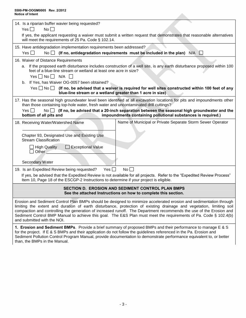
5500-PM-OOGM0005 Rev. 2/2012 Notice of Intent
- 3 -
14. Is a riparian buffer wavier being requested?
Yes No
If yes, the applicant requesting a waiver must submit a written request that demonstrates that reasonable alternatives will meet the requirements of 25 Pa. Code § 102.14.
15. Have antidegradation implementation requirements been addressed?
Yes No (If no, antidegradation requirements must be included in the plan) N/A
16. Waiver of Distance Requirements
a. If the proposed earth disturbance includes construction of a well site, is any earth disturbance proposed within 100 feet of a blue-line stream or wetland at least one acre in size?
Yes No N/A
b. If Yes, has Waiver OG-0057 been obtained?
Yes No (If no, be advised that a waiver is required for well sites constructed within 100 feet of any blue-line stream or a wetland greater than 1 acre in size)
17. Has the seasonal high groundwater level been identified at all excavation locations for pits and impoundments other than those containing top-hole water, fresh water and uncontaminated drill cuttings?
Yes No (If no, be advised that a 20-inch separation between the seasonal high groundwater and the bottom of all pits and impoundments containing pollutional substances is required.)
18. Receiving Water/Watershed Name
Chapter 93, Designated Use and Existing Use Stream Classification
High Quality Exceptional Value Other
Secondary Water
Name of Municipal or Private Separate Storm Sewer Operator
19. Is an Expedited Review being requested? Yes No
If yes, be advised that the Expedited Review is not available for all projects. Refer to the “Expedited Review Process” Item 10, Page 18 of the ESCGP-2 Instructions to determine if your project is eligible.
SECTION D. EROSION AND SEDIMENT CONTROL PLAN BMPS See the attached Instructions on how to complete this section.
Erosion and Sediment Control Plan BMPs should be designed to minimize accelerated erosion and sedimentation through limiting the extent and duration of earth disturbance, protection of existing drainage and vegetation, limiting soil compaction and controlling the generation of increased runoff. The Department recommends the use of the Erosion and Sediment Control BMP Manual to achieve this goal. The E&S Plan must meet the requirements of Pa. Code § 102.4(b) and submitted with the NOI.
1. Erosion and Sediment BMPs. Provide a brief summary of proposed BMPs and their performance to manage E & S for the project. If E & S BMPs and their application do not follow the guidelines referenced in the Pa. Erosion and Sediment Pollution Control Program Manual, provide documentation to demonstrate performance equivalent to, or better than, the BMPs in the Manual.

5500-PM-OOGM0005 Rev. 2/2012 Notice of Intent
- 4 -
E & S BMPs
2. Riparian Buffer Information A. Will you be protecting, converting or establishing a riparian buffer or a riparian forest buffer as a part of this project?
Yes No
B. If the regulations require a riparian buffer or riparian forest buffer and you are not providing one, please list the waiver provisions in the Chapter 102 regulations, Section 102.14(d)(2)(i)-(vi), that you are requesting and provide additional documentation to demonstrate reasonable alternatives for compliance with 102.14 requirements.
C. Will you be protecting, converting or establishing a voluntary riparian forest buffer as part of this project?
Yes No
If yes you must include a Riparian Forest Buffer Management Plan as part of the PCSM plans.
3. SUMMARY TABLE FOR SUPPORTING CALCULATION AND MEASUREMENT DATA See Attachment D in the Instructions on how to Complete This Section
Design storm frequency Rainfall amount inches
Pre-construction Post Construction Net Change
Impervious area (acres)
Volume of stormwater runoff (acre-feet) without planned stormwater BMPs
Volume of stormwater runoff (acre-feet) with planned stormwater BMPs
Stormwater discharge rate for the design frequency storm

5500-PM-OOGM0005 Rev. 2/2012 Notice of Intent
- 5 -
4. Thermal Impacts Analysis Please explain how thermal impacts associated with this project were avoided, minimized, or mitigated.
SECTION E. SITE RESTORATION (SR) PLAN BMPS See the attached Instructions on how to complete this section.
Site Restoration BMPs should be designed to use natural measures to eliminate pollution, infiltrate runoff, not require extensive construction/maintenance activity, promote pollutant reduction, and preserve the integrity of stream channels. The Department recommends the use of PA Stormwater BMP manual to achieve this goal. The SR Plan must meet the requirements of Pa Code § 102.8(n) and submitted with the NOI.
1. Site Restoration Plan Information – The Site Restoration Plan should be designed to maximize volume reduction technologies, eliminate (where possible) or minimize point source discharges to surface waters, preserve the integrity of stream channels, and protect the physical, biological and chemical qualities of the receiving surface water.
Design standards applied to develop the Site Restoration Plan. Check those that apply.
Act 167 Plan – The attached SR Plan is consistent with an applicable approved Act 167 Plan.
Complete the following for all approved Act 167 Stormwater Management Plans. (Use additional sheets if necessary)
Act 167 Plan Name
Date Adopted
Consistency Letter Included
Verification Report Included
The Site Restoration Plan must satisfy either sub paragraph A, B, or C below. Check those that apply.
A.
B.
C.
Act 167 Plan approvals on or after January 2005 - The attached PCSM Plan, in its entirety, is consistent with all requirements pertaining to rate, volume, and water quality from an Act 167 Stormwater Management Plan approved by DEP on or after January 2005.
The PCSM meets the standard design criteria from the PA Stormwater BMP Manual.
Alternative Design Standard – The attached PCSM Plan was developed using approaches other than 102.8(g)(2). Demonstrate/explain in the space provided below how this standard will be either more protective than what is required in 102.8(g)(2) or will maintain and protect existing water quality and existing and designated uses.

5500-PM-OOGM0005 Rev. 2/2012 Notice of Intent
- 6 -
2. Riparian Buffer Information A. Will you be protecting, converting or establishing a riparian buffer or a riparian forest buffer as part of this activity?
Yes No
B. Will you be protecting, converting or establishing a voluntary riparian forest buffer as part of this activity?
Yes No
C. If the regulations require a riparian buffer or riparian forest buffer and you are not providing one, list below the waiver provisions in the Chapter 102 regulations, Section 102.14(d)(i)-(vi), that you are requesting and provide additional documentation to demonstrate reasonable alternatives for compliance with 102.14 requirements.
D. Are you proposing Oil and Gas activities for which SR is required under Chapter 78 within 150 feet of a HQ/EV Watershed?
Yes No
If yes, demonstrate that any existing riparian buffer is undisturbed to the extent practicable.
Note: If the proposed activity protects, converts or establishes a riparian or riparian forest buffer a Buffer Management Plan is required in the PCSM Plan.

5500-PM-OOGM0005 Rev. 2/2012 Notice of Intent
- 7 -
3. SUMMARY TABLE FOR SUPPORTING CALCULATION AND MEASUREMENT DATA
See Attachment D in the Instructions on how to Complete This Section
Design storm frequency Rainfall amount inches
Pre-construction Post Construction Net Change
Impervious area (acres)
Volume of stormwater runoff (acre-feet) without planned stormwater BMPs
Volume of stormwater runoff (acre-feet) with planned stormwater BMPs
Stormwater discharge rate for the design frequency storm
4. SUMMARY DESCRIPTION OF SITE RESTORATION BMPs
In the lists below, check the BMPs identified in the Post Construction Stormwater Management Plan. The primary function(s) of the BMP listed in the functions column (infiltration/recharge; detention/retention; water quality). Additional functions may be added if applicable to that BMP. List the stormwater volume and area of runoff to be treated by each BMP type when calculations are required. If any BMP in the Site Restoration Plan is not listed below, describe it in the space provided after "Other".
BMP Function(s) Volume of stormwater
treated Acres treated
Bio-infiltration areas Infiltration/Recharge
Infiltration Trench
Infiltration Bed
Infiltrated Basin
Natural Area Conservation Infiltration/Recharge
Streamside Buffer Zone
Wetland Buffer Zone
Sensitive Area Buffer Zone
Pre-Construction Drainage Pattern Intact
Stormwater Retention Detention/Retention
Constructed Wetlands
Wet Ponds
Retention Basin
Sediment and Pollutant Removal
Water Quality Treatment
Vegetated Filter Strips
Brush Barriers
Detention Basins
Access Road Design Infiltration/Recharge
Road Crowning
Ditches
Turnouts
Culverts
Roadside Vegetated Filter Strips
Stormwater Energy Dissipaters Infiltration/Recharge
Level Spreaders

5500-PM-OOGM0005 Rev. 2/2012 Notice of Intent
- 8 -
Riprap Aprons
Upslope Diversions
5. Off-site Discharge Analysis. Does the activity propose any off-site discharges to areas other than surface waters? Yes No
If yes, the applicant must have appropriate easement that provides the legal authority for this off-site discharge.
The Applicant must provide a demonstration in both the E&S and Site Restoration Plans that the discharge will not cause erosion, damage, or a nuisance to off-site properties.
6. Thermal Impact Analysis. Explain how thermal impacts associated with this project were avoided, minimized, or mitigated.
SECTION F. POST CONSTRUCTION STORMWATER MANAGEMENT (PCSM) PLAN BMPS See the attached Instructions on how to complete this section.
Post Construction Stormwater Management BMPs should be designed to use natural measures to eliminate pollution, infiltrate runoff, not require extensive construction/maintenance activity, promote pollutant reduction, and preserve the integrity of stream channels. The Department recommends the use of PA Stormwater BMP manual to achieve this goal.
1. 1. Post Construction Stormwater Management Plan Information – The Post Construction Stormwater Management Plan must meet the requirements in 25 Pa. Code §102.8 and should be designed to maximize volume reduction technologies, eliminate (where possible) or minimize point source discharges to surface waters, preserve the integrity of stream channels, and protect the physical, biological and chemical qualities of the receiving surface water.
Design standards applied to develop the Post Construction Stormwater Management Plan. Check those that apply.
Act 167 Plan – The attached PCSM Plan is consistent with an applicable approved Act 167 Plan.
Complete the following for all approved Act 167 Stormwater Management Plans. (Use additional sheets if necessary)
Act 167 Plan Name
Date Adopted
Consistency Letter Included
Verification Report Included
A
B.
C.
Act 167 Plan approvals on or after January 2005 - The attached PCSM Plan, in its entirety, is consistent with all requirements pertaining to rate, volume, and water quality from an Act 167 Stormwater Management Plan approved by DEP on or after January 2005.
The PCSM meets the standard design criteria from 102.8(g)(2) and (3) the PA Stormwater BMP Manual. [comment: PCSM plans have to meet both the volume and rate requirements in the regs, which are provided in these 2 sections].
Alternative Design Standard – The attached PCSM Plan was developed using alternative approaches as provided in 102.8(g)(2)(iv) and 102.(g)(3)(iii). Demonstrate/explain in the space provided below how this standard will be either more protective than what is required in 102.8(g)(2) and 102.8(g)(3) or will maintain and protect existing water quality and existing and designated uses.
The PCSM Plan must satisfy either subparagraph A, B, or C below. Check those that apply.

5500-PM-OOGM0005 Rev. 2/2012 Notice of Intent
- 9 -
2. Riparian Buffer Information A. Will you be protecting, converting or establishing a riparian buffer or a riparian forest buffer as part of this activity?
Yes No
B. Will you be protecting, converting or establishing a voluntary riparian forest buffer as part of this activity?
Yes No
C. If the regulations require a riparian buffer or riparian forest buffer and you are not providing one, list below the waiver provisions in the Chapter 102 regulations, Section 102.14(d)(i)-(vi), that you are requesting and provide additional documentation to demonstrate reasonable alternatives for compliance with 102.14 requirements.
Note: If the proposed activity protects, converts or establishes a riparian or riparian forest buffer a Buffer Management Plan is required in the PCSM Plan.
3. SUMMARY TABLE FOR SUPPORTING CALCULATION AND MEASUREMENT DATA See Attachment D in the Instructions on how to Complete This Section
Design storm frequency Rainfall amount inches
Pre-construction Post Construction Net Change
Impervious area (acres)
Volume of stormwater runoff (acre-feet) without planned stormwater BMPs
Volume of stormwater runoff (acre-feet) with planned stormwater BMPs
Stormwater discharge rate for the design frequency storm
4. SUMMARY DESCRIPTION OF POST CONSTRUCTION STORMWATER BMPs
In the lists below, check the BMPs identified in the Post Construction Stormwater Management Plan. The primary function(s) of the BMP listed in the functions column (infiltration/recharge; detention/retention; water quality). Additional functions may be added if applicable to that BMP. List the stormwater volume and area of runoff to be treated by each BMP type when calculations are required. If any BMP in the Site Restoration Plan is not listed below, describe it in the space provided after "Other".
BMP Function(s) Volume of stormwater
treated Acres treated
Bio-infiltration areas Infiltration/Recharge
Infiltration Trench
Infiltration Bed
Infiltrated Basin
Natural Area Conservation Infiltration/Recharge
Streamside Buffer Zone
Wetland Buffer Zone
Sensitive Area Buffer Zone
Pre-Construction Drainage
Pattern Intact
Sediment and Pollutant Removal Water Quality Treatment
Vegetated Filter Strips
Brush Barriers
Detention Basins
Access Road Design Infiltration/Recharge
Road Crowning
Ditches
Turnouts
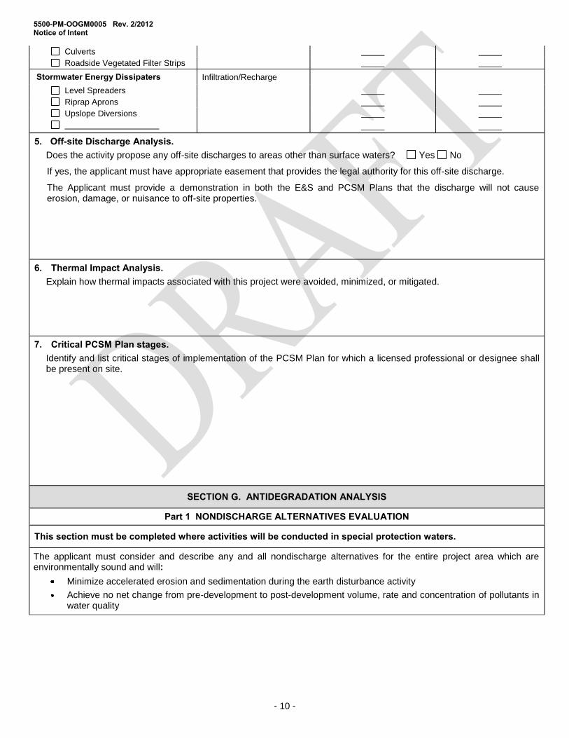
5500-PM-OOGM0005 Rev. 2/2012 Notice of Intent
- 10 -
Culverts
Roadside Vegetated Filter Strips
Stormwater Energy Dissipaters Infiltration/Recharge
Level Spreaders
Riprap Aprons
Upslope Diversions
5. Off-site Discharge Analysis. Does the activity propose any off-site discharges to areas other than surface waters? Yes No
If yes, the applicant must have appropriate easement that provides the legal authority for this off-site discharge.
The Applicant must provide a demonstration in both the E&S and PCSM Plans that the discharge will not cause erosion, damage, or nuisance to off-site properties.
6. Thermal Impact Analysis. Explain how thermal impacts associated with this project were avoided, minimized, or mitigated.
7. Critical PCSM Plan stages. Identify and list critical stages of implementation of the PCSM Plan for which a licensed professional or designee shall be present on site.
SECTION G. ANTIDEGRADATION ANALYSIS
Part 1 NONDISCHARGE ALTERNATIVES EVALUATION
This section must be completed where activities will be conducted in special protection waters.
The applicant must consider and describe any and all nondischarge alternatives for the entire project area which are environmentally sound and will:
Minimize accelerated erosion and sedimentation during the earth disturbance activity
Achieve no net change from pre-development to post-development volume, rate and concentration of pollutants in water quality

5500-PM-OOGM0005 Rev. 2/2012 Notice of Intent
- 11 -
E & S Plan Official
Use Only
PCSM/Site Restoration Plan Official
Use Only
Check off the environmentally sound nondischarge Best Management Practices (BMPs) listed below to be used prior to, during, and after earth disturbance activities that have been incorporated into your E & S Plan based on your site analysis. For BMPs not checked, provide an explanation of why they were not utilized. (attach additional sheets if necessary)
Check off the environmentally sound nondischarge Best Management Practices (BMPs) listed below to be used after construction that have been incorporated into your PCSM/SR Plan based on your site analysis. For BMPs not checked, provide an explanation of why they were not utilized. (attach additional sheets if necessary)
Nondischarge BMPs Alternative Siting
Alternative location Alternative configuration Alternative location of discharge
Limited Disturbed Area Limiting Extent & Duration of Disturbance
(Phasing, Sequencing) Riparian Buffers (150 ft min) Riparian Forest Buffer (150 ft min) Other
Nondischarge BMPs Alternative Siting
Alternative location Alternative configuration Alternative location of discharge
Low Impact Development (LID / BSD) Riparian Buffers (150 ft min) Riparian Forest Buffer (150 ft min) Infiltration Water Reuse Other
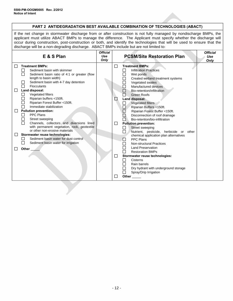
5500-PM-OOGM0005 Rev. 2/2012 Notice of Intent
- 12 -
PART 2 ANTIDEGRADATION BEST AVAILABLE COMBINATION OF TECHNOLOGIES (ABACT)
If the net change in stormwater discharge from or after construction is not fully managed by nondischarge BMPs, the applicant must utilize ABACT BMPs to manage the difference. The Applicant must specify whether the discharge will occur during construction, post-construction or both, and identify the technologies that will be used to ensure that the discharge will be a non-degrading discharge. ABACT BMPs include but are not limited to:
E & S Plan Official
Use Only
PCSM/Site Restoration Plan Official
Use Only
Treatment BMPs: Sediment basin with skimmer
Sediment basin ratio of 4:1 or greater (flow length to basin width)
Sediment basin with 4-7 day detention
Flocculants
Land disposal: Vegetated filters
Riparian buffers <150ft.
Riparian Forest Buffer <150ft.
Immediate stabilization
Pollution prevention: PPC Plans
Street sweeping
Channels, collectors and diversions lined with permanent vegetation, rock, geotextile or other non-erosive materials
Stormwater reuse technologies: Sediment basin water for dust control
Sediment basin water for irrigation
Other
Treatment BMPs: Infiltration Practices
Wet ponds
Created wetland treatment systems
Vegetated swales
Manufactured devices
Bio-retention/infiltration
Green Roofs
Land disposal: Vegetated filters Riparian Buffers <150ft. Riparian Forest Buffer <150ft.
Disconnection of roof drainage Bio-retention/bio-infiltration
Pollution prevention: Street sweeping
Nutrient, pesticide, herbicide or other chemical application plan alternatives
PPC Plans
Non-structural Practices
Land Preservation
Restoration BMPs
Stormwater reuse technologies: Cisterns
Rain barrels
Dry hydrant with underground storage
Spray/Drip Irrigation
Other

5500-PM-OOGM0005 Rev. 2/2012 Notice of Intent
- 13 -
SECTION H. COMPLIANCE REVIEW
Is the applicant in violation of any existing permit, regulation, order, or schedule of compliance issued by the Department within the last 5 years?
Yes No
If yes, provide the permit number or facility name, a brief description of the violation, the compliance schedule (including dates and steps to achieve compliance) and the current compliance status. (Attach additional information on a separate sheets, when necessary)

5500-PM-OOGM0005 Rev. 2/2012 Notice of Intent
- 14 -
SECTION I. CERTIFICATION BY PERSON PREPARING APPLICATION
I do hereby certify to the best of my knowledge, information, and belief, that the Erosion and Sediment Control and PCSM/Site Restoration Plan are true and correct, represent actual field conditions, and are in accordance with the 25 Pa. Code Chapters 78 and 102 of the Department’s rules and regulations. I am aware that there are significant penalties for submitting false information, including the possibility of fine and imprisonment.
Print Name Signature Professional Seal
Company
Address
Phone
Most Recent DEP Training Attended Location Date
e-Mail Address
EXPEDITED REVIEW PROCESS In addition to the certification required above applicants using the expedited permit review process must attach an E&S and PCSM/Site Restoration Plan developed and sealed by a licensed professional engineer, surveyor or professional geologist. The plans shall contain the following certification:
I do hereby certify to the best of my knowledge, information, and belief, that the Erosion and Sediment Control and PCSM/Site Restoration Plan and Post Construction BMPs are true and correct, represent actual field conditions and are in accordance with the 25 Pa. Code Chapters 78 and 102 of the Department’s rules and regulations. I am aware that there are significant penalties for submitting false information, including the possibility of fine and imprisonment.
SECTION J. APPLICANT CERTIFICATION
Applicant Certification. I certify under penalty of law that this document and all attachments were prepared by me or under my direction or supervision in accordance with a system designed to assure that qualified personnel properly gathered and evaluated the information submitted. Based on my inquiry of the person or persons who manage the system, or those persons directly responsible for gathering the information, the information submitted is, to the best of my knowledge and belief, true, accurate, and complete. The responsible official’s signature also verifies that the activity is eligible to participate in the permit, and that the applicant agrees to abide by the terms and conditions of the permit. I am aware that there are significant penalties for submitting false information, including the possibility of fine and imprisonment for knowing violations.
Print Name and Title of Applicant Print Name and Title of Co-Applicant (if applicable)
Signature of Applicant Signature of Co-Applicant
Date Application Signed Date Application Signed Notarization Sworn to and subscribed to before me this Commonwealth of Pennsylvania
day of , 20 County of
My Commission expires
Notary Public
AFFIX SEAL

5500-PM-OOGM0005 Rev. 2/2012 Notice of Intent
- 15 -
SECTION K. CONTACT FOR ADDITIONAL INFORMATION
Contact’s Last Name First Name MI Phone
FAX
Mailing Address City State ZIP + 4
e-Mail Address

5500-PM-OOGM0005 Rev. 2/2012 COMMONWEALTH OF PENNSYLVANIA Checklist DEPARTMENT OF ENVIRONMENTAL PROTECTION OFFICE OF WATER MANAGEMENT OFFICE OF OIL AND GAS MANAGEMENT
- 1 -
NOTICE OF INTENT (NOI) ADMINISTRATIVE COMPLETENESS CHECKLIST EROSION AND SEDIMENT CONTROL GENERAL PERMIT FOR EARTH DISTURBANCE ASSOCIATED WITH OIL AND GAS EXPLORATION, PRODUCTION, PROCESSING, OR
TREATMENT OPERATIONS OR TRANSMISSION FACILITIES (ESCGP-2)
Please check the following list to make sure that you have included all the required information. Place a check mark in the column provided for all items completed and/or provided. Failure to provide all of the requested information will delay the processing of the application, may preclude the use of the expedited review, and may result in the application being placed ON HOLD with NO ACTION, or being considered withdrawn and the application file closed.
THIS CHECKLIST MUST BE COMPLETED AND ENCLOSED WITH YOUR GENERAL PERMIT NOI
CHECKLIST FOR EROSION AND SEDIMENT CONTROL GENERAL PERMIT NOI NEW NOI RENEWAL SUBSEQUENT PHASE Major Revision Minor Revision
If a Renewal, Subsequent Phase or Revision, identify ESCGP-2 Permit Authorization #
Minor revisions are not required to be submitted to the regional office for review.
APPLICANT
PROJECT and PHASE NAME (If applicable)
Applicant Check
if Included
Official
Use Only
1. Fully completed, properly signed and notarized Notice of Intent form (1 original and 2 copies). (Not required for subsequent phases)
2. Complete Erosion and Sediment Control (E&S) Plans. (1 original and 2 copies) NOTE: Identify Locations as Drawings (D), Narrative (N). (Identify Not Applicable as “N/A”) The E & S Plan must contain, at a minimum, the following:
a. Topographic Features Existing topographic features of the project site and immediate surrounding area.
Location: Page:
b. Soil Characteristics Types, depth, slope, locations and limitations of the soils including methods for resolution of all soil limitations.
Location: Page:
c. Earth Disturbance Activity The characteristics of the earth disturbance activity, including the past, present and proposed land uses and proposed alteration to the project site.
Location: Page:
d. Project Site Runoff The Volume and rate of runoff from the project site and its upstream watershed area.
Location: Page:
e. Surface Water Classification The Location of all surface waters of this Commonwealth which may receive runoff within or from the project site including their classification under Chapter 93. Be advised expedited review is not available for projects in special protection watersheds.
Location: Page:
f. BMP Description Narrative A narrative description of the location and type of perimeter and onsite BMPs used before, during, and
Location: Page:

5500-PM-OOGM0005 Rev. 12/2011 Checklist
- 2 -
after the earth disturbance activity.
g. BMP Installation Sequence Narrative A sequence of BMP installation and removal in relation to the scheduling of earth disturbance activities, prior to, during and after earth disturbance activities that ensures proper functioning of BMPs.
Location: Page:
h. Supporting calculations and measurements. Location: Page:
i. Plan Drawings. Location: Page:
j. Maintenance Program A maintenance program which provides for the operation and maintenance of BMPs and the inspection of BMPs on a weekly basis and after each stormwater event, including the repair or replacement of BMPs to ensure effective and efficient operation. The program must provide for completion of a written report documenting each inspection and all BMP repair, or replacement and maintenance activities.
Location: Page:
k. Material Recycling and Disposal Procedures which ensure that the proper measures for the recycling or disposal of materials associated with or from the project site will be undertaken in accordance with this title.
Location: Page:
l. Soil Conditions and Geologic Formations Identification of naturally occurring geologic formations or soil conditions that may have the potential to cause pollution during earth disturbance activities and include BMPs to avoid or minimize potential pollution and its impacts from the formations.
Location: Page:
m. Thermal Impacts Identification of potential thermal impacts to surface waters of this Commonwealth from the earth disturbance activity including BMPs to avoid, minimize or mitigate potential pollution from thermal impacts.
Location: Page:
n. E&S Plan and PCSM/SR Plan Consistency The E&S Plan shall be planned, designed and implemented to be consistent with the PCSM Plan under § 102.8. Unless otherwise approved by the Department, the E&S Plan must be separate from the PCSM Plan and labeled “E&S” or “Erosion and Sediment Control Plan” and be the final plan for construction.
Location: Page:
o. Riparian Forest Buffers Identification of existing and proposed riparian forest buffers (When required).
Location: Page:
p. Antidegradation Requirements Satisfy antidegradation implementation requirements including evaluation of nondischarge alternatives and ABACT.
Location: Page:
3. Permit NOI Filing Fees of $500 plus $100/Acre of earth disturbance payable to the appropriate Clean Water Fund
Location: Page:

5500-PM-OOGM0005 Rev. 12/2011 Checklist
- 3 -
($500 filing fee not required for subsequent phases).
4. Municipal Notification: (3 copies) Not required for subsequence phases.
a. Act 14 Municipal Notifications to the local municipality and county governments that specify that the application is for Erosion and Sediment Control General Permit for Earth Disturbance Associated with Oil and Gas Activities.
A "sample" notification letter is provided as Attachment A of the instructions.
Proof or Receipt of municipal notifications: copies of certified mail receipts, proof of deliver from a commercial carrier or acknowledgment letters from the local municipality and county government
Location: Page:
b. Cultural Resource Notice: for permotted activities on lands of the Allegheny National Forest (ANF) are to be coordinated with the appropriate ANF Ranger.
5. Pennsylvania Natural Heritage Program (PNHP). Include impact clearance letters if proof of agency coordination is required (3 copies) (Not required for subsequent phases if review receipt or impact clearance letters are still valid).
Location: Page:
6 Complete Post Construction Stormwater Management/Site Restoration Plans. (1 Original, 2 copies)
NOTE: Identify location(s) as Drawing (D), Narrative (N). (Identify Not Applicable as “N/A”.)
The PCSM/Site Restoration Plan must contain, at a minimum, the following:
a. Topographic Features The existing topographic features of the project site and immediate surrounding area.
Location: Page:
b. Soil Characteristics The types, depth, slope, locations and limitations of the soils and geologic formations.
Location: Page:
c. Earth Disturbance Activity Characterization The characteristics of the project site, including the past, present and proposed land uses and the proposed alteration of the project site.
Location: Page:
d. Net Change in Volume and Rate of Runoff An identification of the net change in volume and rate of stormwater from preconstruction hydrology to post construction hydrology for the entire project site and each drainage area.
Location: Page:
e. Surface Water Classification An identification and location of surface waters of this Commonwealth, which may receive runoff within or from the project site and their classification under Chapter 93.
Location: Page:
f. BMP Description Narrative A written description of the location and type of PCSM/Site Restoration BMPs including construction details for permanent stormwater BMPs including permanent stabilization specifications and locations.
Location: Page:

5500-PM-OOGM0005 Rev. 12/2011 Checklist
- 4 -
g. BMP Installation Sequence Narrative A sequence of PCSM/Site Restoration BMP implementation or installation in relation to earth disturbance activities of the project site and a schedule of inspections for critical stages of PCSM/Site Restoration BMP installation.
Location: Page:
h. Supporting calculations. Location: Page:
i. Plan Drawings. Location: Page:
j. Long Term Operation and Maintenance Schedule A Long term operation and maintenance schedule, which provides for inspection of PCSM/Site Restoration BMPs, including the repair, replacement or other routine maintenance of the PCSM/Site Restoration BMPs to ensure proper function and operation. The program must provide for completion of a written report documenting each inspection and all BMP repair and maintenance activities and how access to the PCSM/Site Restoration BMPs will be provided.
Location: Page:
k. Material Recycling and Disposal Procedures which ensure that the proper measures for recycling or disposal of materials associated with or from the PCSM/Site Restoration BMPs are in accordance with Department laws, regulations and requirements.
Location: Page:
l. Geologic Formations and Soil Conditions An identification of naturally occurring geologic formations or soil conditions that may have the potential to cause pollution after earth disturbance activities are completed and PCSM/Site Restoration BMPs are operational and development of a management plan to avoid or minimize potential pollution and its impacts.
Location: Page:
m. Thermal Impacts An Identification of potential thermal impacts from post construction stormwater to surface water of this Commonwealth including BMPs to avoid, minimize or mitigate potential thermal pollution from thermal impacts.
Location: Page:
n.
Riparian Forest Buffer Management Plan A riparian forest buffer management plan when required under § 102.14.
Location: Page:
o. Antidegradation Requirements A demonstration of compliance with antidegradation implementation requirements including evaluation of nondischarge alternatives and ABACT for where activities will be conducted in special protection waters.
Location: Page:
7. PCSM Plan Stormwater Analysis Do the regulated activities require site restoration or reclamation? Yes No
If Yes, skip to Item 10.
If No, provide the following information:

5500-PM-OOGM0005 Rev. 12/2011 Checklist
- 5 -
a. Site Characterization and Assessment Predevelopment site characterization and assessment of soil and geology including infiltration and geotechnical studies that identify location and depths of test sites and methods used (If applicable).
Location: Page:
b. Volume Reduction and Water Quality Requirements Analysis demonstrating that the PCSM BMPs will meet the volume reduction and water quality requirement specified in an applicable Department approved and current Act 167 stormwater management watershed plan; or manage the net change for storms up to and including the 2-year/24-hour storm event when compared to preconstruction runoff volume and water quality (If applicable).
Location: Page:
c. Rate Requirements Analyses demonstrating that the PCSM BMPs will meet the rate requirements specified in an applicable Department approved and current Act 167 stormwater management watershed plan; or manage the net change in peak rate for the 2-, 10-, 50-, and 100-year/24-hour storm event in a manner not to exceed preconstruction rates (If applicable).
Location: Page:
d. Calculation Methodologies Identification of the methodologies for calculating total runoff volume and peak rate of runoff and provide supporting documentation and calculations (If applicable).
Location: Page:
e.
Construction Techniques Identification of construction techniques or special consideration to address soil and geologic limitations (If applicable).
Location: Page:
f. Antidegradation Requirements Demonstration of compliance with antidegradation implementation requirements including evaluation of nondischarge alternatives and ABACT for where activities will be conducted in special protection waters.
Location: Page:
8. Expedited Review Process Yes No
Is any part of your project located in or drain into a Special Protection watershed?
Yes No
Is the area surrounding an oil or natural gas wellhead that is subject to earth disturbance and that is used or planned for use for drilling, production or plugging of the well including associated support activities constructed on or in a flood plain?
Yes No
Is any earth disturbance located on land known to be contaminated? Yes No Is your project a transmission project? Yes No If yes, to any of the above questions your project is not eligible for Expedited Review. If your project is not a transmission protect complete items 8a and 8b.
Is an expedited review being requested? Yes No If yes, all of the following items must be completed:
a. E&S and PCSM/Site Restoration Plan drawings and narrative sealed by licensed professional.

5500-PM-OOGM0005 Rev. 12/2011 Checklist
- 6 -
b. Licensed professional prepared, sealed, and certified Application/NOI.
c. Licensed professional listed location and date of DEP training attended in application/NOI.
9. Phased Projects Is the activity being conducted as a phased project? Yes No
If yes, all of the following must be completed:
a. Initial Phase - Is the master plan included? Yes No
b. Subsequent Phase(s) – Is(are) the subsequent phase(s) identified in the master plan? Yes No
10. Preparedness, Prevention and Contingency (PPC) Plan Will fuels, chemicals, solvents, other hazardous materials be used or stored on site during earth disturbance activities?
Yes No
If yes, provide a PPC Plan.
11
Subsequent Phase Certification for Expedited Reviews
Is the activity being conducted as a phased project? Yes No
Is an expedited review being requested for subsequent phase? Yes No
If yes, all of the following must be completed:
I do hereby certify to the best of my knowledge, information, and belief, that the Erosion and Sediment Control and PCSM/Site Restoration Plan are true and correct, represent actual field conditions and are in accordance with the 25 Pa. Code Chapters 78 and 102 of the Department’s rules and regulations. I am aware that there are significant penalties for submitting false information, including the possibility of fine and imprisonment.
Signature Professional Seal
Company
Address
Phone
Most Recent DEP Training Attended Location Date
e-Mail Address
EXPEDITED REVIEW PROCESS In addition to the certification required above, applicants using the expedited permit review process must attach an E&S and PCSM/Site Restoration Plan developed and sealed by a licensed professional engineer, landscape architect, surveyor or professional geologist. The plans shall contain the following certification:
I do hereby certify to the best of my knowledge, information, and belief, that the Erosion and Sediment Control and PCSM/Site Restoration Plan and Post Construction BMPs are true and correct, represent actual field conditions and are in accordance with the 25 Pa. Code Chapters 78 and 102 of the Department’s rules and regulations. I am aware that there are significant penalties for submitting false information, including the possibility of fine and imprisonment.
12. Permit Renewal Is a permit renewal being requested? Yes No If yes, all of the following must be completed:
a. Administratively complete, signed, and notarized Notice of Intent Form, including Items 1-8. (1 signed original and 2 copies of the NOI/application)
b. Permit filing fee of $500 plus $100/Acre of earth disturbance payable to the appropriate Clean Water Fund.

5500-PM-OG0005 Rev. 1/2012 Permit
Page 1 of 14
AUTHORIZATION OF COVERAGE UNDER THE EROSION AND SEDIMENT CONTROL GENERAL PERMIT FOR EARTH DISTURBANCE ASSOCIATED WITH OIL AND GAS EXPLORATION, PRODUCTION, PROCESSING, OR TREATMENT OPERATIONS OR
TRANSMISSION FACILITIES ESCGP-2
AUTHORIZATION NUMBER:
Project Name & Location Permittee Name & Address
In compliance with the provisions of Pennsylvania's Clean Streams Law, as amended, 35 P.S. Section 691.1 et seq., the Oil and Gas Act 58 P.S. §§ 601.101 et seq. and regulations promulgated thereto, including 25 Pa Code Chapters 78,93 and 102, and sections 1905-A, 1917-A and 1920-A of the Administrative Code of 1929, 71 P. S. §§ 510-5, 510-17 and 510-20, the Department of Environmental Protection (Department) hereby authorizes the Notice of Intent (NOI) submitted for coverage to conduct oil and gas activities that involve 5 acres (2 hactares) or more of earth disturbance over the life of the project at the above named location(s):
subject to the Department’s enclosed ESCGP-2 which incorporates all requirements and conditions. Authorization to conduct oil and gas activities is subject to the implementation of the plans and additional associated information submitted as part of the NOI. This authorization is granted to conduct oil and gas activities using erosion and sediment control and stormwater management best management practices (BMPs) within the project indicated above and in compliance with all representations set forth in your application and its supporting documents and permit conditions attached hereto.
Earth disturbance activities conducted in accordance with the terms and conditions herein may commence on the date of the authorization of permit coverage. This authorization is valid for a period of five years when activities are conducted pursuant to such terms and conditions. The Department may terminate this authorization prior to the expiration date upon notice. No condition of this permit shall release the permittee(s) from any responsibility or requirement under Pennsylvania’s statutes or regulations or local ordinances.
AUTHORIZATION DATE: EXPIRATION DATE:
AUTHORIZED BY: TITLE:
COMMONWEALTH OF PENNSYLVANIA DEPARTMENT OF ENVIRONMENTAL PROTECTION
OFFICE OF OIL AND GAS MANAGEMENT

Page 2 of 15
EROSION AND SEDIMENT CONTROL GENERAL PERMIT FOR EARTH DISTURBANCE ASSOCIATED WITH OIL AND GAS EXPLORATION, PRODUCTION, PROCESSING, OR TREATMENT OPERATIONS OR
TRANSMISSION FACILITIES
ESCGP-2 (2011 Amendment) This permit applies to oil and gas activities that disturb equal to or greater than 5 acres, or an earth disturbance on any portion, part, or during any stage of, a larger common plan of development or sale that involves equal to or greater than 5 acres of earth disturbance. This permit does not apply to timber harvesting activities, and road maintenance activities. 1. AUTHORITY
a. ESCGP-2 is authorized by the Clean Streams Law, 35 P.S. Section 691.1 et seq., the Oil and Gas Act 58 P.S. §§ 601.101 et seq. and regulations promulgated thereto, including, 25 Pa Code Chapters 78, 93 and 102 regulations promulgated thereto, and sections 1905-A, 1917-A and 1920-A of the Administrative Code of 1929, 71 P. S. §§ 510-5, 510-17 and 510-20,
b. 25 Pa. Code § 102.5(m)(1) allows for the issuance of general permits on a regional or Statewide basis or
limited to specific watersheds, particular categories of streams or designated geographic regions, for a category of activities not subject to the NPDES requirements, but regulated under Chapter 102, provided that (1) the projects in the category are similar in nature; (2) the projects in the category can be adequately regulated utilizing standardized specifications and conditions, including reference to specific criteria and requirements adopted by another Federal or State agency which adequately regulate the particular category of activities; (3) the projects which are in the category and meet the specifications and conditions will comply with Chapter 102; (4) the projects which are in the category in the opinion of the Department are more appropriately controlled under a general permit than under individual permits; and (5) the projects which are in the category individually and cumulatively do not have potential to cause significant adverse environmental impact. ESCGP-2 is an Erosion and Sediment Control (E&S) Permit under Chapter 102 and is issued pursuant to Section 102.5(m).
c. 25 Pa Code § 102.5(c) provides: “A person proposing oil and gas activities that involve 5 acres (2 hactares)
or more of earth disturbance over the life of the project shall obtain an E&S Permit under this chapter prior to commencing the earth disturbance activity.” Earth disturbance activities authorized by this permit must comply with all the terms, conditions, and processing procedures identified in this ESCGP-2.
2. DEFINITIONS
The following terms are defined for the purposes of ESCGP-2:
ABACT – Antidegradation Best Available Combination of Technologies – Environmentally sound and cost effective treatment, land disposal, pollution prevention and stormwater reuse BMPs that individually or collectively manage the difference in the net change in stormwater volume, rate, and quality for storm events up to and including the 2-year/24-hour storm when compared to the stormwater rate, volume, and quality prior to the earth disturbance activities to maintain and protect the existing quality of the receiving surface waters of this Commonwealth.
Accelerated erosion – The removal of the surface of the land through the combined action of human activities and the natural processes, at a rate greater than would occur because of the natural process alone.
BMPs – Best Management Practices – Activities, facilities, measures, planning, or procedures used to minimize accelerated erosion and sedimentation and manage stormwater to protect, maintain, reclaim and restore the quality of waters, and existing and designated uses of waters of this Commonwealth before, during, and after earth disturbance activities.
Conservation District – A Conservation District, as defined in Section 3(c) of the Conservation District Law (3 P.S. § 851(c), as amended) that has the authority under a delegation agreement executed with the Department to administer and enforce all or a portion of the erosion, sediment, and stormwater management program in the Commonwealth of Pennsylvania.

Page 3 of 15
Co-Permittee/Permittee – Person(s) identified in this permit as responsible for the discharges of stormwater associated with construction activity who is jointly and individually responsible together with the permittee for compliance with all conditions of this permit and applicable laws.
Critical stages – The installation of underground treatment BMPs, structurally engineered BMPs, or other BMPs as deemed appropriate by the Department or the conservation district.
Department – The Pennsylvania Department of Environmental Protection ("DEP") of this Commonwealth.
Earth disturbance activity – A construction or other human activity which disturbs the surface of the land, including land clearing and grubbing, grading, excavations, embankments, land development, agricultural plowing or tilling, operation of animal heavy use areas, timber harvesting activities, road maintenance activities, oil and gas activities, well drilling, mineral extraction, and the moving, depositing, stockpiling, or storing of soil, rock, or earth materials.
Erosion – The natural process by which the surface of the land is worn away by water, wind, or chemical action.
E&S Plan – Erosion and Sediment Control Plan– A site-specific plan consisting of both drawings and a narrative that identifies BMPs to minimize accelerated erosion and sedimentation before, during, and after earth disturbance activities.
Floodplain – The lands adjoining a river or stream that have been or may be expected to be inundated by flood waters in a 100-year frequency flood. Unless otherwise specified, the boundary of the floodplain is as indicated on maps and flood insurance studies provided by FEMA. In an area where no FEMA maps or studies have defined the boundary of the 100-year frequency floodplain, it is assumed absent evidence to the contrary, that the floodplain extends from (1) any perennial stream to 100 feet horizontally from the top of the bank, and (2) from any intermittent stream to 50 feet horizontally from the top of the bank of such intermittent stream.
Floodway – The channel of the watercourse and portions of the adjoining floodplains which are reasonably required to carry and discharge the 100-year frequency flood. Unless otherwise specified, the boundary of the Floodway is as indicated on maps and flood insurance studies provided by FEMA. In an area where no FEMA maps or studies have defined the boundary of the 100-year frequency floodway, it is assumed, absent evidence to the contrary, that the floodway extends from the stream to 50 feet from the top of the bank of the stream. See 25 Pa. Code § 105.1
Licensed professional – Professional engineers, landscape architects, geologists and land surveyors licensed to practice in the Commonwealth.
Long-term operation and maintenance – The routine inspection, maintenance, repairs, or replacements, of a BMP to ensure proper function for the duration of time that the BMP is needed.
Municipality – A county, city, borough, town, township, school district, institution or authority or another public body created by or pursuant to State Law. For the purposes of this definition, town includes an incorporated town.
NOI – Notice of Intent – A request, on a form provided by the Department, for coverage under an erosion and sedimentation control general permit for earth disturbances associated with oil and gas exploration, production, processing or treatment operations or transmission facilities.
NOT – Notice of Termination – A request, on a form provided by the Department, to terminate coverage under an erosion and sedimentation control general permit for earth disturbances associated with oil and gas exploration, production, processing or treatment operations or transmission facilities.
Nondischarge alternative – Environmentally sound and cost effective BMPs that individually or collectively eliminate the net change in stormwater volume, rate and quality for stormwater events up to and including the 2-year/24-hour storm when compared to the stormwater rate, volume and quality prior to the earth disturbance activities to maintain and protect the existing quality of the receiving surface waters of this Commonwealth.
Oil and gas activities - Earth disturbance associated with oil and gas exploration, production, processing or treatment operations or transmission facilities.
Operator – A person who has one or more of the following:
(i) Oversight responsibility of earth disturbance activity on a project site or a portion thereof, who has the ability to make modifications to the E&S Plan, PCSM Plan, or site specifications.
(ii) Day-to-day operational control over earth disturbance activity on a project site or a portion thereof to ensure compliance with the E&S Plan or PCSM plan.

Page 4 of 15
Owner – A person or persons who hold legal title to the land subject to construction activity. This term also includes the person(s) who held legal title to the land subject to construction activity at the time such activity was commenced on a site.
PCSM Plan – Post Construction Stormwater Management Plan – A site-specific plan consisting of both drawings and a narrative that identifies BMPs to manage changes in stormwater runoff volume, rate, and water quality after earth disturbance activities have ended and the project site is permanently stabilized.
Permanent stabilization – Long-term protection of soil and water resources from accelerated erosion.
Person – Any operator, individual, public or private corporation, partnership, association, municipality or political subdivision of this Commonwealth, institution, authority, firm, trust, estate, receiver, guardian, personal representative, successor, joint venture, joint stock company, fiduciary; Department agency or instrumentality of State, Federal or local government, or an agent or employee thereof; or any other legal entity. Whenever used in any clause prescribing and imposing a penalty, or imposing a fine or imprisonment or both, the term "person" shall not exclude the members of an association and the directors, officers, or agents of a corporation.
Point Source - Any discernable, confined and discrete conveyance, including, but not limited to, any pipe, ditch, channel, tunnel, conduit, well, discrete fissure, container, rolling stock, Concentrated Animal Feeding Operation, landfill leachate collection system, or vessel or other floating craft, from which pollutants are or may be discharged.
Post construction stormwater – Stormwater associated with a project site after the earth disturbance activity has been completed and the project site is permanently stabilized.
PPC Plan – A written plan that identifies an emergency response program, material and waste inventory, spill and leak prevention and response, inspection program, housekeeping program, security and external factors, and that is developed and implemented at the construction site to control potential discharges of pollutants other than sediment into waters of this Commonwealth.
Project site – The entire area of activity, development, lease or sale including:
(i) The area of the earth disturbance activity.
(ii) The area planned for the earth disturbance activity.
(iii) Other areas which are not subject to earth disturbance activity.
Riparian buffer – A BMP that is an area of permanent vegetation along surface waters.
Riparian forest buffer – A type of riparian buffer that consists of permanent vegetation that is predominantly native trees, shrubs and forbs along surface waters that is maintained in a natural state or sustainably managed to protect and enhance water quality, stabilize stream channels and banks, and separate land use activities from surface waters.
Road Maintenance Activity –
(i) Earth disturbance activities within the existing road cross-section or railroad right-of-way including the following:
(A) Shaping or restabilizing unpaved roads.
(B) Shoulder grading.
(C) Slope Stabilization.
(D) Cutting of existing cut slopes
(E) Inlet and endwall cleaning.
(F) Reshaping and cleaning drainage ditches and swales.
(G) Pipe cleaning.
(H) Pipe replacement.
(I) Support activities incidental to resurfacing activities such as minor vertical adjustment to meet grade of resurfaced area.
(J) Ballast cleaning.
(K) Laying additional ballast.

Page 5 of 15
(L) Replacing ballast, ties and rails.
(M) Other similar activities.
(ii) The existing road cross-section consists of the original graded area between the existing toes of fill slopes and tops of cut slopes on either side of the road and any associated drainage features.
Stabilization – The proper placing, grading, constructing, reinforcing, lining, and covering of soil, rock, or earth to ensure their resistance to erosion, sliding, or other movement.
Stormwater – Runoff from precipitation, snow melt runoff, surface runoff and drainage.
Surface Waters – Perennial and intermittent streams, rivers, lakes, reservoirs, ponds, wetlands, springs, natural seeps and estuaries, excluding water at facilities approved for wastewater treatment such as wastewater treatment impoundments, cooling water ponds and constructed wetlands used as part of a wastewater treatment process.
Transferee – Person(s) identified through the co-permittee/transferee form as having new responsibility for the discharges of stormwater during construction activities and responsibility for compliance with all conditions of this permit and all applicable laws for discharges of stormwater during the construction activity.
Waters of this Commonwealth – Rivers, streams, creeks, rivulets, impoundments, ditches, watercourses, storm sewers, lakes, dammed water, wetlands, ponds, springs and other bodies or channels of conveyance of surface and underground water, or parts thereof, whether natural or artificial, within or on the boundaries of this Commonwealth.
Well Pad – The area surrounding an oil or gas wellhead that is subject to earth disturbance and that is used or planned for use for the drilling, production or plugging of the well, including associated support activities (such as storage of chemicals, wastewater, drill cutting, and equipment). The well pad does not include roads, pipelines, and facilities for the withdrawal, storage, and conveyance of freshwater.
Wetlands – Areas that are inundated or saturated by surface water or groundwater at a frequency and duration sufficient to support, and that under normal circumstances do support, a prevalence of vegetation typically adapted for life in saturated soil conditions, including swamps, marshes, bogs and similar areas.
3. SCOPE OF ACTIVITIES
a. ESCGP-2 applies to oil and gas activities that involve 5 acres (2 hectares) or more of earth disturbance over the life of the project. ESCGP-2 applies only to activities within the Commonwealth of Pennsylvania. ESCGP-2 does not obviate the need to obtain other Federal, State, or local authorizations required by law. Persons subject to and operating under ESCGP-2 may not commence the earth disturbance activities until receipt of written acknowledgement of coverage under ESCGP-2 from the Department, after Department review and authorization of the NOI and associated E&S and PCSM Plans.
b. ESCGP-2 does not apply to the following activities:
(1) Discharges which contain hazardous pollutants, toxics, or any other substance which - because of its quantity, concentration, or physical, chemical, or infectious characteristics - may cause or contribute to an increase in mortality or morbidity in either an individual or the total population, or pose a substantial present or future hazard to human health or the environment when discharged into surface waters of this Commonwealth;
(2) Discharges or earthmoving activities which are not, or will not be, in compliance with any of the terms or conditions of this general permit;
(3) Discharges or earthmoving activities for which the responsible party (person) has failed and continues to fail to comply or has shown a lack of ability or intention to comply with a regulation, permit, and schedule of compliance or order issued by the Department or conservation district;
(4) Discharges which do not, or will not, result in compliance with applicable effluent limitations or water quality standards;
(5) Discharges or earthmoving activities which are likely to directly or indirectly adversely affect a State or Federal threatened or endangered species or a species proposed for such designation, or which is likely to destroy or adversely modify the critical habitat of such a species, as identified under the Federal Endangered Species Act of 1973; Title 30, Chapter 75 of the Pa. Fish and Boat Code; Title 17, Chapter 25, Conservation of Wild Plants; and Title 31 Chapter 133 Game Wildlife code.

Page 6 of 15
(6) Discharges which individually or cumulatively have the potential to cause significant adverse environmental impact.
4. PERMIT RENEWAL MODIFICATION, TERMINATION, OR REVOCATION AND REISSUANCE
a. The Department will publish a notice of any draft, renewed, or reissued general permit or of any amendments to this general permit in the Pennsylvania Bulletin. After a comment period notice, the final, renewed, reissued or amended general permit will be published in the Pennsylvania Bulletin. Any person with an unexpired authorization of coverage under the general permit shall be responsible for complying with the final renewed, reissued or amended general permit. Such persons shall be covered by the general permit even if the permittee has not submitted a separate NOI to be covered by such final renewed, reissued or amended general permit.
b. This permit may be modified, suspended, revoked, reissued, or terminated during its term for any of the causes specified in 25 Pa. Code Chapter 102, or to require compliance with updated water quality standards or impaired water listings.
c. The filing of a request by the permittee or co-permittee for a permit or coverage modification, revocation, reissuance, or termination, or a notification of planned changes or anticipated noncompliance, does not eliminate any existing permit conditions.
d. Permit modification or revocation will be conducted according to 25 Pa. Code Chapter 102.
5. AUTHORITY AND RESPONSIBILITIES OF THE DEPARTMENT OR CONSERVATION DISTRICTS
a. The Department or Conservation District may notify the permittee at any time that the permit terms and conditions are not being met. Upon plan review or site inspection, the Department or Conservation District may require E&S Plan revisions or other appropriate action to ensure compliance with the conditions of this permit.
b. The Department or Conservation District has the right to enter onto the site to conduct inspections, conduct monitoring or require monitoring where necessary in appropriate circumstances such as where a danger of water pollution or degradation is present, or water pollution or degradation is suspected to be occurring from a construction activity subject to this permit. The permittee and co-permittee shall commence such monitoring upon notification from the Department or Conservation District. Samples and measurements taken as required herein shall be representative of the volume and nature of the monitored discharge.
c. The Department or Conservation District may request copies of records required to be kept by this permit.
d. The Department reserves the rights to modify, suspend, revoke or terminate previous coverage under this permit if the permittee(s) shows a lack of ability or intent to comply with the provisions of the permit, or has exhibited a history of non-compliance with the permit conditions.
e. The Department will review NOIs, including erosion and sediment control plans and post-construction stormwater management/site restoration plans, to ensure that applicants have submitted complete and acceptable applications.
6. NOTICE OF INTENT (NOI) SUBMITTAL
a. Persons proposing to conduct oil and gas activities that disturb equal to or greater than 5 acres, or an earth disturbance on any portion, part, or during any stage of, a larger common plan of development or sale that involves equal to or greater than 5 acres of earth disturbance, who wish to be covered by this general permit, must submit an administratively complete and acceptable Notice of Intent (NOI) to the Department or Conservation District.
b. The NOI for coverage under this this permit must include E&S and PCSM Plans developed in accordance with the requirements of 25 Pa. Code Chapter 102.
c. The Department offers an optional expedited permit process to person seeking an ESCGP-2. NOIs for coverage under ESCGP-2 submitted through the expedited permit process which qualify for permit coverage will be provided with an acknowledgement of coverage under the ESCGP-2 within 14 business days from the submission of a complete and accurate NOI. With respect to review of NOIs for ESCGP-2 for oil and gas activities that are not under the expedited process, the Department will establish as its objective to complete its review of complete submissions within 60 calendar days. A person proposing oil

Page 7 of 15
and gas activities under ESCGP-2 must obtain written authorization from the Department prior to commencing the earth disturbance activity.
d. The Department offers an optional phased permit process to persons seeking coverage under ESCGP-2. Before initiating any earth disturbance activities on each subsequent phase, the permitee must submit to the Department the information listed on “NOI Administrative Completeness Checklist Erosion and Sediment Control General Permit for Earth Disturbance Associated with Oil and Gas Exploration, Production, Processing, or Treatment Operations or Transmission Facilities,” Document Number 5500-PM-OG005, for that phase, for review and authorization. The Department will publish a notice in the Pennsylvania Bulletin for each subsequent phase.
e. Major modifications to the authorized E&S Plan involving new or additional earth disturbance activity and/or the addition of a point source discharge will require prior authorization by the Department or Conservation District and may require the submittal of a new NOI. All minor modifications to the E&S Plan and PCSM Plan shall be noted on the plan that is available at the site and initialed by the Department or Conservation District staff. Minor changes to the E&S Plan or the PCSM Plan may include adjustments to BMPs and locations within the permitted boundary to improve environmental performance within the scope of the authorized E&S Plan, change in ownership or address, typographical errors and field adjustments on-site such as the addition or deletion of BMPs to address unforeseen circumstances.
f. Operators conducting oil and gas activities must implement and maintain E&S BMPs and PCSM BMPs and other pollution prevention measures required by this permit to minimize accelerated erosion and sedimentation before, during, and after construction activities.
g. The NOI must be filed in accordance with the detailed instructions specified in the NOI package.
h. NOIs shall include proof of consultation with the Pennsylvania Natural Heritage (PNHP) regarding the presence of a State or Federal threatened or endangered species on the project site. If the Department or Conservation District determines, based on PNHP data or other sources, that the proposed earth disturbance activity may adversely impact the species or critical habitat, it must be resolved with the appropriate agency prior to submitting the NOI. Information on PNHP searches is available through the PA Department of Conservation and Natural Resources, Bureau of Forestry, Ecological Services Section, P.O. Box 8552, Harrisburg, PA 17105-8852, telephone (717) 787-3444 and at www.naturalheritage.state.pa.us.
i. If hydric soils including soil map units with hydric inclusions of hydric components or other wetland features are present, a wetland determination must be conducted in accordance with Department procedures. A copy of the wetland determination should be provided to the Department or Conservation District as part of the NOI/application. All wetlands identified must be included on the E&S Plan and PCSM\Site Restoration Plan. Special precautions must be taken to protect wetlands and other water resources identified in the NOI, plans, and other supporting documents.
j. Persons requesting a renewal of coverage under this general permit must submit to the Department or Conservation District an administratively complete and acceptable NOI, at least 60 days prior to the expiration date of the coverage, unless permission has been granted by the Department or Conservation District for submission at a later date. In the event that a timely, administratively complete, and acceptable application for renewal of coverage has been submitted and the Department or Conservation District is unable, through no fault of the permittee, to reissue the authorization for coverage before the expiration date of the authorized coverage, the terms and conditions of the authorized coverage will be automatically continued and will remain fully effective and enforceable pending the issuance or denial of the renewal of coverage, provided the permittee is, and has been, operating in compliance with the terms and conditions of the permit. The permittee shall be responsible for complying with the final renewed, reissued or amended General Permit.
k. No condition of this permit shall release any person from any responsibility or requirements under other Federal or Pennsylvania environmental statutes or regulations or applicable local ordinances.
l. Authorization of coverage under this permit does not authorize well site preparation or well drilling within 100
feet measured horizontally from any stream, spring or body of water as identified on the most current 7 ½ minute topographic quadrangle map of the United States Geologic Survey or within 100 feet of any wetlands greater than one acre in size. Persons proposing to prepare a well site or drill a well that meets the criteria listed above must request a waiver to the Department in accordance with Section 601.206 of the Oil and Gas Act.

Page 8 of 15
m. The authorization of coverage is granted based, in part, on information provided by the applicant in the NOI. The information provided by the applicant, including all appendices, attachments, plans and supporting documentation, are incorporated by reference as a part of the authorization and are enforceable as a condition of the authorization. If there is any conflict between the permit and the NOI, including any appendices, attachments, plans and other supporting documentation, the more environmentally protective provision applies.
n. The expedited permit process will not be available to person seeking an ESCGP-2 for the following
activities:
(1) Projects located in or with the potential to discharge to waters that have a designated or existing use of High Quality or Exceptional Value pursuant at Chapter 93 (relating to water quality standards).
(2) Projects in which the Well Pad will be constructed in or on a floodplain.
(3) Earth disturbance activities on lands that are known to be currently contaminated by the release of regulated substances as defined in Section 103 of The Pennsylvania Land Recycling and Remediation Standards Act (Act 2) (35 P.S. § 6026.103).
o. NOIs for coverage under an this permit which are submitted through the expedited permit process shall be prepared and certified by a licensed professional who has attended up-to-date training provided by the Department’s Office of Oil and Gas Management on erosion and sediment control and post construction stormwater management for oil and gas activities. All accompanying erosion and sediment control plans and post-construction stormwater management/site restoration plans shall be sealed by the licensed professional that prepared or supervised the preparation of the application and plans. For such projects, the seal must be placed on each plan drawing and on the cover of the narrative.
p. NOIs for coverage under this permit for projects described in (n) above, shall be prepared and certified by a
licensed professional and all accompanying erosion and sediment control plans and post-construction stormwater management/site restoration plans must be sealed by the licensed professional that prepared or supervised the preparation of the application and plans. For such projects, the seal must be placed on each plan drawing and on the cover of the narrative.
7. EFFLUENT LIMITATIONS
a. This permit establishes narrative performance based effluent limitations in the form of BMPs identified in
E&S Plans, PCSM Plans, and PPC Plans which control the volume, rate and quality of stormwater runoff and associated pollutants from being discharged into surface waters and which replicate preconstruction infiltration and runoff conditions to the maximum extent practicable.
b. Activities covered under this permit must comply with applicable effluent limitations established in 25 Pa.
Code Chapters 92a, 93, 96, 102, and 105 and any applicable federal law or regulation.
8. MONITORING, INSPECTION, AND REPORTING REQUIREMENTS a. The permittee and co-permittee(s) must ensure that visual site inspections are conducted weekly, and after
each measurable stormwater event throughout the duration of construction and until the receipt and acknowledgement of the NOT by the Department or Conservation District. Inspections should occur within 24 hours of measurable stormwater events. The visual site inspections and reports shall be completed by qualified personnel, trained and experienced in erosion and sediment control, to ascertain that E&S BMPs are properly constructed and maintained to effectively minimize pollution to the waters of this Commonwealth. If the earth disturbance activities authorized by this permit at any time are found to create conditions that cause or threaten to cause pollution to waters of the Commonwealth, the permittee(s) shall immediately implement remedial measures to correct the conditions.
b. The permittee and co-permittee(s) shall prepare a long-term operation and maintenance schedule which
provides for inspection of PCSM BMPs, including repair, replacement, or other routine maintenance of the PSCM BMPs to ensure proper function and operation. The program must provide for completion of a written report documenting each inspection and all BMP repair and maintenance activities and how access to the PCSM BMPs will be provided.
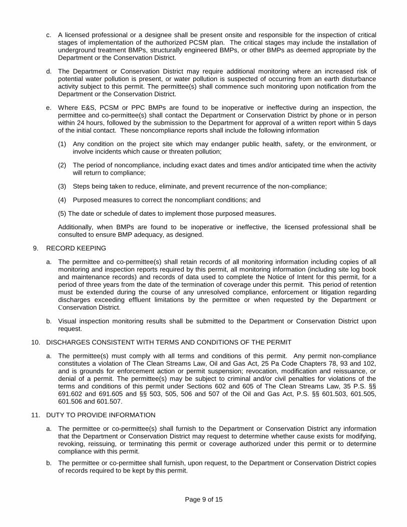
Page 9 of 15
c. A licensed professional or a designee shall be present onsite and responsible for the inspection of critical stages of implementation of the authorized PCSM plan. The critical stages may include the installation of underground treatment BMPs, structurally engineered BMPs, or other BMPs as deemed appropriate by the Department or the Conservation District.
d. The Department or Conservation District may require additional monitoring where an increased risk of potential water pollution is present, or water pollution is suspected of occurring from an earth disturbance activity subject to this permit. The permittee(s) shall commence such monitoring upon notification from the Department or the Conservation District.
e. Where E&S, PCSM or PPC BMPs are found to be inoperative or ineffective during an inspection, the permittee and co-permittee(s) shall contact the Department or Conservation District by phone or in person within 24 hours, followed by the submission to the Department for approval of a written report within 5 days of the initial contact. These noncompliance reports shall include the following information
(1) Any condition on the project site which may endanger public health, safety, or the environment, or involve incidents which cause or threaten pollution;
(2) The period of noncompliance, including exact dates and times and/or anticipated time when the activity will return to compliance;
(3) Steps being taken to reduce, eliminate, and prevent recurrence of the non-compliance;
(4) Purposed measures to correct the noncompliant conditions; and
(5) The date or schedule of dates to implement those purposed measures.
Additionally, when BMPs are found to be inoperative or ineffective, the licensed professional shall be consulted to ensure BMP adequacy, as designed.
9. RECORD KEEPING
a. The permittee and co-permittee(s) shall retain records of all monitoring information including copies of all monitoring and inspection reports required by this permit, all monitoring information (including site log book and maintenance records) and records of data used to complete the Notice of Intent for this permit, for a period of three years from the date of the termination of coverage under this permit. This period of retention must be extended during the course of any unresolved compliance, enforcement or litigation regarding discharges exceeding effluent limitations by the permittee or when requested by the Department or Conservation District.
b. Visual inspection monitoring results shall be submitted to the Department or Conservation District upon request.
10. DISCHARGES CONSISTENT WITH TERMS AND CONDITIONS OF THE PERMIT
a. The permittee(s) must comply with all terms and conditions of this permit. Any permit non-compliance constitutes a violation of The Clean Streams Law, Oil and Gas Act, 25 Pa Code Chapters 78, 93 and 102, and is grounds for enforcement action or permit suspension; revocation, modification and reissuance, or denial of a permit. The permittee(s) may be subject to criminal and/or civil penalties for violations of the terms and conditions of this permit under Sections 602 and 605 of The Clean Streams Law, 35 P.S. §§ 691.602 and 691.605 and §§ 503, 505, 506 and 507 of the Oil and Gas Act, P.S. §§ 601.503, 601.505, 601.506 and 601.507.
11. DUTY TO PROVIDE INFORMATION
a. The permittee or co-permittee(s) shall furnish to the Department or Conservation District any information that the Department or Conservation District may request to determine whether cause exists for modifying, revoking, reissuing, or terminating this permit or coverage authorized under this permit or to determine compliance with this permit.
b. The permittee or co-permittee shall furnish, upon request, to the Department or Conservation District copies of records required to be kept by this permit.

Page 10 of 15
c. When the permittee or co-permittee becomes aware that they failed to submit any relevant facts or submitted incorrect information in the NOI, E&S Plan, PCSM/Site Restoration Plan, or PPC Plan or in any other report to the Department or Conservation District, the permittee or co-permittee shall within 24 hours of becoming aware of the deficiency submit or correct such facts or information.
d. The permittee or co-permittee shall give seven (7) calendar days advance notice to the Department or Conservation District by either telephone or certified mail of the intent to commence earth disturbance activities. Notification may occur prior to receipt of coverage under this permit.
12. SIGNATORY REQUIREMENTS
a. Documents required, submitted, or maintained under this permit shall be submitted with original signatures and be signed in accordance with the following:
(1) NOIs, Transferee/Co-permittee Form, and NOTs.
(a) Corporations: (1) a president, secretary, treasurer, or vice-president of the corporation in charge of a principal business function, or any other person who performs similar policy or decision-making functions for the corporation; or (2) the manager of one or more manufacturing, production, or operating facilities, if authority to sign documents has been assigned or delegated to the manager in accordance with corporate procedures;
(b) Partnerships or sole proprietorships: a general partner or the proprietor, respectively; or
(c) Municipalities, State, Federal, or other public agencies: either a principal executive officer or ranking elected official such as: (1) the chief executive officer or secretary of the agency, or (2) a senior executive officer having responsibility for the overall operations of a principal geographic unit of the agency (e.g., Regional Administrators of EPA).
(2) All reports, plans, documents, and other information required by the permit or requested by the Department or Conservation District shall be signed by a duly authorized representative of the permittee.
(3) If there is a change in the duly authorized representative of the permittee or co-permittee, respectively, the permittee or co-permittee shall notify the Department or Conservation District within 30 days of the change.
13. TRANSFER OF OWNERSHIP OR CONTROL
a. This permit is not transferable to any person except after notice and acknowledgment by the Department or Conservation District.
(1) In the event of any pending change in control or ownership of facilities from which the authorized discharges emanate, the permittee or co-permittee shall notify the Department or Conservation District using the form entitled "Application for Transfer of the Erosion and Sediment Control General Permit" of such pending change at least 30 days prior to the change in ownership or control. If the permittee undergoes a name change, the permit must be reissued under the new name. The permittee, however, is not required to submit this form. Instead, permittee must submit a copy of its Department of State filings to the Department.
(2) The transfer application form shall be accompanied by a written agreement between the existing permittee and the new owner or operator stating that the existing permittee shall be liable for violations of the permit up to and until the date of coverage transfer and that the new owner or operator shall be jointly and individually liable for permit violations under the permit from that date on.
(3) After receipt of an administratively complete and acceptable transfer application form, the Department or Conservation District shall notify the existing permittee and the new owner or operator of its decision concerning authorization of the transfer of ownership or control.
(4) All relevant conditions of any prior Departmental permits, decrees or orders issued to the permittee(s) or their predecessor shall be continued in full force and effect unless explicitly superseded by this permit. The provisions of this permit shall apply to the permittee’s successors, lessees, heirs, and assigns. Permit ownership and/or responsibilities may be transferred or shared after written notice to, and upon authorization from the Department or Conservation District. The notice shall be provided to

Page 11 of 15
the Department or Conservation District at least 30 days prior to the effective date of new ownership or permit responsibility. The transfer does not need to be published in the PA Bulletin.
b. For purposes of this permit, operators shall include general contractors. If, prior to conducting oil and gas activities, the owner is the permittee and an operator/general contractor is later identified to become a co-permittee, the owner shall:
(1) Notify the Department or Conservation District by submitting an administratively complete and acceptable Application for Co-Permittee Addition to the Erosion and Sediment Control General Permit (ESCGP-2) Authorization; and
(2) Ensure that monitoring reports and any other information requested under this permit shall reflect all changes to the permittee and the co-permittee name.
c. After receipt of the documentation described in (b) above, the permit will be considered modified by the Department or Conservation District. For the purposes of this permit, this modification is considered to be a minor permit modification.
d. Upon authorization of a change in ownership or control, the existing permittee shall provide a copy of the permit and authorized plans to the new owner and/or co-permittee.
14. OPERATING CONDITIONS
a. Solids, sediments, and other pollutants removed in the course of treatment or control of stormwater shall be disposed in accordance with Federal and State law and regulations in order to prevent any pollutant in such materials from adversely affecting the environment.
b. The permittee and co-permittee(s) are responsible for the design, installation, operation and maintenance of the BMPs identified in the E&S Plan, PCSM\Site Restoration Plan, and PPC Plan.
d. Upon reduction, loss, or failure of any BMP, the permittee and co-permittee shall take immediate action to restore, repair or replace the BMP or provide an alternative BMP(s). These actions should be undertaken to protect, maintain, reclaim and restore waters of the Commonwealth. This requirement is applicable in situations where the BMP is rendered ineffective, whether the cause of source of the reduction, loss or failure is within or beyond the control of the permittee or co-permittee.
e. All building materials and wastes must be removed from the site and recycled or disposed in accordance with the Department’s Regulations at 25 Pa. Code Chapters 78, 260, 271, and 287. Procedures which ensure that the proper disposal or recycling of materials associated with or from the project site will be undertaken in an environmentally safe manner and in accordance with Federal and State law and regulations shall be implemented. No waste or material shall be disposed, buried, dumped, or discharged at the site unless it is in accordance with Federal and State law and regulations.
f. The permittee(s) and co-permittee(s) shall contact the plan preparer for clarification of any requirements contained in the Erosion and Sediment Control Plan, Post Construction Stormwater Management Plan, Pollution Prevention and Contingency Plan, or other documents related to this permit. If additional clarification is necessary the permittee or co-permittee shall contact the Department or Conservation District.
g. Discharges of material other than stormwater runoff must be in compliance with an NPDES permit issued for the discharge. Discharge of sewage or industrial waste (other than sediment under this permit) to an E&S BMP is not permitted. The permittee/co permittee may not discharge floating materials, oil grease, scum, foam, sheen, and substances which: produce odor, taste, or turbidity or settle to form deposits in concentrations or amounts sufficient to be, or create a danger of being, inimical to the water uses to be protected or human, animal, plant or aquatic life.
h. Where infiltration BMPs are being utilized, the permittee and co permittee must ensure that soil compaction is avoided or minimized in those areas. If the areas planned for infiltration BMPs are compromised, additional soil testing must be performed to verify that the BMP will perform as planned.
i. Upon final completion of an earth disturbance activity or any stage or phase of an activity the project site shall be immediately stabilized in accordance with the requirements of 25 Pa. Code § 102.22(a). E&S BMPs shall be implemented and maintained until permanent stabilization is completed. Once permanent stabilization has been established the temporary E&S BMPs shall be removed. Any areas disturbed in the
Page 12 of 15
act of removing temporary E&S BMPs shall be permanently stabilized upon completion of the temporary E&S BMP removal activity.
j. Upon temporary cessation of the earth disturbance activity, or completion of any stage or phase of an activity where the cessation of earth disturbance will exceed 4 days the project site shall be immediately stabilized in accordance with the requirements of § 102.22(a). E&S BMPs shall be implemented and maintained until permanent stabilization is completed. Once permanent stabilization has been established the temporary E&S BMPs shall be removed. Any areas disturbed in the act of removing temporary E&S BMPs shall be permanently stabilized upon completion of the temporary E&S BMP removal activity.
15. COMPLIANCE RESPONSIBILITIES
a. The permittee and co-permittee must comply with all terms and conditions of this permit. Any permit noncompliance constitutes a violation of the Pennsylvania Clean Streams Law and is grounds for enforcement action; for permit termination, revocation, reissuance, or modification; or for denial of a permit or permit renewal.
b. Any person who violates a permit condition, fails to take corrective action to abate violations or falsifies report or other documents may be subject to criminal and/or civil penalties or other appropriate action for violations of the terms and conditions of this general permit under the Clean Streams Law, 35 P.S. §§ 691.602 and 691.605.
c. The permittee or co-permittee may not use as a defense in an enforcement action that it would have been necessary to halt or reduce the permitted activity to maintain compliance with the conditions of this permit.
d. This permit does not convey any property rights of any sort, nor any exclusive privileges, nor does it authorize any injury to private property nor any invasion of personal rights, nor any infringement of Federal, State, or local laws or regulations.
e. The provisions of this permit are severable; and if any provision of this permit, or the application of any provision of this permit to any circumstance, is held invalid, the application of such provision to other circumstances and the remainder of this permit shall not be affected thereby.
f. Pursuant to the Pennsylvania Clean Streams Law 35 P.S. §§ 691.5(b) and 691.305, 25 Pa. Code Chapter 92a, and § 1917-A of the Administrative Code, the permittee and co-permittee shall allow the Director of the Department and/or an authorized representative of the Department, Conservation District or, in the case of a facility which discharges to a municipal separate storm sewer, an authorized representative of the municipal operator or the separate storm sewer receiving the discharge, upon the presentation of credentials and other documents, as may be required by law, to:
(1) Enter upon the permittee's or co-permittee's premises where a regulated facility or activity is located or conducted or where records must be kept under the conditions of this permit;
(2) Have access to and copy, at reasonable times, any records that must be kept under the terms and conditions of this permit;
(3) Inspect any facilities or equipment (including monitoring and control equipment); and
(4) Observe or sample any discharge of stormwater.
g. Section 309(c)(4) of the Clean Water Act provides that any person who knowingly makes any false material statement, representation, or certification in any record or other document submitted or required to be maintained under this permit, including reports of compliance or noncompliance shall, upon conviction, be punished by a fine of not more than $10,000 or by imprisonment for not more than 2 years or by both. In addition, criminal sanctions are set forth for false swearing and unsworn falsification at 18 Pa. C.S. §§ 4903 - 4904.
16. EROSION AND SEDIMENT CONTROL PLANS
a. An E&S Plan shall be prepared by a person trained and experienced in erosion and sediment control methods and techniques applicable to the size and scope of the project being designed. Each E&S Plan, including any major modifications, must be submitted to the Department or Conservation District for review and authorization. The BMPs shall be designed and implemented to minimize the potential for accelerated erosion and sedimentation in order to protect, maintain, reclaim, and restore water quality and existing and designated uses , in accordance with 25 Pa. Code § 102.4(b). Best Management Practices for oil and gas

Page 13 of 15
activities are listed in the Department’s Erosion and Sediment Pollution Control Manual, (No. 363-2134-008), the Water Quality Antidegradation Guidance (No. 391-0300-002) and the Stormwater Best Management Practices Manual (No. 363-0300-002). These documents are available from the Department or Conservation District or can be downloaded from the Department's Web site at www.depweb.state.pa.us. The permittee(s) may use BMPs that are not identified in the foregoing manuals if the permittee(s) demonstrates to the Department or Conservation District’s satisfaction that the proposed BMPs achieve equivalent or superior environmental protection standards. E&S Plans and BMPs, and revisions thereto, which meet the requirements of 25 Pa. Code Chapters 78, 93, 96, and 102, are conditions of this permit and are incorporated by reference.
b. The staging of earth disturbance activities and maintenance requirements contained in the authorized E&S Plan must be followed.
c. Upon the installation or stabilization of all perimeter sediment control BMPs and at least 3 days prior to proceeding with the bulk earth disturbance activities, the permittee or co-permittee shall provide notification to the Department or conservation district.
17. PREPAREDNESS, PREVENTION AND CONTINGENCY (PPC) PLANS
Under 25 Pa. Code § 102.5(l), a person shall prepare and implement a PPC Plan when storing, using or transporting materials including: fuels, chemicals, solvents, pesticides, fertilizers, lime, petrochemicals, wastewater, wash water, core drilling wastewater, cement, sanitary wastes, solid wastes or hazardous materials onto, on or from the project site during earth disturbance activities. In accordance with 25 PA Code § 78.55, operators of oil and gas wells are required to prepare and implement a control and disposal plan. Operators may meet this regulatory requirement by developing and implementing a site specific PPC Plan. The PPC Plan shall be developed in accordance with Department regulations. The PPC Plan should identify areas which may include, but are not limited to, waste management areas, raw material storage areas, fuel storage areas, temporary and permanent spoils storage areas, maintenance areas, and any other areas that may have the potential to cause noncompliance with the terms and conditions of this permit due to the storage, handling, or disposal of any toxic or hazardous substances such as oil, gasoline, pesticides, herbicides, solvents, etc. BMPs shall be developed and implemented for each identified area. The PPC Plan shall be made available upon the Department's or Conservation Districts' request.
18. POSTCONSTRUCTION STORMWATER MANAGEMENT PLANS\SITE RESTORATION PLANS
a. A PCSM Plan shall be prepared by a person trained and experienced in PCSM design methods and techniques applicable to the size and scope of the project being designed. The management of post construction stormwater shall be planned and conducted in accordance with 25 Pa. Code §102.8. Various BMPs and their design standards are listed in the Pennsylvania Stormwater Best Management Practices Manual, (No. 363-0300-002), as amended and updated. The manual is available from the Department or Conservation District or can be downloaded from the Department's Web site at www.depweb.state.pa.us. Each PCSM Plan, including any major modifications, must be submitted to the Department or Conservation District for review and authorization. The PCSM plan must employ stormwater management BMPs to control the volume, rate, and water quality of the post construction stormwater runoff so as to protect and maintain the chemical, physical, biological properties and existing and designated uses of the waters of this Commonwealth.
b. PSCM Plans shall be consistent with any Department authorized Act 167 Stormwater Management Plan which covers the area where the project is proposed.
c. A licensed professional or a designee shall be present onsite and be responsible for oversight of critical stages of implementation of the authorized PCSM plan. The licensed professional will be responsible to provide a final certification, pursuant to 102.8(l) along with the required NOT and record drawings, indicating that the project site was constructed in accordance with the authorized or modified PCSM plan.
d. The portion of a site reclamation or restoration plan that identifies PCSM BMPs to manage stormwater from oil and gas activities permitted in accordance with Chapter 78, pipelines; or other similar utility infrastructure may be used to satisfy the PCSM requirements if the PCSM, reclamation or restoration plan meets the requirements of §§ 102.8(b), (c), (e), (f), (h), (i) and (l), and when applicable, (m).
19. PRECONSTRUCTION CONFERENCES
For earth disturbance activities authorized by this permit, a preconstruction meeting is required, unless the permittee has been notified otherwise in writing by the Department or Conservation District. The permittee shall invite the Department or Conservation District to attend the preconstruction meeting and provide at least 7 days

Page 14 of 15
notice of the preconstruction meeting to all invited attendees. Permittees, co-permittees, operators, and licensed professionals or designees responsible for earth disturbance activity, including implementation of E&S and PCSM plans and critical stages of implementation of the authorized PCSM plan, shall attend the preconstruction meeting. Where notice of a preconstruction meeting has been provided to the Department and the preconstruction meeting is held pursuant to § 102.5(e), but the Department’s representations do not attend the scheduled pre-construction meeting, the earth disturbance activities authorized under the permit may proceed.
20. LONG-TERM OPERATION AND MAINTENANCE
a. The permittee and co-permittee shall be responsible for long-term operation and maintenance of PCSM BMPs unless a different person is identified in the NOT and has agreed to long-term operation and maintenance of PCSM BMPs.
b. For any property containing a PCSM BMP, the permittee or co-permittee shall record an instrument with the recorder of deeds which will assure disclosure of the PCSM BMP and the related obligations in the ordinary course of a title search of the subject property. The recorded instrument must identify the PCSM BMP, provide for necessary access related to long-term operation and maintenance for PCSM BMPs and provide notice that the responsibility for long-term operation and maintenance of the PCSM BMP is a covenant that runs with the lands that is binding upon and enforceable by subsequent grantees, and provide proof of filing with the NOT under §102.7(b)(5).
c. For Commonwealth owned property, a covenant that runs with the land is not required until the transfer of the land containing a PCSM BMP occurs. Upon transfer of the Commonwealth-owned property containing the PCSM BMP, the deed must comply with §102.8(m)(3).
d. The person responsible for performing long-term operation and maintenance may enter into an agreement with another person, including a Conservation District, nonprofit organization, municipality, authority, private corporation or other person, to transfer the responsibility for PCSM BMPs or to perform long-term operation and maintenance and provide notice thereof to the Department.
e. A permittee or co-permittee that fails to transfer long-term operation and maintenance of the PCSM BMPs or otherwise fails to comply with this requirement shall remain jointly and severally responsible with the landowner for long-term operation and maintenance of the PCSM BMPS located on the property.
21. VOLUNTARY RIPARIAN FOREST BUFFERS
Persons that protect, convert or establish a new riparian forest buffer that meets the requirements of 102.14(b) may qualify for benefits under §§ 102.14(e)(1) and (2) relating to the antidegradation presumption and trading or offsetting of credits.
22. MANDATORY RIPARIAN BUFFERS Permittees or co-permitees must protect, convert or establish a new riparian forest buffer that meets the
requirements of 25 Pa. Code § 102.14 unless otherwise exempted or waived under §§ 102.14(a) or 102.14(d). 23. TERMINATION OF COVERAGE
a. Upon permanent stabilization of earth disturbance activity under § 102.22(a)(2) (relating to permanent
stabilization) and installation of BMPs in accordance with the authorized plan prepared and implemented in accordance with §§ 102.4 and 102.8 (related to erosion and sediment control requirements; and PCSM requirements), the permittee and/or co-permittee shall submit a NOT to the Department or Conservation District. The NOT must include:
(1) The facility name, address and location,
(2) The operator name and address,
(3) The permit number,
(4) The reason for the permit termination,
(5) Identification of the persons who have agreed to and will be responsible for the long term operation and maintenance of PCSM BMPs.

Page 15 of 15
Until the permittee or co-permittee has received written authorization of the NOT, the permittee and co-permittee will remain responsible for compliance with the permit terms and conditions, including long term operation and maintenance of all PCSM BMPs on the project site. The Department or Conservation District will conduct a follow up inspection and approve or deny the NOT within 30 days of receipt unless field conditions such as snow cover prevent inspection.
b. The permittee shall enclose with the NOT “Record Drawings” with a final certification statement from a licensed professional, which reads as follows:
“I (name) do hereby certify pursuant to the penalties of 18 Pa. C.S.A. § 4904 to the best of my knowledge, information, and belief, that the accompanying record drawings accurately reflect the as built conditions, are true and correct, and are in conformance with Chapter 102 of the rules and regulations of the Department of Environmental Protection and that the project site was constructed in accordance with the authorized PCSM plan, all authorized plan changes, and accepted construction practices.”
The permittee shall retain a copy of the record drawings as part of the authorized PCSM plan. The permittee shall also provide a copy of the record drawings as part of the authorized PCSM plan to the persons identified as responsible for the long term operation and maintenance of PCSM BMPs. Permittees shall also provide copies of both the record drawings and the long term operation and maintenance plan to the Department, Conservation District and municipality.