EAME O AIOA EEOME. UEAU O MIEA ESOUCES GEOOGY A GEOYSICS. · sisoe, sae, akose, a sasoe. ^Qua gao...
31
COMMONWEALTH OF AUSTRALIA. DEPARTMENT OF NATIONAL DEVELOPMENT. BUREAU OF MINERAL RESOURCES GEOLOGY AND GEOPHYSICS. RECORDS. 196 2/111 EXPLANATORY NOTES TO THE BAUHINIA DOWNS 1:250,000 SHEET AREA (Revised Edition) Compiled by J.W. Smith The information contained in this report has been obtained by the Department of National Development, as part of the policy of the Common- wealth Government, to assist in the exploration and development of mineral resources. It may not be published in any form or used in a company prospectus without the permission in writing of the Director, Bureau of Mineral Resources, Geology and Geophysics. for
Transcript of EAME O AIOA EEOME. UEAU O MIEA ESOUCES GEOOGY A GEOYSICS. · sisoe, sae, akose, a sasoe. ^Qua gao...

COMMONWEALTH OF AUSTRALIA.
DEPARTMENT OF NATIONAL DEVELOPMENT.
BUREAU OF MINERAL RESOURCESGEOLOGY AND GEOPHYSICS.
RECORDS.
1962/111
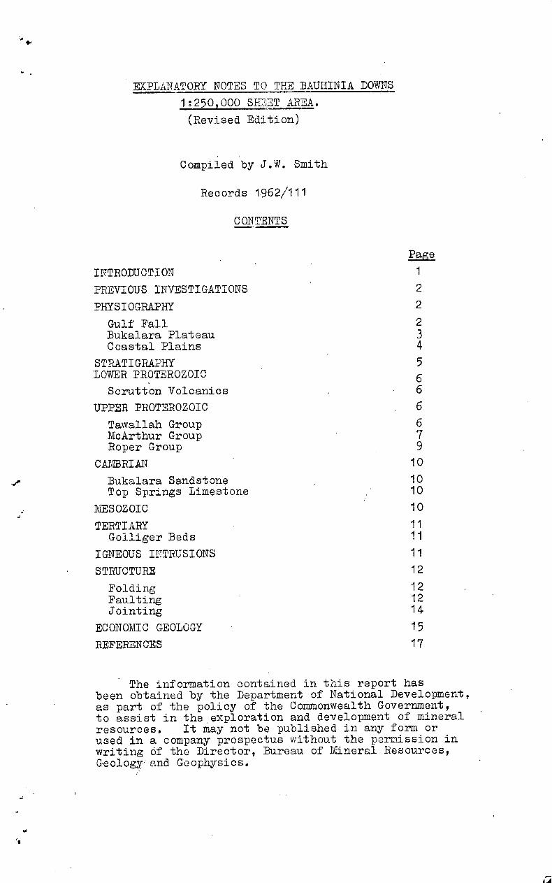
EXPLANATORY NOTES TO THE BAUHINIA DOWNS1:250,000 SHEET AREA
(Revised Edition)
Compiled by
J.W. Smith
The information contained in this report has been obtained by theDepartment of National Development, as part of the policy of the Common-wealth Government, to assist in the exploration and development of mineralresources. It may not be published in any form or used in a companyprospectus without the permission in writing of the Director, Bureau ofMineral Resources, Geology and Geophysics.
for
EXPLANATORY NOTES TO THE BAUHINIA DOWNS1:250,000 SH2ET AREA.(Revised Edition)
Compiled by J.W. Smith
Records 1962/111
CONTENTS
lazaINTRODUCTION 1
PREVIOUS INVESTIGATIONS 2
PHYSIOGRAPHY 2
Gulf Fall 2Bukalara Plateau 3Coastal Plains 4
STRATIGRAPHY 5LOWER PROTEROZOIC 6
Scrutton Volcanics 6UPPER PROTEROZOIC 6
Tawallah Group 6McArthur Group 7Roper Group 9
CAMBRIAN^S 10
Bukalara Sandstone 10Top Springs Limestone 10
MESOZOIC 10
TERTIARY 11Golliger Beds 11
IGNEOUS INTRUSIONS 11
STRUCTURE 12
Folding 12Faulting 12Jointing 14
ECONOMIC GEOLOGY 15REFERENCES 17
The information contained in this report hasbeen obtained by the Department of National Development,as part of the policy of the Commonwealth Government,to assist in the exploration and development of mineralresources.^It may not be published in any form orused in a company prospectus without the permission inwriting of the Director, Bureau of Mineral Resources,Geology and Geophysics.

Contents (cont.)
TABLES
Table 1:^Stratigraphy of the Bauhinia Downs Sheet area.
Table 2:^McArthur River mineral deposits.
PLATES
Plate 1:^
Geological map of the Bauhinia Downs1:250,000 Sheet, N.T..
FIGURES .
Figure 1: Physiographic sketch map of the BauhiniaDowns 1:250 9 000 Sheet area.
Figure 2: Sketch cross section showing environmentof deposition of the McArthur Group.
Figure 3: Structural sketch map of the BauhiniaDowns Sheet area.
•

EXPLANATORY NOTES TO THE BAUHINIA DOWNS
1:250 000 SHEET AREA.(Revised Edition)
Compiled by J.W. Smith
INTRODUCTION
The Bauhinia Downs Sheet area lies within the
latitudes 16 °S and 17 °S and longitudes 135 0000E and136 °30tE on the south-western side of the Gulf of Carpentaria,Northern Territory.
The European population is centred at Borroloola
(where there is a store), Mallapunyah Homestead,
O.T. Downs Homestead, a homestead in the upper Batten Creek
area, and at the time of writing (1962) at McArthur River
Homestead.Road access within the area is good and has been
greatly improved by the recent construction of a formed
road running from Daly Waters on the Stuart Highway toBorroloola.^This road continues eastwards to Robinson
River Homestead on the Robinson River Sheet area but is not
formed beyond Borroloola.^The other main roads in the
area run from Borroloola to Mallapunyah Homestead (and thence
to the Barkly Tableland) and from 0.T.Downs Homestead throughThree Knobs to join the Borroloola - Mallapunyah track
at Leila Lagoon; both are graded dirt roads.Borroloola, McArthur River Homestead, and .
Mallapunyah Homestead all have dirt airstrips which are
open most of the year.^A weekly service by light aircraft
connects them with Mt. Ise., Queensland.
Photographs and maps covering the area are: .
Bauhinia Downs air photographs (Scale 1:48,000) flown by
the Royal Australian AirForce in 1947 and 1952.Bauhinia Downs photoscale maps prepared by and available
from the Division of National Mapping, Department of
National Development..
Bauhinia Downs 4-mile topographic Series - E53/3 Zone 5 1
Division of National Mapping, Department of National
Development.Bauhinia Downs 4-mile uncontrolled photo mosaic.
McArthur River 8-mile military series - E53/3- 4-7-8 Zone 5.The annual rainfall of the area, which is 20-30
inches, falls mainly in the summer months - January to March.

2.
The average temperature is about 85 0 in summer and 70-75 ° inwinter.
PREVIOUS INVESTIGATIONS
Lead,r zinc-copper mineralization in the area around •McArthur River Homestead was first discovered by Mr. Tom Lynott
in 1887, and by 1891 the area had been well prospected forsilver, but without success.^Interest in the area i.evived in
1909, when Cookts deposit was drilled, and again in 1953 when
Bald Hills prospect was drilled by Consolidated anc Pty.Dtd..
Little systematic work was done in the field until Mount Isa
Mines Ltd. began a programme of mapping and prospecting in 1955.Two promising prospects,. the Reward and H.Y.C., were discovered;
subsequently the Reward was abandoned l but drilling is still
proceeding at H.Y.C. (1962) by Carpentaria Exploration Ltd.,
a subsidiary company of Mount Isa Mines Ltd..
Until 1955 little was known of the geology of theSheet area, al •Ti: from the region around McArthur River Homestead.
Brown (1908), Woolnough (1912), and Jensen (1914) visited the
area, but confined most of their observations to the route from
Borroloola to the Barkly Tableland; Woolnough also travelled
from TaLumbirini Homestead east to McArthur River Homestead.
In 1955-6 geologists of Mount Isa Mines Ltd. (Kriewaldt,1957)carried out reconnaissance mapping of the Bauhinia Downs Sheet
area as part of a survey of the country between the Queensland
Border and the Roper River.
In 1959 the Bureau of Mineral Resources completed areconnaissance gravity survey from Burketown, Queensland to .
Daly Waters, crossing the Bauhinia Downs Sheet area en route 9
and during 1960 mapped the Sheet area.^Detailed mapping of an
. Authority to Prospect of 600 square miles around McArthur River
Homestead was begun by geologists of Carpentaria Exploration Co.
Ltd. in the same year. • In 1961 the Bureau of Mineral Resources
conducted a geochemical survey in the McArthur River Homestead
area.PHYSIOGRAPHY
The Sheet area mainly falls in the Gulf Fall
physiographic region (Stewart 1954, Dunn, Smith; and Roberts1962) but around Borroloola the Coastal Plains extend on to
the north of the Sheet area (see figure 1).
The Gulf Fall is defined as the hill country
surrounding the Gulf of Carpentaria in which the drainage is
towards the Gulf.

3.
Apart from isolated ranges the country slopes gradually from
about 800 feet above sea-level in.the south and south-west to
the Gulf Coastal Plains around Borroloola, which are between50 feet and 70 feet above sea level.^The isolated rangesare 100-500 feet above the surrounding country.
The main elevated areas can be divided into three:(a) fLir isolated ranges in the centre of the Sheet area.(b) the Favenc Range in the south-west and
(c) the Bukalara Plateau in the south-east.
The isolated ranges of (a) are the Tawallah Range,
an unnamed feature to the north-north-east of Leila First
Crossing, another around Mallapunyah Homestead, and theAbner Range.^The first three ranges are composed of rocks ofthe Tawallah Group and the last of Roper Group rocks.
All are composed of resistant sandstone ridges,
separated by steep-sided valleys formed by erosion of softerbeds.^The resistant sandstone ridges of the Roper Group havea characteristic strong rectangular jointing pattern which upon
weathering causes the formation of isolated pillars up to 50feet high.
The Favenc Range fringing the Barkly-BeetalooTableland (Dunn, Smith tand Roberts, 1962) is composed of Mesozoicsediments.^The northern edge of the Range is a continuousscarp rising to about 100 feet above the plain.^Southwards theRange is dissected into scattered, low, flat topped hills.
The Bukalara Plateau is a major physiographic feature
of the Gulf Fall occurring in the east and south-east of theSheet area and extending into the adjacent Walhallow, Robinson
River, and Calvert Hills Sheet areas.^The Range is mainly adissected plateau of flat-lying Bukalara Sandstone standing100-BOO feet above the surrounding country.^In places therivers, in the Sheet area principally the Clyde River and its
tributaries, have cut through the Bukalara Sandstone and aresuperimposed on the McArthur Gaup and Roper Group.
A lowland area in the centre of the Sheet area between
the Bukalara Plateau and a north-striking line roughly through
Three Knobs is largely underlain by rocks of the McArthur Group.
(It is within this area that the isolated ranges, describedabove, see^(1), occur).^The area, excluding theisolated ranges, is usually undulating with low rounded, rough,
hills up to 50 feet high, but resistant beds such as theTatoola Sandstone and parts of the Lynott Formation form strike
ridges rising to about 200 feet above the surrounding plain.


5 .
The McArthur River rises on the Walhallow Sheet
area and floods north-eastwards across the Bauhinia Downs Sheet
area.^Along its central portion the river is braided, but at
McArthur River Homestead it forms one main channel.^The river
is deeply incised, with steep banks up to 50 feet high.During the dry season scattered water-holes, some of which are
permanent, are present in the upper and central reaches; by
McArthur River Homestead there is a gentle flow of water for
most of the year, and the :!2iver becomes tidal about 6 miles
upstream of Borroloola.The present drainage system is post-Mesozoic and
largely superimposed on Upper Proterozoic rocks.^Erosion has
removed most of the Mesozoic sediments and the superimposed
drainage has been modified by the structure of the Upper
Proterozoic rocks.
STRATIGRAPHY
The stratigraphy of the Bauhinia Downs Sheet area
have been summarized in Table 1.^General distribution of the
units is shown in Fig.3..The Upper Proterozoic rocks were laid down in the
McArthur Basin (Dunn, Smith, & Roberts, 1962), which covers
a large area of the south-western part of the Gulf of
Carpentaria.The basal Group of the Upper Proterozoic - the
Tawallah Group - compared with the succeeding McA;thur Graup-is
relatively uniform in both thickness and lithology. Maximum
thickness was possibly developed in the Bauhinia Downs and
Mount Young,Sheet areas indicating incipient development of a
north-striking trough through the centre of the Bauhinia Downs
Sheet area.This trough was operative .
throughout the deposition
of the McArthur Group. Subsidence was not uniform and wasmost rapid between two major hinge-lines - The Tawallah -
Abner Fault line and the Emu Fault line.^Between the Emu :tine
and longitude 137 0 some subsidence occurred.^The gravity
traverse conducted by the Bureau of Mineral Resources indicated
a sharp thinning of Upper Proterozoic sediments at about
longitude 137 ° .^From geological mapping of the Robinson
River Sheet area it appears that a stable shelf may haveexisted east of this line during deposition of the McArthur
Group (Yates, 1962),

To the west of the Tawallah-Abner line sinking was also fairly
rapid.^The nature of the sediments suggests that at this
time the western margin of the Basin may have been only a little
to the west of the Sheet area.However, the start of the deposition of the Roper
Group the axis of downwarping had shifted westwards to the
western Bauhinia Downs and on to the Tanumbirini Sheet areas.
Tectonic movements ended deposition of the Roper
Group.^Subsequently the area was relatively stable and small
thicknesses of sediments were laid down in the Cambrian,
Mesozoic, and Tertiary.
LOWER PROTEROZOICScrutton Volcanics.
The Scrutton Voicanics, which crop out in the
Tawallah pocket to the east of old Tawallah Homestead (and on
the Mount Young Sheet area) are unconformably overlain by the
Yiyinti Sandstone, which basally, in places, contains pebbles
and cobbles of volcanics.^The Volcanics have therefore been
placed in the Lower Proterozoic, but may be younger.The Volcanics consist of fine-grained porphyritic acid
to intermediate lenses and vescicular basalt, with lenses of
siltstone, shale, arkose, and sandstone.^Quartz gabbro is
also present and may represent minor intrusions.The thickness of the Scrutton Volcanics is not known.
UPPER PROTEROZOIC Tawallah Group.
The most complete section (about 13,000 feet) of the
Tawallah Group on the Sheet area is in the Tawallah Range;
.elsewhere, except for the exposure north-north-east of Leila
First Crossing, only the upper part of the Group is exposed.The Tawallah Group is mainly composed of sandstonq
with subordinate volcanics, ailtstone, dolomite, dolomiticand ferruginous sandstone, dolomitic and ferruginous siltstone
and conglomerate.^The dominant rock type is a white to pink
medium,-grained quartz sandstone, which occurs mainly in the
ayinti Sandstone, Ely Creek Sandstone and Masterton Formation.In the Sheet area dolomite is entirely confined to the
19.112amlaj"smation and conglomerate mainly to the MastertonFormation and Rosie Creek Sandstone.
Volcanic rocks occur principally in the Peters Creek
Volcanics and Settlement Creek Volcanics, but are found
locally also in the Masterton Formation.

7 .
Apart from local lapilli tuff the volcanics are intermediate
to basic flows; the most common rock:type is an iron-rich
vesicular trachyte or basalt. Microgabbro has been found
within the Masterton Formation, but may be intrusive.
McArthur Group The McArthur Group is best exposed on the Bauhinia
Downs Sheet area; it extends onto the Walhallow, Mount Young,
Robinson River, Calvert Hills, and Mount Drummond Sheet areas.
Carbonate rocks in similar stratigraphic position in theUrapunga Sheet area, (Dunn 1962b) have also been included in the
McArthur Group (Dunn, Smith, & Roberts,1962).The principal area of outcrop on the Sheet area is
found between the. Bukalara Range and a north-striking line
approximately through Three Knobs; minor outcrops also occur
in the extreme west around Lansen Creek, and in the south-east
and east.Within the Bauhinia Downs Sheet area the McArthur
Group is conformable on the Tawallah Group.^In some other
places the two Groups are unconformably related e.g. the
Calvert Hills and Robinson River Sheet areas.
Maximum deposition of the carbonate-rich McArthur
Group took place in a trough striking north through the centre
of the Sheet area.^A major north-striking faulted hinge-line
- the Tawallah - Abner Fault - affected sedimentation during
deposition of the Group; the Emu Fault may also have affected
sedimentation.The history of deposition of the McArthur Group in
the central part of Sheet area is coMplex. Summarized, the
following seemed to have been the order of events (see also
Fig.2):
1. Deposition of the Mallapunyah Formation representing atransition between the dominantly arenaceous Tawallah
Group and the dominantly carbonate McArthur Group.
2. Deposition of widespread carbonate mud accompanied bythe growth of large algal biostromes and much slumping.
Minor lenses of alternating dolomite, siltstone, and
sandstone were deposited locally (the Amelia Dolomite).
3. Minor uplift, both marginal and along thes)
^Tawallah-Abner Fault, resulting in the formation of a reef,
dolomite (the Top Crossing Dolomite) along the
Tawallah-Abner line. Increased marginal run off in
the west produced the Tatoola Sandstone.

8 .
Fore-reef sediments were deposited in the east, e.g. the
11.122ttlormation, Yaloo Formation and Lookin7 Glass
Formation; and back reef sediments in the west - the
Tooganinie Formation.
4. Minor uplift during deposition of the fore and back reef
sediments, resulting in the deposition of the Stretton
Sandstone in the east and the Leila Sandstone Member
of the Tooganinie Formation in the west.
5. Breakdown of the reef, and of fore and back reef sediment-
ation, and deposition of widespread carbonate muds
(Emmerugga Dolomite).^However in the north-east
initially a sandstone (Smythe Sandstone) was laid down
before the carbonate muds-here mainly oolitic - were
deposited.^Locally elsewhere, as in the north side of
the Abner Range, shale and chert were deposited initially
(Amos Formation).^In the north and north-west shallow-
water sandstone, shale, and chart with dolomite and chert
breccia (Billenal,rrah Formation) were laid down, and
towards the close of McArthur Group time extended
southwards to the McArthur River.
The units of the back reef sediments, and sandstones
deposited in the back reef area, have been combined into a
sub-group (the Bauhinia Downs Sub-r), as have the forereef sediments and associated sandstones.(the Batten Sub-Group).
In the north-east of the Sheet area the rocks below
the Lynott Formation and above the Masterton Formation consist
of siltstone, dolomite, quartz, sandstone, and chert breccia.
They do not resemble the Mallapunyah Formation and the Amelia
Dolomite and have therefore been mapped as separate units -the Festing Creak Formation and the Warramana Sandstone;the
topmost chert and chert breccia have been mapped as the
Hammer Creek .,,Memb'er of the Lynott Formation.^Volcanics occur
in the Festing Creek Formation in the Mount Young Sheet area
(Plumb and Paine 1962).The only volcanics in the McArthur Group in the
Sheet area are in the Barney Creek Member of the Amelia
Dolomite.^Fine-grained acid tuffs occur in the footwall
of the H.Y.C. prospect.The outcrops of the McArthur Group around Lansen
Creek consist of white to brown fine-grained sandstone, white
to pink chert and siltstone, flaggy pink fine-grained
dolomite, rare bands of rhythmically alternating dolomitic
sandstone and dolomite with halite pseudomorphs and pebble
conglomerate.

Three Knobs^ Tawallah Fault Line^ Emu Fault
lineBillengorrah Formation
Emmerugga •Dolomite^mom
MIN
Lelia- Sandstone kferbn er--
= TooTc—minie FormaticiF4. .1.^......„--..^,4
Totoola !min^.aDolomite
1111.0.t."... Sandstone -......ammunurrp:
7.alimumwrzt,Immill.11111-111-1-■11111114limIN/Newiti
-ww11116••• rig^0•11,11211
111111MIlsontecesioAwe,"
rmTh %%Fo
Dolomi_mateTawallah Group^ ,41/11111111.LICIIMIAV
41111111
•••• •-•■
Figure 2.
DIAGRAMMATIC SECTION OF THE Mc ARTHUR GROUP( Three Knobs- Emu Fault)
Reference
Sediment of the Mallopunyoh Formation Bock reef sediments
1Biohermo/ Reef dolomite Fore reef sediments
Dolomite with biostromes Sandstone incursionsMEN-
A A A Massive chert breccia
Source of sediments
gureou of 41inero/ Resowres, Geology and Geophysics July /962^TO accompany Record /962////^• E 53/3/11

9 .
The percentage of non-carbonate rocks is g.7eater than in the
main area of outcrop of McArthur Group rocks, and may suggest
proximity to the margins of the Basin. These rocks cannot
be correlated closely with the rest of the McArthur Group.
The outcrops of the McArthur Group in the extreme
east of the Sheet area consist of Karns Dolomite (Firman 1959,
Yates 1962).Analyses of the carbonate rocks of the McArthur
Group show them to be dolomites rather than linestones. Minor
oolitic bands towards thn top of the Group are limestone in
composition.The thickness of the Group in the east of the main
'area of outcrOp, is 13,000 - 14,000 feet, in the west about
11,000 feet and in the north-west probably only about 7,000
feet.
Roper Group.
The Roper Group has a widespread distribution in
the McArthur Basin. In the Bauhinia Downs Sheet area
the main areas of outcrops are the Abner Range, east of the
Emu Fault,.and in the west.The Roper Group is unconformable on the McArthur
Group. With local exceptions the unconformity is very slight.
Normally the basal unit of the Roper Group - the Limmen
Sandstone - overlies the Emmerugga Dolomite, the Billengarrah
Formation, or the Stott Formation. In the east the Limmen
Sandstone overlies various units of the McArthur Group as low
in the succession as the Lynott Formation. In the south-west
a basal 'conglomerate contains pebbles of rocks characteristic
of the McArthur Group. .
The dominant rock types of the Roper Group are quartz
sandstone, siltstone, and shale, with subordinate ferruginous
siltstone, ferruginous sandstone, feldspathic sandstone, fine
to cobbld conglomerate, and glauconitic sandstone (the last
being characteristic of the Crawford Formation and the .
coarser parts of the Mainoru Formation; glauconitic micaceous
siltstone and micaceous shale are characteristic of the rest
of the Mainoru Formation).
The Cobanbirini Formation is nowhere completely
exposed; hence no total thickness can be estimated for the
Roper Group. In the west the exposed thickness is about
10,000 feet, in the Abner Range about 6,000 feet, and east of
the Emu Fault about 1500 feet.

1 0.
The Abner Sandstone, Corcoran Formation, and Bessie Creek
Sandstone are markedly thinned in the last area.^The Limmen
Sandstone thins from about 5,000 feet in the Tanumbirini Shoot
area to about 10-100 feet in the Abner Range and east of the
Emu Fault.
CAMBRIAN
Bukalara Sandstone
The Bukalara Sandstone occurs widely throughout
the Carpentaria region.^It crops out principally on the
Sheet area in the east and south-east but also occurs in the
Abner Range and in theeztreme north-west.^The sandstone,
which is commonly flat-lying or, in places, gently folded forms
a plateau over the folded Upper Proterozoic rocks.^It is
completely uniform throughout the Sheet area, and is character-
ized by its slightly feldspathic nature, its long gently
curving cross-bedding, and its joint pattern.
The sandstone normally ranges from 100-300 feet inthickness, but in the Abner Range, where it is folded into
a syncline, it is 1000 feet thick.^The sandstone was
previously regarded as Upper Proterozoib; but it is relatedto the overlying Lower Cambrian Nutwood Downs Volcanics in the
Hodgson Downs Sheet area (Dunn. 1 1961a).^It is unfossiliferous.
Top_Springs Limestone.
The Top Springs Limestone crops out only in the
extreme south of the Bauhinia Downs Sheet area, but occurs more
widely on the Walhallow Sheet area.The Limestone unconformably overlies units of the
McArthur Group and Roper Group and, on the Walhallow Sheet area,
the Bukalara Sandstone.^No fossils have been found, but it is
tentatively regarded as being.Middle Cambrian because its
geographical position suggests that it may be a basal part of the
Barkly Basin sequence.^The limestone is unconformably overlain
by Mesozoict sediments.
MESOZOIC Mesozoic sediments crop out extensively in the
northern part of the Northern Territory as cappings on older
rocks.^In the Bauhinia Downs Sheet area they are best
exposed in the west and south-west .In general, clays-tone and clayey sandstone overlie
quartz sandstone.^A basal conglomerate with some boulders up
to 3 feet across is present in some places; pebbles also occur
intermittently throughout the quartz sandstone.

11.
Fossils collected consist of marine mollusca and non-marine
plant remains. The distribution of the fossils suggests
that the quartz sandstone and conglomerate are non marine and
Lower Neocomian and the claystone and clayey sandstoneare marine and Middle Neocomian to Lower Aptian. (Skwarko 1960e)
(see also Skwarko 1962b).Open nomenclature has been used for fossil names,
that are now being described (Skwarko, 1 , 962b).
In most places the thickness of the Mesozoic is less
than 100 feet but locally it is up to 300 feet thick, e.g.
east of Tawallah Homestead. The Mesozoic sediments were
deposited throughout most of the area and covered a pre-
Mesozoic band surface with a relief similar to that of today.
Mesozoic sediments cap parts of the Tawallah Range - about
600 feet above present sea level.
TERTIARY.
Golliger Beds.
The Golliger Beds crop out poorly in the Golliger
Creek area between O.T.• Downs Homestead and Three I:nobs,
and north-west of Bauhinia Downs Homestead in the Limmen
Bight River. The Beds, which are massive white to light
yellow limestone, are commonly covered by residual black
soil. Black soils around Lansen and October Creeks may also
overlie the Golliger Beds.The Beds contain freshwater Tertiary gastropods and
are lacustrine. Similar limestones, also considered to
be Tertiary clre found • elsewhere in the Carpentaria province
and the Barkly Tableland, e.g. Carl Creek Limestone (Lawn Hill,
Carter and Opik, 1961) and Cleanskin Beds (Mount Drummond Sheet,
Smith & Roberts, 1962).The thickness of the Golliger Beds is not known,
but is probably less than 50 feet.
IGNEOUS .INTRUSIONS
. As well as the probable basic intrusions alreadymentioned as being associated with the Scrutton Volcanics and
possibly also with volcanics in the Masterton Sandstone, more
acid intrusions, not obviously associated with vulcanism, occur
on the east.side of the Tawallah Range and in the Emu Fault
zone, east of McArthur River Homestead.

SKE: -CC,
L̂ I Recent\-^Sync^axis
M esp3oic
Cambrian.
Roper- grout"
McArtkur qr-oup
N°^g,u1k.(w■th, down-L./iv-ow side)
Trend 1.,,,r
Anticli.n.al axis
ss^Geolo9tcal, bourudari
6
Tawallak c rout)

Both occurrences are close to large faults and intrude the
Tawallah Group.^The intrusions appear to be microsyenites
and syenites and form dykes up to 200 feet thick.
STRUCTURE
The structure of the area is shown in Figure 3.
FoldinFolding in the probable Lower Proteczoic Scrutton
Volcanics is slightly greater than the Upper Proterozoic, but
still relatively gentle, with dips under 50 0 .^The direction
of folding of the Upper Proterozoic rocks has been controlled
by the Tawallah - Abner Fault and the Emu Fault, both of
which were active during Upper Proterozoic sedimentation.
The general strike of the rocks is north, but in the Reward
area it is west.
The Upper Proterozoic rocks are folded into a broadcentral anticline with synclines to the east and west.^The
anticline is faulted on the east by the Tawallah . Fault, and
the eastern syncline is bounded by the Emu Fault.^The
Amelia Dolomite is exposed in the core of a broad west-south-
west-trending anticline south of Reward.^The centre of the
western syncline is modified by a north-striking anticlinal
flexure.^East of the Emu Fault the Upper Proterozoic rocks
are largely covered by the Bukalara Sandstone, but they appearto be folded, with very shallow dips, along north-west axes.
Folding in the main north-trending anticline and
eastern syncline has been much affected by faulting.
Dips within the Upper Proterozoic rocks are generally
shallow and average about 20 0 .^They steepen to about 50 0on
the western limb of the western syncline and in the Abner
Range, where the Roper Group crops out in a closed syncline.
Elsewhere dips are steeper where affected by faulting; in
places they are overturned adjacent to major faults.The Cambrian, Mesozoic, and Tertiary sediments are
usually flat-lying, but in places the Bukalara Sandstone is
gently folded, in particular in the Abner Range, where it is
folded into a syncline with dips of up to 20 ° .
Faulting
The two major faults are the Tawallah-Abner Fault
and the Emu Fault.^Both were probably active throughout
the Upper Proterozoic.

1 3.
The Tawallah - Abner Fault runs north through the
centre of the Sheet area. The Tawallah Fault runs from the
south Tawallah Range (where its continuation northwards is
obsOurd by other major faults) southwards to west of Cape
Crawford, where it joins the Abner Fault.^The latter
persists southwards to near Mallapunyah Homestead in the
south of the Sheet area.Movement on the fault is east side down, but is
variable in magnitude with the largest throw hrth-north,-east
of Leila Creek First Crossing;^the Fault appears to be dying
out around Mallapunyah Homestead.There is little evidence as to whether the .eault
was active during the deposition of the Tawallah Group 7 theunusual thickness of the north-north-east of Leila First
Crossing suggests that the Fault may have been operative
towards the end of the deposition of the Tawallah Group.
During the deposition of the McArthur Group the Tawallah-
Abner line played a major role in determining the distribution
of the units of the Group.^A reef dolomite (Top Crossing
Dolomite) was developed along the line, lagoonal sediments
were deposited to the west of it, and fore-reef sediments
to the east.The fault appears to have had no effect on
sedimentation during deposition of the Roper Group, butmovement may have occurred in Cambrian times, as indicated
by the unusual thickness of Bukalara Sandstone developed
in the Abner Range.The Emu Fault lies in the central east of the
Sheet area and strikes north-north-east.^In the north the
Fault is a single shear plane l .but in the Coxco Valley, east
of McArthur River Homestead,. where movement is greatest, atleast three parallel fault-lines exist. Farther south the
fault bifurcates. Movement on the fault is east side down.
Observed displacement on the falat is nowhere great,
although the adjacent rocks are considerably distorted.^The
apparent sense of movement on the fault is not in agreementwith sedimentary indications that the region between the
Tawallah and Emu Faults was a sinking trough; and it is
possible that initially the Emu Fault may have been west side
down.

14.
The Upper Proterozoic on the eastern side of the
fault if largely obscured by the Cambrian Bukalara Sandstoneand the effect the fault had on sedimentation is difficult to
ascertain..^Variations in the Lynott Formation across the
fault and sharp thinning in parts of the Roper Group suggestthat it may have been active spasmodically in Upper Proterozoic
time^Some movement occurred after the Bukalara Sandstone was
deposited, but this may no have been great.Other faults in the area trend north-west to north.
Major faults occur around Mallapunyah Homestead and in the
Tawallah Range; and some of these have throws of more than
7000 feet.^Faults with the largest throw commonly trend north.
Faults trending north-west usually have small movement; but
exceptions occur such as the Mallapunyah Fault - a transcurrent
fault on which the movement is south side west. North-west-
trending faults are particularly common on the west limb ofthe central anticline; and these may be complementary to the
Tawallah Fault, suggesting that there may have been some lateral
movement on the fault.Faulting in the Tawallah and McArthur Groups is more
severe than in the Roper Group and may be a result of stabiliz-
ation in the sinking embayment. Movement in post-Cambriantimes appears to have been, at least in part, along established
fault lines such as the Emu Fault. Minor movement, mostly
along pre-existing faults, occurred after the deposition of the
Mesozoic.
I2lnIlEaThe sandstones of the Tawallah Group, the Abner and
Bessie Creek Sandstones, and the Bukalara Sandstone, all have
characteristic joint patterns.^Jointing in the sandstones of
the Tawallah Group is inconsistent; in places it is strongly
developed but in general it is patchy.^The joints are commonly
normal to the bedding, but in some places two joint directions
are present and form a rectangular pattern.Strong rectangular jointing is characteristic of
both the Abner and Bessie Creek Sandstones.^The strike of the
joints varies with the strike of the bedding, one joint commonly
being normal to the bedding.^Pillars up to 50 feet high are
formed by weathering of the rock along the joint planes..

15.
The Bukalara Sandstone is strongly jointed in a
west to north-west direction.^In many places the joints
persist over several miles and appear in places to show
displacement by faulting.
ECONOMIC GEOLOGY
Lead, zinc, and copper mineralization occurs mainly
in the McArthur River Homestead area.^Table 2 lists the
main 'occurrences.^Most of the prospects are small and of no
economic value; the three largest are Reward, Cooks, and
H.Y.C..^The Reward and Cooks have been tested and found to be
of no economic value; but the H.Y.C. is considered to be
highly promising and at the time of writing (1962) Carpentaria
Explorations Co.Ltd. are Conducting an extensive drilling
programme to determine the extent of the ore horizon on the
eastern limb of the anticline on which H.Y.C. is situated.As a supplement to this work geologists of Carpentaria
Exploration Co.Ltd. are mapping the area around McArthur
River Homestead and the Bureau of Mineral Resources conducted
a geochemical surrey in the same area in 1961.
The prospects in the area may be divided into two
groups - those in the Coxco Valley and those in the Reward -
H.Y.C. area.^The Coxco Valley prospects are Cooks, Coxs,
Turnbull, Squib, and Cooleys (Cooleys is not in the Coxco
Valley but in the same general area), and are all close to
the Emu Fault Zone and may be remobilized syngenetic deposits,
e.g. Cooks, which is at the Junction of two faults.^The
second group occurs in the Amelia Dolomite and includes theH.Y.C., Reward, W. Fold, Bald Hills, Barneys, and Teena prospects.
The H.Y.C. and W. Fold prospects are stratigraphically controlled
and lie in the Barney C reek Member of the Amelia Dolomite.
The Barney Creek Member is composed of dolomitic
ferruginous shale, fine-grained tuff, dolomite breccia, and
flaggy dolomite.^Mineralization at H.Y.C. consists mainly
of zinc, with subordinate lead and minor copper and silver.
At depth it is in pyritic shale.^Elsewhere in the McArthur
River area the ferruginous shale, which is probably also
pyritic at depth, crops out at W.Fold prospect and in asouth-west-plunging syncline two miles south-west of McArthur
River Homestead.


16.
In the latter area the shale has also been proved to be
pyritic at depth. Poor outcrop and probable faulting east of
the H.Y.C. make the extent of the ore-bearing rocks uncertain.
The Member appears to be restricted to the McArthur River
Homestead area, but the possibility of other similar horizons
elsewhere within the Amelia Dolomite cannot be ignored. The
ore is considered to be syngenetic in origin. Promising
copper, b.ornite, and chalcropyrite occurs associated with dolomite
and chert in the Wollogorang Formation south east of TaWallah
Homestead in the Tawallah Range, and secondary copper- malachite
occurs in the Billengarrah Formation at Darcy's prospect in
the south of the Sheet area. Malachite is present with
barytes filling cavities in the Leila Sandstone. Barytes also
have been observed in one place in the Mallapunyah Fault zone.
Manganese occurs locally in small amounts in the Stott
Formation.
Iron^Ironstone of probable economic importance has been
found elsewhere in the Gulf of Carpentaria region - in theRoper River area (Dunn, 1962(a), 1962 (b))-and in the South
Nicholson Basin (Carter & Zimmerman 1960, Smith & Roberts 1960).
In the Bauhinia Downs Sheet area ferruginous fine conglomerate,
sandstone, and shale occur at the top of the Abner Sandstone
in the Roper Group, and ferruginous sandstone and shale are
also found in the Mallapunyah Formation at the base of the
McArthur Group. These occurrences are probably uneconomic.
Coarse-grained siderite bands occur in the McArthur Group -
mainly in the Mallapunyah Formation and the Amelia Dolomite -
but are not persistent and are probably too small to be econom-
ically important at present.
Water^Most of the lower ground is suitable for cattle
raising and sufficient surface water is available for stock
needs. Only ore bore (at 0.T. Downs Homestead) has been
sunk for water. Bores were sunk at Borroloola in the early
part of the century in the 'hope of finding coal in the
Cretaceous rocks (which were then considered to be Carboniferous).

1 7.
REFERENCES
BROWN, H.Y.L.„^1908 - Report on a geological reconnaissancefrom Van Dolmans Gulf to the McArthurRiver etc. - S.Aust.parl0Paper 1 1908,25
”CARTER, E.K., and °PIK, A.A., 1961 - Lawn Hill.
Bur.Min.Resour.Aust.Explan.NotesSer.2
. CARTER, E.K., and ZIMMERMAN, D.O., 1960 - Constance Range irondeposits, north-western Queensland.Bur.Min.Resour.Aust.Rec.1960/75(unpubl)
DUNN, P.R.,^1962a- Explanatory Notes to the HodgsonDowns 1:250,000 Geological SeriesSheet D53/14. Bur.Min.Resour.Aust.Rec.1962 90 (unpubl.
DUNN, P.R.,^19621- Explanatory Notes to the Urapunga1:250,000 Geological Sheet D53/1G-Bur.Min.Resour.Aust.Rec.1962/94(unpubl)
1959 - Notes on the Calvert Hills 4-milegeological Sheet, E53/8, Bur.Min.Resour.Aust.Rec, 1959/50(unpubl.).
JENSEN, H.I.,^1914 - Geological report on the DarwinMining District; McArthur RiverDistrict; and the Barkly Tableland.Bull.N.Terr.10,
KRIEWALDT, M.,^1957 - Bauhinia Authority to Prospect,final report. Unpub.rep.for Mt IsaMines Ltd.
PARS, J.V. 1^1891 - Report on Northern TerritoryMines and Mineral Resources.
PLUMB, K.A. &nd PAINE, A. G., 1962 - Mount Young 1:250,000Geological Sheet D53-15 ExplanatoryNotes Bur.Min.Resour.Aust.(in prep-aration)
FIRMAN, J.B.,
SKWARKO, S.W.
SKWARKO, S.W.
SKWARKO, S.W.
SKWARKO, S.W.
1961 - Progress report on field activitiesin the Northern Territory duringthe 1960 field season Bur.Min.Resour.Aust.Rec. 1961/11(unpubl.)0
1961 - Progress report on field activitiesin the Northern Territory during the1961 field season.Bur.Min.Resour.Aust.Rec. 1961/153.
1962a- Notes on Australian Lower Cretaceouspalaeogeography. Bur.Min.Rescur.Aust.Rec.1962/11.
1962b- Lower Cretaceous Mollusca from theNorthern Territory, Australia.Bur.Min.Resour.Aust.Bull.67(in preparation)

18.
SMITH, J.W. and ROBERTS, H.G. 9 1962 - Explanatory Notes to theLit. Drummond 1:250,000 Geological SeriesSheet E53/12. Bur.Min.Resour.Aust. Rec.1962/113 (unpubl.).
STEWART, G.A.
WOOLNOUGH, W0 G.
YATES, K.R.
1954 -ISIClinT010 12-ANIMTRT.T 8:3, 42
1961- Lawn Hill. Explan.Notes Ser.21. Bur.Min.Resour.Aust.Explan.Notes Ser. 21.
1962- Robinson River 1:250,000 Geological SheetF53/4 Ex lan.Notes Bur.Yin.Resour.Aust.Rec. ( 9 2/119 (unpubln).