EAME O AIOA EEOME. UEAU O MIEA ESOUCES GEOOGY A … · e maeia a ese oaie om Ocea a auu isas i e...
37
p L-AtotIOC% COMMONWEALTH OF AUSTRALIA. ^ Le:: CRouP COPY FOR DIRECTOR DEPARTMENT OF NATIONAL DEVELOPMENT. BUREAU OF MINERAL RESOURCES GEOLOGY AND GEOPHYSICS. RECORDS. 196 0/6 0 0 1C400 REPORT ON INVESTIGATIONS FOR PHOSPHATE DEPOSITS FIJI ISLANDS, 1959. by 0.N. Warin. The information contained in this report has been obtained by the Department of National Development, as part of the policy of the Common- wealth Government, to assist in the exploration and development of mineral resources. It may not be published in any form or used in a company prospectus without the permission in writing of the Director, Bureau of Mineral Resources, Geology and Geophysics.
Transcript of EAME O AIOA EEOME. UEAU O MIEA ESOUCES GEOOGY A … · e maeia a ese oaie om Ocea a auu isas i e...

p L-AtotIOC%
COMMONWEALTH OF AUSTRALIA.^Le::
CRouPCOPY FOR DIRECTOR
DEPARTMENT OF NATIONAL DEVELOPMENT.
BUREAU OF MINERAL RESOURCESGEOLOGY AND GEOPHYSICS.
RECORDS.
1960/60
0 1C400
REPORT ON INVESTIGATIONS FOR PHOSPHATE DEPOSITS
FIJI ISLANDS, 1959.
by
0.N. Warin.
The information contained in this report has been obtained by theDepartment of National Development, as part of the policy of the Common-wealth Government, to assist in the exploration and development of mineralresources. It may not be published in any form or used in a companyprospectus without the permission in writing of the Director, Bureau ofMineral Resources, Geology and Geophysics.

REPORT ON INVESTIGATIONS FOR PHOSPHATE DEPOSITS FIJI ISLANDS, 1959.
by
O.N. Warin
RECORDS 1960/60
PageCCINTENTS
SUMMARY 1INTRODUCTION 2THE LAU GROUP 2
Geology of the Lau 2PHOSPHATE DEPOSITS IN FIJI 4ISLANDS WITH PHOSPHATE DEPOSITS 4
VANUA VATU 4OGEA DRIKI 6TUVUCA 8VATOA 9VATU VARU 10MARABO 11
ISLANDS WITHOUT PHOSPHATE DEPOSITS /1Vulaga 12Aamuka 12Kabara 12Vuagava 13Yagasa Levu 13Oneata 13Nyau 13Cicia 13Mago 14Cikobia-i-lau 14Katafaga 14Yacata 14Naitaba 14Cikobia 15Qele Levu 15
Stratigraphy of theAnalyses of samples
f"able 1.Table 2,
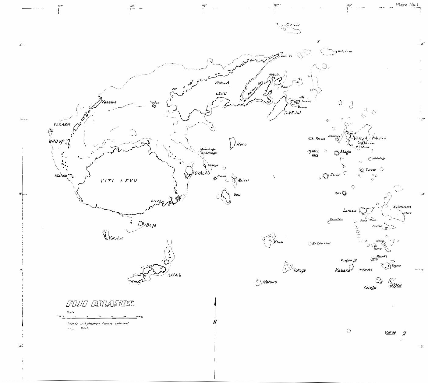
PLATESNo.l.^The Fiji IslandsNo.2^Vanua VatuNo.3^Ogea DrikiNo.4^TuvucaNo.5^VatoaNo.6^Vatu VaraNo.7^VulagaNo.8^Namuka
Lau^3from Lau.^16
o.9 Kabara0.10 Oneata0.11 'Gioia0.12 Maga0.13 Cikobia-i-lau0.14 Yacata0.15 Cikobia0.16 Qele Levu
The information contained in this report haqteen obtainedbythe Department of National Development, as part of the policyof the Commonwealth Government, to assist in the explorationand development of mineral resources. It may not be publishedin any form or used in a company prospectus without the permiss-ion in writing of the Director, Bureau of Mineral Resources,Geology and Geophysics.

REPORT ON INVESTIGATIONS FOR PHOSPHATE DEPOSITS
FIJI ISLANDS, 1959
by
O.N. Warin
RECORDS 1960/60
SUMMARY
During the 1959 field season an investigationof phosphate prospects in Fiji was made.^Most of the islandsvisited are in the Lau group, e-s+p—n Fiji, and the generalgeology of this group is described.
Four islands, Vanua Vatu, Vatoa, Ogea Driki andTuvuca were known to have some phosphatic material on them.Two more islands, Vatu Vara and Marabo were found to havesmall deposits.
The geology of the islands with phosphate. depositsis described in detail and estimates of the tonnage and gradeof the deposits are given.
• The largest deposit, that of Vanua Vatu, has• 200,000 tons of medium to good grade oolitic phosphate whichmight prove a useful source of cheap phosphate fertilizerwithin Fiji but is not likely to be exported.^Ogea Drikihas 77,000 tons of mediuM grade oolitic phosphate andphosphatic clay.^Tuvuca has one to two millions of tonsof clay, which is in part phosphatic.
Points of geological interest on the other islandsvisited are described briefly.
FIJIAN SPELLING.
Two systems of spelling Fijian names and words are in usein Fiji, the 'Fijian'System and the 'phonetic' System. Here I haveused the 'Fijian'System.• This system uses five letters to representsounds that are different from the sounds they represent in English:
'B' is pronounced 'MB' as in'number' e.g. KOROBASAGA = KORO MBASANGA.•'C' is pronounced 'TH'. as in 'that' e.g., CICIA = THITHIA.
'D' is pronounced 'ND' as in'end'e.g., DALICONI = NDALITHONI.'G' is . pronounced 'NG' as in 'sing'a.g., MAGO = MANGO.'Q' is pronounced 'MG' as in'finger e.g.,QELE LEVU^FGGELE LEVU.

2
INTRODUCTION
In 1958 the Australian and New Zealand Governmentsjointly undertook to survey all possible islands in the south-west Pacific in the search for new sources of phosphate suitablefor the manufacture of superphosphate fertilizers, to supplementthe material at present obtained from Ocean and Nauru islandsin the Pacific Ocean and from Christmas island, Indian Ocean.^.The work here recorded, the survey of islands in the Fiji group,was part of the 1959 field season of the phosphate survey. •
A 100 ton auxiliary ketch, the 'Maroro', waschartered for the survey.^Most of the larger islands in theLau group and two islands, Cikobia and Qele Levu, north ofVanua Levu were visited during the two months from June 18thto August 19th.^A further brief visit was made to two islandsin the Lau group from October 21st to 25th.
I would like to thank all the Departments of theAdministration of Fiji for the help that I received in settingup the survey; my thanks are especially due to Dr. Guest, theSenior Geol,gist, and his staff at the Geological SurveyDepartment.^S. Ratuyawa, L. Koto and J. Romanu, of theGeological Survey Department were my able assistants duringthe survey..
In the Lau group the work would have been impossiblewithout the help of Mr. William Wainigolo, the Roko Tui Lau,,and the Bulls and Turagas of the villages throughout the Lau.
I would also like to thank Commander Brown, theMaster of the A.K.'Maroro' and his officers and crew.
THE LAU GROUP
Tile Lau group comprises about 100 small islandsthat make up the eastern part of Fiji (Plate 1),^The largestof the Lau islands, Vanua Balavu, is about 24 sq. ml. in area;the smallest islets are less than i sq.ml. in area. . 20islands were visited; 5 of these were uninhabited.
The visits to all the islands were brief.^3 or4 days were spent on those islands which were known to havephosphate deposits; but some islands were only visited for afew hours or for one day.
Geology of the Lau.
The geology of the Lau has been investigatedby Ladd and Hoffmeister, (1945).^Previously the islandshad been visited by Dana (1849,1890), Gardiner, (1898,1931),Agassiz (1898), Andrews (1916), Davis (1928) and Foye (1917)all of whom were principally interested in the coral reefproblem.
Ladd and Hoffmeister named six fdrmations whichare shown on the accompanying table.

MAGO ODIITEQuaternary
SYSTEM East Indian Stage FORMATION
VULAGA L:MESTONE
DALICONI LIMESTONE
KORO BASLGA VOLCANICS
FUTUNA LIMESTONE
LAU VOLCANICS
Tertiary
3
TABLE 1. Formations in the Lau, (From: Ladd and Hoffmeister 21945)
The rocks of the oldest formation, the LauVolcanics, are andesitic flows and agglomerates and tuffswhich are exposed as the cores of many of the islands and arebelieved to form the cores of those islands on which onlylimestone is exposed.^Above the Lau. Voloanics is the Futuna Limestone, tuffacebus limestone, coral limestone, and algalcalcilutite.^It is at least 600feet thick and is dated asTertiary 'f' stage (lower Miocene).^The Korc Basaga Volcanics which occur above the Futuna Limestone in a few places consistof flows, agglomerates and tuffs, mostly of a basalticcomposition.^Flows are more numerous than in the LauVolcanics.^The most common . rock type is an olivine basalt.In a very few places Ladd and Hoffmeister found a coral limestonewhich they named the Daliconi Limestone, above the Koro BasagaVolcanics and containing a fauna of fossil foraminifera,molluscs, corals and crabs which indicates a late Miocene —Pliocene age.
The younger formations, the Vulaga Limestone andthe Mago Odinite, are not exposed in such a way that theirrelationship to each other and to the other formations canbe established by superposition.
. 90% of the rocks of the Lau are of the two oldestformations, the Lau volcanics an the Futuna Limestone, and onthe majority of the islands only these two forrllations have beenrecognized.
Ladd and Hoffmeister in their classification of theislands recognized the importance of the size of the islandcompared to the size of the platform from which it rises.The islands of the Lau can be usfully divided into two groupson this basis; some islands, such as the Exploring islands,.Oneata and the Yagasa cluster, are circled by a wide lagoonindicating a platform many times the width of the enclosedislands; others, such as Kabara, Cicia, Mago etc., have onlya narrow fringing reef.
A good example of the first group, the Yagasacluster, has three small islands with a total surface area ofless than one square mile enclosed by a reef that. indicates -a

foundation of more than 25 square miles in area.^Alsoincluded in this first group are extensive reefs, for examplethe Bukatatanoa reefs, which have no islands with the lagoon.
Plotting these two groups on a map of the Lauthe first are found to lie on a broad arc begining at thenorth end of Vanua Levu and narrowing towards Vatoa andOno-i-lau in the south; while the second group all lieinside this outer arc apparently along north-east and north-west fractures. (E.g., the Lomaiviti fissure islands, Moala,Totoya, Gau l Batiki etc., referred to by Ibbotson (1959) andthe line of islands akelpa l Nyau, Cicia, Vatu Vara, furthernorth.)
PHOSPHATE DEPOSITS IN FIJI (1950)
Hutchinson/makes no mention of phosphate depositsin the Fiji islands, except to record that two rocks insidethe Reid reef are reported to have some guano on them.However, a small deposit of phosphatic clay and oolitic phosphataon Ogea Driki in the south Lau was investigated in 1941 byF.T.M. White, who was then the inspector of mines for Fiji,(White, 1942).^This deposit was investigated further inOctober, 1942; by Mr. Bridges, a representative of the BritishPhosphate Commissioners, with a view to its immediateutilization to replace supplies normally obtained from Oceanand Nauru islands (Bridges, 1942).^In the last few yearsthere has been a stimulated interest in the search for phosphatesin this part of the Pacific.^The Fiji Geological Survey foundphosphate deposits on two other islands in the Lau group (Vatoaand Vanua Vatu) during 1957, and an aluminous phosphatic claywas reported on Tuvuca by Dr. J.A. Staargaard, of AluminiumLaboratories Limited, duping 'a reconnaissance of the Lau islandsmade in 1958.
The present survey covered nearly all the islands ofthe Lau and led to the discovery of two new deposits, both verysmall.^In addition the known deposits were assessed as regardstonnage by hand auger drilling and mapping and field estimateswere made of the grade.
While none of the deposits in Fiji are large enoughto be exploited comercially outside Fiji, the deposit on VanuaVatu island should be investigated further by the Administrationof Fiji as.a possible source of cheap phosphate fertilizer withinthe Colony.
ISLANDS WITH PHOSPHATE DEPOSITS
Vanua Vatu
Position and Size.^Vanua Vatu (Plate 2) is an almostcircular island, with an area of a little more than one squaremile, surrounded by a fringing reef.^It is in the western partof the Lau, about 155 miles from Suva.^There is a pooranchorage in a bight in the reef 3pposite Taira village, theonly village on the island.

5
Previous Investigations.^The island is mentioned by Ladd andHoffmeister, though only a sketchy account is given as thevisit, by only one of the authors, was very brief.
In 1957 renewed interest in phosphate throughoutthe south-west Pacific led Dr. Guest, of the Geological SurveyDepartment, to make a brief reconnaissance of the raisedlimestone islands of the 4au. • He visited Vanua Vatu anddiscovered thP -nhosphate deposit. Later in the same year theboundary of th ,:l phosphate. occurr6nc:: w,7,s zal .)-ped and tiio deposit,extensively 7itted,b7 R -tuy^of thc Fiji Survc - .Physiography and Geoloy.^The island has only a narrowfringing reef and is entirely of limestone, presumably of theFutuna Limestone.^It lies well within the outer arc of theLau but is not clearly aligned along any of the north-westor north-east features of the inner Lau.^The island has awell defined rim on the north, west and south sides, reachinga maximum height of 330 feet above sea level.^At the north-west corner there is a gap in the rim and a fairly gentleslope leads up from Taira village to the Maumi basin, wheremost of the phosphate is located;
The island's shape suggests a raised coral atollbut Ladd and Hoffmeister found foraminiferal rather than corallimestone along the rim.^Possibly the island is an originalatoll which has been sufficiently eroded to remove the corallimestone of the upper part of the rim while still preservingthe basin shape.
The Phosphate Deposits.^The phosphate occurs a„; oolitic grainsand 'pebbles and phosphatic clay between pinnacles of limestone.In the Maumi basin, (See Plate 2) the tops of the limestonepinnacles protrude about a foot above the surface of the phosphate-.
The oolites are up to 1/3 inch in diameter.Fresh surfaces of broken grains are white, gray, light brownor streaked with black, show signs of concentric structureparticularly near their edges and have the typical vitreouslustre and conchoidal fracture of Collophane.^The ollitesare generally bonded by a small amount of clay but in someplaces the clay is almost entirely absent and the ooliticphosphate runs like a coarse sand and is not retained by ahand auger.
The majority of the pebbles occur with the ooliticphosphate on the western slope (Area 'B').^Most of thesepebbles are formed of oolitic grains cemented together, thougha few, which may be phosphatized coral fragments, appearstructureless on broken surfaces.^All the pebbles have thetypical colloform exterior and do not appear to have beenabraded.
The oolitic material grades over a short distanceinto phosphatic clay on the north, east and south sides of thedeposit.^There are scattered occurrences of the clayelsewhere on the island, notably at Bukidalivou.
Tonnage and Grade.^An estimated 100,000 tons of medium togood grade phosphate is contained in the Maumi basin, (Area'Al)from which it could be easily recovered.^A further 100,000 tonsof similar material from the sloping ground leading down to thenorth-west coast, (Area 'B') would be less easy to recoverbecause it lies in shallow pockets between upstanding pinnacles.There is no overburden in either area.
Twelve determinations on this material are given inTable 2.^The average phosphate content is 25.8% P oe, with.21.6% Al 0 .^The phosphatic clay which surrounds th4 ooliticdeposit is 3of lower and very variable grade; the average ofthree determinations is 15.3% P00, while the content of Aluminais much higher, 38,4%.^Also iftc/uded in Table 3 are determinatj- -and full analyses from earlier work by Guest..
Exploitation.^The exploitation of this deposit by the villagersas a source of phosphate for use within the Colony would perhapsbe a practical possibility and should not be overlooked.^Theland of Area 'A is at the present planted with coconuts butwith little else as the villagers find the oolitic phosphateis unsuitable for the planting of root vegetables.^Most of thegardens seem to be in the Sapuga and Bukidalivou areas andon the phosphatic clay of Area 'C'.^My impression was thatthe exploitation of the Maumi deposit and of Area 'B' would notseriously reduce the area of land under cultivation.
Recent work by Cassidy, (1959) suggests that this typeof phosphate may have real value as a fertilizer for directapplication to paddy rice.^If this is so a study of the costof local exploitation of this deposit should be made to see ifit would be landed at Suva at a compeditive price.^It couldprove a valuable source of cheaper phosphate fertilizer forrice growers.
The deposit on this island is of a higher grade andtonnage than any other in the Lau.
OGEA DRIKI
Position and Size.^Ogea Driki (Plate 3) is one of a group ofthree islands, known collectively as Ogea, which are encircledby a single extensive reef.^Ogea is in the south Lau and is220 miles from Suva.^There is good anchorage within the reefat many points between Ogea Driki and Ogea Levu.^The entranceto the lagoon is from the west.
There is one village on Ogea Levu, but Ogea Drikiand Yanuia are uninhabited. It appears that most of the landof Ogea Driki is owned by men from Vulaga, rather than OgeaLevu.
Previous Investi.crations. The phosphate deposits of Ogea Drikiwere first investigated in 1941 when they were visited byMr. F.T.M. White, who waa then the Inspector of Mines for theColony, (White, 1942).^A comprehensive survey was made inOctober, 1942, by Mr. Bridges of the British Phosphate Commissionr -he assessed the tonnage and grade and reported fully on thepossibility of exploiting the deposits (Bridges, 1942).^Theislands were investigated geologically by Ladd and Hoffmeister,but they made no note of the phosphate.
Since then the island has been visited from time totime by geolop7iRts of the Fiji Geological Survey Department andan assistant of the Lands Department spent some time thereremapping the boundaries of the phosphate deposits and prospectingover Ogea Levu for similar deposits.

Physiography and Geology. North-south faults form the cliff facesalong the west side of Ogea Driki, and the elongation of the Ogeagroup as a whole is in this direction.^Ladd and Hoffmeister alsosuggest a north trending fracture as the reason for the line of reefthat run up from the north-east tip of Ogea Levu - Nuku Sogea etc.
The three islands together evidently form a raised coralatoll, the rim of which has gaps along the east and west sides,allowing part of the old lagoon floor to be re-flooded.^It ispossible that the north trending faults along the west edge ofOgea Driki may have caused the breach in the rim on this side.did not see the east side.^Much of the old lagoon floor ispreserved on Ogea Levu.^The present lagoon is very shallow atthis northern end, drying extensively at low tide, and is dottedwith undercut 'mushroom' islands of limestone.
Ladd art Hoffmeister found many corals in a position ofgrowth at localites round the rim.
The old lagoon floor of Ogea Levu has a fairly extensivered clay soil.^Similar soils were seen in many parts of theLau, (Vatoa etc.).
The Phosphate Deposits. The phosphate deposits occur ohly on thenorth-west tip of Ogea Driki (See Plate 3).^The phosphaticmaterial consists of clay and oolitic phosphate, similar to thatdescribed for Vanua Vatu, but with a higher proportion of clay.
An unusual feature of the deposits is that they occuron the tops and slopes of rises rather than in basins.^The threemain deposits, Maumi, Navakatoga and Denipusi are all on gentlerounded rises.^The yellow-brown phosphatic clay merges ratherabruptly into the red clay soil which occurs on other parts of theold lagoon floor.^Because of this I think these depositsoriginated from a bird colony which nested in a restricted areaon those rises.^Phosphatization took place only where the birdsnested. There is no trace of phosphate elsewhere on Ogea Drikior Ogea Levu and is seems unlikely that the present deposits areall that remains of more extensive deposits which have been eroded.
Tonnage and Grade.^Bridges estimated the tonnages of the threedeposits as follows : -
DENIPUSI^39,000
Maumi^28,000
NAVAKATOGA 10,000
Total^77, 000 tons
Analyses made at the same time gave the average P 20 5content as 25'/o with an average of 12% Al 20 3 and Fe 20 3 .
A few auger holes were drilled during the present survey;these seemed to confirm Bridges estimate of the tonnage available.
White's estimates were larger but were based on a veryshort reconnaissance only.

-8
TUVUCA.
Position and Size. Tuvuca (Plate 4(a), 4(b)) is in the centreof the rau,-177-Elles from Suva. It is 4 miles long and 2 mileswide, elongated in a direction north-north-west.
The only village, situated towards the south end of thewest coast, is small and has no radio station.^Suprisinglylarge areas in the central parts of the island have been cleareFfor gardens and the whole island is well served with tracksinternally, though the first part of the track from the villagehas a steep climb over the limestone rim.
There is no sheltered anchorage but ships commonly hangon opposite the village.
Previous Ilasstigations.^The island was traversed extensivelyby Ladd'and Hoffmeister.^In 1958 the island was visited byDr. Staargaard in the course of his “--7c, c, + -irfatons for bauxite .on behalf of Aluminium Laboratories Limited,^He reportedfinding a phosphatic bauxite on the island and his company hasretained a Prospecting Licence for bauxite over the island.
Geoloay_andaraph,y. .^Tuvuca is of raised limestone with
a series of discontinuous narrow limestone terraces with wellmarked rims reaching a maximum elevation of 750 feet,surrounding an irregular central basin.
The limestone of the island belongs, in the main to theFutuna Limestone, though Ladd and Hoffmeister found two smallareas of Daliconi Limestone on the north coast.
The vo2canic rocks which crop out as a long ridge at thesouth end of the central basin, along the south coast and alongthe north-east coast, belong to the Lau volcanics and consist cyfflows and some agglomerates,^The long ridge of volcanics inthe central basin appears to continue under a limestone coverand to crop out again along the south coast, • The air-photograr'suggest that there is a second ridge, parallel to the firstand about i mile to the west of it, which is only exposed at itssouthern end, close to the village. (See Plate 4(a)).
A remarkable feature of the island are the large clayfloored circular depressions in the limestone which are knownin Fijian as 'Qilos'.^These Qilos are commonly two or threehundred yards in diameter and have steep, almost vertical,limestone walls rising on every side to a height of fifty to onehundred feet above the level of the floor.^Hand auger drillingon the floor of these Qilos showed that the clay filling is inplaces more than 30 feet thick and that below the clay is notlimestone but a steady transition to a weathering volcanic rock.Similar, though sipaller, features were 'later seen onCikobia-i-lau island.
The Phosphatic Clal.^Hand auger dri1lir -as aarried out overmuch Of the floor of the central basin and the Qilos.^Themain areas of clay thus delineated are shown stippled on
• Plate 4(a).^The hand auger drilling proved 700,000 tons ofclay in the central basin and in.the four Qilos numbered onPlate 4(b).^There are more Qilos on Tuvuca that were notvisited and drilled during the survey.^In all there areprobably between one and two million tons of clay in the centralbasin and the larger Qilos.

8 samples of the clay of Tuvuca, taken by the AluminiumLaboratories prospecting team, ranged from 9.8 to 21.3% P 9O R .5 samples taken during this survey were analysed and the Nultsare shown on Table 2.^They range from 4.7 to 21.45 PoO R .Further samples have been sent for analysis and these ethxltswill be added to Table 2 when they are available.
The clay appears to be only discontinuously phosphaticand the high content of Al 20 and Fe 00 (See Table 2) rule outits use in the manufacture of superphodphate.^However, the cln.may be useful within Fiji for direct appliaation.
•
7ATOA.
Position and Size. Vatoa island (Plate 5) is somewhat lessthan 2 sq.mi. in arc P and is in the far south of the Lau 250miles from Suva,^It is actually slightly closer toNuku'alofa, Tonga, than to Suva.
:here is good anchorage within the reef at a number ofplaces along the northern part of the west coast.^The passagethrough the reef is at the north-west corner and is narrow.It is advisable to wait for a pilot from the village.
There is one village on Vatoa; it is close to the southehd of the west coast on low lying land near the sea shore.
Previous. Investigations.^The island was not visited by Laddand Hdrfmeister.^The phosphate was discovered by Dr. Guestduring his 1957 phosphate reconnaissance in the Lau. • Later inthe same year Ratuyawa, of the Fiji Survey, investigated thedeposit by pitting along the main tracks.
Geology and Physiophy. The exposed part of the island isentirely of limestone; presumable of the Futuna Limestone -but no fossils were found to confirm this.
The island has a rather complex form.^The highest partis a limestone rim running round the north-east and north-westsides of the Lomanivanua basin.^This rim reaches 200 ftabove sea level,^T'era is a terrace at 60 to 80 ft above sealevel on the north and east sides of this rim; inside the rimthe basin floor EOopes gently to the south-west and is about 80fee above sea level,^There are two prominent limestone hillsclose together at the south end of the island (Muanivatu) rising40 to 50 feet from a gently shelving terrace at about 60 feetabove sea level.
Much of the island is uneven and difficult to traverse.
Phosphate Deposits^The phosphate of Vatoa, consists of aclay of very varia'cle phosphate content, which occurs in pocketsscattered over mlfeh oi the island.^A very small amount ofoolitic phosphate occurs beneath the clay at the foot of therise from the village to the school (Busabusa).
The clay was examined by hand auger drilling.^It was.found that no sizeable clay filled basins occur - theLomanivanua basin having only scattered shallow pockets on itssurface.

The-clay is friable and brown to yellow brown in colour;lighter coloured clay being of higher grade.^The very smallamount of oolitic phosphate that occurs consists of oolitesabout 1/8th in. in diameter..
No estimates of tonnage are given as.the deposits are tooscattered to be assessed with any accuracy and are obviously toosmall to be worth exploiting. (N.B., if the island were coveredto a depth of 6 in, all over its surface with clay, it would beless than million tons.)
A fragment of weathering pumice was found in one augerhole, in the Lomanivanua area, at a depth of 5 feet.
VATU VARA.
Position and Size.^Vatu Vara (Plate 6) one of the smallestislands in the Lau, is not more than one and a half miles
. across in any direction.^It.has_a very. irregular coastline - inparticular a large bay at the south end of the west coast.^Itis in the northern Lau, 145 miles from Suva.
The island is not inhabited but it is leased as a copraplantation.^Occasionally men from Yacata live for a few dayson the island cutting copra for the owner.^There are two hutsand a water catchment.
There is no anchorage and the boat passage through thereef along the north-west coast can only be used at high tide.At other times it is possible to land on the edge of the reefand wade ashore.
Previous Investigations.^There is no record of previousinvestigation of the island for phosphate deposits, nor was theisland visited by Ladd and Hoffmeister.
Geologyand.plash.^Vatu Vara is nick-named 'Top hat'island, and the nick-name aptly describes its silhouette.^Theonly rock exposed on the island is limestone; the central massrises to 1050 feet, making the island the highest in the Lau.The central mass is surrounded by a broad terrace the surfaceof which is about 250 feet above sea level.
The central mass is elongated north-east in plan and hasa saucer shaped cross section.^It has been cut across at thesouth-west end by a north-west trending fault with the downthrowon the south-west side.^The outside slopes of the central massare very steep and made up of jumbled blocks of limestone, .commonly very large, stabilized by rain forest growth.^On thesouth side signs of a recent slip were seen.^The top 100 feetor so form a vertical cliff, free of vegetation.
The 250 foot terrace is not continuous round the islandand has been affected by the same faulting which has cut thesouth-woc,t end of the central mass.^The terrace, from adistance, appears to slope slightly seaward; the surface of theterrace is actually very uneven and pitted by solution - the pitsare commonly ten to twenty feet across and as much as twenty feetdeep.
The highest . point on the island is at the north-eastend of the central block and there are some signs, on the southface, of bedding dipping to the west.^The . appearence of the

central mass suggests that it was tilted during the upliftwhich preceeded the formation of the lower terrace.
There are no volcanic rocks exposed on the island butI do not.think a full 1000 feet of limestone can be claimed.A large part of the slope of the cent -2a1 mass is of scree materialwhich may cover exposures of the volc:-rnic core,
The Phosphate Deposits. Small deposits of phosphatic clayand oolitic phosphate were found on the north and south sides ofthe central mass at the foot of the sree 'lope.^Close to thescreeslope the otherwise empty hcflow:3 in he surface of thelimestone of the 250 foot limestone terrace are filled or partlyfilled with this phosphatic material.
Traces of phosphate were found in cracks in the limestonemost of the way up the side Of the central mass, suggesting thatthe phosphate may have formed there by leaching of guano frombirds nesting in the cliffs and then be.on washed down and trappedin its present position.
The deposits are very smal an the total tornage ofphosphate available is estimated at 15,000 tons (See Plate 6).
MARABO
Position and Size. Marabo is a small island in the southernlau off Kabara,^sq.ml. in area and 190 miles from Suva. Itis uninhabited but often visited iy men from Kabara for fishingand copra cutting.
Geology, Physiography and Phos hate Deposits. ^The island' isentirely limestone, the highes, p6-17a being 160 feet above sealevel.^It has no easily described physiographic form but ingeneral the highest limestone is in the centre and towards thenorth-east coast.^The rest of the island is formed ofdiscontinuous terraces and limestone ridges.
A narrow terrve along thesoutli-Nest side contains afew hundred tons of phosphatic clay between lirpestone pinnaclPs.No analyses of this material have been made, but qualitativetesting in the field show the clay is'ow grade.
ISLANDS WITHOUT PHOSPHATE DEPOSITS
Islands on which no phosphate deposit was found willnot be described in any detail.^A bTief note Nill be givenof any points of geological interest.^The position of the islandsis shown on Plate 1.^Maps of themore irmortant islands areincluded and these maps show the exteEtof the prospecting carriedout on each island.

- 12 -
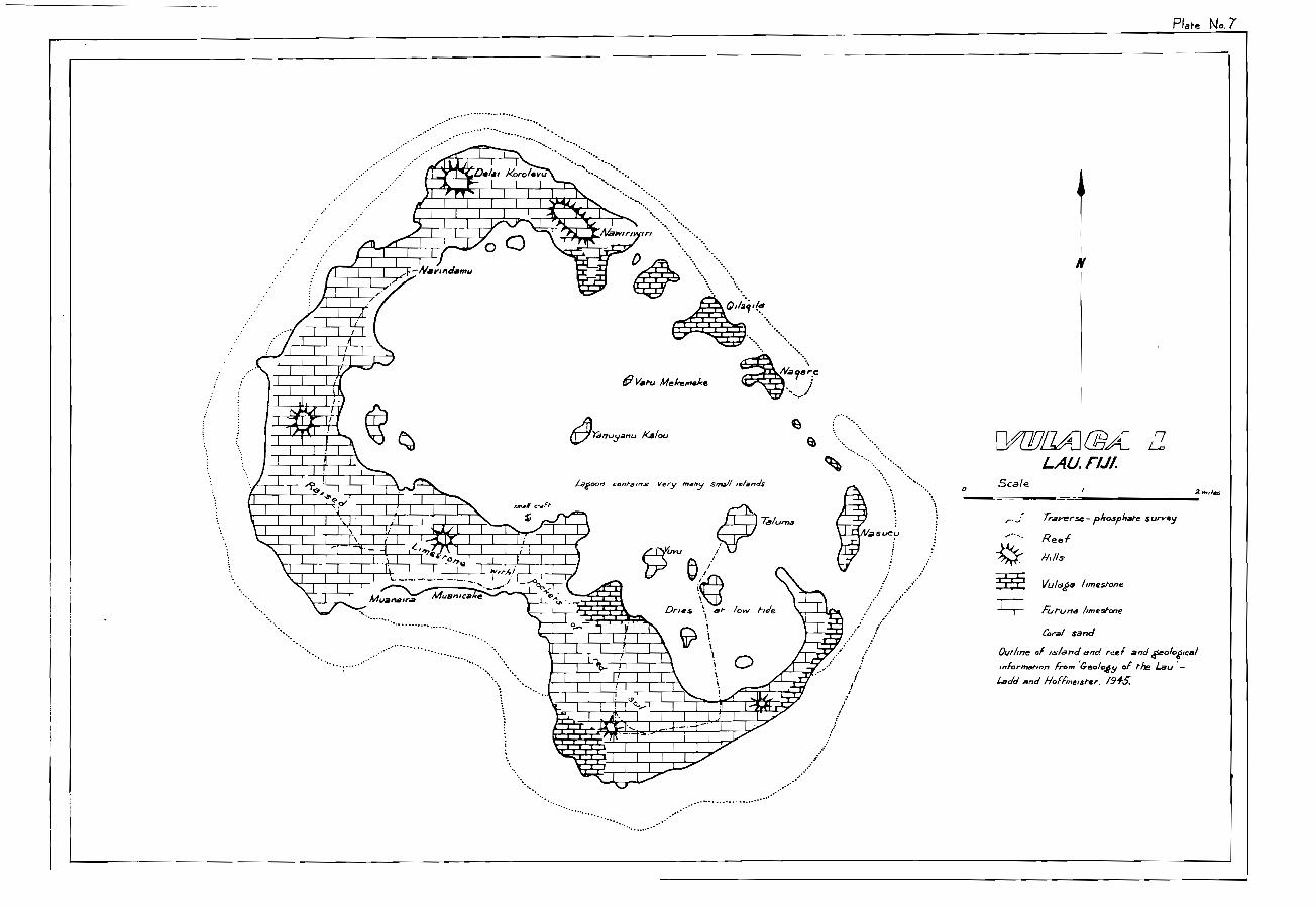
yulma. (Plate 7).^The island is sub-quadrate in outline,has a clearly marked rim of raised limestone which reaches amaximum height of 260 feet above sea level, and has a centra: .
lagoon which is open to the sea through a passage on the eastside.^Ladd and Hoffmeister from the evidenCe of thephysiography and because of finding many corals in a positionof growth in the raised limestone of the rim, concluded thatthe island was a raised coral atoll.^It appears that theisland may have been tilted during the uplift as the rim ishigher and broader on the south-west side and becomes anumber of lower, narrow islands along the north-east side.There are many 'mushroom' islands of limestone in the centrallagoon, particularly at the south end which is very shallowand dries at low tide.
The soils of the island are purple-red in colour,in places UD to 8 feet deep.
Namuka. (Plate 8).^.^ ,e_ ,• -^ a reef away from the
shore enclosing a broad lagoon.^The island is entirely ofraised limestone, and is elongated in an east/west direction,It has a ridge of higher limestone all along its northerncoast and a lower and less continuous ridge along the southcoast, broken in the centre by a broad shallow bay across thefront of which the southern ridge forms a chain of islands.Faulting seems to have been important in the formation ofNamuka; two faults, one north and one north-east are visibleon air photog:oaphs.^The straightness of the north coast isvery suggestive of an easterly fault although the cliffs alcngthis north coast appeared, from the sea, to be fractured insome direction nearly normal to their trend.
The soils of the island are 'quite deep, particular:3 -
in the central area round the bay; depths of more than 8 feetbeing common.^The soils are again a purple-red in colour,purple colour being more marked than on Vulaga. The peopleNamuka are known in this part of the Lau for the purple stainon their hands and clothes from this soil.
Kabara. (Plate 9). Kabara belongs to the younger group of theLau islands, having a narrow fringing reef.^It may be connectedwith a north-east trending feature as the north-west part of theoriginal island has been faulted off by a north-east trending .
fault. The elongation of the island is, however, to the .north.The island has the form of a reised coral atoll, the rim beingrather even at a height of between 200 and 250 feet above sealevel. The chief interest lies in the volcanic rocks which forma steep, double peaked hill, 440 feet high, north of the centreof the west coast. Ladd and Hoffmeister considered thesevolcanics were part of the Mago Odinite and of a younger agethan the limestone.
The old lagoon floor is remarkable for its lack ofsoil.^Much of the interior is simply of jumbled boulders ofcavernous limostene overgrown with rain forest. What soilthere is is derived from the volcanics and is purple-red incolour.^Some Manganese occurs in a swampy area at thenorth end of he old lagoon floor.^It appears to formby redeposition under swamp conditions after beingleached from the volcanic soils.

- 1 3 -
VuaRava. Vuagava is a close neighbour to Kabara and is ver ysimilar in form.^It clearly has the form of a raised atol:the rim being about 300 feet above sea level; it also hasbeen truncated along the north-west coast by a nor -Th-easttrending fault.^It has, however, no outcropping volcanicrocks and much of the old lagoon floor is occupied by abrackish lake.
The soils are similar to those of Kabara,
Yazasa Levu. A small, narrow, north-east trending strip ofraised limestone in the Yagasa lagoon.^It has no 31earlydefined topographic form.^The highest part of the limesto-300 feet, is along the north-west coast;^the rest of theisland appears to be terraced when seen from a disance.The rugged nature of the limestone makes these terraces lessobvious when they are traversed.^There is very little soibetween the pinnacles of the limestone.
(Pkr.'e 10), Only a few hours were spent on. Oneata.It is 2:.sci,1:_a/.e'^•FJ in .area^; and is particriarlyinteresting as 'it Las outcrops of three formations, the Lauvoicanics, the Futuna Limestone and the Koro BasagEVolcanics,^A 60 foot thick bed of foraminiferal :imestoneoccurs at the base of the Futuna Limestone and clearlyestablishes the age of that part of the formation asMioene ('f' Stage). The soils of Oneata are mostly of ared or black colour and suggest that the volcanic rockshave a wider distribution than shown on the map prepar edby Ladd and Hoffmeister. (See Plate 10).
Only a few hours were spent on Nyau.^Ti-e islandwas not examined in detail by Ladd and Hoffmeister and itsgeology is not well known. A rim of limestone abott 550 re.,high encloses an oval basin, elongated in a north-vestdirection.^The flat floor of the central basin is estimat('to lie about 250 feet above sea level.^It is covered withred•brown to purple soil, supporting a growth of reeds andshort palms, suggesting that it may be underlain 1:) - volcanicrocks. The limestone rim is broken, on the north-east coas -
by volcanic rocks which reach to about 500 feet above seaA deposit of manganese is being worked on the slope below V'';evolcanic s.
Ci,c.t.71,a,. (Plate 11). Cicia is^roughly circular, 4 miles indiameter.^Geologically : _pears simple in construction.The centre is made of andesitic volcanics and the island hasthe appearance of a single eroded volcanic cone.^The cent:reaches 540 feet above sea level and is surrounded by adiscontinuous terrace of raised limestone reaching to about400 feet.^The soils of the central area are commenly verythin, but valleys leading down to the coast have a thick fi t 'of clay.

Mau. (Plate 12). Mago island was examined in detail byLadd and Hoffmeister. Their map^,-u,,1;cedhere (Plate 12).^The island is interesting in having twoages of volcanics exposed, one older and one younger than theFutuna Limestone.
Cikobia-i7lau. (Plate 13). The island is within the largelagoon which also encloses Vanua Balavu and Munia.^It hastwo ages of volcanic rocks exposed; andesitic agglomeratesand flows of the Lau Volcanics are exposed beneath the FutunaLimestone along the south-west coast and in various places inthe centre of the island;^whereas a large ridge ofagglomerate which makes up the east coast of the island isplaced by Hoffmeister in the. Kort, Basaga Volcanics (a conclusionwith which Ladd did not agree).^The fact that no limestoneoccurs at any point resting on this agglomerate and that onevalley has limestone on one flank and the agglomerate on theother seems to be very strong evidence for the younger age forthe agglomerate; clearly the agglomerate could not have beenthere during the time that the limestone was being depositedor it would have received a cover of limestone.
An interesting feature of the island are the 'Qilos'that occur there.. They are similar in every respect to the'Qilos' on Tuvuca, though they are umaller.
A fault running along the centre of the island in anorth-east direction is an important tectonic feature. It isshown by scarps inland whose continuity can be seen on airphotographs.
Katafaa. Katafaga is a small island in the central Lau. Thesouth and centre of the island are of volcanics, andesiticflows and agglomerates of the Lau Volcanics; while the northend of the island is of Futuna Limestone. A small amount ofmanganese occurs in cracks in this limestone. In those placeswhere manganese is now exposed it appears that the limestonepreviously was covered by eluvium from the weathering volcanicsin the higher central part of the island.^Manganese dissolvedout of the volcanic eluvium was re-deposited at the limestonecontact.^Subsequent erosion of the eluvium has exposed themanganese in cracks and hollows in the limestone surface.
Yacata. (Plate 14). Yacata is a large island in the north Lau,although for administration it is considered part of CakudroveProvence (Vanua Levu) rather than part of the Lau.^It iscomposed of limestone and volcanics.
Naitaba. Not enough time was spent on Naitaba Island to getany clear picture of the geology.^It has a basin shapedinterior and may be a raised atoll.

- 1 5 -
Cikobia. (Plate 15). Cikobia is an island of about 6 sq.north of Vanua Levu, 200 miles, in a straight linefl from SuYa.It is elongated slightly south of east, and may be structurE:lly
.part of the outcr Lau arc. This easterly elongation iscontinued under sea for some distance at the east end of th.island.
The island is composed of raised limestone andvolcanics. The limestone, which is terraced, makes up thewest and central parts of the island.^It is underlain byvolcanics, chiefly an andesitic agglomerate, which crop outat the east end of the island.^The highest point of theisland, Nauluvatu„ is a residual of limestone resting on thcagglomerate.
A very cursory examination of the island suggeststhat the limestone has been a thin but complete cover over Esteep sided narrow ridge of volcanic material which wasextruded along an east trending fissure. The island hassubsequently been raised above sea level and terraced andpart of the limestone cover removed.
Some manganese occurs on the island in a similargeological setting to the other occurrences in the Lau.
1e Levu. (Plate 16). Qele Levu is a very small islandat the east end of a large lagoon. The island consists ofdeeply pitted limestone raised about 20 feet above sea love?.There is practically no soil on the island but theinhabitants are able to grow bananas and other crops in 2nilscraped together in pockets in the limestone.

3.
4.5.6.7.8.9.10.11.12,13,
14.15.16,
if
17. If
18. Tuvuca19.
20,^If
21. It
22.
TABLE 2.
Anallof sam les from the Lau.
Analues b Bureau ef Mineral Resources Canberra;
Island^Type of Auz,er P2 0 5 % Fe 0 % Al )Poi
^
^ 2 3^, 3Material HoleIIMIZLICOMPAMMINNICSI■^11121.101VarnOte.1111150.411•1
Oolitic^V.R.1^29.6^7.47^17:9phosphate.
Oolitic^V.R.8^28.2 12.1^17.9phosphateand clay.
Oolitic^U.1^25.0^8.91^23 "phosphate.
tt^V.R.11^25.1^4:47^16If^V.R.9^20.8^8.80^22-:;
V.R.13 27.7^7.19^18,5U.S^22.2 12.4^29.5V.R.5^27.5^8.1^19,L
If^V.R.3^21.8^8.4^27,6T.1.^24.9 11.9^25,9
If^U.3^27.2^709^21.V.R.4^. 24.5^9.1^19
Phosphatic^V.5.11^7.4 20.2^39.clay
T.3^16.2 14.1^36 2it^T.5^22.4 14.9^40
Phosphate^V.R.12 38.6^0.6^Nopebble
Phosphate^U.3^31.1pebble^
-2Clay^18.7 14.0^35 2M8^8.3 15.0^33M7^4.7 19.2^30m8b^9.4 16.7^39,DIVI^21.4 16.9^23.01
1. Vanua Vatu
2. It
detec - A.2.1^16,5
Anal see made for Fiji GeoltaLlaisurys_E_Luarraentlaz Overseas Geolo ical Surve_s Lnndon.
No,^Island P20 5% Fe203%^Al203%^CaC
1,--11171■710.3.1=7•1•111r•^ .0.111•17.•-"Ja•-awell
JG167 VatoaJG170JG175^■7
JG178/M23G181/M5JG190^IP
JG228JG250^If
JG252^If
JG255^If
JG258.JG262,JG2‘.3JG266^It
JG272^ttJG277JG280.^If
14.017.48.35.40.626.2 .2.4
20.923.221.212.221.220.322.04.413.820.4
12.1
7.90
21.2
26.5^14,

- 17 -
Table 2. cont'd.
. No. Island P205% Fe203% Al203% CaO%
JG286 Vatoa 17.6
mlac-rarasommal-nesw.
JG296 13.5JG303 17.8JG311 42 13.9JG320 71 2.7JG323 12 6.5JG235 Vanua Vatu 22.1JG236 33.1 5.20 11,6 38.5JG346 27 17.6JG350 I/ 24.6JG351 It 30.6 7.6 1 13.4 33.8JG353 24.6S1 72 25.4S7 1? 24.7314 12 22.2 -S26 I; 25.6S35 42 28.4 9.34 16..2 15.5S39 21.2S48 23.1^.S55 23.5.S63 22 22.6S70 It 23.2S75 19.2VV9(a)VV10
22
ti22.30.5
VV13 42 17.7
Analyses of Additional Samples of Clay fre0M Tuvuca Island.
) •.^v•argb AP-g.PrHole. PAP:t.4.
P 0 q2 5' No. AuerHole Death P 0 %
23 M1 8'to 20' 15.9 41 M8d O t te, 4' 5.924 M1 2' 19.9 42 M8d Li-'to^8' 7.625 M1 20'to 24' 15.5 43 m8d 8'^to16' 7.826 M 1 24'to 28' 14.1 44 m8d 16'^t..18' 7.927 .1 28'^to32' 2.1 45 M8e 0'^to 12' 8.728 M1 a 0'^to20' 14.3 46 M7 0'^to^16' 6.9
29 M2 0'^to12' 20.6 47 m -7b 0'^to 16' 4.930 M2a 8'^to20' 22.9 48 m7c 0'^to 4' 5.5
31 ST 2 6" 3.9 49 M6 0'^to 4 8.0
32 ST_ 4' 9.7 50 M6 to 8' 7.8
33 ST4 4' 12.24 51 m 6 8'^to12 1 8.2
34 ST5 4' 9.5 52 M5 12'^tni6' 8.3
35 ST 6 4' 3.4 53 m 6 16'^to19' 8.3
36 ST7 4' 2.3 54 m 6b 0'^to 3' 5.7
37 m 8c 0'to 16' 10.5 55 N2 0.4
38 M8f 0'^to 9' 0.6 56 N3 Surface 0.1
39 M8 0'^to20' 10.9 57 N 0.5
40 M8d 0'^to^18' 10.3

REFERENCES
AGASSIZ, A., 1898, The Tertiary Elevated Limestone Reefsof Fiji.^Amer. • J„ Sci.4 Ser. Vol.6pp. 165 - 177
A Contribution to the Hypothesis ofCoral Reef Formation, Roy, Soc,N.S.W. Jour. & Proc. Vol.PP,37,
Phosphate Deposits of Ogea Driki.Report to British Phosphate Comm-issioners! Dept. of Lands, Mines &Survey, Suva, Fiji, file No. 701/11A.
Lau Phosphate - Fiji AgriculturalJournal March 1952.
Report of U.S. Exploring Expedition(Wilkes) Geology Vol. 10.
Corals & Coral Islands,^3rd Ed.N. York.
A Migrating Anticline in Fiji.Amer. J^Sci, 5th Ser. Vol. 14,PP. 333 - 351.
The Geology of the Lau Islands,Amer. J.^Sci, 4th Ser, Vol. 43,PP. 743 - 357
The Coral Reefs of Funafuti, Rotuma,Fiji.. Phil, Soc. Camb, Proc. Vol.9pp. 4 1 7 77-5-0-37----
ANDREWS, E C., 1922.
BRIDGES, G., 1942,
2.E.11.11)I, N.G., 1952.
DANA, J.D., 1 849.
18 9 0.
DAVIS, M., 1927,
FOYE, W.G., 1917,
GARDINPR J S^1898,
19 -
' I
STAARGAARD
1 931,^Coral Reefs & Atolls.
HUTCHINSON, G.E., 1950, The Biogeochemistry ofExcretion. Bull. Amer.Hist. Vol. 97, No, 3,
London 1931,
VertebrateMus, Nat.
IBBOTSON, P., 1959.^Structures & Lineations observed inthe south eastern part of the FijiGroup,^Geol, SurveL Dept. Suva,L111.^Report No. 57.
LADD H.S. & HOFFNEISTER, J.E., 1945.^Geology of theLau, Fiji. B.P..Bishoo Mus. Bull,181 PP. 3990
Exploration Results on abandonedAreas of Prospecting Licences Nos.,845 & 865, Lau Group, Fiji.Report to Aluminium Laboratories Ltd.,Montreal, Canada.
Report of Investigation of Islandsin the Territory of Papua & New Guinea,Phosphate Survey 1958. Bur. MinResour:-Aust. Rec. 1959257; - TaTpubl,).^_
WHITE, F.T.M., 1942.^Report of Inspector of Mines on OgeaDriki phosphate deposits', Dept. ofLands, Mines & Survey, Suva: 9 777T.FT.TU-1777. /0771-TA.
J0 A
WAR IN & JENSEN, 1959.
2C. :
/Yr178'—
/BC• -
I
Plate No.
Scalelac 0^ 00^30^40^50.0.42,
/s/andr with phosphate deposits nole, hoed
/6'
- 17'
Yadua
..! • •
• -•
Kanaceit: irgcata^ VAlti..) A^ALAv
Zdla
• •"• • . 0 MUrnaVafu
- Vara....11:),Vafra fags
Tu v,./09
0
.^.
.......^• • F.^.8ukafratanoa
\Reef s-
Any.? ..... ••'
Oneeie; ..**•....• ••
0
7, y•:!^MOCe.^...
ic.^mu a
Vuagava
d'IYagasz
Habarc•t" '16Marab°
- Id ,
— - l9'
.„2(yeALAzi:
No rdiVITI LEVI/
••••
C,d
,^,
Vora
' I))Totoya
...Makodrate
.^•
W.V. kaya
Koro
o
. • ..... •
..• ....• • •
•••••••••••
•
Ala) olo'.-to•.•.
Nyd LI 0•
Vanua Varu
Reef'

So0 rue Moo^ Ifo0 fect
L A U Group,
c rii.
I^I.•••••.••••••
•T6
1-lare Nog
Nettekeeke Pt.
. 544 .^. • $57• • • •.^.^.^•^.^•
vse
&so•^.vs8v s9
Boundary of phospki,te deposit.
Oolitic and pebble phosphate In rackets
betideen hmestooe. outcrops.
Mostly phosplut,c clay
Oolitic and pebble^phospiutte.
(ustrettc)
iØJ/Y2J FA
Tracks
Po5it10p, and /1•11,16ef OF auger holes, pre3e nt survey.
Area
AAINUA/4e.[lift
3-ft .
Symbol Aea b 71 ty
RecoverableOobe,e ano/peWe pkaphate,n MA UM/ 1.441/7.
Estimated Deduction^Est meee<17'o/time for kw-stone tonnage.
fr.)5,200,000^frz^/00,000
Dou bt fullyrecoPeribble
6k
des
,Oolitic and pabble phospietebetoeen MAUMI and rAIRA.
Phosphatic clay uwthpharket
8,164000^roo,000
(30,000)
TOTAL^230000
Tha PHOSPHATE DEPOSITS
1_13 L14-
bap pr/ pp
P•2;r 'aina
y.6.c"PP' o
IL%sukteretlP P•
o
L•••,,orrn fropsod
reliow trown,phosphatic,- 0 Icy (y.12 c)
C./,h0 phosphate (op)
kcrj Phosphate pebbles (p.p.)
hmestorie
V R 7
op.**PP
U1,71'
VR6
ro peJ
T.
V. R VR.I0
0 ,
V. R 13^kR VRI1 V RIZ
V R 5
lonS.P."d PN -
TSFT I7
/ •/ .1,
c with
Fbe op
coarseop with
Pp'
(_f
b.c.with op
coarse opwith pp.
VI? 1 V R 3
• •
V R 2
_ .9.6.c.
- fr,th?J pp
72dari.^11//p!^ts.
^.••, ^with_ Fop
fuld
ph pebble
T3
IA1^-5''V 'IVY
9 6.cPathJrath2,-.,/oolfhts
o.p. end
PP.
DEPTH
r'r.
U5
nc;I^dark brown
Clay end op
and pp.
AUGER HOLES - OINUA VATIJ /6/9,7c1
/1

COntours
tra,CkS
Oolitic phosphate and ph. clay
between limestone pinnacles
rest pets (previous surveys)opth depth in feetNet nil auter holes sod, ref.a-17C1 depth in feet.
//
//
11^//
Area ofhyreie scale roap
\ \
\
//
/
//^/
/^/
00
a/^a
1^/1^/
1^/II
1
YAML11/4
1
°
../..."
/ .- -//^../ ..-,
....• 0••■ ...■
\
\\\
• \\ \ ..-- --- — -- ...
-‘,/^,...
t..../ N \ /
.,. 1
\ \ \ i )
\ \ \ /// \ \ \ ./^Tete, ka
/ 1/
/ 11
1
•k,
',=■0I /
II /
OGEA• `. 1
stone1
A, th pockets
reek^sod1
\
OsSea V, IFe\
\
1^iI^II^1
II
i1 1
11
//
/
___ / ScaleZAU, FIJI.OGEA DRIK1
/'12 2 toles
Traverse, phosphate survey
t"' — \^Afprox,flore, pos,hoo oi . reef

\
7—/
No .4-(a)
I—•••••••
J••••N
N.
1//1127 ^ULUIYATAVU• •/./
•‘•.1 1 \ '\ _
r.I \
•••.
••■
.o‘
• r '
Mn
RAN
•
O
C - 1 1/(1 \\lakes DRANO
LAILAI
\
//
;^ r^\
".. --••• ..I^ \
I s I - ••• - - I^•^.•....^.... ..• ) VI
/. ,./. _ ........Y._,...:Ar^„,^1.
^
,-, v^V , v^V 1
( V^V^V\ V^1
\^V^y^\\V^V I
\V^V^v \V^1
\
^
\ No^N /^v\ V IV^V^V\
^\4I ^V^V^‘' \N N^ \V^V^V \i i \
• \ v^y V 1‘ V\N I \^'
\v V I V \ V \
..N.^ /..../ 1
..• --/
,.........:,,,,^\^1I
/
\ V V\ V \ \
^
\ v^v‘s v ‘•
^
\^-41 • \N.A.'
y Old Villagesifre•
I .
I .
7Tal7 71111^D.LAU, FIJI
SCALE I / 2,S00
yard. 0 1500/000
.^•
iII•\ .
^
%^". N•••^ \\,.^
\N
^
N\^•''..).' (.1^V‘^•
\^TUVLICA^`,■v \^N1, ) v \^-
^
Village^ . \
^
/ v v \^X.V V^V i
V^v iV^'dl
1000 yardswro^700^dm^4ar^50,
W 0 Vs^ Yz
Pace and compass traverse
island outline, dashed where
Traverse, phoephate. surrey
Limestone dig- .
Crest 01 limestone ridge.
Indefinite .
V vLau Volcanic s
•og^„manganese
Mn^prosrec,, position approximate.
••.2^Pos4,6/e co,•cealed volcanic ridges
N Possible fault

....^•^I
^
-.• i^A
^
- :^\
^
1.- ..^4).$' 7-^\•-•^A^k.^\.-......^As'^\^..-1^\..
\r^‘^‘A ....,..: 2i/0 (2)_
^
\^A : •I.^\^■ :".2......••^57-,4-----• '--:^1 \^ST '.-
^43' \^3 :-s• ;.....••'.. .^t^!..:c.. ^'se^,.-.•
^
1 .. • •^87.;- .s.I 'll IA ,\.•
• ST.."..•
.^\ 8'^• ....^•
Rough esh.nare of C. /0 y
TonnaAses
Ca.())^oao
C1/0(2)^>50,00C harrs
Q,/o(3)
Q,/(1)^20,000 FansArea A'^lo0,aa9
F(maAnce,c)
•• ••••^r••••..
■
A
./^•^1 •• 1 ,1, I
...° '41 6b^• MTC•••
3'Area A' • /46c1
81/4:. 41 n,
16'
Pare Nol-(b)
/ -A1^\
I'
1 -----
• 1•••
NS.^. s •.,,\
•\^.‘^/111A A
ST2 7
•■.1.^•
.11^-•NI\
0/ LO (/)
••••
'^0 / 4- )•Al8
. '2 ' °-
eklElf
•I
• 12'1•^,A1‘^ 934'o^/I\12:^ --- .•
ea.L.^....13
°^ iiost/5, l imes/ore20' A .
• M8.‘ 20
• hija. 52>^
5
••••+:.^ \
>,^•A188. ///L^ \\
.‘\■^ / //,
• M8 b^/ ' /.._Lsr
• • • •„ •"'se
•••
••
PARTof
0 418C16'
/
‘2,10 (3)
773gYagOA
•••
L.AU,^/I/.
SCALE hnch to 11-00 feetyards 0^50^sso^ -too^Jo°^
4f°^ 11
4112
11
^
rnesl-one Chief^1
Track.
°412a^Perth , rP reef' .
Hand auger hole.
Raln are-as^ctay

warernale
Plate N.
VaraAa
• ------Bs s,
8, 4 \
‘'Ih‘s
e.r■s..p
/
,
srnkirds
A•40/1
A35.•%
• \
\se A\ 331 it^A kt^A3;
1
A32 „)
• A .3 ., / .. AS 4.)
A2)•\
0
(Pagama
.74‘,1711.1171...
•r•
6'bc^_955
'es^/
•.9)^St'A40/1\^
/S^
h/ /^
I
rrrr)F1^/^ A2)4'S.'^•^,r,
• /1
Nr: '^ ^25/•/
A26/.
^
'•A4o/^ I
^
■ , /,/4./^ I 1e/^ , I
//^///
4
•
,/
-,23^A2+7---t...4^:A
A7,5
•A,3/„A i3 ••••A,,,
• A■,/,
N.s----'.1.---- --^/ ,,, A^i 1,12,^ • ill f,^ .......Ay.rs^;...e^ i
A,..„."^3.ybc^' "
....'" ',, ,,sV.-4 !„.^*"."..^2
A5p
.".4 ybc^'A9//o
• A,,,,^1 l'iJ .. .i.^ ...- AC
'.^. • A213
^
30,^• .A313^ /^ ,b,^•A7/2,^ ryp,I.
,.^.\^• •152 . 7
^A ^0 ,120^
Ah'.• A2ia 2V1,4 y..^ \•,..,,_
r.^• A^.^ ° A 7, 2)^'‘`,Zop^3/Z^, !...."e",^A,16' i ..ksp,
^
1^19, hi'yla,^,..0 \•■■•^ *S
Ir -
LAU. FIJI.'
IL •
Scale finch to 800 Feel-
form hnes - Interval 20 lee/ ,1
Tra.k,s-
Hens/ auger iro/e.A R/24^,^,
°eft, In rte,^575 y0/100' brown clay I^le 5 To which noclepen 45 , renrs^tops•r/ are in timeshone,ImeStone
welt shallow (<1) sad, or non-
NOM areas. of coral sand^phoSphahc Clay.
Ouhline,fracGS arc1 /Oren LneS from^by Fiji Deft 0/ Lancia, Mines and Surveys
recc ): nob' Shown
/Th.)
.„
,j4/111.47/71/104// 4
00

DEPOSIT^ Average^EStorkited^•ID e d u c t f oer^Estimated^Averailedepth
S 1 1 Sit^Yolume(cu ft)^'
649,000^Cr hmestate^tO
%^ntral.e^aJe8,508soa^i'l-
Oolitic phoithate^2/•9^ 2k fr
2^ 0000^3^400
S3^
ft^146, 000^:a^3,300
Al^Oolitic phosp‘ate.^3ft^336000^34^3,300
TOTAL 15,500 toils
PI are N06
00.14,e phosphate betweenlimestone phmeeles
Au*er hole with depth ofphosphate. m feet
fl`')
r•-.1 r•-:••^Cr' 171 .779
e^
• • ... -----^,^.^.^I
"
rsa1.11.• -- - 11 - - .1,./.44 01.)"
.
..... •imiesto
UneVertof^
rle
•
5°^I^I 7- 10.50
(9 2 7,0) \
I^
rro-
t.t^
N^
\\\^
•
- -•
I •
/
. • ,^ (^/• •
^
‘;;-%&.1.1Zu&^•
rs.\\v
I•
\ •-
er3
\\\^ -.
^
\‘^)‘‘ nv"eedtorle
--,
•• 1
\\\^• ,\\ \
•
MAYO VA,ISLAND
,r) o EA^Autt.er bole eithdepth4^of phosphate in feet. ::••1-.T4
.1' 1 ' 1^:,--...- ---..^----- ...-„
I' ,-/-......,,,
\^-r 7I ,z^- ,-' mangroves ss:.,•,^.---'
...-_^;^ •-...•_,'• .^....,
..-,-....^•^,..-,^ _...' • .^,..-..•^i■,
41".k
‘tl.J
Z;')Scale 4 Inches to I r. le
\*.;
Lagoon.
LAU GROUP
0^ 500 1000 yards
• f.j'fIrre -----
TrAver5e5 , phosflia.ee
C l ifffrr
----
.^•. • •
Sand
0oboc phosphate
Reef, pos , tron afrre./mate.4.1(J-D
200100
1-Yd-
tovii€5
mile"6"
Ill
5
0 I-1
E -r TWZPOSZ7F
Scale 1 imh te 400 feetry-d,10^0
.01/4-G=r)0077
heck L. 40oft
0^
0
Oolitic plies-pate 5bet. lonestone 120maxles
SealeI-
• .,^• .
Al•I 1=1 END •//a MB MO•IN I=
OW,
01/TEJ 2A] a,LAU, Fl./I
••Scale
2.olas•••••••• Traverse- pfrosphai-e survey•• •••••• Reef•••
•••
•••
•••
••
Kildee limestone••
••
&rune hinesfrone1
Cora/ sand
Outline of is/and and reef and cfseologsocal
informerion Iron, Weo/oey of the Lau' -
Ladd and Hoffmeister. f91.5:
Taluma
Qua1 1
1^1/ 1^1^/ 14
I= NM• MD la
• 11= IMM-a 1■••■•••■■••••• 11 ami., sm. MI•=1 NM •
0-WM OM
momaimwgi
•4
MIIIMINt_faAMIN 1eEMIMIMI 0, IIMMI—M-1■1■■MINIM^11=11.1111111•=11■^,,,, craft
1.111=1....311MENEMINIMINI M MIVIIMINIALIMIIMUNWMINMENIINie■la■IIIIIMMINOMMON 11,a1MINNIN Ma/
1111M11111111•IMME^MNIMMINIIM
Lagoon contains very many small Iv/aeds
Atlar
al- /ow flie
mr--271 Manila^ EMITINFIM.II^MIME&MII^MEM^/Me
Aar,
OM =MOM^4111VIIMI=1^MIL^_.--atalL"7
MIIIMI^MM.-. .MI !ACV',NMI=^111111110MIGINT4r
IIIMINIIMMIIMINV
■•■ MEI1=I IMO
NM MB•••Mi• •••
MEI
1111.11MIIIMI■••""
111111111w
Vatu Meleemeke
•Ire:A■a. Naoer.earum= ,
•• •
OYartuyanu Kalou^•%..,... •••••••
Dries
.• I= •OM•
IM•=. IN= mmi
1=111MINIMINMINEMIN
"4111IN
bv ie.6/1^•
Muanica e
Muanaara
......
Hake N.. 7
..........• *:::. .................2::::-.....-..-..--Aril." illinil&
111.4111:WNWMA AigIMIMIIMIall■
.Mal=11=11111MMIIIIAITaith..MMIIIMIIIIMMINICMIblgab.-"MalMaINI`IP'-"MIMI11.
■11•11111MI,^-11 '40417 A‘wir4al .11/1
MINIIIMMIIIIAIM •47/MEM -Narinclamu
MEM 11•1■
•

erl,
Nasararnmaima
o ,.
•
Burolu
os.•2
c•P)-'
.^ .^• — • — • ---/■.J^D
•
").>.•
....... •
• '
Mal-aclolo
.4•••^
CPI°co
0^)s•••■■.,
0 0
!I ......\ .......,
%^. •••..... . •MIIP . ,WM..
e.•
• • ...: • .....^.^..... . ...... •^• .^..,^. ."'..... •
/
t/
/-"'". -.....,.
/^ tc?^ `..^,
‘^ .^ 1........^ \^ 1\ - - ... ,,^ /^ ..•-•
• • • . .....
/VAMUKA /K/
•••,,
...
c-t_f
4:a
1/4:4
•Q)
Q c==.
shallow^/ago.",
a'
IN^'..?
.,:.,^7c,-J2
LAU FIJIs‘al. 6250
.00 yards
,
\S.
, ..... ... , \^
%.
/...
)
\
....,..
\\ .,
...._,_,\
v4^ 9t nw
Island out/me
C.7 3^Reef, posamo approximate
Reef, submerged.
77-averse,phosph.ate survey
Crest of hmestone ridge
Ouiligt of 15/8//ds.r&e..1.c a,c/ t000graph,c Seta,/ from ao-phorog5rapl1s
Traver:es by pace arid cornpa..5. S.

9
TOKALAUVillage
smog
Traverse - plieephahe surrey
1Yr^Cliff
Swamp
Limesfrone
Ye/conics
(Oral sand
Boundaries approximate
Ic 441
' Inferred fault
Outline enforced from Admiralty Chart No 441.
Traverses by pace and compass.
Plate N. 9
NA 1KELEYAGAlloga
MINIIIIIMMM11•1•11MMLIMIMUMMINMENINOMfi
1•10•11•MMINEMMOISMMINIIM•01■•••••1111111=WMMININI=MMIIIIIMEM1•7
IM•••11MMINIMEMI•MMEIIIMMIMMIII=1
OALIOALI(deserted
vsllaCe)
OMAJ1 Vg
MIMEINIIMI•1•1111=INIMM-1•11•1•401••1111-11•11.ckfrMIMMIIMMIIIIIMINNIMI•MMINIIMBIGIONI•IIIMMII=I S.WIMMIIMIIMIII■■■1•111MIMIIIIIMMIIMINI1MM MMIIMMIIMMXIIIMIIIIIMM■•1111•Mi=MINIM r. oIMI•=11•111•11111=011•1=9011•111MMIIIIIIIM1111•111=1;NIMMONS IN111•111=11=1=11MMIIMEN1111•0•1•1•1111=111MEMIMMII=IMINN•511•11^111111•11WIMIIIIIMMINIIIIIMIMIII*MMIINIMIIEM•11•1•111311FM•1•11111P=M••1•1•1=111MIIIMMI
MINIMINIMMINI••■=13=11M^IMMM•11•••IMMUM11•1111
SCALE
•1=11INEMdIMOMM^•INIIIIIIMMMMESINESE^NIMMV•11•MMIIMMIMMIIMI•11"MIMMININIM MINIIMIMIMMEM^M=111•EINIMMENI•111M11••■■4=1•MMINIMMIIIIMON•1==1^•IIMMIEMMIIMMEM.IIMMEIMM•11•M•1•11=MMEMIMMINIIM^.^IIMMIMUMMIMAIMILMIIMPEN•M=IMMINNIN■MMIIM111••111=1MIIMI^NIMMIIIMINIIIMMINEINNOMMIEMINI•1 =h.
/ LIIU, FIJI
2inc4es 10 bode
111=1•M1111••• . a
UD1J
I^II^I I
1^I -I^I
I^I I^I
WIINIMMMMMMMMINIM ■IM11•11MMIM1111•111•IIMIINIMINNI•11111111, ridges1•11111•GIIII•11M1111•••111•1Imme.■■=nim■■=0101=11MG■MMEN■=1111•INIIMMINIMMEIN•11•1•1•111M1111M1=MIMIIMMII•1111•111MMI•1111M•IN111•MIIMAINIIIII••1111111=•111=1•M',1111=11•3•111•11•111•0M=11•MI
11111111111111II
^
II^III F^I^I^fl -ETT^I^III^II -1
^
I^I^T^I liii^11^Li,111111
111=11••—•11HINIIMI111•--■—■IMMIGNIMPIIMIIM=1•1•0111111•11MIMMIMMI=1•MaiMrMIIIMIIMMMMIMINI•IM•1111•11MUI■•■■=0•INIIMIIMIIMM•I•MI■MIIMIMOMIIMIrr-------------w-------------wMMININI•11101•11••MM!.MI'MMIMINM111=11•11111•IMMIMIAMIr
of red MI=MMIMIIIMWA•r___________,i_'___________,i_'IIM 1 1=11=1111M•1•11MIMIIIMMIMIII•113/MMEN■rfff

Plai-e N. 10
•
Na lau Pt-
VoPu Vo tu Pt.
'I ■
—^A re d e Keefe A..
a,
A.^Ilis^is ',ode
/mi Ifr
I/1IIIIII
/1 11111[111[111111111 ./1 IIIIIIIIIMIMI
1 1111111111IIIIIIIIIIII
La wakt levu^I1IIIIIIIII1 IIIIIIIIIII
Bay^I^IIIIIIIIII1
IIIIIII^1111IMau tat• i^Pr.^ I^III-1111111111^\‘....z,
tiA. w••■ --•^s^1..- -..=Ns mime^ =a a= III= 1=111 =MI IN= =a lala MI MI I■ IMI ■I
^
- ...^-,^\^ I -MI 1=11=1^...al Ir■^MIN =IN =M =II ■I l■ IMM MO MEN I=M^t' 1^' ' . \=MI M=^--^I. '^.Al ■ Ill= M.. _^dIM I■1=M^OM l■ NM NM MIN =IN ■ MIN MI= EMI NM MEM ^s^\ " IC ,0am l■ Um ---Em IN= =NI^Mm imm em ii■ um min i■ am mm =No ■ =Ns mow c^•IN= Elm mw^I
-■a^ •me ii■ ims■ —^ , ,o^Imo am EN= IN= om Imo Imo EMILMIle=111=1^•--AMi■^.^\ MN == , , —A^ManeNI= In= in= MEM ■I MINIM ■il =M1 ■I MN= Mom i• m . -- 1i„,„„k,fra, I.,^• 1=11■1 ■^I IMM NMI MN IMMI^MMIMMII OM =MI Si IN= II= MN ■IIIIM =MMIN^ Bay■•1= MP' '^ina MB =MI •=1 MOM^=MI ■Il ■Il SI=1 =II --== MN a= EN= 11===Bay^Mt •■••■•■^4= ■• ■ii ■•=1
M^•M• =11 iMil ini=• IN^II S..MMO•^MI EM M=i ■ IMM• IM=_^ 1■11M•IIMIMEMIIMIMEME■Il■^=MIMI..al. _a.m. me ma,.^-1m. IN. mil ■ ...... mil ■Ii■em, ilm Imp =NI i■ wilm^mi.ilmi^il■lim^sl= MN NMI I■ NM IMMI a=^Ma I■ IIIMM IN= a= =Ii =M l■^MIIIIM=1 MI= a= NM =I^=== Min 0 ■IMI= GM II=^=a ■I a= OM II1= IN= =Ill ■I a=^'' OM II■ =II MN MO =11/
■ II= =NM= MP'^ =IN ■ II1= IN= MI= 1=111 I■ IN= Mr^la =I,IN=^=MI a=^Mil =IN NEM 1MM M=I 'i■iala mai mini mar^ ma mm 1=1 am^ 1Mr1(akkaloam^nal ■11^l■^MN =Ii■ir^ PtIMNI■ MEM MN MI5 a a i■ am mm ■^emi am^ Nom am wmew i■ Imo am ma ma^ma immi Imo Emimoo^mim•me mai^ 1mi ■ Alai kph° wag, Beach■1 am ■ii aim imal mai a^ la■II■Isma■^1■1■01■1■1 ' '''m• m• ii■ ... ■ ..wi ... mil ,^ smo Imo r^ AfIE..=/1/8 dodo^aumismo.
/^ Eml am mw .1.1 =. I.= im. OM 1=1"^ MN^ww^.^E. w
^■I ■I ■I MN =IN =MI a= NIM Il■ =^ III= M• Ma/=IAll == ■I ■I =Oa= •a= NM MI=^ I= VW■ MN li■ MI ■I al= la= 1.= MI ■^ \=II MIIN I=M MIll il■ a= ME MN =IN =II /^ a =IV;MR^ 10111... Vafru Tuva Pt1■1■ am I■1 =NI a= I■ SE= ■I =II =^ II= II1= MI=^IIMO Mil MN II=1^i11=1=1M MEI Il■ =II MI= IN=11■1 INM MI= Il■^III tsd= Mh..2 awl =III MB OM •
^
■I M= =MI ■ MII II= a= ■ ME IMO IN= 111.-.0a. .1= a= MEN MB I■111■^ DA KU/LOA V, HaaseM= ii■ IM• IMO IMM M• IN= NEM ■ ••• ••• 1••• •■^■•■•=1^=Mama= IIMEMI i■ =M =M i■ OM == MO 111= MME NIM Wain^ MI= =M^=Om 1■11■1eiMi IM1 =MO INE• MIN IN= ■• •■ MEN— MIN OM= mem.11111E11211111011/^II....im simimi i■ ii■ imm ■ ■ 1mi Emi ■N I.= Emi _^ I.=a Il■ IN= 1■11M11 OM IMM ■ IMM ME^-^ININMa■11■1■11/-^4-1=111=1M= M= ■O^ ra= Mil MB =IS^MENNIMMEIMPIP-^ . 44wIII.^I■1NM OM MN MEI IMIN ■I1^ -^ • Pt..-^ r olovoNampsimm....111. Iiii■•^ ,..% 4.. L .1 7- -...
V^n^MN MI=
4^P.
4OM Mil OMIT m^, ., 4^a A S, A naluil=a111=1 NM =1111■1MN M■ ■I =EP - 11■111121111.111.11MN^ —Nome mei mow ■I NEEmo mom ■N ril^111511111.0•11■MINP°—^IMIN i' ' -,P. 4 77,4 -.'^11=Ie■mmismil■Nwmei ■ imm A.^A. 11^I4 ^< V A Amimigaim.--^ =RI moo am am ■ rl■ min ■Ii 64 .4
mom..^ _AMINE yi 4^i 7 A 1,. 7 4 >^MIIMIEMMEMM=MIrli■inEN =. W 7
= =M MI^!Mgr^ /MIME^V 4 4 7 A A .4 A 4 A^!milt/M=11M/ ME Er1^ =. li■ imm em15/^ /MI=^A^.i. J , & 7 6. moir NMI NU'^ OILYZIA`zi'A--.
4. q ,.._.^ ..mm..m.....^-,^111.0MINNOMIE■A 4:4; 4.47 ---- .4..^■I IMM MI= •In'Cv J. A .,^,,, ,,,‘ ' • ..-1.,..^MO MI=^ —...HIMEMIMIIIMMIIMMIIIMIN^— ' MN^El= IN/^0-12=1....4, ,1^,_1;--. - - •^C N^■I1=•^
:Mdkal-er===111.1MMIIIMEMEIMIN . MM. lirar
X,....
4...^4 ,^<.'‘••.. ,---,^MEI ■I^filill^.1.1. El MEM^1.1011M111111111MI -,-At^•^''.. • . LAU,FIS.I --^ --^MM^11111..111M11=11EM^111.1.11111M=IMMICOM=07
1=IMMEMIM9=155--^. IMIaIMMMMMMMMMMM^1<-4-^IIMIMIMIIMI••■••■,..,^AINEM=OMMINEUMMIMMINIMEMMMMOMINI^t_ i^MOIMMEraml Mr^Scale=Iv^ Y.MIIIIIIIIIIIMIMIIMMINIMNI•111110•1111■1111•1=IIMMIll^---^ IM INIMINIIIII=—
MIIIMININII=INIIIINIIIIIM ..4 ----^IIIIIMMINI•1111 -- - IMIIMIII=Ime•phosphate survey
flats
Volcsnics
Futuna LimestoneI
1
eromister.'C :Lir) j
N^IIIIMMIIIMMIIIIMI*^-" /^\^IIMIM^ mmiwismor^ ■^..- ^...^, .r .^■^_..^M^IIMMIr^ 1--.-•^Traverse -
/ MIIMMIMM■WA/GORI^ ..bro Bay^IMMO' I en"-^lake and coastal
Maiiirs^ V, NageMEM^ 7-1:1■_1/: Koro Basa,pa-- r^ MIMIar^ .am,amilido
am Nor^ ma ,^ .1^1^cry.hdrnea ■^ III-^ 1.1 .1.56-1.11/ Pr
WI^ I^I^Fo ra ma m f era3 ow / o / o Pk^ A'o ros cssa a:^ 4 d• I, A
I. A A 4 Lau Volcanic&
LO au uiln-e(Leadnetcl acCifried°/eloYffml

, -- -1- "., \
.----/- — - —TA, ' _f--- ^- -1
,---A,
v __: __LA
\^'• \^,-.___1/4,---..1.^ /
I, ---^-^,
1^)^-1( ^ 71
^
/^ (^)A^(^i
^
I^I^1^I ^I^I
I^t
I^I
I^I
I^I
-I-
I
I^
k.._ ),,__,, r,---/
ii^------ -----c
1^,, 1 . pi
ji:---1,■ , % ...._.----i,^1
-iN..._
) \-.e .)-C
/ ' /
Tokalulu /^"---L^1^,^,....k
I ^\^)
/
N \
^
,---"/^Rarati?a
,----
---..\
.'^I ; ->"`----\, -_,)' ---r1/^\
)^:.•._.-7-"':.....\--.... N),.. .5.,/ ___\_‘....5) coler: :/...,_.^Deep \.,^0.05,-N\^\-. ----
2 ,' _----\^j\^1^-----,-..r<
..---,
-^—1. ( --
Low^-----,( Hills- (-3^/ 1 nr^•
i Volcanic^,^Rocks
\ --(1,-^--
,
)
-
^
, ,7^,^\ Valley s .
—,_ _1,-- --,^,,-.,--
/ 7
\;-
(
/— \
\i'-.,-< ,_,I'^—
n,,, 1- h------) thiv
N
. )P.-
....-----, ^,
I1
ys--. t
X
/
\
--7/Th t-/- 1- 1./
---'\ / -6-- --,-,-4.
VAKADRA1Al
Estate
"..^?^/ ^t^Ik ....1^1 I
-A- -- ,- \
- 7-•-•
- \C- ,--'-^)
I^T,^NA^\^A^,) ....,,, ---^, ......„------;/a i 1^I ^I I^
)^I 1 i
^
--(^I
^
...•.,-.:-- -.,_,.-- -•'-e-'^ ks^ t I^I^\\^\
^I ^I^1^I^\ .^3.......-- t^Vt^-\---'7^ ---r- ----.^--( , - f^T I 'I^...--,--•^V-r--^, ' ■ i
I r^\^ .1 V4 3I‘P0..........\ s--'
^
\^ , .....^i^r^ ,,^:^:
\^ f- - . ' ,^/
\ 7^ < \. \^\^,---T-^1 ' v
^
.^ / ,
1^L^i `•^ ,^\^)^r'1-.—^\ 1 i^1 , 0^ ----.^-- \ ,^it I^1'
1^1^1 ^'^0t
^
Mad ,^1^1^1 ^\ .,^rir^,i^\^\^,
,‘‘^..._Q---f.
•\A^\ N \. .F9 \ ',".....
BULA 1,7
• VatUSOlale
\-4^. . .^. ... .-t t,,,,-/A A^Prvf0a/nu,,ano,,a
Oararou•ou
SavOUd
011arA aLAU, FIJI.
SCALE^2,/nchasPo /
Traverse- phospl-7ate sutve v
-r- -imeste
r, Reef
Sand .r Mad
Cut/trrc a,c1 crce4s e from Map ,VoTli,
17 cl" Lands,Alimsao1 Surveys, SUVa.
\ \^,,..• - - _1 • ^I
\4^\^\ ' : ,.'
Plate N0. ii

ilL---ymiceoLAU. FIJI.
2mches fro 1 mile— -1
Traverse -idiosphara aurrey
Ceolotssscal boundary
Alluvium
Coastal sand
1(1 MaAso Odante
177— Futuna LImestoriea. AA 4. .? Lay VOICallICS
I&/and ourbne and gfreolvy from
6€0104,1 y of the Lau" - Ladd and Hoff-
'naive., /91-5.
■•••■•■
no,
ye\
:^
a.
V A 7 .7^7^1^4 t- v^1/44 r Vio,
.1 7 7 p. 74 ; ..1. A rr.,`;
'‘,.•
^/(^I ■i‘^\-7 \ \,^1, 1 \\\„.^—'^\^— • mt Rupert1,1^, \I -- 1 \,
1 ^•_....\
C1/41/4^••.‘^/ <4-1^1..) -I^i‘^‘1^.1.,.•43:\
1^ "^\ 1.3^I '1>--i...^, \ .....^.... V.,^—
......^
1^Isl. ..• , ‘ i — ,,,,-7.:. L.c... ‘...,
^,,....\-- , /^ tfi;\ \ ---0 ,,.,r,....A ^
t1
q(
%.'t .,<- - \ .- .....1 /‘ % ,^-% \ it, , / ,:::: ....■ \,4 1 '"i 1---`^1=- C3
i'-1-L-r ^v-I-Ti‘f"''r i r^v^< p.
4 4^.4^4^< 4 1. 7...1. 44> V t 7 7.,
^, 4 7
^
4 ,^N. ,...., 1^r^1^i l' A 4 A 4 4 A 7 A. v 7% • A ,c i i - cgrt---
•1= !NMI 11■1 GI= •Ml k h. p• 4 A „c a. 7 4 IIMINini•=1•= I.:: l' .111"...- k:7A^=NM EWE NM EMI OM S .- ..^INN OM IM EMI iMili
•
NMIN= NM ■I OM NM^MN UM IMMIIIIMMIIIM 11M11■111=11=MB MO ■I MI= 1.1=1•M• 1M• MIMI 1=O OM= MO I■1I■11 Ell•
MEM MIN MB Min MEM II■ OM MEM =MI 1=M iMM MO MOliMi =NB MME MI= MN NMI M=I MEM =MIMEO
MO MEI •■• ■• 1•=1IMM =MO lid• 1=11N El= MI I=• ENN MEM EMI IIMMI =II
IN= MI ME =El •M• MN =MI— --...
r44 r17 44 4 4r4 /' 4 4 V v. 7P. ,. v 7 .1 Al. I^A•^ 4
A'S^
A4 t.,..V7 A^44. 4 AA v • Alt Ryc,t,er,^a*,
^A. 44 1'4 1. " ..... " .^747'1/4(7
^
> V r <1. 4 4 e v 4 „ „^ 4.
v
F.-late N.12

F.
011af /8/7ALAU FIJI
II
SCALE^.12,500 (approximate,0^/Of ZIO J00 400^Sao^ 1000yards
el /00 0^ yz^odes
fj^/s/and outhne.
t;^7i-averse, phospinte surrey.
%.■^Crests ac hmestone
G eological boundary.• 2
•\^Probable fault.
Pia te NA 1 3
/
V^V^/. dra. ‘ ‘11^......;... ^\
^ V .„.. -,V ---- -^/^ /^•
i^• ./ ‘___. I
^ /^•.....• r^v^v•s,^•.
^\
.^Y-it-^V ..-.• V '^ // • . . i^-^/ ‘,^-•V^ ...^ k^•^..^.•••,.
..5.^ ?^1^'NI'^• •,• • •^• •
• •^•/
/ jo/Ie • ....%^i^..•••^
•••......^ /0/ • . • • 7 /^-^5-'. . . I%^ ..7.• .. • • ./‘-^
_
...^ v_..../v•4 •: ./^
z^,D ./ . • ., V . ; . • • . •../• , /..• • i ‘^---- ,^\
• \ . ....'^.‘ 1 s • • • A.") . • • • •
•I^/^\
/^f^ .• • • .•. ,.%^ . . ,^i,./
....--.... - .-- •^.,.... 7^_ _^,^/ • • • ..: .^• • ....•-• • 1^1 .4.,.
V^V^V^ • ••^• /^—^,
V
V^v^,>,
7 . • - • •••••• /^,fl^--r- • '..?.."..•-:-.."-:• • : • .,\. -•.•;.•• •i • .-r,^I. ' ,)". - . • ' . • . • . ,.^ /^/^_^\^/^_N. ,,.* ./^ .^,
i "..: /
,..„ e • ••/. Y^I^V/ \V/i). • . • • • • V • . • i i^„....^ \ .
I^• •^‘^.
z^_.;......- , )., r. .....--::-.. :-„,‘ ? - , ,...‘^i.i . 1‘
.... •••• ti
/^•^•^ I
-./..
/^/ . • ,...-
' • /*./^/ / / , • • ‘.'^• k^I l •• • `••^/^/^.\•
v^V'_.. -7-.^/^/.r^i ..,...^,.../: 1^if ' 1 1:4'.• \:
.^/,..-:.-......^ v17,^)., •^r , _ ... _ ,
• /•
./^ I • . • • . • (/- ‘ -
.^./......----.^ r^. ' .7 -
--" - •^• •^%..,._ _..__• - -
••••■•...• •^
. •1^ /.
A.,^-•.....^t^—
•
/ • . • // - • • !--;^ / •^r. - ./../, -
. • • ---.--.
.....•••••-•"• •^ 1 .. • . • . - . • >
,.....••••••• • •••••,.^ 1^/
.....----
^...././ ^ ,,,, .1. • . • . ../ .^,^_^.^.
^/ ^ I. A c . • I -^N
^.... . • , • ,* / 1 _^I _
.1^/^,..^,.^-^\
/.. •• 4
• .^ -
• i 1^'^,
1 - — T
- -- - -
qv',
. -
.^,^.^..
!^_7.'1^,^".
\ /_
!^"--^_
^:31 ^/-, -
/^/- 1 - / - __^- ....^i ^f -". -
^" / k •C • • - • is^I
^-
^
I
r .-/t. • i I _ _
,
• • ./ , -
. - .
^. ^-
^,... ^/
^1 ^, -
Old Veafe
Younier ro/camos. (Korobasega yoke/na)
Limestone.^(Futuna limestone)
L•r_J^Older vokanics.^(Lau voicatrics)

Pla.F.e N.. I+
.00 yardSCALE
o
12,500 (al.proxa.te)
300 NO^Sea
Is/and outline
Reef, position appravinate.
Traverse, phosphate surrey.
Sedopca/ boundary.
771 1 4iniestone
Manganese prospect.kin
F^Probable fault.
Li Limestone.
lj .1 Volcanics.
E-.1. Cora/ sand.
7:17`')2
471
.7>)
KAIBU I
-7
0
("7"^
0A7117J/
92

YA TUC / C/LA ISLET Cllff /17301fMACUATA, F /if
Clavat^ SCALE 4. 1."3/,45949
Track
Formkacs- interval about /0 0 k
Reef
Limestone
Coral sand
Volcanic:, chiefly ass,sslomerafre.< -1 1 A 7
Outline and topographic detail from Plan No.T40 or Dept
o lands,Minss and Surreys , Suva, t?ii
La5i Loa
Rare N.. 15
Murimuri
irrr"
•.
fine iveather
Vkax.CT' -
tr. :.
CA kA U LEVU Islet frT r
+•<0.,;,.,
Landing
-1111MW'7,s"11111111
1111iii16#IMO&
11•11g:•,.11111•1■:- y_:::::146-
1•1111=111111141110;11■._11111=111111M11k111L-111111b-Aiii....
MIIVIIIIIIII11111:111•111■14F.■IPROMIlia1•11OMINIII*.^Irid1WD.V:11=37110.-^.41■1111?...
iftik,74110=MIMMInig111111M11_,.11111101111111113o ^ 1910111111•1110111010111111111111111M111111111Mmt
-W101111111111.11•1=11111111101111111111121111UMM=11=MIIMS...;_
M111121111111111111M111111MIMM•1111111111M111=1•11111=11116,11•11011111111111111111111MIPMMIIIMIMMIMIMPARIEFIPAINIMMIIIIN.ItEIMIldiMElliimilMIC=CEMNI.411111111111M11111111111/7111112.111•11111111MMIIIIMMILMh.
w•elIN1111:14111111MisiiiiihM0■111111111111111111E,WarAIMINEMIIIIMIIIIIIIIIIMMINIMMEN.IIIWZIMW=M1111111‘ialellaww •41111111111•11■211110•=1•11111M1111111•111.
`94061■1:11211111•"'^'t14.__i_=IL•■11mr-^1111M11111111111=111^ MM.
NAMASUSU /shotA. MAISOGOCEVA /s/et
fuvulevu Pt.P
MATA/Cn9DRO ISLET*-.- /Ii- . fATA/GODRO
-111.11.ani
•
LÄSELASE" ISLE-r
lii.iiiinirainENVONIMMEMNERIIIMMEinalliMIMOMMEMEnNirakloommormutosorm■imiomtrami. `-
'11■1411111111=111111MINIMIIIIIIIMMIWANVArLliMM11111111111111/11=14MIONNIPIIIM.laillalblIMIIIIIMION1131111015G-11•1211111WIL
7:11116.111•1•1•112•111QHMINMIDONS111116111MMININIMIIM^MIS^Weft
_
aviell111=102RINI
--"•1111GAINOINIMI s itVIZWIMINNI
MEMMII1,1011111111111111M
^
.^1,•VA ..414 ,
^7 , V Id^..- v .< •
'111.1N IMEEN
^
1_I_S= k^4-
_1^4.,4>
•
11111111.11111.1^4 44•1#111111■111L
IiMEMEIM
'•441111110111
11411111111116-anr..-massesommilmonsa._-vosammegosommu■mmiminulte
7si
Aflchorstiso
Lanehni
k,T^•
.^.
• •
;:..-
• •^
•
.^e.Sa;s1^Zift/ebred SAvfr
Wanxiabuco• :
•
•

• ,..MACIPITA , FIJI.Al MNIIIIMIN=111=11I
■1111•1■SCALE /;/5,000
••\•• ^T.-a verse - phosphate survey
^ limestone1^
I sandME1=11
MEOW/179120W
/, .. . ..
•••^.1
_Outline en/alecl from Acintoralty ChartAte +le
JIIIMMINIIIIIMMIMMIIMINIOMIIMIMIMMINIIIIMIMMMIM=11=1•1 111MINMEMMIN11•1101IMMINIMIIIIONIIMIIIIMINIMMIEM^Mil.
KIIM111•111=1111=111MMIIIMEriellIME 11•■■...Amnon^Immommuommimmommommol,immommum om,
1
reeP
1
.....^.........^.... ^
(Zeal leglifT1•
Yilla.ge
N... •
.5111Ifil
........ ...........^ \
, ...... . .....
AVE r de1Q depth
0601.1t^IS icathoms
many
COrdi^ 100 4,
pak4e3.• •^........ .......
,c*sI . .......................
CO' d ,..•^—^_•
/
POELELEVU LAGOON
Scale /.../samonoY
............^..........^............... •••
—
gik beka
frin.ssing
.. . ..^. . . .... .... .
Plate N.. 16