E SUB-COMMITTEE ON NAVIGATION, NCSR 4/29 · PDF fileI:\NCSR\04\NCSR 4-29.docx E SUB-COMMITTEE...
251
I:\NCSR\04\NCSR 4-29.docx E SUB-COMMITTEE ON NAVIGATION, COMMUNICATIONS AND SEARCH AND RESCUE 4th session Agenda item 29 NCSR 4/29 24 March 2017 Original: ENGLISH REPORT TO THE MARITIME SAFETY COMMITTEE Table of contents Section Page No. 1 GENERAL 5 2 DECISIONS OF OTHER IMO BODIES 5 3 ROUTEING MEASURES AND MANDATORY SHIP REPORTING SYSTEMS 5 4 UPDATES TO THE LRIT SYSTEM 9 5 INTERCONNECTION OF NAVTEX AND INMARSAT SAFETYNET RECEIVERS AND THEIR DISPLAY ON INTEGRATED NAVIGATION DISPLAY SYSTEMS 14 6 GUIDELINES ASSOCIATED WITH MULTI-SYSTEM SHIPBORNE RADIONAVIGATION RECEIVERS DEALING WITH THE HARMONIZED PROVISION OF PNT DATA AND INTEGRITY INFORMATION 15 7 ADDITIONAL MODULES TO THE REVISED PERFORMANCE STANDARDS FOR INTEGRATED NAVIGATION SYSTEMS (INS) (RESOLUTION MSC.252(83) RELATING TO THE HARMONIZATION OF BRIDGE DESIGN AND DISPLAY OF INFORMATION 17 8 GUIDELINES FOR THE HARMONIZED DISPLAY OF NAVIGATION INFORMATION RECEIVED VIA COMMUNICATIONS EQUIPMENT 19 9 REVISED GUIDELINES AND CRITERIA FOR SHIP REPORTING SYSTEMS (RESOLUTION MSC.43(64)) 20 10 PERFORMANCE STANDARDS FOR SHIPBORNE GMDSS EQUIPMENT TO ACCOMMODATE ADDITIONAL PROVIDERS OF GMDSS SATELLITE SERVICES 23 11 UPDATING OF THE GMDSS MASTER PLAN AND GUIDELINES ON MSI (MARITIME SAFETY INFORMATION) PROVISIONS 25
Transcript of E SUB-COMMITTEE ON NAVIGATION, NCSR 4/29 · PDF fileI:\NCSR\04\NCSR 4-29.docx E SUB-COMMITTEE...

I:\NCSR\04\NCSR 4-29.docx
E
SUB-COMMITTEE ON NAVIGATION, COMMUNICATIONS AND SEARCH AND RESCUE 4th session Agenda item 29
NCSR 4/29
24 March 2017 Original: ENGLISH
REPORT TO THE MARITIME SAFETY COMMITTEE
Table of contents Section Page No. 1 GENERAL
5
2 DECISIONS OF OTHER IMO BODIES
5
3 ROUTEING MEASURES AND MANDATORY SHIP REPORTING SYSTEMS
5
4 UPDATES TO THE LRIT SYSTEM
9
5 INTERCONNECTION OF NAVTEX AND INMARSAT SAFETYNET RECEIVERS AND THEIR DISPLAY ON INTEGRATED NAVIGATION DISPLAY SYSTEMS
14
6 GUIDELINES ASSOCIATED WITH MULTI-SYSTEM SHIPBORNE RADIONAVIGATION RECEIVERS DEALING WITH THE HARMONIZED PROVISION OF PNT DATA AND INTEGRITY INFORMATION
15
7 ADDITIONAL MODULES TO THE REVISED PERFORMANCE STANDARDS FOR INTEGRATED NAVIGATION SYSTEMS (INS) (RESOLUTION MSC.252(83) RELATING TO THE HARMONIZATION OF BRIDGE DESIGN AND DISPLAY OF INFORMATION
17
8 GUIDELINES FOR THE HARMONIZED DISPLAY OF NAVIGATION INFORMATION RECEIVED VIA COMMUNICATIONS EQUIPMENT
19
9 REVISED GUIDELINES AND CRITERIA FOR SHIP REPORTING SYSTEMS (RESOLUTION MSC.43(64))
20
10 PERFORMANCE STANDARDS FOR SHIPBORNE GMDSS EQUIPMENT TO ACCOMMODATE ADDITIONAL PROVIDERS OF GMDSS SATELLITE SERVICES
23
11 UPDATING OF THE GMDSS MASTER PLAN AND GUIDELINES ON MSI (MARITIME SAFETY INFORMATION) PROVISIONS
25

NCSR 4/29 Page 2
I:\NCSR\04\NCSR 4-29.docx
12 DRAFT MODERNIZATION PLAN OF THE GLOBAL MARITIME DISTRESS AND SAFETY SYSTEM (GMDSS)
26
13 ANALYSIS OF DEVELOPMENTS IN MARITIME RADIOCOMMUNICATION SYSTEMS AND TECHNOLOGY
31
14 REVIEW SOLAS CHAPTER IV AND APPENDIX (CERTIFICATES: FORMS P, R AND C) TO ACCOMMODATE ADDITIONAL MOBILE SATELLITE SYSTEMS
32
15 RESPONSE TO MATTERS RELATED TO THE RADIOCOMMUNICATION ITU-R STUDY GROUP
34
16 RESPONSE TO MATTERS RELATED TO ITU WORLD RADIOCOMMUNICATION CONFERENCE
36
17 MEASURES TO PROTECT THE SAFETY OF PERSONS RESCUED AT SEA
37
18 DEVELOPMENTS IN GMDSS SATELLITE SERVICES
38
19 REVISED PERFORMANCE STANDARDS FOR EPIRBS OPERATING ON 406 MHZ (RESOLUTION A.810(19)) TO INCLUDE COSPAS-SARSAT MEOSAR AND SECOND GENERATION BEACONS
40
20 FURTHER DEVELOPMENT OF THE PROVISION OF GLOBAL MARITIME SAR SERVICES
42
21 GUIDELINES ON HARMONIZED AERONAUTICAL AND MARITIME SEARCH AND RESCUE PROCEDURES, INCLUDING SAR TRAINING MATTERS
44
22 AMENDMENTS TO THE IAMSAR MANUAL
46
23 REVISED GUIDELINES FOR PREPARING PLANS FOR COOPERATION BETWEEN SEARCH AND RESCUE SERVICES AND PASSENGER SHIPS (MSC.1/Circ.1079)
47
24 UNIFIED INTERPRETATION OF PROVISIONS OF IMO SAFETY, SECURITY, AND ENVIRONMENT RELATED CONVENTIONS
48
25 BIENNIAL STATUS REPORT AND PROVISIONAL AGENDA FOR NCSR 5
50
26 ELECTION OF CHAIR AND VICE-CHAIR FOR 2018
52
27 ANY OTHER BUSINESS
52
28 CONSEQUENTIAL WORK RELATED TO THE NEW POLAR CODE
59
29 ACTION REQUESTED OF THE COMMITTEE
61

NCSR 4/29 Page 3
I:\NCSR\04\NCSR 4-29.docx
LIST OF ANNEXES
ANNEX 1 TRAFFIC SEPARATION SCHEME AND ASSOCIATED MEASURES ANNEX 2 ROUTEING MEASURES OTHER THAN TRAFFIC SEPARATION SCHEME ANNEX 3 DRAFT MSC RESOLUTION ON AMENDMENTS TO THE REVISED
PERFORMANCE STANDARDS FOR NARROW-BAND DIRECT-PRINTING TELEGRAPH EQUIPMENT FOR THE RECEPTION OF NAVIGATIONAL AND METEOROLOGICAL WARNINGS AND URGENT INFORMATION TO SHIPS (NAVTEX) (RESOLUTION MSC.148(77))
ANNEX 4 DRAFT MSC RESOLUTION ON AMENDMENTS TO THE REVISED
PERFORMANCE STANDARDS FOR INTEGRATED NAVIGATION SYSTEMS (INS) (RESOLUTION MSC.252(83)
ANNEX 5 DRAFT MSC RESOLUTION ON AMENDMENTS TO THE REVISED
PERFORMANCE STANDARDS FOR ENHANCED GROUP CALL (EGC) EQUIPMENT (RESOLUTION MSC.306(87))
ANNEX 6 LIAISON STATEMENT TO WMO, IHO AND IEC TC 80 – CHANGES
CONSEQUENTIAL TO DISPLAYING NAVTEX AND INMARSAT C SAFETYNET INFORMATION ON INTEGRATED NAVIGATION DISPLAYS
ANNEX 7 DRAFT MSC CIRCULAR ON GUIDELINES FOR SHIPBORNE POSITION,
NAVIGATION AND TIMING (PNT) DATA PROCESSING ANNEX 8 DRAFT MSC RESOLUTION ON AMENDMENT TO THE PERFORMANCE
STANDARDS FOR MULTI-SYSTEM SHIPBORNE RADIONAVIGATION RECEIVERS (RESOLUTION A.401(95))
ANNEX 9 DRAFT MSC RESOLUTION ON REVISED GUIDELINES AND CRITERIA
FOR SHIP REPORTING SYSTEMS ANNEX 10 DRAFT MSC RESOLUTION ON PERFORMANCE STANDARDS FOR
A SHIP EARTH STATION FOR USE IN THE GMDSS ANNEX 11 DRAFT MODERNIZATION PLAN OF THE GLOBAL MARITIME DISTRESS
AND SAFETY SYSTEM (GMDSS)
ANNEX 12 PROPOSAL FOR A NEW OUTPUT ON REVISION OF SOLAS CHAPTERS III AND IV FOR MODERNIZATION OF THE GLOBAL MARITIME DISTRESS AND SAFETY SYSTEM (GMDSS), INCLUDING RELATED AND CONSEQUENTIAL AMENDMENTS TO OTHER EXISTING INSTRUMENTS
ANNEX 13 DRAFT AMENDMENTS TO SOLAS CHAPTER IV ANNEX 14 DRAFT AMENDMENTS TO SOLAS APPENDIX ANNEX 15 DRAFT MSC CIRCULAR ON REVISED GUIDELINES FOR PREPARING
PLANS FOR COOPERATION BETWEEN SEARCH AND RESCUE SERVICES AND PASSENGER SHIPS

NCSR 4/29 Page 4
I:\NCSR\04\NCSR 4-29.docx
ANNEX 16 DRAFT MSC CIRCULAR ON UNIFIED INTERPRETATION OF SOLAS REGULATIONS V/18.8, V/18.9 AND IV/15.9 (ANNUAL TESTING OF VDR, S-VDR, AIS AND EPIRB)
ANNEX 17 DRAFT MSC CIRCULAR ON UNIFIED INTERPRETATION OF ANNEX I/9(a)(i)
AND ANNEX I/10(a)(i) OF THE COLREG 1972, AS AMENDED ANNEX 18 BIENNIAL STATUS REPORT 2016-2017 ANNEX 19 PROPOSED BIENNIAL AGENDA FOR THE 2018-2019 BIENNIUM ANNEX 20 PROPOSED PROVISIONAL AGENDA FOR NCSR 5 ANNEX 21 DRAFT REVISION OF MSC.1/CIRC.1460/REV.1 ON GUIDANCE ON THE
VALIDITY OF RADIOCOMMUNICATIONS EQUIPMENT INSTALLED AND USED ON SHIPS
ANNEX 22 STATEMENTS BY DELEGATIONS

NCSR 4/29 Page 5
I:\NCSR\04\NCSR 4-29.docx
1 GENERAL 1.1 The Sub-Committee on Navigation, Communications and Search and Rescue (NCSR) held its fourth session from 6 to 10 March 2017 chaired by Mr. R. Lakeman (Netherlands). The Vice-Chair, Mr. N. Clifford (New Zealand), was also present. 1.2 The session was attended by delegations from Members and Associate Members; by representatives from the United Nations Programmes, specialized agencies and other entities; by observers from intergovernmental organizations with agreements of cooperation; and by observers from non-governmental organizations in consultative status, as listed in document NCSR 4/INF.1. Opening address 1.3 The Secretary-General welcomed participants and delivered his opening address, the full text of which can be downloaded from the IMO website at the following link: http://www.imo.org/en/MediaCentre/SecretaryGeneral/Secretary-GeneralsSpeechesToMeetings Chair's remarks 1.4 In responding, the Chair thanked the Secretary-General for his words of guidance and encouragement and assured him that his advice and requests would be given every consideration in the deliberations of the Sub-Committee. Adoption of the agenda and related matters 1.5 The Sub-Committee adopted the agenda (NCSR 4/1/Rev.1) and agreed to be guided in its work, in general, by the annotations contained in document NCSR 4/1/1 (Secretariat) and the arrangements in document NCSR 4/1/2 (Secretariat). The agenda, as adopted, together with the list of documents considered under each agenda item, is set out in document NCSR 4/INF.17. 2 DECISIONS OF OTHER IMO BODIES 2.1 The Sub-Committee noted the decisions and comments pertaining to its work made by FAL 40, MEPC 69, MSC 96, C 116, III 3, MEPC 70 and MSC 97, as reported in documents NCSR 4/2 and NCSR 4/2/1, and took them into account in its deliberations when dealing with the relevant agenda items. 2.2 The Sub-Committee also noted that the relevant decisions of HTW 4, which took place from 30 January to 3 February 2017, had been reported by the Secretariat under agenda items 12 and 27, respectively. 3 ROUTEING MEASURES AND MANDATORY SHIP REPORTING SYSTEMS Preliminary assessment of ships' routeing proposals 3.1 The Sub-Committee recalled that it was the usual practice that a preliminary assessment of ships' routeing proposals would be made by the Chair in consultation with the Secretariat and the Chair of the group dealing with the proposals, and disseminated as a working paper. In this context, the Sub-Committee noted document NCSR 4/WP.3, outlining a preliminary assessment of the ships' routeing proposals.

NCSR 4/29 Page 6
I:\NCSR\04\NCSR 4-29.docx
3.2 The Sub-Committee noted that MSC 97, at the request of NCSR 3, had authorized the Sub-Committee to establish an Experts Group on ships' routeing at future sessions, as appropriate, taking into account the submissions received on navigation-related subjects. This was in addition to the Navigation Working Group normally established under this Sub-Committee and for the purpose of providing more time for the Navigation Working Group to consider other navigation-related matters than ships' routeing. 3.3 Taking into account the submissions received on navigation-related subjects, the Sub-Committee agreed to establish the Experts Group on Ships' routeing at this session. Establishment of a recommended route off western coast of Izu O Shima Island, Japan 3.4 The Sub-Committee, noting that the proposal by Japan (NCSR 4/3) relating to establishment of a recommended route "Off the western coast of Izu O Shima Island" did not require a particular decision in plenary, referred it to the Experts Group on Ships' routeing for detailed consideration and advice. Amendments to Long Sand Head two-way route and SUNK Inner precautionary area in the existing TSS "In the SUNK area and in the Northern approaches to the Thames Estuary" 3.5 The Sub-Committee, noting that the proposal by the United Kingdom (NCSR 4/3/1) for amendments to Long Sand Head two-way route and SUNK Inner precautionary area in the existing traffic separation scheme (TSS) "In the SUNK area and in the Northern approaches to the Thames Estuary" did not require a particular decision in plenary, referred it to the Experts Group on ships' routeing for detailed consideration and advice. Establishment of a new area to be avoided off the Pacific coast of Costa Rica 3.6 The Sub-Committee, noting that the proposal by Costa Rica (NCSR 4/3/2) to establish an area to be avoided (ATBA) in Bahia de Coronado, off the Pacific coast, Costa Rica, did not require a particular decision in plenary, referred it to the Experts Group on Ships' routeing for detailed consideration and advice. Establishment of a two-way route in Golfo Dulce, off the Pacific coast of Costa Rica 3.7 The Sub-Committee considered the proposal by Costa Rica (NCSR 4/3/3) to establish a two-way route in Golfo Dulce, off the Pacific coast, Costa Rica, and, having noted questions on the effectiveness of a two-way route, referred it to the Experts Group on Ships' routeing for detailed consideration and advice. Establishment of an area to be avoided and adjacent two-way routes with a precautionary area as Associated Protective Measures for the Tubbataha Reefs Natural Park Particularly Sensitive Sea Area (PSSA) in the Sulu Sea, Philippines 3.8 The Sub-Committee, noting that the proposal by the Philippines (NCSR 4/3/4) to establish an area to be avoided and adjacent two-way routes with a precautionary area as Associated Protective Measures for the Tubbataha Reefs Natural Park Particularly Sensitive Sea Area (PSSA) in the Sulu Sea, Philippines, did not require a particular decision in plenary, referred it to the Experts Group on Ships' routeing for detailed consideration and advice.

NCSR 4/29 Page 7
I:\NCSR\04\NCSR 4-29.docx
Model document templates for ships' routeing and reporting system proposals 3.9 The Sub-Committee recalled the availability of Model document templates for ships' routeing and reporting system proposals and, in particular, that these templates could be downloaded in Word format from the IMO website at the following link: www.imo.org/en/OurWork/Safety/Navigation/Pages/ShipsRouteing.aspx 3.10 The Sub-Committee also recalled that these templates were designed to be used by Member States intending to submit a proposal for ships' routeing or a ship's reporting system, along with the provisions in SOLAS regulations V/10 and V/11, the General provisions on ships' routeing (resolution A.572(14), as amended), the Guidelines and criteria for ship reporting systems (resolution MSC.43(64), as amended by resolutions MSC.111(73) and MSC.189(79)), the General principles for ship reporting systems and ship reporting requirements (resolution A.851(20)), and the Guidance note on the preparation of proposals on ships' routeing systems and ship reporting systems (MSC.1/Circ.1060, as amended). It was further recalled that Member States were recommended to use all guidance in complementarity and none of these alone. Review of adopted mandatory ship reporting systems 3.11 The Chair reminded the Sub-Committee of the procedure followed for previous sessions of the NAV and NCSR Sub-Committees, where the Chair had taken the initiative to bring to the attention of Member States the need, in accordance with SOLAS regulation V/11.11 and section 4.4 of resolution MSC.43(64), to carry out an evaluation of adopted mandatory ship reporting systems and appealed to Member States to undertake this exercise. 3.12 Accordingly, the Chair suggested once again that Member States should review the various ship reporting systems adopted by the Organization, at an early date, to ensure that they were all up to date. Guidance on amendments to existing IMO adopted ships' routeing systems 3.13 The Chair drew the Sub-Committee's attention to paragraph 3.11 of the General Provisions on Ships' Routeing (resolution A.572(14)), as amended, which stated that "Governments proposing a new routeing system or an amendment to an adopted system … (particularly if located beyond their territorial sea)… should consult IMO so that such system may be adopted or amended by IMO for international use." Paragraph 3.17 stated further that "a routeing system, when adopted by IMO, shall not be amended or suspended before consultation with, and agreement by IMO unless local conditions or the urgency of the case require that earlier action be taken." The intention of this requirement was to ensure consistency and predictability in routeing measures and the charting of such measures, particularly with regard to TSSs. 3.14 Accordingly, the Chair urged Member States to abide by these requirements and inform the Organization, well in advance, of any intention to propose a new, or of any planned changes to, an IMO-adopted routeing measure, so that the formal procedures for amendments were followed in line with the General Provisions on Ships' Routeing and other guidance.

NCSR 4/29 Page 8
I:\NCSR\04\NCSR 4-29.docx
Establishment of the Experts Group on ships' routeing 3.15 The Sub-Committee established the Experts Group on Ships' routeing, chaired by Mr. G. Detweiler (United States), and instructed it, taking into account decisions of, and comments and proposals made in plenary, to consider documents:
.1 NCSR 4/3, NCSR 4/3/1 and NCSR 4/3/4, taking into account NCSR 4/WP.3, and prepare ships' routeing measures, as appropriate, for consideration and approval by the Sub-Committee with a view to adoption by the Committee; and
.2 NCSR 4/3/2 and NCSR 4/3/3, taking into account NCSR 4/WP.3 on
proposed ships' routeing measurers off the Pacific coast near Costa Rica, and provide comments and advice, as appropriate,
and submit a report on Thursday, 9 March 2017. Report of the Experts Group on Ships' routeing 3.16 On receipt of the Experts Group's report (NCSR 4/WP.7), the Sub-Committee approved it in general and, in particular, took action as summarized in the ensuing paragraphs. TSSs and associated measures 3.17 The Sub-Committee approved the amendments to the existing Long Sand Head two-way route and SUNK Inner precautionary area in the traffic separation scheme "In the SUNK area and in the Northern approaches to the Thames Estuary", as set out in annex 1, which the Committee was invited to adopt for dissemination by means of a COLREG circular. Routeing measures other than TSSs 3.18 The Sub-Committee approved the establishment of the following new routeing measures other than TSSs:
.1 recommended route "Off the western coast of Izu O Shima Island"; .2 area to be avoided "Off Peninsula de Osa in the Pacific coast off Costa Rica";
and .3 area to be avoided "Tubbataha Reefs Natural Park Particularly Sensitive Sea
Area (PSSA) in the Sulu Sea" as an associated protective measure, as set out in annex 2, which the Committee was invited to adopt for dissemination by means of an SN circular. Date of implementation 3.19 The Sub-Committee agreed to recommend to the Committee that the new routeing measures detailed in paragraphs 3.17 and 3.18 above be implemented six months after adoption by the Committee, i.e. on 1 January 2018 at 0000 hours UTC.

NCSR 4/29 Page 9
I:\NCSR\04\NCSR 4-29.docx
Proposal to establish a two-way route in Golfo Dulce, off the Pacific coast of Costa Rica 3.20 With respect to the proposal by Costa Rica (NCSR 4/3/3) to establish a two-way route in Golfo Dulce, off the Pacific coast of Costa Rica, the Sub-Committee concurred with the recommendation of the Group and invited Costa Rica to consider the establishment of national ships' routeing measures within the Golfo Dulce, after the implementation of the ATBA "Off Peninsula de Osa in the Pacific coast off Costa Rica", if deemed necessary. Environmentally instigated routeing measure 3.21 The Sub-Committee considered the opinion of the Group that the establishment of an appropriate procedure might be required to address the protection of marine environmental issues in ships' routeing measures. In this context, it was noted that a procedure was already available in resolution A.982(24) on revised Guidelines for the identification and designation of particular sensitive sea areas (PSSAs) and that the Guidelines also contained procedures for proposals on associated protective measures. 3.22 After some discussion, the Sub-Committee agreed to invite the Committee to authorize the Sub-Committee to forward proposals, where the proposed routeing measures were primarily related to environmental protection, after initial consideration in plenary, to the Marine Environmental Protection Committee (MEPC) for advice, before considering those proposals further in detail in the Experts Group of the Sub-Committee.
4 UPDATES TO THE LRIT SYSTEM 4.1 The Sub-Committee noted the outcomes of MSC 96 and 97 (MSC 96/25, section 17, and MSC 97/22, paragraphs 7.12 to 7.15 and section 14) on LRIT-related matters. Developments in relation to the operation of the LRIT system since NCSR 3 4.2 The Sub-Committee considered the information provided by the Secretariat (NCSR 4/4/1) on relevant developments on LRIT since NCSR 3, including the functioning and operation of the Data Distribution Plan (DDP) and the Information Distribution Facility (IDF), the outcomes of the periodical meetings of the LRIT Operational Governance Body (OGB) and the Second modification testing phase of the LRIT system, and took action as indicated in paragraphs 4.3 to 4.12. 4.3 The Sub-Committee noted, in particular, that:
.1 no major issues were reported with regard to the functioning and operation
of the DDP server and the IDF since NCSR 3 and that the annual disaster recovery exercise of the DDP server had been satisfactorily conducted between 28 and 30 September 2016;
.2 according to current industry standards, Transport Layer Security (TLS)
version 1.2 was implemented in the Modified testing environment and, subsequently, it would be implemented as well in the Production environment once the Second modification testing phase was completed; and

NCSR 4/29 Page 10
I:\NCSR\04\NCSR 4-29.docx
.3 editorial corrections to MSC.1/Circ.1259/Rev.6 and MSC.1/Circ.1294/Rev.4 (NCSR 2/23, annex 3), including minor consequential amendments to other parts of the circulars, were incorporated into MSC.1/Circ.1259/Rev.7 and MSC.1/Circ.1294/Rev.5 to clarify the implementation of the approved modifications to the LRIT system.
4.4 The Sub-Committee:
.1 reminded SOLAS Contracting Governments and LRIT Data Centre (DC) operators of the requirements related to the recognition of Application Service Providers (ASPs) (MSC.1/Circ.1294/Rev.5, annex, annex 1, paragraph 1.1.1.3); and
.2 invited SOLAS Contracting Governments to review their information in the
DDP and the International LRIT Data Exchange (IDE) Administrative interface and to update the contact details of their nominated focal points as soon as possible.
Second modification testing phase of the LRIT system 4.5 The Sub-Committee endorsed the temporary establishment of a new modified testing environment for the Second modification testing phase of the LRIT system, as well as the change of the requirement of test case DC-20.3 to be only internally certified. 4.6 The Sub-Committee considered the progress status of the Second modification testing phase of the LRIT system, including updated information provided by the Secretariat, and noted that:
.1 as of 7 March 2017, 13 DCs had completed modification testing, 5 DCs were undergoing modification testing and 12 DCs were still pending to start modification testing and that the rest of the DCs could be exempted from modification testing based on the agreed procedures (NCSR 3/7/1);
.2 according to the above procedures, modification testing was supposed to be
completed by December 2016; however, due to unexpected delays mainly related to the need to establish a separate environment for Modification testing, some DCs were still in the process of implementing the related modifications;
.3 there were related technical, financial and resource implications in
maintaining an additional testing environment within the LRIT system and thus, it was necessary to complete the modification testing phase as soon as possible; and
.4 due to changes to the XML schemas version, the implementation of the
related amendments was a requirement and not an option and should be conducted simultaneously by all system components as the new modified system would no longer support the previous XML schemas version.
4.7 Having considered the above information, the Sub-Committee:
.1 agreed that the related modifications should be implemented in the
production environment of the LRIT system on or no later than 18 April 2017, giving DCs sufficient time to complete modification testing;

NCSR 4/29 Page 11
I:\NCSR\04\NCSR 4-29.docx
.2 urged DCs which had not yet completed modification testing to do so, as soon as possible so as to avoid being disconnected from the LRIT system;
.3 authorized the Secretariat to revoke the Public-Key Infrastructure (PKI) certificates of those DCs which had not satisfactorily completed modification testing by the above implementation date, if any, as they could otherwise adversely end up affecting the functioning of the LRIT system; and
.4 requested the Secretariat to send written notifications to the SOLAS Contracting Governments responsible for the operation of DCs that had not completed modification testing, advising them of the relevant decisions taken by the Sub-Committee.
Status and operation of the International LRIT Data Exchange 4.8 The Sub-Committee noted with appreciation the information provided by the European Commission (NCSR 4/INF.4) related to the status and operation of the IDE. Performance review and audit of the LRIT system 4.9 The Sub-Committee noted with appreciation the information contained in the following documents submitted by IMSO:
.1 NCSR 4/4, related to the performance of the LRIT system, including updated information provided orally by IMSO advising, in particular, that a revised schedule of LRIT audits for 2017 had been published on IMSO's website, that the Venezuela NDC had agreed to the terms of the audit, and that the Algeria and the Morocco NDCs had settled their outstanding audit financial obligations with IMSO;
.2 NCSR 4/4/3, on audits of DCs and of the IDE conducted by the LRIT coordinator between 28 November 2015 and 2 December 2016, along with the summary audit reports which were made available through the DDP module of the Global Integrated Shipping Information System (GISIS); and
.3 NCSR 4/INF.10, on the scale of charges to be levied by the LRIT Coordinator during 2017.
4.10 The Sub-Committee having considered a number of issues and recommendations presented in documents NCSR 4/4 (IMSO) and NCSR 4/4/1 (Secretariat):
.1 agreed that, due to the time that had already passed since the completion of developmental testing and in order to ensure the proper functioning against the current implemented system, the testing conducted by the Saudi Arabia NDC and the Tunisia NDC should no longer be considered as valid;
.2 requested the Secretariat to remove the Cambodia NDC and the Morocco NDC from the DDP, should they remain non-operational by 30 April 2017;
.3 recalling the decisions taken at MSC 90 related to non-audited DCs (MSC 90/28, paragraph 6.20), which were also reiterated at NCSR 1, urged SOLAS Contracting Governments responsible for the operation of DCs to settle their financial obligations with the LRIT Coordinator in a timely manner, in accordance with the arrangements they had agreed;

NCSR 4/29 Page 12
I:\NCSR\04\NCSR 4-29.docx
.4 recalling also the decisions of NCSR 1 related to DCs that had not been audited or that had been issued with major non-conformity notes (NCSR 1/28, paragraph 8.8.4) and noting that, so far, no proposals had been submitted in that respect, invited, once again, the LRIT Coordinator and/or interested Member States to submit proposals containing draft test cases and procedures for DCs that had not been audited or that had been issued with major non-conformity notes for consideration by the Sub-Committee at a future session;
.5 encouraged DCs and Administrations to monitor the performance of
transmission of LRIT information transmitted by ships associated with the DC and to take timely corrective actions to rectify any possible issues of non-transmission; and
.6 encouraged SOLAS Contracting Governments and interested parties to
support and promote wider use of the LRIT system by SAR services.
4.11 The Sub-Committee requested the Secretariat to send written notification to the Governments responsible for the establishment and operation of the DCs advising them of the relevant decisions taken by the Sub-Committee in paragraphs 4.10.1 and 4.10.2 above. 4.12 With regard to the recommended action contained in the second part of paragraph 40.2 of document NCSR 4/4, the Sub-Committee noted that the performance of LRIT shipborne equipment and ASPs was not part of the audit. Consideration of proposals for amendments to the LRIT-related documentation Changes to the periodic rate of transmission of LRIT information 4.13 The Sub-Committee recalled that NCSR 3 had given preliminary consideration to a proposal submitted by Brazil (NCSR 3/7/2) related to the use of the periodic rate change message and proposing the development of amendments to the Technical specifications for communications within the LRIT system aiming at reducing the current financial burden on Contracting Governments and that, due to time constraints, consideration of the issue had been referred to this session. NCSR 3 had also invited the OGB to consider the proposal from the technical point of view and the impact this might have on the system. 4.14 The Sub-Committee had for its consideration the following documents:
.1 NCSR 4/4/1 (Secretariat), paragraphs 10 to 15, providing the outcomes of the OGB's consideration related to the proposal to changes to the periodic rate of transmission of LRIT information (NCSR 3/7/2); and
.2 NCSR 4/4/2 (Brazil) presenting complementary information and draft
amendments to LRIT-related documentation to support the discussion presented in document NCSR 3/7/2.
4.15 During the ensuing discussions, the delegations who spoke supported the outcomes and recommendations of the OGB in general. However, the view was expressed that further consideration should be given to Option B after gaining experience based on the temporary implementation of Option A, as described in document NCSR 4/4/1.

NCSR 4/29 Page 13
I:\NCSR\04\NCSR 4-29.docx
4.16 Noting the general support for the way forward recommended by the OGB, the Sub-Committee:
.1 authorized interested DCs to implement and test the changes presented in Option A, on an interim basis, and invited them to report their results back to a later session of the Sub-Committee for final consideration of the options presented, together with a cost/benefit analysis; and
.2 requested interested DCs to inform the Organization, through the SOLAS
Contracting Government responsible for the operation of the DC, about their intentions to implement the changes described in Option A, before any changes were implemented, for the information of all DCs.
4.17 The Sub-Committee noted that the Brazil RDC would implement Option A, as recommended, and would report the results back to NCSR 5. Proposal for a new "archived SURPIC request message" for coastal States 4.18 The Sub-Committee considered a proposal submitted by Viet Nam (NCSR 4/4/4) proposing amendments to the LRIT technical documentation to include an option to request LRIT archive information, as coastal State, using a surface picture (i.e. circle or rectangle). 4.19 During the ensuing discussions, general support was expressed for the proposal. However, it was indicated that, before embarking on any developments, consideration should be given to the technical and financial feasibility of the proposal, the cost of the archived LRIT information, the date of the information to be requested and the timing of implementation. 4.20 Noting the general support for the proposal, the Sub-Committee invited interested Member States to submit proposals to a future session addressing the above concerns and including a cost/benefit analysis, the related draft amendments to the LRIT Technical specifications, the XML schemas and the test procedures and cases, as appropriate. Proposal to issue electronic certificates in order to enhance the management of LRIT Conformance Test Reports 4.21 The Sub-Committee considered a document submitted by China (NCSR 4/4/5) proposing to encourage the use of electronic LRIT Conformance Test Reports (CTRs), on a voluntary basis, to facilitate the revoking mechanism of invalid CTRs. 4.22 The Sub-Committee noted that FAL.5/Circ.39/Rev.2 provided relevant guidelines for the use of electronic certificates, including specific procedures for the implementation, notification, verification and acceptance processes. Moreover, Administrations were required to communicate to the Organization, through the "Survey and certification" module of GISIS, the list of certificates categories identified in FAL.2/Circ.127-MEPC.1/Circ.817-MSC.1/Circ.1462 (List of certificates and documents required to be carried on board ships, 2013) which were to be issued by the Administration, or its representative, as electronic certificates. The LRIT Conformance Test Report was one of the documents already contained in that circular, thus allowing the use of electronic CTRs. 4.23 Many delegations who spoke supported the proposal by China, indicating that the use of electronic CTRs would facilitate the validation, as well as the revoking process of invalid CTRs, reduce administrative burden and prevent the falsification of CTRs. It was also indicated that the security aspects related to the electronic issuance of documents should be considered when implementing electronic CTRs.

NCSR 4/29 Page 14
I:\NCSR\04\NCSR 4-29.docx
4.24 Bearing in mind the above, the Sub-Committee encouraged SOLAS Contracting Governments to consider issuing electronic CTRs, on a voluntary basis, and share their experiences related to the use and revoking process of electronic CTRs. 5 INTERCONNECTION OF NAVTEX AND INMARSAT SAFETYNET RECEIVERS
AND THEIR DISPLAY ON INTEGRATED NAVIGATION DISPLAY SYSTEMS 5.1 The Sub-Committee recalled that NCSR 3, after consideration of this item, had agreed to await the outcome of two e-navigation related agenda items, namely item 7 on "Additional modules to the Revised performance standards for Integrated Navigation Systems (INS) (resolution MSC.252(83)" and item 8 on "Guidelines for the harmonized display of navigation information received via communications equipment", before concluding or finalizing this item (NCSR 3/29, section 13). 5.2 The Sub-Committee further recalled that NCSR 3 had instructed the Joint IMO/ITU Experts Group on Maritime Radiocommunication Matters (Experts Group) to consider document NCSR 3/13 and advise the Sub-Committee as appropriate (NCSR 3/29, paragraph 13.7). Amendments to resolutions MSC.148(77), MSC.306(87) and MSC.252(83) 5.3 The Sub-Committee noted that the Experts Group had considered the matter at its twelfth meeting, held from 11 to 15 July 2016, and prepared draft amendments to resolutions MSC.148(77), MSC.306(87) and MSC.252(83) (NCSR 4/16, paragraph 3.1, and paragraphs 7 to 11 and appendix 1 of the annex). 5.4 After consideration, the Sub-Committee approved the draft amendments to resolutions MSC.148(77), MSC.252(83) and MSC.306(87) as set out in annexes 3, 4 and 5, respectively, and invited the Committee to adopt them. Draft liaison statement to IHO, WMO and IEC TC 80 on Changes consequential to displaying NAVTEX and Inmarsat-C SafetyNET information on Integrated Navigation Displays 5.5 Having considered the draft liaison statement to IHO, WMO and IEC TC 80, as set out in appendix 2 of the annex of document NCSR 4/16, the Sub-Committee approved the liaison statement on Changes consequential to displaying NAVTEX and Inmarsat-C SafetyNET information on Integrated Navigation Displays, as set out in annex 6, instructed the Secretariat to convey it to IHO, WMO and IEC TC 80 and invited the Committee to endorse this action. 5.6 The Sub-Committee also agreed that the outcome of discussions under this agenda item should be taken into account when considering the Guidelines for the harmonized display of navigation information received via communication equipment (paragraph 8.9 refers). Completion of this output 5.7 Noting that the work on this output had been completed, the Sub-Committee invited the Committee to delete this output from the Sub-Committee's biennial agenda (paragraph 25.1 refers).

NCSR 4/29 Page 15
I:\NCSR\04\NCSR 4-29.docx
6 GUIDELINES ASSOCIATED WITH MULTI-SYSTEM SHIPBORNE RADIONAVIGATION RECEIVERS DEALING WITH THE HARMONIZED PROVISION OF PNT DATA AND INTEGRITY INFORMATION
6.1 The Sub-Committee recalled that MSC 95 had adopted resolution MSC.401(95) on the Performance standards for multi-system shipborne radionavigation receivers, which would take effect on 31 December 2017, and amended the output so as to develop associated guidelines, with a target completion year of 2017 (MSC 95/22, paragraphs 11.9 to 11.11 and section 19). 6.2 The Sub-Committee also recalled that NCSR 3, after consideration of this item, had established a Correspondence Group, under the coordination of Germany, to develop guidelines for the harmonized provision of both PNT data and integrity information, and to submit a report to this session for consideration (NCSR 3/29, section 8). Report of the Correspondence Group 6.3 The Sub-Committee considered the report of the Correspondence Group provided by Germany (NCSR 4/6) containing draft guidelines for shipborne Position, Navigation and Timing (PNT) data processing Unit, to support the harmonization and improvement of onboard PNT data processing. 6.4 During the ensuing discussions, general support to the further development and finalization of the guidelines was expressed and it was indicated that further consideration should be given to the:
.1 use of the word "unit" in the amended title, as it might misleadingly suggest a dedicated piece of hardware;
.2 graphical representation of the accuracy of the position source, so as to
provide better interpretation of the accuracy of PNT data; .3 recording of PNT data by Voyage Data Recorders (VDRs), as it was critical
for casualty investigations; .4 use of other navigation systems and navigation software; and .5 inclusion of references to the Beidou navigation satellite system, as part of
the systems listed for technical accuracy levels for horizontal position.
6.5 After consideration, the Sub-Committee agreed to refer the draft Guidelines to the Navigation Working Group for review and finalization. Clarification on the use of the performance standards for multi-system shipborne radionavigation receivers 6.6 The Sub-Committee noted that MSC 97 had:
.1 considered a proposal by China (MSC 97/19/6), concerning a proposed new output with a view to developing recommendation on performance standards for shipborne combined GPS/GLONASS/BDS receiver equipment; and
NCSR 4/29 Page 16
I:\NCSR\04\NCSR 4-29.docx
.2 agreed not to include this proposed output, but instead requested NCSR 4 to consider whether there was a need to clarify how to implement resolution MSC.401(95) when considering this agenda item.
6.7 The Sub-Committee considered the proposal by China (NCSR 4/6/1) to clarify the use of performance standards for multi-system shipborne radionavigation receivers and, in particular, that Administrations, when conducting type approval in accordance with this resolution, should also take into account the type-specific performance standards for stand-alone shipborne receiving equipment as some technical parameters were not defined in this generic resolution MSC.401(95). 6.8 During the ensuing discussions, those delegations who spoke supported in general the intent of the proposal. However, the view was expressed that the PNT guidelines might not be the best place to introduce this clarification and some delegations recommended amending the introductory part of resolution MSC.401(95) to provide a generic clarification. The view was also expressed to give further consideration in the Working Group to the best way forward to address this concern. 6.9 After some discussion, the Sub-Committee agreed to instruct the Navigation Working Group to consider including text in the guidelines under development, as appropriate, that type-specific performance standards for stand-alone shipborne receiving equipment should be taken into account. Report on EGNOS application 6.10 The Sub-Committee noted with appreciation the information provided by Germany and Poland (NCSR 4/INF.16/Rev.2), containing the Report on EGNOS application as effective augmentation system for marine positioning in inland and pilot navigation. ESTABLISHMENT OF THE NAVIGATION WORKING GROUP 6.11 The Sub-Committee established the Navigation Working Group chaired by Mr. M. De Gracia (Panama) and instructed it, taking into account decisions, comments and proposals made in plenary, to:
.1 consider document NCSR 4/6 and finalize the draft guidelines for shipborne Position, Navigation and Timing (PNT) data processing; and
.2 taking into account document NCSR 4/6/1, include text in the guidelines that
type-specific performance standards for stand-alone shipborne receiving equipment should be taken into account, as appropriate,
and submit its report on Thursday, 9 March 2017. Report of the Navigation Working Group 6.12 On receipt of the relevant part of the Working Group's report (NCSR 4/WP.4), the Sub-Committee approved it in general and, in particular, took action as summarized in the ensuing paragraphs. 6.13 The Sub-Committee endorsed the draft MSC circular on Guidelines for shipborne Position, Navigation and Timing data processing, as set out in annex 7, and invited the Committee to approve it.

NCSR 4/29 Page 17
I:\NCSR\04\NCSR 4-29.docx
6.14 The Sub-Committee, having recognized that following the development of Guidelines for shipborne Position, Navigation and Timing data processing there was a need for consequential amendments to resolution MSC.401(95), agreed to the draft amendment to resolution MSC.401(95) on Performance standards for multi-system shipborne radionavigation receivers, as set out in annex 8, and invited the Committee to adopt it. Completion of this output 6.15 Noting that the work on this output had been completed, the Sub-Committee invited the Committee to delete this output from the Sub-Committee's biennial agenda (paragraph 25.1 refers). 7 ADDITIONAL MODULES TO THE REVISED PERFORMANCE STANDARDS FOR
INTEGRATED NAVIGATION SYSTEMS (INS) (RESOLUTION MSC.252(83) RELATING TO THE HARMONIZATION OF BRIDGE DESIGN AND DISPLAY OF INFORMATION
7.1 The Sub-Committee recalled that NCSR 3, following consideration of proposals submitted by China (NCSR 3/6/1) and Norway (NCSR 3/6/2), as well as the related information provided by IEC (NCSR 3/6), had established a Correspondence Group on the Development of additional modules to the INS Performance standards under the coordination of China, and instructed it to submit a report to this session (NCSR 3/29, section 6). Report of the Correspondence Group 7.2 The Sub-Committee considered the report provided by China (NCSR 4/7), containing the outcome of the work of the Correspondence Group which developed two additional modules to the INS Performance standards, i.e. Module E on harmonization of bridge design and module F on display of information received via communications equipment. 7.3 During the ensuing discussions, the following views were expressed:
.1 some delegations were not in favour of including references to standards or guidelines that had not yet been developed, such as references to Maritime Service Portfolios (MSPs); however, this should not prevent revisiting the INS Performance standards at a later stage;
.2 further consideration should be given to the use of a gateway to facilitate
data exchange; .3 the new Module F was supported in general; however, the scope and application
of the module should be limited to the display of navigation-related information only; interfaces to communication equipment and control of ship-to-shore communications might be outside the scope of the current work item;
.4 the need for the draft new Module E was questioned as it referred to other
IMO instruments already listed in the current INS Performance standards and it was important to avoid duplication of provisions;
.5 the contents of the new Module F should be harmonized with the work under
Agenda item 8 related to the development of guidelines for the harmonized display of navigation information received via communication equipment; and
NCSR 4/29 Page 18
I:\NCSR\04\NCSR 4-29.docx
.6 given the number of concerns, it was important to clarify the scope of the additional modules before progressing the work further, taking into account the decisions of MSC 95 related to the scope of the new modules when approving the related output (MSC 95/19/8, annex 2).
7.4 After consideration, the Sub-Committee referred further consideration of this matter to the Navigation Working Group, in particular, the scope and need of the additional modules to resolution MSC.252(83). Additional connections with communications equipment 7.5 The Sub-Committee noted that:
.1 MSC 97 had considered document MSC 97/19/9 (Ukraine), proposing a new output with a view to amending paragraphs 12.2 and 15.2 of resolutions A.817(19) and MSC.232(82), respectively, to provide an additional connection of ECDIS with communication equipment; and after consideration agreed not to include this proposed output; and
.2 the majority of the delegations at MSC 97 was of the opinion that this subject
should be considered from a wider perspective under the current work carried out under this agenda item, and therefore the Committee invited Ukraine to submit a document to NCSR 4 for further consideration under this agenda item.
7.6 The Sub-Committee considered the proposal by Ukraine (NCSR 4/7/1) to include new functions in the draft additional two modules (modules E and F) to provide two-way connections for ECDIS with VHF DSC controller. It was suggested that, particularly, ECDIS screens should be fitted with two-way connections to DSC controllers so as to facilitate the use of DSC. 7.7 Noting the concerns expressed by several delegations, amongst others, related to the complication of ECDIS confusing the navigation officer, limitations of the proposal to VHF-DSC, and cybersecurity, the Sub-Committee decided not to include the proposed new functions to provide two-way connections for ECDIS with VHF DSC controller as part of the INS Performance standards. Instructions for the Navigation Working Group 7.8 The Sub-Committee instructed the Navigation Working Group, established under agenda item 6, taking into account decisions of, and comments and proposals made in plenary, to consider document NCSR 4/7 and, in particular, the scope and need of the additional modules to resolution MSC.252(83) and advise the Sub-Committee, as appropriate, and submit its report on Thursday, 9 March 2017. Report of the Navigation Working Group 7.9 On receipt of the relevant part of the Working Group's report (NCSR 4/WP.4), the Sub-Committee took action as summarized in the ensuing paragraphs. 7.10 The Sub-Committee agreed with the Working Group's decision not to amend resolution MSC.252(83) on Revised performance standards for Integrated Navigation Systems (INS) at this stage and to await the interrelated outcome of the work under output 5.2.6.2 on Guidelines for the harmonized display of navigation information received via communications equipment (section 8 refers).

NCSR 4/29 Page 19
I:\NCSR\04\NCSR 4-29.docx
Completion of this output
7.11 Consequently, the Sub-Committee invited the Committee to delete this output from the Sub-Committee's biennial agenda (paragraph 25.1 refers).
8 GUIDELINES FOR THE HARMONIZED DISPLAY OF NAVIGATION INFORMATION RECEIVED VIA COMMUNICATIONS EQUIPMENT
Guidelines for the harmonized display of navigation information received via communications equipment
8.1 The Sub-Committee recalled that NCSR 3, following consideration of information submitted by IHO (NCSR 3/9) and Norway (NCSR 3/9/1), as well as related information provided by IEC (NCSR 3/6), had invited Norway to coordinate the work for the submission of a joint proposal to this session (NCSR 3/29, section 9).
8.2 The Sub-Committee considered the first draft by Norway and IHO (NCSR 4/8) of Guidelines for the harmonized display of navigation information received via communications equipment, which was prepared in consultation with a group of interested Member States and international organizations with Norway coordinating the work.
8.3 During the ensuing discussions, the following views were expressed that:
.1 the draft Guidelines provided a good starting point for future work; however, as much more work was still required, consideration should be given to extending the target completion year of the output and establishing a correspondence group to continue the work intersessionally;
.2 the contents of the Guidelines should be harmonized with the work under Agenda items 5 and 7, in particular, in relation to display of information received via communications equipment; moreover, further developments on S-Mode and MSPs should also be considered;
.3 the Guidelines should take the human factor into account, provide user friendly recommendations and avoid introducing new training requirements; and
.4 reference to standards or other guidelines to be developed should be avoided.
8.4 After consideration, the Sub-Committee referred further consideration of this matter to the Navigation Working Group, in particular, to further develop the draft Guidelines, using the annex to document NCSR 4/8 as the base document, and to prepare terms of reference for a possible correspondence group.
Development of the IHO S-100 Framework
8.5 The Sub-Committee noted the information provided by IHO (NCSR 4/8/1) on developments of the S-100 framework in support of the harmonized display of navigation information. The Sub-Committee noted, in particular, that the current edition of S-100 – IHO Universal Hydrographic Data Model was Edition 2.0.0 which had been published in June 2015. At its 8th meeting in November 2016, the IHO Hydrographic Services and Standards Committee (HSSC) had endorsed the draft Edition 3.0.0 for submission to IHO Member States with a view to its adoption. The draft new edition included extensions that were required to support the further development of S-100 based product specifications.

NCSR 4/29 Page 20
I:\NCSR\04\NCSR 4-29.docx
8.6 The Sub-Committee agreed to refer document NCSR 4/8/1 to the Navigation Working Group, to be taken into account during the development of the draft Guidelines. Instructions for the Navigation Working Group 8.7 The Sub-Committee instructed the Navigation Working Group, established under agenda item 6, taking into account decisions of, and comments and proposals made in plenary, to:
.1 consider document NCSR 4/8, taking into account documents NCSR 4/8/1, NCSR 4/7 and the outcome of discussions on agenda item 5 (NCSR 4/16, annex, appendix 1, refers), and develop the draft Guidelines for the harmonized display of navigation information received via communications equipment, using the annex to document NCSR 4/8 as the base document; and
.2 prepare terms of reference for a possible correspondence group on the development of Guidelines for the harmonized display of navigation information received via communications equipment,
and submit its report on Thursday, 9 March 2017. Report of the Navigation Working Group 8.8 On receipt of the relevant part of the Working Group's report (NCSR 4/WP.4), the Sub-Committee took action as summarized in the ensuing paragraphs. 8.9 The Sub-Committee agreed to the establishment of the Correspondence Group on development of the Guidelines for the harmonized display of navigation information received via communications equipment, under the coordination of Norway1, together with the terms of reference as set out in document NCSR 4/WP.4, annex 3. Extension of the target completion year for this output 8.10 Recognizing that the work on development of the Guidelines for the harmonized display of navigation information received via communications equipment had not been completed and that further work was required, the Sub-Committee agreed to invite the Committee to extend the target completion year for this output to 2018 (paragraph 25.1 refers). 9 REVISED GUIDELINES AND CRITERIA FOR SHIP REPORTING SYSTEMS
(RESOLUTION MSC.43(64)) 9.1 The Sub-Committee recalled that NCSR 3 had agreed to forward documents NCSR 3/10/1 (China) and NCSR 3/10/2 (Republic of Korea) and the comments reflected in the report of NCSR 3 to this session, so as to consider them together with any additional proposals that might be submitted as part of the outcomes of the testbed, as reported in document NCSR 3/10 (Brazil et al.) (NCSR 3/29, section 10).
1 Coordinator:
Mr. Svein David Medhaug The Norwegian Maritime Authority Post address: P.B. 2222, N-5509 Haugesund, Norway Visit address: Smedasundet 50, 5528 Haugesund, Norway Tel: +47 52745157/ +47 97523237 Fax: +47 52745001 Email: [email protected]

NCSR 4/29 Page 21
I:\NCSR\04\NCSR 4-29.docx
Reporting requirements identified as an administrative burden
9.2 The Sub-Committee considered document NCSR 4/9/1 (Secretariat) informing on the instruction of MSC 96 to NCSR 4 to consider the perceived administrative burdens and the Secretariat's recommendations related to reporting requirements as set out in the annex of this document, and advise the Committee on how best to proceed to reduce those perceived administrative burdens.
9.3 The Sub-Committee noted that there were two different issues to be considered under the administrative burdens identified in document NCSR 4/9/1, one related to Ship reporting systems (SOLAS regulation V/11.7); and one related to Records of navigational activities and daily reporting (SOLAS regulation V/28.2). 9.4 The Sub-Committee noted, in particular, the Steering Group's recommendations and stakeholders' comments related to SOLAS regulations V/11.7 and V/28.2 as contained in document MSC 95/21. 9.5 After consideration, the Sub-Committee:
.1 agreed to take the stakeholders' comments related to SOLAS regulation V/11.7 into account when further considering this agenda item and to formulate an advice to the Committee on administrative burdens related to SOLAS regulation V/11.7 at the time this agenda item would come to conclusion; and
.2 instructed the Navigation Working Group to consider the administrative burdens that were identified with respect to SOLAS regulation V/28.2, and provide advice, as appropriate.
Outcome of a testbed on automated ship reporting to assist the proposal on revising resolution MSC.43(64) 9.6 The Sub-Committee had for its consideration documents submitted by:
.1 Norway and Singapore (NCSR 4/9/2) on the outcome of a testbed on automated ship reporting to assist the proposal on revising resolution MSC.43(64); and
.2 Brazil (NCSR 4/9) providing comments and analysis of the testbed results to support the revision of resolution MSC.43(64).
9.7 In this context, the Sub-Committee noted the information provided by Norway (NCSR 4/INF.7) providing further details on the results from a ship reporting testbed outlined in document NCSR 4/9/2. 9.8 The Sub-Committee recalled that the output was to revise the Guidelines and criteria for ship reporting systems (resolution MSC.43(64)), which meant that the output was restricted to mandatory ship reporting systems established in accordance with SOLAS regulation V/11.
9.9 The Sub-Committee noted that the transmission of pre-arrival information related to the FAL forms and Single Window was not a requirement associated with SOLAS regulation V/11, but was defined as part of the FAL Convention. In this context, the Sub-Committee noted that, to discuss matters related to pre-arrival information, it would require amending or expanding the current output and involving the FAL Committee.

NCSR 4/29 Page 22
I:\NCSR\04\NCSR 4-29.docx
9.10 The Sub-Committee further noted that it was not the aim of this output to discuss any possible technical solutions or architecture to achieve standardized and harmonized electronic ship reporting and automated collection of on-board data for reporting. This was something that could not be achieved in two sessions and, therefore, would require a new output.
9.11 During the ensuing discussions, the following views were expressed that:
.1 the trial conducted by Norway and Singapore, with the assistance of Brazil, demonstrated the benefits of using automated ship reporting systems;
.2 the implementation of electronic means of communications for ship reporting should carefully be considered by port and coastal States taking into account the technical limitations of the system to be used (e.g. AIS) as well as the security of the information;
.3 there was a need to look at the issue of ship reporting in a holistic manner, including all kinds of ship reporting concepts, such as maritime single window reporting, and this should be considered in consultation with the FAL Committee;
.4 notwithstanding the above, the work under this agenda item should focus only on mandatory ship reporting aspects, as defined under SOLAS regulation V/11, to emphasize, in particular, the use of electronic systems and harmonized reporting, reducing verbal communications as much as possible; and
.5 Member States should continue to be encouraged to review their existing mandatory ship reporting systems and to make use of electronic means of communication as much as possible.
9.12 After consideration, the Sub-Committee referred further consideration of the matter to the Navigation Working Group, noting that documents NCSR 3/10/1 and NCSR 3/10/2 and the relevant comments reflected in the report of NCSR 3 should also be considered (paragraph 9.1 refers).
Instructions for the Navigation Working Group
9.13 The Sub-Committee instructed the Navigation Working Group, established under agenda item 6, taking into account decisions of, and comments and proposals made in plenary, to:
.1 review resolution MSC.43(64) and identify the necessary modifications to emphasize the use of electronic systems and harmonized reporting for mandatory ship reporting systems adopted under SOLAS regulation V/11, taking into account the stakeholders' comments on administrative burdens related to SOLAS regulation V/11.7 (MSC 95/21);
.2 consider documents NCSR 3/10/1 and NCSR 3/10/2 and the relevant comments reflected in the report of NCSR 3, and provide comments and advise, as appropriate; and
.3 consider document NCSR 4/9/1 in relation to the administrative burdens that were identified in respect to SOLAS regulation V/28.2, and provide comments and advice,
and submit its report on Thursday, 9 March 2017.

NCSR 4/29 Page 23
I:\NCSR\04\NCSR 4-29.docx
Report of the Navigation Working Group 9.14 On receipt of the relevant part of the Working Group's report (NCSR 4/WP.4), the Sub-Committee took action as summarized in the ensuing paragraphs. 9.15 The Sub-Committee approved the draft Revised Guidelines and criteria for ship reporting systems, as set out in annex 9, and invited the Committee to adopt it. 9.16 The Sub-Committee agreed to the Working Group's conclusion on the reporting requirements relating to SOLAS regulations V/11.7 and V/28.2, that no further actions were needed, and invited the Committee to endorse this conclusion. Completion of this output 9.17 Noting that the work on this output had been completed, the Sub-Committee invited the Committee to delete this output from the Sub-Committee's biennial agenda (paragraph 25.1 refers). 10 PERFORMANCE STANDARDS FOR SHIPBORNE GMDSS EQUIPMENT TO
ACCOMMODATE ADDITIONAL PROVIDERS OF GMDSS SATELLITE SERVICES
10.1 The Sub-Committee recalled that NCSR 3 had considered draft performance standards for shipborne GMDSS equipment to accommodate additional providers of GMDSS satellite services, but had not been able to complete the item. NCSR 3 had further invited the Committee to clarify the scope of application of these performance standards (NCSR 3/29, section 12). 10.2 The Sub-Committee noted that MSC 96 had extended the target completion year for this item to 2017 (MSC 96/25, section 23) and considered the scope of application of the performance standards. In this context, MSC 96 had agreed that the new performance standards should be generic and be applicable to all new equipment, to be approved, of all providers after the effective date. It was further agreed that a transition period would be required for equipment already under development (MSC 96/25, paragraph 14.8). 10.3 The Sub-Committee considered the proposal by the United States et al. (NCSR 4/10) providing updated draft performance standards, and some additional comments by France (NCSR 4/10/1). 10.4 After consideration and noting that some delegations had some technical comments, the Sub-Committee referred the matter to the Communications Working Group for finalization of the draft performance standards. ESTABLISHMENT OF THE COMMUNICATIONS WORKING GROUP 10.5 The Sub-Committee established the Communications Working Group chaired by Mr. A. Schwarz (Germany) and instructed it, taking into account decisions of, and comments and proposals made in plenary, to consider document NCSR 4/10 and finalize the draft performance standards for shipborne GMDSS equipment to accommodate additional providers of GMDSS satellite services, taking into account document NCSR 4/10/1 and submit its report on Thursday, 9 March 2017.

NCSR 4/29 Page 24
I:\NCSR\04\NCSR 4-29.docx
Report of the Communications Working Group 10.6 On receipt of the relevant part of the Working Group's report (NCSR 4/WP.5), the Sub-Committee approved it in general and, in particular, took action as summarized in the ensuing paragraphs. 10.7 Having noted the questions raised, and the issues that should be resolved, before the adoption of the draft new resolution on performance standards for a ship earth station for use in the GMDSS could be adopted, the Sub-Committee considered amendments, proposed by the Chair (NCSR 4/WP.9), to the cover of the draft resolution as contained in NCSR 4/WP.5, annex 1. The Sub-Committee noted the explanation by the Chair that:
.1 in the proposed operative paragraph 2 starting from "Recommends Governments to ensure that every ship earth station which forms part of the GMDSS", sub-paragraph .1 identified that the new performance standards would be applicable to new ship earth stations for recognised mobile-satellite services from the effective date;
.2 in the proposed operative paragraph 2 starting from "Recommends
Governments to ensure that every ship earth station which forms part of the GMDSS", sub-paragraph .2 reflected that the existing performance standards, i.e. resolution MSC.130(75) for Inmarsat ship earth stations, could still be used for ship earth stations operating in Inmarsat services recognised before the effective date, irrespective of the installation date; and
.3 in his view, the new performance standards could take effect at an earlier
date than the existing performance standards for ship earth stations operating in Inmarsat services recognised before the effective date in operative paragraph 2, sub-paragraph .2, as such meeting the agreement reached at MSC 96 that a transition period would be required for equipment already under development.
10.8 Having noted general support for the proposal by the Chair and that delegations needed more time to consider the matter before MSC 98, the Sub-Committee decided to include both options in operative paragraph 2, starting from "Recommends Governments to ensure that every ship earth station which forms part of the GMDSS", of the draft new resolution, for consideration at MSC 98. 10.9 The delegations of Japan and the United Kingdom expressed the view that paragraph 3.8.2.5 of the draft Performance standards was agreed on the basis that this was the same as the requirements in the resolution MSC.68(68), and noted that later examination showed this to be incorrect. This would mean that existing equipment might send a distress alert with position fix of any age, whereas the draft Performance Standards now limited the age of position fix to 23.5 hours after which no position was provided. They were of the opinion that the Committee should give careful consideration to the safety implications of the resulting reduced capability before adopting the draft Performance standards. 10.10 After some discussion, the Sub-Committee agreed to the draft MSC resolution on Performance standards for a ship earth station for use in the GMDSS, as set out in annex 10, and invited the Committee to decide on which option in operative paragraph 2 to be used and then adopt it. In this context, the Sub-Committee invited Member States and international organizations to submit proposals on the draft new resolution to MSC 98, as appropriate.

NCSR 4/29 Page 25
I:\NCSR\04\NCSR 4-29.docx
Completion of this output 10.11 Noting that the work on this output had been completed, the Sub-Committee invited the Committee to delete this output from the Sub-Committee's biennial agenda (paragraph 25.1 refers). Workload of to the Communications Working Group 10.12 The Sub-Committee noted that the amount of work assigned to the Communications Working Group had been extensive, resulting in a lack of time to consider matters thoroughly, and that this should be taken into account for future sessions. 11 UPDATING OF THE GMDSS MASTER PLAN AND GUIDELINES ON MSI
(MARITIME SAFETY INFORMATION) PROVISIONS Development of the GMDSS Master Plan 11.1 The Sub-Committee noted the information provided by the Secretariat on amendments to the GMDSS Master Plan, as disseminated through GMDSS.1/Circ.19 on 20 July 2016, and encouraged Member States to check their national data, contained in GMDSS.1/Circ.19, for accuracy and to provide the Secretariat with any necessary amendments, as soon as possible. 11.2 The Sub-Committee also noted the progress made by the Secretariat on the new GISIS module on the GMDSS Master Plan and in particular, that the prototype testbed had been developed. It was further noted that a migration process was being considered for all valid information from the existing paper-based GMDSS circular into the new GISIS module, and the Sub-Committee would be updated on the progress at its next session. 11.3 In this context, the Sub-Committee noted that, until the new GISIS module would be available, amendments should still be sent using MSC.1/Circ.1382/Rev.2 containing the questionnaire on shore-based facilities for the GMDSS. Annual report of the IMO NAVTEX Coordinating Panel 11.4 The Sub-Committee noted with appreciation the information provided by the Chair of the IMO NAVTEX Coordinating Panel, Mr. W. Van Den Bergh (United Kingdom) (NCSR 4/11/3) highlighting a summary of the current issues being addressed by the IMO NAVTEX Coordinating Panel and its actions/activities since NCSR 3. 11.5 The Sub-Committee noted the statement made by the delegation of the Ukraine, as set out in annex 22. Outcome of the eighth session of the IHO World-Wide Navigational Warning Service Sub-Committee (WWNWS-SC) 11.6 The Sub-Committee noted with appreciation the information provided by the Chair of the IHO WWNWS Sub-Committee, Mr. P. Doherty (United States) (NCSR 4/11/1) on the matters discussed and decisions taken at the eighth session of the IHO WWNWS Sub-Committee which was held in September 2016.

NCSR 4/29 Page 26
I:\NCSR\04\NCSR 4-29.docx
Removal of the minimum 12-month notification for the entry-into-force date for operational MSI documentation
11.7 The Sub-Committee noted that MSC 97, having considered a proposal by the representative of IHO for an earlier entry-into-force date of the NAVTEX and SafetyNET manuals, had decided that this should be considered by the NCSR Sub-Committee before agreeing to the proposed modifications relating to the entry-into-force dates.
11.8 Having noted paragraphs 17, 18 and 20.2 of document NCSR 4/11/1 and the verbal proposal by the Chair to unify the amendment procedures for all related MSI documentation, the Sub-Committee agreed to the text to be used in future amendments that "Amendments approved by the Maritime Safety Committee would be notified to all concerned and would come into force on 1 January of the following year, or at another date as decided by the Committee."
11.9 Accordingly, the Sub-Committee invited the WWNWS Sub-Committee to prepare the text of the amendment procedure in the following documents:
.1 resolution A.705(17), as amended by MSC.1/Circ.1287/Rev.1 on Promulgation of Maritime Safety Information;
.2 resolution A.706(17), as amended by MSC.1/Circ.1288/Rev.1 on World-Wide Navigational Warning Service;
.3 resolution A.1051(27) on IMO/WMO Worldwide Met-Ocean Information and Warning Service – Guidance Document;
.4 MSC.1/Circ.1310/Rev.1 on Joint IMO/IHO/WMO Manual on Maritime Safety Information;
.5 MSC.1/Circ.1364/Rev.1 on Revised International SafetyNET Manual; and
.6 MSC.1/Circ.1403/Rev.1 on Revised NAVTEX Manual,
when those documents would be revised in future.
12 DRAFT MODERNIZATION PLAN OF THE GLOBAL MARITIME DISTRESS AND SAFETY SYSTEM (GMDSS)
12.1 The Sub-Committee noted that MSC 96 had approved the outcome of the Detailed Review of the GMDSS and the continuation of the project in developing the Modernization Plan (MSC 96/25, paragraph 14.9), and that NCSR 3 had established a Correspondence Group on the Modernization of the GMDSS (NCSR 3/29, paragraph 14.16).
Report of the twelfth meeting of the Joint IMO/ITU Experts Group
12.2 The Sub-Committee noted the discussions which took place on the further development of the Preliminary draft of the Modernization Plan at the twelfth meeting of the Joint IMO/ITU Experts Group, based on the Interim report of the Correspondence Group (NCSR 4/16, paragraph 3.5, and paragraphs 27 to 64 and appendix 3 of the annex).
12.3 The Sub-Committee also noted that it was invited by the Experts Group to forward the draft Modernization Plan, including the outcomes of the High-level and Detailed review, to the HTW Sub-Committee for its consideration (NCSR 4/16, paragraph 3.6, and paragraph 36 of the annex), and that HTW 4 had already considered this subject (paragraphs 12.21 and 12.22 refer).

NCSR 4/29 Page 27
I:\NCSR\04\NCSR 4-29.docx
12.4 The Sub-Committee further noted that the Experts Group had agreed that the aim should be to have the draft Modernization Plan endorsed by NCSR 4 with the view to approval by MSC 98 to allow the Committee to take the need for new outputs into consideration when identifying the products to be included as outputs for the 2018-2019 biennium (NCSR 4/16, paragraph 3.7, and paragraph 62 of the annex). 12.5 The Sub-Committee also noted that the Correspondence Group on the Modernization of the GMDSS, taking into account the outcome of discussions at the meeting of the Experts Group, should submit a report containing the draft Modernization Plan of the GMDSS, for consideration at NCSR 4 (NCSR 4/16, paragraph 3.8, and paragraph 64 of the annex) (paragraphs 12.7 to 12.14 refer). Report of the twenty-third session of the ICAO/IMO Joint Working Group 12.6 The Sub-Committee noted the outcome of discussions which took place on the development of the Modernization Plan of the GMDSS at the twenty-third session of the ICAO/IMO Joint Working Group (JWG 23) (NCSR 4/21, paragraphs 7.4.1 to 7.4.3 of the annex). Report of the Correspondence Group on the Modernization of the GMDSS 12.7 The Sub-Committee considered the report of the Correspondence Group on the Modernization of the GMDSS, provided by the United States (NCSR 4/12), containing the draft of the Modernization Plan of the GMDSS including three proposed new outputs. 12.8 In doing so, the Sub-Committee agreed that a Drafting Group on the Modernization of the GMDSS should be established for editorial finalization of the draft Modernization Plan, as it would be instructed by the plenary during the consideration of this agenda item. Proposed new outputs 12.9 The Sub-Committee noted that new outputs were proposed on the: .1 revision of SOLAS chapters III and IV for Modernization of the Global
Maritime Distress and Safety System (GMDSS), including related and consequential amendments to other existing instruments;
.2 revision of the Criteria for the provision of mobile satellite communication
systems in the Global Maritime Distress and Safety System (GMDSS) (resolution A.1001(25) and MSC.1/Circ.1414); and
.3 development of performance standards for a digital Navigational Data
system (NAVDAT) for broadcasting maritime safety and security related information from shore-to-ship.
12.10 With regard to the above proposal for new outputs by the Correspondence Group, the Sub-Committee noted concern on its heavy workload and agreed that requests for new outputs by the Sub-Committee should be carefully considered. In this context, it was recognized that this contained follow-up work within the project on the revision and modernization of the GMDSS, which had come to the stage of a revision of the relevant chapters of the SOLAS Convention and related instruments.

NCSR 4/29 Page 28
I:\NCSR\04\NCSR 4-29.docx
12.11 After the general discussion on the report of the Correspondence Group and, in particular, on the proposed new outputs, the Sub-Committee agreed that:
.1 there was substantive support to forward the proposal for a new output on the revision of SOLAS chapters III and IV to MSC 98;
.2 while recognizing the need for a revision of resolution A.1001(25) and MSC.1/Circ.1414, this would only be appropriate after the revision of SOLAS chapter IV had been completed. Having agreed on the view expressed by several delegations that a new output for this revision should not be submitted by the Sub-Committee, interested Member States were invited to submit a request for a new output on this subject to the Committee for its consideration at the appropriate time; and
.3 having noted that more technical information, including test results, was needed before NAVDAT could be considered for operation in the GMDSS, the proposal for a new output on the development of performance standards for NAVDAT would not be forwarded to the Committee.
12.12 Following the decisions taken with respect to the proposed new outputs, as set out above, the Sub-Committee instructed the Drafting Group to delete the proposals on a revision of resolution A.1001(25) and MSC.1/Circ.1414, and on the development of performance standards for NAVDAT from the draft Modernization Plan.
12.13 The Sub-Committee noted a statement from IMSO, as set out in annex 22.
Related and consequential amendments to other existing instruments
12.14 In relation to the proposed new output on the revision of SOLAS chapters III and IV, the Sub-Committee noted that the review of related and consequential amendments to other existing instruments would be a large amount of work which had to be undertaken thoroughly to maintain the fundamental framework for the entire operation of the GMDSS.
Proposed revision of the functional requirements (SOLAS regulation IV/4)
12.15 The Sub-Committee considered supplementary views provided by Denmark (NCSR 4/12/1) on the Modernization Plan of the GMDSS with the aim of facilitating further discussions.
12.16 The Sub-Committee further considered views provided by France (NCSR 4/12/4) on the overarching consideration of the Human Element and the need to harmonize definitions between the SOLAS Convention and the Radio Regulations.
12.17 The Sub-Committee noted that Denmark (NCSR 4/12/1) was of the view that the proposed revision of the functional requirements (SOLAS regulation IV/4) should be a dedicated component of the Modernization Plan, meaning that the discussion on the revision of these functional requirements should be completed at this stage, while France (NCSR 4/12/4) provided several comments on the proposed revision of the functional requirements.
12.18 The delegations who spoke in response to document NCSR 4/12/4 expressed the view that the discussion on the proposed revision of the functional requirements should not be reopened. One delegation supported the proposal by the Chair that certain elements of the proposed set of new requirements could be reviewed under particular circumstances, as a possible compromise solution.

NCSR 4/29 Page 29
I:\NCSR\04\NCSR 4-29.docx
12.19 After the discussion, the Sub-Committee noted that the proposed revision of the functional requirements, as set out in the High-level review of the GMDSS (NCSR 1/28, annex 10), contained the intended set of new requirements. It was agreed that when there were good reasons, and there was substantial support to reconsider certain elements of the proposed set of new requirements, careful reconsideration should be undertaken when developing the amendments to SOLAS chapter IV under the proposed new output. Supplementary views provided by Denmark 12.20 Some delegations supported the proposals contained in document NCSR 4/12/1 and recommended forwarding it to the Drafting Group so as to incorporate the necessary editorial amendments into the GMDSS Modernization Plan. Accordingly, the Sub-Committee referred document NCSR 4/12/1 to the Drafting Group. Outcome of HTW 4 12.21 The Sub-Committee noted the outcome of discussions at HTW 4 related to the draft Modernization Plan of the GMDSS (NCSR 4/12/7), and, in particular, that HTW 4 did not reach any conclusion on this agenda item. 12.22 After some discussion, the Sub-Committee instructed the Drafting Group to include the need to address the user-friendliness of GMDSS installations, when revising performance standards, to reduce the burden for seafarers. Recognition of Iridium Mobile Satellite System as GMDSS service provider 12.23 The Sub-Committee considered the information submitted by the Islamic Republic of Iran (NCSR 4/12/2) providing recommendations on the technical and operational assessment of the application by NCSR 3 to recognize and use the Iridium Mobile Satellite System within the GMDSS. 12.24 After consideration, the Sub-Committee, while noting some support in principle for issues raised in the document, concluded that the proposals in paragraph 5 of the document related to the recognition criteria for GMDSS satellite providers in general, and should, therefore, be considered when resolution A.1001(25) and MSC.1/Circ.1414 would be revised in future. Comments provided by IHO 12.25 Having generally agreed to the comments by IHO (NCSR 4/12/5) on documents NCSR 4/12 and NCSR 4/12/2, in particular, in relation to the promulgation of Maritime Safety Information and the introduction of NAVDAT, the Sub-Committee instructed the Drafting Group to amend the draft Modernization Plan accordingly . Distribution of GMDSS digital distress alerts in addition to the current 406 MHz beacon alerts 12.26 The Sub-Committee noted the information provided by Cospas-Sarsat (NCSR 4/12/6) replying to NCSR 3's invitation to Cospas-Sarsat to conduct an analysis of the proposal for distribution of GMDSS digital distress alerts in addition to the current 406 MHz beacon alerts.

NCSR 4/29 Page 30
I:\NCSR\04\NCSR 4-29.docx
12.27 The Sub-Committee noted, in particular, that the Cospas-Sarsat Council had decided to convene a working group to consider this matter further, with expected feedback to the Cospas-Sarsat Council in 2018. It was further noted that an informal working group of Cospas-Sarsat participants and the Cospas-Sarsat Secretariat had been established to analyse the operational and technical aspects. Review of the Radar SART versus the AIS SART 12.28 The Sub-Committee considered information provided by the United States (NCSR 4/12/3) presenting a review of the radar SART versus the AIS-SART and concluding that the AIS-SART was more cost-effective and considered to be a better technology for search and rescue purposes. The Sub-Committee was invited to consider a proposed draft COMSAR circular on this matter.
12.29 In this context, the Sub-Committee noted that the JWG 23 when considering the development of the Modernization Plan of the GMDSS, had noted the advantages of both the AIS-SART and the radar SART, and that both types of locating devices had benefits (NCSR 4/21, paragraph 7.4.3.1).
12.30 The Sub-Committee noted a general preference for the use of AIS-SART over the radar SART and agreed that more technical information would be needed to take a final decision. In this context, it was noted that an amendment in SOLAS chapter IV would be appropriate to address this matter.
12.31 After the discussion, the Sub-Committee referred document NCSR 4/12/3 to JWG 24 for detailed consideration of this matter, taking into account the outcome of considerations at this session, and to advise the Sub-Committee on the way forward (paragraph 21.18.1 refers). The Sub-Committee agreed to address this matter further when considering amendments to SOLAS chapter IV under the proposed new output.
Evaluation of the coverage of NAVDAT
12.32 The Sub-Committee noted the information provided by Japan (NCSR 4/INF.11) on results of the coverage evaluation of NAVDAT, which was being introduced as a new candidate for GMDSS modernization.
Continuation of the work to prepare for NCSR 5
12.33 The Sub-Committee agreed on the need to progress the work in preparation of NCSR 5 with respect to the proposed new output on the development of amendments to SOLAS chapters III and IV, including related and consequential amendments to other existing instruments (paragraph 12.37.2 refers).
12.34 In the anticipation that the Committee would include the new output in the 2018-2019 biennial agenda of the NCSR Sub-Committee and the provisional agenda for NCSR 5, the Sub-Committee agreed to establish a Correspondence Group on the Modernization of the GMDSS under the coordination of the United States2. The Sub-Committee further agreed that the main task of the Correspondence Group would be to prepare a draft revision of SOLAS
2 Coordinator:
Mr. Robert L. Markle Markle Marine Safety Services 206 Johnston Farm Lane Woodstock, GA 30188 USA Tel./Text: +1 703 283-2266 Email: [email protected]

NCSR 4/29 Page 31
I:\NCSR\04\NCSR 4-29.docx
chapters III and IV and a work plan for the related and consequential amendments to other existing instruments, and instructed the Drafting Group to prepare the terms of reference for this Correspondence Group.
ESTABLISHMENT OF THE DRAFTING GROUP ON THE MODERNIZATION OF THE GMDSS
12.35 The Sub-Committee established the Drafting Group on the Modernization of the GMDSS, chaired by Mr. R. Markle (United States), and instructed it, taking into account decisions of, and comments and proposals made in plenary, to:
.1 finalize the draft Modernization Plan of the GMDSS, using the annex of document NCSR 4/12 as the basic document, taking into account the relevant parts of documents NCSR 4/12/1 and NCSR 4/12/5;
.2 prepare draft terms of reference for the Correspondence Group on the Modernization of the GMDSS for the intersessional work to be done between NCSR 4 and NCSR 5, as well as reporting to the 13th meeting of the Joint IMO/ITU Experts Group; and
.3 submit a report on Thursday, 9 March 2017. Report of the Drafting Group 12.36 On receipt of the Drafting Group's report (NCSR 4/WP.8), the Sub-Committee approved it in general and, in particular, took action as summarized in the ensuing paragraphs. 12.37 The Sub-Committee endorsed:
.1 the draft Modernization Plan of the Global Maritime Distress and Safety System (GMDSS), as set out in annex 11, and invited the Committee to approve it; and
.2 the proposal for a new output on the revision of SOLAS chapters III and IV
for Modernization of the GMDSS, including related and consequential amendments to other existing instruments, as set out in annex 12, and invited the Committee to approve it for inclusion in the 2018-2019 biennial agenda of the NCSR Sub-Committee and the provisional agenda for NCSR 5, with a target completion year of 2022 in association with the HTW and SSE Sub-Committees as and when requested by the NCSR Sub-Committee.
12.38 The Sub-Committee approved the terms of reference of the Correspondence Group on the modernization of the GMDSS, as set out in document NCSR 4/WP.8, annex 3. Completion of this output 12.39 Noting that the work on this output had been completed, the Sub-Committee invited the Committee to delete this output from the Sub-Committee's biennial agenda (paragraph 25.1 refers). 13 ANALYSIS OF DEVELOPMENTS IN MARITIME RADIOCOMMUNICATION
SYSTEMS AND TECHNOLOGY 13.1 The Sub-Committee noted that no documents, other than documents related to the recognition of Iridium, had been submitted on this item for two consecutive sessions.

NCSR 4/29 Page 32
I:\NCSR\04\NCSR 4-29.docx
13.2 Having further noted that the item had become obsolete since the Sub-Committee had adequate outputs under which information on developments in maritime radiocommunication systems and technology could be submitted, it was agreed to invite the Committee to delete this output from the Sub-Committee's biennial agenda (paragraph 25.1 refers). 14 REVIEW SOLAS CHAPTER IV AND APPENDIX (CERTIFICATES: FORMS P, R
AND C) TO ACCOMMODATE ADDITIONAL MOBILE SATELLITE SYSTEMS
14.1 The Sub-Committee noted that MSC 96 had agreed to include in the 2016-2017 biennial agenda of the NCSR Sub-Committee and, as a priority, in the provisional agenda for NCSR 4, an output on "Review SOLAS chapter IV and appendix (Certificates: Forms P, R and C) to accommodate additional mobile satellite systems", with a target completion year of 2017 (MSC 96/25, paragraphs 23.18 to 23.21). 14.2 The Sub-Committee had for its consideration documents submitted by:
.1 the United States et al. (NCSR 4/14) proposing draft amendments to SOLAS chapter IV and to other related documents, to accommodate new mobile satellite systems recognized for use in the GMDSS; and
.2 the United Kingdom (NCSR 4/14/1) commenting on the proposed
amendments to SOLAS chapter IV in document NCSR 4/14. 14.3 During the ensuing discussions, the Sub-Committee noted general support for the proposed draft amendments to SOLAS chapter IV and appendix (NCSR 4/14), and also for the comments provided by the United Kingdom (NCSR 4/14/1). 14.4 Having noted the support for one particular proposed amendment, the Sub-Committee agreed with the recommendation to use "service" instead of "system" and referred further consideration of this matter to the Communications Working Group. Instructions for the Communications Working Group 14.5 The Sub-Committee instructed the Communications Working Group, established under agenda item 10, taking into account decisions of, and comments and proposals made in plenary, to consider document NCSR 4/14, taking into account document NCSR 4/14/1, and finalize draft amendments to SOLAS chapter IV and appendix (Certificates: Forms P, R and C) to accommodate additional mobile satellite systems, and submit its report on Thursday, 9 March 2017. Report of the Communications Working Group 14.6 On receipt of the relevant part of the Working Group's report (NCSR 4/WP.5), the Sub-Committee took action as summarized in the ensuing paragraphs. Part III of the check/monitoring sheet
14.7 Taking into account that this output had been included as a priority and that the Committee had instructed the Sub-Committee to focus on the SOLAS amendments on the basis of streamlined proposals by Member States and international organizations (MSC 96/25, paragraph 23.19), the Sub-Committee noted that the Group had not prepared part III of the check/monitoring sheet for the processing of amendments to the Convention and related instruments (MSC.1/Circ.1500, annex 2).

NCSR 4/29 Page 33
I:\NCSR\04\NCSR 4-29.docx
Views of the Group on the review of SOLAS chapter IV and appendix
14.8 The Sub-Committee noted the views of the Group on the review of SOLAS chapter IV and appendix, and decided to include this in the final report of the Sub-Committee as follows in paragraphs 14.9 to 14.13.
14.9 The Group had considered the proposal contained in NCSR 4/14 (United States et al.) and NCSR 4/14/1 (United Kingdom), and had a thorough discussion on the proposals presented (NCSR 4/WP.5, paragraph 4.1).
14.10 The Group was of the view that no further alignments regarding the definition of sea area A3 were required at this stage. However, as the current definition of sea area A3 was depending on the coverage of Inmarsat and a regulatory gap could occur for future recognized satellite service providers which might have smaller coverage, the Group invited interested Member States and international organizations to provide further views to MSC 98, as appropriate (NCSR 4/WP.5, paragraph 4.2).
14.11 One delegation, supported by other delegations, informed the Group that the draft amendments to regulation 7.1.5, required a radio facility for reception of MSI by EGC messages in any area of recognised satellite service coverage outside NAVTEX service areas. Should a service exist which provides coverage in sea area A4, there was no standard for an EGC receiver for this area. Therefore, any vessel in this area would be required to fit a new ship earth station by 1 January 2020. The delegation expressed the opinion that this was an accidental requirement since the carriage requirement for sea area A4, regulation 11 had not been amended. Other delegations did not agree with this view, and stated that detailed information was necessary to further consider this opinion (NCSR 4/WP.5, paragraph 4.3).
14.12 Some delegations suggested that an amendment would be necessary to the form of the radio certificate that, with respect to the information in the radio certificate on the "Sea areas in which ship is certified to operate (regulation IV/2)", the name of the recognized satellite service which the ship would use shall be stated for identification of sea areas in which the ship was certified to operate. One delegation expressed the intention to submit a proposal in this regard to MSC 98 (NCSR 4/WP.5, paragraph 4.4).
14.13 The representative of ITU, while recognizing that the plenary had already decided to use the term "recognized mobile satellite service" in the context of the recognition of new GMDSS satellite providers, informed the Group that the usage of this term would create a new inconsistency with the ITU definition of the mobile satellite service. The ITU Radio Regulations define the mobile satellite service as a "radiocommunication service involving mobile earth stations and space stations" and hence encompassing all satellite systems providing aeronautical, maritime and land mobile communications via satellites. The representative of ITU, for the sake of consistency between the terminology used in SOLAS Convention and the Radio Regulations, and to avoid difficulties in discussing IMO documents at ITU meetings, including WRC-19, suggested that the term "recognized mobile satellite service" might need to be reconsidered to avoid any possible inconsistencies with the ITU Radio Regulations (NCSR 4/WP.5, paragraph 4.5).
Inconsistencies with the ITU Radio Regulations 14.14 Following the observation by the representative of ITU (paragraph 14.13 above), the Sub-Committee noted that this particular issue should be further considered when considering the revision of SOLAS chapters III and IV under the proposed new output (paragraph 12.37.2 refers).

NCSR 4/29 Page 34
I:\NCSR\04\NCSR 4-29.docx
Draft amendments to SOLAS chapter IV 14.15 The Sub-Committee noted the information provided by the observer of IACS that consequential amendments might be needed to some codes with detailed provisions on radiocommunications, including references to Inmarsat, such as, in particular, the 1994 and 2000 HSC Codes. Consequently, the Sub-Committee invited interested parties to submit relevant proposals to MSC 98. 14.16 After the discussion, the Sub-Committee endorsed the draft amendments to SOLAS chapter IV, as set out at annex 13, and invited the Committee to consider and approve it, with a view to subsequent adoption. Draft amendments to the appendix to the SOLAS Convention, related to certificates 14.17 The Sub-Committee noted the information provided by the observer of IACS that, with respect to the draft amendments to the appendix to the SOLAS Convention, consequential amendments might be needed to also other codes than the ones mentioned in paragraph 14.15 above, such as, in particular, the SPS Code. Consequently, the Sub-Committee invited interested parties to submit relevant proposals to MSC 98. 14.18 After the discussion, the Sub-Committee endorsed the draft amendments to the appendix to the SOLAS Convention, related to certificates, as set out in annex 14, and invited the Committee to consider and approve it, with a view to subsequent adoption. Consequential amendments to related instruments 14.19 Taking into account that the Committee had instructed the Sub-Committee to focus on the SOLAS amendments but not consequential amendments to related instruments (MSC 96/25, paragraph 23.19), the Sub-Committee noted that those consequential amendments could be considered in detail when considering the revision of SOLAS chapters III and IV under the proposed new output (paragraph 12.37.2 refers). Completion of this output 14.20 Noting that the work on this output had been completed, the Sub-Committee invited the Committee to delete this output from the Sub-Committee's biennial agenda (paragraph 25.1 refers). 15 RESPONSE TO MATTERS RELATED TO THE RADIOCOMMUNICATION ITU-R
STUDY GROUP The operational use of new DSC Class M devices 15.1 The Sub-Committee recalled that NCSR 3, following a proposal by the United Kingdom (NCSR 3/16/1), had considered the operational use of new DSC Class M devices and referred the matter to the Joint IMO/ITU Experts Group and the ICAO/IMO Joint Working Group for advice (NCSR 3/29, paragraphs 16.1 to 16.3). 15.2 In this context, the Sub-Committee noted the outcome of discussions on this matter at the twelfth meeting of the Joint IMO/ITU Experts Group (NCSR 4/16, paragraphs 12 to 15 of the annex) and JWG 24 (NCSR 4/21, paragraphs 7.3.1 to 7.3.7 of the annex).

NCSR 4/29 Page 35
I:\NCSR\04\NCSR 4-29.docx
15.3 One delegation suggested sending this matter and the related documents to the Communications Working Group for further consideration. However, noting that the Experts Group and the JWG had had relevant discussions with several suggestions for follow-up as an outcome, it was agreed that it would only be possible to progress when members submit proposals, or volunteer to further develop certain suggested actions. Development of matters under study in Radiocommunication ITU-R Study Groups 15.4 The Sub-Committee noted the information provided by the Secretariat (NCSR 4/15), reporting on the work undertaken in the ITU-R Study Groups in 2016 of relevance to the Sub-Committee. Revision of recommendation ITU-R M.493-14 15.5 The Sub-Committee, having noted the liaison statement from ITU-R Working Party 5B (NCSR 4/15/1) on the development of a working document towards a preliminary draft revision of recommendation ITU-R M.493-14 on Digital selective-calling system for use in the maritime mobile service, referred it to the Communications Working Group for comments and advice, as appropriate. Identification and categorization of autonomous maritime radio devices 15.6 The Sub-Committee, having noted the liaison statement from ITU-R Working Party 5B (NCSR 4/15/2) on the identification and categorization of autonomous maritime radio devices, referred it to the Communications Working Group for comments and advice, as appropriate. Instructions for the Communications Working Group 15.7 The Sub-Committee instructed the Communications Working Group, established under agenda item 10, taking into account decisions of, and comments and proposals made in plenary, to:
.1 consider document NCSR 4/15/1 containing a liaison statement from ITU-R WP 5B on a preliminary draft revision of recommendation ITU-R M.493-14 and provide comments and advice, as appropriate; and
.2 consider document NCSR 4/15/2 containing a liaison statement from
ITU-R WP 5B on the identification and categorization of autonomous maritime radio devices and provide comments and advice, as appropriate,
and submit its report on Thursday, 9 March 2017. Report of the Communications Working Group 15.8 On receipt of the relevant part of the Working Group's report (NCSR 4/WP.5), the Sub-Committee took action as summarized in the ensuing paragraph. 15.9 The Sub-Committee endorsed the view of the Group that the liaison statements received from ITU (NCSR 4/15/1 and NCSR 4/15/2) should be included in the agenda of the
upcoming meeting of the Joint IMO/ITU Experts Group (paragraph 16.10 refers).

NCSR 4/29 Page 36
I:\NCSR\04\NCSR 4-29.docx
16 RESPONSE TO MATTERS RELATED TO ITU WORLD RADIOCOMMUNICATION CONFERENCE
Report of the twelfth meeting of the Joint IMO/ITU Experts Group 16.1 The Sub-Committee noted that, as approved by MSC 95, the twelfth meeting of the Joint IMO/ITU Experts Group on Maritime Radiocommunication Matters was held at IMO Headquarters from 11 to 15 July 2016, chaired by Mr. C. Rissone (France). 16.2 The Sub-Committee, having briefly considered the report of the twelfth meeting of the Joint IMO/ITU Experts Group (NCSR 4/16), noted the discussion which took place on the use of AIS on unmanned craft and dynamic navigation markers (paragraph 3.4); and the report in general. Draft IMO position on relevant WRC-19 agenda items 16.3 Having noted the discussion which took place in the Joint IMO/ITU Experts Group on the development of the Preliminary draft IMO position on WRC-19 agenda items concerning matters relating to maritime services (NCSR 4/16, paragraph 3.9), the Sub-Committee instructed the Experts Group to be held in 2017 to further develop the Preliminary draft IMO position on WRC-19 agenda items and report back to NCSR 5 (paragraph 16.10 refers). The next meeting of the Joint IMO/ITU Experts Group 16.4 Having noted that MSC 96 had approved the intersessional meeting of the Joint IMO/ITU Experts Group to be held in 2017 (MSC 96/25, paragraph 23.41.5), and the Council's endorsement (C 116/D, paragraph 7.4), the Sub-Committee endorsed the holding of the thirteenth meeting of the Experts Group, at IMO Headquarters in London, from 10 to 14 July 2017 (NCSR 4/16, paragraph 3.12), and instructed the Communications Working Group to prepare the draft terms of reference for that meeting. IALA Guideline on VHF Data Exchange System (VDES) Overview 16.5 The Sub-Committee noted the information provided by IALA (NCSR 4/16/1) on the development of the new IALA Guideline No.1117 on VHF Data Exchange System (VDES) Overview. The Guideline introduced a number of potential uses of VDES with an overview of some use cases which were linked to the Maritime Service Portfolios (MSPs), as defined in IMO's e-navigation strategy implementation plan (SIP) (NCSR 1/28, annex 7). 16.6 In this context, the Sub-Committee recalled that WRC-15 had:
.1 agreed on regulatory provisions and frequency allocations to support terrestrial digital data exchange on VHF and amended accordingly the channelling arrangement for VHF maritime frequencies contained in RR Appendix 18; and
.2 decided to continue studies of compatibility between maritime mobile-
satellite service (MMSS), uplink and downlink, and incumbent services in both the identified bands and adjacent frequency bands, for consideration by WRC-19.

NCSR 4/29 Page 37
I:\NCSR\04\NCSR 4-29.docx
16.7 During the ensuing discussions, the delegations who spoke supported the further development of VDES in general as it could become a very important communication tool in the future. However, further studies were recommended to better understand the capabilities and possible limitations of the system. There was also general support for the consideration of this matter as part of the development of the draft IMO position on WRC-19 agenda items, including the allocation of frequencies for the space segment of the system. 16.8 After some discussion, the Sub-Committee referred document NCSR 4/16/1 to the Joint IMO/ITU Experts Group to be taken into account when further developing the Preliminary draft IMO position on WRC-19 agenda items (paragraph 16.10 refers). Instructions for the Communications Working Group 16.9 The Sub-Committee instructed the Communications Working Group, established under agenda item 10, taking into account decisions of, and comments and proposals made in plenary, to prepare draft terms of reference for the 13th meeting of the Joint IMO/ITU Experts Group, scheduled to take place from 10 to 14 July 2017, and submit its report on Thursday, 9 March 2017. Report of the Communications Working Group 16.10 On receipt of the relevant part of the Working Group's report (NCSR 4/WP.5), the Sub-Committee approved the terms of reference for the thirteenth meeting of the Joint IMO/ITU Experts Group, as set out in document NCSR 4/WP.5, annex 4. 17 MEASURES TO PROTECT THE SAFETY OF PERSONS RESCUED AT SEA 17.1 The Sub-Committee recalled that NCSR 3 had noted the information provided by ICS on the second edition of Large scale rescue operations at sea: Guidance on ensuring the safety and security of seafarers and rescued persons, and, in particular, that this Guidance should remain a live document for as long as required, promulgated and updated by the industry co-sponsors. 17.2 The Sub-Committee noted that FAL 40 had noted the information on the new inter-agency platform for information sharing on migrant smuggling by sea, and had encouraged Member States to provide timely and accurate information on migrant incidents and on suspected smugglers and vessels to the Organization via the facilitation module in GISIS. 17.3 The Sub-Committee also noted that MSC 96 had approved MSC.1/Circ.896/Rev.2 on Interim measures for combating unsafe practices associated with the trafficking, smuggling or transport of migrants by sea. 17.4 The Sub-Committee further noted that MSC 97, taking into account that the humanitarian crisis in the Mediterranean region was far from being resolved, had invited Member States and international organizations to submit documents to the next session, and encouraged Member States to report the incidents with the information included in the appendix of MSC.1/Circ.896/Rev.2 via the facilitation module in GISIS.

NCSR 4/29 Page 38
I:\NCSR\04\NCSR 4-29.docx
Extension of the target completion year for this output 17.5 Recognizing that the humanitarian crisis in the Mediterranean was far from being resolved and, that this continued to impact merchant shipping and, that proposals might be submitted to future sessions, the Sub-Committee agreed to invite the Committee to extend the target completion year for this output to 2019 (paragraph 25.1 refers). 18 DEVELOPMENTS IN GMDSS SATELLITE SERVICES 18.1 The Sub-Committee noted that MSC 96 had agreed on the request of NCSR 3 to change the name of output 5.2.5.4 to "Developments in GMDSS satellite services". Cospas-Sarsat 18.2 The Sub-Committee, having briefly considered the status report provided by Cospas-Sarsat (NCSR 4/18/1 and NCSR 4/18/4) on the Cospas-Sarsat System, referred the documents to the SAR Working Group for comments and advice, as appropriate. ESTABLISHMENT OF THE SAR WORKING GROUP 18.3 The Sub-Committee established the SAR Working Group chaired by Mr. N. Clifford (New Zealand) and instructed it, taking into account decisions of, and comments and proposals made in plenary, to consider documents NCSR 4/18/1 and NCSR 4/18/4 (status report on the Cospas-Sarsat System), and provide comments and advice, as appropriate, and submit its report on Thursday, 9 March 2017. Report of the SAR Working Group 18.4 On receipt of the relevant part of the Working Group's report (NCSR 4/WP.6), the Sub-Committee approved it in general and, in particular, took action as summarized in the ensuing paragraphs 18.5 to 18.7. 18.5 The Sub-Committee noted the information provided by the Cospas-Sarsat Secretariat on 406-MHz beacon registration databases, as set out in document NCSR 4/WP.6, paragraphs 8, 9 and 10. 18.6 The Sub-Committee encouraged Member States to lend their supports to non-responsive SAR Points Of Contact (SPOC) in their regions with a view to improving the Cospas-Sarsat system. 18.7 The Sub-Committee noted the availability of a model agreement on the Cospas-Sarsat website which could be used in improving and clarifying the relationship between a SPOC and a Cospas-Sarsat Mission Control Centre (MCC). Inmarsat Annual report on Inmarsat's public service obligations 18.8 The Sub-Committee noted with appreciation the annual report provided by IMSO (NCSR 4/18) on Inmarsat's public service obligations for the provision of recognized mobile satellite communication services in the GMDSS, as overseen by IMSO. This report covered the period from 1 November 2015 to 31 October 2016.

NCSR 4/29 Page 39
I:\NCSR\04\NCSR 4-29.docx
18.9 The Sub-Committee noted, in particular:
.1 that during the period covered by this report, Inmarsat Global Ltd. had continued to provide fully operational maritime mobile satellite distress and safety communication services for the GMDSS and fulfilled the company's public service obligation as stated in the Public Services Agreement (PSA);
.2 the closure of Inmarsat-B services on 30 December 2016 and the need for
consequential amendments in annexes 1, 5 and 6 of the GMDSS Master Plan; and
.3 the report on the decommissioning of Inmarsat-3 F4.
Recognition of the Inmarsat FleetBroadband system for use in the GMDSS 18.10 The Sub-Committee noted that MSC 97 had:
.1 considered the information provided by the United Kingdom (MSC 97/7/4) on the subject of the Inmarsat FleetBroadband Maritime Safety Data Service for recognition and use in the GMDSS;
.2 instructed the NCSR Sub-Committee to consider, under this agenda item,
how the process should be undertaken and, in particular, whether this was to be considered as a new application, or as a bolt-on addition to the existing services; and
.3 further instructed the Sub-Committee to report back to the next session of
the Committee providing comments and advice on, in particular, which requirements of resolution A.1001(25) should be applicable (MSC 97/22, paragraphs 7.20 and 7.21).
18.11 In this context, the Sub-Committee noted the information contained in document NCSR 4/INF.9 (United Kingdom) providing commentary on compliance with resolution A.1001(25), and other relevant provisions, in support of consideration of the process for recognition of the Inmarsat FleetBroadband Maritime Safety Data Service for the GMDSS. 18.12 The Sub-Committee considered document NCSR 4/18/3 (United Kingdom) providing information to support consideration of the application and evaluation process for the Inmarsat FleetBroadband Maritime Safety Data Service (MSDS). In the view of the United Kingdom, the Inmarsat FleetBroadband MSDS should be considered as a new service from an existing GMDSS satellite service provider and, as such, should be treated as a "bolt-on addition" to the existing services provided by Inmarsat. 18.13 During the ensuing discussions, the delegations who spoke were of the view that the requirements of resolution A.1001(25) should be followed for all new services and systems. In the particular case of this proposal, it was indicated that the ground segment could be considered as an existing part of the GMDSS, however the satellite part was seen as a new system or service and, as such, it should be subject to the process described in resolution A.1001(25). It was also indicated that it was important to have only one set of procedures to be followed in all cases, including bolt-on additions to existing services.

NCSR 4/29 Page 40
I:\NCSR\04\NCSR 4-29.docx
18.14 After some discussion, the Sub-Committee:
.1 noted that recognition was sought initially for the coverage area under the Inmarsat-4 Middle East and Asia (MEAS) region satellite that overlapped with other I-4 constellation satellites, but with the intention that recognition also included, subject to any necessary further assessment, additional coverage areas provided by future satellites;
.2 agreed that the recognition of the Inmarsat FleetBroadband Maritime Safety
Data Service for use in the GMDSS should be treated as a new application, noting that not all elements of resolution A.1001(25) would need to be reviewed in detail in this specific case and that it would be subject to IMSO's evaluation of these elements;
.
.3 agreed that the NCSR Sub-Committee should conduct an evaluation of the criteria set out in resolution A.1001(25) comprising at least the capabilities for maritime distress and safety communications, priority access, pre-emption restoration and spare satellites, identification, information to be made available to SAR authorities, reception of distress alerts, control of maritime mobile terminals, test facilities, routeing of maritime distress alerts, data communication systems and facilities for broadcasting Maritime Safety Information; and
.4 agreed that IMSO should undertake the necessary technical and operational
assessment and provide a report for consideration by the NCSR Sub-Committee,
and decided to advise the Committee accordingly. 18.15 In this context, the Sub-Committee noted that paragraph 18.14.3 above was providing a provisional list of matters to be evaluated and that more guidance could be provided by the Committee, as and when appropriate. Recognition process of Iridium mobile satellite system 18.16 The Sub-Committee noted the information provided by IMSO (NCSR 4/18/2) on the progress by Iridium towards recognition of the Iridium mobile satellite system as a GMDSS service provider. 19 REVISED PERFORMANCE STANDARDS FOR EPIRBS OPERATING ON 406 MHZ
(RESOLUTION A.810(19)) TO INCLUDE COSPAS-SARSAT MEOSAR AND SECOND GENERATION BEACONS
19.1 The Sub-Committee recalled that NCSR 3 had invited the United States to coordinate a joint proposal from interested Member Governments and international organizations to NCSR 4. NCSR 3 also invited interested parties to submit test results to the ICAO/IMO Joint Working Group (JWG), in order to allow this Group to study the matter and provide advice to the Sub-Committee, as appropriate, and to forward the characteristics of candidate locating signals, other than 121.5 MHz, to the JWG to facilitate the evaluation of the test results (NCSR 3/29, paragraph 20.6).

NCSR 4/29 Page 41
I:\NCSR\04\NCSR 4-29.docx
19.2 The Sub-Committee had for its consideration documents submitted by:
.1 the United States (NCSR 4/19) recommending amendments to resolution A.810(19) to reflect the Cospas-Sarsat Programme's deployment of the Medium-Earth Orbit Search and Rescue (MEOSAR) satellite service anticipated to achieve full operating capability in approximately 2018, add second generation 406 MHz beacons, include an Automated Identification System (AIS) locating signal, and update out-dated references in the resolution;
.2 Australia (NCSR 4/19/1) providing information on tests for a beacon
deployed in a maritime environment, to assess the impact of proposed changes to the 121.5 MHz homing signal transmitted by EPIRBs; and
.3 the United Kingdom (NCSR 4/19/2) commenting on the draft amendment to
the performance standards for EPIRBs, as proposed in document NCSR 4/19, on the Return Link Message Service, the provision of indicators, the inclusion of AIS, and amendments to the 121.5 MHz homing signal.
19.3 The Sub-Committee further considered the relevant parts of the report of JWG 23 (NCSR 4/21) and noted, in particular, the outcome of discussions which took place on the:
.1 proposed reduced duty cycle on the 121.5 MHz homing signal (paragraph 2.8, and paragraphs 7.2.5 to 7.2.10 of the annex); and
.2 revision of resolution A.810(19) (paragraph 2.9, and paragraphs 7.2.13
to 7.2.15 of the annex). 19.4 During the ensuing discussions, the following views were expressed:
.1 the proposal contained in document NCSR 4/19 was supported in general; .2 the matter should be referred to the SAR Working Group for detailed
consideration; .3 consideration should be given to the inclusion of ship's position as part of
EPIRBs transmissions as a mandatory requirement; .4 any decisions with respect to the 121.5 MHz duty cycle should be delayed
until further operational testing in credible conditions and in a realistic environment would have been conducted;
.5 the addition of an AIS locating signal on EPIRBs could be beneficial but, at
the same time, having different IDs for AIS and EPIRBs, could cause confusion during SAR operations; and
.6 document NCSR 4/18/4 should also be taken into account during further
considerations.
19.5 After consideration, the Sub-Committee referred further consideration of this matter to the SAR Working Group to provide comments and advice, as appropriate.
NCSR 4/29 Page 42
I:\NCSR\04\NCSR 4-29.docx
Instructions for the SAR Working Group 19.6 The Sub-Committee instructed the SAR Working Group, established under agenda item 18, taking into account decisions of, and comments and proposals made in plenary, to consider documents NCSR 4/19, NCSR 4/19/1 and NCSR 4/19/2, taking into account paragraphs 7.2.5 to 7.2.10 and 7.2.13 to 7.2.15 of the annex to document NCSR 4/21, and paragraph 10.2 of document NCSR 4/18/4 on the revision of Performance standards for EPIRBs operating on 406 MHz (resolution A.810(19)), and provide comments and advice, as appropriate, and submit its report on Thursday, 9 March 2017. Report of the SAR Working Group 19.7 On receipt of the relevant part of the Working Group's report (NCSR 4/WP.6), the Sub-Committee took action as summarized in the ensuing paragraphs. 19.8 The Sub-Committee noted:
.1 the invitation from the United States to interested parties to provide comments, input and sponsorship of a revised EPIRB performance standard for submission of a joint proposal to NCSR 5; and
.2 the need for further operational testing results for EPIRB's operating on 406
Mhz before the adoption of the revised performance standards. 19.9 The Sub-Committee encouraged Member States to undertake more operational tests and share the results with the ICAO/IMO Joint Working Group at its upcoming session for its review and report to NCSR 5. Extension of the target completion year for this output 19.10 Recognizing that the work on the revision of the Performance Standards had not been completed and that further work was required, the Sub-Committee agreed to invite the Committee to extend the target completion year for this output to 2018 (paragraph 25.1refers). 20 FURTHER DEVELOPMENT OF THE PROVISION OF GLOBAL MARITIME SAR
SERVICES Global SAR Plan 20.1 The Sub-Committee noted the information provided by the Secretariat on the status of the Global SAR Plan as available in the Global Integrated Shipping Information System (GISIS). 20.2 The Sub-Committee also noted that the Global SAR Plan had been updated by several Member States during the time between NCSR 3 and this session of the Sub-Committee. It was further noted that the status of the availability of SAR services changed day by day and, therefore, providing updated information directly into GISIS was of utmost importance. Having updated information available would enable Rescue Coordination Centres to act promptly without losing precious time the moment they were dealing with a distress situation. 20.3 In this context, the Sub-Committee encouraged Member States to check the available information in GISIS on a regular basis and update the information immediately when changes had been notified to them.

NCSR 4/29 Page 43
I:\NCSR\04\NCSR 4-29.docx
New method of input of the Search and Rescue Regions in the Global SAR Plan module 20.4 The Sub-Committee recalled the change of method to insert information on Search and Rescue Regions (SRRs) in the Global SAR Plan module in GISIS, as introduced in 2015 and circulated by means of Circular Letter No.3588, and that Member States were invited to resubmit the information related to geographical limits of their SRRs in the appropriate prescribed format. Area Search and Rescue Plans 20.5 The Sub-Committee noted the information provided by the Secretariat (NCSR 4/20) on the current status of notifications of agreements, arrangements and Memoranda of Understanding (MoUs) on SRRs in accordance with paragraphs 2.1.4 and 2.1.5 of the annex to the International Convention on Maritime Search and Rescue, 1979, as amended (1979 SAR Convention). 20.6 In this context, the Chair encouraged Member States to:
.1 become a Party to the 1979 SAR Convention, if not already done so; .2 cooperate in search and rescue with neighbouring States; .3 conclude bilateral or multilateral agreements with neighbouring States on
SRRs; and .4 notify such agreements (or arrangements or MoUs) to the
Secretary-General. SAR experts input, and RCC and SRR details, to support two global SAR initiatives 20.7 The Sub-Committee considered a proposal by the United States (NCSR 4/20/1) advising of upcoming changes to the global SAR services, following ongoing initiatives by ICAO and the Cospas-Sarsat Programme.
20.8 After some discussion, the Sub-Committee referred document NCSR 4/20/1 to the SAR Working Group for detailed consideration and advice. Instructions for the SAR Working Group 20.9 The Sub-Committee instructed the SAR Working Group, established under agenda item 18, taking into account decisions of, and comments and proposals made in plenary, to consider document NCSR 4/20/1 and, in particular, identify ways to enhance broader participation by SAR professionals in forums affecting SAR, and ways to better solicit SAR input into the Global Integrated Shipping Information System (GISIS), and advise the Sub-Committee, as appropriate, and submit its report on Thursday, 9 March 2017. Report of the SAR Working Group 20.10 On receipt of the relevant part of the Working Group's report (NCSR 4/WP.6), the Sub-Committee took action as summarized in the ensuing paragraphs. 20.11 The Sub-Committee urged those Member States which had not done so yet to provide relevant information in the Global SAR Plan module of GISIS, and requested all Member States to keep that information up-to-date.

NCSR 4/29 Page 44
I:\NCSR\04\NCSR 4-29.docx
20.12 In this context, the Sub-Committee noted the importance to keep information on "associated Cospas-Sarsat MCC or SPOC" within both GISIS and Cospas-Sarsat databases up-to-date. It was further noted that countries did not have to be a member of Cospas-Sarsat to list points of contact.
20.13 The Sub-Committee invited Member States to explore reliable and practical ways to better solicit SAR input into GISIS.
20.14 The Sub-Committee urged Member States and organizations to involve maritime SAR experts in functions, meetings and other relevant events, including those organised by Cospas-Sarsat, with a view to enhancing the development and implementation of joint initiatives taken by IMO and ICAO. Extension of the target completion year for this output
20.15 Recognizing that it was very important to consider the further development of the Global SAR Plan, the Sub-Committee agreed to invite the Committee to extend the target completion year for this output to 2019 (paragraph 25.1 refers). 21 GUIDELINES ON HARMONIZED AERONAUTICAL AND MARITIME SEARCH
AND RESCUE PROCEDURES, INCLUDING SAR TRAINING MATTERS
Report of the twenty-third session of the ICAO/IMO Joint Working Group on Harmonization of Aeronautical and Maritime Search and Rescue (JWG 23)
21.1 The Sub-Committee noted that, as approved by MSC 95 and the ICAO Secretariat, JWG 23 was held at the Federal Ministry of Transport and Digital Infrastructure in Berlin, Germany from 12 to 16 September 2016, chaired by Mr. D. Edwards (United States).
21.2 The Sub-Committee, having briefly considered the relevant part of document NCSR 4/21 (Secretariat), providing at annex the report of JWG 23, referred paragraphs 2.2 to 2.4, 2.12 and 2.14 of this report to the SAR Working Group for detailed consideration and advice.
The next session of the ICAO/IMO Joint Working Group 21.3 Having noted that MSC 96 had approved the intersessional meeting of the JWG to be held in 2017 (MSC 96/25, paragraph 23.41.6), and the Council's endorsement (C 116/D, paragraph 7.4), the Sub-Committee endorsed the holding of JWG 24 in Wellington, New Zealand from 2 to 6 October 2017, and instructed the SAR Working Group to consider the provisional agenda for JWG 24, for approval by the Sub-Committee (NCSR 4/21, paragraphs 2.13 and 2.15).
Revision of SAR.7/Circ.12 – List of documents and publications which should be held by a Maritime or Joint Rescue Coordination Centre
21.4 The Sub-Committee referred document NCSR 4/21/1 (Secretariat), containing the draft revised SAR.7 circular on the List of IMO documents and publications which should be held by a Maritime Rescue Coordination Centre (MRCC), to the SAR Working Group, instructing it to prepare the draft revised SAR.7 circular.

NCSR 4/29 Page 45
I:\NCSR\04\NCSR 4-29.docx
21.5 In this context, the Sub-Committee recalled that NCSR 3 had invited the Secretariat to make non-mandatory instruments related to SAR available on the IMO public website (NCSR 3/29, paragraph 21.16.1), and noted that the documents listed in the SAR.7 circular were now downloadable from the "search and rescue" section under "Our Work" on the IMO website at the following link: www.imo.org/en/OurWork/Safety/RadioCommunicationsAndSearchAndRescue/SearchAndRescue/Pages/Default.aspx Baltic Sea MIRG – Joint Operational Guidelines for International MIRG Operations TMAS service questionnaire 21.6 The Sub-Committee considered a proposal by Finland and IMRF (NCSR 4/21/2) providing information on the Baltic Sea Maritime Incident Response Group (MIRG) project and the development of joint operational guidelines for international MIRG operations. 21.7 Some delegations supported the proposal in general. However, a number of concerns were expressed indicating that the guidelines were not mature enough for global implementation and that further consideration was needed as part of a new output or by expanding the existing one. The proposed amendments to the IAMSAR manual were not supported. 21.8 Noting the above concerns, the Sub-Committee thanked Finland and IMRF for the information provided and agreed not to consider the proposal any further. Vessel TRIAGE 21.9 The Sub-Committee considered a proposal by Finland (NCSR 4/21/3) providing information on the vessel TRIAGE method and on the gathered feedback during the testing phase and through the online survey in 2016. 21.10 In this context, the Sub-Committee noted that the JWG had also considered information presented on this matter and that the outcome of discussions was reflected in section 4.2 of the annex to document NCSR 4/21. 21.11 Noting that there was no support for the proposal, the Sub-Committee thanked Finland for the information provided and agreed not to consider the subject any further. Report on the eighteenth Combined Antarctic Naval Patrol 2015-2016 21.12 The Sub-Committee noted with appreciation the information provided by Argentina and Chile (NCSR 4/INF.5) on activities of the eighteenth Combined Antarctic Naval Patrol carried out by the submitting States with the aim of enhancing maritime safety and environmental protection on the Antarctic continent. Instructions for the SAR Working Group 21.13 The Sub-Committee instructed the SAR Working Group, established under agenda item 18, taking into account decisions of, and comments and proposals made in plenary, to:
.1 consider paragraphs 2.2 to 2.4, 2.12 and 2.14 of document NCSR 4/21,
containing the report of JWG 23, and provide comments and advice, as appropriate;

NCSR 4/29 Page 46
I:\NCSR\04\NCSR 4-29.docx
.2 finalize the provisional agenda for JWG 24 (NCSR 4/21, annex, appendix I), for approval by the Sub-Committee; and
.3 consider the proposed draft revision of the list of documents and publications
which should be held by a Maritime or Joint Rescue Coordination Centre (NCSR 4/21/1), and prepare the draft revised SAR.7 circular for approval by the Sub-Committee,
and submit its report on Thursday, 9 March 2017. Report of the SAR Working Group
21.14 On receipt of the relevant part of the Working Group's report (NCSR 4/WP.6), the Sub-Committee took action as summarized in the ensuing paragraphs.
21.15 The Sub-Committee encouraged Member States to use IMRF as a resource to improve the dissemination of lessons learned, and to consider other information available at IMRF of use to the maritime SAR community.
21.16 The Sub-Committee drew the attention of Member States to the risks associated with light-emitting diodes (LEDs) used in emergency equipment, navigation aids and obstruction lighting not detectable by night vision equipment, for their consideration and appropriate action.
21.17 In this context, the Sub-Committee invited the Committee to endorse the view of the Sub-Committee that it was of importance to consider the risks associated with LEDs used in emergency equipment, navigation aids and obstruction lighting not detectable by night vision equipment.
21.18 The Sub-Committee approved:
.1 the provisional agenda for the next session of the ICAO/IMO Joint Working Group, as set out in document NCSR 4/WP.6, annex 1; and
.2 SAR.7/Circ.13, revising SAR.7/Circ.12 on the List of documents and publications which should be held by a Maritime or Joint Rescue Coordination Centre, as set out in document NCSR 4/WP.6, annex 2, and instructed the Secretariat to circulate it.
Extension of the target completion year for this output
21.19 Recognizing that it was very important to further consider Guidelines on harmonized aeronautical and maritime search and rescue procedures, including SAR training matters and that proposals were expected to be submitted, in particular, by the ICAO/IMO Joint Working Group, the Sub-Committee agreed to invite the Committee to extend the target completion year for this output to 2019 (paragraph 25.1 refers).
22 AMENDMENTS TO THE IAMSAR MANUAL
Report of JWG 23 on amendments to the IAMSAR Manual
22.1 The Sub-Committee noted the discussions which had taken place at JWG 23 with regard to proposed amendments to the IAMSAR Manual (NCSR 4/21, section 3.2 of the annex), as well as the proposed amendments finalized at JWG 23 (NCSR 4/21, appendices D, E and F of the annex).

NCSR 4/29 Page 47
I:\NCSR\04\NCSR 4-29.docx
22.2 The Sub-Committee further noted that the JWG, at its next session, would merge the finalized proposed amendments at JWG 23 with other amendments for inclusion in the 2019 edition of the Manual, for endorsement by NCSR 5 and approval by MSC 99 and ICAO (NCSR 4/21, paragraph 2.5). Use of a generic term for mobile satellite systems recognized for use in the GMDSS 22.3 The Sub-Committee considered the proposal by the United States (NCSR 4/22) on proposed amendments to the IAMSAR Manual on the use of common terminology for mobile satellite systems recognized for use in the GMDSS, using documents NCSR 4/12 and NCSR 4/14 as guides. 22.4 In this context, the Sub-Committee noted that JWG 23 had also considered this subject and had noted that it was premature to amend the IAMSAR Manual, and that it would be appropriate to await IMO's instruction to conduct this work (NCSR 4/21, paragraph 3.2.46 of the annex). 22.5 After consideration, the Sub-Committee referred document NCSR 4/22 to the SAR Working Group for detailed consideration and advice. Instructions for the SAR Working Group 22.6 The Sub-Committee instructed the SAR Working Group, established under agenda item 18, taking into account decisions of, and comments and proposals made in plenary, to consider document NCSR 4/22 on the use of a generic term for mobile satellite systems recognized for use in the GMDSS, and provide comments and advice, as appropriate, and submit its report on Thursday, 9 March 2017. Report of the SAR Working Group 22.7 On receipt of the relevant part of the Working Group's report (NCSR 4/WP.6), the Sub-Committee forwarded the proposed amendments to the IAMSAR Manual, set out in the annex to document NCSR 4/22, to the next session of the ICAO/IMO Joint Working Group for further consideration and inclusion in the 2019 edition of the Manual 23 REVISED GUIDELINES FOR PREPARING PLANS FOR COOPERATION
BETWEEN SEARCH AND RESCUE SERVICES AND PASSENGER SHIPS (MSC.1/Circ.1079)
23.1 The Sub-Committee recalled that NCSR 3 had considered this item on the basis of documents submitted by Finland and IMRF (NCSR 3/24) and Argentina (NCSR 3/24/1) and, after an in-depth discussion, requested the ICAO/IMO Joint Working Group (JWG) to further consider the matter and report back to NCSR 4. 23.2 The Sub-Committee considered the relevant part of the report of JWG 23 (NCSR 4/21, section 3.3 and appendix G of the annex) providing the draft revision of MSC/Circ.1079 on the Guidelines for preparing plans for co-operation between search and rescue services and passenger ships. 23.3 After consideration, the Sub-Committee referred the draft revised Guidelines, as set out in appendix G of document NCSR 4/21, to the SAR Working Group for further consideration and finalization.

NCSR 4/29 Page 48
I:\NCSR\04\NCSR 4-29.docx
Instructions for the SAR Working Group 23.4 The Sub-Committee instructed the SAR Working Group, established under agenda item 18, taking into account decisions of, and comments and proposals made in plenary, to consider and finalize the draft revision of MSC/Circ.1079 on the Guidelines for preparing plans for co-operation between search and rescue services and passenger ships, as set out in document NCSR 4/21, annex, appendix G, for endorsement by the Sub-Committee and approval by the Committee, and submit its report on Thursday, 9 March 2017. Report of the SAR Working Group 23.5 On receipt of the relevant part of the Working Group's report (NCSR 4/WP.6), the Sub-Committee took action as summarized in the ensuing paragraph. 23.6 The Sub-Committee endorsed the draft MSC circular on the Revised guidelines for preparing plans for cooperation between search and rescue services and passenger ships, as set out in annex 15, and invited the Committee to approve it. Completion of this output 23.7 Noting that the work on this output had been completed, the Sub-Committee invited the Committee to delete this output from the Sub-Committee's biennial agenda (paragraph 25.1 refers). 24 UNIFIED INTERPRETATION OF PROVISIONS OF IMO SAFETY, SECURITY, AND
ENVIRONMENT RELATED CONVENTIONS 24.1 The Sub-Committee recalled that MSC 78 had included the consideration of IACS unified interpretations (UIs) as a continuous item on its biennial agenda, so that IACS could submit any newly developed or updated unified interpretations for consideration by the Sub-Committee with a view to developing appropriate IMO interpretations, if deemed necessary. Annual testing of the VDR, S-VDR, AIS and EPIRB 24.2 The Sub-Committee considered the information provided by IACS (NCSR 4/24) on an IACS unified interpretation of the provisions of SOLAS relating to the annual testing of the VDR, S-VDR, AIS and EPIRB, which had been developed by IACS to facilitate the uniform implementation of these requirements. 24.3 After some discussion, the Sub-Committee agreed to circulate the IACS UI SC279 as an MSC.1 circular, as set out in annex 16, for approval by the Committee. Application of the COLREGs with respect to the placement of sidelights 24.4 The Sub-Committee recalled the outcome of discussions at NAV 57 on navigation light arrangements (NAV 57/15, section 10), and NCSR 3 on the placement of sidelights (NCSR 3/29, paragraphs 25.5 and 25.6). 24.5 In accordance with the way forward agreed at NCSR 3 on this issue (NCSR 3/29, paragraph 25.6), the Sub-Committee considered the proposal by IACS (NCSR 4/24/1) providing a draft IACS unified interpretation on the placement of sidelights according to annex I/9(a)(i) and annex I/10(a)(i) of the COLREGs 1972, as amended.

NCSR 4/29 Page 49
I:\NCSR\04\NCSR 4-29.docx
24.6 Noting some concerns that the proposed UI could go beyond an interpretation, the Sub-Committee agreed to refer document NCSR 4/24/1 to the Navigation Working Group for detailed consideration.
24.7 In doing so, the Sub-Committee noted the clarification provided by the observer of IACS that the UI was an interim measure and that the best way to address this issue would be amending the COLREGs. Interested Member States were invited to approach IACS for assistance in preparing a proposal for a new output.
Specification of hardwood for steps of pilot ladders
24.8 The Sub-Committee noted that MSC 97 had noted the statement by Japan calling for the need to clarify the meaning of the phrase "the steps of the pilot ladders should be free of knots".
24.9 The Sub-Committee had for its consideration documents submitted by:
.1 Japan (NCSR 4/24/2) proposing the development of a unified interpretation of resolution A.1045(27) on Pilot transfer arrangements with regard to specification of hardwood for steps of pilot ladders; and
.2 IMPA (NCSR 4/24/3) expressing concerns and providing comments on the proposal made by Japan, stating that the delay in revising ISO 799:2004 to provide the standards necessary to give effect to the requirements of SOLAS regulation V/23 was one of the difficulties which delayed the improvement in safety of pilot ladders.
24.10 In this context, the Sub-Committee noted the information provided by Japan (NCSR 4/INF.12) on the results of strength tests of steps of Jacob's ladders and sample pictures of sound and unsound knots.
24.11 Having noted concern on the proposed unified interpretation (NCSR 4/24/2), and that the provision in resolution A.1045(27) was straightforward, the Sub-Committee agreed that there was no need for a unified interpretation on this issue. The Sub-Committee noted the statement expressed by Japan, as set out in annex 22.
24.12 The Sub-Committee further noted that ISO was conducting a revision of standard ISO 799:2004 (Ships and marine technology -- Pilot ladders) and that ISO 5489:2008 (Ships and marine technology -- Embarkation ladders) was in the process of periodical review. In this context, the Sub-Committee requested the ISO observer to expedite the work on this standard and also instructed the Secretariat to communicate this decision to the ISO Secretariat.
Instructions for the Navigation Working Group
24.13 The Sub-Committee instructed the Navigation Working Group, established under agenda item 6, taking into account decisions of, and comments and proposals made in plenary, to consider document NCSR 4/24/1 containing a draft unified interpretation of annex I/9(a)(i) and annex I/10(a)(i) of the COLREGs 1972, as amended, on the placement of sidelights, and prepare a draft MSC circular, as appropriate, and submit its report on Thursday, 9 March 2017.

NCSR 4/29 Page 50
I:\NCSR\04\NCSR 4-29.docx
Report of the Navigation Working Group 24.14 On receipt of the relevant part of the Working Group's report (NCSR 4/WP.4), the Sub-Committee took action as summarized in the ensuing paragraphs. 24.15 The Sub-Committee endorsed the draft unified interpretation on the application of COLREG with respect to the placement of sidelights, as set out in annex 17, and invited the Committee to approve it. 24.16 The Sub-Committee also agreed to the Group's view that this unified interpretation was an interim solution, and that an amendment to the COLREGs would provide a long-term solution, and, consequently, invited interested Member States to submit proposals for a new output to that effect to the Committee. 25 BIENNIAL STATUS REPORT AND PROVISIONAL AGENDA FOR NCSR 5 Biennial status report for the 2016-2017 biennium 25.1 Taking into account the progress made at this session, the Sub-Committee prepared the biennial status report for the 2016-2017 biennium (NCSR 4/WP.2, annex 1), including the Committee's post-biennial agenda that fall under the purview of the Sub-Committee, as set out in annex 18, for consideration by MSC 98. In this context, it was noted that at this session the work had been completed on nine outputs. Post-biennial agenda 25.2 With respect to the outputs on the Committee's post-biennial agenda that fall under the purview of the Sub-Committee, it was noted that having completed output 5.2.5.3 on the draft Modernization Plan of the GMDSS a year earlier than the target completion year of 2018, item 38 could be deleted from the Committee's post-biennial agenda. Proposed biennial agenda for the 2018-2019 biennium 25.3 Taking into account the progress made at this session, the Sub-Committee prepared the proposed biennial agenda for the 2018-2019 biennium (NCSR 4/WP.2, annex 2), as set out in annex 19, for consideration by MSC 98. 25.4 In this context, the Sub-Committee noted that the Chair: .1 had included the proposed new output on the revision of SOLAS chapters III
and IV and related instruments, as agreed upon under agenda item 12; .2 had included the 3 e-navigation related outputs currently on the post-biennial
agenda; .3 had included the output on the "Indian Regional Navigation Satellite System
(IRNSS)" currently on the post-biennial agenda; and .4 following the discussion under agenda item 27 on the responsibility of the
Sub-Committee in relation to certain model courses, had included existing output 5.2.2.3 on the validation of model training courses, proposing to add the NCSR Sub-Committee as an associated organ.

NCSR 4/29 Page 51
I:\NCSR\04\NCSR 4-29.docx
25.5 In this context, the Sub-Committee noted the outcome of C 117 on the Strategic Plan (2018 – 2023), as set out in paragraphs 4 to 10 of document NCSR 4/WP.2 and that, to ensure an alignment of the existing outputs with the new strategic directions agreed by C 117, the outputs currently presented in the usual format in annex 19 would be further renumbered and reorganized for the 2018-2019 biennium in due course. Proposed provisional agenda for NCSR 5 25.6 Taking into account the progress made at this session, the Sub-Committee prepared the proposed provisional agenda for NCSR 5 (NCSR 4/WP.2, annex 3), as set out in annex 20, for consideration by MSC 98. 25.7 In this context, the Sub-Committee noted that not all outputs, included in the proposed biennial agenda for the 2018-2019 biennium, had been included in the provisional agenda for the next session. Arrangements for the next session 25.8 The Sub-Committee agreed to establish at its next session working, experts and drafting groups on the following subjects:
.1 routeing measures and mandatory ship reporting systems;
.2 updates to the LRIT system;
.3 guidelines for the harmonized display of navigation information received via communications equipment;
.4 guidelines on standardized modes of operation, S-mode;
.5 develop guidance on definition and harmonization of the format and structure of Maritime Service Portfolios (MSPs);
.6 consequential work related to the new Polar Code; .7 revision of SOLAS chapters III and IV for Modernization of the Global
Maritime Distress and Safety System (GMDSS), including related and consequential amendments to other existing instruments;
.8 ITU related matters;
.9 developments in GMDSS satellite services;
.10 revised Performance Standards for EPIRBs operating on 406 MHz (resolution A.810(19)) to include Cospas-Sarsat MEOSAR and second generation beacons;
.11 SAR matters; and
.12 unified interpretation of provisions of IMO safety, security, and environment related Conventions,
whereby the Chair, taking into account the submissions received on the respective subjects, would advise the Sub-Committee before NCSR 5 on the final selection of such groups.

NCSR 4/29 Page 52
I:\NCSR\04\NCSR 4-29.docx
Correspondence groups established at this session 25.9 The Sub-Committee established correspondence groups on the following subjects, due to report to NCSR 5:
.1 modernization of the GMDSS; .2 development of Guidelines for the harmonized display of navigation
information received via communications equipment; and .3 consequential work related to the Polar Code.
Review group established at this session 25.10 The Sub-Committee established the Review Group to develop and update model course 3.14 on SAR Mission Coordinator (IAMSAR Manual Volume II), due to report to NCSR 6. Intersessional meetings 25.11 Having noted the Intersessional meetings to take place in 2017, the Sub-Committee invited the Committee to authorize the holding of: .1 the fourteenth meeting of the Joint IMO/ITU Experts Group; and .2 the twenty-fifth session of the ICAO/IMO Joint Working Group, in 2018, and to instruct the Secretariat to take action, as appropriate.
Date of the next session
25.12 The Sub-Committee noted that the fifth session of the Sub-Committee had been tentatively scheduled to take place from 19 to 23 February 2018.
26 ELECTION OF CHAIR AND VICE-CHAIR FOR 2018 26.1 In accordance with the Rules of Procedure of the Maritime Safety Committee, the Sub-Committee unanimously re-elected Mr. R. Lakeman (Netherlands) as Chair and Mr. N. Clifford (New Zealand) as Vice-Chair for 2018.
27 ANY OTHER BUSINESS
E-NAVIGATION
Proposal to activate the IMO-IHO Harmonization Group on Data Modelling
27.1 The Sub-Committee recalled that MSC 90 had authorized the establishment of an IMO/IHO Harmonization Group on Data Modelling and approved its terms of reference (MSC 90/28, paragraph 10.12 and annex 22). In this context, it was noted that the Group had not been activated.
27.2 The Sub-Committee further recalled that MSC 96 had agreed to include in the post-biennial agenda of the Committee an output on "Develop guidance on definition and harmonization of the format and structure of Maritime Service Portfolios (MSPs)", with two sessions needed to complete the item, assigning the NCSR Sub-Committee as the coordinating organ (MSC 96/25, paragraphs 23.14 and 23.16).

NCSR 4/29 Page 53
I:\NCSR\04\NCSR 4-29.docx
27.3 The Sub-Committee considered document NCSR 4/27 (IHO et al.) on the activation of the IMO/IHO Harmonization Group on Data Modelling (HGDM) to work on the output on "Develop guidance on definition and harmonization of the format and structure of MSPs", at the same time providing modalities and justification for the activation of the Group. 27.4 During the ensuing discussions, general support was expressed for the activation of the IMO/IHO Harmonization Group on Data Modelling while some concerns were raised, e.g. the scope of the work, budgetary implications, IHO governance and the timing of activation. 27.5 Having recognized the important role of the Group related to the forthcoming work on Maritime Service Portfolios (MSPs) and that this concerned work related to a post-biennial output, the Sub-Committee agreed to instruct the Navigation Working Group to advise on the proposed modalities in paragraph 10 of document NCSR 4/27 and prepare a draft work plan for the Sub-Committee's consideration. Instructions for the Navigation Working Group 27.6 The Sub-Committee instructed the Navigation Working Group, established under agenda item 6, taking into account decisions of, and comments and proposals made in plenary and the progress of the work on e-navigation related agenda items, to consider document NCSR 4/27 on the activation of the IMO/IHO Harmonization Group on Data Modelling (HGDM) and advise, in particular, on the proposed modalities in paragraph 10 and further develop and finalize the draft work plan as proposed in annex 2, and submit a report on Thursday, 9 March 2017. Report of the Navigation Working Group 27.7 On receipt of the relevant part of the Working Group's report (NCSR 4/WP.4), the Sub-Committee took action as summarized in the ensuing paragraphs. 27.8 In considering the draft work plan for the HGDM, the following views were expressed that: .1 the work proposed to be undertaken by the HGDM was not within the scope
of the output on the Development of guidance on definition and harmonization of the format and structure of Maritime Service Portfolios (MSPs);
.2 the Committee should review the terms of reference which were approved 5
years ago, taking into account that the work had moved on considerably, and, as such, there would be no need for a work plan;
.3 there was an urgent need to address the work on MSPs and that revising the
terms of reference or the draft work plan should not delay the activation of the HGDM; and
.4 the existing terms of reference and draft work plan were sufficient to
undertake the work on MSPs. 27.9 After consideration, the Sub-Committee did not agree on the draft work plan for the IMO/IHO Harmonization Group on Data Modelling (HGDM) and invited interested parties to submit proposals for a revision of the terms of reference or the draft work plan (NCSR 4/WP.4, annex 5) to the Committee.

NCSR 4/29 Page 54
I:\NCSR\04\NCSR 4-29.docx
27.10 Consequently, the Sub-Committee invited the Committee, to activate the HGDM to be chaired by Mr. Sunbae Hong (Republic of Korea), to work only on the output on "Develop guidance on definition and harmonization of the format and structure of MSPs"; and endorse the holding of the first meeting of this Group, at IMO Headquarters in London, from 16 to 20 October 2017. Strengthen the effort to harmonize and prioritize the work 27.11 The Sub-Committee noted the Navigation Working Group's discussion on the proposed way forward to strengthen the effort to harmonize and prioritize the work undertaken in relation to e-navigation (NCSR 4/WP.4, section 7). Update of the Strategy Implementation Plan 27.12 The Sub-Committee considered the Navigation Working Group's suggestion to task the Secretariat to develop a project plan on e-navigation, with support from delegations and other international organisations (NCSR 4/WP.4, paragraph 7.2). 27.13 After some discussion, the Sub-Committee: .1 agreed to an update of the e-navigation Strategy Implementation Plan (SIP)
(NCSR 1/28, annex 7) instead of developing a project plan; .2 agreed that it was not the intention to revise the SIP, but to only update it
and, in particular, to prioritize the outputs and reorganize them to avoid duplication; and
.3 having noted that this would not be a task for the Secretariat, invited
interested parties to submit proposals for an update of the SIP to the next session of the Sub-Committee.
Update of the work by international organisations 27.14 The Sub-Committee agreed with the Navigation Working Group's recommendation to encourage international organisations that were involved in the work and progress on e-navigation to provide an up-date on their work to the Organization (NCSR 4/WP.4, paragraph 7.3). Reporting and sharing of e-navigation testbed results 27.15 The Sub-Committee noted with appreciation the information provided by IALA (NCSR 4/INF.6) on reporting and sharing of e-navigation testbed results. Development of guidance on the Standardized (or S) Mode of operation of navigation equipment 27.16 The Sub-Committee noted with appreciation the information provided by Australia et al. (NCSR 4/INF.8) on the development of guidance on the Standardized (or S) Mode of operation of navigation equipment.

NCSR 4/29 Page 55
I:\NCSR\04\NCSR 4-29.docx
GUIDANCE ON THE VALIDITY OF MF AND VHF RADIOCOMMUNICATION EQUIPMENT INSTALLED AND
USED ON SHIPS 27.17 The Sub-Committee recalled that MSC.1/Circ.1460 on the Guidance on the validity of radiocommunications equipment installed and used on ships had been approved by MSC 92 in 2013, for the reason that following decisions taken at WRC-12, incompatibility might exist between radiocommunication equipment installed on ships and the revised frequencies and channelling arrangements for the maritime HF and VHF bands as contained in appendices 17 and 18 to the Radio Regulations. 27.18 The Sub-Committee noted the information in the report of the twelfth meeting of the Joint IMO/ITU Experts Group and, in particular, that the general view under the modernized GMDSS was that NBDP could be removed as a required system under the GMDSS. In the Group's view it was not realistic to require replacement of equipment to comply with a requirement which was already considered to be obsolete (NCSR 4/16, annex, paragraphs 105 to 108). 27.19 The Sub-Committee also noted that MSC 97 had approved MSC.1/Circ.1460/Rev.1 dated 25 November 2016, with the intention of avoiding any unnecessary updates of HF radiocommunication equipment, and that, while noting that a revision of this circular had been anticipated in parallel with the upcoming revision of SOLAS chapter IV, had agreed to amend the date in paragraph 6 of the circular to 1 January 2024 (MSC 97/22, paragraphs 21.20 and 21.21). 27.20 The Sub-Committee considered document NCSR 4/27/4 (Germany) proposing to discuss a further revision of MSC.1/Circ.1460, as amended by MSC 97, providing guidance to Administrations in order to treat MF radiocommunication equipment capable of operating NBDP in the same way as HF NBDP radiocommunication equipment by amending the date to 2024, at the earliest, and also amending the date to 2024 for VHF radiocommunication equipment in the same way as for HF radiocommunication equipment capable of operating NBDP. 27.21 After some discussion and having noted a substantial support for the proposal, the Sub-Committee agreed on the proposed amendment to MSC.1/Circ.1460/Rev.1, to be issued as Rev.2, as set out in annex 21, for approval by the Committee. REVISION OF IMO MODEL COURSES THAT FALL UNDER THE RESPONSIBILITY OF THE SUB-COMMITTEE 27.22 The Sub-Committee considered document NCSR 4/27/3 (Secretariat) on IMO model courses which require input from, or fall under the responsibility of, the NCSR Sub-Committee. 27.23 The Sub-Committee noted that under the Revised Guidelines for the development, review and validation of model courses (MSC-MEPC.2/Circ.15) (Revised Guidelines), model courses which do not derive from STCW Convention and Code requirements were not developed or reviewed by the HTW Sub-Committee but the Committee or sub-committee which had the necessary expertise. 27.24 In this context, the Sub-Committee noted information contained in annex 2 of document HTW 4/3 that the following model courses had been identified to fall under the NCSR Sub-Committee's responsibility for the review and validation:
.1 3.08 on Survey of Navigational Aids and Equipment; .2 3.13 on SAR Administration (IAMSAR Manual, Volume I);

NCSR 4/29 Page 56
I:\NCSR\04\NCSR 4-29.docx
.3 3.14 on SAR Mission Coordinator (IAMSAR Manual, Volume II); and .4 3.15 on SAR On Scene Coordinator (IAMSAR Manual, Volume III),
of which, model course 3.14, last revised in 2003, was due for revising and updating. 27.25 The Sub-Committee, recognizing the importance of IMO model courses in the training and education of personnel tasked with the implementation of IMO instruments and that the Revised Guidelines were a tool to ensure that model courses reflected the provisions of the relevant IMO instrument and associated guidance, as well as best industry practice, decided to revise model course 3.14 on SAR Mission Coordinator (IAMSAR Manual Volume II). 27.26 After some discussions, the Sub-Committee welcomed the delegation of the United States as course developer for the revision of model course 3.14 on SAR Mission Coordinator (IAMSAR Manual Volume II), and instructed the SAR Working Group to develop the terms of reference for the development of this model course, using the template provided in annex 2 of MSC-MEPC.2/Circ.15. 27.27 The Sub-Committee invited interested delegations and observers to participate in the Review Group which would be working intersessionally so as to ensure that the course developers adhere to the terms of reference. The Sub-Committee noted that if individuals wished to become part of the Review Group they should show their interest by sending an email to the Secretariat ([email protected]) at the earliest opportunity. It was also noted that Review Group members were not restricted to individuals present at this session but could include "all" stakeholders, including international organizations, maritime training institutes or representatives from the maritime industry. 27.28 The Sub-Committee noted that a Review Group coordinator needed to be identified to ensure the timely submission of the draft revised model course to a future session. In this context, the Sub-Committee noted the offer of the delegation of New Zealand to participate and act as Review Group coordinator, if so decided. Instructions for the SAR Working Group 27.29 The Sub-Committee instructed the SAR Working Group, already established under agenda item 18, taking into account decisions of, and comments and proposals made in plenary, to:
.1 develop the terms of reference for the revision of model course 3.14 on SAR Mission Coordinator (IAMSAR Manual Volume II), using the template provided in annex 2 of MSC-MEPC.2/Circ.15, and advise, as appropriate;
.2 recommend a Review Group coordinator for appointment by the
Sub-Committee; and
.3 submit a report on Thursday, 9 March 2017. Report of the SAR Working Group 27.30 On receipt of the relevant part of the Working Group's report (NCSR 4/WP.6), the Sub-Committee took action as summarized in the ensuing paragraphs.

NCSR 4/29 Page 57
I:\NCSR\04\NCSR 4-29.docx
27.31 The Sub-Committee approved the terms of reference for the revision of Model Course 3.14 on SAR Mission Coordinator, as set out in document NCSR 4/WP.6, annex 4, with Mr. M. Hill (New Zealand) as the Review Group coordinator and invited other interested parties to contribute to the revision of this model course. 27.32 In this context, the Sub-Committee noted the Islamic Republic of Iran's willingness in the development of this model course. OTHER MATTERS Reporting requirements identified as an administrative burden 27.33 The Sub-Committee considered document NCSR 4/27/1 (Secretariat) informing on the instruction of MSC 96 to NCSR 4 to consider the perceived administrative burdens and the Secretariat's recommendations related to reporting requirements as set out in the annex of this document, and advise the Committee on how best to proceed to reduce those perceived administrative burdens. In this context, it was noted that, to follow the Secretariat's recommendations, new outputs would be required. 27.34 Subsequently, the Sub-Committee invited interested Member States, wishing to pursue any of the above recommendations, to submit relevant proposals for new outputs to the Committee, as appropriate, and invited the Committee to endorse this action. Closure of World VTS Guide 27.35 The Sub-Committee noted the information provided by the Secretariat (NCSR 4/27/2) on closure of the World VTS Guide and considered the consequential amendments to resolution A.857(20) on Guidelines for vessel traffic services and MSC/Circ.586/Rev.1 on World VTS Guide.
27.36 After consideration, the Sub-Committee invited the Committee to:
.1 revoke MSC/Circ.586/Rev.1; and .2 take note that the references to the World VTS Guide in resolution A.857(20)
were no longer valid.
Report on monitoring of ECDIS issues 27.37 The Sub-Committee recalled that IHO, at previous sessions, had reported the outcome of the continuing monitoring by IHO of ECDIS issues related to the implementation of the carriage requirements in SOLAS regulations V/19.2.10 and V/19.2.11. The Sub-Committee further recalled that resolving the known issues with ECDIS operating anomalies had been progressing normally with the active involvement of all key stakeholders, and that no major new issue had been identified since NAV 58 for five years. 27.38 The Sub-Committee noted with appreciation the information provided by IHO (NCSR 4/27/5) reporting the outcome of the continuing monitoring by the IHO of ECDIS issues and welcomed the progress made with ENC surveys. The Sub-Committee further noted that the ENC/ECDIS Data Presentation and Performance Check results indicated a continuing improvement in the updating of ECDIS software and that no new issue had been identified.

NCSR 4/29 Page 58
I:\NCSR\04\NCSR 4-29.docx
27.39 As requested by IHO, the Sub-Committee considered the merit of revising MSC.1/Circ.1503, as amended, on – ECDIS – Guidance for good practice in connection with the possible development of port State control (PSC) guidelines on ECDIS. 27.40 In this context, the Sub-Committee noted that HTW 4 had revised the "ECDIS Training" section (part E) of MSC.1/Circ.1503 on ECDIS – Guidance for good practice, with the view of approval by MSC 98. HTW 4 had issued STCW.7/Circ.24 on Interim Guidance for Parties, Administrations, port State control authorities, recognized organizations and other relevant parties on the requirements under the STCW Convention, 1978, as amended, which addressed, among others, the guidance to PSC authorities in relation to the training and familiarization provisions for ECDIS. 27.41 The Sub-Committee also noted that the development of corrections to the PSC guidelines was already being considered by the III Sub-Committee, including a number of concerns raised by Australia in document III 3/5/5 related to poor navigational practices and difficulties in operating electronic navigation equipment. A view was expressed that this was an important issue but that it might not be addressed by the PSC guidelines. A concern was also expressed in respect to the apparent and inappropriate use of ENC/ECDIS Data Presentation and Performance Check for ships by port State control and of vetting inspectors to check the implementation of ECDIS carriage requirements. 27.42 Following discussion, the Sub-Committee decided not to take any further actions. Report on the installation of Aids to Navigation on the Antarctic Continent 27.43 The Sub-Committee noted the information provided by Argentina (NCSR 4/27/6/Rev.1) on the plan for installing AIS Aids to Navigation on the Antarctic Continent for the purpose of enhancing the safety of navigation. Development of a new GISIS module on Maritime Assistance Services (MAS) 27.44 The Sub-Committee noted the information provided by the Secretariat (NCSR 4/INF.2) on the development of a new GISIS module on Maritime Assistance Services (MAS), replacing existing MSC.5 circulars. It was further noted that this new facility had been made available within the newly introduced MAS section of the existing Contact Points GISIS module, and that Member States were invited to start utilizing it, as appropriate. Improved Safety of Pilot Transfer Arrangements – Results of Safety Campaign/Survey 27.45 The Sub-Committee noted the information provided by IMPA (NCSR 4/INF.3) on Improved Safety of Pilot Transfer Arrangements – Results of Safety Campaign/Survey. Report on the activities of the Amver Program 27.46 The Sub-Committee noted the information provided by the United States (NCSR 4/INF.13) on the activities of the Amver Program. Information on research programme IQ-ROCK for enhancement maritime safety 27.47 The Sub-Committee noted the information provided by Ukraine (NCSR 4/INF.14) on Research programme IQ-ROCK (system of intellectual and quality (IQ) regulation (REGULATE) objects (OBJECT) and knowledge (KNOWLEDGE) their position on board) for enhancement of maritime safety.

NCSR 4/29 Page 59
I:\NCSR\04\NCSR 4-29.docx
Report on the implications for conduct of search and rescue operations in the Northern part of the Black Sea 27.48 The Sub-Committee noted the information provided by Ukraine (NCSR 4/INF.15) on the Implications for conduct of search and rescue operations in the Northern part of the Black Sea. 27.49 In this context, the delegation of the Russian Federation made a statement, as set out in annex 22. 27.50 The Sub-Committee noted a commenting statement by Ukraine, referring to United Nations General Assembly resolutions 68/262 of 27 March 2014 and 71/205 of 19 December 2016, that it had taken all appropriate steps to ensure that the obligations of Ukraine under the 1979 SAR Convention were fully performed by Ukraine in its SAR Region as established by international treaties. Expressions of appreciation 27.51 The Sub-Committee expressed appreciation to delegates and observers, who had recently relinquished their duties, had retired or had been transferred to other duties or were about to, for their invaluable contribution to its work, and wished all of them a long and happy retirement or, as the case may be, every success in their new duties. 28 CONSEQUENTIAL WORK RELATED TO THE NEW POLAR CODE 28.1 The Sub-Committee noted that MSC 97 (MSC 97/22, paragraphs 21.7 and 21.8) had:
.1 considered document MSC 97/21/3 (Argentina et al.) based on the view endorsed at SSE 3 that additional performance and test standards for the equipment and systems on board ships operating in polar waters should be developed, proposing to instruct the SSE and NCSR Sub-Committees to review, adapt and/or develop the necessary requirements; and
.2 instructed the NCSR Sub-Committee to consider current communication
requirements in SOLAS and the need for any amendments, taking into account the extended duration requirements in the Polar Code; and to consider the need for a new performance standard for GNSS compasses.
28.2 The Sub-Committee considered the information provided by Germany (NCSR 4/28) on work to be carried out in view of the development of amendments to performance standards for navigation and communication equipment used in polar waters in support of the implementation of the Polar Code. It was, in particular, proposed to develop a work plan, which should include the evaluation of specific additional conditions as may be required to consider when approving any navigational equipment to be used when navigating in polar waters. 28.3 During the ensuing discussions, the following views were expressed:
.1 that this consequential work related to the Polar Code was urgent and of utmost importance, since it concerned the implementation of a mandatory instrument which was already in force;
.2 the proposal put forward by Germany to develop a work plan should be
considered as a matter of priority;

NCSR 4/29 Page 60
I:\NCSR\04\NCSR 4-29.docx
.3 test standards and performance standards for communication equipment should also be considered; it was also indicated that the work should include all kind of relevant equipment, including integrated systems, and that this might involve the SSE Sub-Committee;
.4 the revision of existing performance standards should not affect ships not
operating in polar waters; moreover, a revision of any specific performance standard should only be conducted when a compelling need was demonstrated;
.5 given the number of performance standards required to be revised and the
time needed to complete this task, further consideration should be given to alternative or interim solutions, such as the development of a single performance standard dealing with the Polar Code or a resolution containing appropriate recommendations; and
.6 to speed-up the process, a correspondence group could be established at
this session to develop a work plan and consider any issues that might arise from MSC 98.
28.4 The view was also expressed that, as a matter of principle, all these issues should have been addressed before the entry into force of the Polar Code and it was important to review the procedures of work of the Organization to avoid repeating the same problems when adopting new mandatory instruments. 28.5 After consideration and noting the general support for the reconsideration of performance standards for navigation and communication equipment in support of the implementation of the Polar Code, the Sub-Committee established a Correspondence Group, under the coordination of Germany3, with the following terms of reference:
.1 develop a work plan listing all performance and test standards and requirements in need of revision in this respect, also taking into account the outcome of discussions at MSC 97, this session of the Sub-Committee, and MSC 98, as appropriate;
.2 include the evaluation of specific additional conditions, as required, to
consider when approving navigation and communication equipment to be used when navigating in polar waters;
.3 consider interim solutions to address important matters, to assist Member
States on short notice;
3 Coordinator:
Mr. Tobias Ehlers Bundesamt fuer Seeschifffahrt und Hydrographie (BSH) (Federal Maritime and Hydrographic Agency) Bernhard-Nocht-Str. 78 20359 Hamburg Germany Tel : +49 (0) 40 3190-7331 Fax: +49 (0) 40 3190-5000 Email: [email protected] http://www.bsh.de

NCSR 4/29 Page 61
I:\NCSR\04\NCSR 4-29.docx
.4 consider alternative ways to address the work, such as the development of a separate consolidated performance standard, development of add-ons to existing performance standards, or a resolution; and
.5 submit a report to NCSR 5 for consideration.
28.6 The Sub-Committee invited MSC 98 to endorse the establishment of the Correspondence Group with the terms of reference as set out in paragraph 28.5 above, and agreed that, after consideration of the work plan at the next session, MSC 99 should be invited to decide on the way forward. Extension of the target completion year for this output 28.7 Noting that this output was urgent and of utmost importance, the Sub-Committee agreed to invite the Committee to extend the target completion year for this output to 2018 (paragraph 25.1 refers).
29 ACTION REQUESTED OF THE COMMITTEE 29.1 The Maritime Safety Committee, at its ninety-eighth session, is invited to:
.1 adopt, in accordance with resolution A.858(20), the amendments to the existing Long Sand Head two-way route and SUNK Inner precautionary area in the traffic separation scheme "In the SUNK area and in the Northern approaches to the Thames Estuary", for dissemination by means of a COLREG circular (paragraph 3.17 and annex 1);
.2 adopt, in accordance with resolution A.858(20), the establishment of new
routeing measures other than traffic separation schemes, for dissemination by means of an SN circular, as follows:
.1 recommended route "Off the western coast of Izu O Shima Island"
(paragraph 3.18.1 and annex 2); .2 area to be avoided "Off Peninsula de Osa in the Pacific coast off
Costa Rica" (paragraph 3.18.2 and annex 2); and .3 area to be avoided as an associated protective measure for the
"Tubbataha Reefs Natural Park Particularly Sensitive Sea Area (PSSA) in the Sulu Sea" (paragraph 3.18.3 and annex 2);
.3 agree that the new routeing measures, as agreed at this session, be
implemented on 1 January 2018 at 0000 hours UTC (paragraph 3.19); .4 authorize the Sub-Committee to forward proposals, where the proposed
routeing measures are primarily related to environmental protection, to the Marine Environmental Protection Committee for advice, before considering those proposals further in detail (paragraph 3.22);
.5 adopt the draft amendments to resolution MSC.148(77) on Revised
Performance standards for narrow-band direct-printing telegraph equipment for the reception of navigational and meteorological warnings and urgent information to ships (NAVTEX) (paragraph 5.4 and annex 3);

NCSR 4/29 Page 62
I:\NCSR\04\NCSR 4-29.docx
.6 adopt the draft amendments to resolution MSC.252(83) on Revised Performance standards for integrated navigation systems (INS) (paragraph 5.4 and annex 4);
.7 adopt the draft amendments to resolution MSC.306(87) on Revised
Performance standards for enhanced group call (EGC) equipment (paragraph 5.4 and annex 5);
.8 endorse the action taken by the Sub-Committee in instructing the Secretariat
to convey the liaison statement on Changes consequential to displaying NAVTEX and Inmarsat-C SafetyNET information on Integrated Navigation Displays to IHO, WMO and IEC TC 80 (paragraph 5.5 and annex 6);
.9 approve the draft MSC circular on Guidelines for shipborne Position,
Navigation and Timing data processing (paragraph 6.13 and annex 7); .10 adopt the draft amendment to resolution MSC.401(95) on Performance
standards for multi-system shipborne radionavigation receivers (paragraph 6.14 and annex 8);
.11 adopt the draft MSC resolution on Revised Guidelines and criteria for ship reporting systems (resolution MSC.43(64)) (paragraph 9.15 and annex 9);
.12 endorse the Sub-Committee's conclusion that no further actions are needed with respect to the perceived administrative burdens on the reporting requirements relating to SOLAS regulations V/11.7 and V/28.2 (paragraph 9.16);
.13 decide on the option in operative paragraph 2 of the draft MSC resolution on Performance standards for a ship earth station for use in the GMDSS, and adopt it (paragraph 10.10 and annex 10);
.14 approve the draft Modernization Plan of the Global Maritime Distress and Safety System (GMDSS) (paragraph 12.37.1 and annex 11);
.15 approve the proposed new output on the revision of SOLAS chapters III and IV for Modernization of the GMDSS, including related and consequential amendments to other existing instruments for inclusion in the 2018-2019 biennial agenda of the NCSR Sub-Committee and the provisional agenda for NCSR 5, with a target completion year of 2022 in association with the HTW and SSE Sub-Committees as and when requested by the NCSR Sub-Committee (paragraph 12.37.2 and annex 12);
.16 approve the draft amendments to SOLAS chapter IV and appendix (certificates), with a view to subsequent adoption at MSC 99 (paragraphs 14.16 and 14.18, and annexes 13 and 14);
.17 endorse the view of the Sub-Committee that the recognition of the Inmarsat FleetBroadband Maritime Safety Data Service for use in the GMDSS should be treated as a new application, noting that not all elements of resolution A.1001(25) would need to be reviewed in detail in this specific case and that it would be subject to IMSO's evaluation of these elements (paragraph 18.14.2);

NCSR 4/29 Page 63
I:\NCSR\04\NCSR 4-29.docx
.18 invite IMSO to undertake the necessary technical and operational assessment of the Inmarsat FleetBroadband Maritime Safety Data Service and provide a report for consideration by the NCSR Sub-Committee (paragraph 18.14.4);
.19 endorse the view of the Sub-Committee that it is of importance to consider the risks associated with light-emitting diodes (LEDs) used in emergency equipment, navigation aids and obstruction lighting not detectable by night vision equipment (paragraph 21.17);
.20 approve the draft MSC circular on Revised guidelines for preparing plans for cooperation between search and rescue services and passenger ships (paragraph 23.6 and annex 15);
.21 approve the draft MSC circular on unified interpretation of the provisions of SOLAS relating to the annual testing of the VDR, S-VDR, AIS and EPIRB (paragraph 24.3 and annex 16);
.22 approve the draft MSC circular on unified interpretation on the application of COLREG with respect to the placement of sidelights (paragraph 24.15 and annex 17);
.23 approve the biennial status report of the Sub-Committee, including the Committee's post-biennial agenda that fall under the purview of the Sub-Committee (paragraph 25.1 and annex 18);
.24 approve the proposed biennial agenda for the 2018-2019 biennium (paragraph 25.3 and annex 19);
.25 approve the proposed provisional agenda for NCSR 5 (paragraph 25.6 and annex 20);
.26 authorize the holding of the fourteenth meeting of the Joint IMO/ITU Experts Group and the twenty-fifth session of the ICAO/IMO Joint Working Group in 2018, and instruct the Secretariat to take action, as appropriate (paragraph 25.11);
.27 activate the IMO/IHO Harmonization Group on Data Modelling (HGDM) to work only on the output on "Develop guidance on definition and harmonization of the format and structure of MSPs"; and endorse the holding of the first meeting of this Group, at IMO Headquarters in London, from 16 to 20 October 2017 (paragraphs 27.9 and 27.10);
.28 approve the draft amendment to MSC.1/Circ.1460/Rev.1 on the Guidance on the validity of radiocommunications equipment installed and used on ships, to be issued as MSC.1/Circ.1460/Rev.2 (paragraph 27.21 and annex 21);
.29 endorse the action taken by the Sub-Committee to invite interested Member States, wishing to pursue any of the recommendations on perceived administrative burdens related to reporting requirements in SOLAS regulations V/26.6 , V/28.1, V/29 and V/30.2, to submit relevant proposals for new outputs to the Committee (paragraph 27.34);

NCSR 4/29 Page 64
I:\NCSR\04\NCSR 4-29.docx
.30 revoke MSC/Circ.586/Rev.1 on World VTS Guide, and note that the references to the World VTS Guide in resolution A.857(20) are no longer valid (paragraph 27.36);
.31 endorse the action taken by the Sub-Committee to establish a Correspondence Group on consequential work related to the Polar Code (paragraph 28.6); and
.32 approve the report in general.
***

NCSR 4/29 Annex 1, page 1
I:\NCSR\04\NCSR 4-29.docx
ANNEX 1
TRAFFIC SEPARATION SCHEME AND ASSOCIATED MEASURES
AMENDMENTS1 TO THE EXISTING LONG SAND HEAD TWO-WAY ROUTE AND SUNK INNER PRECAUTIONARY AREA
IN THE EXISTING TRAFFIC SEPARATION SCHEME "IN THE SUNK AREA AND
IN THE NORTHERN APPROACHES TO THE THAMES ESTUARY" (COLREG.2/Circ.58, paragraph 1.2 and annex 2)
(Reference chart: British Admiralty No 2692, 10th edition, June 2016. Note: These charts are based on World Geodetic System 1984 datum (WGS 84).) Description of the amendments to Long Sand Head two-way route Geographical positions (2) and (3) of two-way route (COLREG.2/Circ.58, paragraph 1.2 and annex 2, paragraph (a)) have been amended as follows:
(2) 51° 48'.12 N; 001° 39'.39 E (3) 51° 48'.22 N; 001° 38'.16 E
Description of the amendments to SUNK Inner precautionary area Geographical positions (52) and (3) of SUNK Inner precautionary area (COLREG.2/Circ.58, paragraph 1.2 and annex 2, paragraph (n)) have been amended as follows:
(52) 51° 48'.32 N; 001° 36'.96 E (3) 51° 48'.22 N; 001° 38'.16 E
***
1 These amendments concern sections B-II/8 and E-8 of IMO publication Ships' Routeing, 2015 edition.


NCSR 4/29 Annex 2, page 1
I:\NCSR\04\NCSR 4-29.docx
ANNEX 2
ROUTEING MEASURES OTHER THAN TRAFFIC SEPARATION SCHEME
NEW RECOMMENDED ROUTE "OFF THE WESTERN COAST OF IZU O SHIMA ISLAND"
(Reference charts: Electronic Navigation Charts Japanese charts Nos. JP44NVQC, Edition No.3/2014; JP34NC9C, Edition No.6/2014; and JP24NC90, Edition No.6/2016 Paper charts Japanese charts Nos. W1066, 2014; W1078, 2005; W51, 2005; JP80/W80, 2007; W61B, 2000; and W81, 2002 Note: These charts are issued by the Japanese Coast Guard and based on World Geodetic System 1984 datum (WGS 84).) Description of the recommended route A recommended route, recommended for use by all ships transiting the area, is established with a central line between the following geographical positions:
(1) 34° 48'.00 N 139° 17'.00 E (2) 34° 42'.20 N 139° 10'.00 E

NCSR 4/29 Annex 2, page 2
I:\NCSR\04\NCSR 4-29.docx
NEW AREA TO BE AVOIDED "OFF PENINSULA DE OSA IN THE PACIFIC COAST OFF COSTA RICA"
(Reference paper charts: British Admiralty N°.1020, 2nd edition, October 2014; and British Admiralty N° 1021, 2nd edition, December 2016. Note: These charts are based on World Geodetic System 1984 datum (WGS 84).) Description the area to be avoided An area to be avoided by all ships of 900 gross tonnage and upwards is bounded by a line connecting the following geographical positions: (1) 08°32'.50 N, 083°17'.10 W
(2) 08°32'.48 N, 083°14'.10 W (3) 08°20'.00 N, 083°14'.10 W
(4) 08°24'.50 N, 083°40'.00 W (5) 08°43'.60 N, 084°00'.00 W (6) 08°47'.36 N, 083°38'.00 W
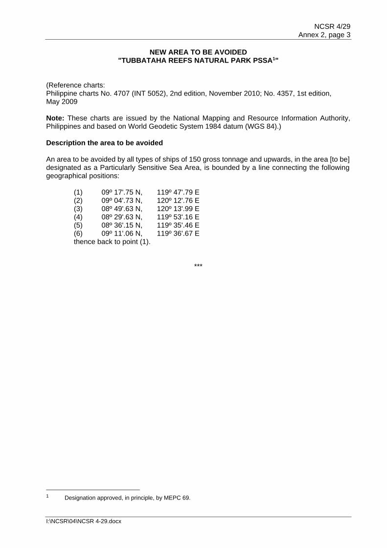
NCSR 4/29 Annex 2, page 3
I:\NCSR\04\NCSR 4-29.docx
NEW AREA TO BE AVOIDED "TUBBATAHA REEFS NATURAL PARK PSSA1"
(Reference charts: Philippine charts No. 4707 (INT 5052), 2nd edition, November 2010; No. 4357, 1st edition, May 2009 Note: These charts are issued by the National Mapping and Resource Information Authority, Philippines and based on World Geodetic System 1984 datum (WGS 84).)
Description the area to be avoided An area to be avoided by all types of ships of 150 gross tonnage and upwards, in the area [to be] designated as a Particularly Sensitive Sea Area, is bounded by a line connecting the following geographical positions:
(1) 09º 17'.75 N, 119º 47'.79 E (2) 09º 04'.73 N, 120º 12'.76 E (3) 08º 49'.63 N, 120º 13'.99 E (4) 08º 29'.63 N, 119º 53'.16 E (5) 08º 36'.15 N, 119º 35'.46 E (6) 09º 11'.06 N, 119º 36'.67 E thence back to point (1).
***
1 Designation approved, in principle, by MEPC 69.


NCSR 4/29 Annex 3, page 1
I:\NCSR\04\NCSR 4-29.docx
ANNEX 3
DRAFT RESOLUTION MSC.[…(…)] (adopted on […])
AMENDMENTS TO THE REVISED PERFORMANCE STANDARDS FOR
NARROW-BAND DIRECT-PRINTING TELEGRAPH EQUIPMENT FOR THE RECEPTION OF NAVIGATIONAL AND METEOROLOGICAL WARNINGS AND URGENT INFORMATION TO
SHIPS (NAVTEX) (RESOLUTION MSC.148(77))
THE MARITIME SAFETY COMMITTEE, RECALLING Article 28(b) of the Convention on the International Maritime Organization concerning the functions of the Committee, RECALLING ALSO resolution A.886(21) on Procedure for the adoption of, and amendments to, performance standards and technical specifications, by which the Assembly resolved that the function of adopting performance standards and technical specifications, as well as amendments thereto shall be performed by the Maritime Safety Committee, HAVING CONSIDERED, at its [ninety-eighth] session, the recommendation made by the Sub-Committee on Navigation, Communications and Search and Rescue at its fourth session, 1 ADOPTS amendments to resolution MSC.148(77) on Revised Performance standards for narrow-band direct-printing telegraph equipment for the reception of navigational and meteorological warnings and urgent information to ships (NAVTEX), set out in annex to the present resolution. 2 RECOMMENDS Governments to ensure that NAVTEX receiver equipment installed on or after [1 July 2019] conforms to performance standards not inferior to those set out in the annex to resolution A.148(77), as amended by the annex to the present resolution.

NCSR 4/29 Annex 3, page 2
I:\NCSR\04\NCSR 4-29.docx
ANNEX
AMENDMENTS TO PERFORMANCE STANDARDS FOR NARROW-BAND DIRECT-PRINTING TELEGRAPH EQUIPMENT
FOR THE RECEPTION OF NAVIGATIONAL AND METEOROLOGICAL WARNINGS AND URGENT INFORMATION TO SHIPS (NAVTEX) (RESOLUTION MSC.148(77))
In the existing section 9 the following new paragraph is added:
"9.4 The equipment should include an interface for alert management in accordance with resolution MSC.302(87) on Performance standards for bridge alert management."
***

NCSR 4/29 Annex 4, page 1
I:\NCSR\04\NCSR 4-29.docx
ANNEX 4
DRAFT RESOLUTION MSC.[…(…)] (adopted on […])
AMENDMENTS TO THE REVISED PERFORMANCE STANDARDS FOR
INTEGRATED NAVIGATION SYSTEMS (INS) (RESOLUTION MSC.252(83))
THE MARITIME SAFETY COMMITTEE, RECALLING Article 28(b) of the Convention on the International Maritime Organization concerning the functions of the Committee, RECALLING ALSO resolution A.886(21) on Procedure for the adoption of, and amendments to, performance standards and technical specifications, by which the Assembly resolved that the function of adopting performance standards and technical specifications, as well as amendments thereto shall be performed by the Maritime Safety Committee, HAVING CONSIDERED, at its [ninety-eighth] session, the recommendation made by the Sub-Committee on Navigation, Communications and Search and Rescue at its fourth session, 1 ADOPTS amendments to resolution MSC.252(83) on Revised Performance standards for integrated navigation systems (INS), set out in the annex to the present resolution. 2 RECOMMENDS Governments to ensure that INS equipment installed on or after [1 July 2019] conforms to performance standards not inferior to those set out in the annex to resolution MSC.252(83), as amended by the annex to the present resolution.

NCSR 4/29 Annex 4, page 2
I:\NCSR\04\NCSR 4-29.docx
ANNEX
AMENDMENTS TO REVISED PERFORMANCE STANDARDS FOR INTEGRATED NAVIGATION SYSTEMS (INS) (RESOLUTION MSC.252(83))
3 Application of these performance standards 1 In paragraph 3.5, insert the following at the end of table 2:
"
Allow for accepting the INS in compliance with as
INS in compliance with
Tasks and functions (Para of this standard)
Applicable modules of specific equipment
standards as specified in the Appendices of the
document
… … … NAVTEX or other IMO-recognized equipment accommodating other providers of GMDSS terrestrially-based services
Meteorological warnings (7.2.3) Navigation and SAR warnings (7.3.2) Ice warnings (7.3.2)
MSC.148(77)
Inmarsat-C EGC SafetyNET or other IMO-recognized equipment accommodating other providers of GMDSS satellite services
Meteorological warnings (7.2.3) Navigation and SAR warnings (7.3.2) Ice warnings (7.3.2)
A.807(19), as amended by MSC.68(68), annex 4 and MSC.306(87)
" 7 Task and functional requirements for an INS 2 In paragraph 7.3.2, insert the following after the bullet point " • AIS reports of AtoNs,":
" • Coastal and NAVAREA navigational warnings, • search and rescue (SAR) warnings, • Coastal and METAREA Meteorological warnings, • ice warnings, • maritime safety information overlay functions,"
3 In paragraph 7.3.3, replace bullet points with the following: "
• tracked radar targets and AIS targets • AIS binary and safety-related messages • initiation and monitoring of man-over-board and SAR manoeuvres (search
and rescue and man-over-board modes) • NAVTEX • tidal and current data • weather data • ice data, and • the operator may appropriately filter the display of Maritime Safety
Information messages."

NCSR 4/29 Annex 4, page 3
I:\NCSR\04\NCSR 4-29.docx
4 In paragraph 7.5.2.1, replace the last bullet point with the following: "
• safety related messages e.g., AIS safety-related and binary messages, Navtex Maritime Safety Information messages."
5 In paragraph 7.7.1, replace the fourth bullet point with the following:
" • presentation of received safety related messages, such as AIS safety-
related and binary messages, Application Specific Messages (ASM), Navtex Maritime Safety Information messages"
Appendix 1
DEFINITIONS
6 Replace the definition of "External safety related messages" with the following:
External safety related messages Data received from outside of the ship concerning the safety of navigation, through equipment listed in SOLAS chapter V and/or NAVTEX maritime safety information messages.
***


NCSR 4/29 Annex 5, page 1
I:\NCSR\04\NCSR 4-29.docx
ANNEX 5
DRAFT RESOLUTION MSC.[…(…)] (adopted on […])
AMENDMENTS TO THE REVISED PERFORMANCE STANDARDS FOR
ENHANCED GROUP CALL (EGC) EQUIPMENT (RESOLUTION MSC.306(87)) THE MARITIME SAFETY COMMITTEE, RECALLING Article 28(b) of the Convention on the International Maritime Organization concerning the functions of the Committee, RECALLING ALSO resolution A.886(21) on Procedure for the adoption of, and amendments to, performance standards and technical specifications, by which the Assembly resolved that the function of adopting performance standards and technical specifications, as well as amendments thereto shall be performed by the Maritime Safety Committee, HAVING CONSIDERED, at its [ninety-eighth] session, the recommendation made by the Sub-Committee on Navigation, Communications and Search and Rescue at its fourth session, 1 ADOPTS amendments to resolution MSC.306(87) on Revised Performance standards for enhanced group call (EGC) equipment, set out in the annex to the present resolution. 2 RECOMMENDS Governments to ensure that EGC equipment installed on or after [1 July 2019] conforms to performance standards not inferior to those set out in the annex to resolution MSC.306(87), as amended by the annex to the present resolution.

NCSR 4/29 Annex 5, page 2
I:\NCSR\04\NCSR 4-29.docx
ANNEX
AMENDMENTS TO REVISED PERFORMANCE STANDARDS FOR ENHANCED GROUP CALL (EGC) EQUIPMENT (RESOLUTION MSC.306(87))
1 INTRODUCTION 1 The following new paragraph 1.3 is inserted after the existing paragraph 1.2:
"1.3 Alternatively to the requirement in paragraph 1.2, the equipment need not provide means to produce a printed copy of received information if it is installed in combination with an interface connecting it to navigation equipment that is compliant with resolution MSC 252(83), as amended, on Revised Performance standards for integrated navigation systems. Provisions for interconnection to a shipborne integrated radiocommunication system (IRCS) when used in the GMDSS (resolution A.811(19)) should also be included."
and the remaining paragraph is renumbered accordingly. 5 ANTENNA SITING 2 After the existing section 5, insert a new section 6 as follows:
"6 INTERFACES
6.1 The equipment should include at least one interface for the transfer of received data to other navigation display or integrated communications equipment. 6.2 The equipment should include an interface for alert management in accordance with resolution MSC.302(87) on Performance standards for bridge alert management.
6.3 All interfaces provided for communication with other navigation or communication equipment should comply with the relevant international standards1."
***
1 Refer to IEC standards 61162.

NCSR 4/29 Annex 6, page 1
I:\NCSR\04\NCSR 4-29.docx
ANNEX 6
LIAISON STATEMENT TO WMO, IHO AND IEC TC 80
Changes consequential to displaying NAVTEX and Inmarsat C SafetyNET information on Integrated Navigation Displays
IMO's Sub-Committee on Navigation, Communications and Search and Rescue, at its fourth session from 6 to 10 March 2017, prepared revisions to resolutions MSC.252(83) Revised Performance Standards for Integrated Navigation Systems (INS), MSC.306(87) Revised Performance Standards for Enhanced Group Call (EGC) Equipment and MSC.148(77) Revised Performance Standards for Narrow-Band Direct-Printing Telegraph Equipment for the Reception of Navigational and Meteorological Warnings and Urgent Information to Ships (NAVTEX) to enable interconnection of NAVTEX and Inmarsat SafetyNET for the purpose of displaying GMDSS maritime safety information on integrated navigation display systems. IHO's World-Wide Navigational Warning Service Sub-Committee is invited to review, at the appropriate time, any necessary changes to the NAVTEX Manual, International SafetyNET Manual or other manuals as a consequence to these performance standard changes or as a consequence to IMO recognizing a GMDSS mobile satellite service provider. IEC Technical Committee 80 is invited to consider any changes, if necessary, to their test standards as a consequence to these performance standard changes. In reviewing these test standards IEC TC80 is invited to consider ensuring NAVTEX, EGC and IMO-recognized GMDSS mobile satellite equipment are compatible to the extent practicable.
***


NCSR 4/29 Annex 7, page 1
I:\NCSR\04\NCSR 4-29.docx
ANNEX 7
DRAFT MSC CIRCULAR
GUIDELINES FOR SHIPBORNE POSITION, NAVIGATION AND TIMING (PNT)
DATA PROCESSING 1 The Maritime Safety Committee, at its ninety-fifth session (3 to 12 June 2015), adopted resolution MSC.401(95) on Performance standards for multi-system shipborne radio navigation receivers and recognized the need to develop associated guidelines. 2 The Maritime Safety Committee, at its [ninety-eighth session (7 to 16 June 2017)], approved the Guidelines for shipborne position, navigation and timing (PNT) data processing to the Performance standards for multi-system shipborne radio navigation receivers, developed by the Sub-Committee on Navigation, Communications and Search and Rescue at its fourth session (6 to 10 March 2017), as set out in the annex. 3 Member States are invited to bring these guidelines to the attention of the appropriate national authorities and all other parties concerned.

NCSR 4/29 Annex 7, page 2
I:\NCSR\04\NCSR 4-29.docx
ANNEX
GUIDELINES FOR SHIPBORNE POSITION, NAVIGATION AND TIMING (PNT) DATA PROCESSING
Purpose 1 The purpose of these Guidelines is to enhance the safety and efficiency of navigation by improved provision of position, navigation and timing (PNT) data to bridge teams (including pilots) and shipboard applications (e.g. AIS, ECDIS, etc.). 2 The shipborne provision of resilient PNT data and associated integrity (I) and status data (S) is realized through the combined use of onboard hardware (HW) and software (SW) components. The shipborne PNT Data Processing (PNT-DP) is the core repository for principles and functions used for the provision of reliable and resilient PNT data. 3 The PNT-DP specified within these Guidelines is defined as a set of functions facilitating:
.1 multiple sources of data provided by PNT-relevant sensors and services (e.g. GNSS receiver, DGNSS corrections) and further onboard sensors and systems (e.g. radar, gyro, speed and distance measuring equipment (SDME), echo-sounder providing real-time data) to exploit existing redundancy in the PNT-relevant input data; and
.2 multi-system and multi-sensor-based techniques for enhanced provision of PNT
data. 4 These Guidelines aim to establish a modular framework for further enhancement of shipborne PNT data provision by supporting:
.1 consolidation and standardization of requirements on shipborne PNT data
provision considering the diversity of ship types, nautical tasks, nautical applications, and the changing complexity of situations up to customized levels of support;
.2 the identification of dependencies between PNT-relevant data sources (sensors
and services), applicable PNT data processing techniques (methods and thresholds) and achievable performance levels of provided PNT data (accuracy, integrity, continuity and availability);
.3 harmonization and improvement of onboard PNT data processing based on a
modular approach to facilitate changing performance requirements in relation to nautical tasks, variety of ship types, nautical applications, and under consideration of user needs (SN.1/Circ.274);
.4 the consequent and coordinated introduction of data and system integrity as a
smart means to protect PNT data generation against disturbances, errors, and malfunctions (safety) as well as intrusions by malicious actors; and
.5 standardization of PNT output data including integrity and status data.

NCSR 4/29 Annex 7, page 3
I:\NCSR\04\NCSR 4-29.docx
Scope 5 These Guidelines define principles and functions for onboard PNT data processing, taking into account the scalability of PNT-DP. 6 These Guidelines provide recommendations on how to handle differences regarding installed equipment, current system in use, feasibility of tasks and related functions, performance of data sources as well as usability in specific regions and situations. 7 A structured approach for the stepwise introduction of integrity is developed to achieve resilient PNT data provision in relation to the application grades and supported performance levels. 8 These Guidelines aim to achieve standardized and integrity tested PNT output data to enhance user awareness regarding achieved performance level. Structure of Guidelines 9 These Guidelines have a modular structure, starting with a general section which introduces the purpose, scope and application of the Guidelines. The general section also explains the high-level architecture of PNT-DP and how the PNT-DP can be integrated into onboard navigation systems, e.g. INS1, ECDIS2 and RADAR3. 10 More detailed guidance on the PNT-DP is given as follows:
Module A – data input: sensors, services, and sources; Module B – functional aspects; Module C – operational aspects; Module D – interfaces; and Module E – documentation.
11 In addition, these Guidelines have three appendices listing definitions, abbreviations and expected operational and technical requirements on PNT/I data output. Application of Guidelines 12 These Guidelines provide prerequisites for harmonized provision of PNT and associated integrity data. 13 These Guidelines are recommended for equipment manufacturers, shipyards, ship owners and managers responsible for onboard equipment and systems used for PNT data provision. Definitions 14 Definitions used in the context of PNT, WWRNS and GNSS are detailed in appendix A.
1 Equipment according to MSC.252(83).
2 Equipment according to MSC.232(82).
3 Equipment according to MSC.92(79).

NCSR 4/29 Annex 7, page 4
I:\NCSR\04\NCSR 4-29.docx
Architecture 15 Generally, a shipborne PNT-DP is made up of three functional blocks:
.1 Pre-processing; .2 Main processing; and .3 Post-processing.
16 The pre-processing function extracts, evaluates, selects and synchronizes input (sensor and service) data (including the associated integrity data) to preselect the applicable techniques to determine PNT and integrity output data. 17 The architecture of the PNT-DP is shown in figure 1.
Figure 1: Architecture of PNT-DP
18 The main processing function generates the PNT output data and associated integrity and status data. 19 The post-processing function generates the output messages by coding the PNT output data (PNT, integrity, and status data) into specified data protocols. Integration 20 The PNT-DP can be integrated as software into ships' navigation systems such as INS, ECDIS or RADAR as shown in figure 2.

NCSR 4/29 Annex 7, page 5
I:\NCSR\04\NCSR 4-29.docx
Figure 2: PNT-DP integrated as software into INS, ECDIS, or RADAR
21 The Multi-system Shipborne Radionavigation Receiver (MSR) is appropriate to facilitate the combined use of WWRNS to improve the provision of position, velocity and time (PVT) data and related integrity data. The application of enhanced processing techniques can be realized by the MSR (figure 3) itself or by PNT-DP as part of INS (figure 2).
Figure 3: PVT-DP integrated as software into MSR

NCSR 4/29 Annex 7, page 6
I:\NCSR\04\NCSR 4-29.docx
Module A – Data input: Sensors, services and sources 22 Different PNT data processing functions need comprehensive input data to keep the PNT-DP running as specified in this document. These Guidelines define how the shipborne PNT-DP should provide output data by processing input data (from sensors and/or services and/or sources) while availability and performance of input data may vary temporally and spatially (see figure 4).
Figure 4: Sensors, services, and sources
23 The desired level of PNT data output depends on currently available inputs that may independently vary over a short or long period of time. These Guidelines aim to specify the demand on needed types of services, sensors, and sources for predefined performance levels of PNT/I data (module B). 24 These Guidelines specify PNT-DP's real-time adjustments of the used data processing functions (module B and C) to applicable methods taking into account the available input data. 25 The PNT-DP processes data from type-approved sensors and recognized services. 26 In a minimum configuration, PNT-DP uses the minimum number and type of sensors as defined in SOLAS (depending on the ship type). The manufacturer may add inputs and outputs to achieve better performance or more information (e.g. with integrity indication) at output of PNT-DP to support additional nautical functions and tasks that require better performance or more information (e.g. with integrity indication). 27 The necessary sensor, service, and source layout is determined by the necessary performance of PNT data provision and integrity evaluation for the subsequent nautical functions and tasks.

NCSR 4/29 Annex 7, page 7
I:\NCSR\04\NCSR 4-29.docx
A.1 Types of services for positioning 28 Services are classified by grade/type as follows:
.1 Radionavigation services provide navigation signals and data which enable the determination of ships' position, velocity and time.
.2 Augmentation services are other services that provide additional correction and/or integrity data to enable improvement of radionavigation-based determination of ships position, velocity and time.
29 Services are classified regarding its geographical coverage:
.1 Global services are characterized by their worldwide coverage. They may have limitations regarding usability for different phases of navigation due to signal disturbances reducing the availability or performance of transmitted signals and/or provided data.
.2 Regional services (and maybe local services) are only available in dedicated
service areas. They may be used to improve the performance of ships' navigational data in terms of accuracy, integrity, continuity and availability even in demanding operations when, for example, higher accuracy and integrity level is required during coast and port navigation.
A.2 Types of sensors and sources 30 The type-approved sensors and data sources are distinguished into the following categories:
.1 Service-dependent sensors rely on any service from outside the ship provided
by human effort. They cannot be used on board without at least a satellite-based or terrestrial communication link to the service provider (shown in figure 4, mainly used to provide data of ships position, velocity and time).
.2 Shipborne sensors and sources:
.1 Primary sensors use a physical principle, e.g. earth rotation or water characteristics and are independent of any human applied service provision (shown in figure 4, mainly used to provide data of ships attitude and movement);
.2 Secondary sensors and sources may be used to provide additional data for the verification of PNT data (see figure 4) e.g. water depth at known position from an ENC, line of position, or directions and distances provided by onboard RADAR.
31 The above described sensors are considered to be usable worldwide and free of any rebilling user charge.

NCSR 4/29 Annex 7, page 8
I:\NCSR\04\NCSR 4-29.docx
A.3 Additional input data 32 In addition to sensors, services and sources listed in A.1 and A.2 further PNT-relevant data may be used for shipborne PNT data provision to increase redundancy or to evaluate plausibility and consistency of data input (ship sensed position, e.g. by position reference systems). Such data may be provided via AIS or VHF Data Exchange System (VDES), see figure 4. A.4 Requirements on input data All sensors, services and data sources used as input for the shipborne PNT-DP should comply with the relevant IMO performance standards.

NCSR 4/29 Annex 7, page 9
I:\NCSR\04\NCSR 4-29.docx
Module B – Functional aspects B.1 General B.1.1 Objective 33 The overarching objective of the shipborne PNT-DP is the resilient provision of PNT data including associated integrity and status data. 34 In this context resilience is:
.1 the ability to detect and compensate against relevant failures and malfunctions in data acquisition and processing to meet the specified performance requirements on PNT data for accuracy and integrity with respect to continuity and availability under nominal conditions; and
.2 the ability to detect, mitigate and compensate malfunctions and failures based
on supported redundancy in data acquisition and processing to avoid loss or degradation in functionality of PNT-DP.
B.1.2 Functional Architecture 35 The architecture of PNT-DP is shown in figure 1. Depicting the principal functions: pre-processing, main processing, and post-processing. 36 The pre-processing of input data: .1 conducts:
.1 analysing of their current availability in relation to their usability for ongoing PNT data processing and selection;
.2 timely and spatial synchronisation of input data within the consistent
common reference system (CCRS); and
.3 determining the feasibility of functions in relation to supported methods taking into account the current performance of data input; and;
.2 provides evaluated, selected and synchronized data for the main processing.
37 The main processing:
.1 conducts:
.1 determination of PNT data; .2 determination of associated integrity and status data in relation to
integrity of sensors and services, functional capability of onboard data processing, and estimated integrity of PNT output data; and
.3 selection of PNT output data including integrity and status data and;
.2 provides the selected PNT output data to post-processing.
NCSR 4/29 Annex 7, page 10
I:\NCSR\04\NCSR 4-29.docx
38 The post-processing:
.1 conducts:
.1 checking the completeness of PNT output data in relation to supported composition of messages; and
.2 the generation of output data streams in the designated
message-coding; and
.2 provides the selected PNT data output.
39 The functional architecture of the shipborne PNT-DP supports the use of numerous processing channels operated in parallel: .1 to enable the application of different processing methods for PNT data
generation in relation to intended accuracy and integrity levels; .2 to improve continuity and availability in PNT data processing and provision by
redundant system layout and/or implemented fall-back option; and .3 to enable reliable detection, mitigation and compensation of failures and
malfunctions in data input and processing. 40 The functional architecture of the shipborne PNT-DP is based on a modular structure to support the adaption of shipborne data processing to: .1 different performance requirements on PNT output data in relation to
navigational situation and nautical tasks in their spatial and temporal context; .2 differences in data input of PNT-DP depending on carriage requirements,
equipment levels, or both; and .3 occurring changes of available/usable sensors, services, and other data
sources during operation. B.1.3 Requirements4 41 The requirements on data output of PNT-DP are specified by:
.1 the application grade of PNT-DP defining the amount and types of output data; and
.2 the supported performance level of provided PNT data regarding accuracy and
integrity.
4 Approaches for resilient provision of PNT data can only be discussed in relation to specific requirements, e.g.
accuracy. A sufficient scaling of requirements is considered as an appropriate way to facilitate the diversity of PNT-DP implementations.

NCSR 4/29 Annex 7, page 11
I:\NCSR\04\NCSR 4-29.docx
Figure 5: Application Grades of PNT-DP (*provided with improved accuracy)
42 The following application grades of a PNT-DP (see figure 5) are used to define different requirements on the amount and types of PNT data output:
.1 Grade I supports the description of position and movement of a single onboard point (e.g. antenna location of a single GNSS receiver);
.2 Grade II ensures that horizontal attitude and movement of ship's hull are
unambiguously described;
.3 Grade III provides additional information for vertical position of a single onboard point and depth; and
.4 Grade IV is prepared for the extended need on PNT data e.g. to monitor or
control ship's position and movement in three-dimensional space. 43 Depending on the supported application grade of an onboard PNT-DP, the following PNT data is provided:
.1 Grade I: horizontal position (latitude, longitude), SOG, COG, and time;
.2 Grade II: heading, rate of turn, STW and CTW in addition to Grade I5;
.3 Grade III: altitude, and depth in addition to Grade II; and
.4 Grade IV: heave, pitch, and roll (and may be surge, sway, and yaw with higher performance) in addition to Grade III.
44 Performance requirements on each set of PNT output data are described in terms of accuracy and integrity, whereby several levels are specified to address the diversity of operational as well as technical requirements (see figure 6).
5 A sufficient provision of Grade II PNT data enables the determination of surge, sway and yaw.

NCSR 4/29 Annex 7, page 12
I:\NCSR\04\NCSR 4-29.docx
Figure 6: Generic performance level for each PNT output data in relation
to accuracy and integrity
45 Numbers and thresholds of operational performance levels per PNT data type should be compliant with existing performance standards and resolutions, e.g. A.1046(27), for horizontal positioning results into two operational accuracy levels: A (better than 100 m) and B (better than 10 m) to 95% confidence; A.915(22) specifies the future need for two additional operational accuracy levels: C (better than 1 m) and D (better than 0.1 m). 46 In addition, the introduction of technical performance levels (A.1, A.2, B.1, B.2, …) enables a graduated specification of task- and application-related requirements on PNT data. Furthermore, it prepares a need-driven evaluation and indication of accuracy. 47 Integrity data per each individual PNT output data should be provided to indicate the further usability of data. The value of included integrity information depends on applied principles of integrity evaluation in relation to a dedicated accuracy level:
.1 None: Unavailable integrity evaluation;
.2 Low: Integrity evaluation based on plausibility and consistency checks of data provided by single sensors, systems, services, or sources;
.3 Medium: Integrity evaluation based on consistency checks of data provided by
different sensors, systems, services, and sources with uncorrelated error parts6 as far as possible; and
.4 High: Integrity evaluation based on estimated accuracy (protection level).
48 As a result of preceding paragraphs, the performance of an individual PNT output data (requirement as well as result of evaluation) should be defined by specified accuracy and integrity levels.
6 See definition of correlation and uncorrelated error parts in appendix A.
Figure 1: Generic performance level for each PNT output data in relation to accuracy and integrity

NCSR 4/29 Annex 7, page 13
I:\NCSR\04\NCSR 4-29.docx
49 Accuracy and integrity levels should be defined for all PNT data of the supported application grade or a combination of them (see figure 7) to ensure that the requirements on data output of a PNT-DP are comprehensively specified.
50 Figure 8 illustrates the interdependencies between application grade and supported performance levels in relation to current and future nautical tasks and applications (exemplified).
Figure 7: Composition of requirements on PNT/I output data
(application grade II as example)

NCSR 4/29 Annex 7, page 14
I:\NCSR\04\NCSR 4-29.docx
B.2 Pre-processing B.2.1 Objective 51 The pre-processing prepares the input data for main processing and pre-evaluates the feasibility of data processing methods supported by main processing under current conditions. B.2.2 Functional and methodical aspects B.2.2.1 Evaluation of input data 52 Data streams received from input data-providing entities should be time-stamped with the time of reception using system time of the PNT-DP. The system time should be synchronized with a common time base by using the input data of an appropriate source, preferably UTC. 53 Incoming data provided by sensors, systems and services should be evaluated with respect to:
.1 completeness and correctness of transmission; and
.2 plausibility and consistency of data content.
Figure 8: Illustration of interdependencies between application grade, performance
level, and nautical tasks / applications

NCSR 4/29 Annex 7, page 15
I:\NCSR\04\NCSR 4-29.docx
54 The evaluation of a data stream received from an input data-providing entity should comprise the following methods:
.1 The correctness of transmitted input data should be checked with respect to the rules of the protocol in use (completeness, parity, etc.). Incorrect data should be excluded from further processing.
.2 It should be checked if the expected data update rate, as needed for main
processing, is met. If the determined update rate implies a latency violation, the data should be marked accordingly.
55 The evaluation of data content should comprise the following methods:
.1 Parameters describing the characteristics of the input data-providing entity should be analysed to identify which following processing steps are applicable. Such parameters include performance parameters, such as number and type of measurements (e.g. GPS/DGPS); and status parameter, such as healthy/unhealthy.
.2 Data describing the performance of input data should be analysed to identify the
following processing steps that are applicable. Such parameters include performance parameters like UERE, HPL; and time of data validity, as available, with respect to latency limitations.
.3 Plausibility and consistency of data should be tested with respect to appropriate
value ranges and thresholds. Data failing those tests should be marked accordingly. Data of former epochs may be used to detect dynamic value ranges and thresholds.
56 Input data provided by sensors, systems, and services should be marked as invalid if the data sources (e.g. sensors and services) have indicated that they are invalid. 57 Input data provided by sensors, systems and services should be excluded from further PNT data processing, if:
.1 data is indicated as invalid;
.2 the identified violation of latency, plausibility, or consistency
.1 is in an order which is intolerable for the accuracy level intended in minimum by the PNT-DP; or
.2 cannot be managed by the PNT-DP in a sufficient manner to avoid
unintended degradations of PNT output data. B.2.2.2 Temporal/spatial adjustment of input data 58 Input data which have passed the evaluation tests should be adjusted spatially and temporally within a Consistent Common Reference System (CCRS), where required, to meet the specified accuracy level. 59 The method for the time synchronization should provide a common time scale referenced to the system time of the PNT-DP, preferably given in UTC. The resolution of time synchronization shall not degrade that of input data.

NCSR 4/29 Annex 7, page 16
I:\NCSR\04\NCSR 4-29.docx
60 The time scale used for time synchronization should also be used to trigger the complete data processing: pre-processing, main processing, and post-processing. All spatially-related information should use a CCRP. If CCRP transformation fails, this should be indicated by corresponding status data. B.2.2.3 Feasibility evaluation of main processing 61 The feasibility of main processing should be assessed in relation to individual processing channels and their requirements on data input. 62 A method performing the feasibility evaluation in relation to an individual main processing channel should include test procedures and thresholds reflecting its requirements on data input. 63 The evaluation results should be provided by internal status data to control the operation of each supported processing channel. 64 The results of the feasibility evaluation enable an early indication of performance degradation in relation to supported performance levels. B.2.3 Results of pre-processing 65 Results of pre-processing should comprise:
.1 input data indicated as usable, time-stamped with a common time base, preferably UTC, and spatially adjusted;
.2 metadata to describe characteristics of usable input data; .3 internal status data describing the current status of pre-processing;
.4 internal status data for controlling of main processing; and
.5 internal integrity data as results of evaluation of input data utilized by main
processing. B.3 Main processing B.3.1 Objective 66 The main processing serves to improve PNT data provision by applying appropriate methods for completion, refinement and/or integrity evaluation. B.3.2 Functional and methodical aspects of PNT data generation 67 Within main processing, the pre-evaluated input data (from sensors, systems and services,) should be used to feed at least one data processing channel. 68 The feasibility evaluation results of pre-processing (B.2.2.3), provided as internal status data, should be used as a control parameter during main processing to activate/deactivate individual processing channels. 69 Each processing channel should be specified by the set of supported methods generating PNT data, integrity data, and status data.

NCSR 4/29 Annex 7, page 17
I:\NCSR\04\NCSR 4-29.docx
70 Each processing channel should provide at least one, preferably several or all PNT data types including associated integrity and status data. 71 Main processing should, if available, combine single or multiple data processing channels, to increase the performance of accuracy, integrity, continuity, availability, and resilience of PNT data provision. Methods should be provided to manage changes in data input e.g. changes in availability of external service data. 72 The main processing stage should generate status data on the mode and progress of data processing for PNT data output. B.3.2.1 Number and types of processing channels 73 A single processing channel should provide some or all intended PNT data and associated integrity data (see channel 1 to 3 in figure 9). 74 The number of processing channels operated in parallel should ensure at least the provision of all PNT output data in the designated application grade and the supported accuracy and integrity levels. 75 The methods provided by an individual processing channel should at least ensure that the intended PNT output data are provided with the intended accuracy and integrity when the requirements on data input are met (nominal conditions).
Figure 9: Illustration of processing channels being operated parallel
within main processing

NCSR 4/29 Annex 7, page 18
I:\NCSR\04\NCSR 4-29.docx
76 More than one processing channel should be supported for the provision of one type of PNT data and associated integrity data (see figure 9), .1 if different accuracy and integrity levels are supported by application of different
methods for data processing, or .2 if an increase of reliability and resilience is aimed by parallel processing of
largely independent input data with the same methods. 77 Parallel processing channels should differ in used input data, or applied methods, or both. These differences may result in measurable differences in PNT data output:
.1 The additional use of augmentation data should improve the accuracy of PNT output data by application of corrections, or should enhance the integrity evaluation with independent evaluation results, or should serve both.
.2 If parallel processing channels are equipped with the same methods and are
fed with largely independent input data, the results of those channels should cover the same types/set of PNT data. The PNT data can be used alternatively for data output due to its independence and should be used internally for integrity evaluation.
.3 Enhanced processing channels should combine multiple types of input data to
enable the application of effective methods during data processing such as:
.1 self-correction (e.g. dual-frequency GNSS signal processing to correct ionospheric path delays; noise reduction by filtering);
.2 self-controlling (e.g. detection and exclusion of outliers),
self-evaluation (e.g. consistency tests or estimation of protection level as overestimate of expected inaccuracies); and/or
.3 self-management (e.g. failure compensation by interpolation or
extrapolation in a common model of movement).
.4 The capability of enhanced processing channels can be increased if redundancy in data input enables the simultaneous and coordinated use of effective methods such as self-correction, self-controlling, self-evaluation, and self-management.
78 The need for the provision of reliable and resilient PNT data requires that at least a parallel processing channel should be implemented as a fall-back solution for an enhanced processing channel, which is more sensitive to availability of data input (Fall-back may not be available after loss of sensitive input data). 79 Ultimately, the number and types of parallel processing channels is determined by:
.1 the supported application grade as well as supported accuracy and integrity levels of aimed PNT data output;
.2 arranging of data processing methods to single channels; and
.3 the aimed level of reliability and resilience of PNT data specifying the residual need for fall-back solutions per application grade and assigned accuracy and integrity levels.

NCSR 4/29 Annex 7, page 19
I:\NCSR\04\NCSR 4-29.docx
B.3.2.2 Methods to refine PNT data 80 An improvement to accuracy for several or all PNT data types by a processing channel is achieved if one, or a combination of the following methods, is applied:
.1 methods applying augmentation data provided by recognized services and external sources (if available and indicated as usable)
.1 to improve the accuracy of data by error correction (e.g. GNSS range
and range rate corrections);
.2 to exclude faulty or disturbed data taking into account integrity evaluation results (e.g. health indicator of GNSS signals provided by Beacon or SBAS); and
.3 to apply performance indicators provided for individual data to control
its influence on potential PNT data output (e.g. weighting within data processing);
.2 methods utilizing redundancy in the database
.1 for self-determination of corrections and application (e.g.
dual-frequency signal processing to correct ionospheric path delays);
.2 for self-reliant detection and exclusion of faulty data (e.g. FDE by RAIM); and
.3 for self-determination of performance indicators for used/derived data
to weight its influence on potential PNT data output;
.3 methods utilizing redundancy in database for application of enhanced algorithm such as
.1 equalization calculus based on an overdetermined set of input data
(e.g. 3-dimensional attitude determination with GNSS); and
.2 filtering with adaptive and/or assisted measurement and transition models (e.g. deeply coupled GNSS/INS positioning).
81 Fall-back solutions should be provided by simultaneously operated processing channel(s) providing the same PNT data with a lower accuracy level by application of:
.1 methods using less input data (to reduce the sensitivity to completeness of data input); and
.2 methods using other input data (to reduce the sensitivity to availability of specific input data).
82 A redundant solution for a single processing channel should be supported by at least one simultaneously operated processing channel providing independent PNT data types with the same accuracy levels by applying:
.1 methods operating with different input data to ensure independency in relation to data input-providing systems, services or sensors; and/or
.2 methods differing in error influences in relation to data input and processing.
NCSR 4/29 Annex 7, page 20
I:\NCSR\04\NCSR 4-29.docx
83 Both, fall-back and redundant solutions should provide an improved resilience of PNT data provision by:
.1 using fall-back solutions with an acceptable limit of loss of data accuracy; and
.2 using redundant solutions with respect to continuity and reliability of PNT data provision in relation to each supported accuracy level.
B.3.2.3 Methods to evaluate PNT data
84 Integrity evaluation should be based on methods that test the plausibility or consistency of potential PNT output data or methods to estimate the current size and behaviour of its individual errors (e.g. noise), error budgets (e.g. ranging error), or resulting errors (e.g. inaccuracy of SOG). An integrity evaluation should be assigned to each processing channel in relation to the nominally designated PNT data output (taking into account currently used data input).
85 Generally, the applied method of integrity evaluation determines the achieved integrity level:
.1 Level None: Failed, unavailable or incomplete integrity evaluation by the processing channel methods and should be regarded as having no integrity.
.2 Level Low: The integrity evaluation of the processing channels, dealing with the refinement or completion of data provided by single sensors or measuring systems, should only be based on plausibility and consistency tests in relation to models of the individual sensor and system:
.1 Plausibility tests should prove if data types are within an expected value range (e.g. ship's speed). The expected value range should ultimately determine the detectability of errors (e.g. indicated speed over ground is much higher than ship's maximum speed).
.2 Simple consistency tests should prove, either that successive data follows an expected time behaviour (e.g. range and range rate), or that multiple outputs of data are compliant within a common measurement model (e.g. position and speed determined by different methods). Consistency should be assumed if the difference between compared values is smaller than a specified threshold describing the tolerable relative error between both.
.3 Enhanced consistency tests should evaluate the expected consistency between used input data and achieved processing result, whereby thresholds used (e.g. in statistical hypothesis tests) should be conditioned in relation to accuracy requirements on output data.
.4 Enhanced consistency tests should be applied iteratively with methods
detecting and excluding most likely faulty input data or intermediate processing results, if supported redundancy of input data enables the application of such tests. This is an appropriate method to improve accuracy and integrity of output data (e.g. RAIM).

NCSR 4/29 Annex 7, page 21
I:\NCSR\04\NCSR 4-29.docx
.3 Level Medium: If the capability of simple, as well as enhanced consistency tests should be increased, the tests should be performed with data provided from different sensors and measuring systems with largely uncorrelated error influences:
.1 If the degree of correlation in the error margin as well as in the data
itself is not taken into consideration, the difference of compared values should not be considered as an estimate of absolute accuracy.
.2 If the error margin of compared values is completely uncorrelated, the
difference between both values has to be smaller than the sum of tolerable inaccuracies per considered value. In this case the consistency test serves the evaluation, if pre-specified accuracy levels are met.
Largely uncorrelated data may inherit partially correlated errors. These errors remain undetected by consistency checks. If the thresholds used during evaluation take the existing uncertainties into account the consistency tests should continue as method to evaluate the fulfilment of certain accuracy levels.
.4 Level High: The highest performance of integrity evaluation should provide a
reliable estimate of the inaccuracy of a single PNT data type. This implicates the necessity to determine the absolute magnitude of significant errors and resulting consequences for the accuracy limits of single PNT output data.
86 As described in the previous paragraphs, each integrity evaluation method needs pre-specified and/or instantaneously determined thresholds to enable the evaluation processes. 87 Generally, integrity evaluation methods applied by a processing channel should be able to adapt the used thresholds on the accuracy level of PNT data provision currently supported. 88 As a minimum, a processing channel should provide integrity data in relation to single PNT output data. It should also cover the results of integrity evaluation as well as information on the supported level of integrity evaluation (applied method and current feasibility). B.3.2.4 Methods to complete PNT data 89 Hardware redundancy in sensors, systems, and services enables the application of further methods dealing with alternative generation of standard PNT output data (e.g. heading determination with data from 2 or 3 GNSS receivers) and/or the provision of further data types for PNT output (e.g. torsion monitoring of ship's hull). 90 Methods for alternative generation of standard PNT output data should only be applied, if the resilience of PNT data provision is significantly increased. Aspects of error correlation and propagation should be considered carefully, if methods are being operated on the same database.
91 Any further methods may be applied to generate additional PNT output data, as long as performance degradation of required PNT data provision is avoided. It is recommended to facilitate those methods by implementing additional processing channels.
B.3.2.5 Methods to provide status data
92 Status data should be considered as part of the potential PNT data output; to report current usability of available sensors, systems, and services as well as the feasibility and performance of supported data processing channels and methods.

NCSR 4/29 Annex 7, page 22
I:\NCSR\04\NCSR 4-29.docx
93 Each processing channel should support the generation of status data at PNT data output by application of own methods to describe or update the status based on:
.1 checking if status data provided by pre-processing is available. In case of:
.1 the unfeasibility of intended data processing the incoming status data should be forwarded; and
.2 degradation of intended data processing the status data should be amended by additional information from performed processing;
.2 checking of tolerated changes in nominal input data in relation to changes in data output; and the reporting of
.1 faults in the augmentation input data resulting in the seamless switching to lower accuracy and/or integrity level (e.g. methods of absolute error estimation are no longer applicable);
.2 loss in redundancy on input data resulting in the seamless switching to
lower accuracy and/or integrity level (e.g. methods for consistency checks and/or plausibility checks are no longer applicable); and
.3 loss in over-determination of input data (e.g. full GNSS processing is
reduced to GNSS processing of four satellites, RAIM FDE is replaced by no RAIM) – Status indications should be raised accordingly;
.3 checking if processing is started or operated by the processing channels as
expected (e.g. watchdog on certain steps during processing to ensure detection of system faults); and
.4 checking if designated output data is supplied in the corresponding time
intervals (nominal update rate is fully available). Testing and reporting should include:
.1 detection of timely incoherent data rates on the input into main
processing; as well as
.2 real-time losses during main processing caused by system failures. B.3.3 Functional and methodical aspects of PNT data output selection 94 The selection of a PNT data output should be based on data provided by active processing channels that are operated in parallel. 95 The supported combination of processing channels defines the specific method to be applied for selecting the PNT output data including associated integrity and status data.
96 The selection process should comprise:
.1 an evaluation of the results of each individual processing channel regarding its intended performance level of PNT/I data provision;
.2 consistency checks between results of individual processing channels on the basis of a common PNT data model; and
.3 the selection of a single set of PNT/I output data based on predefined assessment rules (redundancy and degradation).

NCSR 4/29 Annex 7, page 23
I:\NCSR\04\NCSR 4-29.docx
97 The method for performing the selection process requires an unambiguous classification and ranking system of:
.1 intended results of each processing channel under normal operating conditions; and
.2 degraded results of each processing channel in the case of disturbed operating
conditions (as results of degradations and/or breakdowns of data input and processing),
in relation to its potential utilization for PNT data output. The method should analyse associated integrity and status data as real-time indicator for the current functionality and performance of each processing channel. 98 The classification of data performance should be based on accuracy and integrity levels used for the specification of operational and technical requirements per single type of PNT data (see section B.1.3). 99 For each type of PNT data the ranking system defines the relationship between certain accuracy and integrity levels and "best"/"worst" PNT data output:
.1 If a certain accuracy and integrity level is only supported by a single processing channel, the achieved integrity level should dominate the selection, as illustrated in figure 10.
.2 If a certain accuracy and integrity level is supported by more than one channel,
.1 under nominal operation conditions the selection of data should follow
the configured prioritisation; and
.2 in case of performance degradations the selection should be in compliance with the prioritization, as illustrated in figure 7.
.3 If the same accuracy/integrity level is met by two or more processing channels,
the priority should be given to the results of the processing channels operated under nominal conditions.
Figure 10: Ranking list for safety-relevant PNT data

NCSR 4/29 Annex 7, page 24
I:\NCSR\04\NCSR 4-29.docx
100 The selection process should ensure that PNT data and related integrity data are associated by selecting data provided by the same or assigned processing channel. 101 The selection process should be considered as failed,
.1 if the pre-processing detects the unfeasibility of data processing for all supported processing channels; or
.2 if none of the processing channels provide any type of PNT data with an
increase of accuracy and/or integrity. 102 A failed selection process should be indicated by status data marking the current output data as unusable. For this purpose status data provided by pre-processing should be taken into account and updated. 103 The selection process should include methods ensuring that the status reporting of the PNT-DP to connected navigational systems is presented to the bridge-team. 104 External status communication should be restricted to the PNT-DP output data only and should comprise at least of status indications in case of changes of the operational status of the PNT-DP with impacts on:
.1 the available processed "best" data types; .2 the current accuracy and integrity (operational and technical level); and .3 the PNT-DP system status, which may include information on unusable or
degraded input data to support failure detection by the operator. B.3.4 Results of main processing 105 The results of main processing are:
.1 the selected PNT data for output; .2 associated integrity data; .3 metadata to describe the characteristics of selected output data (e.g. source
and processing identifier);
.4 status data describing the current status of main processing;
.5 internal status data for controlling of post-processing; and
.6 internal integrity data contributing to integrity data at output of PNT-DP. 106 PNT data currently determined by the main processing may be fed back into pre-processing to support the evaluation of the subsequent sensor, system and service data.

NCSR 4/29 Annex 7, page 25
I:\NCSR\04\NCSR 4-29.docx
B.4 Post-processing B.4.1 Objective 107 The post-processing checks completeness of selected PNT output data (PNT data, integrity data, and status data) from main processing and generates output data streams. B.4.2 Functional and methodical aspects B.4.2.1 Completeness check of PNT output data 108 The PNT integrity and status data, which has been selected by main processing for output, should be checked using the following methods:
.1 check of completeness and timeliness of selected output data in accordance with the nominal configuration of the PNT-DP (application grade, accuracy and integrity level, update intervals, intended status reporting);
.2 check if the required update interval is achieved per output data of PNT-DP; and
.3 check of availability of output data in relation to supported message formats.
109 The results of applied checks should be used to update/complete the status data for output. B.4.2.2 `Generation of output data streams 110 Standard messages should be used to provide the selected PNT data output. Proprietary message formats may be used to provide additional data; if used, their format specification should be disclosed. 111 The provision of individual messages is repeated to provide the last valid data set of included PNT data in the following situations:
.1 data is marked as invalid; or .2 data is not available in the expected time interval. 112 Each of the composed messages should contain PNT system time, preferably UTC. 113 A source indication for provided PNT data should be included. 114 If PNT output data streams are provided to external applications, they should, as far as possible, conform to existing maritime interface standards based on the IEC 61162 series. 115 An important benefit of PNT-DP is the provision of integrity data associated with the PNT data at output. Therefore, the messages at output should support the provision of additional integrity data, whereby:
.1 the integrity data per provided PNT data type should include a reference to the
supported accuracy and integrity level;
.2 additional metadata may flag the used integrity method; and

NCSR 4/29 Annex 7, page 26
I:\NCSR\04\NCSR 4-29.docx
.3 the provided integrity data should include the result of the integrity evaluation process performed. Such data should contain at least parameters of error distribution.
B.4.3 Results of post-processing 116 Results of post-processing should comprise:
.1 messages carrying the selected PNT data together with associated integrity data in a specified message format. Both enable the subsequent connected equipment to identify whether the provided data is usable for its dedicated nautical application (e.g. automated track-control); and
.2 status messages reflecting the health status of the entire PNT-DP.

NCSR 4/29 Annex 7, page 27
I:\NCSR\04\NCSR 4-29.docx
Module C – Operational aspects C.1 Configuration 117 The configuration of a shipborne PNT-DP is realized by the system integrator before commissioning to ensure compliance between the shipborne PNT-DP and the operational environment. 118 The intended application grade including the required accuracy and integrity level determines the minimum requirements on the data input and configuration of PNT-DP. 119 The configuration should include the specification of thresholds and value ranges used for integrity evaluation and system controlling (e.g. in relation to operational and technical accuracy levels as well as applied integrity evaluation techniques). 120 The PNT-DP is an embedded software integrated into a mothering system. The configuration of the PNT-DP is performed by manufacturer-specific tools. C.2 Operation management C.2.1 Automatic operation 121 The concept of the PNT-DP is based on automated processing (pre-processing, main processing, and post-processing) to adapt the functionality on current data availability and usability. 122 The PNT-DP is embedded software contributing to the Bridge Alert Management (BAM) of the mothering system by provision of status and integrity data. It does not generate alerts by itself. 123 Since the shipborne PNT-DP has a residual risk regarding total loss of all functionalities, the operational environment e.g. the mothering system, should ensure, by a bypass, that available sensor and service data are available for applications. C.2.2 User interaction 124 The knowledge of users regarding the usability and integrity of input devices (sensors and services) may result in the user decision to exclude data of these sensors and services from PNT data processing. However, the manual exclusion of input data is only possible on the mothering system by controlling, opening, and closing of data interfaces. 125 Due to automatic operation, there is no difference between a user exclusion of data input or a failed data input for the PNT-DP. 126 The PNT –DP should enable the graphical representation of the horizontal accuracy of position information, including status and integrity data in an integrated navigation display or workstation.

NCSR 4/29 Annex 7, page 28
I:\NCSR\04\NCSR 4-29.docx
Module D – Data communication Interfacing 127 Where possible, standardized and approved communication protocols for interfacing should be used7. D.1 Input data 128 The communication protocol for input data should allow the implementation of the supported functions for the intended application grade and performance level as described in these Guidelines. In particular, this includes:
.1 reception of all PNT relevant data (raw or processed); and
.2 the data received should be marked either by the source itself or with a unique source identifier within the PNT-DP.
D.2 Output data 129 The communication protocol for output interfacing should allow the transmission of selected PNT data including integrity and status data. 130 PNT output data, including status and integrity data used for navigation, as well as PNT data processing configuration data, should be provided as an output to support recording by VDR systems. D.3 Configuration interfacing 131 The manufacturer should provide data interfacing with the mothering system for configuration.
7 Refer to publication IEC61162.

NCSR 4/29 Annex 7, page 29
I:\NCSR\04\NCSR 4-29.docx
Module E – Documentation 132 The documentation of a PNT-DP should cover at least
.1 operating manual;
.2 installation manual;
.3 configuration manual;
.4 failure analysis, and
.5 onboard familiarization material. 133 The documentation should be provided, preferably in an electronic format. E.1 Operating manual 134 The operating manual should include:
.1 the specification of application grades including associated accuracy and integrity levels of data output supported by the specific version of PNT-DP;
.2 a statement on the input data that are necessary for the nominal operation of
PNT-DP;
.3 the functional architecture of PNT-DP;
.4 a statement on which operating modes are supported by the PNT-DP (including fall-back options) with details of applied functions and methods, their arrangement in data processing chains, and resulting implication on PNT data output provision;
.5 relevant information on applied means to achieve spatial and temporal
synchronisation of input data coming from different sensors, services and systems;
.6 the description of dependencies between performance of data input
(e.g. availability, accuracy, …), applicable data processing methods including their capability and supported output data provision (application degree, accuracy and integrity level);
.7 a comprehensive description of the internally applied status and integrity
monitoring in relation to .1 used performance identifiers, test methods, and thresholds for decision
finding; .2 consideration of integrity and status data provided by external sensors,
services as well as systems; and .3 their contribution to integrity and status data at data output of PNT-DP;

NCSR 4/29 Annex 7, page 30
I:\NCSR\04\NCSR 4-29.docx
.8 a complete list of internal and external failures and disturbances in accordance with failure analysis (see E.4) including the description of
.1 effects on data processing under consideration of applied methods; .2 supported means for detection and compensation; and .3 effects on the provided PNT data output. 135 Additionally, for further harmonization the manufacturer is encouraged to use the operating manual to inform about
.1 nominal operation conditions for the operating modes of the specific PNT-DP;
.2 reliability of PNT data provision per operating mode under nominal condition (simulation based and/or experimentally evaluated);
.3 effectiveness of supported integrity monitoring methods regarding detectability
of failures and disturbances (internal as well as external error sources); and
.4 the residual integrity risk of the provided integrity data for the intended accuracy level.
E.2 Installation manual 136 The installation manual should include:
.1 a list of input data needed for nominal operation of the PNT-DP; .2 comprehensive specification of data interfacing under consideration of all
supported operating modes of PNT-DP;
.3 a statement on which operating system environments the installation and operation of PNT-DP's software is possible; and
.4 recommendations for software installation and maintenance.
137 Due to its safety-relevance the PNT-DP should be subjected to integration and system tests in the operational environment. For this purpose the installation manual should include:
.1 a description of proposed tests and their importance for quality assurance; and
.2 recommendations for test planning, realization, and analysis. E.3 Configuration manual 138 The configuration of PNT-DP is only realized during installation or maintenance by authorized personnel. The manufacturer of PNT-DP should additionally provide a tool supporting the generation and editing of the configuration as well as samples of configurations containing default values. The configuration manual should include:
.1 recommendations for the use of configuration tool;
.2 a list of configuration parameters; and

NCSR 4/29 Annex 7, page 31
I:\NCSR\04\NCSR 4-29.docx
.3 a description of all contained configuration parameters including meaning, default values and allowed value ranges.
139 Configuration parameters may be used by the manufacturer to adjust:
.1 deviations from default conditions;
.2 redundancy arrangements;
.3 backup arrangements; and
.4 threshold-influencing data processing and selection. E.4 Failure analysis 140 A failure analysis, at functional level, should be performed and documented for the PNT-DP. The results of the failure analysis serves as evidence that the PNT-DP is designed on "fail-safe" principle. Within the failure analysis the impact of all internal and external failures should be considered in relation to feasibility and performance of operation modes supported by the PNT-DP. E.5 Onboard familiarization material 141 Familiarization material should be provided to explain the used configuration and applied functions in relation to benefit and limitations of the data processing performed by the PNT-DP. 142 The familiarization material should inform about status and integrity data to enable a correct interpretation of their meaning and safety significance.

NCSR 4/29 Annex 7, page 32
I:\NCSR\04\NCSR 4-29.docx
Appendix A
DEFINITIONS
Term Definition Source
Accuracy Degree of conformance between estimated parameter at a given time and its true parameter at that time.
Resolution A.915(22)
Accuracy of position
Radionavigation system accuracy is usually presented as a statistical measure of system error and is specified as: Predictable: The accuracy of a radionavigation system's position solution with respect to the charted solution. Both the position solution and the chart must be based upon the same geodetic datum. Repeatable: The accuracy with which a user can return to a position whose coordinates has been measured at a previous time with the same navigation system. Relative: The accuracy with which a user can measure position relative to that of another user of the same navigation system at the same time.
Education Curriculum on Global Navigation Satellite Systems -Glossary; by UNOOSA (United Nations Office for Outer Space Affairs)
Amount of data types
The amount of data types is a certain set of unique data types at output of PNT-DP.
-
Application grade
Specifies the need on amount and type of PNT(PVT) data in relation to navigational use cases (see figure 6).
-
Attitude The orientation of a craft or other object in a plane or space. -
Attitude of AHRS
Roll, pitch and rate-of-turn about all three axes; accounting for the six-degrees of freedom of ships at sea
Adopted from generally accepted scholarly definitions for Attitude and Heading Reference Systems (AHRS)
Availability - System
The percentage of time that a system is performing a required function or set of functions under stated conditions in a specified interval of time.
Derived from Resolution A.915(22)
Availability - Data
The percentage of time that data is provided in a specified interval of time.
Compatibility
Refers to the ability of global and regional navigation satellite systems and augmentations to be used separately or together without causing unacceptable interference and/or other harm to an individual system and/or service: The International Telecommunication Union (ITU) provides a framework for discussions on radiofrequency compatibility. Radiofrequency compatibility should involve thorough consideration of detailed technical factors, including effects on receiver noise floor and cross-correlation between interfering and desired signals; Compatibility should also respect spectral separation between each system's authorized service signals and other systems' signals. Recognizing that some signal overlap may be unavoidable, discussions among providers concerned will establish the framework for determining a mutually acceptable solution;
GNSS - Glossary; by UNOOSA

NCSR 4/29 Annex 7, page 33
I:\NCSR\04\NCSR 4-29.docx
Term Definition Source
Configuration parameter
Initial settings of a system used to manage and/or control the system operation regarding used input data, realized tasks, used techniques, applied functions and/or aimed output data.
-
Consistency of data
Characteristic of a data set to be compliant with a common model (spatial, temporal, and physical) specifying the relationship among each other.
-
Consistent Common Reference Point (CCRP)
Location on own ship, to which all horizontal measurements such as target range, bearing, relative course, relative speed, closest point of approach (CPA) or time to closest point of approach (TCPA) are referenced, typically the conning position of the bridge.
MSC.252(83)
Consistent Common Reference System (CCRS)
A sub-system or functions for acquisition, processing, storage, surveillance and distribution of data and information providing identical and obligatory reference to sub-systems and subsequent functions to other connected equipment or units as available.
Derived from MSC.252(83)
Control variable
Dynamic value extracted from intra-system status and used for intra-system process controlling (data, tasks, techniques, functions).
-
Continuity
Continuity is the ability of a system to perform uninterruptedly its functions for a specified period of time. More specifically, continuity is the probability that the specified system performance will be maintained for the duration of a phase of operation, presuming that the system was available at the beginning of that phase of operation.
Modified Navipedia
Data Carrier of information.
Degraded condition
Reduction in system functionality and/or performance as a result of deviations from standard conditions induced by e.g. disturbances, malfunctions and failures.
Derived from MSC.252(83)
Ephemeris Parameters, such as Keplerian coefficients, that can be used to compute a satellite's position at a specified time.
GNSS - Glossary; by UNOOSA
Error correlation
Error correlation describes how far the accuracy and integrity of two variables (provided by different sensors or techniques) are influenced by the same errors.
-
Integrity The ability to provide users with information within a specified time when the system should not be used for navigation including measures and/or indicating of trust
Derived from Resolution A.915(22)
Integrity data Result of integrity evaluation characterizing the current performance of the system (e.g. flags) or individual data products (e.g. performance data).
-
Method Used for the realization of a function employing dedicated algorithms.
-
Movement Change of position and/or attitude over time. -
Nautical application(s)
Technical function(s) to assist or support the realization of a nautical task.
-
Navigational phase
Spatial characterization of typical navigation scenarios such as navigation at open sea, in coastal areas, restricted waters, port entries, …docking, etc.
-
Navigational situation
Situation of the individual ship taking into account the navigational phase as well as environment (geometric, bathymetric, traffic conditions, etc.
-

NCSR 4/29 Annex 7, page 34
I:\NCSR\04\NCSR 4-29.docx
Term Definition Source
Nautical task
Tasks covering nautical aspects e.g. "Route planning" or "Route monitoring" or "Collision avoidance" or "Navigation control data" or "Status and data display" or "Alert management"
Generalization of INS related definition in MSC.252(83)
Performance class
The set of supported maximum possible performance levels by an individual PNT-DP.
-
Performance level
The degree of merit achieved by each single performance parameter.
-
Performance parameter
Parameters used in relation to data output of PNT-DP are accuracy, integrity, continuity, and availability per individual PNT output data.
-
Plausibility of data
Characteristic of data to be within the defined range for the respective type of data.
Derived from MSC.252(83)
Protection level
The protection level provides an estimate for current data accuracy taking into account error models, error measurements as well as requirements on tolerable residual risk of integrity monitoring (failed evaluation)
-
Resilience
Resilience is the ability of a system to detect and compensate external and internal disturbances, malfunction and breakdowns in parts of the system. This should be achieved without loss of functionalities and preferably without degradation of their performance.
NCSR 1/9 (Annex 1); NAV58/6/1
Scalability Scalability is the ability of a system to adapt its operation to different demands and application conditions.
-
Ship Sensed Position
A position as determined through the use of on-board equipment or information such as visual bearings, radar ranges, depth of water, radio direction finding etc. This may also include astronomical observation.
AMSA
Source A device (sensor, receiver, transmitter) or a location of generated, stored or recorded data used for required input data.
Generalization of INS related definition in MSC.252(83)
Uncorrelated error
If the influence of same error sources on different sensors or data can be excluded, it can be assumed, that their error parts and behaviour are uncorrelated.

NCSR 4/29 Annex 7, page 35
I:\NCSR\04\NCSR 4-29.docx
Appendix B ABBREVIATIONS
ADC - Analog-Digital-Converter
AIS - Automatic Identification System
BAM - Bridge Alert Management
BDS - BEIDOU Satellite Navigation System – Chinese GNSS
CCRP - Consistent Common Reference Point
CCRS - Consistent Common Reference System
CMDS - Common Maritime Data Structure
COG - Course over Ground
CTW - CTW – Course Through Water
DGNSS - Differential GNSS
DOP - A statistical measure of the receiver-satellite(s) geometry
ECDIS - Electronic Chart Display and Information System
EDAS - EGNOS Data Access Service
EGNOS - European Geostationary Navigation Overlay Service
eLoran - Enhanced Loran
ENC - Electronic Navigational Chart
EPFS - Electronic Position Fixing System
FDE - Fault Data Exclusion
GAGAN - GPS-aided Geo-augmented Navigation system – Indian SBAS
GAL - Galileo – European GNSS
GBAS - Ground-Based Augmentation System
GLONASS - GLObal NAvigation Satellite System – GNSS provided by Russia
GNSS - Global Navigation Satellite System
GPS - Global Positioning System – GNSS provided by USA
HDG - Heading
HDOP - Horizontal Dilution of Precision
HPE - Horizontal Position Error
HPL - Horizontal Protection Level (as estimate of HPE)
HSC - High-Speed Craft
HW - Hardware
I - Integrity data
IRNSS - Indian Regional Navigation Satellite System
INS - Integrated Navigation System
LF - Low Frequency
Loran - Long Range Navigation
MF - Medium Frequency
MSAS - MTSAT (Multi-functional Transport SATellite) Satellite Augmentation System – Japanese SBAS
MSC - IMO's Maritime Safety Committee
NAV - IMO's Safety of Navigation Sub-Committee
NCSR - IMO's Navigation, Communication and Search and Rescue Sub-Committee
NMEA - National Marine Electronics Association
PDOP - Position Dilution of Precision
PNT - Position, Navigation, and Timing
PNT-DP - Position, Navigation, and Timing Data Processing
PNT/I - Position, Navigation, and Time Data including associated integrity data
PNT/S - Position, Navigation, and Time Data including associated status data
PVT - Position, Velocity, and Timing
PVT-DP - Position, Velocity, and Timing Data Processing

NCSR 4/29 Annex 7, page 36
I:\NCSR\04\NCSR 4-29.docx
Racon - Radar Beacon
RADAR - Radio Detection and Ranging
RAIM - Receiver Autonomous Integrity Monitoring
ROT - Rate of Turn
RTCM - Radio Technical Commission for Maritime Services
S - Status data
SBAS - Satellite Based Augmentation System
SDCM - System for Differential Corrections and Monitoring – Russian SBAS
SDME - Speed and Distance Measuring Equipment
SOG - Speed over Ground
Sonar - Sound Navigation and Ranging
STW - Speed through Water
SW - Software
UERE - User Equivalent Range Error
UTC - Coordinated Universal Time
VHF - Very High Frequency
VPE - Vertical Position Error
WAAS - Wide Area Augmentation System
WGS84 - World Geodetic System 1984
WWRNS - Worldwide Radionavigation Systems
QZSS - Quasi-Zenith Satellite System – Japanese regional system

NCSR 4/29 Annex 7, page 37
I:\NCSR\04\NCSR 4-29.docx
Appendix C Operational and technical requirements on PNT/I output data Generally, requirements on data are specified as
(a) amount and types of PNT output data (including integrity and status data),
(b) accuracy and integrity of data content, and
(c) continuity and availability of data provision. Appendix C provides guidance on the specifications for the accuracy and integrity levels intended for PNT output data. 1 Accuracy level 1.1 Accuracy definitions Requirements on accuracy should preferably be specified by the 95% error boundaries regarding the absolute accuracy determined as the difference between the measured and reference (true) values ( see figure C-1). Requirements on precision should be defined by the standard deviation to quantify the scattering of measurements around its mean value E(xm). Therefore the standard deviation is only sufficient to specify the absolute accuracy in cases of normal distributed errors with zero-mean (E(xm)=0).
In this case the 95% error boundary corresponds with the 2 value range. Requirements on relative accuracy should take into account the accuracy of used reference.
Figure C-1: Accuracy level of a measurement

NCSR 4/29 Annex 7, page 38
I:\NCSR\04\NCSR 4-29.docx
1.2 Operational accuracy level Operational accuracy level should specify the required absolute accuracy of PNT output data based on current IMO specifications, if available, and future needs. Table C-1 summarizes the operational accuracy level for PNT data intended as output of the PNT-DP supporting the application grades I, II, III or IV.
PNT Output Data Operational Accuracy Level Level of
Confidence8 [%]
A B C D
Horizontal Position [m]
100.09 10.09,10 1.010 0.110 95
SOG [kn] 0.5 0.4 0.3 0.211 95
COG [°] 3.0 1.0 0.5 0.1 95
Time12 1.0 s 0.1 s 0.0001 s 50.0 ns13 95
Heading [°] 1.514 1.014,15 0.514 0.214 95
ROT [°/s] 1.0 0.516 0.3 0.1 95
STW [kn] 0.5 0.4 0.3 0.211 95
CTW [°] 3.0 1.0 0.5 0.1 95
Vertical Position [m] 10.0 5.0 1.010 0.5 95
Depth [m] 5.0 1.0 0.5 0.2 95
Pitch [°] 1.5 1.0 0.5 0.2 95
Roll [°] 1.5 1.015 0.5 0.2 95
Table C-1: Operational Accuracy Level for PNT Output Data
8 A confidence level of 95% offers that the required accuracy level can be violated during e.g.
(a) 3 minutes of a hour (1Hz)
(b) 72 minutes per day (1Hz) 9 Resolution A.1046(27). 10 Resolution A.915(22); vertical position accuracy of 0.1 m may be handled as technical accuracy level.
11 MSC.96(72): accuracy should be 2% of speed or 0.2 knots, whichever is greater (digital display and data output).
12 The large value range for time accuracies results from different reference times (e.g. Galileo system time or
UTC) and different views on time aspects (e.g. synchronisation of data with/without time stamps, latency). 13 MSC.233(82) specifies a time accuracy of 50 ns for GALILEO receivers.
14 MSC.116(73) specifies accuracies in relation to specific failure types (e.g. static, dynamic, transmission,
resolution, follow-up). These accuracies have been used to specify the levels A to D. Resolutions A.424(XI) and
A.821(19) set requirements on heading accuracy as sec-function of latitude. 15 MSC.363(92).
16 Resolution A.526(XIII).

NCSR 4/29 Annex 7, page 39
I:\NCSR\04\NCSR 4-29.docx
1.3 Technical accuracy level Technical accuracy levels enable the gradual specification of task and application-related requirements and promote the performance description of individual technical solutions. The following table provides an example for non-mandatory technical accuracy levels for horizontal position.
Absolute Accuracy level (95%) in m
Operational A 100.0 B 10.0 C 1.0 D 0.1
Technical
A.1 50.0 B.1 5.0 C.1 0.5 D.1 0.05
A.2 35.0 B.2 3.5 C.2 0.35
A.3 25.0 B.3 2.5 C.3 0.25
A.4 15.0 B.4 1.5 C.4 0.15
Table C-2: Technical Accuracy Level for Horizontal Position
Note: A.2 is applied for GPS/GLONASS (MSC.115(73)), A.3 for BDS specification (MSC.379(93) and A.4 for GALILEO specification (MSC.233(82)). B.2 may be used for SBAS specification. B.1 to D.1 may be
used to illustrate requirements for specific applications.
2 Integrity level 2.1 General remarks Generally, integrity data should be associated with individual PNT output data (or a set of it) and used to indicate the further usability of data for multi-purpose nautical applications. As explained in Module B the value of integrity data depends on applied principles of integrity evaluation (N, L, M, H…) in relation to supported accuracy levels (A, B, C…). Therefore, provided integrity data should be completed at least with attributes characterising the applied evaluation principle and the evaluated accuracy level in an unambiguous manner (see table C-9, left-hand side). The attributes may be completed by an additional factor indicating if the integrity evaluation is performed in relation to an operational or a technical accuracy level (see table C-9, right-hand side). If the factor is unspecified or set to 1, the integrity data are associated with the indicated operational accuracy level. A factor less than 1 specifies the technical accuracy level used for integrity evaluation. This enables an application-orientated decision on the usability of provided PNT data.
NCSR 4/29 Annex 7, page 40
I:\NCSR\04\NCSR 4-29.docx
Evaluation Principle Factor F
Accuracy level
Example for operational Level B
N L M H
O
pe
ratio
na
l
Accura
cy
Le
ve
l
O
A {A,N} {A,L} {A,M} {A,H}
F=1 Operational (O)
B
B {B,N} {B,L} {B,M} {B,H} tbd<F<1
Technical (T) T=O.F
C
B< F ≤ 1
C {C,N} {C,L} {C,M} {C,H}
D {D,N} {D,L} {D,M} {D,H}
F=0 Not applicable
-
Table C-3: Attributes of integrity data and factor indicating the evaluated accuracy level
Note: tbd stands for a lower boundary of a factor which results from the associated operational technical levels.
2.2 Requirements on integrity monitoring 2.2.1 Performance parameters Typically, requirements on functions realizing the integrity monitoring of data in the GNSS sector or aviation are specified by the alert limit, time to alarm (TTA), and the residual integrity risk over a specified time period. Paragraph 122 of Module C states that a PNT-DP is embedded software contributing to the BAM of the mothering system by provision of status and integrity data. Therefore, the use of alert limits and time to alarm may be misleading, if they are used to formulate the requirements on integrity monitoring of the PNT-DP. To avoid misinterpretations with BAM the meaning of performances parameters on integrity monitoring is generalized:
.1 Methods and thresholds used by the PNT-DP for integrity monitoring should be qualified to evaluate if the supported accuracy level of PNT output data has been achieved or not. Therefore the accuracy level (AL) is used as intra-system "alert limit" or threshold value (see A.915(22)) to differ between fulfilled and failed requirements on PNT data output.
.2 A.915(22) specifies the time to alarm as time elapsed between the occurrence
of a failure in the radionavigation system and its presentation on the bridge. A PNT-DP evaluates, if the PNT output data will fulfil the supported accuracy level taking into account the performance of used data input and performed data processing. Therefore, the time to alarm (TTA) is more likely the tolerated time span for accuracy evaluation by the PNT-DP.
.3 Residual integrity risk: Probability defined for a specified period that a positive
evaluation result (estimated inaccuracy is smaller than the applied accuracy level) is faulty (inaccuracy of PNT data output exceeds the required accuracy level).

NCSR 4/29 Annex 7, page 41
I:\NCSR\04\NCSR 4-29.docx
2.2.2 Performance requirements IMO Assembly resolution A.915(22) provides requirements on integrity monitoring in relation to accuracy of horizontal position. The following procedures should be adopted by the integrity monitoring function applied by the PNT-DP:
.1 If the integrity of the PNT output data is evaluated based on estimates of its accuracy, the applied AL should be the absolute accuracy level currently supported by the PNT-DP.
.2 If the integrity evaluation is performed with alternative performance identifiers
and tests (not addressed to absolute accuracy), the AL should be determined by the expected value range of used performance identifier. The ALs should be adapted to the currently supported accuracy level, if practicable.
.3 If the final evaluation result is derived from the combination of several test
results, the applied analysis rules and decision criteria should be compliant in relation to currently supported accuracy of PNT output data.
.4 The TTA is limited by the supported update rate (fupdate) for the PNT data
provision: TTA < 1/fupdate.
.5 With increasing capability of integrity monitoring methods it can be expected
that the probability of incorrect integrity assessment decreases. From a safety-critical applications' point of view, an integrity risk is tolerated. It is therefore recommended to manufacturers to pre-determine the integrity risk of applied integrity monitoring methods, taking into account application-relevant time periods under nominal conditions, if practicable.
.6 If the PNT-DP supports a redundant provision of PNT and integrity data in
relation to the same accuracy level, the integrity risk should be pre-evaluated for application-relevant time periods and provided as configuration parameter to ensure that the most reliable PNT data are selected for output (see paragraph 99.2).
2.3 Remarks to integrity data provision at output Integrity data should be synchronized with the assigned PNT data. A prerequisite is the fulfilment of the requirement on TTA described in the previous section. However, if integrity data of external services and systems are needed to generate integrity data at output of the PNT-DP, their latency should be taken into account. This implicates that either the complete data provision is delayed or provisional integrity data can be provided only. Integrity data can be provided
(a) as flags, or
(b) as floating data, carrying the estimated accuracy.

NCSR 4/29 Annex 7, page 42
I:\NCSR\04\NCSR 4-29.docx
Results of integrity evaluation are provided preferably as estimate of achieved accuracy to support that the final evaluation of usability can be done by multi-purpose nautical applications in relation to own requirements on PNT data output. The provision of flags is sufficient to indicate if the considered accuracy level is most probably achieved, taking into account that the applied tests are passed. 3 Integrity explanations In general, the use of different methods for integrity evaluation results in different values of integrity statements. A logical consequence is the implementation of different integrity levels (see chapter B) to reflect these differences and to avoid the misinterpretation of provided integrity information. The applications of plausibility and consistency tests, which are insufficient to prove the fulfilment of requirements on accuracy, are associated to a low level of integrity: Data is considered plausible, if the data content lies within a specified value range. The limits of the specified value range are determined by technical design parameter, typical behaviour, or both. For example, the shortest and largest distance between possible satellite and user positions as well as typical measurement errors determine the expected value range of GNSS-based distance measurements. As shown in figure C-2, the plausibility tests are not sufficient to evaluate the current accuracy of distance measurement. Another example: the position of a ship in operation is considered plausible, if the ship's position is at sea, not ashore. Often plausibility tests are only applied on various performance identifiers such as number of tracked satellites, ranges and range rates, DOP-values, noise, etc. However, plausibility tests are insufficient to prove that requirements on accuracy are met.
Figure C-2: Value range for plausibility tests

NCSR 4/29 Annex 7, page 43
I:\NCSR\04\NCSR 4-29.docx
Consistency tests evaluate either the coherence between several data or the compliance of different data with a common measurement model. Figure C-3 illustrates simple, as well as enhanced, approaches of consistency tests:
(a) The example shown in (a) evaluates the consistency of successive data (e.g. ship's positions) indicated by triangles. The model of ship's movement (curve) may be determined from historical data (e.g. by extrapolation), with support of other data sources (e.g. SDME17), or using complementary measuring methods (e.g. Doppler). If the measured positions are close to the predicted positions (green triangles), they are considered as consistent. If the difference between predicted and measured positions exceeds the level of
tolerated inaccuracies (e.g. 2 circle around predicted value), the position is marked as inconsistent (red triangle). This consistency test is insufficient to validate the currently supported position accuracy because the accuracy of predicted value is undetermined.
Figure C-3: Variety of consistency tests (examples) Note: BL = baseline as the true distance between the 2 sensor positions (e.g. antenna of GNSS receiver)
17 Speed and Distance Measurement Equipment.

NCSR 4/29 Annex 7, page 44
I:\NCSR\04\NCSR 4-29.docx
(b) Example b) illustrates the true position of two sensors (orange points) with different error distribution functions whose means have been adjusted to their true position. It should be remarked that in case of horizontal positioning the error behaviour will be described by a 2-dimensional distribution function. The blue and the cyan triangle represent exemplarily a measured position by sensors 1 and 2 (PosSensor1; PosSensor2). The upper graphic shows the case where the measurement errors of both sensors follow their nominal behaviour. This is assumed, if the difference between both measurements is below the test threshold given by, for example:
2121 SensorSensorSensorSensor kkBLPosPos
with as standard deviation of measuring error at the sensors and k as scaling factor specifying the probability, e.g. k=2 for 95% taken into account. The lower graphic illustrates the case where the increased measuring error at sensor 1 induces that the position difference exceeds the test threshold. However, this consistency test can only attest that both sensors most probably operate according their specified performance. An estimation of absolute accuracy is impossible.
(c) The reliability of the result of such consistency tests decreases if the data of
compared sensors are influenced by the same error sources and the probability increases that the errors at both sensors follow the same magnitude and direction (e.g. GPS receiver with short baseline or at the same antenna). Then it must be expected that the risks of undetected outliers increase. The example in (c) illustrates 4 time points with attested consistency; both positions are located within a common circle (grey line) with a diameter of the test threshold. However, both sensors fulfil only the accuracy requirements at time tn-2. At successive time points one or both measurements violate the accuracy requirements, whereby the large position errors (red crosses) at time tn+1 may remain undetected due to their correlated shift.
(d) Enhanced consistency tests evaluate the achieved processing results in relation
to the used input data. This can be done on a logical level, e.g. it is impossible to provide protection level by RAIM18, if only the signals of 4 GNSS satellites have been tracked. Alternatively, the enhanced consistency test may be performed under consideration of analytical dependencies: The threshold of the best attainable DOP19 per measuring setup is determined by the available number of ranging signals taking into account the applied elevation mask and the current satellite geometry. A DOP value cannot fall below the setup-specific threshold (see graphic (d) in figure C-3). But it is also possible to use statistical hypothesis tests to model the performance of PNT output data in dependence on performance of input data. An example is the precision of position estimated as product of DOP and assumed standard deviation of ranging errors. It should be remarked that precision of position is only a sufficient indicator of position accuracy if the ranging errors follow a normal distribution with zero-mean and assumed standard deviation.
18 Receiver Autonomous Integrity Monitoring. 19 Dilution of Precision.

NCSR 4/29 Annex 7, page 45
I:\NCSR\04\NCSR 4-29.docx
More recently Performance Standards of maritime radionavigation receivers recommend the use of Receiver Autonomous Integrity Monitoring (RAIM) to evaluate the integrity of provided position solution. RAIM applies consistency tests to answer two hypothesis-testing questions:
1) Does a failure exists in the available range measurements? 2) And if so, which is the failed measurement?
The application of consistency tests and therefore the answering of both questions depends on the availability of redundant range measurements: more than 4 ranges are needed for question 1 and more than 5 for question 2. Integrity of the provided position may only be assumed, if the RAIM has confirmed that the position is calculated with consistent range measurements, may be after iterative answering of both questions in relation to different setups of range measurements. Extended RAIM algorithms are also able to answer a third question:
3) Does the currently provided position meet most probably the specified accuracy requirements?
The question will be answered by calculation of protection level based on range measurements indicated as usable, standard deviation of range inaccuracies (nominal, modelled, or estimated), satellite geometry, as well as probabilities of false alerts and missed detection, whereby the latter should be specified in relation to specific applications. However, a wide variety of RAIM implementations has been developed in the last decades. They are realized as snapshot schemes testing only the consistency of current measurement or as averaging and filtering schemes taking into account previous measurements to compensate effects induced by the vessel's movement. They differ also in applied search strategies for fault detection and isolation; and, if supported, in methods and parameters used for the determination of protection level. Ultimately, the diversity of RAIM implementations makes it impossible to achieve a general assignment of RAIM approaches to a single integrity level. A position determined with consistent range measurements of a single GNSS may be assigned to a low integrity level due to the remaining sensitivity to systemic errors. None integrity is ensured, if the position solution has been determined with ranges without proof of their consistency. A medium integrity level may be met by position solutions using ranges of two or more GNSS, for which consistency is attested in the range as well as the position domain. However, the high integrity level should be assigned to RAIM implementations supporting the determination of realistic protection level (PL) as expected bound of position inaccuracies.

NCSR 4/29 Annex 7, page 46
I:\NCSR\04\NCSR 4-29.docx
Figure C-4 illustrates exemplarily the determination of PL by RAIM. From 6 satellites in view only 5 measured ranges have passed the consistency tests.
The left graphic shows the 6 position solutions, which can be determined with the 5 consistent ranges: the all-in-view solution (PosAIV, orange rhombus) and the solutions achieved with any set of 4 ranges (dark blue points). The position error per solution is indicated as blue circle, whose radius depends on the expected standard deviation of position error (DOP based projection of expected standard deviation of ranging errors in the position domain) and a factor k. The right graphic illustrates the dependency between factor k and the required integrity risk, if a normal distribution of errors is assumed. In this example the largest distance of an expected position error (here Pos4) to the all-in-view solution (PosAIV) is determined as protection level:
PLσkPosPos 4AIV4
The examples illustrate that the truthfulness of protection level depends on the correctness of error modelling (distribution function and parameters) in relation to current situation (value of range errors) as well as on specified performance requirements (e.g. tolerable integrity risk).
***
Figure C-4: Exemplary determination of protection level

NCSR 4/29 Annex 8, page 1
I:\NCSR\04\NCSR 4-29.docx
ANNEX 8
DRAFT RESOLUTION MSC.[…(…)] (Adopted on [….])
AMENDMENT TO THE PERFORMANCE STANDARDS FOR MULTI-SYSTEM
SHIPBORNE RADIONAVIGATION RECEIVERS (RESOLUTION A.401(95)) THE MARITIME SAFETY COMMITTEE, RECALLING Article 28(b) of the Convention on the International Maritime Organization concerning the functions of the Committee, RECALLING ALSO resolution A.886(21), by which the Assembly resolved that the functions of adopting performance standards for radio and navigational equipment, as well as amendments thereto, should be performed by the Maritime Safety Committee on behalf of the Organization, HAVING CONSIDERED, at its [ninety-eighth] session, the recommendation made by the Sub-Committee on Navigation, Communications and Search and Rescue at its fourth session, 1 ADOPTS an amendment to resolution MSC.401(95) on Performance standards for multi-system shipborne radionavigation receivers, set out in the annex to the present resolution; and 2 RECOMMENDS Governments to ensure that multi-system shipborne radionavigation receivers installed on or after [31 December 2017], conform to performance standards not inferior to those specified in the annex to resolution A.401(95), as amended by annex to the present resolution.

NCSR 4/29 Annex 8, page 2
I:\NCSR\04\NCSR 4-29.docx
ANNEX
AMENDMENT TO THE PERFORMANCE STANDARDS FOR MULTI-SYSTEM SHIPBORNE RADIONAVIGATION RECEIVERS
After exiting paragraph 1.7, a new paragraph 1.8 is inserted as follows, and the remaining paragraphs are renumbered accordingly:
"1.8 Type-specific performance standards for stand-alone shipborne radionavigation receivers should be taken into account when conducting type approval for multi-system receivers in accordance with this resolution."
***

NCSR 4/29 Annex 9, page 1
I:\NCSR\04\NCSR 4-29.docx
ANNEX 9
DRAFT RESOLUTION MSC.[…](…) adopted on […….]
REVISED GUIDELINES AND CRITERIA FOR SHIP REPORTING SYSTEMS
THE MARITIME SAFETY COMMITTEE, RECALLING Article 28(b) of the Convention on the International Maritime Organization concerning the functions of the Committee, HAVING ADOPTED at its sixty-third session by resolution MSC.31(63) regulation V/8-1, of the International Convention for the Safety of Life at Sea (SOLAS), 1974, on ship reporting systems which, inter alia, requires a ship reporting system, when adopted and implemented in accordance with the guidelines and criteria developed by the Organization, to be used by all ships, HAVING CONSIDERED, [at its ninety-eighth session], the recommendation of the Sub-Committee on Navigation, Communications and Search and Rescue at its fourth session, HAVING CONSIDERED, at its sixty-fourth session, guidelines and criteria for ship reporting systems developed for this purpose, 1. ADOPTS the Revised Gguidelines and Ccriteria for Sship Rreporting Ssystems set out in the Aannex to the present resolution; 2. DETERMINES that the Guidelines and Criteria for Ship Reporting Systems shall enter into force on 1 January 1996, at the same time as SOLAS regulation V/8-1; 23. INVITES Governments developing ship reporting systems for adoption by the Organization in accordance with SOLAS regulation V/8-1 V/11 to take account of the Revised Gguidelines and Ccriteria, set out in the Aannex to the present resolution; 3 ENCOURAGES Governments that operate approved ship reporting systems to consider automated electronic reporting means recognized by the Organization when reviewing their ship reporting systems; 4. REQUESTS the Secretary-General to bring this resolution to the attention of all Contracting Governments to the SOLAS Convention and to Members of the Organization which are not Contracting Governments to the Convention.; 5 REVOKES resolutions MSC.43(64), MSC.111(73) and MSC.189(79).

NCSR 4/29 Annex 9, page 2
I:\NCSR\04\NCSR 4-29.docx
ANNEX
REVISED GUIDELINES AND CRITERIA FOR SHIP REPORTING SYSTEMS
CONTENTS
Preamble 1 Definitions 2 General considerations for adopted ship reporting systems 2.1 Objectives 2.2 Communication 2.3 Shore-based authority 2.4 Participating ships 3 Criteria for planning, proposing, and implementing adopted ship reporting systems by
Contracting Governments 3.1 Responsibility of the Contracting Government or Governments 3.21 Planning or revising ship reporting system for adoption 3.32 Proposing a ship reporting system to the Organization for adoption 3.34 Implementation of an adopted ship reporting system 4 Criteria for assessment of proposals for adoption and review of adopted ship reporting
systems by the Organization

NCSR 4/29 Annex 9, page 3
I:\NCSR\04\NCSR 4-29.docx
GUIDELINES AND CRITERIA FOR SHIP REPORTING SYSTEMS PREAMBLE These guidelines and criteria are associated with SOLAS regulation V/8-1 V/11 and should, in accordance with regulation V/8-1 V/11, be complied with by Contracting Governments when planning and proposing ship reporting systems to the Organization for adoption and implementing such systems after adoption. Ship reporting systems so adopted will be mandatory for use by all ships, certain categories of ships, or ships carrying certain cargoes. In addition to the adoption of mandatory ship reporting systems, the Organization may also review and recognize those ship reporting systems of a recommendatory nature and Contracting Governments are encouraged to submit such systems to the Organization in accordance with paragraph (e) of SOLAS regulation V/8-1 V/11. Such systems will be recommended by the Organization for voluntary use in international waters if they comply as near as practicable with SOLAS regulation V/8-1 V/11 and these guidelines and criteria. 1 DEFINITIONS The following terms are used in connection with matters relating to ship reporting systems:
.1 Adopted ship reporting system means a ship reporting system, (hereinafter referred to as a "system") that has been established by a Government or Governments after it has been accepted by the Organization as complying with all requirements of SOLAS regulation V/8-1 V/11, except paragraph (e) thereof.
.2 Shore-based authority means the authority or authorities designated by a
Contracting Government or Governments with the responsibility for the management and coordination of a system, the interaction with participating ships, and the safe and effective operation of a system. Such an authority mayor may not be an authority in charge of a vessel traffic service.
.3 Interaction between a shore-based authority and a participating ship
means interchange of data between ships participating in a system and a shore-based authority, aimed at enhancing maritime safety or the protection of the marine environment.
.4 Hazardous cargoes means:
.4.1 goods classified in the International Maritime Dangerous Goods
(IMDG) Code; .4.2 substances classified in chapter 17 of the International Code for the
Construction and Equipment of Ships Carrying Dangerous Chemicals in Bulk (IBC Code) and chapter 19 of the International Code for the Construction and Equipment of Ships Carrying Liquefied Gases in Bulk (IGC Code);
.4.3 oils as defined in MARPOL Annex I; .4.4 noxious liquid substances as defined in MARPOL Annex II; .4.5 harmful substances as defined in MARPOL Annex III;

NCSR 4/29 Annex 9, page 4
I:\NCSR\04\NCSR 4-29.docx
.4.6 radioactive materials specified in the International Code for the Safe Carriage of Packaged Irradiated Nuclear Fuel, Plutonium and High-Level Radioactive Wastes on Board Ships (INF Code).
2 GENERAL CONSIDERATIONS FOR ADOPTED SHIP REPORTING SYSTEMS 2.1 Objectives Ship reporting systems should be considered for adoption by the Organization only if supported by a demonstrated need to address one or more of the following: the improvement of the safety of life at sea, the safety and efficiency of navigation and/or to increase the protection of the marine environment. They may or may not be operated as part of a vessel traffic service. 2.2 Communication 2.2.1 Reports 2.2.1.1 Communication between a shore-based authority and a participating ship should be limited to information essential to achieve the objectives of the system and, unless there is an emergency involving the safety of life at sea or a threat to the marine environment, the information should not be used for any other purpose. 2.2.1.2 The communication system should enable the shore-based authority and the participating ship to exchange information. The communication should be clear and simple and avoid imposing an undue burden on masters, officers of the watch and pilots. If verbal communications are used, Tthe language used should enable the shore-based authority and the participating ship to understand each other clearly. Where language difficulties exist and in particular where requested by the master or the shore-based authority, a mutually agreed upon language or English, using the Standard Marine Communication Phrases*, should be used. 2.2.1.3 The initial report required from a ship entering the system should generally be limited to the ship's name, call sign, IMO identification number if applicable, and position. 2.2.1.4 Other supplementary information may also be requested in the initial report if justified in the proposal for adoption as necessary to ensure the effective operation of the system. Such supplementary information required may include, for example, the intended movement of the ship through the area covered by the system, any operational defects or difficulties affecting the ship, and, as set forth in 1.4 above, the general categories of any hazardous cargoes on board. 2.2.1.5 In the case of an emergency or threat to the marine environment, the shore-based authority may request that the participating ship provide as soon as practicable the precise details of any hazardous cargoes, including their location on board the ship. 2.2.1.6 The system should be planned to transmit information quickly and securely in the most effective way.
* See resolution A.918(22) on IMO Standard Marine Communication Phrases are under development by the
Organization and will consist of an expanded "IMO Standard Marine Navigational Vocabulary" and "Seaspeak".

NCSR 4/29 Annex 9, page 5
I:\NCSR\04\NCSR 4-29.docx
2.2.2 Technical considerations 2.2.2.1 The reliability of communications and the availability of communication frequencies should be assured. Shore-based authorities, if practicable, should consider automated electronic means of ship reporting, recognised by the Organization, to should remain alert to the development of modem, non-verbal methods of data transfer which may reduce language difficulties and that have great potential for reducing ships' reporting burden. 2.2.2.2 Careful attention should be given to the format and structure of the message and the mode of transmission. Communication should be conducted in conformity with resolution A.851(20) A. 648(16) on ship reporting, taking into account any other relevant guidelines, criteria, regulations or instruments developed by the Organization. If practicable, ship reporting systems should be automated using available electronic means, recognised by the Organization. 2.3 Shore-based authority 2.3.1 The varying objectives, area of coverage and complexity of a system will dictate the level of staffing of the shore-based authority and the necessary qualifications and standard of training of the operators. These standards should, as appropriate, take account of the recommendations of the Organization*. 2.3.2 For interaction with ships participating in the system, the shore-based authority should be equipped with radio installations compatible with the requirements of SOLAS chapter IV - Radiocommunications and any other radio electronic means equipment, recognized by the Organization appropriate necessary to accomplish the objectives of the system. 2.3.3 The shore-based authority should have the ability to relay information relating to distress, maritime safety or threats to the marine environment without delay to the appropriate national or international maritime authorities, with a view to the initiation of response action. 2.3.4 If necessary for the operation of the system, a shore-based authority should have a database with the capacity to retain, update, supplement and retrieve information once reported. Information retained in the system should be made available only on a selective and secure basis to authorities required to respond to distress, maritime safety or threats to the marine environment. 2.4 Participating ships 2.4.1 Participating ships required by a system to report to a shore-based authority should do so without delay upon entering and, if necessary, when leaving the area of the system in accordance with the provisions of each system so adopted. A ship may be required to provide additional reports or information to update or modify an earlier report. 2.4.2 Failure of a ship's radiocommunication equipment, or other electronic means for communications recognized by the Organization should not, of itself, be considered as a failure to comply with the rules of a reporting system; however, the shipmaster should endeavour to ensure communication is restored as soon as practicable. If a technical failure prevents the ship from reporting, the master should enter the fact and reasons for not reporting in the ship's log.
* Refer to resolution A.857(20) on MSC/Circ.578 on Guidelines for Vessel Traffic Serviceson the recruitment,
qualifications and training of vessel traffic service operators.

NCSR 4/29 Annex 9, page 6
I:\NCSR\04\NCSR 4-29.docx
3 CRITERIA FOR PLANNING, PROPOSING AND IMPLEMENTING ADOPTED SHIP REPORTING SYSTEMS BY CONTRACTING GOVERNMENTS
3.1 Responsibility of the Contracting Government or Governments It is the responsibility of the Contracting Government or Governments to plan, propose to the Organization and implement systems or amendments to such systems. 3.2 Planning or revising ship reporting system for adoption 3.2.1 A Contracting Government or Governments should establish the objectives and clearly define the area of a system. All information for effective utilization of such a system by mariners should be conveyed to the appropriate maritime administrations and hydrographic authorities at least six months prior to the date of implementation. 3.2.2 In planning or revising a system, Contracting Governments should take account of such
factors as:
.1 hydrographical and meteorological elements, such as prevailing winds and currents, shifting shoals, local hazards, aids to navigation, and visibility;
.2 the character of ship traffic, including the density of such traffic, conflicting navigation patterns, narrow fairways, areas where ships converge or cross, the record of maritime casualties, the categories of ships navigating in the area, interference by ship traffic with other marine-based activities, and ships carrying hazardous cargoes or types and quantities of bunker fuel;
.3 environmental considerations;
.4 equipment requirements, and methods of ship-to-shore communication and data processing so as to ensure reliability and clear communication between the shore-based authority and participating ships;
.5 the shore-based facilities (including hardware and software) and the personnel qualifications and training required to support the operation of the proposed system; and
.6 the procedural and communication interfaces of the system with other maritime safety or pollution response systems, including any adjacent ship reporting system.
3.2.3 In planning a system, a Contracting Government should consider whether the authority exists, or should be established, under domestic law to assess violations of any proposed requirements of a system. 3.3 Proposing a ship reporting system to the Organization for adoption Systems and amendments thereto should be proposed to the Organization for adoption. The proposal should include:
.1 the objectives and demonstrated need for the proposed system; .2 categories of ships required to participate in the system;
NCSR 4/29 Annex 9, page 7
I:\NCSR\04\NCSR 4-29.docx
.3 relevant information pertaining to the hydrographical and meteorological elements, the characteristics of ship traffic and any environmental aspects of the area;
.4 the delineation of the reporting system as shown on a nautical chart (type of nautical chart as appropriate) and a description of the system including the geographical coordinates. The coordinates should be given in the WGS 84 datum; in addition, geographical coordinates should also be given in the same datum as the nautical chart if this chart is based on a datum other than WGS 84;
.5 the format and content of the reports required, the times and geographical positions for submitting reports, the shore-based authority to whom these reports should be sent and, if any are to be provided, the available services;
.6 the information to be provided to the participating ship and the procedures to be followed;
.7 the proposed communication requirements for the system, including frequencies on which reports should be transmitted and information to be reported;
.8 the relevant rules and regulations in force in the area of the proposed system;
.9 the shore-based facilities (including hardware and software) and personnel qualifications and training required to support the operation of the proposed system;
.10 a summary of the measures used to date, if any, and the reasons why these measures are considered to be inadequate;
.11 information concerning the applicable procedures if the communication facilities of the shore-based authority fail;
.12 a description, if appropriate, of any plans that have been prepared for responding to an emergency involving the safety of life at sea or threats to the marine environment;
.13 details of the measures to be taken in accordance with 3.4.l.5, if a ship fails to comply with the requirements of the system; and
.14 reference to the relevant data exchange standard, if applicable;
.15 necessary provision to consider cyber-risk management guidelines adopted by the Organization*, if applicable;
.16 consideration of automated ship reporting by electronic means, recognised by the Organization, to reduce ships' reporting burden; and
.174 the proposed effective date of the reporting system which should be as soon as practicable but not earlier than six months after adoption by the Organization.
* MSC.1/Circ.1526 on Guidelines on maritime cyber risk management

NCSR 4/29 Annex 9, page 8
I:\NCSR\04\NCSR 4-29.docx
3.4 Implementation of an adopted ship reporting system 3.4.1 In implementing a system, Contracting Governments should:
.1 ensure that the shore-based authority is provided with the equipment and facilities necessary to effectively accomplish the objectives of the system;
.2 staff the shore-based authority with appropriately qualified and suitably trained personnel capable of performing the tasks required;
.3 establish operating procedures for routine and emergency situations;
.4 in a timely manner, provide mariners full details of the requirements to be met and the procedures to be followed in the area of the system. This information should include the categories of ships required to participate; areas of applicability; the times and geographical positions for submitting reports; the format and content of the required reports; the shorebased authority responsible for the operation of the system; any information to be provided to participating ships; and, if any are to be provided, the types of services available; and
.5 consider whether the failure to comply with a system should be made an offence subject to appropriate measures under domestic law and in accordance with the provisions of SOLAS regulation V/8-1 V/11; however, a technical failure of the communication equipment of a shorebased authority or a ship should be considered to constitute a defence to such measures.
3.4.2 Administrations should require that their ships comply with the requirements of adopted systems. Administrations which have received information of an alleged violation of a system by a ship flying their flag should provide the Government which has reported the offence, with details of any appropriate action taken. 4 CRITERIA FOR ASSESSMENT OF PROPOSALS FOR ADOPTION AND REVIEW OF
ADOPTED SHIP REPORTING SYSTEMS BY THE ORGANIZATION 4.1 The Organization will consider each proposal for a system submitted to it by a Contracting Government or Governments. 4.2 In assessing each proposal, the Organization should take into account the information provided in accordance with 3.3. 4.3 If the Organization determines that a proposal for a system does not satisfy the requirements set forth in SOLAS regulation V/8-1 V/11 or these guidelines and criteria, the proposal will be referred back to the appropriate Contracting Government or Governments. 4.4 The Organization should provide a forum for the review and re-evaluation of systems, as necessary, taking into account pertinent comments, reports, and observations of the system. Elements under review might include the reliability of the communication system and the information requested. Contracting Governments which have ships participating in such systems are encouraged to bring any concerns regarding the operation of a system to the attention of the Organization so that any necessary adjustments may be recommended. 4.5 The Organization will determine the effective date for the commencement of operation of the system which should be as soon as practicable, but not earlier than six months after the date of adoption.

NCSR 4/29 Annex 9, page 9
I:\NCSR\04\NCSR 4-29.docx
4.6 The Organization should, in assessing proposals for the adoption of a system, take into account the technical and financial resources available to developing Contracting Governments and those with economies in transition.
***


NCSR 4/29 Annex 10, page 1
I:\NCSR\04\NCSR 4-29.docx
ANNEX 10
DRAFT RESOLUTION MSC.[…(…)] (Adopted on [….])
PERFORMANCE STANDARDS FOR A SHIP EARTH STATION FOR USE IN THE GMDSS
THE MARITIME SAFETY COMMITTEE, RECALLING Article 28(b) of the Convention on the International Maritime Organization concerning the functions of the Committee, RECALLING ALSO resolution A.886(21), by which the Assembly resolved that the functions of adopting performance standards for radio and navigational equipment, as well as amendments thereto, should be performed by the Maritime Safety Committee on behalf of the Organization, RECALLING FURTHER regulations IV/10.1 and 14.1 of the International Convention for the Safety of Life at Sea (SOLAS), 1974, as amended, concerning radiocommunications for the Global Maritime Distress and Safety System (GMDSS), which require, respectively, that ships remaining in sea area A3 be provided with a ship earth station and that such ship earth stations shall conform to appropriate performance standards not inferior to those adopted by the Organization, FURTHER RECALLING resolution A.1001(25) by which the Assembly adopted the criteria and requirements for mobile-satellite communication services being designed for use in the GMDSS, NOTING that the International Mobile Satellite Organization (IMSO) oversees certain public interests in satellites' operations, including the continued provision of satellite services for the GMDSS, RECOGNIZING the need to prepare performance standards for satellite communication equipment designed in accordance with resolution A.1001(25) in order to ensure the operational reliability of such equipment and to avoid, as far as practicable, adverse interaction between satellite communication equipment and other communication and navigation equipment aboard the ship, HAVING CONSIDERED, at its [ninety-eighth] session, the recommendation made by the Sub-Committee on Navigation, Communications and Search and Rescue at its fourth session, 1 ADOPTS the Recommendation on performance standards for a ship earth station for use in the GMDSS, set out in the annex to the present resolution; 2 RECOMMENDS Governments to ensure that every ship earth station which forms part of the GMDSS: Option 1 (NCSR 4/WP.5, annex 1):
[.1 if designed to operate in a system introduced after [1 January 2020] [16 June 2017], complies with the relevant requirements of resolution A.1001(25) and conforms to performance standards not inferior to those specified in the annex to the present resolution

NCSR 4/29 Annex 10, page 2
I:\NCSR\04\NCSR 4-29.docx
.2 if designed to operate in a system introduced after 1 February 1999, complies with the relevant requirements of resolution A.888(21) and conforms to performance standards not inferior to those specified in the annex to the present resolution;
.3 if installed on or after 23 November 1996, conforms to performance standards
not inferior to those specified in the annex to resolution A.808(19); .4 if installed before 23 November 1996, conforms to performance standards not
inferior to those specified in the annex to resolution A.698(17), which are in accordance with part A of the Inmarsat ship earth station design and installation guidelines;]
Option 2 (NCSR 4/WP.9):
[.1 if designed to operate in a recognized mobile satellite service introduced on or after [1 January 2020] [16 June 2017], complies with the relevant requirements of resolution A.1001(25) and conform to performance standards not inferior to those specified in the annex to the present resolution; and
.2 if designed to operate in a recognized mobile satellite service in use before
[1 January 2020] [16 June 2017], conforms to the provisions specified in resolution MSC.130(75) on Performance Standards for Inmarsat Ship Earth Stations capable of two-way communications, regardless of the date of installation;]
3 INVITES IMSO to ensure that any amendments to part A of the Ship earth station design and installation guidelines are agreed with the Organization prior to their adoption.

NCSR 4/29 Annex 10, page 3
I:\NCSR\04\NCSR 4-29.docx
ANNEX
PERFORMANCE STANDARDS FOR A SHIP EARTH STATION FOR USE IN THE GMDSS
1 INTRODUCTION
The ship earth station installation capable of two-way radiocommunications should comply with the general requirements set out in resolutions A.694(17), A.813(19), MSC.191(79), and with the following minimum requirements.
2 TECHNICAL REQUIREMENTS
2.1 General
.1 The ship earth station should operate using a recognized mobile-satellite service and meet the functional requirements of resolution A.1001(25). The ship earth station should comply with the technical standard provided by the recognized mobile-satellite service provider and be certified by this provider for operation in the GMDSS, in order to ensure operational reliability.
.2 The ship earth station should comply with ITU Radio Regulations.
2.2 Functional requirements
.1 The ship earth station should be capable of automatically recognizing the priority of ship-to-ship, ship-to-shore and shore-to-ship communications and should process them in accordance with the message priority defined by the ITU Radio Regulations. The order of processing these communications should be:
.1 distress;
.2 urgency;
.3 safety; and
.4 other communications.
.2 The ship earth station should provide a specific visual indication when unable to detect or otherwise make contact with the satellites of the mobile-satellite system for a period of one minute or more, as referred to in the appendix.
2.3 Integrated systems and equipment interfaces
.1 The equipment should meet the requirements for Bridge Alert Management (BAM) system1. Equipment interfaces should comply with recognized international standards. Where the ship earth station is part of an Integrated Communication System (ICS), Integrated Navigation System (INS), Integrated Bridge System (IBS) or connected to a navigation system, this should not impair any of the GMDSS functions of these systems or the ship earth station itself.
1 Resolutions A.811(19), MSC.252(83) and MSC.302(87); guideline SN.1/Circ.288; international standards
IEC 62940, IEC 61924-2 and IEC 62923.

NCSR 4/29 Annex 10, page 4
I:\NCSR\04\NCSR 4-29.docx
.2 The ship earth station should provide an interface from which data from Enhanced Group Call (EGC) communications, including Maritime Safety Information (MSI), can be provided to navigation display systems, in accordance with recognized international standards.
.3 The ship earth station should provide either an integral electronic position fixing
equipment or have an interface for position updating conforming to the recognized international standards.
.4 The ship earth station should provide an interface in accordance with
recognized international standards to report a ship's identifier and location data from a received distress alert relay to navigation display systems in order to enable graphical display and possible linking to available target information.
3 OPERATION 3.1 Primary human-machine interface (HMI)
.1 The primary HMI should provide all functions necessary to carry out all communication procedures including those required by the GMDSS.
3.2 Ship earth station identity
.1 No control external to the equipment should be available for alteration of the ship station identity.
3.3 Transmission of distress alerts/calls
.1 It should be possible to initiate transmission of distress alerts/calls at any time. It should be possible to initiate transmission of distress alerts/calls whilst the ship earth station is transmitting lower priority communications, and whilst it is receiving communications of any priority, if necessary by pre-emption of those communications.
.2 It should be possible to initiate and make distress alerts/calls from the position
at which the ship is normally navigated. The equipment should include an option making it possible to initiate transmission of distress alerts/calls at a position remote from the primary HMI of the equipment.
.3 The HMI should include a dedicated distress button that has no other function
than activating distress transmissions. .4 A distress alert/call should be activated only by means of a dedicated distress
button (a physical button, not a touchscreen button). The dedicated distress button2 should not be any key of a digital input panel or a keyboard provided on the equipment. The distress button should be clearly identified and protected against inadvertent activation, requiring at least two independent actions. Lifting of the protective lid or cover is considered as the first action. Pressing the distress button as specified above is considered as the second independent action.
2 MSC/Circ.862.

NCSR 4/29 Annex 10, page 5
I:\NCSR\04\NCSR 4-29.docx
.5 The distress button should be red in colour and marked "DISTRESS". Where a non-transparent protective lid or cover is used, it should be also be red in colour and marked "DISTRESS".
.6 The required protection of the distress button should consist of a spring-loaded
lid or cover permanently attached to the equipment by, e.g. hinges. It should not be necessary for the user to remove additional seals or to break the lid or cover in order to operate the distress button.
.7 The equipment should indicate the status of the distress alert/call. The operation
of the distress button should generate a visible and audible indication. The distress button should be kept pressed for at least 3 seconds. A flashing light and an intermittent audible signal should start immediately. After the transmission of the distress alert/call is initiated, the visual indication should become steady and the audible signal should cease.
.8 The equipment should automatically initiate repetitive initial distress alerts/calls,
which are repeated until cancelled on the ship or until appropriately acknowledged. It should be possible to interrupt repetitive initial distress alerts/calls. Such operation should not interrupt the transmission of a distress alert/call in progress but should prevent repetitive transmissions of a distress alert/call.
.9 The distress alert should contain identification of the station in distress, its
position and the time of the position fix. .10 The equipment should be capable of transmitting and receiving subsequent
distress communication. .11 After initiating a false distress alert/call, it should be possible to send a
cancellation of the alert/call. This cancellation should not be initiated by cutting the power supply to the ship earth station nor by the operator switching the ship earth station off.
3.4 Test facilities
.1 It should be possible to test the distress capability of the ship earth station without initiating a distress alert/call.
3.5 Reception of distress, urgency and safety alerts/calls
.1 It should be possible for the ship earth station to receive distress, urgency and
safety priority alerts/calls whilst it is being used for communications of a lower priority than that being received.
.2 Provision should be made for an audible signal and visual indication at the
position from which the ship is normally navigated, to indicate receipt of a distress or urgency enhanced group call message. It should not be possible to disable this indication and it should only be possible to reset it manually and only from the position where the message is displayed or printed. The audible signals for distress, urgency and their acknowledgements should be continuously repeated until manually terminated.

NCSR 4/29 Annex 10, page 6
I:\NCSR\04\NCSR 4-29.docx
.3 For the presentation of received distress and urgency alerts/calls intended as text to be read, the equipment should include or interface to either: .1 an integrated printing device; or .2 a dedicated display device3, printer output port and a non-volatile
message memory; or .3 a connection to a navigation system and a non-volatile message
memory.
3.6 Audible signals and visual indications:
.1 The audible signals should be activated in relation to:
.1 distress alert/calls or distress relay alert/calls; and
.2 urgency calls and messages.
.2 For visual indication the ship earth station should conform to MSC 191(79). .3 BAM classification of priorities and categories is attached as appendix.
3.7 Enhanced Group Call (EGC) messages, including Maritime Safety Information (MSI)
.1 Facilities should be provided for the ship earth station to receive maritime safety information (MSI) for the NAVAREA/METAREA and the coastal warning areas and different classes of messages:
.1 where the ship is sailing and 300 NM beyond the limits of the
NAVAREA/METAREA; .2 for the planned voyage; and .3 for a fixed position. Additional means should be provided to filter received MSI based on NAVAREA/METAREA and the coastal warning area codes and different classes of messages.
.2 The station should be able to receive and filter distress relay and urgency
messages in accordance with area defined within the EGC message and the ship's position.
.3 For the presentation of received EGC communications intended as text to be
read, the equipment should include or interface to either:
.1 an integrated printing device; or
3 Where there is no printer, the display device should be located in the position from which the ship is normally
navigated.

NCSR 4/29 Annex 10, page 7
I:\NCSR\04\NCSR 4-29.docx
.2 a dedicated display device4, printer output port and a non-volatile message memory; or
.3 a connection to a navigation system and a non-volatile message
memory.
.4 If a dedicated display device or a connection to a navigation system is used, it should meet the general requirements of the Organization for such devices5 and the following additional requirements:
.1 the capability of showing at least 16 lines by 40 characters, with a
non-volatile memory of at least 255 messages of 1,023 characters; .2 an indication of newly received unsuppressed messages should be
immediately displayed until acknowledged, as referred to in the appendix; and
.3 the design and size of the display device should be such that displayed
information is easily read under all conditions, by observers at normal working distances and viewing angles.
.5 If a printing device is used, it should meet the general requirements of the
Organization for such devices and the following additional requirements:
.1 the printing device should be capable of printing at least the standard International Reference Alphabet (IRA) character set. Other character sets can be optionally used according to ISO 20226 standards and ITU-T Recommendations T.50;
.2 the printing device should be able to print at least 40 characters
per line; .3 means should be provided to prevent the re-printing of a message once
it has been received without error; .4 any messages should be displayed or printed regardless of the
character error rate of its reception. The equipment should use an asterisk (the "*" character) or a low line (the "_" character) if a corrupted character is received; and
.5 a "paper low" condition should generate a caution, as referred to in the
appendix.
.6 For the presentation of received group call messages intended as text to be read, or intended as imagery to be viewed, on another connected device or an integrated system, paragraph 2.3.1 also applies.
4 Where there is no printer, the dedicated display device should be located in the position from which the ship is
normally navigated. 5 Resolution MSC.191(79). 6 ISO/IEC 2022:1994, Information technology – Character code structure and extension techniques.

NCSR 4/29 Annex 10, page 8
I:\NCSR\04\NCSR 4-29.docx
3.8 Position updating
.1 Facilities should be provided to automatically update the ship's position and the time at which the position was determined from a suitable electronic position fixing equipment which may be an integral part of the equipment.
.2 To enable updating of the position:
.1 the status of the position update should be visible to the operator (e.g. offline, manual or automatic);
.2 if position data is being updated automatically, a caution should be
raised if no update has been performed for a period of 10 minutes, as referred to in the appendix. The caution should be removed by receiving new position data;
.3 the equipment should have facilities for manually entering the ship's
position and the time of the position fix; .4 if the ship's manually-set position is older than 4 hours, a caution
should be raised, as referred to in the appendix. The caution should be removed by inputting or receiving new position data; and
[.5 if the ships' position is older than 23.5 hours, the position is classified
as unknown for distress alerting purposes.]
4 POWER SUPPLY AND SOURCES OF ENERGY 4.1 The ship earth station should normally be powered from the ship's main source of electrical energy. In addition, it should be possible to operate the ship earth station and all equipment necessary for its normal functioning, from an alternative source of electrical energy. 4.2 Changing from one source of supply to another or any interruption of up to 60 seconds duration of the supply of electrical energy should not require the equipment to be manually re-initialized, should not result in loss of received communications stored in the memory and should not render the equipment inoperative when power is restored. 5 ANTENNA SITING 5.1 Where an omni-directional antenna is used, it is desirable that the antenna be sited in such a position that no obstacle is likely to degrade significantly the performance of the equipment. The manufacturer should provide information, in the installation manual, on the required free line of sight and the angles in the fore and aft directions and in the port and starboard directions that are required for reliable operation, taking into account ship movements in heavy seas. 5.2 Where a stabilized directional antenna is used, it is desirable that the antenna be sited in such a position that no obstacle is likely to degrade significantly the performance of the equipment. The manufacturer should provide information in the installation manual, on the required free line of sight and the angles of elevation required for reliable operation, taking into account ship movement in heavy seas.

NCSR 4/29 Annex 10, page 9
I:\NCSR\04\NCSR 4-29.docx
5.3 For omni-directional antennas, the manufacturer should specify sizes and critical distances of objects related to the antenna which cause a shadow sector, likely to degrade significantly the performance of the equipment, taking into account ship movement in heavy seas. This information should be documented in the installation manual. 5.4 For directional antennas, the manufacturer should specify sizes and critical distances of objects to the antenna, which cause shadow sectors, likely to degrade significantly the performance of the equipment, taking into account ship movement in heavy seas. This information should be documented in the installation manual. 5.5 To ensure reliable and continuous operation of the satellite communication system the manufacturer should specify the necessary distances required between the satellite antenna and marine radar in the installation manual. 5.6 In case of multiple ship earth stations operating on adjacent frequency bands, the antenna should be installed such as to ensure electromagnetic compatibility. 6 RADIO FREQUENCY RADIATION HAZARDS A warning of potential radiation hazards should be displayed in appropriate locations. A label should be attached external to a radome or antenna indicating the distances at which radiation levels of 100 W/m², 25 W/m² and 10 W/m² exist. These distances should be noted in the user manual.

NCSR 4/29 Annex 10, page 10
I:\NCSR\04\NCSR 4-29.docx
APPENDIX
CLASSIFICATION OF SHIP EARTH STATION INDICATIONS BAM classification7 of ship earth station warnings or cautions, as specified in these performance standards.
Cause Alarm Warning Caution Category A Category B
No contact with satellites (referred to in paragraph 2.2.2)
X X
Received distress communications (referred to in paragraph 3.6)
X X
Received urgency message (referred to in paragraph 3.6)
X X
Received safety message (referred to in paragraph 3.7.4.2)
X X
Paper low (referred to in paragraph 3.7.5.5)
X X
Loss of position (referred to in paragraph 3.8.2.2)
X X
Manual position older than 4h (referred to in paragraph 3.8.2.4)
X X
***
7 As referred to in resolution MSC.302(87)

NCSR 4/29 Annex 11, page 1
I:\NCSR\04\NCSR 4-29.docx
ANNEX 11
DRAFT MODERNIZATION PLAN OF THE GLOBAL MARITIME DISTRESS AND SAFETY SYSTEM (GMDSS)
Introduction
1 The Global Maritime Distress and Safety System (GMDSS) was adopted as part of the 1988 Amendments to the International Convention for the Safety of Life at Sea, 1974 (SOLAS). It was fully implemented in 1999. It has served the mariner and the maritime industry well since its inception, but some of the GMDSS technologies used have not reached their full potential, and some GMDSS functions could be performed by more modern technologies.
2 In addition to ships required to meet GMDSS requirements under regulation IV/1 of the SOLAS Convention, other vessels (non-SOLAS ships) also benefit from the GMDSS because search and rescue (SAR) communications are part of the GMDSS. Many national Administrations require non-SOLAS ships1 to be equipped with GMDSS equipment, or equipment compatible with the GMDSS including some of the recommendations and standards of the ITU and IEC. The existing GMDSS architecture ensures that a ship in distress anywhere should always be heard and responded to. It encompasses a unique combination of international technical and operational standards and recommendations, and further a globally coordinated use of frequencies, for both on board ships and on shore.
3 In 2012, the Maritime Safety Committee approved a new unplanned output on the Review and Modernization of the GMDSS (MSC 90/28, paragraph 25.18). The project included a High Level Review (appendix 2), a Detailed Review (appendix 3), and then a Modernization Plan presented here, based on the earlier work.
4 A proposal for a new output on the revision of SOLAS chapters III and IV for Modernization of the Global Maritime Distress and Safety System (GMDSS), including related and consequential amendments to other existing instruments, is provided separately (NCSR 4/29, annex 12) for consideration by the Committee, in conjunction with this Plan. With respect to this proposed new output:
.1 a plan of work is given at appendix 1 to this document;
.2 a list of IMO instruments to be revised is included as appendix 1 to the proposal set out in document NCSR 4/29, annex 12. Other instruments being maintained or revised under other work items may include changes related to GMDSS Modernization. Additional instruments may be identified for revision or revocation with the approval of the Committee, as GMDSS Modernization proceeds, including those listed in the footnotes to regulation IV/14 of the Convention;
.3 with respect to the revision and development of Performance standards it is prudent that these should address the issue of user operability for end users such as deck officers. Familiarization to some current GMDSS installations can be a burden for those who operate the equipment. In order to minimize the burden, a certain level of unified user interface and easy operability for such installations should be taken into account;
1 See the International Convention for Safety of Life at Sea, 1974 (SOLAS), as amended, chapter I, regulations 1
and 3, and chapter IV, regulation 1.

NCSR 4/29 Annex 11, page 2
I:\NCSR\04\NCSR 4-29.docx
.4 at a future time, the Criteria for the provision of mobile satellite communication systems in the Global Maritime Distress and Safety System (GMDSS) (resolution A.1001(25) and MSC.1/Circ.1414) would need to be revised as a result of needed changes identified during the reviews of the Thuraya and Iridium satellite systems, as well as changes in Sea Area definitions anticipated in a revised SOLAS chapter IV; and
.5 the revised SOLAS chapter IV is expected to allow for the use of a digital Navigational Data system (NAVDAT) for broadcasting maritime safety and security related information from shore-to-ship. When NAVDAT has been fully developed, a new performance standard for it will need to be prepared.
5 As a result of the Detailed Review, no new carriage or retrofit requirements for ships are proposed, other than consideration of a requirement for all lifeboats and at least some liferafts to be equipped with search and rescue locating devices (AIS Search and Rescue Transmitters (AIS-SART) or 9 GHz radar SART) is recommended. Some equipment will evolve over time to use newer technologies, and updates of equipment may be necessary as a result of decisions of future competent ITU World Radiocommunication Conferences (WRCs), e.g. if spectrum allocation and/or regulatory provisions are amended. Where new technologies are introduced, it is generally intended that ships can use existing equipment as long as that equipment is serviceable.
The Modernization Plan
6 The Modernization Plan is based on the outline presented in section 17 of annex 7 to NCSR 3/29. The plan consists of the following components:
.1 Overarching considerations;
.2 Functional requirements;
.3 Provision of GMDSS satellite services and redefinition of Sea Area 3;
.4 VHF Data Exchange System (VDES);
.5 NAVDAT;
.6 Routing of distress alerts and related information;
.7 Search and Rescue technologies;
.8 HF Communications;
.9 GMDSS carriage requirements;
.10 False alerts;
.11 Training;
.12 Obsolete provisions; and
.13 Clarifications
7 It should be noted that several actions, indicated to be undertaken in this Plan, could be addressed under existing outputs and work items of the NCSR Sub-Committee.

NCSR 4/29 Annex 11, page 3
I:\NCSR\04\NCSR 4-29.docx
Overarching considerations
8 The GMDSS modernization process, including new and revised instruments, should not exclude non-SOLAS ships from participating in the GMDSS for technical or economic reasons. Such instruments as affect non-SOLAS ships should be compatible with the GMDSS (Detailed review paragraphs 17.4, 17.27 and 17.31).
9 IMO liaison statements to ITU-R must be guided by the principle that non-SOLAS ships can make use of the GMDSS, and that the integrity of the GMDSS should be preserved, including if necessary, that ITU-R recommendations on GMDSS systems and frequency use are prescriptive (Detailed review paragraph 17.30).
10 The GMDSS modernization project needs to continue to support the needs of the e-navigation strategy (Detailed review paragraph 17.5).
11 The Human Element will be embodied both on board and ashore in the process to ensure that both the implementation of GMDSS Modernization and technology are fit for purpose.
12 In connection with the deliberations on the GMDSS Modernization process, the results and conclusions of the High Level Review, and the Detailed Review with related documents, will continue to guide the work (appendices 2 and 3).
13 Action required:
.1 The overarching considerations need to be observed throughout the GMDSS Modernization project;
.2 MSC/Circ.803 on Participation of non-SOLAS ships in the GMDSS should be reviewed and generally updated (reference to 2182 kHz alarm signal which has been removed in COLREG by resolution A.1004(25)/Rev.1); and
.3 Make appropriate revisions to the relevant performance standards for the GMDSS equipment to address the user-friendliness of the GMDSS installations in order to reduce the burden on seafarers.
Functional requirements
14 The functional requirements should be revised in accordance with the outcome of the High-level Review and the Detailed Review.
15 "Security communications" and "Other communications" should be added to the functional requirements in addition to the GMDSS functions (Detailed review paragraph 17.14).
16 The current functional requirements require ships to transmit and receive Maritime Safety Information, but by definition MSI is sent from shore stations and received by ships. Ships transmit and receive safety related information.
17 Definitions are also needed for "Security communications" and "Other communications", as well as requirements for radio installations to perform these functions (High-level Review paragraphs 5 to 12, and Detailed Review paragraph 17.11).

NCSR 4/29 Annex 11, page 4
I:\NCSR\04\NCSR 4-29.docx
18 Action required: Update the GMDSS functional requirements in chapter IV of the Convention according to the High Level Review, including:
.1 Review the revised functional requirements developed in the High Level Review to ensure that they are consistent with established definitions ITU-R recommendations and the Radio Regulations. Revise as necessary or prepare proposed revisions to ITU-R recommendations or Radio Regulations if appropriate;
.2 Correct the functional requirements in chapter IV with respect to MSI and safety related information;
.3 Add "Security communications" and "Other communications" to the functional requirements in addition to the GMDSS functions;
.4 Add definitions for "Security communications" and "Other communications"; and
.5 Align definitions and functional requirements in SOLAS chapter IV and MSC/Circ.1038 with ITU-R Recommendations and the Radio Regulations. Consider incorporating COMSAR/Circ.17 guidance in MSC/Circ.1038 revision.
Provision of GMDSS satellite services and redefinition of Sea Area A3
19 The Maritime Safety Committee, at its eighty-eighth session (MSC 88), had considered documents MSC 88/8/1 and MSC 88/INF.4 (United Arab Emirates), containing information related to the recognition of new satellite providers within the GMDSS under the criteria of resolution A.1001(25). MSC 88 had noted that the United Arab Emirates had proposed that the Thuraya satellite system should be considered within the discussions on the GMDSS taking place in the COMSAR Sub-Committee under its agenda item "Scoping exercise to establish the need for a review of the elements and procedures of the GMDSS". After discussion, MSC 88 instructed COMSAR 15 to consider the matter under the above-mentioned agenda item.
20 The recognition of new satellite providers, including regional satellite service providers, has been taken into account in the project on the Review and Modernization of the GMDSS as instructed by MSC 88 and as a consequence of the application of the Iridium mobile-satellite system for recognition and use in the GMDSS.
21 Regarding the Thuraya Satellite System it has been noted that documents MSC 88/8/1 and MSC 88/INF.4 could be considered in the light of the outcome of the project on the Review and Modernization of the GMDSS, taking into account future work to be undertaken on the basis of the Modernization Plan. As suggested at MSC 88, IMSO might be requested to submit a report with regard to the conformity of the Thuraya Satellite System (MSC 88/26, paragraphs 8.14).
22 Amendments to SOLAS chapter IV are required to provide for additional recognized mobile satellite service providers for use in the GMDSS. MSC 96 agreed to include this as a new output as a priority for NCSR 4. This work includes revision of certificates, so further action on this item under the Modernization Plan might not be required (Detailed review paragraph 17.6). However, revision of resolution A.1001(25) and MSC.1/Circ.1414 will be required in the future.
23 The definition of Sea Area A3 in SOLAS chapter IV should be revised to read:
"Sea area A3 means an area, excluding sea areas A1 and A2, within the coverage of a recognized mobile-satellite communication service supported by the ship earth station carried on board in which continuous alerting is available."

NCSR 4/29 Annex 11, page 5
I:\NCSR\04\NCSR 4-29.docx
24 This redefinition is part of the expected SOLAS revisions described in paragraph 22, so further action on this item under the Modernization Plan might not be required (Detailed review paragraph 17.10).
25 There are consequential matters to be considered with regard to the new definition, and the effect on Sea Area A4. Sea Area A3 will be different for each different mobile-satellite communication service. Sea Area A4 is not redefined, but because it is the sea area not included in Sea Areas A1, A2, and A3, it will be different for ships using different mobile-satellite service providers and would not exist in the case of a satellite service provider with global coverage.
26 One important consequence of the new A3 definition is that it is now a purely satellite service area. The "HF alternative" is still available to a ship which operates beyond Sea Area A2 but does not use a recognized mobile-satellite communication service. Such ships will now be operating in Sea Area A4 which is no longer just polar regions. HF can also be used in Sea Area A3 as an additional means of alerting for a ship using a recognized mobile-satellite communication service.
27 A new generic performance standard for shipborne GMDSS equipment to accommodate additional providers of GMDSS satellite services is needed. MSC 95 agreed to include this in the 2016-2017 biennial agenda of the NCSR Sub-Committee. This work is underway, so no further action on this item under the Modernization Plan is required (Detailed review paragraph 17.6).
28 The introduction of additional satellite providers has raised concerns about MSI messages via satellite, as described in paragraphs 29, 30, 31, and 32 below.
29 Formatting of Enhanced Group Calling (EGC) should be standardized for the MSI Provider and SAR authority message originator to be the same irrespective of the satellite provider if possible to minimize delays (Detailed review paragraph 17.35). The Joint IMO/IHO/WMO MSI Manual provides guidance on standardization and harmonization of the format of MSI messages. The IAMSAR Manual, Volume II, provides guidance to SAR operators for formatting SAR related EGC. The International SafetyNET Manual includes coding which must be followed for preparing SafetyNET broadcasts, including SAR broadcasts. It is concluded that no further work is needed on standardized operational formatting. However, there will be a need in the near future for a standardized EGC adapted to a digital format.
30 If possible, a way should be found to transmit EGC simultaneously on all GMDSS satellite service providers (Detailed review paragraph 17.35). A solution suggested by the ICAO/IMO JWG on SAR (IMO/ITU EG 11/4/2), is to transmit EGC messages through one single point of distribution where message originators (MSI providers and SAR operators) would deliver their messages. Those messages would then be forwarded to satellite service providers for broadcasting through their respective network. Remaining questions are, among others, who would operate, maintain and finance such a single point of distribution?
31 Possible ways for MSI providers to provide and monitor MSI broadcasts over multiple GMDSS satellite service providers should be identified with a view to minimizing or not increasing the cost for MSI providers. Resolution A.707(17) could be revised to provide for shore-to-ship MSI broadcasts without charge to the originator (Detailed review paragraph 17.36). Originators (MSI providers and SAR operators) are required to monitor the broadcast of their messages by every satellite service provider, and would experience increased costs if separate receivers were needed for this purpose. Recommendation ITU-T D.90 on Charging, billing, international accounting and settlement in the maritime services is of interest to the GMDSS satellite service providers as it lists the types of maritime communications for which no charges were raised, and is in alignment with the IMO requirements in resolution A.707(17).

NCSR 4/29 Annex 11, page 6
I:\NCSR\04\NCSR 4-29.docx
32 The GMDSS Master Plan needs to be revised and an MSI manual or manuals prepared to include additional satellite service providers (Detailed review paragraph 3.22; partly paragraph 3.10). MSI manuals are now specific to the satellite service provider, but should be combined into a single generic manual. Both actions can be completed under the NCSR continuing work item on updating of the GMDSS master plan and Guidelines on MSI (maritime safety information) provisions.
33 Action required:
.1 A new output is needed to:
.1 Revise definition of Sea Area A3, if not completed previously;
.2 Revise resolution A.801(19) to include additional GMDSS satellite service providers, and to include the new definition for Sea Area A3;
.3 Revise resolution A.707(17) to take into account additional satellite providers; and
.4 If appropriate, consider who would operate, maintain and finance one single point of distribution where message originators (MSI providers and SAR operators) would deliver their messages.
.2 Editorial revisions are required for the following:
.1 Resolution A.1051(27), resolution A.702(17), MSC.1/Circ.1364/Rev.1, MSC.1/Circ.1287/Rev.1, MSC.306(87), COMSAR.1/Circ.50/Rev.3, COMSAR/Circ.37, and COMSAR/Circ.32 – Remove references to "Inmarsat" and instead refer to "recognized mobile satellite service", as well as consequential revisions. Revise references to Sea Areas.
VHF Data Exchange System (VDES)
34 The use of VDES needs to be considered in future possible mechanisms for the distribution of MSI (Detailed review paragraph 17.39).
35 Action required:
.1 If sufficiently developed, a new output is required to prepare technical recommendations and performance standards for VDES service and ship equipment; and
.2 The new output to revise chapter IV should allow ships to use VDES service where VDES is available.
NAVDAT
36 The use of NAVDAT needs to be considered in future possible mechanisms for the distribution of MSI (Detailed review paragraph 17.8).
37 When the NAVDAT concept is sufficiently developed, IMO and ITU should develop the necessary technical recommendations and performance standards for international NAVDAT service. This work should be closely followed by the development of IMO, IHO, ITU, WMO and IEC standards as appropriate, for shipborne NAVDAT and/or combined NAVTEX/NAVDAT equipment (Detailed review paragraph 17.23, partly repeated in paragraph 17.29 and 17.33).
NCSR 4/29 Annex 11, page 7
I:\NCSR\04\NCSR 4-29.docx
38 The need for a NAVDAT coordination scheme needs to be considered taking account that it should retain the existing NAVTEX service areas, but other aspects may not be compatible with the existing NAVTEX coordination scheme (allocation of transmission times, duration etc.).
39 Action required:
.1 If sufficiently developed, a new output is required to prepare technical recommendations and performance standards for international NAVDAT service and ship equipment, including a coordination scheme; and
.2 The new output to revise chapter IV should allow ships to use NAVDAT service in addition to or in place of NAVTEX in places where NAVDAT is available.
Routing of distress alerts and related information
40 The issue of the routeing of distress alerts and related information directly to the responsible RCC needs to be considered, taking also into account the possible use of the Cospas-Sarsat system for distribution of GMDSS digital distress alerts in addition to the current 406 MHz beacon alerts.
41 Action required:
.1 A new output is needed to develop or revise appropriate instruments to ensure all distress alerts are routed directly to the responsible RCC that is capable of receiving them.
Search and Rescue technologies
42 When considering amendments to the SOLAS Convention, a decision needs to be made as to whether all lifeboats, and whether some or all inflatable liferafts, should be equipped with installed search and rescue locating devices (AIS Search and Rescue Transmitters (AIS-SART) or 9 GHz radar SART), and how that requirement should be introduced, taking into account the regulatory scheme of survey and certification and the environmental conditions inside of the survival craft (liferaft equipment can only be accessed during servicing. Conditions inside may result in high or very low temperatures). (Detailed review paragraph 17.2).
43 Appropriate revisions need to be made to SOLAS chapter III and the "Record of Equipment" list in the certificates (Detailed review paragraph 17.3).
44 Member governments should continue to encourage voluntary carriage of VHF direction finders by ships and other craft entitled to fly their flag to detect 121.5 MHz signals and VHF marine band transmissions, emphasizing resolution A.616(15) Search and rescue homing capability and the IAMSAR manual (Detailed review paragraph 17.24).
45 Consideration should be given to the possible SAR benefits of the inclusion of text messaging, digital data, and chat messaging capabilities (Detailed review paragraph 17.25).
46 Resolution A.810(19) and related sections of SOLAS chapter IV need to be revised to address the Cospas-Sarsat transition to the MEOSAR system. The possibility to allow for the addition of an AIS technology locating device to the EPIRB should also be considered. Revision of this performance standard is already an agenda item for the NCSR Sub-Committee and may not need further consideration under the Modernization Plan.

NCSR 4/29 Annex 11, page 8
I:\NCSR\04\NCSR 4-29.docx
47 MSC/Circ.1039 on Guidelines for shore-based maintenance of satellite EPIRBs needs to be revised to delete references to L-Band EPIRBs. MSC/Circ.1039 and MSC/Circ.1040/Rev.1 on Guidelines on Annual Testing of 406 MHz Satellite EPIRBs need to be revised, as appropriate, to include AIS locators, and reviewed for other needed changes in respect of Second Generation Beacons based on decisions made by NCSR.
48 Action required:
.1 Consider requirements for search and rescue locating devices (AIS-Search and Rescue Transmitters (SART) or 9 GHz radar SART) in lifeboats and liferafts;
.2 Revise SOLAS chapter III and Records of Equipment for locating technology for survival craft;
.3 Continue discussion whether 121.5 MHz direction finders should be on certain categories of ships and if necessary prepare a circular;
.4 Continue discussion on possible benefits of text messaging digital data, and chat messaging capabilities and if appropriate prepare resolution or circular for the purpose;
.5 Update MSC/Circ.1039 on Guidelines for shore-based maintenance of satellite EPIRBs;
.6 Update MSC/Circ.1040/Rev.1 on Guidelines on Annual Testing of 406 MHz Satellite EPIRBs; and
.7 Revise references to "polar-orbiting" satellite system to reflect the current and future Cospas-Sarsat system.
HF communications
49 The list of HF stations in the GMDSS Master Plan needs to be updated, including information on coast stations capable of receiving and responding to test messages. This work can be completed under the NCSR continuing work item on updating of the GMDSS master plan and Guidelines on MSI (maritime safety information) provisions. If possible ITU-R should be invited to carry out the technical studies to determine the number and distribution of stations required.
50 Based on these studies, the technical basis and the governance for determining the minimum number of HF GMDSS coast stations and their geographical distribution should be reviewed and, if necessary, consequential changes should be included in resolution A.801(19) (Detailed review paragraph 17.28).
51 Consider the future role for HF data exchange under ITU-R Recommendation 1798- 1 (Detailed review paragraph 17.32).
52 Guidance for coastal radio stations (CRS) should be established through the development of IEC standards based on IMO Guidelines (Detailed review paragraph 17.34).
53 Technological improvements can make HF easier to use. Consider revising resolutions A.806(19) and MSC.68(68), annex 3, to include a requirement for frequency scanning and/or Automatic Link Establishment (ALE) (Detailed review paragraph 17.40).
54 MSC.1/Circ.1460 should be revised to delete the references to HF radiocommunication equipment capable of operating NBDP. Alternatively it may be revoked since it relates to the 2012 revisions to the Radio Regulations, and by 2022 should not be needed any longer. The impact on

NCSR 4/29 Annex 11, page 9
I:\NCSR\04\NCSR 4-29.docx
Arctic NAVAREAs needs to be appreciated and fully discussed with all the relevant NAVAREAs before it should be finally recommended for removal as a SOLAS requirement, subject to the related provisions of the Polar Code.
55 Action required:
.1 Decide on the future role of HF communications in the GMDSS;
.2 Determine the technical basis and the governance for determining the minimum global number of HF GMDSS stations;
.3 Consider revising resolutions A.806(19) and MSC.68(68), annex 3, to include a requirement for frequency scanning and/or Automatic Link Establishment (ALE);
.4 Revise or revoke MSC.1/Circ.1460; and
.5 Revise SOLAS chapter IV as appropriate.
GMDSS Carriage Requirements
56 The GMDSS carriage requirements should be revised to implement the revised functional requirements, to ensure other changes in SOLAS chapter IV are implemented, to ensure consistency of the carriage requirements in general and to implement improvements in accordance with the findings of the High Level review and the Detailed Review.
57 Except for communications equipment installed or always carried in survival craft, the communications requirements for ships and life-saving appliances in chapter III, should be moved to chapter IV (Detailed review paragraph 17.1).
58 Action required:
.1 Revise SOLAS regulations IV/6 to IV/11 to implement changes in SOLAS chapter IV including the functional requirements; and
.2 Relocate requirements for GMDSS now in SOLAS chapter III to chapter IV.
False alerts
59 No specific action has been identified to reduce false alerts and no determinations have been made at this stage as to which GMDSS equipment is most responsible for false alerts. However, EPIRBs and MF/HF DSC are recognized as transmitting a high number of false alerts under the current GMDSS. Measures should continue to be taken to guide/educate people on how to handle EPIRBs and MF/HF DSC equipment in order to avoid misactivation, including seafarers, operators, shipyards (both for building and recycling), inspectors and surveyors, emphasizing resolution A.814(19) on Guidelines for the avoidance of false distress alerts. Reduction of false alerts caused by human error should be addressed. For example, proper disposal of EPIRBs should be emphasized, including removal of the battery (Detailed review paragraph 17.22).
60 Action required:
.1 No specific new actions have been identified. Resolution A.814(19) on Guidelines for the avoidance of false distress alerts should continue to be implemented.
NCSR 4/29 Annex 11, page 10
I:\NCSR\04\NCSR 4-29.docx
Training
61 Training will be affected and amendments to STCW including Model Courses may be required. Model Courses will in general need to be revised to reflect the new Sea Area A3 definition and its effect on Sea Area A4, together with other amendments to chapter IV. Seafarer and shore personnel training will be affected and amendments to STCW may be required (Detailed review paragraph 17.26).
62 In addition to seafarer training, shore-based personnel training and operational requirements will be affected and amendments to the Radio Regulations, IAMSAR Manual, COMSAR/Circ.33 on the GMDSS Coast Station Operator's Certificate (CSOC) Model course might be required.
63 Action required:
.1 Model courses need to be revised in accordance with GMDSS Modernization revisions under existing HTW work item on validated model training courses; and
.2 Revise Radio Operator's Certificate and operational requirements.
Obsolete provisions
64 Narrow band direct printing (NBDP) telegraph equipment can be removed as a required system, although existing devices can be permitted to remain in use to receive MSI, if a ship is not equipped with other equipment suitable for the purpose. MSI can be displayed on other bridge systems, including integrated navigation systems (INS) (Detailed review paragraph 17.7).
65 The VHF EPIRB should be removed from SOLAS chapter IV, and resolution A.805(19) revoked (Detailed review paragraph 17.16).
66 Remove the regulation IV/18 exemption for communication equipment from automatically receiving the ship's position if the ship is not provided with a navigation receiver (Detailed review paragraph 17.19).
67 COM/Circ.117, COM/Circ.110, and COM/Circ.105, providing clarifications of chapter IV should be considered for revocation.
68 Action required:
.1 Make appropriate revisions to SOLAS chapter IV to eliminate obsolete provisions; and
.2 Resolution A.805(19), COM/Circ.117, COM/Circ.110, and COM/Circ.105, should be considered for revocation.
Clarifications
69 References to the International Radio Consultative Committee (CCIR) should be changed to the International Telecommunications Union (ITU-R) (Detailed review paragraph 17.12).
70 Terms and definitions should be harmonized with the Radio Regulations and other ITU-R documents. MSC/Circ.1038 should be revised with respect to "general communications" and may incorporate guidance in COMSAR/Circ.17.

NCSR 4/29 Annex 11, page 11
I:\NCSR\04\NCSR 4-29.docx
71 Regulation IV/6.2.5 should be revised to clarify the "other codes" required to be clearly marked on the radio installation (Detailed review paragraph 17.15).
72 Revise and simplify regulations, such as IV/9.1.2, to reflect that separate DSC watch receivers are no longer common and modern equipment practice integrates the radio functions into a single installation (Detailed review paragraph 17.17).
73 Revise regulation IV/12.3 to reflect the decision to retain the VHF Channel 16 watch, as well as continuous listening watches is also in some areas for general communications including VTS, Maritime Assistance Service, coastal surveillance, ship reporting, port approaches etc. resolution MSC.131(75) and COMSAR/Circ.32 should be revised to reflect the correct Channel 16 listening watch requirement (Detailed review paragraph 17.18).
74 Review chapter IV for editorial improvements.
75 Action required:
.1 Align definitions and functional requirements in SOLAS chapter IV and MSC/Circ.1038 with ITU-R and the Radio Regulations. Consider incorporating COMSAR/Circ.17 guidance in MSC/Circ.1038 revision;
.2 Make appropriate clarifications to SOLAS chapter IV; and
.3 Revise regulation IV/12.3, resolution MSC.131(75) and COMSAR/Circ.32 to reflect the correct Channel 16 listening watch requirement.

NCSR 4/29 Annex 11, page 12
I:\NCSR\04\NCSR 4-29.docx
APPENDIX 1
GMDSS MODERNIZATION PLAN
PLAN OF WORK FOR THE REVISION AND DEVELOPMENT OF LEGAL INSTRUMENTS, PERFORMANCE STANDARDS AND GUIDANCE MATERIAL
The following reflects the required actions identified in the preceding discussion.
Coordinated Plan of Work for the IMO GMDSS Modernization Project
Y Q Meeting Output Year Deliverable
20
18
First draft of the revision of SOLAS and related instruments.
1 NCSR 5 On the basis of an interim report of the Correspondence Group on the Modernization of the GMDSS (CG), begin the revision of SOLAS chapters III and IV, including related and consequential amendments to other existing instruments.
1 SSE 5 No agenda item.
2 MSC 99 No action foreseen.
3 EG 14 On the basis of the outcome of NCSR 5 [and an interim report of the CG], further consider the revision of SOLAS chapters III and IV, including related and consequential amendments to other existing instruments.
3 HTW 5 No agenda item.
4 MSC 100 No action foreseen.
20
19
1 HTW 6 When requested by NCSR 5, consider the item, as appropriate.
Second draft of the revision of SOLAS and related instruments.
1 NCSR 6 Continue the revision of SOLAS chapters III and IV, including related and consequential amendments to other existing instruments, taking into account the [report of the CG and the] outcome of EG 14.
1 SSE 6 When requested by the NCSR Sub-Committee, consider the item, as appropriate.
2 MSC 101 No action foreseen.
3 EG 15 On the basis of the outcome of NCSR 6, HTW 6, SSE 6 [and an interim report of the CG], further

NCSR 4/29 Annex 11, page 13
I:\NCSR\04\NCSR 4-29.docx
consider the revision of SOLAS chapters III and IV, including related and consequential amendments to other existing instruments.
20
20
1 HTW 7 When requested by the NCSR Sub-Committee, consider the item, as appropriate.
Final draft revision of SOLAS and related instruments.
1 NCSR 7 Continue the revision of SOLAS chapters III and IV, including related and consequential amendments to other existing instruments, taking into account the [report of the CG and the] outcome of SSE 6, EG 15 and HTW 6.
1 SSE 7 When requested by the NCSR Sub-Committee, consider the item, as appropriate.
2 MSC 102 No action foreseen.
3 EG 16 On the basis of the outcome of NCSR 7, HTW 7 SSE 7 [and an interim report of the CG], further consider the revision SOLAS chapters III and IV, including related and consequential amendments to other existing instruments.
4 MSC 103 No action foreseen.
20
21
1 HTW 8 Consider the outcome of NCSR 7 and take action, as appropriate.
Approved SOLAS amendments and related instruments.
1 NCSR 8 Finalize the revision of SOLAS chapters III and IV, including related and consequential amendments to other existing instruments, taking into account the [report of the CG and the] outcome of SSE 7, EG 16 and HTW 7.
1 SSE 8 No agenda item required.
2 MSC 104 Approval of the SOLAS amendments and related instruments.
3 EG 17 No action foreseen.
20
22
1 HTW 9 No agenda item required.
Adopted SOLAS amendments (and related instruments, as appropriate).
1 NCSR 9 No agenda item required.
1 SSE 9 No agenda item required.
2 MSC 105 Adoption of the SOLAS amendments (and related instruments, as appropriate).
3 EG 18 No action foreseen.
4 MSC 106 No action foreseen.
20
23
No action foreseen.
20
24
SOLAS revisions in force.

NCSR 4/29 Annex 11, page 14
I:\NCSR\04\NCSR 4-29.docx
APPENDIX 2
OUTCOME OF THE HIGH LEVEL REVIEW OF THE GMDSS
(Approved by NCSR 1 on 4 July 2014 (NCSR 1/28, paragraph 13.5.14) and noted by MSC 94 (MSC 94/21, paragraphs 9.25 to 9.27)
Introduction
1 The Maritime Safety Committee, at its ninetieth session, approved an unplanned output on "Review and modernization of the Global Maritime Distress and Safety System (GMDSS)", with a target completion year of 2017. In accordance with the work plan, this report is the final report on the outcome of the High-level Review as approved by the Sub-Committee on Navigation, Communications and Search and Rescue (NCSR), at its first session (30 June to 4 July 2014).
2 The work plan provides for this High-level Review to be followed by a Detailed Review. The Sub-Committee on Navigation, Communication and Search and Rescue (NCSR) and its Correspondence Group performed the High-level Review, with the participation of the Joint IMO/ITU Experts Group on Maritime Radiocommunication Matters (Experts Group).
3 The High-level Review was limited to the following over-arching issues concerning the GMDSS:
.1 review of the existing nine functional requirements, including:
.1 the possible need for inclusion of security-related communications in the GMDSS; and
.2 the consideration of the possible need to develop a clearer definition of "General Communications", which is continuing to cause confusion and consider if this category should be included within the requirements of the GMDSS;
.2 the need for the current order of priorities in use for radiocommunications;
.3 the future need for the four different areas of carriage requirements (sea areas A1 to A4), and port State control procedures if sea areas are changed;
.4 the future need to allow for differences for certain categories of ships, including non-SOLAS ships;
.5 whether distress communications should be separated from other types of communications and in consequence whether the arrangements in chapters in SOLAS could be revised (Note: chapter II, (part D Electrical installations), chapter III, (part B in several instances), chapter V in various instances including e-navigation applications);
.6 possible alignment between chapters III, IV, V and XI-2 of SOLAS, in particular, with regard to type approval, secondary equipment and maintenance arrangements and their regulatory status (i.e. mandatory or discretionary); and
.7 assess whether to increase the use of goal-based methodologies when reviewing the regulations and regulatory framework for GMDSS in SOLAS chapters IV and V and the STCW Convention, to provide flexibility to allow the GMDSS to adapt to new and evolving technologies without major revision of the SOLAS and STCW Conventions in future.

NCSR 4/29 Annex 11, page 15
I:\NCSR\04\NCSR 4-29.docx
Review of the existing nine functional requirements
4 The current regulation IV/4 of SOLAS requires that every ship,2 while at sea, shall be capable:
.1 except as provided in regulations 8.1.1 and 10.1.4.3, of transmitting ship-to-shore distress alerts by at least two separate and independent means, each using a different radiocommunication service;
.2 of receiving shore-to-ship distress alerts;
.3 of transmitting and receiving ship-to-ship distress alerts;
.4 of transmitting and receiving search and rescue coordinating communications;
.5 of transmitting and receiving on-scene communications;
.6 of transmitting and, as required by regulation V/19.2.3.2, receiving signals for locating;
.7 of transmitting and receiving maritime safety information;
.8 of transmitting and receiving general radio communications to and from shore-based radio systems or networks subject to regulation 15.8; and
.9 of transmitting and receiving bridge-to-bridge communications.
Security-related communications
5 Requirements for maritime security are given in SOLAS chapter XI-2. The Ship Security Alert System (SSAS) does not involve communication with other ships or with coast radio stations. Therefore, those communications are neither ship-to-ship nor ship-to-shore communications. Communications are addressed to a designated competent authority. Therefore, security-related communications should not be a functional requirement of the GMDSS but chapter IV should include a requirement for ships to be capable of security related communications, and a definition of "security-related communications" is also required.
6 Therefore, a definition of "security-related communications" is proposed to be added to regulation IV/2, as follows:
"Security-related communications means communications associated with the update of security levels, security incidents or threat thereof and security-related information prior to the entry of a ship into a port."
7 Security information is occasionally transmitted as maritime safety information (MSI). Security-related requirements are already included in paragraph 4.2.2.17 of the Joint IMO/IHO/WMO Manual on Maritime Safety Information (MSI Manual). A revision to the definition of MSI, therefore, is not required.
General communications
8 The existing definition in SOLAS regulation IV/2.1.5, defines general radio communications as "operational and public correspondence traffic, other than distress, urgency and safety messages conducted by radio."
2 Under the general applicability requirements of the SOLAS Convention as well as regulation IV/1.1, "every ship"
means cargo ships over 300 gross tonnage and passenger ships, on international voyages.

NCSR 4/29 Annex 11, page 16
I:\NCSR\04\NCSR 4-29.docx
9 Coast radio stations (Government owned) which provided public correspondence facilities when the GMDSS was first designed have now all largely closed down. However, facilities for public correspondence are still required. These communications are now being achieved using commercial services which are not normally associated with coast radio stations and the term public correspondence is no longer widely used. For the Modernized GMDSS it is therefore proposed to change the term Public correspondence to "Other communications" and include a new capability for Other communications but not as part of the GMDSS functional requirements.
10 The definition of urgency and safety communications is given in article 33 of the Radio Regulations and now includes the following communications:
.1 navigational and meteorological warnings and urgent information;
.2 ship-to-ship safety of navigation communications;
.3 ship reporting communications;
.4 support communications for search and rescue operations;
.5 other urgency and safety messages; and
.6 communications relating to the navigation, movements and needs of ships and weather observation messages destined for an official meteorological service.
Operational communications is now, therefore, covered under the definition of urgency and safety communications.
11 It is proposed to redefine the term "General communications" by aligning it with the Radio Regulations. The new definition proposed is:
"General communications means operational communications, other than distress conducted by radio."
12 MSC/Circ.1038 on Guidelines for general communications will need to be revised or withdrawn to reflect this change.
Maritime Safety Information (MSI)
13 A further issue that was identified during the review involved Maritime Safety Information (MSI).
14 Under the existing definition in SOLAS regulation IV/2.1.9, "Maritime safety information" means navigational and meteorological warnings, meteorological forecasts and other urgent safety-related messages broadcast to ships. This definition is also consistent with the Radio Regulations and performed by a shore base service and there is no need to revise the current definition of MSI in SOLAS regulation IV/2. However, in order to align the SOLAS definition with the common use of the term "MSI", and as a consequence the use of this term in other documents, the need was identified to include the abbreviation "MSI" in SOLAS regulation IV/2, by the following editorial amendment: "Maritime Safety Information (MSI) means navigational and ….."
15 The existing functional requirement No.7 however, requires that ships have a capability to transmit and receive maritime safety information. This capability results from requirements in SOLAS V for ships to transmit danger messages.
16 It is therefore, proposed to add a new functional requirement for ships to be capable of transmitting and receiving safety-related information, whilst retaining the functional requirement for ships to receive MSI.

NCSR 4/29 Annex 11, page 17
I:\NCSR\04\NCSR 4-29.docx
Proposed functional requirements for the Modernized GMDSS
17 The new text of regulation IV/4 is proposed as follows:
.1 Every ship, while at sea, shall be capable of:
.1 performing the Global Maritime Distress and Safety System (GMDSS) functions as follows:
.1 transmitting ship-to-shore distress alerts by at least two separate and independent means, each using a different radiocommunication service;
.2 receiving shore-to-ship distress alert relays;
.3 transmitting and receiving ship-to-ship distress alerts;
.4 transmitting and receiving search and rescue coordinating communications;
.5 transmitting and receiving on-scene communications;
.6 transmitting and receiving signals for locating;
.7 transmitting and receiving safety-related information;
.8 receiving Maritime Safety Information (MSI);
.9 transmitting and receiving general communications; and
.10 transmitting and receiving bridge-to-bridge communications;
.2 transmitting and receiving security-related communications, in accordance with the requirements of the International Ship and Port Facility Security Code; and
.3 transmitting and receiving other communications to and from shore-based systems or networks.
Order of priorities in use for radiocommunications
18 The Radio Regulations provide the existing order of four levels of priority, as follows:
.1 Distress calls, distress messages and distress traffic.
.2 Urgency communications.
.3 Safety communications.
.4 Other communications.
19 The four priorities are needed for communications and operational use in general, including voice, maritime safety information, as well as other text and data messages. Priorities for text and data messages can be used to sort message displays in order of importance or the way in which they are displayed. However, two priorities are sufficient for controlling the radiocommunication link, for example by using pre-emption.
20 It is concluded, therefore, that the four levels of priority should be retained, and apply to voice, text, and data messages and that there is no need to revise article 53 of the Radio Regulations. Automated systems should give priority to category 1 as required in article 53.2. Automated systems should also give priority to categories 2 and 3 (ahead of category 4), but this would not be in conflict with article 53.

NCSR 4/29 Annex 11, page 18
I:\NCSR\04\NCSR 4-29.docx
Future need for the four different areas of carriage requirements
Existing definitions
21 SOLAS regulation IV/2 defines the existing sea areas:
"Sea area A1" means an area within the radiotelephone coverage of at least one VHF coast station in which continuous DSC alerting is available, as may be defined by a Contracting Government.
"Sea area A2" means an area, excluding sea area A1, within the radiotelephone coverage of at least one MF coast station in which continuous DSC alerting is available, as may be defined by a Contracting Government.
"Sea area A3" means an area, excluding sea areas A1 and A2, within the coverage of an INMARSAT geostationary satellite in which continuous alerting is available.
"Sea area A4" means an area outside sea areas A1, A2 and A3.
Sea area A1
22 During the High-level Review it was noted that extensive use was made of VHF communications and, therefore, sea area A1 should be retained.
Sea area A2
23 Equipment available for terrestrial communication on board ships is invariably combined MF/HF transceivers which are suitable for use in sea areas A2 and A3. The combination of those two areas was considered, however, it was noted that considerable use is made of MF voice communications. Furthermore, there are also different maintenance requirements for sea areas A2 and A3, and it was finally concluded that sea area A2 should be retained as a separate sea area.
Sea areas A3 and A4
24 The definition of the boundary between sea area A3 and A4 is currently defined by Inmarsat coverage, but Inmarsat might not always be the only GMDSS satellite provider. In future, the Organization might recognize regional or global satellite systems to provide GMDSS services in an A3 sea area, each of them providing coverage different to the current A3 sea area.
25 It is noted that sea areas A3 and A4 are defined by the Organization, whereas A1, which is related to VHF coverage, and A2, which is related to MF coverage, are defined by Contracting Governments.
26 It was considered that HF should remain a requirement for sea area A4 and an option for sea area A3, excluding any special requirements which might be developed under the Polar Code.
27 It was noted that there may be difficulties to relay distress alerts when a large number of providers would offer services through different systems, as SAR authorities would not know what particular equipment is on any particular ship.
28 One way for differentiating between sea areas A3 and A4 which was considered, is that sea area A3 is related to satellite coverage and sea area A4 is related to HF.
29 References to "Inmarsat" throughout SOLAS chapter IV will need to be changed to refer to "recognized mobile satellite communication service", to be consistent with terminology in resolution A.1001(25).

NCSR 4/29 Annex 11, page 19
I:\NCSR\04\NCSR 4-29.docx
Options for the definition of sea areas A3 and A4
30 Recognizing that other options for the definition of sea areas A3 and A4 could be developed, three different options for the definition of sea areas A3 and A4 (SOLAS regulation IV/2.14) were identified as follows:
OPTION 1:
"Sea area A3" means an area, excluding sea areas A1 and A2, within the coverage of a recognized mobile satellite communication service using geostationary satellites in which continuous alerting is available.
"Sea area A4" means an area outside sea areas A1, A2 and A3.
Comments on Option 1:
.1 Option 1 is the most similar to the current SOLAS definition, except that the reference to Inmarsat has been deleted.
.2 Option 1 does not facilitate the introduction of non-geostationary satellite systems.
.3 The boundary between sea areas A3 and A4 would depend upon the satellite system used and could be different for different ships.
OPTION 2:
"Sea area A3" means an area, excluding sea areas A1 and A2, within the coverage of a recognized mobile satellite communication service in which continuous alerting is available between [70][76] degrees North and South.
"Sea area A3-[R][Region][Regional][Sub]" means a sub-area within sea area A3, within the regional coverage of a recognized mobile satellite communication service in which continuous alerting is available.
"Sea area A4" means an area outside sea areas A1, A2 and A3.
"Sea area A4-R" means a sub-area within sea area A4, within the regional coverage of a recognized mobile satellite communication service in which continuous alerting is available.
Comments on Option 2:
.1 Option 2 defines a clear boundary for the A3 sea area and, as such, might be helpful to an Administration in issuing safety radio certificates to ships.
OPTION 3:
"Sea area A3" means an area, excluding sea areas A1 and A2, within the coverage of a recognized mobile satellite communication service in which continuous alerting is available as may be defined by the Organization.
"Sea area A4" means an area outside sea areas A1, A2 and A3.
Comments on Option 3:
.1 Option 3 defines the sea area A3 as somewhere where satellite coverage is available.

NCSR 4/29 Annex 11, page 20
I:\NCSR\04\NCSR 4-29.docx
.2 The boundary between sea areas A3 and A4 would depend upon the satellite system used and could be different for different ships.
.3 The safety radio certificate would require details of the geographical area in which the ship is permitted to sail.
.4 Availability of a global satellite system would result in not having a sea area A4 for ships that are certificated to use a global system.
Port State control procedures if sea areas are changed
31 In future, if other satellite service providers are recognized by the Organization, the safety radio certificates of the ship should be required to define the geographic area in which the ship is permitted to operate. The detail of the geographical areas covered by all the different satellite service providers will be given in the GMDSS Master Plan.
Follow up
32 The definition of the different areas of carriage requirements (sea areas) and port State control procedures will be further considered under the Detailed Review.
Separation of distress communications from other types of communications
33 As described in paragraph 17 it was concluded that "security-related communications" and "other communications" could be separated from distress and safety communications. No further revisions to the arrangements in other chapters of SOLAS were considered to be necessary at this time.
Future need to allow for differences for certain categories of ships, including non-SOLAS ships
34 After WRC-07, articles 30 through 34 of the Radio Regulations contain provisions for operational use of the GMDSS, which apply to all ships of all types. SOLAS chapter IV includes GMDSS radio equipment requirements and applies to cargo ships of 300 gross tonnage and upwards and to passenger ships, on international voyages. Under regulation I/3, the following types of ships are excluded:
.1 ships of war and troopships;
.2 cargo ships of less than 500 gross tonnage (note: this exemption is expressly brought down to 300 gross tonnage in chapter IV);
.3 ships not propelled by mechanical means;
.4 wooden ships of primitive build;
.5 pleasure yachts not engaged in trade; and
.6 fishing vessels.
The Organization also has Codes (DSC, SPS, MODU and HSC Codes) and other instruments such as the Torremolinos International Convention for the Safety of Fishing Vessels, 1977 (with its 1993 Protocol and the 2012 Cape Town Agreement) containing requirements for carriage of radio equipment for certain other types of ships.

NCSR 4/29 Annex 11, page 21
I:\NCSR\04\NCSR 4-29.docx
35 It was suggested that one way to bring consistency to the GMDSS across all types of ships would be to create a GMDSS Code, which could be applied as mandatory to ships under SOLAS chapter IV, as well as various codes. It could be advisory for other types of ships and serve as a recommendation to governments for application to their domestic services.
36 However, it was concluded that at the present time, there is no compelling case for the development of a GMDSS Code. Developing such a code would require addressing the complex issues that would arise from the various instruments that require the carriage of radio equipment. Each of these would then need to be revised to reference the code.
37 Further items for possible consideration in the Detailed Review could include:
.1 relating distress signals in COLREGs to SOLAS chapter IV and requiring SOLAS Convention vessels to relay a distress alert from non-Convention vessels to shore;
.2 the need for all equipment working in the GMDSS system to be type approved, to ensure that it meets compatible standards;
.3 reduction in the applicable tonnage limits for SOLAS chapter IV, applicable functional requirements to non-Convention ships as currently defined, maintenance of equipment and qualification of personnel; and
.4 use of personal devices, such as Man Overboard Devices (MOBs), etc. and protection of the integrity of the GMDSS.
Review of existing systems considered for replacement, and existing and new systems for inclusion in the modernized GMDSS
38 A number of new communication technologies and systems have been developed since the introduction of the GMDSS, which are currently not included in the GMDSS. They offer potential improvements and advantages. The following equipment and systems, among others, might be included in the modernized GMDSS:
.1 AIS;
.2 HF email and data systems;
.3 VHF data systems;
.4 Application Specific Messages over AIS;
.5 NAVDAT (500 kHz and/or HF);
.6 Modern satellite communication technologies;
.7 Additional GMDSS satellite service providers;
.8 Hand-held satellite telephones in survival craft;
.9 Hand-held VHF with DSC and GNSS for survival craft;
.10 Man Overboard Devices;
.11 Cospas-Sarsat MEOSAR system; and
.12 AIS and GNSS-equipped EPIRBs.

NCSR 4/29 Annex 11, page 22
I:\NCSR\04\NCSR 4-29.docx
39 Other systems including mobile internet services, mobile telephone services, broadband wireless access (BWA), e.g. Wimax/mesh networks wireless Local Area Networks and non-regulated Satellite Emergency Notification Devices (SENDs), are more and more used by the public including non-SOLAS ships. These systems do not seem to have a place in the modernized GMDSS.
40 It was therefore concluded that there are a number of new communication systems and equipment that might be part of a modernized GMDSS, However, until the Detailed Review of the GMDSS is completed it is too early to decide which systems and equipment would or would not be included. Similarly, it is too soon to decide which systems, relying on older or inefficient technologies, might be considered for replacement by more modern systems.
Possible alignment between chapters III, IV, V and XI-2 of SOLAS and the use of goal-based methodologies
41 There are differences in arrangements with regard to type approval, secondary equipment and maintenance arrangements and the regulatory status in SOLAS chapters III, IV, V and XI-2. Other SOLAS chapters are also trending toward using goal-based methodologies in order to provide the maximum possible flexibility for designers, and to allow for innovation.
42 With respect to the GMDSS and communications in general, interoperability is required between ships and between ships and shore stations. In the course of the High-level Review, as well as in the work on the e-navigation strategy, there have been numerous calls for standardized user interfaces.
43 However, because of the need for interoperability of radio communications between ships and between ships and shore stations, as well as the need for consistent user interfaces, alignment with other SOLAS chapters and the use of goal-based methodologies is not appropriate.

NCSR 4/29 Annex 11, page 23
I:\NCSR\04\NCSR 4-29.docx
APPENDIX 3
OUTCOME OF THE DETAILED REVIEW OF THE GMDSS (Approved 20 May 2016 (see MSC 96/25, paragraph 14.9))
1 Introduction
1.1 The Global Maritime Distress and Safety System (GMDSS) was adopted as part of the 1988 Amendments to the Safety of Life at Sea Convention (SOLAS). It was fully implemented in 1999. It has served the mariner and the maritime industry well since its inception, but some of the GMDSS technologies used have not reached their full potential and some GMDSS functions could be performed by more modern technologies.
1.2 In addition to ships required to meet GMDSS requirements under regulation IV/1 of the SOLAS Convention, other vessels (non-SOLAS vessels) also benefit from the GMDSS because search and rescue (SAR) communications are part of the GMDSS. Many national Administrations require non-SOLAS vessels to be equipped with GMDSS equipment, or equipment compatible with the GMDSS including some of the recommendations and standards of the ITU and IEC. The existing GMDSS architecture ensures that a ship in distress anywhere should always be heard and responded to. It encompasses a unique combination of international technical and operational standards and recommendations, and further a globally coordinated use of frequencies, for both on board ships and on shore.
1.3 In 2012, the Maritime Safety Committee approved a new unplanned output on the Review and modernization of the GMDSS (MSC 90/28, paragraph 25.18). The project includes a High-level Review (NCSR 1/28, Annex 10), a Detailed Review (this report) and a Modernization Plan. The work was initially coordinated by the Sub-Committee on Radiocommunications, and Search and Rescue (COMSAR), with contributions from the Sub-Committee on the Safety of Navigation (NAV), and the Joint IMO/ITU Experts Group on Maritime Radiocommunication Matters (Experts Group). In 2013, the COMSAR and NAV Sub-Committees were merged into the Sub-Committee on Navigation, Communications and Search and Rescue (NCSR) which carries on the work along with the Sub-Committee on Human Element, Training and Watchkeeping (HTW), and supported by the Experts Group and the ICAO/IMO Joint Working Group on Harmonization of Aeronautical and Maritime Search and Rescue.
1.4 This Detailed Review took place from 2013 to 2016. It builds on the outcome of the High-level Review of the GMDSS (NCSR 1/28, Annex 10) and sets the agenda for the Modernization Plan. As a result of the Detailed Review, no new carriage or retrofit requirements for ships are proposed, although consideration of a requirement for all lifeboats and at least some liferafts to be equipped with SARTs is recommended. Some equipment will evolve over time to use newer technologies, and updates of equipment may be necessary as a result of decisions of future competent ITU World Radiocommunication Conferences (WRCs), e.g. if spectrum allocation and/or regulatory provisions are amended. Where new technologies are introduced, it is generally intended that ships can use existing equipment as long as that equipment is serviceable.
2 Additional satellite systems in the GMDSS
2.1 Inmarsat has been the sole provider of GMDSS satellite communication services since the inception of the GMDSS. Resolution A.1001(25) sets out the criteria for the provision of mobile satellite communication systems in the GMDSS and reflects that the Assembly had noted that future mobile satellite communication systems might have the potential to offer maritime distress and safety communications. Resolution A.1001(25) did not anticipate all of the issues that might arise with the introduction of additional satellite systems.

NCSR 4/29 Annex 11, page 24
I:\NCSR\04\NCSR 4-29.docx
Interoperability 2.2 Concerns were expressed about interoperability, referring to "the ability to conduct ship-to-ship, ship-to-shore, and shore-to-ship communications without regard to differing satellite systems in use by the communicating stations". However, when resolution A.1001(25) was developed, the issue of interoperability was discussed in depth, and it was recognized that this would mean more complexity than when operating with a single provider. This is actually not a new situation raised by the introduction of additional GMDSS satellite service providers. For instance, it is not necessary for a Rescue Coordination Centre (RCC) to have an Inmarsat terminal to communicate with a ship using the Inmarsat satellite system. The connection can be completed through the Public Switched Telephone Network (PSTN), although dedicated land lines may also be used. Similarly, current SafetyNET Maritime Safety Information (MSI) providers do not need to have Inmarsat terminals to provide their broadcasts. This would also be the case for additional satellite systems. Ships with different satellite systems are also connected to each other through the PSTN as well as the terrestrial radio services required in SOLAS regulations IV/10.1.2 and 10.2.
2.3 However, NAVAREA coordinators, Sub-Area coordinators and national coordinators under resolution A.706(17), and METAREA coordinators and issuing services under resolution A.1051(27), are required to monitor their broadcasts to ensure that the messages have been correctly transmitted. These requirements are typically met by having the relevant satellite terminals.
2.4 RCCs, as well as NAVAREA and METAREA coordinators, make use of Enhanced Group Calls (EGC). These would have to be duplicated on each GMDSS satellite service. Furthermore, there is no standard EGC message format, so it is possible that EGC messages may have to be reformatted for different satellite systems. This could cause delays where time is of the essence, such as a distress alert relay on short notice.
2.5 Other concerns were raised on using the PSTN and Internet Protocol (IP) for prioritized distress communications. IP telephony and communication, has become more extensively used, but may be more vulnerable than existing PSTN networks. Satellite communications are dependent on shore-to-shore communication systems in use whether PSTN or any other landline links. The current system sometimes relies on the PSTN, but a standard PSTN line or similar may not be sufficient for any shore-based GMDSS communications. In the early Inmarsat-C implementation days there was a requirement that a dedicated (leased) line should be available between the land earth station (LES) and the Rescue Coordination Centre (RCC). Dedicated communication lines or other high availability and reliability connections may be necessary for the shore based network.
Cost implications
2.6 Inmarsat charging policies are covered in resolution A.707(17), which recommends that coast earth stations not be charged for:
- ship-to-shore and shore-to-ship distress traffic;
- urgent ship-to-shore navigational and meteorological danger reports using record communications; and
- medical assistance for persons in grave and imminent danger.

NCSR 4/29 Annex 11, page 25
I:\NCSR\04\NCSR 4-29.docx
2.7 Furthermore, resolution A.707(17) recommends that ships not be charged for:
- meteorological reports;
- ship position reports; and
- medical advice and assistance messages other than those referred to in paragraph 2.6.
2.8 The same charging policies should apply to any new GMDSS satellite service provider.
2.9 Land stations and ships typically subscribe to Inmarsat services and pay additionally for the amount of voice and data services they receive or transmit, other than those listed in paragraphs 2.6 and 2.7. The addition of new satellite service providers should allow users to compare service plans and charges, which might result in reduced expenses for them, and might result in a wider range of available services.
2.10 Cost implications for SAR authorities should not change because they should not be charged for distress traffic. They should also not have to install additional mobile earth stations, because they will be able to communicate with ships served by new GMDSS satellite service providers, using existing hardware and systems because they should all be interoperable. However, they may find that it is more efficient to have their own mobile earth station for each GMDSS satellite service provider.
2.11 There could be cost implications for MSI providers. With the exception of urgent ship-to-shore navigational and meteorological danger reports, they pay Inmarsat for the SafetyNET broadcasts. It is to be expected that any new satellite service provider would impose comparable charges. Because the MSI providers would have to provide their broadcasts over all GMDSS satellite systems, the addition of one new satellite service provider could double their costs. A third could triple their costs. A solution would be to add MSI broadcasts to the resolution A.707(17) list that MSI providers are not charged for (see paragraph 2.6). This would mean that satellite service providers would have to recover their costs for this service from the basic subscription fees paid by coast earth stations and ship stations, and consequently those fees might increase.
2.12 Unless there is a reliable way for NAVAREA coordinators, Sub-Area coordinators, national coordinators, and METAREA coordinators and issuing services to monitor their broadcasts indirectly, they would need to obtain and operate terminals for any new GMDSS satellite service provider.
Frequency coordination
2.13 Concern was expressed regarding frequency coordination. Coordination should be carried out in accordance with the relevant procedures of the Radio Regulations. Any additional necessary frequency coordination should be able to be carried out at WRC-19 to avoid delays in the GMDSS modernization programme. An agenda item to support the introduction of an additional satellite provider into the GMDSS has been included in the agenda of WRC-19.
ITU List V and MARS Database
2.14 Resolution A.887(21) covers the establishment, updating and retrieval of information in GMDSS databases. This recommendation provides in paragraph 7 of the annex that "all Inmarsat equipment should be registered with Inmarsat". The implication is that Inmarsat identities do not need to be included in the databases, even though paragraph 8.11 says that they should include "radio installations (Inmarsat-A, B, C, M, VHF DSC, etc.) for ship and survival craft".
NCSR 4/29 Annex 11, page 26
I:\NCSR\04\NCSR 4-29.docx
2.15 When records in the MARS database are examined, it is apparent that some ship listings include their Inmarsat identities, and others do not.
2.16 Resolution A.887(21) should be revised to apply to all GMDSS satellite service providers. It is preferred that satellite service provider identities be included in databases such as List V in MARS.
Implications for the Modernization Plan
2.17 SOLAS chapter IV should be revised to provide for other GMDSS satellite service providers in addition to Inmarsat.
2.18 Possible ways for MSI providers to provide and monitor MSI broadcasts over multiple GMDSS satellite service providers should be identified, with a view to minimizing the costs, or at least the cost increases for MSI providers. Resolution A.707(17) could be revised to provide for shore-to-ship MSI broadcasts without charge to the originator.
2.19 Formatting of EGC should be standardized if possible to minimize delays and if possible, a way should be found to transmit EGC simultaneously on all GMDSS satellite service providers.
2.20 Resolution A.887(21) should be clarified so as to ensure that satellite service provider identities are included in national databases and List V in MARS.
2.21 IMO instruments applying to Inmarsat should be reviewed and should be revised, if appropriate, to apply to all GMDSS satellite service providers. See the annex for a listing of instruments that are affected.
3 Redefinition of Sea Area A3
3.1 The High-level Review developed several options for revising the definition of Sea Area A3, and left the final decision to the Detailed Review. The revised definition of Sea Area A3 will be:
"Sea area A3 means an area, excluding sea areas A1 and A2, within the coverage of a recognized mobile-satellite communication service supported by the ship earth station carried on board in which continuous alerting is available."
3.2 The Communications Working Group at NCSR 2 (NCSR 2/WP.5) identified consequential matters to be considered with regard to the new definition, and the effect on Sea Area A4. Sea Area A3 will be different for each different mobile-satellite communication service. Sea Area A4 is not redefined, but because it is the sea area not included in Sea Areas A1, A2, and A3, it will be different for ships using different mobile-satellite service providers, and would not exist in the case of a satellite service provider with global coverage.
HF carriage requirements
3.3 One important consequence of the new A3 definition is that it is now a purely satellite service area. The "HF alternative" is still available to a ship which operates beyond Sea Area A2 but does not use a recognized mobile-satellite communication service. Such ships will now be operating in Sea Area A4 which is no longer just polar regions. HF can also be used in Sea Area A3 as a secondary means of alerting for a ship using a recognized mobile-satellite communication service.

NCSR 4/29 Annex 11, page 27
I:\NCSR\04\NCSR 4-29.docx
Promulgation of MSI by HF
3.4 Because the new definition of Sea Area A3 has the consequence that Sea Area A4 is not restricted to the polar areas, careful consideration should go into how it is ensured that the required MSI will be available to all ships, regardless of their choice of equipment and area of operation.
3.5 Currently, with Inmarsat as the only satellite provider for GMDSS, it is assumed that MSI will be available through the Inmarsat EGC service in areas outside NAVTEX coverage (except for the polar areas). In the future, additional satellite providers may become part of GMDSS, and consequently the issue will become slightly more complex. However, this issue is not only related to the modernization process but also to the recognition of new satellite service providers in the existing GMDSS.
3.6 It is not known whether EGC-receive-only equipment will be available for the new satellite systems. If that would be the case, the modernized GMDSS would not require significant changes to the current use of HF MSI. Decisions and assumptions for the availability of "New EGC" and "New EGC-receive-only-equipment" should be made in order to decide on which carriage requirements should be included in the revised SOLAS chapter IV.
3.7 Nevertheless, it would be valuable if the modernized GMDSS would provide for better and more user-friendly means for ships to receive HF MSI and, thereby, giving additional flexibility to the shore-based infrastructure on how MSI is chosen to be distributed. It could, therefore, be considered whether it would be feasible to require "Future NAVTEX receivers" to be combined NAVTEX and NAVDAT receivers, and that they would be required to receive on 490, 500 and 518 kHz and additionally on all designated HF MSI frequencies (see paragraphs 6.1 and 6.3).
Transitional arrangements
3.8 There should be no difficult transitional problems with respect to the new Sea Area A3 definition. However, ship certificates will need to change. For Inmarsat users, nothing else changes. For future ship certificates for ships operating in A3, the ship's operational area will need to be compared with the provider's service area to determine if the ship will need to be equipped for Sea Area A4. A GMDSS satellite service provider declares its service area when it applies for recognition under resolution A.1001(25).
Obligations for shore authorities provision of services and implications for SAR
3.9 Shore authorities are obligated to provide MSI in their NAVAREAs for the dissemination of Navigational warnings (resolution A.706(17), as amended), and in the METAREAs for the dissemination of meteorological forecasts and warnings to shipping (resolution A.1051(27)). Search and rescue services are provided in Search and Rescue Regions (SRRs) under the responsibility of the coastal States. The redefinition of Sea Area A3 does not affect either of these.
Implications for the GMDSS Master Plan
3.10 The GMDSS Master Plan (currently the GMDSS.1 circular) will need to be revised and possibly reorganized because it lists stations that operate in the various Sea Areas.

NCSR 4/29 Annex 11, page 28
I:\NCSR\04\NCSR 4-29.docx
Implications for amendments to Model Courses
3.11 Mariner training will be affected and amendments to STCW including Model Courses may be required. Model Courses will, in general, need to be revised to reflect the new Sea Area A3 definition and its effect on Sea Area A4, together with other amendments to chapter IV. Mariner training will be affected and amendments to STCW may be required. Work on these matters should be referred to the HTW Sub-Committee.
Implications for non-SOLAS vessels
3.12 Non-SOLAS vessels are vessels that do not fall within the scope of SOLAS regulation IV/1. The redefinition of SOLAS Sea Area A3 should not affect vessels to which regulation IV/1 does not apply.
Effects on ship's certificates
3.13 Ship certificates will require definition of the geographical area in which the ship is permitted to operate with respect to Sea Areas A3 and A4. This can be accomplished by indicating the ship's GMDSS satellite service provider in brackets after the "A3", such as "A3 (Worldwidesat)".
3.14 Alternatively, a geographical presentation could be added to the "Record of Equipment" list in the certificates and considered under chapter I, regulations 12, 13 and 14, and matched with the satellite service provider's service area. This seems much more difficult than the option in paragraph 3.13 and is not recommended.
3.15 However, a ship with two different service providers, e.g. Inmarsat and a regional provider, would introduce some complexity. In that case, there would be a need to identify the intersection of the providers' operational areas.
3.16 Administrations, port State control authorities, and classification societies will need to be aware of the change to Sea Area A3/A4, and a suitable transition period needs to be identified for certificates.
Satellite equipment carriage options
3.17 As with Inmarsat, ships will need to carry satellite terminals approved to work with their selected service provider.
Implications for the Modernization Plan
3.18 SOLAS regulations, including as a minimum IV/2, IV/10 and IV/11, will need to be revised to reflect the revised Sea Areas A3 and A4.
3.19 Determine whether it is possible and feasible to retain the current requirement to be able to receive MSI using EGC (SOLAS regulation IV/7.1.5), taking into account the new definition of Sea Area A3 and the inclusion of new satellite providers in the GMDSS.
3.20 Depending on conclusions under paragraph 3.19, determine whether changes are required to the availability of HF-MSI in certain areas as a consequence of the new definition of Sea Area A3 and the inclusion of new satellite providers in the GMDSS.
3.21 Determine the feasibility of combined NAVTEX and NAVDAT receivers, able to receive on 490, 500 and 518 kHz and additionally on all designated HF MSI frequencies.

NCSR 4/29 Annex 11, page 29
I:\NCSR\04\NCSR 4-29.docx
3.22 The GMDSS Master Plan (currently the GMDSS.1 circular) will need to be revised and possibly reorganized and will need to include the service areas for the GMDSS satellite service providers.
3.23 Model Courses will in general need to be revised to reflect the new Sea Area A3 definition and its effect on Sea Area A4, together with other amendments to chapter IV. The HTW Sub-Committee should consider these issues.
3.24 Administrations, port State control authorities, and classification societies need to be informed of the change to Sea Area A3/A4, and a suitable transition period needs to be identified for certificates.
4 The role of MF/HF
4.1 HF communications would remain the required communication system for Sea Area A4, providing a communication option for those ships that operate outside their satellite/A3 (e.g. regional) areas, or that do not subscribe to a satellite service covering their area of operation. MF DSC and radiotelephony at present are required in Sea Area A3, even when the ship has Inmarsat GMDSS satellite service. This provides a medium-range open channel ship-to-ship communications option for SAR on-scene operations. It is also important to maintain MF/HF communication systems, taking into account the need to have a back-up system in case satellite communication systems fail due to solar events. However, MF/HF communication systems may be also temporarily affected by these events.
4.2 From the GMDSS Master plan, it appears there are 95 HF DSC coast stations and 15 HF NBDP MSI coast stations. From others sources (French hydrography service SHOM), there are still 30 HF facsimile stations and 330 HF stations dedicated to general radio communication for radiotelephony, radiotelegraphy and data. These numbers are very difficult to verify either by IMO and ITU because the information is based on each Government's declaration. They include dormant or under-utilized stations. Also when looking on a world map of the distribution of HF stations, there is clearly a lack of participating HF stations in certain areas. There is no incentive for these stations to provide GMDSS-related communications as well as general radiocommunications because there is no possibility of generating sufficient income. An option for a commercially viable HF service is to combine military, commercial, maritime, land mobile services, etc., and some governmental entities are showing interest in the concept.
4.3 The HF coastal stations of China are operating and playing an important role in maritime safety. The Shanghai HF coast station operating DSC service receives and deals with large quantities of on-air testing from ships operating in the region of the northwest Pacific. The Guangzhou HF coast station operating on general communication channels, provides general and safety services for both merchant ships and large quantities of fishing boats operating in South China Sea. According to the statistical information, the general communication traffic taken by Guangzhou station for fishing boats reached 211,829 minutes in 2013, and 200,593 minutes in 2014. The station completed five cases of real distress communication from fishing boats on HF channels in 2013, and four cases in 2014.

NCSR 4/29 Annex 11, page 30
I:\NCSR\04\NCSR 4-29.docx
Distribution of HF stations
4.4 It appears, from information in the GMDSS Master plan, that HF DSC station distribution does not follow the basic principle for establishing HF DSC coast stations for sea area A3 and A4 as indicated in resolution A.801(19), annex 2, appendix 1. The majority of HF DSC coast stations are located in an area around the Equator. In some regions of the world there is a concentration of HF DSC coast stations and in some other regions, in particular in northern latitudes, there are few HF stations.
4.5 Then, if a majority of HF DSC coast stations are working on all HF bands (i.e. 4, 6, 8, 12 and 16 MHz), there are still some HF coast stations with no long-range HF communication capability in all HF bands. If we take into account the 330 HF coast stations dedicated to general radiocommunications, we may find some stations to be able to complete a global distribution of HF stations. Hence, the capability to have communication in all HF bands should be required. HF stations should also be fitted with adequate shore-based telecommunication infrastructure to relay a distress call to the appropriate SAR service.
4.6 It appears from this finding that the issue of the distribution of HF stations can only be dealt with at an international level with the help of the general methodology that has already been established in resolution A.801(19).
Distress communications
4.7 To ensure an HF distress alert from a ship will be received ashore, some basic requirements are needed for the HF radio installation of the ship:
.1 to transmit a distress alert on all HF bands, in order to be sure to reach an HF station at any time of the day and anywhere;
.2 to have a proper aerial installation; and
.3 to have a transmitting power at least equal to 250 Watt PEP.3
If these conditions are met, different HF coast stations would be able to receive a distress alert from a ship, with the stations receiving the distress alert on a different HF band. The routeing of the distress alerts will lead the distress alert to the RCC in charge of the search and rescue region (SRR) where the ship in distress is located. This solution may provide redundant information to the RCC, but this is a simple solution. It relies on the importance of shore-based telecommunication to route the distress alert.
4.8 Selecting a reliable frequency for HF communications is greatly influenced by atmospheric conditions and therefore reliant on the experience of the operator to know what frequency is the best choice for successful HF communications. A solution may be based on an automatic roaming logging of the ship to the appropriate/closest HF coast station. This system would automatically adapt the HF logging to the position, but whatever the time, all HF frequency bands would be used to send a distress alert to the appropriate HF DSC coast station. This solution would reduce the number of HF stations to receive a distress alert, so there is a danger that the appropriate logged HF station is not operative at the time of the distress alert. Without a solution to secure reception (duplication of receiver for instance) the solution in paragraph 4.7 seems to be the simpler.
3 These radios are required to have a minimum power of 60 W PEP, but less than 400 W. 250 W seems to be
the typical maximum power available for many existing radios.

NCSR 4/29 Annex 11, page 31
I:\NCSR\04\NCSR 4-29.docx
4.9 Automated frequency scanning and Automatic Link Establishment (ALE) could be a solution to HF communication either on radiotelephony or radiotelegraphy or data transmission. ALE eliminates the need for operators to understand frequency selection based on varying propagation characteristics. Two stations would communicate on HF but without operators knowing on which frequency they are working. Consideration would have to be given to compatibility of DSC and ALE. Digital transmission would simplify the use of text messaging with the help of a dedicated computer.
SAR communications
4.10 Appendix 15 of the Radio Regulations lists frequencies that may be used for distress or safety purposes by mobile stations engaged in coordinated SAR operations (AERO SAR frequencies for instance: 3023 kHz, 4125 kHz, and 5680 kHz). Ship-to-aircraft communication is intended to be short-range, so lower frequencies in the spectrum using the ground wave are appropriate. Resolution 354 of the Radio Regulations, section 8 says, "Any aircraft required by national or international regulations to communicate for distress, urgency or safety purposes with stations of the maritime mobile service shall be capable of transmitting and receiving class J3E emissions when using the carrier frequency 2182 kHz or the carrier frequency 4125 kHz." These frequencies should be sufficient.
MSI
4.11 The HF NBDP MSI coast station and HF facsimile coast station infrastructure may be used for NAVDAT HF with the installation of suitable transmitter equipment. Further studies should be made to check the global coverage of this system based on present infrastructure taking into account the 330 HF stations used for general radio communications. NAVDAT is described in ITU-R Recommendation M.2058. The use of this technology would require coordination by IMO [see section 6 for the discussion on the possible use of NAVDAT and implications for the Modernization Plan].
General communications
4.12 There are enough HF coast stations for general communications. But the technology may change the use of HF on board ship in simplifying the operation of HF radio equipment. Frequency scanning/ALE could be a solution as explained above for distress communication, hence tele-medical assistance, radiotelephony, text and data services could be performed on HF smoothly and as a complementary system to satellite communication (HF systems would not have enough capacity for real-time video exchanges).
Implications for the Modernization Plan
4.13 For ensuring reliable global coverage of HF GMDSS in the long term, the technical basis for determining the minimum number of HF GMDSS coast stations and their geographical distribution should be reviewed and if necessary, consequential changes should be included in resolution A.801(19). The Radio Regulations have already been revised for HF data and 500 kHz is reserved for NAVDAT. Technological improvements can make HF easier to use.
4.14 Consider revising resolutions A.806(19) and MSC.68(68), annex 3, to include a requirement for frequency scanning and/or ALE.

NCSR 4/29 Annex 11, page 32
I:\NCSR\04\NCSR 4-29.docx
5 HF DSC and NBDP in Sea Area A3
5.1 The use of NBDP in distress messages for Sea Areas A3 and A4 is negligible. Australia and Denmark have commented that NBDP for follow-up communications has fallen into disuse. Reception of NAVTEX is widely accomplished today with systems other than NBDP that are able to store and display NAVTEX messages.
5.2 The original purpose of NBDP as follow-up communication was to overcome language difficulties in voice communications. Delegations have reported that NBDP has never been used for this purpose. It is even more unlikely today that any crew in distress would initiate a follow-up communication via NBDP, compared to direct voice communication.
5.3 Users rarely or never use NBDP at all and therefore would most likely have difficulties in using it in an emergency situation.
5.4 At the technical level, HF NBDP is more robust compared to voice communication. However, the difference has not been quantified in previous considerations of the possibility to phase out the NBDP carriage requirement, and the "real-life" benefit of having the possibility to "fall back" to NBDP seems unclear.
5.5 HF MSI is still needed in the modernized GMDSS, but can be accomplished by means other than NBDP. It is concluded that NBDP is not required to receive MSI and is not necessary to fulfil any of the other functional requirements.
5.6 ITU-R Recommendation M.1798-1 describes characteristics of HF radio equipment for the exchange of digital data and electronic mail in the maritime mobile service. This resource has not yet been put to use operationally and might be useful for ship-to-ship and ship-to-shore communication.
Implications for the Modernization Plan
5.7 It can be concluded that NBDP can be removed as a carriage requirement for distress follow-up communications in Sea Areas A3 and A4. Existing devices can be permitted to remain in use to receive MSI, if a ship is not equipped with other equipment suitable for the purpose.
5.8 Consider the future role for HF data exchange under ITU-R Recommendation M.1798-1.
6 NAVDAT
6.1 WRC-12 established an exclusive primary allocation to the maritime mobile service in the band 495-505 kHz to fulfil possible requirements in the future, replacing the former Morse Code calling and distress allocation. NAVDAT is a digital broadcasting system designed to operate in the 495-505 kHz band using a multicarrier frequency modulation technique. It would coexist with the global system NAVTEX without mutual interference. The technology allows improved data rates with regard to the frequency band: rates up to 18 kbit/s are possible with NAVDAT, to compare to the 50 bit/s of NAVTEX.4
4 See COMSAR 16/4/3 for a description of the digital system for broadcasting maritime safety and security-related
information in the 500 kHz band (NAVDAT). Also: ITU-R Recommendation M.2010, characteristics of a digital system, named Navigational Data for broadcasting maritime safety and security related information from shore-to-ship in the 500 kHz band. ITU-R Recommendation M.2058-0, characteristics of a digital system named navigational data for broadcasting maritime safety and security related information from shore-to-ship in the maritime HF frequency band.
NCSR 4/29 Annex 11, page 33
I:\NCSR\04\NCSR 4-29.docx
6.2 Purchasing NAVDAT or combined NAVDAT/NAVTEX receivers would be a cost to shipowners, but the quantity and type of information available, including graphical data could prove beneficial. Shipowners would be able to continue to use existing NAVTEX-only receivers for many years. MSI providers would need to install or have access to the required shore infrastructure to provide NAVDAT service.
6.3 If widely adopted, NAVDAT could replace NAVTEX sometime in the future.
Implications for the Modernization Plan
6.4 SOLAS chapter IV should be revised to allow ships to use NAVDAT service in addition to or in place of NAVTEX in places where NAVDAT is available.
6.5 IMO and ITU should develop the necessary technical and operational recommendations and performance standards for international NAVDAT service. This work should be closely followed by the development of IEC standards for shipborne NAVDAT equipment.
6.6 The Modernization Plan should include development of NAVTEX/NAVDAT equipment standards for receiving all HF frequencies for MSI.
7 Shore-to-shore communications
7.1 Shore-to-shore communications are not part of the GMDSS functional requirements, but are essential for the planning and coordination of search and rescue operations. In chapter I, it is clear that SOLAS is intended to apply to ships, even though obligations for Contracting Governments and Administrations may be stated or implied in some parts of SOLAS, as in regulations IV/5.1 and V/4 to V/13. Furthermore, shore-to-shore communications are not solely related to ship safety; they may be used in the case of aeronautical distress on or over ocean areas. However, the establishment of guidance for coastal radio stations (CRS) and the development of IEC standards would be useful.
7.2 SOLAS regulation V/7 includes obligations for Contracting Governments with respect to search and rescue services. A requirement could be added to regulation V/7 for the establishment of reliable shore-to-shore communications and a Maritime Rescue Co-ordination Centre (MRCC) or a Central Alerting Point (CAP) that is responsible for receiving distress alert information and responding as part of a SAR system. Regulation IV/5 (Undertakings by Contracting Governments) could be revised to ensure that it includes adequate responsibilities for governments to ensure adequate global distribution of coastal radio stations, adequate shore-based telecommunication infrastructure for SAR, and adequate staffing for shore-based facilities.
7.3 The establishment of requirements for the shore network is not included in the proposed modernization programme, noting that:
.1 shore-to-shore communications are not included in the GMDSS functional requirements for ships and therefore could be considered outside the scope of GMDSS modernization;
.2 the present distribution of coastal radio stations participating in the GMDSS is inconsistent; and
.3 the establishment of new responsibilities for Contracting Governments would probably be controversial and potentially expensive, resulting in delay in the GMDSS modernization effort.

NCSR 4/29 Annex 11, page 34
I:\NCSR\04\NCSR 4-29.docx
Implications for the Modernization Plan
7.4 Guidance for CRS should be established through the development of IEC standards.
8 GMDSS equipment in SOLAS chapter III
8.1 SOLAS requirements for two-way VHF radiotelephone apparatus and search and rescue locating devices (originally Search and Rescue Transponders (SART)) were part of the 1983 SOLAS Amendments and placed in chapter III, which came into force in 1986 in advance of the GMDSS. However, these requirements form part of the GMDSS because they address some of the functional requirements and would be more naturally located in chapter IV.
Implications for the Modernization Plan
8.2 Except for communications equipment installed or always stowed in survival craft, the communications requirements for ships and life-saving appliances in chapter III, should be moved to chapter IV.
8.3 The "Record of Equipment" list in the certificates for these items will need to be appropriately amended.
9 Emergency devices for survival craft
9.1 The ICAO/IMO Joint Working Group on SAR (JWG) (IMO/ITU EG 10/4/5) expressed the view that PLBs should be considered to be carried as radio equipment for liferafts and/or carried on persons. These would be helpful by enabling RCCs to locate and track every survival craft because survival crafts may be drifting away from each other. However, the search and rescue locating devices required under current SOLAS regulation III/6.2.2 are intended for locating survival craft.5 These devices can be either survival craft radar transponders (SART) operating with X-band radar, or AIS Search and Rescue Transmitters (AIS-SART).
9.2 PLBs are intended to be personal equipment and not for locating a survival craft. They are similar to Cospas-Sarsat EPIRBs, but are small and compact because they do not necessarily have to float, and have about half of the battery lifetime of an EPIRB. Like EPIRBs, they typically include a 121.5 MHz homing device. A PLB can be coded in several ways, e.g. like an EPIRB. However PLBs may not be connected to the ship via the MMSI or other coding, and the battery operational life is also a matter of concern.
9.3 The search and rescue experts subsequently agreed that radar SARTs and AIS-SARTs were appropriate locating devices for survival craft and that PLBs were not necessarily appropriate in this regard.
5 See also regulation IV/7.3.

NCSR 4/29 Annex 11, page 35
I:\NCSR\04\NCSR 4-29.docx
9.4 Requirements for alerting and locating equipment are based on the concept that radio and/or EPIRBs will provide the alert and location of a vessel in distress. SARTs, pyrotechnic distress signals, highly visible colours for survival craft and flotation equipment, and locating lights are all intended to assist rescuers on-scene or close to the scene to locate survivors. 406 MHz equipment cannot be used for locating a survival craft by ships in the vicinity after a distress alert has been transmitted from the ship of origin. At present, the only shipborne system that could locate an EPIRB is a radio direction finder (not required) to detect a 121.5 MHz homing signal. If a survival craft on the open sea at night in harsh weather conditions would need assistance by the nearest ships in the area, their means of locating the survival craft could be limited to receiving position information from shore.
9.5 Radar SARTs have been provided on ships since 1986, but SAR cases do not record many instances where they were of use. There may be several reasons. One is that with the exception of one free-fall lifeboat (if the ship is so equipped), they are not carried on survival craft, but stowed in locations where they can be carried to survival craft. Only one or two are required to be carried on the ship, depending upon the size of the ship. As a result, it may be that they have not been put to use in many distress situations.
9.6 Radar SARTs should be able to be seen on X-band radars of ships responding to a distress, as well as maritime surveillance radars on SAR and military aircraft.
9.7 AIS-SART are relatively new devices, and are just beginning to be provided on ships, so their effectiveness has not yet been demonstrated in a SAR case, so far as is known. They are required in the same numbers as radar SARTs when they are used instead of radar SARTs. They should be visible on radar and other electronic chart screens such as ECDIS, equipped to display AIS targets. Likewise, they should be able to be seen on SAR and military aircraft equipped with AIS displays. In most cases, the range of detection of AIS-SARTs will be much greater than radar SARTs, especially from aircraft. However, older AIS receivers that have not been updated, will show AIS-SARTs as targets but will not display the "SART ACTIVE" text.
9.8 An advantage that an AIS-SART could have over the 121.5 MHz homer is that with the appropriate display on ships and aircraft, the position of the device will be shown. A direction finder for a 121.5 MHz signal will only indicate direction. Location will be indicated only when the indicated direction changes when an aircraft flies over the location. Furthermore, unless ships are equipped with 121.5 MHz direction finders (not required), they will not have any real-time information on the location of the survival craft. If the device is a PLB or something similar, the ship would have to rely on the position transmitted by or calculated from the 406 MHz signal relayed from Cospas-Sarsat. AIS-SARTs are more likely than 121.5 MHz homers to be detected by commercial as well as non-SOLAS ships. A new work item beginning in 2016 may result in a performance standard for EPIRBs that have both 121.5 MHz homing signals and AIS location.
9.9 A simple radio direction finder on certain ships would enable ships to locate distress or urgency radio transmissions in the VHF marine band and detect 121.5 MHz signals.
9.10 Location of survival craft might be improved by installing locating devices on survival craft, rather than just having a few stored on the ship to be carried to survival craft. This would not present a great problem for lifeboats, but might be more difficult for inflatable liferafts.

NCSR 4/29 Annex 11, page 36
I:\NCSR\04\NCSR 4-29.docx
Implications for the Modernization Plan
9.11 Consider the development of a circular or other instrument to encourage Member Governments to adopt a requirement for certain categories of ships to carry VHF direction finders to detect 121.5 MHz signals and VHF marine band transmissions (for instance off shore industry vessels).
9.12 A decision needs to be made as to whether all lifeboats, and whether some or all inflatable liferafts should be equipped with installed locating devices. This would need to be coordinated with the SSE Sub-Committee and may be more appropriate as a requirement in chapter III of SOLAS, because this is where the lists of survival craft equipment are located.
10 Application of SOLAS chapter IV
10.1 In discussions on the Detailed Review, some delegations were of the opinion that SOLAS chapter IV should be applicable to a wider group of ships, others preferred to maintain the current status, and to leave the application to non-SOLAS ships to national authorities. With some exceptions for regional solutions, the GMDSS forms the core of the distress and safety system for ships worldwide, which will apply to almost all ships regardless of the scope of SOLAS chapter IV. Contracting Governments have the ability to specify which components of the GMDSS apply to their non-SOLAS ships.
10.2 Although appropriate emergency devices are defined for SOLAS ships, most SAR operations are reported to involve more numerous non-SOLAS vessels. A lack of command of the English language and also illiteracy may cause problems for these vessels. Nevertheless, ITU has only one system as laid down in the Radio Regulations, which is applicable to all vessels. Furthermore, non-SOLAS vessels may serve as rescue resources. The radar SART/AIS-SART devices are more likely to be detected by these vessels than 121.5 MHz homers.
Implications for the Modernization Plan
10.3 It is not practical to extend the scope of application of SOLAS chapter IV to ships beneath 300 gross tonnage. However, it is recognized that the integration and participation of non-SOLAS vessels in the Modernized GMDSS remains important. Decisions on and changes in the Modernized GMDSS should therefore be made in a way that non-SOLAS vessels are not excluded from participating in the Modernized GMDSS. There are no direct implications for the Modernization Plan. However, it must be ensured that new and revised IMO and ITU instruments do not exclude non-SOLAS vessels from participating in the GMDSS for technical or economic reasons, and that such instruments as affect non-SOLAS vessels are compatible with the GMDSS. Since the application of GMDSS to fishing vessels has been stipulated in the Cape Town Agreement, consideration may be given in the future to revise the Cape Town Agreement for consistency with the Modernized GMDSS.
11 Standards for MOB devices to protect GMDSS integrity
11.1 Concern was expressed about Man Overboard (MOB) Devices, in particular that they may use GMDSS distress frequencies for situations which are not actually distresses and that regulations may be necessary to protect the integrity of the GMDSS.
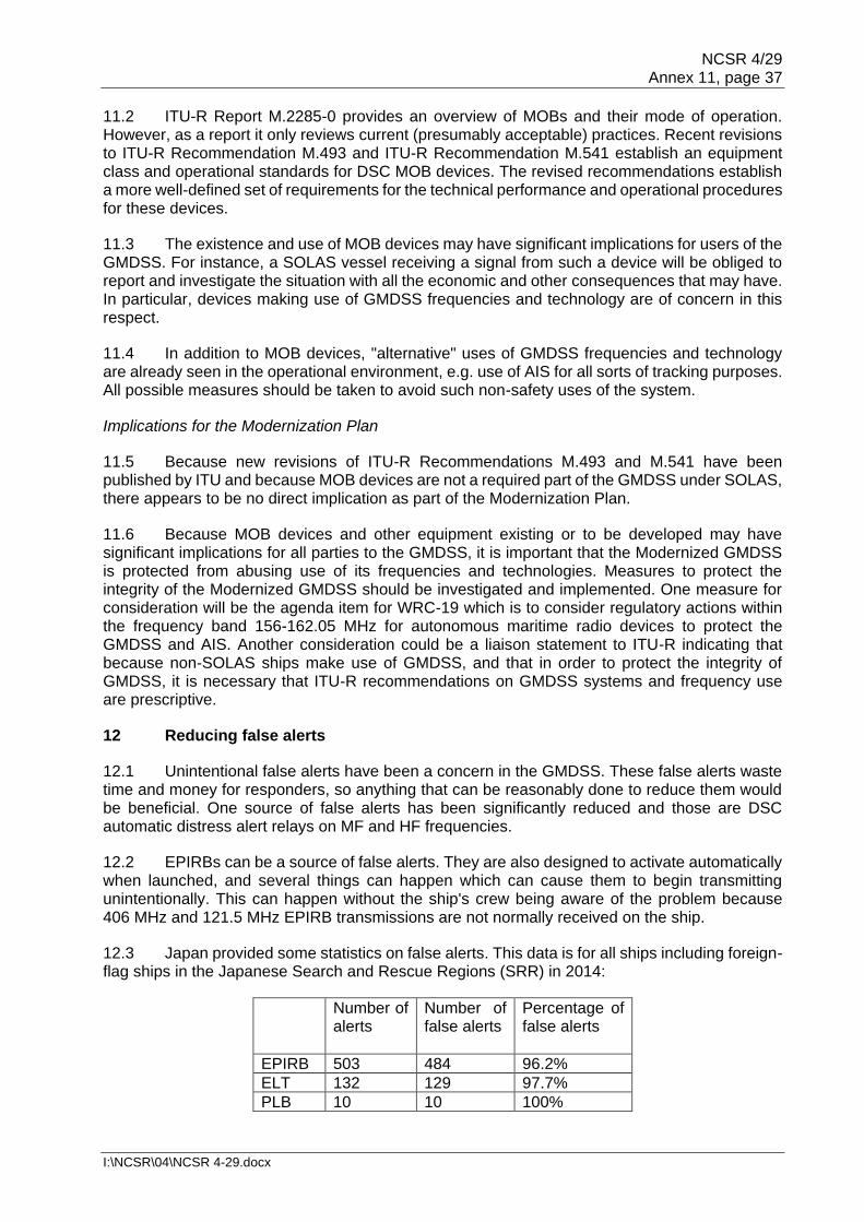
NCSR 4/29 Annex 11, page 37
I:\NCSR\04\NCSR 4-29.docx
11.2 ITU-R Report M.2285-0 provides an overview of MOBs and their mode of operation. However, as a report it only reviews current (presumably acceptable) practices. Recent revisions to ITU-R Recommendation M.493 and ITU-R Recommendation M.541 establish an equipment class and operational standards for DSC MOB devices. The revised recommendations establish a more well-defined set of requirements for the technical performance and operational procedures for these devices.
11.3 The existence and use of MOB devices may have significant implications for users of the GMDSS. For instance, a SOLAS vessel receiving a signal from such a device will be obliged to report and investigate the situation with all the economic and other consequences that may have. In particular, devices making use of GMDSS frequencies and technology are of concern in this respect.
11.4 In addition to MOB devices, "alternative" uses of GMDSS frequencies and technology are already seen in the operational environment, e.g. use of AIS for all sorts of tracking purposes. All possible measures should be taken to avoid such non-safety uses of the system.
Implications for the Modernization Plan
11.5 Because new revisions of ITU-R Recommendations M.493 and M.541 have been published by ITU and because MOB devices are not a required part of the GMDSS under SOLAS, there appears to be no direct implication as part of the Modernization Plan.
11.6 Because MOB devices and other equipment existing or to be developed may have significant implications for all parties to the GMDSS, it is important that the Modernized GMDSS is protected from abusing use of its frequencies and technologies. Measures to protect the integrity of the Modernized GMDSS should be investigated and implemented. One measure for consideration will be the agenda item for WRC-19 which is to consider regulatory actions within the frequency band 156-162.05 MHz for autonomous maritime radio devices to protect the GMDSS and AIS. Another consideration could be a liaison statement to ITU-R indicating that because non-SOLAS ships make use of GMDSS, and that in order to protect the integrity of GMDSS, it is necessary that ITU-R recommendations on GMDSS systems and frequency use are prescriptive.
12 Reducing false alerts
12.1 Unintentional false alerts have been a concern in the GMDSS. These false alerts waste time and money for responders, so anything that can be reasonably done to reduce them would be beneficial. One source of false alerts has been significantly reduced and those are DSC automatic distress alert relays on MF and HF frequencies.
12.2 EPIRBs can be a source of false alerts. They are also designed to activate automatically when launched, and several things can happen which can cause them to begin transmitting unintentionally. This can happen without the ship's crew being aware of the problem because 406 MHz and 121.5 MHz EPIRB transmissions are not normally received on the ship.
12.3 Japan provided some statistics on false alerts. This data is for all ships including foreign-flag ships in the Japanese Search and Rescue Regions (SRR) in 2014:
Number of alerts
Number of false alerts
Percentage of false alerts
EPIRB 503 484 96.2%
ELT 132 129 97.7%
PLB 10 10 100%

NCSR 4/29 Annex 11, page 38
I:\NCSR\04\NCSR 4-29.docx
A survey found that most false alerts were the result of human error, and that mariner education is important. Failure to remove the battery when disposing of the beacon was another cause of false alerts. False alerts as a result of beacon failure rarely occurred.
12.4 The United States Sarsat Office looked at the percentage of false alerts as a function of the beacon population by type:
False alerts as a percentage of beacon population
Percentage of total beacons registered
EPIRB 0.91 % 47%
ELT 4.33 % 18%
PLB 0.38 % 35%
SSAS 4.69 % -
Overall 1.25 %
Note: SSAS is not part of the GMDSS
By this analysis, EPIRBs and PLBs are much less of a problem than aircraft Emergency Locator Transmitters (ELT). The number of SSAS beacons is small, and that result may not be significant. One way to view the EPIRB result is that an individual EPIRB can be expected to transmit a false alert once every 110 years.
12.5 One proposal was to provide an audible signal when the EPIRB begins to transmit.
12.6 Another proposal was to require a system that would include a 406 MHz receiver on the bridge. This would require a significant expenditure throughout the SOLAS fleet and was not thought to be cost-effective. The Maritime Safety Committee has declined to include the consideration of a related proposal in the biennial agenda of the NCSR Sub-Committee (MSC 95/22, paragraph 19.10).
12.7 It was noted that, although not currently part of the GMDSS modernization proposal, the suggestion for a simple radio direction finder on certain SOLAS ships would enable ships to locate distress or urgency radio transmissions in the marine band and detect 121.5 MHz signals (see paragraph 9.9). This would also allow for monitoring of ship's EPIRBs to detect unintentional activations. In this regard, the suggestion was supported to invite IMO to encourage its Member Governments to consider such a requirement for certain categories of ships (for instance offshore industry vessels).
Implications for the Modernization Plan
12.8 No specific action has been identified to reduce false alerts. Manufacturers should be made aware of the problem, perhaps through a circular recommending that they seek to reduce the susceptibility of their equipment to generating false alerts (note resolution A.814(19) on Guidelines for the avoidance of false distress alerts). It should also encourage reduction of false alerts caused by human error. Proper disposal should be emphasized, including removal of the battery. Measures should be taken to guide/educate people on how to handle EPIRBs in order to avoid misactivation, including seafarers, operators, shipyards (both for building and recycling), inspectors and surveyors.
13 Coordination with the work on the implementation of the e-navigation Strategy Implementation Plan
13.1 The GMDSS and other communication technologies are at the core of the e-navigation strategy, providing ship-to-shore and shore-to-ship exchange of data. AIS and ECDIS are the newest technologies included in SOLAS. AIS uses VHF maritime frequencies and ECDIS can

NCSR 4/29 Annex 11, page 39
I:\NCSR\04\NCSR 4-29.docx
indicate the position of the AIS signal on an electronic chart display. GMDSS satellite service providers will provide much of the communication capacity for e-navigation. VHF Data Exchange System (VDES) is another e-navigation technology in development that uses the VHF maritime frequencies. Furthermore, Digital Radio Mondial (DRM) has developed new capacity with digital transmission such as NAVDAT on MF.
13.2 Various e-navigation aspects considered included:
.1 e-navigation gap analysis;
.2 the need to integrate navigation systems and communication systems;
.3 the need to read MSI in graphical display;
.4 functionalities for shore-to-shore communications;
.5 common shore-based system architecture (CSSA) for communications;
.6 usability of equipment;
.7 software quality assurance of equipment;
.8 man-machine interface; and
.9 the scalability to all types of vessels.
13.3 The GMDSS modernization project could be a framework to develop e-navigation communication by primarily securing in SOLAS the fundamental principles of communication for safeguarding human life at sea by the Contracting Governments.
13.4 The GMDSS modernization project could offer a possible common shore-based system architecture (CSSA) for communication by sharing for instance a Coastal Radio Station for different users: Rescue Co-ordination Centre (RCC), Maritime Assistance Service (MAS), Vessel Traffic Service (VTS), Maritime Safety Information (MSI) provider, Public Correspondence (PC).
Implications for the Modernization Plan
13.5 The GMDSS modernization project should support the e-navigation Strategy of IMO (MSC 85/26/Add 1, Annex 20).
14 Role of VDES
14.1 The VHF Data Exchange System (VDES) was developed by IALA to address emerging indications of overload of the AIS VHF Data Link (VDL) and simultaneously enabling a wider seamless data exchange for the maritime community. VDES is capable of exchanging Application Specific Messages (ASM), facilitating numerous applications for safety and security of navigation, protection of marine environment, efficiency of shipping and others. VDES will prospectively have a significant beneficial impact on the maritime information services including Aids to Navigation and VTS in the future. It can potentially provide local MSI.
14.2 The VDES concept includes a satellite component. This system component might be suitable to be used for the transmission of MSI information in remote areas.
14.3 The VDES concept is being developed under of Agenda Item 1.9 for WRC-19.

NCSR 4/29 Annex 11, page 40
I:\NCSR\04\NCSR 4-29.docx
Implications for the Modernization Plan
14.4 The use of VDES needs to be considered in future possible mechanisms for the distribution of MSI.
15 Role of text messages, digital data, and/or distress chat via satellite
15.1 Text messages and chat technologies are means of two-way communication, like voice and NBDP. Resolution A.1001(25) already addresses data communication systems. Under resolution A.1001(25), voice communication systems connect to the PSTN, and data communication systems connect to the public data communication network. Text messages and chat are data communication systems, so there may be no reason why they cannot be used for GMDSS communications. Safety-related messaging is also available through the AIS system.
Implications for the Modernization Plan
15.2 Consideration should be given to the possible SAR benefits of the inclusion of text messaging, digital data, and chat messaging capabilities.
15.3 Resolution A.1001(25) may need to be reviewed to investigate whether text messages, digital data, and chat can be included in GMDSS communications.
16 Other revisions to SOLAS chapter IV
16.1 SOLAS chapter IV includes several provisions that are obsolete or otherwise in need of revision:
.1 As decided under the High-level Review, "Security communications" and "Other communications" should be added to the functional requirements in addition to the GMDSS functions.
.2 There are obsolete references to the International Radio Consultative Committee (CCIR).
.3 Some terms and definitions are not consistent with the Radio Regulations and other ITU-R documents.
.4 Regulation IV/6.2.5 refers to unspecified "other codes" to be clearly marked on the radio installation.
.5 VHF EPIRBs have never been introduced.
.6 Certain regulations, such as IV/9.1.2, should be simplified because separate DSC watch receivers are not common and modern equipment practice integrates the radio functions into a single installation.
.7 Regulation IV/12.3 needs to be revised to reflect the decision to retain the VHF Channel 16 watch. A continuous listening watch is also needed in some areas for VTS, Maritime Assistance Service, coastal surveillance, ship reporting, port approaches, etc.
.8 Regulation IV/18 exempts communication equipment from automatically receiving the ship's position if the ship is not provided with a navigation receiver. Such receivers are now required on all ships under regulation V/19.2.1.6.

NCSR 4/29 Annex 11, page 41
I:\NCSR\04\NCSR 4-29.docx
Implications for the Modernization Plan
16.2 Definitions are needed for "Security communications" and "Other communications", as well as requirements for radio installations to perform these functions.
16.3 In accordance with the decisions of the High-level Review, "Security communications" and "Other communications" need to be added to the functional requirements in chapter IV.
16.4 References to the International Radio Consultative Committee (CCIR) should be changed to the International Telecommunications Union (ITU-R).
16.5 Terms and definitions should be harmonized with the Radio Regulations and other ITU-R documents.
16.6 Regulation IV/6.2.5 should be revised to clarify the "other codes" required to be clearly marked on the radio installation.
16.7 The VHF EPIRB should be removed from SOLAS chapter IV.
16.8 Revise and simplify regulations, such as IV/9.1.2, to reflect that separate DSC watch receivers are no longer common and modern equipment practice integrates the radio functions into a single installation.
16.9 Revise regulation IV/12.3 to reflect the decision to retain the VHF Channel 16 watch, as well as continuous listening watches; also in some areas for general communications including VTS, Maritime Assistance Service, coastal surveillance, ship reporting, port approaches, etc.
16.10 Remove the regulation IV/18 exemption for communication equipment from automatically receiving the ship's position if the ship is not provided with a navigation receiver.
16.11 Review chapter IV for editorial improvements.
16.12 Review and revise IMO resolutions consequential to the decisions made for GMDSS modernization.
17 Outline of the Modernization Plan
Revisions to SOLAS chapter III
17.1 Except for communications equipment installed or always carried in survival craft, the communications requirements for ships and life-saving appliances in chapter III, should be moved to chapter IV (see paragraph 8.2).
17.2 A decision needs to be made as to whether all lifeboats, and whether some or all inflatable liferafts, should be equipped with installed locating devices, and that requirement located in chapter III with other survival craft equipment (see paragraph 9.12).
17.3 The "Record of Equipment" list in the certificates for these items will need to be appropriately amended (see paragraph 8.3).

NCSR 4/29 Annex 11, page 42
I:\NCSR\04\NCSR 4-29.docx
Revisions to SOLAS chapter IV
17.4 The GMDSS modernization process should ensure that non-SOLAS vessels are not excluded from participating in the GMDSS for technical or economic reasons, and such instruments as affect non-SOLAS vessels should be compatible with the GMDSS (see paragraph 10.3).
17.5 The GMDSS modernization project needs to continue to support the needs of the e-navigation strategy (see paragraph 13.5).
17.6 SOLAS chapter IV should be revised to provide for other GMDSS satellite service providers in addition to Inmarsat (see paragraph 3.18).
17.7 NBDP can be removed as a required system, although existing devices can be permitted to remain in use to receive MSI, if a ship is not equipped with other equipment suitable for the purpose (see paragraph 5.7).
17.8 SOLAS chapter IV should be revised to allow NAVDAT service to be used in place of NAVTEX in places where NAVDAT is available (see paragraph 6.4).
17.9 Ship certificates will require definition of the geographical area in which the ship is permitted to sail with respect to Sea Areas A3 and A4. This can be accomplished by indicating the ship's GMDSS satellite service provider in brackets after the "A3", such as "A3 (Worldwidesat)" (see paragraph 3.13).
17.10 SOLAS regulations, including as a minimum IV/2, IV/10 and IV/11, will need to be revised to reflect the revised Sea Areas A3 and A4 (see paragraph 3.18).
17.11 Definitions are also needed for "Security communications" and "Other communications", as well as requirements for radio installations to perform these functions (see paragraph 16.2).
17.12 References to the International Radio Consultative Committee (CCIR) should be changed to the International Telecommunications Union (ITU-R) (see paragraph 16.4).
17.13 Terms and definitions should be harmonized with the Radio Regulations and other ITU-R documents (see paragraph 16.5).
17.14 "Security communications" and "Other communications" should be added to the functional requirements in addition to the GMDSS functions (see paragraph 16.3).
17.15 Regulation IV/6.2.5 should be revised to clarify the "other codes" required to be clearly marked on the radio installation (see paragraph 16.6).
17.16 The VHF EPIRB should be removed from SOLAS chapter IV (see paragraph 16.7).
17.17 Revise and simplify regulations, such as IV/9.1.2, to reflect that separate DSC watch receivers are no longer common and modern equipment practice integrates the radio functions into a single installation (see paragraph 16.8).
17.18 Revise regulation IV/12.3 to reflect the decision to retain the VHF Channel 16 watch, as well as continuous listening watches is also in some areas for general communications including VTS, Maritime Assistance Service, coastal surveillance, ship reporting, port approaches, etc. (see paragraph16.9).

NCSR 4/29 Annex 11, page 43
I:\NCSR\04\NCSR 4-29.docx
17.19 Remove the regulation IV/18 exemption for communication equipment from automatically receiving the ship's position if the ship is not provided with a navigation receiver (see paragraph 16.10).
17.20 Review chapter IV for editorial improvements (see paragraph 16.11).
Other IMO Instruments
17.21 Refer to annex 1 of this report.
17.22 No specific action has been identified to reduce false alerts. Manufacturers should be made aware of the problem, perhaps through a circular recommending that they seek to reduce the susceptibility of their equipment to generating false alerts. Note resolution A.814(19) on Guidelines for the avoidance of false distress alerts. It should also encourage reduction of false alerts caused by human error. Proper disposal should be emphasized, including removal of the battery. Measures should be taken to guide/educate people on how to handle EPIRBs in order to avoid misactivation, including seafarers, operators, shipyards (both for building and recycling), inspectors and surveyors (see paragraph 12.8).
17.23 IMO and ITU should develop the necessary technical recommendations and performance standards for international NAVDAT service. This work should be closely followed by the development of IMO and IEC standards for shipborne NAVDAT and/or combined NAVTEX/NAVDAT equipment (see paragraphs 5.7 and 6.4).
17.24 Consider the development of a circular or other instrument to encourage Member Governments to adopt a requirement for certain categories of ships to carry VHF direction finders to detect 121.5 MHz signals and VHF marine band transmissions (for instance off shore industry vessels) (see paragraph 9.11).
17.25 Consideration should be given to the possible SAR benefits of the inclusion of text messaging, digital data, and chat messaging capabilities (see paragraph 15.2).
17.26 Mariner training will be affected and amendments to STCW including Model Courses may be required. Model Courses will in general need to be revised to reflect the new Sea Area A3 definition and its effect on Sea Area A4, together with other amendments to chapter IV. Mariner training will be affected and amendments to STCW may be required (see paragraphs 3.11 and 3.23).
17.27 New and revised IMO instruments should not exclude non-SOLAS vessels from participating in the GMDSS for technical or economic reasons, and such instruments as affect non-SOLAS vessels should be compatible with the GMDSS (see paragraph 10.3).
17.28 The technical basis for determining the minimum number of HF GMDSS coast stations and their geographical distribution should be reviewed and, if necessary, consequential changes should be included in resolution A.801(19) (see paragraphs 4.13 and also 17.34 regarding guidance for CRS).
ITU Reports and Resolutions
17.29 IMO and ITU should develop the necessary technical and operational recommendations and performance standards for international NAVDAT service (see paragraph 6.5).

NCSR 4/29 Annex 11, page 44
I:\NCSR\04\NCSR 4-29.docx
17.30 Consideration should be given to a liaison statement to ITU-R indicating that it is desirable that non-SOLAS ships make use of the GMDSS, and that in order to protect the integrity of the GMDSS, it is necessary that ITU-R recommendations on GMDSS systems and frequency use are prescriptive (see paragraph 11.6).
17.31 New and revised ITU instruments should not exclude non-SOLAS vessels from participating in the GMDSS for technical or economic reasons, and such instruments as affect non-SOLAS vessels should be compatible with the GMDSS (see paragraph 10.3).
17.32 Consider the future role for HF data exchange under ITU-R Recommendation 1798 1 (see paragraph 5.8).
IEC Standards
17.33 Completion of IMO and ITU technical and operational recommendations and performance standards for international NAVDAT service, should be followed by the development of IEC standards for shipborne NAVDAT equipment (see paragraph 6.5).
17.34 Guidance for coastal radio stations (CRS) should be established through the development of IEC standards (see paragraph 7.4).
Provision of GMDSS satellite services
17.35 Formatting of EGC should be standardized if possible to minimize delays, and if possible, a way should be found to transmit EGC simultaneously on all GMDSS satellite service providers (see paragraph 2.19).
MSI providers
17.36 Possible ways for MSI providers to provide and monitor MSI broadcasts over multiple GMDSS satellite service providers should be identified with a view to minimizing the costs, or at least the cost increases for MSI providers. Resolution A.707(17) could be revised to provide for shore-to-ship MSI broadcasts without charge to the originator (see paragraph 2.18).
17.37 Determine whether it is possible and feasible to retain the current requirement to be able to receive MSI using EGC (SOLAS regulation IV/7.1.5), taking into account the new definition of Sea Area A3 and the inclusion of new satellite providers in the GMDSS (see paragraph 3.19).
17.38 Depending on conclusions under paragraph 17.37, determine whether changes are required to the availability of HF-MSI in certain areas as a consequence of the new definition of Sea Area A3 and the inclusion of new satellite providers in the GMDSS (see paragraph 3.20).
17.39 The use of VDES needs to be considered in future possible mechanisms for the distribution of MSI (see paragraph 14.4).
HF communications
17.40 Technological improvements can make HF easier to use. Consider revising resolutions A.806(19) and MSC.68(68), annex 3, to include a requirement for frequency scanning and/or ALE (see paragraphs 4.13 and 4.14).

NCSR 4/29 Annex 11, page 45
I:\NCSR\04\NCSR 4-29.docx
Transitional provisions
17.41 Administrations, port State control authorities, and classification societies need to be informed of the change to Sea Area A3/A4, and a suitable transition period needs to be identified for certificates (see paragraph 3.24).
18 Elements considered during the Detailed Review and their disposition
18.1 During discussions on the Detailed Review of the GMDSS, a number of possible changes were considered. Annex 2 identifies the subjects that were considered and determined not to be included in GMDSS modernization.
***

NCSR 4/29 Annex 12, page 1
I:\NCSR\04\NCSR 4-29.docx
ANNEX 12
PROPOSAL FOR A NEW OUTPUT: REVISION OF SOLAS CHAPTERS III AND IV FOR MODERNIZATION OF THE GLOBAL MARITIME DISTRESS AND SAFETY SYSTEM (GMDSS), INCLUDING RELATED AND
CONSEQUENTIAL AMENDMENTS TO OTHER EXISTING INSTRUMENTS Introduction
1 This document, submitted in accordance with paragraphs 4.1, 4.6 and 5.9, and annex 1 of MSC-MEPC.1/Circ.5, MSC-MEPC.7/Circ.1 and MSC.1/Circ.1500, proposes a new output for the inclusion in the High-level Action Plan of the Organization on the Revision of SOLAS chapters III and IV, as well as necessary related and consequential amendments to other existing instruments in order to implement the Global Maritime Distress and Safety System (GMDSS) Modernization Plan (NCSR 4/29, annex 11). IMO objectives 2 The proposed output will enable the use of modern communication systems in the GMDSS, while removing the requirement to carry obsolete systems such as Narrow Band Direct Printing (NBDP) if the ship does not use them to meet the functional requirements of the GMDSS.
3 While it is not envisaged to establish new carriage requirements for ships1, the revised GMDSS which is planned to enter into force in 2024, will provide for the introduction of new services and systems, such as other terrestrial communications using digital technologies for receiving Maritime Safety Information, and for enhanced and more reliable Search and Rescue capabilities by, for example, including the Cospas-Sarsat MEOSAR system.
4 The proposal directly supports IMO High Level Actions 5.1.3 to enhance safety of navigation, 5.2.1 for technical and operational safety aspects of all types of ships, 5.2.5 to monitor and evaluate the operation of the GMDSS and 5.2.6 as it is intended to support the e-navigation strategy (resolution A.1098(29)).
Compelling need
5 The Global Maritime Distress and Safety System (GMDSS) was adopted as part of the 1988 Amendments to the International Convention for the Safety of Life at Sea, 1974 (SOLAS). It was fully implemented in 1999, and it has served the seafarer and the maritime industry well since its inception, but some of the GMDSS technologies used have not reached their full potential, and after more than 30 years since their development, some GMDSS functions could be performed by more modern technologies. 6 The compelling need for modernization of the GMDSS also derives from the need to harmonize the IMO provisions with the ITU's Radio Regulations and the deletion of references to obsolete communication systems such as the VHF EPIRB which has never been implemented. The review of the GMDSS also needs to incorporate correct references to present Cospas-Sarsat systems, a modified definition of Sea Area A3, provide for optional use of other terrestrial communications using digital technologies for receiving Maritime Safety Information, removal of the requirement to carry equipment for direct-printing telegraphy, reflect the correct VHF Channel 16 continuous listening watch requirements, and consideration of the need for more search and rescue locating devices on survival craft. Further editorial revisions should include updating references in IMO instruments, for instance changing CCIR to ITU-R, replacing any
1 Only new SAR carriage requirements for lifeboats and life-rafts are considered.

NCSR 4/29 Annex 12, page 2
I:\NCSR\04\NCSR 4-29.docx
references to Inmarsat by the generic reference "recognized mobile-satellite service", revision of any wording that suggests that a GMDSS work station is required separate from the ship's main radio installation, and updating footnotes to reference current IMO instruments. 7 The resolutions and circulars requiring revision are listed at appendix 1, along with a brief description of the changes needed. Analysis of the issue 8 Some provisions of chapter IV of SOLAS are out of date. With the possible exception of the addition of more search and rescue locating devices on survival craft, no new carriage requirements will be introduced, and some existing equipment requirements will be removed. New ships will be able to fit modern equipment and will not need to carry obsolete systems, while existing ships will be able to continue using their existing communication systems. Analysis of implications 9 The additional administrative requirements or burdens to the Organization or to the shipping industry will be minimal as a result of the proposed revisions as set out in the Modernization Plan of the GMDSS. If an additional carriage requirement for ships would be adopted, for example requiring additional search and rescue locating devices on survival craft, the cost to the shipping industry is expected to be manageable. In addition, search and rescue services will benefit from better location information from survival craft, resulting in a higher safety standard and reduced costs to Administrations that provide search and rescue services. 10 The administrative checklist, MSC-MEPC.1/Circ.5, annex 5, is attached to this document as appendix 2. Benefits 11 The adoption of amendments to SOLAS chapters III and IV will improve ship safety and facilitate distress, urgency, safety and routine ship-to-ship and ship-to-shore communications. The revision of the GMDSS through SOLAS amendments will enhance, in particular, search and rescue at sea and provide for harmonization with related instruments of other regulating bodies, such as ITU. With the deletion of obsolete provisions, particularly in chapter IV of the SOLAS Convention, ship owners, marine administrations and the IMO will be relieved of maintaining and supervising systems and processes which are not, or no longer, being used in the GMDSS. Industry standards 12 In close cooperation with the International Electrotechnical Commission (IEC), the IEC standards that now support equipment under SOLAS chapter IV will be amended or withdrawn, if such equipment is no longer required under SOLAS. IEC will need to continue to maintain testing standards for GMDSS equipment as technology advances. Output 13 The output will be revised chapters III and IV:
.1 Specific: Amendments to SOLAS chapters III and IV, as well as necessary related and consequential amendments to other existing instruments in order to implement the Global Maritime Distress and Safety System (GMDSS) Modernization Plan;
.2 Measureable: Completed, approved and adopted instruments;

NCSR 4/29 Annex 12, page 3
I:\NCSR\04\NCSR 4-29.docx
.3 Achievable: MSC's subsidiary bodies have the expertise required; .4 Realistic: Ample time is proposed to complete the work; and .5 Time-Bound: The work is expected to take four years (two biennia) to complete
– 2018-2019 and 2020-2021. Amendments would be approved by MSC in 2021, adopted by MSC in 2022 for entry into force in 2024.
Human element 14 This proposal is consistent with the goals of the Organization and is based upon the vision and principles described in resolution A.947(23). The expected change to training requirements for seafarers are expected to be minimal but should be reflected in the applicable revised IMO model courses. The completed human element checklist from MSC-MEPC.7/Circ.1 is attached to this document as appendix 3. Urgency and target completion year 15 With direct relevance to the objective of enhancing technical, operational and safety management standards, and noting the Modernization Plan of the GMDSS, it is believed that this work is of paramount importance. 16 The work is expected to take four years (two biennia) to complete, from 2018 to 2019 and from 2020 to 2021. Amendments are expected to be approved by the MSC in 2021, adopted in 2022, for entry into force in 2024. A Plan of Work is provided in annex 1 of the Modernization Plan. 17 This initiative should be considered by the Organization as soon as possible and be included in the High-level Action Plan of the Organization and priorities for the 2018-2019 biennium. The NCSR Sub-Committee with the support of the HTW and SSE Sub-Committees, as required, is expected to need four sessions to complete its work starting from NCSR 5 in 2018. Action requested of the Committee 18 The Committee is invited to include a new output on "Revision of SOLAS chapters III and IV for Modernization of the Global Maritime Distress and Safety System (GMDSS), including related and consequential amendments to other existing instruments" in the 2018-2019 biennial agenda of the NCSR, HTW and SSE Sub-Committees and the provisional agenda for HTW 5, NCSR 5 and SSE 5, with a target completion year of 2021.

NCSR 4/29 Annex 12, page 4
I:\NCSR\04\NCSR 4-29.docx
APPENDIX 1
LIST OF IMO INSTRUMENTS TO BE REVISED
Resolution A.806(19) as amended by MSC.68(68) annex 3
Performance standards for shipborne MF/HF radio installations capable of voice communications and digital selective calling
May need to be revised with respect to decisions on NBDP
Consider requirement for Automatic Link Establishment (ALE)
Resolution A.805(19) Performance standards for float-free VHF emergency position-indicating radio beacons
To be revoked
Resolution A.801(19) as amended by MSC.199(80)
Provision of radio services for the global maritime distress and safety system (GMDSS)
Will need to be revised in respect of new satellite providers and A3 and A4 Sea Areas
Resolution A.707(17) Charges for Distress, Urgency and Safety Messages through the Inmarsat System
Revise for additional satellite service providers
Consider provision of shore-to-ship MSI broadcasts without charge to the originator
Resolution A.702(17) Radio maintenance guidelines for the global maritime distress and safety system (GMDSS) related to sea areas A3 and A4
References to Sea Areas and Inmarsat need to be revised
Resolution MSC.306(87) Revised performance standards for Enhanced Group Call (EGC) equipment
Make provision for any additional satellite service providers, if necessary
Resolution MSC.131(75) Maintenance of a continuous listening watch on VHF channel 16 by SOLAS ships whilst at sea and installation of VHF DSC facilities on non-SOLAS ships
Revoke or revise. (Note that the resolution encourages use of VHF DSC and does not reflect decision on continued channel 16 watch. A new instrument may be needed to contain the elements that are still relevant and of importance)
Resolution MSC.68(68), annex 3
Performance Standards for MF/HF Radio Installations Capable Of Voice Communication, Narrow Band Direct Printing And Digital Selective Calling
Consider requirement for frequency scanning and/or Automatic Link Establishment (ALE)

NCSR 4/29 Annex 12, page 5
I:\NCSR\04\NCSR 4-29.docx
MSC.1/Circ.1460 Guidance on the Validity of Radiocommunications Equipment Installed and Used on Ships
Remove reference to HF radiocommunication equipment capable of operating NBDP
MSC/Circ.1040/Rev.1 Guidelines on annual testing of 406 MHz satellite EPIRBs
Ensure Guidelines are relevant for Second Generation Beacons
Provide for EPIRBs with AIS locators
MSC/Circ.1039 Guidelines for shore-based maintenance of satellite EPIRBs
Revise to include AIS locators
Delete L-band EPIRB
Review for needed changes in respect of Second Generation Beacons
MSC/Circ.1038 Guidelines for general radiocommunications
Requires revision with respect to "general communications"
MSC/Circ.803 Participation of non-SOLAS ships in the GMDSS
Should be reviewed and generally updated (reference to 2182 kHz alarm signal which has been removed in COLREG by Res. A.1004(25)/Rev.1)
COMSAR.1/Circ.50/Rev.3 Distress priority communications for RCC from shore-to-ship via Inmarsat
Consider whether similar circular is needed for additional satellite providers
COMSAR/Circ.37 Guidance on minimum communication needs of Maritime Rescue Co-ordination Centres (MRCCs)
Make provision for any additional satellite service providers and revise any Inmarsat-specific terms such as SafetyNET.
Review section on Telex link – is it used?
COMSAR/Circ.32 Harmonization of GMDSS requirements for radio installations on board SOLAS ships
Some terms need revision, i.e. "radar transponder"; "A3" and "A4" will have different meanings
Update channel 16 watch requirements
Is description of radio work station consistent with current bridge design?
Make provision for any additional satellite service providers
COMSAR/Circ.17 Recommendation on use of GMDSS equipment for non-safety communications
Consider including in a revision of MSC/Circ.1038

NCSR 4/29 Annex 12, page 6
I:\NCSR\04\NCSR 4-29.docx
COM/Circ.117 Clarifications of the application of certain provisions of chapter IV of the SOLAS Convention
Should be able to be revoked after adoption of revised chapter IV
COM/Circ.110 + Corr.1 Clarifications of SOLAS regulations IV/6.1, IV/6.2.2 and IV/10.1.1.3
Should be able to be revoked after adoption of revised chapter IV
COM/Circ.105 + Corr.1 Clarification of certain provisions of the 1998 SOLAS amendments for the GMDSS
Should be able to be revoked after adoption of revised chapter IV

NCSR 4/29 Annex 12, page 7
I:\NCSR\04\NCSR 4-29.docx
APPENDIX 2
CHECKLIST FOR IDENTIFYING ADMINISTRATIVE REQUIREMENTS AND BURDENS
This checklist should be used when preparing the analysis of implications required for submissions of proposals for inclusion of unplanned outputs. For the purpose of this analysis, the terms "administrative requirements" and "burdens" are as defined in resolution A.1043(27) on Periodic review of administrative requirements in mandatory IMO instruments, i.e. administrative requirements are an obligation arising from future IMO mandatory instruments to provide or retain information or data, and administrative burdens are those administrative requirements that are or have become unnecessary, disproportionate or even obsolete. Instructions:
(A) If the answer to any of the questions below is YES, the Member State proposing an unplanned output should provide supporting details on whether the burdens are likely to involve start-up and/or ongoing cost. The Member State should also give a brief description of the requirement and if possible, provide recommendations for further work (e.g. would it be possible to combine the activity with an existing requirement?).
(B) If the proposal for the unplanned output does not contain such an activity, answer NR (Not required).
1. Notification and reporting? Reporting certain events before or after the event has taken place, e.g. notification of voyage, statistical reporting for IMO Members, etc.
NR Yes □ Start-up □ Ongoing
Description: (if the answer is yes)
2. Record keeping? Keeping statutory documents up to date, e.g. records of accidents, records of cargo, records of inspections, records of education, etc.
NR Yes □ Start-up □ Ongoing
Description: (if the answer is yes)
3. Publication and documentation? Producing documents for third parties, e.g. warning signs, registration displays, publication of results of testing, etc.
NR Yes □ Start-up □ Ongoing
Description: (if the answer is yes) 4. Permits or applications? Applying for and maintaining permission to operate, e.g. certificates, classification society costs, etc.
NR Yes □ Start-up □ Ongoing
Description: (if the answer is yes)
5. Other identified burdens? NR Yes
□ Start-up
□ Ongoing Description: (if the answer is yes)

NCSR 4/29 Annex 12, page 8
I:\NCSR\04\NCSR 4-29.docx
APPENDIX 3
CHECKLIST FOR CONSIDERING HUMAN ELEMENT ISSUES BY IMO BODIES
Instructions: If the answer to any of the questions below is:
(A) YES, the preparing body should provide supporting details and/or recommendation for further work. (B) NO, the preparing body should make proper justification as to why human element issues were not considered. (C) NA (Not Applicable), the preparing body should make proper justification as to why human element issues were not considered applicable.
Subject Being Assessed: Modernization of the Global Maritime Distress and Safety System (GMDSS)
Responsible Body: Sub-Committee on Navigation, Communications and Search and Rescue
1. Was the human element considered during development or amendment process related to this subject?
Yes No NA
2. Has input from seafarers or their proxies been solicited? Yes No NA
3. Are the solutions proposed for the subject in agreement with existing instruments? (Identify instruments considered in comments section)
Yes No NA
4. Have human element solutions been made as an alternative and/or in conjunction with technical solutions?
Yes No NA
5. Has human element guidance on the application and/or implementation of the proposed solution been provided for the following:
• Administrations? Yes No NA
• Ship owners/managers? Yes No NA
• Seafarers? Yes No NA
• Surveyors? Yes No NA
6. At some point, before final adoption, has the solution been reviewed or considered by a relevant IMO body with relevant human element expertise?
Yes No NA
7. Does the solution address safeguards to avoid single person errors? Yes No NA
8. Does the solution address safeguards to avoid organizational errors? Yes No NA
9. If the proposal is to be directed at seafarers, is the information in a form that can be presented to and is easily understood by the seafarer?
Yes No NA
10. Have human element experts been consulted in development of the solution?
Yes No NA
11. HUMAN ELEMENT: Has the proposal been assessed against each of the factors below?
safely operate, maintain, support, and provide training for system.
Yes No NA
experience levels that are needed to properly perform job tasks.
Yes No NA
improve the necessary knowledge, skills, and abilities to achieve desired job/task performance.
Yes No NA
programmes, procedures, policies, training, documentation, equipment, etc. to properly manage risks.
Yes No NA

NCSR 4/29 Annex 12, page 9
I:\NCSR\04\NCSR 4-29.docx
the safety, health, and comfort of those on working on board, such as noise, vibration, lighting, climate, and other factors that affect crew endurance, fatigue, alertness and morale.
Yes No NA
illness, injury, or death in a catastrophic event such as fire, explosion, spill, collision, flooding, or intentional attack. The assessment should consider desired human performance in emergency situations for detection, response, evacuation, survival and rescue and the interface with emergency procedures, systems, facilities and equipment.
-system interface to be consistent with the physical, cognitive, and sensory abilities of the user population.
NA
Comments: (1) Justification if answers are NO or Not Applicable. (2) Recommendations for additional human element assessment needed. (3) Key risk management strategies employed. (4) Other comments. (5) Supporting documentation. The Sub-Committee on Human Element, Training and Watchkeeping (HTW) has been consulted mainly on the matters of training and model courses that will be affected by GMDSS revisions. Seafarer input has been provided by NCSR observer non-governmental organizations, and in some cases results from surveys of seafarers.

NCSR 4/29 Annex 12, page 10
I:\NCSR\04\NCSR 4-29.docx
APPENDIX 4
CHECK/MONITORING SHEET FOR THE PROCESS OF AMENDMENTS TO THE CONVENTION AND RELATED MANDATORY INSTRUMENTS
(PROPOSAL/DEVELOPMENT)
Part I – Submitter of the proposal
1 Submitted by MSC [104]/. . . , Sub-Committee on Navigation, Communication and Search and Rescue
2 Meeting session MSC [104]
3 Date (date of the submission)
Part II – Details of the proposed amendment(s) or new mandatory instrument
1 High-level Action Plan
5.1.3, 5.2.1, 5.2.5, and 5.2.6
2 Planned output
Amendment to SOLAS
3 Recommended type of amendments (MSC.1/Circ.1481)
Four-year cycle of entry into force
4 Intended instrument(s) to be amended
SOLAS
5 Intended application (scope, size, type, tonnage/length restriction, service (International/non-international), activity, etc.)
The proposed amendments should apply to all ships to which Chapter IV applies
6 Application to new/existing ships (i.e. if intended to be a retro-active application)
The proposed amendments should apply to new and existing ships
7 Proposed coordinating sub-committee
Sub-Committee on Navigation, Communication and Search and Rescue (NCSR)
8 Anticipated supporting sub-committees
Sub-Committee on Human Element, Training and Watchkeeping (HTW) Sub-Committee on Ship Systems and Equipment (SSE)
9 Time scale for completion
2022 (final adoption by the Committee)
10 Expected date(s) for entry into force and implementation/application
[1 January] 2024
11 Any relevant decision taken or instruction given by the Committee
***

NCSR 4/29 Annex 13, page 1
I:\NCSR\04\NCSR 4-29.docx
ANNEX 13
DRAFT AMENDMENTS1 TO SOLAS CHAPTER IV
Radiocommunications
PART A GENERAL
Regulation 2 - Terms and definitions
1 The existing subparagraph 1.16 is amended to read as follows:
".16 Global maritime distress and safety system (GMDSS) identities means maritime mobile services identity, the ship's call sign, lnmarsat recognized mobile satellite service identities and serial number identity which may be transmitted by the ship's equipment and used to identify the ship."
PART C SHIP REQUIREMENTS
Regulation 7 - Radio equipment: General
2 The existing subparagraph 1.5 is amended to read as follows:
".5 a radio facility for reception of maritime safety information by the lnmarsat recognized mobile satellite service enhanced group calling system if the ship is engaged on voyages in any area of lnmarsat recognized mobile satellite service coverage but in which an international NAVTEX service is not provided. However, ships engaged exclusively on voyages in areas where an HF direct-printing telegraphy maritime safety information service is provided and fitted with equipment capable of receiving such service, may be exempt from this requirement.*
__________________
* Refer to the Recommendation on promulgation of maritime safety information adopted by the
Organization by resolution A.705(17), as amended." Regulation 8 - Radio equipment: Sea area A1
3 The existing subparagraph 1.5 is amended to read as follows:
".5 through the lnmarsat geostationary a recognized mobile satellite service; this requirement may be fulfilled by:
.5.1 an lnmarsat a ship earth station* providing a recognized mobile satellite service; or _____________
* This requirement can be met by Inmarsat ship earth stations capable of two-way communications, such as Inmarsat-B and Fleet-77 (resolutions A.808(19) and MSC.130(75)) or Inmarsat-C (resolution A.807(19), as amended) ship earth stations. Unless otherwise specified, this footnote applies to all requirements for an Inmarsat ship earth station prescribed by this chapter.
1 Tracked changes are created using "strikeout" for deleted text and "grey shading" to highlight all modifications
and new insertions, including deleted text.

NCSR 4/29 Annex 13, page 2
I:\NCSR\04\NCSR 4-29.docx
.5.2 the satellite EPIRB, required by regulation 7.1.6, either by installing the satellite EPIRB close to, or by remote activation from, the position from which the ship is normally navigated."
Regulation 9 - Radio equipment: Sea areas A1 and A2
4 In paragraph 1, the existing subparagraph .3.3 is amended to read as follows:
".3.3 through the lnmarsat geostationary satellite service by a ship earth station providing a recognized mobile satellite service."
5 In paragraph 3, the existing subparagraph .2 is amended to read as follows:
".2 an lnmarsat a ship earth station providing a recognized mobile satellite service." Regulation 10 - Radio equipment: Sea areas A1, A2 and A3 6 In paragraph 1, the existing subparagraph .1 is amended to read as follows:
".1 an lnmarsat a ship earth station providing a recognized mobile satellite service and capable of:"
7 In paragraph 1, the existing subparagraph .4.3 is amended to read as follows:
".4.3 through the lnmarsat geostationary a recognized mobile satellite service by on
an additional ship earth station."
8 In paragraph 2, the existing subparagraph .3.2 is amended to read as follows:
".3.2 through the lnmarsat geostationary a recognized mobile satellite service by on a ship earth station; and"
Regulation 12 - Watches
9 In paragraph 1, the existing subparagraph .4 is amended to read as follows:
".4 for satellite shore-to-ship distress alerts, if the ship, in accordance with the requirements of regulation 10.1.1, is fitted with an lnmarsat a ship earth station providing a recognized maritime mobile service."
Regulation 13 - Sources of energy 10 The chapeau of existing paragraph 2 is amended to read as follows
"2 A reserve source or sources of energy shall be provided on every ship, to supply radio installations, for the purpose of conducting distress and safety radiocommunications, in the event of failure of the ship's main and energy sources of electrical power. The reserve source or sources of energy shall be capable of simultaneously operating the VHF radio installation required by regulation 7.1.1 and, as appropriate for the sea area or sea areas for which the ship is equipped, either the MF radio installation required by regulation 9.1.1, the MF/HF radio installation required by regulation 10.2.1 or 11.1, or the Inmarsat ship earth station required by regulation 10.1.1 and any of the additional loads mentioned in paragraphs 4, 5 and 8 for a period of at least:"
***

NCSR 4/29 Annex 14, page 1
I:\NCSR\04\NCSR 4-29.docx
ANNEX 14
DRAFT AMENDMENTS1 TO SOLAS APPENDIX
CERTIFICATES
RECORD OF EQUIPMENT FOR PASSENGER SHIP SAFETY (FORM P)
1 In part 3, the existing item 1.4 is replaced by the following:
"1.4 Inmarsat sShip earth station providing a recognized mobile satellite service"
RECORD OF EQUIPMENT FOR CARGO SHIP SAFETY RADIO (FORM R)
2 In part 2, the existing item 1.4 is replaced by the following:
"1.4 Inmarsat sShip earth station providing a recognized mobile satellite service"
RECORD OF EQUIPMENT FOR CARGO SHIP SAFETY (FORM C)
3 In part 3, the existing item 1.4 is replaced by the following:
"1.4 Inmarsat sShip earth station providing a recognized mobile satellite service"
***
1 Tracked changes are created using "strikeout" for deleted text and "grey shading" to highlight all modifications
and new insertions, including deleted text.


NCSR 4/29 Annex 15, page 1
I:\NCSR\04\NCSR 4-29.docx
ANNEX 15
DRAFT MSC CIRCULAR
REVISED GUIDELINES FOR PREPARING PLANS FOR COOPERATION BETWEEN SEARCH AND RESCUE SERVICES AND PASSENGER SHIPS
(in accordance with SOLAS regulation V/7.3) 1 The Maritime Safety Committee, at its [ninety-eighth session (7 to 16 June 2017)], having considered the recommendations made by the Sub-Committee on Navigation, Communications and Search and Rescue at its fourth session (8 to 10 March 2017), approved the Revised guidelines for preparing plans for cooperation between search and rescue services and passenger ships (in accordance with SOLAS regulation V/7.3), as set out in the annex, revoking MSC/Circ.1079. 2 Member Governments are invited to bring the annexed Revised guidelines to the attention of SAR service providers, shipowners, ship operators, ship masters and all other parties concerned and to use the provisions contained therein as appropriate.

NCSR 4/29 Annex 15, page 2
I:\NCSR\04\NCSR 4-29.docx
ANNEX
REVISED GUIDELINES FOR PREPARING PLANS FOR COOPERATION BETWEEN SEARCH AND RESCUE SERVICES AND PASSENGER SHIPS
(in accordance with SOLAS regulation V/7.3)
1 Introduction 1.1 The purpose of these Guidelines is to provide a uniform basis for the establishment of plans for cooperation between passenger ships and SAR services1 in accordance with SOLAS regulation V/7.3. Co-operation p Plans developed in accordance with the Guidelines will meet the requirements of the regulation. 1.2 These Guidelines are applicable to all passenger ships to which SOLAS chapter I applies. They are relevant to the safety management system maintained by passenger ships in accordance with the International Safety Management (ISM) Code and, in particular, to the section of the safety management system dealing with emergency preparedness. They may also be taken into consideration when drawing up SAR co-operation plans for cooperation for passenger ships in the domestic trade. 2 Aims and objectives of SAR cooperation planning 2.1 The aim of SAR cooperation planning is to enhance the mutual understanding between a ship, a company2 and SAR services so that, in the event of an emergency, all three parties will be able to work together efficiently and effectively. This is best achieved by the prior exchange of information and by conducting joint emergency response exercises. 2.2 The objectives of SAR cooperation planning are:
.1 to link the SAR response plans of the company, the passenger ship, and relevant SAR services so that these plans complement each other;
.2 to enable the early and efficient establishment of contact in the event of
emergency between the passenger ship, her the operator company's shore-based emergency response system and the SAR services. The SAR plan for cooperation should ensure that all relevant contact details are known to each of the three parties beforehand and that these details are kept up-to-date;
.3 to provide the SAR services with easily accessible and up-to-date information
about the ship – in particular her the intended voyage and her onboard communications and emergency response systems; and
.4 to provide the ship and her the operators company with easily accessible
information about SAR and other emergency services available in the ship's area of operation, to assist in decision-making and in contingency planning.
1 Search and rescue service. The performance of distress monitoring, communication, coordination and search
and rescue functions, including provision of medical advice, initial medical assistance or medical evacuation, through the use of public and private resources including cooperating aircraft, vessels and other craft and installations.
2 Company. The owner of the ship or any other organization or person such as the manager, or the bareboat
charterer, who has assumed the responsibility for operation of the ship from the owner and who, on assuming such responsibility, has agreed to take over all duties and responsibility.

NCSR 4/29 Annex 15, page 3
I:\NCSR\04\NCSR 4-29.docx
2.3 The plan for cooperation is of use when a passenger ship suffers an emergency herself or when she it responds as a SAR facility3, particularly when carrying acting as On Scene Coordinator4. 3 The regulation 3.1 The text of SOLAS V/7.3 is as follows:
"Passenger ships, to which chapter I applies, shall have on board a plan for cooperation with appropriate search and rescue services in event of an emergency. The plan shall be developed in cooperation between the ship, the company as defined in regulation IX/1, and the search and rescue services. The plan shall include provisions for periodic exercises to be undertaken to test its effectiveness. The plan shall be developed based on the guidelines developed by the Organization."
4 General requirements 4.1 The SAR plan for cooperation does not replace more detailed emergency response plans already in place, whether as part of the company's safety management system or the SAR services' arrangements. But these plans should be linked so that the tripartite response to an emergency involving a passenger ship – i.e., the response on-board, from the company's emergency response organization ashore and from the SAR services – is coordinated effectively and efficiently. The SAR cooperation plan serves as that link. 4.2 The plan for cooperation should contain the basic information which will enable the response to any emergency to commence without delay. This information will include direct contact details for the three parties – ship, company, and SAR services or SAR data provider5 (SDP) as described in section 6. 4.3 Each of the parties to the cooperation plan should have access to an up-to-date controlled copy6 of it, so that each then knows what information is already available to the others. 4.4 Guidelines on testing the cooperation arrangements between a ship, a company, and SAR services are in section 9 below. 4.5 SAR service personnel should receive periodic training on accessing plans for cooperation and on the importance of the plans' content for coordinating an effective SAR response.
3 Search and rescue facility. Any mobile resource, including designated search and rescue units, used to conduct
search and rescue operations. 4 On-scene coordinator. A person designated to coordinate search and rescue operations within a specified area. 5 The 'search and rescue data provider' is defined in the International Aeronautical and Maritime Search and
Rescue (IAMSAR) Manual as "a Search and rescue data provider. A source for a rescue coordination centre to contact to obtain data to support search and rescue operations […] …" (Vol I, page xi).
6 Document control, including controlled distribution of the copies of the plan held aboard the ship, by the company
and by the SAR services, is essential to ensuring that all copies are kept up-to-date.

NCSR 4/29 Annex 15, page 4
I:\NCSR\04\NCSR 4-29.docx
5 SAR co-operation p Plan frameworks 5.1 The SAR plan for cooperation should be concise and user-friendly, so as to enable its easy use in emergency conditions. Depending on the type of trade the passenger ship is in, the cooperation plan should be drawn up according to the frameworks set out in appendices 1 or 2 to these Guidelines. The frameworks and the SAR cooperation planning process are described in sections 7 and 8 below and are illustrated by flow diagrams given in appendix 3. 5.2 The use of a common frameworks enables SAR service personnel to find the information they require rapidly, whatever ship or company they are dealing with. Likewise, ship's crew members, or members of the company emergency response team ashore, are able to find the information they require, whatever the SAR region7 in which the emergency has occurred. 5.3 The frameworks are is designed to enable modules of information (about different ships or SAR services, for example) to be easily added to the cooperation plan or removed from it if no longer relevant without the need for the whole cooperation plan to be revised. 5.4 It is essential that the SAR plan for cooperation is submitted in accordance with the relevant framework (see sections 7 and 8 and appendices 1 and 2). This enables SAR service personnel to find the information they need without delay. Plans which are not submitted in the correct framework may be returned by the SAR service or SAR data provider for modification. 6 Use by ships trading through many SAR regions 6.1 It will significantly enhance the effectiveness and efficiency of the response to an emergency if passenger ship crews and operators have developed a good mutual understanding with the SAR services available to them. This is as true for passenger ships that routinely transit many SAR regions as for any other passenger ship. Direct cooperation planning between ships, companies and local SAR services is encouraged wherever possible. 6.2 However, there are administrative difficulties in maintaining direct links between a ship transiting many SAR regions, such as some cruise ships, and each every SAR service with which she it might come into contact. For such ships it is not neither necessary to hold a copy of the ship's SAR plan for cooperation at all each of the Rescue Co-ordination Centres8 (RCCs) whose regions she it transits, nor to maintain on board extensive and up-to-date details of each and every SAR service provided that the plan is readily accessible by each RCC. 6.3 The These administrative difficulties can be overcome by use of the SAR data provider system procedure, which permits the use of a contact points between the global SAR service and cruise ship operators. 6.4 Under this system procedure, the SAR data provider holds an electronic copy of the ship's SAR plan for cooperation on behalf of the SAR services. SAR services contact The coordinating RCC contacts the SAR data provider to obtain the plan when it is required.
7 Search and rescue region. An area of defined dimensions associated with a rescue coordination centre within
which search and rescue services are provided. 8 Rescue co-ordination centre. A unit responsible for promoting efficient organization of search and rescue
services and for coordinating the conduct of search and rescue operations within a search and rescue region.

NCSR 4/29 Annex 15, page 5
I:\NCSR\04\NCSR 4-29.docx
6.5 The company or the ship should send a copy of its SAR plan for cooperation to the SAR data provider identified in section 8 below. The SAR data provider can only accept plans submitted in pdf format. select a suitable SAR data provider. A shipping company, RCC, or other suitable entity may act as an SAR data provider. However, the ship cannot be her own SAR data provider, as this would negate the fundamental concept of easing the load on ship's staff during an emergency. 6.6 The SAR data provider should be able to provide essential information rapidly to the parties concerned. In order to achieve this, each SAR data provider should:
.1 provide written acknowledgement of receipt of new or updated plans and confirm that they have been compiled in accordance with these Guidelines9;
.12 arrange easy, continuously available and immediate access to it's the SAR plan for cooperation it holds for relevant shipping companies and operators wishing to administer their plans and for all RCCs with responsibilities in the operating areas of the ships concerned;
.23 ensure that essential technical capabilities, such as computers and communications links, are reliable and are redundant or have arrangements in place for rapid repair, robust and are provided with sources of emergency power – establishing a back-up SAR data provider may satisfy this requirement;
.34 ensure that updates to updated plans are made stored promptly and securely and that back-up data in paper or electronic form is kept in a suitable safe location and is readily available; and
.45 ensure that, if staff are necessary to provide with data access to authorized users, such personnel are always available to handle urgent requests, trained to properly retrieve and transmit the needed information and proficient in the use of the English language; and
.56 ensure that pertinent information in the International SAR Cooperation Plans Index, including information on the primary and any back-up SAR data providers, is kept up-to-date. Details of the Index and the procedure for updating it are at section 8 below; and
.7 ensure that all relevant staff receive periodic training on the importance, retrieval and use of SAR plans for cooperation.
6.7 The SAR data providers should only release copies of co-operation the plans to those parties named in the plans' controlled distribution lists and to coordinating RCCs on request, in the event of emergency or for contingency planning purposes.
6.8 The SAR data provider must have a means of authenticating the requesting SAR service, RCC, or company to ensure that data is not released to unauthorized persons.
6.89 A passenger ship such as a ferry, which trades on fixed routes, should not use the SAR data provider system procedure, but should compile a plan for cooperation incorporating details of all the SAR services along her its route, in accordance with appendix 1 of these Guidelines. Other passenger ships transiting many different SAR regions, perhaps on a seasonal basis, such as some cruise ships, may choose to use the SAR data provider system procedure. Such ships are not required to include in the plan for cooperation information beyond that set out in appendix 2 to these Guidelines.
9 A copy of this confirmation should be kept with each copy of the plan for cooperation, for administrative
purposes.

NCSR 4/29 Annex 15, page 6
I:\NCSR\04\NCSR 4-29.docx
6.910 Flow diagrams summarizing the SAR cooperation planning process in both cases are given at appendix 3. 6.101 Regardless of which system procedure ships use, they are still encouraged to liaise as best they can with relevant SAR services. Direct communications, where practicable, will always be better than indirect. 7 Administrative requirements for ships not using the SAR data provider system
procedure 7.1 The procedure described in this paragraph is that for ships not using the SAR data provider system procedure – that is, passenger ships on fixed routes, such as ferries. These ships and/or their operators companies will work with the relevant SAR services to complete and maintain a SAR plan for cooperation plan drawn up in accordance with the framework set out in appendix 1 of these Guidelines. The first flow diagram in appendix 3 illustrates this process. The procedure for ships which are using the SAR data provider system procedure is described in section 8 below. 7.2 In order to compile a SAR plan for cooperation in accordance with appendix 1 of these Guidelines, the ship or the company should contact one of the SAR services responsible for the area in which the ship operates. 7.3 The ship or company and the SAR services each complete their own sections of the framework. The ship or company is responsible for providing the information in module 1 'The company' and module 2 "The ship(s)". The SAR services are responsible for providing the introductory paragraphs, module 3 "The RCCs" and module 4 "SAR facilities". It is recommended that neighbouring SAR services should each hold copies of the others' modules of information, so that the ship or company need only contact one SAR service in order to complete the whole co-operation plan. 7.4 Module 5 "Media relations" and module 6 "Periodic exercises" should be considered jointly. Module 5 is intended to contain brief details of how the company and the SAR services will coordinate their response to news media interest in any emergency and should include contact details for their respective press/public relations officers. The requirements of module 6, appendix 1, are considered in more detail in section 9 below. 7.5 Copies of the completed cooperation plan should be distributed to each of the three parties to emergency response – the ship, the company and the relevant SAR services. A controlled distribution system should be used to ensure that all parties maintain an up-to-date copy. 7.6 The SAR plan for cooperation should be written in:
.1 the onboard working language(s) of the passenger ship; and .2 English and, if agreed, a language or languages commonly used by
the ship, the company and the SAR services.
The aim is that all those likely to need to refer to the co-operation plan should have a copy readily available in a language in which they are fluent. The plan may be provided and distributed electronically if agreed between the ship, the company and the SAR services. 7.7 SAR plans for cooperation, once they have been agreed for a particular ship, should be recognized by the SAR services of all Administrations.
NCSR 4/29 Annex 15, page 7
I:\NCSR\04\NCSR 4-29.docx
7.8 The originator of each module of the cooperation plan (the ship, company or SAR service, as appropriate) is responsible for keeping it up-to-date and ensuring that all those holding controlled copies of the module are advised of changes. Each holder of a controlled copy of the cooperation plan is responsible for making and recording notified changes. 7.9 All parties should know where the controlled copies of the SAR cooperation plan are held. Each SAR cooperation plan should therefore contain a controlled distribution list; and each party to it should ensure that all relevant staff is are aware of its existence, where it is stored and how it may be used. 8 Administrative requirements for ships, which are using the SAR data provider
system procedure 8.1 The procedure described in this section is that for passenger ships that transit many SAR regions and choose to use the SAR data provider system procedure. These ships and/or their operators companies will identify a SAR data provider (seeking advice from relevant SAR services as necessary) and will complete and maintain a SAR cooperation plan drawn up in accordance with the framework set out in appendix 2 of these Guidelines and send a copy of the plan and updates to it in pdf format to the SAR data provider identified below. The second flow diagram in appendix 3 illustrates this process. The procedure for ships not using the SAR data provider system procedure is described in section 7 above. 8.2 If the SAR data provider system procedure is being used, the ship or company and the SAR data provider each complete their own completes all sections of the framework in appendix 2. , as appropriate. Module 4 'Media relations' and module 5 'Periodic exercises' should be considered jointly. Module 4 "Media relations" is intended to contain brief details of how the company will coordinate with the SAR services their response to news media interest in any emergency, and should include contact details of the company's press/public relations officers. The requirements of module 5 "Periodic exercises" are considered in more detail at section 9 below. 8.3 Controlled copies of the completed plan for cooperation should be distributed by the company and be held by the ship, the company and the SAR data provider. A controlled distribution system should be used to ensure that all parties maintain an up-to-date copy. 8.4 All parties should know where SAR data is held. Each copy of the plan should therefore contain a controlled distribution list, and each party to it should ensure that all relevant staff is are aware of its existence, where it is stored and how it may be used. 8.5 It is not essential that every RCC through whose SAR region the ship trades should hold a copy of the plan for cooperation on file, only that each RCC should be able to obtain a an up-to-date copy from the relevant SAR data provider without delay. The SAR data provider holds copies of the plan for onward distribution to the coordinating RCC on request, in the event of an emergency or for contingency planning purposes. 8.6 Likewise it is not essential for the ship to carry details of each and every SAR region's resources, if the SAR data provider system procedure is being used. However, the ship should always be able to obtain such details. Administrations are encouraged to ensure that information on their SAR services in the Global SAR Plan module on GISIS is kept up-to-date.

NCSR 4/29 Annex 15, page 8
I:\NCSR\04\NCSR 4-29.docx
8.7 It is recommended that the ship carry on board details of the SAR services in regions in which she it spends the majority of her its time, and that the relevant RCCs should therefore be included in the distribution list. Consideration should be given to using the framework set out in appendix 1 in such cases. But, as a minimum, the ship should carry contact details for her the SAR data provider, as set out in the framework in appendix 2.
8.8 The SAR plan for cooperation should be written in:
.1 the onboard working language(s) of the passenger ship; and
.2 English and, if agreed, a language or languages commonly used by the ship, the company, and the SAR data provider.
The aim is that all those likely to need to refer to the co-operation plan should have a copy readily available in a language in which they are fluent. 8.9 The SAR plan for co-operation may be provided and distributed electronically if agreed between the ship, the company and the SAR data provider. 8.9 The SAR data provider must maintain a copy of each co-operation the plan in at least the English language and should be able to transmit it immediately to the coordinating RCC on request, in the event of an emergency or for contingency planning purposes. Paragraph 6.5 above details the required capabilities of the SAR data provider in this context are set out in section 6.
8.910 SAR plans for cooperation, once they have been agreed for a particular ship, should be recognized by the SAR services of all Administrations.
8.101 The originator of each module of the cooperation plan (the ship, the company or the SAR data provider, as appropriate) is responsible for keeping it up-to-date and ensuring that all those holding controlled copies of the module are advised of changes. Each holder of a controlled copy of the cooperation plan is responsible for making and recording notified changes. Complete copies of the plan, including when updates are made, should be sent to the SAR data provider in pdf format. 8.11 It is necessary to have a means of identifying who is acting as a particular ship's SAR data provider, to enable coordinating RCCs to obtain a copy of the co-operation plan on request, in the event of emergency or for contingency planning purposes.
8.132 The SAR data provider for ships using this procedure (i.e., ships trading through many SAR Regions) is:
HM Coastguard National Maritime Operations Centre Fareham Hampshire PO14 4LW United Kingdom
Tel: 00 44 (0)2392 556000 Email: [email protected]
8.123 The International SAR Cooperation Plans Index is maintained by Her Majesty's Coastguard, United Kingdom – see contact details above. It enables users to look up a ships using the SAR data provider procedure. The information is listed by ship's name, IMO number, MMSI, and callsign.by any of three means of identification (name, call sign or MMSI), and to identify who is that ship's SAR data provider and how to contact them. Information in the Index is

NCSR 4/29 Annex 15, page 9
I:\NCSR\04\NCSR 4-29.docx
deliberately limited: the cooperation plans themselves are the prime documents. Index entries are submitted and kept up-to-date by the SAR data provider.
8.14 Entries received are added to the The International SAR Cooperation Plans Index may be found at https://www.gov.uk/government/publications/international-sar-cooperation-plans-index.which has been linked to the website of the United Kingdom's Maritime and Coastguard Agency at www.mcga.gov.uk/sandr/coop.htm . Users with access to the Internet are recommended to visit this website to obtain the details of a particular ship's SAR data provider. Instructions on use of the Index are included on the site. Users who do not have access to the Internet are invited to contact MRCC Falmouth (24-hour telephone: +44 1326 317575) if a SAR co-operation plan is required in an emergency. MRCC Falmouth will then provide the caller with details of the relevant SAR data provider and will be able to assist further if required.
8.15 It should be noted that, although the International SAR Co-operation Plans Index is administered at MRCC Falmouth; and MRCC Falmouth also acts as SAR data provider for some ships, the two functions are distinct. Generally, it is recommended that operators choose a SAR data provider within the ship's geographical area of operation.
8.16 It is, however, essential, if the SAR data provider system is to be used, that an entry is made on the International SAR Co-operation Plans Index as described in paragraph 8.13 above.
9 Periodic exercises
9.1 The regulation requires that the SAR plan for cooperation include provisions for periodic exercises to be undertaken to test its effectiveness.
9.2 Both frequency and type of exercise will depend on the circumstances in which the ship operates, availability of SAR service resources, etc.
9.3 While it is very important that SAR plan for cooperation arrangements be tested from time to time – by, for example, requesting local SAR service involvement in exercises already being run in accordance with the ISM Code and each ship's safety management system requirements – it is also important that the benefits of such exercises are not diluted by over-exercising or by always exercising in particular ways or with particular authorities. Therefore, the ship should not be required to exercise its plan for cooperation arrangements more than once in any twelve month period.
9.4 The aim should be to test all parts of the emergency response network realistically, over time. A wide variety of scenarios should be employed; different SAR services should be involved if appropriate; and exercises should be so arranged as to allow all relevant staff (including relief staff) to participate over time.
9.5 Various types of exercise are acceptable: "full-scale" or "live", "coordination", and/or "communications" exercises10 may all be appropriate, so long as the fundamental principle of cooperation between the ship, the company and SAR services is exercised. "Tabletop" exercises; SAR seminars and liaison exchanges involving ship's personnel, shore-based company emergency response personnel and SAR service personnel can also be beneficial.
9.6 Exercises should be coordinated to ensure efficient use of available resources. The principle of reciprocity applies. If a ship has conducted a SAR plan for cooperation exercise within the last twelve months, she it should be deemed accepted by all parties to have that the ship has fulfilled the requirements of the regulation: the "SAR service" should be considered a global entity in this context. Likewise, the SAR services of individual states should cooperate to ensure that
10 IAMSAR Manual, Vol. I, Chapter 3.3 refers.

NCSR 4/29 Annex 15, page 10
I:\NCSR\04\NCSR 4-29.docx
passenger ships' exercise requirements are distributed between them in a way appropriate to available resources. 9.7 Exercises conducted under this regulation should occasionally include the passenger ship taking on the role of a SAR facility – and, in particular, the role of On Scene Coordinator 9.8 Ships which have participated in actual SAR incidents may be deemed considered to have fulfilled the exercise requirements of this regulation. 9.9 Exercises conducted under this regulation should be formally recorded by all the main participants (ship, company and SAR service). The record should include at least the date, location and type of exercise and a list of the main participants. A copy of the record should be available aboard the ship for inspection. 10 Keeping the cooperation plan up-to-date 10.1 The information contained in each SAR cooperation plan should be kept up-to-date. Review, updating, and auditing of the SAR cooperation plan should be conducted as part of the safety management system required by the ISM Code. 10.2 SAR service and SAR data provider information contained in each SAR plan for cooperation should be reviewed, updated, and audited in a similar way. 10.3 The International SAR Cooperation Plans Index should also be kept fully up-to-date. It is the SAR data provider's responsibility to ensure that this is done. SAR data providers should, therefore, check whether any amendments made to the co-operation plan affect the Index entry and, if so, should proceed in accordance with section 8 above. . To ensure consistency for Port State Control purposes, the Index should record the plan's latest date of revision, not the date it was entered into the Index.

NCSR 4/29 Annex 15, page 11
I:\NCSR\04\NCSR 4-29.docx
APPENDIX 1
PLAN FOR COOPERATION BETWEEN SEARCH AND RESCUE SERVICES AND PASSENGER SHIPS NOT USING THE SAR DATA PROVIDER SYSTEM PROCEDURE
(in accordance with SOLAS regulation V/7.3)
List of Contents Introduction11 Description of a Plan for Cooperation12
1 The Company13
.1 name and address .2 contact list
.1 24 hour emergency initial and alternative contact arrangements .2 further communications arrangements (including direct telephone / fax
links to relevant personnel)
.3 Chartlet(s) showing details of route(s) and service(s) together with delimitation of relevant search and rescue regions (SRRs)14
.4 liaison arrangements between the Company and relevant RCCs15
.1 provision of relevant incident information - how specific information will be exchanged at the time of an
incident, including details of persons, cargo and bunkers on board, SAR facilities and specialist support available at the time, etc.
.2 provision of liaison officer(s)
- arrangements for sending Company liaison officer(s) to the
RCC, with access to supporting documentation concerning the Company and the ship(s); e.g., copies of fire control & safety plans as required by the flag state
11 To be prepared by the SAR service. 12 To be prepared by the SAR service. 13 As defined in the ISM Code. 14 The chartlet may be replaced by a simple description, if appropriate. 15 i.e. how company and SAR service are to work together in the event of an emergency, including the provision
of that information which will only be available at the time.

NCSR 4/29 Annex 15, page 12
I:\NCSR\04\NCSR 4-29.docx
2 The ship(s)16
.1 [ship 1]17
.1 basic details of the ship - MMSI - IMO number - call sign - country of registry - type of ship - gross tonnage - length overall (in metres) - maximum permitted draught (in metres) - service speed - maximum number of persons allowed on board - number of crew normally carried - medical facilities
.2 communications equipment carried18
.3 simple plan of decks and profile of the ship, transmittable by electronic means, and including basic information on:
- lifesaving equipment - firefighting equipment - arrangements for working with helicopters and a picture of the ship - plan of helicopter deck / winching area with approach sector - plan of helicopter deck, if fitted*
- plan of winching area, if fitted, including approach sector - helicopter types for which helicopter deck is designed - means on board intended to be used to rescue people from the sea
or from other vessels
and a colour picture of the ship
.2 [ship 2 as for ship 1, etc.]
3 The RCC(s)19
.1 search and rescue regions along the route - chartlet showing SRRs in relevant area of ships' operation
.2 SAR mission coordinator20 (SMC)
- definition - summary of functions
16 To be prepared by the company. 17 Enter here the ship's name. 18 Enter here basic information on the ship's communications fit, frequencies available, identifiers, etc. * If fitted with a helicopter landing area, a deck-plan drawing depicting the positioning and details of such area
including dimensions (meters) in terms of aiming circle, clear zone and manoeuvring zone as well as maximum permitted height (meters) of obstructions in these zones and maximum allowable weight (KG)
19 To be prepared by the SAR service. 20 Search and rescue mission coordinator (SMC). The official temporarily assigned to coordinate response to an
actual or apparent distress situation.

NCSR 4/29 Annex 15, page 13
I:\NCSR\04\NCSR 4-29.docx
.3 on scene coordinator (OSC) - definition - selection criteria - summary of functions
4 SAR facilities21
.1 [SRR]22
.1 RCC/RSCs along the route - addresses
.2 communications
- equipment - frequencies available - watch maintained - contact list (MMSIs, call signs, telephone, fax and telex numbers)
.3 general description and availability of designated SAR units (surface
and air) and additional facilities along the route, e.g.: - fast rescue vessels - other vessels - heavy / light helicopters - long range aircraft - fire fighting facilities
.4 communications plan .5 search and rescue planning .6 medical advice / assistance .7 firefighting, chemical hazards, etc. .8 shore reception arrangements .9 informing next-of-kin .10 suspension / termination of SAR action
.2 [SRR 2 as for SRR 1, etc.]
5 Media relations23 6 Periodic exercises24
21 To be prepared by the SAR service. 22 Enter here the name of the relevant state SAR Region. 23 To be prepared jointly by the company and each SAR service concerned. 24 Frequency, form and content of training to be considered jointly by the company and the SAR service(s)
concerned.

NCSR 4/29 Annex 15, page 14
I:\NCSR\04\NCSR 4-29.docx
APPENDIX 2
SIMPLIFIED PLAN FOR COOPERATION BETWEEN SEARCH AND RESCUE SERVICES AND PASSENGER SHIPS USING THE SAR DATA PROVIDER SYSTEM
PROCEDURE
(in accordance with SOLAS regulation V/7.3) Note: the copy of the plan sent to the SAR data provider should be in pdf format.
Introduction
1 The Company25
.1 name and address .2 contact list
.1 24 hour emergency initial and alternative contact arrangements .2 further communications arrangements (including direct telephone / fax
links to relevant personnel)
.3 Chartlet(s) showing details of route(s) and service(s) together with delimitation of relevant search and rescue regions (SRRs)26
2 The ship(s)27
.1 [ship 1]28
.1 basic details of the ship - MMSI - IMO number - call sign - country of registry - type of ship - gross tonnage - length overall (in meters) - maximum permitted draught (in meters) - service speed - maximum number of persons allowed on board - number of crew normally carried - medical facilities
.2 communications equipment carried29
25 As defined in the ISM Code. 26 The chartlet may be replaced by a simple description, if appropriate. 27 To be prepared by the company. 28 Enter here the ship's name. 29 Enter here basic information on the ship's communications fit, frequencies available, identifiers, etc.

NCSR 4/29 Annex 15, page 15
I:\NCSR\04\NCSR 4-29.docx
.3 simple plan of decks and profile of the ship, transmittable by electronic means, and including basic information on:
- lifesaving equipment - firefighting equipment - arrangements for working with helicopters and a picture of the ship - plan of helicopter deck / winching area with approach sector - plan of helicopter deck, if fitted*
- plan of winching area, if fitted, including approach sector - helicopter types for which helicopter deck is designed - means on board intended to be used to rescue people from the sea
or from other vessels
and a colour picture of the ship
.2 [ship 2 as for ship 1, etc.]
3 SAR Data Provider
.1 HM Coastguard National Maritime Operations Centre30 Fareham Hampshire PO14 4LW United Kingdom Tel: +44 (0)2392 556000 Email: [email protected] .1 address .2 contact arrangements
4 Media relations31 5 Periodic exercises32
* If fitted with a helicopter landing area, a deck-plan drawing depicting the positioning and details of such area
including dimensions (meters) in terms of aiming circle, clear zone and manoeuvring zone as well as maximum permitted height (meters) of obstructions in these zones and maximum allowable weight (KG)
30 Enter here the name of the SAR data provider. 31 Details of the company's arrangements for working with the news media should be entered here. 32 Exercises should be coordinated between the parties involved to ensure efficient use of available resources.

NCSR 4/29 Annex 15, page 16
I:\NCSR\04\NCSR 4-29.docx
APPENDIX 3
SAR COOPERATION PLANNING: FLOW DIAGRAMS
1 Administrative requirements for ships not using the SAR data provider system
procedure (see section 7)
Ship trades on fixed route, eg ferry or other ship not using the SAR data provider system procedure
Passenger ship requires to compile a SAR plan for cooperation in accordance
with SOLAS regulation V/7-3
See Flow Diagram 2
No
Yes
Ship / Company contacts one of the SAR services responsible for the area in which the ship operates
Using the framework at appendix 1 of these Guidelines, the ship / company completes modules 1 & 2; the SAR
service completes the introductory paragraphs and modules 3 & 4; and modules 5 & 6 are compiled jointly
Module 1: the company Module 2: the ship(s) Module 3: the RCC(s) Module 4: SAR facilities Module 5: media relations Module 6: periodic exercises
Controlled copies of the completed cooperation plan are distributed to all relevant parties – the ship,
the company, and the SAR services RCCs within whose regions the ship trades
Ship, company and SAR services keep the cooperation plan under review, distributing and
recording amendments as necessary

NCSR 4/29 Annex 15, page 17
I:\NCSR\04\NCSR 4-29.docx
2 Administrative requirements for ships which are using the SAR data provider system procedure (see section 8)
***
Ship trades through many SAR regions, e.g. cruise
ship
See Flow Diagram 1 No
Yes
Module 1: the company Module 2: the ship(s) Module 3: the SAR data provider Module 4: media relations Module 5: periodic exercises
Ship / company compiles the SAR plan for cooperation, using the framework at appendix 2 of these Guidelines
Controlled copies of the completed co-operation plan are distributed to the ship, the company and the SAR data
provider
Ship / company and SAR data provider keeps the cooperation plan under review, distributing and recording amendments as necessary: SAR data provider submits
makes amendments to the Index as required
The SAR data provider submits makes an entry to in the International SAR Cooperation Plans Index
The SAR data provider passes the co-operation plan to coordinating RCCs on request in the event of emergency or
for contingency planning purposes
Ship / Company select a SAR
data provider
Passenger ship requires to compile a SAR plan for cooperation in accordance with
SOLAS regulation V/7.3
See Paragraph 8.16
See Section 6


NCSR 4/29 Annex 16, page 1
I:\NCSR\04\NCSR 4-29.docx
ANNEX 16
DRAFT MSC CIRCULAR
UNIFIED INTERPRETATION OF SOLAS REGULATIONS V/18.8, V/18.9 AND IV/15.9 (Annual testing of VDR, S-VDR, AIS and EPIRB)
1 The Maritime Safety Committee, at its [ninety-eighth session (7 to 16 June 2017)], approved the unified interpretation of SOLAS regulations V/18.8, V/18.9 and IV/15.9 relating to the annual testing of VDR, S-VDR, AIS and EPIRB, prepared by the Sub-Committee on Navigation, Communications and Search and Rescue, at its fourth session (6 to 10 March 2017), as set out in the annex. 2 Member States are invited to use the annexed unified interpretation as guidance when applying SOLAS regulations V/18.8, V/18.9 and IV/15.9, and to bring the unified interpretation to the attention of all parties concerned.

NCSR 4/29 Annex 16, page 2
I:\NCSR\04\NCSR 4-29.docx
ANNEX
UNIFIED INTERPRETATION OF SOLAS REGULATIONS V/18.8, V/18.9 AND IV/15.9 (Annual testing of VDR, S-VDR, AIS and EPIRB)
SOLAS regulation V/18.8 - Annual performance test of Voyage Data Recorder (VDR) and Simplified Voyage Data Recorder (S-VDR) Interpretation The annual performance test of VDR (or S-VDR) shall be carried out within the "time window" of the annual / periodical / renewal survey under the Harmonized System of Survey and Certification (HSSC), but not later than the date of completion of the survey for endorsement / renewal of the relevant Certificate. SOLAS regulation V/18.9 - Annual performance test of Automatic Identification System (AIS) Interpretation The annual performance test of the Automatic Identification System (AIS) shall be carried out within the "time window" of the annual / periodical / renewal survey under the Harmonized System of Survey and Certification (HSSC), but not later than the date of completion of the survey for endorsement / renewal of the relevant Certificate. SOLAS regulation IV/15.9 - Annual test of EPIRB Interpretation The annual test of the EPIRBs shall be carried out within the "time window" of the prescribed survey, but not later than the date of completion of the survey for endorsement / renewal of the relevant Certificate.
***

NCSR 4/29 Annex 17, page 1
I:\NCSR\04\NCSR 4-29.docx
ANNEX 17
DRAFT MSC CIRCULAR
UNIFIED INTERPRETATION OF ANNEX I/9(a)(i) AND ANNEX I/10(a)(i) OF THE COLREG 1972, AS AMENDED
1 The Maritime Safety Committee, at its [ninety-eighth session (7 to 16 June 2017)], with a view to providing an interim solution related to the placement of sidelights in relation to Annex I/9(a)(i) and Annex I/10(a)(i) of the COLREG 1972, as amended, approved a unified interpretation, as set out in the annex. 2 The unified interpretation, as set out in the annex, is limited to sidelights that are located "at or near the side" as interpreted by MSC.1/Circ.1260/Rev.1, and that are not fully visible for the horizontal plane applied throughout the vertical sector on the condition that the sidelights are visible at 1000 m from the stem at sea level. 3 Member States are invited to use the annexed unified interpretation as guidance on the placement of sidelights according to annex I/9(a)(i) and annex I/10(a)(i) of the COLREG 1972, as amended, on ships contracted for construction on or after [1 July 2019], and to bring them to the attention of all parties concerned.

NCSR 4/29 Annex 17, page 2
I:\NCSR\04\NCSR 4-29.docx
ANNEX
UNIFIED INTERPRETATION OF ANNEX I/9(a)(i) AND ANNEX I/10(a)(i) OF THE COLREG 1972, AS AMENDED
Annex I/9(a)(i) and Annex I/10(a)(i) of the COLREG 1972, as amended, state: "9 – Horizontal sectors (a) (i) In the forward direction, sidelights as fitted on the vessel shall show the minimum required intensities. The intensities must decrease to reach practical cut-off between 1 degree and 3 degrees outside the prescribed sectors." "10 – Vertical sectors (a) The vertical sectors of electric lights as fitted, with the exception of lights on sailing vessels underway shall ensure that: (i) at least the required minimum intensity is maintained at all angles from 5 degrees above to 5 degrees below the horizontal;" Interpretations with respect to sidelights horizontal sectors 9(a)(i) – Horizontal sectors (noting MSC.1/Circ.1427 and MSC.1/Circ.1260/Rev.1) COLREG Annex I, section 9(a)(i) would require the full intensity of the sidelights to be maintained in the forward direction of 1° outside the prescribed sector (one-degree toe-in sector) with the practical cut-off between 1° and 3°. This is needed to enable other vessels to determine a "head-on-situation" as per COLREG rule 14. 10(a)(i) – Vertical sectors Where sidelights, installed in a position at or "near the side",1 are not fully visible at all angles from 5 degrees above to 5 degrees below the horizontal including the 1° toe-in sector (e.g. see Area A), then that installation is acceptable provided the installed sidelights are visible, with the ship in all normal conditions of trim corresponding to the lightest seagoing draft in the approved T&S Booklet, at a minimum distance of 1000 m measured from the stem when viewed from sea level throughout the horizontal plane of 112.5o defined by Rule 21(b) including the horizontal 1° toe-in sector in the forward direction prescribed in 9(a)(i).
1 Refer to MSC.1/Circ.1260, Rev.1, for interpretation of "near the side".

NCSR 4/29 Annex 17, page 3
I:\NCSR\04\NCSR 4-29.docx
***


NCSR 4/29 Annex 18, page 1
I:\NCSR\04\NCSR 4-29.docx
ANNEX 18
BIENNIAL STATUS REPORT 2016-2017
Sub-Committee on Navigation, Communications and Search and Rescue (NCSR)
Output number
Description Target completion year
Parent organ(s)
Associated organ(s)
Coordinating organ(s)
Status of output for Year 1
Status of output for Year 2
References
1.1.2.2 Response to matters related to the Radiocommunication ITU R Study Group and ITU World Radiocommunication Conference
Annual MSC NCSR Completed Completed MSC 97/22, paragraph 7.6; NCSR 4/29, sections 15 and 16
1.1.2.3 Unified interpretation of provisions of IMO safety, security, and environment-related Conventions
Continuous MSC / MEPC III / PPR / CCC / SDC / SSE / NCSR
Ongoing Ongoing MSC 78/26, paragraph 22.12; NCSR 3/29, section 25 and annex 11; NCSR 4/29, section 24
Notes: The Assembly, at its twenty-eighth session, had expanded the output to include all proposed unified interpretations to provisions of IMO safety, security, and environment-related Conventions.
1.3.4.1 Amendments to the IAMSAR Manual
Continuous MSC NCSR Ongoing Ongoing NCSR 3/29, section 23; NCSR 4/29, section 22
2.0.3.1 Further development of the provision of global maritime SAR services
2017 MSC NCSR In progress In progress NCSR 3/29, section 22; NCSR 4/29, section 20
Notes:
Recognizing that it was very important to consider the further development of the Global SAR Plan and that proposals might be submitted, the Sub-Committee agreed to invite the Committee to extend the target completion year for this output to 2019.
2.0.3.2 Guidelines on harmonized aeronautical and maritime search and rescue procedures, including SAR training matters
2017 MSC NCSR In progress In progress NCSR 3/29, section 21; NCSR 4/29, section 21
Notes:
Recognizing that it was very important to further consider Guidelines on harmonized aeronautical and maritime search and rescue procedures, including SAR training matters and that proposals are expected be submitted, in particular, by the ICAO/IMO Joint Working Group, the Sub-Committee agreed to invite the Committee to extend the target completion year for this output to 2019.

NCSR 4/29 Annex 18, page 2
I:\NCSR\04\NCSR 4-29.docx
Sub-Committee on Navigation, Communications and Search and Rescue (NCSR)
Output number
Description Target completion year
Parent organ(s)
Associated organ(s)
Coordinating organ(s)
Status of output for Year 1
Status of output for Year 2
References
2.0.3.3 Revised guidelines for preparing plans for cooperation between search and rescue services and passenger ships (MSC.1/Circ.1079)
2017 MSC NCSR In progress Completed MSC 95/22, paragraph 19.11 NCSR 3/29, section 24; NCSR 4/29, section 23
5.1.2.2 Measures to protect the safety of persons rescued at sea
2017 MSC / FAL III NCSR In progress In progress MSC 96/25, paragraph 14.11; NCSR 4/29, section 17
Notes:
Recognizing that the humanitarian crisis in the Mediterranean is far from being resolved, that this continues to impact merchant shipping and that proposals might be submitted, the Sub-Committee agreed to invite the Committee to extend the target completion year for this output to 2019.
5.2.1.15 Consequential work related to the new Code for ships operating in polar waters
2017 MSC / MEPC NCSR / PPR / SSE
SDC No work requested
In progress MSC 93/22, paragraphs 10.44, 10.50 and 20.12; MSC 96/25, paragraph 3.77 MSC 97/22, paragraphs 19.14 and 21.8; NCSR 4/29, section 28
Notes:
Noting that this output was urgent and of utmost importance, the Sub-Committee agreed to invite the Committee to extend the target completion year for this output to 2018.
5.2.4.1 Routeing measures and mandatory ship reporting systems
Continuous MSC NCSR Ongoing Ongoing MSC 96/25, paragraphs 14.2 to 14.5 ; NCSR 4/29, section 3
5.2.4.2 Updates to the LRIT system Continuous MSC NCSR Ongoing Ongoing MSC 97/22, paragraph 7.3; NCSR 4/29, section 4

NCSR 4/29 Annex 18, page 3
I:\NCSR\04\NCSR 4-29.docx
Sub-Committee on Navigation, Communications and Search and Rescue (NCSR)
Output number
Description Target completion year
Parent organ(s)
Associated organ(s)
Coordinating organ(s)
Status of output for Year 1
Status of output for Year 2
References
5.2.4.3 Amendment to the General Provisions on Ships' Routeing (resolution A.572(14)) on establishing multiple structures at sea
2016 MSC NCSR Completed N/A resolution MSC.419(97)
5.2.4.4 Interconnection of NAVTEX and Inmarsat SafetyNET receivers and their display on Integrated Navigation Display Systems
2016 MSC NCSR Extended Completed MSC 96/25, paragraph 23.22; NCSR 4/29, section 5
5.2.4.5 Guidelines associated with multi-system shipborne radionavigation receivers dealing with the harmonized provision of PNT data and integrity information
2017 MSC NCSR In progress Completed NCSR 3/29, section 8; NCSR 4/29, section 6
5.2.4.6 Recognition of Galileo as a component of the WWRNS
2016 MSC NCSR Completed N/A MSC 96/25, paragraph 14.6
5.2.5.1 Updating of the GMDSS Master Plan and guidelines on MSI (maritime safety information)
Continuous MSC NCSR Ongoing Ongoing MSC 97/22, paragraphs 7.4 and 7.5; NCSR 4/29, section 11
5.2.5.2 Completion of the detailed review of the Global Maritime Distress and Safety System (GMDSS)
2016 MSC HTW NCSR Completed N/A MSC 90/28, paragraph 25.18; MSC 96/25, paragraph 14.9

NCSR 4/29 Annex 18, page 4
I:\NCSR\04\NCSR 4-29.docx
Sub-Committee on Navigation, Communications and Search and Rescue (NCSR)
Output number
Description Target completion year
Parent organ(s)
Associated organ(s)
Coordinating organ(s)
Status of output for Year 1
Status of output for Year 2
References
5.2.5.3 Draft Modernization Plan of the Global Maritime Distress and Safety System (GMDSS) (2018)
2017 MSC HTW NCSR No work requested
Completed MSC 90/28, paragraph 25.18; MSC 96/25, paragraph 14.9; NCSR 4/29, section 12
Notes: Having completed this output a year earlier than the target completion year of 2018, results in deletion of item 38 from the Committee's post-biennial agenda.
5.2.5.4 Developments in GMDSS satellite services
Continuous MSC NCSR Ongoing Ongoing MSC 96/25, paragraph 14.17; NCSR 4/29, section 18
Notes: Description changed from "Analysis of information on developments in Inmarsat and Cospas-Sarsat" to "Developments in GMDSS satellite services".
5.2.5.5 Revised Performance Standards for EPIRBs operating on 406 MHz (resolution A.810(19)) to include Cospas-Sarsat MEOSAR and second-generation beacons
2017 MSC NCSR In progress In progress NCSR 3/29, section 20; NCSR 4/29, section 19
Notes: Recognizing that the work on the revision of those Performance Standards has not been completed and that further work is required, the Sub-Committee agreed to invite the Committee to extend the target completion year for this output to 2018.
5.2.5.6 Performance Standards for ship-borne GMDSS equipment to accommodate additional providers of GMDSS satellite services
2016 MSC NCSR Extended Completed MSC 96/25, paragraph 14.8; NCSR 4/29, section 10
5.2.5.7 Analysis of developments in maritime radiocommunication systems and technology
2017 MSC NCSR In progress Completed MSC 96/25, paragraph 14.7; NCSR 4/29, section 13
Notes: Recognizing that this agenda item has become obsolete, the Sub-Committee agreed to invite the Committee to delete this output from the biennial agenda.

NCSR 4/29 Annex 18, page 5
I:\NCSR\04\NCSR 4-29.docx
Sub-Committee on Navigation, Communications and Search and Rescue (NCSR)
Output number
Description Target completion year
Parent organ(s)
Associated organ(s)
Coordinating organ(s)
Status of output for Year 1
Status of output for Year 2
References
5.2.5.8 (New)
Review SOLAS chapter IV and appendix (Certificates: Forms P, R and C) to accommodate additional mobile satellite systems
2017 MSC NCSR N/A Completed MSC 96/25 paragraph 23.18; NCSR 4/29, section 14
5.2.6.1 Additional modules to the Revised Performance Standards for Integrated Navigation Systems (INS) (resolution MSC.252(83) relating to the harmonization of bridge design and display of information
2017 MSC NCSR In progress Completed NCSR 3/29, section 6; NCSR 4/29, section 7
5.2.6.2 Guidelines for the harmonized display of navigation information received via communications equipment
2017 MSC NCSR In progress In progress NCSR 3/29, section 9; NCSR 4/29, section 8
Notes: Recognizing that the work on those Guidelines has not been completed and that further work is required, the Sub-Committee agreed to invite the Committee to extend the target completion year for this output to 2018.
5.2.6.3 Revised Guidelines and criteria for ship reporting systems (resolution MSC.43(64))
2017 MSC NCSR In progress Completed NCSR 3/29, section 10; NCSR 4/29, section 9

NCSR 4/29 Annex 18, page 6
I:\NCSR\04\NCSR 4-29.docx
Sub-Committee on Navigation, Communications and Search and Rescue (NCSR)
Output number
Description Target completion year
Parent organ(s)
Associated organ(s)
Coordinating organ(s)
Status of output for Year 1
Status of output for Year 2
References
5.3.1.1 Measures to harmonize port State control (PSC) activities and procedures worldwide
Continuous MSC / MEPC HTW / PPR / NCSR
III No work requested
No work requested
MEPC 66/21, paragraph 18.8; MSC 94/21, paragraph 18.2.1; MEPC 68/21, paragraph 17.3; MEPC 70/18, paragraph 15.20; MSC 97/22, paragraph 19.8
Notes: MEPC 70 and MSC 97 agreed to amend the output to reflect the coordinating role of III and to add PPR, NCSR and HTW as associated organs.
7.1.2.2 Designated Special Areas and PSSAs and their associated protective measures
Continuous MEPC NCSR No work requested
No work requested
MEPC 68/21, paragraph 10.11
14.0.1.1 Analysis and consideration of recommendations to reduce administrative burdens in IMO instruments including those identified by the SG-RAR
2017 Council III / HTW / PPR / CCC / SDC / SSE / NCSR
MSC / MEPC / FAL / LEG
No work requested
No work requested
MSC 96/25, paragraphs 19.4.5, 19.4.9 and 19.4.10

NCSR 4/29 Annex 18, page 7
I:\NCSR\04\NCSR 4-29.docx
OUTPUTS ON THE COMMITTEE'S POST-BIENNIAL AGENDA THAT FALL UNDER THE PURVIEW OF THE SUB-COMMITTEE
SUB-COMMITTEE ON NAVIGATION, COMMUNICATIONS AND SEARCH AND RESCUE (NCSR)
ACCEPTED POST-BIENNIAL OUTPUTS
Parent organ(s)
Associated organ(s)
Coordinating organs(s)
Timescale (sessions)
References Number Biennium*
Reference to High-level
Actions Description
42 2012-2013 5.2.1 Review of the 2009 Code on Alerts and Indicators
MSC NCSR SDC 2 MSC 89/25, paragraph 22.25
131 2016-2017 5.2.4 Application of the "Indian Regional Navigation Satellite System (IRNSS)" in the maritime field and development of performance standards for shipborne IRNSS receiver equipment
MSC NCSR 2 MSC 96/25, paragraph 23.17
Note: included in the proposed biennial agenda for the 2018-2019 biennium
38 2012-2013 5.2.5 Approval of the modernization plan of the Global Maritime Distress and Safety System (GMDSS)
MSC HTW NCSR 2 MSC 90/28, paragraph 25.18 MSC 94/21, paragraph 9.26
Note: when the modernization plan is approved by MSC 98, this item could be deleted from the post-biennial agenda
111 2014-2015 5.2.6 Guidelines on standardized modes of operation, S-mode
MSC NCSR 2 MSC 95/22, paragraph 19.12.1
Note: included in the proposed biennial agenda for the 2018-2019 biennium
* Biennium when the output was placed on the post-biennial agenda.

NCSR 4/29 Annex 18, page 8
I:\NCSR\04\NCSR 4-29.docx
SUB-COMMITTEE ON NAVIGATION, COMMUNICATIONS AND SEARCH AND RESCUE (NCSR)
ACCEPTED POST-BIENNIAL OUTPUTS
Parent organ(s)
Associated organ(s)
Coordinating organs(s)
Timescale (sessions)
References Number Biennium*
Reference to High-level
Actions Description
112 2014-2015 5.2.6 Revised General requirements for shipborne radio equipment forming part of the Global Maritime Distress and Safety System (GMDSS) and for electronic navigational aids (resolution A.694(17)) relating to Built-In Integrity Testing (BIIT) for navigation equipment
MSC NCSR 2 MSC 95/22, paragraph 19.12.4
Note: included in the proposed biennial agenda for the 2018-2019 biennium
132 2016-2017 5.2.6 Develop guidance on definition and harmonization of the format and structure of Maritime Service Portfolios (MSPs)
MSC NCSR NCSR 2 MSC 96/25, paragraph 23.14
Note: included in the proposed biennial agenda for the 2018-2019 biennium
***
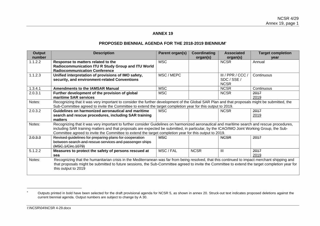
NCSR 4/29 Annex 19, page 1
I:\NCSR\04\NCSR 4-29.docx
ANNEX 19
PROPOSED BIENNIAL AGENDA FOR THE 2018-2019 BIENNIUM
Output number
Description Parent organ(s) Coordinating organ(s)
Associated organ(s)
Target completion year
1.1.2.2 Response to matters related to the Radiocommunication ITU R Study Group and ITU World Radiocommunication Conference
MSC NCSR Annual
1.1.2.3 Unified interpretation of provisions of IMO safety, security, and environment-related Conventions
MSC / MEPC III / PPR / CCC / SDC / SSE / NCSR
Continuous
1.3.4.1 Amendments to the IAMSAR Manual MSC NCSR Continuous
2.0.3.1 Further development of the provision of global maritime SAR services
MSC NCSR 2017 2019
Notes: Recognizing that it was very important to consider the further development of the Global SAR Plan and that proposals might be submitted, the Sub-Committee agreed to invite the Committee to extend the target completion year for this output to 2019.
2.0.3.2 Guidelines on harmonized aeronautical and maritime search and rescue procedures, including SAR training matters
MSC NCSR 2017 2019
Notes: Recognizing that it was very important to further consider Guidelines on harmonized aeronautical and maritime search and rescue procedures, including SAR training matters and that proposals are expected be submitted, in particular, by the ICAO/IMO Joint Working Group, the Sub-Committee agreed to invite the Committee to extend the target completion year for this output to 2019.
2.0.3.3 Revised guidelines for preparing plans for cooperation between search and rescue services and passenger ships (MSC.1/Circ.1079)
MSC NCSR 2017
5.1.2.2 Measures to protect the safety of persons rescued at sea
MSC / FAL NCSR III 2017 2019
Notes: Recognizing that the humanitarian crisis in the Mediterranean was far from being resolved, that this continued to impact merchant shipping and that proposals might be submitted to future sessions, the Sub-Committee agreed to invite the Committee to extend the target completion year for this output to 2019
Outputs printed in bold have been selected for the draft provisional agenda for NCSR 5, as shown in annex 20. Struck-out text indicates proposed deletions against the
current biennial agenda. Output numbers are subject to change by A 30.

NCSR 4/29 Annex 19, page 2
I:\NCSR\04\NCSR 4-29.docx
Output number
Description Parent organ(s) Coordinating organ(s)
Associated organ(s)
Target completion year
5.2.1.15 Consequential work related to the new Code for ships operating in polar waters
MSC / MEPC SDC NCSR / PPR / SSE
2017 2018
Notes: Noting that this output was urgent and of utmost importance, the Sub-Committee agreed to invite the Committee to extend the target completion year for this output to 2018.
5.2.2.3 Validated model training courses MSC HTW HTW NCSR Continuous
Notes: Recognising the Sub-Committee's responsibility in relation to certain model courses, it is suggested to include the NCSR Sub-Committee as an associated organ for this output.
5.2.4.1 Routeing measures and mandatory ship reporting systems
MSC NCSR Continuous
5.2.4.2 Updates to the LRIT system
MSC NCSR Continuous
5.2.4.[..] Application of the "Indian Regional Navigation Satellite System (IRNSS)" in the maritime field and development of performance standards for shipborne IRNSS receiver equipment
MSC NCSR 2019
Note: Included from the post-biennial agenda (number 131)
5.2.4.3 Amendment to the General Provisions on Ships' Routeing (resolution A.572(14)) on establishing multiple structures at sea
MSC NCSR 2016
5.2.4.4 Interconnection of NAVTEX and Inmarsat SafetyNET receivers and their display on Integrated Navigation Display Systems
MSC NCSR 2016
Notes: Extended to 2017, to wait for the outcome of outputs 5.2.6.1 and 5.2.6.2 before concluding or finalizing this output.
5.2.4.5 Guidelines associated with multi-system shipborne radionavigation receivers dealing with the harmonized provision of PNT data and integrity information
MSC NCSR 2017
5.2.4.6 Recognition of Galileo as a component of the WWRNS MSC NCSR 2016
5.2.5.1 Updating of the GMDSS Master Plan and guidelines on MSI (maritime safety information)
MSC NCSR Continuous
5.2.5.2 Completion of the detailed review of the Global Maritime Distress and Safety System (GMDSS)
MSC NCSR HTW 2016
5.2.5.3 Draft Modernization Plan of the Global Maritime Distress and Safety System (GMDSS) (2018)
MSC NCSR HTW 2017
Notes: MSC 96 approved the outcome of the GMDSS Review (output 5.2.5.2) and the continuation of the project in developing the Modernization Plan (this output)

NCSR 4/29 Annex 19, page 3
I:\NCSR\04\NCSR 4-29.docx
Output number
Description Parent organ(s) Coordinating organ(s)
Associated organ(s)
Target completion year
5.2.5.4 Developments in GMDSS satellite services MSC NCSR Continuous
Notes: Description changed from "Analysis of information on developments in Inmarsat and Cospas-Sarsat" to "Developments in GMDSS satellite services".
5.2.5.5 Revised Performance Standards for EPIRBs operating on 406 MHz (resolution A.810(19)) to include Cospas-Sarsat MEOSAR and second-generation beacons
MSC NCSR 2017 2018
Notes: Recognizing that the work on the revision of those Performance Standards has not been completed and that further work is required, the Sub-Committee agreed to invite the Committee to extend the target completion year for this output to 2018.
5.2.5.6 Performance Standards for ship-borne GMDSS equipment to accommodate additional providers of GMDSS satellite services
MSC NCSR 2016
Notes: Extended to 2017, since the performance standards could not be finalised in 1 session.
5.2.5.7 Analysis of developments in maritime radiocommunication systems and technology
MSC NCSR 2017
5.2.5.8 (New)
Review SOLAS chapter IV and appendix (Certificates: Forms P, R and C) to accommodate additional mobile satellite systems
MSC NCSR 2017
5.2.6.1 Additional modules to the Revised Performance Standards for Integrated Navigation Systems (INS) (resolution MSC.252(83) relating to the harmonization of bridge design and display of information
MSC NCSR 2017
5.2.6.2 Guidelines for the harmonized display of navigation information received via communications equipment
MSC NCSR 2017 2018
Notes: Recognizing that the work on those Guidelines has not been completed and that further work is required, the Sub-Committee agreed to invite the Committee to extend the target completion year for this output to 2018.
5.2.6.[..] Guidelines on standardized modes of operation, S-mode
MSC NCSR 2019
Note: Included from the post-biennial agenda (number 111)
5.2.6.[..] Revised General requirements for shipborne radio equipment forming part of the Global Maritime Distress and Safety System (GMDSS) and for electronic navigational aids (resolution A.694(17)) relating to Built-In Integrity Testing (BIIT) for navigation equipment
MSC NCSR 2019
Note: Included from the post-biennial agenda (number 112)

NCSR 4/29 Annex 19, page 4
I:\NCSR\04\NCSR 4-29.docx
Output number
Description Parent organ(s) Coordinating organ(s)
Associated organ(s)
Target completion year
5.2.6.[..] Develop guidance on definition and harmonization of the format and structure of Maritime Service Portfolios (MSPs)
MSC NCSR 2019
Note: Included from the post-biennial agenda (number 132)
5.3.1.1 Measures to harmonize port State control (PSC) activities and procedures worldwide
MSC / MEPC III HTW / PPR / NCSR
Continuous
7.1.2.2 Designated Special Areas and PSSAs and their associated protective measures
MEPC NCSR Continuous
14.0.1.1 Analysis and consideration of recommendations to reduce administrative burdens in IMO instruments including those identified by the SG-RAR
Council MSC / MEPC / FAL / LEG
III / HTW / PPR / CCC / SDC / SSE / NCSR
2017 [2019]
Revision of SOLAS chapters III and IV for Modernization of the Global Maritime Distress and Safety System (GMDSS), including related and consequential amendments to other existing instruments
MSC NCSR HTW / SSE 2022
Note: Proposed to be included following the approval of the Modernization Plan of the GMDSS
***

NCSR 4/29 Annex 20, page 1
I:\NCSR\04\NCSR 4-29.docx
ANNEX 20
PROPOSED PROVISIONAL AGENDA FOR NCSR 5
Opening of the session 1 Adoption of the agenda 2 Decisions of other IMO bodies 3 Routeing measures and mandatory ship reporting systems (5.2.4.1)* 4 Updates to the LRIT system (5.2.4.2)* 5 Application of the "Indian Regional Navigation Satellite System (IRNSS)" in the
maritime field and development of performance standards for shipborne IRNSS receiver equipment*
6 Guidelines for the harmonized display of navigation information received via
communications equipment (5.2.6.2)* 7 Guidelines on standardized modes of operation, S-mode* 8 Develop guidance on definition and harmonization of the format and structure of
Maritime Service Portfolios (MSPs) * 9 Updating of the GMDSS master plan and guidelines on MSI (maritime safety
information) provisions (5.2.5.1)* 10 Consequential work related to the new Polar Code (5.2.1.15)* 11 Revision of SOLAS chapters III and IV for Modernization of the Global Maritime
Distress and Safety System (GMDSS), including related and consequential amendments to other existing instruments*
12 Response to matters related to the Radiocommunication ITU-R Study Group and ITU
World Radiocommunication Conference (1.1.2.2)* 13 Measures to protect the safety of persons rescued at sea (5.1.2.2)* 14 Developments in GMDSS satellite services (5.2.5.4)*
15 Revised Performance Standards for EPIRBs operating on 406 MHz
(resolution A.810(19)) to include Cospas-Sarsat MEOSAR and second generation beacons (5.2.5.5)*
16 Further development of the provision of global maritime SAR services (2.0.3.1)* 17 Guidelines on harmonized aeronautical and maritime search and rescue procedures,
including SAR training matters (2.0.3.2)*
* Output number will be allocated and/or renumbered, depending on the decision by A30. * Output number will be allocated and/or renumbered, depending on the decision by A30.
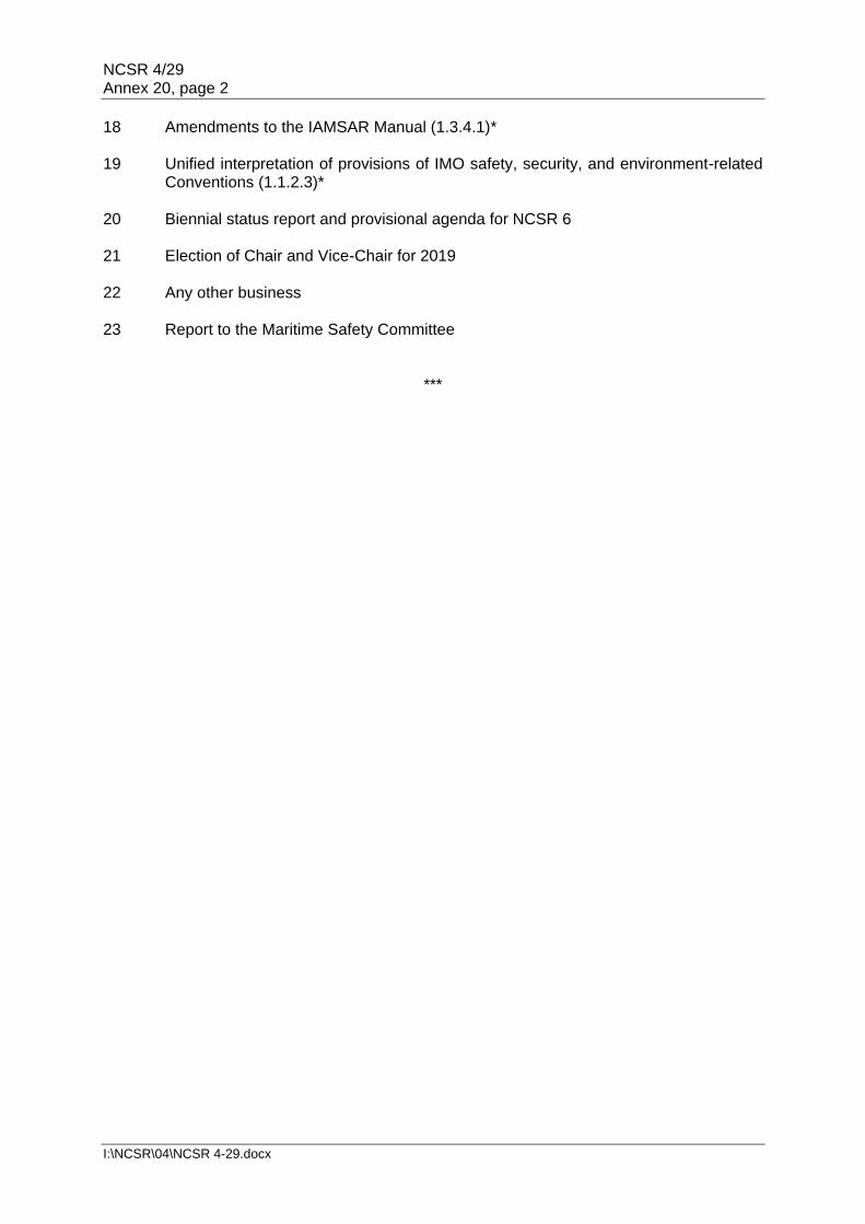
NCSR 4/29 Annex 20, page 2
I:\NCSR\04\NCSR 4-29.docx
18 Amendments to the IAMSAR Manual (1.3.4.1)* 19 Unified interpretation of provisions of IMO safety, security, and environment-related
Conventions (1.1.2.3)* 20 Biennial status report and provisional agenda for NCSR 6 21 Election of Chair and Vice-Chair for 2019 22 Any other business 23 Report to the Maritime Safety Committee
***

NCSR 4/29 Annex 21, page 1
I:\NCSR\04\NCSR 4-29.docx
ANNEX 21
DRAFT REVISION OF MSC.1/CIRC.1460/REV.1
GUIDANCE ON THE VALIDITY OF RADIOCOMMUNICATIONS EQUIPMENT INSTALLED AND USED ON SHIPS
1 The Maritime Safety Committee, at its ninety-second session (12 to 21 June 2013), taking into account the recommendation of the Sub-Committee on Radiocommunications and Search and Rescue at its seventeenth session (21 to 25 January 2013), having recognized concerns that incompatibility may exist between radiocommunication equipment installed on ships, and the revised frequencies and channelling arrangements for the maritime HF and VHF bands as contained in appendices 17 and 18 to the Radio Regulations (RR) – Edition 2012, approved the Guidance on the validity of radiocommunications equipment installed and used on ships (MSC.1/Circ.1460).
2 The Maritime Safety Committee, at its ninety-seventh session (21 to 25 November 2016), while noting that a revision of this circular was anticipated in parallel with the upcoming revision of SOLAS chapter IV, agreed to amend the date from 1 January 2017 to 1 January 2024 (paragraph 8 below), with the intention of avoiding any unnecessary updates of HF radiocommunication equipment that is already capable of operating narrow band direct printing (NBDP). 3 The Maritime Safety Committee, at its ninety-eighth session (7 to 16 June 2017), taking into account the recommendation of the Sub-Committee on Navigation, Communications and Search and Rescue at its fourth session (6 to 10 March 2017), agreed on paragraph 9 below, with the intention to treat MF radiocommunication equipment capable of operating NBDP as well as VHF equipment in the same way as HF NBDP radiocommunication equipment. 4 The World Radiocommunication Conference 2012 made extensive changes to appendices 17 and 18 of the RR. Whilst these changes do not affect the GMDSS, they do affect the use of other frequencies that would be used by services such as Port Operations and VTS.
5 The RR provisions apply as from the dates of application indicated in article 59 and resolution 98 of the RR. Timely action is required by ships to ensure that radiocommunication equipment complies with the RR. Replacement of operating hardware may be necessary to meet the changed requirements.
6 According to the Performance standards for shipborne VHF radio installations capable of communication and digital selective calling (resolution A.803(19)), the equipment should comply with the Radio Regulations.
7 Attention is drawn to MSC.1/Circ.1389, which contains Guidance on procedures for updating shipborne navigation and communication equipment, and that updates to application software and firmware to meet changes in IMO and ITU regulatory requirements were needed.
8 To ensure GMDSS communication capability, HF radiocommunication equipment capable of operating narrow-band direct printing (NBDP) should be updated so that, following the first radio survey after 1 January 2024, it meets the channelling arrangements reflected in sections II and III of part B in appendix 17 of the RR.

NCSR 4/29 Annex 21, page 2
I:\NCSR\04\NCSR 4-29.docx
9 To ensure GMDSS communication capability and the availability of appropriate GMDSS radiocommunication equipment, MF radiocommunication equipment capable of operating NBDP as well as VHF equipment, without prejudice to the arrangements contained in Appendix 18 of the RR, should be updated so that following the first radio survey after 1 January 2024, at the earliest, it meets the arrangements which will be in force by then. 10 Member States are invited to bring this information to the attention of the appropriate national authorities and all other parties concerned.
***

NCSR 4/29 Annex 22, page 1
I:\NCSR\04\NCSR 4-29.docx
ANNEX 22
STATEMENTS BY DELEGATIONS AGENDA ITEM 11
STATEMENT BY UKRAINE Thank you, Mr. Chair. First of all, I'd like to thank the Chairman of the IMO NAVTEX Coordinating Panel for the delivered summary of the current issues being addressed by the IMO NAVTEX Coordinating Panel and its activities since the third session of the Sub-Committee. At MSC 97, the Committee invited Member States and interested parties to notify the Organization of any threats to the security and safety of navigation in the North-Eastern part of the Black Sea. Therefore, in January 2017 Ukraine requested the IMO NAVTEX Coordinating Panel to consider the following unauthorized unilateral actions of the Russian Federation affecting the promulgation of Maritime Safety Information (MSI) in the region: 1) the Novorossiysk NAVTEX station of the Russian Federation causes on a regular basis interference on 518 kHz during hours of darkness to the Odessa NAVTEX station of Ukraine. For instance, despite 20-minute timeslots allocated by the IMO NAVTEX Manual, including 10 minutes for transmission of information, our records show that actual transmission by the Novorossiysk NAVTEX station well exceeds the IMO established limitations causing interference to the NAVTEX transmissions from Odessa station in Ukraine:
Date Actual period of transmission of navigational information by the Novorossiysk NAVTEX station
01.02.2016 00.00 – 00.23
28.02.2016 00.00 – 00.22
31.03.2016 00.00 – 00.23
15.04.2016 00.00 – 00.25
26.05.2016 00.00 – 00.23
04.09.2016 20.20 – 20.25
2) starting from 6 November 2014, the Russian Federation unilaterally ceased the broadcast of navigational warnings by the Kerch NAVTEX station in the temporarily occupied territory of the Autonomous Republic of Crimea, Ukraine without any preliminary coordination either with the NAVAREA III and METAREA III Coordinators, or with Ukraine;
3) starting from 23 October 2015 the Russian Federation unilaterally ceased to forward to the State Hydrographic Service of Ukraine (SHSU) any relevant MSI on coastal warnings for the maritime waters around the Crimean Peninsula, in the Sea of Azov, the Kerch Strait or the

NCSR 4/29 Annex 22, page 2
I:\NCSR\04\NCSR 4-29.docx
North-Eastern part of the Black Sea. Such unilateral actions of the Russian Federation violate the National coordinator responsibilities as defined by section 3.6 of the Joint IHO/IMO/WMO S-53 Manual on MSI.
Given reported circumstances, this delegation expects the IMO NAVTEX Coordinating Panel to consider the mentioned unauthorized unilateral activities of the Russian Federation and take action as appropriate and also, Mr Chair, we would like to ask the Sub-Committee to note the information provided. Thank you. AGENDA ITEM 12
STATEMENT BY IMSO "Having noted the outcome of the consideration of the Sub-Committee that the revision of resolution A.1001(25) will not be included in the Modernization Plan of the GMDSS, IMSO would like to express its support to the views expressed by Denmark particularly in paragraph 4 of document NCSR 4/12/1 and would like to underline the need and necessity of revising resolution A.1001(25) at an appropriate time in the future. The compelling need for this work is clearly indicated in appendix 3 of the report of the Correspondence Group (NCSR 4/12). IMSO recalls the decision of the Sub-Committee at its last session to invite "interested Member Governments to submit a relevant proposal for a new output to the Committee" (NCSR 3/29 paragraph 11.8). In this regard, IMSO is of the view that the need for revision of resolution A.1001(25) should not be completely discarded and be upheld by the Sub-Committee following revision of SOLAS chapter IV." AGENDA ITEM 24
STATEMENT BY JAPAN In this regard, the delegation of Japan stated that that resolution A. 1045(27) on pilot transfer arrangement, which was referred to as a footnote for paragraph 2.1 of regulation SOLAS/V.23 (Pilot transfer arrangements), was a recommendatory instrument and that each flag State Administration should implement a performance standard for pilot transfer arrangements paying due regard to the resolution. Based on these understanding, Japan emphasized that when port State control was conducted, due regard should be paid to a fact that pilot ladders had been inspected in accordance with regulations SOLAS/I/6, 7 and 8 by the Administration, with its interpretation on the resolution A. 1045 (27). The Sub-committee endorsed this statement.

NCSR 4/29 Annex 22, page 3
I:\NCSR\04\NCSR 4-29.docx
AGENDA ITEM 27
STATEMENT BY THE RUSSIAN FEDERATION
Statement of the delegation of the Russian Federation on the Ukrainian Submission NCSR 4/INF.15 and in response to the statement made by the delegation of Ukraine with
regards to NAVTEX service in Black Sea.
1. The Russian delegation cannot agree either with the form or content of NCSR 4/INF.15 submitted by Ukraine. The issues raised therein are of politicised nature; they cannot and shall not be considered by IMO.
The document in question does not reflect the existing true situation. We reiterate that
there is no threat to safety and security of navigation, including planning and conducting search and rescue operations, either in sea areas off the Crimea coast or elsewhere in the Russian Federation. Marine rescue sub-centres in Sevastopol and Kerch operate normally. It is in continuous mode of 24/7 that distress signals are received, communication provided between ships and aircrafts and search and rescue forces and facilities.
In view of the above the Russian delegation cannot consider NCSR 4/INF.15 as an
appropriate notification as part of the MSC97 decision (on the existing threats to safety and security of navigation in the Black Sea areas in question) referred to in para 4 of the Ukrainian submission.
2. Hereinafter, concerning the previous statement by the Ukrainian delegation on the NAVTEX information transmission, we may confirm that all the NAVTEX stations in the Russian Federation operate in full compliance with the NAVTEX Manual as indicated in the current GMDSS Master Plan. In case of any issue neighbouring countries might have concerning the NAVTEX information transmission, we would think it appropriate to settle such issues through the IMO NAVTEX Coordinating Panel as provided for in the NAVTEX Manual, i.e. through interaction with the Administrations concerned and NAVAREA area coordinator.
Thank you.
___________