E – POST-WAR PUBLIC HOUSING SCHEMES
122
89 E – POST-WAR PUBLIC HOUSING SCHEMES These developments have a distinctive layout and design of housing which gives them a clearly recognisable and unique character. The houses are built along curving streets and culs-de- sac arranged around grassed and treed communal amenity areas. Often set back from the road the properties frequently face onto the footpaths and open spaces or are set at an angle to the road. The semi detached houses are generally of two designs. The first have flat fronted elevations and distinctive steeply pitched gabled or hipped roofs and tall chimneys, sometimes paired. They are constructed in a number of standard designs which are repeated within each development and in different developments making them easily recognisable. The front elevations are red brick or cream with some use of decorative brick bands. One design incorporates wide vertical cream panels between brick columns and is particularly distinctive. The second style of housing also has flat front elevations but is generally pebble-dashed and painted in pastel shades. The hipped roofs are less steeply pitched and the plain chimneys are smaller. These character areas have a spacious feel which is enhanced by the mature landscaping, grassed public areas and private gardens. They are generally designed to segregate the houses and pedestrian routes from the street, providing traffic free routes within the character areas and linking with surrounding development. The Winterfield estate in East Malling and Larkfield is designed on Radburn principles: This style of development originating in the USA in the 1920s was intended to make provision for ‘the motor age’ without giving cars priority over pedestrians and became very influential in the new town movement in the UK. The housing is arranged around a heart of communal open space and is accessed via a network of footpaths which is separated from the road network. The properties front onto the footpaths and open spaces whilst vehicular access is provided to the rear of properties by short culs-de-sac.
Transcript of E – POST-WAR PUBLIC HOUSING SCHEMES

89
E – POST-WAR PUBLIC HOUSING SCHEMES
These developments have a distinctive layout and design of housing which gives them a clearly recognisable and unique character.
The houses are built along curving streets and culs-de-sac arranged around grassed and treed communal amenity areas. Often set back from the road the properties frequently face onto the footpaths and open spaces or are set at an angle to the road. The semi detached houses are generally of two designs.
The first have flat fronted elevations and distinctive steeply pitched gabled or hipped roofs and tall chimneys, sometimes paired. They are constructed in a number of standard designs which are repeated within each development and in different developments making them easily recognisable. The front elevations are red brick or cream with some use of decorative brick bands. One design incorporates wide vertical cream panels between brick columns and is particularly distinctive.
The second style of housing also has flat front elevations but is generally pebble-dashed and painted in pastel shades. The hipped roofs are less steeply pitched and the plain chimneys are smaller.
These character areas have a spacious feel which is enhanced by the mature landscaping, grassed public areas and private gardens. They are generally designed to segregate the houses and pedestrian routes from the street, providing traffic free routes within the character areas and linking with surrounding development.
The Winterfield estate in East Malling and Larkfield is designed on Radburn principles: This style of development originating in the USA in the 1920s was intended to make provision for ‘the motor age’ without giving cars priority over pedestrians and became very influential in the new town movement in the UK. The housing is arranged around a heart of communal open space and is accessed via a network of footpaths which is separated from the road network. The properties front onto the footpaths and open spaces whilst vehicular access is provided to the rear of properties by short culs-de-sac.

90
LOCALLY DISTINCTIVE CONTEXTUAL FEATURES
Age of buildings 1950s – 1960s
Type of buildings Semi-detached, terraced and some apartment blocks.
Main uses Residential with some community facilities
Building heights 1-3 storeys
Prominent building materials Red, brown, or buff brick, brown roof tiles, cream or white painted render, concrete and pebbledash.
Predominant boundary treatments Picket fences, hedges and some brick walls.
Open spaces Road network and houses arranged around grassed amenity areas, wide verges and a network of footpaths.
Locally Distinctive Positive Features
• Glimpses and some views of the North Downs and banks of trees in surrounding areas
• Strong cohesive character created by uniformity of building design, materials and limited personalisation
• Spacious verdant character created by properties being set back from the road, views to the surrounding countryside and glimpses of mature trees between and over properties
• Traffic free pedestrian network
• Provision of public open space which is overlooked by properties gives a spacious character
• Sections of development have a strong unified character

91
Negative Features Worthy of Enhancement
• Loss of front boundaries and gardens to provide off street car parking
• Some poor surfacing of roads and pavements
• Some prominent views of pylons and over head cabling
• Traffic noise from the A20 or M20 or other roads in the area
• Lack of visual interest – undistinguished buildings with few design details and featureless amenity spaces
92
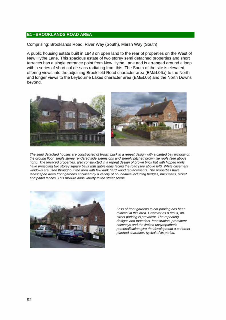
The semi detached houses are constructed of brown brick in a repeat design with a canted bay window on the ground floor, single storey rendered side extensions and steeply pitched brown tile roofs (see above right). The terraced properties, also constructed in a repeat design of brown brick but with hipped roofs, have projecting two storey square bays with gable ends facing the road (see above left). White casement windows are used throughout the area with few dark hard wood replacements. The properties have landscaped deep front gardens enclosed by a variety of boundaries including hedges, brick walls, picket and panel fences. This mixture adds variety to the street scene.
Loss of front gardens to car parking has been minimal in this area. However as a result, on-street parking is prevalent. The repeating designs and materials, fenestration, prominent chimneys and the limited unsympathetic personalisation give the development a coherent planned character, typical of its period.
E1 –BROOKLANDS ROAD AREA
Comprising: Brooklands Road, River Way (South), Marsh Way (South)
A public housing estate built in 1948 on open land to the rear of properties on the West of New Hythe Lane. This spacious estate of two storey semi detached properties and short terraces has a single entrance point from New Hythe Lane and is arranged around a loop with a series of short cul-de-sacs radiating from this. The South of the site is elevated, offering views into the adjoining Brookfield Road character area (EM&L06a) to the North and longer views to the Leybourne Lakes character area (EM&L05) and the North Downs beyond.

93
Long views to neighbouring character areas and the North Downs beyond give the area a spacious feel (see above). However the prominent roofline of the Leybourne Lakes character area interrupts views of the North Downs and gives a feeling of enclosure to this development. The mature landscaping, deep frontages, medium/high hedges and curving streets create a private character where overlooking of the properties from the street is minimised.
In addition to the landscaping, mature specimen trees which line some of the routes through the area and grass road verges add to the verdant character. The entrance to the site is particularly green being lined by tall hedging which give an almost arcadian character to the gateway to the area (see below).

94
Locally Distinctive Positive Features
• Strong cohesive character created by repeat building design and uniformity of materials
• Verdant character created by landscaped gardens, hedges and tall trees
• Long views of the North Downs
• Spacious character created by deep front gardens, curving streets and long views
Negative Features Worthy of Enhancement
• Long views of the North Downs interrupted by the prominent roofline of the Leybourne Lakes character area

ì
ì
Long views of North Downsand Leybourne Lakes development.
Leisure Centre
BROOKLANDS
NEW H
YTHE LA
NE
ROAD
MA
RS
H
RIVER W
AY
WAY
1
5
338
11
77
35
3
37
22
71
355
95
332
7
101
12
99
321
14
69
31
20
2
47
83
331
105
16
97
4
15
33
49
324
322
51
21
19
13
337
91
8 9
103
10
6
8
AVENUE
11
BROOKLANDS
2
1
ROAD
1
11
BROOKLANDS
ROAD
2
0 50 10010 20 30 40Metres¯
© Crown copyright and database rights 2011 Ordnance Survey 100023300
E1 Medway Gap Character Area AppraisalRef
Title Brooklands Road Area

96
E2 – BIRDS ESTATE
Comprising: Plover Road (South), Kingfisher Road, Nightingale Close, Wren Close, Woodpecker Road (North), Raven Close, Magpie Close, Martin Square.
An area of 1960s public housing built along curving streets and short cul-de-sacs named after native British birds. Construction began in 1963. This was the first phase of development of the large Birds Estate, and bisects the later 1960’s open plan housing development. This site stretches from Lunsford Lane in the West to New Hythe Lane in the East and includes semi-detached and terraced houses, town houses, blocks of flats and bungalows. The layout of the streets comprise a series of short culs de sacs off a main street which turns through a right angle.
The houses in this character area are a mix of types including mostly two storey terraced Houses with some three storey town houses, bungalows and three storey blocks of flats. They are constructed using a range of brown, red and buff coloured bricks, with shallow pitched roofs and white casement windows. The majority of properties have a flat front elevation, broken only by flat roofed porch canopy.
Brown hung tiles, white render and white UPVC weatherboarding details can also be found on the front façade of some properties, in particular in the eastern half of the area. The eastern section also has a higher incidence of town houses and flats, where as the western section is predominantly houses.
The majority of the houses, and some of the town houses, have front gardens enclosed by dwarf walls and hedges. Some of these have been lost to provide off road car parking but not sufficient to dilute the character of the area. Despite the presence of front gardens and some communal landscaped areas around the flats and bungalows, few mature trees are present to enhance the street scene and soften the architecture.

97
The majority of houses do not have private attached garages and parking is either on the road, on a forecourt or in garage blocks. This results in cars being dominant in the street scene. Although unsightly, the garage blocks are mostly located to the rear of properties out of sight so do not significantly detract from the area.
Beyond the replacement of doors and windows, the level of personalisation has been kept to a minimum which has preserved the planned character of the area and gives sections of the development a strong planned character.
The western section of the area is elevated and enjoys views to the west of the North Downs along Kingfisher Road. Beyond this, views into and out of the site are limited due to the flat topography and enclosed nature of the terraced development. The limited views outside the character area give the area a generally enclosed character. However, there are glimpses of neighbouring character areas between properties (see above right)

98
Locally Distinctive Positive Features
• Sections of the development have a strong unified character
• Limited personalisation has preserved the original buildings and features
• An enclosed private character created by limited views into and out of the development
Negative Features Worthy of Enhancement
• Loss of front boundaries and gardens to provide off street car parking

?
?
ì
ì
View oftrees.
Views of North Downs.
ROAD
M 20
0 250 50050 100 150 200Metres¯
© Crown copyright and database rights 2011 Ordnance Survey 100023300
E2 Medway Gap Character Area AppraisalRef
Title Birds Estate

100
E3 –STEP STILE ESTATE
Comprising: Carnation Crescent, Larkspur Road, Rosemary Road, Columbine Road, Jasmine Road, Lavender Road, Twisden Road, Chapman Way (East), Catlyn Close, Larkspur Close, Edward Walk (North).
A public sector housing development, built during the late 1950s and early 1960s on open land south of the A20. Many of the roads are named after garden flowers. The estate includes two storey semi detached and terraced houses, along with three storey town houses and flats and bungalows. The grassed amenity areas and mature trees contribute to the green, spacious, planned character of the estate, particularly in the northern section. The southern most portion of the site was developed in a separate phase during the late 1960s, therefore has a slightly different character.
The one to three storey semi- detached and terraced houses and flats are arranged around curving streets, culs-de-sac and some amenity green spaces. They are constructed of red and brown bricks and are of several repeat designs. All have pitched roofs, white casement windows and flat front elevations. The two storey houses have a flat roof porch canopy above the front door.
There is limited detailing on the one and two storey houses and flats, with the exception of panels of white render on the upper floors of some properties. Personalisation has been kept to a minimum thereby preserving the original planned character of the development. The limited palette of materials also unifies the development and creates a cohesive character.
The southern section of the site, known as Water Meadow, also contains town houses (see right) which have integral garages and brown hung tile detailing to the upper floors. The increase in building height and lack of amenity space in this part, give it a more enclosed feel than the rest of the development.
101
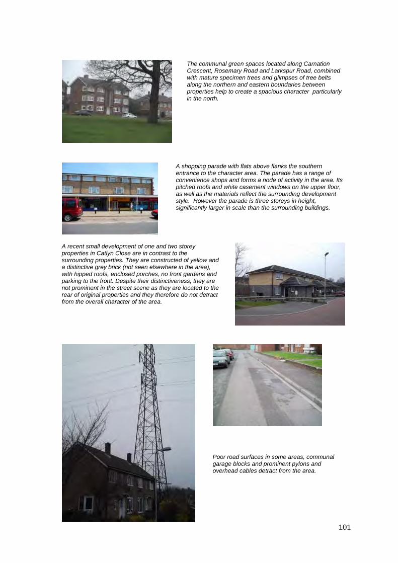
The communal green spaces located along Carnation Crescent, Rosemary Road and Larkspur Road, combined with mature specimen trees and glimpses of tree belts along the northern and eastern boundaries between properties help to create a spacious character particularly in the north.
A recent small development of one and two storey properties in Catlyn Close are in contrast to the surrounding properties. They are constructed of yellow and a distinctive grey brick (not seen elsewhere in the area), with hipped roofs, enclosed porches, no front gardens and parking to the front. Despite their distinctiveness, they are not prominent in the street scene as they are located to the rear of original properties and they therefore do not detract from the overall character of the area.
Poor road surfaces in some areas, communal garage blocks and prominent pylons and overhead cables detract from the area.
A shopping parade with flats above flanks the southern entrance to the character area. The parade has a range of convenience shops and forms a node of activity in the area. Its pitched roofs and white casement windows on the upper floor, as well as the materials reflect the surrounding development style. However the parade is three storeys in height, significantly larger in scale than the surrounding buildings.

102
Locally Distinctive Positive Features
• The strong planned character has been retained due to limited personalisation of properties and retention of original features
• Glimpses of mature trees and tree belts between and over properties
• Provision of public open space which is overlooked by properties gives a spacious character
• Enclosed character in the south created by an increase in the height of buildings and a reduction in the amount of green space
Negative Features Worthy of Enhancement
• Loss of front gardens to parking particularly in the south of the area
• Poor surfacing of roads and pavements, particularly in the south of the area
• Some prominent views of pylons and over head cabling

?
ì
ì
ì
ì
ìì
III
Views of trees over properties.
Views ofwoods.
#
Parade of shops.
#
Footpath.
#
Garage block is an visual intrusion.
LONDON
St James Close
St James the Great
Childrens Centre
Court
BEECH
CRESCENT
Lavender Walk
RUSKIN C
LOSE
BONDFIELD
LARKSPUR CLOSE
LISTER CLOSE
DIC
KEN
S D
RIV
E
HERON ROAD
OWEN C
LOSE
BLACKLANDS
CO
LUM
BIN
E
LAV
EN
DE
R C
LOS
E
LARKSPUR ROAD
COBBETT CLOSE
CA
RN
ATIO
N C
RES
CE
NT
TASS
ELL
CLOSE
LAVENDER
BRADBOURNE PARK ROAD
BLACKLANDS DRIVE
TWISD
EN R
OA
D
CATLYN CLOSE
NEW
RO
AD
ED
WA
RD
WALK
ROAD
ELM
ROSEMARY ROAD
JAS
MIN
E
TEM
PLE W
AY
CHAPMAN W
AY
4
1
9
Posts
74
32
3
50
47
13
19
69
3531
24
105
41
131
165a
113
76
104
121
107
103
80
778
111
17
20
94
141
784
27
10810
1
34
64
59
95
83
183
93
68
46
82
26
18
22
21
90
52
23
163
14
7
49
98
43
110
40
51
61
5 4
139
8
15
67
4a
16
6380
0
65
33
5
123
153
60
97
73
2
56
58
36
115
28
30
81
102
175
6
42
37
38
25
11
85
48
53
44
10
12
70
Falcon Gr een
24
1
259
26
17
8
16
93
2
2
1
3
7
20
1
2 0
7
1
8
67
5
12
22
14
7
15
5
1
1
15
1
13
9
12
26
40
12
1
46
ROAD
8
10
1
10
2
30
115
3
11
35
12
13
60
70
20
CATLYN
CLO
SE
3
10
2 3
2
35
9
83
68
34
51
1
56
36
40
17
16
58
1
5
46
4
28
23
35
1 0
1
CA
RN
ATIO
N C
RE
SC
EN
T
30
6
1
35
3418
6
4
12
36
14
1
5
36
1434
13
19
1
8
20
18
63
21
1
8
11
2
9
6
22
15
24
1
8
24
36
1
2
16
10
10
115
73
14
15
9
2 6
L AR
KS
PUR
RO
AD
47
60
4 3
12
1
12
10
10
5
1
10
9
13
48
24
5
2
24
1
5
2
15
21
47
2
9
1
5
16
16
21
7
11
24
33
4
19
1
11
6
1
6
16
44
8
11
70
54
11
46
22
3
64
5
18
38
26
31
6
4
1
3
54
12
5
52
12
7
5
11
31
16
63
30
31
TEM
PLE
WAY
6
11
11
13
1
5
1
1
46
34
18
1
1 13
61
7
58
19
17
1
2
44
0 150 30030 60 90 120Metres¯
© Crown copyright and database rights 2011 Ordnance Survey 100023300
E3 Medway Gap Character Area AppraisalRef
Title Step Stile Estate
104
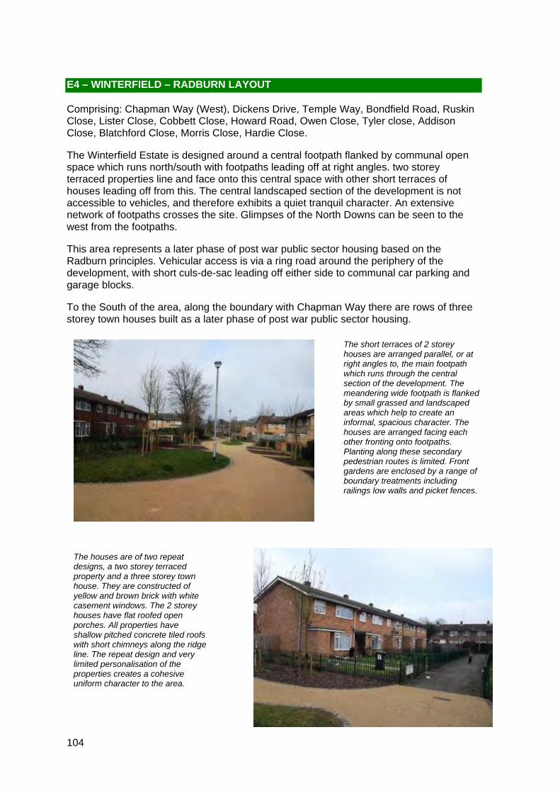
The short terraces of 2 storey houses are arranged parallel, or at right angles to, the main footpath which runs through the central section of the development. The meandering wide footpath is flanked by small grassed and landscaped areas which help to create an informal, spacious character. The houses are arranged facing each other fronting onto footpaths. Planting along these secondary pedestrian routes is limited. Front gardens are enclosed by a range of boundary treatments including railings low walls and picket fences.
The houses are of two repeat designs, a two storey terraced property and a three storey town house. They are constructed of yellow and brown brick with white casement windows. The 2 storey houses have flat roofed open porches. All properties have shallow pitched concrete tiled roofs with short chimneys along the ridge line. The repeat design and very limited personalisation of the properties creates a cohesive uniform character to the area.
E4 – WINTERFIELD – RADBURN LAYOUT
Comprising: Chapman Way (West), Dickens Drive, Temple Way, Bondfield Road, Ruskin Close, Lister Close, Cobbett Close, Howard Road, Owen Close, Tyler close, Addison Close, Blatchford Close, Morris Close, Hardie Close.
The Winterfield Estate is designed around a central footpath flanked by communal open space which runs north/south with footpaths leading off at right angles. two storey terraced properties line and face onto this central space with other short terraces of houses leading off from this. The central landscaped section of the development is not accessible to vehicles, and therefore exhibits a quiet tranquil character. An extensive network of footpaths crosses the site. Glimpses of the North Downs can be seen to the west from the footpaths.
This area represents a later phase of post war public sector housing based on the Radburn principles. Vehicular access is via a ring road around the periphery of the development, with short culs-de-sac leading off either side to communal car parking and garage blocks.
To the South of the area, along the boundary with Chapman Way there are rows of three storey town houses built as a later phase of post war public sector housing.

105
The townscape seen from the ring road is less appealing with views of the rear of properties, garage blocks, high fences and bins. The parking for the two storey houses is provided via forecourts and garage blocks around the periphery of the site which are accessed from the ring road. These have recently undergone a programme of rejuvenation which has enhanced the landscaping and surface treatments.
The town houses have private parking to the front, rather than front gardens, and integral garages but with limited landscaping to soften the stark buildings (see below right).
The properties to the south of Howard Road, and those along Bondfield Road, Cobbett Close, Ruskin Close and Lister Close all front onto the road rather than a communal car free area but make use of the same palate of materials. The two storey properties retain the repeat design featured in the rest of the site. The three storey town houses feature prominently here. These are constructed of predominantly brown brick, with brown hung tile detail to the front elevation and white casement windows which create a strongly uniform character. These represent a later phase of the development and these taller structures flank the access route to this site. The height of these buildings helps to screen the development from Chaucer Way and along with mature tree belts along the Western and Northern boundaries creates an enclosed private character to the area.
106
Locally Distinctive Positive Features
• Strong cohesive character created by the uniformity of building design, a limited palate of materials and low levels of individualisation
• Central footpath flanked by open space which creates an informal, spacious character
• Glimpses of the North Downs to the west
• Green edges to the north, south and west of the character area created by mature tree belts, which can on occasion be glimpsed between properties
• Traffic free pedestrian network
• Enclosed private character due to limited views into and out of the site
Negative Features Worthy of Enhancement
• Streetscape of the ring road marred by high walls and fences and garage blocks
• Traffic noise in the north from traffic travelling along the A20

ì
ì
ì
ì ì
IIII
Views of mature tree belt.
Glimpses of North Downs through trees.
St James Close
St James the GreatPrimary and Nursery School
Depot
Childrens Centre
Lavender Walk
RUSKIN C
LOSE
BONDFIELD
LISTER CLOSE
DIC
KEN
S D
RIV
E
WIN
TER
FIEL
D
OWEN C
LOSE
CO
LUM
BIN
E
LAV
EN
DE
R C
LOS
E
COBBETT CLOSE
CA
RN
ATIO
N C
RES
CE
NT
TYLE
R CLO
SE
LAVENDER
TWISD
EN R
OA
D
HOWARD ROAD
TEM
PLE
WAY
CHAPMAN W
AY
1
15
22
9
24
47
3
69
17
105
131
1 13
29
121
1 07
48
35
1 11
20
141
97
34
60
9 1
95
8393
82
10
2618
64
21
19
99
23
163
36
40
5951
139
8
6716
56
63
14
5
31
153
7375
119
33
13
7
46
61
30
28
81
2
6
11
8553
12
70
4
Winterfield House
WALPOLE CLOSE
SHAFTESBURY CLOSE
BLATCHFORD CLOSE
ADDISON CLOSE
Clare House
CO
LUM
BIN
E R
OAD
HA
RD
IE C
L OS
E
MO
RR
IS C
LOS
E
24
8
10
12
40
1
1
8
8
CA
RN
ATIO
N C
RE
SC
EN
T
6
46
1 12
1 810
2
9
13
2
22
2416
24
22
8
15
1
11
6
12 2
3 4
34
1
1
93
5
1
10
16
1
5
67
20
1
1
1
6
5
30
1
5
12
11
1
16
4
16
7
11
15
1
13
6
1
20
116
105
15
11
48
10
5
1
10
26
83
10
2
1
1
20 8
18
61
22
9
47
10
13
1
7
11
0 100 20020 40 60 80Metres¯
© Crown copyright and database rights 2011 Ordnance Survey 100023300
E4 Medway Gap Character Area AppraisalRef
Title Winterfield - Radburn Layout
108
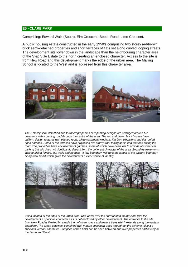
The 2 storey semi detached and terraced properties of repeating designs are arranged around two crescents with a curving road through the centre of the area. The red and brown brick houses have uniform design features with pitched roofs, white casement windows, flat front elevations and flat roofed open porches. Some of the terraces have projecting two storey front facing gable end features facing the road. The properties have enclosed front gardens, some of which have been lost to provide off-street car parking but this does not significantly detract from the coherent character of the area. Boundary treatments include picket fences, low walls and hedges. A low boundary wall runs the length of the eastern boundary along New Road which gives the development a clear sense of identity.
Being located at the edge of the urban area, with views over the surrounding countryside give this development a spacious character as it is not enclosed by other development. The entrance to the site from New Road is flanked by a wide tract of open space and mature trees which extends along the eastern boundary .The green gateway, combined with mature specimen trees throughout the scheme, give it a spacious verdant character. Glimpses of tree belts can be seen between and over properties particularly in the South and West
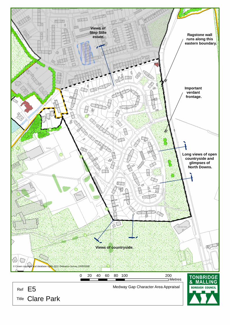
E5 –CLARE PARK
Comprising: Edward Walk (South), Elm Crescent, Beech Road, Lime Crescent.
A public housing estate constructed in the early 1950’s comprising two storey red/brown brick semi-detached properties and short terraces of flats set along curved looping streets. The development sits lower down in the landscape than the neighbouring character area of the Step Stile Estate to the north creating an enclosed character. Access to the site is from New Road and this development marks the edge of the urban area. The Malling School is located to the West and is accessed from this character area.

109
The rooftops of the neighbouring Step Stile character area can be seen to the north.
The communal garage blocks, although untidy, are set back out of sight behind properties and therefore do not detract from the area.
Some houses face onto communal parking areas which detract from the streetscene due to the dominance of the private car. The scale and prominence of large pylons and over head cables also detract from the character of the area.
Listed Buildings
108 New Road
Single storey cottage, originally East Lodge to Clare House Park dated c.1800.
Grade II
110
Locally Distinctive Positive Features
• Strong cohesive character created by uniformity of building designs and materials and limited personalisation
• Verdant eastern edges with mature trees
• Listed former East Lodge
• Spaciousness verdant character created by properties being set back from the road, views to the surrounding countryside and glimpses of mature trees between and over properties
Negative Features Worthy of Enhancement
• Some traffic noise from traffic travelling along New Road
• Views of unsightly structures pylons and overhead cables
?
ì
ì
ì
ìì
Long views of open countryside and
glimpses of North Downs.
Views of Step Stile
estate.
#
Important verdant frontage.
Views of countryside.#
Ragstone wallruns along this
eastern boundary.
The Malling School
St James Close
School
BEECH
CR
ESC
EN
T
ELM
CR
ES
CEN
TBLACKLA
NDS
LAV
EN
DE
R C
LOS
E
LAVENDER
BLACKLANDS DR IVE
TWISD
EN R
OA
D
CATLYN CLOSE
NE
W R
OA
D
ED
WA
RD
WALK
RO
AD
ELM
LIME
CHAPMAN W
AY
Nursery
4
Posts
74
32
3
2
41
23
13
8894
86
4945
36
3135
14
71
76
104
96
85
80
65
6
17
21
51
47
27
10864
70
59
46
18
22
26
40
103
8
54
11
98
110
30
112
4a
67
16
63
12
3 3
39
5
60
97
73
56
34
61
24
28
20
100
102
38
43
37
44
25
9
48
15
7
19
10
1
Hall and Clinic
PathPO
16
8
1
22
ROAD
94
419
28
17
1
30
9
7
13
18
16
13
2
13
9
5
CRESCENT
26
13
5
7
20
4
11
24
3
4
47
1
10
24
26
25
1
30Path
28
4
6
33
16
2
16
CATLYN
CLO
SE
9
12
30
24
2 3
96
5
18
17
5
1
1
20
1
12
2
10
17
15
22
NE
W R
OA
D
17
17
19
21
26
31
49
40
11
22
8
15
2
23
6
18
98
43
35
47
26
2
10
0 100 20020 40 60 80Metres¯
© Crown copyright and database rights 2011 Ordnance Survey 100023300
E5 Medway Gap Character Area AppraisalRef
Title Clare Park

112
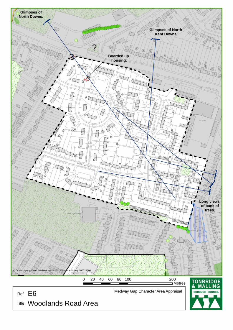
E6 – WOODLANDS ROAD AREA
Comprising: Woodlands Road, Linkway, Medina Road, Golding Close, Nursery Road, Pear Tree Avenue (North)
A large development of post war public housing built in the early 1950s and early 1960s. The profile of the land is relatively flat and the estate can be accessed from New Road near the junction with the A20. Along the northern edge, the properties are inward looking with rear gardens backing onto London Road.
A development of one and two storey semi-detached and terraced houses and bungalows. Uniform design features and details which help create a cohesive character include red/brown bricks steeply pitched gable-ended roofs topped with concrete tiles and prominent tall chimney stacks (which also create rhythm), white casement windows and white fascias and a uniform building line with the properties all fronting the road. Original features including flat fronted elevations, have, in many cases (see above, left) been eroded through the individualisation of the properties by the building of porch extensions.
Boundary treatments vary throughout the character area ranging from low-level brick walls (top, left) to high level brick walls with detailing (see right) low fences and hedges (see left) providing visual interest. There are several grassed amenity areas (see top, right) throughout the estate which are positive features in that they help soften the street scene by providing a green frontage to many properties. However, these amenity areas are more often than not featureless pieces of grassland lacking variety in terms of landscaping resulting in an environment that is not visually stimulating.
113
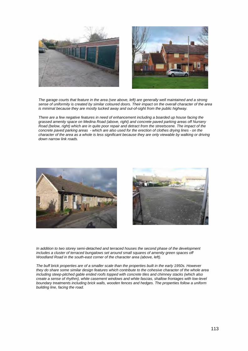
In addition to two storey semi-detached and terraced houses the second phase of the development includes a cluster of terraced bungalows set around small squares of amenity green spaces off Woodland Road in the south-east corner of the character area (above, left). The buff brick properties are of a smaller scale than the properties built in the early 1950s. However they do share some similar design features which contribute to the cohesive character of the whole area including steep-pitched gable ended roofs topped with concrete tiles and chimney stacks (which also create a sense of rhythm), white casement windows and white fascias, shallow frontages with low-level boundary treatments including brick walls, wooden fences and hedges. The properties follow a uniform building line, facing the road.
The garage courts that feature in the area (see above, left) are generally well maintained and a strong sense of uniformity is created by similar coloured doors. Their impact on the overall character of the area is minimal because they are mostly tucked away and out-of-sight from the public highway.
There are a few negative features in need of enhancement including a boarded up house facing the grassed amenity space on Medina Road (above, right) and concrete paved parking areas off Nursery Road (below, right) which are in quite poor repair and detract from the streetscene. The impact of the concrete paved parking areas - which are also used for the erection of clothes drying lines - on the character of the area as a whole is less significant because they are only viewable by walking or driving down narrow link roads.

114
Locally Distinctive Positive Features
• Glimpses of the North Downs and views of the bank of trees along the skyline to the east providing a verdant edge
Negative Features Worthy of Enhancement
• Traffic noise from the adjoining A20 in the northern part of the character area
• Boarded up property on Medina Road (temporary)
• Lack of visual interest – undistinguished buildings with few design details and featureless amenity spaces
Short and long views, as well as glimpses of the surrounding areas can be enjoyed from various locations in the character area. The adjoining Woodlands Road area to the east enjoys an elevated position in relation to the character area and the open plan housing is clearly visible from Woodlands Road (see above, left). The positive feature of this view is the dense bank of tall mature trees along the skyline which provides a verdant edging to this backdrop for the character area. Another positive feature is the glimpses of the North Downs between properties on Woodland Road. Elsewhere in the character area there are short glimpses of the nearby main road of the A20 which is accessible via a link path from Medina Road (above, middle)
?
?
IIII
ì
ì
ì
ìì
#
Boarded up housing.
Glimpses of North Kent Downs.
Glimpses ofNorth Downs.
Long views of bank of
trees.
LONDON ROAD
TA Centre
Para
de
Woodlands
Ditton Infant School
GOLDING CLOSE
NU
RS
ERY
RO
AD
SCOTT CLOSE
WOODLANDS ROAD
NEW
RO
AD
ROAD
PE
AR
TR
EE
AV
EN
UE
STATION ROAD
LIN
KW
AY
to
3
65
24
11
74
42
37
79
51
44
33
2
7
40
73
14
1050
38
12
131
25
84
60
141
32
27
75
96
18
127
1
76
81
540
15
111
98
64
45
17
527
476
20
22
23
488
97
36
49
518
547
57
47
62
19
55
28
95
13
58
135
123
464
41
56
549
31
492
139
66
87
70
545
53
46
4
8
539
43
39
106
101
29
35
506
63
52
30
16
7161
78
9
67
54
5
Community Centre
Club
MS
Hall
PO
6
47
50
6
12
8
2
63
17
47
76
3
1
32
42
20
PEAR TREE AVENUE
12
40
5
45
4
3
16
2
52
41
1
63
2
5
47
17
46
70
31
51
1
SCOTT CLOSE
37
31
2
23
24
53
2915
24
Club
5
39
28
6
13
11
9
2
37
46
30
1
1
5
27
16
9
75
1
WO
OD
LAN
DS
RO
AD
77
33
74
1
1
30
33
2
1418
20
45
43
2
7
57
32
1
53
37
8
9
0 100 20020 40 60 80Metres¯
© Crown copyright and database rights 2011 Ordnance Survey 100023300
E6 Medway Gap Character Area AppraisalRef
Title Woodlands Road Area

116
F – OPEN PLAN HOUSING DEVELOPMENTS
The Medway Gap expanded considerably between the late 1950s and 1970s with the construction of planned private estates of semi detached and terraced housing on green field sites along the A20/M20 corridor.
These housing developments comprise mainly two storey properties with attached garages, either to the side or to the rear of the properties, and are relatively evenly spaced along curving roads, culs-de-sac and loops. There are also some smaller developments of short, straight culs-de-sac. The distinctive feature of these areas is the open plan character with the houses generally set behind dwarf walls or unenclosed lawns and driveways. There are few public open spaces or community facilities.
The buildings are constructed in various brick shades and are frequently decorated with hung concrete tiles, pebbledash and weatherboard. Wide white casement windows with a distinctive horizontal emphasis are a general characteristic. Windows and doors frequently appear to be randomly distributed within elevations without aligning vertically or horizontally with each other. Significant openings make the buildings appear less robust. Properties characteristically have a shallow roof pitch with brown concrete roof tiles and no or small chimneys. Many properties have porches. The developments incorporate buildings of repeated design. The buildings show few local references in terms of materials or design and there are generally no local landmarks.
Landscaping features such as trees and shrubs are prominent in the streetscene. These character areas are quiet with a peaceful residential ambience. They have no through or fast moving traffic and ample off-street parking.

117
LOCALLY DISTINCTIVE CONTEXTUAL FEATURES
Age of buildings 1960s-1970s
Type of buildings Mainly semi-detached
Main uses Residential
Building heights 1-2 storeys
Prominent building materials Red/brown or buff coloured brick, concrete roof tiles, wide casement windows, hung tiles often coloured and shaped, white weatherboards or painted concrete render.
Predominant boundary treatments Deep, open grassed frontages or dwarf walls
Open spaces Unenclosed privately owned frontages create an open character. Limited public grassed spaces.
Locally Distinctive Positive Features
• Verdant open plan frontages with landscaped gardens, and tall trees
• Spaciousness created by properties being set back from the road and long panoramic views to the North Downs or woodland on elevated land or open spaces and other landmarks such as local churches
• Public open space – clustering of buildings around the edge of formal play areas
• Belts of mature trees along boundaries of the character areas is common and provides a verdant edge and a green backdrop
• Cohesive character created by uniformity of building scale, design features including roof pitch, build materials and open lawned frontages
• Private, quiet residential character with no through traffic due to cul-de-sac layouts
• Wide roads, pavements and uncluttered townscape create an open character
Negative Features Worthy of Enhancement
• Traffic noise from the M20 and/or main roads in the surrounding areas
• Noise from the railway line for those areas in Aylesford Parish
• On street parking and some communal garage blocks are unsightly and could be improved

118
• Loss of front gardens to provide car parking hardens the streetscene
• Some footpaths and road surfaces are in poor condition
• Unsympathetic personalisation of properties results in dilution of the character and cohesion of the area.
• There is an absence of landmarks or distinctive buildings

119
The house designs vary across the area reflecting the different phases of development. The properties in the south are predominantly semi-detached and are constructed of brown brick with shallow pitched roofs, with attached or integrated garages and open front gardens. However there are some feature properties (see below right) with mono pitched and flat roofs which add diversity to the development.
A larger number of properties in the central and northern areas are terraced and these are constructed of buff brick with similar pitched roofs (see below left). Despite the differences in property types there are unifying features too in the white casement windows, white UPVC weatherboarding detailing to the upper front façade on some properties and the retention of the open plan front gardens.
House designs across the character area vary, but predominantly they are buff brick houses with low pitched roofs covered in brown concrete tiles, with white casement windows. Personalisation and individualisation of properties has been kept to a minimum, with the addition of relatively few porches and dormer windows.
F1 – POETS ESTATE
Comprising: Kipling Drive, Woodhouse Close, Stevenson Way, Austen Way, Christie Drive, Jerome Road, Bronte Close, Orwell Close, Cronin Close, Blake Drive, Chesterton Road, Browning Close, Barrie Drive, Coleridge Close, Masefield Road, Wordsworth Way, Sassoon Close, Auden Road, Bates Close, Betjamen Close, Marlowe Road, Keats Road, Thakery Road.
A large residential development constructed in phases during the 1970’s and 1980’s on the site of Gighill Farm and surrounding open land situated between Leybourne Way and the M20. The site was identified for medium and high density housing in the North Larkfield Informal Action Area Plan (1973). There is a range of property types including bungalows, terraces, semi-detached and detached houses, with those located in the centre of the area occupying an elevated position allowing for long panoramic views of the North Downs. The properties are arranged around curving streets and culs-de-sac with Chaucer Way acting as a distributor road for the area.

120
There is an increased incidence of detached and semi detached houses and bungalows in the western part of the area. This part of the character area has less of an open plan character with more trees and hedged boundaries.
Although the properties in the western section of the area include features such as front facing gable end roof detailing, pitched roof porches and bay windows, as well as an increase in the use of red brick and dark brown wooden weatherboard detailing not seen in the other areas, it still retains the open plan character of the other parts of the character area. These variations simply reflect the changes in design over the period of the different phases of development.
The character of the estate is greatly enhanced by its elevated setting, allowing for views of Holy Trinity Church to the East and long panoramic views to the North and West of the North Downs creating a spacious feel.
From the lower lying area to the south, there are shorter views and glimpses between properties of the open space to the east which forms part of Larkfield Leisure Centre. This, combined with the on site play areas and green spaces, along with the open plan lawned front gardens, specimen planting and grassed walkway areas creates a spacious green character.
On street parking and garage blocks do not make a positive contribution to the street scene and, in parts of the development, there is some road noise form the M20, particularly in the south.
The pylon located at the junction of Gighill Road and Chaucer Way dominates one of the gateways to the area.

121
Locally Distinctive Positive Features
• Verdant open plan frontages with landscaped gardens, and tall trees
• Long panoramic views of the North Downs and Holy Trinity Church
• Distinctive feature properties with mono pitched and flat roofs
• Public open space – clustering of buildings around edge of formal play areas
Negative Features Worthy of Enhancement
• Traffic noise from M20, particularly in the South
• Some parking on street and on unsightly forecourts and garage courts
• Views of unsightly pylon at the entrance to the area

ì
ì
ì
ìì
ì ìì ìì
ì
ì
ì
Panoramic viewsover housing ofNorth Downs.
Long view of trees.
Views of HolyTrinity Church.
Views of NorthDowns over housing.
Panoramic views of
North Downs.
#
Maturehedging.
#
Pylons.
#
Play area is an elevated
high point.
Short view of Larkfield Leisure
Centre playing fields.
LEYBOURNE WAY
Little Lunsford Farm
CHAUCER
CLOSE
CR
ON
IN C
LOSE
LUNSFORD LANE
AUDEN
CH
RIS
TIE
BR
ON
TE
WODEHOUSE CLOSE
CA
RR
OLL
GA
RD
EN
S
BRO
WN
ING
CLO
SE W
OR
DS
WO
RTH
CHESTERTON ROAD
KIP
LIN
G D
RIV
E
GIG
HIL
L R
OA
D
BETJEMAN CLOSE
ROAD
BAR
RI E
DR
I VE
BLA K
E D
RIV
E
CHAUCER WAY
SASSOON
JEROME ROAD
M 20
MA
SE
F IELD
RO
AD
MARLOW
E ROAD
THAC
KER
AY R
OA
D THACKERAY
BATE
S
STEVENSON WAY
SOUTHEY WAY
AU
STE
N W
AY
MACAULAY
Surgery
1
9
3
8
92
64
59
11
52
62
69
98
75
23
46
34
14
4
61
102
44
74
35
33
314
106
63
48
384
10
103
372
77
51
22
5
91
71
39
3 0
32
18
396
83
67
43
25
393
93
47
19
259
13
408
278
412
2850
27
10166
97
31
20
302
72
87
399
54
60
73
1521
53
249
251
24
12
42
2
348
360
6
290
237
37
299
164
193
81
41
16
49
29
26
17
756
58
40
38
55
36
10
35
1 7
17
16
42
38
8
9
23
25
16
5
18
1
19
27
8
10
10
15
28
2
5
26
19
34
8
16
15
17
23
1
11
23
14
2
29
17
13
24
4
32
2
1
13
15
17
7
LUN
SFO
RD
LAN
E
19
75
3
39
1
11
12
25
48
1
19
32
6
26
8
27
15
1
2
6
18
43
2
1
6
17
53
7
1
24
46
9
2
22
24
1
1
26
87
15
11
2
13
55
15
20
31
59
5
11
8
24
1
13
20
8
13
GIG
HIL
L R
OA
D
152
28
54
11
6 4
122
2 54
64
10
22
42
1
1
1
9
7
17
21
60
17
11
1
14
16
8
21
24
2
14
8
42
2
31
30
1
5
10
24
21
20
39
19
1
14
1
2
11
2
27
1 6
11
9
2
6
9
28
37
36
9
5
16
1
34
1
9
10
21
5
6
22
19
98
1
259
19
7
29
30
7
CHAUCER WAY
15
16
5 254
2
69
8
LEYBOURNE WAY
6
8
6
41
64
33
60
1
10
249
35
5
2
1
1
11
35
19
25
2
8
11
28
4
53
1
12
29
0 150 30030 60 90 120Metres¯
© Crown copyright and database rights 2011 Ordnance Survey 100023300
F1 Medway Gap Character Area AppraisalRef
Title Poets Estate
123
The houses are of repeat designs, although there has been a high level of personalisation of properties over time, including conversion of attached garages into living rooms, side extensions, the addition of porches and the enclosure of some front gardens with dwarf walls (see below right).
The houses are set back behind generally open front gardens, although there has been a loss of the traditional lawned areas (see below left) in favour of hard standings to provide off-street car parking.
The personalisation of properties and loss of front gardens has increased the diversity of the street scene but in the process has diluted the cohesive character of area.
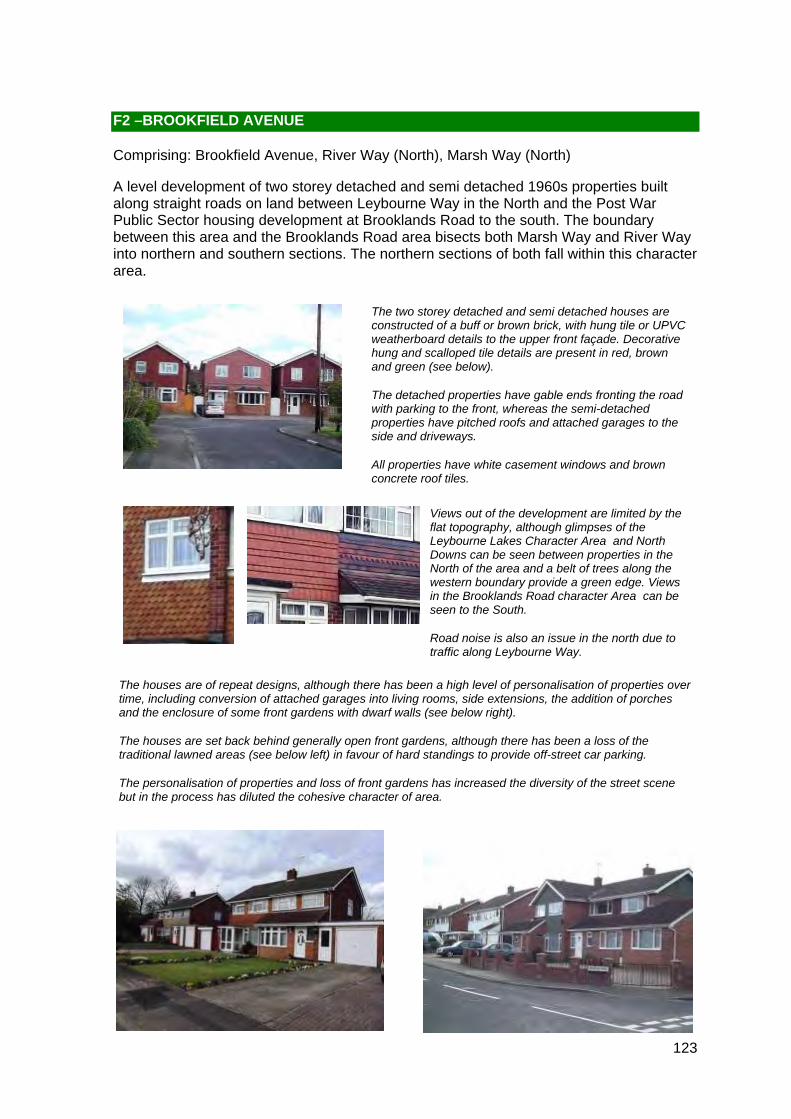
The two storey detached and semi detached houses are constructed of a buff or brown brick, with hung tile or UPVC weatherboard details to the upper front façade. Decorative hung and scalloped tile details are present in red, brown and green (see below).
The detached properties have gable ends fronting the road with parking to the front, whereas the semi-detached properties have pitched roofs and attached garages to the side and driveways.
All properties have white casement windows and brown concrete roof tiles.
F2 –BROOKFIELD AVENUE
Comprising: Brookfield Avenue, River Way (North), Marsh Way (North)
A level development of two storey detached and semi detached 1960s properties built along straight roads on land between Leybourne Way in the North and the Post War Public Sector housing development at Brooklands Road to the south. The boundary between this area and the Brooklands Road area bisects both Marsh Way and River Way into northern and southern sections. The northern sections of both fall within this character area.
Views out of the development are limited by the flat topography, although glimpses of the Leybourne Lakes Character Area and North Downs can be seen between properties in the North of the area and a belt of trees along the western boundary provide a green edge. Views in the Brooklands Road character Area can be seen to the South.
Road noise is also an issue in the north due to traffic along Leybourne Way.

124
Locally Distinctive Positive Features
• Views northwards of the North Downs
• Belt of trees along the eastern boundary provides a green backdrop to the area
Negative Features Worthy of Enhancement
• Traffic noise from traffic travelling along Leybourne Way
• Loss of front gardens to car parking

ì
ì
ìì
ì
Glimpses of North Downsand Leybourne lakes Development.
Views of BrooklandsRoad development.
Leisure Centre
PERCH CLOSE
Superstore
13
CLOSE
MERCER CLOSE
BROOKLANDS
THE LAKES
NEW H
YTHE LANE
ROAD
LEYBOURNE WAY
MA
RS
H
RIVER
WAY
Posts
1
to
76
338
11
47
77
404
35
5
4454
32
172
to 1
88
346
90
39
60
37
88
22
38
71
84
14 to
30
355
95
332
2 to
12
36
28
42
4140
20
101
99
12
160
to 1
70
80
30
8 to
28
321
82
78
347
98
92
103
31
2
104
26
387
83
190
102
196
331
105
16
375
25
97
356
4
113
378
380
15
33
81
49
324
365
395
389
56
322
72
100
353
23
21
19
1b1a
116
337
76 a
91
3
89
10
86
5048
64
62
Shelter
Depot
El Sub Sta
AVENUE
358
370
376
372
374
1
2
2
1
7
78
11
MERCER C
LOSE
4
6
THE
LA
KE
S
3
2
64
1
Depot
7
1
2
11
7
13
103
5
3942 8
1
12
4
5
5
1
1
95
91
1
5
12
21
11 12
47
1
4
10
0 100 20020 40 60 80Metres¯
© Crown copyright and database rights 2011 Ordnance Survey 100023300
F2 Medway Gap Character Area AppraisalRef
Title Brookfield Avenue Area
126
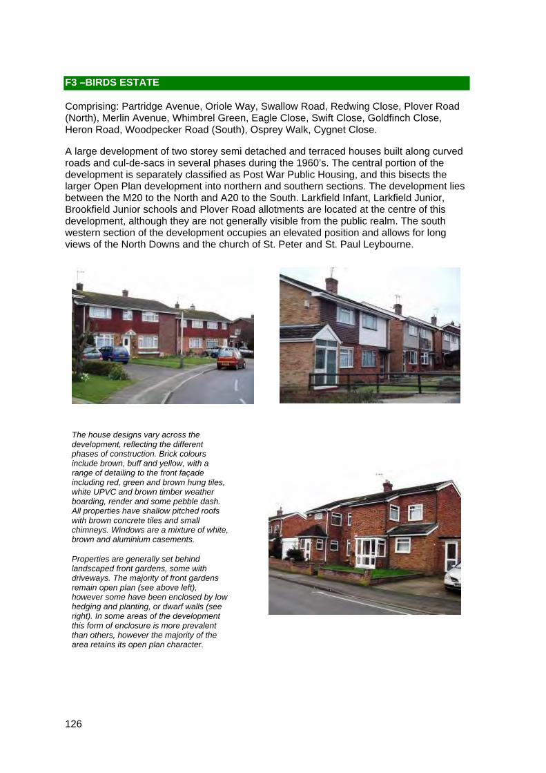
F3 –BIRDS ESTATE
Comprising: Partridge Avenue, Oriole Way, Swallow Road, Redwing Close, Plover Road (North), Merlin Avenue, Whimbrel Green, Eagle Close, Swift Close, Goldfinch Close, Heron Road, Woodpecker Road (South), Osprey Walk, Cygnet Close.
A large development of two storey semi detached and terraced houses built along curved roads and cul-de-sacs in several phases during the 1960’s. The central portion of the development is separately classified as Post War Public Housing, and this bisects the larger Open Plan development into northern and southern sections. The development lies between the M20 to the North and A20 to the South. Larkfield Infant, Larkfield Junior, Brookfield Junior schools and Plover Road allotments are located at the centre of this development, although they are not generally visible from the public realm. The south western section of the development occupies an elevated position and allows for long views of the North Downs and the church of St. Peter and St. Paul Leybourne.
The house designs vary across the development, reflecting the different phases of construction. Brick colours include brown, buff and yellow, with a range of detailing to the front façade including red, green and brown hung tiles, white UPVC and brown timber weather boarding, render and some pebble dash. All properties have shallow pitched roofs with brown concrete tiles and small chimneys. Windows are a mixture of white, brown and aluminium casements.
Properties are generally set behind landscaped front gardens, some with driveways. The majority of front gardens remain open plan (see above left), however some have been enclosed by low hedging and planting, or dwarf walls (see right). In some areas of the development this form of enclosure is more prevalent than others, however the majority of the area retains its open plan character.
127
Although the development includes a variety of materials and building types which add to the mixed character of the area, there has also been a high degree of personalisation, some of which has been unsympathetic. The high incidence of porch extensions, side extensions, garage conversions and the loss of front gardens to car parking (see above left) have resulted in a significant dilution of the original design so there is no longer a unifying character to the area.
Road noise from the M20 and A20 is significant in the far north and south of the development, which detracts from an otherwise quiet area.
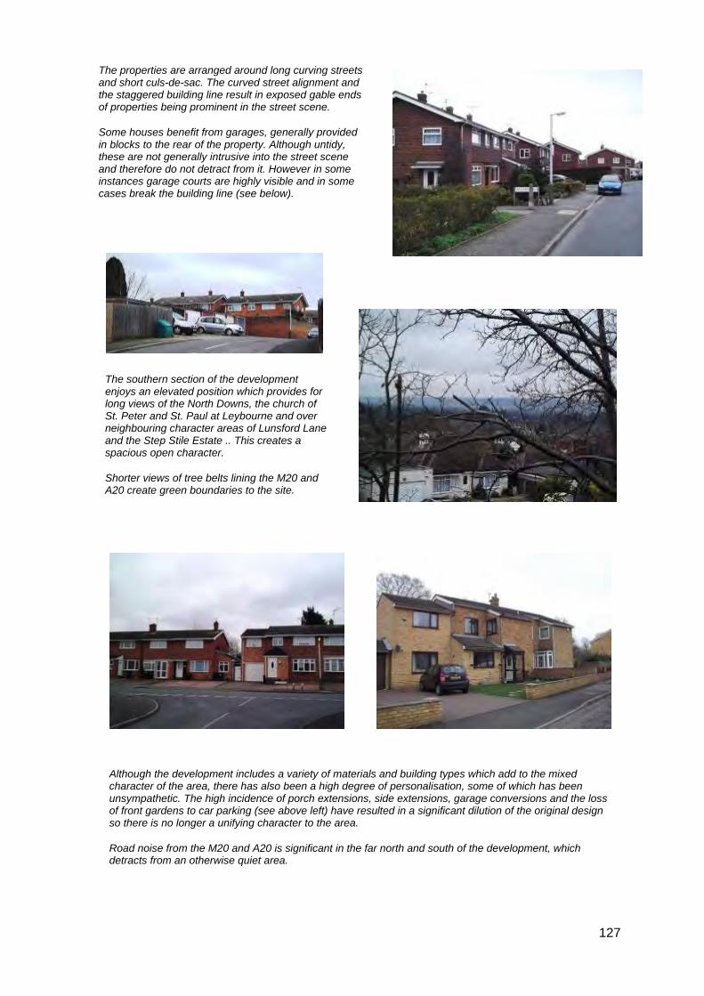
The southern section of the development enjoys an elevated position which provides for long views of the North Downs, the church of St. Peter and St. Paul at Leybourne and over neighbouring character areas of Lunsford Lane and the Step Stile Estate .. This creates a spacious open character.
Shorter views of tree belts lining the M20 and A20 create green boundaries to the site.
The properties are arranged around long curving streets and short culs-de-sac. The curved street alignment and the staggered building line result in exposed gable ends of properties being prominent in the street scene.
Some houses benefit from garages, generally provided in blocks to the rear of the property. Although untidy, these are not generally intrusive into the street scene and therefore do not detract from it. However in some instances garage courts are highly visible and in some cases break the building line (see below).

128
Locally Distinctive Positive Features
• Generally open landscaped front gardens with glimpses of mature tree belts between properties along the northern ad southern boundaries
• Long views of North Downs and the church of St. Peter and St. Paul Leybourne
• Spaciousness created by properties being set back from the road and long views, particularly in the elevated southern section
Negative Features Worthy of Enhancement
• Some traffic noise from the M20 and A20 in the northern and southern sections of the site
• Loss of front gardens to car parking
• Some unsympathetic personalisation of properties resulting in dilution of the character
• Some unsightly communal garage blocks could be improved

?
?
ì
ì
II
ì
ì
ì
ìì
ì
Views over houses of North Kent Downs.
Short view of trees.
Views of trees in between houses.
Views of North Downs in distance.
Views of Leybourne, North Kent Downs and St. Peters and St. Pauls Church.
Views of trees.
#
Garage courtis a detractor.
M 20
0 250 50050 100 150 200Metres¯
© Crown copyright and database rights 2011 Ordnance Survey 100023300
F3 Medway Gap Character Area AppraisalRef
Title Birds Estate
130
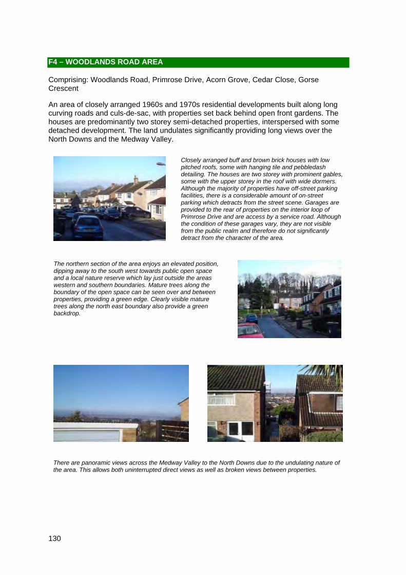
Closely arranged buff and brown brick houses with low pitched roofs, some with hanging tile and pebbledash detailing. The houses are two storey with prominent gables, some with the upper storey in the roof with wide dormers. Although the majority of properties have off-street parking facilities, there is a considerable amount of on-street parking which detracts from the street scene. Garages are provided to the rear of properties on the interior loop of Primrose Drive and are access by a service road. Although the condition of these garages vary, they are not visible from the public realm and therefore do not significantly detract from the character of the area.
The northern section of the area enjoys an elevated position, dipping away to the south west towards public open space and a local nature reserve which lay just outside the areas western and southern boundaries. Mature trees along the boundary of the open space can be seen over and between properties, providing a green edge. Clearly visible mature trees along the north east boundary also provide a green backdrop.
There are panoramic views across the Medway Valley to the North Downs due to the undulating nature of the area. This allows both uninterrupted direct views as well as broken views between properties.
F4 – WOODLANDS ROAD AREA
Comprising: Woodlands Road, Primrose Drive, Acorn Grove, Cedar Close, Gorse Crescent
An area of closely arranged 1960s and 1970s residential developments built along long curving roads and culs-de-sac, with properties set back behind open front gardens. The houses are predominantly two storey semi-detached properties, interspersed with some detached development. The land undulates significantly providing long views over the North Downs and the Medway Valley.

131
Locally Distinctive Positive Features
• Belt of mature trees to the rear of properties on Woodlands Road provide a visible verdant edge to the western boundary of the area
• Sloping topography allows for long views and glimpses between properties of the North Downs and the Medway Valley from sections of Primrose Drive and Woodlands Road
Negative Features Worthy of Enhancement
• No significant detractors but on street parking and loss of some front gardens for additional parking clutter the street scene
A shopping parade with flats above flanks the western entrance to the character area. The parade has a range of convenience shops and forms a node of activity in the area. Its pitched roofs and white casement windows on the upper floor, as well as the materials reflect the surrounding development. However, the single vacant retail unit has broken glazing and graffiti which currently detract from the area.

ì
ì
ì
ì
ìì
ì ì
ì
Panoramic views of North Kent Downs.
Long views of North Kent Downs.
Views of trees.
Long views of North Downs and
Aylesford Newsprint.
#
Tall trees.
Para
de
Woodlands
BIR
CH
CE
DA
R C
L OS
E
WOODLANDS ROAD
PRIM
RO
SE
DR
I VE
ACORN GROVE
Trac
k
7
20
3
15
79
21
40
54
13
119
43
8211
7
73
68
80
247
118
6
38
24
52
191
154
131
255
46
84
60
34
9
141
143
167
179
75
32
96
1 21
58
201
170
72
41
30
127
107
51
27
111
98
22
23
160
130
97
16
423
425
142
44
37
99
93
62
423a
251
33
415
95
11
74
45
87
39
155
213
101
14
86
61
63
12
116
53
71
78
55
83
90
2 1
Sub
31
2
1
7
33
46
12
13
53
1
16
7
39
1
52
33
33
7
14
2
7324
1
5
WO
OD
LAN
DS
RO
AD
37
62
3
45
2
9
58
39
22
37
12
21
12
1
0 100 20020 40 60 80Metres¯
© Crown copyright and database rights 2011 Ordnance Survey 100023300
F4 Medway Gap Character Area AppraisalRef
Title Woodlands Road Area
133
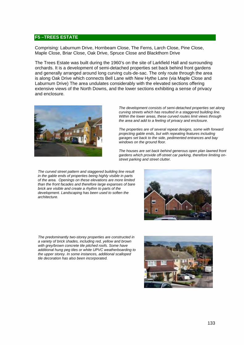
The development consists of semi-detached properties set along curving streets which has resulted in a staggered building line. Within the lower areas, these curved routes limit views through the area and add to a feeling of privacy and enclosure.
The properties are of several repeat designs, some with forward projecting gable ends, but with repeating features including garages set back to the side, pedimented entrances and bay windows on the ground floor.
The houses are set back behind generous open plan lawned front gardens which provide off-street car parking, therefore limiting on-street parking and street clutter.
The predominantly two-storey properties are constructed in a variety of brick shades, including red, yellow and brown with grey/brown concrete tile pitched roofs. Some have additional hung peg tiles or white UPVC weatherboarding to the upper storey. In some instances, additional scalloped tile decoration has also been incorporated.
The curved street pattern and staggered building line result in the gable ends of properties being highly visible in parts of the area. Openings on these elevations are more limited than the front facades and therefore large expanses of bare brick are visible and create a rhythm to parts of the development. Landscaping has been used to soften the architecture.
F5 –TREES ESTATE
Comprising: Laburnum Drive, Hornbeam Close, The Ferns, Larch Close, Pine Close, Maple Close, Briar Close, Oak Drive, Spruce Close and Blackthorn Drive
The Trees Estate was built during the 1960’s on the site of Larkfield Hall and surrounding orchards. It is a development of semi-detached properties set back behind front gardens and generally arranged around long curving culs-de-sac. The only route through the area is along Oak Drive which connects Bell Lane with New Hythe Lane (via Maple Close and Laburnum Drive) The area undulates considerably with the elevated sections offering extensive views of the North Downs, and the lower sections exhibiting a sense of privacy and enclosure.

134
The eastern part of the character area is relatively flat, but the western half experiences significant elevation changes. These variations in topography provide for panoramic views of the North Downs with shorter views of surrounding tree belts to the North and East. The tree belts along the M20 and eastern boundary, as well as the wooded area to the north of Spruce Road both screen the M20 from the development and provide a green backdrop and clearly defined verdant edge to the character area.
A number of properties have experienced modern additions, principally the conversion of the loft space resulting in the inclusion of prominent wide dormer windows. Other modifications include porches and some side extensions where plots size allows for it. Although a significant number of properties have been modified, the openness and gaps between the properties have been retained.
Locally Distinctive Positive Features
• Mature trees along the north and eastern boundaries to the area provide a verdant edge to the character area and backdrop to development
• Panoramic and interrupted views of the North Downs
• Undulating topography and curving streets produce a mixture of enclosed private areas in the dips, and more spacious open areas on the crests
Negative Features Worthy of Enhancement
• Background traffic noise from near by M20

?
?
?
ì
ì
ì
ì
ì
ì
ìììì
Glimpses of North downs.
Views ofKia garage.
Views of North Downs and Aylesford
Newsprint.
Long views ofNorth Downs and
Aylesford Newsprint.
Short views of trees.
45
M 20
43a
23b
43d
Business Park
Church
Access 4:20 New Hythe Business Park
Parish Council Office
Access 4:20
Vicarage
SPRUCE CLOSE
FER
NS
FER
NL E
IGH
BRAD
BOU
RN
E
LARCH CLOSE
Track
THE FERNS
PINE CLOSE
BE
L L L AN
E
LARKFIELD CLOSE
LAR
KFIE
LD
BLACKTHORN DRIVE
BR
IAR
CLO
SE
CYG
NE
T C
LOS
E
LABURNUM DRIVE
NE
W H
YTH
E L
AN
E
MA
PLE
CLO
SE
DOWNDERRY WAY
OAK DRIVE
16c
Surgery
777 - 779
2
1
Posts
24
53
61
4
15
Garage
773
3746
789 785
30
48
17
47
62
708
7773
749
89
4 9
169 to 179
20
629
38
124
43
657
40
16d
751
56
to
55
726
727
72
191
146
11
8
616
11 0
26
717
9
60
632
23
29
84
58
54
22
36
757
643
13
31
37
3368
200
34
2 7
718
44
65
94
723
135
25
204a
16b
100
32
28
130
7 6
63
156
1 20
7950
14
16a
69
88
59
35
50a
661
42
204
737
701
695
39
127
5
16
720
52
51
659
18
7
21
99
10
66
6
12
46
LONDON ROAD
1
11
4
28
38
5 0
12
27
14
6
12
14
NE
W H
YTH
E L
AN
E
44
3 2
24
5
29
48
17
16
6 5
24
5
36
10
34
23
17
2112
39
17
14
42
40
16
5
18
11
26
1
77
24
12
38
13
26
1
36
15
1
4
34
8
39
12
12
3
27
48
37
1
12
3
8
31
6
15
16
52
11
1
16
7
29
9
37
52
1
16
4
51
4 8
2
27
44
M 20
23
1
15
43
18
15
1
11
31
49
14
6
25
3
12
27
36
21
29
8
22
1
60
39
58
1
1
23
17
55
5131
42
73
34
12
10
2
2212
1
59
7
2
28
2
38
24
10
1848
7
7
17
11
76
24
26
23
39
11
2
51
11
36
22
16
3
17
34
38
26
24
5
21
0 150 30030 60 90 120Metres¯
© Crown copyright and database rights 2011 Ordnance Survey 100023300
F5 Medway Gap Character Area AppraisalRef
Title Trees Estate

136
The development is situated along a single curving cul-de-sac. The properties are of varying styles with a combination of hipped and pitched roofs, some with attached garages and some in blocks nearby. The materials also vary through the development with a mixture of brown and buff bricks being used, along with some red and green hung tile detail and pebble dash to the upper floors on some properties.
The properties are all set back from the road behind open front gardens and driveways, thereby limiting the need for on street parking.
The area has verdant character with glimpses between properties of mature specimen trees in Cobdown Park, an Area of Landscape Significance to the east. A green backdrop can also be seen behind and between properties in the north of the area and along the stream corridor in the east. These green corridors along with retention of front lawns and mature planting within the development add to its verdant character.
F6– COBDOWN CLOSE
Comprising: Cobdown Close
Cobdown Close was built on former orchard land in the 1970s and it situated between the A20 to the south and the M20 to the north. It is a development of predominantly two storey semi detached residential properties, although there are a few bungalows at the either end of the development. There is also a small garage court in the north west corner. The site abuts Cobdown Park to the east and a stream runs along this boundary.

137
Although the properties are well maintained, the road surface is in a poor state of repair and this detracts from the character of the area.
The close proximity of both the M20 and A20 result in a high level of background road noise, particularly in the north of the area.
Although most properties have attached garages, there are two blocks of garages. The garage court in the north west corner of the site is not easily visible from the development itself and is therefore not a significant detractor as it does not front onto the road. However the smaller block in the south east fronts onto the road and breaks the building line allowing views to the rear of properties in Orchard Grove.
Locally Distinctive Positive Features
• Verdant frontages and edges provided by landscaped gardens and tall trees with glimpses of specimen planting in neighbouring Cobdown Park
Negative Features Worthy of Enhancement
• Traffic noise from traffic in the area and from the M20 and A20
• Unsightly garage court
• Poor surfacing of roads

?
ìì
ì
ì ì
ì
ì
ì
II
ì
ì
ììì
Glimpses of housing.
Views of tops of trees over housing.
Views of trees andsteep embankment.
Views of tall trees over housing.
Views of trees.
Views of oast houses.
View of housingin Orchard Grove.
#
Tall trees form an backdrop.
#
Garages area detractor.
M 20
Cobdown House
Cobdown Park
CLOSEC
OBD
OW
N C
LOS
E
BE
LL LAN
E LOWER BELL LANE
PLACE
OR
CH
AR
D G
RO
VE
DIT
TON
PLA
CE
Sub
wa y
16c
7
3
5
53
61
29
40
10
42
15
4112
62
5 88
31
65
3 660
629
124
562
578
657
16d72
8
616
110
632
1
84
643
584
32a
38
17
568
27
563
2214
556
94
48
16b
602
10 0
76
63
120
16a
16
549
44
88
45
661
545
2311
51
50
659
73
26
52
66
39
4
2
77
9
Ppg Sta
Pavilion
Westlea Barn
Greenside Oast
Newbarn House
Manor Oast
Tall Trees
Barn
2
16
9
1
1
1
4
12
1
4
2
1
26
3
1
17
1 4
51
8
2
1
12
16
1
17
336
4
2
0 100 20020 40 60 80Metres¯
© Crown copyright and database rights 2011 Ordnance Survey 100023300
F6 Medway Gap Character Area AppraisalRef
Title Cobdown Close

139
This small section of New Road contains two terraces of Open Plan housing built circa late 1960s/ early 1970s. They are divided by an access road to a garage block behind the houses. The houses and the garage block at the rear are surrounded by Ditton Conservation Area and have views to the west of St. Peter's Church and the Green.The architectural style and materials of the properties contrasts with its surroundings, creating a definite break in what is otherwise a historic character.
The properties are two storey with shallow grey concrete tiled pitched roofs and have predominantly unenclosed front gardens that provide parking although some gardens are enclosed by a variety of boundary treatments including fencing, high hedges and shrubs. Despite the dilution of the unenclosed gardens that are typically characteristic of open plan developments, these properties retain an open plan character because they retain their original design features such as the large windows, whiteboard cladding and shallow pitched roofs.
Some individualisation of properties is evident from the variety in replacement windows and doors and front boundary treatments but overall the individual variations are subtle and the character of the area is unified by the greenery of the front gardens and the retention of the original materials, scale and dimensions of the properties, the similarities between the two separate blocks and the unaltered building line.
F7 – NEW ROAD
Comprising: New Road
New Road heads upwards from the A20 London Road into Ditton village and contains a number of properties predominantly dating from the 19th century. The small section of New Road that is this character area contains two blocks of four terraced houses separated by a narrow entrance to a rear garage court. The properties in this character area look over to St. Peter's Church and Ditton Conservation Area.
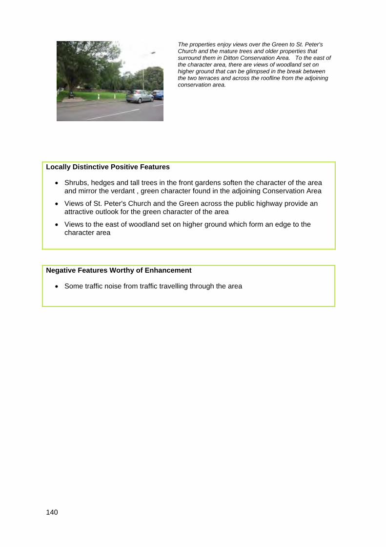
140
The properties enjoy views over the Green to St. Peter's Church and the mature trees and older properties that surround them in Ditton Conservation Area. To the east of the character area, there are views of woodland set on higher ground that can be glimpsed in the break between the two terraces and across the roofline from the adjoining conservation area.
Locally Distinctive Positive Features
• Shrubs, hedges and tall trees in the front gardens soften the character of the area and mirror the verdant , green character found in the adjoining Conservation Area
• Views of St. Peter's Church and the Green across the public highway provide an attractive outlook for the green character of the area
• Views to the east of woodland set on higher ground which form an edge to the character area
Negative Features Worthy of Enhancement
• Some traffic noise from traffic travelling through the area

ì
ìLong views of ridge, trees and housing.
Views of Church.
68
55
59
94
Ditton
C of E Junior School
St Peter's Church
St Peter's Court
SCOTT CLOSE
THE STREAM
7
91
63
3
6
39
9
2
1512
1 to 20
40
32
31
14
33
57
22
96
24
101
103
1
79
10
46
4
45
43
13
95
16
41
37
81
47
49
87
11
1
45
55
47
1
2
2
1
2
43
13
0 50 10010 20 30 40Metres¯
© Crown copyright and database rights 2011 Ordnance Survey 100023300
F7 Medway Gap Character Area AppraisalRef
Title New Road

142
The properties are constructed of buff or red brick with white casement windows and pitched gable-ended roofs topped with brown concrete tiles (see left and below). Original features include integral garages with flat felt roofs (see left and bottom left) which project forward breaking up the flat frontages
Cohesive character created by uniformity of building scale, design features including shallow pitched roofs, build materials and open lawned frontages with no boundary treatments.
The row of properties in between the two culs-de-sac (see right and map) enclose a narrow grassed amenity area which softens the street scene and creates a private character These properties also have decorative features including white door surrounds moulded into the shape of columns topped with a pitched portico, which also feature on some of the housing elsewhere in the character area (see below, left). Brown hung tiles also feature on the upper storey of the façade (see right). These details provide visual interest.
Several properties have been individualised with the conversion of the original integral garages to internal living space (see above left). This, however, has not significantly diluted the cohesive character because the build materials and designs of the conversion work are sympathetic to the original property and the building line has remained unaltered. A positive feature is the short panoramic views of Ditton Recreation Ground to the south of the area which provides a verdant edge (above, right). A significant number of the front gardens have been paved over to create additional parking bays. This has had the effect of hardening the streetscape which is a detracting feature.
F8 – PEAR TREE AVENUE
Comprising: Pear Tree Avenue
A development of two storey semi-detached and terraced properties constructed during the mid 1970s. Pear Tree Avenue, comprising a series of straight culs de sac, is accessed off Woodlands Road. The Avenue is bordered to the south by Ditton Recreation Ground.

143
Locally Distinctive Positive Features
• Cohesive character created by uniformity of building scale, design features including shallow pitched roofs, build materials and open lawned frontages with no boundary treatments
• Short panoramic views of Ditton Recreation Ground to the south
• Long views of the North Downs from the western cul-de-sac
• Enclosed, private character created by culs-de-sac
Negative Features Worthy of Enhancement
• Paved front gardens hardening the streetscene

ì ìì ì
ì
ì
ì
ì
ì
Short panoramic views of recreation ground.
Short panoramic views ofrecreation ground.
Long views of North Downs.
CE
DA
R C
LOS
E
PE
AR
TR
EE
AV
EN
UE
WOODLANDS ROAD
7
9
20
6
65
2
33
53
37
44
24
73
38
60
75
18
111
45
22
16
6 2
46
17
19
13 58
52
31
74
66
39
28
1
6 3
47
30
61
71
78
55
8
PEAR TREE AVENUE
53
37
31
WO
OD
LAN
DS
RO
AD
7
1
63
0 50 10010 20 30 40Metres¯
© Crown copyright and database rights 2011 Ordnance Survey 100023300
F8 Medway Gap Character Area AppraisalRef
Title Pear Tree Avenue

145
The properties are constructed of buff or yellow brick with white casement windows and pitched gable-ended roofs topped with brown concrete tiles and chimney stacks (see left and below). Original features include integral or side garages with flat felt roofs which project forward breaking up the otherwise flat frontage (see left and middle right). Cohesive character created by the uniformity of building scale, roof pitch and short chimney stacks (which create a sense of rhythm), fenestration and building line. The properties on Wilton Drive differ slightly from those on St Peter’s Road, with coloured hung tiles on the upper storey and white rendered surfaces on the ground floor façade (see below, right).
There is no through traffic on Wilton Drive resulting in a relatively quiet enclosed private residential character. Several properties on Wilton Drive have been individualised with porches and large two storey side extensions. In some places the resultant development has had a terracing effect on the streetscene (see right) which has diluted significantly the original character of the area and increased the building mass. A positive feature are glimpses between some of the properties on Wilton Drive of the open countryside to the rear.
One minor exception to the open plan character of the area is St Peter’s Court (above, left) which is a building of greater mass built of darker brick. This was built slightly later than the rest of the development. The positive feature of this part of the character area is the short view of St Peter’s Church in the Ditton Conservation Area to the rear from the car park area. The Church and the surrounding mature specimen trees within its grounds provide visual interest and a contrast to the prevailing architecture in the area.
F9 – ST PETER’S ROAD AREA
Comprising: St Peter’s Road, Wilton Drive and St Peter’s Court
A development of two storey semi-detached properties constructed during the 1960s. St Peter’s Road is accessed off New Road (to the east) and Bradbourne Lane (to the north). The area is bordered by Ditton Conservation Area to the north, with short views of St Peter’s Church, and by open countryside to the south (rear of the properties on Wilton Drive).

146
Locally Distinctive Positive Features
• Cohesive character created by building scale, roof pitch, chimney stacks and building line
• Private enclosed character (Wilton Drive) created by cul-de-sac
• Glimpses of the open countryside between properties on Wilton Drive
• Short view of St Peter’s Church from St Peter’s Court car park
Negative Features Worthy of Enhancement
• Proliferation of large two storey side extensions (Wilton Drive) has significantly diluted the original cohesive character of the open plan development

ìì
Glimpse ofcountryside.
Short views of St. Peters Church.
75
68
90
81
55
67
94
Park
Houses
Farm
43a
102
110
BRAMPTON FIELD
Ditton
Walnut Row
St Peter's Church
St Peter's Court
CHERRY
CO
UR
T C
LOSE
BRAD
BOURNE
LANE
ST PETERS CLOSE
ST P
ETE
RS
RO
AD
WIL
TON
DR
IVE
THE STREAM
Track
4
41
48
91
63
8
3
7
86
6
39
7682
9
15
35a
30
38
1 to 20
20
31
32
14
37
2
33
40 84
26
13
96
46
36
24
42
50
101
103
34
25
56
11
12a
79
29
23
35
52
44
19
70
10
51
28
45
43
54
38a
65
17
12
9 5
16
69
22
59
47
49
58
87
1
5
Park Farm Cottage
Park Farm
GP
10
40
10
23
4
33
55
22
24
11
10
19
55
45
22
1
10
28
12
Trac
k
34
33
54
37
40
55
24
51
141
6
BRA
MPT
ON
FIE
LD
1
1
12
42
5
28
12
1
38
13
30
59
2
30
1
47
37
2
81
13
THE STREAM
45
7
ST PETERS ROAD
7
25
43
13
42
22
7
9
2
40
11
25
17
31
37
23
2
13
45
41
43
49
0 100 20020 40 60 80Metres¯
© Crown copyright and database rights 2011 Ordnance Survey 100023300
F9 Medway Gap Character Area AppraisalRef
Title St. Peter's Road Area

148
A variety of materials have been used including brown, buff and yellow brick. There are two main styles of property here. These brown brick two storey detached and semi detached properties have front facing gables roofs with white soffits and protruding flat roofed garages. The staggered building line and the repeated design features such as the roof line, the fenestrations and the open, verdant frontages provide a rhythm along this part of Cherry Orchard and a sense of uniformity which is assisted by the lack of individualisation.
Pitched roofs are the norm in this character area except for the row of front facing gable roofs shown above. However, like those properties with front facing gable roofs, the pitched roof properties have open grassed frontages except where individualisation has taken place to provide off road parking, hardening the character. These properties also have decorative features including mock-Georgian white column door surrounds. Brown hung tiles also feature on the upper storey of the façade.
Several properties have been individualised with the conversion of the original integral garages to internal living space (see above left). This, however, has not significantly diluted the strong cohesive character because the proportions have largely been retained. The southern part of the character area is bound by open countryside but there are no views through the line of properties except for a short glimpse at the south western corner. The tall trees forming the western edge of the character area provide a tree lined backdrop and soften the otherwise hard character of the area which has some verdant frontages, but most are used for off street parking and tend to create a hard landscaped character along with the walls of garage blocks. The northern part of the character area enjoys views over Ditton school playing fields over to the chimney stacks of Aylesford Newsprint and the North Downs in the distance. Overall, the lack of front boundaries coupled with the wide roads creates an open spacious character.
F10 – SCOTT CLOSE AND CHERRY ORCHARD
Comprising: Scott Close and Cherry Orchard
Scott Close is located off Kiln Barn Road to the north and is surrounded by school playing fields and community centre land to the north and east. Cherry Orchard is constructed off Kiln Barn Road to the south and is set on the edge of the urban area, with open countryside around its boundary. Constructed during the mid 1970s, these two roads are set on level ground along a cul-de-sac road layout.
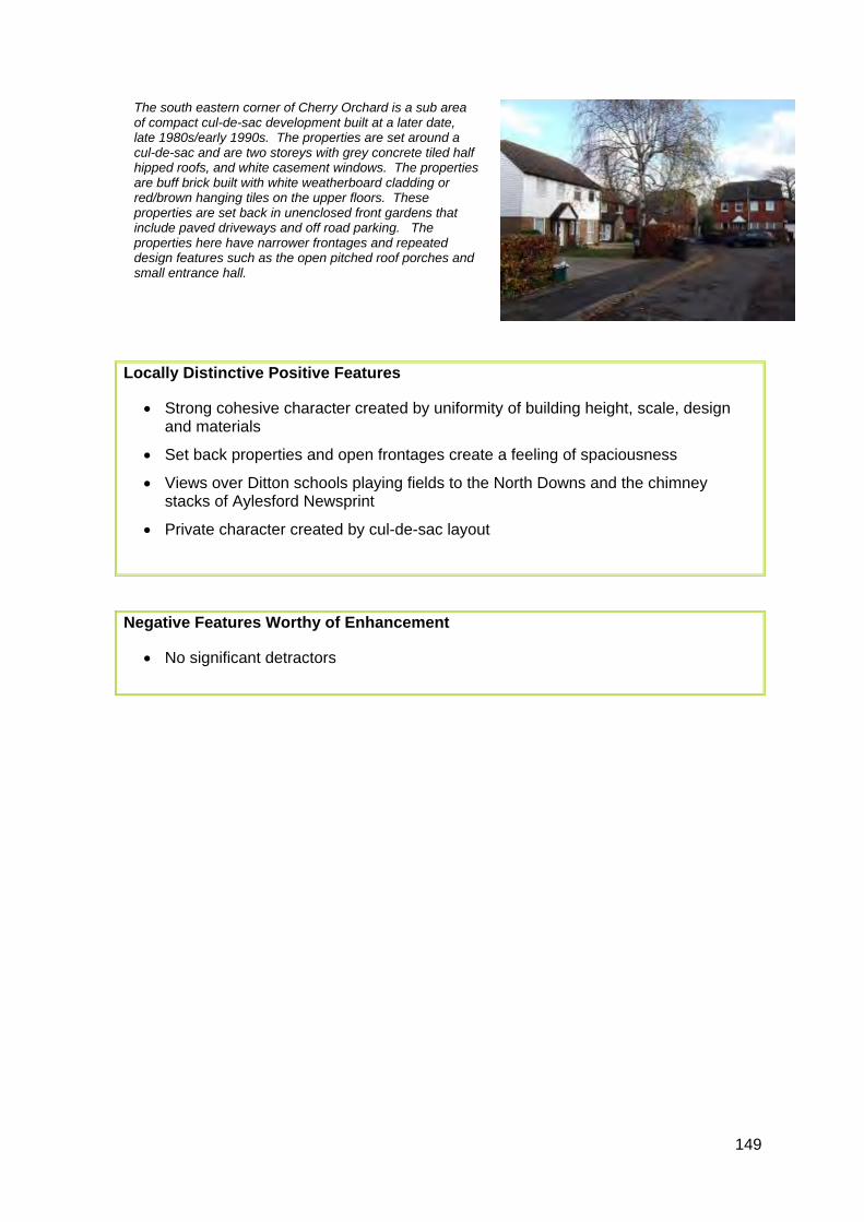
149
The south eastern corner of Cherry Orchard is a sub area of compact cul-de-sac development built at a later date, late 1980s/early 1990s. The properties are set around a cul-de-sac and are two storeys with grey concrete tiled half hipped roofs, and white casement windows. The properties are buff brick built with white weatherboard cladding or red/brown hanging tiles on the upper floors. These properties are set back in unenclosed front gardens that include paved driveways and off road parking. The properties here have narrower frontages and repeated design features such as the open pitched roof porches and small entrance hall.
Locally Distinctive Positive Features
• Strong cohesive character created by uniformity of building height, scale, design and materials
• Set back properties and open frontages create a feeling of spaciousness
• Views over Ditton schools playing fields to the North Downs and the chimney stacks of Aylesford Newsprint
• Private character created by cul-de-sac layout
Negative Features Worthy of Enhancement
• No significant detractors

ì
ì
ìGlimpse of countryside.
Views of recreation area
and North Downs.
Long view of Aylesford Newsprint Chimneys.
75
68
90
81
55
67
94
102
110
BRAMPTON FIELD
Ditton
St Peter's Church
Ditton Infant SchoolSt Peter's Court
CHERRY
CO
UR
T C
LOSE
SCOTT CLOSE
RA
GS
TON
E C
OU
RT
KILN BARN ROAD
WOODLANDS ROAD
PE
AR
TR
EE
AV
EN
UE
THE STREAM
Trac
k
91
63
8
3
79
6
39
44
82
9
2
70
14
1 to 20
4031
7
32
33
11
1 8
1 7
57
22
76
13
96
15
51
24
101
103
2512
a
23
34
19
10
46
28
20
4
43
45
54
12
95
69
41
16
52
37
64
59
47
49
58
87
5
1
Community Centre
46
13
THE STREAM
24
10
17
10
59
15
81
17
2
491
10
46
22
8
55
SCOTT CLOSE
16
12
22
81
51
43
1
23
44
19
9
1
1
63
1
45
37
1
2
BRA
MPT
ON
FIE
LD
2
49
24
13
1
58
79
11
75
3
12
7
31
24
12
13
51
47
69
32
76
25
24
69
2
14
19
18
1 3
45
1 2
1
0 100 20020 40 60 80Metres¯
© Crown copyright and database rights 2011 Ordnance Survey 100023300
F10 Medway Gap Character Area AppraisalRef
Title Scott Close and Cherry Orchard

151
The two storey semi-detached houses are arranged on an even building line behind front gardens and driveways which are partially enclosed by hedges, dwarf walls or wood panel fences. The roads are straight and wide with pavements creating an open character. The topography rises gently towards the west. The uniform materials and building height and relatively even building line create a consistent character typical of the period, but the area lacks landmarks and distinctive buildings.
The houses are constructed of red/brown or yellow brick with brown concrete roof tiles on quite steeply pitched gabled roofs with small chimneys on the ridge. The properties are of several repeated designs, and design details include hung brown concrete tiles on upper storeys, white painted ground floors, canted bay windows and flat porch canopies. Many properties have been modified with front extensions and dormer windows (see right) some of which are over-dominant.
A former quarry has been converted to recreation open space incorporating play equipment and a sports pitch. Situated on low ground and tucked behind the houses, it has limited visual impact on the area as a whole. There are long views westwards over open countryside to the North Downs across the open space and from elevated points at the western end of the development. Tall trees in an adjoining garden are an important feature visible from many parts of the development. There is a further small area of trees and grass by the shopping parade. Garden trees, hedges and shrubs soften the architecture providing relief from the brick.
F11 – THE AVENUE AREA
Comprising: Ash Close, Elm Walk, Firs Close, Orchard Avenue, Rowan Close, Sycamore Drive, The Avenue, The Beeches, The Bounds, The Coppice, The Hawthorns, The Lindens, The Oaks and Yew Tree Close.
The Avenue area was laid out in the early 1960s on former agricultural land between the A20 London Road and the proposed route for the M20. The southern section was completed first. It comprises straight roads and culs de sac laid out in a grid pattern.

152
At the northern edge of the development, short cul-de sacs lead off the Avenue at regular intervals. The motorway beyond is screened by high panel fencing and trees.
A short 2 storey shopping parade with a small parking area is in good condition. A section of pitched roof disguises the flat roof behind, so that the parade blends with the surrounding residential development.
On Hall Road there is a depot, now used as a charity warehouse, and some infill development dating from the late 1970s/early 1980s. The houses have a relatively square appearance with low pitched roofs, wide fenestration and forward projecting garages, the design contrasting with other houses in the area.
Locally Distinctive Positive Features
• The area has a cohesive character typical of the period with consistent use of materials, repeated designs, a common building height and relatively even building line unifying the identity of the development
• The area has a quiet residential character with the layout ensuring low traffic speeds and little through traffic
• The area is enhanced by mature landscaping including garden hedges, trees and shrubs, tall trees by the shopping parade and an area of green open space
• The London Road and M20 are screened by tree planting. Properties along Hall Road are set back on a service road behind a row of trees
• There are long views westwards of the North Downs from more elevated parts of the area
• The wide roads, pavements and uncluttered townscape create an open character
153
Negative Features Worthy of Enhancement
• There is traffic noise from surrounding roads, particularly the M20
• Some surfacing is in poor condition
• Some dormer extensions are over prominent
• There is an absence of landmarks or distinctive buildings

ì
ì
ì
ì
#
Shopping Parade.
#
More recentinfill development
and charity warehouse.
#
Prominent trees.
#
Former quarry,now a recreation
open space.
#
Verge and treespartially screen
Hall Road.
Views ofNorth
Downs.
Views ofNorth
Downs.
View of North Downs.
LONDON ROAD
M 20
The Duchess
House
Clive House
Premier Parade
Charles Busby Court
Court
LIN
DE
NS
THE BOUNDS
THE
BE
ECH
ES
RUSS
ETT
CLO
SE
HO
WIC
K C
LOSE
THE
CO
PPIC
E
FIRS CLOSE
SEDLEY
THE HAWTHORNS
MC
KEN
ZIE
CLO
SE
ASH
CLO
SE
RO
WAN
CLO
SE
ORCHARD AVENUE
HA
LL R
OAD
YEW
TR
EE C
LOSE
CLARK MEWS
THE AVENUE
THE
OA
KS
ELM WALK
TEA
POT
LAN
ESTATION ROAD
SYC
AM
OR
E D
RIV
E
ADMIRAL MOORE DRIVE
Surg
ery
The Doctors House
15
2
6
5
4
4 to 5
88
1 to 44
40
81
35
48
57
7
49
16
78
379
390
400
11
59
266
2 to 9
9
162
112
21
12
280
3
138
216
2 to 82
42
141
165
58
100
155
97
52
68
56
31
176
121
29
95
60
24
67
244
109
115
3837
174
122
172
143
146
154
8
7a
46
23
10
145
144
32
76
160
230
25
400a
1b
107
28
20a
13
179
254
395
18
30
131
222
45
2a
103
50
1a
12a
163
134
119
133
39
69
20
33
18a
54
27
17
378
294
90
290
22
62
19
1
26
93
34
14
Shelter
39
11
29
1
13
23
42
17
6
34
28
12
11
14
12
21
6
SYCAMORE DRIVE
1
10
17
SYC
AMO
RE
DR
IVE
7
23
20
38
18
10
10
34
18
HALL
RO
AD
26
2
14
22
12
21
1
7
15
1
17
58
16
14
131
11
2
19
34
2
11
26
39
1
2
2
40
19
11
12
21
13
11
7 10
62
60
100
33
25
11
18
1
29
33
1
House
88
9
THE AVENUE
1
6
20
26
7
1
14
13
7
M 20
HA
LL R
OAD
8
7
31
33
109
2
2
29
32
12
1
23
11
32
14
1
20
14
23
20
1
9
30
2
2
1
1
1
1
11
12
45
4
6
3
31
12
1
22
TEAP
OT
LAN
E
21
8
95
90
7
11
109
3
20
2
27
1
0 150 30030 60 90 120Metres¯
© Crown copyright and database rights 2011 Ordnance Survey 100023300
F11 Medway Gap Character Area AppraisalRef
Title The Avenue Area
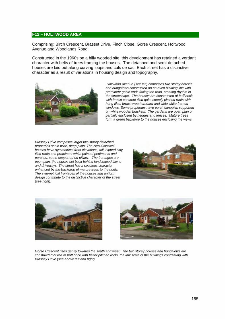
155
Holtwood Avenue (see left) comprises two storey houses and bungalows constructed on an even building line with prominent gable ends facing the road, creating rhythm in the streetscape. The houses are constructed of buff brick with brown concrete tiled quite steeply pitched roofs with hung tiles, brown weatherboard and wide white framed windows. Some properties have porch canopies supported on white wooden brackets. The gardens are open plan or partially enclosed by hedges and fences. Mature trees form a green backdrop to the houses enclosing the views.
Brassey Drive comprises larger two storey detached properties set in wide, deep plots. The Neo-Classical houses have symmetrical front elevations, tall, hipped clay tiled roofs and prominent white painted pediments and porches, some supported on pillars. The frontages are open plan, the houses set back behind landscaped lawns and driveways. The street has a spacious character enhanced by the backdrop of mature trees to the north. The symmetrical frontages of the houses and uniform design contribute to the distinctive character of the street (see right).
Gorse Crescent rises gently towards the south and west. The two storey houses and bungalows are constructed of red or buff brick with flatter pitched roofs, the low scale of the buildings contrasting with Brassey Drive (see above left and right).
F12 – HOLTWOOD AREA
Comprising: Birch Crescent, Brasset Drive, Finch Close, Gorse Crescent, Holtwood Avenue and Woodlands Road.
Constructed in the 1960s on a hilly wooded site, this development has retained a verdant character with belts of trees framing the houses. The detached and semi-detached houses are laid out along curving loops and culs de sac. Each street has a distinctive character as a result of variations in housing design and topography.

156
Finch Close is a curved cul de sac which drops sharply towards the east with the houses to the south set down below and those to the north set above the road. The houses are individually designed incorporating a range of syles (see left).
Woodlands Road is elevated and gently curving. The houses on the south side are set back from the road and garden trees enhance the character. The housing designs vary but there is a more unified character around the junction with Brassey Drive. There are long views to the west towards Sevenoaks (see right).
The entrance to Birch Crescent is particularly verdant and a large specimen tree is a feature (see above left). One older house in red herring bone brick with a tall hipped clay tile roof and decorative chimneys provides an interesting contrast with the more recent buildings. The out house is an attractive feature in the townscape (see above right).

157
Locally Distinctive Positive Features
• The belts of mature trees form a backdrop to the houses and constrain long views contributing to the leafy, private, residential character of the area. There are also some individual trees which are prominent in the streetscene. Tree belts to the east screen the neighbouring light industrial uses
• Each street has a distinctive character due to the changing topography and differences in house design and plot size
• Brassey Drive has a particularly spacious and distinctive character due to the uniform design, use of traditional materials, size and spacing of the houses and the deep unenclosed front gardens. The symmetry of the houses is a characteristic feature
• The undulating topography, curved road layout and mature trees create changing views and vistas
• Some sections of Holtwood Avenue have rhythm due to repeated house design, forward facing gables and regular spacing of the housing
• The older house in Birch Crescent retains original features including herringbone brick work, exposed timber, clay tile roof and decorative chimneys, adding character to the street
Negative Features Worthy of Enhancement
• There is some traffic noise from the A20
• Some footways and road surfaces are in poor condition

ì
View towards East Malling.
#
Older house.
#
Prominent tree.
#
Area of tree preservation order.
#
.
Depot
BIR
CH
CRESCENT
FFINCH
RUSS
ETT
CLO
SE
LONDON ROAD
WOODLANDS
WOODLANDS ROADH
OLT
WO
OD
AV
EN
UE
PRIMROSE DRIVE
MILLS ROAD
LAKE
ROAD
BRASSEY DRIVE
TEA
PO
T L A
NE
WEALD
EN W
AY
2
15
21
54
26
40
1 to
3
379
13
390
18
400
28
59
31
43
16 to
17
8211
7
73
80
68
62
247
118
196
22
200
237
52
154
191
184
131
255
56
39
46
180
416
9
141
143
179
32
29
3b
121
58
201
60
170
402
72
69
127
107
3 4
3a
214
402a
10
38
23
160
12
11
130
425
142
423
44
37
241
2 5
9993
218
3e
400a
423a
251
20
33
415
48
7
49
24
16
45
439
222
225
5
155
14
269
4
263
431
42
213
106
259
401
27
86
17
61
378
8
116
53
63
83
3
90
1
Shelter
El Sub Sta
59
2
21
2
15
9
15
7
9
33
8
4
7
12
2
9
16
49
1
7
42
11
40
33
13
7
29
1
1
27
2
1
14
4
1
218
21
3
21
10
1
2
9
PRIM
RO
SE
DR
IVE
58
22
14
26
12
11
14
12
8
13
46
29
44
4
31
56
20
46
14
21
14
1
0 150 30030 60 90 120Metres¯
© Crown copyright and database rights 2011 Ordnance Survey 100023300
F12 Medway Gap Character Area AppraisalRef
Title Holtwood Area

159
The entrance from Station Road is unprepossessing with panel fences and concrete garages flanking the road. However, the steeply pitched clay tile roofs, chimneys and dormer windows of the early 20th century houses to the north east add historical interest.
The semi-detached, terraced and detached two storey houses and bungalows are constructed of buff, red/brown or yellow brick (see below and right). Roof pitches vary and include both gabled and hipped, some with small chimneys. A number of properties have forward facing gables. Designs vary but many properties have a brick motif on rendered upper storeys (see below left) adding some distinctiveness. Other features include front projections on the ground floor and integral garages.
The depth of the front gardens varies. Some are open plan whilst others are enclosed by walls, picket fences or hedges. Overall, the development lacks a cohesive character and there are few unifying features.
The pavements and some driveways are poorly surfaced but the swan neck lamps are an attractive feature. Poorly landscaped communal parking areas and garages detract from the character of the scheme.
F13 – ROBSON DRIVE AREA
Comprising: Robson Drive, Teapot Lane (north) and Trewin Close.
A development of semi detached, detached and terraced houses on flat land directly south of the M20.

160
The traffic bollards and footbridge at the eastern end of the area are in poor repair harming the character of the area.
At the northern end of Teapot Lane, two more recent houses close the view from Robson Drive.
Locally Distinctive Positive Features
• The area has a residential character with little through traffic
• Short views of the Victorian roofs to the north east
Negative Features Worthy of Enhancement
• There is noise from the M20 and the railway line
• The street furniture and surfacing is poorly coordinated and maintained
• The townscape lacks a cohesive character and has few unifying features

ì
Vista ofroofscapes.
Aylesford School - Sports College
M 20
Works
Millhall
Depot
Primary School
(Secondary)
Aylesford Station
TREW
IN C
LOSE
ROBSON DRIVE
MILLHALL
MILL HALL ROAD
PRIORY GROVE
ELM WALK
TEA
POT
LAN
E
STATION ROAD
1c
2
7
1
6
31
88
27
19
71
14
56
1 to 18
66
48
38
5
49
73
41
30
110
63
58
452
3
75
68
94
176
78
53
99
67
95
97
156
40
174
100
18
57
37
25
51
87
1b
43
46
92
102
1 2 45
42
1a
61
170
85
69
35a
9 0
60
26
52
9 3
11
9
84
91
Sub Sta
Sta
El Sub Sta
GP
101
Depot
69
6
1
99
TEAP
OT
LAN
E
2
1a
1
1
1b
5
3
MILLH
ALL
7
45
61
0 100 20020 40 60 80Metres¯
© Crown copyright and database rights 2011 Ordnance Survey 100023300
F13 Medway Gap Character Area AppraisalRef
Title Robson Drive Area

162
The red, buff and yellow brick houses are constructed in a 1930s style with hipped tiled roofs, projecting front elevations and sun trap windows. Some are tile hung or pebble dashed and have curved or recessed porches. The houses are set back behind open plan lawns and driveways. At the eastern end there are two short terraces constructed in buff brick with hung tiles.
Tall trees screening the M20 form a green back drop to the development.
The cul de sac is gently curved with no long views. A grassed area with mature trees screens the buildings from Station Road but the character of the area is affected by traffic noise both from Station Road and the M20. The surfacing is in poor condition.
F14 – SEDLEY CLOSE
Comprising: Sedley Close
This small cul de sac development of semi detached and terraced houses was constructed in the late 1960s/early 1970s. It is situated off Station Road immediately north of the M20.
Locally Distinctive Positive Features
• The Close has a distinctive character created by the uniform height and scale of the buildings and repeated designs and features
• The grass verge and mature trees separating the cul de sac from Station Road enhance the outlook of the houses and creates a verdant character
• There is no through traffic and the Close has a residential character
Negative Features Worthy of Enhancement
• There is traffic noise from Station Road and the M20
• The road surface is in poor condition

M 20
Warehouse
Homefarm Estate
CLOSE
THE
BE
ECH
ES
THE
CO
PPIC
E
HEATHCOTE CLOSE
ASH
CL O
SE
HA
LL R
OAD
6
15
8
16
22
2 72 1
266
9
162
280
138
141
165
284034
155
20
121
25
5
17
109
115
122
172
143
146
154
2
144
145
160
14
23
179
18
30
7
131
45
41
103
13
12a
163
134
119
133
33
18a
294
11
10
1
Station
12
Path (um)
El Sub Sta
Tank
PC
PC
6
14
2
HALL
RO
AD
45
18
12
Tank
16
33
10
34
9
1
Path (um)
34
1
131
13
1
40
1
Path (um)
0 100 20020 40 60 80Metres¯
© Crown copyright and database rights 2011 Ordnance Survey 100023300
F14 Medway Gap Character Area AppraisalRef
Title Sedley Close

164
The detached properties are set back behind deep landscaped front gardens with a mixture of stone walls, fences, railings and high hedges along the boundaries. The properties are situated on generally substantial plots. The specimen trees visible over and between properties, mature hedging and views into the grounds of the houses from the road give the area a spacious green character.
Its elevated position gives long views to the south over the built up area of Ditton and to Oaken Wood in the distance.
Each property is individually designed and the range of materials and roof types vary throughout giving a mixed character to the area. However the recurring use of red brick and white rendering, along with brown tiles on the roofs and white casement windows help to unify the character.
G – LOWER DENSITY DETACHED HOUSING
This category incorporates detached houses from the 1930s onwards, set back from a private road within substantial plots. They follow an irregular building line, behind front gardens enclosed by mature hedges or walls. Often deep rear gardens contain mature trees and vegetation.
The houses incorporate a mixture of materials and individual designs. The buildings are typically constructed in orange/red brick or white render. The use of hipped and half hipped roofs produces complex roof patterns.
Downderry Way is located close to the A20, but is accessed by a private no through road and therefore traffic is minimal. This gives the area a private secluded character.
G1 – DOWNDERRY WAY
Comprising: Downderry Way
Downderry Way is a narrow private cul de sac accessed from Bradbourne Lane with seven large detached properties. They are a mixture of large bungalows and two storey properties, dating from the 1930’s onwards. The large gardens, trees and hedges lend themselves to encouraging wildlife which contributes to the spacious and verdant character of the area.

165
The quality of the road surface is extremely poor, with large pot holes along its length. This detracts from the quality of the rest of the area.
The lack of pavements further contributes to the narrow character of the road itself.
The limited vehicular and pedestrian access through the site gives the area has a private secluded character.
LOCALLY DISTINCTIVE CONTEXTUAL FEATURES
Age of buildings 1930s onwards
Type of buildings Detached
Main uses Residential
Building heights 1 - 2 storeys
Prominent building materials Red brick, white rendering, brown roof tiles, white windows.
Predominant boundary treatments Stone walls, fences, railings and hedges
Open spaces None
Locally Distinctive Positive Features
• Verdant frontages and edges with landscaped gardens, hedges and tall trees, particularly in the East of the area
• Long views of the surrounding countryside to the South
• Individuality of buildings
• Spaciousness created by generous plot sizes and properties being set back from the road
Negative Features Worthy of Enhancement
• Poor surfacing of road

ìì
Views over Ditton to Oaken wood.
45
43a
43d
BRAD
BOU
RN
E
BRADBO
URNE
LANE
LONDON ROAD
LAN
E
DOWNDERRY WAY
41
Garage
11
3
10
629
37
13
31
43
657
40
269
632
54
643
16
38
1 6b
34
16a
661
663
5
29
55
1
659
23
21
4
8
Tall Trees
9
0 50 10010 20 30 40Metres¯
© Crown copyright and database rights 2011 Ordnance Survey 100023300
G1 Medway Gap Character Area AppraisalRef
Title Downderry Way
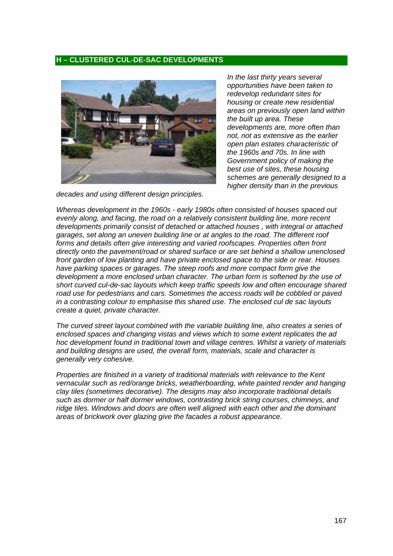
167
H – CLUSTERED CUL-DE-SAC DEVELOPMENTS
In the last thirty years several opportunities have been taken to redevelop redundant sites for housing or create new residential areas on previously open land within the built up area. These developments are, more often than not, not as extensive as the earlier open plan estates characteristic of the 1960s and 70s. In line with Government policy of making the best use of sites, these housing schemes are generally designed to a higher density than in the previous
decades and using different design principles.
Whereas development in the 1960s - early 1980s often consisted of houses spaced out evenly along, and facing, the road on a relatively consistent building line, more recent developments primarily consist of detached or attached houses , with integral or attached garages, set along an uneven building line or at angles to the road. The different roof forms and details often give interesting and varied roofscapes. Properties often front directly onto the pavement/road or shared surface or are set behind a shallow unenclosed front garden of low planting and have private enclosed space to the side or rear. Houses have parking spaces or garages. The steep roofs and more compact form give the development a more enclosed urban character. The urban form is softened by the use of short curved cul-de-sac layouts which keep traffic speeds low and often encourage shared road use for pedestrians and cars. Sometimes the access roads will be cobbled or paved in a contrasting colour to emphasise this shared use. The enclosed cul de sac layouts create a quiet, private character.
The curved street layout combined with the variable building line, also creates a series of enclosed spaces and changing vistas and views which to some extent replicates the ad hoc development found in traditional town and village centres. Whilst a variety of materials and building designs are used, the overall form, materials, scale and character is generally very cohesive.
Properties are finished in a variety of traditional materials with relevance to the Kent vernacular such as red/orange bricks, weatherboarding, white painted render and hanging clay tiles (sometimes decorative). The designs may also incorporate traditional details such as dormer or half dormer windows, contrasting brick string courses, chimneys, and ridge tiles. Windows and doors are often well aligned with each other and the dominant areas of brickwork over glazing give the facades a robust appearance.

168
LOCALLY DISTINCTIVE CONTEXTUAL FEATURES
Age of buildings Mid 1980s onwards
Type of buildings Detached, semi-detached and attached houses, terraces and a few bungalows
Main uses Residential
Building heights Predominantly 2 storey a few 1 storey (bungalows)
Prominent building materials Red, orange/red and yellow brick, tiled and slate roofs, weatherboard, hung tiles, ‘tudor-bethan style timbers white casement windows.
Predominant boundary treatments Open frontages or some low boundary treatments including hedges and fences
Open spaces Landscaped public amenity space sometimes incorporated in the developments.
Locally Distinctive Positive Features
• Cohesive character (in the majority of areas) created by uniformity of design, materials and details
• Well maintained landscaped frontages
• Amenity green spaces, often lined with mature landscaping, soften the streetscene and create a sense of spaciousness
• Verdant edges and backdrops
• Enclosed private character created by close relationship between properties, curving streets and inward-looking urban form
• Curving layout and varied building line coupled with, at times, an undulating topography creates a series of vistas, glimpses, short, long and/or panoramic views of historical buildings and surrounding countryside including the North Downs and Oaken Wood
• Interesting building and roof lines and roofscapes
• Traditional brick, tile and roof materials
• Quiet residential character with no through traffic
• Quality surface treatments

169
Negative Features Worthy of Enhancement
• Traffic noise from traffic travelling along near by major routes including the A20 and M20
• Parking on-street and on paved frontages clutter the street scene

170
The culs-de-sac are laid out on undulating land either side of Oxley Shaw Lane and are mostly inward looking creating an enclosed private character. The character of the properties differs slightly between the two areas split by Oxley Shaw Lane. To the south of the Lane the development is at a slightly higher density featuring more linked detached, semi-detached and terraced properties (see above). Also, there is less variety in terms of building styles and details, with the vast majority of the buildings south of the Lane built of either buff or red brick with gable-ended pitched roofs and white casement windows. A unifying feature of interest on most of the front elevations are brick built porches with either sloping or gable-fronted roofs (see above) which break-up what would otherwise be a plain frontage.
H1 – LEYBOURNE SOUTH AREA
Comprising: Oxley Shaw Lane, Roundhay, Barleycorn, Wheatfield, Millbrook, Old Orchard Lane, Lillieburn, Harvest Ridge, Old Barn Road, Broadoak, Hayfield and Evergreen Close
A large development of several culs-de-sac either side of Oxley Shaw Lane accessed primarily off London Road (A20) in the south-west corner at the junction with Castle Way. Junction 4 of the M20 to the north is close by and can be accessed off Castle Way. This area, along with Leybourne North, was developed by Croudace in the 1980s, both forming part of one major planning application of approximately 1000 units. The areas are similar but are separated by Rectory Lane North and Rectory Lane South which run through the middle of Leybourne. The development of Leybourne is at the outer extent of the built-up confines of the Medway Gap with open farmland to the south and metropolitan Green Belt to the west, beyond Castle Way.
Most of the properties to the north of Oxley Shaw Lane are larger in comparison, with a higher proportion of detached houses (see above). These properties have more variety in terms of building styles and design features including large gable-fronted or hipped roofs with cat-slide roofs, mock ‘tudor-bethan’ wood beams and white render or decorative hung tiles on the upper storey (see above). This detailing and variety of styles and colours creates a visually more interesting environment than that experienced in the culs-de-sac south of the Lane.
Unifying features in both areas include the building height of two storeys (with the exception of a couple of bungalows), short frontages, curving street layout and traditional brick build. Looking at the area as a whole, there is a broad harmonious palette of materials and a variety of styles and design details which are positive distinctive features.

171
Mature landscaping features predominantly throughout the area either at the frontages to the properties (see above left and right) or at the edges to the areas where they abut Oxley Shaw Lane (see above, middle) or strong verdant back drops including the row of mature trees along the A20 bund to the south and the elevated Leybourne Woods to the west (see right). These are positive features which help soften the streetscene and provide a green frame (when in full foliage) to the area as a whole.
Another positive distinctive feature is the series of views, vistas and glimpses that can be enjoyed from many points in the area, particularly the culs-de-sac north of Oxley Shaw Lane. The undulating topography coupled with the curving streets and variable roof line results in glimpses and long, sometimes panoramic views of the North Downs (see above). A vista of St Peter and St Paul’s Church to the west can be enjoyed from the junction of Evergreen Close with Old Barn Road (see left).
The undulating topography also results in a quite striking stepped building line and visually interesting roofscapes (see above middle and below, right).
All households enjoy close and safe access via a network of footpaths to grassed amenity spaces. These include the large area equipped with children’s play frames north of Oxley Shaw Lane (see right). These are positive features because not only do they play an important role in softening the townscape but the tall mature trees often lining the edges of the open spaces provide strong verdant backdrops to many of the properties.

172
Locally Distinctive Positive Features
• Well maintained landscaped frontages to the properties (including hedges and tall trees) and strong verdant edges to the whole area (including Leybourne Wood and the screen of mature trees and hedges lining the bund along the A20 to the south)
• Enclosed private character created by close relationship between properties, curving streets and inward-looking urban form
• Undulating topography coupled with curving layout and varied building and roof lines creates a series of views including vistas of the spire of St Peter and St Paul’s Church, long views over and between properties of the North Downs and short views of the elevated Leybourne Wood to the west
• Undulating topography creates interesting roof lines
• Traditional brick, tile and roof materials
• Broad harmonious palette of materials and varied building styles enriches the character of the area by providing visual interest
• Quiet residential character within the culs-de-sac north of Oxley Shaw Road
• Proximity of grassed amenity areas to the houses, which provide soft landscaped backdrops to many of the properties
Negative Features Worthy of Enhancement
• Background noise of traffic travelling along the A20 in the cul-de-sac developments south of Oxley Shaw Lane
• Parking on-street cluttering the streetscene
? ?
ì
ì
ìì
Glimpses ofSt. Paul's and
St. Peter's Church.
Long view of North Downs over properties.
LONDON ROAD
Primary School
Church of England
Leybourne,
Medical
Hall
Chimneys
Pat
h ( u
m)
LILL
IEBU
RN
CLOSE
OLD ORCHARD
Trac
k
RIDG
E
RE
DB
ANK
HIG
HBER
RY
Rectory
BARLEYCORN
LITTLE
THE CROFT
RO
UN
DH
AY
LAN
E
OL D
BA
RN
RO
AD
MILLBROOK
BRIDGEWATER PLACE
WHEATFIELDSHAW LANE
Lay-
b y
HAYFI
ELD
BAYWELL
THE MEAD
OXLEY SHAW LANE
CA
STLE WAY
Gas Govn
8c
8
45
Posts
6
2
4
25
18
65
2a
78
44
34
14
85
92
76
74
33
62
28
13
51
37
71
36
67
75
120
5973
to
77
46
49
7
58
30
16
35
70
60
42
15
2b40
10
39
29
72
48
9
57
3
11
27
17
8b
19
50
54
26
52
12
38
61
1a
31
77a
63
69
55
24
23
22
47
43
1
20
56
41
32
5
Shelter
Path
2
18
13
57
6
7
17
49
4
34
44
1
46
1
77
33
57
31
12
33
41
Track
18
19
62
LONDON ROAD
10
7
37
1
28
23
2
15
2478
1
24
11
13
7
36
75
45
10
56
39
18
69
8
51
16
34
13
9
40
73
18
26
50
32
41
8
51
14
10
31
20
19
1
1
3
24
8
59
48
69
232
13
49
46
10
24
16
55
8
7
23
4
48
57
13
6
6
23
22
18
2
28
40
4
1
19
1
3
1
9
16
1
7
73
16
13
7
12
7
6
7
14
8
23
40
26
28
10
41
1
ROUNDHAY
58
41
8
19
1
25
11
27
45
13
76
1
22
34
1
74
67
27
4
77
7
52
71
ROUNDHAY23
6
2
5142
7
63
34
14
10
13
46
26
2
31
1
0 150 30030 60 90 120Metres¯
© Crown copyright and database rights 2011 Ordnance Survey 100023300
H1 Medway Gap Character Area AppraisalRef
Title Leybourne South Area

174
H2 – LEYBOURNE NORTH AREA
Comprising: Oxley Shaw Lane, Baywell, Grassmere, Highberry, Redbank, Little Oxley, Copsehill, Woodlea, Willowmead, Terry Walk, Bridgewater Place, The Croft, The Mead
A large development of several culs-de-sac either side of Oxley Shaw Lane accessed primarily off London Road (A20) in the south-west corner at the junction with Castle Way. Junction 4 of the M20 to the north is close by and can be accessed off Castle Way. This area, along with Leybourne South, was developed by Croudace in the 1980s, both forming part of one major planning application of approximately 1000 units. The areas are similar but are separated by Rectory Lane North and Rectory Lane South which run through the middle of Leybourne. The development of Leybourne is at the outer extent of the built-up confines of the Medway Gap with open farmland to the south and metropolitan Green Belt to the west, beyond Castle Way.
The culs-de-sac are laid out on undulating land either side of Oxley Shaw Lane. The properties do not face onto the Lane but follow an inward looking urban form creating an enclosed private character. There are a few clusters of properties to the east of the Lane that are of a higher density compared to the rest of the area, including parts of Willowmead where there are terraced properties (see above left).
Unifying characteristics of the two storey detached, linked detached, semi-detached and terraced properties to the east of Oxley Shaw Lane include the pitched gable-ended roofs and traditional brick built homes. A positive feature is the broad harmonious palette of building materials including buff, red and brown brick, sometimes with mock-‘tudor bethan’ wood beams and white render on the upper storey and white and brown casement windows which enrich the character and create a visually interesting environment.
The development comprises private housing with the exception of two sheltered accommodation schemes at Willowmead (above left) and Grassmere (above right) which are managed by Russet Homes. The positive feature of the Willowmead sheltered housing scheme is its relatively low profile, including a block of single storey apartments which allow for long views of the North Downs and short views of the trees surrounding the adjacent Castle Lake which provides a strong verdant backdrop (see above, middle).
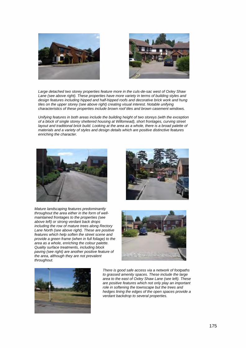
175
Large detached two storey properties feature more in the culs-de-sac west of Oxley Shaw Lane (see above right). These properties have more variety in terms of building styles and design features including hipped and half-hipped roofs and decorative brick work and hung tiles on the upper storey (see above right) creating visual interest. Notable unifying characteristics of these properties include brown roof tiles and brown casement windows. Unifying features in both areas include the building height of two storeys (with the exception of a block of single storey sheltered housing at Willomead), short frontages, curving street layout and traditional brick build. Looking at the area as a whole, there is a broad palette of materials and a variety of styles and design details which are positive distinctive features enriching the character.
There is good safe access via a network of footpaths to grassed amenity spaces. These include the large area to the east of Oxley Shaw Lane (see left). These are positive features which not only play an important role in softening the townscape but the trees and hedges lining the edges of the open spaces provide a verdant backdrop to several properties.
Mature landscaping features predominantly throughout the area either in the form of well-maintained frontages to the properties (see above left) or strong verdant back drops including the row of mature trees along Rectory Lane North (see above right). These are positive features which help soften the street scene and provide a green frame (when in full foliage) to the area as a whole, enriching the colour palette. Quality surface treatments, including block paving (see right) are another positive feature of the area, although they are not prevalent throughout.

176
Another positive distinctive feature is the series of views and vistas that can be enjoyed from many points in the area, particularly the culs-de-sac west of Oxley Shaw Lane). The undulating topography coupled with the curving streets and variable roof and building line results in glimpses of the North Downs (see right) and short views of the trees lining the edge of one of the Leybourne Lakes (see above right). A vista of St Peter and St Paul’s Church to the west can be enjoyed from the elevated position of Willowmead (see above left).
The undulating topography also results in a quite striking stepped building line in many areas and visually interesting roof lines, particularly in the culs-de-sac east of Oxley Shaw Lane (see above).

177
Locally Distinctive Positive Features
• Well-maintained landscaped frontages to the properties (including hedges and tall trees) and verdant backdrops (including the row of tall mature trees and hedges lining Rectory Lane North)
• Enclosed private character created by close relationship between properties, curving streets and inward-looking urban form
• Undulating topography coupled with curving layout and varied building and roof lines creates a series of views, including vistas of the spire of St Peter and St Paul’s Church, long views over and between properties of the North Downs and short views of the trees lining one of the Leybourne Lakes
• Traditional brick, tile and roof materials
• Quality surface treatment, in places
• Quiet residential character within the majority of the culs-de-sac, with the exception of properties in Willowmead
• Proximity of grassed amenity areas to houses, which provide soft landscaped backdrops to many of the properties
Negative Features Worthy of Enhancement
• Background noise of traffic travelling along the M20 in the Willowmead cul-de-sac development
• Parking on-street cluttering the streetscene

? ?
ì
ì
ì
ì
ì
ì
Long views of North Downs over properties.
Vista ofSt. Peter's
andSt. Paul'sChurch
and NorthDowns.
Short view of line oftall specimen trees.
Short viewsof trees liningCastle lake.
Wat
e rs i
d e
Medical
Hall
Court
Chimneys
Wat
ersi
de C
ourt
Garage
Path
CO
PS
EH
I LL
CLOSE
LUN
SFO
RD
L AN
E
RE
DB
ANK
HIG
HBER
RY
WO
OD
PE
CK
ER
RO
AD
BARLEYCORN
LITTLE
THE CROFT
BRIDGEWATER PLACE
TERRY
WHEATFIELD
WO
OD
LEA
GR
ASS
ME
RE
SHAW LANE
WIL
LOW
MEA
D
BAYWELL
MA
RKET R
OW
THE MEAD
OXLEY SHAW LANE
Posts9
47
2
8
94
3
61
11
68
21
to
3 8 t o
44
6
16
65
18
5
28 to 32
2a
2 0
78
161
3 3 to
37
5 7
5 8
92
12a
7 to 17
33
62
51
83
36
30
67
70
169
146
1 32
1 00
171
113
27
59
13
114
73
137
74
77
44
25
125
135
46
147
92a
24
39
79
49
56
37
4 5
28
127
9 0
183
103
157
151
1 02
9 5
9 7
8 7
60
88
9 8
1586
76
109
2b40
3 5
34
48
10
115
41
193
41a
99
194
163
164
1 22
112
110
50
54
26
149
75
81
38
123
104 108
1
31
1 07
1 05
77a
80
175
69
185
55
19
17
89
23
22
12
14
43
7
4
85
32
RECTO
RY L
ANE
SOUT
H
13
4
54
2
6
10
61
7
LUN
SFO
RD
LA
NE
1
39
1
23
7
59
7
115
8
6
51
18
11
1
13
10
2 4
13
135
68
8
38
11
12
20
28
34
28
33
2
19
88
1 45
86
2
40
99
18
25
2 4
34
49
100
23
1
11
46
10
92
69
8
36
1
85
4
16
98
4
7
7 36
16
7
2
31
28
23
36
1
6
5
45
57
24 40
69
97
31
1
16
2 3
5
35
10
9
49
WILLOWMEAD
25
23
548
76
68
2
38
4 3
193
12
32
97
12
57
125
2
49
1
28
46
22
45
15
1
58
48
4
43
1
102
4
15
1
22
6
26
26
169
2
14
23
18
22
22
20
77
75
11
24
1
137
BAYW
ELL
17
8
8
2
13
1515
71
6 5
20
34
27
24
1
11
1
0 150 30030 60 90 120Metres¯
© Crown copyright and database rights 2011 Ordnance Survey 100023300
H2 Medway Gap Character Area AppraisalRef
Title Leybourne North Area

179
There are two designs of properties in this development. The red brick, pitched roof houses with large porches extending across the ground floor in the left of picture, and the buff brick, hipped roof properties on the right. Although different in appearance, they also share characteristics such as the white casement windows and attached garages. The repeat design, materials and common features create a cohesive character to the area.
Glimpses of mature specimen trees and the North Downs can be seen between properties, particularly in the North of the development.
This, combined with the use of hedging and landscaping in the development, adds to the green character.
Some of the properties have additional red hung tile and brown scalloped tile detailing to the upper front façade.
H3 – CARROLL GARDENS
Comprising: Carroll Gardens
A small residential cul-de-sac development built in the 1980’s on land formerly part of the Lunsford Hall Estate. It is sandwiched between the M20 to the South and Lunsford Lane to the North and this generates significant road noise. The properties are larger two storey detached houses on generous plots with attached garages set along a curved building line.

180
Several properties have been individualised with the conversion of the attached garages to internal living accommodation. However, this does not significantly detract from the cohesive character of the development.
Locally Distinctive Positive Features
• Strong cohesive character created by consistency of design, materials and detailing
• Verdant frontages and edges with hedges and glimpses of tall trees beyond
• Enclosed private character
Negative Features Worthy of Enhancement
• Traffic noise from the M20

ì
ì
ìView
of trees.
Glimpses ofNorth Downs.
Short view of tall trees.
Lunsford Hall
Hanover Green
LUNSFORD LANE
CA
RR
OL L
GA
RD
EN
S
M 20
CL O
SE
5
4
7 to 10
314
313
15
11 t o
14
23
259
13
305
278
320
301
302
318316
249
290
237
299
8
12
25
16
17
1
Path (um)
315
LUN
SFO
RD
LAN
E
0 50 10010 20 30 40Metres¯
© Crown copyright and database rights 2011 Ordnance Survey 100023300
H3 Medway Gap Character Area AppraisalRef
Title Carroll Gardens

182
The detached two storey properties face onto the tarmac road or paved shared surfaces on a varied building line. They are set behind front gardens and drives for off-street car parking. The use of hedging and low level landscaping helps create an open green character.
The houses are constructed of red or buff brick with white casement windows and integral or attached garages. The majority of properties have dark timber cladding to the upper front façade and a mono pitched canopy across the ground floor openings. Whilst there is a strong consistency in the size and materials of the buildings, interest is created through variations in the roofline with a mixture of brown tiled shallow hipped and pitched roofs, some with front facing gable end details projecting from the roof line (see below).
Although the development itself is relatively flat, there are short views of mature trees to the rear of and between properties providing a green backdrop to the development. This is particularly noticeable along the northern and eastern boundaries.
Glimpses of the North Downs can be also seen between properties in the north of the area.
H4 – FIELDING DRIVE
Comprising: Fielding Drive
A cul-de-sac development of detached houses, accessed from Chaucer Way, developed during the 1990’s on land identified for low density housing in the North Larkfield Informal Action Area Plan (1973). The site nestles between the adjacent Poets Estate character area to the east and south, and the adjacent sports grounds by Larkfield Lesiure Centre to the west. A footpath also runs along the western boundary.

183
A doctors surgery in the north of the character area, although visually unremarkable, forms a functional community hub for the local area.
Locally Distinctive Positive Features
• Strong cohesive character created by consistency of building materials and design
• Views of neighbouring tree belts and the North Downs
• High quality paved shared space surface treatments
Negative Features Worthy of Enhancement
• No significant detractors

ìì
ì
Long views ofNorth Downs.
Glimpses of trees.
Leisure Centre
Lunsford District Centre
Hall
George Holding
CHAUCER
CLO
SE
AUDEN
WO
RD
SW
OR
T H
FIELD
ING
NEW HYTHE LANE
ROAD
CHAUCER WAY
SASSOON
MA
SE
FIEL D
RO
AD
MARLOWE R
OAD
THAC
KER
AY R
OA
D
THACKERAY
Surgery
692
11
44
62
98
52
75
10
46
34
35
61
102
33
37
63
71
53
249
77
22
32
91
39
30
13
26
83
67
25
43
93
47
69
28
27
45
101
17
66
97
31
20
60
24
87
72
54
16
73
49
15
251
5
64
42
57
21
2
14
23
29
19
8
56
1
58
59
40
36
38
55
12
9
3
4
7
Post
Pavilion
COLERIDGE CLOSE
641
30
5 27
1
7
19
35
28
53
10
30
10
1
19
47
1
9
1
98
25
21
34
6
55
23
2
1
2
15
31
42
13
33
9
8
16
Post
19
31
60
2
26
2
54
1
2
11
28
35
32
15
11
2
10
22
2
7
12
8
21
7
2
71
22
6
29
1
20
27
12
1
28
22
1
11
20
29
39
39
24
16
31
24
33
37
17
15
15
8
39
13
42
28
20
29
35
19
36
0 100 20020 40 60 80Metres¯
© Crown copyright and database rights 2011 Ordnance Survey 100023300
H4 Medway Gap Character Area AppraisalRef
Title Fielding Drive
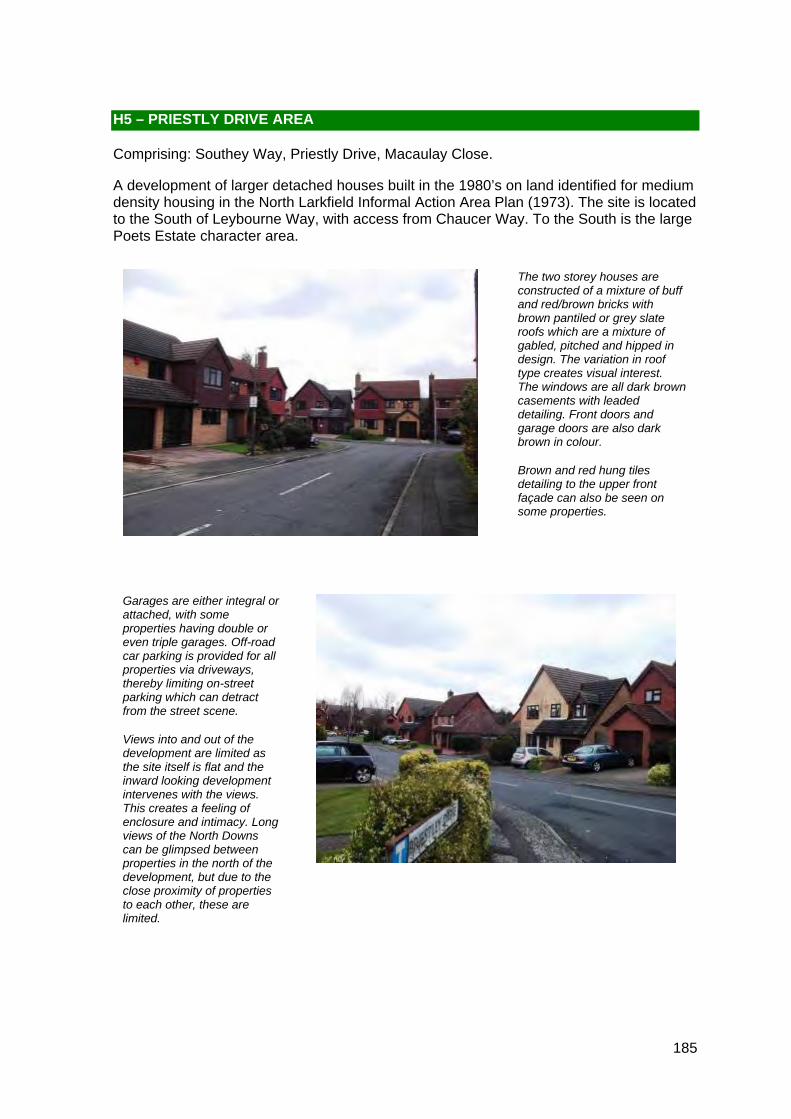
185
The two storey houses are constructed of a mixture of buff and red/brown bricks with brown pantiled or grey slate roofs which are a mixture of gabled, pitched and hipped in design. The variation in roof type creates visual interest. The windows are all dark brown casements with leaded detailing. Front doors and garage doors are also dark brown in colour.
Brown and red hung tiles detailing to the upper front façade can also be seen on some properties.
Garages are either integral or attached, with some properties having double or even triple garages. Off-road car parking is provided for all properties via driveways, thereby limiting on-street parking which can detract from the street scene.
Views into and out of the development are limited as the site itself is flat and the inward looking development intervenes with the views. This creates a feeling of enclosure and intimacy. Long views of the North Downs can be glimpsed between properties in the north of the development, but due to the close proximity of properties to each other, these are limited.
H5 – PRIESTLY DRIVE AREA
Comprising: Southey Way, Priestly Drive, Macaulay Close.
A development of larger detached houses built in the 1980’s on land identified for medium density housing in the North Larkfield Informal Action Area Plan (1973). The site is located to the South of Leybourne Way, with access from Chaucer Way. To the South is the large Poets Estate character area.

186
Although there is limited personalisation to the properties which retains the cohesiveness of the development, there has been a high incidence of loss of front gardens to car parking. In some parts of the development all of the traditional lawned front gardens have been removed in favour of hard standings. This loss of gardens has resulted in a hardened appearance of the streetscape.
There is some traffic noise form Leybourne Way, particularly in the north of the area.
Locally Distinctive Positive Features
• Strong cohesive character created by consistent and unaltered building design, consistency of materials and brown wood windows
• Enclosed, private character – created by close relationship between buildings; often short or curved streets; overlooked space
• Glimpses of countryside between roofs to the north
Negative Features Worthy of Enhancement
• Traffic noise from Leybourne Way
• Loss of front gardens to provide hard surfaced off-street car parking
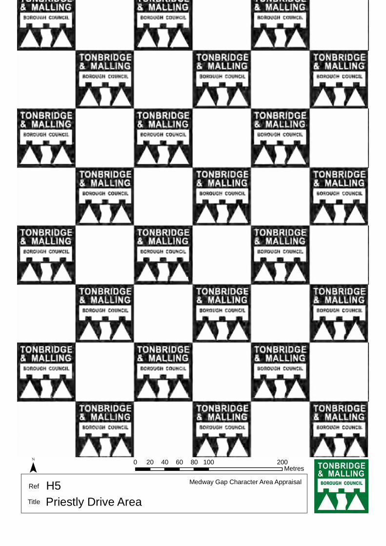
ì ì
Glimpses of trees along Leybourne Lakes.
CHAUCER
CLO
SE
CR
ON
IN C
LOSE
Track
AUDEN
BRO
WN
ING
CLO
SE
WO
RD
SW
OR
T H
CHESTERTON ROAD
GIG
HIL
L R
OA
D
BETJEMAN CLOSE
PRIE
STL
EY D
RIV
E
BAR
RIE
DR
IVE
BLAK
E D
RIV
E
CHAUCER WAY
SASSOON
MA
SE
F IELD
RO
AD
SOUTHEY WAY
MACAULAY
Surgery
9
8
35
52
44
17
23
34
14
4
33
10
22
5
39
30
32
13
43
25
11
47
19
28
2731
20
60
48
16
21 1 5
24
6
37
2
54
41
18
46
29
49
26
7
1
40
12
36
38
3
Byre
Cottage
COLERIDGE CLOSE
The Stable
The Barn
26
2
32
14
19
1
14
275
13
29
9
7
29
18 1
28
18
25
22
8
6
39
17
15
12
241
11
1
26
10
9
19
4
6
19
25
7
8
17
15
22
2 5
7
16
21
2
2
4
9
28
29
10
20
43
32
17
8
1
9
1
36
5
15
10
11
31
21
8
20
8
16
27
1
16
24
19
1
15
9
22
24
12
1
2
16
12
9
2
1
11
2
8
30
1
1
5
1
1
39
19
2
10
33
9
28
2
11
19
7
14
5
25
20
31
18
22
5
21
13
1 9
34
2
1
0 100 20020 40 60 80Metres¯
© Crown copyright and database rights 2011 Ordnance Survey 100023300
H5 Medway Gap Character Area AppraisalRef
Title Priestly Drive Area

188
The 2 storey detached houses face onto the roadway along a staggered building line. The bungalows along the western edge face onto shared space overlooking Castle Lake. Substantial sections of the road and pavement are paved which adds to the attractiveness of the area. The properties are constructed of buff and red brick with a variety of materials to the upper front façade, including red/brown hung tiles, dark timber weather boarding and mock tudor cream render with dark timbers. The roofs are a mixture of pitched and half hipped, and are finished in brown concrete tiles. The windows are a mixture of white and brown casements. The properties have attached single and double garages. The variation in materials and layout of the buildings creates a varied character.
The area slopes downhill from east to west. This change in topography allows for views over Castle Lake to the East, and long views of the church of St Peter and St Paul at Leybourne and the North Downs to the east and north respectively. There are also views of the rear of properties in Willowmead in the south of this character area.
These views, along with deep front gardens and wide road, create a spacious character.
The views add to the verdant character of the area which is further supported by the green backdrop of mature trees along the northern boundary, prevalence of hedging as a boundary treatment and low level soft landscaping in front gardens throughout.
The close proximity of the M20 to the North results in traffic noise.
H6 – WILLOW ROAD
Comprising: Willow Road
A development of 2 storey detached houses and bungalows built during the 1980s along a single curving close serving three short culs de sac. The site lays immediately south of the M20 and is accessed through the adjacent character area from Lunsford Lane. It has views over Castle Lake to the west which creates a spacious verdant character.

189
Locally Distinctive Positive Features
• Verdant edges formed by mature trees particularly in the west and north
• Long views of the North Downs, Castle Lake and the church of St Peter and St Paul at Leybourne
• Spaciousness created by properties being set back from the road behind deep front gardens and long views over open spaces
• Quality of surface treatments
Negative Features Worthy of Enhancement
• Traffic noise from traffic travelling along the M20
ì
ì
ìì
ì
ìViews of backs of properties
on Lunsford Lane.
Views of backs of properties on Willowmead.
View of St. Peter and St. Paul's Church.
Views of North Downs in
distance.
Short view of verdant edge.
View over Castle Lake.
WILLOW ROAD
WILLOWMEAD
1
5
2
11
34
16
22
28 to 32
23
161
31
18
30
169
171
150
12
180
148
162
152
135
17 8
183
157
33
19
193
194
172
163
188
170
15
24
6
175
185
25
186
Path (um)
169
193
WIL
LOW
MEA
D
175
0 50 10010 20 30 40Metres¯
© Crown copyright and database rights 2011 Ordnance Survey 100023300
H6 Medway Gap Character Area AppraisalRef
Title Willow Road

191
Bradbourne Parkway is the main road into the area. It is lined on both sides with grass verges and trees, contributing to the verdant character of the area and reflecting the connections of the area with the adjacent Bradbourne House and historic parkland. There are pockets of grassed amenity space throughout the character area and two significant grassed areas that are wide and open with occasional trees reflecting the character of the parkland at Bradbourne House. Footpaths and cycleways are separated from the road by the grass verges and trees creating a sense of enclosure for the road, separating it from the wide open spaces that mirror the parkland of Bradbourne House.
Throughout the area there are specific characteristics that create a sense of unity, but there are three distinct sub areas where there are significant differences in scale, materials and design features that provide an individual identity for each of the sub areas. Tassell Close is located off Bradbourne Parkway and consists of larger two storey detached houses set around a cul-de-sac road layout. These properties are constructed in red brick with mock Tudor beams and white painted render on the upper floors. There is a variety of roof types including pitched, and half hipped, some with front facing gables creating an interesting roofscape. Decorative brick stringcourses, brown casement windows and decorative brick patterns, particularly on garden boundary walls are the norm. Frontages are open unenclosed lawned areas with driveways for off road parking provision providing an open, unenclosed character. The mature trees to the west and south of the area provide a tree backdrop and contribute to the leafy character of the area.
H7– BRADBOURNE FIELDS
Comprising: Bradbourne Park Road, Chatfield Way, Collinge Close, Forsyth Close, Garner Drive, Reeves Court, Tassell Close and Whiffen Walk.
This area sits behind the rear of the properties along the south side of the A20 London Road and the northern boundary of Bradbourne Park. Known locally as "Bradbourne Fields", this development was built in 2000 by Hillreed Homes. The area is accessed off New Road by Bradbourne Parkway, and is enclosed by a high ragstone wall with red brick coping around the A20 and New Road boundary. The area has a cul-de-sac road layout, accessed off a main 'spine' road that is straight and narrow and tree lined on both sides. The land levels rise upward round a split crescent to the east which has a number of culs-de-sac leading off both arms of this curving road. The western and southern parts of the site are more flat and level with the area rising upwards to the north and the east.

192
A section in the southern part of the area contains detached and terraced three storey town houses built in buff brick in mock Georgian style with white painted render on the ground floor frontages only. The roofs are shallow pitched (hipped at the end of the terrace) in grey slate and have white casement windows. Some of these properties have canted bay windows and chimneys at regular intervals. They have shallow front gardens that are generally enclosed with open metal fencing or low hedging at the front and unenclosed at the side to provide access to the driveway and garage. The properties of this style are set around a cul-de-sac layout, portions of which form gated areas. The area is generally more enclosed with the taller buildings and the edges with Bradbourne Park to the south are enclosed by high walls and fences and tall mature trees that obsure views into the parkland giving a private character. A straight row of terraced town houses along the southern side of Garner Drive overlook open space on a curved crescent but there are other styles of properties around the green creating an eclectic mix of housing.
The scale and design features of the first cul-de-sac are repeated in the properties to the west of the central open space, but the properties that overlook the open space on Garner Drive are varied in their architectural style, massing and materials.
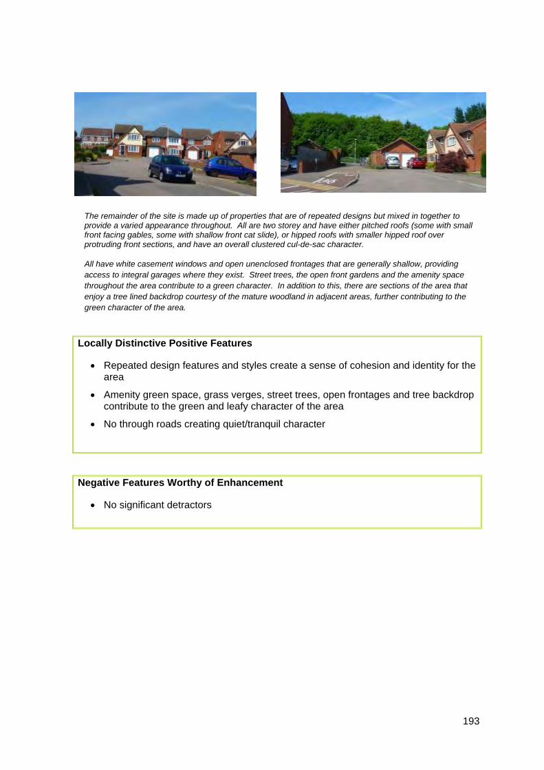
193
The remainder of the site is made up of properties that are of repeated designs but mixed in together to provide a varied appearance throughout. All are two storey and have either pitched roofs (some with small front facing gables, some with shallow front cat slide), or hipped roofs with smaller hipped roof over protruding front sections, and have an overall clustered cul-de-sac character.
All have white casement windows and open unenclosed frontages that are generally shallow, providing access to integral garages where they exist. Street trees, the open front gardens and the amenity space throughout the area contribute to a green character. In addition to this, there are sections of the area that enjoy a tree lined backdrop courtesy of the mature woodland in adjacent areas, further contributing to the green character of the area.
Locally Distinctive Positive Features
• Repeated design features and styles create a sense of cohesion and identity for the area
• Amenity green space, grass verges, street trees, open frontages and tree backdrop contribute to the green and leafy character of the area
• No through roads creating quiet/tranquil character
Negative Features Worthy of Enhancement
• No significant detractors
?
?
?
Park
45
Park
0 250 50050 100 150 200Metres¯
© Crown copyright and database rights 2011 Ordnance Survey 100023300
H7 Medway Gap Character Area AppraisalRef
Title Bradbourne Fields

195
Substantial detached two storey houses face onto the road or shared accesses on a variable building line. They are constructed of red or yellow/brown brick some with painted brickwork or render, and timber effects to the upper storeys and the majority have brown casement windows. Single storey pitched roof porches or porch canopies projecting towards the road can be found on most properties. The roofs are a mixture of pitched, hipped and half-hipped, some with dormer windows and gable ends fronting the road, thereby creating a varied roofscape. Properties have integral or free-standing garages thereby limiting the amount of on-street parking.
The frontages are predominantly enclosed behind low hedges and landscaping. This gives the development a private enclosed character.
H8 – DITTON PLACE & STREAMSIDE
Comprising: Ditton Place, Streamside
A development of predominantly detached houses built on the site of the former commercial premises at Ditton Place during the late 1980’s and early 1990s. The detached properties, along with a short terrace, are set at angles along curving culs de sac. In addition Troutbeck House provides flatted accommodation within the area. The development is accessed from the A20 and a stream runs from north to south through the area which bisects the area with a wide open space containing mature trees and creates a focal point. The area is bounded by New Road recreation ground to the east, although this is not visible from within the character area itself.
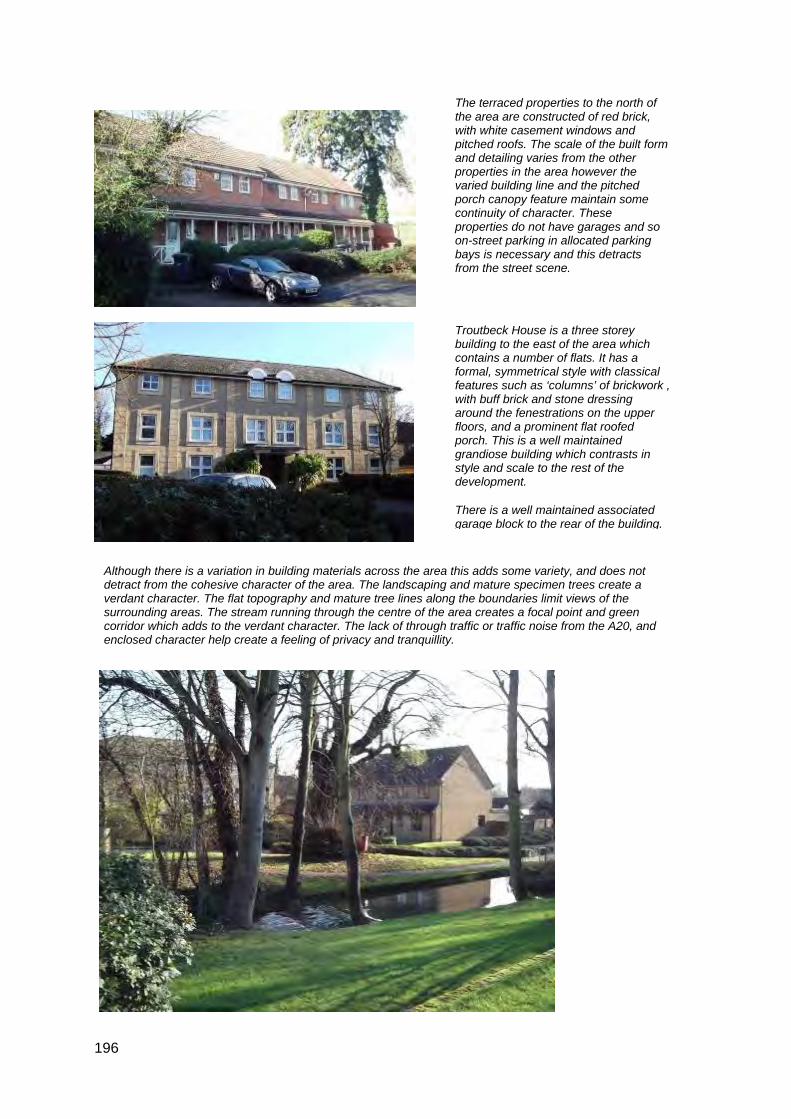
196
The terraced properties to the north of the area are constructed of red brick, with white casement windows and pitched roofs. The scale of the built form and detailing varies from the other properties in the area however the varied building line and the pitched porch canopy feature maintain some continuity of character. These properties do not have garages and so on-street parking in allocated parking bays is necessary and this detracts from the street scene.
Troutbeck House is a three storey building to the east of the area which contains a number of flats. It has a formal, symmetrical style with classical features such as ‘columns’ of brickwork , with buff brick and stone dressing around the fenestrations on the upper floors, and a prominent flat roofed porch. This is a well maintained grandiose building which contrasts in style and scale to the rest of the development.
There is a well maintained associated garage block to the rear of the building.
Although there is a variation in building materials across the area this adds some variety, and does not detract from the cohesive character of the area. The landscaping and mature specimen trees create a verdant character. The flat topography and mature tree lines along the boundaries limit views of the surrounding areas. The stream running through the centre of the area creates a focal point and green corridor which adds to the verdant character. The lack of through traffic or traffic noise from the A20, and enclosed character help create a feeling of privacy and tranquillity.

197
Locally Distinctive Positive Features
• The landscaping and mature trees through the centre of the site along the stream create a green core to the area and provide screening to properties
• Quiet and tranquil character with no through traffic
• The open space around the stream with mature trees provides a focal point for the development as well as enhancing the setting of the neighbouring properties
• The development has a private, enclosed character
Negative Features Worthy of Enhancement
• Some on-street parking clutters the street scene

ì
#
Footpath to playing pitch.
Views of rear of properties.
PLACE
DITTON
DIT
TON
PLA
CE
STR
EA
MS
IDE
Troutbeck
5
41 to 14
19
10
30
320
629
31
578
40
12
616
632
580
643
11
32a
2
23
14
2232
38
602
34
630
51
65
29
55
1
13
25
9
House
Westlea BarnEastlea
Barn
10
1
2
12
11
1
9
0 50 10010 20 30 40Metres¯
© Crown copyright and database rights 2011 Ordnance Survey 100023300
H8 Medway Gap Character Area AppraisalRef
Title Ditton Place and Streamside

199
The detached properties are 2 storey brown or orange brick built with brown hung tiles on the upper floors and brown concrete tiled pitched roofs. Many properties have forward facing gable roof details above one or all of the upper storey windows with white bargeboards and white soffits.
Properties generally have protruding sections on the ground floors, such as integral garages, porches and windows with pitched roofs above.
White casement windows are the norm and there is little evidence of individualisation through replacement windows and door, strengthening the uniformity of the area and the cohesive character.
There is repetition throughout the area of similar design features such as roof pitch, front facing gable end details over upper floor windows, integral garages and unenclosed lawned frontages.
There is some communal landscaping, garden trees and unenclosed front lawned gardens that further soften the overall character in conjunction with the glimpses between the houses of the surrounding countryside. Around the turning heads, there is low level hedging further contributing to the sense of enclosure and verdant character of the area.
The character area has a predominant sense of enclosure as the properties are set out in clusters with the land being both level and low lying with limited views of the surrounding areas, except for the backdrop of trees that is visible between properties. The curved layout of the area and the land levels allows short vistas.
H9 – RAGSTONE COURT
Comprising: Ragstone Court.
A development of detached, two storey residential properties built in the 1990’s on the southern edge of the urban area that was a former quarry, Ragstone Court is built in curved culs-de-sac with unenclosed front gardens that provide off road parking. The area is bounded by open countryside to the west and south, with a recreation ground to the north and Local Nature Reserve to the east contributing to the quiet, tranquil character of the area and provide a green backdrop where there are glimpses between the properties of the trees in the surrounding areas and the Church of St Peter the Great at East Malling.

200
Locally Distinctive Positive Features
• Strong cohesive character created by the uniformity of some of the design features such as brick colour, roof pitch, fenestration details and front gardens
• Verdant frontages and edges of the properties, such as unenclosed lawned front gardens, some communal landscaping including low shrubs and hedges and glimpses of the trees in the surrounding areas create a green character
• No through traffic creating a quiet/tranquil character
• Enclosed, private character – created by close relationship between buildings along the curved streets and cul-de-sacs and the shared surfaces at the turning heads
Negative Features Worthy of Enhancement
• No significant detractors

ì
Views of countryside and St. Peters the Great Church.
K ILN
CE
DA
R C
LOS
E
SCOTT CLOSE
RA
GS
TON
E C
OU
RT
KILN BARN ROAD
Trac
k
7
2
22
8
1
3979
6
70
24
12
3
17
13
44
5857
81
51
75
33
34
29
49
11
20
106
14
46
69
41
64
63
59
Sub
Community Centre
Track
69
24
39
1
12
34
Track
1
34
49
0 100 20020 40 60 80Metres¯
© Crown copyright and database rights 2011 Ordnance Survey 100023300
H9 Medway Gap Character Area AppraisalRef
Title Ragstone Court
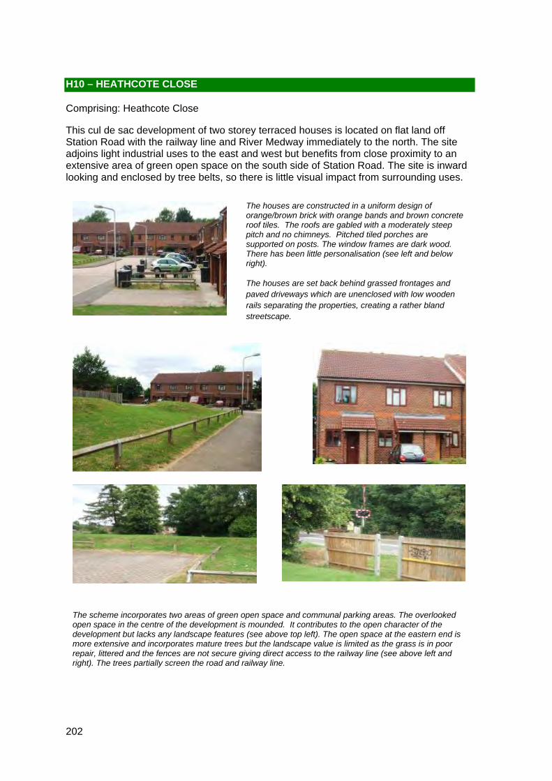
202
The houses are constructed in a uniform design of orange/brown brick with orange bands and brown concrete roof tiles. The roofs are gabled with a moderately steep pitch and no chimneys. Pitched tiled porches are supported on posts. The window frames are dark wood. There has been little personalisation (see left and below right).
The houses are set back behind grassed frontages and paved driveways which are unenclosed with low wooden rails separating the properties, creating a rather bland streetscape.
The scheme incorporates two areas of green open space and communal parking areas. The overlooked open space in the centre of the development is mounded. It contributes to the open character of the development but lacks any landscape features (see above top left). The open space at the eastern end is more extensive and incorporates mature trees but the landscape value is limited as the grass is in poor repair, littered and the fences are not secure giving direct access to the railway line (see above left and right). The trees partially screen the road and railway line.
H10 – HEATHCOTE CLOSE
Comprising: Heathcote Close
This cul de sac development of two storey terraced houses is located on flat land off Station Road with the railway line and River Medway immediately to the north. The site adjoins light industrial uses to the east and west but benefits from close proximity to an extensive area of green open space on the south side of Station Road. The site is inward looking and enclosed by tree belts, so there is little visual impact from surrounding uses.
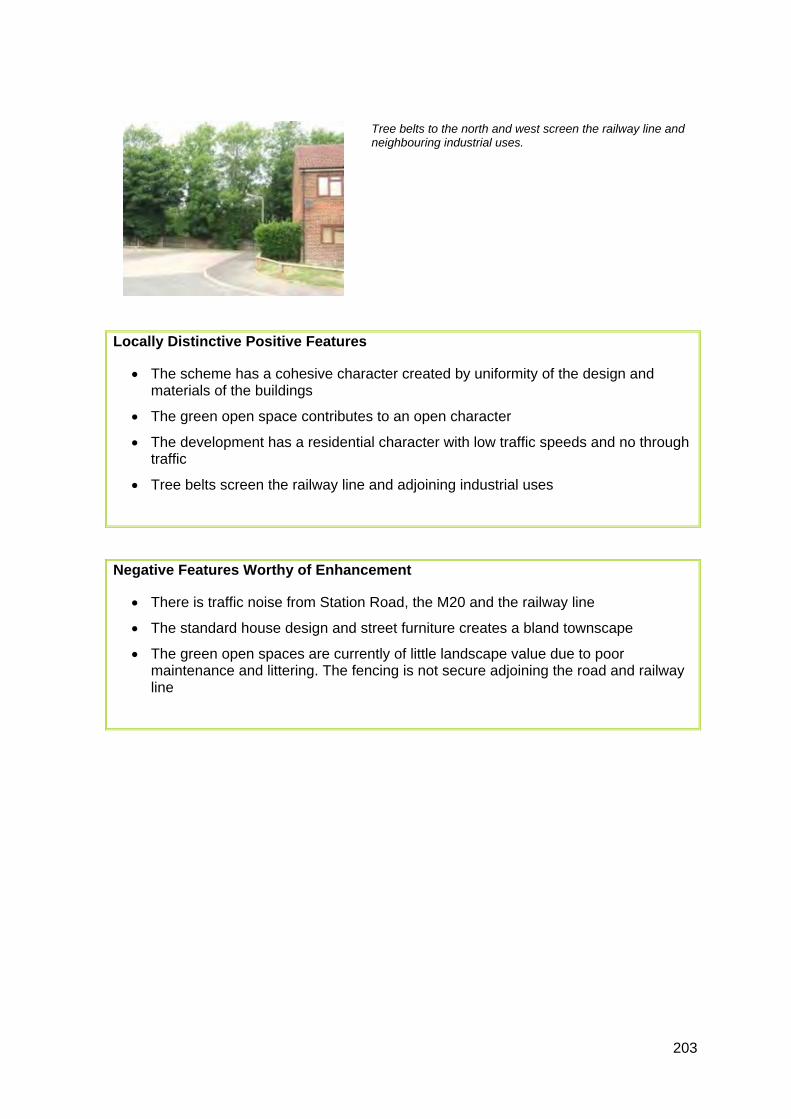
203
Tree belts to the north and west screen the railway line and neighbouring industrial uses.
Locally Distinctive Positive Features
• The scheme has a cohesive character created by uniformity of the design and materials of the buildings
• The green open space contributes to an open character
• The development has a residential character with low traffic speeds and no through traffic
• Tree belts screen the railway line and adjoining industrial uses
Negative Features Worthy of Enhancement
• There is traffic noise from Station Road, the M20 and the railway line
• The standard house design and street furniture creates a bland townscape
• The green open spaces are currently of little landscape value due to poor maintenance and littering. The fencing is not secure adjoining the road and railway line

#
Trees help toscreen industrial
units.
#
Tree belt screensthe railway line.
#
Areas of open space.
#
.
BR
IDG
E
HEATHCOTE CLOSE
PLACE
HALL
RO
AD
STATIO
N ROAD
15
9
13
68
1
3
27
2216
21
141
28
3340
34
5
24
4 14 5
Station
Path (um)
El Sub Sta
Tank
Pumping
1
0 50 10010 20 30 40Metres¯
© Crown copyright and database rights 2011 Ordnance Survey 100023300
H10 Medway Gap Character Area AppraisalRef
Title Heathcote Close
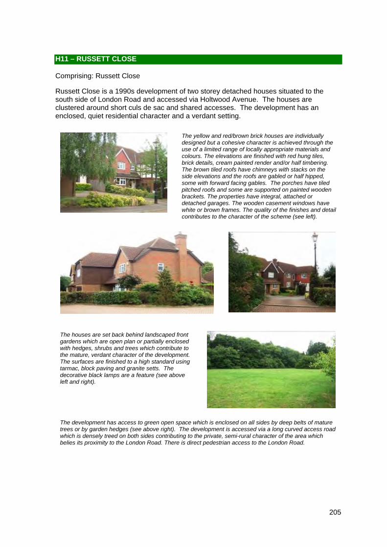
205
The yellow and red/brown brick houses are individually designed but a cohesive character is achieved through the use of a limited range of locally appropriate materials and colours. The elevations are finished with red hung tiles, brick details, cream painted render and/or half timbering. The brown tiled roofs have chimneys with stacks on the side elevations and the roofs are gabled or half hipped, some with forward facing gables. The porches have tiled pitched roofs and some are supported on painted wooden brackets. The properties have integral, attached or detached garages. The wooden casement windows have white or brown frames. The quality of the finishes and detail contributes to the character of the scheme (see left).
The development has access to green open space which is enclosed on all sides by deep belts of mature trees or by garden hedges (see above right). The development is accessed via a long curved access road which is densely treed on both sides contributing to the private, semi-rural character of the area which belies its proximity to the London Road. There is direct pedestrian access to the London Road.
The houses are set back behind landscaped front gardens which are open plan or partially enclosed with hedges, shrubs and trees which contribute to the mature, verdant character of the development. The surfaces are finished to a high standard using tarmac, block paving and granite setts. The decorative black lamps are a feature (see above left and right).
H11 – RUSSETT CLOSE
Comprising: Russett Close
Russett Close is a 1990s development of two storey detached houses situated to the south side of London Road and accessed via Holtwood Avenue. The houses are clustered around short culs de sac and shared accesses. The development has an enclosed, quiet residential character and a verdant setting.

206
The green open space is enclosed and overlooked by housing. It provides an open landscape setting for the development which contributes to its verdant character.
Locally Distinctive Positive Features
• The houses are individually designed using traditional, quality materials and incorporating many design details. However the overall character of this area is cohesive due to common design themes and materials
• The development has a private, verdant, semi-rural character enhanced by the private access road, dense belts of mature trees, landscaped gardens, hedges and green open space
• The surfacing is good quality and the black street lights are a feature of the development
• The area has a quiet residential character despite some road noise
• The well maintained green open space incorporates mature trees and is enclosed and overlooked by housing
Negative Features Worthy of Enhancement
• There is some traffic noise from the London Road

THE BOUNDS
RUSSE
TT C
LOSE
WOODLANDS
ORCHARD AVENUE
HO
LTW
OO
D A
VE
NU
E
LAKE R
OAD
THE
OA
KS
BRASSEY DRIVE
TEA
PO
T L A
NE
SYC
AMO
RE
DR
IVE
15
2
35
7
379
390
400
59
9
16 to
17
21
45
22
26
16
44
31
56
58
23
1
29
60
24
34
214
46
10
38
3214
13
12
25
218
400a
20
11
33
48
49
395
222
5
269
42
394
263
401
27
17
378
8
62
40
3
Shelter
Unit 13
El Sub Sta
Unit 5
Holly Cottage
CLOSE
LONDON ROAD
7
42
2
2
11
2
Shelter
SYCAMORE DRIVE
12
32
21
13
39
14
2
12
3
1
29
4
17
13
23
29
10
31
26
13
49
21
39
1
21
29
34
59
14
33
1
1
13
1
34
20
9
11
4
0 100 20020 40 60 80Metres¯
© Crown copyright and database rights 2011 Ordnance Survey 100023300
H11 Medway Gap Character Area AppraisalRef
Title Russett Close
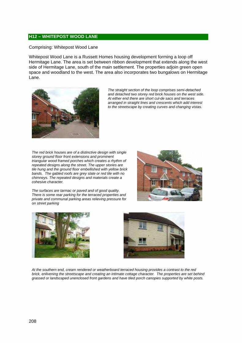
208
The straight section of the loop comprises semi-detached and detached two storey red brick houses on the west side. At either end there are short cul-de sacs and terraces arranged in straight lines and crescents which add interest to the streetscape by creating curves and changing vistas.
The red brick houses are of a distinctive design with single storey ground floor front extensions and prominent triangular wood framed porches which creates a rhythm of repeated designs along the street. The upper stories are tile hung and the ground floor embellished with yellow brick bands. The gabled roofs are grey slate or red tile with no chimneys. The repeated designs and materials create a cohesive character.
The surfaces are tarmac or paved and of good quality. There is some rear parking for the terraced properties and private and communal parking areas relieving pressure for on street parking
At the southern end, cream rendered or weatherboard terraced housing provides a contrast to the red brick, enlivening the streetscape and creating an intimate cottage character. The properties are set behind grassed or landscaped unenclosed front gardens and have tiled porch canopies supported by white posts.
H12 – WHITEPOST WOOD LANE
Comprising: Whitepost Wood Lane
Whitepost Wood Lane is a Russett Homes housing development forming a loop off Hermitage Lane. The area is set between ribbon development that extends along the west side of Hermitage Lane, south of the main settlement. The properties adjoin green open space and woodland to the west. The area also incorporates two bungalows on Hermitage Lane.
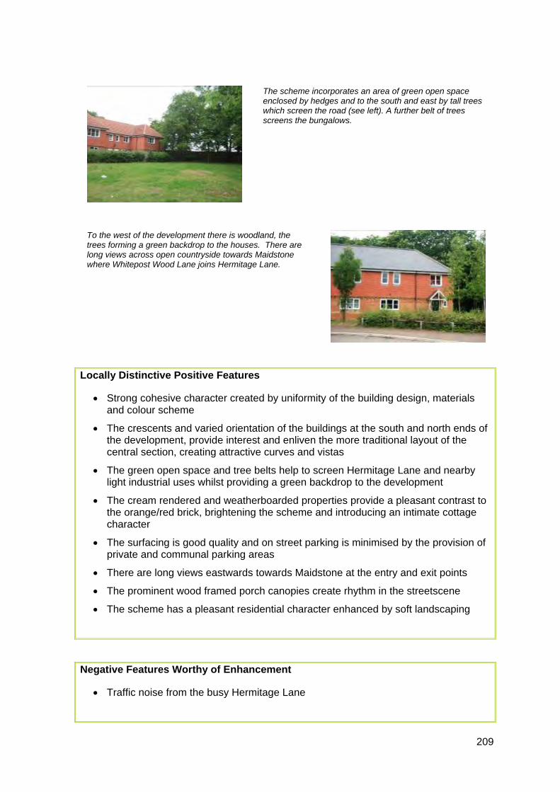
209
The scheme incorporates an area of green open space enclosed by hedges and to the south and east by tall trees which screen the road (see left). A further belt of trees screens the bungalows.
To the west of the development there is woodland, the trees forming a green backdrop to the houses. There are long views across open countryside towards Maidstone where Whitepost Wood Lane joins Hermitage Lane.
Locally Distinctive Positive Features
• Strong cohesive character created by uniformity of the building design, materials and colour scheme
• The crescents and varied orientation of the buildings at the south and north ends of the development, provide interest and enliven the more traditional layout of the central section, creating attractive curves and vistas
• The green open space and tree belts help to screen Hermitage Lane and nearby light industrial uses whilst providing a green backdrop to the development
• The cream rendered and weatherboarded properties provide a pleasant contrast to the orange/red brick, brightening the scheme and introducing an intimate cottage character
• The surfacing is good quality and on street parking is minimised by the provision of private and communal parking areas
• There are long views eastwards towards Maidstone at the entry and exit points
• The prominent wood framed porch canopies create rhythm in the streetscene
• The scheme has a pleasant residential character enhanced by soft landscaping
Negative Features Worthy of Enhancement
• Traffic noise from the busy Hermitage Lane

ì
ìViews across open
countryside towardsMaidstone.
Views across opencountryside towards
Maidstone.
#
Trees partially enclose
open space.
#
Curved terraces.
#
.
#
Curved terraces.
#
.
1 14
WH
I TEP
OS
T WO
OD
LAN
E
74
30
39
19
25
54
38
34
76
1413
1011
43
31
56
47
1
40
51
54
0 50 10010 20 30 40Metres¯
© Crown copyright and database rights 2011 Ordnance Survey 100023300
H12 Medway Gap Character Area AppraisalRef
Title Whitepost Wood Lane


![THE PUNJAB PRIVATE HOUSING SCHEMES AND LAND SUB- … · TEXT PUNJAB PRIVATE HOUSING SCHEMES AND LAND SUB-DIVISION RULES 2010 SOR(LG)38-2/2004-P [13th March, 2010] CHAPTER I INTRODUCTION](https://static.fdocuments.us/doc/165x107/5e7744fd8988d71fb905bacd/the-punjab-private-housing-schemes-and-land-sub-text-punjab-private-housing-schemes.jpg)


![War emergency construction [housing war workers]](https://static.fdocuments.us/doc/165x107/58677f061a28abcd408bc55a/war-emergency-construction-housing-war-workers.jpg)