
Durham E-Theses Water resources of Wadi Hanifah, Saudi ...
250
• • •
Transcript of Durham E-Theses Water resources of Wadi Hanifah, Saudi ...

Durham E-Theses
Water resources of Wadi Hanifah, Saudi Arabia: a case
study
Al-Sobaihi, Sulaiman M.
How to cite:
Al-Sobaihi, Sulaiman M. (1976) Water resources of Wadi Hanifah, Saudi Arabia: a case study, Durhamtheses, Durham University. Available at Durham E-Theses Online: http://etheses.dur.ac.uk/10170/
Use policy
The full-text may be used and/or reproduced, and given to third parties in any format or medium, without prior permission orcharge, for personal research or study, educational, or not-for-pro�t purposes provided that:
• a full bibliographic reference is made to the original source
• a link is made to the metadata record in Durham E-Theses
• the full-text is not changed in any way
The full-text must not be sold in any format or medium without the formal permission of the copyright holders.
Please consult the full Durham E-Theses policy for further details.
Academic Support O�ce, Durham University, University O�ce, Old Elvet, Durham DH1 3HPe-mail: [email protected] Tel: +44 0191 334 6107
http://etheses.dur.ac.uk

WATER RESOURCES OF W A D I H A N I F A H , SAUDI ARABIA
A CASE STUDY
Sulaiman M Al-Sobaih i
M A Thesis August 1976
Department of Geography, Un ive r s i t y of Durham

ACKNOWLEDGEMENTS
I owe my greatest debt to the K i n g Abdu l -Az iz U n i v e r s i t y , Saudi :
A r a b i a , f o r the f inanc ia l support wh ich enabled me to c a r r y out th is .
study.
I would especial ly l i k e to thank the M i n i s t r y of A g r i c u l t u r e , the
Department of Geology and. the Department of Hydrology f o r a l lowing
me access to the var ious studies which have been c a r r i e d out.on t h e i r
behalf .
I must also give my thanks to the M i n i s t r y of Petroleum and
M i n e r a l Resources f o r g iv ing me access to a i r photographs of the area
under study, and I w i s h to r e c o r d my grat i tude to the many government
o f f i c i a l s , p a r t i c u l a r l y at the Munic ipa l A f f a i r s Agency, who provided
me w i t h much valuable i n f o r m a t i o n .
I a m indebted to my superv i so r , D r J H Stevens, f o r his
encouragement, guidance and advice throughout my study.
F i n a l l y , f o r the maps and photographs I w i s h to thank the s t a f f
of the Cartographic and Photographic units i n D u r h a m Un ive r s i t y
Geography Department .

ABSTRACT
Although Saudi Arab ia has made grea t progress on a lmos t a l l f r o n t s ,
water has always been, and s t i l l i s , a serious p rob lem. Settlement i n the
cen t ra l area of the country i s concentrated i n the wadis , of w h i c h Wadi
Hanifah is a good example.
The Wadi descends through the cen t ra l slope of the Tuwaig mountain,
where Jurassic uni ts predominate , and ends i n the A l - K h a r j Plain , where
Cretaceous deposits outcrop.
Cl imate is influenced to a l i m i t e d extent by the r e l a t i ve ly high al t i tude
of the Tuwaig mountain, especial ly where r a i n f a l l is concerned, and an
annual average of 100 m m is recorded . The rate of evaporat ion, however,
is v e r y h igh , because of the cloudless sky and high tempera tures .
Run-of f occurs only a f t e r t o r r e n t i a l r a i n , when the Wadi col lec ts
f lood water f r o m i t s many t r i b u t a r i e s . Seven dams have.been b u i l t i n
recent years i n an at tempt to increase underground recharge,
The vo lume , qual i ty and locations of underground water are deter
mined a lmos t e n t i r e l y by c l i m a t i c reg ime and geological cha rac t e r i s t i c s .
F rac t ions and cavi t ies in the Jubaila l imestone around Riyadh, and the
a l l u v i u m deposits i n the Wadi ' s channel used to be*.the main water sources.
Water i n these aqui fers used to be at an easy reach at a depth of about 10 m
beneath the sur face . Urban expansion of Riyadh C i t y , however , r equ i red
a cont inual increase i n water ex t r ac t i on , and the in t roduc t ion of modern,
equipment i n ag r i cu l tu re also increased water consumption. Th i s led to
the l o w e r i n g of the a l l u v i u m aqui fe r on the one hand, and the contamination
of the Jubaila l imestone aqui fe r on the other*

The tapping, of the M i n j u r aqui fe r in 1956 at a depth of more than
1,000 m t e m p o r a r i l y solved the p r o b l e m , but as the discharge increased
sharply water l e v e l f e l l to a considerable depth, and in the meantime the
a l l u v i u m aqui fer continued d ropp ing , so that i n some areas water has been
a lmos t complete ly depleted.
I t is obvious that the lack of con t ro l over water use, and the shor t
age of adequate invest igat ion and exper ience, combined w i t h the many
d i f f e r e n t author i t ies i n charge of wate r , produced a careless attitude to
t h i s valuable resource i n both u rban l i f e and a g r i c u l t u r e .
CONTENTS
Page
Acknowledgement ^ i Abs t r ac t i i . Contents i v L i s t of F igures v i i L i s t of Tables v i l i L i s t of Plates x L i s t of Abbreviat ions x i Arab ic Names x i i
CHAPTER ONE : INTRODUCTION 1
1.1 The Area of Study . 3
CHAPTER TWO : PREVIOUS STUDIES AND SCOPE ,
OF PRESENT STUDY 10
2 . 1 Previous Studies 10
2 .2 The Scope of the Present Study 16
CHAPTER T H R E E : GEOLOGY 19
3. 1 Tuwa ig Mountain Limestone - Upper Jurassic 22
3 .2 Hanifah Fo rma t ion - Upper Jurassic 28
3.3 Jubaila Limestone - Upper Jurassic 30
3 .4 Arab F o r m a t i o n - Upper Jurassic 33
3 .5 Hi th Anhydr i te - Upper Jurassic 35
3 .6 Sulaiy F o r m a t i o n - Upper Jurassic and Lower Cretaceous 36
3.7 Quaternary A l l u v i u m 38
CHAPTER FOUR : PHYSIOGRAPHY 42
4 . 1 General L a n d f o r m 42
4 .2 The Drainage Network 43
4.3 Evolut ion of Drainage Network 50

Page
CHAPTER F I V E : C L I M A T E 56
5 . 1 Factors A f f e c t i n g Cl imate 57 5 . 1 . 1 Geographical Situation 57 5 . 1 . 2 Pressure Zones 58 5 .1 .3 A i r Masses 60
5.2 Prec ip i ta t ion 64 5 . 2 . 1 , V a r i a t i o n of Prec ip i ta t ion 66 5 . 2 . 2 Types of Prec ip i ta t ion 78
5.3 Evaporat ion 83 5 . 3 . 1 Annual , Monthly and Da i ly Evaporat ion . 83 5 . 3 . 2 Evaporat ion f r o m Dams and I r r i g a t e d Areas 86
5.4 Tempera tu re . 92
5.5 Humid i ty
CHAPTER SIX : R U N - O F F , 99
6 . 1 Sources of Run-Off 99
6. 2 Factors Af fec t ing - the D i s t r i b u t i o n of Run-of f i n T i m e 101 6 . 2 . 1 Q i m a t i c Factors 102 6 . 2 . 2 Catchment Charac te r i s t ics 103 6 .2 .3 Land Use 108
6.3 Flood Observations ' 119
CHAPTER SEVEN : A L L U V I U M AQUIFER 126
7 . 1 The Extent and Nature of the A qu i f e r 128
7 .2 Boundary Conditions of the A qu i f e r 131 7 . 2 . 1 Water Table and Water Table Var ia t ions 131 7 . 2 . 2 Conditions of Recharge 146 7 .2 .3 Conditions of Discharge 156
7.3 Water Qual i ty 163
CHAPTER EIGHT : T H E JUBAILA LIMESTONE AQUIFER 172
8 .1 Conditions of Recharge 175
8.2 Water Table and Water Table Flow 178
8.3 Conditions of Discharge 182
8.4 Water Qual i ty 185

vi
Page
CHAPTER NINE : MINJUR AQUIFER 188
9 . 1 Geological Highl ights 193
9.2. Qua l i ty and Quantity of Water .198
9.3 Conditions of Discharge and Water Table 207
CONCLUSION 217
BIBLIOGRAPHY 223
)

L I S T OF FIGURES
Page
. 1 . 1 Wadi Hanifah A r e a . 4
3 . 1 Geological Format ions of the Wadi Hanifah Basin 23 3 .2 Geologic Section Across Wadi Hanifah 40
4 . 1 Contour Map of the Wadi Hanifah Basin 44 4 .2 Long Section of the Wadi Hanifah 45 4 .3 Cross Section of the Wadi Hanifah 47 4 .4 Wadi Hanifah Drainage Network 48 4 .5 The Wadi Sahba Drainage, at the t ime when the
Wadi Ha Drainage extended into the Basement Complex 51
5 . 1 A Combination of C l ima t i c Conditions and Loca l Calendar 62
5.2 Loca t ion of the Rain Gauges 67 5.3 Approximate Rain Belt of a Single Thunder s to rm 70 5 .4 Isohytal Lines 72
6 . 1 Hanifah Sub-Catchments i n t e rms of Run-Off 105 ' 6 . 2 D i a g r a m i l l u s t r a t i n g A g r i c u l t u r a l Techniques
to u t i l i s e Flood f o r I r r i g a t i o n 110
7 . 1 Water Table Prof i les of the A l l u v i u m A q u i f e r 134 7 .2 The Piezometr ic Levels of A l - H a ' i r Wel l s i n
1967 140 7.3 Sketch showing Underground Water T r a n s f e r
between the A l l u v i u m Aqu i f e r and the Adjacent Jubaila Limestone 154
8 .1 Extent of Jubaila Limestone Aqui fe r 174 8.2 Piezometr ic Maps of the Water Table of the
Jubaila Limestone A q u i f e r f o r 1960 and 1967 180
9 . 1 Locat ions of M i n j u r Wel ls in the Wadi Hanifah Area 191 9.2 The M i n j u r Outcrop 194 9.3 Discharge and Water Leve l in the M i n j u r Aqu i f e r
Wadi Hanifah Area (1957-1972) 208 9.4 Decl ine i n Water Levels i n some Wel l s of the
M i n j u r Aqu i f e r between 1956 arid 1968 213 9.5 Piezometr ic Maps of the M i n j u r A qu i f e r 215

L I S T OF TABLES
Page
1.1 A g r i c u l t u r a l Holdings and the Area under Cul t iva t ion i n the Wadi Hanifah 8
3 . 1 Wadi Hanifah Geological Outcrop Sequence 24 3 .2 The Li tho log ic Sequence of Tuwaig Mountain
Limestone at Ash-Shumaiss i Borehole 27 3.3 A Section of the juba i l a Limestone at Wadi
N i sah , showing Thickness and Li tho log ic Sequence 32
5 . 1 The Monthly Ra in fa l l of the Wadi Hanifah Basin i n 1967 69
5 .2 T i m e Var ia t ions of Kah ' ts and Rej ' an between 1637/38 and 1872/73 (1047 to 1289 AH) 73
5.3 Ra in fa l l i n the Area of Wadi Hanifah (1969-1973) 77 5.4 The M a x i m u m and Average Monthly Ra in fa l l i n
Riyadh A i r p o r t Station (1952/52-1966/67) and (1948) 79
5.5 Number of Days w i t h Fog in the Riyadh A i r p o r t Station (1961-1974) 80
5.6 Monthly Evaporat ion at Riyadh (1968-1971) and D i r a b (1967) 85
5.7 Volume of Evaporated Water f r o m the Reservo i r o f Hanifah Dam . 88
5. 8 A . The L i m i t e d Da i ly Tempera tu re (the Highest and Lowest T e m p e r a t u r e , °C) recorded i n the Period 1957-71 at Riyadh A i r p o r t B. . The Average Mean Tempera ture i n the Period 1957-71 at Riyadh A i r p o r t 94
5 .9 Charac te r i s t i cs of Relative Humid i ty at Riyadh A i r p o r t ( 1 9 6 5 - 1 9 7 1 ) 97
6 . 1 Volume of Flood Passing through the Hanifah D a m (1964-1972) 121
6.2 Observations of Four Floods i n the Wadi Hanifah 123
7 . 1 The Recharge of the A l l u v i u m A qu i f e r between Al-Jubai lah and A l - H a ' i r (1967-68) 150
7.2 Average Amount of Water that can be Drawn f r o m a Hand-dug W e l l by One A n i m a l 158
7.3 The Annual Volume of Water Exploi ted f r o m the A l l u v i u m Aqu i f e r of Wadi Hanifah and i ts T r i b u t a r i e s 160
8 .1 Water discharged f r o m the Jubaila Limestone Aqu i f e r i n 1960 and 1967 184

9 . 1 Samples taken f r o m the Mara t S38 Borehole 9 .2 Water L e v e l and Water Qual i ty of B i r S id i r iyyah
and B i r Tabrak d u r i n g the Rainy Seasons of 1966 and 1968
9.3 Volume of Stored Water i n M i n j u r F o r m a t i o n

L I S T OF PLATES
4 . 1 The S i l t T e r r a c e near Al-Jubai lah Vi l l age
4 .2 The Channel of the Wadi Hanifah - ups t r eam f r o m Al-Uyaynah Vi l l age
6 . 1 The e f f ec t of the Ni rnar D a m (below) on the Flow of Flood Downst ream (above)

LIST OF ABBREVIATIONS
A H A f t e r HLjrah ( Is lamic Calendar)
c m cent imet res
cu m cubic metres
E East
etc. e t c e t e r a
i . e . . that is
k m k i l o m e t r e s
m metres
m m m i l l i m e t r e s
N N o r t h
p i . p l u r a l
ppm par t s per m i l l i o n
sq k m square k i l o m e t r e s
sq m square metres
1/s l i t r e s per second
TDS T o t a l Dissolved Solids

ARABIC NAMES
Abalkbash
Ad-Dahna *
A d - D i r ' i y y a h
A in A d - D h i l ' a *
A l - A f l a j *
A l - A h a i s i Group
Ala i san
A l - A r t a w i y y a h *
A l - A r a m a h *
Al -Bad i ' ah
Al -Bat 'ha •
A l - E l b
A l - E r d h
A l - F a r a z d a g
Al -Gha t
A l -Gh i thwanah
Al -Gurash iyyah
A l - H a ' i r
Al -Hautah *
A l - H i s y a n
Al -Hu tay ' ah at
Al-Juba i l *
Al-Jubai lah
A l - K a s s e i m ^ — t
A l - K h a r j *
A l - K u l l e y y a h
A l - M a j m a ' a h *
A l - Mi rba ' an iyyah
A l - Manscur iyyah
A l - M a s a n ' i
A l - M a ' t h e r
Al-^Mughaider
A l - M u r a b b a ! a Palace
A l - Muzahi miyyah * . A . ^ j V t
Al-ThumaLrL Gate — I S J ^ J I A , \ " V •a t ~ %
As-Safat i V i _ - J ^
As-Sayf
Ash-Shafa .
Ash-ShumaissL
As-Sulayyel * J t 1 - 1 ^ As-Suwaidi 4 ? - ^ > ~ ^ . ^ • ••. ' • - U ^ n t
At-Tawdheyyah - J~
A l - U r a i j a ' W f - r ^ Al-Uyaynah O - L - J y
A l - W a s h m * f°V>
A l - W a s m ^ " i r x
Bani Hanifah ^ h r 0 - ^
B i r S id i r i yyah * >
B i r Tabrak * —*->J? J? Boudhah Group *V-^>> A s - ^
Dahl Hei t *
Dhruma * j L a >
D i r a b ' ^ - r ^ P
Dukhnah
Ergah
Gharb
Great Nafud *
Guway' iyyah *
Hanifah
H a j r
Haradh *
Hisyan u U —
Hi th Anydr i te tj-SL-Hura imela * . iVvxy~
Jabal Al -Abakkayn v - ^ ^ ^ w V T
Jabrah °Jfr J i l h Format ion- - ^ O ^ "

Jiza
Jubaila Limestone
Khafs Dighrah *
Kah ' t .
Khareef
Khash Al-Baladiyyah
Khashm A l - K h a l t a *
Khash m Ma wan *
Khashm Midhya 'ah *
Khashm Musaigerah *
L iban
Mara t S 3 8 *
M a r r a t F o r m a t i o n *
M i n j u r
Nafud Ad-Dahi *
Nafud A s - S i r *
Nafud Kunai f i thah *
Nejd
R i j ' a n
Riyadh
Riyadh-Ta i f Highway
Rub a l K h a l i *
S'iah
Salam
Salboukh
Y A '*\ +
tip."* ^
Sanyah
Shat A l - A r a b *
Sodous *
Sulaiy F o r m a t i o n
Tuwaig Mountain
Tuwaig F o r m a t i o n
Urn A l - H a m a m
U r a i d h

Wadi Ala i san
Wadi A d - D a w s i r *
Wadi A l - A m m a r i y y a h
Wadi Al -Buay ja
Wadi Al -Haddar *
Wadi A l - K a b e i r
Wadi A l - K h o m r a h IP L ^ J
Wadi Ghalah
Wadi Ghubairah
Wadi Ha
Wadi Hanifah
Wadi Hareiqah
Wadi Hinow *
Wadi Huraymi la *
Wadi L iban
Wadi N i m a r
Wadi A r - R u m m a h *
Wadi S i r
Wadi Sofar
Wadi Was i t * u r j > \ 9
Outside the area under study.
CHAPTER ONE
INTRODUCTION
Water is a vital resource in any part of the world, but it is a par
ticularly important factor in arid lands such as the central part of Saudi
Arabia and has a great impact on the way of life and the location of
settlements. Shortage of water has played a primary role in determining
the type of farming and size of cropped areas in the region. Indeed, it
was the lack of water which was the main cause of people leaving their
homeland, seeking an easier life in places like the Arabian Gulf States
or even as far afield as North Africa and India. At present, many fam^
ilies have settled in Kuwait, Bahrain, Syria, Egypt and India, whose
forefathers originated from Nejd - Central Arabia, and these families
stil l have strong links with their relatives in the region (Wahbah, 1946).
In Bedouin communities, the conflict which used to arise in the past over
priority in obtaining water from an isolated shallow well caused many
deaths.
Over the last half-century, the socio-economic life of Saudi Arabia
has been developing rapidly, mostly as a result of two factors:
(i) The foundation in 1931 of the Kingdom of Saudi Arabia
as a new, modern state, offering greater stability and
security.
(ii) The potential of the oil revenue which has played a
tremendous part in raising the living standards of the
people.
Yet. with such socio-economic change., the problem of water

supplies has become even more important , largely because of the rapid
increase of population brought about by natural growth and by immigra
tion to the expanding urban areas from rural areas and from abroad.
One clear example of this is the city of Riyadh, which was described by
the VBB f i r m (1965) as one of the fastest growing cities in the world.
In addition to this the introduction of modern equipment, both equipment
for water extraction and equipment employing water, has accelerated the
depletion of traditional water resources in the farming areas of the
country.
To make matters worse,-cultivated areas have habitually been ex
panded as soon as any source of water has become available. This con
sequently entails high extraction, coupled often with careless and inefficient
use.
This drastic change in water use is most marked in the central area
of Saudi Arabia, where water is always in short supply. Most of the popu
lation live in wadis of the central area, and these mostly flow along the
eastern slope of the 800 km long Tuwaig mountain.
To provide a clear example of water utilisation in these wadis, i t
was decided to select the Wadi Hanifah as a wadi typical of the region.
Other considerations also favour this choice:
(i) The historical importance of the wadi since the establish
ment of the present Saud Royal family, whose capital
was f i rs t Ad-Dir'iyyah and later the city of Riyadh.
(ii) The size of the wadi and consequently the age and size of
the old villages and farming areas : the wadi is one of
the largest of those flowing from the Tuwaig mountain.

( i i i ) Its closeness to the capital city : this has entailed
the availability of, relatively speaking, a great deal
of data and material, partly as a result of the inter
action between the city and the wadi with regard to
the water supply..
The Area of Study
The name of the Wadi Hanifah comes from the Bani Hanifah tribe
who occupied the wadi two centuries before the rise of Islam, probabLy
in 420 AD (Al-Jasir, 1966). Al-Erdh was the popular name for the wadi
in the few scattered historical studies. This aame, however, according
to Yakout Al-Humawi (1955 ) used to be given to any wadi in Arabia
where there was sufficient water for irrigation. The advantages of water
and agriculture gave the wadi a particular importance in many historical
events. One of these was the war of Apostasy near Al-Jubailah village,
between the Bani Hanifah and the army of Kalif Abu Bakr a few years after
the death of the Prophet Muhammed in the seventh century AD. Again, the
wadi in the eighteenth century and afterwards was the leading political
region in Nejd, and a large area was ruled from time to time from Ad-
Dir'iyyah. Lately, since 1931, the bulk of the Arabian Peninsula has been
united and ruled from the city of Riyadh.
The Wadi Hanifah drainage extends along the eastern flank of the
Tuwaig mountain and lies between latitude 25° 00' and 24° 20' N, with an
area of 4,053 sq km (Figure 1.1). At the crest of the escarpment it
attains an elevation of about 900 m . above sea level and flows down the
east-dipping sediments to join with one of the Wadi Hariifah's

i
as
i
i
V 1 z a
V
V
*7
V . r V
\ V 3
CM
I V 3
i
id X 12

main tributaries, the Wadi Al-Khomrah, which flows at right angles to
the direction of the principal wadi. The wadi changes direction, follow
ing the outcrops, and striking towards the south-east, just after leaving
Al-Jubailah village, where i t is joined by a cluster of tributaries. Apart
from the Wadi Alaisan, and the Wadi. Al-Bat'ha, these follow the initial
slope of Tuwaig mountain, as does, for example, the Wadi Al-Ammariyyah.
The cultivated areas and population centres are concentrated in a
section of about 90 km between Al-Uyaynah in the north and Al -
Ha'ir in the south. Here, the channel of the wadi, with an alluvium
deposit of about 60 m depth, supplies water for the irrigation of the cul
tivated terraces. Since run-off is limited and uncertain, water was tradi
tionally obtained by the pull-donkey method from the.hand-dug wells.
In this section lies Riyadh, the capital city, with a population of
about 350,000 inhabitants. Situated in the eastern part of the area, it is
connected by four highways with the Taif in the west, the'Sudair region to
the north, Dammam to the east, and the. Wadi Ad-Dawasir region to the
south.
The remaining settlements are old villages sited on either bank of
the wadi proper, except Al-Ammariyyah village which lies in the Wadi-
Al-Ammariyyah tributary. The largest villages in size and population
are Ad-Dir'iyyah, Al-Uyaynah, Al-Ha'ir and Al-Ammariyyah. Their
populations range between 4,000 in the case of Ad-Dir'iyyah to about
1,000 in Al-Ammariyyah. The remaining villages of Al-Jubailah, Al -
Awdah, Al-Elb, Al-Uraija, Ergah, Manfouhah and Al-Masan'i have pop
ulations ranging between 200 and 1,000. The estimated total population
of all the villages is about 10,000. This means that abouf97 per cent of

. the whole population of the region live in the city of Riyadh (Ministry of
Labour and Social Affairs, 1964).
Through the period of water shortage which started roughly in the
1940's, the wadi region has witnessed major changes, largely due to the
expansion of Riyadh city. Though the city appeared at f i rs t to be a mar
ket for the agricultural products and livestock of the wadi, the rising
standard of living paved the way for a larger and more sophisticated and
competitive market, and also for the absorption of the nomad population
of the region.
Vegetation is limited by the amount of rainfall and the type of ecol
ogical environment. Since the bulk of the wadi basin consists of rocky
limestone, particularly on the Tuwaig slope, and since rainfall is fluctu
ating and uncertain, the vegetation is found in wadi channels and in loamy
micro-depressions.
The wild vegetation consists mainly of shrub and bush species, such
as Calotropis procera, and in ephemeral annual species growing after
rain and belonging to various families, for example graminaceae and
plantaginaceae.
Although the ephemeral vegetation is the source of pastoralism in
Arabia, in the Wadi Hanifah it is hardly used at all for grazing because
of the diminution in nomadism. Instead, i t is used to provide recreation
for sightseers on excursions from the capital and nearby villages.
The wadi remains an important agricultural region in the central
area, with a volume of produce dependent on the water available. The
cultivated area, according to the census of the Ministry of Agriculture
and Water (1964), is potentially 5,026 hectares. Nearly 65 % of .

this area is actually under cultivation (Table 1.1).
According to the previous report, the average agricultural holding
is 39-98 decares. The size of the individual holding is controlled by
various factors, such as the age of the farm, the density of population in
the village nearby , the income of the owner, and above all the availability
of water. Though the bulk of agriculture is sited in the wadi proper
around the ancient villages - for example, Al-Uyaynah and Ad-Dir'iyyah -
the isolated farming areas in the wadi seem to contain larger holdings.
This is due to the fact that market gardening and the cultivation of alfalfa
is commonly practised here whenever possible.
Palm groves have always played an important part in local agricul
ture. The total number of date palms was estimated at 252,662 in 1964.
The palm grove holdings contain a few frui t trees such as oranges, citrus,
pomegranates, apples and figs, and they occupy nearly 24 per cent of the
area under cultivation. Vines grow outside the palm groves, particularly
in the newly cultivated areas, for example at Al-L^aynah. Traditionally
they used to be near the water, pool when the animal - pull method was
used, and in some holdings they are planted in a corner of the palm
groves.
Alfalfa is grown in palm groves and sometimes outside. It grows
on loam and loamy sand in a total area of about 272 hectares. In addition,
to the local consumption, Riyadh city is the main market for the excess
products.
Cereals, sorghum and millet are also commonly grown whenever
water is available. The amount of land used for this in 1964 was in the
order of 2,516-4 hectares. The land is irrigated in strips ranging bet-

TABLE 1.1
Agricultural Holdings and the Area under Cultivation in the Wadi Hanifah
Number Area under Average Area Location Village of. Cultivation of Holding
Holdings (decares)*** (decares)***
Al-UyayDah 65 5,114 78- 67 Al-Jubailah 19 2,339 123-10 Al-Mughaider** 9 1,147 127-44 Al-Elb . 13 771 .59-31
u -p- Al-Awdah 23 478 20-78
ft* 3 Ad-Dir'iyyah 77 6,227 80- 87
8 ° Ergah 59 2,584 43-80 * s Al-Ghithwanah 5 56 11-20
Al-Batin** 14 1,379 98-50 cd O
T 1 £2 Al-Uraija 40 2,020 50-50
I-IH W
- s Al-Badi'ah 22 1,547 70-32 Manfouhah 48 1,737 36-19 Al-Masan'i 46 1,834 39- 87 S'iah** 28 1,766 63-07 Uraidh** 4 257 64-25 A l - Mansouriyyah** 1 237 237-00 Al-Ha'ir 152 1,640 10-79
Wadi Al - Al-Ammariyyah 26 1,891 72-73 Ammariyyah Abalkbash** 11 1,790 162-73
Um Al-Hamam 3 247 82-33 Wadi Alaisan** 3 162 54-00 Alaisan Al-Ma'ther** 3 173 57-66
Wadi Liban Liban** 8 407 50-87
Wadi Nimar Nimar** 7 423 60-43
Wadi Ha Dirab** .1 82 82-00
Total 816 32,627 39-98
* Agricultural holdings which have disappeared owing- to the expansion of Riyadh City are exluded as a result of checking undertaken by the author in March 1974.
** Farming areas only.
*** Adecare equals 1,000 sqm (or 0-1 hectare)
Source : Census of the Ministry of Agriculture and Water in 1964

ween 30 and 200 sq m , or in . some cases these crops are
grown between the date palms.
Market gardening has attracted reasonable attention in the last two.
decades. This arises mostly from the capital city being the nearest and
the most highly absorptive market in the central area of Saudi Arabia.
The area cultivated for these products amounted to 834- 7 hectares. The
main market crops are water melons, tomatoes, pumpkins, marrows,
beans, melons, egg-plants, okra, cucumbers and peppers. Chief of all
are water melons and tomatoes, which occupied respectively about
26 % and 14 % of the .cultivated market gardening area. An
expansion of the water melon plantations has been caused by the high
demand of Riyadh during the hot summer.
It is, however, important to remember that, apart from the palm
groves and orchards, the area under cultivation varies from year to year
depending on the availability of irrigation water in the wadi alluvium
aquifer. In a dry year, agriculture contracts and consists only of the
cultivation of date palms and alfalfa. But whenever the aquifer holds a
sufficient water reserve, cultivation expands to include the crops men
tioned in the previous paragraphs.
The wadi seems likely to lose its agricultural status in the future
through urbanisation and the related development trends now prevalent.
Bearing in mind that the substantial deep aquifer of Minjur is restric
ted to use for the urban supply within a fifty-kilometre radius of Riyadh,
native farmers may give up their traditional farms and sell them to
wealthy city residents, and in this way agricultural holdings could well
be turned into beauty spots and recreational centres.

CHAPTER TWO
PREVIOUS STUDIES: AND SCOPE OF PRESENT STUDY
Previous Studies
Being in an isolated area, the central part of Saudi Arabia, or "Nejd",
had not been the subject of any major studies before the formation of
Saudi Arabia in 1931. Such neglect by scholars resulted from the fact
that this area is isolated by vast sand belts to the north, east and south,
and by the Sarat mountains in the west. During the Ottoman Empire and
the period of European expansion, this area had been left alone due to its
harsh environment and to the poverty of its natural resources. Even when
the Muslim Empire was expanding in North Africa and Central Asia, the
Nejd area did not attract much attention in comparison with the Fertile
Crescent in the north or the holy places in the west.
However, during the preparation of this study, it was found that the
area has been referred to in one context or another through the years, and
particularly in the last four decades. For the sake of convenience, the
references wil l be classified as groups.
The old literature includes two groups - f i rs t , tribal poetry which
gives some account of various aspects of the region, including descriptions
of tribal areas when a poet is far away and homesickness makes him give
a description of the tribal land, particularly the prominent features such
as valleys, mountains, etc. From the people who used to live in the area
during both the pre-Islamic period and the rise of Islam, came Al-A'asha,
Jarier, Al-Farazdag, Thu Er-Rimmah, Al-Hutayfah and others, whose
verses are published and are available in the major libraries and bookshops

of the Arab states. Because of the way of life at that time, when tribes
moved from one place to another following the grazing area, no urban or
rural knowledge can be gained; the only thing that can be detected is
where they used to.move, and the influence of the natural environment
upon their lives. For instance, Amr Ibn Kalthoum, who lived before the
rise of Islam, gave a very distinctive description of the west-facing
cuesta of the Tuwaig mountain when he described it as "swords in
warriors' hands". This picture, which describes the reflection of the
sun's rays on the hanging wall of Tuwaig mountain, can be seen by trav
ellers nowadays along the Riyadh-Taif highway in the area between
Dhruma - 90 km west of Riyadh city - and Al-Washm - 80 km further
westward.
The other group are the historians, either from the area or from
the outside world. The history of the Wadi Hanifah as well as neighbour
ing areas is recorded by what can be called the Nejd historians. Chief of
them are Husain Ibn Ghannan, who died in 1859 (1225 AH), Othman lbn
Bishr, who lived between 1795 (1210 AH) and 1873 (1290 AH), and more
recently, Ibrahim Ibn Salih Ibn Eissa, who lived between 1853 (1270 AH)
and 1924 (1343 AH). These three historians give the major political
events after the movement of Sheikh Muhammed Ibn Abdul-Wahhab. Ibn
Ghannam's record started about 1744 (1157 AH) and ended in 1797
(1212 AH), Ibn Bishr included the events mentioned by Ibn Ghannam and
continued until the year 1851 (1268 AH). In addition, he mentioned older
major events starting from the year 1446 (850 AH). Though these pub
lications were devoted to local conflicts, mention of trade routes, prices,
droughts and floods was not uncommon.

An even earlier period in the history of the Wadi Hanifah and its
settlements is mentioned sporadically in some old literature devoted
mainly to the sites of places and.major topographical features. The
most important book of all was "Mu'ajam Al-Buldan", written by
Yagout Al-Humawey in the thirteenth century. In this book, the author
concentrates upon the location of particular areas, and the tribes to
which they belonged.
However, dealing with such literature requires a basic knowledge
of the various historical names, and the existing names have mostly
changed through the years. To give one example of the many wrong
interpretations by present-day scholars, Abul-Ela (1965A) published a
paper about some geographical aspects of the city of Riyadh in the
Bulletin de la Societe" de Ggographie d'Egypt, in which he concluded that
Yakout Al-Humawi does not mention Riyadh in his book. The fact is
that, although the name Riyadh is not mentioned, the place does appear
appropriately entered under its historical name of Hajr. The story of
the invasion of the Wadi by the tribe of Bani Hanifah is also included.
Thus, the existing names have to be converted to make sense of older
historical literature.
In the nineteenth and early twentieth centuries, some European
travellers reached the central part of Arabia. Palgrave (1865),
Leachman (1914) and Philby (1922) were probably the only travellers to
visit the Wadi Hanifah itself; although their publications are concerned
with their personal observations, these explorers have the advantage of
presenting their stories in an adventurous way. However, while their
descriptions of villages, people and some social habits contributed new

knowledge to outside readers, these covered phases of. everyday life
that were already familiar to native scholars. .
Since the formation of the Kingdom of Saudi Arabia in 1931 and
the adoption of Riyadh City as the capital of the new state, a period of
detailed, research has begun. The discovery of oil helped the state to send
for scientific experts to launch new urban and rural developments. Being
in the vicinity of the capital, which has grown fast during the past four
decades, the Wadi Hanifah was the main focus of the search for a source
of water to supply the city.
The f i rs t body to start investigation on the water conditions of the
Wadi was the Arabian American Oil Company (Aramco) in 1947.
Unfortunately, their report is not available, but other reports by the
company dealt with conditions between 1938 and 1948, and included the
work done by the company to evaluate the water level and provide a pre
liminary evaluation of the recharge of the alluvium aquifer based upon
assumed hydrological conditions in the wadi.
A United States Geological Survey mission to Saudi Arabia, repre
sented by Dr G F Brown, produced a report to the government in 1950
describing the main features of the geology and hydrology of the Riyadh
BasinArea,. and this assessment was used as a basis for various sugges
tions to solve the problem of lack of water at Riyadh. Their suggestions
led to the drilling of test boreholes around Riyadh, and of one 60kms to
the east of the city. Though their approximate depths are about 230 m,
the results were unsuccessful.
During the investigation by Dr Brown, International Bechtel Inc
was carrying out a number of different contracts for the Public Works

Division, including a study of a new source of water for Riyadh. Their
recommendations were given in two reports in 1951 : one concerned a
subsurface dam at Al-Ha'ir, about 30 kms downstream from Riyadh;
and the other involved a recommendation to dr i l l a new well at Al-Ha'ir and
pipe water to the city. The water level of the area around Riyadh and
the nearby section of the Wadi Hanifah proper was measured during their
investigation.
The Michael Baker Company submitted two reports as a result of
their investigation in 1953. In a joint report written by George R Wilson
of that company and Donald Doughtery of the US Geological Survey, they
pointed out the economic disadvantages of building subsurface dams in
the Wadi, as had been suggested previously by other f i rms. They also
drew attention to the need for basic data concerning the rate of recharge
and discharge of the alluvium aquifer. The company, which was in charge
of drilling wells at Al-Ha'ir and constructing a pipeline and reservoir in
Riyadh, submitted a report in June 1953, which, reviewed previous sugges
tions by others, including the possibility of bringing water from Shat AL-
Arab in Iraq.
Following the Michael Baker Company studies, sporadic studies
were carried out by the Govenco Company and the Pakistan Technical
Survey; both in 1954. Their work appears to have added little to what
was already known. In 1954, the HydrauliqE Afrique launched a. study to
find an additional water supply for Riyadh; during their work the deep
Minjur Aquifer in the region was explored, preliminary drilling taking
place west of Riyadh, at Ash-Shumaissi. Thus, a new source of water
was discovered, but its aquifer conditions and quality needed a lot of

investigation.
The Ralf M Parsons Company carried out a number of investigations
in 1958 and 1959, including a study of the water level in the Wadi aquifer.
Their work included an evaluation of water storage in the aquifer between
Al-Uyaynah village in the upper section of the Wadi proper, downstream
from Ergah village. Their studies were-backed by new data and maps of
the area under study, especially the report written by D L McCann,
working under the technical direction of Mr R Davis, and assisted by
members of the staff of the Water Resources Division of the Ministry of
Agriculture and Water.
In 1959-60, Dr Wolf art, leading a German team, made an investi
gation into the neighbouring southern wadi, the Wadi Nisah, Though the
area of the study is outside the Wadi Hanifah area, their work in the
Fault Zones of the Wadi Nisah explained some of the geological aspects
of the Wadi Al-Awsat, a feeder of the Wadi Hanifah in the Al-Ha'ir area,
which used to be a tributary of the Wadi Nisah.
In the early 1960's, studies were carried out by G F Brown of the
United States Geological Survey and C F Lough of the Ministry of
Agriculture and Water of Saudi Arabia, on the existing water resources,
mainly the Minjur Aquifer, Wadi Nisah and Dahl Heit. Their work was
devoted mainly to the quality of the water in these resources.
The latest completed investigation was carried out by the Sogreah
Company between 1966 and 1968. Their studies included the Wadi
Hanifah, Sudair, Al'-Washm, Al-Hautah and Al-Kharj , which constitute
Area 5 according to the classification of the Ministry of Agriculture and
Water. Various final reports v/ere submitted in 1967 and 1968, including

16
reports on ground water, conditions, the agricultural and grazing potential, and a report about Riyadh Water Supply. Their investigation, which was carried out with new technical equipment, gave logical results concerning the present water conditions in the area.
In addition to these investigations, some official staff of the
Departments of Geology and Hydrology in the Ministry of Agriculture and
Water produced various papers and articles, some of them published and
some confined to Ministry use. Most of these studies gave a general
idea of water conditions in the whole or part of the country. The
Department of Hydrology, which provided data on climate and on surface
water, produced two reports about the Wadi Hanifah Dam.
2.2 The Scope of the Present Study
In starting work on this study, the major obstacles were to discover
what kinds of investigations had been made, arid where and how to find
them. The rapid development and the movement of staff in the govern
ment offices consequent upon promotions or the expiry of work contracts
made most of the material written previously difficult to trace.
Accordingly, two field trips were made : the f i r s t was carried out
in August-September 1972 and involved exploration and enquiry. Visits
were paid to different offices in the capital city, including the Ministry
of Agriculture and Water, the Central Planning Organisation, the
Municipal Affairs Office, the Ministry of Petroleum and Minerals, the
Technical Co-operation Office, the General Department of Statistics
and the Headquarters of the VBB Company in Riyadh. The difficulty in
tracing old material stems from the fact that, though most people have
heard of the Wadi Hanifah as such, few possess detailed knowledge of
the region. Consequently, most interviews had to include some mention
of the areas and places that go to make it up. By the end of the tr ip, the
scope of material which was available had been established.
During the second field trip, which v/as made in the rainy season
from December 1973 to March 1974, systematic trips were made through
most of the main wadi and main tributaries. The primary purpose was
tc check directly some of the physiographical and land use aspects, and .
residents and farmers were interviewed in different settlements. In
addition, some of the wadi's features were photographed, including
flood sheets in different parts. Data and maps concerning climate,
flood and underground water were obtained mainly from the Ministry of
Agriculture and Water and the Ministry of Petroleum and Minerals, in
cluding the aerial photographs of the wadi drainage.
The present synthesis of existing reports is meant-to cover the
overall Basin of the Wadi Hanifah in terms of its main water resources.
This task did not appear to be possible at f i rs t due to the fact that pre
vious works had concentrated on finding sources for the Riyadh water
supply, and had not studied the areas as a whole.1
The physical background is dealt with in the chapters on Geology and
Physiography.. The former shows the different geological formation
outcrops of the drainage basin and discusses their importance in terms
of water bearing* The latter highlights the physical features of the wadi
that influence the surface water, runoff as well as the percolation processes.
The surface water is tackled in the chapters on climate and runoff.
Rainfall is obviously the only source of surface runoff; therefore con-

centrated attention is given to the climatic conditions in general and rain
fal l in particular. Run-off is studied in terras of flood occurrence, and
an account is also given of the major features which influence i t . With
regard to underground water, which is the only source of water in the
wadi, three chapters tackle the only three local aquifers separately.
Each one contains, as far as possible, the condition boundaries of the
aquifer, including the recharge and discharge and water quality, and.
the tapping development. In dealing with the Minjur Aquifer, which holds
a deep fossil water, an expansion of the study was made to cover the
general characteristics of the aquifer as a whole, with an emphasis on
the depth, recharge, discharge and the water table in the study area.
The reason for such expansion is that this aquifer is the present and
foreseeable water resource for the urban sector in the wadi. Investiga
tions are being carried out to tap this aquifer outside the wadi basin,
and pipe the water to the capital city.
In the Conclusion, the present water condition is summed up as a
whole, and the future outlook is considered. Although many points
-remain to be clarified when their basic data become available, a great
effort has been made to give an accurate and. correct picutre in this
study,, including the provision of accurate data, maps, names, locations,
etc.
It is hoped that this study wil l be of great value in tackling the
water problem not only of the Wadi Hanifah, but also in the whole cen
tral part of Saudi Arabia, and that it wil l contribute to the promotion of
the geographical approach in "the study of water resources in Saudi
Arabia.

CHAPTER THREE
GEOLOGY
A discussion of the geology of the Wadi Hariifah catchment almost
inevitably necessitates some prior account of the major geological fea
tures of the Arabian Peninsula, and especially of the way the present
structure of the sedimentary strata came into being. Before the 1930's,
little was known about i t , as a result of difficulties caused by political
isolation, topography and climate. The creation of a modern political
state in the Kingdom of Saudi Arabia led to the f i rs t investigations of the
stratigraphy and structure of the sedimentary rocks' when the Arabian
American Oil Company (Aramco) started exploring for oil in the eastern
province. In September 1933 two American geologists, R P Miller and
S B Henry, arrived at Al-Jubai! docks on the western coast of the Arabian
Gulf and began their work for the California Arabian Standard Oil
Company (Casco), the former name of Aramco (Lebkisher, 1965). From
that date onwards, American geologists in particular have produced detailed
studies of the geological sequence of Saudi Arabia. The two most outstand
ing, who have produced a great deal of work on the sedimentary section of
the country, are Max Steinke and R A Brampkamp (1952). They arrived at
the field in the autumns of 1934 and 1936 respectively. A major study
was published by US Geological Survey (1958) and consisted of 21
maps, comprising geological and geographical information, and cover
ing the entire area of Saudi Arabia. The maps have since been a basic
tool for the geological and geographical study of the country.
The central part of the Arabian Peninsula, on which the Wadi Hanifah

developed its catchment, consists.of a deposition of marine and non-
marine rocks standing on a vast mobile Pre-Cambrian complex of
igneous and metamorphic rocks, which are exposed in the western part
where they carry the name of the Sarat Mountains. Up to the Eozoic
era, the Basement Complex formed part of the Gpndwana continent,
which extended from Australia to South America.. To the north and east
of Gondwanaland a long geosynclinal sea in the Tethyan Trough occupied
an area covering Turkey, Iraq and the southern part of Iran. By the
outset of the Paleozoic epoch, the surface of the Basement had been red
uced to a nearly level plain (Powers et_al» 1966). After the
Devonian Age, the vast epicontinental seas, which were rich in marine
l i fe , moved back and forth across the lower part of the Basement.
During this process their floors were filled by accumulated deposits
which originated mainly from the hard calcareous part of the marine
organisms and formed successions of almost flat-lying strata, semi-
parallel to the Old Shield (Fisher, 1971). Destruction of the Tethyan
Trough by orogenic movements started as early as the late Cretaceous
period and continued until the beginning of the Cenozoic Age. In the late
Tertiary, probably in the Miocene and Pliocene periods, the rocks of
the Trough were folded and thrust up to form the mountains of Taurus
and Zagros. Subsequently, the remaining part of Tethyes, the
Mediterranean Sea, was separated from the deepest part of the trough
which is now occupied by the ArabianGulf. Additionally, the sedimentary
strata of the Peninsula were tilted towards the east (Lees, 1928)
and the Arabian Gulf also joined the Oman Gulf. As a result of the
extensive tectonic framework, the Arabian Peninsula started to take its

present shape. In the western part of the country, the Basement Complex
was not affected by the uplift folding because of its high resistance.
Instead, the great rif t-fault system of the Red Sea and East Africa
occurred during that period. At the outset of the Pliocene, the Red Sea
was blocked out from the Tethyes seaway (the Mediterranean), and
was connected with the Indian Ocean (Wilson, 1928).
However, our understanding of changes in the earth's skin, as
they occurred both in the Arabian Peninsula and elsewhere, has recently
been changed by the theory of Plate Tectonics put forward by H H Hess
in 1960. A discussion of the elements of this theory is not relevant
here,, but the theory itself must be taken into account in any estimate of
the future geological outlook of the area. If the theory is correct, then
the geological development is st i l l continuing. In other words, the fold
ing action of the Zagros and Taurus Mountains is st i l l active, which means
according to Flint and Skinner (1974), that the Arabian Gulf wi l l disappear
in the course of 50 million years, without any distinct change in the Red
Sea, except that i t may be connected again with the Mediterranean Sea
through the Suez Canal.
The Arabian Peninsula has also been affected through the geological
ages by deformation, faults, volcanic lavas and erosion. Within the
sedimentary rocks, the effects have appeared as unconformities, dis-
conformities in the contact of the sedimentary beds, and tensions in fold
ing, producing domes, the latter located in the eastern province of the
country. It is in these that the oil has been trapped.
Regarding the Wadi Hanifah Basin, it follows the geological order
of the sedimentary section of central Arabia. The southern part of the bas

22
also has been affected by the graben and fault system which extends as far as the Haradh area in the east and al-Artawiyyah in the west.
Apart from the grabens and faults which are physiographically clear-
some of the geological units are locally disrupted, as is the Jubaila
limestone, which is thrown down against the Tuwaiq limestone in the
hanging-wall block of the Wadi Al - Awsat.
In general, the basin falls largely within the Tuwaiq Mountain,
and the rocks were formed during the upper Jurassic and early
Cretaceous periods.
The geological sequence of the outcrops consists of seven forma
tions:-
(1) Tuwaig Mountain Limestone
(2) The Hanifah Formation
(3) Jubaila Limestone
(4) The Arab Formation
(5) Hith Anhydrite
(6) The Sulaiy Formation
(7) Quaternary Alluvium
as shown in Figure 3.1 and Table 3 .1 .
3.1 Tuwaig Mountain Limestone - Upper Jurassic
The name of the formation comes from Jabal Tuwaig, which extends
from near latitude 17° 30' N to 27°30' N : a distance of more than
1,200km. It forms the top ridge of the mountain and has a well-defined
westward-facing cuesta shape. This formation is regarded as a good
example of the more resistant sedimentary formations in Saudi

23
i as U i
s 8 xoS £ 5 8 U I
|3s g*3§Sg o ? S U J _ * U J r mm
a 5! 2
E 4 I SSoS 30 IS"?
I I s e s s S <J in 1
s
m
tij • i n CM
CVI to ,
is.
C3
I «
5 a

z o
as U w • Q O B o o K H i — i
<! B3 W z w o
CO
d cfl
•a r/3
5-1 O CO
a o 4-j CO <D
e 13 U
o 4-1 • - ^
M •a
t <3
g ° O 3 m ,9.
CD
a o n o 3 O
o at
I - I " I n
«J CD
"8 b M CO
CD
5 52 & VJ jet j» c at •ti at o
cu cu . y co a
ed at a , ^ 0 0 O T3 C
CD 4-»
•p-4
s o
1—1 o •a at
O 4 - J
CO CD
E
a o 4-1 CO CD
B CD
"3 at o
1—i cd o
•a R) • 0)
O 4-> CO 0)
6
1 Cd
a o, u 4-1 CO
1 at CO n o o a at •a a 3
H
a a>
3
• £ 33 C co O T3
4-> CO CD
E o S-l o a o
& § co
CD PS
o o o m H
o • O !
r — i
+ 1
o CM
8 O H 1—1
I -
<<< « < <<< <<<
- \
\ \
H A \ \
z o K < 2 o
8 3-at co
E 3-
• • — I
> 3
at t - H 3
CO
J3 at
<;
at 1—1
at X ) 3
- G at
• Ml c at
—J at
O
u at a IB cd 3
a
•3: .3i
an
>\
a at co at s-i SH
A
snoso
xreiuotpij, UB]SpiJStUU18>I
a a 3 .2 > •0 o- VH
1—1 , 1 0 at U O

Arabia (Abul-Ela, 1965B). In the central part of Tuwaig, the difference
of elevation between the escarpment and the plain in front is more than
500m. At the south and north ends, the relative, relief gradually
decreases, and the limestone occurs as very low weathered benches.
With the exception of the northern part, which loses its elevation grad
ually, the elevation of the Tuwaig mountain is about 1,000 m above
mean sea level. Some 90 to 100 m of the formation can form almost
vertical cl iffs , for example those which can be examined at close
quarters in Sha'ib Nisah, southward of the Wadi Hanifah. In addition,
30 to 40 m of argillaceous rock belonging to the Tuwaig mountain
formation and subject to weathering lie below the vertical cl i f f , and
appear to be an extension of the gentle slope established in the underlying
Dhruma formation.
The upper part of the formation constitutes a strong plateau sur
face, sloping gradually eastwards to the slumped zone, particularly in
the area under study. The surface of the slope is bevelled, and more
recent beds dip downwards.
The vertical cl i ff is cut by a number of traverse channels, running
from north to south. Three examples are to be found in the Wadi
Hanifah region, i . e . , Al-Hisyan in the north, and the Wadis Ha and
Al-Awsat in the south. While the Wadis Al-Awsat and Ha were, on the
one hand, the result of faults and grabens, the Hisyan, on the other
hand, might have been caused by erosion reducing the vertical cl iff to
a step-like slope.
In the southern part of the Wadi Hanifah basin, the Tuwaig.
Mountain Limestone is present at Al-Awsat graben, as prominent

edges and erosional remnants. Here, the lower beds - some 33 m -
are relatively softer than the upper la3^ers, and show conformity with
the uppermost layers of the underlying Dhruma formation (Aramco,
1962).
The eastern slope of the Tuwaig mountain- is ended by a wide
valley separating the Hith Escarpment to the east from the mountain;
to the west, and in this the Wadi Hanifah channel is eroded.
The thickness of the Tuwaig limestone as a whole reaches a max
imum in the southern part of the Wadi Hanifah area. Here, between
the Riyadh-Taif Highway and the Nisah area (Lat. 24° 15' N), the
thickness has been calculated to be between 200 and 215 m. In the
Salboukh borehole No 3, to the east of Ad-Diriyyah village, where the
formation is overlain by the Hanifah formation, the log of the well
showed that the thickness of the formation ranges from 215 to 26lm
(Ministry of Agriculture and Water, 1973). At the Ash-Shumaissi bore
hole in Riyadh city (Lat. 24° 36* 43" N, Long. 4° 40' 38" E) its
thickness was 203 m (Table 3.2). In the northern part of the Hanifah
region, the formation appears to be thinner. Powers et al ,(1966)
have pointed out that a section measured near Al-Ghat (Lat. 26° 02' N)
had a thickness of 130 m.
The lithologic characteristics of the Tuwaig mountain limestone
include a white and cream compact, fine-grained limestone, with some
calcarenitic limestone and calcarenite. The limestone is dense, partic
ularly in the upper layers, which form the main escarpment and the
western slope. Few fossils were collected from it during a previous
study by Aramco geologists. The lower part (25 to 2,0 m) consists of a

TABLE 3.2
The Lithologic Sequence of Tuwaig Mountain Limestone
At Ash-Shumaissi Borehole
Thickness in metres
Aphanitic limestone, grey to tan, compact, slightly impure; thin bed of dark grey, poorly sorted, skeletalat base 4-9
Aphanitic limestone, light tan, moderately porous; Foraminifera common, rare grey to white chert 24-4
Calcarenitic limestone, tan, moderately porous, skeletal; thin bed of grey-tan, strongly cemented, finegrained, skeletal calcarenite at base 6-1
Aphanitic limestone, tan, slightly impure, moderately porous; common 'birdseye' texture, rare white chert
Calcarenitic limestone, grey, partially re-crystallised, fine-grained, pellet-skeletal
Aphanitic limestone and calcarenite; complexly inter-bedded tan compact aphanitic limestone and grey finegrained, well-cemented biogenic calcarenite; common chert
Aphanitic limestone, tan, compact; common 'birdseye' texture
Calcarenite, dominantly tan, fine- to medium-grained, well cemented, partially re-crystallised, pellet-skeletal; common interbeds of tan aphanitic and calcarenitic limestone
Aphanitic limestone, tan, compact, rarely pelleted; commonly mottled with 'birdseye' texture; rare thin beds of tan, fine- to medium-grained calcarenitic limestone. Thin bed of grey, fine- to medium-grained, weakly cemented calcarenite at base
Aphanitic limestone, tan to gray, compact, in part marly and impure, rarely particlly dolomitised; occasional thin beds of grey, compact pellet calcarenitic limestone. Interval becomes progressively more marly, impure and pelleted in the basal part
Total thickness of Tuwaig Mountain Limestone 203-0
9 1
5 5
3- 7
4- 9
13- 4
33-5
97-5
Source : Powers et al (1966)

well-bedded, highly fossiliferous, soft, chalky limestone which forms
an even talus slope at the foot of the cuesta.
The hydrological properties seem to be poor or non-existent in
the area under study, though to the north, at Wadi Huraymila, and to
the south, at Wadi Wasit in Al-Afla j , an aquifer is reported by Sogreah
(1968A)to be workable. There the surface is in a cracked and weathered
condition to a depth of 20 to .40 m. However , percolation presumably
occurs within the channels of the Wadis, where the water accumulates
in large quantities and remains for some time after the rains, to flow
down through the joints.
Hanifah Formation - Upper Jurassic
The Hanifah formation derives its name from the Wadi Hanifah,
where the type section was f i rs t described. Writings related to the
formation, dated prior to 1952, consider it as a member-of the Tuwaig
group. Subsequent studies have since established that it belongs to a
different formation.
The outcrop of the Hanifah formation follows a narrow curving
zone comparable with the zone of the outcrop of the Tuwaig mountain.
The eroded channels of the Wadi Hanifah and its tributaries on the right
bank, descending down the eastern slope of the Tuwaig mountain (for
example, the upper Wadi proper, the Wadi Al-Ammariyyah and Wadi
Nimar) have exposed a westward extension of the formation. Unlike
the underlying formation, the outcrop of the Hanifah unit varies in width
from one place to another: for example, near the Riyadh-Taif highway
at Dirab the width does not exceed 2km> whilst in an area to the west

of Ad-Diriyyah village, the outcrop measures over 20km I n width.
The underlying and overlying rocks, which are harder and more
resistant, give the Hanifah unit more protection. Nevertheless, the
.formation in the Wadi Hanifah region has weathered to a long, shallow
trough. Rocks outcrop to the east and the west of the trough in the
shape of a low, irregular scarp, which appears to be steeper in the
east. Moreover, some rounded outlines of the unit are scattered over
the Tuwaig mountain limestone.
In spite of the gradual decrease in the thickness of the formation
to the north and south, but outside the area under study, this unit has a
constant thickness in the study area of about 116 m. The previous inves
tigation carried out by Aramco (Report No G. 27, no date) .claimed the
thickness in the Wadi Nisah area to be about 180 m. This seems to be
an overestimate. The most accurate study so far was done at Jabal
A-Abakkayn Ln the extreme north of the Wadi Hanifah watershed. Here,
the thickness of the formation's 113-3 m (Bowers et al, 1966).
The recent drilling (1973) of the Salboukh wells has shown the thick
ness of Hanifah to be about 120 m (Ministry of Agriculture and Water,
1973).
The lithological characteristic of the Hanifah formation is that it
is basically a carbonate unit. It consists mainly of a cream-coloured
soft limestone, with minor interbedded marls and tan clay shales.
Several brown calcarenite beds occur in the middle and upper layers of
the formation. These can be traced without interruption over almost the
enite length of the outcrop. Isolated coral reefs are present in the
middle and upper portions also (US Geological Survey, 1958). Many

thin brown oolite beds are preserved : these are apparently more resist
ant than the interbedded limestone. The fragments of the oolite are
embedded in the weathered surface, giving the outcrop a brown colour,
and this characteristic also makes.it easy to distinguish the Hanifah
unti from the overlying Jubaila limestone. The continuity of the forma
tion is disturbed in the southern part of the Wadi Hanifah drainage area,
where the Wadi Al-Awsat and Dhiruma grabens slice through the Tuwaig
mountain and offset the various Jurassic units.
The hydrological properties appear to be very poor, owing to the
cracked and weathered condition of the upper portion of the chalky
limestone. Al-Ammariyyah village is the only place in the basin where
the formation yields a small quantity of water.
Jubaila Limestone - Upper Jurassic
The name of the formations derives from the village of Al-Jubailah,
in the upper part of the Wadi Hanifah basin, where a thickness of 75 m
of rocks forms a resistant dip slope which caps the Hanifah formation.
These rocks have subsequently been found to form the lower portion of
the unit. The upper series forms a steep eastward - tilted plateau,
slightly bevelled on the surface.
The outcrop extends over a distance of 1,100 km from north to
south, curving around the Central Arabian Arch. The surface exposure
occupies more than 30% of the present watershed of the Wadi Hanifah.
Within this area it has been cut into by a large number of tributaries in
the right bank of the main valley.
The thickness of this formation varies from one place to another

31
in the study area, in contrast to the other Jurassic units, which.show a
relatively constant thickness. In the Wadi Nisah, its thickness is about
130 rn, and in the central part of the Hanifah region, the formation has a
similar thickness (Table 3.3). McCann (1959) claimed the thickness in
the Wadi Hanifah channel to be about 100 m - nevertheless, it is safer to
say that the thickness in the region ranges from 110 to 130 m. This •
figure is derived from measurements atJabal Al-Abakkayn in the extreme
northern part of the Wadi Hanifah catchment area, where the formation
is reducing in thickness. The formation has a' thickness of about 72 m at
Wadi Huraymila, 20km north of Jabal Al-Abakkayn.
The Jubaila limestone consists mainly of a cream-coloured, com
pact, thick-bedded limestone. In the Hanifah region the unit is composed
of aphanitic and calcarenite limestone, with some beds of resistant cal
carenite. The contact between this formation and the underlying and
overlying units is conformable. The light colour of the bed of Jubaila
limestone contrasts sharply with the brown-coloured, compact pellet-
oolite calcarnite rocks at the top of the Hanifah formation. On the other
hand, the contact with the overlying Arab formation is also obvious,
since the upper portion of Jubaila limestone contains thin calcarenite
with some relatively dense and quite resistant aphanitic limestone.
These rocks have been weathered to small fragments.
Joints and solution channels in this formation ensure that rocks of the
jubaila series form a main workable aquifer in the area (cf Chapter 7,. Jubaila
Aquifer). Furthermore, it has been established that this upper portion of
the Jubaila unit, along with the alluvium in the Wadi Hanifah, was once the
main source of water to the shallow hand-dug wells inihe capital city and its environs

TABLE 3.3
A Section of the Jubaila Limestone at Wadi Nisah, Showing Thickness and Lithologic Sequence
Thickness in metres
4. Aphanitic and calcarenitic limestone (6-0 m thick) Aphanitic limestone, tan to yellow, tight, chippy-weathering, partially re-crystallised; single thin bed of grey, tight, skeletal calcarenitic limestone near middle 1 • 5 Calcarenitic limestone, tan to yellow, tight, chippy^ weathering, skeletal; occasional thin layers of aphanitic limestone and beds of grey-brown, tightly cemented calcarenite near middle and at base 4-5 .
3. Calcarenite (7-Om thick) Pellet-skeletal calcarenite, grey to golden-brown, tightly cemented, fine- to medium-grained, rarely sandy; thin bed of golden-brown, tightly cemented, partially dolomi-tised, coarse stromatoporoid carbonate near base 7 0
2. Calcarenitic limestone and caicarenite (20-5 m thick) Dolomite, dark reddish-brown, compact, finely crystalline 1-0 Limestone and calcarenite; complexly interbedded, off-white to reddish-brown, partially dolomitised, tight, fine- to medium-grained, pellet-skeletal calcarenitic limestone and cream-coloured to golden-brown, tightly cemented, partially re-crystallised, fine- to medium-grained pellet skeletal calcarenite 12-5 Calcarenitic limestone, cream to yellow, tight, partially dolomitised, fine- to medium-grained, pellet-skeletal; rare thin beds of aphanitic limestone, common scattered coarse-grained shell debris at various levels 7 0
1. Aphanitic limestone (84-4 m thick) Aphanitic and calcarenitic limestone, approximately equal amounts of complexly interbedded, cream-coloured to yellow, tight, commonly partially dolomitised, very rarely sandy aphanitic limestone and golden-brown, tight, fine- to medium-grained, partially dolomitised, pellet-skeletal calcarenitic limestone; occasional thin beds of tan, tightly cemented calcarenite and finely crystalline dolomite 22-0 Aphanitic limestone, cream-coloured to tan, chippy- to rubbly-weathering, tight, rarely chalky, commonly sandy; occasional thin beds of brown, pellet skeletal calcarenitic limestone and tightly cemented calcarenite 62- 8
Total thickness of Tubaiia Limestone 118-3
Source : Powers et al (1966)

before the vast expansion during the last few decades.
Wadi Hanifah cuts its channel through a long stretch of the Jubaila
formation. The contact between the upper limestone and the alluvium
is continuous along the channel from the Al-Ha'ir area as far as the .
area beyond AL-Jubailah village, and this upper portion of the limestone
receives a small quantity of water through the alluvium and along the
joints. Only in a small area immediately downstream of Ergah village
is the non-bearing water series raised to the surface by folding. Though
the tributaries in the right bank of the Wadi Hanifah intersect the Jubaila
unit, the contact between the alluvium of these tributaries and the lime
stone occurs in the non-water-bearing rocks, except in the cases of
the Wadis Ha and Al-Buaija in the southern sub-drainage area.
Arab Formation - Upper Jurassic
Until 1958, the Arab formation was classified as a member of the
Riyadh Group, which contained Lower Riyadh and. Hith Anhydrite. After
1958, the classification "Riyadh Group" was dropped, aiid the two
formations were classified individually.
The Arab Formation occupies the eastern part of the Wadi Hanifah
drainage area. In contradistinction from the exposure of the previous
unit, the Arab Formation is characterised by the presence of several
series of rolling hills, occupying a very badly slumped zone over the
whole formation of the outcrop. These hills are separated and conical
in form. In this section of the basin, the tributaries of the Wadis Alaisan
and Al-Bat'ha cut their channel between those separated hills. Their
flow is smooth, in unpronounced channels.

Slumping in the Arab formation could be .accounted for by the
theory that the anhydrite beds of Hith formation may have been dis
solved beneath the overlying unit; the consequent extensive loss of
material causing the slumping condition. Because the outcrop of the
Arab formation is so badly affected, it seems to be more or less im
possible to study a locality-type section in the Wadi Hanifah area.
Thus the thickness of the unit and the lithologie sequence have not been
accurately defined, although an attempt was made by Aramco in their
sections oii the Al-Kharj plain and in the Wadi Nisah. It has been
reported that the rocks which could be measured were about 20 m in
thickness (Aramco, Report No G. 27, no date). The upper beds of
these sections were badly brecciated or slumped.
With regard to: the thickness of the Arab formation and its
lithoiogic characteristic, it is reasonable to follow the suggestions
of Powers ejt al (1966), that the oil wells in the Eastern Province
of Saudi Arabia are the best section in which to study the Arab
unit.
At the outcrop in the area of the Wadi Hanifah, the basal carbon
ate rocks are small in quantity and the interior is mainly soluble
Anhydrite. The composition of the other rocks is hardly known,
owing to. the effect of the solution collapse.
The contact between the Arab unit and overlying Hith Anydrite
can be observed on the Dahl Heit (Lat. 24° 29' 8" N, Long. 47° 0' 6" E> .
The contact there between the Anydrite and the upper member of the
Arab formation is conformable. Apart from this, the dissolving of the
gypsum beds in the Arab formation at the outcrop has caused an admixture

35
of the rocks of the Arab unit, with Hith Anhydrite and (probably) the
Sulaiy formation.
Existence of ground water in the Arab formation had been confiised
in early investigations. The more recent study of Sogreah (1968A) and
the Ministry of Agriculture confirmed that the aquifer might yield a
small amount of water in a few wells east of Riyadh where the formation
was cracked and weathered. However, water in the series is probably
contaminated due to its existence beneath the city.
3.5 Hith Anhydrite - Upper Jurassic
An apparently complete Hith sequence is clearly visible in the
sharp cliffed cave of the Dahl Heit, some 32km south-east of Riyadh
City. In the area of the Wadi Hanifah, where the Anhydrite might well
have outcropped, there is no trace of i t . The reason is that the area
inside and outside the Wadi drainage, on which the unit could have out
cropped, is a rather broad zone of badly slumped beds extending even
beyond the Sulaiy formation (Upper Cretaceous), This phenomenon
is attributed to the dissolving of Anhydrite beds within the underlying
Arab formation. The extent of the slumped zone confirms the long
period and great circulation of water, which has probably removed
almost all the Anhydrite in the zone.
The first measurement of the Anhydrite was carried out by R A Bramkamp
and T C Berger in 1938. The results showed mat the thickness of the unit
was 72-2 m, where the top of the Anydrite is in contact with some layers
thought to be fragmental limestone (Powers, e t a l , 1966). The

layers on top of these are collapsed breccia, which occurs with the
loss of thick interbeds of Anhydrite. They bring the total thickness of
the formation to 90-3 m (Powers et al, 1966).
The formation observed and measured at the exposure of Dahl
Heit is composed mostly of light, blue-grey massive Anhydrite in the
upper part. In the lower part, the Anydrite is interbedded with
aphanitic limestones
In addition to the type locality at the Dahl Heit, it was reported
by Brown (1949) that the Anhydrite of Hith unit was found near Ain
Ad-Dhil'a at Al-Kharj plain. Jhis indicates that the formation does, in
fact, extend south of the locality section. Through the vertical cl iff of
the cave of Dahl Heit, the Anhydrite is speckled with spherical and ovoid
masses of gypsum, which probably originated from enclosed moisture at
the time of deposition.
The massive Anhydrite is primarily impermeable to ground water.
However, it is more soluble than the limestone, and, accordingly, when
ever unsaturated water comes against i t , caverns are formed.
Sulaiy Formation - Upper Jurassic and Lower Cretaceous
The name of this formation comes from the Wadi As-Sulay, which
cuts its course at the foot of the Al-Aramah and Heit Escarpments.
The outcrop is exposed in a north-south belt, covering a distance of more
than 350km. The exposure of the Sulaiy unit is seen mainly in the lower
part of the Wadi Hanifah. In some parts of the outcrop, within the
Hanifah drainage, its rock is found in small isolated islands surrounded
by Quaternary f i l l s .

An accurate measurement of the total thickness of the Sulaiy unit
in the locality section appears to be virtually impossible. The reason
is that the formation at the outcrop is badly slumped, owing to solution
of the anhydrite and limestone. Two attempts to measure the unit have
been carried out by Aramco (Report No G. 27, no date) at Al-Kharj
plain and its surrounding areas. A thickness of 9-7 m has been detected,
fully exposed, at a spot close to Khafs Dighrah - a ground water pit.
The other section was recorded in the northern part of the Wadi Nisah.
Here a total thickness of 45 m of the upper beds is exposed. It goes with
out saying that the best known spot of the unit exposure is at Dahi Heit,
Where the basal beds are clearly visible. The most accurate measure
ment so far has been reported by Powers et al (1966) on the type
section in the sharp walled cl i ff of Dahl Heit, where the total
thickness of the formation is found to be about 170 m.
Throughout the Sulaiy formation, the main rock type is cream and
tan, chalky compact aphanatic limestone, including a few thin ofllithic
beds. In the lower part, much interbedded calcarenite limestone, cal-
carenite and some breccia are present.
The age of the Sulaiy unit is not yet clear. While .US Geological
Survey (1958) had suggested that the Sulaiy could be of Neocomian age
(Lower Cretaceous) , Powers et al (1966) pointed out that it must
date from the late Jurassic or earliest Cretaceous, i . e . , somewhere
between the Tithonian and early Volaginian.
In terms of ground water, the formation within the Wadi Hanifah
basin appears to be very poor. Water has been traced only at some
places outside the area under study, for example at the Al-Kharj plain

and the Wadi As-Sulay (Sogreah, 1967).
Quaternary Alluvium
Wadi Hanifah drains its course through the resistant Jurassic
units where the slope dips gently towards the east. It then flows in a
north-west to south-east direction along the strike of the Jubaila form
ation. Beyond Al-Ha'ir village, the Wadi dissects the Sulaiy formation
in a smooth, slow, wide channel, ending at the Al-Kharj plain. The
general orientation of the Wadi after leaving the Tuwaig eastern slope
is actually along a relatively wide trough between the dip- slope of Tuwaig
and the Al-Aramah and Heit escarpments.
The Quaternary deposition in this long trough consists mainly of
three major deposits:-
(i) Alluvium f i l l of wadi channels;
(ii) Wind-blown and alluvial silt, in undrained depressions;
(i i i) Belts of drifting sand.
However, because the bulk of the Wadi Hanifah drainage area falls within
the area of the Jurassic formations, which in turn are more resistant
and steeper than the rest of the trough, the deposit in the channels of the
Wadi and its tributaries are mostly of alluvium f i l l , controlled in their
origin and extent by the structure of the underlying Jurassic series. Whilst
drifting, as exemplified by small dunes of sand, is common in the trough,
this is hardly found in the watershed.
Thus, the weathering process is mainly deflation. The contents of
the deposits are either carried out by the water current, or laid down in
the locality of deposit or nearby.

The distribution of the Quaternary f i l l occurs mainly over the
upper part of Wadi Hanifah proper and the major feeders in the right
bank, namely the Wadis Al-Ammariyyah, Al-Awsat and Ha. It is in
this area that channels cut through the outcrop of the Hanifah forma
tion. As the rocks of this formation are less resistant than the over^
lying Tuwaig and underlying Jubaila limestone, the wadis have eroded .
rather wide channels, with gentle slopes. The channels in this area
are floored with an extensive layer of unconsolidated surface deposits
of silt, sand and gravel, derived from the surrounding areas. US Geological
Survey (1958) claimed that the sediment in this area may con
tain some unrecognised equivalent of other units of the Quaternary
system.
In the middle part of the Wadi Hanifah proper, the Quaternary f i l l
is controlled also by the surrounding geological units. A channel of
about 60m in depth, filled, with sand, silt and gravel, is.cut in the Jubaila
limestone, extending from the village of Al-Jubailah downstream, as far
as the Al-Ha'ir area. In this area the alluvium has been the traditional
source of water for the Wadi Hanifah (cf Chapter 7, The Alluvium
Aquifer).
The alluvium deposits consist of four different units of the
Quaternary system, as shown in Figure 3.2.
(i) A silt terrace stands above the existing wadi survace. Here
the terrace is the principal land available for cultivation and farming
in the Wadi Hanifah region. Whole villages of the wadi are built on
top of the channel cl i f f , adjacent to the silt terrace. A flood-water
course flows in the middle and is separated from the terrace by man-

40
i i
bJ
DC O !r to Q z ^ UJ
(/) O (0 19 J U O
UJ (0
i
•il.-O
UJ C/) ro CO UJ • q :
:».
UJ TO
8 UJ CO
1 CVJ
CD ••y.
l±J
mm 0)
CM ro
8 ID I I I
S3M13W Nl Hid3Q

made walls to prevent further erosive action.
(ii) A former back-filled channel, containing sands and gravels.
These sands and gravels consist mainlyof calcareous materials,
derived from weathered limestone.
(ii i) Silt and clay; some gravel lenses are present.
(iv) Gravel clasts, ranging in size from granules to pebbles,
and more frequently sub-rounded. There are also some Eolian sands,
predominantly quaitz, and clay lenses. At the base of the alluvium, a
thin layer of dark grey, shaley material, is found.
The alluvium in general within this section is unconsolidated.
However, minor zones of caliche and gravel lenses, well cemented with
calcium carbonate, are occasionally to be seen.
In the southern sub-catchment area, where the Wadis Al-Awsat
and Ha cut their channels, a deposit of quartz, sand and limestone
boulders is present at the base of the channel (Wolfart, 1961).
In the lower part of the Wadi Hanifah, downstream of the Al-Ha'ir
area, where the channel widens and falls less steeply, the f i l l consists
mainly of silt and associated fine sediment.

CHAPTER FOUR
PHYSIOGRAPHY
General Landform
The topography and the extent of the Wadi Hanifah Drainage has
been influenced by the Tuwaig Mountain. Here, where the wadi has
developed, the mountain stands as a resistant ridge in central Arabia.
Weathering processes, particularly weathering by water, have
sculptured the western slops of the mountain, and it has come to form .
a vertical cl iff rising about 120 m above the adjoining Dhrurna plain to
a height of more than 900 m above sea level.
The gradual eastern slope of the mountain, which is comparable
to the sedimentary layers of Arabia, has been reduced in such a way
that near the vertical cl iff edge there is a nearly smooth stretch, devoid
of protuberances, that dips slightly for about 300 m (personal observation).
Below the former point, various finger-tips of tributaries start
to form incised canyons which become larger and deeper in the area
where the formations of Hanifah and Jubaila outcrop, due to their softer
beds. At the outcrop of the Hanifah formation, in particular, pydomical
Jebals and many facet-like slopes have emerged.
At the central part of the wadi catchment, where the Jubaila lime
stone outcrops, the slope dips eastward by about 1°, but steeper angles
can be locally distinguished resulting from collapse in the limestone
(Sogreah, 1967).
In the extreme east of the basin region, a slumped zone
begins on a small scale, its features gradually becoming more common

further to the east. Most of the hills are conical, though some of
early Cretaceous and Jurassic limestone are found (Abul-Ela, 1965B).
The surface water in the slumped zone runs towards the south as a
result of the collapse of the topographical forms.
However, apart from the slumped zone, the general slope appears
to follow the initial slope of the Tuwaig Mountain and the overlying strata
striking towards the east, and in some places towards the south-east.
(Fig 4.1).
4.2 The Drainage Network
The Wadi Hanifah drainage basin extends between the eastern flank
of the Tuwaig mountain. in the west and the Aramah escarpment in the
east, covering a pear-shaped catchment area of 4,053 sqkm between
latitude 25 °00' and 24°20*.
The wadi rises near the crest of the east-dipping Tuwaig escarp
ment at an elevation of about 900 m above sea level, then flows down the
dip slope of the Jurassic limestone (Tuwaig, Hanifah, Jubaila and Arab
formations) in an easterly direction. In the vicinity of Al-Jubailah
village, the wadi curves its bed along the successive outcrops in an
approximately north-west - south-east direction (Sogreah, 1967), passing
the capital city of Riyadh and then eventually flowing into the Al-Kharj plain
and joining the great Wadi Sahba valley, which runs from west to east.
The direct length, of the wadi is about 180km (Fig 4.2 ) c The
bottom width is variable along the wadi. Leachman (1914) reported that
the. width of the upper part, near al-Hisyan, was about 750 m. Down
stream, where the wadi is clearly marked by two cliffed banks, it

•
i I 9 § i
8 'l
in I
b.
\ \ _
\ 8 i V * 009
A
i i
OS*
006
0S9
7 m
i
4 V
UJ
I
•c
! <0
006
3

CM
CO <0
\ \ \ \ CM
\ CM \ co at
\ CO
0
UJ in
CM • 6
CO CM \ UJ CO
\ CD
CO
CM
m m m to m in to co cn |9A8| D9S8A0q0 S9JISW Uj U0!(DA9|3

reaches about 400m (Fig 4.3). Between Riaydh City and the Ai-Ha'ir
area, the width ranges between 300 and 400 m.
The effective drainage area is from Al-Jubailah village to Al-Ha'ir
along almost 90km of the wadi. In this area, where the wadi runs
parallel to the Tuwaig escarpment, its right bank is joined by tribu
taries of varying length and size. .On the left bank, two wad is feed the
main valley, rising from the hilly outcrop of the Arab formation; the
Wadi Alaisan, with a total length of 30km, unites with the main wadi in the
Al-Ma' ther to the north of Riyadh, and the Wadi Al-Bat'ha , which has
been affected by the expansion of Riyadh City, joins the main wadi to
the south of the city. The authorities plan to include this wadi, utilised
within the city, in the sewage system.
The Wadi Hanifah drainage can be sub-divided into four sub-
catchment areas for the purpose of discussion (Fig 4.4).
(i) Upper Wadi Hanifah Drainage ;
This area is bounded by the Tuwaig Crest in the west, and the
water-parting which divides the. Wadi Hanifah and the Wadi
Salboukh-Sudous in the north. Two major small wadi groups rise at
almost the same level and meet 20km west of Al-Uyaynah village, the
Boudhah group joining the right bank and the Al-Ahaisi group the left
bank. Al-Uyaynah and Al-Jubailah are two settled areas where the
wadi channel has a layer of silt deposits and water is available from
underground.
(ii) Ad-Dir'iyyah Drainage
This consists of a number of tributaries following the dip-slope
of the mountain, and joining the main wadi at a rather sharp angle.

47
m m
—' — o u j T3 ^ z a d
0 t
1 § ? |
1 8 o c
~ c * s CO <->
.2 i
O O _J CO
S3U13W - Hid30
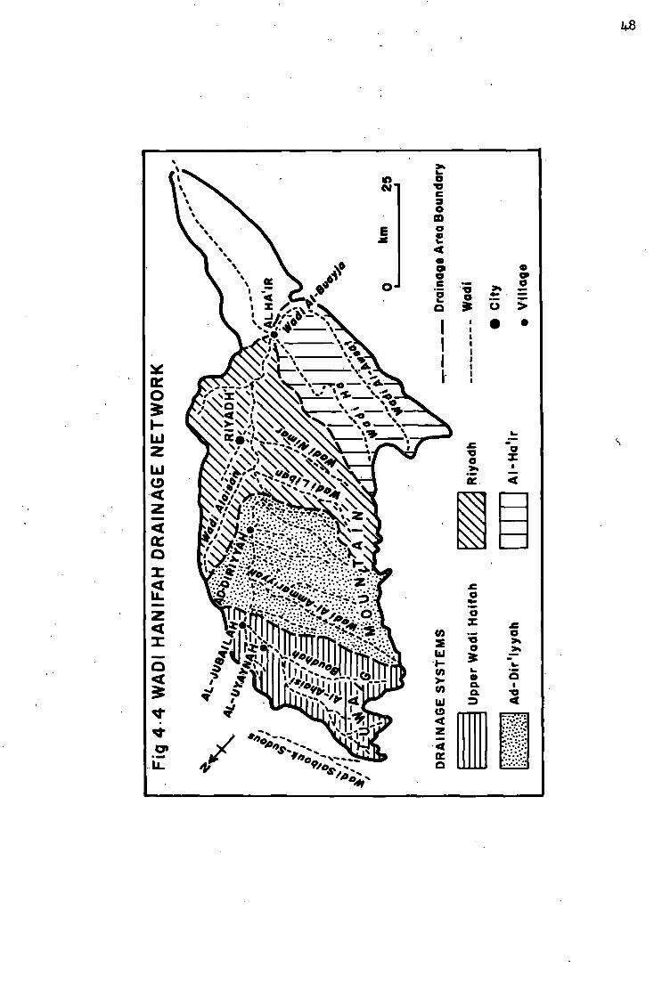
48
in CM
UJ s
UJ
3 1
CO
n I .-J
UJ
Mr to CO l u
* J I

They are in consequence characterised by deep channels and short
runs.. Ad-Dir'iyyah area is the most densely populated area in the
wadi, apart from Riyadh City. The alluvial terraces make it possible
to find an accessible water supply and suitable land for cultivation arid
settlement. However, the Ministry of Agriculture and Water has con
structed four smal l dams on the main tributaries, besides the Wadi
Hanifah Dam, to help in recharging- the alluvium aquifer.
( i i i ) Riyadh Drainage
Here, the topographical features are slightly different, particu
lar ly in the left bank area by virtue of some scattered hills stretching
along to the Arab formation. Thus the Wadis Al-Bat 'ha and Alaisan join
the Wadi Hanifah in the vicinity of Riyadh, On the Wadis Nimar and
Liban, smal l impounding dams have been constructed to replenish the
wells which help to supply the capital city.
(iv) A l - H a ' i r Drainage
In this a r e a , the Wadi Hanifah is joined from the right by the Wadi
Ha, which enriches Jebal Tuwaig within a graben, and the Wadi Buayja
flowing from the east and south respectively. Advantage was taken of
the junction of these wadis and the alluvial water sheds- for the installa
tion of a long complex of extraction works, comprising private wells
and the Riyadh City wells . The ground water in this area is mainly
stabilised by floods (Sogreah, 1967). T h e Wadi Hanifah leaves A l -
Ha' ir in an easterly and south-easterly direction. The drainage down
stream is comparatively narrow, and the course rather unpronounced.

4.3 Evolution of Drainage Network
Since the JdbAl Tuwaig slopes gently towards the east, a number
of drainage systems have been developed following this general slope.
Between them lie eroded plateaux and the drainage systems are
separated by water-partings. These systems form a base for the
replenishment of the shallow aquifers, and the aquifers in their turn
made early settlement possible.
Within these drainage systems the Wadi Hanifah collects various
tributaries along a stretch of nearly 70 km between the Wadi Nisah in
the south and the Wadi Salboukh in the north.
The present relief of the Hanifah drainage basin, particularly in
the A l - H a ' i r drainage, developed after a gentle uplift that probably
occurred in the Miocene or Pliocene eras (Wolfart, 1961). During and
after the alpine epirogeny, the Wadi Ha - which at present belongs to
the Wadi Hariifah drainage basin - drained the Dhuruma, -Al-Muzahimeyyah
and Al-Quway'iyyah regions, which are parts of the area covered by
rocks of the Basement Complex (Sogreah, 1967). The Wadi Hanifah of
that time flowed into the Wadi Ha, which in turn was the head-water of
the Wadi Sahba. Owing to the large catchment of 71 ,120sqkm (the
active catchment in the Wadi Sahba is at present 18,000 s q k m , includ
ing the Wadi Hanifah catchment), the long Wadi Sahba cut its bed and
flowed eastwards at far as the Arabian Gulf, south of Qater (Fig 4 .5) .
Metamorphic and igneous pebbles reported to be found in the dried
valley of the Wadi Sahba by Brown (1949) give strong evidence of its.
dimension. .
Eros ion in the valley of the Wadi Hanifah proper occurred

51
ID
m l i J
UJ 7— U J • CO
i iij < m UJ
H I
U J 0
< 2 F
CE UJ OO
NX XN
X < U J CO
^ i j j CO
0 0 <0 <<
10
J._
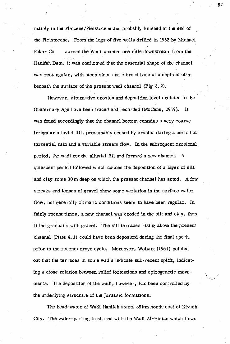
mainly in the Pliocene/Pleistocene and probably finished at the end of
the Pleistocene. From the logs of five wells drilled in 1953 by Michael
Baker Co across the Wadi channel one mile downstream from the
Hanifah Dam, it was confirmed that the essential shape of the channel
was rectangular, with steep sides and a broad base at a depth of 60 m
beneath the surface of the present wadi channel (F ig 3 .2) .
However, alternative erosion and deposition levels related to the
Quaternary Age have been traced and recorded (McCann, 1959). It
was found accordingly that the channel bottom contains a very coarse
irregular alluvial f i l l , presumably caused by erosion during a period of
torrential rain and a variable stream flow. In the subsequent erosional
period, the wadi. cut. the alluvial f i l l and formed a new channel. A
quiescent period followed which caused the deposition of a layer of si lt
and clay some 30 m deep on which the present channel has acted. A few
streaks and lenses of gravel show some variation in the surface water
flow, but generally climatic conditions seem to have been regular. In
fairly recent t imes, a new channel was eroded in the si lt and clay, then
filled gradually with gravel . The silt terraces rising- abore the present,
channel (Plate 4 .1) could have been deposited during the final epoch,
prior to the recent arroyo cycle . Moreover, Wolfart (1961) pointed
out that the terraces in some wadis indicate sub-recent uplift, indicat
ing a close relation between rel ief formations and epirogenetic move
ments. The deposition, of the wadi, however, has been controlled by
the underlying structure of the Jurass ic formations.
The head-water of Wadi Hanifah starts 85km north-east of Riyadh
City. The water-parting i s shared with the Wadi Al -His ian which flows

53
J ft a ,
• /
v
I) f •4
m 1i 3 f
r
.1
t ? i, . r r
m'4 5 i J
. . i , ' j y . >,-.. -
JT-X-
V
CD
bo
' I I *
S •i
2? r
[i
1
T ft,
! s

54
through a gorge in the opposite direction to that of the dip slope.
15km east of the water parting, , the Wadi Hanifah can easily be d is
tinguished as it is joined by a number of smal l , step-wall tributaries,
which also extend to the crest of the Tuwaig Mountain (Leachmah, 1914).
In die 20km stretch upstream of Al-Uyaynah village, the wadi crosses
the Hanifah formation in a generally easterly direction. Here the
wadi forms a rather flat valley with irregular channels of varying
width (between one and 10km), covered with alluvial material (Plate 4 .2) .
Wliile the drainage water in the area has a simple west-to-east flow,
a break in the resistant rock of the Jubaila unit forced the flow to con
tinue in a roughly south-easterly direction. F r o m Al-Uyaynah downstream to
Al-Ha' ir village, a stretch of more than 70km, the wadi is controlled
by dams and hand-built diversions which therefore affect the water
flow and the erosion-deposition processes . Between A l - H a ' i r and A l -
Kharj plain, the wadi appears to be relatively flat, and here infiltration
is active. Ultimately it joins A l - K h a r j plain at an altitude of 450 m
above sea level and dries up in the Tawdheeheyyah Playa - a lake, to
the east of A l - K h a r j , at an altitude of. 400 m above sea level .

55
7 T
CN1
03 +J rt a,
CD
I
o 4 - 1
s CD
!-i 4-> !/5 Q H
3
J ! 4 - 1 • H
T3
0)
c
U
03
E-
o
•h •)•
a 0
"4 ' V i'v ' i ' ^ : '
1 o '
I "
1 '".V J% 1
o C
' o
j -
•1; ; t
1 l v -

. C H A P T E R F I V E
C L I M A T E
Existing publications concerning the Arabian Peninsula seem to
deal with the climatic conditions of the country in relation to the climate
of the Mediterranean and, while this is broadly justifiable, the informa
tion given lacks local detail. The only organisations to make a com
prehensive study of the area have been U N E S C O and the F A O of the
United Nations. The ir publications concentrate largely on precipitation
and its inter-influence with biological resources . The problem here is
that such studies need to be based on and supported by a wide range of
statistics and other material relating to the a r e a , and although climatic
data over long periods are available for some of the world's arid lands,
no such data are available for central Arabia , including the Wadi
Hanifah Basin.
F o r more than 400 years , the Ottoman Empire extended over the
whole of the Arabian Peninsula, except the region of Nejd which was
protected by great belts of sand stretching from the Great Nafud in the
north, to Ad-Datina in the east and Rub a l -Kha l i in the south. Even after
the collapse of the Ottoman E m p i r e , the world's great powers of that
period were concerned only with the Mediterranean countries and the
seas surrounding Arabia. As a result , while a survey of cl imatic con
ditions was carr ied out in the Mediterranean Basin and the Arabian Sea,
central Arabia was considered too remote for such a survey. These
surveys helped to define the influence of the a i r masses and pressure
zones which might affect the Arabian inferior, but no definite statistics

could be obtained from them, since their findings were based mainly on
results obtained in other cl imatic regions, outside the area under study.
Over the last four decades, studies by Thornthwait, Kdppen, De Martin
and Meigs have succeeded in defining various cl imatic boundaries,
including those of the arid zone, and their investigations have paved the
way for a greater understanding of the basic work needed to explain
this desert like regime; from here, the necessary data can be obtained
with the aid of instruments and applied research .
By using the available data, an attempt wi l l be made in this study
to avoid confusion concerning the climate of the Wadi Hanifah. An anal
ys i s wi l l be made which refers not only to meteorological data, but also
to old publications and to observations made over a long period by local
inhabitants, for whom the climatic conditions of the area are vital in
their constant struggle for survival . By studying these extra factors,
it is hoped to throw more light on different methods of defining climatic
conditions, as relating to the hydrology of the area .
5.1 Factors Affecting Climate
5. 1.1 Geographical Situation
The Waid Hanifah l ies in a vast, dry , hot area; the nearest water
being the Arabian Gulf, some 400km to the east, and the Red Sea, about
1,000 km to the west. Except for the Tuwaig Mountain, which forms its
waterhead boundary to the west, the adjacent areas in al l directions are
rather flat, dominated by huge sand dunes and Quaternary deposits. One
exception is the west where the sand dunes l ies in discrete sand areas ,

separated from each other - for example, . Nafud Kunaifethah, Nafud
Ad-Dahi and Nafud A s - S i r . Further westward, the Sarat Mountains
form a topographical barr ier which affects central Arabia , including the
Hanifah region.
These topographical features affect the climatic elements of the
Wadi Hanifah in the following ways:-
(i) The surrounding sand areas (in particular the Rub al-Khali)
are the source of the hot, dusty winds which prevail in the late spring
and summer seasons.
( i i) The western mountains of Sarat effectively shade the region
from the monsoon precipitation, which fal ls on the western side of these
mountains during the summer season.
Its location leaves the region between the influence of the
Mediterranean climate system and the influence of the huge sand zone in
the south in terms of effects of seasonal precipitation. However, the
highlands of the Tuwaig mountain are one of the larger features of the
Arabian Peninsula, and they tend to influence the surplus precipitation
which passes through the north-western area of Saudi Arabia.
On a larger scale , the topography and situation, coupled with the
influence of the a ir pressure zones to the north and east, helps the solar
influence to form an area of ar id climate. Due to the absence of long-
term meteorological records and accurate local investigations, these
conditions are not yet fully understood.
5 .1 .2 Pressure Zones
Existing knowledge about atmospheric pressure zones and a ir

masses w i l l , with care , enable us to describe the climatic character
ist ics of the area under study.
The pressure zones which are likely to affect the region of the
Wadi Hariifah during the summer appear to be two. The low pressure ,
zone, which prevails over the Gulf of Oman, carr i e s over to the Arabian
Gulf and the central part of Saudi Arabia, including the area of the Wadi
Hanifah. A secondary low pressure zone, which l ies over the area round
Cyprus in the eastern Mediterranean, seems to be formed as a result of
the contrast between sea and land in that area . These pressure zones
give r i se to the north-west, north and north-east winds prevailing in the
Wadi Hanifah during the summer, particularly when the two pressures
over Cyprus and the Arabian Gulf constitute a single front.
During- the winter, the Wadi Hanifah region is mainly influenced by
three patterns of pressure:-
(i) the high pressure which covers Central As ia and extends
westwards to the western part of Iran;
(ii) the low pressure zone south of the Equator, and,
(i i i) the minor low pressure zone over the Mediterranean Sea.
Whilst the pressure conditions over the Middle E a s t seem to be variable
in winter (Fisher, 1971), the three aforementioned pressure zones have a
major influence on wind direction over the study area , and the Equatorial
low pressure to the south draws an a i r current from the Asian high pres
sure zone, resulting in the north-westerly winds which prevail over the
Wadi Hanifah. The depressions of the Mediterranean are certainly a
major cl imatic condition affecting the Wadi Hanifah region. The depres
sions which come from the Atlantic in the west across the Mediterranean

may not be as effective as the depressions which form, over the
Mediterranean itself. Thus , while the local depressions of the
Mediterranean are smal ler , they are of greater intensity. The tracks
take a roughly west to east direction over the Mediterranean. Some
depressions pass over the Northern Basin towards central Europe and
southern Russ ia , and some pass across the Mediterranean towards the
Levant, and possibly as far as Iran and northern India, before dying
out over the plains of northern India (Biel, 1946). Yet others pass over
the southern basin of the Mediterranean, and curve in a south-easterly
direction towards the Arabian Peninsula, particularly the northern and
central parts , and these latter depressions are the main source of wintry
ra in over the Wadi Hanifah. T h e i r movements and frequency are i r reg
u lar , and their journey across the Mediterranean to the inland areas of
Levant and central Arabia takes approximately four to eight days. T h i s
frequency over the Wadi Hanifah has so far been unrecorded, but it is
believed that they occur at s imi lar intervals to those in the northern
parts of the country's boundaries; for example, approximately three or
four times monthly during the winter (Al-Marzouq, 1971). Under the
influence of these depressions over the Wadi Hanifah region, the wind
tends to be changeable, responding to the location of the depression, but
once the depression passes away, it is replaced by the prevailing wind -
normally in a north-west to south-east direction.
5 .1 .3 A i r Masses
Over the year , the climate of the Wadi Hanifah is influenced by four
a i r masses:-

(a) Monsoon a i r , originating over India.
(b) Maritime a i r , from the Atlantic.
(c) Tropica l continental a i r , from the wide desert of Rub
a l -Khal i and the Sahara.
(d) Polar continental a ir from E u r a s i a .
F r o m the previous section on pressure distribution and depression
tracks , it is evident that the range of a i r masses and the intensity of
their clashes are much greater in winter than in summer. Thus , from
October till May the Maritime damp a i r from the Atlantic moves from
west to east, passing through .the Mediterranean and Northern Afr ica
to the north-west of Saudi Arabia and penetrating the Wadi Hanifah region
from late October and early November. The influence of the Maritime
a ir is characterised by the comparatively smal l depressions which dev
elop mainly over the Atlantic and the Mediterranean and travel to the
region under study. The invasion of Maritime a i r during the winter mod
ifies the cl imatic conditions, causing rather cloudy weather for a few
days, with some spells of cold weather.
At the same time, periodic interruption by the Polar Continental
a ir from E u r a s i a may cause the Maritime a i r to retreat westward, and
the region is then occupied by a current of cold northern wind, known
locally as "Nassry". When this a i r invades the Hanifah area the sky
becomes cloudless, with brill iant stars at night, and occasionally the
temperature drops to one or two degrees below freezing point. The in
vasion of these cold northerly a i r currents begins, according to the local
seasonal calendar, in Al-Mirba'aniyyah, from the second week of
December until the middle of January .( F i g 5 . 1 ) . - The a i r pressure

51 A COMBINATION OF CLIMATIC CONDITIONS AND THE LOCAL CALENDAR
CO
10 =
2 CO CO
4*.
©0*
Winter Ram Rainy Season
Al-Wasm — valuable ? Uncertain period for inhabitants

becomes stable from the second half of January until about 10th February
which is well known as the coldest period of the year , and is called "Ash-
Shibt" (singular Shubat). It appears that when the Polar a ir c l ears away,
it is replaced by the Maritime a i r , which continues until the end of
spring.
With the coming of spring, which normally begins in the latter half
of March and continues until approximately the end of Apr i l , the
Tropica l Continental a i r from the Rub a i -Khal i in the south begins to
blow, particularly when depressions penetrate to central Arabia on a
large scale. The a i r is pulled into the warm sector of the rapidly mov
ing depression, formed in the Maritime a i r , and this wind can be com
pared to the Khamasin wind of Egypt, which blows from the Sahara
Desert . As it is in the central part of Arabia , a few hundred kilometres
north of the wide desert of Rub a i - K h a l i , the Wadi Hanifah region
enjoys two types of Tropical Continental A i r . The f i rs t is characterised
by sandstorms which reach the region as comparatively smal l w h i r l
winds, but which seldom last for more than 30 minutes. Th i s weather
usually occurs in March and A p r i l , with winds at gale force, and occurs
very often after two o'clock when the ground temperature r i se s sharply.
Its occurrence is usually connected with low spring clouds (Cumulus and
Nimbostratus). The second occurs at the end of spring, when the c u r
rents of a i r flow in a south-north direction; the dust and sandstorms last
for a long time.
The Tropica l Continental a i r is interrupted from June onwards by
the Monsoon a i r , which originates over the Indian Ocean and flows via
I r a n , eventually taking a north-east to south-west direction, and the two

a i r masses bring dry, hot weather to the region. The Monsoon a i r
brings a pleasant a i r current at night, which is modified by a decline in
the surface a ir temperature.
5,2 Precipitation
While there appears to be a considerable amount of information
concerning precipitation, an attempt to discover the relationship between
precipitation and run-off revealed a lack of relevant data. Since the
Wadi Hanifah area forms a catchment or drainage system, a number of
network stations should have been installed to provide the necessary in
formation concerning the density, duration and frequency of precipitation.
Furthermore , as the drainage basin is in the Tuwaig mountain, which
receives a variety of types of genetic precipitation, for example convective,
cyclonic and orographic, the Riyadh Airport station, which is the nearest
with detailed meteorological records , cannot give an overall picture of
the types in the area . However, a great effort has been made to obtain
a l l the available existing data, both from the Airport station and from
other organisations which contributed official hydrological work. The
following data have in consequence been examined:-
(i) The recorded data from Riyadh Airport station, which
commenced operations in 1952.
(ii) The climatic data collected between 1941 and 1945 for the
Riyadh area , giving only the average rainfall•, the number
of days with at least 1- Onm rainfal l , and the absolute max
imum daily rainfal l .
( i i i) Rainfall at Riyadh for 1948, taken by .the Ralf M Parsons

Company.
(iv) Climatic data, recorded by separate ra in gauges in Riyadh
City, Al-Jubailah and Hanifah Dam areas f r o m 1967 on
wards, by the Hydrological Department of the Ministry of
Agriculture and Water,
(v) Information f r o m a survey and investigation study carried
out between 1966-and 1968 by Sogreah. A number of ra in
gauges were installed in different parts of Area V, includ
ing the Wadi Hanifah region. Twelve were installed in d i f
ferent parts of the Wadi Hanifah catchment.
(vi) General information supplied by the well-known historians
of Nejd, Ibn Bishir, and Ibn Eissa (see references). Although
such publications were wr i t t en according to the Muslim cal
endar (Hijrah), the conversion method given by Freeman-
Grenville (1963) is used to convert these dates to the mod
ern calendar.
NB : No data were forthcoming for 1949, 1950 and 1951.
While this information seems substantial, its inaccuracy and lack
of continuity are major obstacles. Sogreah (1968A), in their f inal
report, gave an account of the diff icul ty of obtaining daily readings
f r o m the r a i n gauges:-
"However, its (the instrument's) lightness and general appearance are obviously tempting to some people as more than 30% of them had to be replaced during the course of f ie ld work. Also, i t is very d i f f icu l t tc protect these apparatus once placed in the open a i r , even i f they are near- the guardian's dwelling They were sometimes emptied or interfered with by person unknown, so that i t is not certain that a l l the observations made with totalisers are exact. "

Accordingly, the greatest possible care is taken in considering
the existing data.. Though i t is necessary to rely on the recorded data,
some of the conditions are examined in the light of long-range observa
tions by local inhabitants; since the climate vi tal ly affects their l i v e l i
hood, they have a knowledge of some weather conditions which have
been vividly described.
5 .2 .1 Variation of Precipitation
In dealing with precipitation in terms of its mean annual total in
any f o r m or appearance, precipitation must be treated as ra infa l l . The
available climatic data have failed to differentiate between one type and
another, for example rain or hai l .
The Wadi Hanifah region broadly follows the climatic regime of
central Saudi Arabia, where ra infal l may occur in almost seven months
of the year, and the remaining months (June to October) are almost tot
ally without rain. The climatic data used were taken f r o m 12 sites -
where the period of measurement ranges between only a few months to
20 years.
Precipitation very often occurs in the f o r m of desert thundrstorms
which suggests that the mean annual ra infal l figures give a very mislead
ing idea of the local rainfal l characteristics. Indeed, variation of ra in
f a l l density and amount occurs f rom place to place in the wadi. In spits
of the interrupted and sparse data, the variations of the ra infa l l w i l l be
defined in terms of different localities and various periods of time.
(a) Geographical Variation
Data collected f r o m a. series of 12 ra in gauges (Fig 5.2) over a

67
Fig 5-2 LOCATION OF T H E RAIN GAUGES | Khashm Al-Baladeyyah
- < A I - H i 8 y o n * o ^ \ ^ ~ N ^ \
Existing Rain Gauges
Previously Existing Rain Gauges
0 i —
km 25 i
Khashm Khosrah i Nj> ^ \
N " " - x ^ A Al-Jubailah I " Al-Ammariyyah
* \ I \
\ " \ \vXeK(Harigah;| , V \ . ^ C } « d l 8 o A ' r / k> * \ v
* i t
— — N \ / 1 V " v^^Hanifah Dam
Latitude(N) 24 p 57'
Longitude(E)Altitude 46° I0 ' 950 1
Latitude(N) 24 p 57'
Longitude(E)Altitude 46° I0 ' 950
2 24°5l ' 46° I4 ' 800 3 24°50 46°28' 670 4 .24° 45' 46°06 ' 1000 5 24° 48' 46° 28' 680 6 24° 41' 46 ° 24' 800 7 24° 45' 46° 30' 800 8 24° 43' 46° 32' 800 9 24° 40 ' 4 6 ° 43 ' 570
10 24° 42' 46 ° I 0 ' 46 °50 '
? II 24° 20*
46 ° I0 ' 46 °50 ' 550
12 24° 31' 46°27 ' 920
•Al-Ha'ir
/Dirab v "V / /
>)' / Riyadh «/ v

68
period of three years indicates that the area under study shows distinct var
iations, both in the annual total and the monthly average.' Unfortunately, due
to interference, the records over the measurement period are incomplete,
and the only year which appears to be comparatively complete for most of the
localities is 1967. Table 5.1 gives the monthly ra infa l l for the 12 areas with
the exception of Al-Ammariyyah, fo r which no records are available in that
year. In six cases records are complete, but the remaining records were
intermittent; the table gives information for the northern part of the catch
ment (Upper V/adi sub-catchment) and the eastern part. However, these
records should be considered carefully with regard to the type of ra infa l l and .
the r a i n belts. The comparatively heavy annual ra infa l l in the northern part
was due to the wintry ra infa l l which occurred particularly in November,
while the high volume of ra infa l l at Riyadh was due to the early spring that
year, in late March, Apr i l and May. Though high monthly figures may dis
tinguish the rainy season, rain normally fal ls on only one. or two days each
month, leaving the rest of the month almost dry , with a minimal amount
of ra in . Thus the volume of ra infa l l is almost totally dependent on
thunderstorms, which are characterised by their narrow path and varying intensity.
I t can be assumed that in 1967 the cyclonic ra infa l l in the winter was
concentrated over the northern part in the fo rm of comparatively wide
spread thunderstorms, which travelled f r o m north-west to south-east
(Fig 5.3). Most of the ra infa l l over Riyadh and Hanifah Dam
occurred in the early spring of that year, with the narrower belts being
observed elsewhere. I t is rather d i f f icu l t to distinguish the gradient of
ra infa l l f r o m only one complete year's measurements, and calculations
are hampered by the inefficient distribution of the rain gauges.
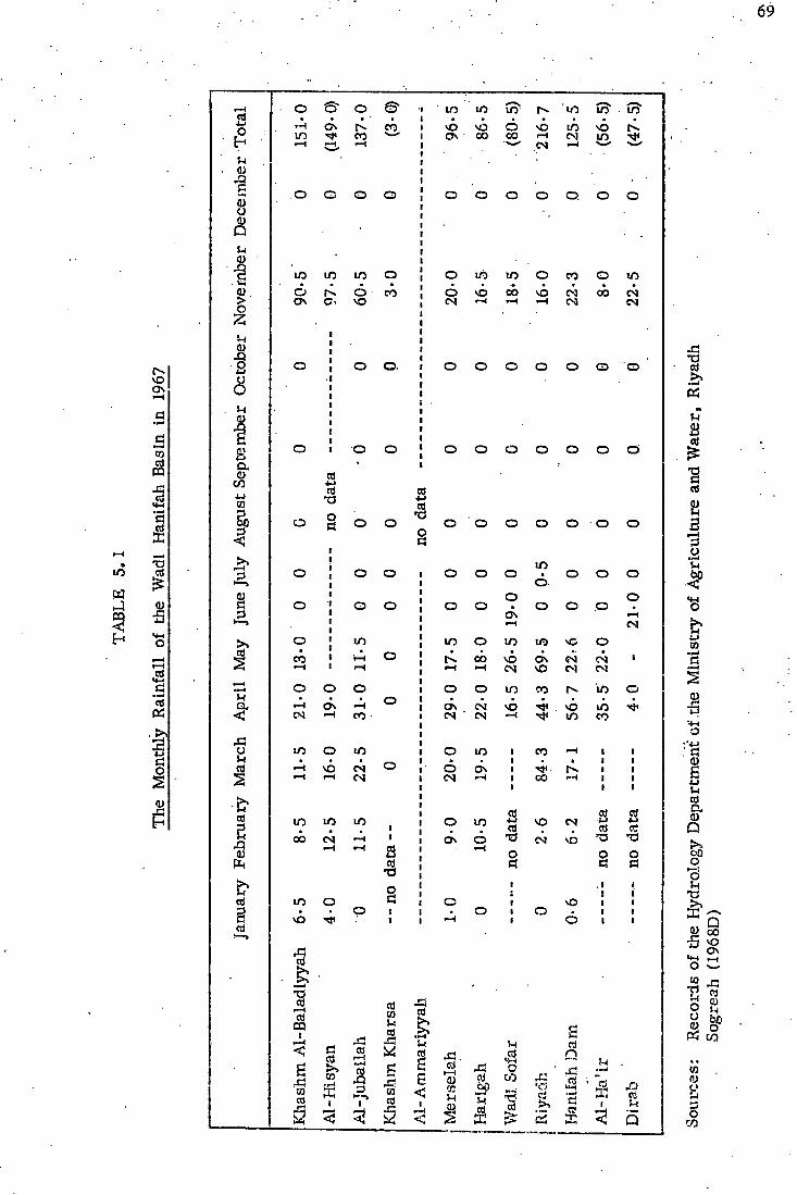
69
ITS
vO O N
c! CO
s X !
•p-1
a
•a
& CD
5 <4-l C • I—J
Ri
o
3 o h n c;
X !
o CD
a 0)
1 CD > O
CD X !
2 O
O 5-1
CD
a CD
C/3 J-J CO
S,
>. r—I
3
i
X i O
cd
cd
5 xi 0)
cd
3 cd
o o © ., m m ft m ft to" H O N CO 1 vO vO o vO m vO m CO 1 O N oo 0 0 i—l CM in -* • — i i — ! 1—1 ! CM >—i —-
o o o o J o o O O a o o
m in o !
o in m o CO o m o o CO • o VO oo vO CM 0 0 CM O N c> vO
! CM •—( i—I CM CM
o j O o . | o o O o O o O
o J o o |
o o o o O o o'
cd 1
4-1 cd « • a
cd
o o a o o
o o ' o o o O o o
, CI
o ! o to o o o m O o o i i 6
• o o o - | o o o o • o O p •
O N p 1—1 [ | i—i CM
o [ m m o in m vC o CO i i—i o [ 0 0 vo O N CM CM 1 1—( i-H 1 <- i 1—1 CM vO CM CM
o o o ! o o m CO r>. in o 1—1 O N 1—1 o j O N CM vO vO m •<*> CM —t ! CM CM —1 m CO
m o m j o in , CO • — I 1
• — i SO CN o j 6 O N 1 1
• ! 1 1
• — I i-H CM ! CM 1 1 oo • — I ! 1
1
j cd as cd m •
m 1 • o in 4-1 cd
vO CM J-> cd
+ J
rt ob • — I 1 i O N 6 73 CM vD *a • — I B • i—i
O o o as [ Pi d n X) •
o • i • J i i
m o S i o i vO i i • • p 1 i • o i O i •
vO 1 i i 6 i i
X j cd
T 3
-—* as CQ i
£ X ! Ml CO
csJ
• f - l
£! 1
CS r—1 • p-4 cd
D 1—>
I
2 <i
cd CO u ai
,5 a as f
cd
s <
I
X ! . cd
r—( CD tc ' H CD.
X ! id
.£P
3
HH
Q w X i cd
cd
t5
cd n £1 • l>W
3 i
X ! TS cd
as »-l Si
"S cd
B 3
i—i =>
b
o
& u CO
•p- i
a
a>
3
: n; a> E 4-1
5- l cd c. 0)
Q o *o
oo •S vo O N
CO j - .
13 «
K c/3
w fl) c
o CO

Fig 5-3 APPROXIMATE RAIN BELT OF A SINGLE THUNDERSTORM
>
•v.-
• » • . • • • ' • • • • • • > v
• A." • • ••• • "V
"V'#: ;AYI • • * • - a". v«. ••V".
I •V-•'h
vv
r i
5 1
km 25
RAIN BELT OF WINTER THUNDERSTORMS RAIN BELT OF SUMMER THUNDERSTORMS
(based on personal observation)

However, even this short measurement throws some light on the
existence of two local factors which should be taken into consideration: -
( i) The relative height of the western boundary, represented by
Tuwaig mountain,does influence the adiabetic process of the cloud. The
altitude of the crest of the mountain within the Wadi Hanifah Basin
ranges between 900 m in the north and 750 m above sea level in the
south. From the one year's climatic data, the effect of the Tuwaig
mountain was recognisable on the Khashm Al-Baladiyyah, Al-Hisyan
and Dirab (Fig 5.4), but the effects of such a short period, of data
recording must be dealt with in the light of the individual bands of
thunderstorm cloud which take a more or less identifiable track over
one part of the catchment for one single rainy period, which may be only
a few hours or even a few days.
( i i ) The other factor is seen in Riyadh City, which occupies an area
of more than 70sqkm. Being an urban area with contrasting features
of parks, streets and buildings, etc. , circulation of local wind and air
pressures could be influenced accordingly. In 1967, Riyadh was the only
station out of 12 rainfal l stations in the region where any rain was rec-
o rded during the summer.
The rest of the Wadi basin has comparatively low ra infa l l owing to
its location away f r o m the orographical effect of the mountain.
(b) Variation with Time
(i) Cyclic Variation
The available data f r o m Riyadh Airpor t appear to cover too short
a time to permit tine detection of any definite cycle of ra infa l l . The
measurements begun in 194S recorded 88 mm of rainfal l fo r one year;

ISOHYETAL LINES ig.5-4 NOVEMBER 1967 APRIL 1967
10
9-0
90 eo {figures not available!
75
70
65 *0 60 310 55 \
50 30 31-4 40 194 io
/ 2 9 0
16 220
3$ 18-5 40 45
22
«5 10 22 5
20
•44-3
40
>0 35
35-5
ISOHYETS Actual Estimated
• 20-0 Rain Gauge (showing rainfallin mm.)
Wad s
\ km 20
Based on data from the Hydrology Dept. Min.ofAg.ond Water. Abo Sogroah (1966A)

the recordings were recommenced in 1952, and successive years showed
large variations in r a in f a l l . Out of 11 successive hydrological years*
f r o m 1954/55 to 1966/67, the total annua! rainfal l was less than the
monthly total of February 1953, and within this period the amount fal l ing in
five successive hydrological years ranged between 92-3 mm and 45-8 mm.
Though such variations migttbe considered accidental, historical in form
ation over three centuries roughly conforms to this cycle. Ibn Bishr (1971)
and Ibn Eissa (1966), who wrote about polit ical and social aspects in the
central part of Saudi Arabia, mentioned years of extreme drought, and
then years of successive ra infa l l , which are recognised in a hydrological
sense as "wet years". These were known locally as "Kah't" (years of
extreme drought) and "Refan" (wet years). From 1637/38 (1047 AK)
until 1784/85 (1199 AH), ten different "kah'ts" hit the area violently,
and caused the loss of many human lives and the destruction of domestic
animals. The time interval between two successive drought periods is given
in Table 5.2.
TABLE 5.2
Time Variations of Kah'ts and Rej'an between 1637/38 and 1872/73 (1047 to 1289" AH)
Years : <2 2-10 10-20 20-30 30-40 40-50 50-60
Total No of 1 c •3 1 droughts (Kah'ts) 1 D O JL
Total No of wet yenrs (Rej :an) 2 4 4 3 2 - -
* From November to October.

Most of these dry years were given identifiable names, for example,
Habran and Doulab for droughts which occurred in 1654/55 (1965/66 AH)
and 1782/83 (1197/98 AH) respectively. I t is interesting to note that
four of these droughts each lasted for at least three successive years,
two for two years and the rest for one year each. During the recorded
period of Nejd his tor ian, i . e . , about 235 years, the years which can be
classified as wet years only amounts to 15 years. However, the import
ant point is that an average or mean annual ra infa l l , without sufficient
records, is not totally accurate. Alternatively, i t can give the annual
ra infa l l regime, leaving a margin fo r variation.
( i i ) Annual and Seasonal Variation
As has previously been mentioned, the area under study receives
almost a l l its annual rainfal l in the winter and spring seasons, as a res
ult of a combination of cyclonic and convectional processes, combined
with the orographic influence of the Tuwaig highlands. The summer and
autumn seasons are generally dry with clear skies and high temperatures.
The average annual ra infal l recorded over a period of 16 years at
Riyadh Airpor t between 1952/53 and 1968/69 was about 110 mm.
Variation between years is rather high, and the fluctation between two
successive years has been as Mgh as 84%. This type of fluctation has
always created an unstable balance between the inhabitants and their
ecological environment. In one period the region may enjoy a semi-arid
climate, facili tating abundant growth of vegetation, while in other
seasons i t may remain completely dry in terms of its eco-environment.
Thus relating- the amount of ra infal l to the contribution of run-off is
extremely important in terms of grazing plants. Moreover, as the land

is used for cultivation and grazing, calculation of the. amount .of ra infa l l .
necessary to produce a fodder harvest over a specified period w i l l help
to define the l imi t s of the wet and dry years. This method w i l l help to
calculate the effect of ra infa l l upon agricultural and grazing land; unfor
tunately, the period for which data are available in the Wadi Hanifah
region is too short to indicate the percentage of wet years out of the total,
except for Riyadh Airpor t station. However, i f allowances are made for
the difference between the effectiveness of seasonal ra infa l l , i t is est im
ated by Sogreali (1968A) that every year that has one week or more of
30 mm ra infa l l can be considered as a wet year, as this amount of ra in
f a l l can produce a fodder harvest, and any year which has less than 30 mm
ra infa l l is classified as a dry year.
Statistics f r o m Riyadh Airpor t indicate that considerable fluctua
tions exist. Rainfall could be in excess of 30 mm in a period of one week;
and one day had four times that amount, as happened in February 1953
when 134-3 mm was recorded.
However, Ibn Bishir (1971) and Ibn Eissa. (1966) mentioned that
in 1809 (1224 AH) and 1819 (1234 AH) .. torrential rains of long duration
occurred in July in. the Nejd Province, and as a result the Wadi Hanifah
and Wad! Ar-Rummah of Al-Kasseim were flooded. Such summer rain
is unusual according to existing climatic data, but i t certainly occurs
occasionally, and older inhabitants in some villages can recall such a
phenomenon called "Khareef" taking place once or twice during their
l i fe t imes, probably one year within a period of 30 to 50 years. Thus
climatic records going back many years must be studied to widen our
knowledge of the climatic elements of the region.

In Table 5.3, data f r o m the three stations of Riyadh,
Hanifah Dam and Al-Jubailah are analysed to meet the requirements of
this study. I t can be seen that the percentage of wet years (out of the
five years mentioned in the table) in Riyadh and Hanifah dam is almost
6 wet years the same as for Riyadh Station before 1969, i . e . , • _ „ ,
J 10 total years while at Al-Jubailah station, the percentage is 4 w e t v ? a r s .
10 total years
A possible e r ro r which could affect this generalisation is that ra infa l l
of more than 30 mm may occur only on one day or one week, while the
rest of the year is almost dry; therefore, a number based on the total
of ra infa l l per day is established on the table to c la r i fy the effectiveness
of ra infal l in terms of run-off and benefits to grazing land. Thus, when
low density ra infal l occurred for a long period, while only a minimum
volume of run-off could be expected, grazing land would flourish fo r long
periods of the year - for example, Riyadh, 1969. I f the amount of ra infal l
is high on only one or two days per year, while the remaining days have
only low density ra infa l l , run-off is expected, but the effect on grazing
lands is variable. In addition, the occurrence of a large volume of ra in
f a l l on one or two days per year indicates the type of spring ra infa l l
which was observed in Al-Jubailah i n 1972.
In short, the Wadi Hanifah rainfal l occurs mainly in the winter and
spring; the winter ra infal l consists of one peak in January and February,
while the spring ra infa l l extends f r o m March to the end of May, with a
further peak in A p r i l . As a result of the orographic condition caused by
the Tuwaig Mountain the average total ra infal l exceeds 100 mm. The
summer and autumn seasons are considered a dry period, although a
trace of rainfal l (less than 5 mm) has been recorded in some years fo r
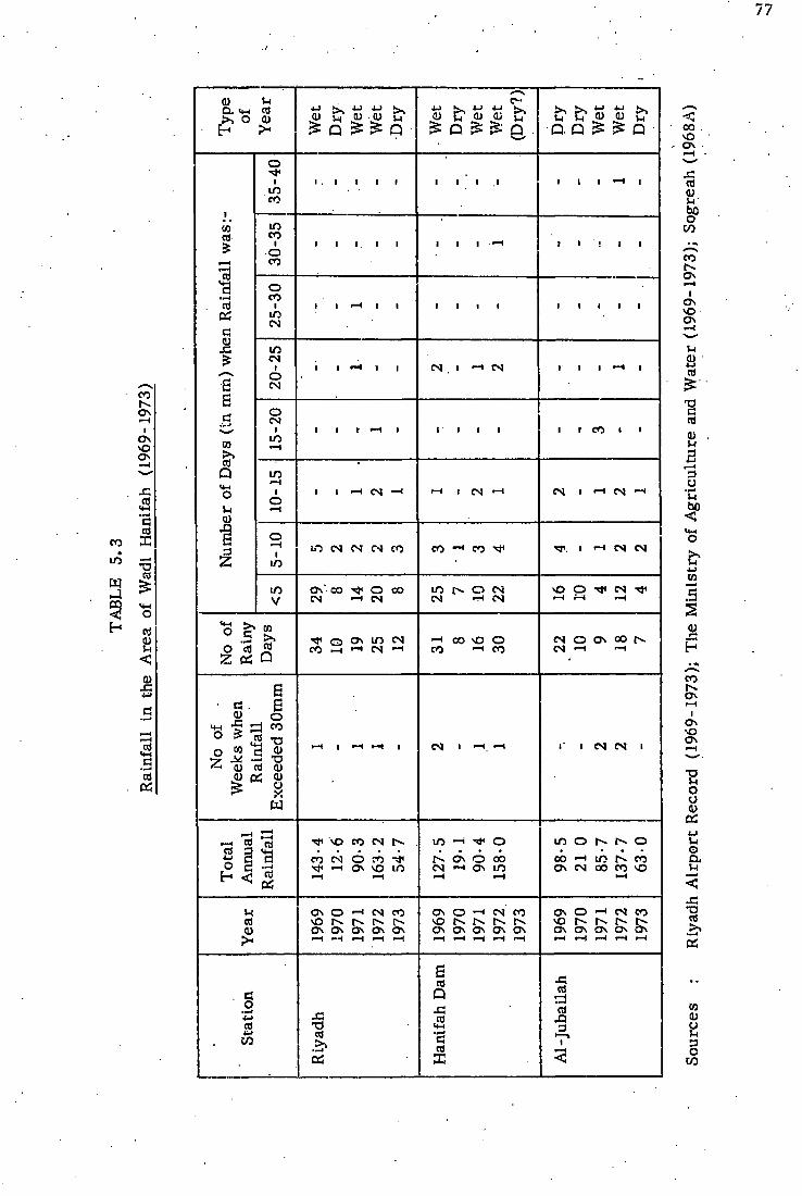
Typ
e of
"\
7 _
__
__
Yea
r
4-J ^ 4-J i-J ^
0) ! U 0) u £ Q £ £ Q . W
et
Dry
W
et
Wet
(D
ry?)
• o. a £ £ Q •
Num
ber
of D
ays
(in
mm
) w
hen
Rai
nfal
l was
:-
35-4
0
I . I i i i i i I . I • • I •—» i
Num
ber
of D
ays
(in
mm
) w
hen
Rai
nfal
l was
:-
30-3
5
• i i . i i • i i — i 1 1 ! 1 1
Num
ber
of D
ays
(in
mm
) w
hen
Rai
nfal
l was
:-
25-3
0
i i — i i i i i i i 1 1 1 1 1
Num
ber
of D
ays
(in
mm
) w
hen
Rai
nfal
l was
:-
20-2
5 i
i i —< i i N I H N I I 1 — * 1
Num
ber
of D
ays
(in
mm
) w
hen
Rai
nfal
l was
:-
15-2
0
i I I - — i i l i i i 1 1 C O ' 1
Num
ber
of D
ays
(in
mm
) w
hen
Rai
nfal
l was
:-
10-1
5
I l H t S H *—* l ( N H N 1 H CS H
Num
ber
of D
ays
(in
mm
) w
hen
Rai
nfal
l was
:-
5-10
I O N N H C O eo —• co I —4 C M CM
Num
ber
of D
ays
(in
mm
) w
hen
Rai
nfal
l was
:-
<5 O N " C O ^ O C O
C N H C S m f - o C M CM C N
vO O CM
—1 f-H •—(
No
of
Rai
ny
Day
s
Q » I D N C O — • C M - H
— I C O vO O C O - I C O
£ N O O N C O [ N CM — 1 —1
No
of
Wee
ks w
hen
Rai
nfal
l E
xcee
ded
30m
m
1—1 1 I—1 ~* 1 CM I — I . — I I ' 1 CM C M I
Tot
al
Ann
ual
Rai
nfal
l
143-
4 12
-6
90-3
16
3-2
54-7
127-
5 19
-1
90-4
15
8-0
98-5
21
0
85-7
13
7-7
63
0
Yea
r
1969
19
70
1971
19
72
1973
O N O —' CM C O N N N N O N O N O N O N O N
O N O —' C M C O N O r-- r-* r>. O N O N O N O N O N
Sta
tion
Riy
adh
Han
ifah
Dam
Al-
Juba
ilah

78
July. (Table 5.4).
5.2.2 Types of Precipitation
A classification of precipitation types can be made either on the
basis of f o r m or appearance (for example, liquid or solid), or on the
basis of genesis ( for example, cyclonical, convectional and orographic).
In order to define the types in the Wadi Hanifah area, we must examine
both these classifications.
In consequence of the general climatic conditions in the area under
study the liquid type is the main fo rm of precipitation. The dominant
type is undoubtedly showery ra in , which occurs during the rainy season
and becomes intense in the spring. This type is very important in pro
ducing flooding in the Wadi streams, and in some years may cause sub
stantial damage to the properly of HE inhabitants, particularly when the
rain is accompanied by a high-velocity wind. Fog and dew also occur in
minimum volume; no recording of dew can be traced, but dew can be
observed in the early morning on the leaves of cultivated plants and
trees, and may sometimes leave damp traces on hard ground. , Fog
rarely occurs in the Wadi Hanifah, forming only very occasionally during
the winter months of January and February; over a thirteen-year period,
only 22 days were foggy. The monthly average seems to be comparatively
high in January, and 50% of a l l fog occurs during this month (Table 5.5).
However, fog is very rarely noticed in the city of Riyadh i tself , due to
urban obstruction; but i t can easily be seen, when i t occurs, in some
places near the channels and c l i f f s of the main Wadi. The duration
ranges between one and six hours.

l O
W -1 <q
o &
CO
O
a X3 X )
>> PS
cd PS
xi o
bo cu n tu
"S a)
3 E
O N
<=* T3 cd
vO
o\
es m O N
mn Oct
• o o
Aut
u
Sept
i o o
Aug
• o o
umm
er
i—H
3
o o CN
o
0-15
CO
June
I o . o
May
69-0
o 13
-4
Spr
ing
Apr
il
51-0
o
17-5
Spr
ing
Mar
ch
84-3
o 15
-5
Feb
134-
3
o
15-9
nter
a cd i—i 57
-2
o
14-0
•r-«
Dec
70-0
o
13-6
Nov
44-0
o
12-1
Max
imum
Min
imum
Mon
thly
Mon
thly
Ave
rage

80
crj 4-> O
H
i •—i i n C N i i > — i >-H i co C M cs
w
H
o crj 4-> CO 4-> J-l O a. u
T3 crj > .
••—I
OS
.8
CQ > s crj Q <*-i o S-i 0)
3 2
O S
NO OS
CO
I I I I
' ' I
I I I I I I I I
I t -H I C O I
I I I I I I I I
I . I I I ! I I I I
I I I I I I I I I
1 I I I I ^ I I I I I I I I I
"ccj >
• i i i i i i i i i i i i crj 4-1
Q i i i • i i i i i i i i i
i i i i
• i i i
• i i i .
i i i i i i i i i
i i i i i i i i i
fM I I • — I >—! I I I I
C N C S I in I I i i N
CM
in
a o 4-1
cd CO
4-1 u o u
•a crj >>
PS
J-l crj
a) v o \ o v o v o v o v O v o r ^ r > . r > . r > i v O S O S O S C N O S O N O N O S O S O S O N Os Os O N
crj 4 J o H
a> o (H 3 O
CO

The only solid precipitation is hail, which is associated with
the convectional clouds which occur only in spring; hailstones falling in
the area range between 5 and 20 mm in diameter, and sometimes the
density of the hail is so great that it can cover the surface of the ground
in a few minutes.
As previously stated, the bulk of precipitation in the Wadi Hanifah
region occurs as a result of the lateral penetration of maritime air.
It is generally accepted that the formation of cloud and occurrence of
precipitation can be subdivided, in terms, of genesis, into three types:-
(i) frontal or depressional;
(ii) orographical;
(i i i) convectional.
Such subdivision in the.Wadi Hanifah area is difficult, , as two or three
of these conditions may occur, together in a short period. Nevertheless,
in a broad sense, the cyclonic convectional types relate to the seasons.
There is a tendency for the cyclonic type to occur in the region during
the f i rs t half of the rainy season, i . e., from November to February;
such a frontal or depressional rainfall results from a horizontal con
vergence of air in a depression which overlies colder, denser air.
These phenomena, are common during the winter when the cloud in front
of the depression is very high (mostly cirrus or cirrocumulus types)
accompanied by a southerly gradient wind. These high clouds may cover
the sky for a few hours or even a whole day, and these are followed by
cumulonimbus clouds, increasing in thickness as they approach the area.
When these clouds cover the sky, lightning is often observed, as most of
the region's rainfall is associated with thunderstorms.

The convectional type can be observed in the spring, i . e . , March,
April and May. When the sun warms the ground surface, it causes a
condition of instability in the air which leads to ascending pockets of
air that cool adiabatically to below the dew point. However, while this
is common in the warm, moist, tropical climate, i t is controlled in the
area under study by the moist air which is brought within the maritime
influence. The formation of clouds is observed mainly at noon, although
they may begin to gather around 11 00a m. Around 2 00 or 3 00p m, the
clouds appear to be atrostratus in the front (in the case of a thunder
storm) and cumulonimbus in the middle, with an almost sharp rear. The
convectional-like type of thunderstorm cloud, appears to have a smaller
size and comparatively low height; the density of the rainfall is great and
the shower droplet may exceed 2 mm in diameter; occasionally the warm
air becomes unstable, resulting in hailstones.
It is therefore thought that the impact of the maritime air is the or i
ginal source of the convectional rainfall in this area in both seasons.
This conclusion stems from the fact that the direction of movement of
clouds in winter and spring is more or less the same - from west to
east.
The orographic precipitation, as such, is not individually recog
nisable. That is to say that the relatively high topographical features of
the Tuwaig Mountain have further effects upon the density of rainfall when
comparison is made between the amount of rainfall which occurs in the
mountain itself and the adjacent areas, as has been stated (see Figure
5.4).

83
5.3 Evaporation
The Wadi Hanifah is a region where actual evaporation is compara
tively smail, not because evaporation is naturally low, but because the
region becomes an almost arid zone for most of the year, and surface
water as a source of .evaporation is extremely, scarce. In the summer
and spring, however, the region has a high potential rate of evaporation.
The major obstacle when dealing with evaporation, as with other
climatic conditions, is that, while humans can adjust to almost any situ
ation and use it to their own advantage, this particular phenomenon is
not easy to control owing to the complicating factors that work in correl
ation with each other, despite some minor success in protecting water
reserves by various methods, for example, mono-molecular layers,
etc (Ward, 1967). While evaporation is a constant and continuous pro
cess, its effect upon the area under study can be seen most clearly
when water is within easy reach, either as a free water-body or a few
feet below the ground. This circumstance occurs only when the region
has. a sufficiently large surplus of rainfall to constitute an actual flood.
In accord with the scope of this work, evaporation wi l l be dealt with in
terms of annual and seasonal volume, and also with regard to its
impact upon dams and irrigation water.
5.3.1 Annual, Monthly and Daily Evaporation
The measurement of evaporation, as opposed to precipitation,
has not received sufficient attention during the last two decades, prob
ably due to the common lack of interest in the subject in the country.
Evaporation in the Wadi Hanifah was estimated in the 1950's and early

1960's by foreign consultants and has been subjected to technical measure
ment only over the last few years. The only two bodies to give recorded
measurements for evaporation are Sogreah (during their 1966 and 1967
investigations of the Dirab area near the water head of the Wadi Liban
tributary in the western highland of the catchment), and the Hydrology
Department of the Ministry of Agriculture and Water for Riyadh area.
In spite of the short period covered by these, two measurements, they
show contrasting features of evaporation (Table 5.6).
The total annual evaporation in the Dirab area reached 4,659 mm,
while the Hydrology Department records show the annual average
evaporation for Riyadh area between 1968 and 1971 inclusively to be
2,608 mm. Such a large difference between two areas with a distance
of less than 30km between them is caused partly by the type of instrum
ents used by Sogreah and the Hydrology Department. While Sogreah
investigations were carried out by a class A pan, the Hydrology
Department used a Colorado pan. The ratio between the two instruments
is not actually known, but it is estimated to be around 80%. It is also
caused by the influence of local geographical factors in the two localities.
Since the Dirab area is bcated near the crest of the Tuwaig Mountain
with an altitude of more than 910 m above sea level, its greater exposure
could be responsible for the comparatively high rate of evaporation.
The comparatively low rate of evaporation at Riyadh area, which rep
resents the low land of the drainage basin, was caused by a variety of
meteorological factors as a result of microclimatic conditions, as well
as the low altitude (approximately 600m above sea level), wind velocity,
and relative humidity; ground and solar radiation, are modified by the

Tot
al
2407
27
09
2711
' 26
05
2608
.
4659
Dec
0 0 O H O a s o c o o o
.—1 91-2
5
ts sO •—i
Nov
C O Is O • CM <~i i-H CM ^-i ^ i—t >—i 11
8-50
i_
•- vO
OS i—t
Oct
N N r-l N Ov M O H H H N
O ' 0 0 i—l
>—I
o Se
pt
o o- —* CO m h. in in CM C M CM CM . 25
7-25
s o 00
Aug
m • I N \ o v o — i m CM <-< C O C O C O C O 32
8-50
1—1 r H
»—i D i—i
o —< m •—1
c o o m m C O - * C O C O 35
9-25
CO s o
June
0 0 ON o c o v o i n c o CM C O C O C O
336-
75
rs CM
. sD
May
o\ ts I O C N
1—1 ^ is C M C O C O CM
o OS C M
i—1 is
Apr
il c o c o ts * o O N I s rt
CM CM C M CM 229-
75
m C O C O
Mar
C M m CM O ON Os O esi H H N 19
8-25
i—i •—i c o
Feb c o is ^ CM ON ON C O • *
i - i i—t 117-
75
i n CM CM
a •—> C O C O CM O vO ON O
r H r H 91-7
5
m OS ••H
Yea
r
1968
19
69
1970
19
71
1967
Stat
ion
Riy
adh
Ave
rage
Dir
ab

contrasting features of the urban and cultivated areas, which provide
additional shelter.
Monthly evaporation appears to be at maximum in July in both
Riyadh and Dirab, and at minimum in December or January.
Evaporation in the rainy season (from. November until the end
of May) is approximately 40% of the total annual evaporation; within this
period, the evaporation increases sharply during the spring period, i.e. ,
between March and May, while evaporation in the dry season, i . e . ,
from June until the end of October, is accelerated by the high tempera
tures and the cloudless skies during these months.
The daily evaporation rates differ according to the season; in winter
the daily evaporation is in the region of 5 mm, as recorded by Sogreah,
while in summer the daily evaporation rate could be six times as high
as the winter rate.
5.3.2 Evaporation from Dams and Irrigated Areas
The man-made reservoirs in the Wadi Hanifah proper and its main
tributaries are the main areas for evaporation. Flood water is usually
controlled behind seven impound dams until it eventually disappears by
virtue of evaporation and infiltration. The moisture in soil, either i r r i
gated fields or barren lands within the Wadi Basin, is also affected by
evaporation.
In practice, evaporation in the Wadi Hanifah occurs when an
available amount of water and moisture can be evaporated, and the rainy
season is the main time when this process takes place.
As floods normally occur during the winter and spring, accordingly

evaporation increases during the spring, when the solar radiation is free
to reach the surface of the water. Usually, the wadi is filled with flood soon
after a substantial run-off reaches the main stream; and due to the short
duration of the flood, no attempt has yet been made to determine the
actual amount of water lost by evaporation, although the ratio of evap^
oration is probably greater in the shallow moving flood than in the sti l l
water behind the dams. In other words, solar and ground radiation,
coupled with the circulation of air, accelerate the rate of evaporation
in the shallow depth of the flood blanket along the stream. While, behind
dams, the small size of water surface and the relatively high depth of
water help in decreasing the amount of evaporation.
Local geographical factors affecting, evaporation of the flood water
in the seven dams of the wadi are nearly similar in terms of orientation,
depth, area and surrounding relief environments.
Accordingly, the main Wadi Hanifah Dam is selected to be the sub
ject of the following discussion.
Between April 1965 and May 1972 the Dam received about 53 • 40
x 10^ cu m from 17 floods with varying volumes of water. (Ministry of
Agriculture and Water, 1973). The evaporation rate was observed
through an evaporation pan in the area, but the daily readings were
carried out only when the lake was ful l of flood water. Table 5.7 gives
the volume of water evaporated against the flood accumulated
behind the dam during the period of recording. It must be
stated, however, that the evaporated water figures given in the previous
Table ought to be treated only as a guide to the ratio between the average
volume of flood and the amount of water evaporated. With regard to the

TABLE 5.7
Volume of Evaporated Water from the Reservoir of
.Hanifah Dam (1965-1972)
(In 10^ cu m)
Period of Recording Water Evaporated
Volume of Flood
23rd April to 10th May 1965 . 0;031 11- 27
6th November to 29th.December 1965 .0-04 2-62
5th to 14th May 1967 0-005 0-16
24th November 1967 to 10th February 1968 0-085 15-64
14th April to 21st May 1968 0-094 6-79
16th January to 7th February 1969 0-011 1-52
11th April to 31st May 1971 0-082 7-39
29th March to ist May 1972 0- 08 7-92
Total 0-428 53-40
Mean volume 0-0535 6-675
Source : Hydrology Department of the Ministry of Agriculture and Water, 1973

total volume of the evaporated water (0-428 x l(P cum) the ratio
appears to be relatively low, but if we evaluate a single flood (for
example, 5th May 1967) in comparison with the amount of water evap
orated in the same period, the ratio tends to be comparatively high.
Nevertheless, when considering the period of measurement of evapor
ation of a single flood, the mean value is 0-0535 x 10^ cu m . per flood.
Before statistics were recorded, the consulting companies (including
some of the water advisers, in the Ministry of Agriculture), believed that
loss by evaporation was a major obstacle to the conservation of flood
water in dams, but this hypothesis appears to have been exaggerated.
The annual rate of evaporation, however, is relatively high, but because
of the short time in which the water is controlled by the dam (between ten
and 60 days approximately), the amount which might be evaporated is
not sufficient to cause alarm.
The low rate of evaporation in the main dams of the wadi proper and
its various tributaries is, as previously stated, influenced by local geo
graphical factors, the most important being the size and shape of
see
reservoirs ^Plate6.1). All dams on the Wadi Hanifah drainage were
constructed in a narrow section of the wadi where the cliffs of the channel
around and behind the dam are rather high, thus making the reservoir
rectangular in shape.
The depth of the water varies according to size and shape, and
ranges between 0 m in the upper end of the reservoir to a minimum of
3 m, such as in. the Sorfar Dam, and a maximum of 8 m, as in Nimar
Dam. The depth near the dam may reduce, the rate of evaporation of water
and this reduction stems from the fact that the greater the depth of the

water., the greater the difference between the air temperature and the
water temperature, the main controlling factors in evaporation. The
degree of water pollution appears to influence the rate of evaporation,
depending on the percentage of total solids (De Wiest, 1965); while the
flood water maintained in the reservoir is fresh water, it is thought that
the fine silt and deposits, along with the total solids which have not so
far been tested, may proportionately reduce evaporation. Finally, the
surrounding relief of the reservoir, for example the high cliffs on either
side, provide shelter against the local surface whirlwinds which move in
the area during the rainy season in spring.
The volume of evaporation in the irrigated lands depends on the
evaporation rate, the size of the area concerned, and on the water applied
to the land. While the evaporation rate is taken mostly from irrigated
lands (for example, Dirab and Riyadh), the rate on the cultivated zones
can be affected by local environmental conditions. The supply of water
also raises a major obstacle to any estimation of the evaporation rate,
due to the availability of shallow underground water, which relies on
seasonal rainfall (see Chapter 7, The Alluvium Aquifer). Nevertheless,
an evaluation of water evaporating from such land (excluding transpiration)
would appear to be useful.
Unlike evaporation from dams, the evaporation here is caused by
the excessive production of ground water for the irrigation of date gardens
and alfalfa crops. According to the only agricultural investigations so
far carried out by the Ministry of Agriculture and Water in 1964, the
constant irrigated land is in the order of approximately 3,262-7 hectares
(see Table 1.1). Forty per cent of the area consists of constantly i r r i -

y 2
gated plants, for example palm trees and alfalfa. It is believed that a
considerable volume of water is evaporated, particularly during the
summer when the evaporation rate reaches its maximum. McCann
(1959), when studying the cultivated area in the upper part of the Wadi,
estimated that, from a volume of 2 -1 x lO^cu m of water
applied to an area of 752*6 hectares, a total of about 0-9 x 10 cu m of
water could have evaporated in 1958, and this drew attention to an unex
pected loss of v/ater by evaporation. However, unless such discoveries
are technically analysed, substantial errors may be made in any estima
tion.
5.4 Temperature
Temperature is the second most important element after rainfall,
strongly affecting not only the biological characteristics of the region,
but also human behaviour and lifestyle. Unlike the seasonal identity of
the coastal areas of Gaudi Arabia, which are affected by the neighbouring
water bodies, the seasonal identity of the Wadi Hanifah region is governed
by the variation between two distinct periods of summer and winter, for
it lies one degree latitude north of Cancer, and a distance of approxim
ately 370km from the Arabian Gulf, which is the nearest sea. Also, the
bulk of the wadi area stands at the eastern foot of the Tuwaig mountain,
and these geographical factors provide considerable modification to the
temperature characteristics of the region.
In practice, the variations of seasonal and diurnal temperature
are rather more important than the annual average; whilst the latter can
give a broad impression of the regime in. terms of global distribution,

the shorter period is more accurate. However, according to the Riyadh
Airport data, the mean annual temperature for the period between 1959
and 1970 inclusive ranges between 23-5°C and 26°C. The monthly average
mean temperature for the same period ranges between 34-48°C In July
and 14-52°C in January. The mean annual temperature of the Dirab
area, near the escarpment of the Tuwaig mountain, was 23-3°G for the
only recorded year, 1967 (Sogreah, 1968D).
The daily temperature range appears to be very high. According
to 16 years' data recorded at Riyadh Airport, the absolute maximum
and absolute minimum recorded temperatures have a difference of 51 °G
(Table 5.8). Such variation in temperature is not apparent every year,
but it is rather important in terms of agricultural crops and plantations.
In some years, for example, heavy losses were sustained in the tomato
crop due to the low temperature, which dropped to 2°C at Riyadh and
-4°C at Dirab in 1968. Low temperatures in winter are-caused mainly
by the interference of the dry cold air current from central Asia, and
the period between 10th January and 15th February, known as Ash-Shubt,
is definitely the coldest time, when the northerly wind may blow for a
considerable number of days and be coupled with clear skies and a
chance of some frost, in contrast, the summer period is generally
very hot, except for a few nights when the region enjoys a mild northerly
wind, and the most extreme l imit of temperature used to result in the
loss of human lives in both winter and summer.
Diurnal variation is very noticeable during any day of the year;
unfortunately no statistics are available, but personal observations have
shown that the range may reach 15°C. Such variations in temperature in

f x I
m O N •—t T3 O
U 4> CD
5
CD T3 J-l O U CD 5-1
U
0) J-i
3 cd n ID
o. B a> 4-> CO
% o •a cd 4-> CO CD •a s
CD
a cd u CD
a E CD
cd
Q S .1—1
E • r - l
CD
si
n o a u
si T3
cd
cd
Dec
CO i CM c o
Nov
m m c o
o CO
Oct
~ - . O - H
CO
Sept
m t>. C O CM
bo <
O N —1 CN
o o CM
=> • — I
I>- O N T P *4 o o
CM
June
N O o o CO . CM
May
m c o • — i
CM CO
Apr
il
CM 0 0 c o
Mar
h» N O C O
— ( CO
Feb m o
c o in c o
Jan O CM
c o i CM CO
Abs
olut
e M
axim
um
Abs
olut
e M
inim
um
Dif
fere
nce
u o Q,
si •a cd
>J OS cd
O N
I I s -m O N
•o o M
CX,
CD
CD H
s cd W CD
B CD
H cd CD
cd u
CD
CD
en
inua
l M
ean
25-0
6
<
Dec
14-7
8
Nov
19-6
1
4-1
o CO c o
O in CM
Sept
31-4
0
Aug
34-2
8
>.
34-4
8
June
33-8
8
May
29-9
8
Apr
il
24-9
2
Mar
20-6
3
Feb
16-4
2
G cd
— i 14-5
2 M
ean
Ave
rage

one day, especially during the summer, affect all aspects of.life; in order
to escape the persistently high afternoon temperature, schools, shops
and offices begin work as early as possible, for example between 06 00
and 08 00am, and after 2pm human activities slow down considerably.
Several open-air cafes outside the capital city on the Riyadh-Taif Highway
in the west and on the Riyadh-Dhahran Highway in the east flourish in
the summer months, as a result of people taking advantage of the late
evening fresh air, whereas in the winter these cafes barely exist.
The temperature gradient within the area under study decreases
from east to west; the exposed highlands of the Tuwaig enjoy a compara-
• tively low temperature, while Riyadh city's microclimate varies accord
ing to its different districts. The Malez area with irrigated garden
houses, enjoys a modified temperature, while in contrast the central part
and the remaining sectors of the city, where wide streets with compara
tively high ground and solar radiation prevail, have very high temperatures.
5.5 Humidity
Relative humidity, like other climatic elements, is formed and '
modified by the synoptic climatic regime, coupled with the surrounding
geographical environment. The humidity element in the Wadi Hanifah
differs in its range and'limits from other areas in the country, due to the
location of the area, far away from the sea, with the periodic invasion of
alternating warm or cold and dry air currents (for example, Continental
Tropical Air , or Continental Polar Air, and occasionally the penetration
of the moist Maritime Air) , which are responsible for the fluctuation of
the relative humidity.

The mean annual relative humidity in Riyadh Airport for the years
1959 to 1971 inclusive ranged from 22- 8 in 1970 to 43- 2 in 1964, with an
annual mean for the whole period of 31 5%. On the other hand, in the
Tuwaig mountain (represented by Dirab) the mean annual humidity, is
somewhat different : according to the figures for the only year when
data were recorded by Sogreah (1967), the mean annual was in the order
of 40-1%. In the same year, Riyadh Airport had an annual mean of
29-5%. In comparison, Jeddah Airport, on the western coast of Saudi
Arabia, had a recorded annual mean of 58% for the period 1959 to 1970,
giving an annual mean for the whole period of approximately 62%. Thus,
while the coastal areas have a rather high rate of humidity, the Wadi
Hanifah region enjoys a lower volume of relative humidity. The highest
monthly mean figure ever recorded at Riyadh Airport Station was 63%,
in January 1965. January has the highest monthly mean for the whole per
iod, with an average of 48-58% (Table 5.9). Within a single year, how
ever, any one month of the rainy winter season (November to February)
could have the highest recorded mean.
The absolute maxima and minima of relative humidity show contrasts
ing figures. For example, in April 1970, the minimum dropped to 1%,
and the maximum for this specific month reached as high as 71%; 100%
of relative humidity has been recorded in seven months in the period 1959
to 1971, figures for three of these months occurring in 1971.
The daily relative humidity varies immensely with temper
ature, and observations by Sogreah (1968A) showed that in winter
the daily maximum occurs at approximately 09 00 am, and the
minimum at approximately 5 00p m, while in summer the maximum

o • — I
I m
u o a S-l
T3 a t
cd
B 3
0)
> 4 J cd
>—i 4) 05 CO CJ 4- 1 CO
••—4 5-l s o ct) J-l to
- d U
Dec j
45-2
8
61-3
3
25-5
0
100 6
Nov
43-7
5
54-8
3
23-6
7.
100 7
Oct
27-3
3
31-8
3
13-0
0
98
6
Sept
17-3
3
23-5
0
8-83
67
4
bo < 16
- 17.
28-3
3
10-0
0
85
4
3 • i—> 16
-76
19-1
7
9-00
68 4
June
14-8
2
21-5
0
8-83
81
2
May
26-7
5
88-6
7
16-5
0
95
3
Apr
il
37-3
3
51-1
7
22-0
0
100 1
Mar
.41-
00
45-3
3
16-8
3
100 3
Feb
43-9
2
67 3
3
24-7
7
100 5
Jan
48-5
8
63-0
0
28-1
7
100
Ave
rage
M
ean
Ave
rage
M
axim
um
Ave
rage
M
inim
um
Abs
olut
e M
axim
um
Abs
olut
e M
inim
um
o • • ^ 4-1
cd 4-) C/3 4-J Si
o Q . U
T3 g. 05
u u 3 o
occurs at approximately 07 00 a m and the minimum at approximately
4 00pm.
To summarise briefly, the characteristic features of the relative
humidity indicate that it is rather low over the whole year, but
increases during the rainy season as a result of the westerly and
northerly air stream.

CHAPTER SIX
RUN-OFF
Sources of Run-off
Whilst rainfall can be accepted as almost the only source of fresh
water in the earth, the way by which the water accumulates into a
single stream-flow is very important for defining the components of
run-off. Two multiple purposes are aimed at in this study: the f i rs t is
to define as far as possible the difference between run-off in a perennial
river and an arid-land wadi; the second is to give the general character
istics of one or more flood analyses.
In the run-off in any single river, four components act inter-
dependently to form a stream-flow : (1) direct precipitation; (2) surface
run-off; (3) interflow; (4) ground water flow. While it is rather compli
cated to define the actual volume of each of the components and their dis
tribution in time, they may all contribute a variable amount of water to
the stream-flow at a given time and a given point.
In the case of the Wadi Hanifah, all four components hardly ever
occur together at any time because of the climatic and ecosystem char
acteristics. The most important is the overland flow, L e . , the sheet
flow of water from the point at which a raindrop reaches the land surface
to the point at which it becomes part of the turbulent flow in the channel.
Such flow is affected by many factors related to the features of the
catchment and the climatic system, both of which will be studied in
another section of this chapter.
Direct precipitation over the stream-flow' is unlikely to happen

except in the finger tips of tributaries where the run-off is formed
within the time of rainstorm. Sometimes, however, when the catchment
is affected by frontal rainfall of comparatively long duration, the direct
precipitation over the various tributaries and dams contributes a negli
gible proportional volume which is probably consumed by evaporation.
The chief effect of direct precipitation can be distinguished indirectly
where a channel bed with sand grains has a relatively high soil moisture
content, immediately after the occurrence of a storm shower. This
causes a decrease in the infiltration capacity on the one hand, and, on the
othei; helps the run-off or stream-flow to travel a longer distance within
the wadi length. The winter season flood, which occurs between
November and February, has a comparatively long duration, and conse
quently may reach the flood-plain of As-Sah'ba and At-Tawdheheyyah at
Al-Kharj Plain. In spring, though the density of storm-rain is rather
heavy, the flood may have a high peak and travel a short.distance, due
partly to the high rate of infiltration in the dry channels.
The interflow and base-flow components, which constitute a con
stant flow-, are not available during the whole year. This is due to high
soil deficit, which is caused by the high potential evaporation and small
amount of rainfall. Thus, when the flood occurs, the depth of the under
ground water in the alluvium channel is far below the bed surface of the
channel. Instead of water seeping to the stream during a flood, infiltra
tion and percolation will take place. The only exceptional case, is the
seepage flow originating from the impound dams to the downward section
of the stream, which is totally dependent on the flood reserves.
Equally, during a wet year when floods occur frequently in a short

period, for example, two weeks, the date gardens on the silt terrace
of the wadi, which are normally irrigated by flood when this is possible,
may also contribute a small portion of seepage flow.
Thus the stream-flow of the Wadi Hanifah is composed primarily
from the overland flow contributed by the seasonal rainfall in the shape
of temporary floods.
6. 2 Factors Affecting the Distribution of Run-off in Time
The flood hydrograph of the Wadi Hanifah is controlled by many
factors, some permanent and others transient. In any stream-flow the
inter-relation of such factors seems to be common. In the case of the
Wadi Hanifah, some factors are more dominant than others, as a result
of their individual type. Establishing quantitative relations between the
flood and those factors would be invaluable, not only for the wadi under
study, but also for all wadis of central and northern Saudi Arabia. Such
a study needs substantial investigation and long observation at precise
locations, something which is not available at the present time. Such
factors wi l l , however, be discussed on the grounds of their importance
for the flood in order to increase our understanding of the interaction
between physical and human systems.
The factors are closely inter-related, and exert a common
combined influence. For convenience, they wil l be classified
in three groups. Chief among these is the physical character
istic of the drainage area and the climatic condition prevailing within
the catchment. Human interference in altering and modifying the natural
conditions is also very important, especially where the trend of water

. development in the country swings towards computing and controlling the
available surface water in order to evaluate the water balance.
6.2.1 Climatic Factors ' .
Climate is probably the most powerful influence on the mass run
off. In a general sense, the balance between water gain and water loss
is rather important here. When a comparison is made between the
rate of rainfall and evaporation, it is clear that the ratio is as much as
1 to 25. Such a difference is usually modified or reversed on the occur
rence of rainfall. Owing to the intensity of the prevailing rainfall, the
evaporation rate is smaller than the rainfall in a given place and at a
given time.
Thus, if an average 100 mm were distributed all through the year,
the run-off might be zero owing to the high rates of evaporation. Even
if the water loss arid the water gain occur uniformly through a rainy
month, the run-off wil l also be zero. Thus, the reason for the mass run
off, which may be as much as 12- 80 x 106cu m in the Hanifah Dam, is in fact
the intensity and duration of the rainfall in a single period, which may
sometimes continue for more than one day.
One important point has to be considered here. As the bulk of the
run-off occurs through individual storms, close attention should be paid
to their sizes, rates of movement, tracks, frequency and distribution
over the catchment. As has been mentioned in the chapter on climate,
the above factors can be classified in two groups, according to the time
of occurrence of the storms, i . e . , winter or spring.
In winter4 the size of thunderstorms is comparatively large, their

density is rather high, and the rate of movement is relatively slow.
Consequently, rain tends to cover the whole catchment, allowing a mas
sive run-off to occur at one time.
Though the intensity of rainfall in spring is rather high, rainfall
from one single storm occurs in a narrow.belt unless successive thunder-
showers fall within a short period. Afternoon rainfall in April or May
falling on an isolated patch with a relatively high temperature may be
lost by evaporation and infiltration before it accumulates in the stream.
The relationship between the wadi slope on one side, and the inten
sity, duration and movement of the rain-storm on the other, is very imp
ortant in terms of the peak of flood. Taking the upper sub-catchment,
for instance, which was observed at Al-Jubailah, the three major tribu
taries flowing from west to east, i . e . , Al-Khomrah, Al-Hisyan and the
wadi proper, join the main stream at roughly the same time, due to the
track of.the storms, which usually hit the sub-catchment-from north
west to south-east.. When a rainy-run occurs on.the sub-catchment during
a previous stream-flow, the peak following the rainfall occurs rapidly and
intensely.
6.2.2 Catchment Characteristics
Though precipitation is the only source of run-off in the wadi, the
Basin area, including the shape, size and drainage network of the catch
ment, defines the dimension and magnitude of the flood hydrograph.
Infiltration is a rather important factor, since the ground water level
always lies beneath the surface of the channel.
Probably the most influential factor is the shape of the catchment

area, and its size and slope. In this respect the v/adi catchment can be
sub-divided into three parts (Fig 6.1):-
(a) The Sub-Catchment of Tuwaig. Highland
An elevation at the water head of the tributaries of more than
900 m above sea level slopes down to an elevation of between 700 and
650 m near their mouths in the main wadi. The proportional loss of
water by infiltration is consequently small, and the velocity of the water
is also rather high, due to the rocky-type slope, which reduces the
influence of evaporation before the water joins the wadi proper.
Furthermore, this area of comparatively high elevation enjoys a higher
rainfall than that enjoyed by the rest of the basin.
The drainage network of this sub-catchment seems to render it
well-drained. No attempt has been made to establish the relationship
between the density of the network and the trunk. However, the latest
observations of Sogreah (196SA) and the Ministry of Agriculture and
Water (1973) show that a substantial volume of the overall run-off of
the wadi was drained from this part. For example, in November 1968,
Sogreah recorded an observation of the Wadi Al- Ammariyyah, which
6 shows that 3 x 10 cum of flood had been drained. Though this wadi is the largest tributary within the area, a number of tributaries can, pre-
6 6
sumably, contribute between 0-5 x 10 and 2 x 10 cum in a single
flood.
While tributaries flow in a rather steep channel from the highland
of Tuwaig to the channel of the wadi proper, the latter tends to be more
horizontal. Although a difference of gradient is noticed in one or two
sections, the extensive land use has led to artificial channels, cultivation

1.05
* IM
J
i
CO '.Si UJ
UJ
to
UJ
(!)
i CD
CM n CO
(O
techniques and dams, and has modified the original characteristics of
the channel.
(b) The Sub-Catchment of Al-Ha'ir
The Al-Ha'ir area appears to have a different type of drainage
owing to the relatively low elevation. As has been described in Chapter
Four, Physiography,, this area lies in the graben and fault belt which crosses
the Wadi Hanifah basin. Accordingly, the area has only two major
tributaries, i . e . , Wadi Ha and Wadi Al-Awsat. The two tributaries
drain a substantial amount of their flow from short sub-tributaries which
descend from the right and left bank cliffs of their channels.
Owing to the protrusion of the Al-Halr. region into the Dhruma
Plain to the west of the Tuwaig sub-catchment, the water head sometimes
lies in the track of clouds which cross the Dhruma Plain. Conversely,
while the sub-catchment of the Tuwaig highland may lie in the track of a
particular cloud, this may not pass over the water head of the Al-Ha'ir
sub-catchment.
While the tributaries of both wadis, i . e . , Ha arid Al-Awsat, are
steep towards the main channel, the latter has a smooth slope, particu
larly in the upper heads. This, in fact, provided an ancient track across
the Tuwaig Mountain,
The effect'of such physical features upon flood is that the two
tributaries have long narrow drainage. Both join the Wadi Hanifah
proper near Al-Ha'ir village. Owing to their location, which is more
than 80 km from the v/ater head of the wadi proper, they supply their
flood earlier than the wadi proper, which takes approximately three to
four hours before it reaches the Al-Ha'ir area. Thus, if a long
107
observation of flood hydrograph is taken immediately downstream of the .
Al-Ha'ir area, two peaks wi l l be recorded, one caused by the Al-Ha'ir
drainage and the other by the Tuwaig highland sub-catchments through
the wadi proper.
(c) Sub-Catchment of Slumped Zone
This sub-catchment is the drainage area of the left bank tributaries
of the Wadi Hanifah, in the area between the Wadi Hanifah Dam and Al-
Ha'ir. As previously mentioned in the chapters on Physiography and
Geology, this area lies largely within the Arab Formation. Despite the
fact that the geological series bf the central Arabian formation slopes
eastward, the existence of small hills in the area creates a poor drain-,
age area flowing to the main channel of the wadi proper. The main trib
utaries are the Wadi Alaisan and the Wadi Al-Bat'ha. The remaining tributaries
are very short and shallow, with an approximate length of between
1 and 5km. Their effect on the volume and magnitude of the flood in the
wadi proper seems to be reasonable when the wadi proper is already flow
ing; otherwise, their volume of flood may be lost in the sandy channel of
the wadi by high infiltration.
The Wadi Al-Bat'ha was connected with the construction of Riyadh
City. Its length and subsequently its capacity were reasonable for the
old Riyadh, which was estimated to have something like 17,000 inhabit
ants at the end of the nineteenth century (Abul Ela, 1965A). Nowadays,
a large area of its catchment has been lost through the expansion of the
city. However, although the wadi channel was modified and converted
into a flood sewer for the city centre, the wadi may still flow when sub
stantial rain continues in the remaining drainage to the north of the

Airport.
The Wadi Alaisan has similar ph/scgraphical features to the Wadi
Al-Bat'ha; its length and size do not allow a large volume of run-off to
be drained towards the main wadi.. Additionally, it crosses a rather
extensive cultivated area before it joins the wadi proper immediately
' downstream of. Al-Uraija village, to the west of the capital city. This
cultivated land reduces its capacity due to the diversion of water through
artificial channels towards the palm groves. .
6.2.3 Land Use
The term "land use" is defined here to mean the impact of human
activities in changing, the course, volume or velocity of the flood. While
the natural phenomena. for example, climate and the physiographical
features of the drainage, established the l imit of the flood in the wadi,
man, on the other hand, started modifying the stream-flow in order to
practise cultivation and to protect himself and his environment from
damage.
Although the connection between earlier settlements and the wadi
basin is not relevant here, a quick look at the wadi before and after the
1950's can, indeed, explain the relationship of two types of human acti
vity to the flood in general. Prior to the 1950's, the wadi had a rural
function, limited by the water available in the form of both flood and
ground water. That function has been modified by the explosive growth
of Riyadh from the 1950's up to the present time. Thus, the urban area
has extended in each direction to obstruct some of the old drainage areas
and tributaries. Increased urban demand caused the Wadi Hanifah to be

drawn on as the f i rs t new source of municipal supply. Because of the
shortage of water in the alluvium aquifer, the construction of dams
started as early as 1959 in the wadi proper, and in the Wadi Liban and
Wadi Nimar. Additionally, with Riyadh being the capital city, new roads
were built linking the city to the rural area, and these had to be paved; \
a new bridge and spill-over road consequently caused the diversion of
some tributaries to minimise the number of bridges.
For the sake of simplicity, the influence of man over the mass
run-off wi l l be classified under three headings:-
(a) AgriculturalTechniques;
(b) Urbanisation;
(c) Hydraulic Structures.
(a) Agricultural Techniques
Diversion of flood water started as early as the start of culi.tvation
in the Wadi Hanifah. One prime factor for cultivated land in the wadi is
the use by irrigation of flood water whenever possible. However, the
elevation of the terrace in some localities is too high above the channel
surface for the terrace to be reached by the stream-flow in a moderate
flood. On the other hand, a powerful flood is so damaging that those
cultivated terraces had to be protected by stone wall barriers. Thus,
special techniques were applied in different localities along the length
of the wadi.
These techniques were generally of two types. Firstly, in the
case of a cultivated terrace adjacent to a small tributary (Fig 6.2A),
the flood was diverted in such a way that surplus water was returned to
the channel of the wadi. Secondly, in an area where there was no trib-

Fig 6-2 DIAGRAM ILLUSTRATING AGRICULTURAL TECHNIQUES TO UT IL IZE FLOOD FOR IRRIGATION
i i i i i i i i i i i i i i i i i i i i i 11 i i I I I L i m e s t o n e C . l i f f l 1(A) I I I I I l I I I I I I I I I I I I I I I I 1.1 I I I I i I
Artif ic ial 'Channel diverted
from-the top of the cl i f f
Small Tributary
I I I I I I I I I I I I I I I I I S I I I I I I I L i m e s t o n e C M f.f. » » i i i i i i i i i i • i i i i i i I
I I I I I I I I I I I I I I I I I I I I I I U I I L i m e s t o n e C l i f f i i i i i i 1 1 i i i 1 1 I i I i I I i i i i i i
(B) • i
Ar t i f i c i a l Channel
Stream
Surplus of irrigated f lood
Flood Diversion
I I I I I I I I I I I I I I I I I I I I I I I I L i m e s t o n e C l i f f • • i • i i • i • i i i i i i i i i-.i

utary, a small dyke with an approximate height of l m was built across
the width of the wadi before the rainy season (fig 6.2B). Such a barrier
raises the surface of the flood in the main channel, so that the flood
reaches the area which is to be irrigated.
I t is not possible to evaluate the quantity of flood which is used
for irrigation; nor is it possible to give the ratio of flood used in this
way to mass run-off. However, the statistics of the Ministry of
Agriculture and Water (1964) showed that the cultivated area in the
wadi was in the order of 3,262-7 hectares. The bulk of this area was
so sited that i t had its share of the flood water.
While such techniques reduce the magnitude cf the flood in the
wadi, i t is equally true that.the flood peak is also affected. The different
ar t i f icial channels and diversions inevitably reduce the crest of the flood
hydrograph and result in a longer duration of the stream flow.
(b) Urbanisation
Unlike the agricultural techniques which affect almost one half of
the wadi length, the influence of urbanisation is limited to the expanded
area of the capital city.
The expansion of the city has passed through a number of historical
stages; the city was originally constructed in the basin of the Wadi Al -
Bat'ha, whence it took the name of Al-Riyadh - gardens in Arabic -
though a number of historians (such as Yakout El-Hamawey in the thir
teenth century) mention its original name as Khadhra Hajr, or alterna
tively Hajr.* It is quite safe to say that until the outset of the twentieth
- The name Hajr is written is Arabic as

century Riyadh could be classified as a small village. In 1917, the area
of the city was estimated to be about 100 acres (Philby, 1922). When it
became the capital of a new state (Saudi Arabia) in the f i rs t half of the
twentieth century, it acquired the ability to attract immigrants from all
over the country, in addition to the newcomers from abroad who helped
in the development of the growing town.
Thus, two events can be considered as the starting points of the
expansion : f i rs t ly, the movement of the late King Abdulaziz from the
old city to Al-Murabba's Palace, l«5km to the north of the old city
centre in 1938; secondly, the construction of the Riyadh-Dammam Rail
way in 1951, coupled, with the transferring of the government offices
from Jidda to Riyadh in 1957. Abul Ela (1965A) estimated that the kernel
expansion of 1938 covered an area nine times as great as that of the old
walled city, i . e . , 3-5km from north to south, and 2*6km from east to
west. He estimated also that the city extended 12km from north to south
and 8km from east to west in the 1960's. Today, the expansion of the
city has become very rapid, especially near the highways which connect
the city with the remainder of the country.
While the city was , until 1950, only concentrated around the Al-
Bat'ha tributary, at the present time the expansion covers almost all the .
Al-Bat'ha Basin and some of the area around the lower part of the Wadi
Alaisan tributary. Previously the Wadi Hanifah proper was the l imit of
expansion towards the west. In the 1970's, the development of the Ash-
Shafa area beside the Riyadh-Taif Highway has caused development to
the west of the channel of the wadi proper, paving the way for further
extension on the eastern slope of the Tuwaig mountain. Thus, accord-

ing to the aerial photographs of the Aerial Survey Department of the
Ministry of Petroleum and Mineral Resources (December, 1967), tog-
ether with a fresh check made by the author in February and
March 1974 ,. the city now extends about 11km from the city centre,
As-Safat, to the north, which almost equals the distance between the
latter arid Ad-Dir' iyyah village. The extension from the city centre to
the Ash-Shafa area along the Riyadh-Taif Highway covers about 8kni.
The city is expected to continue to grow at about the same rate
and to have expanded by the year 2000, particularly to the north into
the Wadi Alaisan Basin and to .the east. According to the Consult
Limited f i rm which established the.Sanitary Sewerage Master Plan of
the city (1971), the city wi l l stretch 24km from north to south and 11km
from east to west, with a surface area of about 291 sqkm.
The effect of such a sudden and vast expansion of the city upon
the run-off and the flood in the Wadi Hanifah differs, in fact, from the
effect of a similar development in a humid area. In the latter case,
where the water is disposed of through drainage systems, a rapid and
marked build-up of surface run-off is likely to occur immediately below
a large urban area (Ward, 1967). In the Wadi Hanifah, the effect is
more complicated. This complexity stems from the fact that the city
suffers from the lack of storm sewage systems.
Before the recent explosive expansion, the building area of the
city was sited near the Wadi Al-Bat'ha and the surrounding palm groves.
Such a site helped the urban run-off to disperse through the surface
ground of the road towards the stream.
Nowadays, the linkage of the old city by new paved roads with

the modern building area on the outskirts has created a problem. The did
narrow lanes, which lack storm sewage, constitute an area of non
existent or poor drainage, bounded by the high elevated paved road
Consequently * such sewage, after torrential rain, either disperses into
nearby old covered hand-dug wells, or accumulates in ponds in the mid-
die of the roads and remains there for some time until it is lost by evap
oration and percolation.
In the case of some of the major paved streets which slope towards
the artificial channel of the Wadi Al-Bat'ha, a sewage drainage network
has been constructed. The proportional quantity of such discharge is
probably insignificant at the moment, in comparison with the overall
run-off in the city.
The bulk of the run-off in the city vanishes by both evaporation and
infiltration. The latter, which is more important in terms of ground^
water recharge, takes place partly through the fil l ing of-the old hand-dug
wells which were distributed all over the city. This factor, in addition
to the domestic sewage disposal which also infiltrates continuously,
gives rise to the local underground water (see Chapter 8 on Jubaila
Aquifer).
Owing to the problem of water shortage in the Wadi Hanifah region,
the overall run-off in the city - excluding the domestic sewage disposal -
may contribute a considerable amount of surface water. Such an
expectation wil l not, however, be fulfilled unless the storm sewerage
system is carefully designed and diverted either to the main wadi stream
or to be used for irrigation purposes. By this means, the negative effect
upon the surface run-off of the Wadi Al-Bat'ha and Wadi Alaisan could be

avoided. Furthermore, the impermeable surfaces of the city,
paved roads, house roofs, etc., wi l l enable a substantial proportion of
rainfall to escape infiltration and evaporation. Thus the mass run-off
of the city wi l l probably be greater than the Wadi Alaisan and Wadi Al -
Bat'ha together. .
The previous hypothesis is based on two facts. Firstly the surface
area of the town wil l be larger than the catchment of all the Wad is
Harigah, Ghubairah, Sofar, Mahdiyyah and Wubair.
Also, the spatial area of the city, in almost two decades* is expected to
be as large as 50% of the largest tributary, i . e . , the Wadi Al -
Ammariyyah. Secondly, the drainage system of the city follows roughly
the same slope as the Wadi AlTBat'ha, which slopes gradually from north
to south, joining the wadi proper at the south end of the greater Riyadh.
(c) Hydraulic Structures
This term here means primarily the dams in the wadi proper and
the main tributaries. The wadi region contains seven dams, plus two
more under construction. All dams are built in the area, between Al - .
Uyaynah village in the upper reach and Al-Ha'ir.
Prior to 1958, the Wadi Hanifah flowed along its length, without
any obstacles apart from those arising from the practice of agriculture,
mainly in the middle part. Thus, it was not uncommon for the flood to
reach the Al-Kharj area, especially when overall run-off occurred in
the whole catchment.
The growth of the city of Riyadh, coupled with a continuous increase
in the standard of living in the city, made it necessary to establish a
municipal water network. The alluvium aquifer v/as traditionally known

as a comparatively major water reserve, and exploration and tapping .
was carried out near Ergah village and the Wadi Nimar, in the Al-Batin
area, west of Riaydh, and later in the Al-Ha'ir area. At that stage,
i t was felt that the alluvium underground water was unable to meet the
increasing demands of the city. Moreover, the traditional hand-dug
wells were being deepened to increase supply. When the Minjur aquifer
was discovered and tapped in 1956, a substantial volume of water was
found, but its quality was hot as good as that of the alluvium aquifer,
in the Wadis Nimar and Al-Ha ' i r . . Thus the alluvium aquifer con
tinued to be exploited to supply both the city and agricultural demand. .
During the same period, the fear of water exploitation.in the aquifer
was also present. Accordingly, the idea of constructing sub-surface and
surface dams along- the wadi and main tributaries was recommended by
most experts. Aramco (1948), in its investigation on the water supply
for Riyadh, recommended constructing a series of underground dams
along the wadi and low surface dams in main tributaries; this sugges
tion was followed immediately by engineering studies by the International
Bechtel Company between 1948 and 1951. In 1950, J F Brown, Director
of the United States Geological Survey Mission to Saudi Arabia, stressed
the need to construct groundwater dams along the wadi, as had been
suggested by Aramco, But, after a study of the economic feasibility of
underground dams in the wadi, International Bechtel (1951) concluded,
that the saving of water involved would not justify the cost cf construction.
Instead, they recommended the construction of two surface check dams
in the Wadi Liban and in the main wadi, i . e . , Llban Dam and Kanifah
Dam. The arguments for and against building dams were mentioned
in almost every investigation for Riyadh water supply, Including those
undertaken by the Pakistan Technical Survey Mission to Saudi Arabia
in. 1954, and the Raif M Parsons Engineering Company in 1958.
Following these investigations, the Riyadh Municipality started
the construction of two dams, one.in the Wadi Nimar tributary and the
other in the Wadi Liban tributary. Both were completed in 1959.
The construction of Hanifah Dam was also completed in 1960
(Ministry of Agriculture and Water, 1971). These hydraulic struc
tures having been completed, the wadi was then left for agricultural
purposes, owing to the development of the Minjur Aquifer, which sup
plied water to the city.
Another epoch of construction started in 1968, with the building of
three small dams in the.Wadis Sofar, Ghubairah and Harigah, near
Ad-Dir'iyyah village. The construction of two dams in the Wadi Hanifah
proper was proposed, the Ha'lr Dam was to be located 2-5 km upstream
of the Water Treatment Plant at Al-Ha'ir and the Dir'iyyah Dam between
the mouth of the Wadi Al-Ammariyyah and Ad-Dir'iyyah village
(Shaikh, 1972). Details of their capacities are not available, but it
is- assumed that each one wil l hold between 1- 5 and 2 million cu m
of water.
Though all the dams are constructed for re-charging the alluvium
aquifer, they influence all the mass floods and the hydrograph.ic peaks.
Al l have been built on the area with effective run-off and comparatively
intensive agriculture. The Ad-Dir'iyyah Dam wil l obstruct any small
volume of stream-flow due to occur from the upper reach of the wadi proper
or from the Wadi Al-Ammariyyah. The same result is likely to be

caused by the small dams on the Sofar, Ghubairah and Harigah Wadis.
The Hanifah Dam wil l be supplied mainly by the Wadis Mahdiyyah and
Wubair immediately, upstream, and in addition by the surplus flood over
spill from the Ad-Dir'iyyah Dam. The Ha'ir Dam wi l l hold the flow of
the slumped zone sub-catchment in addition to short tributaries flowing .
from the triangle to- the east, bounded by the Riyadh-Taif Highway in
the west, the watershed of the Wadi Ha in the south and the main wadi
in the east.
When the construction of Ad- Dir'iyyah Dam and Ha'ir Dam is
finished, the Wadi Hanifah wi l l be unable to reach the Al-Kharj Plain
unless a substantial and continuous run-off occurs. In other words,
even if the flood passes the Al-Ha'ir area, the wide and gradual slope
of the. Wadi Hanifah channel further downstream wil l help the flood to
be lost by infiltration and evaporation. However, the areas which are
stil l free of any flood restriction are the area upstream of Al-Uyaynah
village, and Al-Ha'ir subcatchment.
If any run-off occurs in the whole catchment of the Wad.i, two
flood peaks presumably pass the Al-Halr area. The f i rs t one results
from the Wadis Ha and Al-Awsat which meet with the wadi proper almost
together in one short section of its course. The second occurs as a
result of the spillway flood leaving the other dams in the middle course.
The volume, cpacity of all the existing- dams is about 19-87 x 10^ cu m.
Though this quantity looks rather small in terms of overall flow, the dis
tance between them, which has a high infiltration rate, might force
any small portion of flood passing any individual dam to be lost by
infiltration. Thus, unless a substantial flood occurs, the wadi course

south of Riyadh City will, have a minimum flow (Plate 6.1).
Flood Observations
The climatic regime and the size of the wadi catchment mostly
decide the magnitude.of the flood. In other words, the flood occurs
for a comparable time to the occurrence of local rainfall.
In dealing with the flood characteristics of the Wadi Hanifah, as
well as other wadis in the Tuwaig mountain, the important point is to def
ine the dimension and the volume of the surface flow at a given time.
The aim of such an investigation is not to avoid a flood tragedy, which
is out of the question nowadays owing to human interference with the
flood; it is rather to take advantage of the flood as much as possible in
such a way that an accurate estimate of its impact upon the shallow
underground water can be taken into account.
Flood observations started as early as human settlements on the
wadi; the villages, which have been located on or near the cultivated
terrace, were constructed in such a way that damage was, as far as
possible, avoided. Such an intention can be seen in flood development
and management over the years. Cultivation has been developed, for
instance on the silt terrace which could be protected from flooding, even
in the wettest years. Within such management, velocity, height and
dimension of floods have been given some consideration. Hydraulic
structures and human interventions for controlling the flood were sited
and adjusted to cope with the flood shape and magnitude.
The investigations which started in the late 1950's and early 1960's •
were related to the construction of dams and bridges on the wadi proper

Pla te 6 .1
The e f f e c t o f the Nimar Dam (below) on the f l o w o f f l o o downstream (above)

and the main tributaries. Thus, the necessities of planning led to
mathematical estimates of flood behind the dams. Other precise obser
vations were made from 1965 onwards by the Water Resources Division
of the Ministry of Agriculture and Water , and'also by Spgreah between
1966 and 1968; both sets of observations wi l l be considered in this
section. The observations of .the former are mainly concerned with the
behaviour of the Wadi Hanifah Dam in terms of its water reserve. The
latter, in 1967 and 1968, succeeded in recording four flood hydrographs
in four sections of the.wadi proper, i . e . , at Al-jubailah in the upper
reach, Hanifah Dam, Al-Ha'ir and for the surplus of flood which passed
Al-Kharj Bridge.
According to the few observations carried out before the building of
the most recent hydraulic structures in the wadi, the volume of flood passing
through the middle reach is believed to have been larger. In January 1958
a storm lasting for about 40 hours produced about 7 x 10^ cu m, as
measured at the Al-Badi'ah Bridge to the west of Riyadh City. An esti
mated flow of about 45 x 10^ cu m in 24 hours was also given in another
storm occurring on 15th February 1958 (Davis, 1959). Such a relatively
substantial flow of the wadi appeared to reach the Al-Ha'ir area where
the wadis Al-Awsat and Ha join the main wadi and i t descends to the A l -
Kharj Plain.
Data collected by the author from the office of the Hydrology
Department in Riyadh (Table 6.1) show the irregularities of flood in
terms of its occurrence and volume. Within the recorded period
(between 1964 and 1972) the total volume of flood passed through the 5
Hanifah Dam was of the order of 55-55 x 10 cu m. Slightly more than

vO
CM —< i •* vO ON
£
Q
,cti <4-l
"3 <L>
•a s J-l A bp CD CO
o I — I
13 i 3
i — i
3 O
vO O
T3 0) CO CO <D
(U
CO
e 3
i — i O
>
1971
/ 19
72
0-09
0-29
7-
14
0-49
8-01
1970
/ 19
71
6-27
6-27
1969
/ 19
70
• i i i i i i i i
1968
/ 19
69
1-48
0-
04
1-52
1967
/ 19
68
4- 9
5 .
0-64
0-
36
9-47
1
A
C
1- 4
5 5-
90
. 0-
60
0-28
**
23-6
5
1966
/ 19
67 O vO
- H O 1 1 1 1 1 1
o o 0-16
1965
/ 19
66
2-39
2-
30
4-69
1964
/ 19
65 CO CO CN O
1 1 1 1 1 • • 1 - H O >—1 '
vO CN •—( • - i
Mon
th*
Nov
embe
r D
ecem
ber
Janu
ary
Febr
uary
M
arch
A
pril
May
Ju
ne
Tot
al
> CO
a H U CD
•8-
t—i
£ o n xs CO
Hi CO
X I
o •3 o o o z
CN ON
•o.
C5
J-l
B
I •a cd
6 3 O
- H i ' 5-1
K-t
o & • CO
•a mmmt
co
o •u rt 0)
E 5-1 Cfl
a CO
G
S-l
I I o
o 3 O

20%. of this volume was recorded in one month - April 1965.
This clearly reveals the nature of the run-off in the Wadi, which
is characterised by a high density of rainfall from time to time. It gives
a clear idea, of the characteristic of the Wadi Hanifah catchment in com
parison with other wadis in the Tuwaig mountain. That is to say,
whereas the other wadis in the.eastern slope of the Tuwaig mountain
flow in a west to east direction, their catchments are smaller than
that of the Wadi. Hanifah, which behaves in its middle reach as a collector
of major tributaries with a considerable catchment surface, for example
the Wadi Al-Ammariyyah.
Owing to. the climatic regime of the area and the physiological char
acteristics of the catchment, the overall flow of the Wadi Hanifah cannot
be deduced from one given point. In other words, one sub-catchment can
contribute stream-flow, while others may be dry at the same time. If
the observation is carried out at the lower end, for example Al-Kharj
Bridge, the result wi l l be meaningless in terms of the stream flow in the
upper and middle reach owing to the high rate of infiltration between A l -
Uyaynah in the upper reach and Al-Kharj Bridge.
Accordingly, the observation of the volumes of flood accumulated
in the whole length of the wadi (Table 6.2), revealed that the volumes
6 6 ranged between 11-7 m 10 cu m and 24-3 x 10 cum. An average of
96% of the flood was lost by infiltration and evaporation. The remaining
portion found its way through Al-Kharj Bridge.
Due to the irregularity in the temporal and spatial distribution of
rainfall , the volume of flood in various sections of the wadi differs
distinctly. Thus, the data for the section between Al-Jubailah and Hanifah
123
x; Cd C cd
T3 3 o
CM 3
CO < f -
T3 O O
• — I
5-1 3 O
4-1 cd
( U CO
8
•a u CO CO co u & CU
CO
E ,3
J 3
cd U
<
r3 oo S-l VO a, os-< -«
5-1 ed
g X) CO
oo sO ON
cu "§ rv . e \o a; ON
2
U vO
a o\
o
o CO CD
Q
W oo 00 CO CO o 00 m m CO Csl O . © •* Os 00 OS oo oo i - i i — i
m sD o sO CO CO OS 00 o • - I <—1
o o o o o o o . o m o in m o I D co. in oo CO o CO . oo
•* CO r—1 so CM CM in •<* CO <—1 CM CM
O o
o in
o co
o Os
O o CM
o CM
O o CM
o • oo
o so
O CM
op CM i - H
O 00 CO CO CO co CM
CO CM
O
o o o o m os ^ o o o-O Os
o o m m
CO 'O CO • * - CM ' r j i
O
sO
O
sO
o o o o C O CO O —i O - H CM ©
o sO
o I - I
o in
O OS
SO o
Os so CO CM <—i O i—t 6
B cd Q X !
- ed •Ml
a
•a CO
X 3
.3 CO . ^ t
en -B
g CO
co g bo £ S? o CO
^ l o . T3 5-1 O <D o t i
— i cd
a o •—*
CO E 5-i cd O Q °< -cd x i > cd
a a O
"rj *o CO CD 5-1 T )
3 8-» o § 5
- J PH
a CO Q x i cd
cd
i
B cd
E cd
u cd
X .
•
co
"B cd
I cd X
XI .cd O
-3 E3 ™
o > cd 5 ( D J J - u B
T ) cd o * O I> J - J
2 1 § O .-3 —• OJ <
6 2 =» « 2 O cd O
> J .
a-o < • «
•a: o a; a» i
cd (-4
. o cd >
•a cd a o cd S-l
T3 o o
2 -a 3 5-1™ o o
S
•a
cd i — i
i 3' U O cd
"8 o
<4-l '
o CI)
B 3
i — i O >
i—i' S o H
cu B
•a
cd u o cd *
CD bO •a T3
ed PQ T3 & cd 5-1
n cd
o 4-1 cd o a cd > a> •a cd
§ u ^ ^ u :r1 CQ 13 — S-l
Q . ^
cd i w ^ o
T3 CD CO co cd a
•a cd
X3 cd
i—<
cd XI 3
x: o
T3 0) O 5 O O
*M CU <4H 5-1 o cu cu "£ 3 a
2 3, CO
6 5
cu T 3
u 1—1
tn
B cd Q X J
n—1
. « cd I ! 4-1 cd •a cu •a 3 O
a E. •8 o
i B. o >

Dam are separated from that data for the section between the Hanifah
Dam and Al-Ha ' i r / The irregularities can be seen in any single flood
observation. For instance, in the April flood of 1967, the section between
Al-Jubailah and Hanifah Dam contributed only 1- 8 x 10^ cu m, most of it
drained from the tributaries of the Wadis Al-Ammariyyah, Wubair and .
Ai-Mahdeyyah. In the section between Hariifah Dam and Al-Ha'ir , the
proportional volume was as high as 9-6 x 10^ cu m. The observation of the
flood occurring in November of the same year showed that the former section
received 6-4 x lO^cum, while the latter section received only 2-0 x 10^
cu m. In such conditions; where the southern sub-catchment has got a
substantial inflow, there is a possibility of a rather high proportion of
flood passing Al-.Ha'ir towards the Al-Kharj Bridge.
In the case of the lower reach (beyond Al-Ha'ir) , the proportional
volume of flood passing the Al-Kharj Bridge is. very small when compared
with the volume accumulating in the whole Wadi. In February 1968, the
observation of the flood showed that the volume of flood in the Wadi was
6 6 23- 8 x 10 cu m, and at the Al-Kharj Bridge it was only 0- 2 x 10 cu m.
In Apri l of the same year, while 24*3 x 10^ cu m was recorded in the
former, 1- 85 x 10^ cu m was recorded at the latter. This proportion
w i l l eventually decrease when the Al-Ha'ir Dam is constructed. The only
flow that wi l l then find its way without any hydraulic obstruction is the flood of
Wadis Al-Awsat and Ha, and this is too small to reach the Al-Kharj Plain
without any substantial flow through the wadi proper.
I t may be concluded that three areas are responsible for the inc
rease in the total inflow in the Wadi. This f i rs t is the drainage of the
Tuwajg highland between Al-Jubailah. and Hanifah Dam. This area

contributed about 37% of the total inflow of the Wadi. The second area
is the drainage of the Tuwaig highland between Hanifah Dam and Al -
Ha'ir, including Al-Ha'ir sub-catchment. Although the flow in this
area is obstructed by the dams of Wadi Liban and Wadi Nimar, it con
tributed about 36% of the total inflow of the Wadi. The third area is
the drainage of the Tuwaig highland in the upper part of the Wadi Hanifah,
mostly the Wadis Al-Khomrah, Al-Hisyan and the water-head of the
Wadi Hanifah proper. The contribution of this area was in the order of
about 27% of the total inflow of the wadi. The slumped zone area seems
to contribute a very small quantity when compared with the areas of an active
run-off in the Tuwaig highland. This has been caused by the lack of rainfall
as well, as the small drainage of its tributaries.

CHAPrER SEVEN
ALLUVIUM AQUIFER
One of the dominant features of Saudi Arabian history has been the
scarcity of water, which has prevented people from efficiently cultivat
ing the land and forced them either to accept the challenge of the env
ironment or to emigrate to better land. .
According to the scant evidence concerning the region's past
history, the Wadi Hanifah has attracted people from neighbouring areas
because of the easy accessibility of its water either in the form of surf
ace flow or of shallow ground water.
Given sufficient rainfall or permanent streams, man is able to
practise cultivation and to domesticate animals, but. in an area such as
the wadi, which is located in a vast desert where nomadism has existed
for a very long time, the practice of agriculture through.flood control
management and. the utilisation of underground water has also been pursued
since long before the rise of Islam. Unfortunately, little is know of the
history of the wadi prior to the time of Islam. Al-Jaslr (1966) pointed
out that water was abundant in the wadi, and that the region had more
water and cultivated land than any neighbouring region, A trace of a past
important channel was found at. the confluence of the Wadis Hanifah- and
Al-Bat'ha, which provided the area with sufficient water for human
settlement. Another example was Al-Uyaynah village, on the upper
reach of the wadi catchment. The name of the Village means a "small
spring", which sti l l exists. The water came from lateral surface seep-,
age through the left bank of the Wadi Hanifah. From the trace of the

spring channel, i t was observed by the author in April 1974 that the
stream had previously been deeper, and the gorge wider.. This might
have been caused by a greater or more constant flow in the past.
Nowadays, the spring flows during the wet years for almost two months,
and dries up for the rest of the year. This is a result of the severe
depletion of the subsurface aquifer, possibly linked with a change in the
weather.
Up to three decades ago,the water use was devoted mainly to
traditional agriculture. When modern pumping equipment was introduced,
Wadi Hanifah began to suffer from a water shortage, but because the
country was then in the f i rs t stage of its development, people and author
ities tried to dr i l l new wells and deepened the existing boreholes in the
hope of making more ground water available. Ever increasing utilisation
of water and a lack of knowledge accentuated the problem.
The surveys arid investigations carried out by Aramco and other
foreign experts paved the way for a realisation that water was so precious
that efforts had to be made, not only to extract and dr i l l for i t , but also
to conserve i t .
Many reports were also presented to the government of Saudi Arabia;
most of them explained how to improve the life of the country in general,
including water development and management. Priority was given then
to investigation and drilling in the Wadi Hanifah, owing to its location near
the capital city, at a time when other regions of the country were too
isolated and far away to supply water to Riyadh, or even to provide agri
cultural produce. Gardening was already established in the wadi, where
hand-dug wells were in operation; the lowered water levels and the desire

for increased production prompted farmers to deepen their wells and
install centrifugal pumps, which were usually set iip in the old hand-
dug wells. By 1948, many of these wells had been abandoned, since the
water level had dropped, thus highlighting the problem of water short
age. From then on, an acceleration in discharge from the remaining wells
increased the rate of lowering of the water level.
7.1 The Extent and Nature of the Aquifer
The alluvium aquifer extends along the Wadi Hanifah in the
Quaternary f i l l of the main channel. To define the exact extent of the .
usable area, one must look to certain locations within the Wadi, where
the aquifer has already been tested and utilised. These locations extend
from Al-Uyaynah village (near Lat 24° 55' N, Long 46 9 27' E) downstream
to the area of Al-Ha'ir. In addition, the aquifers near the mouths of the
tributaries have more or less the same character as the aquifer in the
main channel. The area beyond these limits is excluded from this study,
since the area upstream from Al-Uyaynah village has no water points by
which the aquifer could be tested, and it is doubtful whether it has a
major exploitable aquifer. The lower area downstream from Al-Ha'ir
area has no importance in terms of exploitable water, because the thick
ness of the Quaternary f i l l decreases. There is some scattered cultiva
tion which can be seen from the Riyadh-Al-Kharj road, though the road
is, in fact, outside the wadi channel, and this cultivation depends for
water on the Sulaiy formation rather than the Wadi alluvium aquifer.
Thus the alluvium aquifer stretches from Al-Uyaynah along the
wadi course, where intense cultivation has taken place for more than

1,500 years. The length of the wadi here is about 100km, with an ave
rage width of about 500 m. The alluvium deposit in which the aquifer
exists is embraced by the channel cl iffs , which mostly consist of the
Jubaila unit rocks, the difference in elevation between the superficial
alluvium bed and the limestone plateau in both banks being' of the order
of 30 to 40 m in the Al-Ha'ir area and slightly more in the area of Ad-
Dir'iyyah and the Wadi Hanifah Dam.
The alluvium, according to a sight test borehole drilled by Sogreah
in 1967, appeared to be heterogeneous. It varies from fairly silty fine
sand to pebbles about 10 cm in diameter. Nearly two-fifths of the sediment
consists of discontinuous lenses of sand and silt, with interbedded deposits
of sand and gravel; together this probably forms 50% of the thick
ness of the Wadi alluvium (McCann, 1959).
Silt deposits in the Wadi Nimar formed impermeable lenses which
in turn affected infiltration downward and created small Semi-perched
aquifers. This phenomenon was detected by observing some shallow wells
in the area where the water level is higher than the water level in ad
jacent wells. The occurrence of ground water can be traced in the under
lying permeable sediments of the Wadi alluvium, which consist mainly of
fine grained deposits, as well as sands and gravels.
The thickness of the alluvium in general ranges between 60 m near
the Hanifah Dam to nearly 30m in the Al-Ha'ir area. In some places,
the thickness decreases markedly as a result of folding in the underlying
Jubaila limestone.
However, the limestone, which acts as a base for the alluvium, is
in some places water-bearing. In spite of the general opinion that the

. . . 130
Jubaila unit underneath the alluvium is impermeable, it was found by Sogreah in 1966-67 that some wells in the Al-Ha'ir area did, in fact* traverse the alluvium and penetrate the limestone. Because water investigations of these wells were initiated only after the water table had dropped, no attempt has been made, to determine the exact amount of water underneath the alluvium. The existing hand-dug wells in the lower part, near Al-'Ha'ir, may obtain some water from the.fissures and joints, of the limestone.. In the upper part, near Ad-Dir'iyyah for instance, it is doubtful whether any old hand-dug well reaches the limestone because, of the comparatively thick alluvium. - However, the amount of water which used to be extracted from the old shallow wells is insignificant, in terms of the total volume of water in the aquifer. . .
When the trans mi ssibility and the permeability of the aquifer were
tested in the Al-Ha'ir area, they were found to vary widely in value from .
place to place, presumably because of the heterogeneity of the alluvium
sediments. The permeability value indeed ranges widely between 4 and
-4
40 x 10 m/s (Sogreah, 1968A). As these values have been tested in
Al-Ha'ir region only, the results cannot reliably be applied to the aquifer
as a whole. Nevertheless, they can be taken as a general basis for
future investigation. The movement of the subsurface water is rather
difficult to determine at this stage. All one can say is that, owing to
the different types of Quaternary deposit, the flow and the hydraulic head
or gradient of the ground water is controlled by the deposit. Thus, the
silt deposit allows a slow flow, which means that the water in the upper
stream may take.some time before it reaches the middle and lower
reach.
131
7.2, Boundary Conditions of the Aquifer
In discussing the boundary conditions, the aim is to give a clear
idea of three main factors governing the behaviour of the aquifer.. It is
important to say here that, although the whole wadi wi l l be considered
in forming a general picture, the areas which have been tested are the
Al-Ha'ir area in the southern part of the wadi, and the exploitable
aquifer upstream, both of which have been defined before. The boundary
conditions are decided by three main factors:-
Water table and water table variation;
Recharge;
Discharge.
7.2.1 Water Table and Water Table Variations ;
The availability of water combined with the cultivable silt terrace
determines the density and distribution of human settlements within the
wadi. Consequently, the location and size of settlements has locally
affected the water table. Unfortunately, before 1947 no investigation was
undertaken which would provide a basis for estimating the water level.
To supply this deficiency, more than 25 interviews were held with elderly
ex-farmers who were sti l l living in their villages and who had observed
the water level during their lives. These interviews took place between
20th and 26th January 1974, at different villages throughout the whole
length of the utilised aquifer, particularly at Al-Uyaynah, Ad-Dir'iyyah,
Riyadh City and Al-Ha'ir. In addition, two interviews were carried out
in Al-Ammariyyah village.
According to local people, the water level variations were

controlled by the flood.
. When the wadi channels were flooded more than three.
times during the year, the water level would rise distinctly; it probably
reached about 5 m from the surface in the section between Al-Jubailah
in the upper stream and somewhere between Manfouhah village and Al-
Ha'ir area. At Al-Ha'ir, trie water, table rose right to the surface follow
ing a succession of flood flows. The villages could not recall the dates
of such rises, though it was suggested that they probably happened every
13 years at most. The decline of the water level used to occur slowly
through the whole hydraulic year. The period between July and
September was claimed to be the worst period, when the water level
reached its lowest point. To establish the lowest l imit of the water table
before recent development is not difficult, for the old hand-dug wells
penetrated to the deepest level reached by the water. The total depth
found between Al-Uyaynah and Manfouhah does not exceed 30 m. Different
depths were reached at different times, in consequence of the lowering of
the water during drought years. The approximate depth of all wells is
about 12 and 20 m. According to the earliest report submitted by
Aramco (1948), the water level stood between 5 and 9 m below the surface
before 1935. This estimate is probably accurate, since the level con
forms to that at present in some areas which have not been heavily
affected by pumping.
Between 1938 and 1948, the change in the level began in Riyadh
City, along the Wadi Al-Bat'ha, which traverses the city from north to
south beside the Airport Street and Al-Bat'ha Street. Because this
wadi is conveniently adjacent to the old city, a number of boreholes

were drilled, particularly near Al-Thumairi Gate, at the junction of King
Faisal Street and King Abdulaziz Street in the capital city. These, showed
that the water level had dropped to 10 m in a period of some eight years.
It was realised then that most boreholes had dried up and the Wadi Al -
Bat'ha was eventually abandoned. The water level in the Wadi Hanifah
proper at this time was probably not largely affected, particularly in the
reach upstream and downstream of Manfouhah village and Al-Batin to the
west of Riyadh City.
When the f i rs t record was started by Aramco in March 1948, the
water in the whole length of the Wadi proper was more or less at the same
level, except in the far extremities up and downstream (Fig 7.1). Al -
Uyaynah, Al-Jubailah and Wadi Nimar sections showed a drop of a few
metres beneath the general level of the downstream area. The reason
was probably the rapid drawing of the water in these cultivated
areas,combined with the subsurface flow toward the lowest parts down
stream. Towards the southern end of the Al-Ha'ir area, where the two
main tributaries, the Wadi Ha and the Wadi Al-Buayja, join the main
Wadi, the water was a few metres beneath ground level. Here the
alluvial deposit is thicker than in the area immediately upstream.
The second record of the water level was again compiled by
Aramco in 1950. The measurements showed a semi-depression in the
central part between Ad-Dir'iyyah and Manfouhah. An average drop of
3 m below the previous level was recorded, but in some wells along this
section a drop of 7 m was detected. During the period March to June
1951, the decrease in the water level was claimed by International
Bechtel. (1951) to equal 0- 04 rn per week. At the same time, a rise of

134
W G
8
•o
CM
i
2L
I I s
I
1 A ID
i. 8 V.
3 e 111
co en
in
1 I !
i

135
nearly l-52m is also recorded as a result of some 12 mm of rainfall on
9th and 10th March. After 1951, a deterioration west of Riyadh City
was observed, when boreholes were drilled for domestic water supply at
Al^-Batin and As-Suwaidi, between the Wadi Nimar and the Wadi Liban;
a decline of 16 m was recorded in the lower reach of the Wadi Nimar
(Davis, : 1959A). According to Wilson (1953), the cumulative decline
at that time was approximately 25 m. By 1953, the semi-depression west
of Riyadh had extended between Hanifah Dam and Manfouhah village. The
water level within this.area had dropped to 21-5 m (Davis, 1959B) below
surface. Needless to say, this fall was caused by the relatively heavy
pumping to supply the city's demands. In addition, the decline of the
water level in the adjacent limestone, due to the drilling of boreholes in
the city may have aggravated the drop of the level in the. wadi channel.
The upper reach above the Wadi Wubair is believed to have been affected
by the new mechanical equipment which was being operated in the old wells and
new drilled boreholes. Unfortunately, no measurements were recorded.
The lower reach at Al-Ha'ir appears to have had a partial flow until 1956,
when new boreholes were drilled to supply the capital city. Then the
level started to drop every year. In 1959 the water level had fallen to
about 30m below surface in the exploited wells, while the average level
stood at 20 m from the surface.
When the new projects began in Al-Ha'ir and the f i rs t of the
Minjur water was extracted, the record of the water level in the Wadi
Hanifah appears to have ceased. This was a consequence of the search
for a new source of water to supply the growing city of Riyadh, and the
search had, in turn, resulted from the measurements taken in the alluvial

136
channel of the Wadi Hanifah. The Water Authority did not continue measuring the previously recorded locations.
During the dry season of 1957, a measurement taken at Al-Badi'ah,
west of Riyadh City, showed that the water level had fallen to a depth of
35 m. below surface. Twelve metres were made up again by the substan
tial inflow accumulated in the Wadi channel following 57-2 mm of rainfall
during January 1958. However, the accumulation was found to have been
depleted once more when the well was measured the following September.
Moreover, the water level had dropped to a record depth of 42 m below
surface. While in the upper reach the water resources seemed to have been
less depleted, the rise in the water level,resulting from the flood of
January 1958 in Ad-Dir'iyyah.was reported to be only 6 m, and probably
less in the Al-Uyaynah area. An overall measurement of the. water level
from Al-Uyaynah to the site of the Hanifah Dam was recorded at the end
of the dry season of 1958 (McCann, 1959); the results showed that the
depth of the water in Al-Uyaynah was about 15 m below surface, and in
Al-Jubailah 10 m, while Al-Mughaider, at the confluence of the Wadi
Al-Ammariyyah, had a depth of 12 m. From the upper stream of Ad-
Dir'iyyah to the lower reaches the level declined from 12 to 30 m.
Finally, 35 m were recorded at the village of Ergah and 30 m at the
Hanifah Dam. Downstream of the Hanifah Dam, the gradient of the water
level abruptly increased to the confluence of the Wadi Nimar, where the
water level reached the basal level of the alluvium. Another measure
ment of the area, taken downstream from the Hanifah Dam, at the same
period, indicated that the water table between Al-Badi'ah Bridge and the
Wadi Nimar was at its deepest level. The depth of the water was about

45 m beneath the ground.
Thus, a depression has developed over the years, over 45 m along
the main wadi channel (Fig 7.1). The depression very clearly illustrates
the heavy pumping that has gone on in the area to supply Riyadh and the
local farmers. The most affected sections within the depression are
the Ergah section and Al-Batin, west of the capital city. Here, new
drilling has taken place since the f i rs t warning of the water shortage.
The measurements of the Ministry of Agriculture and Water in the wet
season of 1961 and 1962 showed that the depression is far from achieving
a replenishment balance, except in the areas where impounding dams have
been constructed; though such dams, make infiltration difficult, they
undoubtedly benefit the surrounding areas. The major cause of the drop
in the water table is certainly the use of modern mechanical equipment.
According to the statistics of the Ministry of Agriculture and Water (1964),
the region of the Wadi Hanifah has 679 operating wells. ' 244 of these are
drilled wells, and they are concentrated mainly in the area between
Ergah village and Al-Ha'ir, mostly on a 20km stretch between Ergah and.
Manfouhah;. The rest of the operating wells are hand dug,, and now
operated by turbine-driven pumps. Such a classification of the wells, as
either drilled or hand dug, clearly explains the depth of the water table
in the depression area. The water in the drilled wells may rise to a
reasonable depth if the pumps stop for a sufficient length of time, but
the effect of pumping is so great that the water drops again after a few
minutes. Such an effect was observed in one well of Prince Nayef Bin
Abdulaziz at Al-Gurashiyyah, downstream from (he Hanifah Dam, where
the pump penetrated 64- 764. m in the boreholes. When tested by the

Geology Department of the Ministry of Agriculture and Water at the end
of a dry season,*, it was found that a dishcarge of 4 litres/second contin
ued for seven minutes and then ceased as the water level had dropped
from its static level of 40- 04 m to the bottom of the bore. The borehole
was left for one hour to recover, and then pumping at nearly 2 l i tres/
second started again. It lasted for only one minute, and then stopped.
In the areas upstream and downstream from the large depression,
the water level also appears to be declining.as a result of instant pumping.
In the upper reach from Al-Uyaynah village to the confluence of the Wadi
Al-Ammariyyah, the general deterioration of the water level between
1948 and 1962 amounted to approximately 25 m. From 1962 to 1972,
the record of Hydrology Department of the Ministry of Agriculture and
Water shows a drop of more than 7 m in well P606 in the Al-Jubailah
area. Unlike the depression area, the upper reach enjoys a more
frequent inflow of flood than the lower reach, owing to its nearness to
the Wadi water-head. While this advantage dominates here, there is also
a possibility of loss of water through sub-flow. The section where the
water depth is sti l l unaffected is near Al-Mughaider, possibly, because of
the inflow from the right bank tributaries, for example, the Wadi Al -
Ammariyyah. No recent measurement can be obtained, but according to
local inhabitants it falls to about 20 m below the surface. At Al-Ammariyyah
village and Abal Kbash in the lower reach of the Wadi Al-Ammariyyah
tributary, local farmers claim that it ranges from 9.to 20 m.according
* No date of the record was given in the copy of a report, filed in the Geology Department of the Ministry of Agriculture and Water.

to the duration of replenishment.
The water table in the lower reach, particularly in the Al-Ha'ir
area (Fig 7.2) used to be near the surface until the drilling of boreholes
to supply Riyadh's domestic needs. In spite of an existing cultivated
area, irrigated by water from drilled or hand-dug wells prior to the
dri l l ing of the Municipal water wells, the water level seemed to decrease
'almost uniformly and very slightly. Reports following the piping of water
to Riyadh in 1956, confirmed a lowering of the water table. Up to 1962,
the water table dropped by about 25 m throughout, the area (Davis, 1959A)b
The latest detailed investigation carried out by Sogreah in 1966 and 1967
claimed that the water table depths ranged between 25 and 40 m below
ground, depending on the date of measurement (rainy or dry season);
and the discharge condition of the tested wells. The variation in water
level between dry and rainy seasons changes from one well to another.
In the case of unexploited wells - for example S 54 downstream of the con
fluence of the Wad is Ha and Al-Buayj a - the water level dropped from
21 to 23 - 5 m below surface during the dry period between March 1966 and
Apri l 1967. According to the records of the Hydrology Department of
the Ministry of Agriculture and Water, a drop of more, than 15 m was also
observed between May 1969 and 1970. Although the water level rose
12 m in 1971, it started to deteriorate in the following year. In other
wells where pumping is greater, the depth of the water is correspondingly
larger. Such a depletion of water cannot be made up completely after the
flood, owing to a continuous discharge that is greater than the discharge .
usual throughout the area. Nevertheless, the rise in the level caused by
the flood can be clearly observed, particularly in the exploited wells.

140
Fig 7-2 THE PIEZOMETRIC L E V E L S OF AL HA'lR WELLS IN I967
S II27 WADI AL-BUAYJA UPSTREAM H6 H5 WADI AL-BUAYJA UPSTREAM S 5 3 WADI AL-BUAYJA DOWNSTREAM H8 H9 WADI HANIFAH UPSTREAM SI23I WADI HANIFAH UPSTREAM S59 WADI HANIFAH UPSTREAM
554 WADI HANIFAH DOWNSTREAM H2H3H4 W. HANIFAH DOWNSTREAM H7 WADI HANIFAH UPSTREAM 555 WADI HANIFAH DOWNSTREAM
Silt Terrace
S55 Well or Borehole
FEBRUARY MARCH 1 9 6 7
Source:Sogreah (1968 A)

In Figure 7. 2 the rise of water following flood conditions is obvious. Very
often the rise of the water continues after the flood for a period of time
before it reaches a maximum. At some wells, for example S59, the
recovery caused by the flood in April 1967 continued for only two weeks
until i t reached its maximum, while at well S54 the water rose for about,
six weeks before reaching its maximum. Unfortunately, the lack of con
tinuous measurement is a great obstacle when tracing the general decline
of the water level in Al-.Ha'ir. While the increase takes place in a few
weeks, the discharge may continue for a year before the level drops to
its minimum, particularly whore there is a generous inflow. It is quite
clear that the piezometric level in Al-Ha'ir in the previous figure throws
light only on the effect of floods upon the recovery of the water table.
Determination of the decrease in the water level requires a long period of
accurate measurements. Nevertheless, the flood of 1967 in the Al-Ha'ir
reach made the water rise in some wells in the Wadi proper by as much as
12 m, for example, S59 well. In other wells downstream from the Wadi
Ha and Al-Buayja confluences, the rise did not exceed 7 m, as was the
case with well S54. In the lower reach of die Wadi Ha and Al-Buayja,
the drop in the water level reached a maximum of 6 m. The variation in
the depth of water in the area reflects the heterogeneity of the alluvium,
and also the intensity and duration of the flood in each length, which is in
turn affected by the width of the channel and the thickness of the alluvium
deposit. It can be said with certainty that the main Wadi aquifer at A l -
.Ha'ir is more affected by infiltration than are the main tributaries, the
Wadi Ha and Wadi Al-Buayja, in consequence of its width and the length
of the duration of the flood.

However, the water tables in the Wadi Hanifah as a whole vary in
depth from one place to another, on the one hand because of extensive
pumping, as in the Ergah and Al-Batin area, and on the other because of
generous recharge caused by the availability of infiltrated water either
through surface inflow, as in the Al-Uyaynah area and Al-Ammariyyah,
or through the controlling of the flood by dams for a period of time to
permit increased infiltration. Accordingly, the water level is governed
by two major factors:-
1) The general decline which has continued since 1948. The
gradient of the sub-surface water is more or less horizontal from the
upper reach to the area between the confluence of Al-Ammariyyah and
Ad-Dir'iyyah, then the hydraulic gradient increases abruptly downstream
to Ad-Dir'iyyah, where the water level reaches the channel base. It con
tinues in contact with the base until the area of Manfouhah village, where
the water level assumes an almost horizontal surface until the down
stream reach of Al-Ha'ir. Throughout the entire length, the hydraulic
gradient has been interrupted locally by the impounding dams which have
been constructed individually as early as 1959. Thus, for the sake of
simplicity, the annual f i l l in the water level can be defined within four
sections of the length of the alluvium channel:-
(a) The section from Al-Uyaynah village to the area immediately
under the mouth of the Wadi Al^Ammariyyah (about 25km in
length). The water level here decreases by about one metre
every year.
(b) The section from the previous reach to Ad-Dir'iyyah village
(about 7 km in length). Annual fal l here ranges between 1 m and

3 m.
(c) The Section between Ad-Dir'iyyah village and Manfouhah (a
distance of about 30 km). Here the water level had already dropped
to. the basal alluvium by 1959, particularly at the confluence of the
Wadi Nimar, where there is a continuous decline in the water level
of about 4 m a year.
(d) The section between Manfouhah and the Al-Ha'ir area (a
stretch of about 20km). Here the fall in the water, level is due
mainly to the relatively heavy pumping at Al-Ha'ir. The average
annual drop is in the region of 0-5 to 0- 7 rn.
These.are approximate estimates, based on the various measure
ments. However, they do give a broad idea of the constant decline of
the alluvium water. Allowing for errors, it can be said with certainty
that the minimum fal l of the water through the whole length of the exploited
aquifer is in the region of 0-4 m per year. Again, the maximum fall of
the water table in local areas was 4 m per year.
2) The seasonal fluctuation in the water level which has occurred
since the onset of the present climatic regime. When measurement
started in 1948, the fluctuation of the water was observed from time to
time. Such variation is controlled by infiltration, which is in turn con
trolled by the heterogeneity of the alluvial deposit, the width of the channel
and the density and duration of the inundations. The average variation -.
of the water level was reported by Otkun (1968) to be about 6 m, Such
fluctuation starts one or two days after the flood accumulates in the sur
face channel. The water then rises for either a few days or a few weeks,
depending on the recharge and discharge conditions of a particular well.

When.the water reaches its maximum, it may stabilise for a week, or
more, in the case of an unexploitedwell, or when a succession of floods
takes place. The diminishing of the water starts gently during the rainy
season, restrained by the relatively low discharge. In the earlier half of
autumn, the rate of water extraction appears to be comparatively small,
which in turns allows some degree of stabilisation in the water depth.
According to the record of Well P606, immediately upstream from Al -
Jubailah village, taken by the Hydrology Department of the Ministry of
Agriculture and Water between 19.10.70 and 4.6.72, the maximum water
level was .28-70 m beneath surface and occurred oil 7th May 1971, the min
imum level was observed on 4th September 1971, when the water reached
a depth of approximately 32 -84 m below surface, reflecting heavy extrac
tion in the summer for irrigation. Such variation cannot be applied to each
year because of the variations in the times of occurrence, the density and
duration of the floods. The most affected area in the whole length is the
depression section between Ad-Dir'iyyah and Manfouhah. Here the
Dams of Hanifah, Liban and Nimar create the possibility of recovering
a great deal of water in a short time. Records show that during the
rainy season of 1958-59, despite the impact of the Hanifah Dam, the
water level in its vicinity increased by only 5 m and diminished again
at the beginning of the following dry season (McCann, 1959). Accord
ing to new records taken by the Hydrology Department during the hydraulic
year 1969/70 at two wells downstream from the Hanifah Dam, the fluc
tuation ranged between 21-43 and 42-92 m below surface. Such a wide
variation between maximum and minimum levels of water in the large
depression throws light on the depleted state of the aquifer and the rapid
recover}' caused by the Hanifah Dam. In the Al-Ha'ir region, the range .

is between 6 and 12 m.
However, i t is quite obvious that the water authorities are aware
of the rapid depletion of the alluvial aquifer, not only at the Wadi
Hanifah but throughout the whole country, where the traditional balance
between man and his environment has been disturbed. Thus, the con
struction of impound dams in the main channel of the Wadi Hanifah and
some of its tributaries creates both an advantage and a disadvantage.
The advantage concerning the water level in the wadi is that the ground
water may be controlled at some local spots where an intense concentra
tion of drilled wells exists. The disadvantage is that when the flood is
small in density and duration, such dams may prevent the flood from,
flowing to the lower reaches. At the same time, loss by evaporation
makes the flood too small to be effective.
It can be assumed that the lowering of the water table in the wadi
wil l continue over coming years. The upper reach beyond Ad-Dir'iyyah
is unlikely to drop fast, but it may fall slowly to a point where the dis
charge wil l depend totally on seasonal replenishment. Such a level may
be expected during the coming two decades. In the case of the large
dpression between Ad-Dir'iyyah and Mahfouhah, the level of the water
has dropped to the fissured limestone, except for the section where the
dams exist. The level in Al-Ha'ir area is falling now, but the two
tributaries, the Wadi Ha and Al-Buayja, may add a substantial volume of
replenishment and allow the aquifer here to last longer than in the upper
reach.

7.2.2 Conditions of Recharge
The recharge of the aquifer is controlled by the wadi flow, which
is in turn restricted by the shape and size of run-off, and the lateral
flow from the adjacent layers. The Wadi Hanifah is unique in its char
acter and orientation compared with the neighbouring wadis, i . e . , the
Wadi. Nisah to the south, and the Wadi Salboukh to the north. The
Wadi Hanifah, unlike these wadis, drains its channel in a north-west/
south-east direction, which is favourable in two respects. First, the
head of the main Wadi rises, as do other wadis, in the Tuwaig Mountain,
with a dense system of feeders joining it at the foot of the mountain,
and it flows rather steeply. Because of the geological factors which
govern the behaviour of the drainage, the.wadi turns to the south, where
a large number of tributaries, most of them locally considered wadis
(for example, the Wadi Al-Ammariyyah) join the wadi at a more or less
steep gradient, which largely avoids evaporation loss. Secondly, as
these wadis flow in a similar direction, they flush the flood in a relatively
small area, which aids recharging.
The factors restricting- recharge are the occurrence of seasonal
rainfall, the density and duration of accumulated floods. Before recorded
history, the Wadi Hanifah, as well as other Arabian wadis, are believed
to have enjoyed a more constant precipitation which sculptured the gen
eral relief of the area (Abul-Ela, 1965B). The site and relative length
of the Wadi Hanifah indicate that it has had an efficient recharge, even
during the past 14 centuries. The wadi has also sometimes suffered
from droughts lasting several years.
Investigations carried out in the last three decades have mainly

been concerned vAth the volume of recharge and the factors governing i t .
Studies have been undertaken by different bodies, primarily by the
Ministry of Finance prior to the establishment of the Ministry of Agriculture
and Water, and jointly by the Water Resources Development Department
and the US Geological Survey. In addition, the master plan for water
exploration and development has been undertaken by foreign consultant
firms; but all these studies have failed to provide an accurate evaluation
of the water recharge in relation to human use and human distribution with
in the Wadi Hanifah. However, this is the quite understandable consequence
of social and economic change-within the area. The planning authorities
controlling water. generally tried to make use of the aquifer for urban
supply, and therefore none of the studies has. surveyed the entire
aquifer; this is especially true of the last investigation, carried out in the
late 1960's.
The recharge of the V/adi Hanifah alluvium aquifer is obtained in
two ways:-
(1) Direct recharge percolated through the channel
surface and retained in the aquifer;
(2) Indirect recharge occurring from the adjacent
Jubaila limestone as a lateral flow through the
fracture and joints of the unit.
(1) The predominant mode of recharge is by direct infiltration along the
wadi course. It is generally true that any volume of run-off (excluding
evaporation) entering the wadi channel in the catchment area is likely to
percolate downwards and move along the stream. Here, the main d i f f i
culty is defining in detail the up-rising and depression within the channel

bottom. Despite attempts to shed light on this subject, a detailed inves
tigation is badly required.
The f i rs t attempt to determine the volume was carried out by
McCann (1959) during the 1958-59 rainfall season. The investigation
relied on determining the volume of water collected in the impound
Wadi Hanifah Dam. This was used as a basis for estimating the amount
of water that could sink downwards to the aquifer. The volume of water
within the impound reservoir was estimated to be in the order of
2-5 x 10^ cu m. After deducation of the volume.of water evaporated, the
remainder must have been added to the aquifer reserve. Another volume
of water was measured by Ralf M Parsons Engineering Company in 1959, .
in the long section between the Wadi Alaisan and Al-Ha'ir village,
within four days of the rainy period. An estimated 0- 672 x 10** cu m
replenished the aquifer (Davis, 1959A).
These records gave a possible volume of water, which, in the case
of the Wadi Hanifah, was of value in view of the time when the water could
be extracted. Since the places where the records were obtained lie within
the cultivated area, the recharge could be extracted immediately, thus
preventing the loss of water by underground flow to the lower part of
the wadi.
A more accurate investigation was carried out by Sogreah in 1966
and 1967. The volume of the flood passing a section located downstream
from the Wadi Ha confluence at Al-Ha'ir , on 13th, 14th and 15th April
1967 was estimated as 4-0 x 10^ cum. Another section, set up at
the same time, 40km further downstream, yielded a measurement
of 0-6 x icf* cum. There are no confluents to the wadi between these

points of measurement, and the percentage of lateral flow through.the
banks is very low. The calculation, based on the measurements,
assumed that a rate ,of infiltration is more or less proportional to the
surface flow, and it allowed for loss by evaporation between the two
points during the three days. It led to the conclusion that the quantity
of water infiltrating tc the V/adi aquifer was about 3 - 0 x 10** cu m. The
volume which enters the aquifer within this reach has less practical
value than that entering the upper reach - between Al-Ha'ir and A l -
Uyaynah. Even if the aquifer here is workable and extractable, the
channel is comparatively narrow, and this, coupled with the nature of .
the surface deposit, does not encourage settlement. This area must
inevitably be considered in connection with the Wadi As-Sahba system
because of the agricultural unity of the region.
The aquifer between Al-Uyaynah and Al-Ha'ir lies in an area where
farms and gardens have flourished for a long time; unlike the lower part
of the wadi, the alluvium aquifer here lies within the main channel and
the lower part of its confluents. The recharge conditions seem favour
able, and the volume appeared to be high.. According to the measurement
of the floods, in 1967-68 (Table 7.1), the volume of recharge to the
alluvium bed in the two specific years was about 57 - 0 x 10^ cu m. The
fraction of surface flow infiltrated was approximately 82 % in winter
and 67 % in spring. The water infiltrated in the tributary channels
is excluded, though this presents a substantial quantity.
Some elderly people, interviewed in Ad-Dir'iyyah and A l -
Ammariyyah, reported that two factors influenced the alluvium recharge.
Firstly, when the wadi channel was filled with the flood early in the

150
oo NO O S o o m o o . o CO o CM sO 6 CM
3 o
NO
o
T3 CO CO CO (U l-l a x a> 10 I 3 i—i O >
en 8 CD S-l 3 CO as CO
2
CO
<u 4-1 at D
oo NO ON — i '
S-l a)
2 CO
o . o o o o m 00 m CO 6\ 6 CN
NO ON
u a>
XI E CO > o
Z
o o NO
o o 00 CO
NO ON
U
<
o o r>« o o I—1
o —H •—I 00 ,o
CO C o
Li
a CO CO
a
O O
o
£ 3 i—i O
>
13 CO cd s-i
* 4-1 <D E o
I—I — J
J*! »-l CD § •—>j 4-J
cd
3 1 CO
£ 3 •—i o
>
9 o o . a) i-i CO >
B . -S
NO CO ON
bp -S
S w o 4-1 J_j CO S
• C <4-l
H <

rainy season (from November to February), a rise in the water level of
the wells was. common. This could be-explained by the fact that in those
months the temperature is relatively low, and therefore evaporation is
insignificant. Additionally , at this time of year rainfall is of rather
lengthy duration (this has been confirmed by the survey undertaken in
1967 by Sogreah). Secondly, one peasant who had observed the effect
of inflow on the recharge reported that there was a definite recharge of
the aquifer in the area of Al-Jubailah and Al-Uyaynah within the upper .
reaches when the fiood took place in some of the tributaries to the upper,
reach. Which tributary has the greatest effect on the ground water re
charge was not stated.
However, the recharge within the length of the wadi is not neces
sarily produced by one large flood, as the observations of local inhabit
ants and the rainstorm system both indicate that the southern part, the
'Al-Ha'ir sub-drainage area', for instance, can be affected by a series
of rainstorms outside the area, which in turn produce a substantial in
flow, and consequently raise the water level.
During the winter, the surface flow of the wadi proper may take
two or three times a year. Sometimes the surface is insignificant,
in density and duration, and is retained in the main impound dams,
i . e. , Hanifah Dam, Leban Dam and Nimar Dam. This kind of minor
flood has a great effect on the replenishment of the aquifer, but within,
local sectors.
An attempt was made by Sogreah in 1968 to.estimate the floods
which are likely to have recharged the alluvium over a period of 20 years. iv
The estimate was based on the rainfall records of Riyadh airport and on

direct observations. The results claimed that over 20 years the surface
flow in Al-Ha'ir should have been of the following order:-
1 flood equivalent to 8-' Ox 1C& cu m 1 flood equivalent to 7 1 flood equivalent to 6 2 floods equivalent to 5 2 floods equivalent to 4 4 floods equivalent to 3 6 floods equivalent to 2 9 floods equivalent to 1
0 x 10g cum 0 x 10g cum . 0 x 10, cum _ o / > ,«6 . • n6 72-0 x 10 cum 0 x 10g cu m 0 x 10^ cum • Ox 10^ cum 0 x 10 cu m
In addition.to these results, small floods may also have occurred
in the upper reach of the wadi, and been mainly blocked behind the dams.
Fourteen floods of this order may have taken place in the twenty-year
period, and they would have had a significant effect on the aquifer re
charge.
To determine the average annual replenishment of the entire
aquifer according to the preceding remarks, one must have the annual
average of surface flow, which occurs throughout the whole length of the
main Wadi Hanifah. According to the frequency and quantity of surface
flow, the average amount of the overall surface flow is .18-4 x 10^cum
or more per annum. (Sogreah, 1968A). To estimate the quantity of
water recharging the aquifer, the average annual amount of surface flow
passing Al-Ha'ir ( i . e . , 3-6 x 10^ cum) must be deducted from the aver
age overall annual surface flow of 18-4 x 10^cum. Thus, the average
annual replenishment to the alluvium aquifer is about 14 - 8 x. 10^ cum.
A relevant factor here is the distribution of the discharge area, which
is scattered in the main confluents and the places where the silt terrace
is suitable for cultivation.
(2) The other indirect mode of recharge supplies the alluvium aquifer

via the Jubaila limestone. The latter unit is fissured and fractured, so
that a quantity of water is held within the fissured limestone. It is
also obvious that the alluvium deposit in the exploitable section between
Al-Uyaynah village and Al-Ha'ir area lies in the channel cut by the main
wadi between the limestone strata. In other words, the limestone under
lies and embraces the alluvium deposit. Consequently, the bed of the
wadi channel is, in fact, based on permeable layers of the limestone.
It is possible that the banks of the channel may receive a portion of the
water stored in the fractures, particularly when the water table of the
alluvium drops as a result of discharge. Before the introduction of
mechanical pumps, when the balance of water, favoured storage, the
water in the fractures of the limestone might have had the same level
as the alluvium, and a connection between the two units may thus have
been formed. Thus, the water of the limestone joined the water in the
alluvium in the direction of the water flow, which would have had to fo l
low the dipping of the strata from west to east. If this assumption is
correct, the direction of flow must be the same now. In addition, the
abundant water recharging the limestone in the urban sector, Riyadh
Gity, may replenish the alluvium aquifer in the opposite direction to the
slope of the strata (Fig 7.3). One piece of evidence supporting this
theory is that the sewage water of Riyadh City has made ground water
in the limestone rise up near the surface of the ground in some parts of
the city. Thus, the alluvium aquifer in the western part of the city may
receive some replenishment, particularly when the level of the aquifer
decreases in the heavily pumped areas., for example Al-Bati.n, Ergah
and Ad-Dir'iyyah= The existence of underground water in the fissured

1 5 4
UJ
5 a> a 0)
/ Si 0>
0> CO
O V . 5 ® c to C (A
O a)
UJ
°o5|oo gfcs '5 V
a) a ©©• © O*0
a B n t a>
• J CO
liJ
CO < TO
limestone beneath the bed of the Wadi Hanifah was confirmed by drilling
two boreholes in the vicinity of Hanifah Dam (HD 10 and HD 11), as
well as one borehole (in 1967) in the area downstream of Al-Ha'ir (H2).
When the latter borehole was drilled, the water table reached a depth
of 50 m below the surface. Because the unit was highly fissured and the
water was under pressure, it rose by about 22 m, slightly above the
water table of the alluvium water. If the two units - the alluvium and
the fissured limestone - are connected hydraulically, then alluvium
water might seep through to the limestone. This is, however, unlikely,
since the high level period in the alluvium aquifer is too short to allow
water to escape. It is more probable that the water in the limestone,
being under relatively high pressure, should flow to the alluvium. The
lateral movement from the limestone was noticed in the late 1950's,
when similar samples were taken from different wells at Al-Uyaynah
in the upper reach as well as the section between Ad-Dii*'iyyah and
Ergah in the middle reach (McCann, 1959).
A considerable increase in the mineral content of the alluvium
water in these samples gives some evidence that the limestone water
must have invaded the alluvium aquifer in the rural sectors, since the
installation of motor-driven pumps. There is no possible record deter
mining the quantity of water recharging the alluvium water in the rural
sectors.
In the metropolitan area of Riyadh City, the limestone aquifer is
heavily charged by the sewage water of the city. Here, the water is
drawn from different sources, for example Minjur aquifer, Wadi
Alluvium, and the Jubaila aquifer itself. The amount of recharge to the

limestone is found to be 40 % of the consumption of the urban
area (Sogreah, 1967), including the city water supply, the private well
penetrating the Jubailah, and other boreholes extracting water from the 6
Minjur aquifer, i-7 x 10 cum are estimated to recharge the Wadi
Hanifah water table in the. area flanking Riyadh city.
Until further investigation determines the amount by which the
limestone in the upper reach recharges the alluvium water table,
greater accuracy is impossible. It is, however, at least clear that
this factor must affect the local water table, replenishing the aquifer
when the water there is at a lower level.
7.2.3 Conditions of Discharge
The alluvium has gradually been losing its store of water over the
past three decades. Looking at storage before that date, i t is possible
to deduce the recharge and discharge conditions which maintained the
Wadi Hanifah settlements for so long. To this end, it is f i rs t necessary
to establish the factors that have accelerated discharge and disturbed the
historical water balance in the Wadi Hanifah proper., chief of which has
been the changing pattern of water extraction and use since 1948.
A field trip by the author in February 1974 on an eighty-kilometre
stretch of the Wadi Hanifah, from near the area upstream of Al-Uyaynah
to a point south of Al-Ha'ir, revealed that the alluvium aquifer was
penetrated by hand-dug wells of different sizes, located mainly in the
silt terraces within the banks of the main wadi and the major tributaries,

The maximum depth of the wells was 30 m, from which depth the
animals can l i f t the water by skin-^pocket (Gharb). Wells used for cul
tivation must have an oblong shape, as the wooden wheels need to be
arranged parallel to one of the sides. Water-raising by animals is
called Sanyah (pi Sawani). The.number of animals operating one well
depends on the size of the well; usually about four animals work on one
side of the well. A few large wells can be operated from two opposite
sides by eight animals. The volume of water extracted from the well
depends on the level of the water, since this governs the distance the
animal goes and returns. In other words, if the level of the water is
5 m from the surface, the time interval between raising and re-raising
the filled container wi l l be the time taken by the animal in going 5 m
away and returning. The quantity of water that can be collected in a
gharb varies; generally the camel's gharb is slightly larger than that of
a cow or donkey. An earlier attempt to estimate the water extracted
per animal per minute was made by the American Mission to Saudi Arabia
(1943), and the results are given in Table 7.2. If we assume that the
wells in the middle reach of the Wadi Hanifah have a depth of 13 m, a
water level 9 m beneath ground level, and four animals raising the water,
then the average yield wi l l be approximately 2-48 litres/second (1/s). The
quantity of water extracted wil l decrease as the water level declines
(see Table 7.2). The volume of water raised by the animals in one unit
of time represents more or less the maximum yield capacity.
With the introduction of mechanised pumps, the amount of water
extracted was far greater than the storage capacity of the well. Centri
fugal pumps, the type f i rs t introduced after 1943 (Nouri, 1974) are

158
cd
.E
i •a cd
cd E o n c OS S-i Q CD
43
C cd u 4 - 1
•B u Si cd
c s £
% u CD >
•a G CJ cu co \ CO 0) •n
X} Si u Cd
4 - 1
X H t-i CO
O V E 3
t— i O
CO <u n 4-J
0) 2 CD O
•?< "4-1 U 3
CO
o I — I
A I — I CD > CD
J S-l
£3 cd
5 a a
1ft CO Csl CO oo m CN OS •* CO 1—1 «-( i—l O O o o
in o CO
o O o CN
CO
cd
3 u < % cd
CO
o "53 CO
c cd
CD
E <
o 3 o
CO

believed to have increased the water discharge sharply. According to v i l
lagers in Al-Uyaynah and Ad-Dir'iyyah, this type of pump became more
common in the 1940's and 1950's. Its ease of operation and reasonable
price, coupled with the carelessness of farmers and peasants, caused a
sharp decline in the quantity of water stored. The same is true of the
turbine-driven pump, introduced after the acceleration of discharge had
made it impossible to conserve ground water between rainy seasons.
Thus, the change from the traditional sanyah to mechanical pumps for
raising water was, in fact, responsible for heavy discharge.
Moreover, when the sanyah was in operation, the well itself used
to be a reservoir collecting water. Between two intervals of go and
return by animals, the water in the well increased. In contrast, the
mechanical pumps do not permit water to flow in again at the rate of
discharge. In spite of new drilling and deepening to the alluvium basal
layer, discharge remains faster than replenishment. As has been ob
served, this is not the effect of urban invasion only, but also of modern
equipment and a lack of wise supervision. According to the geologists
and hydrologists of the Ministry of Agriculture and Water, who have
observed this phenomenon over the last 15 years, most peasants who
contacted the Ministry were concerned with the depletion of the water in
their wells. Very often they asked the Geology Department to investigate
the possibility of deepening the existing wells in the hope of striking a
supplementary water supply.
The wells in the Wadi Hanifah proper can be divided into two cat
egories according to their management (Table 7.3). On one side, we
have the wells supplying Riyadh City, and, on the other, those used by

160
3 O SO o CO
<u u a 4 - »
.8 J-l H CO
T3 c cd
-C cd •••4
cd X
1 J H
! 6
> <
a o J H
•o
w J-l
Cd
I I 1—4
3
a CL 3 co J-l <D 4 - 1
at
x ; CO
o CM
O CN CN
o CO
CO
D i—i cd j-i 3
4-> • — I 3 O J - l fao <
# o o m o o o CO O CO SO
in o o o m -rji os — • c o r ^ c M c o e o c o O
vO 6 VO
J-l
S
•a
cd a> j-i <
3 .2
D 1
4= cd J3 >» cd >»
Is 2 < • i
<<:<:<:
CO cd JH
Si 3
B cd
4 - 1 CO c I
3 T 3
£ o 3 —' G
cd - C 3
J3 cd
60 I
o "a cd
cd cd 4 - 1 O
"a cd f—*
s cd > •
3 U «w o cd co JH cd
a3
o u o cd
cd E CO 0) co
JH CJ 4 - 1 cd
m O Q>
e o > CO
•s cd
2 3 O 'u 9 o a CO
a
CO o 4 - 1
CO *4->
CO
< oo sO OS
cd cu JH 0° CO
£ 3 — 4
"*""' JH
- S .2 cd
c d ^
Q
co CD
3 O CO
0) Si
H

private owners.
The wells used for the requirements of the city aire mainly found
in the Al-Ha'ir area and near the mouth of. the Wadi Nimar, to the
west of the city. . In the Wadi Nimar, downstream of the impounding
Nimar Dam, six wells are used for. the city's water supply. The
water is taken to the houses either by tanker lorry, or by a small,
pipeline connected to the Manfouhah water tank. All these, wells sup
ply a maximum average yield of 50 1/s, and a minimum average
yield of less than 30 1/s. The peak value attained when the dam is
filled with flood water rises to about 100 1/s. However, though the
Nimar wells contain good quality water, their average yield during
the whole year probably does not esceed 20 1/s. In the Al-Ha'ir area,
13 wells with a depth of about 50 m exploit the water-bearing
alluvium of the Wadi Hanifah and its feeders, the Wadi Ha and Wadi
Al-Buayja. The confluence of the Wadi Ha and the Wadi Al-Buayja with
the main wadi encouraged the water authorities to d r i l l these wells,
since the relatively small size of the confluence zone facilitated the
installation of a large complex of extraction works made up of private and
municipal wells. Eight out of. the 13 wells send the water by pipeline
to the city. The area in which these wells were drilled is unique, due
to the fact that the junction of the two tributaries with the main Wadi
has an alluvial infilling deeper than the adjacent area. The wells in
operation, according to the Ministry of Agriculture and Water officials,
have a yield of a slightly variable nature, ranging between 120 and
130 1/s.
Privately operated wells are scattered all over the exploited section

of the aquifer, between Al-Uyaynah village in the upper reach to A l -
Ha'ir in the lower reach. Though the alluvium aquifer has been exploited,
in the area of Al-Uyaynah,downstream on a stretch of approximately
61km of the main wadi, is the spot where discharge is heaviest. Here,
the wadi silt terraces are highly cultivated. More than 114 hand-dug
wells st i l l exist at Ad-Dir'iyyah area, in addition to some 30 or 40
drilled wells of the same dimensions. The Ergah area seems to have
been exploited particularly by drilled wells. In addition to this, wells
have been dug or drilled in the wadi wherever the terrace is found. In
Al-Mughaider, for instance, and immediately upstream of the confluence
of the Wadi Al-Ammariyyah and the Wadi Hanifah proper, the silt terrace
covers more than half the width of the wadi channel. Here about eight
hand-dug wells occur in a small area. After Ad-Dir'iyyah, the most
heavily pumped area lies between Al-Batin and Manfouhah downstream.
Here also, the wadi has been heavily pumped due to the existence of a
widely cultivated area within the silt terraces. Some small villages lie
in this section, for example Al-Uraija, Al-Badi'ah, Utay'gah, Manfouhah
and Al-Masan'i.
As a result of the lack of water control, the aquifer has been
depleted badly. In a comparison between the approximate annual volumes
of recharge (15-0 x 10^ cum) and discharge (64-7 x 10^ cum), the
latter figure is far greater than the former. Accordingly, the aquifer
proved to be incapable of satisfying the agricultural need.
In an attempt to save palm gardens in the most depleted areas,
such as Ad-Dir'iyyah and Ergah, the Ministry of Agriculture and Water
piped water to the area from the Minjur Salboukh boreholes.

Water Quality
The existence of settlements and cultivation along the Wadi
Hanifah is controlled partly by the quality, as well as the availability,
of water. The names Al-Ha'ir, Al-Uyaynah, Al-Mughaider, Liban,
and Nimar, all originate either from the excellent quality of the water
or its plentiful availability, at the beginning, or during the course of
human settlement. "Sweet", "bitter" and "salt" are the descriptive
categories applied to the water by farmers and villagers. When the
inhabitants are questioned about the quality of the alluvial water, their
reply is that the general quality is good. When they are questioned
about specific wells, in a particular village, they distinguish between
different qualities of water. Such distinctions lead to observations that
particular qualities of water are suitable for men, plants, or livestock.
However, before pursuing the definition of the different qualities, i t
wi l l be useful to ascertain what kind of water has traditionally been con
sidered acceptable for human use in the area under study.
People living in the Wadi Hanifah have passed through three
social stages in the historical epoch; their way of life has been controlled
by the quality of water available in their environment. Before the
encouragement of the village community by King Abdul-Aziz arid also
before the growth and expansion of Riyadh City, the Wadi Hanifah , like
the rest of the Arabian Peninsula, was occupied by tribal communities,
dependent largely on grazing. Such communities were, through the
hardness of the desert, inured to variations in the quality of their water.
Luckily, the quality of the water of the wadi alluvium aquifer is gener
ally good, and the water is thus suitable for Bedouin use. Polluted water

used to be considered drinkable, as long as it was religiously acceptable.
So, Bedouin society is fairly tolerant when i t comes to the quality of its
water. The inhabitants of the villages are more concerned to find
water with a low rate of dissolved materials. In other words, people I n
the villages have the chance to look for water of good quality, but they seem
to be quite unaware of the quality of the water in terms of its effect on
physical health, caring only for its palatability. The modern society of
the city, as well as the surrounding villages, has benefited from the puri
fication treatment ox water and from the supervision of the health authori
ties, who determine the quality- of water that people can use.
The quality of the water in the entire wadi alluvium aquifer is con
sidered to be good, although variations in the water can be found in both
vertical and horizontal directions. The quality varies according to the
age and origin of the water; thus, the recently infiltrated water is found .
to be of good quality. This water derives f rom the run-off which drains
the catchment, and it accumulates in the wadi channel. It would not be a
fair judgement to say that when the water table rises to a maximum level,
water quality becomes good. The quality may on the contrary be due to
the type of deposit through which the water percolates. But the investi
gations by different consultant firms led to the conclusion that the recent
water is relatively little mineralised. Such water can be found in some
main tributaries, like the Wadi Nimar and the Wadi Liban to the west of
Riyadh City. The water extracted from another adjacent aquifer and
returned to the aquifer itself, as a result of surplus irrigation, seems
to be more mineralised than the recently inf iltrated water. Such water
is common in and near to the cultivated area. Another kind of water with

relatively high mineralisation seems to be found when the water table in
the alluvial aquifer is very low. Such water moves to the aquifer from
the surrounding limestone formations (Tuwaig, Hanifah, Jubaila and
Arab) according to their dip slope, or through a lateral sub-surface
inflow. Though such movement is very slow, it has affected the
aquifer, particularly in recent years. Finally, the recharge in the
part of the aquifer to the west of Riyadh City originates from the sewage
water of the city, and appears to be highly mineralised and contaminated.
This water is probably seeping into the aquifer between the confluences
of the Wadis Alaisan and Al-Bat'ha, with the main wadi.
The earliest investigation of the aquifer claimed that, though the
water showed an appreciable variation in mineral content, i t was gener
ally suitable for domestic use without any treatment (McCann, 1959).
It is equally true that, despite a general range of 500 to 900 parts per
million (ppm) total dissolved solids (TDS), it is also possible to find
local variations of between 1,000 and 2,000 ppm .
The water between Al-Uyaynah and Al-Mughaider appears to have
a consistent content of approximately 800 ppm of total dissolved solids.
According to McCann (1959), the area downstream from Al-Mughaider
to Ad-Dir'iyyah yields a smaller amount of TDS as the subsurface inflow
comes from the Wadi Al-Ammariyyah. The water here contains about
500 to 800 ppm. Between Ad-Dir'iyyah and Ergah village, the mineral
isation content increases to between 1,200 and 1,500 ppm. Downstream
from Ergah village to the Hanifah Dam, a combination of the lateral in
flow from the Wadis Wubair and Al-Mahdiyyah, and from the Hanifah Dam,
appears to produce a mixture of ground water containing about 650 ppm.

Again, at the confluence of the Wadi Nimar with the main wadi, the water
seems to have a low mineralisation content, and the same is true of the
Wadi Al-Ammariyyah confluence. The area between the Wadi Nimar
and Al-Ha'ir appears to have a comparatively low mineralisation content;
while at Al-Ha'ir, the water of the Wadi Ha drains off the Dhruma Plain
and contains large amounts of solid, it is ultimately diluted so as to
give a relatively low TDS value.
The effect of the subsurface inflow from the large tributaries is
combined with the effect of water f rom irrigation. The percolation of ex?
cess irrigation water may contribute substantial quantities of salt. The
evaporation process tends to increase the total dissolved salt in the
ground water. Such an effect occurs in the Ad-Dir'iyyah area, where
there is variation in the mineral content of the water., An example of the
combination of these factors is provided by the area between the conflu-
e nces of the Wadis Liban and Nimar with the wadi proper.' Upstream of the
Wadi Liban, where irrigation used to take place, the water in February
1958 contained 2,000 ppm of TDS, while further upstream st i l l it con
tained only about l,000ppm. Downstream, a decrease of 400ppm con
firmed the effects of the water from the Wadi Liban, which has a salinity
of about 350ppm (Davis, 1959B). In the case of the section near the
confluence of the Wadi Nimar, the area upstream appears to have a
constant salinity of about 950 ppm, while at the mount of the Wadi Nimar
the ground water contains only 500 ppm. From the Wadi Nimar down
stream to the confluence of the Wadi Al-Bat'ha, near Manfouhah village,
there is a cultivated area where the salinity of the water tends to increase
to 1,200 pp. Downstream to Al-Ha'ir , the salinity again decreases to

800 ppm in consequence of the relatively low and scattered agricultural
activity, coupled with the contribution of the surface inflow from the
small tributaries in both banks of the wadi (Davis, 1959B). It is quite
certain that when the water table falls to a considerable depth, there is
likely to be an invasion of water from the fractured limestone. In the
areas which were the f i rs t to be.affected by drilling, particularly near
Ergah village, the total dissolved solid ranged between 1,200 and 2,000
ppm in 1959. Here the water level has varied considerably, andftiis
has permitted lateral replenishment from the adjacent limestone. The
recent investigation by Sogreah (1968A), confirmed an increase in
mineralisation in the Ergah section and the area upstream. Irrigation
water must also have produced some effect, for the Ad-Dir'iyyah area
is intensely cultivated. The cause of the accumulation of solids has
long been a subject of uncertainty. Salt may have accumulated because
the percolation of water through the silt terrace is very small, and the
evaporation rate is relatively high. Nevertheless, a comparison of two
samples taken in 1948 and 1958 shows that the dominant factor is replen
ishment from the Jubaila limestone. The samples reveal that an increase
of about 300ppm was detected in the Ad-Dir'iyyah area, while at Ergah
village the water had, in 1958, declined 25 m, and the total dissolved
solids ranged between 1,200 and 2,000ppm. These results indicate that
despite the large cultivated area around Ad-Dir'iyyah, i t is the drilling
at Ergah and the lowering of the water level which has brought about the
increase by occasioning interference from the ground water in the ad
jacent fissured limestone.
Recently, the Riyadh water supply has affected the quality of the

water between Al-Ma'ther - north of Riyadh City - and the area down
stream from Manfouhah village. It is too early to determine the exact
rate of effect, owing to insufficient investigation coupled with the
complicating factor of the sub-flow from the limestone. The sub-flow
to the alluvium aquifer comes originally from the Minjur water and
from the Jubaila limestone water, and this water eventually recharges
and affects the alluvial aquifer water. The sewage of Riyadh City,
which replenishes the limestone, contributes some sub-surface water
to the alluvium. In addition, Minjur water from Salboukh deep wells
has been recently supplied in the dry season to the cultivated areas at
Ad-Dir'iyyah and Ergah, and this may also have affected the quality of
the ground water.
The latest samples taken by Sogreah in 1967 and 1968 can be clas
sified as follows:-
(1) The Wadi proper. Samples taken from upstream, between Al-Uyaynah
and Al-Mughaider have a relatively uniform chmeical content. Average .
values of 1,540, 1,760 and 1,300 micromhos/cm at 25°C (1,080,
1,230 and 910ppm of TDS) are recorded from Al-Uyaynah, al-Jubailah
and Al-Mughaider respectively. In the section of the wadi channel bet
ween Ad-Dir'iyyah and Ergah the salinity increases in a downstream
direction. The increase rate ranges from 1,500 to 4,000 micromhos/cm
(1,050 to 2,800ppm of TDS). Downstream from Ergah village, the .
samples reveal less salinity; 1,500 micromhos/cm (l,050ppm of TDS)
is detected in the small farmed area near the Hanifah Dam. At A l -
Gurashiyyah, a large variation in salinity is present, ranging between
approximately 600 and 3,000 micromhos/cm (420 and 2,100ppm of

TDS). From Riyadh downstream to the Al-Ha'ir area, the salinity
varies from place to place. For instance, near Riyadh changes in
chemical composition have been traced. There is as much sulphate
as chloride and the magnesium content almost equals the sodium con
tent. Thus, salinity increases in some localities. At Manfouhah village,
a range from. 6,000 to 7,000 micromhos/cm (4,200 to 4,900 ppm of
TDS) is noted by Sogreah. Another report from this section was. made
by Davis (1959B) who found that the water in a well 4km downstream
from the Wadi Al-Bat'ha confluence contained 2,750 ppm of TDS.
Thus, the quality of the water in the main channel of the Wadi Hanifah
varies from one spot to another as a result of the mixture of water
from different sources.
(2) The quality of the water in the main tributaries seems compara
tively good. The Wadi Al-Ammariyyah water had a value of 900
micromhos/cm (630 ppm of TDS) in 1967. The Wadi Nimar had a
similarly low value. This wadi is known among the inhabitants of
Riyadh for its good quality water; it is quite common for travellers on
the Riyadh-Taif highway to see a long line of cars and an equally lengthy
queue of people fil l ing water containers from a tap situated a few hundred
yeards from the right bank of the Wadi Nimar. As the water is of good
quality, this tap has been provided for tanker lorries and car drivers.
Thus the water of the Wadi Nimar is of good quality, but its volume is small.
The mineralisation of the ground water in the Al-Ha'ir area varies
from one well to another, depending on the spot where the wells are loca
ted. This fact was f i rs t established by Meyerhofer (1958) when he gave

an estimate of the chemical deposit detected from conductivity in the
Al-Ha'ir wells. Though he failed to.correlate variation with well loca
tion, an average of 844 ppm of total dissolved salts was given for
Al-Ha'ir water. The surrey by Sogreah which involved the sampling
of water in the Wadi Hanifah proper and in the Wadi Ha, revealed the
local variations. Though ground water at the Wadi Al-Bu\ayja has not
been sampled, the Wadi Ha ground water shows a lot of the variation. .
According to some, of these samples taken from the Dirab area, 25km
west of Al-Ha'ir , a range of 3,200 ppm to 5,619 ppm is found, while
at well S 615 in the lower reach the analysis gives 1,980 ppm.. This
high rate of mineralisation in the Wadi Ha in general results from the
high salinity of the Dhruma plain, which is the drainage area of the Wadi
in its water-head and upper stream. The low rate of mineralisation in
the lower stream is probably a consequence of the infiltration process in
the Tuwaig mountain and adjacent formations. In the Al-Ha'ir area of
the Wadi Hanifah proper , the very low rate of mineralisation upstream
of the Wadi Ha confluence increases gradually in the downstream sec
tion. Samples taken from boreholds S 621 anc S216 in the upstream
area give rates of 435 and 565 ppm respectively. Analysis of other
samples from the downstream area revealed that the mineralisation
rate is 1,620ppm for well S 603 and 2,000 ppm for well S 604. The
low rate for the ground water upstream from the main wadi is due to the
short period it has spent underground in the alluvium. The compara
tively high rate in downstream wells is caused by the inflow of the
Wadi Ha, which is more mineralised, and also by the percolation of
irrigation water applied to the farms of the Al-Ha'ir area.

Finally, it is quite safe to say that the great bulk of the alluvial
aquifer contains water of good quality. The increase of mineralisation
is connected with recent development, which has caused a lowering of
the water level, and consequently more invasion by water from adjacent
fissured limestone, and by surplus sewage water from the urban area.

CHAPTER EIGHT
THE JUBAILA LIMESTONE AQUIFER
Historically , the Jubalia limestone along with the Alluvium
Aquifer used to be the backbone of the water supply of the region of
Wadi Hanifah. While the Alluvium Aquifer supplied water to the rural
area of the wadi, the Jubaila Aquifer was used mainly within the old
city of Riyadh and its surroundings.
Owing to the latest development of water and the expansion of the
city, the Aquifer is left nowadays without any significant use.
The outcrop of the Jubaila limestone extends along a
comparatively wide belt on the foot of the Tuwaig Mountain- (see
Figure 3.1).
Although its thickness reaches about 130 m, the Aquifer is traced
only within a vertical section of approximately 30 m from the top of the
formation. Here the limestone is mainly karst, with open cracks and
fractures, the effect of strong solution. The fractures have developed,
in some places, to large cavities and connected channels. Water, as
a result, is restricted to the fractures and cavities. In other words,
it is mainly derived from inflow through the fractures rather than from
the porosity of the rocks themselves.
Such a phenomenon is seen clearly in trenches dug for water mains,
telephone cables and electricity in the city of Riyadh, and particularly
in the central and western parts. In some places, these trenches may reach
the water table, which is rising as a result of sewage disposal. The
cracked condition was also observed by Sogreah (1967) in Well P632,

at Urn Al-Hamam in the middle reach of the Wadi Alaisan, and at Well
P629 at Al-Ma'ther, in the lower reach of the same wadi (Fig 8.1).
The cracked limestone in these wells appeared to be within the upper
most portion of the formation. The jointing and fractures are copious
underneath the alluvium deposit rather than where its outcrop exposes
on the surface. In some places the fissuring is shallow, while in other
areas i t may continue to a considerable depth. It seems obvious that the
fissuring of the limestone is more deeply weathered and dissolved by
water beneath the alluvium deposits than outside them. Outside the
small valleys, the depth of the-cracked or fractured limestone is
shallower and more irregular; one example of this is the area between
Riyadh City and Al-Ha'ir village, where a drilling of three boreholes
took place near WeiP106. One of the boreholes struck water, whilst
the remaining two were completely unproductive. Similar phenomena
can be seen in the city of Riyadh and its surrounding area. Drilling
carried out between 1950 and 1953 showed that 20 out of 70 boreholes
had been abandoned due to missing any large cracks in the area.
The water of the Aquifer has kept the old city of Riyadh supplied
for many years, mainly for domestic use and irrigation purposes,
particularly in the area near the wadi channels. It is rather difficult
to obtain a record of the. number of wells which penetrated the Aquifer
in the city, due to the absence of data giving details of the number of
water points and the number of houses in the city at that time. The
manner in which the site of digging a well was decided was related to
the size of the city, its location in relation to the Wadi Hanifah basin,
and above all the pattern of social and religious structures, where the

174
in CO CO CP
CO CO
\ FCM
CO s
• I CO uj|-q I
I 3
1 •c
CP
\ Id •te % v w»
5™E • CM CP £ - 6 = E _ CO \ Ul 55 O O O —
2 CM mcp C o !»: to CP w— I »
coo- i * -OD
3 CO
CO <T UJ at 11\ A V A \ V
CO 00 9
in CM / CO
CO I
Z7
00 IS in m 5 m » ? •
2 S5 • • CP i CO CM m 2 • «
CO
0'
CO
A ^

man was the financial provider and the woman took care of the dom
estic and housing problems. Water was extracted from wells in and
near the cultivated areas, which are distributed either in the silt terrace
of the wadi proper in the northern part of the city, or at the outwash fans
of small wadis which have been diverted to flat plains or slumped areas
around the city. Thus, the maximum potential of the Jubaila Aquifer is
relaised in the area of Riyadh City, as well as in Um Al-Hamam on the
Wadi Alaisan, in the Wadi Al-Bat'ha basin to the north, and in the
Manfouhah and Al-Masan'i area to the south (see Figure 8.1).
Conditions of Recharge
The recharge of the Aquifer comes primarily from the wadi
channels, which cross the outcrop. The middle course of the Wadi
Hanifah proper recharges the Aquifer through the saturated alluvium
deposits. However, although the main v/adi has the major surface in
flow within the region, the recharge of the limestone appeared to be
from the left bank tributaries, for example the Wadi Alaisan and the
Wadi Al-Bat'ha. Here the alluvium obscuring the limestone within the
channels is rather thin when compared with the one. of the Wadi Hanifah
proper; also, while the Wadi Alaisan rises from the Arab formation
outcrop, the bulk of the flood flows smoothly along the 10km length of
the wadi. The fracturing phenomena in many places along the course
of the Wadi Alaisan, especially at Um-Al-Hamam in the upper reach and
Al-Ma'ther in the lower reach, support this idea. In addition, observa
tions and investigations carried out by Sogreah in 1967 confirmed that
the Wadi Alaisan sti l l adds its own recharge to the Aquifer when seen

from the piezometric gradient upstream from the Al-Ma'ther area
in the vicinity of tte northern part of the city.
Sewage water from the old city also contributes to the constant
recharge; thus, water consumed in the city finds its way to the upper
portion of the limestone. Prior to 1948, when Riyadh City was in its .
earlier stages of development, water consumption was rather small,
but since then the expansion of the city in all directions has meant that
the Aquifer is being replenished with large quantities of waste water.
This replenishment occurs all over the city area because of the
technique by which the sewage system is operated.. Thus the sewage
water does not flow in. a sewage pipe network; instead, every house
has a hand-dug pit penetrating from two to four metres downwards
through the limestone. The digging usually takes place on the adjacent
road and the pit is connected to the house by a pipe, and although there
are no records, i t is quite certain that each house has a sewage pit
outside.
Also, run-off occurs after a rainstorm in the city, supplying a
substantial amount of water. This storm-sewage is diverted to the old
hand-dug wells, scattered about the city, which formerly supplied
water to the cultivated areas.around the city. The expansion of the city
over-ran the farms and gardens, and their wells were covered and
eventually used for rainfall sewage.
Thus the water percolating to the Jubaila Aquifer at the present
time comes mainly from the Riyadh water supply, which is in turn
derived mainly from the Minjur sandstone.- Tne recharge of the Aquifer
both from sewage pits and irrigation water depends basically on the

cracked condition of the limestone. The potential amount of . water
used in the city has increased, and is still increasing, due to rises in
both population and the number of houses. The water consumption of
the city in 1959 was in the order of 9-0 x 106 cum. Of this ,
4- 0 x 10 6 cti m were, consumed in An-Nasiriyyah area in the west
of the city (Davis, 1959B). This water distribution has left its mark
on the piezometric water table around the city down to .the end of the
recent survey. From 1960 to 1967, the areas providing the bulk of
used water were mainly An-Nasiriyyah, Al-Ma'ther (north) and Al -
Malaz area (north-east), as in. these areas the modern buildings have
the advantage of piped water. Though the remainder of the city has the
same facilities, the sewage discharge is comparatively larger in the
western and northern parts.
However, in the northern part (An-Nasiriyyah and Al-Ma'ther),
the irrigation flow of the gardens appeared to comprise 200 1/s,
three-quarters of it extracted from the Minjur water beneath the region.
Twelve to . 15 % of this. water percolates down to the water
table, which means that the recharging flow to the Jubaila limestone
must be about 20 1/s. In the autumn of 1967, Riyadh consumption was
recorded as 0-075 x lO^cu m per day, and in the autumn of 1973, it
rose to 0- 08484 x lO^cu m per day, arid is expected to be 0-118 x 10^
cu m at the end of 1975 (Agric Guidance Bull No 3, 1973).
According to Sogreah's survey, 40 % of the water used in the cap
ital city sinks down to the water table of the Jubaila limestone, the infer
ence from this being that 0- 0472 x lO^cu m per day are recharding the
Aquifer. Additionally, the flood accumulates and flows along the Wadi

Alaisan, providing a substantial amount of water recharge.
Water Table Level and Water Table Flow
As a result of the continuous increase in the replenishment of
the limestone by sewage water, the water table appears to show a
considerable rise since 1956. Outside the city, particularly in the basin
of the Wadi Alaisan, the depth of the water table ranges between 30
and 35 m beneath the ground. In comparison, the water table beneath
the city ranges between 15 and 25 m, while in the southern suburbs -
for example, Manfouhah and Al-Masan'i villages - the depth of the
water table varies between 20 and 25 m. Prior to the recent expansion
of the city, the water table over the whole extent of the Wadi Alaisan
and Al-Bat'ha basins and in the area to the south was at more or less
the same level. The constant replenishment of the Aquifer by the
sewage water, caused the water level to rise between 10 and 12 m
between 1960 and 1967. As the rate of pumping is less than the rate
of recharge, the water table wi l l rise gradually underneath the city,
which wil l affect not only the underground water in the aquifer of the
wadi alluvium deposits, but may also contaminate the reserve water
stored in cement tanks, which are stil l used in almost every house in
the city. The water circulates at a depth of between two and three
metres with seepage directly from the pits; this phenomenon can be
observed in the hilly areas of the western part of the city, particularly
at Ash-Shumaissi (near the Central Hospital) and Um-Sulaim (between
Al-Khazzan Street and the New Ash-Sumaissi Street). At some places
within this stretch, the water falls about l - 5m beneath the surface. It

was previously thought, quite wrongly, that this circulating water was
the water table of the Aquifer, whereas in fact the water circulates
between the fractures as the rate of replenishment from the sewage
pits is higher than the percolation rate of the limestone deposits.
However, this subsurface water percolates slowly to the water table of
the main Aquifer.
The direction of flow of the water has been affected by the re
charge through seepage and by discharge in other parts. If we examine
Figure 8.2A, we see that the direction of flow of the water appears to
be from north to south, with an average gradient of 2 - 5 per thousand in
the Wadi Alaisan basin in the north of the city. The disturbance caused
by pumping in Al-Ma'ther and the upper reach of the Wadi Al-Bat'ha
drainage has caused two minor local depressions. Beneath the capital
c i ty, the isopiezometric curve swings sharply toward the south where
the farms and gardens of An-Nasiriyyah recharge the Aquifer with a
comparatively large quantity of seepage water. This replenishment in
the An-Nasiriyyah area increased in 1964 with the completion of building
of the Royal Palace, the residence of the late King Saud. The effect of
the water disposed of in An-Nasiriyyah diminishes gradually in the area
between Al-Uraija and Al-Badi'ah, where the direction of the water
flow becomes regular to the south of Ash-Shumaissi, with a gradient
of 14 per thousand. In the area east of the Wadi Al-Bat'ha channel,
the piezometric gradient is in the order of 7*5 per thousand, and in the
lower part of the Wadi Al-Bat'ha, particularly near the tributary of
Kim Sheleilah, pumping operations have affected the water table, char
acterised in curves 515 and 510. On the* southern outskirts of Utaikah

Fig 8-2 PIEZOMETRIC MAPS OF THE WATER TABLE OF THE J UB AIL AH LIMESTONE AQUIFER FOR 1960 and 1967
9 6 0 Um Al Hamarn
»X_ •%
X 5' I §1
•ft Al-Ma'ther
545 An-Nasiriyyah
Central
5 «5
1 V' \
C Al-Ma Al-Malaz
N Kim Sheleilah
Dale Palm Gardens
k m Roads 1301 Groundwater level (below ground) in metres
9 6 7 MM "It iSd" '
1/ Hi 125-301
ftiV s'
Al-Ma'ther
0 5 4 5
Central Hospital 545 ' 0 Um-Sulai
\Wadi* I Al-Murabbah
Utaikah !
Manfouhah 1 y < V - i , " ~ >
ft/ AMMoIaz ««!••• -V'i • 4«P
try. Kim Sheleilah
t IL *. I20-25P
[13 3
After: Sogreah 1967

and in the villages of Manfouhah and Ai-Masan'i the water flow takes a
south-westerly direction and emerges with the Wadi Hanifah alluvium
aquifer.
When the piezometric level was again taken at the same location
in 1967, i t was found that the water level gradient in the Wadi Alaisan
basin was more or less the same as in 1960 (Fig 8.2B). The local
depressions at Al-Ma'ther and the upper Wadi Al-Bat'ha were stil l in
evidence due to the pumping of local wells. The 'nose' of An-Nasiriyyah
has expanded both westwards and eastwards as a result of the increasing
use of water in the area, coupled with the construction of new houses all
over the area. This has increased the water potential in the form of
sewage pits, which sti l l have a greater effect of infiltration than irrigation
water, giving the local water table a gradient of 27 per thousand. In
the area of Airport Street and Al-Malaz, the water table had risen by
ten to. 12 m, giving a piezometric gradient of about four per thousand.
Near the tributary of Kim Sheleilah, the water table had risen more
than ten metres as a result of a halt in pumping operations, and the
seepage inflow of the city sewage. At Manfouhah and Al-Masan'i villages
the water table is slightly higher than in 1960.
The continuous rise of the water table of the Jubaila Aquifer is
unique in the Wadi Hanifah area. The problem here is pollution, which
affects all the shallow aquifers within the Wadi Hanifah region. Such a .
rise in the amount of contaminated water wi l l continue until the sewage
pipeline project is completed. Thus, the danger of polluted water invad
ing the alluvium aqifer is alarming. If we compare the water level in
the main wadi channel and the adjacent Jubaila Aquifer* we see that the

alluvium water has deteriorated over the last three decades, while
the Jubaila Limestone Aquifer has risen considerably, over the same
period. As a result, the alluvium water to the west and south of the
capital city has already been contaminated by the water transferred
from the limestone.
.3 Conditions of Discharge
The Jubaila Limestone Aquifer has been used for many decades;
prior to the most recent developments which accompanied the growth of
the city of Riyadh, the old hand-dug wells were scattered as far north
as Um A l - Hamam on the Wadi Alaisan, and to the south of Manfouhah.
The tapping of these supplies has differed from place to place according
to water use. The old city was constructed on the west bank of the Wadi
Al-Bat'ha, and formerly the city was flanked on al l sides by palm grove
gardens. As the area was mainly agricultural, small housing communi
ties gathered near the old city, particularly in the southern vicinity,
for example Jabrah and Salaam. In the eighteenth and nineteenth cen
turies, these small hamlets were no longer residential areas, and the
land was taken over by irrigated farms (Al-Jasi.r, 1966). Thus the
semi-trough of the Wadi Al-Bat'ha basin was made up of small cultivated
areas, which got their water from the fractured limestone. The wells
supplying the area struck water at an approximate depth of 15 m. As the
cultivated gardens received their water from hand-dug wells, which
were subject to replenishment, the gardens were rather small and thus
numerous wells penetrated the Aquifer. In the old city, narrow, hand-
dug wells scattered in the old streets are mainly concentrated near the

larger houses and places of worship. Tapping the water of such wells
is done by skin-pockets, which are operated by a single rope. Water
from these wells.was used for a variety of purposes, mainly cooking,
laundry and for the ablutions required before prayers in accordance
with Islamic tradition. Such wells have now been abandoned, due to the
growth of the city and the installation of the water-pipe network. The old
cultivated areas around the city have also been replaced by residential
areas and parks. Accordingly, the present tapping is mainly for
agricultural use outside the city, mostly in the basins of the Wadi
Alaisan and the Wadi Al-Bat'ha..
The tapping of the Aquifer resulting, from the recent wealth and
increased prosperity of the city developed between 1950 and 1954, and
during this period the introduction of mechanical drilling methods and
turbine pumping helped to improve tapping operations. Other factors
affecting tapping were the disappearance of the old agricultural gardens,
swept away by the urban expansion around the city, and their replace
ment by new ones, either in use or deserted, and the attendant drilling
of new boreholes. The urban explosion at the end of the 1950's brought
about a considerable drop in tapping, not because of a lack of water
reserves, but owing to the abandoning of the cultivated areas.around the
city. This was confirmed by comparing the amounts of water tapped in
1960 and 1967 (Table 8.1). In 1960, the total volume of water tapped
was 410 1/s, while in 1967 it decreased to 350 1/s. According to
Sogreah's survey, water from this Aquifer is tapped from 85 product
ive boreholes at various points over the extent of the Aquifer around
greater Riyadh. The functions of these boreholes are defined as follows

184
NO O n
•5
o ON
u a>
CO
T3 CJ cd j-> X w
at !6
o w m m eo CN
O m CO
o •o ON
m m m o o CN
m in CN
o
ao
o 4-1 CO
w 1-1 CQ cd
•—4 •MM
3
J! E o u
» cd
u
cd cd
2
cd
E CS
e J3
CO
3 '3 E
cd r r
•a _ « E £ D
,G U cd
ft VI (U a 3
•cd X ! 4-1 co cq
i
8 t—I cd
10
<u 1—1 a a CO S-l (U
O 3 o
ON
cd
u J-l
s

Riyadh Water Supply
Irrigation Use from Private Wells
Domestic Use from Private Wells
Total
However, both the quantity and quality of this water supply are inadequate
for domestic needs, though sufficient for irrigation and street washing.
.4 Water Quality
Samples taken from various points on the Aquifer showed that the
original quality of water , is better in places further away from urban
districts, and this is also true of water extracted from the Jubaila
limestone beneath or near the wadi alluvium. According to the samples .
taken by Sogreah in 1967 from 30 wells, the total dissolved
solids appeared to be comparatively' low and very similar to the :
total in the extreme northern area. This is mainly due to the origin of
the water, which generally seeps from the flood accumulation and flow in
the channels of the Wadis Alaisan and Al-Bat'ha. One exception is Well
S1011, west of the airport, which differs in chemical composition to the
other wells in the basin.
The analysis of wells beneath the city of Riyadh has been affected
to some extent by the sewage system of the city, which spreads over to
the wadi alluvium aquifer in the west and south. Sixty per cent of the
irrigation water of An-Nasiriyyah and Al-Ma'ther, which finds its.way
to the Jubaila Aquifer, is derived from the M'mjur Aquifer. This,
coupled with the sewage water taken from the Minjur water, has also
Litres per Second
120 i
200
30 350

largely affected the southern part of the Aquifer near Manfouhah village
and Al-Masan'i, where the highest rates were recorded, particularly
for nitrates (approximately 100 ppm). However, while this water finds
its way through the cracks of the limestone, it shows irregularity in
mixing with the original water produced by the run-off and lateral inflow
from the wadis. It is now taken for granted that the aquifer beneath the
city has already been contaminated, and consequently, the water in its
sub-surface flow is mixing with the alluvium aquifer in various areas
around the city, particularly west of An-Nasiriyyah, for example
Borehole S 626, where the water contains 3,390 ppm of total dissolved
solids. The Wadi Hanifah water in Al-Masan'i and Manfouhah gave the
first warning; if the sewage water continues to percolate to the
aquifer, in spite of the low rate of flow, the water in the wadi alluvium wi l l i
be polluted, and this wi l l eventually threaten the domestic water supply.
In comparison with the alluvium aquifer, water outside the greater
Riyadh area shows higher mineralisation also. A well located 1km
north-east of Al-Jubailah village-, penetrates the Jubaila Aquifer, and
the water contains about 1,900 ppm of total dissolved solids (McCann,
1959). This wi l l be representative of the quality of water in the lime
stone in the northern part of the Wadi Hanifah area. In addition, the
water of the alluvium aquifer shows some change in chemical composi
tion at various points near the bank of the channel (cf The Quality of
Water, Chapter Seven).
In general, the water of the Jubaila Aquifer has relatively equal
sulphate and chloride contents; its bicarbonate content is invariably
lower; the rates of Ca, Mg and Na show considerable variation, and the

Mg rate is approximately midway between the Ca and Na rates
(Sogreah, 1967).

CHAPTER NINE
MNJUR AQUIFER
The discovery of the Minjur Aquifer as a workable source of
water is a consequence of the serious water shortage which faced the
city of Riyadh in the early 1950's.
By 1953 geologists and experts in water management had been
imported from the western world as well as from, the neighbouring
countries to give their views about tackling the problem of supplying
the capital city with water. -At that time the country lacked accurate
knowledge of the geohydrological conditions, not only in Riyadh City
or the Wadi Hanifah, but also all over the country. Because of its
economic and political advantages, Riyadh City had become the destina
tion of continuous waves of immigrants from outside as well as inside
Saudi Arabia. The growth of the city to accommodate the'newcomers
and the establishment of governmental offices with new western stand
ards forced the government to decide whether to divert all the water
available in the Wadi Hanifah area to the capital, or to find a new source
of water capable of meeting urban demands. The authorities realised
that the f i rs t alternative was not practical, for it would have caused
the cultivated gardens in the wadi area to vanish. Consequently, the
city would have lost a major source of vegetables and frui t on the one
hand, and would have been faced with yet more immigrants from the
farms and villages of the wadi on the other. Furthermore, the govern
ment might have found it difficult to withstand the complaints of powerful
farm owners and resistant peasants.

Consequently, the other alternative of searching for new sources
of water has had to be put into effect. Despite the unsuccessful deepen
ing of some existing wells, and the equally unsuccessful drilling of new
boreholes to a reasonable depth, Camean (1953) warned that unless a
new borehole were drilled to a maximum depth at the capital city to
exploit all the water available downward, the problem would remain
unsolved. Many separate investigations have followed, concentrating on
the Wadi Hanifah catchment. One worth mentioning is the report sub
mitted to the government of Saudi Arabia in January (1955) by the
Hydraulique Afrique Company-. The report gave a broad idea of the
hydrological properties of the Riyadh region. Hope of a new workable
aquifer was raised when a connection between the Minjur sandstone
;.and upper Triassic in the Sahara was considered.
Thus, the comparison between the Minjur formation and a similar
layer of sandstone belonging to the Triassic era in the Sahara, along
with the results of previous investigations by various geologists, per
suaded the water authority in the country to conclude an agreement with
Hydraulique Afrique to continue work in the hope of striking fossil
water. Eventually, that hope became fact when Ash-Shumaissi bore
hole was drilled and completed in the western part of Riyadh in 1956.
Surprisingly, after the drilling had been completed to a depth of 1,307 m,
the water rose to a level just below the ground surface. Pumping:- star
ted in 1957 at Asli-Shumaissi well, and it was found that the well yielded
60 1/s , with a specific capacity of 2-3 1/s/m, and transmissibility of
3-8 x 10"3 m 2 / s .
Following the success in tapping the MLnjur Aquifer for water of

drinkable quality in large quantities, underground water developments
in the Wadi Hanifah region have concentrated heavily on the Aquifer.
More than 25 boreholes have been drilled in the region since 1956.
The well-field extends.over an area with a radius of more than 30 km
from Ash-Shumaissi borehole (Fig 9.1).
The exploitation of the Minjur Aquifer has expanded as far as
the region of Sudair to the north of the area under study, and the
region of As-Sulayyel in the south (Quimpo, 1972). In 1972 about 50
boreholes in Saudi Arabia either penetrated or traversed the Aquifer.
Twenty-one wells, at least are within the region of Wadi Hanifah.
Nevertheless, the exploitation of the Minjur Aquifer, unlike the shal
low aquifers in the region, gives rise to many technical problems and
high operating costs in terms of drilling and pumping. These factors
throw light on the size and distribution of wells all over central Arabia.
Naturally, the densest location is in the Wadi Hanifah region, and
especially around Riyadh city.
However, the vast exploitation of the Minjur water in the Wadi
Hanifah has caused a decline in the water level. This has caused
alarm on account of two major risks. On the one hand, i f the ex
traction remains within the relatively small area of the well-field in
the region, then the risk of water depletion wil l be great. On the other,
because the wadi region lies in the eastern part of the drinkable
Minjur Aquifer, a shifting of the boundary between the salt and fresh
water would be unpredictable (Aero Service Bahamas Limited, Sucursal
Espanola, 1962v). The fear of this danger encouraged the Ministry of
Agriculture and Water in Saudi Arabia to sign a contract with the

191
2"- in CM
ih. s m 3
2|*
I
<
r s 1
-»i • i CM
M <
i l l 8 - ? \
ril A: 3 i
V i i
1 L±J i i
CO
UJ
a: N
1 i
CO
_i
C7>

consultant f i rm of McDonald and Partners in 1973 to investigate the
further possibility of developing a new well-field in the Minjur Aquifer
in the Al-Muzahimiyyah area, 60km west of the capital city. The con
tract also provides for an investigation of the Wasi'a Aquifer, 110km
to the east of the city (Nouri, 1974). The Ministry of Agriculture
and Water revealed in the Agricultural Guidance Bulletin (Vol 5, No 1, .
1973) that the consultant company had agreed to undertake detailed
geohydrological investigation, including the drilling of test wells.
The f i rm was also to carry out a topographical survey of the area
through which the proposed water pipeline wi l l have to pass on its way
to the city. The agreement also covers the economic and the technical
side of the well-field operation.
The development of the Minjur Aquifer in the Wadi Hanifah and
its surroundings aims mainly at meeting the municipal and housing dem
ands of Riyadh City. The major question is whether the Aquifer can cope
with these demands in coming years. Otkun (1970) estimated that the
total reserve of Minjur water in the area 240 km south and 240 km
north of the city was of the order of 2,010,000 x 10^ cu m of water
of a suitable quality. However, because of technical
difficulties, the amount of water extractable is estimated at about
700,000x 10 cum. Considering the continuous
growth of the city, owing to natural growth and immigration, coupled
with an increase in the consumption of water per head, the Minjur
is likely to supply the city with water for a few decades. The water
authorities seem to be aware of the possibility of depleting the Aquifer.
The Ministry of Agriculture and Water, which has the right to give

permission to dr i l l in the country, generally declines to allow private
wells to penetrate the Aquifer within a radius of 50km around the city
of Riyadh, though a few exceptional private wells have been constructed
within this radius, for example Al-Ma'ther well.
9.1 Geological Highlights .
The Minjur sandstone exposes at the outcrop over an area of
6,500 sqkm. The outcrop lies about 75km to the west of the Wadi
Hanifah proper (Fig 9.2) and extends 820km from north to south,
between latitude 21° 32* N and-28° 07'.N. Exposure is con-
V tinuous except for some breaks in the extreme north and south.
The basic layers of the Minjur formation are in contact with the
underlying Jilh formation, in which brown oolite calcarenite with marine
fossil rocks are present in a type of cl iff formation. Contact with the
overlying Marrat formation seems to be unrecognisable near latitude
23°00' N due to the grading of the basal Marrat to sandstone.
To the north the contact is between the maron siltstone and coloured
sandstone of the Minjur and the grey, tan compact limestone of the
basal Marrat.
The lithologic sequence of the Minjur formation constitutes a
monotonous succession of light-coloured, cross-bedded, fairly coarse,
consolidated, quartzitic sandstone, formed by the weathering of the
old crystalline rocks of the Arabian Shield. The sandstone layers
represent about 70% of the thickness of the whole formation. Ten
per cent of the Minjur unit consists of varicoloured shale occurring
at various levels in a thin bed which hardly exceeds 5 m thick (Powers

00
f N W »||,H • l Mil, l«* • I "
'I «»' in t o •««« CM CM i > ' *f»v
0 *
its <0 , l l l l t i l }
or * v H I
UJ
w. UJ
CM
CM

et al , 1966). The rest of the formation consists of thin layers of con
glomeratic material distributed through the entire formation, and
including hard grey and brown limestone, dolometic cement and in
some places gypsum . .
The sand in the outcrop is white or light grey, weathering commonly
to tan, red or yellow on account of oxidised iron. Some of the sand is
cross-bedded, developed by the wind; in other places the deposits show
a hydraulic origin. The effective grain, size of the sand and the uniform
ity co-efficient vary from place to place vertically and horizontally
through the Minjur sandstone. Sogreah (1968A) released data on sam
ples taken at various depths from the Marat S38 borehole (Table 9.1),
and the average on the results indicates that the permeability co
efficient, calculated according to the formula of Allen-Hazen, would be
-4
3 6 x 10 m/sec.
Although an angular frosted quartz predominates, there is a host
of feldspar in various degrees of alteration, hornblende and calcite,
in addition to some igneous and metamorphic minerals in minor
quantities. A few thin marine tongues of limestone in prominent
outcrops were reported by Borwn and Lough (1963X Some thin beds of
gypsum are exposed in association with the limestone near the basal
layer of the formation. However, the Minjur sandstone is essentially
non-marine of torrential eolian deposit. The other materials,
limestone, shale and gypsum, of lacustrine origin might have been
formed within inundated depressions.
Within the area between the Minjur outcrop and the Wadi Hanifah
region, die formation is crossed by a network of continuous faults

196
ON
W CO
0) »—1
o X ! D U O
CQ 0 0 CO CO
U « 2 (U
X !
E o iJ 0)
4-1 CO <D
1—1
a E
CO
a, o o
8 u
E a C D
.a GO
o | > • ••4 4-1 o a> w
5 Q. a> Q «j E o C a;
i — I
a CO
o CS
o <—1
o o
o • 0 0
o CM
o ON
o o i n
CM CO CO c o CO . CM CM CO CO
o CS
vO o CS
o o CO CS
m CO
CS CS
6 o o o o o o o o
CS
CN
1—1 ON m CO e s e s CS o CO m 0 0 i — i
< 1—1 . 1—1 CS e s CS CS e s . CO
1—1 ON i n m CO NO CO CO 1—1 CS ON CS t > . o
1—1 • — I i — i CS CS e s CS CO
H > <
< 0 0 NO ON
cd
u
CO
a 3 O
CO

starting in the area to the west of Al-Majm'ah and Al-Artawiyyah
(near latitude 26 °30' N) and extending in a north-west - south-east
direction to Al^Kharj plain (near latitude 24° 13' N and longitude
47o10'E). Five grabens, bounded by the faults, have broken the
strata of the Minjur unit. The most effective subsidence in the
Minjur is the Dhruma grabeu. This graben extends over a distance of
60km, and is approximately 1 or 2 km in width (Karpoff,
1955). The vertical displacement along the graben faults is of the order
of * 400 m. The Minjur formation in the collapsed zone is of similar
or slightly greater dimension. • The flow of water in the sandstone
probably passes through the non-collapsed zone in a sinuous course
between the grabens. On the other hand, some of the flow may also
pass in the sandstone layers that occur at the contact between the
Marrat and Jilh formations and the Minjur beds. Accordingly, although
faults and grabens may entail some head losses of the flow, the Aquifer
is not discontinuous.
The thickness of the formation varies from one place to another,
particularly towards its northern and southern limits, presumably bec
ause the Minjur is disconformably truncated and overlapped by marine
lower and middle Jurassic beds. The maximum thickness at the out
crop is found at Khashm Al-Khalta (latitude 23°35'24" N , longitude
46° 10'36" E ) , where 315 m has been measured. To the south of
Khashm Mawan (latitude 22°50' N ) , the formation diminishes rapidly
and disappears near Wadi Ad-Dawasir. Thinning of the formation
starts at Khashm Al-Khalta and continues northwards. A thickness of
about 290m was measured at Khashm Ad-Dhabi (latitude 24° 13' N ) ,

and one of 185 m was also recorded north of Wadi Ar-Rummah
(Powers e ta l , 1966). The range of thickness along the dip slope of
the Minjur unit appears to vary from the outcrop in the west to the
Khurais oil field in the east. Whereas the thickness at the Khurais oil
field is 380 m, according to Brown and Lough (1963), the recent data
taken from the Riyadh deep v/ell (1968), which penetrated the entire
depth of the formation, showed the total thickness to be 403 m. This
means that the greatest thickness so far recorded is to be found in
the region of the Wadi Hanifah.
From the hydrodynamic point of view, the sandstone in the base of
overlying Marrat formation and the sandstone in the uppermost of the
underlying Jilh formation are both related to the Minjur formation and
constitute one single aquifer complex. Thus, in the area under study,
the water-bearing sandstone is found, according to the log of the Riyadh
deep well (1968), in two layers. First, the upper layer lies at a depth
of 1,352 and 1,432 m and has a maximum thickness of 80 m. Second,
the lower layer is located at a depth of between 1,570 m and 1,653 m.
and has more or less the same thickness as the upper sandstone layer
(Sogreah, 1968B). Almost all the boreholes drilled in the Wadi
Hanifah region reached the upper layer of the Minjur sandstone. In
most cases the boreholes did not penetrate more than 200 m into the
Minjur unit.
Quantity and Quality of Water
Water in the Aquifer does not rely totally on the present annual
rai nfall. The commonly accepted idea is that the water reserved in

the sandstone accumulated there during a period when conditions
favoured precipitation. In recent years, more attention has been paid
to the question of whether the formation receives any replenishment
at the present time or not. Up-to-date information given by Otkun
(1970) claimed that the percentage of recharge to the actual reserve
is insignificant.
Nevertheless, in order to evaluate the recharge, if any, of the
Aquifer, the prevailing local climate and the geological elements of the
formation must be considered.
The outcrop itself extends in a belt from the north-west to the
south-east, with a maximum width of about 33km (near latitude
23°30' N ) , and a minimum at one point of less than. 10km (Powers
e t a l , 1966). Topographically, the surface is rather flat, and consists
of a buff and massive sandstone with irregularly distributed shale and
shaley sandstone. In some places, particularly to the south of the
Riyadh-Taif highway, small prominent features are scattered at some
distance from each other, but these are too small to affect the local
run-off. On the top, quite a large area of eolian sand is represented
by Nafoud Kunaifethah, which extends about 300km to the south of
latitude 25° N . In addition, some surface deposits of silt, sand and
gravel occur in some places located on and to the south of latitude
24° N (US Geological Survey, 1958).
The local climatic conditions are similar to those of the Wadi
Hanifah area, combining low precipitation and high evaporation.
Rainfall occurs almost from November through to May, but the rate of
rainfall is lower than the rate in the Wadi Hanifah area. Climatological
investigation revealed a decrease of rainfall to the immediate west of
the Tuwaig mountain (Sogreah, 1968D). Thus, the mean annual rain
fall on the Minjur outcrop was estimated at 75 mm.
The combination of a lower rate of rainfall and a permeable
surface is unlikely to produce any important run-off, except where
the compact Jilh formation (Triassic) and the Minjur outcrop meet
on the surface. Here a local run-off, collected in small ponds, could
be observed, notably near Khashm Musigirah on the Riyadh-Guway'iyyah
road and at Khashm Midhya'ah further north. On the other hand, run
off does occur from the part of the catchment that extends over the
neighbouring outcrop of the Marrat formation. A part of the relatively
high run-off follows the initial slope from west to east, small wadis
rise up on the west crest of the Marrat formation and flow eastwards
through the Minjur sandy outcrop for a short distance. The length of
these wadis does not exceed 10km, and they dry up because of the
permeability of the layers coupled with high evaporation. In the
southern part of the formation, the extent of the outcrop is rather
limited. Accordingly, the recharge is relatively low. At the Wadi
Faw, Wadi Hinow and Wadi Al-Haddar, however, the Minjur formation
is covered by an alluvium deposit favourable to contact infiltration.
The infiltration effect on the Aquifer was confirmed by Sogreah (1968A)
following an investigation conducted during the rainy seasons of 1966
and 1968 on two shallow wells in the outcrop.
It was observed that the level of water in the wells rose several
metres after the rainfall (Table 9.2). Water analysis at the same time
showed some improvement in quality, thus furnishing evidence that the rise

201
CM
ON
W -1 CQ <
•a H CQ
c at -c CO
C/3
05
CCS
3 o i
I - I
£ ed
"S cd
i — i
> 0)
>-l cu
c o NO ON
•a cd
NO NO ON
CO a o CO cd 0>
a Ml cd
££
Q
a a. C/3
Q H
CO CD I - I
a> e u
«t-t
3 CO
I 1—1
cd
0 0 NO ON
NO
NO NO ON
CO CM
0 0 NO ON
in NO
NO NO ON
CO CN
o NO CO
o ON
NO
ON
cd
•a CO
o o oo
o o
I D
NO
•a •3 H. CQ
oo NO ON
cd
» co
u n 3 o
CO

of water level was the result of infiltration by the rain, water and was
not due to a decrease in the water extraction. Further results recor
ded the decline of the water levels in the shallow wells at the outcrop
during the dry period when the water potential is usually insignificant.
Thus the water penetrates slowly in the shallow perched aquifers at
the depth reached by these wells, percolating either through the semi
permeable layers or by overspill from the perched aquifers.
With regard to the relationship between rainfall and infiltration,
it was estimated that probably only 1- 5% of the quantity of water in an
average rainy year escapes evaporation and infiltrates to the Aquifer
(Otkun, 1972). Taking this result into consideration as well as the
average annual rainfall and the possibility of surface flow coming from
neighbouring areas, the mean annual recharge of the Aquifer is about
0-0015 x 10^ cu m per sqkm, which means the entire Aquifer receives
annually about 9-75 x 10^ cu m. •
Investigations carried out by the Ministry of Agriculture and Water
as well as the consultant companies, to ascertain the total quantity of
water in the Minjur sandstone, have produced conflicting estimates of
the good-quality water reserve. Nevertheless, i t seems clear : that
an accurate determination of the reserve in the Aquifer would require
ful l investigations, including the following'processes. First, the defin
ition of the extent and nature of the Aquifer. Second, the discovery of
the exact fresh-salt boundaries, both to avoid unnecessary drill ing, and
to predict possible salt-water invasion of the good-quality water zone.
Unsuitable water needs to be located and eventually excluded, since the
Minjur water is to be used for supplying domestic needs (Mishari, 1967 ).

Within the Minjur water, two different types of need require
eventual satisfaction, the needs of (1) Riyadh water supply, and
(2) the privately owned cultivated areas north and south of the Wadi
Hanifah area. The satisfaction of the former seems certain, as the
government is operating the extraction of the water whatever its
depth. The satisfaction of the latter is doubtful because of the econ
omic and technical difficulties which face the private sectors.
The Minjur formation varies in depth and thickness, .as
explained elsewhere. The combination of depth and dip goes with
increasing salinity, which means broadly speaking that the salinity
gradient is maximum in the vertical direction. Actually, allowance
should be made for the unhomogeneous nature of the Aquifer. Following
the drilling of Khurais well by Aramco (1960), about 150km east of
Riyadh, it is known that the water there is saline and undrinkable.
On the other hand, the traversing of the Minjur at Riyadh-by many bore
holes , shows that the water there is suitable for domestic utilisation.
Accordingly, the boundary of saline water is somewhere between the
region of Wadi Hanifah and Khurais.
Following various studies carried out by Sogreah from 1966
onwards, it is found that the salinity of the water decreases eastwards
corresponding to the depth of the Aquifer. A test of four boreholes
(Table 9.3) between the outcrop and the identified saline zone (Khurais)
proved that the water above 500 m beneath sea level is of good quality,
which means that the eastern boundary of the Wadi Hanifah region is
roughly the same as the fresh-water boundary. Allowing a reasonable
margin, the depth, of 1,000 m beneath sea level is considered to be the

204
ON
W
CQ <
g 4- 1 cd
6 o 5-1 3
t-i a> 4-> cd
o 4-1 GO
o
& o >
GO c
s *
a) E 3 * 3
^ CJ
rt 2 o o w C
H
> s
CJ
> •J cd a <o o w
CJ g GO g
(U
<4-l
«
CJ I—* X) <u cd >
o <u a <u
W
u I—I JQ cd
• B l a o
E n E
o o CM
o o CO
o o o CM
o o o o o o o o o o o o m c o c o
NO NO
o o o o o o o o o o o o m •—1 H CM CM CM
o o o o o in
o • o o o CM
O o o o CM
O O in •
o o o •
o in o o m i
a o vO ON
S cd T3 -C • rd <D u 9
GO a o n a> CO cd CQ
CJ T )
3 O X OJ
CO
cc J-l a> > N cs
i — i
. cd
•a. u <u & <u u CJ 4-1
cd
•a 8 o 4-1 GO

absolute boundary of the Minjur's usable water.
The area up to 100km eastwards from the outcrop is considered
to have more or less drinkable water. Bearing in mind the extent of
the Aquifer and assuming the porosity ranges around 30%, the volume . "ft
of water reserved in the Aquifer is as much as 2,010,000 x 10 cu m.
(see Table 9.3). .
In reality this amount of water cannot be exploited since part of
the water is retained in the ground. The quantity of water which could
actually be obtained is dependent on the effective porosity which was
assumed in Minjur to be 10% in the sand and sandstone of the Aquifer
(Sogreah, 1967). As a result, the amount of water which can be extrac
ted is estimated to be approximately 670,000 x 10^ cum. Moreover,
an.additional quantity of water must be reserved in the interbedded
clayey layers of the formation. Owing to thsneed for more investigation,
it is too early to estimate the amount.
I t has been revealed that the intention is to keep the Minjur water
for the urban demand of Riyadh City. As for the volume of water
suited to urban demand, samples collected confirmed variation in the
water quality according to locality and depth. In the Wadi Hanifah area
where numerous wells penetrate to the Aquifer at different depths, the
amount of total dissolved solids varies from one well to another within
a range of between 1, .100 and 1,500 ppm. The sodium chloride content
increases within the depth of the Aquifer, v/hich may be a result of the
slow flow of water in the lower beds. Samples taken within two categories
of wells in terms of depth indicate that sodium and calcium sulphate are
the major chemical deposits in wells that penetrate into the Minjur sand-

stone at a depth of less than 170 m. The wells of Ad-Dir'iyyah, Al -
Kulleyyah, pukhnah and Al-Badi'ah lie within this category. Samples
collected from the wells of An-Nasiriyyah, Ash-Shumaissi and National
Guard No 1, whose depth in the Minjur exceeds 170 m, showed that the
main content is calcium sulphate and sodium chloride. Therefore, a
borehole which penetrates the Aquifer to a small depth is likely to
have water of relatively good quality. However, the oldest well, Ash-
Shumaissi, has tended in recent years to show an increase in salinity,
and this may prove true of the other operating wells as pumping increas
ingly continues. However,1 the water in Riyadh City is treated
before it is contributed to the municipal supply.
In A-Muzahimiyyah, from whose wells the Minjur water wi l l be
piped to Riyadh, the quality of water is questionable. Samples taken
from the well S430 confirmed that the water is of bad quality. The
Ca, HCO^, Mg and S0 4 ion contents are very low; while'the NaCl
ion is the main content (Sogreah, 1968A). No possible explanation
could be obtained for this, except that the water composition is
affected by the faults of Dhruma graben in the north and the fault semi-
continuation of Al-Awsat in the south.
The age of the water in the Minjur Aquifer in the area of the
Wadi Hanifah is believed to be more than 25,000 years. This con
clusion was arrived at by testing three wells near the gravity centre
and the fringe, i . e . , Ash-Shumaissi, Al-Ha'ir and Jiza (Otkun, 1972).
The age of the water in the Ash-Shumaissi borehole was claimed by
Quimbo (1972) to be 24,630 ± 500 years. Others thought the age of
the water in some areas was about 30,000 years (Nouri, 1974).

Conditions of Discharge and Water Level
When the f i rs t well of Minjur was drilled and completed on the
10th October 1956, the log showed that the total depth was 1,307 m
and the static water level was 84-75 m beneath the surface. Following
that event, 15 wells were completed in the Wadi Hanifah area in a
period of five years, eight of them within a radius of 8km around the
Ash-Shumaissi well. Exploitation accelerated sharply from 1960
onwards.
Since the Aquifer recharge is relatively insignificant and the
rate of flow is very slow, a lowering of the water table in the Wadi
Hanifah region resulted from the increasing discharge. Between the
start of the pumping in Ash-Shumaissi well (1957) and February 1960
the static water level in the well had declined by 13 m. During the
same period, four other wells were put into operation at different
times, and the total mean discharge was nearly 160 1/s.-
The record of August 1960 confirmed that the rate of decline
continued to be more or less the same. Observations taken on 30th
October 1962 showed that the following 18 months saw a drop in the
piezometric level from 521-5 to 513 m. No record of the amount of
water drawn from the wells was available, but it was evident that
in 1962 the mean discharge of all wells was about 300 1/s
(Fig 9.3)... Following that period, from 1963 to 1965 there was
some decline in the quantity of water extracted from the Minjur wells.
Consequently, the water level became relatively stabilised.
Though the water extraction increased by more than
400 1/s in 1966, . it again tended to stabilise in the three following

208
T 1 1 1 r 1 1 1 r~i 1 1 1 1 • r
22
o> (0 2> 00
O)
01 <o CO ID
I CM CD u> a> 0 )
OJ A
g 0)
ID 05
co c 8 at
tn a S ro
in
8 i
S X R 8 CM CO 0> (0 (S/l) aDJDqosia (w)S|aAa-| JSIOM jo UOIIDASO
years. Relative to the rapid growth of domestic needs, the water
consumption has increased gradually, which means that another
source of water has also been used from time to time. The added
water must be from the shallow aquifers within the region, particu
larly the wadi alluvium wells. No available records back this hypo
thesis, but it is probable, since the water from the shallow aquifers
is easily obtained, either by raising water or through their supply to
the three main reservoirs, which in turn supply water to the city of
Riyadh. The availability of ground water in the wells of the shallow
aquifers can be concluded from the rainfall data in the region.
Accordingly, whenever the amount and density of rainfall is compara
tively high, the discharge from the Minjur wells decreases or stabil
ises. One clear example is that, while the total rainfall in the year
1963-1964 (from November to October) at Riyadh Airport
was 104-4 mm, in one day the amount of rainfall was recorded to be
from 40 to 50 mm. With such density of rainfall, the run-off must
have been quite high. The consequent flood, except for the evapo-
transpirated water, would infiltrate through the alluvium deposit. In
addition, the possibility of conserving water by careful handling and
special projects could be considered. .
However, the vast demand for the water and the continuous d r i l
ling of more wells caused the yield of water to increase from 1966 on
wards. At the beginning of 1972, the mean yield of the National Guard
Well No 1 was about 800 1 / s , and the observed water level
had dropped by about 32 m in a period of ten years' time (Fig 9.3.).
Because of the lack of investigation into the characteristics of the

Aquifer in consequence of its recent discovery, the piezometric level
was not at f i rs t known. The first attempt to measure it was made at
the end of 1962, v/hen observation of 15 wells showed a continuous water
decline. On 6th October a suggestion was made that all the existing
wells should stop operating for 24 hours to permit the water in the wells to
rise (Brown and Lough, 1963). The suggestion was put into effect on the 29th
and 30th October in that year. Al l well pumps were turned off for 24
hours, after which it became necessary to start pumping again. It
was noticed after the observation that the water-levels in the wells in
the gravity centre of the well-field were sti l l rising, while the water
level on the fringe of the well-field had reached a static level. The
results showed that the water level at Al-Ha'ir well in the southern
part of the well-field was 1,752 f t (533-31 m) and in Ad-Dir'iyyah well
the water surface rose to 1:664 f t (502 m), while at Ash-Shumaissi
well in the centre, the piezometric surface was 1,684 ft-(505-28 m).
The general core of depression reflected withdrawal from storage
and, despite the general downward slope of the Aquifer towards the
east, the general ground water movement appeared to be from south
to north (Brown and Lough, 1963), perhaps as a consequence of the ex
traction depression. These results gave a broad idea of the exact
piezometric gradient, but they did not rule out the possibility of
error in terms of water temperature and variety of salinity.
Thus, in order to determine the piezometric level of the Minjur
water, two factors have to be considered. On the one hand, when
measurement was carried out in the Wadi Hanifah region, it was found
that the water temperature was slightly high, averaging 52°C. When

the piezometric level was measured immediately after pumping, an
exaggerated level occurred, owing to the expansion of the water col
umn. When the measurement was repeated after the temperature
of the water had dropped, the water column, which was about 1,200 m
high, had decreased by approximately 2 m (Otkun, 1972). On the
other hand, it was found that, according to the various grades of the sal
inity of the water in the entire Aquifer, the piezometric level would
be liable to an error of one metre in a column J;200 m high. However,
the deleted error in the piezometric level caused by salinity and temp
erature is restricted to the Wadi Hanifah area. The remaining wells
In the Aquifer have not been fully tested, but the error presumably
increases from the west to the east, as indicated by the corresponding
increase in salinity and temperature. The measurements and data
were collected mainly from the existing boreholes which are concen
trated in the Wadi Hanifah area, while wells in other regions are
scattered and need more observation.
The depth of the piezometric level in the Wadi Hanifah region
varies according to the elevation of the ground. In the northern part
of the well-field, where the altitidue is slightly high, the depth of the
water level at Ergah well in 1967 was about 118 m below the surface of
the ground, while in the National Guard well No 2 to the east of the
region, the water level was 60 m below the surface of the ground. In
the southern part, at Al-Ha'ir in particular, the Aquifer had an artesian
flow on the ground surface.
From the available data and observation, it is assumed thatthe
Minjur Aquifer becomes artesian in the lower Wad). Hanifah area; in

other words, from Al-Ha'ir village southwards, except for a small area
where the relief contour lines are more than 530 m (see Figure 9.1).
However, this rule will not apply for long if the amount of water extracted
from the wells continues to increase as it is. In other words, until the
Aquifer under the Wadi Hanifah area reaches an equilibrium where the
water moving underground equals production, the decline of the water
table wi l l be progressive. The acceleration of the exploitation which
started in 1957 has caused a depression in the aquifer beneath Riyadh
City. All wells are concentrated within a radius of 32 km around Ash-
Shumaissi borehole. Seven wells are owned privately and their pumping
lasts a few hours a day. The remaining boreholes are pumped 24 hours
a day with a high yield, unless the pumps need servicing or have been
damaged. Such conditions have caused a heavy fall in the piezometric
level noticeable not only in the gravity centre but also for as far as
70km in all directions.
The National Guard well No 1, which has never been pumped since
it was completed, showed a clear idea of the piezometric decrease. The
well is located near the Riyadh - Kharj road, about 16km to the east of
Ash-Shumaissi well. From the data obtained, the piezometric level fel l
by 32 m from 1962 to 1972.
In the case of wells pumped regularly at a high yield, a very large
drop in the piezometric level is observed in the f i rs t years of pumping.
The decline was over 25 m a year in Ad-Dir'iyyah well during the f i rs t
two years of pumping (Fig 9.4). According to Davis (1959A), it was also
noticed that when a new borehole had been drilled, the piezometric level
was lower than the original level of the previous one, which reflected

213
545 H
540 H
535 J
o • 530 H o
> o
.o o CD
525 H
E 520 A
0 > 4>
a o 5
5I5H
5I0H
505 H
500 1
I I I I I I I Fig. 9-4 Decline in Water Levels in some Wells ot the
Minjur Aquifer between 1956 and I968
After Sogreah (1968 ) to I s loo I o l o I — I N Iro I <fr I m I <o I N I co O ) O ) O ) O > 0 ) 0 > O ) 0 > 0 > 0 ) 0 > 0 ) 0 >

the interference to the water level caused by the existing wells.
However, in the Minjur wells of the Wadi Hahifah region, many
difficulties impede the measurement of the water level. In addition to.
the salinity and temperature exaggeration, the pumping of wells is
intermittent, either because a particular well is private and therefore
only operated for a few hours a day, or because a pump needs servicing,
which may prevent its operating for one or two months. Furthermore,
it was noticed that the rate of discharge is bigger after the pump is
serviced and becomes smaller as the pump wears out- (Quimpo, 1972).
In order to evaluate the depth of piezometric level, it
was assumed that as the Minjur Aquifer is hydraulically
connected , it would be more efficient to give a piezometric
gradient for the entire Aquifer, and specifically between the
unconfined section of the Aquifer and the Khurais area. Because the
formation had not.been investigated prior to the extracti~n of the con
fined Aquifer, the f i rs t attempt was carried out by Sogreah in 1967 using
measurements taken immediately after the completion of the drilling of
Ash-Shumaissi borehole in 1956 and of the Khurais borehole No 1 in
1958, the latter being beyond the fresh-salt water boundary. The meas
urements were taken in 1965 in the Sudair area a distance of about
100km towards the northern boundaries of Wadi Hanifah region. And
finally the evaluation was based on two wells in the unconfined Aquifer -
Bir Tabrak, 90km west of Riyadh, and Bir Minjur, about 120km to the
south-west of Riyadh. The tentative piezometric map (Fig 9.5A) showed
the existence of a piezometric gradient from the Minjur outcrop area
tending east-north-east and north of the line between Khurais and

Fig 9-5 PIEZOMETRIC MAPS OF T H E MINJUR AQUIFER
A PROBABLE PIEZOMETRIC MAP OF MINJUR AQUIFER BEFORE PUMPING i i
Z- ZILFI N t i
WADI HANIFAH AREA 26 •AL-MAJMAH MINJUR WELLS
ESCARPMENT JILAJIL
AR-RAWDHAH ALHAWTAH 53
THADI6
JRAIs \ HURAIMELA KHURAIS ARAT 550 25
X KHASHM AAL-AAN
DHRUMA AL-HAIR AL-MUZAHIMIYY
DIRA * B U A * Y J A ^ - ^ -km 5 0 AL-KHARJ
47 45° 46 24 I
B PIEZOMETRIC MAP IN 1966-67
i — 1 — 1 1 r
• AZ ZILFI
EL 525* AL-MAJMAH
JILAJIL
529
54
KHURAIS 1520 WJRAJMELA 25
rMUZAHIMIYtfAHV«B!
DH
I A D . " 'Vis} I A km 50 AVJ TA
24 45 47 48° I I
Source: SOGREAH(1968A)

Riyadh. It was also concluded that, because the Aquifer becomes thinner
towards the north-east, the gradient must in consequence be relatively
steeper, The.nose of the piezometric lines along Riyadh-Khurais goes
With the isopach lines of the formation and faces the zone where re
charge appears to be greater due to the extent of the Aquifer coupled
with the height of the infiltration rate.
The measurements taken recently showed the super-imposition of
a large depression . on the initial piezometric surface due to the heavy
density of wells in the Wadi Hanifah area. The fall in the piezometric
surface decreased in all directions and influenced the elevations of the
water level outside the Wadi Hanifah region.
Comparing the Figures 9.4A and B, we see that the iso-piezometric
lines 540 and 550 m in 1966-67 get close to each other in the graben
zone south-west of the Wadi Hanifah area owing to the dam effect of the
Dhruma Graben, which creates head losses in the ground water flow
coinciding with the seepage flow resulting from water drawn off in the
area under study.

CONCLUSION
Being situated in an arid land, where surface water is absent
except for a few hours a day after torrential rain, the urban and
agricultural settlements in the Wadi Hanifah area are totally dependent
on the ground water supply. Prior to the discovery of oil and the
resulting recent wealth of the country, the Wadi used to be typical of
the settlement centres in central Arabia. The population was largely
concentrated in limited areas which were mostly distinguished by access
to ground water. The prevalence of such small, scattered settlements
made it evident that the water shortage was the greatest obstacle facing
the life of the region.
Water in the region is governed by both the volume of rainfall and
the lithology and the type of geological formation. The area is charac
terised by the drainage of the wadi dissecting the surface "exposures of
the Upper Jurassic and Early Cretaceous.
Ground water is retained in three aquifers:-
(1) in the wadi alluvium deposit, which receives its water from
direct infiltration following rainfall.
(2) in the joints and cavities of the Jubaila limestone; mainly in the
upper portion of the unit,
(3) in the Minjur deep sandstone.
The remaining geological units appeared to be non-water-bearing series
as confirmed by the Riyadh deep well in 1968. Thus, they are excluded
from this study.
Prior to the later change of economic and social standards, flood

that had accumulated in the wadi channel used to be applied, for a short
period, to irrigation. Afterwards, the shallow ground water would be
utilised in a minimal way. Over the years, experience of how to benefit
from the shallow aquifers led to the maintenance of a balance between
recharge and discharge.
The Alluvium Aquifer used to supply the rural areas along the .
whole length of the wadi. The water level ranged between a few metres
beneath the surface in the rainy season and not more than 30 m in the
dry season. The Jubaila Aquifer used to be the main supply for the city
of Riyadh and its surroundings. At that time, water development and
exploitation techniques were relatively simple , mainly hand-dug wells
within a shallow depth operated by very simple lifting devices.
A change in that traditional system started to take place soon
after the establishment of the Kingdom of Saudi Arabia. The oil revenue
which was introduced shortly afterwards has enabled the change to take
place.
As the city of Riyadh was chosen to be the capital of the country,
its fast expansion resulted in two things. First, many cultivated areas
in the vicinity were replaced by urbanisation. Second, the growth of the
city imposed an urgent need for more water for both building and domes
tic purposes.
As a result, the traditional methods of lifting water appeared to be
too slow to cope with the sharp increase in water consumption. In
addition, the new prosperity, which the country had never enjoyed
before, necessitated a dramatic change in water development as well as
other aspects of l i fe .

Thus, foreign experts and modern technology were introduced to.
the region. Modern equipment was used to pump water from the
Jubaila Aquifer. Then, it was realised that water in the existing hand-
dug wells was no.longer sufficient for a year-round supply.
As the geological units and their hydrological properties had not
been investigated, drilling seemed to be the only way to locate new
sources of water. Although a few boreholes were drilled to a consider
able depth, no additional water was to be found. Thus, deepening and
exploitation accelerated and the water level deteriorated sharply.
Although no record of the-water level in the Jubaila Aquifer could
be traced, the drilling of the Alluvium Aquifer at the Wadis Liban,
Nimar and Al-Ha'ir in the early 1950's gave evidence that the Jubaila
Aquifer had been over-exploited and depleted.
The government then began to use new technical methods for
pumping in the Alluvium Aquifer, and farmers in various-villages along
the wadi course were also indirectly encouraged to do so. As the tradi
tional raising of water by animals continued to diminish, new pumps
,were set up instead. The large market for vegetables and frui t at nearby
'Riyadh gave reasonable incomes v/hich were invested in deepening and
drilling.
Owing to the absence of water legislation and control, the tradi
tional water table had dropped badly; and many boreholes dried up.
As the capital city was growing fast, existing water in both the
Jubaila Aquifer and the Alluvium could not satisfy the large demand.
Consequently, other solutions were investigated, but without success.
Then, water devebpment concentrated on two combined objects:-

1) to attempt to increase water recharge in the alluvium;
2) to explore for more water in the underlying units.
Thus, a number of dams were constructed on the wadis near
the capital city. This clearly indicated that the prime purpose was to
increase recharge for the Riyadh water supply boreholes at the wadis .
Liban, Nimar and the wadi proper. Other areas, such as Ad -
Dir'iyyah and Irgah, where water supplies had deteriorated, were not
given consideration.
Owing to the fact that this solution was not based on an overal
investigation, some.problems arose. Before the building of dams,
flood used to flow along the wadi course. Dams therefore obstructed the
traditional recharge of one of the cultivated areas in the wadi between
the Wadi Hanifah Dam and Al-Ha'ir. In the meantime, the fine silt
deposit laid in the dams decreased the infiltration and also helped more
water to be wasted by evaporation. It could be argued, however, that
these dams are too small to obstruct any major flood. Although ideally
this is so, flood does not always occur in the whole wadi, owing to the
basin characteristics and the precipitation regime.
Contrary to the shallow aquifers, the Minjur Aquifer had a sub
stantial volume of water when f i rs t exploited in 1956. Water has.been
raised up to the surface from a depth of more than 1,000 m. Again
modern technological methods helped to depress the water level.
Within a few years of the beginning of extraction, the Aquifer was pene
trated by a number of deep wells concentrated in a relatively small
area. At this well-field, the water level has been lowered by more
than 50 m since the f i rs t drilling. As a result, problems of salinity

and expense have arisen.
As a consequence of the high rate of utilisation from the Minjur
Aquifer, combined with the absence of an adequate sewerage system,
sewage water found its way down to the Jubaila Aquifer. This Aquifer,
which had been almost depleted in the. early days of pumping, started
to rise up again in proportion to the amount of water used in the city
and its surroundings. In the meantime,, the Aquifer continued to
receive the natural recharge of the Wadis Alaisan and Al-Bat'ha. The
water in the Aquifer has now become so polluted that it. is almost out of
use. Moreover, the contaminated water in the unit is affecting the
adjacent section of the Alluvium deposits.
The preceding remarks show that water resources in the Wadi.
Hanifah have suffered greatly from a lack of control and from improper
management.
In the f i rs t period of development, ground water was treated as
though it was an independent resource. When the need for control arose,
the lack of adequate major investigation was reflected in the disappoint
ing results. Since agriculture is as important as other types of water
use, the shallow aquifer cannot be, at present, an adequate source of
supply.
Again, in the urban sector, the water wastage by both the private
consumer and the authority is an alarming factor. Various authorities
deal with water in the region. The Ministry of Agriculture and Water
is responsible for estimating the quality and quantity of water required,
and for finding, storing and treating i t . The Riyadh Water Board is
responsible for delivering i t , while the Municipalities Ministry tends to

be in charge of water sewage projects. As the three authorities are
administratively separate, each one deals with its responsibility in
the manner and time considered to be proper. This may throw light
on water conditions as they exist today.
However, as the country is st i l l undergoing its f i rs t experience
of development, with a shortage of skilled and technical staff, such
problems seem to be unavoidable. This is especially so since the
bulk of previous investigations were carried out by foreign f i rms,
which all too often had no prior experience of the social and economic
aspects of the country.
In recent years, water development has tended to improve, yet
water management and planning stil l need more organisation.
The point which has to be raised is : wi l l the wadi region be able
to satisfy the demands for water? Although no absolute answer can be
given at the present time, the future seems to be rather gloomy. •.
However, water in the Alluvium Aquifer wi l l be available in the upper
reach of the wadi and in the lower reach, where water has not yet been
over-depleted. The Minjur Aquifer will be able partially to supply the
municipal demand. Yet, difficulties of salinity and technical operations
could be major obstacles.
Water control and treatment are urgently necessary to relieve the
situation. In addition, water projects always need to be investigated in
relation to the master plan of the country. In doing so, a fair share of
utilisation as well as proper planning can be achieved.
Finally, it is hoped that this study wi l l shed light on the water res
ources not only in the study area but also in the rest of the country.

223
BIBLIOGRAPHY
I - Used Bibliography
(1) Abdul-Ela, M.T . (1965 A)
(2)
(3)
(8)
(1965 B)
Aero Service Bahamas Ltd. Sucursal Espanola (1962)
(4) AI-Abdul-Razzaq, F. (1971)
(5) Al-Humawi, Y. (1955)
(6) Al-Jasir, H. (1966)
(7) Aramco (1948)
(nc date)
(9) Biel, E.R. (1946)
(10) Brown, G.F. (1949)
(11) Brown, G.F. (1950)
(12) Brown, G.F. and Lough, C.F. (1963)
"Some Geographical Aspects of Al-Riyadh" Bull. Soc. Geogr. Egypt. Vol. 38 pp 31-72.
"Geography of the Arabian Peninsula". Dar Al-Bayan, Cairo, (in Arabic)
"Resistivity Surveys in Saudi Arabia". Unpublished Report filed in the Central Planning Organisation, Riyadh.
"The Problem of Water in Kuwait". M.A. Thesis, Geography Department. University of Cairo, Egypt, (in Arabic)
"Description of Places". Dar Sadir, Beirut, 1955, (in Arabic)
"History of Riyadh City". Dar Al-Yamamah, Riyadh, (in Arabic)
"Water Supply for Riyadh". A Report prepared for the Government of Saudi Arabia, Riyadh, 1948.
" Geological Reconnaisance of Kharj Area and surroundings including parts of Riyadh, Hauta and Wasia Quadrangles". Report No. G. 27
" Climatology of the Mediterranean Area". Publication of the Institute of Meteorology of the University of Chicago, Chicago Press.
"Geology and Ground Water of Al-Kharj District, Nejd, Saudi Arabia". Ph. D. Thesis Northwestern University, Evanston, Illoinois.
"The Water Supply for Riyadh". A Report prepared for the Ministry of Agriculture. U.S. Geological Mission, Riyadh.
"Water Supply for Riyadh, Saudi Arabia". Unpublished Report prepared for the Ministry of Agriculture, Washington, 1963.

224
(13) Consulted Limited (1971)
(14) Davis, R. (1959)
(15) Davis S.R. (1959 A)
(16) (1959 B)
(17) De Wiest, R.T. (1965)
(18) Fisher, W.B. (1971)
09) Flint, R.F. and Skinner, B.J. (1974)
(20) Freeman-Greniville, G.S.P. (1963)
(21) Govenco Company (1954)
(22) Hydrology Department (1973)
(23) Hydrology Department (1973)
(24) Ibn Bishr (1971)
(25) Ibn Eissa (1966)
"City of Riyadh Sanitary Sewerage Master Plan". Unpublished Report prepared for the Ministry of Interior, Riyadh.
"Upper Wadi Hanifah Water Resources". Unpublished Report prepared for the Ministry of Agriculture. Ralf M. Parsons, Engineering Co. ? Riyadh.
"Review of Wadi Hanifah Water Resources". Unpublished Report prepared for the Ministry of Agriculture, Riyadh.
"Addendum Review of Wadi Hanifah Water Resources". Unpublished Report prepared for the Ministry of Agriculture, Riyadh.
"Geohydrology". John Wiley & Sons, Inc., New York, London, Sydney.
"The Middle East". Methuen & Co. Ltd. , London.
"Physical Geology". John Wiley & Sons, Inc., New York, London, Sydney, Toronto.
"The Muslim and Christian Calendar". Oxford University Press.
"Riyadh Reservoir and Hayer Pipeline". Unpublished Report prepared for the Ministry of Agriculture, Riyadh. .
'Infiltration in Hanifah Dam Reservoir and V/adi Hanifah Reach-Between Hanifah Dam and Hair Bridge". Unpublished Report filed in Hydrology Department, Ministry of Agriculture and Water, Riyadh.
"Behaviour of Wadi Hanifah Dam and its Reservoir". Unpublished Report filed in the Hydrology Department, Ministry of Agriculture and Water, Riyadh.
"The Guide of Pride in the History of Nejd" Dar Al-Yamamah, Riyadh, (in Arabic)
"History of Some Events Occured. in Nejd Between 700 and 1340 A . H . " . Dar Al-Yamamah Riyadh, (in Arabic)

225
(26) International Bachtel Inc. , (1951)
(27) Karpoff, R. (1955)
(28) Leachman, G. (1914)
(29) Lebkisher, R. et al (1965)
(30) Lees, G.M. (1928)
(31) McCann, D . L . (1959)
(32) Ministry of Agriculture and Water (1964)
(33)
(34)
(35)
(1971)
(1973)
0973)
(36) Ministry of Labour and Social Affairs (1964)
(37) Ministry of Petroleum and Mineral Resources (1967)
(38) Mishari, H. (1967)
"Sub-surface Dam at Riyadh". Unpublished Report prepared for the Government of Saudi Arabia, Riyadh.
"Etude Geologique De La Region De Riyadh". Unpublished Report prepared for the Ministry of Agriculture. Hydraulique Afrique, Paris, (in French)
"A Journey through Central Arabia". Geog. J., Vol. 43, pp 500-520.
"Aramco Handbook". Arabian American Oil Company.
"The Physical Geography of South-East Arabia Geog. J. , Vol. 71, pp 441-470.
"Upper Wadi Han if ah Water Resources". Unpublished Report prepared for the Ministry of Agriculture, Riyadh.
" Agricultural Survey of the Central Area of Saudi Arabia". Unpublished Statistic filed in the Department of Statistic and Agric.ul-. tural Economy, Riyadh.
"The Green Deserts". Unpublished mimeograph filed in the Division of Guidance and Agricultural Services, Riyadh, (in Arabic)
" Agricultural Guidance Bulletin". Vol. 5, No. 3, (in Arabic)
"Composite Well Log-- SaLboukh No. 2". "Composite Well Log - Salboukh No. 3". "Composite Well Log - Salboukh No. 4". Maps No. 5 R3/4/5, filed in the Department of Geology, Riyadh.
"Social Development in the Kingdom of Saudi Arabia". Unpublished Mimeograph, Riyadh, (in Arabic)
"Aerial Photographs of Najd Area'!. Sheets No. 5, 6, 7, 8, 9, 10, 11, 12, 13, 14, 15 and 16. Aerial Survey Department, Riyadh.
"Towards Full Water Utilization in Saudi Arabia". Water for Peace Conference, Washington, D.C. , 1967.

226
(39) Nouri, M. 0967)
(40) (1974)
(41) Otkun, G. (1968)
(42) (1970) .
(43) Pakistan Technical. Survey Mission (1954)
(44) Philby, H. St. J.B. (1922)
(45) Powers et al (1966)
(46) Quimpo, J.S. (1972)
(47) Ralf M. Parsons Engineering Company (1958)
(48) Riyadh Airport
(49) Shaikh, A.K. (1972)
"Water Control in Saudi Arabia". Unpublished Report filed in the Department of Geology, Ministry of Agriculture and Water, Riyadh, (in Arabic)
"The Aquifers of Saudi Arabia: A Study of Their Extents, Development and Extractions". Unpublished Report filed in the Department of Geology, Ministry of Agriculture, Riyadh, (in Arabic)
"Ground Water in Saudi Arabia". Report .. filed in the Department of Geology. Ministry of Agriculture and Water, Riyadh.
"Some Aspects of Ground Water Distribution and Exploration in Saudi Arabia". Report filed in the Department of Geology. Ministry of Agriculture, Riyadh.
"Report of the Pakistan Technical Survey Mission". Unpublished Report prepared for the Government of Saudi Arabia, Riyadh.
"The Heart of Arabia". London, 1922.
"Geology of the Arabian Peninsula - Sedemen-tary Geology of Saudi Arabia". Geological Survey Professional Paper 560-D, United State Government Printing Office, Washington.
"Water Level in Minjur at Riyadh". Unpublished Report filed under No. 389/106/9211, Water Resources Division, Ministry of Agriculture and Water, Riyadh.
"Preliminary Report on Hayir Water System". Unpublished Report prepared for the Ministry. of Agriculture, Riyadh.
" Meteorological Data of Riyadh Airport between 1953 and 1971". Data filed in the Meteorology Department, Riyadh.
"Preliminary Reconnaisance Report on Proposed Ha'ir Dam Site". Unpublished Report filed under No. 96/107/923, Water Resources Division, Ministry of Agriculture and Water, Riyadh, (in Arabic)

227
(50) Sogreah (1967)
(51) - - - - (1968 A)
(52) ---(1968 B)
(53) . ( 1 9 6 8 C )
(54) (1968 D)
(55) Steineke, M. and Bramkamp, R.A. (1952)
(56) U.S. Geological Survey (1958)
(57) V.B.B. (1965)
(58) Wahbah, H. (1946)
(59) Ward, R.C. (1957)
(60) Wilson, A .T . (1928)
(61) Wilson, G. (1953)
" Riyadh Water Supply". Unpublished Report prepared for the Ministry of Agriculture and Water of Saudi Arabia, Grenoble, France
"Water Resources - Area V " . Unpublished . Report prepared for the Ministry of Agriculture and Water of Saudi Arabia, Grenoble.
"Riyadh Deep Well". Unpublished Report prepared for the Ministry of Agriculture and Water of Saudi Arabia, Genoble
"Agriculture and Grazing Potential - Area V " . Unpublished Report prepared for the Ministry \ of Agriculture and Water of Saudi Arabia, Grenoble.
" Observations - Area V". Unpublished Data carried out between 1966 and 1968, prepared for the Ministry of Agriculture and Water of, Saudi Arabia, Grenoble.
"Mesozoic Rocks of Eastern Saudi Arabia". Bull. Amer. Assoc, Petrol Geologists, Vol. 36, p 909.
" Geology of the Northern Tuwayq Quadrangle, Kingdom of Saudi Arabia". Miscellaneous Geologic Investigations, Map 1-207 A, Scale 1 : 500,000.
"The Project of Treatment and Distribution of Riyadh Water Supply". Unpublished Report prepared for the Ministry of Agricul-ture and Water, Riyadh.
" Arabian Peninsula in the 20th Century". Cairo, (in Arabic).
"Principles of Hydrology". McGraw - Hill Publishing Company L td . , London, New York, Toronto, Sydney.
"The Persian Gulf". Oxford, 1928.
" Riyadh Water Supply". Unpublished Report prepared for the Ministry of Agriculture, . Riyadh.

228
(62) Wolf art, R. (1961) " Geologic-Hydrologic Research for the Utilization of Ground Water in the Wadi Nisah Area". Unpublished Report prepared for the Minlstryof Agriculture of Saudi Arabia, Hanover.
I I - Consulted Bibliography
a) Al-Blehed, A. (1975)
(2) Al-Khameis, A. (1970)
(3) Altered, B.W. et al (1965)
(4) Aramco (1962)
" Contribution to the Climate Studies on Saudi Arabia". M.Sc. Thesis, The Geography Department, University of Durham, England.
"The Road between Al-Yamamah and Al-Hijaz". Dar Al-Yamamah, Riyadh, (in Arabic)
"Ecological Evaluation of Plants, Saudi Arabia". Typed Publication Project 117, FAO, Rome.
"The Evolution of known Clay Deposits in Al-Kharj and the Eastern Province of Saudi Arabia". Aramco Contact No. 1301-0030. Al-Khober.
(5) Bagnold, Brigadier R.A. (1951)
(6) Bannon, J.K. (1954)
(7) Baumer, M. (1964)
(8) Beaty, C.B. (1971)
"Sand Formation in Southern Arabia". Geog. J. , Vol. 117, pp 78-82.
" Note on the Structure of the High Altitude Strong Wind Belt in the Middle East in Winter'' Quat. Jour of the Roy. Meteo. Soc., Vol. 80 pp 218-221.
"Scientific Research aimed at Developing the Arid Zone of Saudi Arabia". Typed Mimeograph , NS/AZ/754, UNESCO, Paris.
"Climate Change: Some Doubts". Bull. Geol. Soc. of America, Vol. 82, pp 1395-1397. '
(9) Beaumont, P. (1974)
et a l (10) Beaumont, p/(1975)
New Uses for Ancient Water". The Financial Times, London, June 10th, 1974.
" The Middle East : A Geographical Study". John Wiley & Sons, London, New York, Sydney, Toronto.

229
(11) Beckchourin, S. (1961)
(12) Brown, G. (1960)
(13) Burdon, D.J. (1950)
(14) Burdon, D.J. and Otkun, G. (1968)
(15) Burdon, D.J. et al (1971)
(16) Burdon, D. (1973)
(17) Butzer, K.W. (1957)
(18) Champon, R.W. (1971)
(19) Chorley, R.J. (edit.) (1971)
"Hydrology of Irrigated Lands". Foreign Languages Publication, Moscow.
"Geomorphoiogy of Western and Central Saudi Arabia". Rep. 21st Int. Geol. Cong., part 21, pp 150-159, Copenhagen.
"Ground Water Development at Riyadh". Unpublished Report prepared for the Ministry of.Agriculture, Riyadh.
" Hydrological Control of Development in Saudi Arabia". Inter. Geol. Cong. , Vol. 12, pp 145-153. '
"Ground Water's Role in Social and Economic Development : An example based on FAO Near East Regional Activities on Ground Water Development and Use". Paper prepared to the Conference on (Hydrology and Hydrometeorology in the Economic Development of Africa), Addis Ababa,
"Ground Water Resources in Saudi Arabia". Ground Water Resources in Arab Countries, Science Monograph No. 2.
"Late Glacial and Postglacial Climate Variation in the Near East". Erdkunde, Vol. 11, pp 21-35.
"Climatic Changes and the Evolution of Landform in the Eastern Province of Saudi Arabia". Bull. Geol. Soc. of America, Vol. 82, pp 2713-2727.
''Introduction to Geographical Hydrology". Methuen & Co. L td . , London.
(20) Chorley, R.J. (edit.) (1971)
"Introduction to Physical Hydrology". Methuen & Co. L td . , London.
(21) Crary, D.D. (1951)
(22) Cressey, G.B. (1957)
(23) Cressey, G. (1960)
"Recent Agricultural Development in Saudi Arabia". Amer. Geog. J. Vol 41, pp 366-388.
"Water in the Desert". Annals of the Association of American Geographers, Vol. 47 , pp 105-124.
"Crossroads : Land and Life in South-west Asia". J;B. Lippincott Co., Chicago, New York, Philadelphia.

230
(24) Davis, R. (1959)
(25) Davis, R. and Bahta, M. (1961)
(26) Davis, S.N. and . De Wiest, J .M. (1966)
(27) Davis, W.M. (1905)
(28) Dincer, D. et al (1974)
(29) Dodd, A.V. (1965)
(30) Dougherty, D. and Wilson, G.R. (1953)
(31) Dresch, J. (1966)
(32) Droubin, G. et al (1963)
(33) FAO (1958)
(34) Furn, R. (1967)
(35) Gresswell, R. (1970)
(36) Halm, H . M . (1955)
"Preliminary Master Plan for "Water Resources Development in Saudi Arabia". Unpublished Report prepared for the Ministry of Agriculture, Ralf M. Parsons Engineering Co., Riyadh.
"Report about Drilling for Agricultural Purposes". Unpublished Report filed in the Geology Department of the Ministry of Agriculture and Water, Riyadh, (in Arabic). -
"Hydrogeology". John Wiley & Sons, Inc., New York, London, Sydney.
"The Geographical Cycle in an Arid Climate". Jour. Geol. Vol. 13, pp 381-407.
"Study of the Infiltration and Recharge through the Sand Dunes 1 in Arid Zones with Special Reference to the Isotopes and Thermonuclear Trit ium". Jour, of Hydrology, Vol. 23, pp 79-lo9.
"Some Aspects of the Climate of Southwest Asia". Meteo. Magazine, Vol. 94, pp 38-47.
"The Water Supply of Riyadh, Saudi Arabia". Unpublished Report prepared to the Government of Saudi Arabia, Riyadh.
"Utilization and Human Geography". Institute of British Geographers. Translation No. 40, George Phillip & Son L td . . London.
" Report to the Government of Saudi Arabia on Future Prospects for Hydro-Agricultural Development". Typed EFT A Report No. 1638, FAO, Rome.
"Agriculture Extension in Saudi Arabia". Typed EPTA Report No. 518.
"The Problems of Water : A World Study". Faber & Faber, London
"Physical Geography". Longman Group L td . , London.
"The Agricultural Resourced of the Arabian Peninsula". Unpublished Mimeograph, U.S.D.A. , Washington.

231
(37) Heady, H.F . (1963)
(38) Holm, D.A. (1960)
(39) Kassa, M. and Imam, M. (1954)
(40) Levi, W.M. (1963)
(41) Maktari, A.M.A. (1971)
(42) Manners, Ian R. (1971)
" Report to the Government of Saudi Arabia in Grazing Resources arid Problems". Typed ETEP Report No. .1614, FAO, Rome.
"Desert Morphology in the Arabian Peninsula''. Science Vol. 132, pp 1369-1379.
"The Wadi Ecosystem". Jour. Ecol., Vol. 42, pp 424-441.
"The Dry Winter of 1962/63 : A Synoptic Analysis". Israel Exploration j . , Vol. 13, pp 229-241.
"Water Rights and Irrigation Practices in Lahj : A Study of the application of customary and Shariah Law in Southwest Arabia". Oriental Publication No. 21, Cambridge University Press.
"The Desert and the Sown : An Ecological Appraisal of the Middle East". Focus, Vol. 22, November 1971.
(43) McGinnies, W.G. et al (edit.) (196S)
(44) Ministry of Agriculture and Water (1964)
"Deserts, of the World : An Appraisal of Research into their Physical and Biological Environments". University of Arizona Press.
"Economic Studies on Agriculture in Saudi Arabia". Typed Report filed in the Department of Agricultural Economic and Statis-tics.
(45) Ministry of Agriculture and Water (1972)
(46) Mitchel, W.A. (1971)
(47) Newton, R.B, (1921)
(48) Oppenheimer, H. R. (1950)
"Water Table Observations at Some Wells in the Wadi Hanifah". Data prepared by the Hydrology Department, Riyadh.
"Movement and Pastoral Nomadism : A Tentative Model". The Rocky Mountains Social Science J. , Vol. 8, pp 63.71.
"On a Marine Jurassic Fauna from Central Arabia". Ann. & Mag. N. Hist., Vol. 7, pp 389-403.
"Summer Drought and Water Balance of Plants Growing in the Near East". The Seventh International Botanic Congress, Stockholm. .
(49) Otkun, G. (1971) . "Paleozoic Sandstone Aquifers in Saudi Arabia ". Paper published in Me moires of I . A . H . Symposium, Tokyo, 1971.

232
(50) Otkun, G. (1971)
(51) Otkun, G. (1972)
(52) Pedgley, D.E. (1969)
(53) Philby, H. St. J.B. (1949)
(54) Philby, H. St. J.B. (1952)
(55) - (1955)
(56) Philby, H. St. J. (1972)
(57) Heard, L. (1937)
(58) Popenoe P. (1962)
(59) Quimpo, J. (no date)
(60) Qurashi, A, Iqbal (1956)
(61) Romeyrol, R. (1968)
(62) Sayigh, Y.A. (1971)
(63) Shaft > A. (1953)
"Report about the Wells in the Farm of HRH Prince Talal Bin Abdul Aziz in Wadi Hanifah". Unpublished Report No. 416/71/ U/91, filed in the Geology Department, the Ministry of Agriculture and Water, Riyadh, 1971, (in Arabic)
" Observations on Mesozoic Sandstone Aquifers in Saudi Arabia". 24th Int. Geol. Cong. , Section 11, pp 28-53.
" Cyclones along the Arabian Coast". Weather Vol. 24, pp 456-469.
"Two Notes from Central Arabia". Geog.J., Vol. 113-114, pp 86-92.
" Arabian Highlands". London,
"Saudi Arabia". London.
"Rub'al Kja l i" . Geog. J. , Vol. 82, pp. 1-33.
"On the Structure of the Arabian Peninsula". Bull. Hebrew University, Jerusalem, Section 1, pp 3-12.
"The Distribution of the Data Palm". Amer. Geog. J. , Vol. 16, pp 117-121.
"Report about the Wells of HRH Prince Nayef Ibn Abdul Aziz in Wadi Hanifah". Unpublished Report filed in the Geology Department, the Ministry of Agriculture and Water, Riyadh.
"Basic Facts about Saudi Arabia". Typed Report prepared for the Ministry of Finance and National Econoiry.
"Nubian Sandstone". Bull. Amer. Assoc. Petrol Geologists, Vol. 52, pp 589-600.
"Problems and Projects of Development in the Arabian Peninsula". Internation J. of Middle East Studies., Vol. 2, pp 40-59.
"Preliminary Report on Water Resources in Wadi Hanifah, Neighbouring Wadis and New Water Supplies for Riyadh". Unpublished Report prepared for the Government of Saudi Arabia, Riyadh

233
(64) Shaikh, A .H . 0971)
(65) Smith, C.G. (1970)
(66) Stevens, J.H. (1972)
(67) Thatcher, L . et al (1961)
(68)thornthwait, C.W. (1948).
(69) Twitchel, K.S. (1944)
(70) Twitchel, K.S. and - Jurgi, E. (1952)
(71) Tylor, A. (1966)
(72) U.N.E.S.C.O. (1953)
(73)
(74)
(1959)
(1962)
(75) V.B.B. (1971)
(76) Wells, M.J. (1966)
(77) White, G.F. (edit) (1961)
(78) Zaghloul, F .H. (1963)
"The Majmaah Dam, Saudi Arabia". Water and Water Eng.,, Vol. 75, p 70.
"Water Resources and Irrigation in the Middle East, Geography, Vol. 50, pp 407-425.
" Oasis Agriculture in the Central and Eastern Arabian Peninsula". Geography, Vol. 57, pp 321-326.
"Dating Desert Ground Water". Science, Vol. 134, pp 105-106..
"An Approach Towards a Rational Classification of Climate". The Geog. Rev. , Vol. 38, pp 55-94. ~~
"Water Resources of Saudi Arabia". Amer. Geog. Rev., Vol. 34, pp 364-386.
"Saudi Arabia, with an Account of Development of its Natural Resources". New Jersey, Princeton.
"Saudi Arabia". Focus, Vol. 16, May 1966.
"Reviews of Research in Arid Zone Hydrology". Arid Zone Research Series No./
"Arid Zone Hydrology : Recent Development". Arid Zone Research Series No. 12.
"The Problems of the Arid Zone : Proceeding of the Paris Symposium". Arid Zone Research Series No. 18.
"The Project of Distribution and Treatment, of Riyadh Water Supply". A Report to the Ministry of Agriculture and V/ater, Stockholm, Sweden.
"New Assessment of Saudi Arabian Water Resources have high Potential". Wld. Petrol., Vol. 37, p 14.
" Flood Porblems ". Department of Geography, Research Paper No. 70, University of Chicago, Illinois.
"The Scope of Community Water Supply in Saudi Arabia". Taped Report prepared for the Ministry of Health, Riyadh.