Durango, Colorado, Processing and Disposal Sites Fact Sheet
4
Page 1 of 4 Fact Sheet Durango, Colorado, Processing and Disposal Sites This fact sheet provides information about the Uranium Mill Tailings Radiation Control Act of 1978 Title I processing and disposal sites located at Durango, Colorado. These sites are managed by the U.S. Department of Energy Office of Legacy Management. Locations of the Durango Processing and Disposal Sites Site Description and History The Durango processing site is a former uranium-ore processing facility located a quarter of a mile southwest of the city of Durango, Colorado. The site consists of two separate areas: the mill tailings area and the raffinate ponds area. Both areas are located on the west bank of the Animas River and are immediately southwest of the intersection of U.S. Highways 160 and 550. A narrow terrace above the Animas River connects the two areas. The facility was constructed on the site of a former lead smelter that operated from 1880 to 1930. Vanadium Corporation of America constructed and operated the mill from 1942 to 1946 to produce vanadium. Between 1949 and 1963, the mill processed uranium ore for U.S. government national defense programs. Milling operations produced about 1.2 million cubic yards of radioactive mill tailings, a predominantly sandy material. The tailings contaminated about 33 acres and raffinate liquids (the spent solution remaining after removing of uranium and vanadium by solvent extraction) contaminated about 20 acres. The City of Durango owns the former mill tailings area property, and the Animas-La Plata Water Conservancy District owns the former raffinate ponds area. From 1986 to 1991, the U.S. Department of Energy (DOE) removed tailings and other contaminated materials from the Durango processing site and local contaminated properties (known as vicinity properties) and stabilized them in a disposal cell located 3.5 miles southwest of Durango. The disposal cell occupies about 42 acres of a 120-acre disposal site that was transferred from the State of Colorado to DOE. The former mill tailings and raffinate ponds areas were contoured and reseeded with native grasses after the tailings piles and contaminated soils were removed. Some residual contamination was left in place in two regions along the bank of the Animas River, in unreachable areas of windblown contamination on the adjacent slope of Smelter Mountain and in soils of the raffinate ponds area. Regulatory Setting Congress passed the Uranium Mill Tailings Radiation Control Act (UMTRCA) in 1978 (Public Law 95-604) and DOE remediated 22 inactive uranium-ore processing sites under the Uranium Mill Tailings Remedial Action Project
Transcript of Durango, Colorado, Processing and Disposal Sites Fact Sheet

Page 1 of 4
Fact Sheet
UMTRCA Title I
Durango, Colorado, Processing and Disposal SitesThis fact sheet provides information about the Uranium Mill Tailings Radiation Control Act of 1978 Title I processing and disposal sites located at Durango, Colorado. These sites are managed by
the U.S. Department of Energy Office of Legacy Management.
Locations of the Durango Processing and Disposal Sites
Site Description and History The Durango processing site is a former uranium-ore processing facility located a quarter of a mile southwest of the city of Durango, Colorado. The site consists of two separate areas: the mill tailings area and the raffinate ponds area. Both areas are located on the west bank of the Animas River and are immediately southwest of the intersection of U.S. Highways 160 and 550. A narrow terrace above the Animas River connects the two areas.
The facility was constructed on the site of a former lead smelter that operated from 1880 to 1930. Vanadium Corporation of America constructed and operated the mill from 1942 to 1946 to produce vanadium. Between 1949 and 1963, the mill processed uranium ore for U.S. government national defense programs. Milling operations produced about 1.2 million cubic yards of radioactive mill tailings, a predominantly sandy material. The tailings contaminated about 33 acres and raffinate liquids (the spent solution remaining after removing of uranium and vanadium by solvent extraction) contaminated about 20 acres. The City of Durango owns the former mill tailings area property, and the Animas-La Plata Water Conservancy District owns the former raffinate ponds area.
From 1986 to 1991, the U.S. Department of Energy (DOE) removed tailings and other contaminated materials from the Durango processing site and local contaminated properties (known as vicinity properties) and stabilized them in a disposal cell located 3.5 miles southwest of Durango. The disposal cell occupies about 42 acres of a 120-acre disposal site that was transferred from the State of Colorado to DOE. The former mill tailings and raffinate ponds areas were contoured and reseeded with native grasses after the tailings piles and contaminated soils were removed.
Some residual contamination was left in place in two regions along the bank of the Animas River, in unreachable areas of windblown contamination on the adjacent slope of Smelter Mountain and in soils of the raffinate ponds area.
Regulatory SettingCongress passed the Uranium Mill Tailings Radiation Control Act (UMTRCA) in 1978 (Public Law 95-604) and DOE remediated 22 inactive uranium-ore processing sites under the Uranium Mill Tailings Remedial Action Project

Page 2 of 4
Institutional Control Boundaries at the Durango Sites
in accordance with standards promulgated by the U.S. Environmental Protection Agency (EPA) in Title 40 Code of Federal Regulations (CFR), Part 192. Subpart B of 40 CFR 192 regulated cleanup of contaminated groundwater at the processing sites.
The radioactive materials were encapsulated in U.S. Nuclear Regulatory Commission–approved disposal cells. The U.S. Nuclear Regulatory Commission general license for UMTRCA Title I sites is established in 10 CFR 40.27. The Durango disposal site was included under the general license in 1996.
Processing SiteAlluvial groundwater beneath the mill tailings area is contaminated as a result of constituents leaching from the tailings piles. Cadmium, molybdenum, uranium, and selenium are the constituents of concern in the mill tailings area groundwater.
Groundwater flow at the raffinate ponds area is primarily through joints, faults, and fractures in bedrock formations in the area. The primary source of groundwater contamination in this area is raffinate liquid from the milling process that was disposed of through evaporation in settling ponds. Uranium and selenium are the only groundwater constituents with concentrations that have exceeded EPA’s maximum concentration limits since completion of surface remediation. Elevated selenium concentrations are not mill related and derive from natural geologic sources in the area.
Compliance StrategyDOE designed separate groundwater compliance strategies for the mill tailings area and the raffinate ponds area to better address the constituents of concern.
The compliance strategy for the mill tailings area is natural flushing (i.e., natural groundwater movement and geochemical processes that decrease contaminant concentrations through time) in conjunction with institutional controls and continued monitoring. Groundwater modeling predicts that concentrations of all constituents except selenium will decrease to levels below their respective standards within 100 years, the maximum time allowed under 40 CFR 192. Evaluation of sample results from background wells has shown that elevated selenium concentrations are due to naturally occurring sources and are not related to uranium-ore processing. Modeling indicates that concentrations will decrease to levels below EPA’s Safe Drinking Water Act standard (0.05 mg/L) within 60 years. Therefore, DOE has proposed using the Safe Drinking Water Act standard as the alternate concentration limit for selenium in groundwater at the mill tailings area.
At the raffinate ponds area, the compliance strategy is no further remediation in conjunction with application of supplemental standards, institutional controls, and continued monitoring. Supplemental standards are groundwater quality standards that may be applied instead of other, more stringent standards when at least one of eight criteria in 40 CFR 192.21 is met.
Page 3 of 4
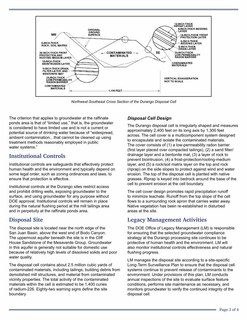
Northwest-Southeast Cross Section of the Durango Disposal Cell
The criterion that applies to groundwater at the raffinate ponds area is that of “limited use,” that is, the groundwater is considered to have limited use and is not a current or potential source of drinking water because of “widespread, ambient contamination…that cannot be cleaned up using treatment methods reasonably employed in public water systems.”
Institutional ControlsInstitutional controls are safeguards that effectively protect human health and the environment and typically depend on some legal order, such as zoning ordinances and laws, to ensure that protection is effective.
Institutional controls at the Durango sites restrict access and prohibit drilling wells, exposing groundwater to the surface, and using groundwater for any purpose without DOE approval. Institutional controls will remain in place during the natural flushing period at the mill tailings area and in perpetuity at the raffinate ponds area.
Disposal SiteThe disposal site is located near the north edge of the San Juan Basin, above the west end of Bodo Canyon. The uppermost aquifer beneath the site is in the Cliff House Sandstone of the Mesaverde Group. Groundwater in this aquifer is generally not suitable for domestic use because of relatively high levels of dissolved solids and poor water quality.
The disposal cell contains about 2.5 million cubic yards of contaminated materials, including tailings, building debris from demolished mill structures, and material from contaminated vicinity properties. The total activity of the contaminated materials within the cell is estimated to be 1,400 curies of radium-226. Eighty-two warning signs define the site boundary.
Disposal Cell DesignThe Durango disposal cell is irregularly shaped and measures approximately 2,400 feet on its long axis by 1,300 feet across. The cell cover is a multicomponent system designed to encapsulate and isolate the contaminated materials. The cover consists of (1) a low-permeability radon barrier (first layer placed over compacted tailings), (2) a sand filter/drainage layer and a bentonite mat, (3) a layer of rock to prevent biointrusion, (4) a frost-protection/rooting-medium layer, and (5) a rock/soil matrix layer on the top and rock (riprap) on the side slopes to protect against wind and water erosion. The top of the disposal cell is planted with native grasses. Riprap is keyed into bedrock around the base of the cell to prevent erosion at the cell boundary.
The cell cover design promotes rapid precipitation runoff to minimize leachate. Runoff from the top slope of the cell flows to a surrounding rock apron that carries water away. Native vegetation has been re-established in disturbed areas at the site.
Legacy Management ActivitiesThe DOE Office of Legacy Management (LM) is responsible for ensuring that the selected groundwater compliance strategy at the Durango processing site continues to be protective of human health and the environment. LM will also monitor institutional controls effectiveness and natural flushing progress.
LM manages the disposal site according to a site-specific Long-Term Surveillance Plan to ensure that the disposal cell systems continue to prevent release of contaminants to the environment. Under provisions of this plan, LM conducts annual inspections of the site to evaluate surface feature conditions, performs site maintenance as necessary, and monitors groundwater to verify the continued integrity of the disposal cell.

11/30/2016 Page 4 of 4
In accordance with 40 CFR 192.32, the disposal cell is designed to be effective for 1,000 years, to the extent reasonably achievable, and, in any case, for at least 200 years. However, the general license has no expiration date, and LM’s responsibility for the safety and integrity of the Durango disposal site will last indefinitely.
ContactsSite-specific documents related to the Durango processing and disposal sites are available on the LM website at http://www.lm.doe.gov/Durango/Disposal/Sites.aspx (disposal site), and http://www.lm.doe.gov/Durango /Processing/Sites.aspx (processing site).
For more information about LM activities at the Durango processing and disposal sites, contact:
U.S. Department of Energy Office of Legacy Management 2597 Legacy Way, Grand Junction, CO 81503
(970) 248-6070 (monitored continuously), or (877) 695-5322 (toll-free)