Duncan, Brad G. (2006) The maritime archaeology and ... · buried still born children in the sand...
32
This file is part of the following reference: Duncan, Brad G. (2006) The maritime archaeology and maritime cultural landscapes of Queenscliffe: a nineteenth century Australian coastal community. PhD thesis, James Cook University. Access to this file is available from: http://eprints.jcu.edu.au/2050
Transcript of Duncan, Brad G. (2006) The maritime archaeology and ... · buried still born children in the sand...
This file is part of the following reference:
Duncan, Brad G. (2006) The maritime archaeology and maritime cultural landscapes of Queenscliffe: a nineteenth century Australian
coastal community. PhD thesis, James Cook University.
Access to this file is available from:
http://eprints.jcu.edu.au/2050

Appendix G: Selected Shipping Mishap Landscape Data
App. G
Appendix G: Selected Community Landscape Data

Appendix G-1: Sacred and Revered Landscapes
App. G-1:1
Appendix G-1: Sacred and Revered Landscapes 1) Sacred/ Revered Landscapes A) Burials, Final Resting Places and Memorials Ethnographic data also revealed several areas of special significance to the various maritime communities. These revered landscapes (for want of a better term) were associated with significant cultural events, which were often specific to subgroups within the maritime community. St George’s Church holds special significance to Piloting families for a number of reasons. St George’s banner bore similarities to the pilots signal flag [PF], which may have been a contributing factor for its popularity for pilots. The local church was also the first in the district, and was its establishment was probably influenced by the early presence of the pilots and their associated religious views. The church is also significant for its memorial commemorating the death of several pilots in recent times, and displays the pilots’ running lights as both a gesture of memorial respect, and a mark of the church's similarity for guiding souls through troubled waters. The first burials in the area took place near the front of the white lighthouse and/or near the Crows Nest Camp/ Football Ground where seamen were originally buried, but these bodies were later moved to Pt Lonsdale Cemetery (McWilliams 1865 [plan]; GA 20/11/1866, 29/11/1866) and these areas still hold significance in some sectors of the community as hallowed areas. However, other unexpected revered burial sites for key maritime groups included the Pilots Jetty [CSp], the Swan Spit Pile Light –‘Qa’ [PF], Mud Islands [IS], Pt Lonsdale Front Beach (in front of the Beach Guesthouse – [DS]) and the Goorangi shipwreck (for the Pilots, Lighthouse Keeper's/fishers, birdwatchers, guesthouse proprietor, and Military respectively). Queenscliff Bight was also recorded as a significant area where boatbuilder Peter Locke had his ashes scattered (QMM Display). Other areas, such as Swan Bay were mentioned as preferred burial areas, due to their significance associated with childhood playgrounds [GW], and the Pt Lonsdale Pier [DS].
Mum and Dad are buried at Point Lonsdale. I want my ashes scattered overlooking the Rip where I pulled my pots. This is near Pt Lonsdale, but more towards Queenscliff. Dad was a fisherman, and that’s the area he worked in too. Lewis [Ferrier] has scattered ashes of many of his people (family and congregation) in the West Channel. They were different people from his church, not just his family. [HM]
It became clear that individual burial preference varied markedly, and was often associated with areas derived from the informants’ former trade, or childhood memories. Other unofficial and highly secretive burial areas were identified. One informant indicated that his grandmother buried still born children in the sand hills behind Pt Nepean, as the fishing family was too poor to be able to afford a proper funeral [nw]. Many memorials were scattered around the town, but many are concentrated along the coastal areas overlooking Lonsdale Bight. In particular, the area near the low lighthouse, (the Shortland’s Bluff carpark) yielded a concentration of predominantly military memorials dedicated to events that are often unrelated to the area. The first memorial installed in this area was dedicated to the crew of the HMAS Goorangi, a small supply vessel that was run down during the blackouts of WWII. Other memorial to the pilots, lifeboat and merchant seamen’s services also are located in this area.

Appendix G-1: Sacred and Revered Landscapes
App. G-1:2
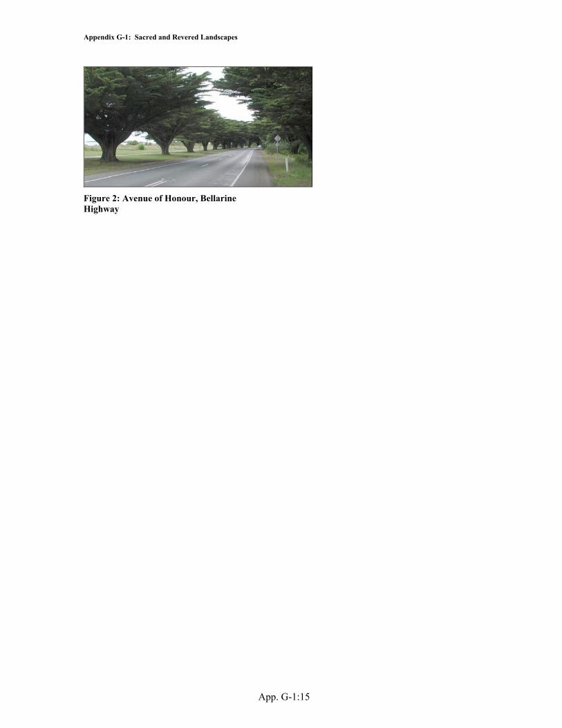
The importance of Queenscliff memorials may lie in their provision of tangible connections to historic and ancestral events that may not be able to be seen offshore as they are covered with water (e.g. Goorangi shipwreck/ pilots deaths). It is suggested that these tangible physical remains are required as validations by descendents/ thematic communities as a material place at which to remember events that can no longer be seen, thus reinforcing their own cultural identity and belief systems. This observation has strong ties to Roe and Taki (1999:415) observations in Erromango regarding the necessity of physical remains as tangible evidence for supporting informal oral histories and place names. I) The Rip Significantly, a large number of informants spoke of the Rip in respectful tones, and several indicated the area was the equivalent of an initiation ground for indoctrination into manhood. Similarly, the fishermen's shed on the fishers wharf was a restricted area, and admittance to the shed as an equal signified manhood for adolescents. Other places of special significance to community groups include the Fort Queenscliff parade ground which was only used during parade, and could not be walked on outside that time (Holdsworth, cited in Tate 1982: 160); The Avenue of Honour (on the Approach Rd to Queenscliff) which was installed as a memorial to soldiers lost in the war, and Shortland’s Bluff memorials. II) Religious landscapes Religious landscapes have already been discussed in Chapter Seven in regards to fishing. Although the Queenscliff fishermen appear to have apathetic towards religion, it has clearly influenced their activities, especially in the observance a prohibition of fishing on Sundays. It has been noted above that soldiers were compelled to attend weekly sermons, and that Despite the apparent casual attitude towards religion, it was clear that it did effect the activities of a number of thematic groups, either by choice or by enforcement, and therefore religion may represent another authoritative landscape in the region. This aspect opens another raft of landscapes based on individual religious denomination and/or sect, along with yet another range of interactions between each group, which were not explored in this study.
Appendix G-1: Sacred and Revered Landscapes
App. G-1:3
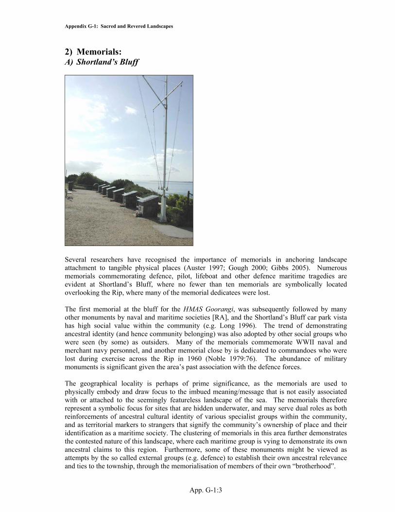
2) Memorials: A) Shortland’s Bluff
Several researchers have recognised the importance of memorials in anchoring landscape attachment to tangible physical places (Auster 1997; Gough 2000; Gibbs 2005). Numerous memorials commemorating defence, pilot, lifeboat and other defence maritime tragedies are evident at Shortland’s Bluff, where no fewer than ten memorials are symbolically located overlooking the Rip, where many of the memorial dedicatees were lost. The first memorial at the bluff for the HMAS Goorangi, was subsequently followed by many other monuments by naval and maritime societies [RA], and the Shortland’s Bluff car park vista has high social value within the community (e.g. Long 1996). The trend of demonstrating ancestral identity (and hence community belonging) was also adopted by other social groups who were seen (by some) as outsiders. Many of the memorials commemorate WWII naval and merchant navy personnel, and another memorial close by is dedicated to commandoes who were lost during exercise across the Rip in 1960 (Noble 1979:76). The abundance of military monuments is significant given the area’s past association with the defence forces. The geographical locality is perhaps of prime significance, as the memorials are used to physically embody and draw focus to the imbued meaning/message that is not easily associated with or attached to the seemingly featureless landscape of the sea. The memorials therefore represent a symbolic focus for sites that are hidden underwater, and may serve dual roles as both reinforcements of ancestral cultural identity of various specialist groups within the community, and as territorial markers to strangers that signify the community’s ownership of place and their identification as a maritime society. The clustering of memorials in this area further demonstrates the contested nature of this landscape, where each maritime group is vying to demonstrate its own ancestral claims to this region. Furthermore, some of these monuments might be viewed as attempts by the so called external groups (e.g. defence) to establish their own ancestral relevance and ties to the township, through the memorialisation of members of their own “brotherhood”.

Appendix G-1: Sacred and Revered Landscapes
App. G-1:4
Many other memorials dot the Queenscliff landscape, and attest to the bravery (and often loss) of members of their specific social group. It is notable that although many shipwrecks have occurred in the study area, there are no real shipwreck memorials evident in the borough, except where they involved local people (e.g. HMAS Goorangi), as most vessels (especially those wrecked at Pt Lonsdale) were transient international and interstate vessels that were external to the community. This signifies that the memorials are for people (and not ships), and are testament to the dangerous nature of the sea as a source of the town’s livelihood. An annual commemorative service held for the Goorangai at this location, further reiterates this observation and their importance to the community (QH Nov 2003:1). Queenscliff is replete with these types of memorials, and appears to be another mechanism for the reinforcement of ancestral cultural identity within the local community, which has always been strongly tied to the sea.

Appendix G-1: Sacred and Revered Landscapes
App. G-1:5
I) Submarine Miners Memorial
II) Cruisers of the RAN 1939-45 Memorial

Appendix G-1: Sacred and Revered Landscapes
App. G-1:6
III) Queenscliff Lifeboat Memorial
IV) HMAS Manoora Memorial

Appendix G-1: Sacred and Revered Landscapes
App. G-1:7
V) Port Phillip Sea Pilots Memorial
VI) WWII Merchant Navy Memorial

Appendix G-1: Sacred and Revered Landscapes
App. G-1:8
VII) WWII: Naval Vessels Memorial
VIII) Napier Crewmen Memorial

Appendix G-1: Sacred and Revered Landscapes
App. G-1:9
IX) HMAS Goorangi Memorial
Appendix G-1: Sacred and Revered Landscapes
App. G-1:10
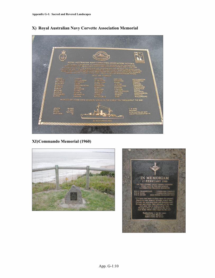
X) Royal Australian Navy Corvette Association Memorial
XI) Commando Memorial (1960)

Appendix G-1: Sacred and Revered Landscapes
App. G-1:11
XII) Lonsdale Bight Memorial (Near former Crows Nest Camp)
Memorial to Cecily Irwin
Appendix G-1: Sacred and Revered Landscapes
App. G-1:12
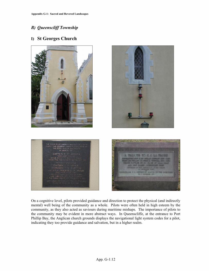
B) Queenscliff Township I) St Georges Church
On a cognitive level, pilots provided guidance and direction to protect the physical (and indirectly mental) well being of the community as a whole. Pilots were often held in high esteem by the community, as they also acted as saviours during maritime mishaps. The importance of pilots to the community may be evident in more abstract ways. In Queenscliffe, at the entrance to Port Phillip Bay, the Anglican church grounds displays the navigational light system codes for a pilot, indicating they too provide guidance and salvation, but in a higher realm.

Appendix G-1: Sacred and Revered Landscapes
App. G-1:13
II) Wharf St
Illegible Memorial
Ozone Memorial
J Class Submarine Memorial, Wharf St 2001 (Photo: M. Gibbs)

Appendix G-1: Sacred and Revered Landscapes
App. G-1:14
Figure 1: Port Phillip Sea Pilots Sign, Tobin Drive
Bonito Benito Sign 2001
Relict wreck bell (as a memorial)
Underwater Memorials – Shipwrecks
Appendix G-1: Sacred and Revered Landscapes
App. G-1:15
Figure 2: Avenue of Honour, Bellarine Highway

Appendix G-2: Differing Landscapes as Evidenced by Toponymic Evidence
App. G-2:1
Appendix G-2: Differing Landscapes as Evidenced by Toponymic Evidence It has been previously noted that toponymic sources in themselves are indicators of alternative landscapes. A number of examples were found within the study area where individual landscape features were allocated multiple names. The military structure located on Popes Eye was officially known by the military as Station M, which was derived from its position in the Middle of a network of structures used to detect incoming shipping. However the feature also had several other names including The Magic Eye, The Caisson, and Caisson M, but was more commonly known as The Chinaman’s Hat, due to its open side and sloping roof. The common use of the latter term may represent an attempt to subvert and/or parody the official defence landscape of the Bay, by replacing its official identity with one of a more comical nature, which may possibly have more relevance to the fishing community of whom the Chinese originally contributed large numbers. Furthermore, many of the smaller islands around Swan Bay were still known locally by different names to the official charts and maps. In particular, Duck Island was known as Rabbit Island, as it had been a popular rabbiting location [CA; CS; HM; JB]; Dod 1931:29); and Rabbit Island (between Queenscliff and Swan Island) was known as Goat Island after its former use as a goat pen and slaughter yard [CA; CS; LID]; QS 5/9/1891), Langabeer’s Island [CS] after a former occupant; or Camp Island for the former huts that once existed there (Thompson n.d.:2). The use of these names was distinctive to local residents, and can be traced back to the roots of the town (Dod 1931: 25-9, 89). The current official names of Duck and Rabbit Islands may reflect the official histories of those places, particularly Duck Island, which was first discovered by Bowan (under Capt. Murray, of the Lady Nelson) in 1802 (Sutherland 1888:39) who shot ducks and swans there. The island is named Duck Islands by 1836 (Symonds and Shortland 1836 [chart]). Similarly Swan Bay (originally named Swan Harbour) was named by Capt. Murray after the prolific bird species there (QS 28/2/1914). It appears that many of the original features around the Bay were first named after members of the original survey crews (e.g. Shortland’s Bluff, Symonds Channel, Popes Eye – crew members from HMS Rattlesnake). This tradition was continued with the naming of the many pile lights around the bay (Knopwood, Grimes, Tuckey, Wedge, Woodriff, etc), and is notable as it informs about who is officially naming these features (the hydrographers, who were the traditional working descendents of the surveyors). This custom may reflect the recording of traditional official names only for an area, a practice that has also been observed by O’Sullivan (2001:263) in Ireland. Furthermore, fisherman had adopted unofficial names for some navigational features (such as “Qa”: Queenscliff approach) for unnamed pile beacons. Many geographic names in the study area reflect a possessive aspect of toponymy, as they are named in honour of famous people or those involved in their discovery. These names reflect to some degree the patronage system that was extant in society at the time, where protégés named localities in honour of their mentors or peers. These areas have the capacity to identify significant figures in past society, in addition to the types of social constructs extant at the time of naming. Further, the names reflect a degree of territoriality, due to their reinforcement of ancestral cultural identity and heritage. There are a number of authoritarian landscape names that exist in this area. Port Phillip was previously known as Port King, named by Lt Murray after the then governor of NSW, who later renamed to honour the original governor (Anon. 1965:27). When the land sales were underway in 1852/3, the proposed new name for Shortland’s Bluff (which was originally named Whale Head by Tuckey of Calcutta - Gardner 1996:13) as St Leonards, but a local judge proposed the name of Queenscliff in honour of the beloved and late Queen Victoria, after whom the state had been renamed from Port Phillip (QS 28/2/1914). Pt Lonsdale was named after the first resident Police Magistrate (Noble 1979:42),

Appendix G-2: Differing Landscapes as Evidenced by Toponymic Evidence
App. G-2:2
and Pt Nepean after the Secretary to the Admiralty (Gardner 1996:24). This trend was also extended to naming military vessels (HMVS Childers – Commissioner of Trade; HMVS Lonsdale, HMVS Countess of Hopetoun). Of note is the naming of some seemingly useless places by innocuous names that have no symbolic or patronage value. This is shown by the Mud Islands, which although large and distinctive features in the Bay have only been known as the Swan Isles, Flat Islands or Mud Islands. This may suggest that toponymy associated to patronage is reserved for suitably striking monumental/monolithic features, and bland featureless places might not be appropriate choices. Perhaps the most daunting authoritative name was reserved for the warship HMVS Cerberus (guardian of the gates of hell) which has dual connotations that may refer to the dangers of the Rip, or to the intense military concentration of fortresses which with the help of this ship would to an enemy vessel indeed seem like it had entered purgatory. Similarly, the supply vessel Mars was named after the Roman god of war. Port Phillip Bay itself was also known by two different names, as the French also named the area Port de Debut during their explorations in 1801 (Gardner 1996:26). Some names reflect the perspective from where the place was viewed. The name Shortland’s Bluff reflects the initial discovery of the area from a seaward perspective, where original observations of the area were enunciated from a seaward perspective. Even the toponymy of the West and South Channels reflect the positioning of the seat of power base at that time (i.e. Melbourne). These subtle reminders of power encode the landscape with hidden meaning. The labelling of oceanic foreshores as “back beaches” also reflects the favoured location of swimming activities was on the sheltered “front beaches” inside the Bay (e.g. Pt Lonsdale, Portsea, Queenscliff, Sorrento). It has already been noted above that there are several toponymic snapper fishing areas named after either their locations or lead marks (West Channel Patch, and Boarding House Patch), the local environmental/seabed conditions (North and South Roughup), local identities (Goat Patch) or local historical fishermen’s events (Shear Blade Patch). These names and locations were not widely known within the township, and appear to have been predominantly restricted to the fishing community. The only other distinctive fishing name identified was Yellowtail Reef (Pt Lonsdale), which was named after the fish species caught there. Although some informants freely divulged the location of these names and areas when prompted, it was not offered independently, suggesting that these areas were part of a secretive landscape that was predominantly accessible to fishermen. This selective access to arcane knowledge may have been used as a power base, both against outsiders and uninitiated fishermen alike. Without doubt, further vernacular toponymic areas existed in this area, but the author had difficulty accessing them. The knowledge of these may be restricted to members of the local community, and used as a mechanism to demonstrate one’s belonging to that community based on that restricted knowledge. This has similarities to indigenous societies, where specialised groups were highly secretive about expert knowledge, particularly fishermen and navigators (e.g. Johannes 1992) The naming of various snapper patches by fishermen represents a very localised toponymy that is not recognised by many other residents of the town. As the functional utilisation of these areas was purely oriented towards exploitation of their commercial resources, these represent a toponymic landscape that is predominantly unique to within the fishing community. Similar circumstances have been noted by O’Sullivan (2001:263) in Ireland. Few vernacular names were discovered for the township itself, but Little Hesse St was known as Jug Alley, for its association with the custom that beer was sold cheaper if it was drunk outside (and the customer provided his own jug), and also for its association with passed out sleeping drunks [GW].

Appendix G-2: Differing Landscapes as Evidenced by Toponymic Evidence
App. G-2:3
Some areas reflected the recording of significant historical events in those areas, such as Triconderoga Bay which was named after a ship quarantined there with large loss of life. However changes in place names can provide further indications of changing social values of those same areas. This same cove was renamed Weeroona Bay around 1874, when it began to be extensively used by holiday makers (Welch 1969:33). Its new name was taken from the popular Bay paddle steamer, but the change reflects new attitudes to recreation, where escapism from reality was paramount. Similarly, the names of tourist vessels reflected this trend. The bay steamers Hygeia (goddess of Health) and Ozone (Fresh Air), Weeroona (Indigenous term for ‘resting place’ - Gardner 1996:25) reflected the new lust for sea air as a sanatorium for good health. Similarly Sorrento was named after a Mediterranean Italian seaside town, whose region was also promoted as a health resort (Rogers 1960:66). Some names represent transported place names from ancestral homelands, such as Portsea, which was named by an early pioneer (James Sandle Ford) after a suburb in Portsmouth (Rogers 1960:61). Rosebud was named after an early wreck of the same name at that location, and local looters would say “lets meet at the Rosebud” (Rogers 1960: 49). Similarly, submerged rocks were often named after ships that wrecked or stranded there (Lightning Rock, Corsair Rock, Victory Shoal). Some localities were named to describe features or activities present in that region (e.g. Tip Island – rubbish dump; Burnt Point – where rubbish/ nightsoil was burnt; The Springs – water source Dod 1931:51). Others locations were titled from their nearby owners or residents (McDonald’s Jetty; Black Billy Point (a peninsula finger of Edwards Pt, Swan Bay); Chinamen’s Point (Queenscliff); Langabeers Island; Drapers Reef; or their creators (Dutchie’s Island – an island created from spoil from dredging around the Creek entrance - named after the dredge operator) or discoverers (Cole’s Channel – named after local entrepreneur George Cole) (Dod 1931:18; [CS; GW; LID; PF]). The street names of the township (see Zada 2004) provide a further historical summary of prominent identities, either from and/or associated with this locality, and further afield. These include: • Significant local identities: Dod St (first Queenscliff postmaster); Fellows Rd (prominent
Judge and local resident); Fraser St (ex-mayor Queenscliff); Larkin Parade (Local Hydrographic Surveyor); Smith St (early local settler); Stevens St (1st pastoralist at Shortland’s Bluff); Thwaites Walk (early fisher family); Tobin Drive (1st pilot in Queenscliff)
• Significant Local Vessels: Hygeia Drive (Local Bay Steamer – see above); Weeroona Parade (Local Bay Steamer – see above);
• Local Features: Bay St (Street runs along former edge of Port Phillip Bay); Bridge St (Swan Island Bridge at ed of Street- formerly called Fish St after Fishers Flat – McWilliams 1865 Plan); St Andrews St (Street led to rear of Church); Wharf Rd (Road to former Fishermen’s Pier)
• Significant State identities: Bethune St (prominent Port Phillip pastiorlist); Gellibrand St (Solicitor and member of Port Phillip Assn which founded site of current Melbourne); Hesse St & Little Hesse St (Barrister and early settler); Learmonth St (Early settler in Ballarat); Mercer St ( Early settler); Swanston St (member of Port Phillip Assn);
• Significant National/ International identities: Queen St (Queen Victoria); Raglan St (British Field Marshal in Crimean War);
• Explorers and Surveyors: Flinders St (Matthew Flinders – Explorer); Henry St (Surveyor HMS Rattlesnake); Hobsons St ( Capt., HMS Rattlesnake); King St (Surgeon , HMS Rattlesnake); Richards St (1st Lt , HMS Rattlesnake); Stokes St (Capt., HMS Beagle); Symonds St (Lt., HMS Rattlesnake).

Appendix G-2: Differing Landscapes as Evidenced by Toponymic Evidence
App. G-2:4
Official Name Associated Official Group
Reason Vernacular Name Vernacular Associated Group
Reason
Station M Defence Defence Plan Annotation - Middle Station (M) in defence network
Chinaman's Hat/ The Caison/ Caison M/ Magic Eye/
Local Residents/ Tourists
Resemblance to Chinese Headdress/ Caisson at base of structure/ Mechanism on structure
Rabbit Island Explorers/ Hydrographers
Goat Island/ Langabeers Island/ Camp Island
Local Residents Goats pen and slaughter yard/ Former occupant/ Camp sites on Island
Duck Island Explorers/ Hydrographers
Ducks shot by Bowan (Explorer)
Rabbit Island Local Residents Popular rabbitting location
Swan Bay Explorers/ Hydrographers
Prolific Swans (Named by Murray)
Shortlands Bluff Explorers/ Hydrographers
Crew Member HMS RattleSnake
Formerly Whale Head Whaling?
Queenscliff Explorers/ Hydrographers
After Queen Victoria The Cliff
Pt Lonsdale Explorers/ Hydrographers
Victorian Police Chief
Pt Nepean Explorers/ Hydrographers
Secretary of Admiralty Siberia Defence Used as punishment duty for errant soldiers - too far away from girls at Queenscliff
Port Phillip/ (ex Port King)/ (ex Port de Debut)
Explorers/ Hydrographers/ French Explorers
Governor Phillip/ (Governor King)/ (First public opening)
French ExplorersMud Islands Low Muddy
AppearanceSwan Isles Flat Islands
Bird life/ Appearance
Symmonds Channel
Explorers/ Hydrographers
Crew Member HMS RattleSnake
Popes Eye Explorers/ Hydrographers
Crew Member HMS RattleSnake
Coles Channel Local Businessman discovered route
Pile LightsKnopwood Explorers/
HydrographersHydrographic Surveyor
Grimes Explorers/ Hydrographers
Explorer
Tuckey Explorers/ Hydrographers
Hydrographic Surveyor
Wedge Explorers/ Hydrographers
Hydrographic Surveyor
Woodriff Explorers/ Hydrographers
Hydrographic Surveyor

Appendix G-2: Differing Landscapes as Evidenced by Toponymic Evidence
App. G-2:5
Military Vessels
HMVS Childers Defence Victorian Commissioner of Trade
HMVS Lonsdale Defence Victorian Police Chief HMVS Countess of Hopetoun
Defence
HMVS Cerberus Defence Guardian of the gates of Hell
Mars Defence God of War
West Channel Explorers/ Hydrographers
Relationship to Melbourne
South Channel Explorers/ Hydrographers
Relationship to Melbourne
Loellia Channel Explorers/ Hydrographers
Early survey vessel
Sorrento Back Beach Locals/ Tourists Rear of arrival location
Sorrento Front Beach Locals/ Tourists Arrival location Portsea Back Beach Locals/ Tourists Rear of arrival
locationPortsea Front Beach Locals/ Tourists Arrival location
Lonsdale Bight Queenscliff Back Beach
Locals/ Tourists Rear of arrival location
Queenscliff Bight Queenscliff Front Beach/ Governors Hole
Locals/ Tourists Arrival location / Governor LaTrobes Swimming Hole
Pt Lonsdale Ocean Beach
Pt Lonsdale Back Beach
Locals/ Tourists Rear of arrival location
Lonsdale Bight Pt Lonsdale Front Beach
Locals/ Tourists Arrival location
Tourist LandscapesSorrento Tourism Mediteranean seaside
townPortsea Tourism Town in Portsmouth
UKRosebud Wrecks Shipwreck where
looters regularly met - later township site
Tourist VesselsHygeia Tourism Goddess of HealthWeeroona Tourism Sea BreezeOzone Tourism Fresh Air

Appendix G-2: Differing Landscapes as Evidenced by Toponymic Evidence
App. G-2:6
Fishing Landscapes
Fishing Shear Blade Patch
Fishing West Channel PatchFishing North Roughup Patch
Fishing South Roughup Patch
Fishing Boarding House Patch
Fishing Goat PatchYellowtail Rock FishingMushroom Rock FishingLittle Hesse St Fishing Jug Alley Locals Alley where
cheap takeaway beer (purchased in ones own jug) is drunk outside
Lightning Rock Stranding Vessel that collided with uncharted rock
Corsair Rock Wrecks Vessel that collided with uncharted rock
Lonsdale Rock Stranding Associated with Pt Lonsdale
Victory Shoal Stranding Stranded vesselRhondella Reef Stranding Stranded vesselDrapers Reef Pilots Local PilotWeeroona Bay (ex Ticonderoga Bay)
Tourism/ Quarantine
Renamed after ferry during tourism heyday/ Former Quarantined ship - great loss of life
Burnt Point Rubbish Rubbish burnt here Burnt Point local residents Rubbish DumpThe Springs Farming The Springs local residents Spring water
outletTip Island Rubbish Tip Island local residents Rubbish DumpSwan Bay Jetty Farming Adjacent Bay McDonalds Jetty local residents Previous name-
named after local farmers
Sand Island Hydrographic Surveyors
Sand dredge spoil dumped in this location
Dutchies Island local residents Dredge Operator
Fishing Chinamans Point local residents Chinese fishersFishing Fisherman's Flat local residents Fishing
community accomodation area
Edwards Point Farming Suposedly named after local Grazier
Black Billy Point local residents Historic Indigenous leader

Appendix G-3: Palaeo-environmental Evidence of Community Coastal Landscapes
App. G-3:1
Appendix G-3: Palaeo-environmental Evidence of Community Coastal Landscapes The evolution of the Queenscliff coastline is partly attributable to the various periods of pier, baths, harbour and channel construction, both locally and within the Rip. Beginning in 1855 with the construction of the first pier, current borne sediments were slowed causing sand accretion around the extremities of the piers and baths. As further extensions were added, along with two additional piers and two bathing complexes, current velocity in the area was reduced to the extent where all these structures verged on becoming unusable (QS 8/6/1876; 2/11/1907; 30/11/1907). The construction of the fort at Swan Island further contributed to silting in the area (QS, 10/4/1886). When dredging was undertaken around the extended piers to facilitate access for tourist, cargo and defence vessels (QS 21/11/1908; 17/9/1910; 25/5/1912), it further altered the dynamics of the region, allowing sea swells to approach closer to the shoreline, which caused local scouring at the rear of the Beach St Fishermen’s Houses [JP]. Several unsuccessful attempts to alleviate the problem included the installation of timber groynes, stone seawalls, and a derelict hulk (HMVS Lonsdale) as erosion control measures [HM; MW]. The construction and deepening of navigation channels at the Rip appears to have significantly altered the coastal dynamics at Pt Lonsdale [HM; PF], where several erosion mitigation devices were installed to retain the tourist beach ([JP] Dunn 1949:72-74), but which in themselves further contributed to shoreline change [JG]. Further groynes and hulks were installed to protect defence facilities at Swan Island (Yule 1884:313; [LID]). Channel deepening at the Heads from 1909-1935, along with guano mining, the introduction of rabbits and firewood collection appear to have contributed to massive alterations of the Mud Island coastline (Yugovic 1998:99; [CS; IS; LJ]). Similarly, extensive extractive industries (sand, shell mining, firewood and bark cutting, farming), exotic animal introductions and artificial channels along the coast of Swan Bay also led to extensive silting and erosion [CA; JG]. The installation of a permanent opening (The Cut) for the fishing boat harbour into Swan Bay and an associated breakwater training wall to direct water direction, led to further massive siltation in the Queenscliff Bight area, and erosion around the fishers residence in Bridge Street [JP]. Dredging to keep The Cut open significantly altered the shape of Swan Island and led to the creation of a new island north of the Cut. The silting affected the viability and location of several infrastructure sites in Queencliff Bight. Communal landscapes were also evident in other more subtle archaeological aspects of landscape, and specifically in evidence of environmental landscape evolution. Modification of the maritime environment produced tangible archaeological signatures that became evident through use of historical, cartographic and folklore evidence. The evolution of the Queenscliff coastline is partly attributable to the various periods of pier, baths, harbour and channel construction, both locally and within the Rip. Siltation had always been a problem on the Queenscliff foreshore, ever since the establishment of the piers at Queenscliff. Beginning in 1855 with the construction of the first pier, current borne sediments were slowed causing sand accretion around the extremities of the piers and baths. As further extensions were added, along with two additional piers and two bathing complexes, current velocity in the area was reduced to the extent where all these structures verged on becoming unusable (QS, 8/6/1876; 2/11/1907; 30/11/1907). The construction of the fort at Swan Island further contributed to silting in the area (QS, 10/4/1886). The removal of obsolete structural elements of the piers (QS, 30/11/1907) and the raising of the baths paddock fences in winter to

Appendix G-3: Palaeo-environmental Evidence of Community Coastal Landscapes
App. G-3:2
encourage scouring alleviated the symptoms to some extent, but problematic access to the pier was only solved by localised dredging around the piers after they had been extended to facilitate access for tourist, cargo and defence vessels (QS, 21/11/1908; 17/9/1910; 25/5/1912). This further altered the dynamics of the region, allowing sea swells to approach closer to the shoreline, which caused local scouring at the rear of the Beach St Fishermen’s Houses [JP]. After several unsuccessful attempts to alleviate the problem with timber groynes and stone walls, a hulk (HMVS Lonsdale) was deposited in the area as an erosion control measure [HM; MW] – see Figures G3-2.2 to G3-2.5.
Figure G-3. 1: Queenscliff Bight groynes, c. 1930s (Photo: PH 5162 QHM).
Figure G-3. 2: Timber Groyne, Pilots Reserve, Queenscliff.
Figure G-3. 3: Timber groyne uncovered in former Queenscliff Bight area behind Beach St in 2006.
Figure G-3. 4: Excavated conning tower of the HMVS Lonsdale in 2005. Formerly used as a breakwater in Queenscliff Bight.

Appendix G-3 : Palaeo-environmental Evidence of Community Coastal Landscapes
App. G-3:3
In the 1880s, a small channel, the boat channel, was constructed using dynamite through the rock Ledge at Pt Lonsdale in an attempt to give a safer passage through the Rip for fishermen in bad weather, but this encouraged scouring around the Pt Lonsdale Beach [HM; PF]. The blasting of the Rip which began around the turn of the twentieth century to deepen the main access channel further altered regional coastal dynamics. Several residents reported that the current directions changed dramatically during this period, and that the previous healthy Pt Lonsdale Front Beach was washed away to bare rock, which also began to undermine the cliff face and wash away the bathing box structures ([JP] Dunn, 1949:72-74). A series of timber sand groynes were constructed along the beach (and later a seawall at Pt Lonsdale when this failed to alleviate the problem), but they further contributed to coastal siltation [JG]. However, the seawall caused further problems as the reflected waves then scoured away the beach [AH]. Later the sand groynes were extended and raised (and replaced as necessary), and this appeared to solve the scouring problem. However, when these groynes were cut down in 1977 and the mid 1990s due to their perceived un-aesthetic appeal, the beach again disappeared, leading the renewed installation of two large groynes with another planned for this year [MW]. Problems were also experienced along the edge of Swan Island, where the shoreline began to erode and fill up Queenscliff Bight (Yule 1884:313) thus threatening the foundations of the fort and beacon, leading to the installation of two hulks to stop the erosion. Groynes were also later installed around the island, in particular at the Swan Island Beacon/ Fort and at the Swan Point, along with a submarine hulk at the latter, which was sunk on top of a barge to give it more height [LID]. Until this time, the water depth at Swan Point was such that large ships could moor in a gutter close to the point [PF]. The dredging and deepening of the South Channel from 1909 onwards probably contributed to the changing dynamics of the Mud Islands, which were dramatically altered by the Rip blasting around 1935 (Yugovic 1998:99; [LJ]), and this was recognised by fishermen when shellfish stocks in the area disappeared [CS]. Furthermore, the environment of the Islands had been dramatically altered by the introduction of rabbits by fishermen, guano mining and the use of the local foliage for firewood by inhabitants and visitors which decimated the large tree population [IS; LJ], all of which may have further contributed to coastline change. In 1935, the Cut was constructed through the Queenscliff Bar to facilitate access for fishermen to the Swan Ponds. A permanent training wall was installed to keep the channel open, but silting remained a problem, and the mobile nature of the bar peninsula meant that a natural entrance was constantly being formed. A breakwater designed to permanently close the natural channel was later added across inside edge of the former peninsula to Swan Island. However, this caused an embayment in the interior of Swan Bay, which slowed waterway borne sediments to settle, and the bay gradually began to silt up, thus limiting the size of watercraft and available usable area in the inlet. The blocking of the former creek entrance also caused major problems on the Flat, as water from Swan Ponds could not escape fast enough through the Cut. This resulted in major flooding and scouring threatened to wash away the backyards and even houses on the northern end of the flat on Beach and Bridge Street, leading to the installation of stone walls and groynes to try to alleviate the problem [JP]. Furthermore, the entrance to The Cut required constant dredging to keep it open, and spoil was pumped into the area behind the new breakwater (thus creating the new Dutchie’s Island – named after the dredge operator), and further changing the shoreline dynamics, as the area began to silt up with the sediments from Swan Ponds. It also led to the removal of the lifeboat shed from the Fishermen’s Pier to the New Pier after the former began to silt up [JB]. The Cut entrance was extended over time, leading to the creation of new land behind the current maritime museum. A new harbour was later cut into this land, with training walls added, which again encouraged sand accretion around the channel entrance. When a new ferry terminal was added to the eastern extremity of the harbour, it acted as a sand groyne, further increasing the need for dredging.

Appendix G-3 : Palaeo-environmental Evidence of Community Coastal Landscapes
App. G-3:4
A new seawall was built at the Queenscliff Front Beach in the 1950s [JP], along with another seawall in front of the Shortlands Bluff Cliffs below the fort in the 1960s [PF]. The intense exploitation of the Swan Bay foothills initially for firewood and bark, and later for farming has further contributed to silting of the Swan Bay as the streams silted up and hence reduced the flushing of the bay from fresh water sources [JG]. Furthermore, the installation of the railway and dumping of rubbish along the western edge of Queenscliff, the excavation of the southern western extremity (of Swan Bay) for shell grit mining, the introduction of agricultural animals to islets, and the installation of an access channel between Swan and Duck Island for the firewood trade all affected the coastal dynamics of Swan Bay, and led to the disappearance of several smaller islands [CA]. As can be seen from above, the installation of new underwater structures and channel dredging, along with other industrial activities had significant impacts on this coastline. It is therefore postulated that these impacts in themselves demonstrate tangible archaeological evidence of maritime industry and associated infrastructure which is no longer extant in the area. It is possible therefore to trace the development of Queenscliff Harbour and the Rip through the various environmental changes and erosion control devices which have been installed in the area. The blasting of the Rip and the Boat Channel, along with dredging of the Dredged Cut in the South Channel also represent tangible archaeological alteration of the environment. These observations have relevance for the relocation of archaeological sites, as some former underwater sites are now located under prograded land, and these alterations in themselves represent potent archaeological signatures of past landscapes and landscape modification.

Appendix G-3 : Palaeo-environmental Evidence of Community Coastal Landscapes
App. G-3:5
Figure G-3. 5: Beachline progradation at Queenscliff Front Beach. Note the seawall on the right.
Figure G-3. 6: Swan Ponds breakwater and causeway.
Figure G-3. 7: Shortland’s Bluff Seawall from west.
Figure G-3. 8: Shortland’s Bluff Seawall from east.
Appendix G-3 : Palaeo-environmental Evidence of Community Coastal Landscapes
App. G-3:6
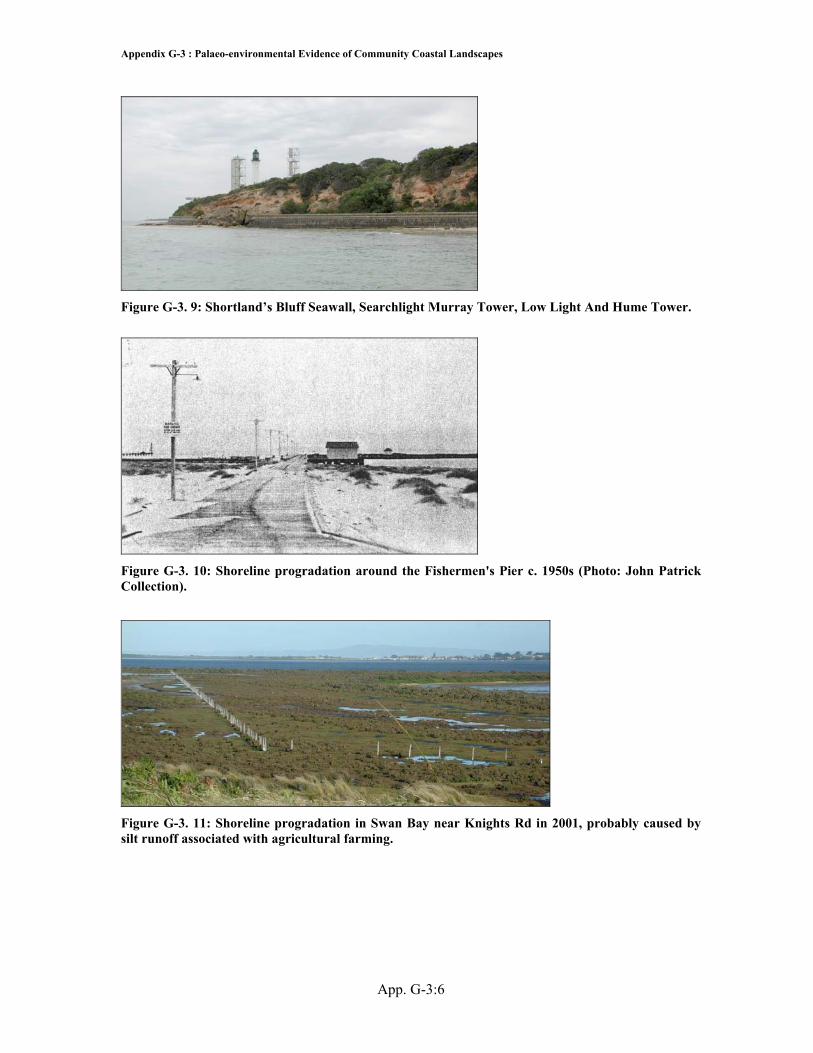
Figure G-3. 9: Shortland’s Bluff Seawall, Searchlight Murray Tower, Low Light And Hume Tower.
Figure G-3. 10: Shoreline progradation around the Fishermen's Pier c. 1950s (Photo: John Patrick Collection).
Figure G-3. 11: Shoreline progradation in Swan Bay near Knights Rd in 2001, probably caused by silt runoff associated with agricultural farming.

Appendix G-4: Potential and Actual Archaeological Signatures of Community and Interactive Landscapes
App. G-4:1
Appendix G-4: Potential and Actual Archaeological Signatures of Community and Interactive Landscapes Feature Artefact LocationC
apel Sound/ Rye
Sorrento/ South SandPortseaT
riconderoga Bay
Pt Nepean
The R
ipPt L
onsdaleL
onsdale Bight
Shortalnds Bluff/
Queenscliff B
ight Popes E
ye Shoal Sw
an Bay
Swan Island
Duck Island
Swan Spit
St Leonards to
Coles C
hannelW
est Channel
Mud Islands
South Channel
Geelong
Melbourne
Administ-rative/ Municipal Services
bathing facilities
council offices egraveyard e ah
library eh
lighting - gas aeh
morgue/ undertaker aeh
pier aeh
aeh
aeh
aeh
aeh
aeh
aeh
post office e e e e erecreational halls, lodges
eh
road - plank road hroad networks - submerged causeway
ah ah ah
road networks - terrestrial
e e
rubbish dumps - general
a a
rubish dump - nightsoil
a
sewerage/ stormwater pipelines
ah ah ah
sporting facilities -eg footbal, cricket ground, yachting racecourses
aeh
h
train station aeh

Appendix G-4: Potential and Actual Archaeological Signatures of Community and Interactive Landscapes
App. G-4:2
Social Compet-ition & Marginal-isation
accomodation - differences in housing types, sizes and oppulance
aeh
accomodation - differences in tourist accomodation standards and types
aeh
differences in recreatiuonal areas: eg bathing, drinking, etc
aeh
displacement of one maritime theme's area with another, eg military take over park reserve
h h aeh
empty space as a territorial marker
h h h h h h h h h h h
empty space used as a health barrier
h h h h
empty space used as a social marginalisation tool
h h h h h h h
empty space used as to create frontier boundaries to create places of unacceptable behaviour
h h h h
exclusive social areas between thematic groups
h
exclusive social areas within thematic groups
h
memorials as markers of
aeh
pier - differences in pier types: working vs tourist piers
aeh
aeh
aeh
social status demonstrated by elite in high areas, poor in lower areas
eh aeh
Social Interrelat-ionships
landscapes of reciprocity
h h
wreck bell - links bewteen lifeboat crews
eh eh

Appendix G-4: Potential and Actual Archaeological Signatures of Community and Interactive Landscapes
App. G-4:3
Environ-mental change
breakwater - hulk ah
breakwater - stone aeh
aeh
changing location/ extensions of coastal landscape structures
aeh
sand groynes ah aeh
ah ah aeh
seawall - stone aeh
aeh
aeh
aeh
aeh
aeh
aeh
seawall - timber ah
CODE archaeological aextant ehistorical h