DUBLIN DOCKLANDS AREA OPENING BRIDGES · 2020-01-29 · Samuel Beckett Bridge . Dublin Docklands...
54
DUBLIN DOCKLANDS AREA OPENING BRIDGES FORBES STREET / BLOOD STONEY ROAD BRIDGE LOCATION REVIEW Final Report DDA-BSB-REP-107-v03.docx 18 December 2018 A RPS COWI Joint Venture Working with:
Transcript of DUBLIN DOCKLANDS AREA OPENING BRIDGES · 2020-01-29 · Samuel Beckett Bridge . Dublin Docklands...

DUBLIN DOCKLANDS AREA OPENING BRIDGES
FORBES STREET / BLOOD STONEY ROAD BRIDGE LOCATION REVIEW
Final Report DDA-BSB-REP-107-v03.docx 18 December 2018
A RPS COWI Joint Venture
Working with:

Dublin Docklands Area Opening Bridges
DDA-BSB-REP-107-v03.docx i Dec-18
Document Control Sheet
Rev. Status Date By Check Approved
01 1st Draft 12/12/18 CNAS/OLSS OLSS PASS
02 Final 17/12/18 OLSS CNAS PASS
03 Minor amendments 18/12/18 OLSS CNAS OLSS
Document prepared and controlled by: COWI UK Ltd. Bevis Marks House 24 Bevis Marks London EC3A 7JB Tel: +44 (0)20 7940 7600 Email [email protected] Web: www.cowiuk.com
RPS West Pier Business Campus Dun Laoghaire Co Dublin Ireland Tel: +353 1488 2900 Email [email protected] Web: www.rpsgroup.com
COWI Bevis Marks House 24 Bevis Marks London EC3A 7JB Tel: +44 (0)20 7940 7600 Email: [email protected] Web: www.cowiuk.com - www.cowi.com
Copyright RPS COWI Joint Venture. All rights reserved. The report has been prepared for the exclusive use of our client and unless otherwise agreed in writing by RPS Group Limited or COWI UK Limited no other party may use, make use of or rely on the contents of this report. The report has been compiled using the resources agreed with the client and in accordance with the scope of work agreed with the client. No liability is accepted by RPS Group Limited or COWI UK Limited for any use of this report, other than the purpose for which it was prepared. RPS Group Limited and COWI UK Limited accepts no responsibility for any documents or information supplied to RPS Group Limited or COWI UK Limited by others and no legal liability arising from the use by others of opinions or data contained in this report. It is expressly stated that no independent verification of any documents or information supplied by others has been made. RPS Group Limited and COWI UK Limited have used reasonable skill, care and diligence in compiling this report and no warranty is provided as to the report’s accuracy. No part of this report may be copied or reproduced, by any means, without the written permission of the RPS COWI Joint Venture

Dublin Docklands Area Opening Bridges
DDA-BSB-REP-107-v03.docx ii Dec-18
Contents 1 Introduction .......................................................................................................................... 1
1.1 Background ................................................................................................................... 1 1.2 DART Underground Project .......................................................................................... 5
2 Forbes Street Bridge Study 2015 ......................................................................................... 7 2.1 Review of Forbes Street Bridge Location and Connectivity ......................................... 11 2.2 Review of Risks and Costs to Bridge at Forbes Street ................................................ 11 2.3 Risks and Cost to DART Underground ........................................................................ 18
3 Blood Stoney Bridge .......................................................................................................... 21 3.1 Location and Connectivity ........................................................................................... 22 3.2 Risks and Costs .......................................................................................................... 25
4 Conclusion ......................................................................................................................... 27 APPENDIX A .............................................................................................................................. 2 APPENDIX B .............................................................................................................................. 3

Dublin Docklands Area Opening Bridges
DDA-BSB-REP-107-v03.docx iii Oct 2018
[This page has been left blank intentionally].

Dublin Docklands Area Opening Bridges
DDA-BSB-REP-107-v03.docx 1 December 18
1 Introduction
The Dublin Docklands Area has been designated a Strategic Development Zone (SDZ)
that is covered by The North Lotts and Grand Canal Dock SDZ Planning Scheme 2014.
This includes two new pedestrian bridges across the River Liffey between the Samuel
Beckett and East Link Bridges. In 2017, DCC applied for an amendment to change the
location of the two bridges shown in the Planning Scheme due to the complexity of building
a bridge at Forbes Street above the planned DART Underground tunnel. The proposed
amendment also improved the spacing of crossings along the Liffey and significantly
reduced the need for a further bridge at Castleforbes Road. In November 2018, An Bord
Pleanála rejected this application for an amendment to the SDZ planning scheme.
This report has been prepared by RPS COWI on behalf of Dublin City Council to re-
examine the feasibility of building a new bridge at Forbes Street and gives detailed
commentary on the impact of the DART Underground tunnel to the bridge with respect to
initial and future costs/risks, and vice versa.
The report concludes it is impossible to proceed with a bridge at Forbes Street without
complicating or compromising the future development of the DART Underground to some
degree or without incurring very significant technical, financial and programme risks.
Without a Designer currently appointed to develop the DART Underground it is unlikely
that the technical approvals needed to progress the bridge would be granted by the DART
Underground promoter. Consequently, it is strongly advised against proceeding with a
bridge at Forbes Street until the status of the DART Underground is known.
1.1 Background
Dublin City Council (DCC) commissioned RPS COWI in 2015 to develop the design for a
new bridge in the Dublin Dockland Area. The new structure is intended to cross the Liffey
River between the existing Samuel Beckett Bridge and the East Link Bridge and forms part
of the North Lotts and Grand Canal Dock Planning Scheme 2014. The bridge will be a
dedicated pedestrian and cyclist crossing and must open to allow the passage of river
traffic.
Preliminary studies for a new bridge aligned with Forbes Street commenced in 2015.
These studies identified significant technical and procedural challenges related to
constructing a bridge above the proposed Dublin Area Rapid Transit (DART) Underground.

Dublin Docklands Area Opening Bridges
DDA-BSB-REP-107-v03.docx 2 December 18
This led the National Transport Authority (NTA), in April 2016, to request that design of the
bridge was suspended to avoid restricting future development of the DART Underground
project.
The programme for the DART Underground project remains uncertain, whilst the demand
for a new pedestrian and cycle bridge across the Liffey remains as strong as ever. As
development of the North Docks progresses, the desire lines for pedestrians and cyclists
have also moved East. This has led DCC to pursue an amendment to the North Lotts and
Grand Canal Planning Scheme 2014 so that the proposed bridge is moved East from
Forbes Street to Blood Stoney Road removing all conflict with the DART Underground
project.
The stages for the Liffey Bridge design have followed the Capital Works Management
Framework Stages 1 to 5. The project is currently at the end of Design Stage 2(a)
(Preliminary Design and Site Investigation). The preliminary design for a bridge aligned at
Blood Stoney Road was complete in June 2018, with project specific ground investigation
well advanced as at December 2018.
1.1.1 SDZ Planning Scheme
The Dublin Dockland Area has been designated a Strategic Development Zone and is
going through a period of significant investment. This includes major improvements to the
public transport system and the creation of new business and residential zones within the
historically industrial docklands.
The 2014 North Lotts and Grand Canal Dock Planning Scheme provides the masterplan
for achieving this future development. This includes defining land zoning for commercial
and residential use and the planned improvements to public infrastructure. The document
gives the principles and aspirations for future developments and the criteria for assessing
the detailed planning applications for individual projects. The goal is to provide a
framework for delivering a united and consistent urban design. However, given the high-
level nature of the document it was impossible for the Planning Scheme to consider all the
detailed engineering challenges for each individual project.
The 2014 North Lotts and Grand Canal Dock Planning Scheme did not explicitly consider
the interaction between the proposed bridge near Forbes Street and planned DART
Underground. Whilst the document includes plan drawings for the bridge and tunnel, these
Dublin Docklands Area Opening Bridges
DDA-BSB-REP-107-v03.docx 3 December 18
were never shown superimposed. Consequently, the degree of interaction between the
projects may not have been fully recognised when preparing the masterplan.
Nevertheless, the Planning Scheme does state very clearly that any proposals within this
zone must not "compromise the integrity of, or adversely impact on the DART Underground
Line".
Furthermore, it states that:
"All planning applications within the Zone of Influence of the proposed DART Underground,
shall demonstrate to Iarnród Éireann how the proposal relates to the DART Underground
Project. No development shall compromise the integrity of, or adversely impact on the
DART Underground Line."
Consequently, the development of a bridge at Forbes Street could only proceed with
approval from Iarnród Éireann. In April 2016, the National Transport Authority (NTA)
strongly recommended that plans for a bridge at Forbes Street was suspended to avoid
restricting future development of the DART Underground project.

Dublin Docklands Area Opening Bridges
DDA-BSB-REP-107-v03.docx 4 December 18
Figure 1-1 Strategic Development Zone (SDZ) showing the proposed bridges within the
Dublin Docklands Area connecting city block North and South of the River Liffey.
This has led DCC to seek an amendment to the Planning Scheme to relocate the bridge
to remove the conflict with the DART Underground Line. This change should be considered
consistent with the aims of the 2014 Planning Scheme.
1.1.2 Influence of New Crossing Adjacent to Tom Clarke Bridge
In addition to the bridge at Forbes Street, DCC have progressed the development of
another bridge across the Liffey within the SDZ. The existing Tom Clarke (East Link)
Bridge has very poor pedestrian and cyclist facilities that are inadequate for the current
high demand. DCC commissioned a study investigating widening the footways to increase
Proposed DART Underground
Proposed Dodder Bridge
Castleforbes Road Bridge The Point
Bridge (Approved) Forbes
Street Bridge
Tom Clarke Bridge
Samuel Beckett Bridge

Dublin Docklands Area Opening Bridges
DDA-BSB-REP-107-v03.docx 5 December 18
capacity in 2016. This concluded that modifying the existing bridge would be prohibitively
expensive and recommended that a new bridge be constructed immediately west of the
Tom Clarke Bridge instead. In An Bord Pleanala's decision on DCC's Planning
Amendment, they approved the location for this new crossing, The Point Bridge.
Providing a new purpose built pedestrian bridge adjacent to Tom Clarke Bridge alters the
rationale for the other bridges. The new Point Bridge and bridge at Forbes Street/ Blood
Stoney Bridge will provide very high-quality pedestrian and cyclist crossings with ample
capacity for predicted demand. Traffic modelling has shown that in this scenario, the
demand for a third crossing point, at Castleforbes Street, is low and so difficult to justify
economically. This alters the optimum location for the proposed western bridge in the SDZ.
Locating the western bridge at Blood Stoney Bridge rather than Forbes Street provides a
more uniform spacing between crossing points.
1.2 DART Underground Project
The DART Underground scheme is a proposed railway line passing below Dublin City
Centre, linking all rail, DART and LUAS services in Dublin. First proposed in 1972, the
project has been subject to several delays or postponements over the last few decades.
Most recently, An Bord Pleanála granted the DART Underground Electrified Heavy
Railway Order on the 14th December 2011. This also approved the compulsory purchase
of lands and rights in, under or over land indicated within the Railway Order application.
However, on 22nd September 2015, the Minister of Transport, Tourism and Sport, Pascal
Donohoe T.D. announced that the DART Underground, as currently designed in the DART
Underground Electrified Heavy Railway Order 2011, would not proceed and that the
compulsory acquisition powers under that Order will not be activated. The Order has now
lapsed. The NTA are currently reviewing the scheme for cost savings. Following the
review, Iarnród Éireann will need to apply to An Bord Pleanála for a new Railway Order
and new CPO powers. This process will take several years. Whilst the DART Underground
is still referenced in the 2018-2027 National Development Plan, the project is currently
unfunded, and its programme remains unclear.
This leads to substantial procedural difficulties with pursuing a bridge at Forbes Street.
The technical challenges of constructing a tunnel near bridge foundations are significant.
These are discussed in more detail later in this report. To overcome these technical
challenges would require close cooperation between the designers and promoters for both
the bridge and tunnel.
Dublin Docklands Area Opening Bridges
DDA-BSB-REP-107-v03.docx 6 December 18
Without a designer or promoter appointed to develop the DART Underground, it is currently
impossible to agree the design criteria required to achieve a successful outcome for both
projects. Consequently, it would be very difficult to proceed with a bridge at Forbes Street
without risking comprising or complicating the future development of the DART
Underground. This will make obtaining the required approvals for NTA and Iarnród Éireann
extremely difficult.
Iarnród Éireann. have stated that 'It is Iarnród Éireann’s intention to protect the integrity of
the existing DART Underground corridor and ensure the integrity of the route is not
compromised by development during the redesign process.’
For this reason, it is strongly inadvisable to proceed with a bridge at Forbes Street until the
status of the DART Underground is known.
The following Sections of the report, provide a summary of the work undertaken to date
for bridges at both Forbes Street and Blood Stoney Road locations. It also provides a more
detailed explanation of the risks associated with proceeding with a bridge at Forbes Street
whilst the status of the DART Underground is unknown.

Dublin Docklands Area Opening Bridges
DDA-BSB-REP-107-v03.docx 7 December 18
2 Forbes Street Bridge Study 2015
The original commission for the design of a bridge at, or near, Forbes Street commenced
in 2015. The project was suspended in May 2016 following a request from the NTA in their
letter dated 25 April 2016.
The design progress is summarised in the following reports:
• Bridge Location Report (DDA-FSB-REP-101-v1),
• Options Report (DDA-FSB-REP-102-v2)
• Summary of Stage 2a Services and Status (DDA-FSB-REP-RPS-009-v00);
produced following NTA's request to suspend works on the bridge.
During the location and options assessment, a range of various bridge forms and crossing
locations were considered, accounting for assumed exclusion zones for the DART
Underground. The exclusion zones assumed that the alignment and construction
methodology for the tunnels was fixed and that the two projects would progress in parallel
with close cooperation between the tunnel and bridge promoters and designers. An
exclusion zone of 3m either side of the tunnel bore was assumed. This was based on
London Underground guidance for piling near existing tunnels and should be considered
the best-case scenario. Given the current status of the DART Underground this
assumption is no longer valid and larger exclusion zones are likely to be required.
The three shortlisted options derived as part of 2015 process are summarised below:
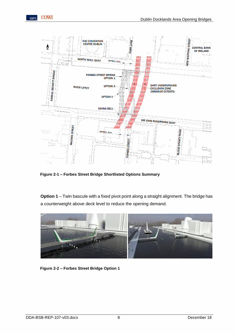
Dublin Docklands Area Opening Bridges
DDA-BSB-REP-107-v03.docx 8 December 18
Figure 2-1 – Forbes Street Bridge Shortlisted Options Summary
Option 1 – Twin bascule with a fixed pivot point along a straight alignment. The bridge has
a counterweight above deck level to reduce the opening demand.
Figure 2-2 – Forbes Street Bridge Option 1

Dublin Docklands Area Opening Bridges
DDA-BSB-REP-107-v03.docx 9 December 18
Option 3 – Double balanced-cantilever swing bridge on an "S" shaped alignment. The
bridge is supported on circular piers with two equal swing spans and two back spans.
Figure 2-3 – Forbes Street Bridge Option 3
Option X – Twin bascule with a central spine beam along a "C" shaped piecewise linear
alignment. Two internal v-shaped piers support a central opening main span.
Figure 2-4 – Forbes Street Bridge Option X
Of the options presented, Option 3 provided the best alignment from the perspective of
users, integrating well with the city's existing road layout. The sinuous deck also provided
visual interest and was generally preferred aesthetically.
Nevertheless, the interaction with the proposed DART tunnels was identified as a major
risk. The footbridge would need to accommodate the future needs of the DART
Underground scheme and it would be impossible to proceed with the Bridge scheme
without Iarnród Éireann’s agreement. This means that Iarnród Éireann were identified as
an extremely important stakeholder who must be satisfied during the bridge design.

Dublin Docklands Area Opening Bridges
DDA-BSB-REP-107-v03.docx 10 December 18
Figure 2-5 – Cutaway view showing the indicative foundation layout for Option 3
Based on the information available at the time, it appeared that a technical solution was
possible, albeit accompanied by higher initial capital costs than alternatives. Option 3
carried a greater complexity than the other options because of the proximity and number
of its foundations to the DART tunnels as shown in Figure 2-5.
The alignment was only judged viable based on the understanding that high-level
commitments had been reached between the promoters for the Liffey Bridge and DART
Underground to facilitate the technical agreements and approvals required during design
and construction.
The viability of the scheme was dependent on a shared willingness to manage all
interfaces in a timely and effective manner. The current situation, in which the status of the
DART is unknown, means that this is no longer possible and this option is no longer
considered viable whilst safe guarding the interests of the DART Underground.
Consequently, it is likely that this option could only be pursued if the DART Underground
project was either abandoned or delayed to such an extent that the positions of the bridge's
foundations were considered a fixed restraint during development of the DART
Underground.

Dublin Docklands Area Opening Bridges
DDA-BSB-REP-107-v03.docx 11 December 18
Section 2.2 and 2.3 explore in more detail the risks for the Bridge and DART Underground
projects, respectively, of pursing a shared alignment.
2.1 Review of Forbes Street Bridge Location and Connectivity
The Forbes Street Bridge crossing location would undeniably provide the quickest crossing
route for pedestrian and cyclist desire lines between Grand Canal Dock and Spencer Dock.
When considering possible alignments, a street to street connection was greatly preferred
by local stakeholders, whom favoured options that provided a direct connection between
Forbes Street to the South and Park Lane to the North.
However, there are now compelling reasons for relocating the bridge to the Blood Stoney
Road location. This not only removes all interference with the DART Underground
alignment, it also provides a more uniform spacing of river crossing. If a crossing is
provided at Forbes Street, the walking distances between this crossing the next crossing
to the West (Samuel Beckett Bridge) and the East (proposed Point Bridge) would be
approximately 220m and 650 m, respectively. The typical spacing between crossings
along the Liffey is less than 400m. The non-uniform distance between the Forbes Street
and Point Bridge would therefore substantiate the desire for an additional opening bridge
at Castleforbes Road, as shown in Figure 1-1. However, traffic modelling studies have
shown that the forecasted demand at Castleforbes Road would be low and so difficult to
justify economically.
Relocating the Forbes Street Bridge to Blood Stoney Bridge provides a more uniform
spacing between crossings; 370m to Samuel Beckett Bridge and 500m to the proposed
Point Bridge. This further negates the need for a bridge at Castleforbes Road. Eliminating
the need to construct a third bridge provides financial savings (circa €12 to €18m), reduces
environmental impact, and reduces disruption to berthages.
2.2 Review of Risks and Costs to Bridge at Forbes Street
2.2.1 Programme and approvals risk
The most significant risk for the bridge programme will be getting the necessary agreement
from the key stakeholders including Iarnród Éireann.
A common design basis will be required between the designers of the bridge and tunnel.
Agreeing this design basis will become more difficult the closer the proximity between the
structures, with additional design verifications needed to ensure that neither scheme is

Dublin Docklands Area Opening Bridges
DDA-BSB-REP-107-v03.docx 12 December 18
adversely affected. There is a risk that objections and requirements for provision of
information from Iarnród Éireann will delay the design programme for the bridge.
Whilst, Iarnród Éireann were positive during preliminary discussions in 2015 it is
understandably difficult for both Iarnród Éireann and RPS-COWI to share detailed
information until the bridge and tunnel designs are further developed. Given the current
uncertainty associated with the DART Underground, NTA have retracted their support for
a bridge on the alignment of Forbes Street until the future of the DART Underground is
better understood.
The biggest risk to the footbridge is that Iarnród Éireann are now unable to fully mobilised
their engineering team within the timeframe of the footbridge design being undertaken and
that this leads to residual risks being passed on to the next phase of the project without
being resolved.
Some information may remain unavailable until much later in the project. For example,
temporary works such as the cofferdams for the river piers are typically designed after
appointment of a contractor. Whilst the construction contract documents could impose very
restrictive constraints on the temporary works designer or possibly these items could be
brought forward, this is likely to attract additional risk to DCC. Furthermore, the importance
of selection of tunnel construction methodology will not be fully captured in any design
basis agreed at this stage and leaves open the possibility of changes being required at a
later date to reflect the tunnel contractor's preferences. This will also introduce additional
risk into tunnel construction contract that Iarnród Éireann will need to recognise.
For these reasons it would be extremely difficult to pursue a bridge at Forbes Street without
the full support from NTA and Iarnród Éireann.
2.2.2 Risks to key stakeholders and public relations
Local stakeholders were against any bridge alignment that did not provide street to street
alignment to roads that were perpendicular to the Liffey. During the 2015 study this was
identified as an ongoing stakeholder engagement issue for any option where the southern
bridge abutment was shifted away from Forbes Street to avoid the DART Underground
tunnel exclusion zone beneath. Given the uncertainty associated with the DART
Underground it is unlikely that a direct connection with Forbes Street would now be
possible. Shifting the alignment to avoid an underground obstacle risks appearing illogical

Dublin Docklands Area Opening Bridges
DDA-BSB-REP-107-v03.docx 13 December 18
for bridge users at ground level who are unaware of the obstructions below. In comparison
a bridge at Blood Stoney guarantees street to street connectivity on a straight alignment.
As has already been discussed, there is risk that agreeing a design basis with Iarnród
Éireann will lead to programme delays. In the extreme case, it may be that an agreement
cannot be found and an alternative design must be produced. Such delays in programme
(and potentially bridge option) are likely to attract criticism from wider stakeholders
including the general public leading to reputational damage.
2.2.3 Risk to the Bridge arising from ground movements
There is a risk that the ground movements caused by the tunnels' future construction will
cause detrimental differential settlements. Moving bridges are particularly sensitive to
differential settlements due to their tight tolerances to ensure satisfactory performance of
the opening mechanism. There would need to be provision in the design for an agreed
magnitude of ground movement that will result from the tunnelling operations and
recognition that unforeseen ground conditions or other construction related issues could
lead to increased magnitude of ground movement. The old Rail Order included settlement
contours. While this information is quite detailed it is not based on Iarnród Éireann's
possible redesign. A new Rail Order will be required before the DART Underground can
be progressed. It is probable that predicted ground movement due to the tunnel will not be
available at the point they are required for the bridge design.
It is likely the DART Underground will be constructed using a tunnel-boring machine
(TBM). This may cause ground movements at several stages of the operation. During
tunnel construction, the face of the tunnel and a section of the bore behind the cutting face
is typically subject to reduced confining pressures as the excavation progresses. In
addition, it is normal for the tunnel bore to be slightly larger than the final external diameter
of the tunnel, with the annulus grouted at some point during construction. The resulting
contraction of the ground around the tunnel into the face and diameter of the tunnel is
normally referred to as "volume loss". Because of this, there will be ground movement
immediately adjacent to the tunnel itself which will reduce with increasing distance from
the tunnel. This generally leads to ground movement within a "zone of influence" which in
this case would include movements at ground level.
The resulting ground movements cause a trough-like profile, typically with the maximum
movement along the tunnel alignment. These movements are generally fairly predictable

Dublin Docklands Area Opening Bridges
DDA-BSB-REP-107-v03.docx 14 December 18
provided there is a comprehensive geotechnical survey accompanied by numerical
modelling.
An enhanced risk at the proposed bridge site will result from the alignment of the tunnel
bore resulting in the TBM passing from the Calip Limestone into the overlaying Dublin
Boulder Clay as shown in Figure 2-6. The resulting "mixed face" conditions will
complicate the tunnel construction process and the prediction of ground movements.
Furthermore, whilst it is normal for the geotechnical strata to exhibit a general variation in
properties and therefore behaviour, the influence of local sudden changes in ground
permeability, for example the presence of gravel lenses which are common in Boulder
Clays is much more significant. Such local variations cannot be accurately located along
the entire length of the tunnel in advance of tunnel construction.
Figure 2-6 - Geological Long Section at Bridge Site
The sudden change in permeability experienced at gravel lenses (which may vary across
the tunnel face) can lead to additional volume loss if the ground water flows are not
controlled properly. Such inflows can lead to substantial local variations in horizontal
stresses within the ground and as such would have a major impact on any bridge piles that
are close to the tunnel bore in this area. This is exacerbated by the fact that the tunnelling
will be carried out beneath a river which introduces additional risks. The change in the
overburden pressure and variations in hydraulic gradients require careful control of the
River Liffey South North

Dublin Docklands Area Opening Bridges
DDA-BSB-REP-107-v03.docx 15 December 18
face pressure. Shallower tunnels also tend to have narrower settlement troughs and
greater maximum settlement which increases the risk of differential settlement.
Initial discussions with Iarnród Éireann between 2015 and 2016 indicated that
compensation grouting is intended to control ground movements. Irish Rail indicated the
compensation grouting would be undertaken from within the tunnel bore by monitoring
ground movements and pumping grout into the ground to physically fracture and heave
the overlying strata upwards, directly compensating for ground movements that would
otherwise occur at the surface. At the proposed location of the bridge, to mitigate ground
movement, this grouting would need to be carried out within the Boulder Clay stratum
above the limestone. However, this layer is at relatively shallow depth below ground
surface and pumping of grout at high pressure into this strata could result in fracturing of
the ground extending to river bed level with the attendant loss of grout into the river and/or
ingress of water into the grouting channel. As such it is considered that the feasibility of
compensation grouting to limit ground movement under the river may be limited.
Consequently, it may be necessary to assume that piles in close proximity to the tunnels
would need to be sleeved to minimise the effect of vertical ground movements and/or the
imposed vertical or horizontal pressures associated with compensation grouting. However,
sleeves will have limited benefit at providing effective isolation arising from any horizontal
ground movements.
Figure 2-7 - Drawing illustrating a foundation in close proximity to the tunnels indicate a typical zone of influence
Dublin Docklands Area Opening Bridges
DDA-BSB-REP-107-v03.docx 16 December 18
The tunnels will further complicate the design of any fender piles required for ship impact
protection. The tunnels will make it impossible to place fender piles in some locations. It is
likely that the fender piles will require a greater exclusion zone than the bridge foundations,
as the tunnels may be more sensitive to potentially greater horizontal loads attached during
a ship impact.
2.2.4 Estimated cost to Forbes Street Bridge
As part of the options development for the Forbes Street Bridge, capital construction costs
were estimated to help with the option comparison, refer to Report DDA-FSB-REP-102-
v2. These estimated costs did not account for risks discussed in the previous sections due
to the lack of information about the DART Underground project. As the DART Underground
project has not been progressed in any significant detail, the costs estimated in Table 2.1
below are based on three possible outcomes (best cast, probable, and worst case).

Dublin Docklands Area Opening Bridges
DDA-BSB-REP-107-v03.docx 17 December 18
Table 2.1 Risk Analysis – Consequences on Bridge
Risks Possible Outcome Estimated Risk Cost / Programme
Ground Movements (Section 2.2.3)
Best Case: Negligible settlement occurs during tunnel construction. Bridge and foundations over-designed. Additional monitoring required during tunnel construction.
€0.5m to €1.5m for additional foundation costs and monitoring.
Probable: Increased foundation design to account for conservative estimated settlements for bridge construction and the future tunnelling works resulting in differential settlements with manageable range. Additional monitoring required during tunnel construction.
€0.5m to €1.5m for additional foundation costs and monitoring.
Worst Case: Deviation of tunnel alignment, or unexpected undermining of the bridge supports resulting in:
• Significant foundation settlement perceptible to bridge users forcing closure of the bridge;
• Failure of bridge opening mechanism; and/or,
• Large scale failure resulting in significant damages, injuries and/or deaths of public.
€20m (material) + third party health and safety
Stakeholders (Section 2.2.2)
Best Case: No objections to any proposed bridge options and alignments giving the Designer freedom to choose the ideal solution based on cost.
Nil
Probable:
• Prohibitively difficult to maintain street to street connectivity which was identified as critical to the scheme's success;
• DART Underground authority, currently Iarnród Éireann, unable to approve the proposed design without sufficient understanding of the DART Underground;
• Public frustration due to overcrowding of available river crossing routes during peak times.
€1 to 2 m additional construction cost for longer curved deck + political and lost opportunity costs from delays
Worst Case: Strong opposition to the scheme preventing its development leading to greater public frustration and significant political pressures.
Per the Probable outcome with increased political cost
Programme and Approvals (Section 2.2.1)
Best Case: The DART Underground is cancelled for the foreseeable future removing the requirement for the bridge foundation design to account for the impact of the tunnelling.
Saving: €0.5m to €1.5m for additional foundation costs varying with bridge option.
Probable: No approval from NTA or DART Underground authority prevents progress of work until design
Increased design and construction fees by delaying

Dublin Docklands Area Opening Bridges
DDA-BSB-REP-107-v03.docx 18 December 18
Risks Possible Outcome Estimated Risk Cost / Programme
of the DART Underground is sufficiently advanced.
construction (€3 to 5 m, due to inflation and increased consultation). Reputational damage. Project delayed by 5-10 years.
Worst Case: Bridge project remains suspended by the NTA for over ten years whilst the DART Underground project remains uncertain.
Economic losses due to development of Docklands being suppressed by lack of bridge.
2.3 Risks and Cost to DART Underground
2.3.1 Restrictions on tunnel alignment and cross-section
The new design for the DART Underground is currently unknown. The alignment and/or
cross-section may require changes as Iarnród Éireann seek cost savings. It is also
uncertain when the DART Underground will be built and so the performance requirements
and diameter for the tunnels may change from previous studies. The preferred design for
the bridge at Forbes Street contains foundations on both sides of the tunnel. This will
significantly restrict the alignment and cross-section during any future redesign.
2.3.2 Increased risk to tunnel design and construction
The possible change in in-situ ground conditions caused by pile construction together with
the potential for uneven imposed loads from the bridge foundation and/or fender piles risks
increasing the hazard to the tunnel construction if the piles are in very close proximity to
the tunnel. This complicates the tunnel design and itself increases the likelihood of ground
movement and differential settlements. Due to these concerns, at the meeting on 4th
December 2015 Irish Rail requested that the toe of the bridge piles should be extended to
below the invert of the tunnels. This is considerably deeper than required for the structural
design of the bridge, leading to significant additional pile boring through limestone which
will cause an increase in construction costs for the bridge. The greater the distance
between the tunnel and the bridge foundations the greater the possibility to relax this
requirement. Whilst, Iarnród Éireann have not yet indicated over what distance this

Dublin Docklands Area Opening Bridges
DDA-BSB-REP-107-v03.docx 19 December 18
restriction would apply, from our experience we assume the zone of influence will be
approximately 1 tunnel diameter.
The tunnel promoter will need to closely monitor the ground settlements and movement of
the bridge during tunnel construction. The cost of this instrumentation and monitoring will
increase with the proximity between the bridge and tunnel. To minimise the impact of the
tunnelling operations to the bridge foundations, this will also result in increased volume
loss control requirements. These factors will significantly increase the cost of the tunnel
operations due to the greater quality control required for tunnelling operations.
Iarnród Éireann may need to enter into asset protection agreements to safeguard both the
footbridge and tunnel structures during the tunnel construction and thereafter. This will
attract additional costs and require The DART Underground Contractor to carry additional
insurance for working so close to the bridge foundations. These may be expensive and/or
difficult to obtain.
2.3.3 Estimated cost to DART Underground
The additional costs for the DART Underground construction associated with a bridge at
Forbes Street are difficult to quantify but are expected to be significant based on
precedencies in other urban environments. As an example, during the Crossrail
construction, the cost of monitoring existing structures, (e.g. Docklands Light Railway
(DLR) Canning Town Viaduct, Lord Hill's Bridge and Lindsey Street Bridge) for settlement
during the tunnel boring operations was significant.
Condition surveys of the bridge will be needed before and throughout the tunnel
construction.

Dublin Docklands Area Opening Bridges
DDA-BSB-REP-107-v03.docx 20 December 18
Table 2.2 Estimated Cost of Risks to Tunnel
Risks Possible Outcome Estimated Risk Cost
Alignment and Cross-section (Section 2.3.1)
Best Case: Preferred DART Underground alignment matches the assumed best-case exclusion zone adopted for the bridge design.
Nil
Probable: The bridge foundations constrain the DART Underground alignment and cross-section size beneath the Liffey near the North Docks station resulting in increased tunnel construction costs.
Increase to all tendering design and construction tenders.
Worst Case: Limitation of the alignment and cross-section governs the functional widths and design speeds (e.g. through required curve radii).
Significant cost with the potential to invalidate the DART Underground altogether.
Design and Construction (Section 2.3.2)
Best Case: Bridge is relocated away from the DART Underground exclusion zone removing all risks associated with the interaction between the structures.
Nil
Probable: Existing Forbes Street Bridge foundations lead to:
• Increased quality control requirements for tunnelling (e.g. reduced volume loss) requiring a slower tunnelling speed and more expensive resources and planning;
• Bridge settlement monitoring during tunnelling works;
• Structural condition assessments of the bridge before and after the tunnelling works.
€2m to €5m
Worst Case: Significant construction issue arises during construction, such as impact with the existing foundation resulting in significant damages, injuries and/or deaths of public.
€20m to €40m (material) + third party health and safety

Dublin Docklands Area Opening Bridges
DDA-BSB-REP-107-v03.docx 21 December 18
3 Blood Stoney Bridge
The proposed Blood Stoney Bridge removes all the risks associated with the interaction
between a proposed river crossing and the DART Underground structure whilst also
responding to the shift in the desire lines of pedestrians and cyclists to the east due to the
development of the Norths Docks. Additionally, the proposed Blood Stoney Bridge is being
developed as an effective substitute for both the Forbes Street and Castleforbes Road
Bridges. This is shown figuratively on the SDZ map in Figure 3-1.
Figure 3-1 - Strategic Development Zone (SDZ) showing the proposed Blood Stoney Bridge
replacing the proposed Forbes Street and Castleforbes bridges
The overriding purpose for the proposed Blood Stoney Bridge remains the same as the
Forbes Street Bridge. This is to "provide an architecturally sensitive opening pedestrian
and cyclist bridge linking the north and south docklands". The currently proposed bridge
scheme is depicted in Figure 3-2 and Figure 3-3.
Proposed Dodder Bridge
Castleforbes Road Bridge
Forbes Street Bridge
The Point Bridge (Approved)
Proposed Blood Stoney Bridge
Proposed DART Underground

Dublin Docklands Area Opening Bridges
DDA-BSB-REP-107-v03.docx 22 December 18
Figure 3-2: Blood Stoney Bridge (Closed Position)
Figure 3-3: Blood Stoney Bridge (Open Position)
3.1 Location and Connectivity
The proposed Blood Stoney Bridge location is shown in Figure 3-4 and links Blood Stoney
Road in the South to New Wapping Street in the North. The proposed bridge location is
underpinned by the eastward shift in the desire lines for pedestrian and cyclists due to the
development of the North Docks area, with notable recently completed buildings including
the new Central Bank of Ireland Headquarters on New Wapping Street.

Dublin Docklands Area Opening Bridges
DDA-BSB-REP-107-v03.docx 23 December 18
Figure 3-4 – Blood Stoney Bridge location and notable surrounding buildings
The proposed shift from Forbes Street to Blood Stoney Road represents a shift away from
the desire lines between Grand Canal and Spender Dock observed during the 2015 traffic
study commissioned by the Spencer Dock Development Company. The more recent traffic
modelling undertaken by DCC as part of the design development for Blood Stoney Bridge
are summarised in Table 3.1. The high pedestrian volumes show that although the
crossing location is shifted slightly from these desire lines, it is still expected to be highly
utilised. Importantly, it also supports the assertion that Blood Stoney Bridge will alleviate
pedestrian traffic on the adjacent Samuel Beckett Bridge. As shown in Table 3.1, the
Samuel Beckett Bridge is estimated to fall below the minimum acceptable Level of Service
(LoS) without Blood Stoney Bridge in place by 2035. The acceptable minimum LoS is C.

Dublin Docklands Area Opening Bridges
DDA-BSB-REP-107-v03.docx 24 December 18
Table 3.1 Extract from 2018 Traffic Study: Predicted pedestrian volumes and Level of Service (LoS) classification.
Full traffic modelling results and are included within the Project Appraisal Report (DDA-
BSB-REP-104-v03).
As a result of the projected cyclist and pedestrian demand from DCC's traffic modelling,
the functional widths of the proposed Blood Stoney Bridge were increased as part of the
preliminary design. This demand is based on the scenario of only the Blood Stoney Bridge
being constructed in place of the Forbes Street and Castleforbes Road Bridges. This also
supports the claim that Blood Stoney Bridge can effectively replace both these bridges
currently proposed in the SDZ planning scheme.
As part of the 2017 Planning Amendment Application, DCC undertook extensive public
consultation. Thirteen submissions were received, all of which were supportive of the
revised location. The Department of Housing, Planning and Local Government specifically
welcoming that the Blood Stoney Road location would limit the complications and
interactions with the DART Underground project. A copy of the report that was prepared
by DCC to summarise the public consultation that was carried out for the Amendment
application is included in Appendix B.

Dublin Docklands Area Opening Bridges
DDA-BSB-REP-107-v03.docx 25 December 18
3.2 Risks and Costs
The proposed Blood Stoney Bridge crosses the River Liffey away from the DART
Underground exclusion zone, as shown in Figure 3-5. This effectively removes the risks to
the bridge and the tunnels summarised in Sections 2.2 and 2.3.
Figure 3-5 – Blood Stoney Bridge crossing location relative to the DART Underground
exclusion zone
By shifting the crossing location, this provides the greatest risk control mechanism by
removing them altogether. The remaining risks identified for the proposed Blood Stoney
Bridge are similar to those of the Forbes Street Bridge when those discussed in Sections
2.2 and 2.3 are removed. The risk register for the Blood Stoney Bridge is included in the
Preliminary Design Report (DDA-BSB-REP-103-v01).
A detailed preliminary cost estimate and sensitivity assessment is documented in the
Project Appraisal Report (DDA-BSB-REP-104-v03). The estimated capital and whole life
costs for the Blood Stoney Bridge are as follows:
• Capital Cost: €16,995,000

Dublin Docklands Area Opening Bridges
DDA-BSB-REP-107-v03.docx 26 December 18
• Whole Life Cost (30 year period): €18,895,000
The level of detail for the build-up of these estimated costs is higher than for the previous
Forbes Street options documented in the Draft Options Report (DDA-FSB-REP-102-v2).
It is also noted that since Blood Stoney Bridge would also remove the requirement for the
Castleforbes Road bridge, this would result in additional saving of between €12m and
€18m capital cost for the construction of this bridge. This excludes the additional whole life
cost component resulting from the ongoing maintenance requirements for an additional
bridge.
Dublin Docklands Area Opening Bridges
DDA-BSB-REP-107-v03.docx 27 December 18
4 Conclusion
A crossing at Forbes Street would provide the optimal alignment for the pedestrian desire
lines between the Grand Canal Docks and Spencer Dock. However, it is evident that there
are numerous significant risks with constructing a bridge above the alignment of the
proposed DART Underground. Most critically, the status of the DART Underground project
is currently uncertain whilst the National Transport Authority reviews the project to reduce
costs. The programme and findings of this review remain uncertain.
This ongoing review will make gaining the required approvals from the DART promoter,
which are needed to progress the bridge design, extremely difficult. The NTA or Iarnród
Éireann do not have sufficient information to consider the impact of the bridge on their
currently unknown future plans. Consequently, it is inadvisable to progress a bridge at
Forbes Street whilst the status of the DART Underground is unknown. In the meantime,
demand for an additional pedestrian bridge across the Liffey has intensified.
Blood Stoney Bridge provides the best alternative to the Forbes Street crossing by
avoiding all conflict with the DART Underground and also responding to the eastward shift
of the pedestrian and cyclist desire lines. Traffic modelling studies show that Blood Stoney
Road is a suitable location for a bridge with high predicted utilisation, and importantly,
reducing the demand on adjacent bridges to satisfactory levels, due to its more central
location between the Samuel Beckett Bridge and the proposed Point Bridge. The Blood
Stoney Bridge location can satisfy the demand for crossings between the North and South
Docklands without the need for an additional bridge at Castleforbes Street.
The Blood Stoney Bridge is a much more cost-efficient solution than the Forbes Street
location. Critically it also avoids the risk of prolonged delays caused by the difficulties in
achieving the consensus between the various stakeholders required to build a bridge
above the proposed DART Underground.

Dublin Docklands Area Opening Bridges
DDA-BSB-REP-107-v03.docx December 18

Dublin Docklands Area Opening Bridges
DDA-BSB-REP-107-v03.docx December 18
APPENDIX A
Indicative Foundation Layouts for Shortlisted Forbes Street Bridge Options

DRAFT

DRAFT

DRAFT
Dublin Docklands Area Opening Bridges
DDA-BSB-REP-107-v03.docx December 18
APPENDIX B
Summary of public consultation conducted as part of 2017 Planning Amendment
Application
1
Proposed amendment to the North Lotts and Grand Canal Dock SDZ Planning Scheme in relation to revised bridge locations across the River Liffey ; Your Ref ; ZE 29N.ZE0006
Report on Consultation Phase
1) Context 2) Current position 3) List of submissions received 4) Summary of Issues raised in submissions 5) Response of the Planning Authority 6) Conclusion
Appendix 1 ; Copy of Public notice Appendix 2 ; Report to Central Area Committee
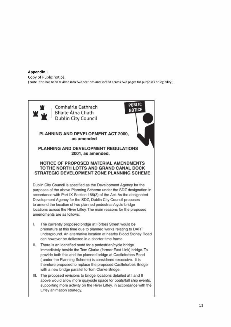
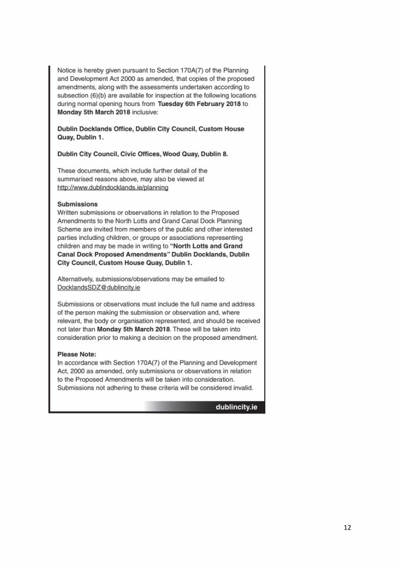
1 Context In August 2017, Dublin City Council, as Development Agency for the North Lotts and Grand Canal Dock SDZ, made an application to An Bord Pleanála requesting amendments to the 2014 Planning Scheme in relation to revised bridge locations across the River Liffey. The proposed changes had already been presented to both Central and South East Area Committees of Dublin City Council, and were noted ( see Appendix 2). Subsequently, An Bord Pleanala wrote to Dublin City Council on 15th January 2018 confirming that as the amendments were considered to constitute a material change, a process of consultations/ notifications needed to be carried out ( ABP ref ZE 29N.ZE0006). The letter set out required procedure in relation to the consultation stage and subsequent reporting as set out in relevant sections of the Planning and Development Act . Proposed amendments to the Planning Scheme in relation to the revised bridge locations, and related documents, were made available for public inspection during the period Tuesday 6th February to Monday 5th March 2018 inclusive. A notice placed in the Independent Newspaper advertised the availability of relevant documents and how to source them, and this advert can be viewed in Appendix 1 of this document. The content of the notice conforms with the requirements of Section 170A (7) of the Act. The proposed amendments and related documents were also referred to the minister and prescribed authorities for their consideration The proposed amendments and related material was available at two locations ; Dublin Docklands Office, Dublin City Council, Custom House Quay, Dublin 1, and also Dublin City Council, Civic Offices, Wood Quay, Dublin 8. It was also made available online on the relevant website at www.dublindocklands.ie/planning The material included;
The proposed amendments ; A document which included context, the amendments in detail, and conclusions statements from the environmental assessments.
2
Appropriate Assessment screening of the proposed amendments Strategic Environmental Assessment screening of the proposed amendments
Written submissions or observations were invited, and these could be submitted in writing or by email during the stated period. In relation to the time period for submissions, an additional day ( Tues 6th March) was allowed at the end of the period for receipt of submissions . This was because of extreme winter weather in the second half of the previous week, during which many workplaces were closed and public transport services were suspended.
2 Current position Now that this period has ended, the Planning Authority must prepare a report on any submissions or observations received, and submit the report to the Board for its consideration prior to 14th April. The content of this report is guided by the requirements set out in section 170A of the Planning and Development Act (as amended and updated by the Courts Act 2016) in relation to the amendment of a Planning Scheme. Subsection 9 sets out the required content of this report which is to be submitted to An Bord Pleanala for its consideration. This includes ( in summary) ;
▪ A list of persons/bodies who made submissions or observations ▪ A summary of the issues raised in these submissions and observations. ▪ To include, whre required , either/both
the environmental report and Strategic Environmental Assessment , and the Natura Impact Report and Appropriate Assessment.
▪ Response of the planning authority to issues raised , taking account of the proper planning and sustainable development of the area, the overall objectives of the planning scheme, statutory obligations of the Local Authority and relevant policies/objectives of the Government or any minister.

3
3 List of submissions received A total of 13 submissions were received , and persons/bodies who made submissions are listed below;
Sub-mission no.
Received From Company
1 Donal Steele, NTMA Dublin Landings Programme Manager.
NTMA
2 Cian O Mahony, Scientific Officer. Environmental Protection Authority
3 Jim Conway, Director. Eastern and Midlands Regional Authority
4 Niall Cussen, Chief Planner, Forward Planning Section
Department of Housing, Planning and Local Government.
5 Denise Kenny, Director of Administration.
MC Cann Fitzgerald (Law Firm)
6 Tara Spain, Head of Land Use Planning.
Transport Infrastructure Ireland
7 Garret Marrinan, General Manager.
The Gibson Hotel, Point Village, Dublin 1.
8 Sorcha Turnbull, Senior Planner . Brady Shipman Martin, on behalf of Crossman Properties Ltd (In Receivership) acting through the Statutory Receiver David Carson
9 Blaine Cregan
John Spain Associates on behalf of Chinook Investments (in Receivership) acting through The Statutory Receiver David Carson
10 Susan Fogarty, Planning Manager National Asset Management Agency
11 Sinead O’Brien, Development Applications Unit,
Department of Culture, Heritage & the Gaeltacht
12 Stephen Tennant,. Joint Statutory Receiver, Grant Thornton
13 Trevor Sadler Mc Gill Planning on behalf of TIO DAC and Targeted Investment Opportunities ICAV
The text below summarises the content of submissions received. Note that submissions from Government/statutory bodies have been kept separate for purposes of clarity.

4
4 Summary of Issues raised in submissions The majority of submissions received expressed support for the proposed amendments. One submission added that the revised bridge locations will improve business and increase connectivity in an increasingly busy area, beneficial to customers, employers and visitors. Two submissions took the position that the Blood Stoney Road Bridge would be positioned more appropriately than the original, whilst another maintained that the new bridge at the east link would benefit the wider pedestrian, cycle and public transport network. Another submission looks forward to the installation of the bridges as soon as possible. A submission from the NTMA refers to its interest in nearby property and supports the amendments. Similarly, receivers for large scale existing /proposed developments in Block 10 have expressed strong support . A submission from the National Asset Management Agency (NAMA) also expresses strong support for the amendments, considering them viable and more appropriate alternatives, supporting a more sustainable modal split and improved connectivity. They are also supported in the context of other network improvements such as the nearby proposal for a Dodder Bridge and the cycle strategy for the campshires and Sutton to Sandycove route. One submission, made on behalf of commercial clients makes reference to specific recent planning permissions secured by them for large scale residential, office and hotel developments at Sir John Rogersons Quay, Hanover Quay and North Wall Quay, and expressed the view that the proposed amendments will optimise north-south permeability for pedestrians and cyclists, and also increase accessibility to public transport . The relevant permissions include eight large-scale separate planning permissions for residential and commercial developments. Similarly, a separate submission made on behalf of a property company refers to recent permissions on City Block 9 for large scale residential and commercial development, along with a new park. Again, this submission supports the amendments, the related improvements in connectivity, and also the associated benefits for business and residents alike. It is added that this will in turn foster innovation and inclusiveness. A submission on behalf of management at an existing hotel at Point Village adds that the amendments will improve congestion through reducing the use of cars in the immediate area. Submission from the Department of Housing Planning and Local Government This submission refers to consideration of the amendment and states that the rationale for both proposed alterations is reasonable. Both proposed amendments are welcomed. It also states that proposals to limit the complications associated the construction of any future DART Underground is welcomed by the Department, with the proposals to move the bridge further east. Specific reference is made to improved pedestrian/cyclist facilities in the vicinity of East Link Bridge, stating that this allows for improved connectivity between Poolbeg West SDZ and the area North of the River Liffey. Submission from Eastern & Midland Regional Assembly (content approved by the Cathaoirleach) This refers to the emerging transition in regional guidance from the earlier Regional Planning Guidelines (RPGs) 2010-2022, to the forthcoming Regional Spatial and Economic Strategy (RSES). This RSES, once in place, will support the implementation of the recently published National Planning Framework and Project 2040 (DHPLG ). The existing RPGS remain relevant for Dublin City Council in that they set out strategic goals and objectives, including stated infrastructural priorities. The Regional Assembly notes that the Blood Stoney Road Bridge would have similar connectivity

5
benefits to the bridge at Forbes Street, and that the second bridge, next to the Tom Clarke Bridge would improve connectivity to this area with further connectivity westwards when the forthcoming Dodder Bridge is complete ( scheduled by 2021). The submission states that the RPGs support strategic infrastructure required to improve sustainable transport, and also support sequential development in the North Lotts & Grand Canal Dock SDZ area, which is considered to be of strategic importance to the State. The SEA document and an amendment to policy CR1 (a cultural objective) are both referred to. The assembly states its support for policy that recognises the importance of artistic and cultural activities. Transport Infrastructure Ireland Reference is made to relevant statutory guidance ; ‘Spatial Planning and National Roads Guidelines for Planning Authorities’ (Department of Environment, Community and Local Government 2012). The submission states it is critical that the proposed amendments address potential issues associated with the Dublin Tunnel (M50) and that they are compatible with provision for the M50 South Port Access Route (formerly Eastern Bypass) which has been indicated in the recently published National Development Plan. The submission adds it is unclear how the proposed bridge beside the Tom Clarke bridge will tie in/impact with the M50 SPAR. Careful coordination is therefore needed between TII , National Transport Authority, Dublin City Council and the Port Company in relation to this national road and bridge projects. It is requested that an evaluation of the proposal be undertaken to take account to f the Bypass Corridor Protection study sector A ; Dublin Tunnel to Sandymount Strand ( Sept 2014), and an evaluation of the impact of the proposals on the Eastern Bypass Corridor should be undertaken. This will involve interaction between Dublin City Council, TII , National Transport Authority, and the Port Company. Department of Culture, Heritage and the Gaeltacht ( DCHG) In relation to nature conservation, issues are raised which need to be addressed in the Strategic Environmental Assessment and/or Appropriate Assessment screening/NIS. It is recommended that the SEA /AA are amended where necessary to include these ;
• Otters are active between the Rivers Liffey and Dodder/Grand Canal . They are protected under annex IV of the Habitats Directive. The creation of artificial otter holts should be considered.
• A bat survey would need to be carried out and existing bat data examined. The impact of new lighting should also be assessed. They are protected under annex IV
• Birds ; Black Guillemots and terns are likely to be present. Bird usage data, including breeding data, needs to be included in any assessment, particularly at t eh Dodder Bridge. Artificial breeding holes for Black Guillemots should be considered. Overhead cables for Luas may be problematic at the Dodder Bridge.
• Rare plants. A flora survey would need to be done in flowering season, and three separate relevant data sources are detailed in the submission.
• Marine Issues ; Marine mammals need to be considered and assessed. The submission states that specialist expertise should be sought in relation to any hazardous materials, and in relation to any infill of the River Liffey, this needs to be uncontaminated and free from invasive alien species. Additional comments are made specifically in relation to the Dodder Bridge .
Dublin City Council is requested to send further communications/correspondence to the Development Applications Unit of the DCHG.

6
Submission from the Environmental Protection Agency SEA Determinations; there is a need to ensure that the SDZ scheme is consistent with environmental protection commitments contained in the National Planning Framework. The previous submission made on the original SDZ and dated 10th May 2013, is enclosed with the submission as relevant/appropriate. Future modifications to the amendments; Changes should be screened for potential for likely significant effects, in accordance with criteria in the Strategic Environmental Assessment Regulations Schedule 2A criteria. Environmental Authorities ; Under the Strategic Environmental Assessment Regulations as amended, notice should be given to
The minister for Housing, Planning and Local Government. Minister for Agriculture, Food and the Marine & Minister for Communications, Climate
Action and the Environment, where there may be effects on fisheries or the marine environment.
Minister for Culture, Heritage and the Gaeltacht, where there may be effects on architectural/archaeological heritage or nature conservation.
Any adjoining Planning Authority. A copy of the decision determination, including any reasons for not requiring an appropriate assessment, should be made available for public inspection, and notified to any Environmental Authorities already consulted.
5 Response of the Planning Authority to issues raised Dublin City Council welcomes the many positive comments received in relation to the material amendments and looks forward to progressing delivery of this important infrastructure subject to full approval from An Bord Pleanala. It is accepted that there would be benefits to pedestrians and cyclists visiting, working and living in the area given that the new bridges would ease significant congestion and provide viable alternatives to existing options for pedestrians and cyclists. It is further acknowledged that the proposed bridge locations would work in tandem with other forthcoming improvements in sustainable transport as part of the emerging network ( including the LIHAF approved Dodder Bridge and also improvements to the strategic cycle network). The improved permeability would help meet policy goals relating generally to transport and sustainable development in this area, where mixed uses are planned at relatively high density and where the residential and business/commercial population is increasing. DHPLG ; The submission received is welcome support for the amendments, particularly given reference to the Poolbeg West SDZ Planning Scheme ( currently on appeal) and the need to address the restrictions relating to the timeline for DART Underground. Eastern & Midland Regional Assembly ; Dublin City Council acknowledges relevant Regional planning guidance. It is agreed that improvements to the transport network help improve the sustainability of this wider area, which is considered of strategic importance to the state.
7
Reference to CR1 is likely to be a erroneous as the text quoted is in fact from policy CR9 (p102 of the SDZ). There is no proposed amendment to CR1 or CR9. Transport Infrastructure Ireland The submission From TII states it is critical that the proposed amendments address potential issues associated with the Dublin Tunnel (M50) and that they are compatible with provision for the M50 South Port Access Route (formerly Eastern Bypass) which has been indicated in the recently published National Development Plan. In response to this , Dublin City Council has been cognisant of the need to reserve a corridor for this important piece of national road infrastructure and has ensured its inclusion in both the City development Plan and also in the planning scheme for Poolbeg West. Objective MTO32 of the City Development Plan ( section 8.5.7) specifically aims to protect this corridor MTO32: To protect the routes of the proposed eastern by-pass from existing Dublin Port tunnel to Poolbeg, also referred to as the Southern Port Access Route, and in the longer term to provide a route corridor between Poolbeg and the Southern Cross/ South Eastern Motorway (in accordance with the NTA Strategy for the Greater Dublin Area 2016–2035). The preferred route for DCC is by means of a bored tunnel, under Sandymount Strand and Merrion Strand and will be subject to full statutory Environmental Assessment, together with an Appropriate Assessment for the entire proposed routes, in accordance with the Habitats Directive, together with a full consultation process. (See Map J) The route is similarly protected in objective MV4 of the Poolbeg West SDZ Planning Scheme. MV4 ; To protect the route of the proposed Southern Port Access Route and Eastern Bypass in accordance with the objectives of Transport Infrastructure Ireland and the National Transport Authority Strategy for the Greater Dublin Area 2016-2035. As an interim measure it is proposed to provide a separate road access to the south port area via a new road link located north of the existing Sean Moore Roundabout. Dublin City Council fully understands TIIs concern in relation to how the proposed bridge beside the Tom Clarke bridge will tie in/impact with the M50 SPAR. The City Council agrees that a coordinated approach is indeed needed between TII , the National Transport Authority, Dublin City Council and the Port Company. It is considered that this will greatly assist at detailed design stage, particularly given that the proposed Dodder Bridge, planned nearby, is currently progressing at Design stage. TII‘s twofold request for evaluations (a) …of the proposal to take account of the Bypass Corridor Protection study sector A ; Dublin Tunnel to Sandymount Strand ( Sept 2014), and (b) …of the impact of the proposals on the Eastern Bypass Corridor, are understood .DCC accepts that such evaluations would involve interaction between Dublin City Council, TII , the National Transport Authority, and Dublin Port Company. However, given the nature and scale of any pedestrian bridge at the intended position ( ie at the very western extremity of the illustrated protected corridor), and the anticipated extend of works , it is not likely to impact in any significant way on the protected corridor and would not jeopardise the deliverability of the bypass Motorway. Subject to necessary approvals, pedestrian and cycle movement on the new bridge will tie in appropriately with pedestrian/cycle movement on the proposed Dodder Bridge, all positioned west of the existing Tom Clarke Bridge. For information on the Dodder Bridge please see

8
;https://consultation.dublincity.ie/traffic-and-transport/dodder-public-transportation-opening-bridge-public/ In more general terms, postponing the provision of a much needed pedestrian bridge,- which would have a relatively low impact on the established built environment, because of a much longer term project which is yet to be designed would seem excessive in this instance, subject to appropriate design considerations. In this regard I note relevant content of the recently adopted National Development Plan, which lists the “M50 Dublin Port South Access” as one of a number of sections of road network which “ will be progressed through pre-appraisal and early planning during 2018 to prioritise projects which are proceeding to construction..”. The NTAs Transport strategy for the Greater Dublin Area 2016-2035 states that it is intended during the period of the strategy , to develop “a road link connecting from the southern end of the Dublin Port Tunnel to the South Port area, which will serve the South Port and adjoining development areas”. South Port Access is hence a long term project.
Above ; extract from graphic included with RPA’s Corridor Protection Study document (dated September 2014)
Above ; Proposed location of pedestrian bridge (pink dashed line)

9
In regard to recent developments in the vicinity of the Tom Clarke Bridge, An Bord Pleanala
Reference no. 29N.PA0034 ( earlier Dublin City Council ref PARTX/0015) relates to the Alexandra Basin Redevelopment Project (Strategic Infrastructure Development) , which proposed a range of works, mainly on the northern side of the river to the east of Tom Clarke Bridge. These works included the infilling of a graving dock, demolition of a jetty, new quay walls, new jetty & ramps, dredging works, etc . Also included were some improvements to the pedestrian environment on the north quays (very close to Tom Clarke Bridge) to enhance east-west connectivity into the cruise terminal/basin area. These improvements were not omitted in the Boards grant of planning permission in July 2015 (under section 37E of the Principal Act), although it was decided that a proposed interpretative pavillion and related connections, to be located within the Bypass corridor, could be relocated at a future date, if the need arose. This 10 year permission was granted after the publication of the Bypass protection corridor in Sept 2014, and it appears that the current proposal for amendments to Bridge locations would be compatible with this project. Department of Culture, Heritage and the Gaeltacht ( DCHG) The planning scheme is committed to the protection, conservation and improvement of the environment. The North Lotts and Grand Canal Dock planning scheme was adopted alongside the publication of the findings of the Strategic Environmental Assessment (SEA); Appropriate Assessment (AA); Strategic Flood Risk Assessment (SFRA) and Contamination and Remediation Assessment (CRA). The proposed amendments are to only amend text and graphics, which supports the relocation of two pedestrian/cycle bridges in the SDZ. Taking into account the measures that have already been integrated into the Planning Scheme which contribute towards environmental protection, environmental management and sustainable development, it is identified that all potential adverse effects arising from proposed bridges relocation are either present already and will be further contributed towards or will be mitigated so as not to be significant (residual adverse); or are potentially adverse and would be mitigated by the measures integrated into the planning scheme. Dublin City Council is currently carrying an environmental impact assessment for the “Dodder public transportation opening bridge” and the heritage-related observations/recommendations submitted are being considered as part of the process. Environmental Protection Authority The proposed amendments to the North Lotts and Grand Canal Dock planning scheme is subject to Strategic Environmental Assessment (SEA) in accordance with the Planning and Development (Strategic Environmental Assessment) Regulations 2004 and consistent with the commitments made in the National Planning Framework (DHPLG, 2018). Dublin City Council has always taken precautionary approach to environmental protection. Where changes to the amendments are proposed prior to finalisation, Dublin City Council will screen for potential likely significant effects in accordance with SEA Regulations Schedule 2A Criteria and notify environmental authorities.
6 Conclusion This report gives an overview of the public consultation process followed, and it both documents and responds to the content of submissions received during the allotted time period. The report complies with the requirements of Section 170A(9) of the Planning and Development Act ( as amended).

10
Having considered the content of submissions received, it is considered that the proposed amendments are consistent with the proper planning and sustainable development of the area , the statutory obligations of the Local Authority and relevant Government objectives. Dublin City Council seeks the opportunity to proceed with the amendments as originally submitted, and submits this report to the Board for assessment prior to making a determination on the case. ---------------------------------- Myles Farrell Senior Planner (Acting)
11
Appendix 1 Copy of Public notice. ( Note ; this has been divided into two sections and spread across two pages for purposes of legibility.)
12

13
Appendix 2 Report prepared for both Central Area Committee and South East Area Committee ( please note ; date at top is an error and should read June 2017) This report was ‘noted’ by the members in the minutes of the Southeast Area Committee Meeting held Monday 12th June 2017 ( item 8.vi). The report was also noted by the members of the Central Area Committee at meeting held 13th June 2017 (item 5)

14

15

16

17
Cover Letter Your Ref; ZE 29N.ZE0006 Re ; Proposed amendment to the North Lotts and Grand Canal Dock SDZ Planning Scheme in relation to revised bridge locations across the River Liffey ; On 15th January 2018 An Bord Pleanala wrote to Dublin City Council confirming that as the amendments were considered to constitute a material change, a process of consultations/ notifications needed to be carried out . This consultation phase has now concluded, And Dublin City Council is hereby submitting all relevant material . In this regard please find enclosed,
• Comprehensive report on the consultation Phase
• Material made available to the public during the consultation phase a) The proposed amendments ; A document which included context, the amendments in detail,
and conclusions statements from the environmental assessments. b) Appropriate Assessment screening of the proposed amendments c) Strategic Environmental Assessment screening of the proposed amendments
Regards