
Dublin City Council Further Characterisation/ Programmes...
102
Dublin City Council Further Characterisation/ Programmes of Measures Groundwater Abstractions Pressure Assessment February 2009 Final Report
Transcript of Dublin City Council Further Characterisation/ Programmes...

Dublin City Council Further Characterisation/ Programmes of Measures Groundwater Abstractions Pressure Assessment February 2009
Final Report

Groundwater Abstractions Pressure Assessment Final Report – February 2009
Document Control Sheet
Client Dublin City Council
Project Eastern River Basin District – National POM/Standards Study
Report Groundwater Abstractions Pressures Assessment – Final Report
Date February, 2009
Project No: 39325 Document Reference: 39325/AP/DG 43 - S
Version Author Reviewed Checked Date
Draft 01 H. Moe
L. Gaston; Peer Review Group; Steering Group
H. Moe June 2008
Final 01 H. Moe L. Gaston; Steering Group
H. Moe December 2008
Final 02 H. Moe L. Gaston H. Moe February 2009
Distribution: ERBD File Steering Group
A i

Groundwater Abstraction Pressure Assessment Final Report – February 2009
A
ii
Table of Contents
Document Control Sheet ................................................................................................................. i
EXECUTIVE SUMMARY ........................................................................................................... viii
1. Introduction .................................................................................................................................. 1
1.1 Background ............................................................................................................................. 1 1.2 Study Objectives ..................................................................................................................... 3 1.3 Steering Group ........................................................................................................................ 3 1.4 Data Sources ............................................................................................................................ 4 1.5 Acknowledgement ................................................................................................................. 4
2. Approach and Methodology ...................................................................................................... 6
2.1 Updated Groundwater Abstractions Risk Assessment ..................................................... 6 2.1.1 Groundwater Abstractions Register ................................................................................... 7 2.1.2 Recharge Coefficients .......................................................................................................... 7 2.1.3 National Groundwater Recharge Map ............................................................................... 9
2.2 Impacts of Groundwater Abstractions .............................................................................. 11 2.3 Groundwater Abstraction Licensing System .................................................................... 11
3. Groundwater Abstractions Pressure Assessment ................................................................ 13
3.1 Updated Groundwater Abstractions Register .................................................................. 13 3.1.1 Unregistered Abstractions ................................................................................................ 16
3.2 National Groundwater Recharge Map .............................................................................. 19 3.3 Groundwater Abstraction Risk Assessment (2008) ......................................................... 20
3.3.1 At-Risk Scenarios – Abstraction Rates vs. Recharge Test ............................................... 22 3.3.2 At-Risk Scenarios - Saline Intrusion ................................................................................ 28 3.3.3 Potential Impacts to Groundwater Receptors ................................................................... 30
4. Programmes of Measures ......................................................................................................... 32
4.1 WFD Status Objectives ......................................................................................................... 32 4.2 Existing Basic Measures ....................................................................................................... 33
4.2.1 Environmental Impact Assessment Directive .................................................................. 33 4.2.2 Water Supplies Act ........................................................................................................... 34 4.2.3 Planning and Development Regulations .......................................................................... 34 4.2.4 Water Services National Training Group Procedures Manual ........................................ 34 4.2.5 Local Government (Water Pollution) Act 1977 ............................................................... 35 4.2.6 European Communities (Drinking Water) Regulations .................................................. 35
4.3 WFD Requirements for Abstraction Controls .................................................................. 35 4.3.1 Existing Abstraction Regulations in Northern Ireland and Scotland .............................. 36
4.4 Proposed Licensing Framework for Ireland ..................................................................... 37 4.4.1 Options for New Licensing Regulations .......................................................................... 39 4.4.2 Responsibilities ................................................................................................................. 39 4.4.3 Interface with Existing Procedures .................................................................................. 40 4.4.4 Format .............................................................................................................................. 41 4.4.5 Time Limits ...................................................................................................................... 41 4.4.6 Costs ................................................................................................................................. 41 4.4.7 Retroactive Licensing ....................................................................................................... 42 4.4.8 Training ............................................................................................................................ 42
5. Abstractions Licensing Guidance ........................................................................................... 43
5.1 WFD Status Objectives ......................................................................................................... 43 5.1.1 Elements of Quantitative Status Assessment................................................................... 44

Groundwater Abstraction Pressure Assessment Final Report – February 2009
5.1.2 Scale Dependency ............................................................................................................. 47 5.2 Licensing Framework ........................................................................................................... 47
5.2.1 Abstraction Categories Included ...................................................................................... 48 5.2.2 Abstraction Categories Exempted .................................................................................... 48 5.2.3 Definition of a Groundwater Abstraction Scheme ........................................................... 50
5.3 Technical Content of the Licensing Framework ............................................................... 50 5.4 Abstraction Thresholds and Screening Criteria ............................................................... 53
5.4.1 Levels of Assessment ........................................................................................................ 54 5.4.2 Specific Hydrogeological Considerations .......................................................................... 57 5.4.3 Notes on Groundwater Monitoring Requirements .......................................................... 60
5.5 Review of Existing Schemes in Context of the Licensing Framework .......................... 61
6. Proposed Supplementary Measures ...................................................................................... 66
6.1 Survey of Abstractions ......................................................................................................... 66 6.2 Borehole Construction Practices ......................................................................................... 66 6.3 Information Management .................................................................................................... 67
7. References ................................................................................................................................... 69
A iii

Groundwater Abstraction Pressure Assessment Final Report – February 2009
A
iv
List of Tables
Table 1: Initial Characterisation of ‘Risk’ for Abstraction Pressures ..................................... 1
Table 2: Recharge Coefficients Used in the Recharge Calculations ....................................... 8
Table 3: Summary of the Updated Groundwater Abstractions Register ............................ 13
Table 4: Summary of Computed Recharge by Flow Regime ................................................. 19
Table 5: Summary of At-Risk Scenarios .................................................................................... 24
Table 6: Known or Potential Impacts to Groundwater Receptors ........................................ 31
Table 7: Existing Basic Measures ................................................................................................ 33
Table 8: WFD Definition of Good Quantitative Status .......................................................... 43
Table 9: Technical Information to be Provided or Reviewed during Initial Screening ... 51
Table 10: Proposed Abstraction Thresholds for Screening of Abstraction Schemes ........ 53
Table 11: Screening Criteria for Different Abstraction Thresholds ..................................... 55
Table 12: Summary of Assessments and Reporting at Six Abstraction Schemes .............. 63
List of Figures
Figure 1: Article V Groundwater Abstraction Risk Assessment 2005 ................................... 2
Figure 2: National Groundwater Vulnerability Map .............................................................. 10
Figure 3: Estimated Groundwater Abstraction for Public Supply by County ................... 14
Figure 4: Known Groundwater Abstraction Schemes > 1,000 m3/day ................................. 15
Figure 5: The Groundwater Abstractions Register by Thresholds ....................................... 16
Figure 6: National Groundwater Recharge Map ...................................................................... 20
Figure 7: Updated (2007) Groundwater Abstractions Risk Assessment .............................. 21
Figure 8: EPA Groundwater Level Monitoring Network for WFD Purposes ..................... 23
Figure 9: Hydrographs from Bog of the Ring Observation Wells ........................................ 25
Figure 10: Electrical Conductivity in a Supply Well on Inish Oirr, 2008 ............................ 28
Figure 11: Proposed Licensing Framework ............................................................................... 38
Figure 12: Existing IPPC Licensing Process .............................................................................. 41
Figure 13: GWDTE and SAC Boundaries .................................................................................. 46
Figure 14: Proposed Levels of Assessment ............................................................................... 55

Groundwater Abstraction Pressure Assessment Final Report – February 2009
List of Appendices
Appendix A: Details of GIS Processing of Recharge Computations
A v

Groundwater Abstraction Pressure Assessment Final Report – February 2009
Acronyms
ABF – Aquatic Baseflow
ASIS – Abstraction Screening and Information System
BOTR – Bog of the Ring
CFB – Central Fisheries Board
DCC – Dublin City Council
DCENR – Department of Marine, Energy and Natural Resources
DEHLG – Department of Environment Heritage & Local Government
EA – Environment Agency (England and Wales)
EC – European Commission
EHS – Environment & Heritage Service (Northern Ireland)
EIA – Environmental Impact Assessment
EPA – Environmental Protection Agency (Ireland)
ERBD – Eastern River Basin District
GIS – Geographic Information System
GSI – Geological Survey of Ireland
GWB – Groundwater Body
GWDTE – Groundwater Dependent Terrestrial Ecosystem
GWG – national Groundwater Working Group
GWS – Group Water Scheme
HSE – Health Services Executive
IGI – Institute of Geologists of Ireland
IPPC – Integrated Pollution Prevention Control
LSO – Less Stringent Objectives
NFGWS - National Federation of Group Water Schemes
NI – Northern Ireland
NPWS – National Park and Wildlife Service
NTCG – National Technical Coordination Group
A vi

Groundwater Abstraction Pressure Assessment Final Report – February 2009
A vii
Acronyms (cont.)
OEE – Office of Environmental Enforcement
OPW – Office of Public Works
pNHA – proposed Natural Heritage Area
POM – Programme of Measures
PPA – Poorly Productive Aquifer
RBD – River Basin District
RBMP – River Basin Management Plan
RFT – River Flow Threshold
ROI – Republic of Ireland
SAC – Special Area of Conservation
SEPA – Scottish Environmental Protection Agency
SNIFFER – Scotland and Northern Ireland Forum for Environmental Research
TCD – Trinity College, Dublin
UK – United Kingdom
UKTAG – UK Technical Advisory Group
WSNTG - Water Services National Training Group
WFD – Water Framework Directive
ZOC – Zone of Contribution

Groundwater Abstraction Pressure Assessment Final Report – February 2009
EXECUTIVE SUMMARY A national study of groundwater abstraction pressures has been carried out as part of Ireland’s implementation of the European Union Water Framework Directive (WFD). Following the Initial Characterisation (IC) report of environmental pressures that was submitted by the Environmental Protection Agency (EPA) to the European Commission (EC) in March 2005 (EPA, 2005), groundwater abstraction was identified as a topic that would require further characterisation.
This report represents a national Further Characterisation (FC) study of groundwater abstraction pressures. It was carried out as part of the Programmes of Measures (POM) phase of the WFD, and explores risk and impact to groundwater bodies from abstraction pressures. The broad objectives of this FC/POMs study were to:
Update the national register of groundwater abstractions;
Update the national risk assessment of groundwater abstractions that was submitted to the EC in 2005;
Develop technical guidance towards establishing a future groundwater abstraction licensing system.
National Register of Groundwater Abstractions A national Register of groundwater abstractions has been collated from information collected and verified across each river basin district in Ireland. From the present Register, an estimated 575,000 m3/day is known to be abstracted from groundwater sources. The Register is a relatively complete representation of public water supply and group water schemes, but is almost certainly underestimating the total number of abstraction points across the country, particularly in the industrial and commercial sectors. As a result, the total abstraction volumes may also be under-represented.
Groundwater abstractions associated with domestic supplies for single houses are not included in the Register. However, such abstractions are of reduced consequence from a quantitative water management perspective, as the majority of the water is returned to the groundwater system through onsite septic systems.
Revised Groundwater Abstractions Risk Assessment Only a few known groundwater abstraction schemes raise concerns about abstraction sustainability. The schemes in question include four public water supplies, two mines, and two quarries. The quarries and mines operate under EPA’s Integrated Pollution Prevention Control licensing regulations and are required to submit environmental monitoring reports which include monitoring of groundwater and surface water hydrology. The four public water supplies are monitored by Local Authorities and each case has been included in EPA’s future groundwater monitoring network for WFD purposes.
Localised saline intrusion risk has been identified in coastal areas of Cork, Kerry and Galway. However, some of the risk cases are not caused by abstraction
A viii

Groundwater Abstraction Pressure Assessment Final Report – February 2009 pressures but rather by natural tidal action in coastal aquifers. Saline intrusion is considered a real risk where future new supplies would be developed close to the coastline.
There are few identified impacts to groundwater receptors such as rivers, lakes and groundwater dependent terrestrial ecosystems (GWDTEs). Those cases that are identified in this FC/POM study are currently being monitored and assessed for further action by the EPA, the National Parks and Wildlife Service (NPWS), and respective Local Authorities.
Technical Guidance - Groundwater Abstractions Licensing System The increased focus that groundwater has received under the WFD and the recently enacted Groundwater Directive will require improved regulatory supervision under WFD-stipulated POMs.
Growing water demand across Ireland highlights the need for an updated regulatory framework for water resources management. The increased use of groundwater implies a need for improved controls on abstractions.
Article 11.3(e) (Programme of Measures) of the WFD requires that abstraction controls be introduced that include a register of abstractions and a requirement for “prior authorisation”.
Primary legislation to cover abstraction licensing in Ireland does not yet exist. This FC/POM study has explored a potentially suitable groundwater abstraction licensing framework modelled on recent legislation in Northern Ireland and Scotland.
A risk-based licensing framework is proposed whereby environmental risk increases with abstraction rates and proximity to ecologically sensitive receptors and saltwater. Within the proposed framework, potential impacts are initially screened against a set of distance criteria and abstraction thresholds. The initial screening flags potential issues that may have to be looked at in closer detail, and informs the applicant about the required course of action. Higher risk scenarios would require a greater level of technical assessment, and in certain defined cases, it is envisaged that a licensing “supervisory body” will assist in the scoping, review and approval of technical study (and ultimately approval of a licence).
The technical elements included in the licensing framework relate to EPA’s status classification objectives for groundwater bodies, as follows:
Maintaining the “available groundwater resource” (i.e., a water balance element);
No diminution of surface water flow conditions;
No significant impact to GWDTEs;
No saline intrusion.
A ix
Groundwater Abstraction Pressure Assessment Final Report – February 2009 Abstractions less than 10 m3/day would be exempt from licensing but should be registered to the extent possible. Abstractions less than 250 m3/day would be approved in the majority of cases, provided the following information is submitted: well construction diagrams, boring logs, aquifer test results, and water quality data (the latter would only be required if the abstraction is to be used for drinking water). Abstractions greater than 100 m3/day and within 250 m of a GWDTE would be subject to greater technical scrutiny and input from the NPWS.
Abstractions greater than 250 m3/day but less than 1,000 m3/day would require a greater level of technical assessment, and depending on the initial screening, may require the involvement of the licensing supervisory body in the scoping of field work. Licences would be granted upon submittal of an Environmental Report provided that no significant impacts are identified.
Finally, abstractions greater than 1,000 m3/day would automatically be deferred to the licensing supervisory body. It is envisaged that a scoping meeting between the applicant and the supervisory body would be arranged early in the application process to define the level of assessment that would be needed. The level of assessment would in principle become more complex with greater abstraction rates and proximity to groundwater users or receptors. Licences would be granted upon submittal of an Environmental Report provided that no significant impacts are identified.
All abstraction schemes greater than 100 m3/day would be required to report on volumes abstracted on an annual basis.
Future licensing of groundwater abstractions will have implications for all participants in the process. While it has not been within the remit of this FC/POM study to define specific roles and responsibilities, it is expected that licensing will require the formation of a new licensing body or modification to existing planning or licensing structures.
Supplementary Measures This FC/POM study has identified other measures that are recommended for improved groundwater resources management. These supplementary measures involve surveys, codes of practice, and use of information technology to facilitate the licensing process as well as management of abstractions-related data.
The current Register of groundwater abstractions contains data gaps, and targeted surveys are recommended in relation to:
Quarries – national survey of dewatering operations;
Golf courses – national survey of golf courses that use groundwater for irrigation purposes;
Farming – national survey of groundwater use for irrigation purposes;
Food and drinks industry – national survey of groundwater use for the food processing and drinks industry, as well as the hotel and leisure industry.
A x

Groundwater Abstraction Pressure Assessment Final Report – February 2009
A xi
Manufacturing – national survey of groundwater use in the manufacturing industry, primarily those that involve cooling processes.
Geothermal – primarily those that abstract water and discharge to streams.
The surveys would be carried out with input from a variety of sources, including drilling companies.
There are presently no statutory regulations or comprehensive guidelines concerning the drilling industry in Ireland. As a result, there are inconsistent standards of construction and decommissioning of boreholes. Improperly constructed wells can provide misleading data resulting in false or erroneous interpretations of local hydrogeology.
Proper well construction practices should be formally promoted within the licensing framework. A mandatory well construction code is regarded as a necessary means of achieving good construction practice. The well construction documentation available through the IGI (IGI, 2007) could serve as a useful starting point towards establishing a code of practice.
The introduction of a licensing system will generate a wealth of new hydrogeological data and information. The submittal and processing of licence applications should be managed through an appropriate information management system (IMS). The IMS would be accessible in different ways to all parties involved. Similarly, it is envisaged that monitoring data and environmental reports could be processed and accessed through a database linked to the national Register of abstractions.
The roll-out of a new licensing framework and system would have to be accompanied by formal training programmes geared towards Local Authorities, as well as practitioners within the groundwater industry.

Groundwater Abstractions Pressure Assessment Final Report – February 2009
1. Introduction 1.1 Background The European Union (EU) Water Framework Directive (WFD) requires that a characterisation of pressures from significant water abstractions be carried out for all types of water bodies in Ireland.
An “Initial Characterisation” of abstraction pressures was reported to the European Commission (EC) by the Environmental Protection Agency (EPA) in the national report titled “The Characterisation and Analysis of Ireland’s River Basin Districts” (EPA, 2005). The report provided a general assessment of abstraction pressures in each of six river basin districts delineated in Ireland and identified water bodies that are deemed to be ‘at risk’ from meeting environmental status objectives, as defined by the WFD, by year 2015. Results are highlighted in Table 1.
Table 1: Initial Characterisation of ‘Risk’ for Abstraction Pressures
Risk Level Rivers Lakes Transitional
Waters Ground Waters
Water Bodies At Risk (1a) 95 111 6 6 Water Bodies Probably At Risk (1b)
107 16 5 36
Total No. of Water Bodies 4,467 805 196 757 % of 1a or 1b of Total 5 16 6 6
The geographic distribution of risk that is specific to groundwater abstractions is shown in Figure 1. On a national scale, only 6 groundwater bodies (GWBs) were considered to be at risk from meeting WFD good status objectives by year 2015, while a further 36 were considered to be “probably at risk”, involving less certainty and reduced confidence in the assessment. Of the 36 “probably at risk” cases, only 12 were linked directly to abstraction rates or saline intrusion, while 24 were linked to perceived threats of drainage impacts on nearby GWDTEs.
The risk characterisation for groundwater was carried out following a risk assessment methodology developed by the national Groundwater Working Group (GWG, 2005). The methodology is predictive in nature and uses groundwater level data to verify predictive risk where possible. The methodology was developed at the national level to ensure consistency in application across all RBDs in Ireland.
The term “groundwater abstraction” is used in this report to include: a) pumping of groundwater from a well (or an infiltration gallery); b) pumping from natural springs; and c) drainage related to engineering schemes where permanent cuts intersect the groundwater table and results in a permanent impact on groundwater levels (or flow rates) by passively draining the groundwater resource.
A 1

Groundwater Abstractions Pressure Assessment Final Report – February 2009
Figure 1: Article V Groundwater Abstraction Risk Assessment 2005
Although the initial risk assessment of 2005 does not, in general, indicate that groundwater abstraction pressures would be a significant water management issue in Ireland, the work carried out by various RBD projects highlighted areas of uncertainty relating to existing pressure information, the physical characterisation of individual GWBs, as well as individual cases of predicted risk. For this reason, a more detailed assessment of groundwater abstraction pressures was commissioned by the DEHLG and implemented by the Eastern River Basin District project. The updated assessment represents the “Further Characterisation” (FC) stage of WFD implementation in Ireland. FC supports the development of Programmes of Measures (POMs) to address significant water management issues.
A 2

Groundwater Abstractions Pressure Assessment Final Report – February 2009
1.2 Study Objectives The primary objectives of this FC study are:
1. To develop an improved national groundwater abstraction Register; 2. To update the Initial Characterisation risk assessment using improved
abstraction data and physical characterisation information; 3. To examine predicted risk scenarios in greater detail, on a case-by-case
basis; 4. To develop technical guidance towards establishing a suitable
groundwater abstraction licensing system. To arrive at the stated objectives, numerous WFD participants and stakeholders were consulted for information, opinions and technical review. Importantly, the work has coordinated with, and contributed to, the following important projects led by the EPA and the National Parks and Wildlife Service (NPWS):
The WFD-required quantitative status classification of GWBs across Ireland; and
The development of a monitoring and management framework for GWDTEs, which includes definition of environmental supporting conditions for groundwater dependent ecosystems.
The development of technical guidance is an important step towards establishing a groundwater abstraction licensing system in Ireland. As described in Section 4, the WFD requires member states to establish a system of “prior authorisation” for future abstraction schemes, including a Register which can be updated and improved with time. This FC study was tasked specifically with identifying and describing the scientific elements and thresholds that would form part of a future groundwater abstractions licensing system in Ireland.
Finally, existing groundwater abstractions schemes were reviewed retroactively in view of the proposed licensing framework, to assess the potential significance that new technical criteria might have on the planning and review process of new schemes compared to existing procedures. Results of the study have been presented to the project’s Steering Group and discussed with the Hydrometric and Groundwater Section of the EPA to ensure that findings are incorporated into EPA’s groundwater monitoring network and WFD status classification efforts. 1.3 Steering Group The project steering group consisted of the following representatives:
Brian McKeown and Brian Smyth, Dublin City Council (Chairmen);
Ray Earle, Project Co-ordinator, Eastern River Basin District Project;
Oliver Fogarty, Department of the Environment, Heritage & Local Government;
A 3
Groundwater Abstractions Pressure Assessment Final Report – February 2009
PJ Shaw, Department of Communications, Energy & Natural Resources;
Donal Daly, Deirdre Tierney, Micheál MacCarthaigh, Catherine Bradley & Rebecca Quinn, Environmental Protection Agency;
David Harrington, Wicklow County Council;
Edwina Moore & Cliona Murphy, Kildare County Council;
Tim O’Leary, Meath County Council;
Jimmy King & Trevor Champ Central Fisheries Board;
Eileen Loughman, Health Service Executive (Kildare);
Lily Byrne, Health Service Executive (Dublin North East); and
Aine O’Connor, National Parks and Wildlife Service.
1.4 Data Sources Primary sources of data and information include:
Geological Survey of Ireland (GSI);
River Basin District Projects;
Local Authorities;
National Federation of Group Water Schemes (NFGWS);
Environmental Protection Agency;
Trinity College, Dublin (TCD); and
National Park and Wildlife Service (NPWS).
Relevant literature is referenced as appropriate. 1.5 Acknowledgement The authors wish to acknowledge the advice provided by members of the national GWG as well as the contribution of individual river basin districts in collating relevant abstraction data, checking the risk assessment results, and providing local knowledge in the evaluation of specific case studies. Robbie Meehan and Natalie Hunter-Williams at the GSI were instrumental in developing relevant soil and subsoil permeability information and maps, thereby guiding the development of the updated national groundwater recharge map. Compass Informatics synthesised, re-formatted and processed databases and GIS layers from the different RBD projects to provide consistency in approach, and was instrumental in re-running the risk assessments on a GIS platform.
A 4

Groundwater Abstractions Pressure Assessment Final Report – February 2009 The authors also wish to thank the participants of the Peer Review Group who reviewed and met to discuss the draft findings of this study. The constructive inputs and critiques from seasoned Irish hydrogeologists are particularly acknowledged.
Finally, the ERBD project wishes to thank the efforts and inputs from individual Steering Group members for direction and constructive review.
A 5

Groundwater Abstractions Pressure Assessment Final Report – February 2009
2. Approach and Methodology The national assessment of groundwater abstraction pressures involved the following basic steps:
Developing an updated register of groundwater abstractions (current as of September 2008);
Developing an updated national groundwater recharge map;
Re-running the national risk assessment of groundwater abstractions using the updated abstractions Register and recharge map; and
The updated risk assessment was subsequently reviewed in context of a separate study on surface water abstractions (CDM, 2008a and 2008b). Similar to this groundwater study, the surface water study provides updated risk assessments of abstractions for rivers and lakes across Ireland. In those cases where both surface waters and their associated GWBs are deemed to be at risk from overabstraction, a review of relevant metrics was carried out whereby potential groundwater discharge volumes were compared to relevant flow thresholds of river and lakes. The objective of this comparison was to assess whether or not there are instances where groundwater abstractions could directly and negatively impact on baseflow to rivers and lakes.
2.1 Updated Groundwater Abstractions Risk Assessment The updated risk assessment used the same methodology that was applied during the initial risk assessment of 2005. The methodology compares summed abstraction rates against computed long-term average recharge across each GWB in Ireland. Criteria for risk level designations are based on percentages of abstraction rates vs. recharge volumes for each GWB. Where groundwater level data are available, these can be used on a case-by-case basis to: a) support or overwrite the predictive risk results; and b) add confidence to the risk assignments. Because groundwater abstraction impacts can be of a localised nature, water level trends can also be used to justify subdividing the officially designated GWBs in order to reduce the predicted risk across otherwise much larger areas.
A separate test for saline intrusion is based on assessing locations and rates of abstractions against distance from seawater. A corresponding test for GWDTEs is based on abstraction rates and distances from the boundaries of wetland areas as mapped by the NPWS. It also considers the distance to arterial drainage features as mapped by the Office of Public Works (OPW).
The risk test for GWDTEs was not updated as part of this FC study. A separate research project led by the EPA and NPWS has examined the hydrogeological context of different classes of GWDTEs across Ireland. On the back of this research project (Kilroy and Dunne, 2008), the NPWS also re-assessed environmental risks to GWDTEs and classified their ecological status using ecological survey data and
A 6

Groundwater Abstractions Pressure Assessment Final Report – February 2009 expert judgement (NPWS, 2008). Outputs from these efforts have been incorporated in this report.
Although the basic methodology for the updated risk assessment has not changed, the following basic inputs have undergone considerable updates:
Groundwater abstractions Register (nationally);
Range and distribution of recharge coefficients to account for new sets of physical scenarios considered in the assessment; and
Groundwater recharge assignment on a GWB basis.
Each is described in turn.
2.1.1 Groundwater Abstractions Register Groundwater abstraction data used by individual RBDs for the initial risk assessment in 2005 were assembled and formatted consistently in a single database. Each RBD was subsequently requested to error-check and update abstraction information. In some RBDs, detail was added with regard to small, individual abstractions used for water supply and therefore “regulated” by Local Authorities, as well as industrial supplies.
Domestic abstractions associated with one-off housing and small group water schemes supplying less than 50 people, or 10 m3/day, are, with few exceptions, not included in the updated Register. While such abstractions are numerous they are of a smaller consequence from the point of view of quantitative groundwater management, as most of the water is returned to groundwater via septic systems and soakaways (typically, up to 85% of domestic abstractions are returned to ground). In contrast, public and larger private abstractions typically serve sewered areas, whereby water is ‘removed’ from aquifers and is either consumptively used or “exported” from the GWB through sewer systems. The latter case also includes quarries which abstract water for dewatering purposes and discharge the abstracted water to nearby streams, whereby the discharged water is no longer part of the GWB system from which it originated.
Overall, the updated Register is considered an improvement over that used in 2005. Data for supply wells and springs have been cross- and error-checked by each RBD project, and abstraction schemes have been added or removed as appropriate. While the vast majority of public and group water schemes that are used for water supply have been identified and included, the majority of industrial, commercial, and small private abstraction schemes (e.g., farms) have not. This is described further in Section 3.1.
2.1.2 Recharge Coefficients To compare groundwater abstraction rates against recharge volumes in each GWB, an updated groundwater recharge map was developed covering all formally designated GWBs in Ireland. As presented in Section 2.2.3, this map is partly derived from a revised distribution and range of recharge coefficients which were assigned spatially in a GIS on the basis of combinations of physical scenarios
A 7
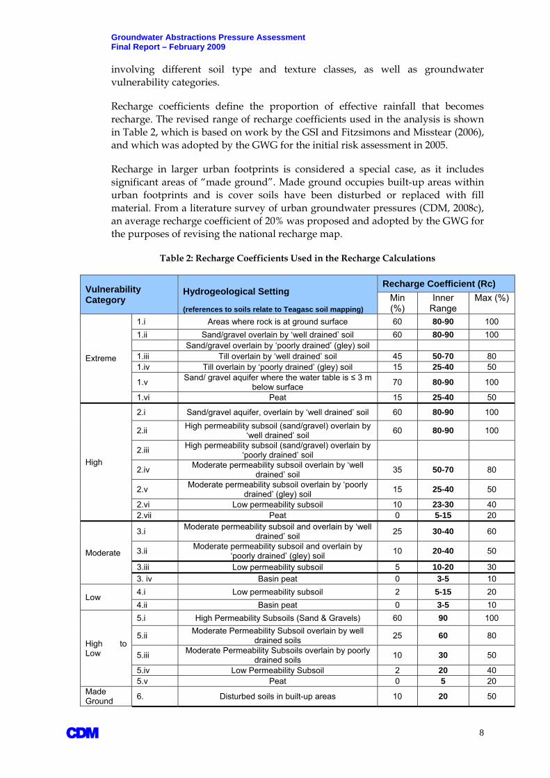
Groundwater Abstractions Pressure Assessment Final Report – February 2009 involving different soil type and texture classes, as well as groundwater vulnerability categories.
Recharge coefficients define the proportion of effective rainfall that becomes recharge. The revised range of recharge coefficients used in the analysis is shown in Table 2, which is based on work by the GSI and Fitzsimons and Misstear (2006), and which was adopted by the GWG for the initial risk assessment in 2005.
Recharge in larger urban footprints is considered a special case, as it includes significant areas of “made ground”. Made ground occupies built-up areas within urban footprints and is cover soils have been disturbed or replaced with fill material. From a literature survey of urban groundwater pressures (CDM, 2008c), an average recharge coefficient of 20% was proposed and adopted by the GWG for the purposes of revising the national recharge map.
Table 2: Recharge Coefficients Used in the Recharge Calculations
Vulnerability Category
Hydrogeological Setting (references to soils relate to Teagasc soil mapping)
Recharge Coefficient (Rc) Min (%)
Inner Range
Max (%)
Extreme
1.i Areas where rock is at ground surface 60 80-90 100 1.ii Sand/gravel overlain by ‘well drained’ soil 60 80-90 100 Sand/gravel overlain by ‘poorly drained’ (gley) soil 1.iii Till overlain by ‘well drained’ soil 45 50-70 80 1.iv Till overlain by ‘poorly drained’ (gley) soil 15 25-40 50
1.v Sand/ gravel aquifer where the water table is ≤ 3 m below surface 70 80-90 100
1.vi Peat 15 25-40 50
High
2.i Sand/gravel aquifer, overlain by ‘well drained’ soil 60 80-90 100
2.ii High permeability subsoil (sand/gravel) overlain by ‘well drained’ soil 60 80-90 100
2.iii High permeability subsoil (sand/gravel) overlain by ‘poorly drained’ soil
2.iv Moderate permeability subsoil overlain by ‘well drained’ soil 35 50-70 80
2.v Moderate permeability subsoil overlain by ‘poorly drained’ (gley) soil 15 25-40 50
2.vi Low permeability subsoil 10 23-30 40 2.vii Peat 0 5-15 20
Moderate
3.i Moderate permeability subsoil and overlain by ‘well drained’ soil 25 30-40 60
3.ii Moderate permeability subsoil and overlain by ‘poorly drained’ (gley) soil 10 20-40 50
3.iii Low permeability subsoil 5 10-20 30 3. iv Basin peat 0 3-5 10
Low 4.i Low permeability subsoil 2 5-15 20 4.ii Basin peat 0 3-5 10
High to Low
5.i High Permeability Subsoils (Sand & Gravels) 60 90 100
5.ii Moderate Permeability Subsoil overlain by well drained soils 25 60 80
5.iii Moderate Permeability Subsoils overlain by poorly drained soils 10 30 50
5.iv Low Permeability Subsoil 2 20 40 5.v Peat 0 5 20
Made Ground 6. Disturbed soils in built-up areas 10 20 50
A 8

Groundwater Abstractions Pressure Assessment Final Report – February 2009 The revised distribution of recharge coefficients is defined by several new combinations of soil and subsoil scenarios, reflecting the:
Recently published national soil and subsoil maps by Teagasc (2006); and
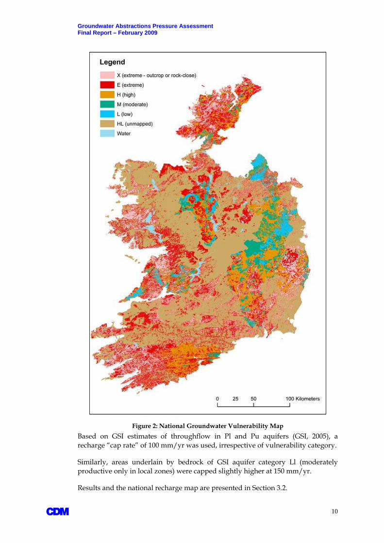
Updated national groundwater vulnerability map of Ireland distributed by GSI (2006) and reproduced in Figure 2. It accounts for GSI’s recently completed vulnerability mapping in counties Galway and Cavan for all vulnerability categories, as well as areas of extreme vulnerability across all counties in Ireland by individual RBD projects in 2004 and 2005.
In areas not yet covered by GSI’s detailed vulnerability mapping, recharge coefficients were assigned according to subsoil permeability indicated by either GSI drilling results or subsoil mapping by Teagasc (in that order).
2.1.3 National Groundwater Recharge Map A national groundwater recharge map of Ireland has been produced which builds on the original recharge estimates produced by each individual RBD project in 2005 and incorporates the updated recharge coefficients described above. Significant effort was made in synthesizing all available data and GIS information from the various RBDs into a single consistent format.
Recharge to each groundwater body was computed by applying the recharge coefficients to a national map of effective rainfall provided by Met Eireann, using their 30-year annual median rainfall distribution for years 1961-1990. Details of the GIS processing of recharge computations across each GWB are provided in Appendix A, and represent a supplement to the risk assessment test methodology (GWG, 2005).
Computed recharge in areas underlain by “poorly productive aquifers” (PPAs) were adjusted on account of their (generally) low storage and transmissive properties. PPAs comprise groundwater bodies of generally low-permeability bedrock, and are significant as they cover approximately two-thirds of the total land area of Ireland.
Because of their low transmissive and storage properties, PPAs are not capable of accepting all the recharge that may be available, resulting in rejected recharge (Aldwell et al, 1983) and enhanced discharges to local streams via shallow groundwater pathways and overland flow. As a result, PPAs tend to be characterised by small, localised groundwater flow systems.
To account for rejected recharge, a maximum recharge limit or cap was used in the final assignment of recharge over PPAs, defined by GSI aquifer categories Ll, Pl and Pu:
Ll – Locally important aquifer, moderately productive only in local zones
Pl - Poor aquifer, generally unproductive except for local zones
Pu - Poor aquifer, generally unproductive
A 9
Groundwater Abstractions Pressure Assessment Final Report – February 2009
Figure 2: National Groundwater Vulnerability Map Based on GSI estimates of throughflow in Pl and Pu aquifers (GSI, 2005), a recharge “cap rate” of 100 mm/yr was used, irrespective of vulnerability category.
Similarly, areas underlain by bedrock of GSI aquifer category Ll (moderately productive only in local zones) were capped slightly higher at 150 mm/yr.
Results and the national recharge map are presented in Section 3.2.
A 10
Groundwater Abstractions Pressure Assessment Final Report – February 2009
2.2 Impacts of Groundwater Abstractions Potential impacts of groundwater abstractions relate to both groundwater resources and associated surface water ecosystems:
Reduced groundwater availability;
Lowered groundwater levels;
Altered flow gradient;
Reduced groundwater throughflow and discharge;
Induced saline intrusion (in coastal areas).
Guided by the revised risk assessment results, potential “at-risk” scenarios were reviewed on a case-by-case basis. Site-specific knowledge was researched to try to ensure that local conditions are as accurately considered as possible. Results are presented in Section 3.4.
One of the challenges encountered was identifying impacts of groundwater abstractions on river flow thresholds (RFTs). The WFD places emphasis on ecologically-based thresholds for river flows, beyond which more stringent environmental standards (and programmes of measures) may apply. While different methods for determining ecological instream flows are found in the literature, these are difficult to derive and to agree on, due to their location-specific nature. Competing interests define and interpret RFTs differently. A parallel FC study on surface water abstractions (CDM, 2008a) attempted to define aquatic base flows (ABF) from correlations between river flow data and EPA’s biological Q indices. Subsequent discussions amongst stakeholders resulted in the abandonment of ABFs on the basis that different habitats require different ABFs, and insufficient scientific information is available to specify which ABFs would be more representative. More importantly, the EPA Q index is subject to variables that are somewhat subjective in nature. It was therefore decided that basing ABFs on Q-indices would not be scientifically defensible.
For these reasons, abstraction rates, by themselves, were reviewed in context of EPA-estimated Q95 values. The Q95 is the flow in a river which is exceeded 95% of the time.
2.3 Groundwater Abstraction Licensing System Although groundwater remains secondary to rivers and lakes as a source of water for public supply at the national level, groundwater resources are becoming increasingly developed for large-scale public supply schemes in counties such as Kildare, Kilkenny, Laois, Wexford, Louth and Meath. Even counties with limited groundwater resources such as Wicklow are exploring new groundwater alternatives.
Growing water demands across Ireland highlights the need for an updated regulatory framework for water resources management. The increased use of
A 11

Groundwater Abstractions Pressure Assessment Final Report – February 2009 groundwater implies a need for improved controls on new and planned abstraction schemes.
Article 11.3(e) (Programme of Measures) of the WFD specifically requires that abstraction controls are put in place by EU member states. As described in Section 5, this involves maintaining an active Register of abstractions and a system of “prior authorisation”. In the Irish context, this implies an abstraction licensing system.
A licensing and registration system is therefore regarded as one possible means of regulating abstraction in a sustainable manner, whereby potential cases of impact (to surface waters or GWDTEs) are predicted, monitored, and verified.
Consequently, this FC study was tasked with exploring and summarizing the technical elements that would form part of a potential future licensing regime, based largely on experiences in Northern Ireland and Scotland, and coordinating activities with the following related work:
Quantitative status classification of groundwater bodies across Ireland (EPA, 2008);
Framework for the Assessment of Groundwater-Dependent Terrestrial Ecosystems under the Water Framework Directive (Kilroy and Dunne, 2008).
SNIFFER (2005) framework for the assessment of groundwater abstractions.
The existing regulatory environment for groundwater abstractions in Ireland, along with the proposed framework for licensing, is presented in Section 4 while the technical elements of licensing guidance are described in Section 5.
A 12
Groundwater Abstractions Pressure Assessment Final Report – February 2009
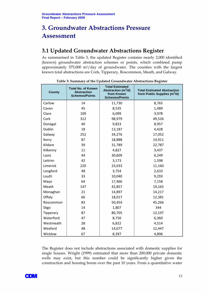
3. Groundwater Abstractions Pressure Assessment 3.1 Updated Groundwater Abstractions Register As summarised in Table 3, the updated Register contains nearly 2,000 identified (known) groundwater abstraction schemes or points, which combined pump approximately 575,000 m3/day of groundwater. The counties with the largest known total abstractions are Cork, Tipperary, Roscommon, Meath, and Galway.
Table 3: Summary of the Updated Groundwater Abstractions Register
County Total No. of Known
Abstraction Schemes/Points
Total Estimated Abstraction (m3/d)
from Known Schemes/Points
Total Estimated Abstraction from Public Supplies (m3/d)
Carlow 14 11,730 8,765 Cavan 45 8,535 1,489 Clare 109 6,099 3,978 Cork 312 98,979 49,526 Donegal 40 9,823 8,957 Dublin 18 13,187 4,428 Galway 252 34,276 17,052 Kerry 87 18,888 14,911 Kildare 39 31,789 22,787 Kilkenny 11 4,827 3,437 Laois 44 30,609 6,249 Leitrim 42 3,173 1,598 Limerick 220 23,033 11,160 Longford 48 3,754 2,633 Louth 33 10,040 9,293 Mayo 64 17,466 7,158 Meath 147 42,857 19,165 Monaghan 21 14,897 14,217 Offaly 66 18,017 12,381 Roscommon 83 50,454 45,266 Sligo 14 1,807 344 Tipperary 87 80,705 12,197 Waterford 47 8,750 6,360 Westmeath 28 6,822 4,514 Wexford 48 14,677 12,447 Wicklow 67 8,397 4,896
The Register does not include abstractions associated with domestic supplies for single houses. Wright (1999) estimated that more than 200,000 private domestic wells may exist, but this number could be significantly higher given the construction and housing boom over the past 10 years. From a quantitative water
A 13

Groundwater Abstractions Pressure Assessment Final Report – February 2009 management and WFD perspective, domestic wells are of reduced consequence, as nearly all domestic water returns to the ground through onsite septic systems.
The single largest groundwater abstraction scheme nationally is the Lisheen mine in North Tipperary, which actively pumps 65,000 m3/day on average from the mined area.
Figure 3 provides a summary, by county, of groundwater abstractions associated with public water supplies. An estimated 305,000 m3/day is pumped for public supply. The estimated equivalent figure for Group Water Schemes is approximately 45,000 m3/day.
Figure 3: Estimated Groundwater Abstraction for Public Supply by County
By comparing groundwater supplies to the sum of all public water supplies nationally, the updated Register indicates that groundwater would represent approximately 16% of total public water supplies. This figure would rise to almost 21% if the surface water sources that supply Greater Dublin (Poulaphuca and Leixlip reservoirs) are excluded.
The updated Register contains data gaps in relation to surface water abstractions for Group Water Schemes. It is therefore not possible at this time to present reliable comparisons between groundwater and surface water supplies to GWSs.
Approximately 100 known groundwater abstraction schemes, public or private, produce more than 1,000 m3/day, as summarised in Figures 4 and 5. Some of the larger public supply schemes such as Monaghan Town consist of several wells that
A 14

Groundwater Abstractions Pressure Assessment Final Report – February 2009 each produce less than 1,000 m3/day but that combined add up to several thousand m3/day.
Approximately 550 known abstraction schemes or points produce more than 100 m3/day. The majority of known supply schemes produce between 10-100 m3/day. Such schemes tend to serve small communities, private entities, and industry. There are also numerous smaller supplies for which actual production data do not exist, but are generally thought to produce less than 10 m3/day.
Figure 4: Known Groundwater Abstraction Schemes > 1,000 m3/day
A 15

Groundwater Abstractions Pressure Assessment Final Report – February 2009
Figure 5: The Groundwater Abstractions Register by Thresholds 3.1.1 Unregistered Abstractions The current national abstractions Register includes public supply schemes and private abstraction points that are known from information collected and verified by individual RBD projects. The collated data is primarily based on Local Authority records, as well as information researched with the GSI, EPA, well drillers, and consulting firms.
The updated Register is almost certainly underestimating the total number of abstraction schemes or points across the country, and as a result, the total abstraction volumes may also be under-represented. Well drillers across the country report an explosion in drilling activity in recent years, primarily for industrial and commercial entities, mainly in response to the introduction of water rates for non-domestic services.
Domestic supply wells aside, the total number of non-domestic abstractions that may be missing from the current Register could be in the hundreds, if not thousands. Important categories of non-domestic users of groundwater that may have their own groundwater supplies (and that are not in the present Register) are (in no particular order):
Quarries
Farms
Golf Courses
Industry/Commerce/Other
A 16

Groundwater Abstractions Pressure Assessment Final Report – February 2009 3.1.1.1 Quarries Groundwater is abstracted in quarry operations for dewatering purposes, processing of aggregate, and cement production. While the GSI maintains a register of active quarries (with more than 400 entries at present), and each local authority has recently updated their quarry registries under Section 261 (4) of the Planning and Development Act 2000, a review of existing registries reveals that information about water use generally and groundwater abstraction specifically is cursory or missing in the vast majority of cases. Hence, the number of quarries which operate pumping wells and actual quantities abstracted are not known. It may therefore not be possible to fully assess the current and future quantitative impacts of quarry dewatering activities until abstraction licensing comes into force in Ireland.
Based on the information that is available, some operators are known to abstract groundwater at rates exceeding 1,000 m3/day. The largest known quarry dewatering system pumps groundwater in excess of 20,000 m3/d. The vast majority of dewatering operations would be far smaller than this, but the existence of such large abstractions nonetheless highlights the importance of recording water source, abstraction rate, and usage information in future registration activities.
The same is true for surface water. Groundwater that is abstracted for dewatering or processing purposes is commonly discharged back into local rivers or streams under discharge licence regulations. Some quarry operators hold Integrated Pollution Prevention Control (IPPC) licences with the EPA. Whereas IPPC licences stipulate discharge volume limits to surface or groundwater as well as environmental monitoring requirements, few of the licences reviewed include information about sources of water used or dewatering operations.
Similarly, mines operate under IPPC licences with strict environmental controls enforced by the EPA. There are few mines in Ireland, and information on all of the mine dewatering operations have been accessed as part of this study and have been included in the national abstractions Register.
3.1.1.2 Farms Farms that pump groundwater may use the water for domestic purposes, general farm operations, and irrigation.
There are no readily available statistics for water use associated with irrigation. An EU-wide report (Baldock et al, 2000) concludes that water demand for irrigation is “relatively insignificant” in Ireland, but irrigation is practiced in the south and east of the country. Quoting Teagasc, Baldock et al report that less than 1,000 hectares (ha) of potato and vegetables crops, and 100 ha of strawberries, are actively irrigated. The information system (Aquastat) of the Food and Agricultural Organisation (FAO) indicates that the majority of areas equipped for irrigation within Ireland are located in Dublin (624 ha), followed by counties Cork (160 ha) and Meath (136 ha).
According to Baldock et al, potato and vegetable crops “might receive two applications of about 25 mm/ha” in a year from sprinkler systems, while
A 17

Groundwater Abstractions Pressure Assessment Final Report – February 2009 strawberries “might receive up to” 100 mm/ha through drip systems. If it is assumed that groundwater is the sole source of water, the above statistics would suggest that groundwater abstractions for irrigation purposes could total 700,000 m3/yr. However, this is probably an overestimate. Baldock et al quote surface water as the main source of water for irrigation purposes. While the presence of irrigation wells are known in places like north Dublin and Fingal, actual groundwater abstractions for irrigation purposes nationally are not known.
All irrigation is carried out on an individual farm basis, and is largely seasonal. A proportion of the irrigation water will recharge back into the ground and into groundwater.
For farm operations, the largest quantities of water used would be associated with dairy farms, to wash farm yards and machinery, and to supply drinking water for dairy cows. A preliminary but nonetheless very helpful estimate of total non-domestic water use on an “average-sized” dairy farm of 70 cows would approximately 6.5 m3/day (Richards, 2008). For an estimated 20,000 active dairy farms in Ireland (Teagasc, 2008), and assuming that each farm is abstracting groundwater, this equates to a total groundwater abstraction rate for dairy farm purposes of 130,000 m3/day.
3.1.1.3 Golf Courses Golf courses are irrigated during dry weather periods, mostly in the summer months. The precise number of golf courses that irrigate with groundwater is not known, but there are approximately 420 golf courses in Ireland and it is assumed that many have private groundwater supplies. Irrigation is practiced in dry summers but may not be needed at all in wet summers.
An indication of water demand on the Tralee golf course is provided in an article in the Greenside Magazine (March, 2008). The golf course is not supplied by wells, and a 1.3 million gallon reservoir is kept full in the winter months from town water mains to ease pressure on summer supply restrictions by the county council. The reservoir provides sufficient water to meet the irrigation demands for a 14-day period, equivalent to supply of approximately 400 m3/day.
Irrigation volumes are a function of golf course size and design. Limited information obtained during this study would suggest that abstraction rates for any given golf course can vary from less than 10 m3/day up to 1,000 m3/day. Assuming an average of 200 m3/day, and an effective pumping period of 30 days in a year, this would equate to a total abstraction rate of 2,500,000 m3/yr (for 420 golf courses). This is 5 times higher than the current total of the national abstractions Register, and while it is very likely an overestimate, it points out the need to carry out a detailed national survey of abstractions and irrigation of golf courses.
3.1.1.4 Industry/Commerce/Other There are numerous potential other unregistered groundwater users in the industrial and commercial sectors, as well as the expanding (small-scale) geothermal industry. Locations of approximately 160 industrial wells have been identified, but this likely represents only a fraction of industrial or commercial
A 18

Groundwater Abstractions Pressure Assessment Final Report – February 2009 groundwater users around the country. Potential other categories of well users not described above include hotels, sports clubs, car washing facilities, creameries, and the food and drinks industry.
Planning permission records generally do not include details of sources of water supply, and there is currently no formal reporting mechanism in place to capture such potential abstractions.
There is therefore considerable room for improvements to the national abstractions Register. A mandatory Register of abstractions is regarded by this project as a necessary and recommended step towards improved water resources management practice.
Finally, although the Register of public and some private supplies is current as of September 2008, it is possibly already outdated in the sense that some schemes may have been modified or upgraded in the period since the abstractions were last verified with Local Authorities and private entities. The Register is therefore an ever changing database, which needs regular maintenance.
3.2 National Groundwater Recharge Map The resulting national groundwater recharge map is shown in Figure 6 and Table 4 summarises the recharge computations for all GWBs by the major types of groundwater flow regimes defined by the GSI. Normalised to GWB areas, and capped where applicable, computed recharge ranges from 60 to 890 mm/yr across the country. The higher values are associated with vulnerable groundwater scenarios in high rainfall areas, and are mostly associated with sand and gravel aquifers and karst areas in the west of Ireland (e.g., Burren karst).
Table 4: Summary of Computed Recharge by Flow Regime Computed Recharge
(m3/day per km2) Computed Recharge
(mm/yr)
Flow Regime Avg. Min Max Avg. Min Max Sand and Gravel 1,030 413 2,112 376 151 771 Karst 711 189 2,449 260 69 894 Fissured 618 163 1,600 226 60 584 Poorly Productive 385 166 1,264 140 61 461*
* - computed recharge >100 mm/yr is considered to be rejected in Pl and Pu aquifers. An equivalent cap of 150 mm/yr applies for Ll aquifers
The national groundwater recharge map is intended to be made available online through the GSI and EPA, and will be updated in the future as new subsoil information becomes available in counties undergoing continued GSI vulnerability mapping. Further improvement to the recharge map is also possible if an improved national effective rainfall map is developed with the assistance of Met Eireann.
Some of the mapping layers associated with recharge calculations do not extend to islands, and recharge estimates for such values were developed independent of the GIS-based methodology. Abstraction risks associated with island scenarios is
A 19

Groundwater Abstractions Pressure Assessment Final Report – February 2009 therefore assigned based on the site-specific knowledge of respective RBD projects and Local Authorities.
Figure 6: National Groundwater Recharge Map
3.3 Groundwater Abstraction Risk Assessment (2008) Results of the updated groundwater abstraction risk assessment using known abstractions and the updated recharge map are shown in Figure 7. Overall, patterns of risk are similar to those from 2005, but notable differences can be summarised as follows:
The Knockatallon GWB in Monaghan is no longer deemed to be at risk from overabstraction as the overall abstraction from the Knockatallon supply wells has been significantly reduced since 2005. Monaghan County Council has partly replaced groundwater with a new surface water supply.
The Bettystown groundwater body has now been placed in the at-risk category on the basis of new information received in relation to a large
A 20

Groundwater Abstractions Pressure Assessment Final Report – February 2009
dewatering scheme associated with the Platin cement works near Platin, Co. Louth, as well as planned pumping from new supply wells to the south of Drogheda.
With the possible exceptions of Inish Oirr and Inish Meain on the Aran Islands, it has been verified that abstraction risks are absent on the majority of WFD-listed islands as groundwater is used in very small quantities from shallow wells.
Figure 7: Updated (2007) Groundwater Abstractions Risk Assessment
Many of the category 1b “probably at risk” GWBs shown in Figure 7 represent GWDTEs which have not been re-assessed as part of this study. Recent work by the NPWS indicates that all of the “probably at risk” GWDTEs identified in 2005 will remain in the same risk category for EPA’s 2008 status classification of related GWBs.
It should be noted that actual risk may be influenced by hydrogeological factors which are not captured in the predictive risk assessment methodology. An
A 21
Groundwater Abstractions Pressure Assessment Final Report – February 2009 example is a high abstraction rate within a small GWB which is in hydraulic communication with, and induces transboundary flow from, a neighbouring GWB. By itself, the predictive GIS-based methodology would place the GWB in which the abstraction takes place at risk. However, as the abstraction straddles two or more GWBS that are hydraulically connected the predicted risk of overabstraction is in reality reduced.
Rule-based GIS methodologies also cannot consider the potential for 3-dimensional interactions between aquifer units and surface water features. The risk assessment methodology therefore allows for local knowledge and expert judgement to overrule predictive risk assignments provided there is supporting data or information to do so. Each RBD project has therefore examined the revised risk assessment results to ensure that hydrogeological principles and analysis are adequately and appropriately considered.
The national EPA water level monitoring network established in late-2006 for WFD purposes covers all those GWBs that are deemed to be either “at risk” or “probably at risk” from not meeting WFD quantitative status objectives. The network, shown in Figure 8, also incorporates “not at risk” scenarios intended to monitor long-term natural trends associated with climatic variations. Additional monitoring wells may be added by EPA on the back of the WFD groundwater quantitative status classification of GWBs nationally in 2008.
3.3.1 At-Risk Scenarios – Abstraction Rates vs. Recharge Test Eight GWBs are highlighted as “at risk” cases, as summarised in Table 5. Nearly all of these involve Lm and Rkd aquifers. These are among the more productive aquifers and include some of the largest known abstraction schemes in the country.
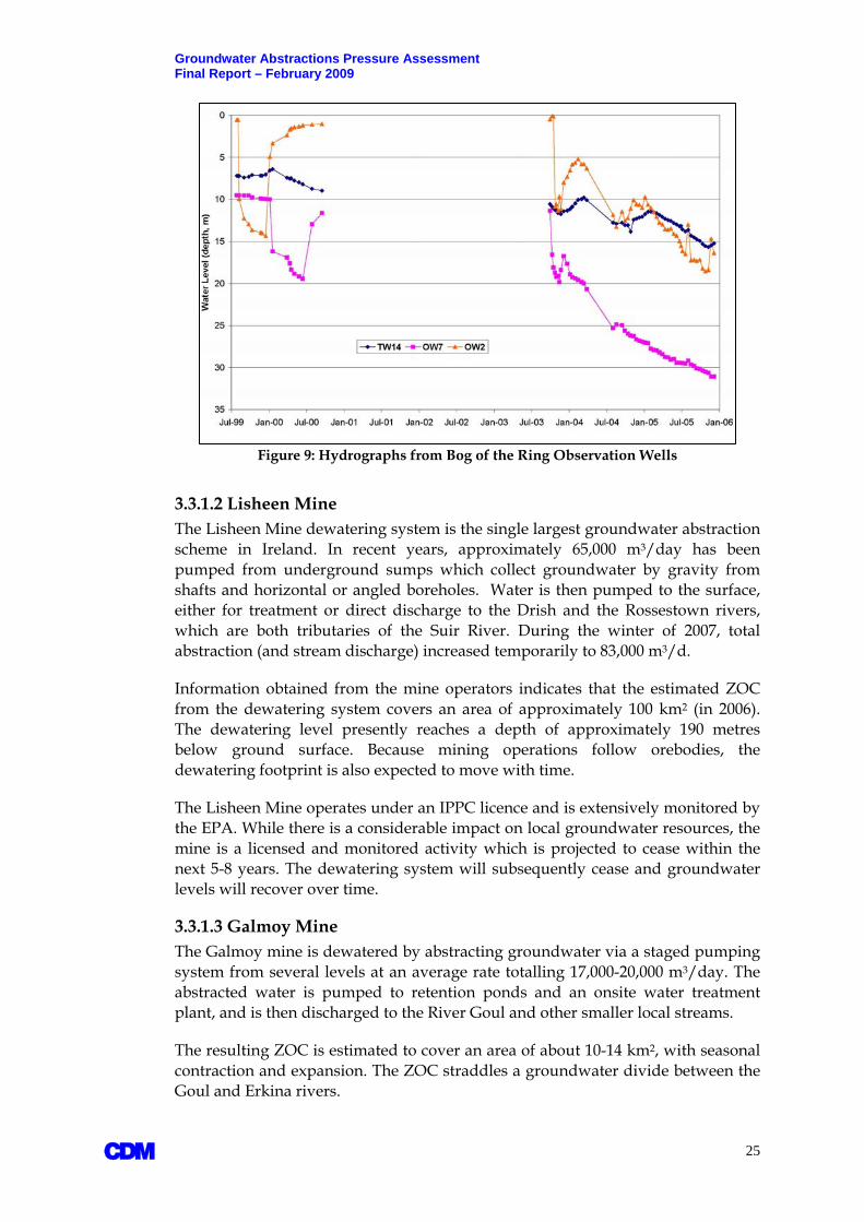
3.3.1.1 Bog of the Ring The Bog of the Ring (BOTR) wellfield operated by Fingal County Council (FCC) pumps 3,500-4,000 m3/day from four wells to supply the town of Balbriggan.
From the abstraction vs. recharge ratio risk test, the associated Lusk-BOTR GWB is classified as “potentially at risk” from meeting WFD status objectives by year 2015. However, this assignment uses the recharge estimate from the entire Lusk-BOTR GWB, which is significantly larger than the estimated zone of contribution (ZOC) of the wellfield (GSI, 2005; TES, 2006). If the estimated recharge is restricted to the area of the ZOC only, the resulting ratio is significantly higher, placing the wellfield firmly in the “at-risk” category.
The “at-risk” designation is substantiated by monitoring data. FCC has monitored groundwater levels extensively in the BOTR aquifer and shallow fluvial river deposits as part of a sustainability assessment between 2003 and 2006. The assessment was carried out in response to concerns about the long-term sustainability of the wellfield as well as potential impacts to the bog area which is a designated “proposed Natural Heritage Area” (pNHA).
A 22

Groundwater Abstractions Pressure Assessment Final Report – February 2009
A
Figure 8: EPA Groundwater Level Monitoring Network for WFD Purposes
Figure 9 shows measured water levels in three observation wells screened at different depths and in different geological formations. In each case, and over a 5-year period, water levels are declining gradually but steadily, lending evidence of potential overabstraction.
Continued monitoring of water levels at BOTR is recommended and is included in the EPA national network.
23

Groundwater Abstractions Pressure Assessment Final Report – February 2009
Table 5: Summary of At-Risk Scenarios
Groundwater Body
Total Abstraction
Total Estimated Recharge[1] Abstraction/Recharge Main Abstraction
Scheme County
(m3/day) (m3/day) Ratio (%) Lusk Bog of the Ring 3,972 24,212 16.4 Bog of the Ring wellfield Fingal Lisheen Mine 65,000 17,718 366.9 Lisheen Mine dewatering North Tipperary Galmoy Mine 20,000 13,982 143.0 Galmoy Mine dewatering Kilkenny Fardystown 20,655 14,725 140.3 Fardystown Supply Wexford Bettystown 14,800[3] 21,638 68.3[3] Platin Quarry dewatering Meath Drogheda Urban 1,400 4,460 31.9 Drogheda area supply Louth Dundalk Gravels 3,950 7,465 52.9 Dundalk area supply Louth Monaghan Town 10,900 28,821 37.8 Monaghan Town supply Monaghan Midleton 30,423[3] 31,943 95.2[3] Wood Quarry dewatering Cork
Aquifer Type[3] Flow Regime[3] Nearest Stream Nearest Gauging Reported Q95 Flow Station[4] (m3/day)[4] Lusk Bog of the Ring Lm FI/KA Matt NA NA Lisheen Mine Lm KA Drish, Rossestown 16039 and 16001 NA and 12,096 Galmoy Mine Rkd KA Goul 15049 NA Fardystown Rkd FI/KA Several small tributaries NA NA Bettystown Rkd KA Nanny and Boyne 08011 and 07012 5,184 and 259,200 Drogheda Urban Rkd/Lm FI/KA Boyne Estuary Tidal NA Dundalk Gravels Sand & Gravel SG Several small tributaries NA NA Monaghan Town Rf FI Blackwater 03051 4,320 Midleton Rkd KA Several small tributaries NA NA [1] - from national recharge map - 30-year average, 1961-1990 [2] – Total abstraction schemes involve quarry dewatering operations which could increase in the future as abstractions are not regulated [3] - as defined by GSI mapping [4] - EPA register of hydrometric stations
A 24
Groundwater Abstractions Pressure Assessment Final Report – February 2009
Figure 9: Hydrographs from Bog of the Ring Observation Wells 3.3.1.2 Lisheen Mine The Lisheen Mine dewatering system is the single largest groundwater abstraction scheme in Ireland. In recent years, approximately 65,000 m3/day has been pumped from underground sumps which collect groundwater by gravity from shafts and horizontal or angled boreholes. Water is then pumped to the surface, either for treatment or direct discharge to the Drish and the Rossestown rivers, which are both tributaries of the Suir River. During the winter of 2007, total abstraction (and stream discharge) increased temporarily to 83,000 m3/d.
Information obtained from the mine operators indicates that the estimated ZOC from the dewatering system covers an area of approximately 100 km2 (in 2006). The dewatering level presently reaches a depth of approximately 190 metres below ground surface. Because mining operations follow orebodies, the dewatering footprint is also expected to move with time.
The Lisheen Mine operates under an IPPC licence and is extensively monitored by the EPA. While there is a considerable impact on local groundwater resources, the mine is a licensed and monitored activity which is projected to cease within the next 5-8 years. The dewatering system will subsequently cease and groundwater levels will recover over time.
3.3.1.3 Galmoy Mine The Galmoy mine is dewatered by abstracting groundwater via a staged pumping system from several levels at an average rate totalling 17,000-20,000 m3/day. The abstracted water is pumped to retention ponds and an onsite water treatment plant, and is then discharged to the River Goul and other smaller local streams.
The resulting ZOC is estimated to cover an area of about 10-14 km2, with seasonal contraction and expansion. The ZOC straddles a groundwater divide between the Goul and Erkina rivers.
A 25

Groundwater Abstractions Pressure Assessment Final Report – February 2009 The Galmoy Mine operates under an IPPC licence and is extensively monitored by the EPA. Similar to Lisheen, groundwater levels will recover when mining operations cease in the future.
3.3.1.4 Fardystown The Fardystown public water supply scheme near Wexford operates eight abstraction wells that combined produce approximately 15,000 m3/day. The abstraction rate totals approximately 72% of the long-term average recharge of the associated GWB, and on this basis the groundwater body is deemed to be at risk from meeting WFD good status objectives by year 2015.
Water level monitoring is being carried out in observation wells that are between 1-4 kms away from the production wells. These are not considered to be optimally placed to monitor the hydraulic response of the wellfield. Groundwater level monitoring data for the period 2004-2007 have been reviewed and are inconclusive regarding potential negative impacts. There is an apparent downward trend in some of the wells, but the database is not deemed sufficiently long to draw definitive conclusions. The monitoring of the Fardystown GWB should therefore continue, and is included in EPA’s national monitoring network.
An EIS for Fardystown (PH McCarthy, 1990) recognised that the proposed levels of abstraction could have potential impacts on local streams and saline intrusion. The quantities presently pumped are lower than indicated in the original EIS.
3.3.1.5 Bettystown/Drogheda There are numerous abstraction schemes in operation in and around Drogheda. The largest individual scheme at present is the dewatering operation within Platin quarry, which pumps groundwater from the Bettystown GWB. Information received to date indicates that the quarry is pumping approximately 12,000 m3/day from two wells. The quarry is licensed to discharge up to 28,000 m3/day to the Nanny River under an IPPC licence agreement with EPA. The IPPC licence also allows the quarry floor to be deepened to an elevation of 20m below sea level which could see the need for expanded abstractions in the future.
Environmental monitoring reports are submitted annually to the EPA and Meath County Council (MCC). Concerns about the scale of abstraction have been raised by the public in relation to potential impacts on Duleek Commons, a wetland area a few kms from the quarry. The ZOC of the dewatering system is monitored and reviewed annually from observation wells surrounding the quarry and near Duleek Commons. This monitoring is intended to continue.
A nearby public abstraction scheme at Kiltrough is about to start pumping from the same GWB. Two supply wells were recently completed as part of the new East Meath/South Louth water supply scheme. These wells will produce approximately 1,400 m3/day each and will increase production to a planned total of 9,000 m3/day by year 2015.
The Bettystown GWB is a karstic limestone aquifer. It is bordered to the north by the Drogheda and Drogheda-Urban GWBs. These are part of the same hydrogeological system and while they are hydraulically connected, they were
A 26

Groundwater Abstractions Pressure Assessment Final Report – February 2009 subdivided along a surface water divide (serving as an assumed groundwater divide) to the south of the town of Drogheda for WFD reporting purposes.
The Bettystown, Drogheda and Drogheda-Urban GWBs should be regarded as a single hydrogeological system. For this reason, the abstractions at Platin Quarry and Kiltrough should be reviewed in context of other abstractions in and around Drogheda, such as the Drybridge and Ballymakenny public water schemes and industrial abstraction points within Drogheda’s urban footprint. The combined total abstraction (in mid-2008) from all these abstractions place respective GWBs into the “at-risk” abstraction category.
EPA’s national groundwater level monitoring network for WFD purposes includes wells at Gaskinstown and Kiltrough which serve to monitor potential impacts of the abstractions in the area to the south of Drogheda. Adequate monitoring of groundwater resources will have to accompany any further aquifer development in this area, including monitoring for saline intrusion. Monitoring associated with the Platin quarry may be included in the network at a future time.
3.3.1.6 Dundalk The Dundalk water scheme pumps groundwater from three wells at a combined rate of approximately 3,600 m3/day. The groundwater is derived from a locally important gravel aquifer which overlies a fractured bedrock aquifer. The degree to which the gravel and bedrock aquifers are interconnected are not known. The estimated abstraction:recharge ratio from the associated gravel GWB is 52%. If the gravel aquifer is in hydraulic continuity with the underlying bedrock aquifer, then the supply scheme draws groundwater from a larger area, reducing the overall contribution from the gravel aquifer. The gravel aquifer is monitored by the EPA. Water levels between 1998 and 2006 were stable, which could imply that the aquifer is not over-abstracted. Continued monitoring is recommended.
3.3.1.7 Monaghan Town The town of Monaghan is supplied by 10 wells which combined produce an estimated 10,900 m3/day. The abstraction:recharge ratio is approximately 32%, which places the associated GWB in the “at-risk” category. In terms of water level trends, existing water level data from a well in vicinity of the wellfield is inconclusive. Groundwater levels were dropping steadily between 1998 and 2001 but were rising gently between 2002 and 2006. Monitoring is continuing as part of EPA’s national monitoring network of groundwater levels for WFD purposes.
3.3.1.8 Midleton The Midleton GWB east of Cork City includes both smaller-scale industrial abstractions and large-scale quarry dewatering operations. The combined abstraction rate from the GWB totals more than 30,000 m3/day, and the resulting abstraction:recharge ratio for the associated GWB is nearly 100%, which places the GWB firmly in the “at-risk” category. Groundwater level monitoring data have not been obtained or reviewed, and future monitoring of groundwater water levels and salinity is recommended.
A 27

Groundwater Abstractions Pressure Assessment Final Report – February 2009 3.3.2 At-Risk Scenarios - Saline Intrusion There are approximately 100 known groundwater supply schemes within 1 km of the coastline, and approximately 330 known abstraction points within 5 km of the coast. Following the risk assessment methodology, only a few potential at-risk cases have been identified:
Inish Oirr in Co. Galway;
Cork City;
Carrigtwohill, Co. Cork;
Ardfert, Co. Kerry;
Dublin harbour;
Miscellaneous local-scale impacts in the west of Ireland.
Of these, only Inish Oirr and Cork City can be substantiated with data in this report. Sufficient monitoring data do not otherwise exist and individual other cases are inferred from anecdotal information or high abstraction rates in close proximity of coastlines.
3.3.2.1 Inish Oirr Figure 10 shows recent (2008) electrical conductivity data from a supply well on Inish Oirr. There is an increase in conductivity towards the summer months, when demands and pumping rates from two shallow, local wells increase. Abstraction rate and electrical conductivity is monitored on a regular daily schedule.
Figure 10: Electrical Conductivity in a Supply Well on Inish Oirr, 2008
Information from the well operators suggest that when the conductivity reaches 1,600 uS/cm, the water produced from the wells is blended with rainwater which
A 28
Groundwater Abstractions Pressure Assessment Final Report – February 2009 is collected in a balancing tank nearby. This may happen a few times each summer, but is not a persistent problem per se.
The cause of the salinity rise is periodic entrapment of saline/brackish groundwater. The wells are very shallow (only a few metres deep) and the local geology comprises gently dipping Carboniferous limestones. Groundwater conditions on the island are tidally influenced and the saline water influence is partly occurring naturally from tidal action in fissured (or karstic) limestones. The tidal action may be exaggerated periodically by the abstraction, especially during prolonged dry weather conditions. Information obtained to date indicates that Inish Meáin has experienced similar problems in the past (Galway County Council, 2008).
Similar scenarios are known to occur along the western coastline of Ireland, where small-scale abstractions associated with golf courses or hotels may become periodically impacted by saline groundwater.
In summary, Inish Oirr is concluded to be an “at-risk” scenario. However, the natural hydrogeological setting of the island is such that saline intrusion is also occurring naturally from tidal action.
3.3.2.2 Cork City There are three geothermal wells in Cork City which pump from the sands and gravel underneath the city. The pumped water is returned to the same aquifer at approximately the same rate via two injection wells. They are located only about 100 metres from the tidal River Lee. Sampling of the wells carried out as part of another FC study on urban groundwater pressures (CDM, 2008c) demonstrates that the pumped water is brackish/saline. The presence of saline is exaggerated by the abstraction, but it is also known to be naturally influenced by tides. Cork City occupies a reclaimed marsh area entirely surrounded by a tidal estuary. Allen and Milenic (2003) references normal tidal variations of 2-3 metres with a very shallow water table (<30 cm from street level at high tide) in some parts of the city centre. As a result, groundwater quality is brackish or saline and this has reportedly a corrosive effect on underground engineering structures and piping.
3.3.2.3 Other The other cases listed above are deemed to be potential “at risk” scenarios solely on the basis of the abstraction rate and distance from the coastline, per the risk assessment methodology. No detailed, site-specific monitoring data are available to verify whether or not saline intrusion is actually occurring. Individual cases should be followed up with appropriate monitoring.
Brackish/saline groundwater has been measured in both shallow and deep monitoring wells along Dublin harbour. The intrusion in the deeper limestones is probably tidal of a nature, whereas the reported saline cases in the shallow sand and gravel aquifer may be exaggerated by temporary dewatering during construction activities and underground drainage of large infrastructure such as the Port Tunnel entrance.
A 29

Groundwater Abstractions Pressure Assessment Final Report – February 2009
A 30
The Co. Cork case involves dewatering of quarries. The abstraction rate associated with one quarry (JA Woods, Carrigtwohill) exceeds 20,000 m3/d, and is located less than 2 kms from the coastline. Any saline intrusion impacts would be expected to be localised on the sea-ward side of the quarry.
In addition to the above cases, several private well operators in areas along the western coastline are reportedly experiencing seasonal or episodic salinity problems. These are associated with hotel and golf course development, and other industrial applications. It has not been possible to obtain details on such cases, but as referenced above, they may be partly tidal in nature.
Despite such occurrences, saline intrusion is not considered to be a wide-spread phenomenon, and is not considered a major water management issue in Ireland at the present time. Under WFD requirements, future groundwater development in coastal areas and on islands must be accompanied by appropriate hydrogeological studies and monitoring, as well as licensing of abstractions.
3.3.3 Potential Impacts to Groundwater Receptors All groundwater abstractions impact on groundwater levels and flow. The degree of impact is a function of numerous variables, including abstraction rate, location, and site-specific hydrogeology. Impacts to surface water bodies are usually in the form of reduced baseflow to rivers and streams. Impacts to GWDTEs (wetlands) can be more complex, involving changes to environmental supporting conditions (such as reduced flow, reduced water levels, and altered chemistry).
Each of the at-risk scenarios listed above have been researched for potential impacts to surface water features and ecosystems, as well other users. This has involved the national GWG, as well as cross-referencing cases with the EPA as part of their ongoing status classification work. In this process, the local knowledge of working members and other hydrogeologists has proven critical in identifying cases of known or potential impact.
Known or suspected cases of abstraction impacts to important receptors are summarised in Table 6. There are cases involving impacts to rivers and impacts to GWDTEs, but none that involve interference to other or adjacent abstraction schemes. Table 6 may not capture all cases of impact around the country, however represent those which have been identified or verified by RBD projects as abstraction-related. Each of the listed cases is subject to present or future planned study or monitoring by the EPA, NPWS, or Local Authorities.

Groundwater Abstractions Pressure Assessment Final Report – February 2009
Table 6: Known or Potential Impacts to Groundwater Receptors Known or Potential Impact Issue Comment Surface Water Bog of the Ring (Fingal) Potential reduced discharges to Matt River. Wellfield is included in EPA’s groundwater level monitoring network.
Potential issue with aquifer sustainability. Monitoring to continue.
Fardystown (Wexford) Lowering of groundwater levels. Potential impacts on headwaters of rivers and saline intrusion.
Observation wells included EPA’s groundwater level monitoring network. Study on potential impacts to headwaters of local streams and saline intrusion recommended.
JA Woods Quarry (Kerry) Section of stream ‘disappears’ upstream of quarry, and loss is directly linked to adjacent quarry. Karst aquifer.
Situation under review. Water from quarry is discharged back into the stream downgradient of the quarry. Proposal to cement off stream bottom in affected section has been rejected.
Lisheen Mine (North Tipperary) Small section of stream has dried up due to dewatering activities.
Water is pumped from quarry dewatering system back into the Drish stream, augmenting flow below the affected section of stream. Mine operates under an IPPC licence.
Castlemore Quarry (Cork) Small section of stream dries up due to quarry dewatering.
Water is discharged back into the river downstream of quarry. Mitigation measures may be necessary. Situation under review by EPA and local authority.
GWDTE/SAC
Pollardstown Fen (Kildare) Gradual drainage of and decline in groundwater levels, drying up a GWDTE (fen). Possibly linked to road construction.
Situation under review and monitoring. Observation wells included in EPA’s groundwater level monitoring network for WFD purposes. Mitigation measures to rehabilitate fen may be necessary.
Platin Quarry (Louth/Meath)
Significant dewatering, large and expanding zone of contribution, concerns about impacts on Nanny River And Duleek Commons (wetland).
Monitoring reports submitted regularly to Meath County Council. Data do not (yet) suggest impacts to Duleek Commons although this is under review. Impacts to Nanny River not quantified, but would be negated by present direct discharge of water under IPPC licence.
Lagan Quarry (Louth) Objection to planning application on the basis that expanded quarry could result in negative impact on local wetland area.
Under review by the NPWS.
Carrol Quarry (Laois) Quarry dewatering adjacent to a bog which has qualifying interests as a GWTDE. NPWS has been asked to study potential impacts.
Galmoy Mine (Kilkenny) Presence of GWDTE north of the mine (Galmoy Fen complex).
Monitoring data do not yet suggest impact, but situation requires close monitoring, especially if mine and dewatering system expands northward.
Derravaragh (Westmeath) Abstraction point (1,400 m3/day) near Lough Owel SAC and Sragh Bog SAC
Abstraction of 1,400 m3/day from the Taughmon GWS is greater than 5% of the estimated recharge for the Derravaragh GWB, and is located less than 1 km from the SE shore of Lough Owel which includes important alkaline fen habitats. Further study and monitoring is recommended.
A 31

Groundwater Abstractions Pressure Assessment Final Report – February 2009
4. Programmes of Measures Programmes of Measures (POMs) are mitigation measures that may be required by EU Member States to ensure that WFD status objectives are met in all water bodies, including groundwater, by year 2015. POMs are incorporated into River Basin Management Plans (RBMPs) which have to be submitted to the EC in June, 2009. Draft RBMPs are presently being prepared for each RBD in Ireland. These are due in December 2008 and will be available for a 6 month public review period. POMs are intended to address significant water management issues that have been identified in the characterisation phase of WFD implementation, as well as specific requirements of the WFD.
POMs are intended to address specified requirements of the WFD and significant water management issues that have been identified in both the Initial and Further Characterisation phases of WFD implementation to date. POMs will be revised by competent authorities every 6 years following a review of monitoring data being generated in the intervening period, as well as a re-assessment of environmental pressures. Thus, revised RBMPs will be submitted to the EC in 6-year cycles.
4.1 WFD Status Objectives The WFD status objectives for groundwater and surface waters are as follows:
Achievement of at least “Good” status by year 2015;
Prevention of deterioration from one status class to another;
Achievement of environmental standards for drinking water protected areas.
An initial status classification of water bodies is therefore fundamental to deciding where and what types of POMs may be required. The EPA is presently undertaking the status classification of all GWBs nationally, partly with input from FC studies carried out by the various RBD projects. Any GWB that is classified as being at less than Good (LTG) status due to abstraction pressures will require mitigation measures. Measures are basically of two types:
Basic measures – covered under existing statutory instruments (laws and regulations); and
Supplementary measures – new recommended measures that could be voluntary or made statutory. They could take the form of codes of good practice, bye-laws, or one-off actions (e.g., surveys and research).
The financial and political costs of returning a poor status groundwater body to good quantitative or ecological status are likely to be significant. The types of mitigation measures that could be needed are: (1) capping abstraction rates; (2) implementing water conservation programs; (3) upgrading water transmission systems to reduce leakage; (4) restricting development; and (5) identifying and building the infrastructure for alternative sources of water.
A 32

Groundwater Abstractions Pressure Assessment Final Report – February 2009
4.2 Existing Basic Measures There are several Basic Measures (BM) that are applicable to abstraction controls and that are covered by Irish Statutory Instruments (SI), as summarised in Table 7.
Table 7: Existing Basic Measures
Irish Legislation Corresponding EU Directive S.I. 722 of European Communities (Water Policy) Regulations 2003 Water Framework Directive (2000/60/EC)
S.I. 41 of 1999 Protection of Groundwater Regulations, 1999 (to be revoked 22/12/2013)
The Groundwater Directive (80/68/EEC) (To be revoked 22/12/2013)
S.I. 278 of European Communities (Drinking Water) (No. 2) Regulations 2007
The Drinking Water Directive (98/83/EC) (80/778/EEC repealed 25/12/2003)
S.I. 349 of 1989 EC (Environmental Impact Assessment Regulations) 1989 and amendments
The Environmental Impact Assessment Directive (85/337/EEC) as amended by Directive 97/11/EC
S.I. 94 of 1997 EC (Natural Habitats) Regulations, 1997 - 2005 The Habitats Directive (92/43/EEC)
S.I. 85 of 1994 EPA (Licensing) Regulations, 1994 & 2004
The Integrated Pollution Prevention Control Directive (96/61/EC)
Water Services Act 2007; S.I. 12 of 2001 Water Quality Dangerous Substances Regulations, 2001; Local Government (Water Pollution) Act, 1977 and amendments (Section 4 and 16).
The Dangerous Substances Directive (2006/11/EC) (76/464/EEC Repealed) and Daughter Directives
S.I. 436 of 2004 Planning and Development Regulations
Strategic Environmental Assessment Directive (2001/42/EC)
Related Policy Frameworks Purpose
National Water Pricing Policy Framework (1998)
To apply the principle of recovery of costs of water use; To promote efficient and sustainable water use
The principal, existing abstraction controls are summarised below.
4.2.1 Environmental Impact Assessment Directive The only legally required evaluation of potential groundwater abstraction impacts is stipulated in the Environmental Impact Assessment (EIA) Directive (85/337/EEC). An EIA is required for the following situations:
Drilling, other than test drilling, for water supplies, where the expected supply would exceed 2 million cubic metres per year (approximately 5,500 m3/day);
Groundwater abstraction and artificial groundwater recharge schemes where the average annual volume of water abstracted or recharged would exceed 2 Million m3/yr; and
Works for the transfer of water resources between river basins where the annual volume of water abstracted or recharged would exceed 2 Million m3/yr.
A 33

Groundwater Abstractions Pressure Assessment Final Report – February 2009 The EIA directive is included in statutory instrument (S.I.) No. 93 of 1999 (EC (EIA) (Amendment) Regulations, 1999) and referred to in Part 2 of Schedule 5 of the Planning and Development Regulations, 2001.
Because the abstraction threshold of 2 Million m3/yr is high, relatively few EIAs are carried out.
4.2.2 Water Supplies Act The Water Supplies Act, 1942 (S.I. No. 1 of 1942) permits a sanitary authority (i.e. a City or County Council) to take a supply of drinking water from a “source of water” under and in accordance with a provisional order that has been made and confirmed under that Act. Applications are made to and granted, refused or amended by An Bord Pleanala.
The expression “source of water” is defined to mean “any lake, river, stream, well, or spring”. Groundwater is not explicitly stated as a source, but is implied by the terms “well or spring”.
The Act was primarily intended to compensate downstream riparian landowners from losses caused by the abstraction of water for public water supply purposes. It did not consider groundwater and associated environmental impacts per se. However, the Act’s status as the sole piece of legislation covering abstraction projects has given it de facto status as the means of assessing (often by means of a public hearing) and regulating abstractions and attaching conditions to their management.
4.2.3 Planning and Development Regulations Groundwater abstraction proposals for water supply to Local Authorities (and others) are covered under the Planning and Development Regulations (2001), and proposals are subject to public consultations, notifications, and review. An Bord Pleanala may be brought in to review individual cases and render a verdict. This process may typically involve some level of technical assessment.
As the planning laws in Ireland are extensive, almost every borehole or well that is constructed to serve the public is included in a planning application. An Bord Pleanala will occasionally examine proposals which include the impact of the proposed development on local groundwater resources and potential environmental impacts. However, there are no general binding rules on criteria and thresholds, procedures, or the levels of assessment that may be required in any given situation. Hence, there may be a lack of consistency in how planning applications are reviewed.
4.2.4 Water Services National Training Group Procedures Manual Water services projects proposed by Local Authorities follow guidelines set out in the WSNTG Procedures Manual, which collects the information from current Departmental (DEHLG) circulars and other guideline material that is relevant to the planning and implementation of water services projects.
A 34

Groundwater Abstractions Pressure Assessment Final Report – February 2009 The first stage in planning a water supply abstraction is the preparation of a ‘Preliminary Report’ on the proposed scheme, typically by the Local Authority engineering department or consulting engineers on their behalf. Where such reports propose new or increased abstractions, the detail which accompanies the report can be of variable quantity and quality. The studies and reports are frequently prepared by engineering companies that may not have the hydrogeological expertise necessary to be able to factor in relevant influences or impacts of a scheme.
For public schemes, initial pumping tests of trial wells are normally carried out to assess or verify yield, to ensure that the recommended source would supply demands over a 20 year planning horizon.
Preliminary Reports are submitted to the DEHLG’s Water Services Engineering Inspectorate for detailed evaluation prior to approval by the Minister for the Environment, Heritage & Local Government to proceed with implementation of the project.
4.2.5 Local Government (Water Pollution) Act 1977 A comprehensive Register of abstractions greater than 25 m3/day is required by the Local Government (Water Pollution) Act, 1977 (S.I. No 117 of 1977). This applies to all abstractions, irrespective of the abstractor, and is administered by individual Local Authorities. The work by, and experienced of, the various RBD projects suggests that the completion and details of existing registries vary considerably across Local Authorities, and most are of poor quality. While the information resides in Local Authority files, the collation of information has required considerable effort on the parts of individual RBD projects. Even then, and as described in Section 2, considerable data gaps remain, particularly in relation to industrial and commercial abstraction schemes.
4.2.6 European Communities (Drinking Water) Regulations Once a public groundwater abstraction scheme is in place, it is monitored in the same manner as other sources based on the quantity of water supplied and number of people served, as defined by the European Communities (Drinking Water) (No. 2) Regulations 2007, (S.I. No 278 of 2007). Article 8 requires the Local Authority to keep a Register to record the details for each water supply for which it is a supervisory authority i.e. regulated private supplies.
4.3 WFD Requirements for Abstraction Controls Article 11.3(e) (Programme of Measures) of the WFD requires:
“controls over the abstraction of fresh surface water and groundwater, and impoundment of fresh surface water, including a register or registers of water abstractions and a requirement for prior authorisation for abstraction and impoundment. These controls shall be periodically reviewed and, where necessary updated. Member states can exempt from these controls, abstractions and impoundments which have no significant impact on water status.”
A 35
Groundwater Abstractions Pressure Assessment Final Report – February 2009 The current practice of “prior authorisation”, through EIA and planning laws, do not fully satisfy the WFD requirements. First, registers are not consistently kept or maintained. Second, the current system of prior authorisation tends to be implemented only for larger schemes exceeding the EIA regulation threshold. Third, the current practice does not factor in the WFD-defined GWB status.
As such, an improved system of prior authorisation is needed that meets the requirements of the WFD. A consistent and transparent system of licensing is regarded as one mechanism of achieving WFD objectives.
4.3.1 Existing Abstraction Regulations in Northern Ireland and Scotland A useful overview of abstraction control mechanisms around the world, including the UK, is included in the final report of the SNIFFER Project WFD 53 titled “Criteria for WFD Groundwater Good Quantitative Status and a Framework for the Assessment of Groundwater Abstractions” (SNIFFER, 2005). Of particular interest to Ireland is recent legislation introduced in Northern Ireland and Scotland. Both involve formal licensing of new groundwater abstraction schemes.
4.3.1.1 Northern Ireland Following a legal challenge by the EC for breaches of the Habitats Directive (Council Directive 92/43/EEC), and anticipating the requirements of the WFD, Northern Ireland established a new abstraction licensing regime in 2006. The “Water Abstraction and Impounding (Licensing) Regulations (Northern Ireland) 2006” cover abstraction from surface waters and groundwater under a process managed by the Northern Ireland Environment & Heritage Service (EHS). It uses a risk-based approach to licensing with two primary levels of authorisation:
Abstractions below 10 m3/day are known as Permitted Controlled Activities (PCAs) which require no interaction with the EHS (i.e., are exempt); and
Abstractions greater than 10 m3/day, for which licenses are awarded on the basis of the volume abstracted. Abstractions up to 100 m3/day require “simple licences” with few terms and conditions. Larger abstractions may require “complex licences” with terms and conditions that imply greater level of technical study on a case-by-case basis.
Prior to the enactment of the regulations, NI had limited controls over abstractions as well as an inconsistent registration system. The new regulations provide a consistent environmental approach that covers all abstraction and impoundment operations. The system includes licence application and maintenance fees.
It is important to note that the Habitats Directive, one of the drivers behind Northern Ireland’s decision to establish a licensing system, does not explicitly require Member States to introduce a licensing regime for water abstraction. However, it does require that any plan or project, either alone or in combination with other projects, that might have a significant impact on a protected site, must be subject to “appropriate assessment” before it receives consent to proceed. The same applies to the Republic of Ireland (ROI).
A 36

Groundwater Abstractions Pressure Assessment Final Report – February 2009 4.3.1.2 Scotland The WFD was transposed into Scottish law by means of the “Water Environment and Water Services Act 2003”, which gave the Scottish Environmental Protection Agency (SEPA) power to control water abstraction from all surface water and groundwater sources. The subsequent “Controlled Activities Regulations (CAR) of 2005” formally introduced licensing controls over abstractions for all types of water.
The abstraction regime, which is very similar to the regime in Northern Ireland, is based on General Binding Rules (GBR). Abstractions less than 10 m3/day are not subject to licensing, whereas abstractions greater than 10 m3/day require either “simple licenses” or “complex licenses” which may be subject to different levels of site-specific assessment. Like Northern Ireland, licensing may involve terms and conditions which are site-specific. A licence also requires that a 'responsible person' is identified who will ensure that the terms and conditions of the licence are complied with. A responsible person can be an individual, an organisation, or a partnership.
SEPA have similarly produced a 'Groundwater Protection Policy' which aims to:
Protect groundwater quality (by minimising the risks posed by point and diffuse sources of pollution); and
Protect groundwater resources by controlling abstractions and influencing developments, which could affect available groundwater resources.
SEPA have also created a schedule of administration charges for the licensing system, in addition to a detailed system of charging for use of the resource (which varies according to volume abstracted, season, location, etc.).
4.4 Proposed Licensing Framework for Ireland The proposed groundwater abstraction licensing framework for Ireland is similar to that of Northern Ireland and Scotland. A risk-based approach would be adopted whereby licensing requirements and levels of assessment increase in detail and complexity with higher abstraction rates and proximity to important groundwater receptors or users.
The proposed framework is summarised in Figure 11. Potential impacts of groundwater abstractions are initially screened against a set of basic criteria and thresholds (described in Section 5). The initial screening flags potential issues that may have to be looked at in closer detail, and informs the applicant about the required courses of action. Higher risk scenarios would require a greater level of technical assessment, and it is envisaged that a supervisory body will assist in the scoping, review and approval of technical study (and ultimately approval of a licence).
A 37

Groundwater Abstractions Pressure Assessment Final Report – February 2009
Figure 11: Proposed Licensing Framework
While it is envisaged that the majority of applications can be processed swiftly from initial screening criteria, larger schemes or those involving sensitive receptors will require site-specific study. The scoping and review should involve experienced hydrogeologists.
Section 5 provides details of the technical content of the licensing framework, including proposed criteria and thresholds for different levels of assessment. The following sections provide a brief overview of some of the implementation aspects of licensing that are deemed important to: a) fulfil the objectives of the WFD, and b) fit into the existing regulatory environment in Ireland.
A 38

Groundwater Abstractions Pressure Assessment Final Report – February 2009 4.4.1 Options for New Licensing Regulations Because primary legislation for groundwater abstractions licensing does not yet exist, new legislation will be necessary. There are two main options:
A wider modernisation of water resources legislation, similar to the modernisation of water services legislation which concluded with the Water Services Act, 2007.
An adaptation or extension of non-specific legislation (for example, the Planning & Development Regulations, the Environmental Protection Agency Acts, or the Local Government Acts).
4.4.2 Responsibilities Ireland has a different regulatory structure to Northern Ireland and Scotland, and it is not immediately apparent who would be responsible for implementation of an abstractions licensing system.
Responsibility for both delivery of water services and environmental monitoring to ensure compliance with various EU Directives, including aspects of the WFD, is presently vested in Local Authorities. Local Authorities are themselves promoters of large groundwater abstraction projects (for public supply), or sponsors of proposals by Group Water Schemes to develop small- to medium-sized groundwater abstractions. Local planning decisions, which may include permission for development of groundwater abstractions, are granted or refused by local authority planning departments.
Oversight and a range of other enforcement and auditing responsibilities are vested in the Environmental Protection Agency (EPA). The EPA includes several directorates, including the Office of Environmental Enforcement (OEE), which is responsible for the existing licensing functions of the EPA (waste disposal and recovery activities; industrial processing; integrated pollution prevention, etc.).
Development of policy for water services, environmental affairs and planning, and provision of funding for both the Local Authorities and the EPA is vested in the DEHLG. The DEHLG’s Water Services Engineering Inspectorate oversees the development by Local Authorities of water supply schemes, and provides advice to the Minister to allow approval to be granted for capital schemes.
In addition, An Bord Pleanala, the independent planning appeals authority, has both direct and indirect roles in abstraction matters. The Board is responsible for the determination of appeals and certain other matters under the Planning and Development Acts, which include the Local Government (Water Pollution) Acts, 1977 and 1990 (where the Board can grant, refuse, modify or revoke a licence to discharge effluent to waters) and the Water Supplies Act, 1942 (where the Board can grant, refuse, modify or revoke a licence to a local authority to abstract water).
Finally, the Geological Survey of Ireland (GSI) maintains a groundwater section which has historically advised Local Authorities (and their consultants) on hydrogeological aspects and impacts of proposed groundwater abstractions. The GSI, the DEHLG and the EPA jointly developed a methodology for the
A 39

Groundwater Abstractions Pressure Assessment Final Report – February 2009 preparation of Groundwater Protection Schemes (GSI, 1999). These provide guidelines for planning authorities in carrying out their functions, and a framework to assist in decision-making on the location, nature and control of certain activities to protect groundwater quality.
Unless a new licensing body is established, a groundwater abstraction licensing system would have to fit within the existing Irish environmental regulatory and supervisory framework insofar as possible. There are two primary options:
Running all applications through Local Authorities, following existing planning processes but involving a supervisory body as necessary to scope, review and approve complex licenses;
Setting up a new licensing division within the EPA, operating in a manner similar to the existing IPPC licensing system.
In the latter case, the existing responsibilities of Local Authorities to register abstractions and process planning applications are continued. New specific requirements would be introduced to provide thresholds and criteria beyond which abstraction proposals are referred to the supervisory body. The EPA could suitably serve this role. It is a role it already fulfils in a number of existing scenarios with respect to Local Authorities.
All abstraction applications for planning permission to a local authority, including Part VIII planning (where a local authority carries out a development within its own functional area), or directly to An Bord Pleanala (through the Strategic Infrastructure Act 2007 and other provisions), would initially be vetted to determine: a) whether a licence is required; b) the need for involvement of the supervisory body; c) the level of study and monitoring that may be required to assess environmental impact.
4.4.3 Interface with Existing Procedures There are three existing procedures which involve Local Authorities and Group Water Schemes, and that are directly applicable to water supply and groundwater abstraction licensing:
The planning process of Local Authorities. Planning permission for projects which include groundwater abstraction would be contingent on obtaining a groundwater abstraction licence.
The Water Services Act 2007, which provides for a system of licensing of Group Water Schemes (GWS) that supply more than 10 m3/day, or 50 or more persons. A significant proportion of GWSs rely on groundwater as the source of water. The Water Services National Training Group (on behalf of the Minister for the Environment, Heritage & Local Government) is in the process of developing guidance for this system, and would in time require interface with the groundwater abstraction licensing system.
Securing funding from the DEHLG for new schemes, including infrastructure to deliver water. The Certificates of Completion of Planning, which provide confirmation to the DEHLG that all the Planning, Public Notice, Public
A 40

Groundwater Abstractions Pressure Assessment Final Report – February 2009
Inquiry and Land Acquisition Requirements have been satisfied, would now be extended to ensure that Local Authorities or the supervisory body have certified that a groundwater abstraction application has undergone the required level of study and that a licence can be granted.
4.4.4 Format The licensing format would be similar to the established EPA managed IPPC process, shown in Figure 12. The format must be consistent on a national basis, and would in each case involve the Applicant, Local Authority and supervisory body.
Local Authorities would receive applications and process these initially according to an initial screening which involves the technical criteria and thresholds proposed in Section 5. Complexity then determines whether or not the application is sent to the supervisory body.
Figure 12: Existing IPPC Licensing Process
4.4.5 Time Limits Licensing schemes commonly involve time limits. To ensure compliance with the WFD, it may be appropriate to tie the review of (new) groundwater abstraction licences into the 6-year reporting cycles of the River Basin Management Plans. Existing abstractions schemes started prior to new licensing regulations coming into effect would be exempted, except if increases in abstraction rates are sought.
Certain licence holders would be required to provide monitoring to satisfy the Local Authority or supervisory body that terms and conditions of a licence are met. Depending on the terms and conditions attached to each future licence, the supervisory body would periodically carry out licence auditing and enforcement measures.
4.4.6 Costs While outside the scope of this study, it is noted that most licensing systems involve charges for either: a) administration - normally proportional to the complexity of the licence; and b) use of the resource – usually based on volume and type of use.
A 41

Groundwater Abstractions Pressure Assessment Final Report – February 2009 It is envisaged that Local Authorities in Ireland would incur basic administrative charges and potential extra costs for reviewing complex licenses. An equal, if not greater burden, would be placed on the supervisory body. It is expected that the annual number of licence applications greater than 1,000 m3/day would be relatively low (approx 10-15 per annum).
4.4.7 Retroactive Licensing Retroactive licensing of existing abstraction schemes could be regarded as unfair practice. However, existing developments that propose extending their operations would be subject to the licensing requirements. Retroactive registration, however, is proposed for all existing schemes greater than 100 m3/day and all existing regulated schemes (by Local Authorities) greater than 10 m3/day.
4.4.8 Training A national training programme will be necessary to implement the new licensing system. The training would cover the WFD-background, the licensing framework, thresholds and criteria, reporting, as well as the basic requirements of field-related study. The training programme would be geared towards a wide audience, including Local Authorities and practitioners within the groundwater industry.
A 42

Groundwater Abstractions Pressure Assessment Final Report – February 2009
5. Abstractions Licensing Guidance The technical elements of a future groundwater abstractions licensing system must address the water management topics that are central to the WFD. These relate primarily to WFD status objectives, as defined below.
The licensing system must also ensure that a register of abstraction is maintained and that the appropriate level of data becomes readily available for WFD reporting purposes, with improved certainty and greater confidence in reporting.
Ireland, like all EU Member States, will be required to report on GWB status, nationally, every 6 years. Thus, WFD status objectives are integrated into the licensing guidance.
5.1 WFD Status Objectives The overall WFD objective is to achieve “Good” status of all water types and associated ecosystems by year 2015. In the context of abstractions, the objective is to achieve “Good” quantitative status, as defined in Annex V of the WFD and reproduced in Table 8.
Table 8: WFD Definition of Good Quantitative Status
Primary Element
Good Status
Groundwater level
The level of groundwater in the groundwater body is such that the available groundwater resource is not exceeded by the long-term annual average rate of abstraction.
Accordingly, the level of groundwater is not subject to anthropogenic alterations such as would result in:
failure to achieve the environmental objectives specified under Article 4 for associated surface waters,
any significant diminution in the status of such waters,
any significant damage to terrestrial ecosystems which depend directly on the groundwater body,
and alterations to flow direction resulting from level changes may occur temporarily, or continuously in a spatially limited area, but such reversals do not cause saltwater or other intrusion, and do not indicate a sustained and clearly identified anthropogenically induced trend in flow direction likely to result in such intrusions.
The environmental objectives that are referred to in Table 8 are largely defined by individual EC Member States. The objectives that determine quantitative status in
A 43
Groundwater Abstractions Pressure Assessment Final Report – February 2009 Irish GWBs are detailed in the UK TAG guidance document titled “Proposals for a Groundwater Classification System and its Application in Regulation” (UK TAG, 2007), and summarised below.
5.1.1 Elements of Quantitative Status Assessment In classifying groundwater bodies, certain ‘tests’ are carried out against criteria and thresholds that define good quantitative status (UKTAG, 2007). The tests relate to Table 8 and consider the:
Water balance of the GWB (aquifer);
Potential impacts to the natural conditions of associated surface water bodies (rivers and lakes);
Relationship between the GWB and the environmental supporting conditions of GWDTEs; and
Risk of inducing saline intrusion in coastal settings.
5.1.1.1 Water Balance Status is determined by an assessment of the “available groundwater resource” within a GWB. Good quantitative status objectives are met when the “available groundwater resource is not exceeded by the long term annual average rate of abstraction".
The “available groundwater resource” is defined as:
“the long-term annual average recharge over the groundwater body less the long-term annual rate of flow required to achieve the ecological quality objectives for associated surface water specified under Article 4, to avoid any significant diminution in the ecological status of such waters, and to avoid any significant damage to associated terrestrial ecosystems”.
It therefore takes into account the ecological needs of rivers (flow requirements) and the environmental supporting conditions of GWDTEs within the GWB.
The need to define environmental supporting conditions of rivers and GWDTEs poses a particular challenge to hydrologists, aquatic ecologists, and fisheries officials, as these are frequently not known without considerable study or measurement. The ecological flow requirements of surface waters in particular have been the subject of some debate and there are presently no agreed thresholds for Irish surface waters in this context. As a first approximation, and until formal thresholds are established, the Q95 value is being used by the EPA as a surrogate flow threshold. The Q95 represents the flow in a river that is exceeded 95% of the time.
A 44

Groundwater Abstractions Pressure Assessment Final Report – February 2009 5.1.1.2 Diminution of Surface Water Flow Conditions All groundwater abstractions have an impact on flow and levels, which in turn influence the groundwater discharge rates to surface waters and associated ecosystems.
In terms of abstraction impacts to rivers, the classification test addresses potential impacts of individual abstractions on individual surface waters, taking account of all other potential pressures on the same feature, such as a direct surface water abstraction scheme on the same river. Conditions for “Good” groundwater quantitative status are not met when an associated surface water body does not meet its status objectives and at least a 50% loss of the river flow threshold (Q95) is caused by the groundwater abstraction. The Q95 applies at the point on the river opposite/close to the groundwater abstraction.
The application of this test requires site-specific knowledge of flow conditions on the river at the point of groundwater withdrawal, and all pressures that may influence these flow conditions. It is recognised that seasonality becomes important where potential influences of abstractions on river flow thresholds have to be evaluated.
The EPA is presently carrying out the status test as part of a national study on groundwater and surface water interactions.
5.1.1.3 Groundwater Dependency of GWDTEs Conditions for good quantitative status of GWBs associated with GWDTEs are not met when GWTDEs are “significantly damaged”. The term “significant damage” is not defined in the WFD, but relates conceptually to changes in the environmental supporting conditions such that GWDTEs become negatively impacted (“stressed”).
A research project by the EPA and NPWS (Kilroy and Dunne, 2008) recently defined three major classes of environmental supporting conditions for GWDTEs:
Fluctuations of water levels;
Influx of groundwater; and
Groundwater chemistry.
The quantitative status classification of GWBs that incorporate GWDTEs therefore requires site-specific knowledge of each GWDTE.
It may take years to study, understand and classify all. As a staring point, the NPWS has developed an initial list of 48 SACs which include GWDTEs as a qualifying interest. Until the appropriate level of study and monitoring are carried out, each of the 48 GWDTEs are presently considered to be potential “at-risk” cases for the purposes of WFD risk characterisation (EPA, 2005). A further 25 potential at-risk GWTDEs have recently been identified by the NPWS (NPWS, 2008), bringing the total potential “at-risk” cases to 73.
A 45

Groundwater Abstractions Pressure Assessment Final Report – February 2009 The majority of at-risk GWDTEs are represented by turloughs and raised bogs. Some of the GWDTEs have multiple individual sites of a single type (e.g. alkaline fen) or a single or few sites with many different types (e.g. alkaline fen, Cladium fen and petrifying spring).
Under the recent NPWS/EPA research project, the 48 initial GWDTEs were prioritised for detailed mapping. The resulting priority GWDTEs, as well as SACs with GWDTE qualifying interests, are highlighted in Figure 13. Most are located in the Shannon and Western RBD.
Figure 13: GWDTE and SAC Boundaries
A 46

Groundwater Abstractions Pressure Assessment Final Report – February 2009 For GWDTEs that have not yet undergone detailed mapping, the full SAC boundary is regarded as the potential GWDTE boundary. Thus, any licensing system has to take account of both the existing GWDTE mapping efforts and potential other GWDTEs represented by SAC boundaries.
In this context, the licensing review process will be tasked to identify the presence of GWDTEs or SACs with qualifying interests, and ensure that the EPA and the NPWS will play prominent roles in the review of licence applications. Future licensing of abstractions in proximity of GWDTEs should include inputs from both ecologists and hydrogeologists on a case-by-case basis.
5.1.1.4 Risk of Inducing Saline Intrusion While technically a qualitative classification element, saline intrusion typically occurs as a result of abstraction pressures. Induced by pumping, saline groundwater migrates landward in response to declining groundwater levels inland and as the freshwater/surface water interface attempts to find a new hydrodynamic equilibrium. The physical controls on intrusion rates and distribution are numerous, and groundwater status is appropriately determined through an assessment of trends in conductivity or other indicator substances (e.g., chloride, isotope ratios). Studies involving saline intrusion tend to be data intensive.
5.1.2 Scale Dependency The good quantitative status classification of a GWB does not automatically imply that further groundwater abstraction will be permitted – it depends on whether the proposed abstractions would result in unacceptable impacts. Conversely, poor quantitative status of a groundwater body does not necessarily impose a ban on additional groundwater abstractions. For example, a GWB may have been designated as being of poor quantitative status on the basis of a local-scale problem, yet the groundwater body may be very large and the problem confined to a small, specific area. In this case, further groundwater abstraction in another area of the same GWB may be permitted.
5.2 Licensing Framework The framework adopted for the licensing guidance is based on the SNIFFER WFD53 report entitled “Criteria for WFD Groundwater Good Quantitative Status and a Framework for the Assessment of Groundwater Abstractions” (SNIFFER, 2005). SNIFFER is a collaborative research organisation established to address WFD implementation in Scotland and Northern Ireland. The GSI contributed funding for SNIFFER WFD53, and participated in its development.
The concept behind the proposed licensing for Ireland was presented in Figure 11. It involves a decision-making process, whereby potential impacts of groundwater abstractions are initially screened against a set of basic criteria and thresholds. The initial screening raises warning flags and provides direction in terms of the course of action that is necessary, possibly involving review and interaction with the supervisory body. In principle, the actions that may be required are proportional to the potential impacts that are flagged. Impact assessment will therefore involve varying degrees of hydrogeological complexity, disciplines and skill-sets.
A 47
Groundwater Abstractions Pressure Assessment Final Report – February 2009 The intent would be to ensure that qualified individual or organisations are involved in defining the level of ecological and hydrogeological assessment that may be necessary, rather than prescribing a cook-book approach. There is a considerable risk that a great burden will be placed on the supervisory body, and it is therefore important to try and ensure that the initial screening process captures the essential technical requirements needed to assess impact.
5.2.1 Abstraction Categories Included The following abstraction categories are included in the licensing framework:
All public and private water supply schemes, supplying more than 10 m3/day (total daily volume) or serving more than 50 persons, including Group Water Schemes. This threshold is defined in Article 7 of the WFD;
All schemes serving industrial and commercial uses of water, supplying more than 10 m3/day (total daily volume);
Long-term dewatering schemes associated with quarries, mines and construction activities (whether temporary or permanent);
Most geothermal applications (see Section 5.2.2 for exemptions);
Agricultural schemes intended for irrigation and non-domestic farm use, supplying more than 10 m3/day (total daily volume);
Remediation of contaminated lands;
Arterial drainage within buffer zones defined herein.
Abstractions directly from emerging springs do not exert direct pressure on the GWB, and is therefore considered a surface water regulatory (licensing) issue, notably where springs gives rise to headwaters of streams and rivers. Springs in karst areas have to be considered differently, as emerging streams may disappear back into the ground further downstream through swallowholes. In this case, abstractions from springs could impact on downstream ecosystems and groundwater resources. Thus, abstractions from springs in karst areas would be subject to impact assessment through catchment-specific study.
5.2.2 Abstraction Categories Exempted There are several abstractions schemes that would be exempted from the formal licensing process, but that nonetheless would be subject to registration and certain terms and conditions, as described below.
Abstractions Less Than 10 m3/day Any abstraction that does not exceed 10 m3/day (total daily volume) or supplies a population less than 50 persons would be exempt from the licensing process.
Open Loop Geothermal Applications Open loop geothermal applications would be exempted from the licensing process provided:
A 48

Groundwater Abstractions Pressure Assessment Final Report – February 2009
Groundwater is pumped from and injected into the same aquifer (geological formation);
The volume of water abstracted is the same as that injected;
Geothermal wells that are not located within any of the buffer zones described herein;
The chemical composition of the abstracted water is not appreciably altered chemically prior to injection.
Aquifer Testing Trial wells that are pumped for aquifer yield estimation purposes would be exempted from the licensing process provided:
The trial well is part of an abstraction scheme for which a licence is being formally processed; and
The well is not pumped for more than 30 days; and
The pumping rate of the well does not exceed 1,000 m3/day (total daily volume).
Beyond these requirements, the aquifer testing has to receive prior authorisation in the same manner as permanent abstraction schemes.
Water Quality Sampling From Monitoring Wells Monitoring wells specifically and properly constructed for groundwater quality sampling purposes would be exempted from the licensing process.
Temporary Abstractions in the Construction Industry Temporary abstractions in the construction industry (water supply or dewatering) would be exempted. These will be identified and reviewed in context of existing discharge licence requirements and regulations.
Temporary abstractions are defined as abstractions from any associated well, borehole, collector trench or open pit.
The majority of large and longer-term abstractions in the construction industry are expected to require an EIA, in which case potential negative environmental impacts associated with the intended abstraction would also be identified. The EIS regulations should be updated to reference new abstraction licensing requirements, including new thresholds for impact assessment.
Intermittent Abstractions for Other Uses Intermittent abstractions would be exempt from the licensing process provided abstractions do not exceed 10 m3 on any given day. Examples would be abstractions for filling spray equipment, car washing, and swimming pools.
Emergency Abstractions Emergency abstractions are defined as those required to cover any human emergency or fire-fighting activity.
A 49
Groundwater Abstractions Pressure Assessment Final Report – February 2009
A 50
5.2.3 Definition of a Groundwater Abstraction Scheme A groundwater abstraction scheme is defined by the sum total abstraction rate (m3/day) and ultimately, the total number of wells or springs that provide the total quantity to be supplied from the same scheme.
A scheme consisting of multiple abstraction points would be assessed in its totality unless hydrogeologic reasoning dictates that the scheme can be justifiably divided into different components. In the latter case, it is envisaged that the application would be forwarded to the supervisory body for further review and decision-making.
All applications would be screened and processed on an individual basis. The licensing body will check each application in context of existing schemes and groundwater receptors within the same groundwater body. Uncertain or conflicting matters would be flagged by the licensing body and referred to the supervisory body for review and further decision-making.
5.3 Technical Content of the Licensing Framework The technical content of the licensing framework matches the elements of the status classification tests described in Section 5.1. Table 9 summarises the technical information that should be reviewed and considered in the application process by both the applicant and the decision-making entity.
During initial screening, it is particularly important that the application be checked against EPA’s status classification of water bodies that are associated with the abstraction scheme location. This could, ideally, be done online, both by the applicant and the licensing body. If the related GWB or associated groundwater receptor (e.g., river, GWDTE) is deemed to be at less than Good status due to groundwater abstraction pressures, then the application should be deferred to the supervisory body to verify the specific reason for the poor status classification. It is expected that subsequent processing of the application would be led by the supervisory body.

Groundwater Abstractions Pressure Assessment Final Report – February 2009
Table 9: Technical Information to be Provided or Reviewed during Initial Screening
Item
Information Required for Initial Screening Source/
Consultation Information Could be
Accessed Online
Abstraction Details Proposed rate and use Total rate of intended scheme and intended use Applicant n/a
Area identification Map of general area Conceptual diagram of supply distribution Applicant n/a
Single well, multiple wells Statement of intent Applicant n/a Demands Total demands of scheme Applicant n/a Groundwater Body (Aquifer) Groundwater body ID Official EU designation EPA Y Rock type/formation Aquifer type, formation name, flow regime, aquifer category GSI Y
Quantitative status
Official EPA designation, per classification tests for: Water balance Surface water diminution GWDTE Saline intrusion
EPA Y
Confined/unconfined conditions
Subsoil cover and type GSI, Teagasc Y
Groundwater vulnerability Vulnerability designation within study area GSI Y
Groundwater recharge Range of estimated long-term average recharge within study area GSI,EPA Y
Surface WatersNearest river/stream Name, description Applicant Y Nearest gauging station Station ID, type of station, records available EPA, OPW Y
Nearest surface water abstraction points Name, description, rate, recipient EPA, Local Authority Y
Nearest lake Name, description Applicant Y Ecological status of river/stream EPA designation EPA Y Ecological status of lake EPA designation EPA Y Groundwater Dependent Terrestrial EcosystemNearest mapped GWDTE Identification, type, sensitivity NPWS Y
Nearest SAC with a GWDTE qualifying interest Identification, type, qualifying interest
NPWS
Y
A 51

Groundwater Abstractions Pressure Assessment Final Report – February 2009
A 52
Item
Information Required for Initial Screening Source/
Consultation Information Could be
Accessed Online
Saline IntrusionNearest distance to coastline/tidal water Distance Applicant n/a
Groundwater conditions between proposed abstraction point and coastline
Bedrock type, formation name, flow regime, aquifer category, subsurface soils, other groundwater abstraction points, other GWBs (ID),quantitative status of other GWBs, surface water bodies
GSI, EPA, Teagasc, Applicant Y
Contaminated Land
Nearest contaminated land site Location, type, status (active/inactive) EPA, Local Authority Y
Nearest known landfill or waste facility Location, type, status (active/inactive) EPA, Local Authority Y
Other Groundwater Supplies
Nearest groundwater abstraction point Location, distance EPA, Local Authority Y
Total abstraction rate Daily volume/rate EPA, Local Authority Y
Single source, or multiple wells Description of scheme EPA, Local Authority Y
Aquifer pumped ID of GWB, formation, aquifer type EPA, GSI Y
Source protection scheme Name/ID, zone of contribution EPA, GSI, Local Authority Y
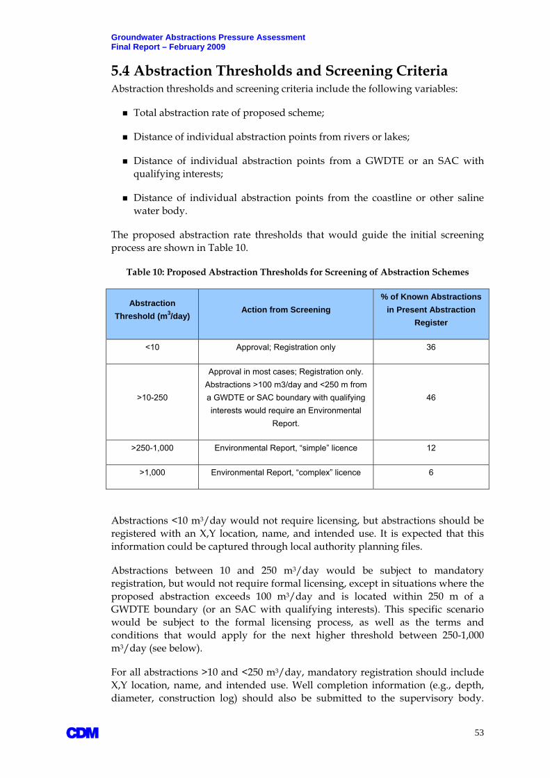
Groundwater Abstractions Pressure Assessment Final Report – February 2009
5.4 Abstraction Thresholds and Screening Criteria Abstraction thresholds and screening criteria include the following variables:
Total abstraction rate of proposed scheme;
Distance of individual abstraction points from rivers or lakes;
Distance of individual abstraction points from a GWDTE or an SAC with qualifying interests;
Distance of individual abstraction points from the coastline or other saline water body.
The proposed abstraction rate thresholds that would guide the initial screening process are shown in Table 10.
Table 10: Proposed Abstraction Thresholds for Screening of Abstraction Schemes
Abstraction Threshold (m3/day)
Action from Screening % of Known Abstractions
in Present Abstraction Register
<10 Approval; Registration only 36
>10-250
Approval in most cases; Registration only. Abstractions >100 m3/day and <250 m from a GWDTE or SAC boundary with qualifying interests would require an Environmental
Report.
46
>250-1,000 Environmental Report, “simple” licence 12
>1,000 Environmental Report, “complex” licence 6
Abstractions <10 m3/day would not require licensing, but abstractions should be registered with an X,Y location, name, and intended use. It is expected that this information could be captured through local authority planning files.
Abstractions between 10 and 250 m3/day would be subject to mandatory registration, but would not require formal licensing, except in situations where the proposed abstraction exceeds 100 m3/day and is located within 250 m of a GWDTE boundary (or an SAC with qualifying interests). This specific scenario would be subject to the formal licensing process, as well as the terms and conditions that would apply for the next higher threshold between 250-1,000 m3/day (see below).
For all abstractions >10 and <250 m3/day, mandatory registration should include X,Y location, name, and intended use. Well completion information (e.g., depth, diameter, construction log) should also be submitted to the supervisory body.
A 53

Groundwater Abstractions Pressure Assessment Final Report – February 2009
A 54
There is presently no mechanism to ensure that this happens on a routine basis. One possible mechanism is to make drilling companies responsible, under amended legislation (e.g., Water Pollution Act), to submit records of wells drilled, tested and completed on an annual or bi-annual basis.
Similarly, because of the large number of wells drilled in the past few years, a separate survey and registration of recently completed wells is recommended, notably for wells that have been drilled for industry and commercial entities. A good starting point would be drilling companies that routinely work for industrial and commercial clients.
For abstractions between 250 and 1,000 m3/day, applicants would generally be granted a “simple” licence under the conditions defined in Table 11. A simple licence implies a relatively “simple” level of assessment (See Section 5.4.1) and submittal of basic information in an Environmental Report. Under the conditions proposed in Table 11, an initial scoping meeting may be required with the supervisory body.
For abstractions greater 1,000 m3/day, a more “complex” license would be granted whereby the applicant is likely to be asked to perform a more detailed level of impact assessment, submit an Environmental Report, and carry out more stringent monitoring, as described in Section 5.4.1.
Abstraction schemes less than 250 m3/day are generally not expected to result in significant impact (Peer Review Group, 2008), leaving the licensing process to focus on abstractions >250 m3/day.
5.4.1 Levels of Assessment The proposed levels of assessment for the different abstraction thresholds are summarised in Figure 14. Higher abstraction rates imply an increased level of assessment and greater complexity in monitoring and reporting. For those scenarios in Table 11 where a supervisory body is or may be required, it is intended and recommended that scoping meetings be arranged such that appropriate field programmes and courses of action can be agreed on. This is expected to be beneficial to both the Applicant and the supervisory body.
Because of the site-specific nature of abstraction impacts, rule-based decision-making is not deemed appropriate for larger abstractions (those exceeding 1,000 m3/day). It is therefore proposed that all applications greater than 1,000 m3/day be directed automatically to the supervisory body for initial consultation. In this way, the licensing process takes immediate stock of relevant expertise that may be needed to steer an impact assessment in the right technical direction. The initial screening therefore serves to identify warning flags. Subsequent scoping between the Applicant and the supervisory body would ensure that the warning flags are addressed in the appropriate manner.
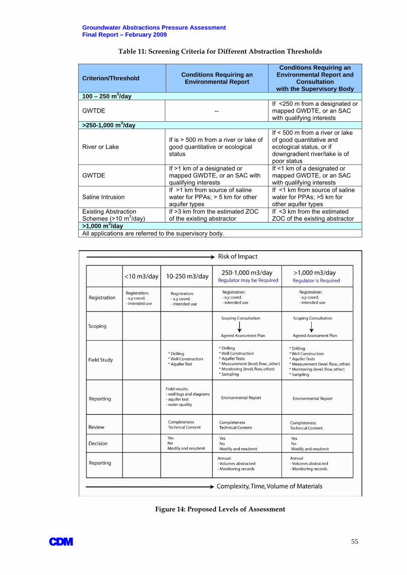
Groundwater Abstractions Pressure Assessment Final Report – February 2009
Table 11: Screening Criteria for Different Abstraction Thresholds
Criterion/Threshold Conditions Requiring an Environmental Report
Conditions Requiring anEnvironmental Report and
Consultation with the Supervisory Body
100 – 250 m3/day
GWTDE -- If <250 m from a designated or mapped GWDTE, or an SAC with qualifying interests
>250-1,000 m3/day
River or Lake If is > 500 m from a river or lake of good quantitative or ecological status
If < 500 m from a river or lake of good quantitative and ecological status, or if downgradient river/lake is of poor status
GWTDE If >1 km of a designated or mapped GWDTE, or an SAC with qualifying interests
If <1 km of a designated or mapped GWDTE, or an SAC with qualifying interests
Saline Intrusion If >1 km from source of saline water for PPAs; > 5 km for other aquifer types
If <1 km from source of saline water for PPAs; >5 km for other aquifer types
Existing Abstraction Schemes (>10 m3/day)
If >3 km from the estimated ZOC of the existing abstractor
If <3 km from the estimated ZOC of the existing abstractor
>1,000 m3/day All applications are referred to the supervisory body.
Figure 14: Proposed Levels of Assessment
A 55

Groundwater Abstractions Pressure Assessment Final Report – February 2009 5.4.1.1 Abstraction Category 10-250 m3/day With the exception of the one scenario involving GWDTEs (see Table 11), abstractions would be deemed authorised without a prescribed level of environmental assessment. Registration is required. Good practice would be to submit basic information, as follows:
Well construction diagram;
Aquifer test data;
Water quality results.
If the water is to be used for public consumption, water quality must be tested and must meet drinking water standards. The data would be submitted to the EPA and respective Local Authorities.
All abstraction schemes greater than 100 m3/day would be subject to annual recording and reporting of volumes of water pumped.
5.4.1.2 Abstraction Categories >250 m3/day Abstraction schemes greater than 250 m3/day would require the Applicant to submit an Environmental Report (ER). Provided the scheme does not require initial consultation with the supervisory body, the ER should, at a minimum, contain the following information:
Identification of existing abstraction schemes within a 3 km radius of the proposed new scheme (information is researched from a register of abstractions and/or other local information);
Identification and description of the aquifer and GWB from which the abstraction will take place;
Identification of nearest groundwater receptors;
Quantification of relevant metrics associated with the receptors (e.g., Q95 flow of a river);
An estimated water balance of the groundwater catchment in which the abstraction scheme is located;
The estimated Zone of Contribution (ZOC) of the new abstraction scheme, and its position in relation to nearest known abstractions schemes and nearby receptors;
Statement of expected or predicted impact;
Planned monitoring of abstraction rates and water levels.
The Environmental Report should be accompanied by all relevant field data, including:
Well construction diagrams;
A 56

Groundwater Abstractions Pressure Assessment Final Report – February 2009
Hydrogeological logs;
Relevant maps (e.g., groundwater catchment, associated receptors, ZOC);
Aquifer test data and results;
Water quality data.
Schemes that are flagged for supervisory input would involve an initial scoping meeting between the Applicant and the supervisory body. A conceptual model of the abstraction scheme and associated hydrogeological setting should be prepared as a basis for the scoping meeting.
Public or private supply schemes that are intended for human consumption, directly or indirectly (i.e., food processing) would require the development of Source Protection Areas following the guidance established by the GSI (1999). Such schemes would also have to prove compliance with drinking water standards.
All schemes greater than 250 m3/day would be required to maintain and submit reports of quantities of water pumped, and where applicable, related environmental monitoring data as stipulated by license conditions. At a minimum, these should show monthly records of abstraction.
5.4.2 Specific Hydrogeological Considerations There are several specific hydrogeological factors that can influence the scoping and review of licence applications, and that merit particular mention in context of the licensing process.
5.4.2.1 Aquifer Type Karstic limestone aquifers are important because they represent the most significant source of groundwater supply in the country, and involve some of the largest identified dewatering schemes in the quarry and mining industries. Karstic limestone aquifers also give rise to some of the largest springs and lakes in the country and include important GWDTEs such as turloughs and alkaline fens.
In contrast, bedrock aquifers of volcanic or metamorphic origin tend to be important for small-scale supplies due to their inherent low-yield characteristics. As such, they are often referred to as poorly productive aquifers (PPAs). They are nonetheless spatially significant as they cover almost two-thirds of the total land area of Ireland, and include many important GWDTEs such as raised bogs.
Groundwater flow in karst aquifers is highly unpredictable, often dominated by flow through discrete, interconnected solution openings and cave systems. The groundwater resource available for abstraction, and the impacts of abstraction are extremely difficult to predict, requiring specialised and often costly (labour intensive) field study. Karst aquifers are subject to greater scientific uncertainty and a need for greater conceptual understanding than most other hydrogeological settings.
A 57
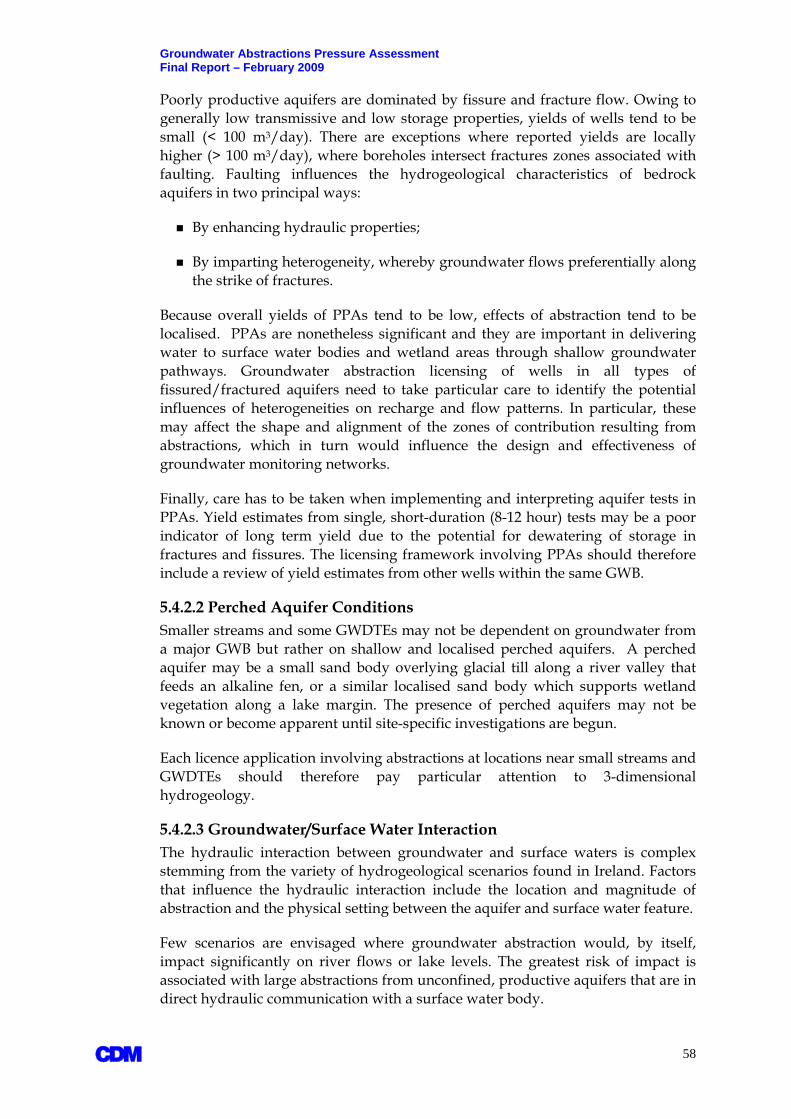
Groundwater Abstractions Pressure Assessment Final Report – February 2009 Poorly productive aquifers are dominated by fissure and fracture flow. Owing to generally low transmissive and low storage properties, yields of wells tend to be small (< 100 m3/day). There are exceptions where reported yields are locally higher (> 100 m3/day), where boreholes intersect fractures zones associated with faulting. Faulting influences the hydrogeological characteristics of bedrock aquifers in two principal ways:
By enhancing hydraulic properties;
By imparting heterogeneity, whereby groundwater flows preferentially along the strike of fractures.
Because overall yields of PPAs tend to be low, effects of abstraction tend to be localised. PPAs are nonetheless significant and they are important in delivering water to surface water bodies and wetland areas through shallow groundwater pathways. Groundwater abstraction licensing of wells in all types of fissured/fractured aquifers need to take particular care to identify the potential influences of heterogeneities on recharge and flow patterns. In particular, these may affect the shape and alignment of the zones of contribution resulting from abstractions, which in turn would influence the design and effectiveness of groundwater monitoring networks.
Finally, care has to be taken when implementing and interpreting aquifer tests in PPAs. Yield estimates from single, short-duration (8-12 hour) tests may be a poor indicator of long term yield due to the potential for dewatering of storage in fractures and fissures. The licensing framework involving PPAs should therefore include a review of yield estimates from other wells within the same GWB.
5.4.2.2 Perched Aquifer Conditions Smaller streams and some GWDTEs may not be dependent on groundwater from a major GWB but rather on shallow and localised perched aquifers. A perched aquifer may be a small sand body overlying glacial till along a river valley that feeds an alkaline fen, or a similar localised sand body which supports wetland vegetation along a lake margin. The presence of perched aquifers may not be known or become apparent until site-specific investigations are begun.
Each licence application involving abstractions at locations near small streams and GWDTEs should therefore pay particular attention to 3-dimensional hydrogeology.
5.4.2.3 Groundwater/Surface Water Interaction The hydraulic interaction between groundwater and surface waters is complex stemming from the variety of hydrogeological scenarios found in Ireland. Factors that influence the hydraulic interaction include the location and magnitude of abstraction and the physical setting between the aquifer and surface water feature.
Few scenarios are envisaged where groundwater abstraction would, by itself, impact significantly on river flows or lake levels. The greatest risk of impact is associated with large abstractions from unconfined, productive aquifers that are in direct hydraulic communication with a surface water body.
A 58

Groundwater Abstractions Pressure Assessment Final Report – February 2009 An important consideration is the nature of the subsoil cover which overlies bedrock aquifers across much of the country. This includes deposits of glacial till which can be several metres thick, as well as sand and gravel bodies which tend to occur along river valleys. As a general rule, surface waters that are separated from underlying bedrock aquifers by thick tills are less likely to be hydraulically impacted by deep groundwater abstractions.
Screening of potential impacts to rivers and lakes using simple rule-based criteria is an imprecise science until field work is carried out that: a) establishes the hydraulic relationship between the aquifer and the surface water feature; and b) quantifies the groundwater discharge into a river or lake.
In the WFD context, the quantitative status of a river and lake is important. For rivers, flow has to be “sufficient” to support its particular ecological needs (UKTAG, 2007). There is no agreed upon metric for this, and until ecologically-based flow standards are adopted, the Q95 is used as a surrogate.
The Q95 might be a useful surrogate standard where they are available and where they have been established on the river at a point near the groundwater abstraction scheme. However, in the vast majority of cases, a representative Q95 estimate will not be available. EPA has recently tested and adopted techniques for estimating Q95 flows in ungauged catchments (EPA/ESBI, 2007) which could become important in future licence application cases.
Groundwater dependent lakes are mostly associated with the karstic lowland of central and western Ireland. Like rivers, there are no simple metrics that can be applied to assess potential impact, and the scoping of hydrogeological investigations will have to be scoped accordingly on a case by case basis.
5.4.2.4 Saline Intrusion Licence applications for abstractions in coastal settings need to consider the potential for saline intrusion very carefully, and may require extensive investigation and monitoring efforts. Karstic areas present a particular challenge due to the presence of enhanced and rapid groundwater flow conditions along solution openings. There are cases in the west of Ireland where springs located several kilometres inland are naturally affected by seawater (tides), and where wells become saline very quickly during dry weather conditions and periods of increased pumping.
5.4.2.5 Groundwater Inflow from an Adjacent GWB The resulting ZOC of an abstraction scheme may draw on groundwater from an adjacent GWB. In theory, this would result in the reduction of the “total available resource” of that GWB. Lateral cross-flow across boundaries of GWBs should be flagged by the screening process and addressed quantitatively by the Applicant.
5.4.2.6 Induced Cross-Border Flow Abstraction schemes that may extend their hydraulic influence into Northern Ireland should be automatically directed to the supervisory body.
A 59

Groundwater Abstractions Pressure Assessment Final Report – February 2009 5.4.2.7 Arterial Drainage In the context of groundwater abstractions, arterial drainage is represented by linear excavations that result in a permanent lowering of groundwater level and changes in groundwater flow and discharge conditions. Localised impacts from road-building are already documented in Ireland. Because potential impacts are subject to site-specific conditions, it is proposed that infrastructure activities resulting in permanent changes of groundwater conditions be referred to the supervisory body for consultation, especially for cases that may impact on GWDTEs.
Infrastructure drainage schemes would be subject to EIA requirements, and potential problem areas would be expected to be identified as part of the EIA process. EIA regulations should be amended to refer to new abstraction licensing regulations.
5.4.3 Notes on Groundwater Monitoring Requirements Groundwater monitoring requirements should be kept flexible and adaptable according to the impact questions that have to be answered, and the hydrogeological setting of the study area. Some licence applications may not require any specific monitoring, whereas others will require detailed monitoring over long periods of time.
5.4.3.1 Impacts to Rivers Where groundwater abstractions may impact on river flows, documenting the nature and degree of hydraulic communication between groundwater and the river may be necessary. The objective would be to help quantify groundwater baseflow to the river, and estimate the reduced baseflow contribution that might result. Aquifer testing over periods of several days may be necessary involving continuous water level monitoring in wells on either side of the river.
5.4.3.2 Impacts to GWDTEs The assessment of potential impacts to GWDTEs may require that environmental supporting conditions to the GWDTE be quantified and monitored over a period of time. It is expected that all licensing cases involving GWDTEs should be consulted with the supervisory body and the NPWS. The NPWS would also be a major contributor in the review and decision-making of such licence applications.
Cases involving GWDTEs will in likelihood involve:
Characterising the type and degree of groundwater dependency of indicator species;
Developing a conceptual model for the GWDTE, including its water balance components;
Establishing a monitoring network that adequately quantifies the supporting conditions to which the GWDTE is deemed most sensitive to – groundwater level, flow, and/or chemistry.
A 60

Groundwater Abstractions Pressure Assessment Final Report – February 2009 5.4.3.3 Saline Intrusion A useful overview of coastal aquifer planning elements is provided in Cheng and Quazar (2003) and SALTRANS (2004). There is no single, generally accepted methodology for assessing saline intrusion. One of the initial objectives would be to establish approximately where the freshwater/saline water interface is located. This could involve one or more of the following:
Conducting surface geophysical surveys (e.g., time-domain electromagnetic method) over large areas;
Calculating chloride mass balances;
Running downhole focused induction logging in drilled boreholes;
Conducting isotopic fingerprint studies.
Licensing cases involving potential saline intrusion impacts may require that new boreholes are drilled and wells are constructed at targeted locations between the abstraction scheme and the saline water body. The wells would be monitored for water levels and chemistry.
Subsequent monitoring during development (and operation) of an abstraction scheme would then have to include monitoring of water levels and chemistry for a sufficiently long period of time (years) to estimate the extent and rate of intrusion. Monitoring of saline intrusion is data intensive.
The management of coastal aquifers is often concerned with the recognition that saline intrusion can not be avoided, and the challenge lies in deciding upon an acceptable landward extent of the saline water.
5.5 Review of Existing Schemes in Context of the Licensing Framework From Table 10, approximately 18% of existing known abstraction schemes would have been subject to detailed assessment and environmental reporting as defined by the proposed licensing framework. Only about 6% would have been subject to automatic referral to the supervisory body. The actual of cases that would be subject to detailed assessment and environmental reporting would be approximately 350. The number could be higher since there are likely additional abstractions that are not captured in the present Register (See Section 3.1.1).
Although the proposed licensing framework is not retroactive, the comparison is nonetheless useful in highlighting the potential number of cases that would submit environmental reports and annual operational records to a licensing body.
To appreciate the implications of future licensing regulations, six existing schemes were reviewed in context of the requirements of the licensing framework. These are:
Bog of the Ring, Fingal (operational);
A 61

Groundwater Abstractions Pressure Assessment Final Report – February 2009
A 62
Fardystown, Wexford (operational);
Wicklow Town, Wicklow (planned);
East Meath/South Louth Scheme, Meath and Louth (planned);
Johnstown Bridge, Kildare (not yet operational, awaiting funds for additional reservoir and associated infrastructure); and
Platin Quarry, Meath (operational).
Each scheme was reviewed from the point of view of identifying whether or not the technical elements of the licensing framework were, or are, being addressed under existing planning and regulatory procedures. All of the schemes have been part of the present planning application process in different counties. Results are summarised in Table 12.
The schemes range in size from approximately 4,000 m3/day to 20,000 m3/day. All of the schemes have undergone some level of assessment which ranges from the cursory to the very detailed. Schemes that have undergone detailed assessments are those which have been objected to or which have been required to undertake environmental impacts assessments on account of abstraction rates exceeding the EIS-required threshold of 2 million m3/yr (see Section 4).
The scheme at Johnstown Bridge is interesting from the point of view that it is part of the much larger Kildare water supply strategy, but was exempted from an EIS of the planned abstraction schemes. The strategy includes future supply from several sources of water, including new wellfields.
The wellfield at Johnstown Bridge is one of the new planned wellfields. Although the combined total abstraction from the proposed wellfields exceeds the EIS threshold, Johnstown Bridge was exempted from an EIS on the basis that it was geographically separated from the other schemes. The Johnstown Bridge wellfield is located in the Boyne catchment whereas the other schemes are located within the Barrow catchment. In response to a public concern about “project splitting”, An Bord Pleanala (ABP, 2003a) supported Kildare County Council and found that it was satisfied that the Johnstown Bridge scheme would not have negative environmental impacts (ABP, 2003b). Planning and development of the Johnstown Bridge scheme has proceeded under the Part VIII process of the Local Government (Planning and Development) Regulations, 2001.
Each of the schemes in Table 12 that have advanced beyond the Preliminary Report stage of planning takes appropriate account of relevant environmental concerns. However, not all are supported by operational monitoring or environmental reporting of actual impact. This is an area that would be strengthened by the licensing framework. While public review is clearly important in the planning process by shaping the level of assessment that is carried out, the proposed licensing framework will enhance the likelihood that potential impacts are adequately addressed, and as relevant, quantified and followed up.

Groundwater Abstractions Pressure Assessment Final Report – February 2009
Table 12: Summary of Assessments and Reporting at Six Abstraction Schemes
Scheme Bog of the Ring Fardystown Wicklow Town Johnstown Bridge East Meath, Drogheda and South Louth Platin Quarry
Stage of Development Operational Operational Initial field investigations Operational Preliminary Report in
progress Operational
Abstraction (m3/day) Approx. 3,800 Approx. 20,600 Approx. 4,000 planned Approx. 4,000
Approx. 3,800 for immediate development,
and 9,000 planned by 2013
Approx. 12,000
EIS N Y N N (an Environmental
Report was prepared to address public comments)
Needs assessment in preparation Y
Level of Impact Assessment
Groundwater balance
Detailed. Source protection scheme and sustainability assessment carried out over 3 years - addresses concerns raised over long-term sustainability of wellfield
Basic calculations. Yield testing extensive.
Detailed. Ongoing assessment of resource being carried out at present
Basic calculations. Yield testing extensive.
Yield testing of new wellfield locations completed. Detailed groundwater balance not yet completed.
Detailed. Assessment has been subject of recent review by the EPA as part of their status classification work
Flow across GWB boundaries
Limited cross-flow from adjacent GWBs deemed n/a n/a Limited – none predicted Not yet assessed Predicted
River/stream flow
Monitoring of groundwater in shallow deposits adjacent to local stream was included
Statement of potential impact to flow in small headwaters included
Detailed. Extensive testing and monitoring included in assessment
None predicted. Not monitored. Not yet assessed Not predicted
Lake levels n/a n/a n/a n/a n/a n/a
GWDTE, SAC No mapped GWTDE or SAC in wellfield area
No mapped GWDTE or SAC in wellfield area
No mapped GWDTE or SAC in wellfield area
Distance from “ecologically sensitive areas” sited as one reason for siting wellfield
Included as criterion in site selection of trial wells – areas of GWTDEs and SACs avoided
Potential impact on wetland at Duleek Commons included
Saline intrusion n/a Statement of potential saline intrusion included n/a n/a Not yet assessed Not predicted
Other abstractors Review of nearby abstractions included
Review of nearby abstractions included
Review of nearby abstractions included
Review of nearby abstractions included
Review included. Trial well sites selected to avoid related impacts
Review of nearby abstractions included
A 63

Groundwater Abstractions Pressure Assessment Final Report – February 2009
A 64
Verification of Impact AssessmentExisting Water Level Monitoring in Dedicated Monitoring Wells
Included in EPA’s national monitoring network for WFD purposes
Monitoring carried out by LA and EPA. Included in EPA’s national monitoring network for WFD
Investigative monitoring ongoing
None specific to wellfield or local rivers/streams Not yet in place
Extensive monitoring of zone of contribution and nearby wetland area
Verification of Impact
Sustainability in question. Potential impacts: water balance
(abstraction not sustainable);
local bog hydrology
Water levels in existing wells do not indicate impact, but monitoring of local headwaters and saline intrusion not carried out.
Investigative monitoring not yet completed. Conclusions not yet available.
No impact was predicted. Routine monitoring not carried out.
Not yet available
Zone of contribution well defined, but data relating to local wetlands are as yet inconclusive. Monitoring to continue.
Routine Environmental Reporting by Operator
No routine reporting at the present. Sustainability assessment completed in 2006. Current monitoring assumed by EPA.
No routine reporting at the present. Water levels will be routinely assessed by EPA as part of the national water level monitoring network
Not yet applicable, but would be necessary None. Not yet applicable, but
would be necessary
Annual monitoring reports submitted to Meath Co. Co.
Involvement of outside agencies to date
GSI, EPA, An Bord Pleanala An Bord Pleanala EPA, CFB, ERBD An Bord Pleanala, GSI EPA, NPWS, An Bord
Pleanala EPA, NPWS, An Bord Pleanala
Source Protection Plan Prepared by GSI Does not exist Does not exist Prepared by Kildare CC Does not yet exist N/a. Not a public supply.
Comment
Sustainability assessment concluded that wellfield abstraction is sustainable at present rates. Monitoring data indicates otherwise. BOTR wellfield included as an “at-risk” abstraction case and is included in EPA’s WFD monitoring network. Past well construction practices are poor, and may contribute to the identified impact to the bog area.
Current production is lower than quantities considered in the 1990 EIS.
Extensive early consultation between Wicklow, EPA and the Central Fisheries Board in scoping an appropriate hydrogeological investigation. Would serve as good model in connection with licensing framework.
Abstraction scheme is part of greater Kildare water supply strategy. Total abstraction rates exceed threshold for EIAs. An Bord Pleanala ruled that Johnstown Bridge could be considered a separate scheme from other wellfield in the Kildare strategy as it is located in a separate surface water catchment. An EIA was therefore not ruled to be necessary.
Hydrogeological work and trial well locations purposefully avoided areas that may be ecologically sensitive (Site Selection Report)
Platin quarry is presently pumping about 12,000 m3/day for dewatering purposes but has licence to discharge up to 28,000 m3/day to the River Nanny under an existing IPPC licence.

Groundwater Abstractions Pressure Assessment Final Report – February 2009 The development of large abstraction schemes, or those which involve potential impacts to important groundwater receptors, can be effectively guided by the preliminary planning and investigation process that has recently taken place in County Wicklow, notably in relation to the evaluation of new supplies for the town of Wicklow. One alternative which is being considered is the abstraction of groundwater from gravel deposits along the lower parts of the Vartry River. The river and adjacent gravel aquifer are suspected to be in direct hydraulic continuity, and the concern is that any groundwater abstraction would reduce the flow in the river.
The flow in the Vartry River is regulated by releases from the reservoirs higher up in the catchment. Early consultations have involved relevant stakeholders to scope out the types and levels of assessments that will be needed to address concerns about potential impacts on river flows and fish habitats. These consultations have included officials from County Wicklow, the EPA, and the Central Fisheries Board. Each party has been represented by an appropriate mix of scientists in the fields of hydrogeology, engineering, ecology, and fisheries. A scope of work was quickly agreed to and an investigation and monitoring programme has been underway for several months to try and quantify potential impacts of abstractions.
A 65

Groundwater Abstractions Pressure Assessment Final Report – February 2009
6. Proposed Supplementary Measures In addition to the licensing of groundwater abstractions which would be introduced as part of future legislation, this FC study has identified other potential measures that are recommended for WFD implementation in Ireland and in context of improved water resources management. These supplementary measures are described below and involve surveys, codes of practice, as well as information technology to facilitate the licensing process and management of abstractions-related data.
6.1 Survey of Abstractions As outlined in Section 3, knowledge of total groundwater abstractions is incomplete. While the national Register of abstractions has been improved from the work carried out under the various RBD projects, targeted surveys are recommended to try and close the known data gaps in certain sectors, as follows:
Quarries – survey of dewatering operations, targeted at quarry operators;
Golf courses – survey of golf courses that use groundwater for irrigation purposes;
Farming – survey of groundwater use for irrigation purposes;
Food and drinks industry – survey of groundwater use for the food processing and drinks industry, as well as the hotel and leisure industry.
Manufacturing – survey of groundwater use in the manufacturing industry, primarily those that involve cooling processes.
Group Water Schemes – although small compared to public water supplies, total abstraction rates from GWSs should be field-verified by measurement.
These sectors are regarded as the potentially largest abstractors of groundwater outside of the public supply schemes.
6.2 Borehole Construction Practices There are presently no statutory regulations or comprehensive guidelines concerning the drilling industry in Ireland. As a result, there are inconsistent standards of construction and decommissioning of boreholes.
New abstraction and associated monitoring wells should be constructed such that they provide reliable data from the aquifer and hydrogeological setting they represent.
It is not an uncommon occurrence that wells are constricted without proper grout seals between the borehole annulus and casing materials. This allows for potential cross-flows between aquifer units and improper sanitary seals with the surface. Improperly constructed wells can provide misleading data resulting in false or erroneous interpretations of local hydrogeology.
A 66
Groundwater Abstractions Pressure Assessment Final Report – February 2009 Proper well construction practices should therefore be formally promoted in the licensing framework. A mandatory well construction code is regarded as a necessary means of achieving good construction practice. Non-compliance could result in licences not being granted. It is therefore proposed that the well construction documentation available through the IGI (IGI, 2007) be used as a starting point towards establishing a code of good well construction practice.
The introduction of such a code would have implications for the drilling industry. The roll-out of the construction code would have to be accompanied with an awareness and training programme. The drilling industry is a relatively small audience. There may be up to 80 operators of well drilling equipment in the country of which a much smaller number (10-20) are routinely involved in the construction of larger abstraction or monitoring schemes. Awareness and training would not, however, be limited to well drilling firms, but also Local Authority personnel and water supply practitioners.
A registration or certification programme of well drilling firms would be another means of promoting good construction standards, but this would require an entirely different level of effort and approach, and would hold further financial and operational implications for well drillers.
6.3 Information Management The introduction of a licensing system for groundwater abstractions will generate a wealth of new hydrogeological data and information. There are five broad classes of information which have to be deposited, processed and maintained:
Licence applications;
Field studies and environmental reports;
Monitoring data;
Licence decisions and terms and conditions; and
Register of abstractions.
The submittal and processing of licence applications should be managed through an appropriate information management system (IMS). Similarly, monitoring data and environmental reports would be processed and accessed through a database linked to a national Register of abstraction as well as a repository of reports that can be accessed for any given abstraction scheme, whether a licence is granted or not.
The IMS should be accessible to both the Applicant and the entity that is processing the application, but in different ways. The Applicant would address a series of basic questions or requests for information, and the person responsible for processing the application would check that all the needed information is provided. The application would be registered and subsequently processed by the licensing body, depending on the information provided in the application.
The initial screening process would result in one of five decisions:
A 67

Groundwater Abstractions Pressure Assessment Final Report – February 2009
1. a licence is not required - abstraction is registered;
2. a licence is granted - abstraction may be subject to terms and conditions;
3. a licence is refused - application is registered;
4. application is incomplete and must be re-submitted;
5. application requires direct consultation with the supervisory body.
It is expected that up to 20 cases each year would require active participation of the supervisory body. This is based on the expectation that most applications will be for smaller abstraction schemes, and these will generally not trigger any significant environmental concerns. However, the initial screening process will have to be sufficiently robust to flag potential impact cases, even for smaller abstractions where these are located close to, and are hydrogeologically connected to, GWDTEs or other users of groundwater.
The IMS would be web-based and could be a single application or a combination of applications between different sources of information. The Applicant would be able access basic information about the application process, the submittal requirements, and potential avenues that might have to be followed.
Depending on whom the licensing body is, the IMS would record applications, allow for processing of applications, and record decisions. Decisions are regularly reviewed to update the national Register of abstractions. This could also be made accessible to the public.
The database for monitoring data captures the subsequent data generated from a licenced scheme under the agreed terms and conditions such as volumes of water pumped in a month and water levels from monitoring wells. It also provides links to a database of submittals including environmental reports or EIAs.
For the supervisory body, the IMS provides all basic information about the Applicant and proposed scheme, and given the envisaged database functionality, can be used to audit abstractions and associated monitoring records. It would be important for the licensing body to be able to access monitoring data for its own reporting requirements, whether as national status reports or as deliverables to the EC. It is proposed that a supervisory body maintains the register for all abstractions and advise Local Authorities on which GWBs are close to their “sustainable abstraction rates” allowing Local Authorities to refuse or re-direct applications to the supervisory body at the outset of the licensing process.
A 68

Groundwater Abstractions Pressure Assessment Final Report – February 2009
7. References Aldwell, C. R., D.J. Burdon, and M. Sherwood, 1983, Impact of agriculture on groundwater in Ireland: Environmental Geology, v. 5, p. 39-48.
Allen, A. and D. Milenic, 2003. Impact of Tidal Variations on the Groundwater System Beneath Cork City, SW Ireland. In Proceedings of the Second International Conference on Saltwater Intrusion and Coastal Aquifers — Monitoring, Modeling, and Management. Mérida, Yucatán, México, March 30 - April 2, 2003.
An Bord Pleanala, 2003a. Board Direction Ref. 09.ED.2020. June 4, 2003.
An Bord Pleanala, 2003b. Inspector’s Report Ref. 09.ED.2020. May, 2003.
Baldock, D. et al, 2000. The Environmental Impacts of Irrigation in the European Union. A Report to the Environment Directorate of the European Commission. March 2000.
CDM, 2008a. Revised River Risk Assessment: Abstractions National POM/Standards Study. Eastern River Basin District Project, November 2008.
CDM, 2008b. Development of a Revised Risk Assessment Methodology for Surface Water Abstractions from Lakes: Abstractions National POM/Standards Study. Eastern River Basin District Project, December 2008.
CDM, 2008c. Urban Groundwater Pressures Assessment. Draft Report. Urban National POM/Standards Study. Eastern River Basin District Project. November 2008.
Cheng, A., and D. Ouazar (eds.), 2003. Coastal Aquifer Management-Monitoring, Modeling, and Case Studies. 1st Edition. CRC Press. ISBN-10: 156670605X.
EPA, 2005. The Article 5 Characterisation and Analysis of Ireland’s River Basin Districts: National Summary Report (Ireland) 2005). Prepared by the Environmental Protection Agency and submitted to the European Commission – March 2005.
EPA/ESBI, 2007. The EPA/ESBI Method for Estimating River Flows Ungauged, Non-Karstic Catchments. Procedure developed by EPA and the WRBD/ESBI on behalf of the WFD National Hydrology Group.
EPA, 2008. Quantitative Status Classification of Irish Groundwater Bodies. Prepared for all River Basin District Projects in Ireland, December 2008.
Fitzsimons, V.P. and Misstear, B.D.R., 2006. Estimating groundwater recharge through tills: a sensitivity analysis of soil moisture budgets and till properties in Ireland. Hydrogeology Journal, Volume 14, Number 4, April 2006.
Galway County Council, 2008. Personal Communication.
Greenside Magazine, 2008. Course Feature – Tralee. March 2008.
A 69

Groundwater Abstractions Pressure Assessment Final Report – February 2009 GSI, 1999. Groundwater Protection Schemes. Guidelines Document prepared jointly by the Geological Survey of Ireland, the Environmental Protection Agency, and the Department of Environment, Heritage and Local Government.
GSI, 2005a. Calculation of expected throughflow in different rock types. Presented at a meeting of the national groundwater working group. Unpublished, 2005.
GSI, 2005b. Bog of the Ring: Groundwater Source Protection Zones. Prepared by the Geological Survey of Ireland in collaboration with Fingal County Council. March 2005.
GSI, 2006. Groundwater vulnerability map of Ireland. Updated, Autumn 2006 and distributed to all River Basin District projects.
GWG, 2005. WFD Pressures and Impacts Assessment Methodology: Guidance on the Assessment of the Impact of Groundwater Abstractions. Guidance document No. GW5. Prepared by the national Groundwater Working Group, March 2005. Available on the www.wfdireland.ie website.
IGI, 2007. Guidelines on Water Well Construction. Published by the Institute of Geologists of Ireland, with support from the Environmental Protection Agency, March 2007. Available from www.igi.ie.
Kilroy, G and F. Dunne, 2008. Framework for the Assessment of Groundwater-Dependent Terrestrial Ecosystems under the Water Framework Directive. Environmental Research Centre Report. Prepared for the Environmental Protection Agency and National Parks and Wildlife Service.
Meath County Council, 2007. County Meath Development Plan 2007-2013. Adopted March 2, 2007.
NPWS, 2008. Miscellaneous files relating to a revised risk assessment and status classification of GWDTEs. Unpublished materials submitted to the EPA, November 2008.
Peer Review Group. 2008. A meeting was held at the offices of the ERBD project in June 2008 to discuss suitable abstraction thresholds and levels of impact assessment for licensing purposes. The meeting was attended by some of the most experienced hydrogeologists in Ireland.
PH McCarthy, 1999. Fardystown Regional Water Supply. Environmental Impact Study. Prepared for Wexford County Council. June 1990.
Richards, K., 2008. Preliminary Estimate of Water Use on Dairy Farms. Unpublished.
SALTRANS, 2004. Methods for Assessing Salt Intrusion and Transport in Heterogeneous and Fractured Aquifers: Deliverable 14: Basic principles and concepts for understanding and managing sea water intrusion in coastal aquifers. European Commission Programme: “Energy, Environment and Sustainable Development” Contract No. EVK1-2000-00062. January 2004.
A 70

Groundwater Abstractions Pressure Assessment Final Report – February 2009
A 71
SNIFFER, 2005. Criteria for WFD Groundwater “Good” Quantitative Status Classification and a Framework for the Assessment of Groundwater Abstractions. Final Report WFD 53. Scotland and Northern Ireland Forum for Environmental Research. September 2005.
Teagasc, 2006. National Soil and Subsoils Mapping Project.
Teagasc, 2008. Note on Farmfest ’08. From www.teagasc.ie/events/2008/farmfest
TES, 2006. Groundwater Monitoring of the Bog of the Ring: Final Hydrogeological Assessment Report. Prepared by TES Consulting Engineers in association with Fingal County Council. October 2006.
UKTAG, 2007. Proposals for a Groundwater Classification System and its Application in Regulation. Final Report (SR1– 2007). Prepared by the UK Technical Advisory Group on the Water Framework Directive. October 2007. Available at www.wfduk.org/tag_guidance/Article%20_11/POMEnvStds/gw_final07/view
Wright, G. 1999. How many wells are there in Ireland? The GSI Groundwater Newsletter, Vol. 35.

Groundwater Abstractions Pressure Assessment Final Report – February 2009
APPENDIX A
Details of GIS Processing of Recharge Computations

Groundwater Abstractions Pressure Assessment Final Report – February 2009 Notes on GWB1 groundwater abstraction GIS analysis The GWB1 groundwater abstraction test provides an indication of the risk posed by groundwater abstraction to the water resource within groundwater bodies. The methods employed in the analysis and the source datasets used have been determined by the Groundwater Working Group (GWG) in 2004 with a small number of modifications since that time. This note provides an overview of the implementation of the method in a GIS The principal GIS data processing script ‘gwb1_combine’ (avenue scripting language for the ESRI ArcView 3.x GIS package) used in the overlay combination of source datasets is also provided. Calculation of the risk posed by groundwater abstraction is achieved through a four stage process:
• determination of spatial distribution of recharge coefficients • determination of spatial distribution of recharge • application of recharge cap in certain aquifer type settings • analysis of recharge and abstraction volumes per groundwater body
Determination of spatial distribution of recharge coefficients The hydro-geological settings pertinent to the spatial distribution of recharge and their associated recharge coefficients are set out in Table 1 of the GWB1 Abstraction test document. These hydro-geological settings are determined through a step-wise analysis performed in the GIS. Data sources: Vulnerability GSI vulnerability 2006 with updates to Cavan and Galway in 2007 Peat EPA/Teagasc Subsoils (parent materials) Peats (subclasses – ‘BkPt’, ‘RsPt’ and ‘FenPT’ ) Made (subclass – ‘Made’) Not_Peat (all other classes) Sand & Gravels GSI Aquifers Subsoil Permeability GSI ‘provisional_subsoil_permeability_september2008’ Soil Drainage EPA/Teagasc IFS Soils (classes – ‘Well Drained’, ‘Poorly Drained’ and ‘n.a.’) Effective Rainfall provided by each RBD Aquifer Type GSI aquifer types, used to determine caps to recharge volumes in low permeability settings Data processing In sequence the following datasets are overlain: Interim dataset Vulnerability and Peat -> overlay 1 V_P Overlay 1 and Sand/Gravel aquifers -> overlay 2 V_P_S Overlay 2 and Subsoil Permeability -> overlay 3 V_P_S_K Overlay 3 and Soil Drainage -> recharge coefficient layer V_P_S_K_D The data processing is carried out per river basin district (RBD). In the GIS each RBD is provided with its own View or Data Frame identified by a 2 letter code: Eastern RBD EA South-Eastern RBD SE South-Western RBD SW Shannon IRBD SH Western RBD WE North-Western IRBD NW Neagh-Bann IRBD NB

Groundwater Abstractions Pressure Assessment Final Report – February 2009 The datasets used in each stage of the overlay process within each RBD are recorded in the database table ‘rbd_components.dbf’. These component datasets, per RBD, must be loaded onto the RBD View to facilitate execution of the data processing script. With each subsequent overlay or combination of component datasets, a series of partial hydro-geological settings are determined. The worksheet ‘flowchart’ in spreadsheet ‘gwb1_rech_coef_matrix.xls’ provides a summary flowchart of the outcomes arising from this step-wise combination of layers that results in hydro-geological recharge (coefficient) settings. Worksheet ‘method’ in spreadsheet ‘gwb1_rech_coef_matrix.xls’ provides more detail on the overlay process. Each dataset used in the process contains a series of source values or input conditions. When 2 datasets are combined through spatial overlay during the stepwise combination process a series of outcomes can result from the spatial co-incidence of the input conditions in the 2 source datasets. Worksheet ‘method’ should be read from left to right. Across the top the values or input conditions within each of the source layers used in the overlay process are shown. In the rows below, the combination results are shown:
• Category & Code – refers to the input condition values (by name and short code) of each of the 2 layers
• Results – refers to the hydro-geological combination result of any pairing of input values. These are recorded in short code format.
• Recharge – at a certain stage in the step-wise (left – to – right) combination a final recharge setting is determined. When achieved the Table 1 equivalent code and recharge % values are recorded.
The following should be noted:
• For 2 initial vulnerability values (X – ‘rock near surface’ and water) no further overlay is required as the recharge coefficient values are known immediately.
• Certain combination stages are only relevant in particular hydro-geological settings, e.g. the overlay of sands & gravels is only relevant where the vulnerability is extreme or ‘E’.
• De facto the overlay process is carried out for all hydro-geological settings using all overlay layers. Where the overlay has no relevance to the hydro-geological setting the outcomes recorded in ‘results’ remain unaltered from the input condition.
For example the Vulnerability layer has 7 source values or input conditions. The Peat layer has 3 source values or input conditions. As noted above 2 of the vulnerability settings (X and water) give an immediate recharge coefficient result. Thus 5 vulnerability classes are effectively combined with 3 peat classes in Stage 1 to give 15 overlay results. 11 of these 15 results derive final recharge coefficient settings at Stage 1 leaving 4 hydro-geological settings that require further analysis to derive their ultimate recharge condition. In total 33 hydro-geological settings are identified each with an associated recharge coefficient. Determination of spatial distribution of recharge A short step-wise process is undertaken in 2 stages:
• overlay of the recharge coefficient values and (annual) effective rainfall to derive the recharge potential (recorded as mm rainfall per annum)
• overlay of the recharge potential with the aquifer capping layer to derive the final recharge layer.
Capping of maxima Maximum 200mm/year – LL – ‘Locally Important Aquifer - Bedrock which is Moderately Productive only in Local Zones’
Maximum 100mm/year – PU/PL – ‘Poor Aquifer - Bedrock which is Generally Unproductive & Poor Aquifer - Bedrock which is Generally Unproductive except for Local Zones’.

Groundwater Abstractions Pressure Assessment Final Report – February 2009 The resultant dataset contains 3 recharge setting values
• Potential recharge (mm/year) • Maximum recharge (capped recharge values in LL, PL and PU aquifer settings) • Actual recharge (mm/year) that replaces potential recharge with maximum
recharge in LL, PL and PU aquifers where the potential recharge is greater than the maximum capped recharge.
Analysis of recharge and abstraction volumes per groundwater body Analysis of the potential impact (as risk classification) of groundwater abstractions is performed for each of the groundwater bodies in the national groundwater dataset. On an annual basis the volume of recharge to each groundwater body can be determined from the overlay of the groundwater body outline on the ‘actual recharge’ dataset. The ‘actual recharge’ dataset is comprised of an array of grid cells each 50x50 metres in extent. Each cell records an annual recharge depth in mm. A ‘zonal statistics’ function is employed to obtain the mean recharge depth across the groundwater body and the groundwater body area. Data are provided by each RBD on the location and abstraction volume (m3/day) of recorded abstractions. Overlay analysis is used to assign the abstractions to the relevant groundwater bodies which yields a volume of abstracted water per groundwater body. The proportion of available recharge that is abstracted provides impact potential values as set out below. Sand & Gravel Aquifer Bedrock Aquifers
(FI, KA & PP) Recharge (% abstracted)
Impact Potential Impact Potential
>= 30% H H >=20 - <30 M H >=10 - <20 L M >=2 - <10 L L >=0 - <2 N N If there is no or insufficient field evidence from other sources to correct the estimate of the impact potential derived from the GIS analysis then the following risk classes are assigned: Impact Potential Risk Class H 1a M 1b L 2a N 2b Compass Informatics Ltd 25/11/2008

Code (VPSKD layer) RCH_CODE COEFFICIEN ISSUE NOTEE_P 1iv 32.50E_nP_S 1ii 85.00HL_P 5v 5.00HL_nP_H 5i 90.00 not 85 using Table 1 not flow chartHL_nP_L 5iv 20.00HL_nP_M_P 5iii 30.00HL_nP_M_W 5ii 60.00 not 50 using Table 1 not flow chartH_P 2vii 10.00H_nP_H 2i 85.00H_nP_L 2vi 26.50H_nP_M_P 2v 32.50H_nP_M_W 2iv 60.00L_P 4ii 4.00L_nP 4i 10.00M_P 3iv 4.00M_nP_H_P 3ii 30.00 (for Offaly GSI perm error) treat k of H as MM_nP_H_W 3i 35.00 (for Offaly GSI perm error) treat k of H as MM_nP_L 3iii 15.00M_nP_M_P 3ii 30.00M_nP_M_W 3i 35.00X 1i 85.00na zero 0.00water zero 0.00E_nP_nS_P 1iv 32.50E_nP_nS_W 1iii 60.00H_nP_nK new 25.00 missing perm (k) - assign to 25%M_nP_nK new 25.00 missing perm (k) - assign to 25%HL_nP_nK new 25.00 missing perm (k) - assign to 25%E_M new 20.00 made ground 20%H_M new 20.00 made ground 20%M_M new 20.00 made ground 20%L_M new 20.00 made ground 20%HL_M new 20.00 made ground 20%
Step 1 - Vulnerability X, E, H, M, L, HLStep 2 - Peat P, (Peat), nP (not Peat)Step 3 Sand & Gravel S (Sand/Gravel) only where Vuln = E (see 'Counties with Recent GWPS)Step 4 Subsoil Perm H, M, L Step 5 Soil W, P
Rch_Code Original Values set out in Table 1 "Recharge Coefficients for different hydrogeological settings - Groundwater Risk Assessment Sheet
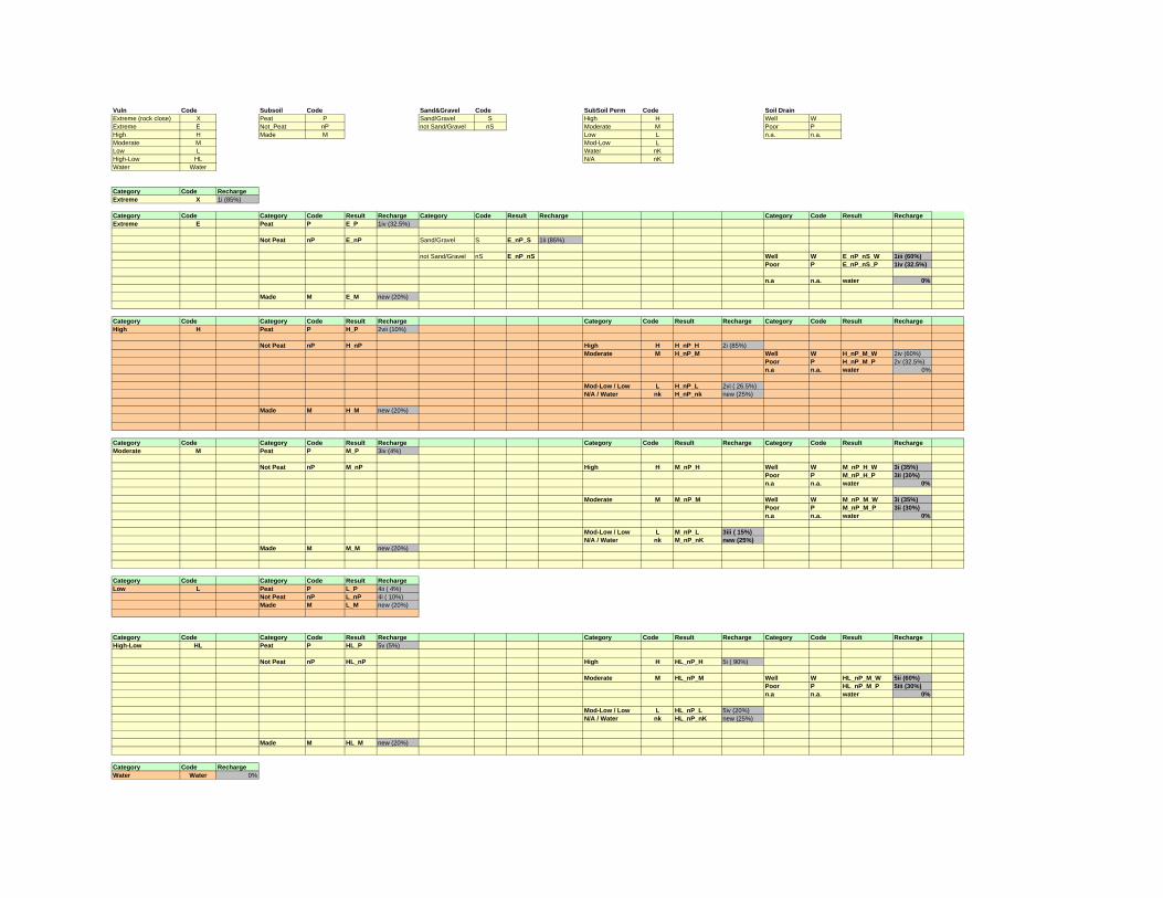
Vuln Code Subsoil Code Sand&Gravel Code SubSoil Perm Code Soil DrainExtreme (rock close) X Peat P Sand/Gravel S High H Well WExtreme E Not_Peat nP not Sand/Gravel nS Moderate M Poor PHigh H Made M Low L n.a. n.a.Moderate M Mod-Low LLow L Water nKHigh-Low HL N/A nKWater Water
Category Code RechargeExtreme X 1i (85%)
Category Code Category Code Result Recharge Category Code Result Recharge Category Code Result RechargeExtreme E Peat P E_P 1iv (32.5%)
Not Peat nP E_nP Sand/Gravel S E_nP_S 1ii (85%)
not Sand/Gravel nS E_nP_nS Well W E_nP_nS_W 1iii (60%)Poor P E_nP_nS_P 1iv (32.5%)
n.a n.a. water 0%
Made M E_M new (20%)
Category Code Category Code Result Recharge Category Code Result Recharge Category Code Result RechargeHigh H Peat P H_P 2vii (10%)
Not Peat nP H_nP High H H_nP_H 2i (85%)Moderate M H_nP_M Well W H_nP_M_W 2iv (60%)
Poor P H_nP_M_P 2v (32.5%)n.a n.a. water 0%
Mod-Low / Low L H_nP_L 2vi ( 26.5%)N/A / Water nk H_nP_nk new (25%)
Made M H_M new (20%)
Category Code Category Code Result Recharge Category Code Result Recharge Category Code Result RechargeModerate M Peat P M_P 3iv (4%)
Not Peat nP M_nP High H M_nP_H Well W M_nP_H_W 3i (35%)Poor P M_nP_H_P 3ii (30%)n.a n.a. water 0%
Moderate M M_nP_M Well W M_nP_M_W 3i (35%)Poor P M_nP_M_P 3ii (30%)n.a n.a. water 0%
Mod-Low / Low L M_nP_L 3iii ( 15%)N/A / Water nk M_nP_nK new (25%)
Made M M_M new (20%)
Category Code Category Code Result RechargeLow L Peat P L_P 4ii ( 4%)
Not Peat nP L_nP 4i ( 10%)Made M L_M new (20%)
Category Code Category Code Result Recharge Category Code Result Recharge Category Code Result RechargeHigh-Low HL Peat P HL_P 5v (5%)
Not Peat nP HL_nP High H HL_nP_H 5i ( 90%)
Moderate M HL_nP_M Well W HL_nP_M_W 5ii (60%)Poor P HL_nP_M_P 5iii (30%)n.a n.a. water 0%
Mod-Low / Low L HL_nP_L 5iv (20%)N/A / Water nk HL_nP_nK new (25%)
Made M HL_M new (20%)
Category Code RechargeWater Water 0%
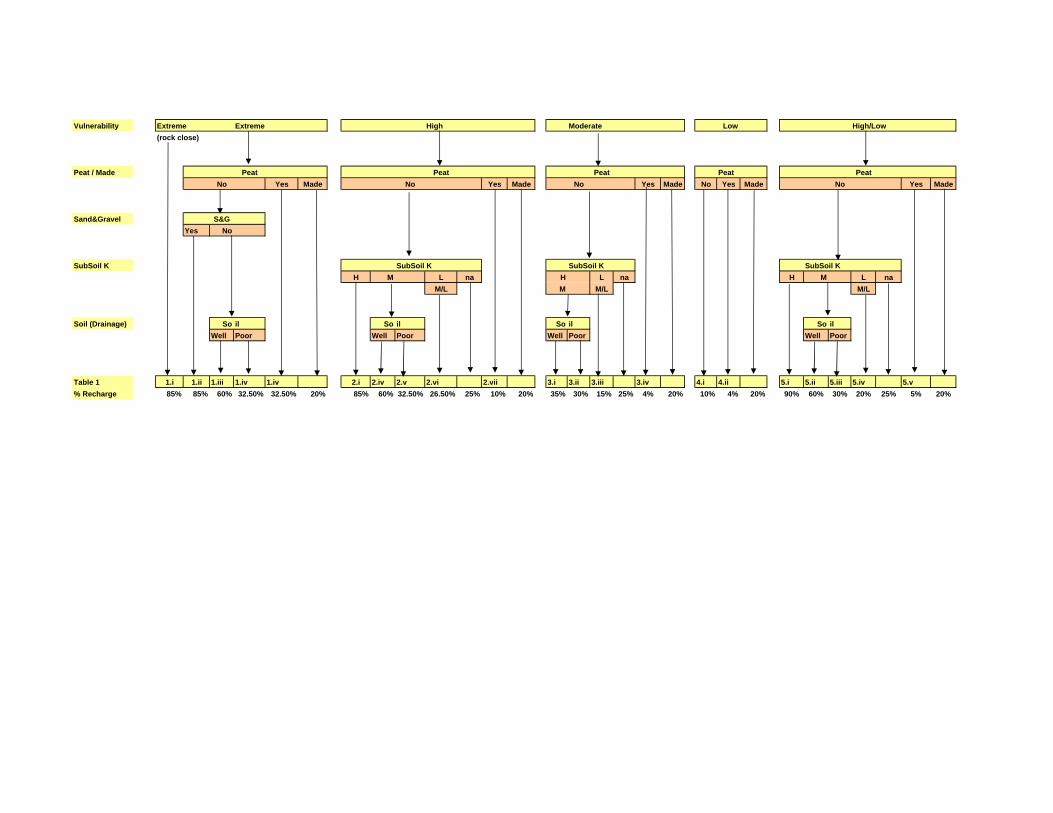
Vulnerability Extreme Extreme High Moderate Low High/Low(rock close)
Peat / Made Peat Peat Peat Peat Peat No Yes Made No Yes Made No Yes Made No Yes Made No Yes Made
Sand&Gravel S&GYes No
SubSoil K SubSoil K SubSoil K SubSoil KH M L na H L na H M L na
M/L M M/L M/L
Soil (Drainage) So il So il So il So ilWell Poor Well Poor Well Poor Well Poor
Table 1 1.i 1.ii 1.iii 1.iv 1.iv 2.i 2.iv 2.v 2.vi 2.vii 3.i 3.ii 3.iii 3.iv 4.i 4.ii 5.i 5.ii 5.iii 5.iv 5.v % Recharge 85% 85% 60% 32.50% 32.50% 20% 85% 60% 32.50% 26.50% 25% 10% 20% 35% 30% 15% 25% 4% 20% 10% 4% 20% 90% 60% 30% 20% 25% 5% 20%

AVENUE SCRIPT FOR GIS PROCESSING OF RECHARGE COMPUTATIONS

mv = av.getactivedoc ' ** Get components rbd_db = av.finddoc("rbd_components.dbf") if(rbd_db = nil) then msgbox.error("Load ' rdb_components.dbf'","") return nil else rbd_db = rbd_db.getvtab fdb_rdb = rbd_db.findfield("rbd") fdb_vuln = rbd_db.findfield("vuln") fdb_peat = rbd_db.findfield("peat") fdb_sg = rbd_db.findfield("sg") fdb_perm = rbd_db.findfield("sub_perm") fdb_soildrain = rbd_db.findfield("soil_drain") fdb_effective = rbd_db.findfield("effective") fdb_aquif_cap = rbd_db.findfield("aquif_cap") end rbd = mv.getname rbd_query = "([rbd] = "+rbd.quote+")" rbd_db.query(rbd_query,rbd_db.getselection,#VTAB_SELTYPE_NEW) if(rbd_db.getnumselrecords <> 1) then return nil else g_vuln = rbd_db.returnvalue(fdb_vuln,rbd_db.getselection.getnextset(-1)) g_peat = rbd_db.returnvalue(fdb_peat,rbd_db.getselection.getnextset(-1)) g_sg = rbd_db.returnvalue(fdb_sg,rbd_db.getselection.getnextset(-1)) g_perm = rbd_db.returnvalue(fdb_perm,rbd_db.getselection.getnextset(-1)) g_drain = rbd_db.returnvalue(fdb_soildrain,rbd_db.getselection.getnextset(-1)) g_eff = rbd_db.returnvalue(fdb_effective,rbd_db.getselection.getnextset(-1)) g_aq_cap = rbd_db.returnvalue(fdb_aquif_cap,rbd_db.getselection.getnextset(-1)) end gt_vuln = mv.findtheme(g_vuln) if(gt_vuln = nil) then msgbox.error("load "+g_vuln,"") else g_vuln = gt_vuln.getgrid end gt_peat = mv.findtheme(g_peat) if(gt_peat = nil) then msgbox.error("load "+g_peat,"") else g_peat = gt_peat.getgrid end gt_sg = mv.findtheme(g_sg) if(gt_sg = nil) then msgbox.error("load "+g_sg,"") else g_sg = gt_sg.getgrid end gt_perm = mv.findtheme(g_perm) if(gt_perm = nil) then msgbox.error("load "+g_perm,"") else g_perm = gt_perm.getgrid end gt_drain = mv.findtheme(g_drain) if(gt_drain = nil) then msgbox.error("load "+g_drain,"") else g_drain = gt_drain.getgrid end gt_eff = mv.findtheme(g_eff)

if(gt_eff = nil) then msgbox.error("load "+g_eff,"") else g_eff = gt_eff.getgrid end gt_aq_cap = mv.findtheme(g_aq_cap) if(gt_aq_cap = nil) then msgbox.error("load " +g_aq_cap,"") else g_aq_cap = gt_aq_cap.getgrid end savepath = "i:\gis_data\risk_ass_06\groundwater\gwb1_abstraction\" coef_db = av.finddoc("gwb1_rech_coef_matrix.dbf") if(coef_db = nil) then msgbox.error("Load 'gwb1_rech_coef_matrix.dbf' ","") return nil else coef_db = coef_db.getvtab fcoef_join = coef_db.findfield("s_vpskd") end '** combine Vuln & Peat **************************************************************************** g_V_P = g_vuln.combine({g_peat}) grid_fn = (savepath+rbd+"\v_p").asfilename g_v_p.savedataset(grid_fn) gt_v_p = gtheme.make(g_v_p) g_v_p_tab = gt_v_p.getvtab s_vuln = field.make("s_vuln",#FIELD_CHAR,8,0) s_peat = field.make("s_peat",#FIELD_CHAR,12,0) s_v_p = field.make("v_p",#FIELD_CHAR,16,0) g_v_p_tab.starteditingwithrecovery g_v_p_tab.addfields({s_vuln, s_peat, s_v_p}) s_vuln = g_v_p_tab.findfield("s_vuln") s_peat = g_v_p_tab.findfield("s_peat") s_vp = g_v_p_tab.findfield("v_p") gt_v_p.setname("V_P") mv.addtheme(gt_v_p) gt_v_p.setlegendvisible(false) if(rbd = "ea") then g_v_p_tab.join(g_v_p_tab.findfield(rbd+"_vuln"),g_vuln.getvtab,g_vuln.getvtab.findfield("value")) else g_v_p_tab.join(g_v_p_tab.findfield("vuln_"+rbd),g_vuln.getvtab,g_vuln.getvtab.findfield("value")) end for each rec in g_v_p_tab vuln = g_v_p_tab.returnvalue(g_v_p_tab.findfield("vul"),rec) g_v_p_tab.setvalue(s_vuln,rec,vuln) end

g_v_p_tab.join(g_v_p_tab.findfield(rbd+"_peat"),g_peat.getvtab,g_peat.getvtab.findfield("value")) for each rec in g_v_p_tab peat = g_v_p_tab.returnvalue(g_v_p_tab.findfield("peat_made"),rec) g_v_p_tab.setvalue(s_peat,rec,peat) end g_v_p_tab.unjoinall for each rec in g_v_p_tab vuln = g_v_p_tab.returnvalue(s_vuln,rec) peat = g_v_p_tab.returnvalue(s_peat,rec) v_p = "" if(vuln = "X") then v_p = "X" elseif(Vuln = "E") then if(peat = "peat_made") then v_p = "E_P" elseif(peat = "made") then v_p = "E_M" else v_p = "E_nP" end elseif(Vuln = "H") then if(peat = "peat_made") then v_p = "H_P" elseif(peat = "made") then v_p = "H_M" else v_p = "H_nP" end elseif(vuln = "M") then if(peat = "peat_made") then v_p = "M_P" elseif(peat = "made") then v_p = "M_M" else v_p = "M_nP" end elseif(vuln = "L") then if(peat = "peat_made") then v_p = "L_P" elseif(peat = "made") then v_p = "L_M" else v_p = "L_nP" end elseif(vuln = "HL") then if(peat = "peat_made") then v_p = "HL_P" elseif(peat = "made") then v_p = "HL_M" else v_p = "HL_nP" end elseif(vuln = "Water") then v_p = "water" else v_p = "na" end g_v_p_tab.setvalue(s_v_p,rec,v_p) end g_v_p_tab.stopeditingwithrecovery(true) '** CombIne Vuln_Peat & SG ********************************************************************************** g_V_P_S = g_v_p.combine({g_sg}) grid_fn2 = (savepath+rbd+"\v_p_s").asfilename g_v_p_s.savedataset(grid_fn2)

gt_v_p_s = gtheme.make(g_v_p_s) gt_v_p_s.setname("V_P_S") mv.addtheme(gt_v_p_s) gt_v_p_s.setlegendvisible(false) g_v_p_s_tab = g_v_p_s.getvtab s_vp = field.make("s_vp",#FIELD_CHAR,16,0) s_sg = field.make("sg",#FIELD_CHAR,8,0) s_Vps = field.make("s_vps",#FIELD_CHAR,8,0) g_v_p_s_tab.starteditingwithrecovery g_v_p_s_tab.addfields({ s_vp, s_sg, s_Vps}) s_vp = g_v_p_s_tab.findfield("s_vp") s_sg = g_v_p_s_tab.findfield("sg") s_vps = g_v_p_s_tab.findfield("s_vps") g_v_p_tab.findfield("v_p").setalias("prev_v_p") g_v_p_s_tab.join(g_v_p_s_tab.findfield("v_p"),g_v_p.getvtab,g_v_p.getvtab.findfield("value")) for each rec in g_v_p_s_tab vp = g_v_p_s_tab.returnvalue(g_v_p_s_tab.findfield("prev_v_p"),rec) g_v_p_s_tab.setvalue(s_vp,rec,vp) end g_sg_tab = g_sg.getvtab g_sg_tab.findfield("sg").setalias("prev_sg") g_v_p_s_tab.join(g_v_p_s_tab.findfield(rbd+"_sg"),g_sg.getvtab,g_sg.getvtab.findfield("value")) for each rec in g_v_p_s_tab sg = g_v_p_s_tab.returnvalue(g_v_p_s_tab.findfield("prev_sg"),rec) g_v_p_s_tab.setvalue(s_sg,rec,sg) end g_v_p_s_tab.unjoinall for each rec in g_v_p_s_tab vp_s = "" vp= g_v_p_s_tab.returnvalue(s_vp,rec) sg = g_v_p_s_tab.returnvalue(s_sg,rec) if(vp = "E_nP") then if(sg = "sg") then vp_s = "E_nP_S" else vp_s = "E_nP_nS" end else vp_s = vp end g_v_p_s_tab.setvalue(s_vps,rec,vp_s) end g_v_p_s_tab.stopeditingwithrecovery(true)

'** CombIne Vuln_Peat_SG & Perm ********************************************************************* g_V_P_S_K = g_v_p_s.combine({g_perm}) grid_fn3 = (savepath+rbd+"\v_p_s_k").asfilename g_v_p_s_k.savedataset(grid_fn3) gt_v_p_s_k = gtheme.make(g_v_p_s_k) gt_v_p_s_k.setname("V_P_S_K") mv.addtheme(gt_v_p_s_k) gt_v_p_s_k.setlegendvisible(false) g_v_p_s_k_tab = g_v_p_s_k.getvtab s_vps = field.make("s_vps",#FIELD_CHAR,16,0) s_k = field.make("K",#FIELD_CHAR,8,0) s_Vpsk = field.make("s_vpsk",#FIELD_CHAR,8,0) g_v_p_s_k_tab.starteditingwithrecovery g_v_p_s_k_tab.addfields({ s_vps, s_k, s_Vpsk}) s_vps = g_v_p_s_k_tab.findfield("s_vps") s_k = g_v_p_s_k_tab.findfield("k") s_vpsk = g_v_p_s_k_tab.findfield("s_vpsk") g_v_p_s_tab.findfield("s_vps").setalias("prev_vps") g_v_p_s_k_tab.join(g_v_p_s_k_tab.findfield("v_p_s"),g_v_p_s.getvtab,g_v_p_s.getvtab.findfield("value")) for each rec in g_v_p_s_k_tab vps = g_v_p_s_k_tab.returnvalue(g_v_p_s_k_tab.findfield("prev_vps"),rec) g_v_p_s_k_tab.setvalue(s_vps,rec,vps) end g_perm_tab = g_perm.getvtab g_perm_tab.findfield("perm").setalias("prev_perm") g_v_p_s_k_tab.join(g_v_p_s_k_tab.findfield(rbd+"_perm"),g_perm.getvtab,g_perm.getvtab.findfield("value")) for each rec in g_v_p_s_k_tab k = g_v_p_s_k_tab.returnvalue(g_v_p_s_k_tab.findfield("prev_perm"),rec) g_v_p_s_k_tab.setvalue(s_k,rec,k) end g_v_p_s_k_tab.unjoinall for each rec in g_v_p_s_k_tab vps_k = "" vps= g_v_p_s_k_tab.returnvalue(s_vps,rec) k = g_v_p_s_k_tab.returnvalue(s_k,rec) if(vps.left(4) = "H_nP") then if(k = "H") then vps_k = "H_nP_H" elseif(k = "M") then vps_k = "H_nP_M" elseif(k = "M/L") then vps_k = "H_nP_L" elseif(k= "L") then vps_k = "H_nP_L"

elseif(k= "na") then vps_k = "H_nP_nK" end elseif(vps.left(4) = "M_nP") then if(k = "H") then vps_k = "M_nP_H" elseif(k = "M") then vps_k = "M_nP_M" elseif(k = "M/L") then vps_k = "M_nP_L" elseif(k= "L") then vps_k = "M_nP_L" elseif(k= "na") then vps_k = "M_nP_nK" end elseif(vps.left(5) = "HL_nP") then if(k = "H") then vps_k = "HL_nP_H" elseif(k = "M") then vps_k = "HL_nP_M" elseif(k = "M/L") then vps_k = "HL_nP_L" elseif(k= "L") then vps_k = "HL_nP_L" elseif(k= "na") then vps_k = "HL_nP_nK" end else vps_k = vps end g_v_p_s_k_tab.setvalue(s_vpsk,rec,vps_k) end g_v_p_s_k_tab.stopeditingwithrecovery(true) '** CombIne Vuln_Peat_SG_Perm & Drain ******************************************************************** g_V_P_S_K_D= g_v_p_s_k.combine({g_drain}) grid_fn4 = (savepath+rbd+"\v_p_s_k_D").asfilename g_v_p_s_k_d.savedataset(grid_fn4) gt_v_p_s_k_d = gtheme.make(g_v_p_s_k_d) gt_v_p_s_k_d.setname("V_P_S_K_D") mv.addtheme(gt_v_p_s_k_d) gt_v_p_s_k_d.setlegendvisible(false) g_v_p_s_k_d_tab = g_v_p_s_k_d.getvtab s_vpsk = field.make("s_vpsk",#FIELD_CHAR,16,0) s_d = field.make("drain",#FIELD_CHAR,8,0) s_Vpskd = field.make("s_vpskd",#FIELD_CHAR,16,0) s_rech_coef = field.make("rech_coef",#FIELD_DECIMAL,6,2) g_v_p_s_k_d_tab.starteditingwithrecovery g_v_p_s_k_d_tab.addfields({ s_vpsk, s_d, s_Vpskd, s_rech_coef}) s_vpsk = g_v_p_s_k_d_tab.findfield("s_vpsk") s_d = g_v_p_s_k_d_tab.findfield("drain") s_vpskd = g_v_p_s_k_d_tab.findfield("s_vpskd") s_rech_coef = g_v_p_s_k_d_tab.findfield("rech_coef")

g_v_p_s_k_tab.findfield("s_vpsk").setalias("prev_vpsk") g_v_p_s_k_d_tab.join(g_v_p_s_k_d_tab.findfield("v_p_s_k"),g_v_p_s_k.getvtab,g_v_p_s_k.getvtab.findfield("value")) for each rec in g_v_p_s_k_d_tab vpsk = g_v_p_s_k_d_tab.returnvalue(g_v_p_s_k_d_tab.findfield("prev_vpsk"),rec) g_v_p_s_k_d_tab.setvalue(s_vpsk,rec,vpsk) end g_drain_tab = g_drain.getvtab g_drain_tab.findfield("drainage").setalias("prev_drain") g_v_p_s_k_d_tab.join(g_v_p_s_k_d_tab.findfield(rbd+"_soildrain"),g_drain.getvtab,g_drain.getvtab.findfield("value")) for each rec in g_v_p_s_k_d_tab d = g_v_p_s_k_d_tab.returnvalue(g_v_p_s_k_d_tab.findfield("prev_drain"),rec) g_v_p_s_k_d_tab.setvalue(s_d,rec,d) end g_v_p_s_k_d_tab.unjoinall for each rec in g_v_p_s_k_d_tab vpsk_d = "" vpsk= g_v_p_s_k_d_tab.returnvalue(s_vpsk,rec) dr = g_v_p_s_k_d_tab.returnvalue(s_d,rec) if(vpsk = "H_nP_M") then if(dr = "Well") then vpsk_d = "H_nP_M_W" elseif(dr = "Poor") then vpsk_d = "H_nP_M_P" end elseif(vpsk = "HL_nP_M") then if(dr = "Well") then vpsk_d = "HL_nP_M_W" elseif(dr = "Poor") then vpsk_d = "HL_nP_M_P" end elseif(vpsk = "M_nP_M") then if(dr = "Well") then vpsk_d = "M_nP_M_W" elseif(dr = "Poor") then vpsk_d = "M_nP_M_P" end elseif(vpsk = "M_nP_H") then if(dr = "Well") then vpsk_d = "M_nP_H_W" elseif(dr = "Poor") then vpsk_d = "M_nP_H_P" end elseif(vpsk = "E_nP_nS") then if(dr = "Well") then vpsk_d = "E_nP_nS_W" elseif(dr = "Poor") then vpsk_d = "E_nP_nS_P" end else vpsk_d = vpsk

end if(dr = "n.a.") then vpsk_d = "water" end g_v_p_s_k_d_tab.setvalue(s_vpskd,rec,vpsk_d) end g_v_p_s_k_d_tab.join(s_vpskd, coef_db, fcoef_join) for each rec in g_v_p_s_k_d_tab coeff = g_v_p_s_k_d_tab.returnvalue(g_v_p_s_k_d_tab.findfield("coefficien"),rec) g_v_p_s_k_d_tab.setvalue(s_rech_coef,rec,coeff) end g_v_p_s_k_d_tab.unjoinall g_v_p_s_k_d_tab.stopeditingwithrecovery(true) '** CombIne Vuln_Peat_SG_Perm Drain & Effective Rainfall ******************************************************************** g_rech_rain = g_v_p_s_k_d.combine({g_eff}) grid_fn5 = (savepath+rbd+"\rech_rain").asfilename g_rech_rain.savedataset(grid_fn5) gt_rech_rain = gtheme.make(g_rech_rain) gt_rech_rain.setname("rech_rain") mv.addtheme(gt_rech_rain) gt_rech_rain.setlegendvisible(false) rech_rain_tab = g_rech_rain.getvtab rech_rain_tab.starteditingwithrecovery s_coef = field.make("rch_coef",#FIELD_DECIMAL,6,2) s_eff = field.make("src_eff",#FIELD_DECIMAL,9,0) s_pot_rech = field.make("pot_rech",#FIELD_DECIMAL,9,0) rech_rain_tab.addfields({s_coef, s_eff, s_pot_rech}) s_vpskd = rech_rain_tab.findfield("v_p_s_k_d") f_eff = rech_rain_tab.findfield(gt_eff.getname) s_coef = rech_rain_tab.findfield("rch_coef") s_eff = rech_rain_tab.findfield("src_eff") s_pot_rech = rech_rain_tab.findfield("pot_rech") rech_rain_tab.join(s_vpskd,g_v_p_s_k_d.getvtab,g_v_p_s_k_d.getvtab.findfield("value") ) for each rec in rech_rain_tab rech_coef = rech_rain_tab.returnvalue(rech_rain_tab.findfield("rech_coef"), rec) rech_rain_tab.setvalue(s_coef,rec,rech_coef) end rech_rain_tab.join(f_eff, g_eff.getvtab, g_eff.getvtab.findfield("value")) for each rec in rech_rain_tab src_eff = rech_rain_tab.returnvalue(rech_rain_tab.findfield("eff_rain"), rec) rech_rain_tab.setvalue(s_eff,rec,src_eff)
end for each rec in rech_rain_tab this_eff = rech_rain_tab.returnvalue(s_eff,rec) this_coef = rech_rain_tab.returnvalue(s_coef,rec) pot_rech = this_eff * ( this_coef / 100) rech_rain_tab.setvalue(s_pot_rech,rec,pot_rech) end rech_rain_tab.stopeditingwithrecovery(true) rech_rain_tab.unjoinall '** CombIne Rech_Rain (potential) with Aquifer Cap to derive actual recharge *************************************************** g_gw_rech = g_rech_rain.combine({g_aq_cap}) grid_fn6 = (savepath+rbd+"\gw_rech").asfilename g_gw_rech.savedataset(grid_fn6) gt_gw_rech = gtheme.make(g_gw_rech) gt_gw_rech.setname("gw_rech") mv.addtheme(gt_gw_rech) gt_gw_rech.setlegendvisible(false) gw_rech_tab = g_gw_rech.getvtab gw_rech_tab.starteditingwithrecovery s_pot_rech = field.make("pot_rech",#FIELD_DECIMAL,9,0) s_max_rech = field.make("max_rech",#FIELD_DECIMAL,9,0) s_gw_rech = field.make("gw_rech",#FIELD_DECIMAL,9,0) gw_rech_tab.addfields({s_pot_rech, s_max_rech, s_gw_rech}) s_rech_rain = gw_rech_tab.findfield("rech_rain") f_aq_cap = gw_rech_tab.findfield(gt_aq_cap.getname) s_pot_rech = gw_rech_tab.findfield("pot_rech") s_max_rech = gw_rech_tab.findfield("max_rech") s_gw_rech = gw_rech_tab.findfield("gw_rech") g_rech_rain.getvtab.findfield("pot_rech").setalias("prev_rech") gw_rech_tab.join(s_rech_rain,g_rech_rain.getvtab,g_rech_rain.getvtab.findfield("value") ) for each rec in gw_rech_tab pot_rech = gw_rech_tab.returnvalue(gw_rech_tab.findfield("prev_rech"), rec) gw_rech_tab.setvalue(s_pot_rech,rec,pot_rech) end g_aq_cap.getvtab.findfield("max_rech").setalias("prev_max") gw_rech_tab.join(f_aq_cap,g_aq_cap.getvtab,g_aq_cap.getvtab.findfield("value") ) for each rec in gw_rech_tab max_rech = gw_rech_tab.returnvalue(gw_rech_tab.findfield("prev_max"), rec) gw_rech_tab.setvalue(s_max_rech,rec,max_rech) end for each rec in gw_rech_tab this_pot = gw_rech_tab.returnvalue(s_pot_rech,rec) this_max = gw_rech_tab.returnvalue(s_max_rech,rec)
gw_rech = 0 if(this_pot >= this_max) then gw_rech = this_max else gw_rech = this_pot end gw_rech_tab.setvalue(s_gw_rech, rec, gw_rech) end gw_rech_tab.stopeditingwithrecovery(true) gw_rech_tab.unjoinall '********* export to Ftab and attribute msgbox.info("use av9 SpaAna\reclass\lookup to reclass on gw_rech to 'gw_rech_val, then run '3a.summarise.capped.rech AND 4.calc abstraction' '","convert Att Val to Value field")


![VDG2 [abstractions]](https://static.fdocuments.us/doc/165x107/577dab811a28ab223f8c82cc/vdg2-abstractions.jpg)