dspace cover page - GDMC... Rights / License: Creative Commons...
7
Research Collection Conference Paper Using a Dynamic Sensor Network to Obtain Spatiotemporal Data in an Urban Environment Author(s): Angelova, Lilia; Flikweert, Puck; Karydakis, Panagiotis; Kersbergen, Daniël; Teeuwen, Roos; Valečkaitė, Kotryna; Verbree, Edward; Meijers, Martijn; van der Spek, Stefan Publication Date: 2018-01-15 Permanent Link: https://doi.org/10.3929/ethz-b-000225582 Rights / License: Creative Commons Attribution-NonCommercial-NoDerivatives 4.0 International This page was generated automatically upon download from the ETH Zurich Research Collection . For more information please consult the Terms of use . ETH Library
-
Upload
nguyenkhanh -
Category
Documents
-
view
217 -
download
0
Transcript of dspace cover page - GDMC... Rights / License: Creative Commons...

Research Collection
Conference Paper
Using a Dynamic Sensor Network to Obtain Spatiotemporal Datain an Urban Environment
Author(s): Angelova, Lilia; Flikweert, Puck; Karydakis, Panagiotis; Kersbergen, Daniël; Teeuwen, Roos; Valečkaitė,Kotryna; Verbree, Edward; Meijers, Martijn; van der Spek, Stefan
Publication Date: 2018-01-15
Permanent Link: https://doi.org/10.3929/ethz-b-000225582
Rights / License: Creative Commons Attribution-NonCommercial-NoDerivatives 4.0 International
This page was generated automatically upon download from the ETH Zurich Research Collection. For moreinformation please consult the Terms of use.
ETH Library

Using a Dynamic Sensor Network to Obtain Spatiotemporal Data in an Urban Environment
L. Angelova, P. Flikweert, P. Karydakis, D. Kersbergen, R. Teeuwen, K. Valečkaitė, E. Verbree*, M. Meijers & S. van der Spek (contributed equally)
* Corresponding author. Delft University of Technology, Faculty of Archi-tecture and the Built Environment, Julianalaan 134, 2628BL, Delft. contact via [email protected], [email protected]
Abstract. Along with the rise of the smart city movement, Internet of Things is an upcoming phenomenon. Objects and devices are becoming more and more wirelessly interconnected, communicating information be-tween themselves and to human beings. As an addition to static sensor net-works that gather real-time environmental data, the feasibility of imple-menting a dynamic sensor network based on LoRa communication is re-searched. To achieve such a dynamic system, a self-developed sensor plat-form was constructed, based on the microcontroller LoPy, measuring tem-perature and humidity. The emphasis of the research is on the localisation of the sensor platforms. A WiFi fingerprinting radiomap was constructed based on available MAC-addresses, their signal strengths, and GPS coordi-nates. In this method the GPS module is only used for the composition of the radiomap. The quality of the radiomap methodology was assessed by constructing it of measurements gathered in four days, and testing it for the remaining three days. This test gave a correctness of 50% while another 38% of measurements were localised in a neighbouring cell. The quality of the collected sensor data turned out to be dependent on the weather condi-tions and the placement location on the carrier vehicle. Another topic of research was LoRa communication, which was deemed as very limited for dynamic implementations, as the sending of location-related data takes up a large part of the already limited message size.
Keywords. Dynamic Sensor Network, Internet of Things, WiFi Finger-printing, Localisation, Sensor Data
LBS 2018 http://doi.org/10.3929/ethz-b-000225582
13

1. Introduction
The concept of sensor networks has already been researched multiple times over the last decades (Khedo, Perseedoss & Mungur 2010). If a sensor net-work is made dynamic by mounting sensors on moving vehicles, a larger area can be covered by one sensor, as opposed to a static setup. Therefore fewer sensors are needed (Larson et al. 2017). In regard to this the following research question is defined:
To what extent can near real-time spatiotemporal data be obtained using a dynamic sensor network based on LoRa (Long Range Ra-dio) communication in an outdoor urban environment?
In which obtain refers to data collection, storage and access.
The goal of this research is to determine the possibility of obtaining usable near real-time spatiotemporal data using a dynamic sensor network based on LoRa communication in an urban environment. The research is per-formed in the city centre of Delft using sensors on vehicles, tuk-tuk and boats, during a ten week period in spring 2017. The expectation of the pro-ject team is that the goal can be reached, although the level of location granularity and localisation correctness is expected to require further im-provement in order of relevant spatiotemporal data to be obtained.
This paper discusses localisation theory, practical background of the re-search, the methodological proposed and results and discussion of the re-search, followed by conclusions and future recommendations.
2. Localisation Methods
Distinction can be made between localisation and positioning: localisation is concerned with context or meaning, in contrast to positioning, which only refers to specific coordinates (Mautz 2012). The localisation granularity and correctness should be such that data on street level can be obtained.
Several localisation alternatives were evaluated. The energy consumption of Global Navigation Satellite System (GNSS) limits possibilities in Internet of Things applications. WiFi and Bluetooth Low Energy (BLE) fingerprinting are a proven success, but they do come with the downside of continuous maintenance or the use of non-transparent Application Programming Inter-faces (API) provided by third parties, such as the Google API. Trilateration based on Received Signal Strength Indicator (RSSI) measurements from BLE and WiFi is heavily influenced by multipath and would require an ex-tensive network. An Inertial Navigation System (INS) is not sufficient for localisation on its own. Long Range Radio (LoRa) is a new communication technique, with capabilities to provide periodic position information.
LBS 2018 http://doi.org/10.3929/ethz-b-000225582
14

This research will continue to explore WiFi fingerprinting, WiFi trilatera-tion and LoRa positioning in practice, since these techniques provide the best opportunities while using the least amount of resources.
3. Technical Implementation
To build a dynamic sensor network, vehicles are used. Because the sensors measure temperature, air humidity and noise levels of the city environment, the vehicles themselves should influence these variables as little as possible. In addition, it is regarded advantageous when vehicles operate on fixed routes, to allow for high density measurements along them and therefore better conclusions. Delft tourist tuk-tuks and boats were found to fulfill the requirements in the area of interest, both electrically and operating daily on fixed routes through Delft city centre.
The electronic elements selected for the final sensor platform (LoPy) in-clude a microphone (MAX9814), temperature and humidity sensor (AM2302), GPS module (u-blox NEO-6M), two antennas (LoRa and WiFi 8dBi), and a battery of 5000mAh, which is charged with a USB-based cir-cuit of 500mA (ADA-1305), assembled on a perfboard. In the research, the platforms could measure for two days, although it is expected that battery life is extended to 10 days when switching off GPS.
In the Netherlands, LoRa communication is possible via the network of telecom provider KPN, with a maximum payload size of 54 bytes per mes-sage. For this the unlicensed 868 MHz band is used, with government regu-lation enforcing devices to send messages to send only 1% of the time. A message can be either long and less powerful (high spreading factor) or short and powerful (low spreading factor) dependent on its reception of available LoRa masts (Jol n.d.).
To store data, a virtual machine was used with PostgreSQL and PostGIS spatial data extension software. Node-RED was used to wire data flows to-gether and for the decryption of data. JavaScript was used to import the data from the KPN server to the own database.
4. Benchmark Tests
For localisation, further tests were required on WiFi fingerprinting, WiFi trilateration and LoRa Time Difference of Arrival (TDoA).
For localisation using LoRa, TDoA principles have been considered, requir-ing synchronisation of time tot he LoRa gateways. In a static experiment, it was found that the clocks of available LoRa gateways were not synchronized and the time accuracy provided was only milliseconds, corresponding to
LBS 2018 http://doi.org/10.3929/ethz-b-000225582
15

kilometres inaccuracy when applying TDoA localisation. Morever, docu-mentation and research available on LoRa localisation is very limited. How-ever, communication between the LoPy device and KPN gateway was found to be stable outdoors.
The accuracy of the LoPy GPS module was evaluated in a static test in a nearly unobstructed environment, assuming a standard deviation of meas-urements. The standard deviation (σ) was found to be 5.3 metres.
To conclude, tests were performed to check the influence of the casing of the sensor station on the measurement values, both in the sun and in the shade. In dynamic experiments, no greenhouse effect was found. In static experiments however, it was found that temperature values rise significant-ly independent of the casing, probably due to absence of airflow in static deployment.
5. Methodology
The sensor platforms were attached to the vehicles, six tuk-tuks and two boats, obtaining data on seven consecutive days in June 2017. Every three minutes a 30-byte hexadecimal message was sent to the database over Lo-Ra, containing three MAC addresses, RSSI values, temperature, humidity and sound and the GPS coordinate in relation to a reference point. In the database, the message was decrypted and the Google geolocation API coor-dinates for each measurement were determined, to allow for validation of own localisation later on (Google 2017).
A grid with cells of 50 by 50 meters was fit over the area of interest. In this way each cell allows the granularity of data to be sufficient for data analysis. Based on the theoretical and practical findings, localisation via WiFi finger-printing was chosen. To avoid long measurement calibration periods (Mautz 2012), radiomap composing was automated using GPS coordinates.
The GPS coordinates were assigned to a grid cell, to which a list of MAC addresses and corresponding RSSI values was composed. In case a MAC address accured multiple times for one cell, logarithmic averaging was ap-plied. The MAC-RSSI lists per grid cell together form the radiomap.
After composing the radiomap, each new measurement could be matched to a grid cell in the radiomap using the concept of Euclidean Distance in signal space (Teuber & Eissfeller 2006). Candidate locations are found by check-ing the radiomap for presence of the three or else two present MAC ad-dresses. For each candidate, the Euclidean Distance in signal space between the measurement and radiomap MAC-RSSI combination was calculated. Then, it was located in the cell where the Euclidean distance is smallest.
LBS 2018 http://doi.org/10.3929/ethz-b-000225582
16
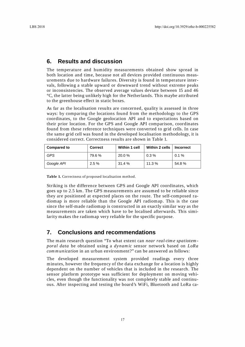
6. Results and discussion
The temperature and humidity measurements obtained show spread in both location and time, because not all devices provided continuous meas-urements due to hardware failures. Diversity is found in temperature inter-vals, following a stable upward or downward trend without extreme peaks or inconsistencies. The observed average values deviate between 15 and 46 °C, the latter being unlikely high for the Netherlands. This maybe attributed to the greenhouse effect in static boxes.
As far as the localisation results are concerned, quality is assessed in three ways: by comparing the locations found from the methodology to the GPS coordinates, to the Google geolocation API and to expectations based on their prior location. For the GPS and Google API comparison, coordinates found from these reference techniques were converted to grid cells. In case the same grid cell was found in the developed localisation methodology, it is considered correct. Correctness results are shown in Table 1.
Compared to Correct Within 1 cell Within 2 cells Incorrect
GPS 79.6 % 20.0 % 0.3 % 0.1 %
Google API 2.5 % 31.4 % 11.3 % 54.8 %
Table 1. Correctness of proposed localisation method.
Striking is the difference between GPS and Google API coordinates, which goes up to 2.5 km. The GPS measurements are assumed to be reliable since they are positioned at expected places on the route. The self-composed ra-diomap is more reliable than the Google API radiomap. This is the case since the self-made radiomap is constructed in an exactly similar way as the measurements are taken which have to be localised afterwards. This simi-larity makes the radiomap very reliable for the specific purpose.
7. Conclusions and recommendations
The main research question “To what extent can near real-time spatiotem-poral data be obtained using a dynamic sensor network based on LoRa communication in an urban environment?” can be answered as follows:
The developed measurement system provided readings every three minutes, however the frequency of the data exchange for a location is highly dependent on the number of vehicles that is included in the research. The sensor platform prototype was sufficient for deployment on moving vehi-cles, even though the functionality was not completely stable and continu-ous. After inspecting and testing the board’s WiFi, Bluetooth and LoRa ca-
LBS 2018 http://doi.org/10.3929/ethz-b-000225582
17

pabilities, it was concluded that the most effective and reliable method to localise measurements is WiFi fingerprinting using Euclidean distance in signal space for matching, based on a radiomap composed with additional GPS measurements during the radiomap training period. By using GPS for automated radiomap training, the major fingerprinting drawback is avoid-ed, while limiting the GPS energy consumption still as far as possible. The quality of the collected data returned contrary results. While the localisa-tion proved to be sufficient for the current use case, the sensor data was often not representative of the ambient air temperature. Further research about the most suitable sensor setup, acquiring unbiased measurements, is required. LoRa communication method is not fully suitable for the deploy-ment of a dynamic sensor network, due to the small maximum payload size and sending frequency restrictions, limiting the measurement interval and the amount of MAC addresses to be used for localisation. An opportunity would be to increase the microcontroller storage and perform the localisa-tion on the device itself. LoRa power usage is very low and its range long and therefore useful for the application.
It is advised to extend the proposed methodology with a Euclidean distance threshold value and a procedure to keep the radiomap up to date over long-er periods of time. The method should be adapted to work with existing sensor network standards, such as Sensor Web Enablement and Sen-sorThings by the Open Geospatial Consortium (OGC). Also, care is needed while collecting MAC addresses to avoid legal issues with personal data.
For application in larger IoT networks, further research is recommended on the reliability of RSSI trilateration with the use of machine-learning, net-work approaches, and the principle of sensor fusion for localisation: com-bining information from different sensors to improve localisation accuracy.
References
Google (2017) The Google Maps Geolocation API. Retrieved May 10, 2017, from https://developers.google.com/maps/documentation/geolocation/intro
Jol M (n.d.) KPN LoRa: Advanced Workshop. Presentation, IoT Academy.
Khedo K, Perseedoss R, Mungur A (2010) A wireless sensor network air pollution monitor-ing system. arXiv preprint arXiv:1005.1737.
Larson T, Gould T, Riley E, Austin E, Fintzi J, Sheppard L, ... , Simpson C (2017) Ambient air quality measurements from a continuously moving mobile platform: Estimation of area-wide, fuel-based, mobile source emission factors using absolute principal component scores. Atmospheric Environment, 152, 201-211.
Mautz R (2012). Indoor Positioning Technologies. Sgc.Ethz.Ch. Zürich: Print-Atelier ADAG.
Teuber A, Eissfeller B (2006) WLAN Indoor Positioning Based on Euclidean Distances and Fuzzy Logic. Institute of Geodesy and Navigation, University FAF, Munich, Germany.
LBS 2018 http://doi.org/10.3929/ethz-b-000225582
18