DRIED & STATE OF THE RIVERS - HIMACHAL PRADESH DUSTED · Himachal Pradesh is the largest producer...
64
0 DRIED & DUSTED STATE OF THE RIVERS - HIMACHAL PRADESH HIMDHARA ENVIRONMENT RESEARCH AND ACTION COLLECTIVE INDIA RIVERS WEEK 2016
Transcript of DRIED & STATE OF THE RIVERS - HIMACHAL PRADESH DUSTED · Himachal Pradesh is the largest producer...
0
DRIED &
DUSTED
STATE OF THE RIVERS - HIMACHAL PRADESH
HIMDHARA ENVIRONMENT RESEARCH AND ACTION COLLECTIVE
INDIA RIVERS WEEK 2016
Dried &
Dusted
State of the Rivers Report – Himachal
Pradesh
India Rivers Week 2016
Prepared by Himdhara Environment Action and Research
Collective
November 2016

Dried & Dusted
State of the Rivers Report for Himachal Pradesh
Prepared for the India Rivers Week 2016

Author: Himdhara Environment Research and Action Collective
Maps: SANDRP, Maps Of India, EJOLT
Cover Photo: Nicholas Roerich – ‘Chandra-Bhaga. Path to Trilokinath. Tempera on Canvas. Nicholas
Roerich Museum, New York, USA.’
November 2016
Material from this publication can be used, with acknowledgment to the source.
4
Introduction
The lifelines of Himalayas
A massive collision between two tectonic plates of the Indian and Eurasian land masses about 50 to 70 million years
ago led to the formation of the youngest and tallest mountain ranges, the Himalayas. Once the Himalayas started to
rise, a southward drainage developed which subsequently controlled the climate of the newly formed continent, and
there started the season of monsoon as well. The river systems of the Himalayas thus developed because of rains and
melting snow. The newly formed rivers were like sheets of water flowing towards the fore-deep carrying whatever
came in their way. Once the rivers reached the plains their gradients became lesser, their hydraulics changed and they
started to deposit their sediment (Priyadarshi, 2016).
The river is a defining feature of a mountain eco-system. And if that ecosystem is the Himalayas then this makes the
rivers originating here special for several reasons. Their origin and source to start with, which includes glaciers and
snow bound peaks; their length and size, and the area they cover is larger than most peninsular rivers; their rapid,
high velocity, meandering flow which is constantly shaping the young and malleable Himalayan valleys; their
propensity to carry silt and form rich plains to facilitate a fertile agriculture downstream is another unique feature.
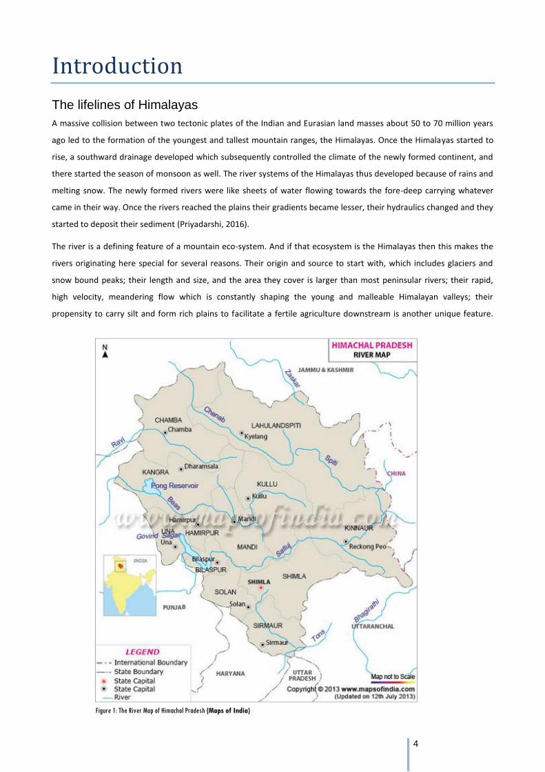
Figure 1: The River Map of Himachal Pradesh (Maps of India)
5
The Himalayan rivers are older than or as young as the Himalayas themselves. And yet, despite, the sense of power
and reverence they command and convey and all the life they support, they are vulnerable. This vulnerability is rarely
spoken of. The slightest variation and changes in temperature, flow, course and composition of the rivers impacts its
surroundings and the shifts in the landscapes in turn impacts all these aspects of the rivers, such is the degree of
interdependence and fragility.
Most text books and articles largely highlight the magnitude of the Himalayan river systems and move on to speaking,
anthropocentrically, of their energy and irrigation potential, along the lines of what can we squeeze out from them for
furthering the cause of 'human development'. Rarely ever are these seen as riverine ecosystems that are already
providing services and support life systems. Today, we speak of interlinking these rivers but fail to see the existing
natural inter linkages between, not just the rivers but amongst all life forms, the benefits of which are drawn by
human beings as well. If these rivers are stressed out, if they are tampered with, if they are tunnelled and damned,
what would after all be the impact of all other dependent systems?
In this 'State of the Rivers Report' from Himachal we focus on highlighting the key information about Himachal's rivers,
pointing out the threats that these rivers are facing. We compare the health of these rivers based on certain broad
criteria but in order to actually do a 'State of the Rivers Report' and assess the social, cultural, economic values of
these rivers and how these have changed historically, a detailed study based on primary data as well as secondary
research from a variety of sources. Moreover it is the communities who depend on these rivers who would best
describe the changes that have occurred over time. And thus any assessment would be incomplete without a people's
voice in it. For the purpose of India Rivers Week's process we have put together a preliminary document that provides
some basic information on Himachal's rivers.
A brief profile of the state and its major river basins
Himachal Pradesh a mountain state in Indian Himalaya, covering an area of over fifty five thousand square kilometres,
has 5 major river basins Satluj, Ravi, Beas, Chenab and Yamuna. Yamuna crosses only the south-eastern border of the
state, and but its tributaries originating in Himachal include Giri and Tons which form a part of the Ganga river basin
flowing westward. The other four rivers are major tributaries of the eastward flowing Indus River, the longest in the
world (2000 miles or 3200 kilometres) with a flow twice the size of the Nile. The Indus becomes a much larger river
once it is joined by what are known as the 'Punjab' (literally meaning 5 rivers - Satluj, Ravi, Beas, Chenab and Jhelum).
Of the four Himachal Rivers, except Satluj which has its source in Tibet, the rest originate within the boundaries of the
State of Himachal Pradesh. While the Satluj meets Beas meet within India, it joins the Chenab in Pakistan. Ravi too
joins the Chenab in Pakistan. Chenab then goes on to meet the Jhelum and then the merged rivers meet the Indus at
Mithankot in Pakistan followed by its confluence with the Arabian Sea. Himachal's unique geography and variation in
altitude produces a wide spectrum of climates from hot and sub-humid tropical in the southern tracts to cold, alpine
and glacial in the northern and eastern mountain ranges. There is a vast diversity of communities that reside in this
landscape.
While the large rivers are referred to by them locally as dariya, their tributaries (glacial and snow fed) are smaller
rivers are called khad, and smaller streams are known as nallahs. The, khads and nallahs, are critical components of
the riverine ecosystem, even from the point of view of the local communities, who have a direct relationship with
6
these for their day to day use – drinking water, irrigation, running watermills and fishing. It is rare to find communities
residing very close to the larger rivers or dariyas, except in some parts of Lahaul-Spiti or then lower down in the
valleys.
Himachal is a relatively small state and in 2011 its population stood at 68.65 lakhs. It is only 9% urbanised and most of
Himachal lives in its villages. Of the total land geographical area only 10% is under agriculture while close to 70% in
under the category of 'Forest land'. And yet agriculture is the main source of livelihood in Himachal with over 93% of
the population dependent on it. As in most mountain areas agriculture and forest dependence is interwoven.
Agriculture is made possible due to the irrigation from river channels or natural springs. The health of the forests
directly determines the health of the surface and ground water systems which in turn determines the viability of
agriculture and horticulture. Horticulture and cash based agriculture was pushed by the government in the late 70s
and 80s. Today the state has massive apple cultivation, apart from commercial vegetable cultivation, which is an
important source of income for the farmers.
Post the 90s, while Himachal has witnessed changes that the rest of the country was going through as a result of the
economic reforms and push to the neoliberal agenda, this process has been slower here. Despite this over the last two
decades commercial tourism has seen a massive rise, with the number of tourists visiting the state having doubled in
the last decade. The other major driver of economic growth in the state has been the Hydropower sector. Himachal
has the largest hydropower installed capacity in the country - more than 10000 MW, out of a total potential of more
than 27000 MW (Govt. of HP, 2015-16). In such a scenario the nature of development is bound to impact the state of
the rivers. In the next section we examine some of the major developments that have emerged as threats to the
health of Himachal's rivers.
Threats to riverine health in Himachal Pradesh
Before we start looking at some of the major threats to the health of Himachal's rivers, there is a need to understand
how the health of a river is monitored and assessed. Our regulatory agencies like the Pollution Control Board for
instance refer to river as 'surface waters' and the health of these is measured by assessing the 'water quality' by
looking at parameters like dissolved oxygen, PH, colour, temperature, presence of heavy metals etc. However, there is
a need to review the definition of a 'river' which comprises not just the water, but the entire riverine landscape. No
doubt the water quality is indicative of the health of the river, but the perspective on the river needs to be widened to
include a larger body of information as well as a spatial and temporal mapping of the river and its course. It is with this
understanding that we list some of the major threats to rivers and their health in Himachal Pradesh.
Hydropower Development
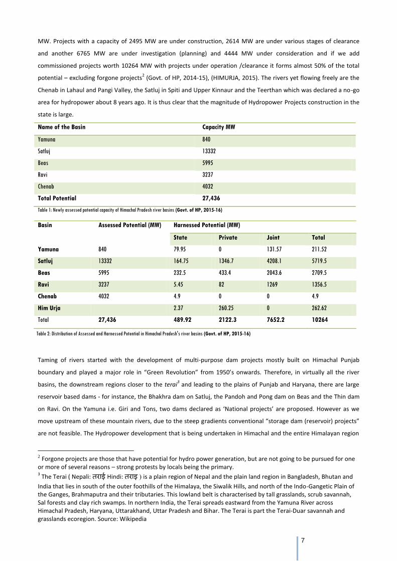
Himachal Pradesh is the largest producer of Hydropower in India. The state has already installed 10264 MW worth of
projects. It is planning to harness a total 27436 MW out of which 24000 MW of power is harnessable (Govt. of HP,
2015-16) from the five major river basins of the state namely Satluj, Chenab, Ravi, Beas and Yamuna across a total of
813 large, medium and small projects and micro-hydels1. The Satluj river basin alone has a planned potential of 13,332
1 There are various schemes of classification of hydro power projects but no one standard. One classification is across
micro (<5 MW), small (between 5 and 25 MW) and large (greater than 25 MW) projects. But some sources also add a medium category (between 25 and 100 MW). This report uses the classification of the sources cited, but otherwise tries to use the former classification as much as possible.
7
MW. Projects with a capacity of 2495 MW are under construction, 2614 MW are under various stages of clearance
and another 6765 MW are under investigation (planning) and 4444 MW under consideration and if we add
commissioned projects worth 10264 MW with projects under operation /clearance it forms almost 50% of the total
potential – excluding forgone projects2 (Govt. of HP, 2014-15), (HIMURJA, 2015). The rivers yet flowing freely are the
Chenab in Lahaul and Pangi Valley, the Satluj in Spiti and Upper Kinnaur and the Teerthan which was declared a no-go
area for hydropower about 8 years ago. It is thus clear that the magnitude of Hydropower Projects construction in the
state is large.
Name of the Basin Capacity MW
Yamuna 840
Satluj 13332
Beas 5995
Ravi 3237
Chenab 4032
Total Potential 27,436
Table 1: Newly assessed potential capacity of Himachal Pradesh river basins (Govt. of HP, 2015-16)
Taming of rivers started with the development of multi-purpose dam projects mostly built on Himachal Punjab
boundary and played a major role in “Green Revolution” from 1950’s onwards. Therefore, in virtually all the river
basins, the downstream regions closer to the terai3 and leading to the plains of Punjab and Haryana, there are large
reservoir based dams - for instance, the Bhakhra dam on Satluj, the Pandoh and Pong dam on Beas and the Thin dam
on Ravi. On the Yamuna i.e. Giri and Tons, two dams declared as ‘National projects’ are proposed. However as we
move upstream of these mountain rivers, due to the steep gradients conventional “storage dam (reservoir) projects”
are not feasible. The Hydropower development that is being undertaken in Himachal and the entire Himalayan region
2 Forgone projects are those that have potential for hydro power generation, but are not going to be pursued for one
or more of several reasons – strong protests by locals being the primary. 3 The Terai ( Nepali: तराई Hindi: तराइ ) is a plain region of Nepal and the plain land region in Bangladesh, Bhutan and
India that lies in south of the outer foothills of the Himalaya, the Siwalik Hills, and north of the Indo-Gangetic Plain of the Ganges, Brahmaputra and their tributaries. This lowland belt is characterised by tall grasslands, scrub savannah, Sal forests and clay rich swamps. In northern India, the Terai spreads eastward from the Yamuna River across Himachal Pradesh, Haryana, Uttarakhand, Uttar Pradesh and Bihar. The Terai is part the Terai-Duar savannah and grasslands ecoregion. Source: Wikipedia
Basin Assessed Potential (MW) Harnessed Potential (MW)
State Private Joint Total
Yamuna 840 79.95 0 131.57 211.52
Satluj 13332 164.75 1346.7 4208.1 5719.5
Beas 5995 232.5 433.4 2043.6 2709.5
Ravi 3237 5.45 82 1269 1356.5
Chenab 4032 4.9 0 0 4.9
Him Urja 2.37 260.25 0 262.62
Total 27,436 489.92 2122.3 7652.2 10264
Table 2: Distribution of Assessed and Harnessed Potential in Himachal Pradesh's river basins (Govt. of HP, 2015-16)
8
of India is based on the Run-of-the-river technology which produces electricity by checking and diverting river flow.
The diverted water is made to flow through underground tunnels in the mountains and released downstream on the
turbines that spin generators before returning the water back to the river.
Cascade of Projects on a single river: Obstruction of the Natural flow of the river
It is important to note that the projects using this technology are being built in a cascade form on a river basin. This
means that at the tail of one project, the head of the next is located. A series of these projects are being built bumper
to bumper on the streams and rivers to harness the capacity of the rivers to produce power to its maximum. In the
Satluj River Basin alone the total length of tunnels once all the planned hydroprojects are built will be 185 kms. If all
the planned projects in Himachal and across the Himalayas are constructed there will be hundreds of kilometres of
tunnels underneath the mountains in this region.
This is perhaps the most serious issue as far as a tunnels are concerned considering that there are hardly any long
stretches of the rivers Ravi, Satluj, Beas and Chenab that will be free-flowing once all the projects that are being
planned, come up. This is bound to lead to an ecological crisis in the long run. More importantly, for a river to be
called a 'river' there needs to be free-flowing water in it. In many cases, the distance between two successive projects
on a river is less than a Km with some of the projects like Rampur HEP receiving water directly from the tail race of the
upstream projects.
Cumulative Environment Impact Assessment (CEIA) report of Satluj River prepared by Indian Council of Forestry
Research and Education clearly states that “The constructions of barrage in the middle zones (Karcham, Nathpa and
Baspa-II) have negatively impacted the fish migration between lower and middle zone. The cascade of run off the
river hydro projects impact the river ecology in three ways-
1. Diversion structure breaks the longitudinal connectivity of the river which checks the migration of fish and also
fragment the fish population in isolated patches
2. The river bed is virtually get dry in the lean season which adversely impacts riverine ecology
There are many studies which indicate that the fish population has declined due to construction of projects. Most
rivers in Himachal have the Schizothoracines as the dominant species and migratory nature needs suitable
temperature and conditions for spawning. Due to blockage, fish can no longer move freely though different habitats,
and don’t get suitable temperature for spawning and become genetically isolated from other fish populations
throughout the river (Theophilus, 2014).
During the current investigation it was observed that the river basin above Rampur up to Karcham and Tapri is
impacted due to the existing HE projects (Nathpa-Jhakri and Karcham-Wangtoo).” The diversion of rivers and streams
and tunnelling have affected the water flows and aquifers crucial not just to the river fauna but to the local
inhabitants dependent on the streams and springs for irrigation, drinking, running watermills, fishing, etc. The
planning and monitoring mechanisms that exist currently for hydropower projects have completely failed to take into
account the various issues regarding tunnels built for hydropower projects.
9
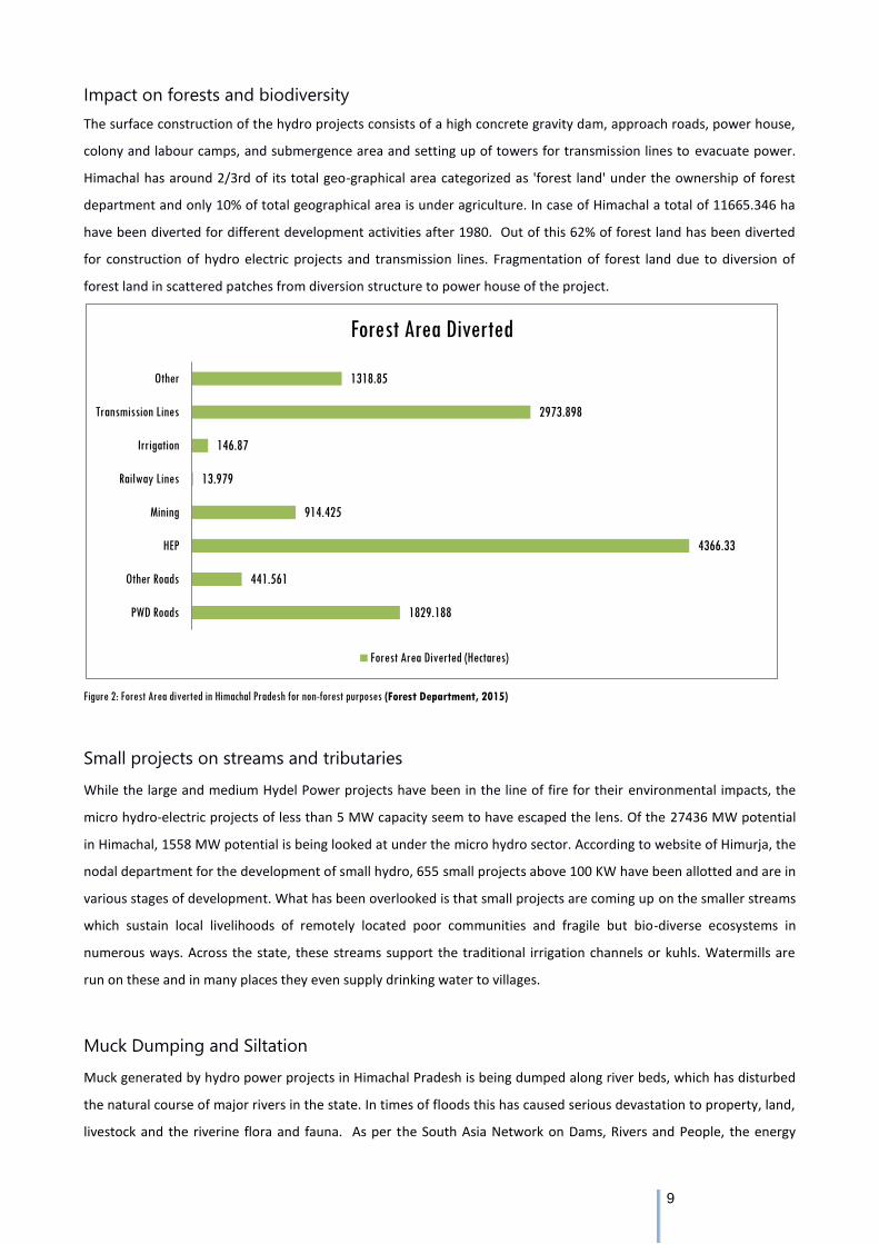
Impact on forests and biodiversity
The surface construction of the hydro projects consists of a high concrete gravity dam, approach roads, power house,
colony and labour camps, and submergence area and setting up of towers for transmission lines to evacuate power.
Himachal has around 2/3rd of its total geo-graphical area categorized as 'forest land' under the ownership of forest
department and only 10% of total geographical area is under agriculture. In case of Himachal a total of 11665.346 ha
have been diverted for different development activities after 1980. Out of this 62% of forest land has been diverted
for construction of hydro electric projects and transmission lines. Fragmentation of forest land due to diversion of
forest land in scattered patches from diversion structure to power house of the project.
Figure 2: Forest Area diverted in Himachal Pradesh for non-forest purposes (Forest Department, 2015)
Small projects on streams and tributaries
While the large and medium Hydel Power projects have been in the line of fire for their environmental impacts, the
micro hydro-electric projects of less than 5 MW capacity seem to have escaped the lens. Of the 27436 MW potential
in Himachal, 1558 MW potential is being looked at under the micro hydro sector. According to website of Himurja, the
nodal department for the development of small hydro, 655 small projects above 100 KW have been allotted and are in
various stages of development. What has been overlooked is that small projects are coming up on the smaller streams
which sustain local livelihoods of remotely located poor communities and fragile but bio-diverse ecosystems in
numerous ways. Across the state, these streams support the traditional irrigation channels or kuhls. Watermills are
run on these and in many places they even supply drinking water to villages.
Muck Dumping and Siltation
Muck generated by hydro power projects in Himachal Pradesh is being dumped along river beds, which has disturbed
the natural course of major rivers in the state. In times of floods this has caused serious devastation to property, land,
livestock and the riverine flora and fauna. As per the South Asia Network on Dams, Rivers and People, the energy
1829.188
441.561
4366.33
914.425
13.979
146.87
2973.898
1318.85
PWD Roads
Other Roads
HEP
Mining
Railway Lines
Irrigation
Transmission Lines
Other
Forest Area Diverted
Forest Area Diverted (Hectares)
10
generated per unit installed capacity from large hydro projects has been almost continuously falling over the last
sixteen years. The major factors that have been observed as responsible for this trend include: over development in
the river basin, making the capacity un-viable; the operational projects not getting enough repair and maintenance;
increasing silt load, erosion, muck dumping affecting downstream projects; and climatic changes leading to flash
floods, erratic rainfall patterns causing more damage.
Urbanisation and tourism: Municipal Solid Waste and Untreated Sewage
In the causes of degradation of rivers urbanisation and the heavy inflow of tourists both are emerging as problems
because of the disposal of solid waste, encroachment upon the river waterway and water extraction involved. The
Kullu-Manali stretch, Shimla and Dharamsala are the centres which have rapidly urbanised and have large tourist
traffic. To save the Beas River from pollution National Green Tribunal in 2013 had ordered to close 34 hotels located
along river banks in Kullu and Manali as they were operating without obtaining required permissions from the
pollution control board. The sewerage system in the urban areas of Himachal is highly inadequate and it is ultimately
the rivers which become the dumping ground for untreated sewage.
Industrial Pollution
Industry is located in the terai region of the state – concentrated in the Solan District (Baddi-Baotiwala, Nalagarh) and
Sirmaur (Paonta Sahib) wherein the polluting units like pharma are located. Discharge of contaminated waste from
the industrial units in BBN area, into the local water bodies have gravely polluted almost 6 to 7 small streams flowing
into the Sarsa River, a tributary of the Satluj. The Punjab and Haryana governments have been raising issues of here
were five major points from where Himachal river water flows into Punjab in huge scale and has industrial areas on its
bank from where some industrial waste enter into the river. At Gualthai of Bilaspur district, the waste goes into river
Satluj, at Mehatpur of Una district the industrial waste goes into river Swan, at Paonta Sahib- Kala Amb of Sirmaur
district the waste flows into river Markanda, at Parwanoo of Solan district the waste flows into river Gaggar and at
Baddi-Barotiwala of Solan district, the waste flows into river Sarsa.
Polluted rivers categorised as “priority” for Himachal Pradesh as per the Central Pollution Control Board are “Beas,
Tons, Sirsa, Swan, Sukhana, Suketi khad, Markanda and Binwa.
Sand Mining
Removal of sand, minerals and aggregate from river beds is posing a serious threat to the flow of rivers, survival of
forests upon river banks and most seriously to the environment of river banks – a fact that has been observed by the
National Green Tribunal in 2013. Following this the issue of illegal river bed mining has come up in a major way in
Himachal as well. Apart from the major rivers, almost all tributaries are faced with the threat of over mining. Some of
tributaries of the Beas, such as Neugal (colloquially called Neogal), is one such case.
With the rise in industrialisation in the BBN area during the early 2000s, the need for construction material also grew
rapidly, putting strain on the river ecosystem. The ban on mining or minor minerals inside Punjab further accentuated
the already critical situation in the BBN area vis-a-vis river bed mining. The area borders Punjab along its southern and
western periphery and Haryana along its southern and eastern part. Years of rampant illegal mining and clandestine
export of the mined stone, sand and bajri to the nearby stone crushers in the BBN area as well as Punjab have
11
decimated the area's ability to support this activity. As a consequence, the riverine ecology has undergone drastic
transformation for the worse.
Floods and climatic changes (glacial melt)
The Himalaya holds the planet's largest body of ice outside the polar caps - an estimated 12,000 cubic kilometres of
water. They feed many of the world's great rivers - the Ganges, the Indus, the Brahmaputra - on which hundreds of
millions of people depend. The fate of Himalayan glaciers and the rivers fed by these glaciers is uncertain due to global
warming (Bagla, 2009). The extent of impact of global warming is magnified in the Himalayas because of two reasons.
First, the high-altitude zones of Himalayas are closer to the Equator and, the second is soot emitted from burning of
coal, fuelwood and petroleum products, is fast turning Himalayas into a heat-absorbing, rather than heat-reflecting
landform. These two phenomena are accelerating temperature in the Himalayas.
Glaciers and ice bodies cover 2,473 sq. km. in Himachal which was 4.44 per cent of the total area of the state and all
major rivers, the Satluj, Beas, Chandrabhaga, Ravi and Yamuna, are fed by these glaciers. According to a report
brought out by the World Bank in collaboration with the Government of India, most of the Himalayan glacial rivers will
deplete in next seven-eight decades. It means the rivers originating from the Himalayan glaciers will dry up in the near
future and the melting of these Himalayan glaciers will have a more direct long-term effect on the hundreds of
millions of people who live along rivers fed by their seasonal runoff.
Glacier status in HP: (State strategy and Action Plan on Climate Change, Himachal 2012)
1. An overall reduction in glaciers area from 2077 km2
to 1628
km
2 from 1967-2001 in Chenab, Parbati and Baspa
Basin, HP
2. An overall de-glaciations of 21% of total area in three basin
3. An overall de-glaciations is observed in Spiti Basin during 2001-07
Prominent glaciers as studied by GSI in Himachal Pradesh show
1. Chhota Shigri 6.81m/yr retreat during 1962-95
2. Bara Shigri Glacier29.78 m/yr during 1906-1957
3. Triloknath as 17.86 m/yr
4. Beas Kund as 18.8 m/yr during 1963-2003
5. Manimahesh as 29.1 m/yr during 1968-2005
Geological Survey of India studied (Samjwal R. Bajracharya, 2006)
1. The Gara, Gor Garang, Shaune Garang, Nagpo Tokpo Glaciers of Satluj River Basin and observed an average
retreat of 4.22 - 6.8 m/year.
2. The Bara Shigri, Chhota Shigri, Miyar, Hamtah, Nagpo Tokpo, Triloknath and Sonapani Glaciers in Chenab
River Basin retreated at the rate of 6.81 to 29.78 m/year. The highest and lowest retreat was in the Bara
Shigri Glacier and Chhota Shigri Glacier respectively.
As the glaciers are retreating back new lakes are forming behind newly exposed moraine. Rapid accumulation of water
in these lakes can lead to sudden breaching of the unstable 'dams' behind which they are formed. The resultant
discharges of huge amounts of water and debris -known as a Glacial Lake Outburst Floods, or GLOFs -often have
catastrophic effects. Most of the glacial lakes in the Himalayan region are known to have formed within the last 5
decades, and a number of Glacial Lake Outburst Flood (GLOF). At least between 3 to 10 years one GLOF event was
12
recorded in Himalayan region. These GLOF events have resulted in loss of many lives, as well as the destruction of
houses, bridges, fields, forests and roads. (Samjwal R. Bajracharya, 2006)
In case of Himachal, the Parechu lake outburst in 2005 had incurred a loss of Rs 610 crore and National Highway-22
got washed away at a number of places. Ten bridges and 11 ropeways were washed away while 15 motorable bridges
and 8 jeepable roads and 10 km stretch between Wangtoo and Sumdoh were damaged. This is also a trans-boundary
issue because the lake is formed in Tibet and the impacts of it being borne in the downstream riparian country.
Two lakes having highest GLOF threat identified in Himachal are Gopang Gath and Samudra Tapu Lake in Lahaul and
Spiti. The pro-glacial Gopang Gath Lake was considered as critical, principally due to the steep slope of the
downstream face of the moraine dam, the big lake area and the possibility for mass movements to occur from the
surroundings of the lake.
In order to understand the nature of each river basin, the changes that it has undergone and the gravity of each of
these threats for the 5 rivers, in the next section we take a detailed look at Satluj, Beas, Chenab, Ravi and Yamuna
rivers individually. Each river basin profile has five sections. The first is River Narratives – which provides a fact sheet
on the river and talks about its tributaries. This is followed by the mythology and legends around the river. The
ecology section covers the floral and faunal biodiversity of the river basin, the ‘economy’ deals with key livelihoods of
the area and finally the threat analysis and assessment which has a detailed description of the major threats and a
chart that rates the severity of the five threats (described here) for that specific river.
13
RIVER BASINS
14
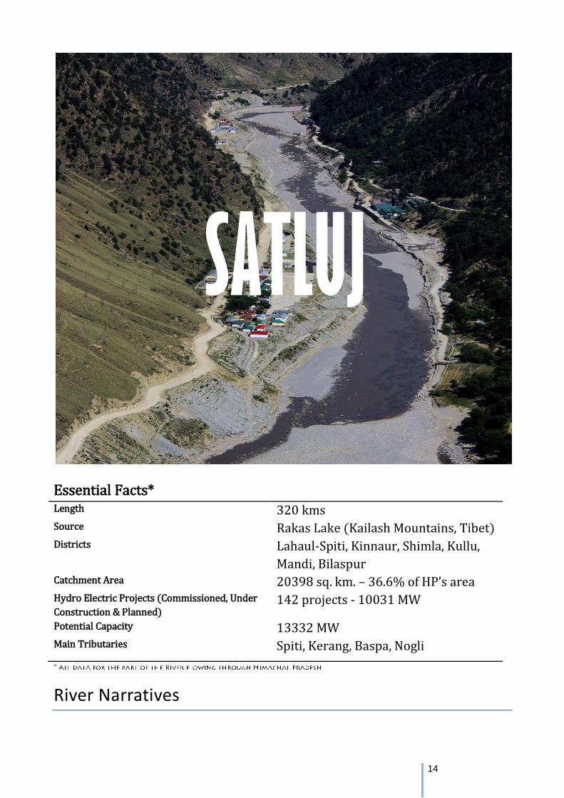
Essential Facts* Length 320 kms Source Rakas Lake (Kailash Mountains, Tibet) Districts Lahaul-Spiti, Kinnaur, Shimla, Kullu,
Mandi, Bilaspur Catchment Area 20398 sq. km. – 36.6% of HP’s area Hydro Electric Projects (Commissioned, Under
Construction & Planned) 142 projects - 10031 MW
Potential Capacity 13332 MW Main Tributaries Spiti, Kerang, Baspa, Nogli
River Narratives
SATLUJ
15
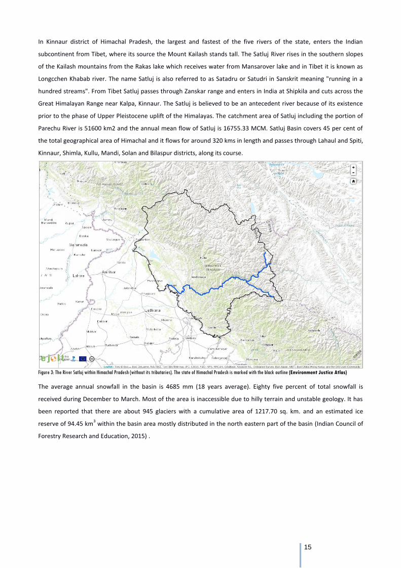
In Kinnaur district of Himachal Pradesh, the largest and fastest of the five rivers of the state, enters the Indian
subcontinent from Tibet, where its source the Mount Kailash stands tall. The Satluj River rises in the southern slopes
of the Kailash mountains from the Rakas lake which receives water from Mansarover lake and in Tibet it is known as
Longcchen Khabab river. The name Satluj is also referred to as Satadru or Satudri in Sanskrit meaning "running in a
hundred streams". From Tibet Satluj passes through Zanskar range and enters in India at Shipkila and cuts across the
Great Himalayan Range near Kalpa, Kinnaur. The Satluj is believed to be an antecedent river because of its existence
prior to the phase of Upper Pleistocene uplift of the Himalayas. The catchment area of Satluj including the portion of
Parechu River is 51600 km2 and the annual mean flow of Satluj is 16755.33 MCM. Satluj Basin covers 45 per cent of
the total geographical area of Himachal and it flows for around 320 kms in length and passes through Lahaul and Spiti,
Kinnaur, Shimla, Kullu, Mandi, Solan and Bilaspur districts, along its course.
Figure 3: The River Satluj within Himachal Pradesh (without its tributaries). The state of Himachal Pradesh is marked with the black outline (Environment Justice Atlas)
The average annual snowfall in the basin is 4685 mm (18 years average). Eighty five percent of total snowfall is
received during December to March. Most of the area is inaccessible due to hilly terrain and unstable geology. It has
been reported that there are about 945 glaciers with a cumulative area of 1217.70 sq. km. and an estimated ice
reserve of 94.45 km3 within the basin area mostly distributed in the north eastern part of the basin (Indian Council of
Forestry Research and Education, 2015) .
16
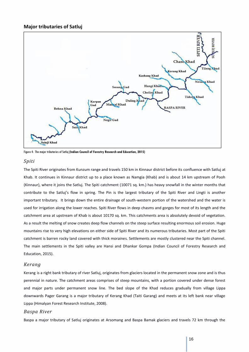
Major tributaries of Satluj
Figure 4: The major tributaries of Satluj (Indian Council of Forestry Research and Education, 2015)
Spiti
The Spiti River originates from Kunzum range and travels 150 km in Kinnaur district before its confluence with Satluj at
Khab. It continues in Kinnaur district up to a place known as Namgia (Khab) and is about 14 km upstream of Pooh
(Kinnaur), where it joins the Satluj. The Spiti catchment (10071 sq. km.) has heavy snowfall in the winter months that
contribute to the Satluj’s flow in spring. The Pin is the largest tributary of the Spiti River and Lingti is another
important tributary. It brings down the entire drainage of south-western portion of the watershed and the water is
used for irrigation along the lower reaches. Spiti River flows in deep chasms and gorges for most of its length and the
catchment area at upstream of Khab is about 10170 sq. km. This catchments area is absolutely devoid of vegetation.
As a result the melting of snow creates deep flow channels on the steep surface resulting enormous soil erosion. Huge
mountains rise to very high elevations on either side of Spiti River and its numerous tributaries. Most part of the Spiti
catchment is barren rocky land covered with thick moraines. Settlements are mostly clustered near the Spiti channel.
The main settlements in the Spiti valley are Hansi and Dhankar Gompa (Indian Council of Forestry Research and
Education, 2015).
Kerang
Kerang is a right bank tributary of river Satluj, originates from glaciers located in the permanent snow zone and is thus
perennial in nature. The catchment areas comprises of steep mountains, with a portion covered under dense forest
and major parts under permanent snow line. The bed slope of the Khad reduces gradually from village Lippa
downwards Pager Garang is a major tributary of Kerang Khad (Taiti Garang) and meets at its left bank near village
Lippa (Himalyan Forest Research Institute, 2008).
Baspa River
Baspa a major tributary of Satluj originates at Arsomang and Baspa Bamak glaciers and travels 72 km through the
17
valley before joining the Satluj River at Karcham. Its 1102 km2 catchment is situated in the orogenic interior and
glaciers cover 20% of the catchment. The basin is comprised of 19 valleys that vary in size Most part of the Catchment
of Baspa River is covered with thick vegetation. The tributary streams bring down sediments and block the river at
times.
Nogli Khad
Nogli Khad is a snow fed and rain fed stream which join Satluj at Nogli. It originates as Sageti Gad in the east of a 5236
m high peak on Kumashi Kharang Dhar, flows for 38 km in a channel of gradient 1:9.97 and finally merges with Satluj
on its right bank at 910 m near Nogli village (Indian Council of Forestry Research and Education, 2015).
Religious/Cultural significance
There is a diverse range of communities residing in the Satluj river basin. While upstream, the Spiti and Kinnaur region
is dominated by Buddhist and animistic clans, in the middle basin around Shimla, Mandi, Bilaspur and Kullu, the
population is predominantly worshipping local deities and identify themselves as ‘Hindus’. The upper zone is known
for its monasteries while the lower areas for various temples and other places of significance.
Tattapani
Tattapani “stands for hot water ´is a pilgrimage spot for the devotees. A number of hot sulphur springs are located
beside the right riverbanks of the Satluj, which spans more than one sq. km. These hot sulphur springs are important
attributes of the village, and therefore the name “Tattapani” was given. Thousands of Hindus visit the place round the
year. Flocks of religious devotees assemble here during the occasion of Lohri, which takes place on January 26 every
year and Tara Ratri as well. A bath here is extremely advantageous for those who are having problems from arthritic
pains, any type of skin infections, or tiredness.
Kye Monastery
Spiti, popularly known as the 'land of the lamas', is dotted with numerous Buddhist monasteries or Gompas that are
known throughout the world. The Kye Monastery 1000 years old is a key learning centre of Buddhist studies situated
by the Spiti River. Rare Thangka paintings and ancient musical instruments have been preserved in the Monastery.
Tabo Monastery
Another site of religious significance is the Tabo Monastery which is often referred to as the 'Ajanta of the Himalayas'.
It stands at an altitude of 3050 meters on the left bank of the Spiti river. Founded by the great scholar Richen Zangpo
in the 10th century it has been declared as a World Heritage Site by UNESCO. The monastery contains a rare collection
of scriptures and wall paintings -Thankas and Stucco. It is near the Tabo monastery that the mummy of the meditating
Lama can be found in Giu. It is believed that he died when Giu was hit by an avalanche while he was in deep
meditation.
Temples of Sangla
Temples of Sangla, Nag Mandir and Devi Maa Mandir are popular amongst the locals. The richly decorated Semi-
Buddhist temple is a typical example of Hindu-Buddhist confluence. The Nag Devta the main idol in Sangla temples is
said to have come from the Dhauladhars.
18
Ecology & Biodiversity
The Satluj River Basin of Himachal Pradesh falls under Western Himalaya, which harbours a rich regional flora due to
its diverse topography, wide altitudinal range and location at the intersection of several bio-geographical units. The
forests groups in Satluj Basin consist of 24 forest types as per the classification with the total forest cover area of
2550.90 sq. km (Indian Council of Forestry Research and Education, 2015).
Ecologically the Satluj Basin shall be broadly divided into three zones based on elevation, slope and
temperature viz. 1. Lower zone Bhakhra dam to Nathpa; 2. Middle zone, Nathpa to Khab and 3. Upper zone,
Khab to Kunzum.
The vegetation is represented by lower and upper western Himalayan temperate forests, dry temperate
coniferous forests, sub-alpine forests and scrubs, alpine pastures, dwarf Juniper scrub, and dry alpine scrub
communities (Champion and Seth, 1968).
The Neoza Pine forest type 13/C2a (Pinus Gerardiana) is found only in Himachal Pradesh occupies an area of
120.68 km2, which is the area that represents for the entire country (100%) and out of this 115 km2 is in
Satluj basin only. It is the only pine whose fruit is edible and has commercial value.
The forest type 12/C2/DS1 Oak Scrub that occurs only in Himachal Pradesh (5.07 km2) has half of its
distribution in the Satluj Basin (2.54 km2 i.e. 50.10%).
Alpine pastures dominated with Juniper scrub and Betula utilis (birch) and harbour important threatened and
medicinal plant species cover maximum area of the landscape.
The entire Satluj Basin, with its unique structural compositions has 10 protected areas, supports with habitats
for umbrella and key stone species of wild life.
Of the total 368 species of birds, 43 bird species falling under 14 families that are highly dependent on the
river for their survival were recorded along the main river and tributaries Most of these bird species depends
on aquatic fauna especially fishes as their food source (e.g., Crested Kingfisher, Grey Heron, Little Egret, Large
Egret, Great Cormorant, Lesser Pied Kingfisher, Pallas’s Fish-eagle and White-breasted Kingfisher).
Satluj Basin, 26 species are listed under “Critical Faunal Species” category including 1 amphibians, 12 birds
and 13 mammalian species. Of these, 5 species are Critically Endangered (4 birds and 1 mammal), 4 species
are endangered (1 bird and 3 mammals) and 17 species are Vulnerable species (1 amphibian, 7 birds and 9
mammals).
Out of the total 610 faunal species of different taxonomic groups (118 butterflies, 13 amphibians, 37 reptiles,
368 birds and 74 mammals), recorded from the study area of or species for which there is evidence that the
loss of species from the area is likely to cause an unacceptable impact on another important (threatened or
endangered) species or the structure or function of the system that support the critical species category
(USEPA, 1994a.).
As per a study by Geological Society of America Spiti houses various unique and rare fossils of marine life
19
(Trilobites, of the Palaeozoic Era are some of the first legged creatures). The Parhio Valley in the Pin Valley
National Park is considered to be the most fossil rich region in the world, dating back to over a billion years.
Threat Assessment
The first noose around the Satluj’s neck, also known as the first temple of modern India, was tied in the 1950s. The
Bhakra Dam, the world’s highest gravity dam was built at Bhakra village in Himachal Pradesh, just before the Satluj
enters Punjab, at a height of 740 feet submerged. Fishing, agriculture and forest based livelihoods of more 40,000
families were lost. The river was channelized to feed the power and irrigation needs of the northern states to usher in
the Green Revolution. After five decades, even as the fallouts of the miracle called Green Revolution are unravelling
themselves in the form of an agriculture crisis, the heavy environmental and social costs of damming the Satluj itself
remain unaccounted for.
The major threat to the river, surrounding ecology and livelihood of local population is today from 41 big hydro and
dam projects and 91 small and micro HEPs. Satluj basin has highest hydropower potential to the tune 13,332 MWs.
Already 9 big hydro projects are in operational stage with total installed capacity of 5780 MW, which is more than 50%
of total hydro power generation of the state. The biggest hydro power projects of the country after Bhakra was the i.e.
Nathpa Jhakri 1500 MW in the public sector and Karcham Wangtoo 1000 MW in the private sector built by Jaypee
group which also constructed Baspa II of 300 MW.
So from Karchham onwards the river has been reduced to a trickle as Satluj is diverted in a 17 km long tunnel. Further
downstream is Nathpa Jhakri, followed by the 412 MW Rampur project which was only recently commissioned. Next
was the 750 MW Luhri dam which is now in the doldrums following local opposition. After this comes the 800 MW Kol
Dam which located in Bilaspur district Kol Dam has an installed capacity of 800 MW and got commissioned in 2015.
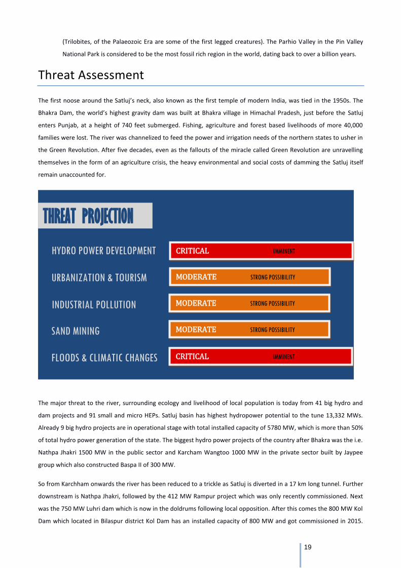
CRITICAL IMMINENT
THREAT PROJECTION
HYDRO POWER DEVELOPMENT
URBANIZATION & TOURISM
INDUSTRIAL POLLUTION
SAND MINING
FLOODS & CLIMATIC CHANGES
MODERATE STRONG POSSIBILITY
MODERATE STRONG POSSIBILITY
CRITICAL IMMINENT
MODERATE STRONG POSSIBILITY
20
The total height of the project is 167 meters. Around 1,100 families from Himachal’s Bilaspur, Mandi, Solan and Shimla
districts were ousted due to the construction of Kol Dam project. This is followed by the Bhakra dam where the river
dies and is diverted into several irrigation channels.
Already these projects have caused immense damage to the river with the major sections of the river stretch
completely drying up. This has not only disturbed the riverine ecology but also surrounding ecology. The mountains
through which tunnels have passed through have got destabilized and incidences of landslides and soil erosion have
increased and adversely impacting the environment and local lives and livelihoods.
Hydro Power Development
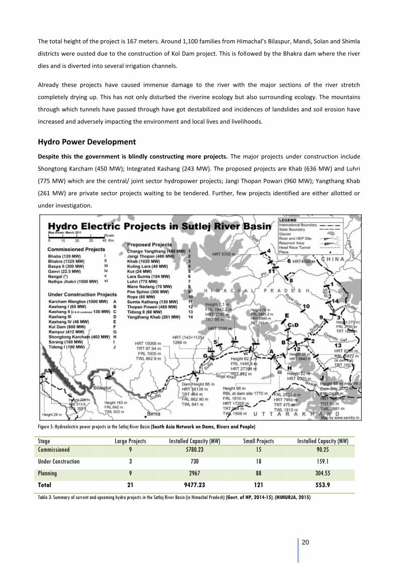
Despite this the government is blindly constructing more projects. The major projects under construction include
Shongtong Karcham (450 MW); Integrated Kashang (243 MW). The proposed projects are Khab (636 MW) and Luhri
(775 MW) which are the central/ joint sector hydropower projects; Jangi Thopan Powari (960 MW); Yangthang Khab
(261 MW) are private sector projects waiting to be tendered. Further, few projects identified are either allotted or
under investigation.
Figure 5: Hydroelectric power projects in the Satluj River Basin (South Asia Network on Dams, Rivers and People)
Stage Large Projects Installed Capacity (MW) Small Projects Installed Capacity (MW)
Commissioned 9 5780.23 15 90.25
Under Construction 3 730 18 159.1
Planning 9 2967 88 304.55
Total 21 9477.23 121 553.9
Table 3: Summary of current and upcoming hydro projects in the Satluj River Basin (in Himachal Pradesh) (Govt. of HP, 2014-15), (HIMURJA, 2015)
21
The following projects are proposed on the Spiti River:
Lara Sumta near Tabo Village in Lahaul & Spiti District - The total land requirement for the project is about 97.75 ha.
Out of which 79.50 ha is forest land 18.50 ha is private land.
Sumte-Kothang dam is proposed on Spiti river near Hurling Village An underground powerhouse is proposed on the
right bank of the river near Chango village with 2 units of 65 MW. Head Race Tunnel (HRT) is about 10.84 Km with 6.20
diameter and 286 m long tail race tunnel (TRT) with 6.20 m diameter. The total land requirement for the project is
about 110 ha. Out of which 87 ha is forest land 23 ha is private land. Total submergence area is 32.20 ha.
Chango Yangthang for which the total land requirement will be of 146 ha. 72 ha is barren un‐demarcated forest land
of which about 40 ha will be submerged. This includes private land and some potion of NH22. This will be followed by
Yangthang Khab. After this Khab Shaso on the Satluj was proposed but met with great local opposition and is in the
cold store for now (Indian Council of Forestry Research and Education, 2015).
Cumulative Impacts (Indian Council of Forestry Research and Education, 2015)
After much pressure exercised by environmental groups and concerned communities, the government announced the
carrying out of Cumulative Impact Assessment Studies on all the river basins of the state. The study for the Satluj River
was completed last year by ICFRE. According to Satluj CEIA report “The main Satluj River from stem location where it
enters India and up to Kol Dam the river stretch affected length is 220 km out of a total river length 239 km which is
70% (220.65 Km) of the total river stretch and the river submerged is observed to be 22 % (52.65 km).” It means 70%
river stretch will be dry due to diversion of river flow into concrete tunnel and on 22% of river stretch will be
stagnated behind dams. There is a provision of releasing 15% of minimum flow “average of two winter months” which
is ridiculously low. Two old projects, i.e. Nathpa-Jhakri and SVP Bhaba do not release even this amount of water below
the diversion point.
All the out flow from the tail race of the Nathpa-Jhakri HEP is utilised for generating power at the Rampur HEP, thus
leaving the river stretch for the length of the Rampur project virtually dry, except the water from the smaller streams
that join the Satluj river between these points, these streams have also projects constructed on them which alter the
diurnal flow within these smaller streams too.
Impact on fish - The constructions of barrage in the middle zones Karcham, Nathpa and Baspa-II) have negatively
impacted the fish migration between lower and middle zone. In case of Natha Jhakri project about 405 cumecs of
water is required to harness the installed capacity of the project. During monsoon, the flow of the river varies from
700 to 2500 cumecs, and from 100 to 150 cumecs during the lean months. In the lean period, the entire water in the
river at Nathpa is required for power generation. Flow of Sholding khad is also diverted into HRT during lean period.
According to the CEIA report “the river basin above Rampur up to Karcham and Tapri is impacted due to the existing
HE projects (Nathpa-Jhakri and Krcham- Wangtoo). Mahseer (Tor putitora) was not recorded during present
investigation from Kol Dam to Kunjum. It was reported that the migration of this species got affected due to the
construction of Bhakra barrage on Satluj”
22
Impact on rare and endangered plants - Another important factor is diversion of forest land for hydropower
development and its allied activities in the Neoza pine rich areas of Kinnaur district. There are 10 hydroelectric
projects for which forest land from the Chilgoza belt has either been diverted or will be diverted in the future. The
hydro projects are Karcham Wangtoo; Kashang-I, Kashang stage-II and III, Kashang stage-IV, Ropa, Tidong-I; Shongtong
Karcham; Roura-II; Nesang, Jangi Thopan Powari and Nesang. Around 285 hectares of forest land will be diverted for
the 6 projects for which data is available. There are also 4 transmission lines which are passing through the Chilgoza
belt for which forest land has been diverted. A total of around 2743 Chilgoza trees have been directly felled from the
forest land diverted for HEPs and TLs as of now.
Fragmentation of habitat - According to the CEIA report of Satluj basin several protected areas will be impacted by
the projects on this river basin. Three Wild Life Sanctuaries are in the Greater Himalaya, where winter is quiet severe
and heavy snowfall takes place. In this winter period, wild life tends to move down to lower altitudes looking for food
and it is in these lower areas that hydro projects are coming up. Majthal wild life sanctuary which is habitat of Chir
Pine pheasant has got adversely impacted due to diversion of area from WLS for the Kol dam project.
Impact on livelihood of local population - According to a report by the Indian Council of Social Science Research
(Anup Katoch, 2014), the production and productivity of apple and plum in the study area had been declined, in spite
of large number of state government schemes. Also, the quality of drinking water of natural water bodies had
deteriorated after the project work mainly due to the fact that sources have got disturbed through the blasting at the
time of excavation of tunnel. Natural water bodies like chou/spring etc. were the major sources of water irrigation and
the condition of all such sources after implementation of the project was reported to be deteriorated. The extent of
soil erosion in case of cultivated land and orchards increased in comparison to before project implementation period.
Before project implementation the extent of cracks in the buildings and field were negligible as reported by the
respondents. In the present scenario, the cracks were observed by the majority of population in all type of man-made
structures and other resources. Among the different structures, cracks in building like residential, cattle sheds, stores,
shops, orchards etc. were highest. Damage to irrigation system, agricultural fields, roads, electricity poles etc. were
also reported by respondents.
Industrial Pollution
According to report of Punjab Pollution Control Board (PPCB) prepared after various tests on the river's waters at
various points in the 2010, as per the report, Satluj's waters, which are rated 'A' class (pure) at Nangal headworks,
become 'E' class and 'D' class respectively at the confluence of Budha Nullah in Ludhiana and East Bein or Chitti Bein
(rivulet) in the Doaba region. Notably, a large quantity of industrial effluent is discharged in both Chitti Bein and Budha
nullah and both these water sources flow into the Satluj. As per the report, D class water is highly unfit for drinking
while Satluj's water is used for drinking by the people of Malwa region of the state as well as people in several districts
of Rajasthan.
In Doaba region, the Chitti Bein has been getting maximum pollution from Kala Sanghia Drain. Even the PPCB study in
the past revealed that the bein has become highly polluted because of untreated industrial and sewer waste from
Jalandhar and Phagwara.
A study by PPCB in the past revealed that people have been living in highly toxic environment along the Chitti Bein and
23
even ground water quality has been affected with respect to total dissolved solids (TDS). Accumulation of chromium,
nickel, zinc, and pesticides is high in the sediment of Chitti Bein. Traces of metals like chromium, nickel and zinc were
detected in soil samples of the fields irrigated by the waters of the Bein. There is high level of inorganic and organic
pollution in both the east Bein and the Kala Sanghia drain, said the PPCB reports.
Sirsa river another tributary of the Satluj located in the Nalagarh and Baddi areas of Solan districts is severely polluted
due to the thousands of pharma and polluting units in the Baddi-Barotiwala-Nalagarh (BBN) Industrial Area. Discharge
of contaminated waste from the industrial units into the local water bodies have gravely polluted 6 to 7 small streams
flowing into the Sirsa River. Sirsa used to be a lifeline for those living on its banks, especially the Gujjar Community
now live under the looming danger of health impacts on their cattle. In fact, the case of cattle developing skin allergies
is already on a rise. Livestock is being forced to drink polluted water and graze on contaminated grass. Fish kills have
also been reported several times in the Sirsa due to the contamination (Himdhara Environment Research and Action
Collective; HimParivesh Environment Protection Organization, 2014).
Sand Mining
The BBN area is mainly comprised of the Shiwalik foothills and the terai region below them. The area abounds with
the detritus that has been brought downhill due to erosion over thousands of years. The area has seven
streams/khads that eventually flow into the River Satluj, Sirsa River being the biggest among them. With the rise in
industrialisation in the BBN area during the early 2000s, the need for construction material also grew rapidly, putting
strain on the river ecosystem. The ban on mining or minor minerals inside Punjab further accentuated the already
critical situation in the BBN area vis-a-vis river bed mining.
Almost all of the streams now lie in an extremely depleted condition as far as minable material is concerned.
Beginning from the Western extremity of the industrial area, if one travels along the NH 21, the Balad, Sirsa, Ratta,
Chikni, Mahadev, Palli Mahadev, Kundlu, Baglehar and Lohund streams have all been badly mined. The river bed levels
in these streams has gone down by 3-12 meters below that of their original levels – most vividly visible at the bridges
built along the highway where the difference in the level of the river bed upstream of the bridge to that downstream
is stark. Perhaps the most remarkable 21 reminders of the impact of the depletion of river bed levels is the manner in
which these bridges are constructed - almost all of them are standing on retaining walls which then cascade
downwards, towards the lower level of the river downstream. In fact it is only because of these bridges that the
stretches of the rivers upstream retain some of their original condition.
Since almost all the streams in the area are severely depleted of minable material, the stone crusher operators, in
order to remain in business, have promoted the practice of mining minerals on private land which they often get on
lease. Loose rock is mined along with soil and transported to the stone crushers where it is washed to separate out
the stone (to be converted into bajri), sand and silt. Silt, being of no use to the crusher owners, is conveniently
discharged into the nearby streams. As a result of the excessive silt in the streams, their water level rises, resulting in
water and silt entering the farmlands located in the flatter areas downstream of the crushers, thus affecting
agricultural productivity adversely (Himdhara Environment Research and Action Collective; HimParivesh Environment
Protection Organization, 2014).
24
Climate Change
The number of lakes in the Satluj basin rose from a mere 38 in 1994 to 390 in 2014 due to glacial melting. Although
the number of lakes has remained stagnant during the last two years this region has some of the biggest lakes as there
are 10 lakes with areas more than 10 hectares and 45 having are between five to 10 hectares (HP State Centre on
Climate Change, State Council for Science Technology & Environment, 2014).
With Himachal having lived under the threat of the bursting of Parechu Lake, located in the upper catchment of the
Spiti basin in Tibet in 2004, the findings of the study necessitate the need for having a mechanism where these
mapped lakes are monitored regularly for any change to avert any major mishap on account of glacial lake outburst
floods (GLOF).
The flash floods on the night of 31st July and on 1st August 2001 increased the water level of Satluj up to 60 feet
above normal and the incidence has been termed as the one that occurs once in 61,000 years Since the threat in 2004,
the Parechu Lake is being monitored regularly during April-September when there is more melting and the State
Disaster Management Authority, district administration and the Satluj Jal Vidyut Nigam is being updated from time to
time.
The glaciers in the Spiti sub catchment of Satluj Basin have shown a retreating trend, both in spatial as well as in linear
retreat. In case of 188 glaciers which show decrease in their aerial extents in 1962 when compared with the
corresponding glaciers in 2001 found that a deglaciation of 25.80% has occurred in terms of area loss between 1962 to
2001. Likewise 812 glaciers in the year 2001 when compared with the glaciers in 2007, found that a total deglaciation
of 11.04% has taken place between 2001 and 2007. As far as linear retreat is concerned, the glaciers which could have
been monitored, shows different variations in terms of their snout positions. An increase of 2° C in air temperature
reduced annual snow water equivalent in the range of 1 to 7% has been noticed as per a study by Singh and Kumar
(2005).
In June 2013, while the world watched images of a Shiva statue being submerged chest deep in the devastating
Uttarakhand floods, and concrete habitations being swept off along the river beds of Alaknanda and Bhagirathi—both
tributaries of the Ganga, a calamity on a similar scale was unfolding in the neighbouring region of Kinnaur, which got
little media attention.
From 15 to 17 June 2013, Kinnaur region experienced extremely heavy rainfall and parts of upper Kinnaur saw
unprecedented snowfall up to 3 feet in the winter of the same year. The total rain in 3 days measured 368 mm, which
was more than the average annual rainfall—350mm, experienced by a region like Kinnaur. The rain and snow caused
serious floods, landslides, erosion and damage to agriculture fields, apple orchards and cattle apart from disrupting
daily life. The infrastructure of the region collapsed causing losses estimated at 2500 crores.
But more than anything the floods once again highlighted the fact that large scale construction activity in this region
was likely to further exacerbate the erosion and destabilise the slopes, the impact of which would be multiplied at the
time of heavy rains and floods. Areas where projects’ roads and tunnels had been constructed since then have
experienced landslides on an unprecedented scale (Asher, 2015).
25
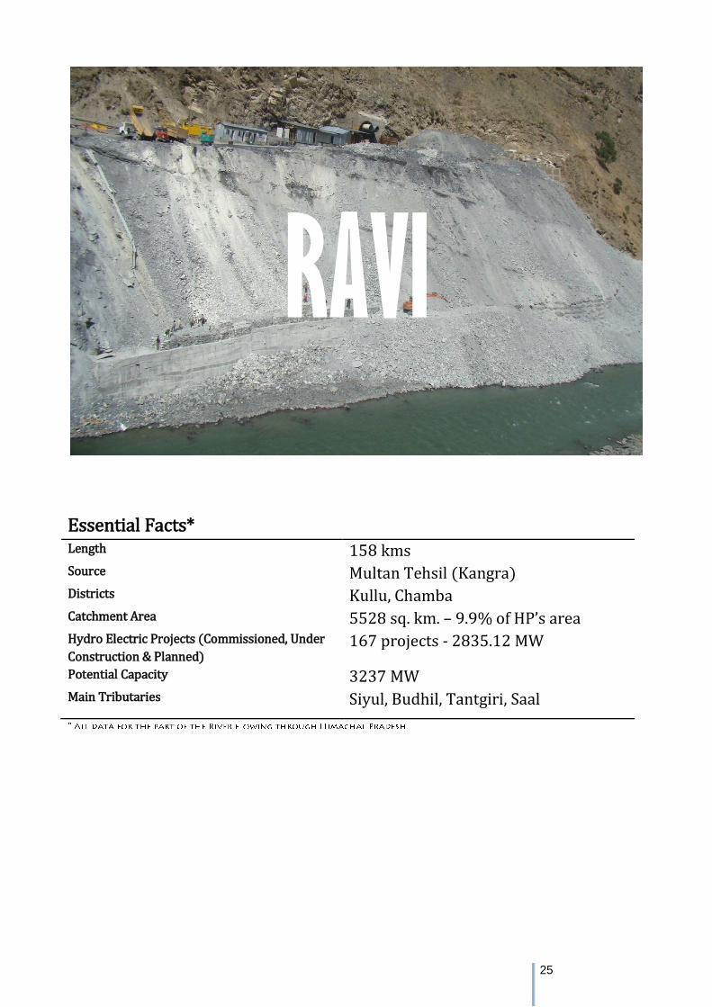
Essential Facts* Length 158 kms Source Multan Tehsil (Kangra) Districts Kullu, Chamba Catchment Area 5528 sq. km. – 9.9% of HP’s area Hydro Electric Projects (Commissioned, Under
Construction & Planned) 167 projects - 2835.12 MW
Potential Capacity 3237 MW Main Tributaries Siyul, Budhil, Tantgiri, Saal
RAVI
26
River Narratives
The Ravi was known as Parushani or Iravati to Indians in Vedic times and Hydraotes to the Ancient Greeks. The Ravi
River originates in the Bara Banghal area in the Multhan tehsil of Kangra district of Himachal Pradesh, India. The
Bara‐Bangahal comprises of snow covered peaks at heights ranging from 3000 m to about 6000 m elevation. It is a
glacier‐fed river originating from the glaciated areas of Beas Kunderi Dhar, the water divide between Beas and Ravi
Rivers. Ravi is formed by the confluence of Bhadal Nalla originating from Bhadal glacier, Rai Nalla originating from Rai
Ghar glacier and Tantgari Nalla originating from Tantgari and Karu glaciers.
It follows a north-westerly course and is a perennial river. The river is 720 km long, out of which 320 km is in India, of
which 158 km lies within Himachal Pradesh and 162 km within Punja. It meets the Punjab plains near Madhopur and
later enters Pakistan 26 km below Amritsar. The Catchment area of the basin is 14,442 sq km . In Himachal has a
catchment area of about 5,451 sq. km.
The climate of Ravi basin is affected by the tropical weather systems during the summers and the cold weather
systems known as Western Disturbances during winter and pre‐monsoon months. The western disturbances have
their origins near the Mediterranean Sea and move in the westerly wind regime along Himalayan latitudes during the
winter season. These disturbances may be in the form of a depression or a low‐pressure area formation or an upper
air cyclonic circulation or a trough in lower isobaric levels. They shift to more northerly latitudes as the summer
season approaches. Summer precipitation in the Ravi basin area is mainly associated with the Southwest monsoon
which is dominant from June to September; most of the precipitation is in the form of rainfall. Extreme rainfall floods
are mostly experienced during this season.
The rainfall characteristics of Ravi basin is given below:
The average annual rainfall for the basin is 1370 mm
The highest amount of rainfall is received in the month of August i.e. 20% of the average annual value
Significant amount of rainfall occurs during winter month of January to March i.e. 26% of the average annual
value, which reflects the significant contribution of Western Disturbances
Tributaries
Bhadal River
It rises from the snowy range of the area lying between the Pir Panjal and Dhauladhar ranges in the Bara Banghal area
of the Central Himachal Pradesh. It flows in a Westerly direction before merging with the Tant Gari river to form the
mainstream of the Ravi. Bhadal river's catchment is made up of U shaped valleys, waterfalls, moraines, cirques and
towering peak
Tant Gari River
It is a tributary of the Ravi River. This river rises as a small stream from the slopes of an off-shoot of the Pir Panjal
range in the area East of Bharmaur in Chamba district. The Tant Gari valley is U-shaped. Its bottom is strewn with
boulders and morainic deposits laid down by the glaciers in the past.
27
Budhil and Dhona (Nai)
These tributaries join the Ravi waters about 40 miles downstream from the source. The Budhil River starts off from
the Lahaul Range and is fed by the glaciers of Manimahesh Kailash Peak and Manimahesh Lake. The Nai on the other
hand takes its course from Kali Debi pass and after flowing a length of 30 miles joins the Ravi at Triloknath (colloquial
called Trilokinath). The Budhil River rises in Lahaul range of hills and is sourced from the Manimahesh Kailash Peak and
the Manimahesh Lake, at an elevation of 4,080 metres (13,390 ft), and both are Hindu pilgrimage sites. The entire
length of Budhil is 72 kilometres (45 mi) where it has a bed slope of 314 feet per mile (59.5 m/km). It flows through
the ancient capital of Bharmwar, now known as Bharmour in Himachal Pradesh. During 1858–1860, the Raja of
Bharmour had considered the Budhil valley as an excellent source of Deodar trees for supply to the British Raj.
However, a part of the forest surrounding the temple was considered sacred and declared a reserved area.
Siul River
It is the tributary of the Ravi River. It rises from the tract between the Dhauladhar and Pir Panjal ranges near Jammu
and Kashmir and Himachal Pradesh border. Thereafter this river flows towards East, takes a U turn and attains a
South-Westerly course before flowing into the Ravi River downstream of Chamba. River Baira is the prominent
tributary of the Siul River. This river is fed by both snow melt waters and spring waters.
Baira River
It rises from the snows on Southern slopes of the Pir Panjal range in Himachal Pradesh. Numerous tributaries of the
Baira River are also fed by the snow and so make it a Perennial river before it joins the Siul river, which is a tributary of
the Ravi river. Its catchment consists of steep slopes, deep valleys and terraces that have been laid down by the river
since a long time.
Mythology
As per Indian Vedas, Ravi was traditionally known as Iravati also spelt and pronounced Airavati. To the ancient Greeks,
Ravi River was referred to as the Hydraotes. The part of the legendary battle of the ten kings was fought on the banks
of the Parushani River, later inferred by MacDonell and Keith as the Ravi River. When the Indian National Congress
changed it goals to Purna Swaraj or Total Independence, President Jawaharlal Nehru unfurled the tricolor on the
banks of Ravi River in the midnight hours of 31st December 1929 amidst the slogans of ‘Inquilab Zindabad’ and ‘Bande
Mataram’.
The Manimahesh peak and the lake, which feeds the Budhil River - a tributary of the Ravi, in Chamba, has several
myths associated with it. It is believed that Lord Shiva resides with Maa Parvati in Manimahesh Kailash. A rock
formation in the form of a shivling on this mountain is considered as the manifestation of Lord Shiva and the field at
the base of the mountain is called by the local people as Shiva’s Chaugan. The local Gaddi community considers this
region as Shiva Bhoomi. Legend says that before Shiva married Maa Parvati at the Mansarovar Lake and they became
universal parents, Shiva created mount Kailash in Himachal Pradesh and made it his abode. The Manimahesh Ganga
river originates in a cascade from the lake and joins the Budhil river on its left bank (Kotwal, 2016).
Another popular festival held in Chamba is the "Minjar Mela" which marks the triumph of the Raja of Chamba over the
ruler of Kangra, in 935 AD. The festival also celebrates the paddy and maize crops grown at this time of the year. On
28
the last day of the festival Minjar Mela, a parade is held from the Akhand Chandi Palace to Ravi River, where offerings
are made to the river. This commemorates an event in which Raja Sahil Verman changed the course of the river, to
make the Hari Rai temple accessible to all devotees.
Ecology
The major forest types found in the study area and in catchment area
are: Semi-tropical to Himalayan temperate and Sub-Alpine types with
a thick cover of reserved forests. The important species found in this
region are Longifolia, Oak, Chestnut, Deodar, kail, Juniper and Birch.
i) Lower Western Himalayan Temperate Forest,
ii) Upper Western Himalayan Temperate Forest,
iii) Alnus nepalensis Forest
iv) Moist Alpine Forest.
Flora & Fauna
272 flowering plant species were recorded which include 28 trees, 48
shrubs, 10 climbers and 186 herbs.
The habitat areas of musk deer, snow leopard and Himalayan tahr,
Musk deer, Ibex and Serow are restricted to the upper reaches of Ravi
catchment (2,800 – 4,000m) and occupy the upper cold desert layer.
Naemorhaedus goral (Goral) and Muntiacus muntjak (Barking deer)
are most common ungulates in this region. These animals are
distributed in the temperate to sub‐alpine forests in elevations
between 2,400 and 2,800m. Among the Primates, Macaca mulatta
(Rhesus macaque) and Presbytis entellus (Langur) apart from other
animals like squirrel, jackal, leopard and porcupine etc. are found to
inhabit the same ecological niche from the lower parts to upper parts
of the hills (1,400 ‐3,400m). Further down to lower foothills layer
comprises of squirrel, jackal, macaque, leopard and porcupine etc.
Among all the faunal elements found in this area birds show the
maximum diversity area is a paradise for avian fauna.
A total of 13 fish species are known to inhabit the Ravi River. In
addition to these a few species, viz. Barilius spp. and Puntius spp. are
found in different khads of Ravi River. These fishes are known to
perform local migration from these brooks to main channel, but do
not undertake long migration. Two exotic species namely brown trout (Salmo trutta fario) and rainbow trout (Salmo
gairdnerii gairdneri) have been introduced in the Ravi River. The rainbow trout propagation has become more
successful as compared to that of brown trout.
FROM THE RIVER RAVI
by Hera Naguib
From the railing of the bridge
I toss a coin
into the river’s murky sleeve—
its litter floating, dispersals lustred
by the sky. Once, I wanted
to say one true thing—
as in let me break free.
The river is hurt,
a toxic belly with bloated
minnows, lovers
dumped. I walk its cusp.
A weary pilgrim
who haunts the sludge
flings from gaunt arms
chunks of meat for crows.
She holds out a lump, waits
for me to clutch back.
I turn to leave the river
the city, and its people.
You will carry this burden,
she rasps, eyes narrowed
on a bubbling rainbow,
long after you learn
your city, your love,
is a force, the planet spinning
retrograde to the sun.
29
Threat Assessment
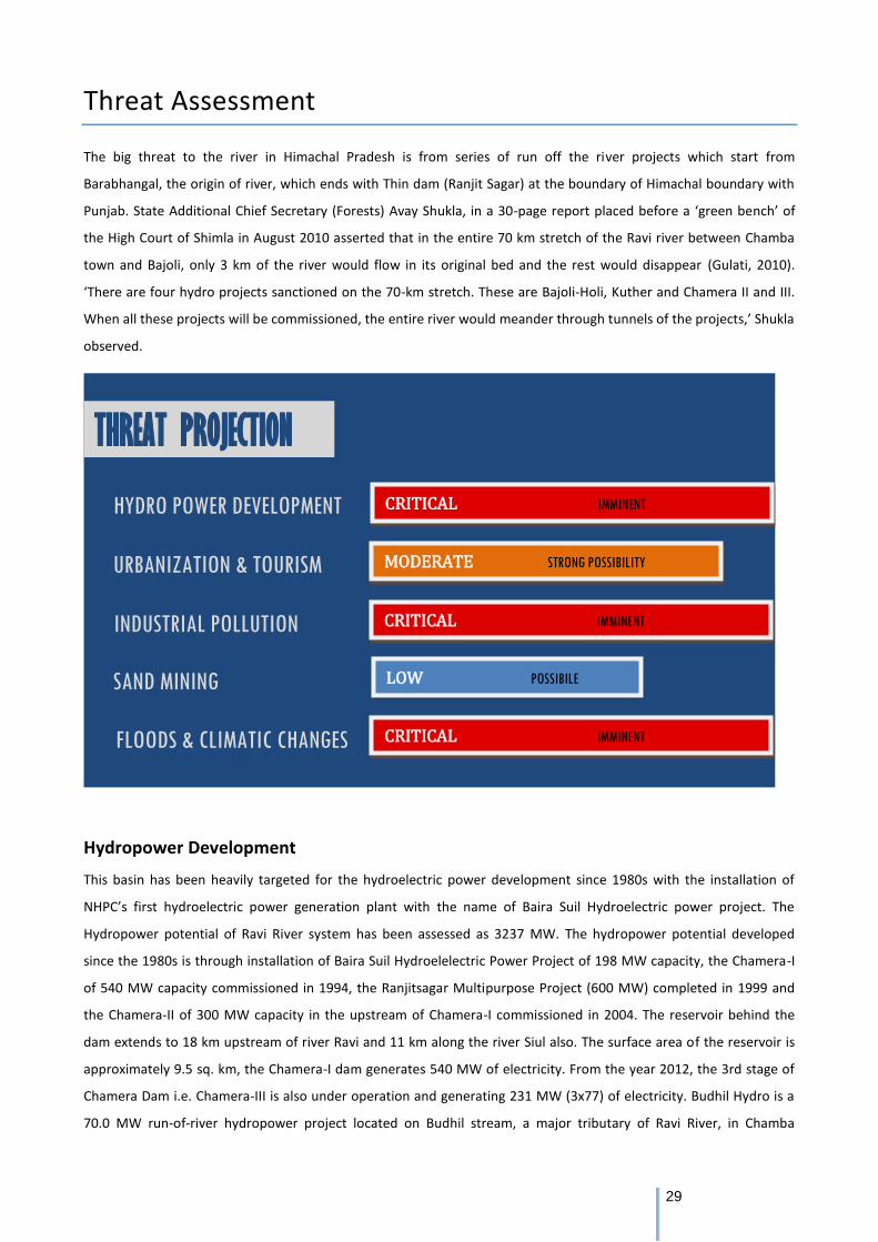
The big threat to the river in Himachal Pradesh is from series of run off the river projects which start from
Barabhangal, the origin of river, which ends with Thin dam (Ranjit Sagar) at the boundary of Himachal boundary with
Punjab. State Additional Chief Secretary (Forests) Avay Shukla, in a 30-page report placed before a ‘green bench’ of
the High Court of Shimla in August 2010 asserted that in the entire 70 km stretch of the Ravi river between Chamba
town and Bajoli, only 3 km of the river would flow in its original bed and the rest would disappear (Gulati, 2010).
‘There are four hydro projects sanctioned on the 70-km stretch. These are Bajoli-Holi, Kuther and Chamera II and III.
When all these projects will be commissioned, the entire river would meander through tunnels of the projects,’ Shukla
observed.
Hydropower Development
This basin has been heavily targeted for the hydroelectric power development since 1980s with the installation of
NHPC’s first hydroelectric power generation plant with the name of Baira Suil Hydroelectric power project. The
Hydropower potential of Ravi River system has been assessed as 3237 MW. The hydropower potential developed
since the 1980s is through installation of Baira Suil Hydroelelectric Power Project of 198 MW capacity, the Chamera-I
of 540 MW capacity commissioned in 1994, the Ranjitsagar Multipurpose Project (600 MW) completed in 1999 and
the Chamera-II of 300 MW capacity in the upstream of Chamera-I commissioned in 2004. The reservoir behind the
dam extends to 18 km upstream of river Ravi and 11 km along the river Siul also. The surface area of the reservoir is
approximately 9.5 sq. km, the Chamera-I dam generates 540 MW of electricity. From the year 2012, the 3rd stage of
Chamera Dam i.e. Chamera-III is also under operation and generating 231 MW (3x77) of electricity. Budhil Hydro is a
70.0 MW run-of-river hydropower project located on Budhil stream, a major tributary of Ravi River, in Chamba
CRITICAL IMMINENT
THREAT PROJECTION
HYDRO POWER DEVELOPMENT
URBANIZATION & TOURISM
INDUSTRIAL POLLUTION
SAND MINING
FLOODS & CLIMATIC CHANGES
MODERATE STRONG POSSIBILITY
LOW POSSIBILE
CRITICAL IMMINENT
CRITICAL IMMINENT
30
District, Himachal Pradesh. The project has been operational since October 2012. The power generated by the project
is transmitted over a distance of approximately 18.0 km through a transmission line connecting to the PGCIL 220 kv
Chamera Grid sub-station.
Chamera-I- Dam is a concrete arch gravity structure of height 141 m and length 295m. It has an 84 m high surge shaft
and 157 m long vertical pressure shaft connecting to an underground Power House through 3 penstocks. The project
has an installed capacity of 540 MW (3x180 MW turbines). The reservoir extends 18 km upstream along the River Ravi
Basin and 11 km along the River Siul Basin. The surface area of the reservoir is approximately 9.5 sq. km. 1554 families
were affected by acquisition of land for the project, of which 433 became homeless and required resettlement, the
remainder losing a portion of their land (Sustainable Hydropower).
Holi Bajoli- The project is proposed to harness the head available between Bajoli and Holi villages upstream of the
under investigation Kutehr H.E. (240 MW) project and is accessible via Chamba -Holi road. The proposed diversion
site is located between Bajoli and Nayagram villages and is about 15 km upstream of Holi, a large village in the area.
The powerhouse site is located near Barola village, which is about 2 km downstream of Holi.
The negative impacts of hydro power projects on the indigenous water mills, which have been the barrier of Hatt and
Gharat Culture of hills, meaning thereby the watermills are the focal point of meeting the villagers and discuss the
problem of all sorts and find the solutions thereof by seating in the watermills.
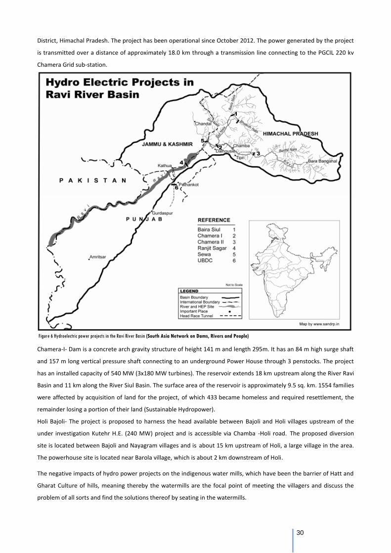
Figure 6 Hydroelectric power projects in the Ravi River Basin (South Asia Network on Dams, Rivers and People)
31
Table 4: Summary of current and upcoming hydro projects in the Ravi River Basin (in Himachal Pradesh) (Govt. of HP, 2014-15), (HIMURJA, 2015)
The Bajoli Holi Hydroelectric Project is located in the vicinity of Dhauladhar Wildlife Sanctuary which comprises mainly
the upper catchment of Ravi River upstream of confluence of Thamsar Nala with Ravi River and its left bank ridge
forms the western boundary of the Sanctuary. There was massive resistance to this project from 2012 to 2014 on the
grounds that the tunnelling activity would impact the horticulture in the area and that the forest diversion was being
done in non compliance of the FRA 2006 (Chakravartty, 2014).
A small hydro project on a tributary of the Ravi in Chamba district was opposed tooth and nail by 2 Panchayats on the
grounds that it would end their livelihoods dependent on the stream’s water (irrigation) and also because of the
deforestation involved. This movement by the Saal Ghati Bachao Sangharsh Samiti played an important role in
highlighting the damaging impacts of small hydro projects (Saal Ghaati Bachao Sangharsh Samiti, 2010).
In the past, hydroelectricity projects involving the construction of tunnels (including Chamera-II, Chamera- III, Lanco
and downstream of the Kuther hydro power project in the same river valley) have resulted in immense loss and
hardships to the local people on account of natural water sources drying up and houses developing cracks. In April
2012 there was a massive leakage in the 16km HRT of the 231 MW, Chamera III project just above the Mokhar village
in Chamba district leading to severe threat to the village downhill so much so that the 40 families residing there had to
be evacuated. The leakage occurred during testing of the generating units.
Sand Mining and Pollution
Large-scale mining of stone and sand takes place along river bed of Ravi especially along Modhupur- Kathlour region
where the river bed is stony, gravel and scarce of water resources with the result even growth and breeding of minor
fishery is constrained. The river Ravi on the whole especially in Indian Punjab is not subjected to much industrial and
municipal effluents as the catchment as well as adjoining area of river does not have many heavy or small-scale
industries. Moreover, river flows some 20 to 30 km away from big cities and towns, with the result is not subjected to
much municipal effluents too. Water quality monitoring of the river Ravi is carried out at 2 different locations of the
interstate boundary of J.K./Punjab. The BOD and DO concentration are within the prescribed standards at the location
whereas the total Coliform count is exceeding at said locations.
Climate Change
The Ravi basin saw an increase of 12 lakes during the period of 2013 to 2015 due to accelerated glacial melting as per
a study conducted by State Council for Science, Technology and Environment. This raises the danger of glacial lake
outbursts.
Stage Large Projects Installed Capacity (MW) Small Projects Installed Capacity (MW)
Commissioned 5 1339 18 75.45
Under Construction 2 216 8 29.5
Planning 7 684 127 491.17
Total 8 2239 87 596.12
32
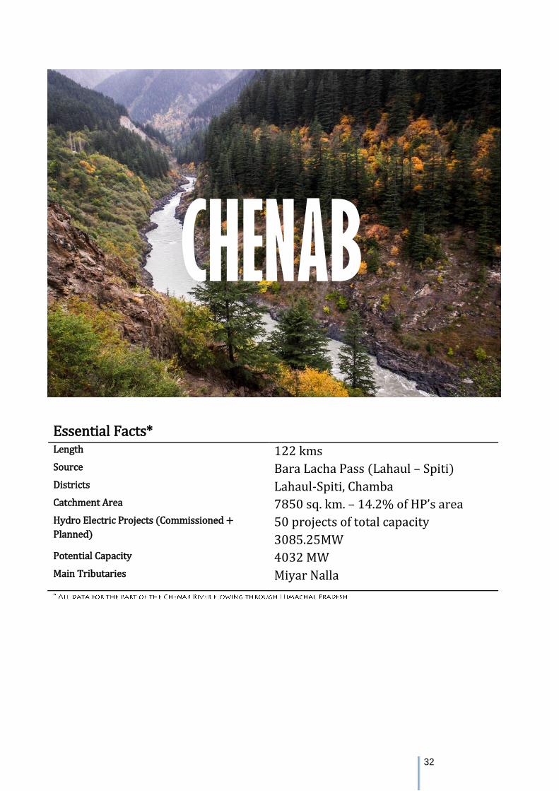
Essential Facts* Length 122 kms Source Bara Lacha Pass (Lahaul – Spiti) Districts Lahaul-Spiti, Chamba Catchment Area 7850 sq. km. – 14.2% of HP’s area Hydro Electric Projects (Commissioned +
Planned) 50 projects of total capacity
3085.25MW Potential Capacity 4032 MW Main Tributaries Miyar Nalla
CHENAB
33
River Narratives
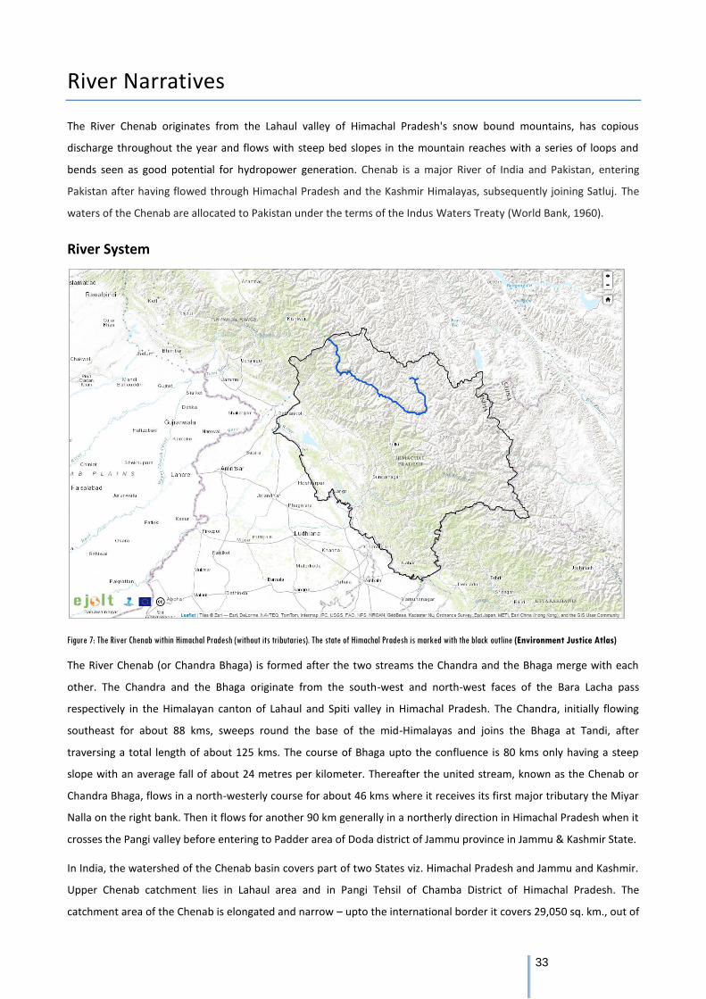
The River Chenab originates from the Lahaul valley of Himachal Pradesh's snow bound mountains, has copious
discharge throughout the year and flows with steep bed slopes in the mountain reaches with a series of loops and
bends seen as good potential for hydropower generation. Chenab is a major River of India and Pakistan, entering
Pakistan after having flowed through Himachal Pradesh and the Kashmir Himalayas, subsequently joining Satluj. The
waters of the Chenab are allocated to Pakistan under the terms of the Indus Waters Treaty (World Bank, 1960).
River System
Figure 7: The River Chenab within Himachal Pradesh (without its tributaries). The state of Himachal Pradesh is marked with the black outline (Environment Justice Atlas)
The River Chenab (or Chandra Bhaga) is formed after the two streams the Chandra and the Bhaga merge with each
other. The Chandra and the Bhaga originate from the south-west and north-west faces of the Bara Lacha pass
respectively in the Himalayan canton of Lahaul and Spiti valley in Himachal Pradesh. The Chandra, initially flowing
southeast for about 88 kms, sweeps round the base of the mid-Himalayas and joins the Bhaga at Tandi, after
traversing a total length of about 125 kms. The course of Bhaga upto the confluence is 80 kms only having a steep
slope with an average fall of about 24 metres per kilometer. Thereafter the united stream, known as the Chenab or
Chandra Bhaga, flows in a north-westerly course for about 46 kms where it receives its first major tributary the Miyar
Nalla on the right bank. Then it flows for another 90 km generally in a northerly direction in Himachal Pradesh when it
crosses the Pangi valley before entering to Padder area of Doda district of Jammu province in Jammu & Kashmir State.
In India, the watershed of the Chenab basin covers part of two States viz. Himachal Pradesh and Jammu and Kashmir.
Upper Chenab catchment lies in Lahaul area and in Pangi Tehsil of Chamba District of Himachal Pradesh. The
catchment area of the Chenab is elongated and narrow – upto the international border it covers 29,050 sq. km., out of
34
which an area of about 6,242 Sq. Km. is under perpetual snow. The catchment area of the River Chenab upto Akhnoor,
the lower most gauge discharge site in India is 21,808 sq. km (Chenab).
The Miyar Nalla
The Miyar Nalla – the only major tributary that joins Chenab within Himachal Pradesh - rises in Himalayas from near
Lopen jot at about 5100m. After traversing of about 35 km in south-east direction, it takes a big loop and turns south
west. After flowing about 60 km it joins the Chenab on its right bank opposite Udaipur.
Spiritual Mythology
Tandi Village
The Tandi village has sacred importance to the people of Lahaul, as Haridwar to Hindus of the world. The village is
situated above the confluence of the Rivers Chandra and Bhaga in the Pattan valley - some 7 kms away from Keylong.
Revenue and settlement records reveal that Tandi was founded by Raja Rana Chand Ram under the name of Chandi
which over the years got corrupted into Tandi.
There are at least three mythological stories connected with Tandi. First, Tandi is believed to mean Tan Dehi, i.e.,
giving up of the body. This is associated with Draupadi, the wife of Pandavas, who left her body at this place. Second,
it is believed that Rishi Vashishtha, who meditated near the hot water springs of Manali, was cremated at this
confluence; hence named Tandi, i.e., body consumed. According to the third, Chandra and Bhaga were the son and
daughter of the Moon and the Sun gods respectively. They were in love with each other. To perform their celestial
marriage they decided to climb the Baralacha-la and from there run in opposite directions encircling a vast tract of
Lahaul. Thus flowing south-east and south-west both met at Tandi to enter the wedlock (Govt. of Himachal Pradesh,
2011).
Kardang Monastery
It is situated on the left bank of the Bhaga River opposite Keylong and was built in the late medieval times. It was
rebuilt by Reverend Lama Norbu in 1912 AD and has four chapels. The statues of Tara (Devi) and Padmasambhava are
installed and a chorten – a 4 foot high silver casket containing the relics of Lama Norbu are enshrined. The image of
Togdan Sakyo Sri, the teacher of Lama Norbu and grand teacher of Lama Hishe Rangdol has also been enshrined. It is a
treasure of good Buddhist manuscripts and is decorated with beautiful fresco paintings depicting the life of Buddha
and Buddhist tantric deities. (Govt. of HP, 2015-16)
Guru Ghantal Monastery
It is situated on the right bank of the Chandra Bhaga River and is perhaps the oldest monastery in Lahaul area dating
back to 10th century. The monastery now enshrines a black stone image of goddess Kali called Varjeshwari Devi (Dorji
Lhama) and a wooden image of Buddha which, local tradition says, was installed by a Lama Ringchen Zangop from
Kinnaur some eight hundred years ago. (Govt. of HP, 2015-16)
Ecology
There are forests of Junipers (Devidyar) and Birch (Bhojpatra) in the area which are very slow growing. According to
residents living near the proposed Jispa Dam Site, there are more than 100,000 trees of Devidyar, Poplar and Willow
each in the 1200ha forest area being diverted for the project. The forests at this site are rich in high altitude medicinal
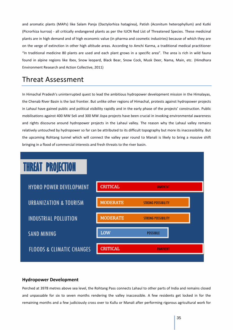
35
and aromatic plants (MAPs) like Salam Panja (Dactylorhiza hatagirea), Patish (Aconitum heterophyllum) and Kutki
(Picrorhiza kurroa) - all critically endangered plants as per the IUCN Red List of Threatened Species. These medicinal
plants are in high demand and of high economic value (in pharma and cosmetic industries) because of which they are
on the verge of extinction in other high altitude areas. According to Amchi Karma, a traditional medical practitioner
“In traditional medicine 80 plants are used and each plant grows in a specific area”. The area is rich in wild fauna
found in alpine regions like Ibex, Snow leopard, Black Bear, Snow Cock, Musk Deer, Nama, Main, etc. (Himdhara
Environment Research and Action Collective, 2011)
Threat Assessment
In Himachal Pradesh's uninterrupted quest to lead the ambitious hydropower development mission in the Himalayas,
the Chenab River Basin is the last frontier. But unlike other regions of Himachal, protests against hydropower projects
in Lahaul have gained public and political visibility rapidly and in the early phase of the projects’ construction. Public
mobilisations against 400 MW Seli and 300 MW Jispa projects have been crucial in invoking environmental awareness
and rights discourse around hydropower projects in the Lahaul valley. The reason why the Lahaul valley remains
relatively untouched by hydropower so far can be attributed to its difficult topography but more its inaccessibility. But
the upcoming Rohtang tunnel which will connect the valley year round to Manali is likely to bring a massive shift
bringing in a flood of commercial interests and fresh threats to the river basin.
Hydropower Development
Perched at 3978 metres above sea level, the Rohtang Pass connects Lahaul to other parts of India and remains closed
and unpassable for six to seven months rendering the valley inaccessible. A few residents get locked in for the
remaining months and a few judiciously cross over to Kullu or Manali after performing rigorous agricultural work for
CRITICAL IMMINENT
THREAT PROJECTION
HYDRO POWER DEVELOPMENT
URBANIZATION & TOURISM
INDUSTRIAL POLLUTION
SAND MINING
FLOODS & CLIMATIC CHANGES
MODERATE STRONG POSSIBILITY
LOW POSSIBILE
CRITICAL IMMINENT
MODERATE STRONG POSSIBILITY
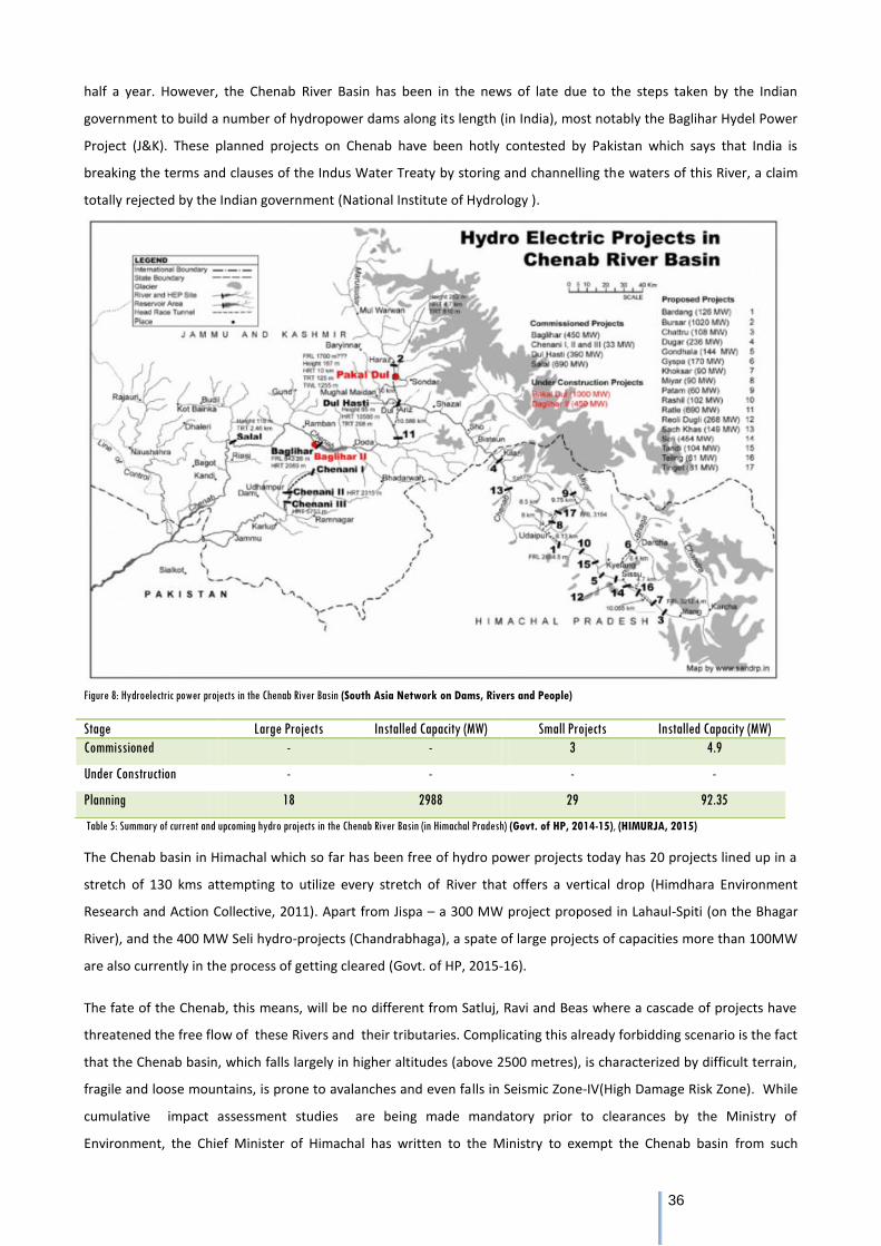
36
half a year. However, the Chenab River Basin has been in the news of late due to the steps taken by the Indian
government to build a number of hydropower dams along its length (in India), most notably the Baglihar Hydel Power
Project (J&K). These planned projects on Chenab have been hotly contested by Pakistan which says that India is
breaking the terms and clauses of the Indus Water Treaty by storing and channelling the waters of this River, a claim
totally rejected by the Indian government (National Institute of Hydrology ).
Figure 8: Hydroelectric power projects in the Chenab River Basin (South Asia Network on Dams, Rivers and People)
Table 5: Summary of current and upcoming hydro projects in the Chenab River Basin (in Himachal Pradesh) (Govt. of HP, 2014-15), (HIMURJA, 2015)
The Chenab basin in Himachal which so far has been free of hydro power projects today has 20 projects lined up in a
stretch of 130 kms attempting to utilize every stretch of River that offers a vertical drop (Himdhara Environment
Research and Action Collective, 2011). Apart from Jispa – a 300 MW project proposed in Lahaul-Spiti (on the Bhagar
River), and the 400 MW Seli hydro-projects (Chandrabhaga), a spate of large projects of capacities more than 100MW
are also currently in the process of getting cleared (Govt. of HP, 2015-16).
The fate of the Chenab, this means, will be no different from Satluj, Ravi and Beas where a cascade of projects have
threatened the free flow of these Rivers and their tributaries. Complicating this already forbidding scenario is the fact
that the Chenab basin, which falls largely in higher altitudes (above 2500 metres), is characterized by difficult terrain,
fragile and loose mountains, is prone to avalanches and even falls in Seismic Zone-IV(High Damage Risk Zone). While
cumulative impact assessment studies are being made mandatory prior to clearances by the Ministry of
Environment, the Chief Minister of Himachal has written to the Ministry to exempt the Chenab basin from such
Stage Large Projects Installed Capacity (MW) Small Projects Installed Capacity (MW)
Commissioned - - 3 4.9
Under Construction - - - -
Planning 18 2988 29 92.35
37
studies because these were acting as 'obstacles' in the quick implementation of the projects. In 2008 the HP
government was planning to construct the Jispa Dam as a 170 MW project but the Central government modified this
project into a water storage scheme to have 1.7 MAF storage in Chenab basin as per IWT, without properly assessing
the benefits of this project and the environmental and socioeconomic implications. Whatever little information is
available related to the sheer magnitude and location of the project is enough to ring the alarm bells and indicate that
this is the beginning of a cycle of destruction that the rest of the state has already witnessed. The residents who are
living in this fragile, difficult and hostile environment of the Lahaul valley have opposed the Jispa dam since the day
they heard of it. They have seen the condition of the Satluj and Ravi in their front yards and have vowed to protect the
pristine Chenab for everything it is worth (Himdhara Environment Research and Action Collective, 2011).
The impacts of the blasting undertaken for tunnelling on foundations of houses and crops were also raised as a
pressing concern. For Seli and Miyar hydroelectricity projects, the residents also raised questions over the transfer of
'scheduled' land to non-tribals (Lahaul-Spiti is a Schedule V area under the Indian Constitution, granting special rights
and tribal status to its people). That critical provisions such as Forest Rights Act and Panchayat (Extension Scheduled
Areas) Act, 1996 have been outrightly violated is evident as many people stated the roping in of locals as contractors
to smoothly to carry out the acquisition process in Kukumseri, Chimret, Shakoli, and Triloknath villages.
The major concerns behind the local agitation are that the Chenab basin falls largely in the high-altitude region (above
2,500 metres) and the area is characterized by difficult terrain, fragile and loose mountains, prone to avalanches and
landslides and falls in seismic zone-IV. Three projects are slated to come up on the Miyar River of which the Miyar
Project (Moser Baer - Hindustan Power) is in the most advanced stage where land has been acquired. Seli
Hydroelectric Power Company Ltd (also Moser Baer) is executing 400 MW project over the Chenab River near Shulling
village in the district. Corporate giant Larsen and Toubro (L&T) has been allotted 420 MW hydro-power project in
Reoli-Dugli, the biggest in the district. This is followed by the Purthi project allotted to Reliance, the Sach-Khas project
allotted again to L&T and Dugar Hydroproject to be implemented by Tata Power.
Urbanisation and Tourism
The 8.8 km Rohtang Tunnel, being called a tunnel of good hope or an engineering marvel, is supposedly the longest
tunnel at this altitude and promises unhindered access to Lahaul the year around. This dream project of the Ministry
of Defence claims to bring about economic prosperity by integrating the local and global market with Lahaul's 'rural'
economy. It aims at a new economic and cultural shift through new trade and tourism avenues. It intends to end the
isolation and gloom Lahaulis undergo for six months. The tunnel, which is under construction, will reduce the road
distance between Manali and Keylong by 48 kms and travel time by four hours. After major cost overruns and many a
delay due to ‘geological surprises’, all hopes are now set on 2017- the new deadline for the completion of the
construction. Some of the residents are anticipating overhauling the winter drudgery with the new physical mobility
the tunnel would bring. Many are already speculating shifts in socioeconomic, cultural and political structure of
Lahaul. Many are worried about its implications; if the hydropower spate will intensify with the tunnel construction.
The major boost that the people are expecting is of a rise in tourism and a change in the standard of living as a result.
Already Manali is coping with severe environmental stress because of tourism. Expressing concern over heightened
tourist inflow in Lahaul-Spiti district once the Rohtang Pass tunnel opens for public, the National Green Tribunal in
38
October 2016 asked the Himachal Pradesh government to spell out the measures it plans to take to protect the eco-
sensitive zone.
The NGT also directed the state government to submit "precautionary and remedial" measures it proposes to take
with regard to the eco-sensitive and sparsely populated area, which remains cut off by snow for most parts of the
year. The concern emanated from the experience in Manali which, experts say, is on the verge of an ecological
disaster. (Business Standard, 2016)
Climate Change
Since Lahaul-Spiti is the Trans- Himalayan and snow bound region of the state in Himachal, the changes in snowfall
patterns are rather apparent in this area. Over the years, with changes in temperatures globally the intensity of
snowfall has been decreasing. In 2016 the measure of snowfall received was entirely less even at the higher altitude
areas of the Western Himalayas. The average snowfall this year has been inadequate by around 45 percent in
Himachal Pradesh, and by 26 percent in Jammu and Kashmir, while it is as high as 53 percent in Uttarakhand, as
indicated by data provided by Snow and Avalanche Studies Establishment (SASE), a DRDO lab that screens snow action
in the Himalayas. This has obviously impacted the freshwater discharge in the Rivers as well. Information discharged
by the Central Water Commission (CWC), which screens six noteworthy stores in north India, uncovered that as of
April 7, water levels are 34 percent underneath normal in Punjab, 21 percent beneath normal in Himachal Pradesh
(Kharaik, 2016). The district of Lahaul and Spiti has one of the largest concentrations of glaciers, about 2,000 sq.km in
extent. Temperatures have risen by 2ºC over the past two decades, and most glaciers are thinning. In the past four
decades, 13% of the glaciers have melted (Lenin, 2016).
During 2007-08, Geological Survey of India (GSI) had carried out preliminary inventory of glacial lakes in Chandrabhaga
basin in Lahaul-Spiti district. For one particularly risky lake in Himachal Pradesh, namely, the Gepang Gath, Glacial Lake
Outburst Floods (GLOF) risk mapping in field area was done in 2008, 2012 and 2013 field seasons. The study found
that Gepang Gath glacial lake was risky and threatens the Manali-Leh National Highway and the downstream Sissu
village (Bodhi, 2014). In the Chenab basin total number of glacial lakes has increased from 116 in 2013 to 192 in 2015,
which is almost four times than the number of lakes identified during 2001Out of these 192 lakes, 04 lakes have area
more than 10 hectare, 6 lakes between 5-10 hectare and 182 are the small ones having area less than 5 hectare.
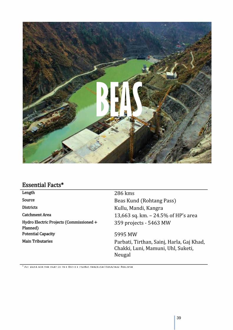
39
Essential Facts* Length 286 kms Source Beas Kund (Rohtang Pass) Districts Kullu, Mandi, Kangra Catchment Area 13,663 sq. km. – 24.5% of HP’s area Hydro Electric Projects (Commissioned +
Planned) 359 projects - 5463 MW
Potential Capacity 5995 MW Main Tributaries Parbati, Tirthan, Sainj, Harla, Gaj Khad,
Chakki, Luni, Mamuni, Uhl, Suketi, Neugal
BEAS
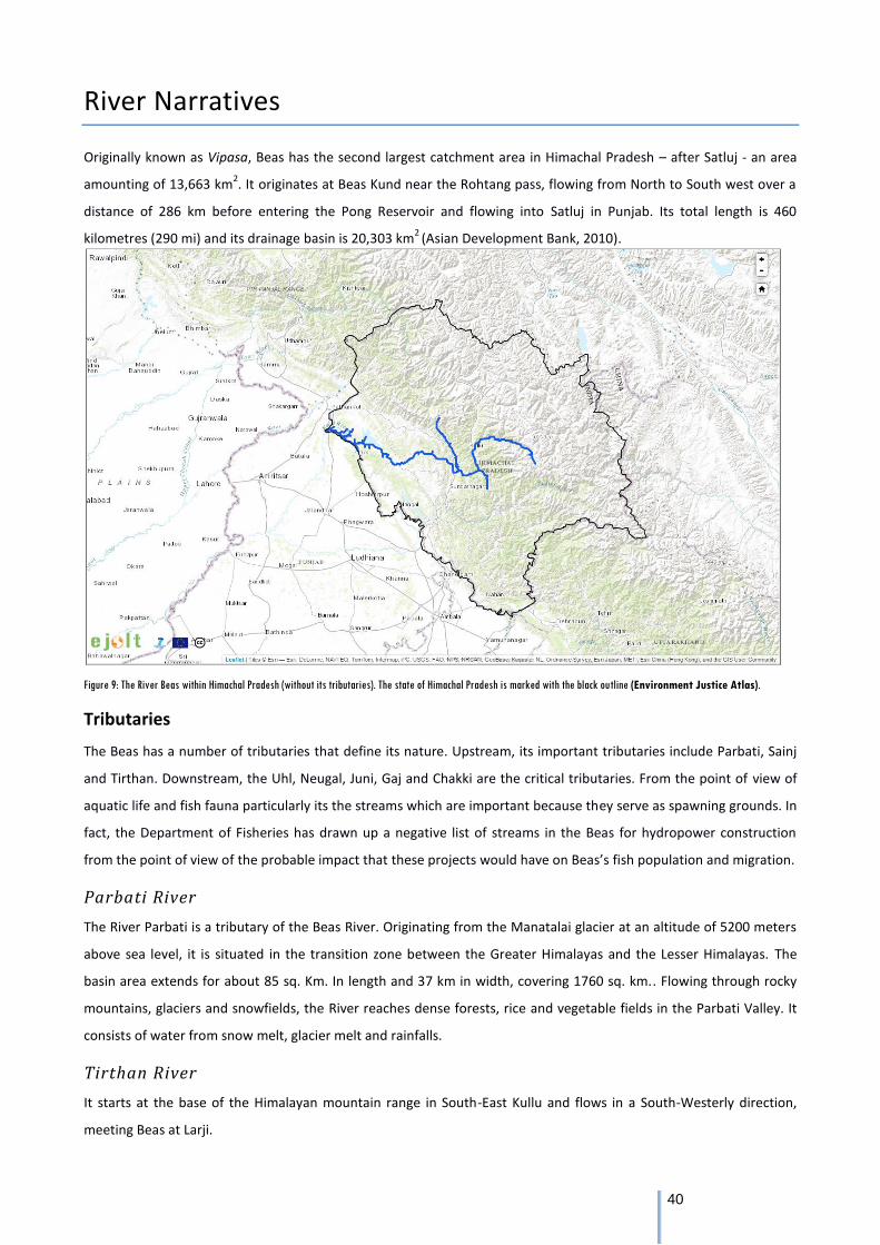
40
River Narratives
Originally known as Vipasa, Beas has the second largest catchment area in Himachal Pradesh – after Satluj - an area
amounting of 13,663 km2. It originates at Beas Kund near the Rohtang pass, flowing from North to South west over a
distance of 286 km before entering the Pong Reservoir and flowing into Satluj in Punjab. Its total length is 460
kilometres (290 mi) and its drainage basin is 20,303 km2
(Asian Development Bank, 2010).
Figure 9: The River Beas within Himachal Pradesh (without its tributaries). The state of Himachal Pradesh is marked with the black outline (Environment Justice Atlas).
Tributaries
The Beas has a number of tributaries that define its nature. Upstream, its important tributaries include Parbati, Sainj
and Tirthan. Downstream, the Uhl, Neugal, Juni, Gaj and Chakki are the critical tributaries. From the point of view of
aquatic life and fish fauna particularly its the streams which are important because they serve as spawning grounds. In
fact, the Department of Fisheries has drawn up a negative list of streams in the Beas for hydropower construction
from the point of view of the probable impact that these projects would have on Beas’s fish population and migration.
Parbati River
The River Parbati is a tributary of the Beas River. Originating from the Manatalai glacier at an altitude of 5200 meters
above sea level, it is situated in the transition zone between the Greater Himalayas and the Lesser Himalayas. The
basin area extends for about 85 sq. Km. In length and 37 km in width, covering 1760 sq. km.. Flowing through rocky
mountains, glaciers and snowfields, the River reaches dense forests, rice and vegetable fields in the Parbati Valley. It
consists of water from snow melt, glacier melt and rainfalls.
Tirthan River
It starts at the base of the Himalayan mountain range in South-East Kullu and flows in a South-Westerly direction,
meeting Beas at Larji.
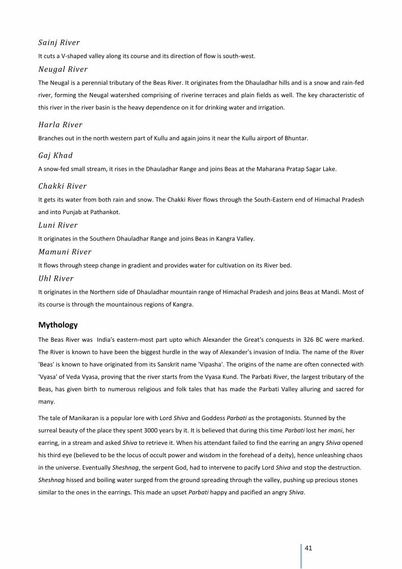
41
Sainj River
It cuts a V-shaped valley along its course and its direction of flow is south-west.
Neugal River
The Neugal is a perennial tributary of the Beas River. It originates from the Dhauladhar hills and is a snow and rain-fed
river, forming the Neugal watershed comprising of riverine terraces and plain fields as well. The key characteristic of
this river in the river basin is the heavy dependence on it for drinking water and irrigation.
Harla River
Branches out in the north western part of Kullu and again joins it near the Kullu airport of Bhuntar.
Gaj Khad
A snow-fed small stream, it rises in the Dhauladhar Range and joins Beas at the Maharana Pratap Sagar Lake.
Chakki River
It gets its water from both rain and snow. The Chakki River flows through the South-Eastern end of Himachal Pradesh
and into Punjab at Pathankot.
Luni River
It originates in the Southern Dhauladhar Range and joins Beas in Kangra Valley.
Mamuni River
It flows through steep change in gradient and provides water for cultivation on its River bed.
Uhl River
It originates in the Northern side of Dhauladhar mountain range of Himachal Pradesh and joins Beas at Mandi. Most of
its course is through the mountainous regions of Kangra.
Mythology
The Beas River was India's eastern-most part upto which Alexander the Great's conquests in 326 BC were marked.
The River is known to have been the biggest hurdle in the way of Alexander's invasion of India. The name of the River
'Beas' is known to have originated from its Sanskrit name 'Vipasha'. The origins of the name are often connected with
'Vyasa' of Veda Vyasa, proving that the river starts from the Vyasa Kund. The Parbati River, the largest tributary of the
Beas, has given birth to numerous religious and folk tales that has made the Parbati Valley alluring and sacred for
many.
The tale of Manikaran is a popular lore with Lord Shiva and Goddess Parbati as the protagonists. Stunned by the
surreal beauty of the place they spent 3000 years by it. It is believed that during this time Parbati lost her mani, her
earring, in a stream and asked Shiva to retrieve it. When his attendant failed to find the earring an angry Shiva opened
his third eye (believed to be the locus of occult power and wisdom in the forehead of a deity), hence unleashing chaos
in the universe. Eventually Sheshnag, the serpent God, had to intervene to pacify Lord Shiva and stop the destruction.
Sheshnag hissed and boiling water surged from the ground spreading through the valley, pushing up precious stones
similar to the ones in the earrings. This made an upset Parbati happy and pacified an angry Shiva.
42
Manikaran holds religious significance for Sikhs too, as Guru Nanak is believed to have visited the spot with his disciple
Bhai Mardana. Upon reaching the spot Guru Nanak asked Mardana to get flour from the langar to pacify their hunger.
Mardana did so diligently and even rolled them into rotis. However, they had no fire to cook on. It is believed that
when Mardana lifted a stone under Guru Nanak’s instruction he found that a hot spring appeared at the spot
magically but upon placing the rotis on the hot spring Mardana was disappointed as they sank to the bottom. Guru
Nanak then suggested that he pray and if the rotis floated back up in answer, they would donate one in God's name.
This story rests in the folk lore of the mountains as a reminder that those who give in the name of God will get back
what they have lost.
Ecology
The climate varies from temperate at the origin to sub-tropical downstream. The Beas catchment has rich cedar
(Himalayan Moist Temperate) forests in the Kullu District, and deciduous sub tropical mixed forests in Mandi and
Kangra. The main tree species are Deodar, Fir, Spruce, Alder, Poplar and Walnut. Sub-Alpine and Alpine Forests
distributed in the Alpine zone (above 3,000 m) are ecologically very important, as it is in these areas that the rivers
originate from the glaciers. Vegetation is mostly herbs and shrubs with occasional trees of the temperate zone. Major
species observed include Birch, Juniper, Willow, Artemisia, Podophyllum hexandrum, Kutki, Atis etc.
Slope grasses occur on the southern aspects on very steep slopes while Riverine forests occur in subtropical and
temperate zones. These occur in very narrow belts along streams. Subtropical riverines are dominated by Prunus sp.,
Pyrus sp., Girardinia sp. and Berberis sp.
Trade in medicinal plants is the most important activity in Parbati, Sainj and Tirthan Valleys as well as the catchment
near the Dhauladhar region and is significantly related to the local economy – to the tune of from 0.54 to 2.92 lakhs
per annum. Among the medicinal plants species are Atish/Patish (Aconitum Heterophyllum), Karu (Picrorhiza Kurrooa)
and Bankakiri (Podophyllum Hexandrum). The Kullu District also falls in the apple orchard zone. There are extensive
grasslands above the tree line and below snow line. During summers, grazing is very common. Plant species such as
Quercus Spp, Alnus Nitida, Ulmus Villosa, Ulmus Wallichiana, Morus Serrata, Celtis Australis, etc. are collected as
fodder and majority of the people are dependent on these species for fuel wood.
The Great Himalayan National Park (GHNP), lying within the Parbati valley, is home to a rich variety of mammals such
as the Musk Deer, Himalayan Tahr, Bharal or Blue Sheep. The lower hills of the park are home to the Serow and
Ghoral. The Snow Leopard is also seen but rarely other than in the extreme interiors of the park, so too for the
Himalayan Black and Brown Bear.
Birds with spectacular plumage like the Monal pheasant and the rare western Tragopan are found here. Apart from
these rare birds the Himalayan Griffon, the Lammergeier, the Golden Eagle, the Slaty-headed Parakeet, and the Great
Himalayan Barbet also call this park home. Butterflies belonging to the high altitudinal species are also commonly
found here.
The vegetation along the banks mainly consists of species of Alnus, Salix, Rrubenia and Conifers. The agro-climatic
condition in the area is congenial for production of crops like potato, ginger, and off-season vegetables and fruits such
as apple and chuli besides conventional wheat in Rabi season.
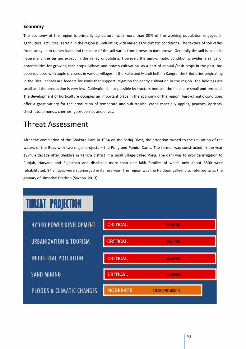
43
Economy
The economy of the region is primarily agricultural with more than 80% of the working population engaged in
agricultural activities. Terrain in the region is undulating with varied agro-climatic conditions. The texture of soil varies
from sandy loam to clay loam and the color of the soil varies from brown to dark brown. Generally the soil is acidic in
nature and the terrain except in the valley undulating. However, the agro-climatic condition provides a range of
potentialities for growing cash crops. Wheat and potato cultivation, as a part of annual /cash crops in the past, has
been replaced with apple orchards in various villages in the Kullu and Mandi belt. In Kangra, the tributaries originating
in the Dhauladhars are feeders for kuhls that support irrigation for paddy cultivation in the region. The holdings are
small and the production is very low. Cultivation is not possible by tractors because the fields are small and terraced.
The development of horticulture occupies an important place in the economy of the region. Agro-climatic conditions
offer a great variety for the production of temperate and sub tropical crops especially apples, peaches, apricots,
chestnuts, almonds, cherries, gooseberries and olives.
Threat Assessment
After the completion of the Bhakhra Dam in 1964 on the Satluj River, the attention turned to the utilisation of the
waters of the Beas with two major projects – the Pong and Pandol Dams. The former was constructed in the year
1974, a decade after Bhakhra in Kangra district in a small village called Pong. The dam was to provide irrigation to
Punjab, Haryana and Rajasthan and displaced more than one lakh families of which only about 3500 were
rehabilitated. 94 villages were submerged in its reservoir. This region was the Haldoon valley, also referred to as the
granary of Himachal Pradesh (Saxena, 2013).
CRITICAL IMMINENT
THREAT PROJECTION
HYDRO POWER DEVELOPMENT
URBANIZATION & TOURISM
INDUSTRIAL POLLUTION
SAND MINING
FLOODS & CLIMATIC CHANGES MODERATE STRONG POSSIBILITY
CRITICAL IMMINENT
CRITICAL IMMINENT
CRITICAL IMMINENT
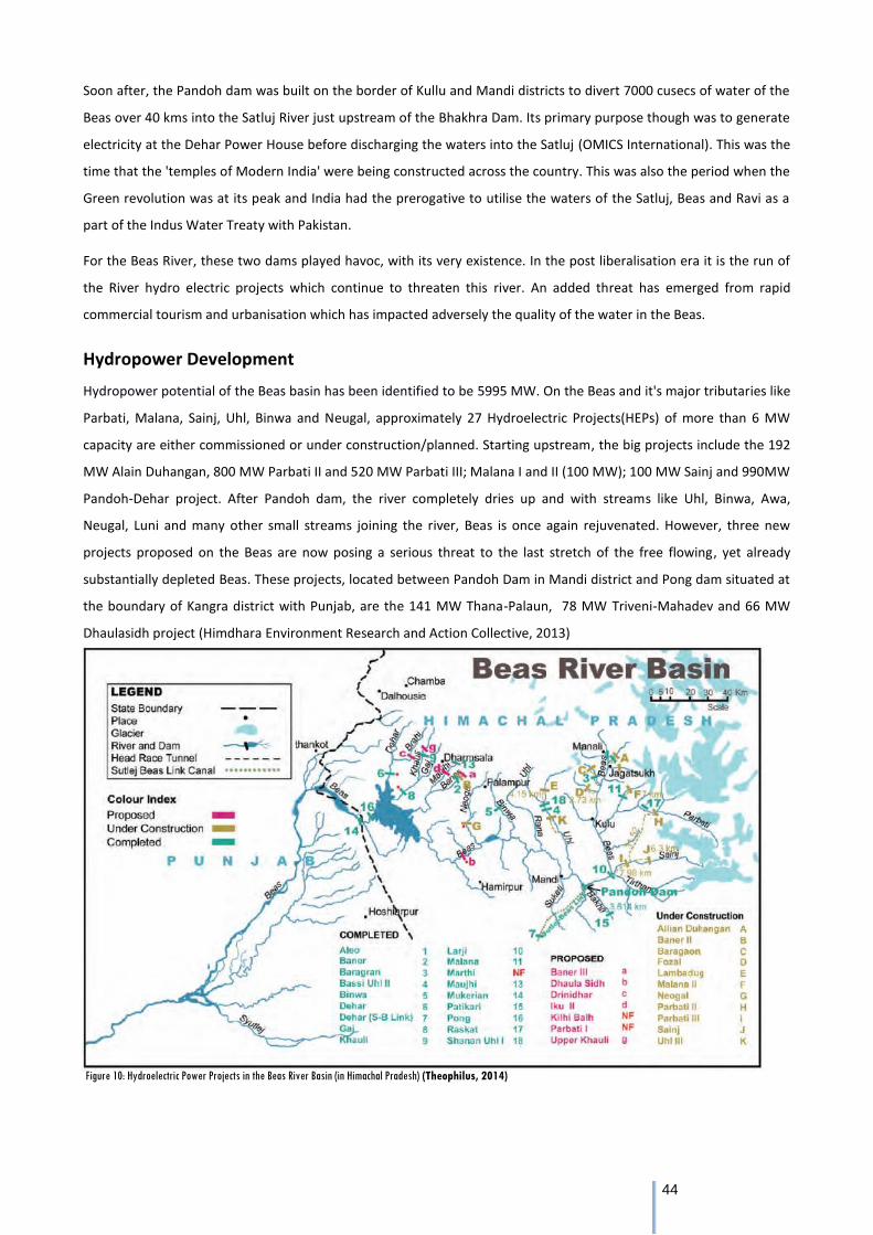
44
Soon after, the Pandoh dam was built on the border of Kullu and Mandi districts to divert 7000 cusecs of water of the
Beas over 40 kms into the Satluj River just upstream of the Bhakhra Dam. Its primary purpose though was to generate
electricity at the Dehar Power House before discharging the waters into the Satluj (OMICS International). This was the
time that the 'temples of Modern India' were being constructed across the country. This was also the period when the
Green revolution was at its peak and India had the prerogative to utilise the waters of the Satluj, Beas and Ravi as a
part of the Indus Water Treaty with Pakistan.
For the Beas River, these two dams played havoc, with its very existence. In the post liberalisation era it is the run of
the River hydro electric projects which continue to threaten this river. An added threat has emerged from rapid
commercial tourism and urbanisation which has impacted adversely the quality of the water in the Beas.
Hydropower Development
Hydropower potential of the Beas basin has been identified to be 5995 MW. On the Beas and it's major tributaries like
Parbati, Malana, Sainj, Uhl, Binwa and Neugal, approximately 27 Hydroelectric Projects(HEPs) of more than 6 MW
capacity are either commissioned or under construction/planned. Starting upstream, the big projects include the 192
MW Alain Duhangan, 800 MW Parbati II and 520 MW Parbati III; Malana I and II (100 MW); 100 MW Sainj and 990MW
Pandoh-Dehar project. After Pandoh dam, the river completely dries up and with streams like Uhl, Binwa, Awa,
Neugal, Luni and many other small streams joining the river, Beas is once again rejuvenated. However, three new
projects proposed on the Beas are now posing a serious threat to the last stretch of the free flowing, yet already
substantially depleted Beas. These projects, located between Pandoh Dam in Mandi district and Pong dam situated at
the boundary of Kangra district with Punjab, are the 141 MW Thana-Palaun, 78 MW Triveni-Mahadev and 66 MW
Dhaulasidh project (Himdhara Environment Research and Action Collective, 2013)
Figure 10: Hydroelectric Power Projects in the Beas River Basin (in Himachal Pradesh) (Theophilus, 2014)
45
Table 6: Summary of current and upcoming hydro projects in the Beas River Basin (in Himachal Pradesh) (Govt. of HP, 2014-15), (HIMURJA, 2015)
The Dhaulasidh project is coming up in the Hamirpur District of Himachal Pradesh and will be constructed by the
Satluj Jal Vidut Nigam Limited (SJVNL). Its capacity is 66 MW and is called a run-of-the-River (ROR) project. However, a
dam of 70.75 m height from the river bed is proposed as part of the project. For an ROR project and that too of only
66 MW, the requirement of 330 hectares of land is quiet high, especially if we compare it with other projects. Again
the three new proposed projects (Thana-Palaun, Triveni-Mahadev and Dhaulasidh) have been announced arbitrarily
without any assessment to understand the cumulative impacts of these on river health and ecology at the basin level.
This stretch of the river flows through a water stressed area like Changar region and people are dependent on the
Beas River for drinking and irrigation. This region is especially prone to landslides and such a huge artificial pondage
will have adverse impacts on agriculture and micro-climatic conditions. This will also adversely impact aquatic ecology,
surrounding vegetation and livelihoods of people.
According to the EIA report of the Dhaulasidh Project 20 fish species are found in the river flowing through the project
area and of these, 2 species are endangered and 3 are vulnerable. The major adverse impact of the Dhaulasidh project
will be on the population of those fish which are migratory in nature like Tor Putitora (Mahaseer) and Schizothorax
Richard Sonii (Snowtrout). On account of the construction of the dam at Pandoh, the population of snow trout in the
River Beas between Mandi and Nadaun towns reduced from 10.2 - 13.5% prior to construction of project to 0.5 - 1%
after project. The EIA claim – without any substantive studies to base it upon - that these fish will get acclimatized to
the changed habitat seems to be farfetched. Moreover, once the whole river gets dammed with the three new dams
proposed between Pandoh and Pong, it would be too late to undertake mitigative measures even if detailed studies
reveal serious impacts due to the dams’ construction on the population these migratory fish.
On the tributaries, the large projects are coming up on the Parbati and the Sainj Rivers. The 800 MW Parbati II will
divert the waters of the Parbati to its neighbouring river, Sainj, also a tributary of the Beas. The Parbati Stage III
hydroelectric project is proposed for the Sainj River, a tributary of the Beas that will receive water from the tailrace of
Parbati Stage II. The Sainj 100 MW hydroelectric project is coming up in Banjar tehsil of Kullu district on Sainj River,
which originates from Rakte Sar glacier in Great Himalayan National Park (GHNP). Near village Niharini a 24.5 metre
high barrage is proposed to be constructed on the right bank of the river. An underground powerhouse with 2 units (2
x 50 MW) is proposed on the right bank of River Sainj near its confluence with Jiwa Nallah, 300 mtrs upstream of
Parbati –II 800 MW HEP. These two structures will be connected by a 6.3 km headrace tunnel passing through a
mountain range inhabited by 5 Panchayats (Himdhara Environment Research and Action Collective, 2011).
Additional to this massive hydropower construction, 313 projects of 5 MW and under are planned on the various
streams (tributaries) of the Beas, the total capacity being 668 MW. These projects have impacted adversely the Kuhl
system of irrigation in Kangra leading to losses in rice cultivation. Apart from this many a watermills have been
rendered useless due to the disappearance of water in kuhls. The contamination of streams due to sewage from
Stage Large Projects Installed Capacity (MW) Small Projects Installed Capacity (MW)
Commissioned 8 2066 44 227.95
Under Construction 4 1520 25 154.65
Planning 5 885 273 609.435
Total 17 4471 342 992.035
46
labour camps is another issue apart from encroachment of forest lands and deforestation leading to erosion and
landslides (Himdhara Environment Research and Action Collective, 2012).
The only valley untouched by hydro projects in Beas River basin is the Tirthan Valley which was made a no-go area for
hydropower. The area is known for its snow and rainbow trouts and has been announced as an angling reserve. Local
panchayats, community members, and fishing lodge owners launched a five year court battle against small
hydropower development in this watershed. The High Court ruled in favor of the arguments set forth concerning the
negative effects on the environment, fisheries, and affected communities of the planned small hydropower projects in
the watershed. The court declared the Tirthan off limits to all hydropower projects, and it cancelled the 9 previously
approved small hydropower projects (Baker, 2014).
Urbanisation and Tourism
There are 302 polluted river stretches along 275 rivers in the country as per the Ministry of Environment, Forests and
Climate Change. Water quality, the total dissolved solids and other parameters like dissolved oxygen, pH level,
temperature are used as indicators to determine the health of a river. Beas is one of these 275 identified rivers
(Governance Now, 2016).
The degradation of the Beas over the last two to three decades is also in terms of the quality of water and the health
of the river impacted by pollution. Between 1985 and 2006, the number of hotels in the Kullu-Manali valley increased
from 10 to 600. The number of tourists increased from 11,002 to 67,132 between 1975 and 1991. The Kullu, Bhuntar
and Manali municipalities have failed to check pollution in the Beas. The substantial part of sewage, solid waste trash
and junk churned by certain resorts and house owners from tourist spots of Rohtang Pass, Solang, Old Manali, Aleo,
Kullu and Bhuntar towns continue to end up in the surging Beas. The River Beas is getting polluted day by day as there
is no proper planning for sewage disposal or the disposal of solid waste either. Heaps of untreated solid waste can be
seen along the banks of river passing through these municipalities (Mishra & Nanda, 2014). It is only after several
orders of the NGT on unregulated tourism related pollution at Rohtang and closure of illegal hotels, that the State
Pollution Control Board is monitoring the river closely. However, the brunt of the NGT orders is being faced by several
thousands of small time tourist operators who are losing their livelihoods as a result of closure of hotels and shacks. It
is the failure of the regulatory authorities which are not working out any sort of a policy for ecologically responsible
tourism or controlled construction, which is ultimately leading to the problem.
Sand Mining
In June 2015, a group of 25 engineering students drowned in the Beas after the Larji Dam discharged water suddenly.
Apart from the issue of negligence and safety vis-a-vis dams, the incident also brought to light another issue, that of
illegal sand mining. The group of students apparently went inside the River bed following an approach road, which
was reportedly built for illegal sand mining. While the issue of over mining of the river beds by the sand mafia is
something that is rampant across the state and country, in Himachal the tributaries of the Beas, especially the smaller
streams and Rivers near the towns and urban centres are facing a larger threat (PTI, 2014).
47
While the NGT had banned sand mining without environmental clearances a couple of years ago, on the ground the
situation remains dismal, again because of the failure of monitoring authorities. Similarly the Himachal High Court has
issued orders of a ban on mining in the tributaries of the Beas, an order which is being violated rampantly.
Illegal and unscientific mining quarrying in the Kangra valley has resulted in large-scale deforestation, landslides and
flash floods. Over 20,000 hectares of land have been seriously affected by mining, quarrying and other activities in this
region, resulting in a drastic reshaping of the landscape. Illegal mining is also posing a serious threat to existence of
dozens of irrigation and drinking water supply schemes, local paths, village roads and cremation grounds. The
existence of the Kirpal Chand Kuhl, feeding over 30 panchayats comprising 100 villages of Palampur, Bhawarans and
Daroh blocks and the Charnamati and Lower Baijnath kuhls feeding 15 panchayats of Baijnath block is in danger
because of continuous mining in the catchments of Neugal and Binwa Rivers (Sood, 2014).
Climate Change and Floods
As per a report in Down to Earth, owing to rising temperatures due to global warming, the Parbati glacier in Himachal
Pradesh is melting fast. A study of satellite images shows the glacier has retreated by 578 metres between 1990 and
2001, a decline of almost 52 metres per year. This is bad news, as the glacier is the largest in the Parbati River basin,
and is an important water source for the River Beas. Researchers found the total loss in glacial extent is 8.3 square
kilometres from 1962 (when the glacial extent was 48.44 sq km) to 1990. In addition, 1.93 sq km and 1.32 sq km loss
in extent was observed over the periods 1990-1998 and 1998-2001 respectively. The loss in glacial length was
estimated at 5,991 metres from 1962 to 1990 and 578 metres from 1990 to 2001. The retreat of the Parbati glacier is
much higher than other glaciers in the Himalayas because the glacier is located at a low altitude. 96 per cent of the
glacier is located at a height of less than 5,200 metres (Down To Earth, 2005).
In the Beas basin, number of lakes has gone up from 67 lakes during 2013 to 89 lakes in 2015, revels satellite data.
Further analysis of these 89 lakes reveals that 80 lakes are smaller one having area less than 5 hectare, 07 lakes with
aerial range between 5-10 hectare and 02 lakes which are having area more than 10 hectare (Himachal Watcher,
2016).
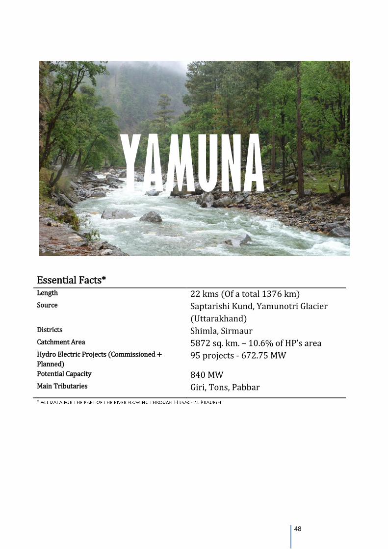
48
Essential Facts* Length 22 kms (Of a total 1376 km) Source Saptarishi Kund, Yamunotri Glacier
(Uttarakhand) Districts Shimla, Sirmaur Catchment Area 5872 sq. km. – 10.6% of HP’s area Hydro Electric Projects (Commissioned +
Planned) 95 projects - 672.75 MW
Potential Capacity 840 MW Main Tributaries Giri, Tons, Pabbar
YAMUNA
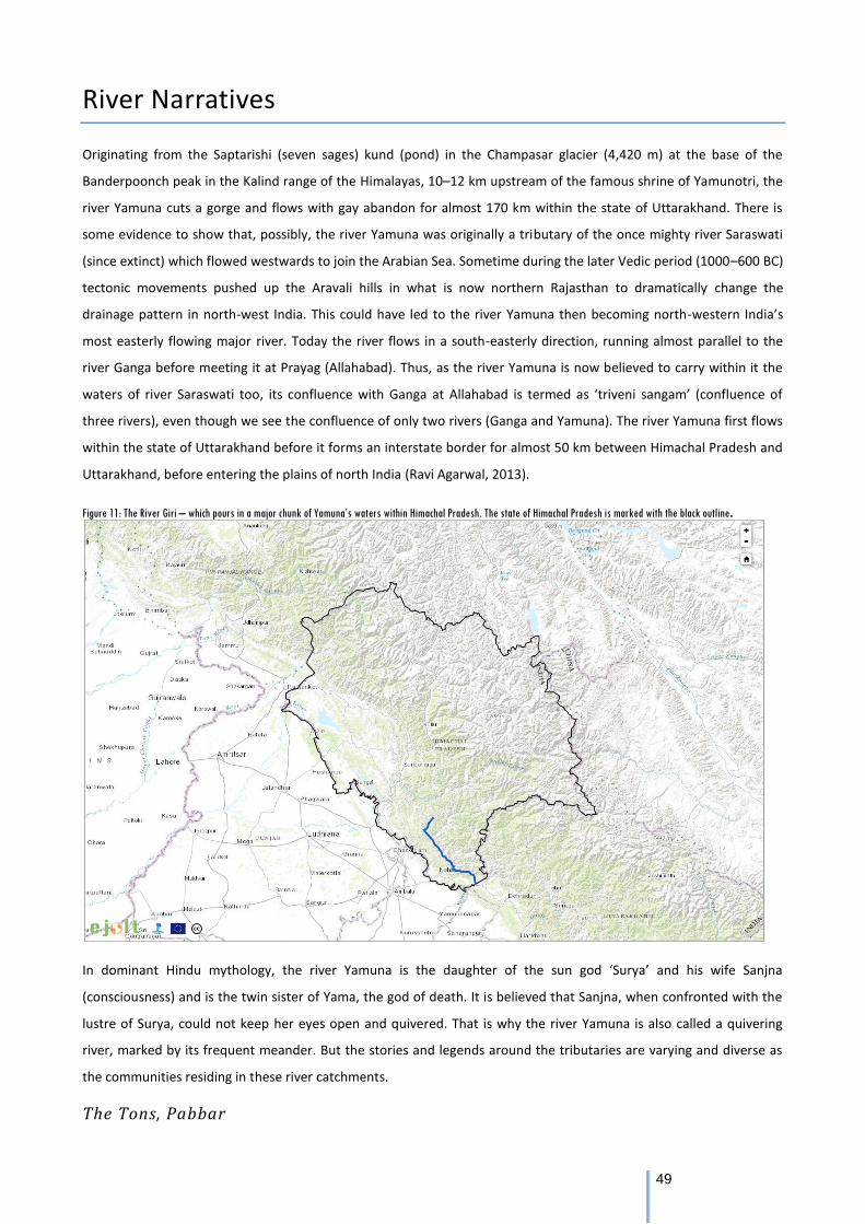
49
River Narratives
Originating from the Saptarishi (seven sages) kund (pond) in the Champasar glacier (4,420 m) at the base of the
Banderpoonch peak in the Kalind range of the Himalayas, 10–12 km upstream of the famous shrine of Yamunotri, the
river Yamuna cuts a gorge and flows with gay abandon for almost 170 km within the state of Uttarakhand. There is
some evidence to show that, possibly, the river Yamuna was originally a tributary of the once mighty river Saraswati
(since extinct) which flowed westwards to join the Arabian Sea. Sometime during the later Vedic period (1000–600 BC)
tectonic movements pushed up the Aravali hills in what is now northern Rajasthan to dramatically change the
drainage pattern in north-west India. This could have led to the river Yamuna then becoming north-western India’s
most easterly flowing major river. Today the river flows in a south-easterly direction, running almost parallel to the
river Ganga before meeting it at Prayag (Allahabad). Thus, as the river Yamuna is now believed to carry within it the
waters of river Saraswati too, its confluence with Ganga at Allahabad is termed as ‘triveni sangam’ (confluence of
three rivers), even though we see the confluence of only two rivers (Ganga and Yamuna). The river Yamuna first flows
within the state of Uttarakhand before it forms an interstate border for almost 50 km between Himachal Pradesh and
Uttarakhand, before entering the plains of north India (Ravi Agarwal, 2013).
Figure 11: The River Giri – which pours in a major chunk of Yamuna’s waters within Himachal Pradesh. The state of Himachal Pradesh is marked with the black outline.
In dominant Hindu mythology, the river Yamuna is the daughter of the sun god ‘Surya’ and his wife Sanjna
(consciousness) and is the twin sister of Yama, the god of death. It is believed that Sanjna, when confronted with the
lustre of Surya, could not keep her eyes open and quivered. That is why the river Yamuna is also called a quivering
river, marked by its frequent meander. But the stories and legends around the tributaries are varying and diverse as
the communities residing in these river catchments.
The Tons, Pabbar
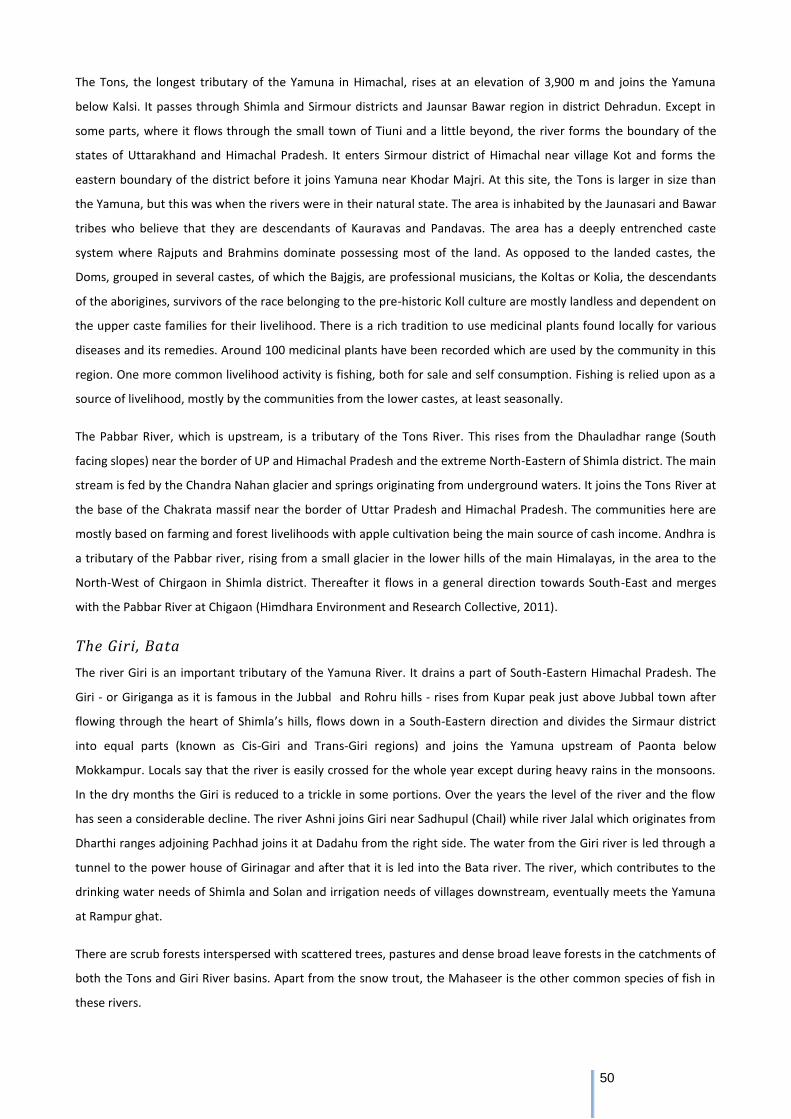
50
The Tons, the longest tributary of the Yamuna in Himachal, rises at an elevation of 3,900 m and joins the Yamuna
below Kalsi. It passes through Shimla and Sirmour districts and Jaunsar Bawar region in district Dehradun. Except in
some parts, where it flows through the small town of Tiuni and a little beyond, the river forms the boundary of the
states of Uttarakhand and Himachal Pradesh. It enters Sirmour district of Himachal near village Kot and forms the
eastern boundary of the district before it joins Yamuna near Khodar Majri. At this site, the Tons is larger in size than
the Yamuna, but this was when the rivers were in their natural state. The area is inhabited by the Jaunasari and Bawar
tribes who believe that they are descendants of Kauravas and Pandavas. The area has a deeply entrenched caste
system where Rajputs and Brahmins dominate possessing most of the land. As opposed to the landed castes, the
Doms, grouped in several castes, of which the Bajgis, are professional musicians, the Koltas or Kolia, the descendants
of the aborigines, survivors of the race belonging to the pre-historic Koll culture are mostly landless and dependent on
the upper caste families for their livelihood. There is a rich tradition to use medicinal plants found locally for various
diseases and its remedies. Around 100 medicinal plants have been recorded which are used by the community in this
region. One more common livelihood activity is fishing, both for sale and self consumption. Fishing is relied upon as a
source of livelihood, mostly by the communities from the lower castes, at least seasonally.
The Pabbar River, which is upstream, is a tributary of the Tons River. This rises from the Dhauladhar range (South
facing slopes) near the border of UP and Himachal Pradesh and the extreme North-Eastern of Shimla district. The main
stream is fed by the Chandra Nahan glacier and springs originating from underground waters. It joins the Tons River at
the base of the Chakrata massif near the border of Uttar Pradesh and Himachal Pradesh. The communities here are
mostly based on farming and forest livelihoods with apple cultivation being the main source of cash income. Andhra is
a tributary of the Pabbar river, rising from a small glacier in the lower hills of the main Himalayas, in the area to the
North-West of Chirgaon in Shimla district. Thereafter it flows in a general direction towards South-East and merges
with the Pabbar River at Chigaon (Himdhara Environment and Research Collective, 2011).
The Giri, Bata
The river Giri is an important tributary of the Yamuna River. It drains a part of South-Eastern Himachal Pradesh. The
Giri - or Giriganga as it is famous in the Jubbal and Rohru hills - rises from Kupar peak just above Jubbal town after
flowing through the heart of Shimla’s hills, flows down in a South-Eastern direction and divides the Sirmaur district
into equal parts (known as Cis-Giri and Trans-Giri regions) and joins the Yamuna upstream of Paonta below
Mokkampur. Locals say that the river is easily crossed for the whole year except during heavy rains in the monsoons.
In the dry months the Giri is reduced to a trickle in some portions. Over the years the level of the river and the flow
has seen a considerable decline. The river Ashni joins Giri near Sadhupul (Chail) while river Jalal which originates from
Dharthi ranges adjoining Pachhad joins it at Dadahu from the right side. The water from the Giri river is led through a
tunnel to the power house of Girinagar and after that it is led into the Bata river. The river, which contributes to the
drinking water needs of Shimla and Solan and irrigation needs of villages downstream, eventually meets the Yamuna
at Rampur ghat.
There are scrub forests interspersed with scattered trees, pastures and dense broad leave forests in the catchments of
both the Tons and Giri River basins. Apart from the snow trout, the Mahaseer is the other common species of fish in
these rivers.
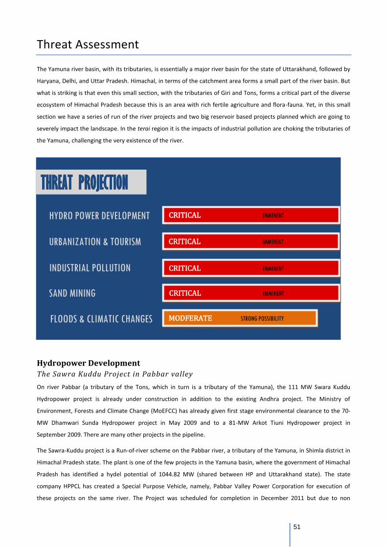
51
Threat Assessment
The Yamuna river basin, with its tributaries, is essentially a major river basin for the state of Uttarakhand, followed by
Haryana, Delhi, and Uttar Pradesh. Himachal, in terms of the catchment area forms a small part of the river basin. But
what is striking is that even this small section, with the tributaries of Giri and Tons, forms a critical part of the diverse
ecosystem of Himachal Pradesh because this is an area with rich fertile agriculture and flora-fauna. Yet, in this small
section we have a series of run of the river projects and two big reservoir based projects planned which are going to
severely impact the landscape. In the terai region it is the impacts of industrial pollution are choking the tributaries of
the Yamuna, challenging the very existence of the river.
Hydropower Development
The Sawra Kuddu Project in Pabbar valley
On river Pabbar (a tributary of the Tons, which in turn is a tributary of the Yamuna), the 111 MW Swara Kuddu
Hydropower project is already under construction in addition to the existing Andhra project. The Ministry of
Environment, Forests and Climate Change (MoEFCC) has already given first stage environmental clearance to the 70-
MW Dhamwari Sunda Hydropower project in May 2009 and to a 81-MW Arkot Tiuni Hydropower project in
September 2009. There are many other projects in the pipeline.
The Sawra-Kuddu project is a Run-of-river scheme on the Pabbar river, a tributary of the Yamuna, in Shimla district in
Himachal Pradesh state. The plant is one of the few projects in the Yamuna basin, where the government of Himachal
Pradesh has identified a hydel potential of 1044.82 MW (shared between HP and Uttarakhand state). The state
company HPPCL has created a Special Purpose Vehicle, namely, Pabbar Valley Power Corporation for execution of
these projects on the same river. The Project was scheduled for completion in December 2011 but due to non
CRITICAL IMMINENT
THREAT PROJECTION
HYDRO POWER DEVELOPMENT
URBANIZATION & TOURISM
INDUSTRIAL POLLUTION
SAND MINING
FLOODS & CLIMATIC CHANGES MODFERATE STRONG POSSIBILITY
CRITICAL IMMINENT
CRITICAL IMMINENT
CRITICAL IMMINENT
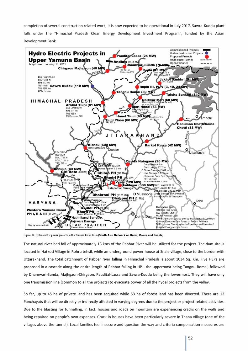
52
completion of several construction related work, it is now expected to be operational in July 2017. Sawra-Kuddu plant
falls under the "Himachal Pradesh Clean Energy Development Investment Program", funded by the Asian
Development Bank.
Figure 12: Hydroelectric power projects in the Yamuna River Basin (South Asia Network on Dams, Rivers and People)
The natural river bed fall of approximately 13 kms of the Pabbar River will be utilized for the project. The dam site is
located in Hatkoti Village in Rohru tehsil, while an underground power house at Snale village, close to the border with
Uttarakhand. The total catchment of Pabbar river falling in Himachal Pradesh is about 1034 Sq. Km. Five HEPs are
proposed in a cascade along the entire length of Pabbar falling in HP - the uppermost being Tangnu-Romai, followed
by Dhamwari-Sunda, Majhgaon-Chirgaon, Paudital-Lassa and Sawra-Kuddu being the lowermost. They will have only
one transmission line (common to all the projects) to evacuate power of all the hydel projects from the valley.
So far, up to 45 ha of private land has been acquired while 53 ha of forest land has been diverted. There are 12
Panchayats that will be directly or indirectly affected in varying degrees due to the project or project related activities.
Due to the blasting for tunnelling, in fact, houses and roads on mountain are experiencing cracks on the walls and
being repaired on people's own expenses. Crack in houses have been particularly severe in Thana village (one of the
villages above the tunnel). Local families feel insecure and question the way and criteria compensation measures are
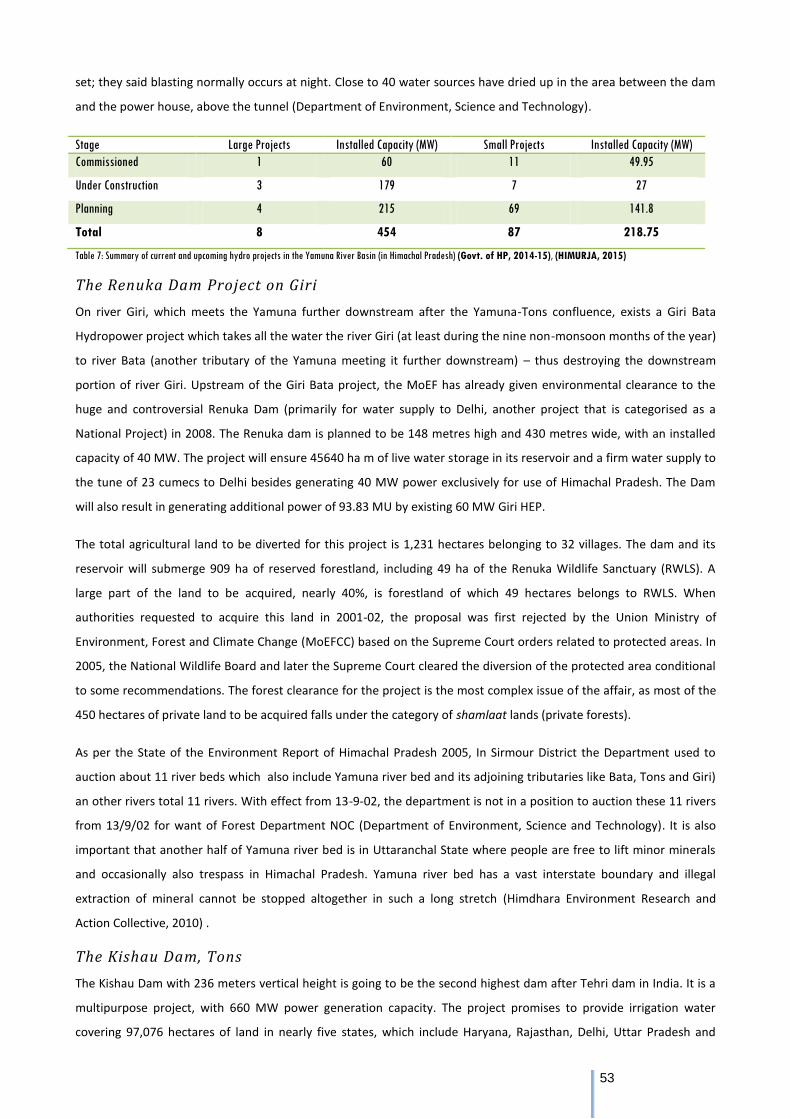
53
set; they said blasting normally occurs at night. Close to 40 water sources have dried up in the area between the dam
and the power house, above the tunnel (Department of Environment, Science and Technology).
Stage Large Projects Installed Capacity (MW) Small Projects Installed Capacity (MW)
Commissioned 1 60 11 49.95
Under Construction 3 179 7 27
Planning 4 215 69 141.8
Total 8 454 87 218.75
Table 7: Summary of current and upcoming hydro projects in the Yamuna River Basin (in Himachal Pradesh) (Govt. of HP, 2014-15), (HIMURJA, 2015)
The Renuka Dam Project on Giri
On river Giri, which meets the Yamuna further downstream after the Yamuna-Tons confluence, exists a Giri Bata
Hydropower project which takes all the water the river Giri (at least during the nine non-monsoon months of the year)
to river Bata (another tributary of the Yamuna meeting it further downstream) – thus destroying the downstream
portion of river Giri. Upstream of the Giri Bata project, the MoEF has already given environmental clearance to the
huge and controversial Renuka Dam (primarily for water supply to Delhi, another project that is categorised as a
National Project) in 2008. The Renuka dam is planned to be 148 metres high and 430 metres wide, with an installed
capacity of 40 MW. The project will ensure 45640 ha m of live water storage in its reservoir and a firm water supply to
the tune of 23 cumecs to Delhi besides generating 40 MW power exclusively for use of Himachal Pradesh. The Dam
will also result in generating additional power of 93.83 MU by existing 60 MW Giri HEP.
The total agricultural land to be diverted for this project is 1,231 hectares belonging to 32 villages. The dam and its
reservoir will submerge 909 ha of reserved forestland, including 49 ha of the Renuka Wildlife Sanctuary (RWLS). A
large part of the land to be acquired, nearly 40%, is forestland of which 49 hectares belongs to RWLS. When
authorities requested to acquire this land in 2001-02, the proposal was first rejected by the Union Ministry of
Environment, Forest and Climate Change (MoEFCC) based on the Supreme Court orders related to protected areas. In
2005, the National Wildlife Board and later the Supreme Court cleared the diversion of the protected area conditional
to some recommendations. The forest clearance for the project is the most complex issue of the affair, as most of the
450 hectares of private land to be acquired falls under the category of shamlaat lands (private forests).
As per the State of the Environment Report of Himachal Pradesh 2005, In Sirmour District the Department used to
auction about 11 river beds which also include Yamuna river bed and its adjoining tributaries like Bata, Tons and Giri)
an other rivers total 11 rivers. With effect from 13-9-02, the department is not in a position to auction these 11 rivers
from 13/9/02 for want of Forest Department NOC (Department of Environment, Science and Technology). It is also
important that another half of Yamuna river bed is in Uttaranchal State where people are free to lift minor minerals
and occasionally also trespass in Himachal Pradesh. Yamuna river bed has a vast interstate boundary and illegal
extraction of mineral cannot be stopped altogether in such a long stretch (Himdhara Environment Research and
Action Collective, 2010) .
The Kishau Dam, Tons
The Kishau Dam with 236 meters vertical height is going to be the second highest dam after Tehri dam in India. It is a
multipurpose project, with 660 MW power generation capacity. The project promises to provide irrigation water
covering 97,076 hectares of land in nearly five states, which include Haryana, Rajasthan, Delhi, Uttar Pradesh and
54
Uttarakhand. The dam is meant to also augment the drinking water supply for Delhi, the national capital by 619
million cubic meters.
In a sense the histories of both Renuka and Kishau dam have had a similar trajectory. While the Renuka Dam, in the
past decade has had to face 'hurdles' in clearances around environmental and forests, the Kishau Dam being a larger
and costlier affair with a huge irrigation component has many unresolved issues as far as its viability is concerned. The
Inter-state benefit sharing concerns, at present in the background, are also likely to have a major role to play in
determining whether the Kishau dam project will really take off. Two realities, however, are apparent. First, that as
long as the Upper Yamuna basin agreement is considered as the guiding policy document for water distribution and
use, the execution of the Kishau Dam project will continue to receive impetus. Second, this project is much bigger in
magnitude than the Renuka dam, and its impacts are likely to be more far reaching. It is keeping in mind these two
realities that a preliminary assessment has been done on the likely local ramifications, both social and environmental,
of this project.
All along 44.5 kms of the submergence area, villages are located on both sides of the river at some interval. The
villages on the right bank in Sirmour district are connected via rope trolleys to Tiyuni- Dehradun road. There are strong
religious, cultural and economic ties between villages on both sides. According to information provided under RTI by
UJVNL, 9 villages from Uttarakhand and 8 villages (6 from Sirmour and 2 from Shimla district) are going to be affected
by Kishau dam project and it's submergence area will spread over 2950 hectares. Of the total submergence area, 512
hectares is cultivated private land and 2438 hectare is forest land. A total of 5498 people belonging 701 families will
be affected by the project. If we look at the cost-benefit analysis only from the point of view of the state of Himachal
Pradesh, the ratio seems quite poor. Himachal will get no share in the irrigation, only 50% in the power and will lose
177 hectares of cultivated land, 1321 hectares of forest land and will displace hundreds of families in return
(Himdhara Environment Research and Action Collective, 2016).
Industrial Pollution The Kala-amb region in district Sirmour has about 350 industrial units and most of the units are situated around
Markanda River. Markanda is a small river of Nahan area of the Sirmaur district and also a tributary of the Yamuna. It
rises from the Southern face of the lower Himalayas on the Western extremity of the Kiarda dun (Paonta) valley. The
lower Himalayan hills of Nahan occur on the right flank of the Markanda valley while the low rolling Shivalik hills are
on its left flank. It is a rain-fed river and has very low flow in the winter and summer months, but rises abruptly in the
monsoon. The major industries in these areas include pharmaceutical, chemicals, ghee industry, food industry,
ferroalloy, paper & pulp etc. These industries, although developed with proper planning, but are discharging their
effluents in the nearby natural drains and are being ultimately collected in Markanda river. Increasing industrialization
and urbanization in these areas are resulting in the degradation of natural resources. The disposal of effluents
generated by the industries into river (Kashyap, Verma, & Bhardwaj). More than half dozen residents of Ambwala,
Sainwala, Moginand etc falling downstream of Kala Amb industrial area in Sirmaur district of Himachal Pradesh have
been suffering as a result of Sewage Treatment Plants and industrial effluents being released in the Markanda River.
As a result of this their cattle were under the spate of various water borne diseases. They were facing the apathy of
State Pollution Board which could not force the paper units and pharmacy firms to release their industrial effluents
after treating it in sewerage treatment plants as many of them were openly flouting the norms. Villagers lament that

55
they were becoming victims of various skin diseases as they have to use the polluted water of this river for bathing
and washing clothes daily.
The water Quality of river Ravi Yamuna at Pontasahib (H.P.) is monitored regularly. According to the Central Pollution
Control Board's report, “Polluted River Stretches in India”, the stretch of the Yamuna at Paonta Sahib has been
categorised as priority 1 as far the dissolved oxygen levels are concerned because it has a BOD of above 6mg/l (Central
Pollution Control Board, 2005).
56
Conclusions and recommendations
Of these five threats that have been identified as the major threats to river basins in Himachal, climate change and
glacial melt is an over-arching threat, the cause of which is not restricted to the developments within the state, region
or country but are of a global nature. Which then brings us to the other threats, all of which are directly connected
with the current developmental model, which is profit oriented and based on relentless extraction of natural
resources. WE believe that until and unless a larger policy change occurs there is little hope to save the Himalayan
rivers. For immediate action however, there are certain policy initiatives that could yield some benefits:
Some of the smaller streams and tributaries of the major river basins need to be marked for their fragility not
just from a single view point but given that they support ecological diversity and livelihoods. The Tirthan is a
brilliant example of this. Thriving fish farms on the river, small home based eco tourism initiatives and
cultural preservation all becomes possible in such an environment. Similarly some of the other streams on
Ravi - like the Hul streams in the Saal valley which also feed into the drinking water needs of the valley as well
as Chamba town, needs to be declared as a no-go zone not just for hydro projects but also for large scale
sand mining, polluting industries and unplanned construction of both roads and buildings. List of such
streams/tributaries on each of the rivers needs to be drawn up. Other examples are Kerang, Ropa, Spiti
(Satluj).
Of the major rivers it is now the Chenab and Satluj in Upper Kinnaur as well as Spiti that remains free flowing.
Given that these are high altitude regions and are ecologically fragile and more at risk due to climatic
variations, these should also be declared as 'Eco sensitive zones' and no-go for major construction activity. As
per the recommendations of the Avay Shukla Committee report submitted to the Shimla High Court there has
to be a restriction on projects above 7000 feet. On Yamuna, the Tons and Giri both are important life lines of
the local community and the only non polluted sections of the river basin upstream these need to be
conserved as well given the impending threat of two large dams (Renuka and Kishau) in this region. In fact a
review of the Upper Yamuna Basin Agreement is warranted given that 5 states are involved and a Cauvery
like situation would mean increasing tensions amongst the riparian states and communities
Additionally the Cumulative Impact Assessment studies for Hydropower Projects on the river basins need to
be undertaken in a thorough and multi-disciplinary fashion. While the studies for Satluj, Chenab and Beas are
already complete - there has been little local consultation in carrying out these studies. Further, these studies
have become a mere formality as the process of giving environment and forest clearances for hydroprojects
has been de-linked from the CEIA process. Environmental groups have been demanding that until the
complete studies are carried out there must be a moratorium on further hydro development in Himachal
As far as Sand mining is concerned if the orders of the NGT and High Court are strictly implemented, and the
mining is regulated or even stopped in the streams and rivers, the revival would take place in a short period
of time
Tourism and Urbanisation need serious policy measures that strengthen the role of regulatory agencies as
well as work towards models that are not large and commercial in nature but small scale and community
owned and managed. Urban bodies as well as Panchayats need to involve community representatives in
57
development plans where health of the river is placed as the central concern
Last but not the least, all rivers – Beas, Satluj and Lower Stretches of the Yamuna (tributaries) - or already
critically polluted – that are in the red, can be at least monitored strictly by the Pollution Control board again
in consultation with communities. At present the Pollution Control Board and the Irrigation and Public Health
department's roles have either been made redundant or they have been working to ensure least hindrance
to 'developers'. In this regard the Amendments in the Hydropower Policy of 2006, which were made in 2014
and 16, need to be withdrawn as they dilute the process of NOCs from these departments prior to approval
of hydro projects. The role of these regulatory agencies needs to be strengthened with community
involvement in ensuring compliance to existing legislations that protect rivers and riparian rights.
Environment flows, though a concept that really needs to be re-examined given that most hydroprojects are
unable to ensure even the 15% minimum e-flow requirement (as per the Hydropower Policy 2006). In recent
years, the Expert Appraisal Committee on River Valley projects has proposed a minimum eflow of 25 to 30%
in some cases. While this may be desirable, when 15% flow is not being maintained it seems like a long shot.
In the context of e-flows when main rivers have been plugged with projects, there is a need to do following:
Where there are cascade of projects the projects they should discharge sufficient amount of water and all the
small streams joining the river should be kept free of projects so that fish can migrate in these small for
streams for spawning. As mentioned earlier, the rivers which don’t have projects should be kept free of the
project so that all the biodiversity present can be protected.
The Forest Rights Act 2006, if implemented in full spirit will strengthen community control and ownership
over forests around river basins (which mostly fall under the category of 'Forest lands'). This would also mean
having the responsibility of conserving and protecting these resources. Unfortunately, the Himachal
government has the poorest track record in FRA implementation with the State government and forest
bureaucracy impeding rather than facilitating the filing of claims process. The focus has been on 'individual
rights' rather than CFR (Community Forest Rights).
Special attention needs to be paid to monitoring and regulation of industrial pollution in areas like Baddi
Barotiwala Nalagarh and Paonta Sahib. Common Effluent Treatment Plants have failed miserably and an
effort needs to be made to monitor pollution at the source as well as treat the effluents there. Industries
violating norms should face closure as well as punitive action. The Himachal Pollution Control Board needs to
be held accountable.
58
References Anup Katoch, J. G. (2014). Impact of Nathpa Jhakri Hydroelectric Power Project on the Environment and
Livelihood in Kinnaur and Shimla Districts of Himachal Pradesh. New Delhi: Indian Council of Social Science
Research.
Asher, M. (2015). Kinnaur’s Curse? Economic & Political Weekly , 50 (20).
Asian Development Bank. (2010). Climate Change Adaptation in Himachal Pradesh.
Bagla, P. (2009, December 5). Himalayan glaciers melting deadline 'a mistake'. Retrieved from BBC News:
http://news.bbc.co.uk/2/hi/8387737.stm
Baker, J. M. (2014, June 8). The Socio-Ecological Effects of Small Hydropower Development in Himachal
Pradesh. Retrieved from South Asia Network of Dams, Rivers and People:
https://sandrp.wordpress.com/2014/06/08/the-socio-ecological-effects-of-small-hydropower-
development-in-himachal-pradesh/
Bodhi, A. (2014, July 23). Melting glaciers giving rise to new lakes in Himachal Pradesh. Retrieved from
Times Of India: http://timesofindia.indiatimes.com/home/environment/global-warming/Melting-glaciers-
giving-rise-to-new-lakes-in-Himachal-Pradesh/articleshow/38889169.cms
Business Standard. (2016, October 5). What Steps to Protect Eco-sensitive Lahaul-Spiti, NGT asks HP.
Central Pollution Control Board. (2005). Water Quality of Rivers in Indus Basin . Retrieved from Central
Pollution Control Board: http://cpcb.nic.in/INDUS.php
Chakravartty, A. (2014, April 14). Women protesting GMR's hydel project charged with 'inciting communal
riots'. Retrieved from Down To Earth: http://www.downtoearth.org.in/news/women-protesting-gmrs-
hydel-project-charged-with-inciting-communal-riots-44014
Chenab. (n.d.). Retrieved from India-WRIS Wiki: http://www.india-
wris.nrsc.gov.in/wrpinfo/index.php?title=Chenab
Department of Environment, Science and Technology. State of Environment Report, Himachal Pradesh.
Down To Earth. (2005, July 15). Parbati glacier shrinks. Retrieved from Down To Earth:
http://www.downtoearth.org.in/news/parbati-glacier-shrinks-9814
Environment Justice Atlas. (n.d.). Environmental Justice in Himachal Pradesh, India. Retrieved from
Environment Justice Atlas: https://ejatlas.org/featured/himachal_pradesh
Forest Department, G. o. (2015). Year wise detail of proposals approved under FCA up to 30.11.2015.
Retrieved from Himachal Pradesh Forest Department: http://hpforest.nic.in/files/FCA_1.pdf
Governance Now. (2016, July 19). 302 polluted stretches along 275 rivers across India. Retrieved from
Governance Now: http://www.governancenow.com/news/regular-story/302-polluted-stretches-275-
Rivers-india
Govt. of Himachal Pradesh. (2011). District Census Handbook - Lahul & Spiti. Directorate of Census
Operations.
Govt. of HP. (2014-15). Economic Survey of Himachal Pradesh.
59
Govt. of HP. (2015-16). Economic Survey of Himachal Pradesh. Govt. of Himachal Pradesh, Economics &
Statistics Department.
Gulati, V. (2010, August 13). Hydro projects could make Ravi river stretch disappear. Retrieved from
TwoCircles:
http://twocircles.net/2010aug13/hydro_projects_could_make_ravi_river_stretch_disappear.html#.WCc8l
Wp96Ul
Himachal Watcher. (2016, October 8). Himachal at high risk of floods due rise in number of Supra glacial
lakes formed by melting snow: Study. Retrieved from Himachal Watcher:
https://himachalwatcher.com/2016/10/08/himachal-at-high-risk-of-floods-due-rise-number-of-supra-
glacial-lakes-study/
Himalyan Forest Research Institute. (2008). Environment Impact Assessment for Integrated Kashang
Hydroelectric Project (243 W) of Himachal Pradesh. Shimla: Indian Council of Forestry Research and
Education.
Himdhara Environment and Research Collective. (2011). In the Name of Clean Energy.
Himdhara Environment Research and Action Collective. (2011). A Report on Asian Development Bank
Financed Hydropower Projects in Himachal Pradesh. South Asia Network on Dams, Rivers and People.
Himdhara Environment Research and Action Collective. (2011). Beginning of the End.
Himdhara Environment Research and Action Collective. (2013). Big Cost, Little Gain.
Himdhara Environment Research and Action Collective. (2010). Dispossessing Mountain Communities.
Himdhara Environment Research and Action Collective. (2012). Small Hydropower, Big Impacts?
Himdhara Environment Research and Action Collective. (2016). Submerging Jaunsar-Bawar, the Dam
onslaught continues, A preliminary study of the impact of Kishau Dam in Himachal Pradesh and
Uttarakhand.
Himdhara Environment Research and Action Collective; HimParivesh Environment Protection Organization.
(2014). Report of People's Public Hearing on Industrial Pollution in Baddi Barotiwala Nalagarh Industrial
Area. Baddi.
HIMURJA. (2015). List/Status of 655 Projects upto 5.00 MW Capacity as on Today. Retrieved from HIMURJA:
http://himurja.nic.in/mousigned.html
HP State Centre on Climate Change, State Council for Science Technology & Environment. (2014). A
technical report on the inventory of moraine dammed glacial lakes (GLOFs) in Satluj, Beas, Chenab and Ravi
Basins in Himachal Pradesh using IRS LISS III Satellite data.
Indian Council of Forestry Research and Education. (2015). Cumulative Environmental Impact Assessment
Studies of Hydro Electric Projects of Sutlej River Basin in Himacgal Pradesh. Shimla: Directorate of Energy,
Government of Himachal Pradesh.
Indian Council of Forestry Research and Education. (2014). EIA Report for Nakthan Hydroelectric Project
(460 MW). Environment Management Division, Directorate of Extension, Dehradun.
60
Kashyap, R., Verma, K., & Bhardwaj, S. Pollution Potential Assessment of Markanda River Around Kala-Amb
Industrial Town of Himachal Pradesh, India.
Kharaik, A. (2016, April 12). Snowfall Deficiency In Hills Of North India May Escalate Scarcity Of Water.
Retrieved from HillPost: Snowfall Deficiency In Hills Of North India May Escalate Scarcity Of Water
Kotwal, K. (2016, September). Manimahesh Pilgrimage. Retrieved from DailyExcelsior:
http://www.dailyexcelsior.com/manimahesh-pilgrimage/
Lenin, J. (2016, October 17). How Climate Change is Affecting an Old Pastoral Tradition in Spiti. Retrieved
from The Wire: http://thewire.in/73427/shepherds-climate-glaciers-spiti/
Maps of India. (n.d.). River Map of Himachal Pradesh. Retrieved from MapsofIndia.com:
http://www.mapsofindia.com/maps/himachalpradesh/rivers/
Mishra, P. R., & Nanda, R. K. (2014). Water Resource Pollution and Impacts on the Local Livelihood: A Case
Study of Beas River in Kullu District, India. Future of Food: Journal on Food, Agriculture and Society , 2 (1).
National Institute of Hydrology . (n.d.). Chenab Sub Basin of Indus Basin. Retrieved from Hydrology and
Water Resources Information System for India:
http://nihroorkee.gov.in/rbis/basin%20maps/Indus/chennab.htm
OMICS International. (n.d.). Pandoh Dam. Retrieved from OMICS International:
http://research.omicsgroup.org/index.php/Pandoh_Dam
Priyadarshi, N. (2016, September 8). Sedimentation by Himalayan Rivers may cause Earthquakes and Land
subsidence in Eastern India. Retrieved from https://www.linkedin.com/pulse/sedimentation-himalayan-
rivers-may-cause-earthquakes-land-nitish
PTI. (2014, June 15). Beas Tragedy Exposes Illegal Sand Mining. Retrieved from Times of India:
http://www.ndtv.com/india-news/beas-tragedy-exposes-illegal-sand-mining-578415
Ravi Agarwal, T. K. (2013). Yamuna Nama. Delhi: Project Y.
Saal Ghaati Bachao Sangharsh Samiti. (2010). Struggle Against Hul Hydro Projects.
Samjwal R. Bajracharya, P. K. (2006). The Impact of Global Warming on the Glaciers of the Himalayas.
International symposium on Geo-disasters, infrastructure management and protection of world heritage
sites, 25-26 Nov 2006, Nepal Engineering College, Ehime College and National Society for Earthquake
Technology Nepal., (pp. 231-242).
Saxena, A. (2013). The Socio-Economic Impact of Hydro-Projects: A Case Study of the Pong Dam. Journal of
Indian Research , 1 (2), 1-22.
Sood, R. (2014, May 25). Illegal mining rampant in Palampur. Retrieved from Tribune India:
http://www.tribuneindia.com/2014/20140526/himachal.a#17
South Asia Network on Dams, Rivers and People. (n.d.). Basin Maps. Retrieved from South Asia Network on
Dams, Rivers and People: http://sandrp.in/basin_maps/
Sustainable Hydropower. Public Health - Chamera, India.
Theophilus, E. (2014). Headwater Extinctions. South Asia Network on Dams, Rivers and People.

61
World Bank. (1960). Indus Water Treaty.
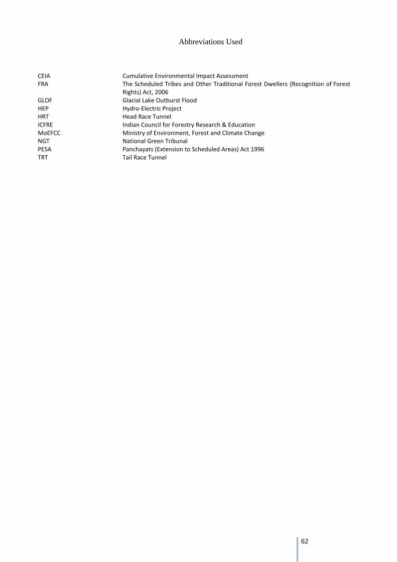
62
Abbreviations Used
CEIA Cumulative Environmental Impact Assessment FRA The Scheduled Tribes and Other Traditional Forest Dwellers (Recognition of Forest
Rights) Act, 2006 GLOF Glacial Lake Outburst Flood HEP Hydro-Electric Project HRT Head Race Tunnel ICFRE Indian Council for Forestry Research & Education MoEFCC Ministry of Environment, Forest and Climate Change NGT National Green Tribunal PESA Panchayats (Extension to Scheduled Areas) Act 1996 TRT Tail Race Tunnel

63