Draft WRIA 20 Report: Visioning Forum and · PDF fileDraft WRIA 20 Report: Visioning Forum and...
54
Draft WRIA 20 Report: Visioning Forum and Interviews Prepared by Miranda Wecker and Rebekah Gentry UW Olympic Natural Resources Center June 30, 2011
Transcript of Draft WRIA 20 Report: Visioning Forum and · PDF fileDraft WRIA 20 Report: Visioning Forum and...

Draft WRIA 20 Report: Visioning Forum and Interviews
Prepared by Miranda Wecker and Rebekah Gentry UW Olympic Natural Resources Center June 30, 2011

Table of Contents
WRIA 20 Visioning Forum
Introduction ............................................................................................................................................................ 1
Comments Taken at Listening Stations .............................................................................................................. 2
Public Comments Submitted on Handout Maps ............................................................................................... 3
Visioning Forum Attendance List ........................................................................................................................ 4
Handout Maps with Public Comments
Bear Creek Map .............................................................................................................................................. 5
Bogachiel Map ............................................................................................................................................... 6
Calawah ‐ Elk Creek Map ............................................................................................................................... 7
Forks Area Map ............................................................................................................................................... 8
Lake Pleasant Map .......................................................................................................................................... 9
Three Rivers Map .......................................................................................................................................... 10
Visioning Interviews
Introduction .......................................................................................................................................................... 11
Outreach to WRIA 20 Co‐Managers ................................................................................................................ 11
Forks Urban Growth Area Stakeholders .......................................................................................................... 11
WRIA 20 Stakeholders ........................................................................................................................................ 11
Conclusions ......................................................................................................................................................... 12
Quileute Tribal Staff: Comment Map ............................................................................................................... 14
Forks UGA Interviews .......................................................................................................................................... 15
David Mansfield ............................................................................................................................................ 15
Patricia Dorst, Kurt Klahn, Jim and Leslie Klahn ........................................................................................... 17
Dan Kousbaugh ............................................................................................................................................. 18
Kevin Miller ................................................................................................................................................... 20
Jean Miller .................................................................................................................................................... 21
Patricia Whidden .......................................................................................................................................... 22
Criss Whidden ............................................................................................................................................... 23
WRIA 20 Interviews ............................................................................................................................................. 24
Andrew Marks, Coastal Conservation Association ....................................................................................... 24
Joe Murray, Merrill and Ring ........................................................................................................................ 25
Jody Kennedy, Surfrider Foundation ............................................................................................................ 26
Harry Bell, Green Crow ................................................................................................................................. 27
Greg Good, North Olympic Land Trust ......................................................................................................... 28
Ron Garner & Dave Croonquist, Puget Sound Anglers ................................................................................. 29
Anne Shaffer, Coastal Watershed Institute ................................................................................................... 30

Jill Silver, 10,000 Years Institute .................................................................................................................... 31
Norm Schaaf, Merrill and Ring Co. ............................................................................................................... 32
Meghan Tuttle, Rayonier Co. ......................................................................................................................... 34
Devona Ensmenger, Wild Salmon Center ..................................................................................................... 35
Letter from the Wild Salmon Center .............................................................................................. 36
Exhibit A: Designation Recommendations ...................................................................................... 38
Attachment 1: Western Washington Strong Populations ............................................................... 41 Attachment 2: Elk Creek Acquisition Proposal ............................................................................... 42 Attachment 3: Summary Draft Manuscript on Calawah River Critical Habitat ............................... 50

Page | 1
WRIA 20 Visioning Forum
Clallam County Shoreline Management Plan Update Forest Hemlock Room
Olympic Natural Resources Center Forks, WA 98331 7pm – 9:30pm
October 26, 2010
Introduction The Forum was called to order by John Calhoun, Director of the University of Washington’s Olympic Natural Resources
Center. Mr. Calhoun welcomed the participants and asked them to introduce themselves. He then explained the
purpose of the meeting and the role of ONRC. Mr. Calhoun described ONRC as serving in a facilitating role for the
component of the Clallam County SMP update that addresses shoreline rules in Water Resource Inventory Area (WRIA)
20 and the Forks Urban Growth Area (FUGA). This meeting is the first public session in a process that is expected to
require extensive public input and two to three years of activities. He assured the audience that a lengthy opportunity
for detailed input would be offered during the second half of the meeting and encouraged those present to share their
knowledge, express their views and consider ways that the area’s natural resources can be conserved and protected. He
then introduced his colleague, Miranda Wecker, the Director of Marine Programs for ONRC.
Ms. Wecker presented a series of slides aimed at explaining the SMP Update process as mandated and defined in state
law. The SMP planning process was established to prevent uncoordinated and piecemeal development, protect against
adverse effects to waters and aquatic life, and secure the public interest. The state directs that local jurisdictions protect
the environmental resources of the state, set priorities for uses that require shoreline location and promote public
access and enjoyment of the shorelines. Existing uses are “grandfathered in” but new uses must be consistent with the
updated rules. A new state directive that is central to the update planning process is the mandate to assure “no net loss
of ecological functions necessary to sustain shoreline natural resources.”
She stressed throughout her presentation that state law demands that local jurisdictions provide citizens and
stakeholders with repeated and meaningful opportunities to influence the outcome of this planning process. A great
deal of flexibility is anticipated so that the rules fit the local conditions and suit the preferences of local residents and
other interested parties. Approval by the Department of Ecology is required of all updated SMP plans and all
jurisdictions must have approved plans by 2014. She went on to outline the various documents that the state guidelines
call for to satisfy the requirements established in the law. As facilitator of the WRIA 20 component of this process, ONRC
assured participants that their knowledge and viewpoints would count in the outcome of this update.
The purpose and design of this evening’s “Visioning Forum” was then explained. The Visioning Forum is the first step is
establishing the direction for the SMP update in WRIA 20. Other steps in the Update process were identified and she
assured the group that additional opportunities to provide comments would be available over the course of the year. As
the first SMP Update task, the Visioning Forum was intended to allow residents and stakeholders to define their views of
a preferred future for the shorelines of WRIA 20. In particular, the law mandates that residents consider and provide
Page | 2
their vision in relation to four major topics: shoreline uses, shoreline protection, shoreline restoration and public access.
She explained that 4 “Listening Stations” had been set up to allow for submission of written comments on flip charts and
to support more intensive conversations on the 4 mandated topics.
Ms. Wecker directed the audience’s attention to a series of maps that had been posted on the walls to provide relevant
information on the local rivers with shorelines of statewide significance. She pointed to stacks of copies of “zoomed in”
maps. These handout maps depicted key reaches that will require the most thorough review due to the potential for
development. These “hand out” maps were generated to allow citizens to make notations in regard to specific areas
they are familiar with and want to comment on. She mentioned that the maps posted on the walls will be available to
view and comment on throughout the process. ONRC and Clallam County had established an “online map cabinet” at
Clallam County’s website, as well as a SMP Information Center at ONRC. She asked if there were any questions about
the SMP process or the evening’s activities. A few citizens asked whether their views would really matter, how the plan
would be adopted, and how designations would affect their property. Participants were then invited to move around the
room and view the data layers presented in the WRIA wide maps.
Comments Taken at the Listening Stations
Shoreline Uses
Current recreational uses include camping, fishing, horseback riding, and hiking. Landowners also on occasion need to
remove danger trees and replace physical structures that have been lost. More information is needed on the effects of
the new rules: whether buildings must be constructed on the same foundation, what will be allowed if structures are
lost due to fire or wind; whether a replacement building must be same type and have the same footprint; how “no net
loss” will be defined; and how non‐conforming uses will be regulated. Concerns were raised about the noise and safety
hazards associated with log truck traffic along the western shore of Lake Pleasant.
Protection Opportunities
Most of the shorelines of WRIA 20 are productive and relatively healthy compared to the shorelines in urban areas. The
presence of large blocks of commercial forestlands is beneficial in minimizing impacts to habitat. Maintaining the
viability of commercial forestlands will help protect the shorelines. Control of invasive knotweed is important to protect
salmon habitat. Salmonid spawning beds are found in various places and need protection. A Bear Creek location was
pointed out as one example. Concerns were raised regarding streambed gravel mining taking place regularly at a
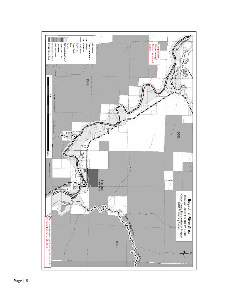
shallow ‘ford’ on the Bogachiel River. (See handout map below.)
Restoration Opportunities
Bear Creek has been impacted by logging by USFS and State on uplands and offers a restoration opportunity. The
structure over Mill Creek should be a bridge not culvert. This project is being assessed this year by SRF Board. (NOTE:
This area of Mill Creek is beyond SMP jurisdiction). Information was requested regarding the agency responsible for
implementation of the restoration plan.
Public Access
Concerns were raised about noise associated with recreational boating on Lake Pleasant. More information in the form
of maps or signage should be offered to visitors on shoreline trail hiking opportunities. The salmon coalition trail on Mill
Creek was an example.
Page | 3
Public Comments Submitted on Handout Maps
The public offered a number of comments through written notes on handout maps. The maps are presented below. The
following list compiles the submitted notations.
Forks Area West map:
o Oxbow on Calawah River below Highway 101 bridge: “Flood map NOT accurate.”
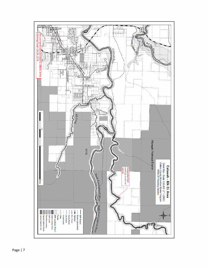
Calawah‐Elk Creek Area map
o On North Fork Calawah River: “Designated ford could go across with vehicle.”
Three Rivers Area map:
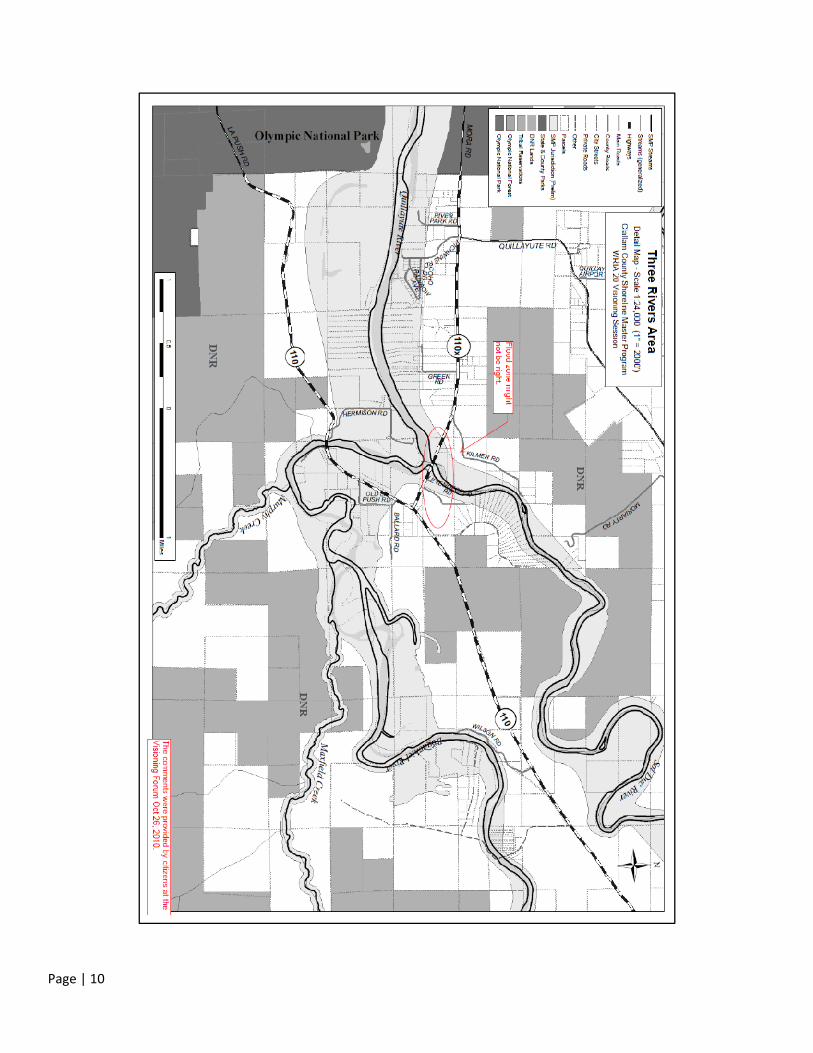
o At confluence of Bogachiel, Sol Duc and Quillayute Rivers: “Flood zone might not be right.”
Lake Pleasant Area map:
o “What’s the rule on: 1. Removal of dangerous tree? 2. Private access to the lake?”
o At north end of lake: “Gravel beach; sockeye spawning area.”
o Along east shore of lake: “Please look at the designation for this as conservancy. This is the developing
side of Lake Pleasant and should not be designated as conservancy.
Bogachiel River Area map
o On Bogachiel River upriver from confluence with Mill Creek: “Campbell Bar: Gravel mining? Maybe not
in past years?”
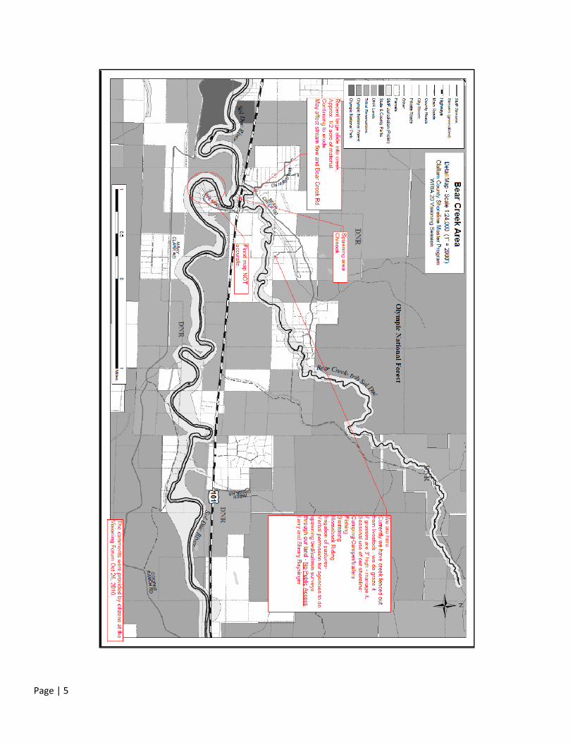
Bear Creek Area map:
o Near the Walgren Rd/Bear Creek Rd junction: “Recent large slide into creek. Approx. ½ acre of material.
Continuing to erode. May affect stream flow and Bear Creek Rd.”
o On Sol Duc River upstream of Bear Creek confluence: “Spawning area: Chinook.”
o On Sol Duc River near Hilstrom Rd: “Flood map NOT accurate.”
o At end of spur off of Bear Creek Rd: “We are here. Currently we have creek fenced out from livestock—
we do graze it if grasses are 3’ high—manage it. Seasonal use of our shoreline: Camping—
camper/trailers; Fishing; Swimming; Horseback riding; Irrigation of pastures; Verbal permission for
agencies to do spawning bed/salmon surveys through our land. No Public Access.
Page | 4
Visioning Forum Attendance List
M. Hopfensperger
G. Preuett 3530 NE Old Belfair Hwy. #57 Belfair, WA 98528
Kris Northcut [email protected]
Denise Graham [email protected]
Rich Hsu [email protected]
Theresa Santman [email protected]
Richard & Kandi Lohneis [email protected]
Roy Grafstrom [email protected]
Rich Osborne WRIA 20
Stephen V Barnett 20917 Military Rd. S, Seatac, WA 98198
Jim Klahn 19034 40th PL NE Lake Forest Park, WA 98155 [email protected]
Joe Soha Forks, WA [email protected]
Bert Paul 162 Valley View Drive Forks, WA 98331 [email protected]
Katie Krueger P O Box 187 Lapush (QNR) [email protected]
Rod Fleck 500 East Division St Forks, WA 98331 [email protected]
Bryon Monohon 500 East Division St Forks, WA 98331 [email protected]
Linda M Dillard P O Box 51 Clallam Bay, WA 98326‐0051 [email protected]
Ed Bowen P O Box 111 Clallam Bay,WA [email protected]
Larry & Sherry Baysinger 2094 Bear Creek Rd Port Angeles, WA 98363 [email protected]
Page | 5
Page | 6
Page | 7

Page | 8

Page | 9
Page | 10

Page | 11
Visioning Interviews
Introduction
ONRC developed a strategy for soliciting the views of key interested stakeholders who were unable to attend the
Visioning Forum. It was decided that ONRC would conduct a series of interviews with interested individuals. ONRC
drafted and circulated two explanatory emails seeking assistance and advice from interested parties. The emails
included hot links to the online map cabinet and a powerpoint display that provided a summary explanation of the SMP
update process. These emails were circulated to a list of representatives of numerous conservation organizations,
timber companies, fishing advocacy groups and the local tribes. No responses were received to the first email message.
The second message was followed up with phone calls encouraging participation and seeking a convenient time for the
survey.
Outreach to WRIA 20 Co‐managers
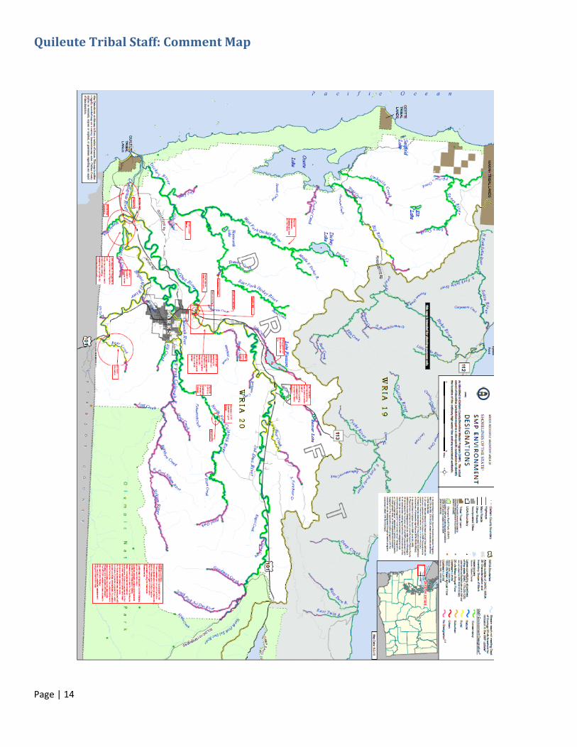
Technical staff of the Quileute Department of Natural Resources provided extensive information during a 2 hour session
with ONRC staff on February 10, 2011. Staff interviewed included Katie Krueger, Kris Northcut, Frank Geyer, and Garrett
Rasmussen. The views of the Tribe were solicited regarding use, protection, restoration and public access priorities and
concerns. Detailed notes were taken during that 3 hour meeting held in La Push at the Quileute Natural Resources
Department. The information and comments provided by these representatives of the co‐managers are documented
the map presented below. Interviews with representatives of the Makah Tribe were requested. No opportunity for such
interviews was made available.
Forks Urban Growth Area (UGA) Stakeholders
The following City of Forks Urban Growth Area (UGA) property owners participated in the interviews:
David Mansfield
Patricia Dorst, Kurt Klahn, & Jim and Leslie Klahn
Dan Kosbaugh
Kevin Miller & Jean Miller
Patricia Whidden & Criss Whidden
WRIA 20 Stakeholders
The following WRIA stakeholders agreed to take part in the survey and were interviewed by telephone:
Andrew Marks, Coastal Conservation Association
Joe Murray, Merrill and Ring
Jody Kennedy, Surfrider Foundation
Harry Bell, Green Crow
Greg Good, North Olympic Land Trust

Page | 12
Ron Garner, Puget Sound Anglers
David Croonquist, Puget Sound Anglers, Olympic Peninsula Chapter
Anne Shaffer, Coastal Watershed Institute
Jill Silver, 10,000 Years Institute
Norm Schaaf, Merrill and Ring Company
Meghan Tuttle, Rayonier Company
Devona Ensmenger, Wild Salmon Center
Comments provided by WRIA 20 and FUGA stakeholders are presented in the appendix below
Conclusions
The residents and stakeholders of WRIA 20 held a diversity of views about the preferred future for shorelines of WRIA
20. For the most part, participants felt that the local rivers are in good condition and the ecological processes are
functioning well. The absence of any listed salmon runs in most of the rivers is seen as evidence of the good stewardship
of local people. Some citizens pointed to the small population of WRIA 20 and the vast tracts of public and private
forestlands as the reason the ecosystem is as healthy as it is.
There are areas of concern however, some of which were noted on the handout maps. Participants described
themselves as very concerned about maintaining the local quality of life, a large part of which is enjoyment of natural
resources. Among the specific issues mentioned were gravel mining in the riverbed, roads along shorelines, vehicle
traffic in the streambed (where shallow fords are located), mass wasting and windthrow from unwise logging or
development practices. All of these impacts are viewed as occurring on a small scale than in many areas around the
state.
Many participants displayed concern about the SMP update process and the potential impacts on their ability to use and
develop their property. They worried whether they would in fact be able to influence the outcome. It was feared that
the real decisions would be made in Port Angeles by county planners without regard to the views of local people. Many
wanted to know from the outset how the new regulations would differ from current rules. Some wanted to know how
the designations would be changed. It was explained that the update process calls for a serious and authentic re‐
examination of the Clallam County SMP, so it was not possible at this time to know how it would all turn out. Their
views did count and they should provide their perspectives. Many of the vague concepts central to the update process
such as “no net loss of ecological function” were troubling to people, because they feared that these ideas could be used
to foreclose all new development.
Residential development is limited to a minor portion of the rivers of this WRIA. Over the years, the WRIA 20 area has
experienced very limited growth in the population. Concern was expressed that zoning restrictions already limit
subdivision of shorefront property in most river reaches. The prohibition on subdivision in conservancy reaches within
the Forks UGA was particularly problematic in light of the purpose of the UGA as a planning tool to channel growth away
from open spaces into urbanized areas. This logic also applies to a portion of the Lake Pleasant reach that is designated
conservancy but contains residential zoning. The subdivision prohibition is opposed in the UGA and Lake Pleasant.
The economy has shifted towards more dependence on tourism and less on extractive uses. Nevertheless, timber
production and fisheries‐based tourism remain key elements of the local economy. Fishing organizations consider the
rivers of WRIA 20 among the most productive and pristine in the state. Representatives indicated that they felt the rivers
are being fairly well protected under the current rules. The biggest challenge in protecting the shorelines is the adequacy

Page | 13
of riparian buffers. In some cases, the riparian buffers left by commercial harvest operations have blown down. Bank
erosion is also an issue. Buffer problems are visible in places along the Bogachiel and the Sol Duc shorelines. The Sol
Duc, Bogachiel, Calawah, and Quillayute are very popular with bank fishers as well as drift boat and inflatable raft
fishers. The Dickey River was cited as an example of a river with more limited access options, but it was recognized that
some areas are just difficult to get to. Maintenance problems were cited. Not all ramps are well maintained and many
have trash and outhouse problems. Public information and outreach are needed on available camping sites, hunting
access opportunities, and areas of danger such as rapids and steep slopes. Access is considered very good for most of
the rivers that are easiest to navigate. Bank access to rivers is considered sufficient, but camping opportunities could be
improved and expanded.
In general, citizens appeared to be interested in maintaining the quality of life in WRIA 20 and cooperating in this
process to define how the shorelines of statewide significance will be managed. They take their stewardship
responsibilities seriously, but want to make sure that objective information is used as a basis for decisionmaking. They
recognize that as residents who work and play in the environment, they have a great deal of knowledge to share.
Page | 14
Quileute Tribal Staff: Comment Map
Page | 15
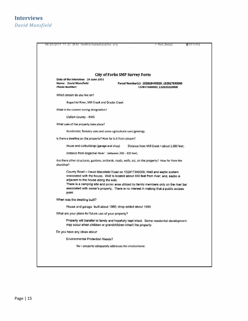
Interviews David Mansfield

Page | 16
Page | 17
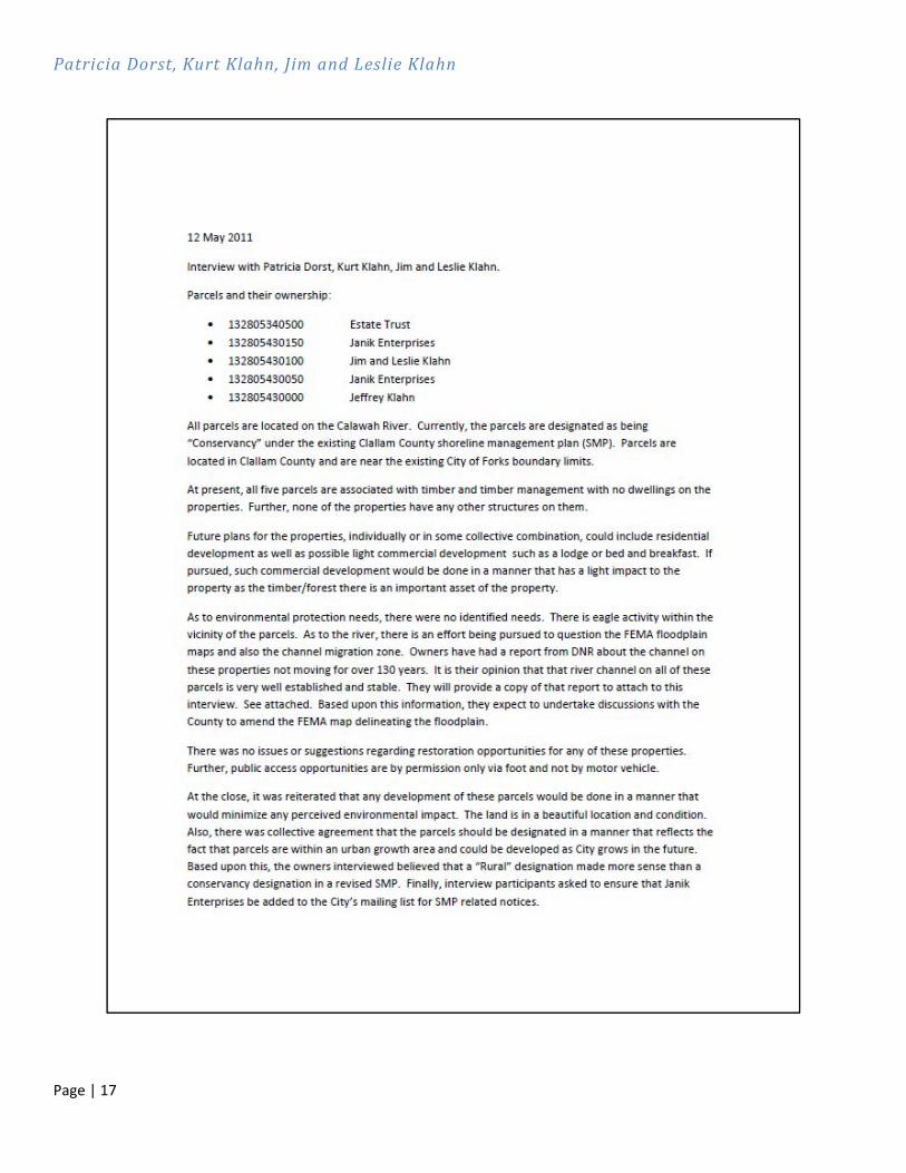
Patricia Dorst, Kurt Klahn, Jim and Leslie Klahn

Page | 18
Dan Kousbaugh

Page | 19
Dan Kousbaugh: 2nd Parcel

Page | 20
Kevin Miller

Page | 21
Jean Miller

Page | 22
Patricia Whidden
Page | 23
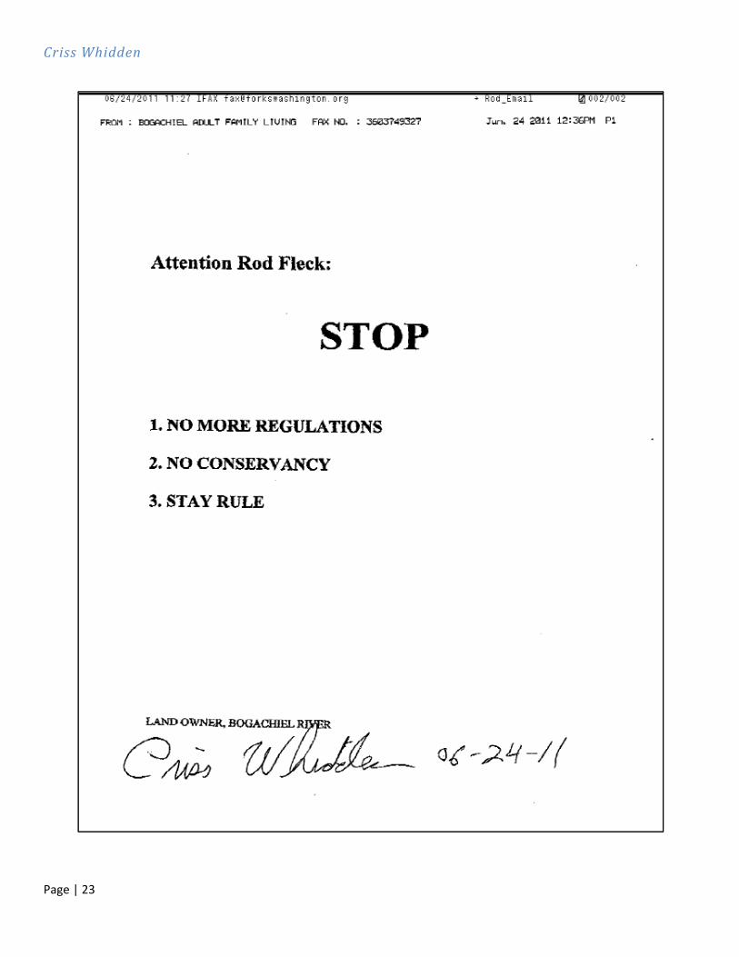
Criss Whidden
Page | 24
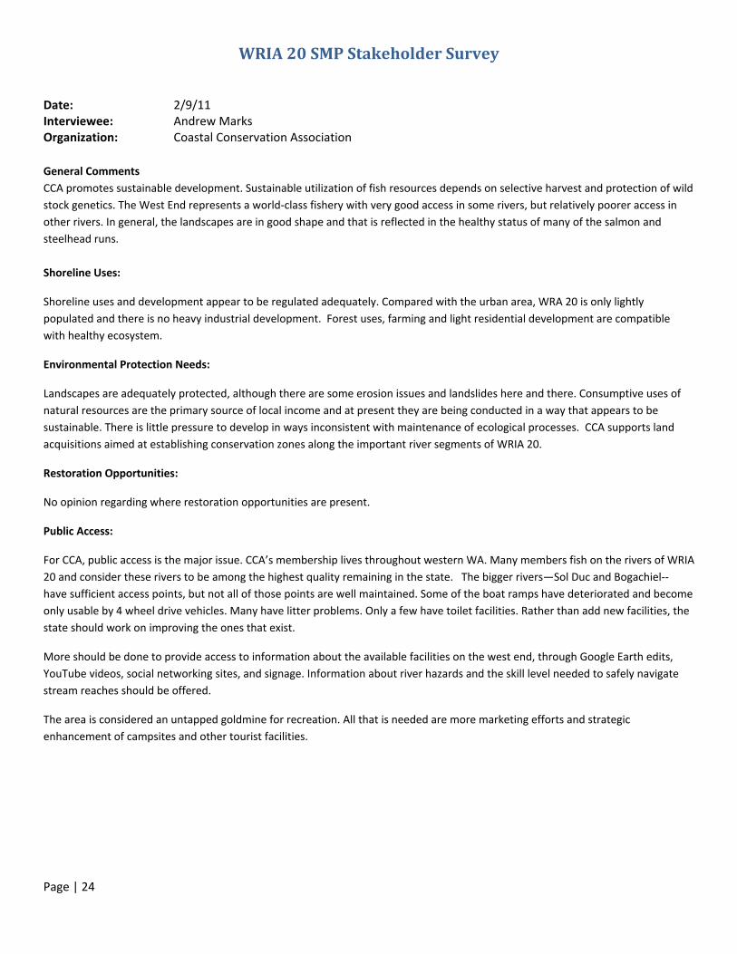
WRIA 20 SMP Stakeholder Survey
Date: 2/9/11 Interviewee: Andrew Marks Organization: Coastal Conservation Association
General Comments
CCA promotes sustainable development. Sustainable utilization of fish resources depends on selective harvest and protection of wild
stock genetics. The West End represents a world‐class fishery with very good access in some rivers, but relatively poorer access in
other rivers. In general, the landscapes are in good shape and that is reflected in the healthy status of many of the salmon and
steelhead runs.
Shoreline Uses:
Shoreline uses and development appear to be regulated adequately. Compared with the urban area, WRA 20 is only lightly
populated and there is no heavy industrial development. Forest uses, farming and light residential development are compatible
with healthy ecosystem.
Environmental Protection Needs:
Landscapes are adequately protected, although there are some erosion issues and landslides here and there. Consumptive uses of
natural resources are the primary source of local income and at present they are being conducted in a way that appears to be
sustainable. There is little pressure to develop in ways inconsistent with maintenance of ecological processes. CCA supports land
acquisitions aimed at establishing conservation zones along the important river segments of WRIA 20.
Restoration Opportunities:
No opinion regarding where restoration opportunities are present.
Public Access:
For CCA, public access is the major issue. CCA’s membership lives throughout western WA. Many members fish on the rivers of WRIA
20 and consider these rivers to be among the highest quality remaining in the state. The bigger rivers—Sol Duc and Bogachiel‐‐
have sufficient access points, but not all of those points are well maintained. Some of the boat ramps have deteriorated and become
only usable by 4 wheel drive vehicles. Many have litter problems. Only a few have toilet facilities. Rather than add new facilities, the
state should work on improving the ones that exist.
More should be done to provide access to information about the available facilities on the west end, through Google Earth edits,
YouTube videos, social networking sites, and signage. Information about river hazards and the skill level needed to safely navigate
stream reaches should be offered.
The area is considered an untapped goldmine for recreation. All that is needed are more marketing efforts and strategic
enhancement of campsites and other tourist facilities.

Page | 25
WRIA 20 SMP Stakeholder Survey
Date: 2/1/11
Interviewee: Joe Murray
Organization: Merrill and Ring
Shoreline Uses:
They are fine the way they are. There is residential, industrial and residential access in place already. Also, if someone were to
propose a new shoreline use, it would be hard to get through for approval. Applications for use tend to get negative feedback as
opposed to desires for more protection. Protection and use need equal time. The ONP access should also count, since they are uses
that do exist, even though they have chosen to be exempt from the update. Like to see uses for things like jet skis; there should be a
place for those uses to go. The whole coastal region should come into play here because there are designated uses all along here
already‐incorporate them.
Environmental Protection Needs:
Good! The environmental protection laws we have in place are being carried out well: Forest Practices, Coast Guard, shoreline
protection, etc. They are doing a bang‐up job of protection: no sewage dumping, emergency oil spill clean‐up is in place, etc.
Cautious in adding additional setbacks. The ones in place are doing a good job: if it’s not broken, don’t fix it.
Restoration Opportunities:
What makes a site good for restoration? Some people might say that the old Rayonier Mill site is a restoration opportunity. But we
need places for industrial uses too. Some of these sites are just cleaned up and moved around because we end up creating a new
site for another industrial use. Why not just keep the old mill site as a site for light industrial use? This should be a decision for the
landowners if they are not doing anything to degrade the shoreline. Should a house within 200’ of the shoreline be torn down? Is
that restoration? This is a nebulous question, so how to answer it? Maybe the approach should be something like: Do you know of
any specific places that could/should be restored?
Public Access:
This should be the landowner’s prerogative. However, even if the landowner wanted to create a new public access point, they would
have a hard time getting things approved through the permitting process. This makes it difficult to add access points. Think it
through! The county approached Merrill and Ring asking them to supply public access to their beach in Sekiu, but the county was not
willing to offer any assistance with law enforcement, clean‐up, maintenance, litter, etc. It is not appealing to the landowner to
create a new public access point if they are asked for access but offered no help in maintenance! If the landowner chooses to add a
new public access point, like installing a boat ramp, then they are responsible for clean‐up and they go into it willingly that way. Be
aware of liability: once the access is developed, you have all the protection needs that come into play again because now people are
involved and it is no longer pristine.

Page | 26
WRIA 20 SMP Stakeholder Survey
Date: 2/9/11
Interviewee: Jody Kennedy
Organization: Surfrider Foundation (The Surfrider Foundation is made up of volunteer groups with locations all over
Washington.)
Shoreline Uses:
The Surfrider Foundation is a water recreational uses group, so most of their influence is on the coast. Their mission
statement relates to nearshore impacts and uses, so those are the areas they have a concern about—not the rivers as
much, except as to how they impact the nearshore. This means a main concern is sediment transport. The foundation is
also concerned about recreational access for things such as kayaking and fishing. It is important that people be able to
enjoy their access and not have it blocked off. This may be a better question to pose to the public: Do people feel like
they have enough access? Another area of concern is the quality of the ecosystem—fish getting upriver—forest
practices possibly blocking the river.
Environmental Protection Needs:
Water quality is a top priority—better care taken of the rivers. Buffers are a major priority. Logging practices in and near
buffer zones can end up damaging fish passage through sediment and blockage. Also ensuring historical and cultural
access. This might be a question to pose to tribal managers. There is a question about how much authority they have in
private lands off of tribal reservations.
Restoration Opportunities:
Stabilize banks, LWD, impacts on the nearshore—how stream management and conditions interface with the nearshore.
She said she would defer to the Quileute Tribe on this.
Public Access:
This is a priority, but it should stay a local issue. Locals know where they want access and where they don’t. A possibility
would be to invest some money in a process to involve property owners in public access so that there could be some
cooperation between the land owner and the public. A possible scenario could be landowner provision and volunteer
cleanup/maintenance, with some funding source for development. This would prevent the landowner being responsible
for the maintenance, which might deter them from donating public access. Local chapters could adopt site maintenance.
This comes with a fear that the property owner could close the access at any time if it remains privately owned. Marine
debris? This is often carried down through the rivers. Excess garbage is often a problem because there is a cost for
throwing garbage away. More dump sites? How is this impacting the nearshores.
Page | 27
WRIA 20 SMP Stakeholder Survey
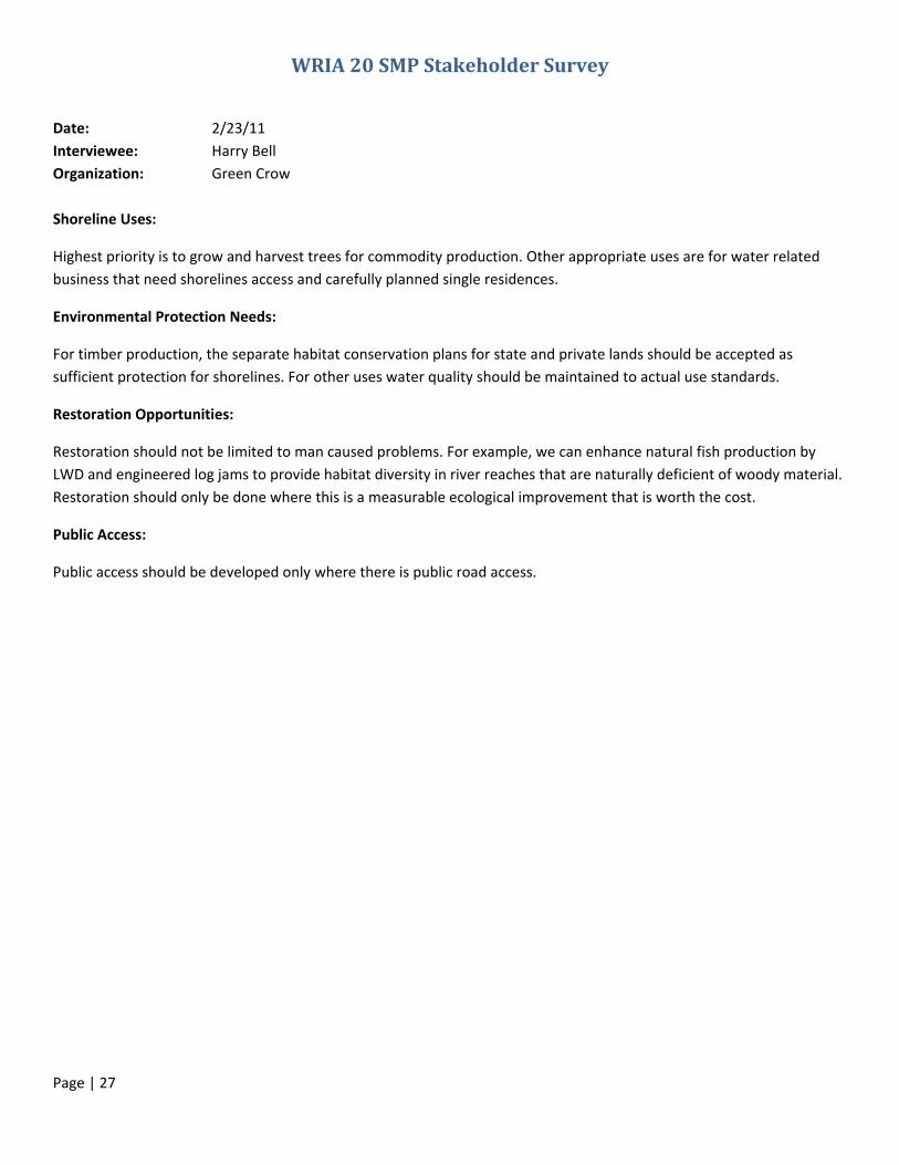
Date: 2/23/11
Interviewee: Harry Bell
Organization: Green Crow
Shoreline Uses:
Highest priority is to grow and harvest trees for commodity production. Other appropriate uses are for water related
business that need shorelines access and carefully planned single residences.
Environmental Protection Needs:
For timber production, the separate habitat conservation plans for state and private lands should be accepted as
sufficient protection for shorelines. For other uses water quality should be maintained to actual use standards.
Restoration Opportunities:
Restoration should not be limited to man caused problems. For example, we can enhance natural fish production by
LWD and engineered log jams to provide habitat diversity in river reaches that are naturally deficient of woody material.
Restoration should only be done where this is a measurable ecological improvement that is worth the cost.
Public Access:
Public access should be developed only where there is public road access.
Page | 28
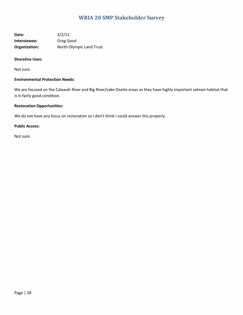
WRIA 20 SMP Stakeholder Survey
Date: 3/2/11
Interviewee: Greg Good
Organization: North Olympic Land Trust
Shoreline Uses:
Not sure.
Environmental Protection Needs:
We are focused on the Calawah River and Big River/Lake Ozette areas as they have highly important salmon habitat that
is in fairly good condition.
Restoration Opportunities:
We do not have any focus on restoration so I don’t think I could answer this properly.
Public Access:
Not sure.

Page | 29
WRIA 20 SMP Stakeholder Survey
Date: 2/8/11 Interviewee: Ron Garner and Dave Croonquist Organization: Puget Sound Anglers
Puget Sound Anglers has members all over the Puget Sound Basin. The chapter closest to WRIA 20 is the North Olympic Chapter. It is
estimated that hundreds of PSA members use the rivers of WRIA 20. Overall, PSA representatives reported that they believe the
County is doing a good job managing WRIA 20’s shorelines. They rivers are in good shape and the fish runs are healthy with few
exceptions. The rivers of WRIA 20 are among the most productive in western Washington.
Shoreline Uses:
The shorelines of WRIA 20 are at most lightly populated. This level of development presents few problems for fish runs.
Environmental Protection Needs:
The biggest challenge in protecting the shorelines is the adequacy of riparian buffers. In some cases, the riparian buffers left by
commercial harvest operations have blown down. Bank erosion is also an issue.
Restoration Opportunities:
Where riparian buffers have failed, replanting can be done to stabilize the banks and begin the process of restoring the canopy
cover. Buffer problems are visible in places on the Bogachiel and the Sol duc. There are a number of opportunities for erosion
control and LWD enhancement. One approach mentioned was stabilizing trees that were about to fall into the river. These trees
would be cabled to interior trees to hold them along the bank once they did fall into the river.
Public Access:
Many of the WRIA 20 rivers have numerous access options. The Sol Duc, Bogachiel, Calawah, and Quillayute are very popular with
bank fishers as well as drift boat and inflatable raft fishers. The Dickey River was cited as an example of a river with more limited
access options. It was recognized that some areas are just difficult to get to. Not all ramps are well maintained. Some have trash
problems. Some have outhouses that are not well maintained. Some ramps are difficult to use without 4 wheel drive. Some are no
more than steep muddy banks. Some are causing sediment inputs into the river. In addition, the rules governing access to bank
fishing are not easy to find in relation to specific stream reaches. Clarification of the rules regarding which rivers are navigable would
be helpful. Agencies should look for ways to make that information more easily accessible. There should also be more readily
available information on camping sites, hunting access, and areas of danger such as rapids and steep slopes.
Page | 30
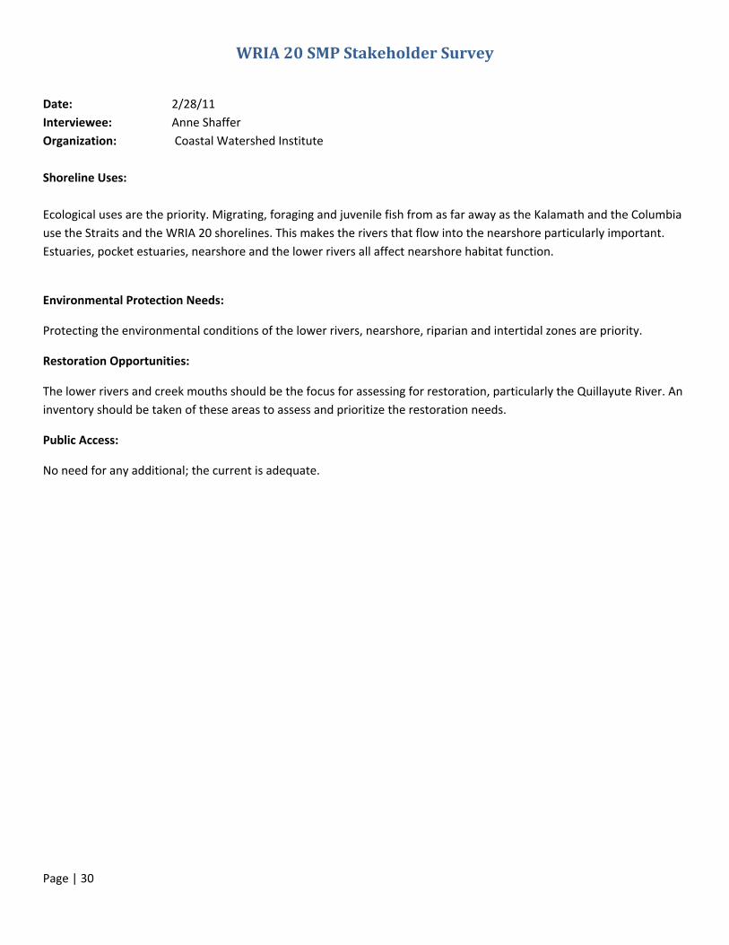
WRIA 20 SMP Stakeholder Survey
Date: 2/28/11
Interviewee: Anne Shaffer
Organization: Coastal Watershed Institute
Shoreline Uses:
Ecological uses are the priority. Migrating, foraging and juvenile fish from as far away as the Kalamath and the Columbia
use the Straits and the WRIA 20 shorelines. This makes the rivers that flow into the nearshore particularly important.
Estuaries, pocket estuaries, nearshore and the lower rivers all affect nearshore habitat function.
Environmental Protection Needs:
Protecting the environmental conditions of the lower rivers, nearshore, riparian and intertidal zones are priority.
Restoration Opportunities:
The lower rivers and creek mouths should be the focus for assessing for restoration, particularly the Quillayute River. An
inventory should be taken of these areas to assess and prioritize the restoration needs.
Public Access:
No need for any additional; the current is adequate.

Page | 31
WRIA 20 SMP Stakeholder Survey
Date: 2/2/11
Interviewee: Jill Silver
Organization: 10,000 Years Institute
Shoreline Uses: Priority uses should be water quality, habitat and fish protection. Secondary uses should be public
access, residences, parks, trails, etc. If she could go back 100 years and write an SMP, she would ensure a public trail
along these rivers. Now much of that opportunity has been lost because of development. Most of the rivers have very
difficult walkable access. For example, the Sol Duc is very difficult to access because of its steep banks. They are
accessible by floating or boating downriver, but this is not enough for most people. The Quillayute river has easier access
because it has more gravel bars and is not as steep; but this is in itself a problem because it is has lost most of its large
wood, which is eroding the banks.
People are clearing and developing their properties right up down to the banks, and the loss of the large wood is causing
a significant degradation of the banks, particularly in the Quillayute and Bogachiel rivers. The SMP should protect the
public resources (water, habitat, wildlife, etc.) first and the residences and private owners should be pleased about this.
“Limbing up”—instead of the removal of the whole tree and its root structure, encourage landowners to remove the
lower limbs of the trees between the residences and the water view. This leaves the tree in place to protect the river,
but allows a water view.
Where anyone is willing to giving public access, a trail should have SMP priority/protection to connect a walking trail
along the rivers between the public access trails on ONP and NF land. Right now, you can’t walk from Forks to the ocean
and biking is not comfortable on the highways with all of the trucks.
Environmental Protection Needs: Mainly along the Quillayute and Bogachiel rivers, where the banks are being degraded
from large wood loss.
The SMP is not being well applied, possibly because the channel migration and wetland zones are not accurate. We
should develop accurate maps so that we can implement protections.
The mainstream rivers need riparian zones restored. On highway 110 from Three Rivers to La Push by the Bogachiel
Bridge, the river is being riprapped. If the bridge is lost and the river channel migrates it will take out the town and the
only access to La Push. The Bogachiel is going to eventually cut through the road. But riprapping is not the way to go.
Quit riprapping and use softer structuring techniques, like log jams and large wood. The Quinault is a good example of
where they have done this successfully.
Restoration Opportunities: Knotweed, reed canary grass and other invasive species control. Walking the rivers reveals
that there is a lot of invasive species material still moving, in spite of efforts. In her experience, once you think you’ve
got it under control, you have another ten years to go!
Restore riparian zones where they have been eliminated, particularly on private land.
Inform the public about how to control invasive species and why it is a danger for the natural environment. Also inform
them on why restoration is desirable.

Page | 32
Public Access: Connect the trails in ONP and NF through direct purchase or easements to give the public more
waterfront access.
Not enough public access to rivers. They should be better signed and have more education to go with them too. There is
a need for public awareness and enforcement so that the largest, best wood is not lost from the tribes and fishermen
cutting out the log jams for firewood. Educate the public on what is legal and why it makes sense to support protection.
Notes: Is the SMP combining with the Critical Areas Ordinance? Maybe we should adopt it by reference like the
Jefferson county SMP did. Jefferson also found that viewsheds were a big concern, especially in real estate pricing. The
buffer management component was fraught with conflict. Owners were afraid of losing rights and uses to their property,
losing lawn space, views, etc.
Jill recommended making the two sets of laws (Critical Areas Ordinance and SMP) copacetic. Jefferson county also tried
to make sure to give a lot of attention to landowner concerns and public access/protection.

Page | 33
WRIA 20 SMP Stakeholder Survey
Date: 3/2/11
Interviewee: Norm Schaaf
Organization: Merrill and Ring
Shoreline Uses: Based on the location of the shorelines in WRIA 20, a huge amount of use is in forestry and commercial
timber production. This use is kept within the restrictions of existing shoreline regulations and Forest Practices, but it is
the dominant land use in WRIA 20.
The other dominant use is in dispersed outdoor recreation such as fishing, hunting, gathering, public boat
access/launches, etc. Not things like water extraction for sale (beyond the limited amount that already exists), industrial
and transportation uses, etc. Those uses are not dominant or the focus for resources out here.
Environmental Protection Needs: No specific locations for additional environmental protection. Already operating
within the shoreline regulations and Forest Practices. Regulations like these are already protecting the environment. No
knowledge of any additional needs.
Restoration Opportunities: Opportunities would include any required restoration methods that are already in place and
being worked on. Road Maintenance and Abandonment Plan (RMAP) is already working toward this goal and is
scheduled to continue over the next few years. This plan includes restoration for culverts, bridges, sediment control,
etc.—anything associated with roads. RMAP restoration covers a good share of the land in WRIA 20.
He can’t speak to federal land needs, since RMAP does not include federal lands.
There are chronic Hoh River washouts on the road that goes up into the rainforest and at the Hoh River mouth on Oil
City Road. On Oil City Road, the river is encroaching and was backflooding onto the road when he was out there in
December.
There are extensive opportunities for LWD placement, but he is not aware of specific locations.
Public Access: He has always had all the access he has needed, but that has included private access to places, so this
may be less of an impact from his perspective. He is not aware of any necessary additional access; it is not needed from
his perspective.

Page | 34
WRIA 20 SMP Stakeholder Survey
Date: 3/1/11
Interviewee: Meghan Tuttle
Organization: Rayonier
Shoreline Uses: A sixth category is needed for the environmental designations. The five current categories are focused
on residential and ecological use; a sixth is needed for forestry/agricultural use. Rayonier’s position is that the uses
should continue in forestry using current Forest Practice regulations.
Environmental Protection Needs: Current regulations already satisfy the Endangered Species Act and the Forest
Practices Act, etc. Additional regulations and restrictions limit forest uses and encourage private timber companies like
Rayonier to use their land for more economical purposes, liking parceling it off and selling it for development. This ends
up having a negative effect on environmental protection, particularly along sensitive areas like shorelines where
management is even more restricted. The incentive to manage these restricted areas goes down and the incentive to
sell them increases as the restrictions/regulations increase.
Restoration Opportunities: These locations should be out of the plan for private landowners and kept for public lands.
Rayonier is happy to partner with other organizations/tribes for restoration work, and has done so, but this should be
something private landowners do voluntarily, not something that is required. RMAP is ongoing restoration work that
Rayonier and all private timber companies are part of.
Public Access: Rayonier is currently transitioning to charging for their public access locations. They want to make sure
and keep private any areas that Rayonier maintains complete control over.
If the Olympic Discovery Trail were to come out here, Rayonier would be open to easements to make that possible.

Page | 35
WRIA 20 SMP Stakeholder Survey
Date: 2/15/11 Interviewee: Devona Ensmenger Organization: Wild Salmon Center, Portland OR Phone Number: 360 640 2631
Shoreline Uses:
The Wild Salmon Center has focused on the Hoh River (outside the scope of the Clallam County SMP Update Process) and on the
Calawah System. The Center will be submitting detailed written comments. For the purpose of this interview, the interests of the
WSC are principally aimed at protecting key habitat important to resident and anadromous fish. Several areas of high value have
been targeted for intensive analysis by WSC. Most are currently undeveloped forestlands and are unlikely to be subject to
development pressure in the future. A number of high value reaches are desirable for human shoreline uses. One such reach is the
portion of Elk Creek in the Forks Urban Growth Area. Another is the reach f Elk Creek immediately upstream of the FUGA boundary.
These reaches are extremely important for trout and coho rearing. More detailed comments will also include the specific scientific
information on which these suggestions were based.
Environmental Protection Needs:
Protection for the key fish rearing habitat Elk Creek has been advanced by the acquisition of adjacent lands by the North Olympic
Land Trust. Natural designation status under the SMP would be consistent with the conservation status of the shorelands. The WSC
also recommends the highest levels of protection for the Sitkum River and its tributaries. Upstream portions of the North Fork of the
Calawah system also are important areas for protection. More protection should be afforded to the highly active channel migration
zones in the Sol Duc and Bogachiel mainstems.
Restoration Opportunities:
The WSC took part in the development of the Restoration Plan facilitated by the Quileute Tribe a few years ago. Those priorities
were well defined.
Public Access:
No immediate suggestions were made.
NOTE: The Wild Salmon Center submitted a Letter and 3 attachments in a pdf format by email. These are attached
below.
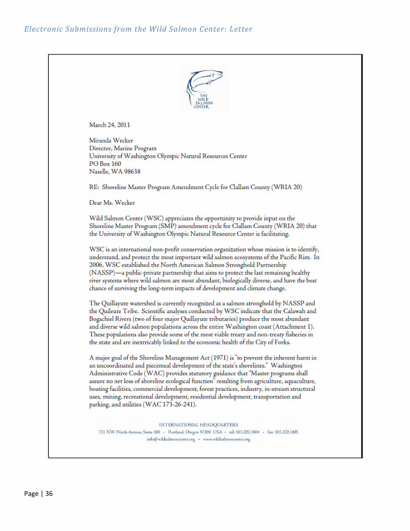
Page | 36
Electronic Submissions from the Wild Salmon Center: Letter

Page | 37

Page | 38
Electronic Submissions from the Wild Salmon Center: Exhibit A

Page | 39
Page | 40
Page | 41
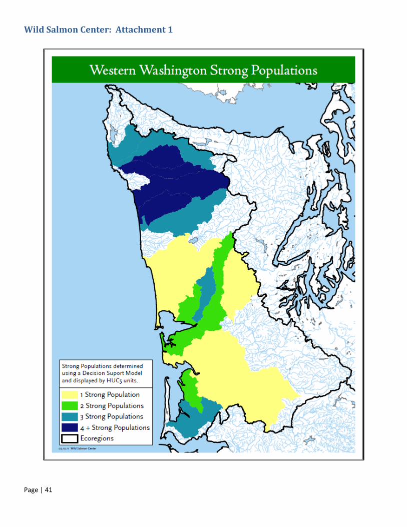
Wild Salmon Center: Attachment 1
Page | 42
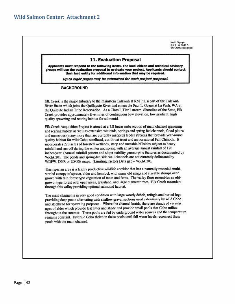
Wild Salmon Center: Attachment 2
Page | 43

Page | 44
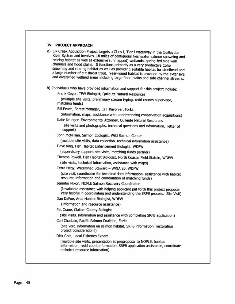
Page | 45

Page | 46
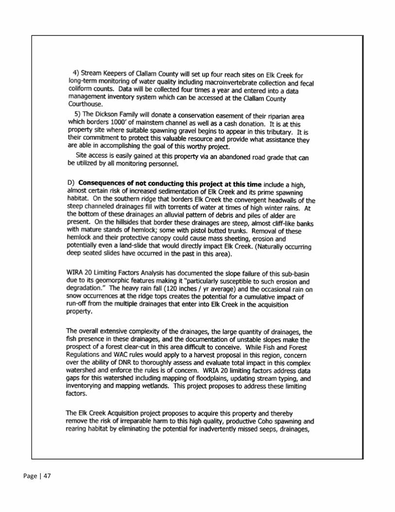
Page | 47

Page | 48

Page | 49

Page | 50
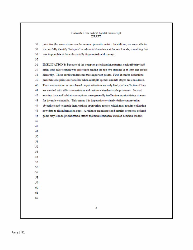
Wild Salmon Center: Attachment 3
Note: The complete draft manuscript was submitted by WSC, but only the summary is provided below. Because the
article is undergoing peer review, the authors asked that public distribution be delayed until the article is finalized. It is
available by request to the Wild Salmon Center.
Page | 51