
DRAFT - South African Heritage Resources Agency
127
DRAFT REPORT Proposed Surface Pipeline and Associated Infrastructure AngloGold Ashanti (Pty) Ltd Submitted to: Department of Mineral Resources Submitted by: Golder Associates Africa (Pty) Ltd. Building 1, Maxwell Office Park, Magwa Crescent West, Waterfall City, Midrand, 1685, South Africa P.O. Box 6001, Halfway House, 1685 +27 11 254 4800 19121900-328397-9 September 2019
Transcript of DRAFT - South African Heritage Resources Agency

DRAFT
REPORT
Proposed Surface Pipeline and Associated Infrastructure AngloGold Ashanti (Pty) Ltd
Submitted to:
Department of Mineral Resources
Submitted by:
Golder Associates Africa (Pty) Ltd. Building 1, Maxwell Office Park, Magwa Crescent West, Waterfall City, Midrand, 1685, South Africa P.O. Box 6001, Halfway House, 1685
+27 11 254 4800
19121900-328397-9
September 2019

September 2019 19121900-328397-9
i
Distribution List 1 x copy Department of Mineral Resources
1 x copy AngloGold Ashanti (Pty) Ltd
1 x electronic copy e-projects library [email protected]
1 x electronic copy Golder project folder
September 2019 19121900-328397-9
ii
Table of Contents
1.0 DETAILS OF APPLICANT ......................................................................................................................... 8
2.0 DETAILS OF THE ENVIRONMENTAL ASSESSMENT PRACTITIONER (EAP) ..................................... 8
2.1 Details of the EAP ............................................................................................................................. 8
2.2 Expertise of the EAP ......................................................................................................................... 8
2.2.1 Qualifications of the EAP .............................................................................................................. 8
2.2.2 Summary of the EAP’s past experience ....................................................................................... 9
3.0 PROJECT INFORMATION AND DESCRIPTION .................................................................................... 10
3.1 Location of the activity ..................................................................................................................... 10
3.2 Locality map .................................................................................................................................... 10
3.3 Description of the scope of the proposed overall activity ................................................................ 13
3.4 Listed and specified activities .......................................................................................................... 13
3.5 Description of the activities to be undertaken ................................................................................. 14
3.6 Policy and Legislative Context ........................................................................................................ 15
3.7 Need and desirability of the proposed activities .............................................................................. 18
3.8 Motivation for the overall preferred site, activities and technology alternative ............................... 19
4 FULL DESCRIPTION OF THE PROCESS FOLLOWED TO REACH THE PROPOSED PREFERRED ALTERNATIVE WITHIN THE SITE .......................................................................................................... 19
4.1 Details of the development footprint alternatives considered ......................................................... 19
4.1.1 Location of activity ....................................................................................................................... 19
4.1.2 Type of activity to be undertaken ................................................................................................ 19
4.1.3 The design or layout of the activity ............................................................................................. 19
4.1.4 The technology to be used in the activity .................................................................................. 20
4.1.5 The operational aspects of the activity........................................................................................ 20
4.1.6 The option of not implementing the activity. ............................................................................... 20
5 PUBLIC PARTICIPATION PROCESS ..................................................................................................... 20
5.1 Objectives of public participation..................................................................................................... 20
5.2 Identification of interested and affected parties (I&APs) ................................................................. 21
5.3 Register of I&APs ............................................................................................................................ 21

September 2019 19121900-328397-9
iii
5.4 Public participation process undertaken to date ............................................................................. 22
5.4.1 Announcement of the Proposed Project ..................................................................................... 22
5.4.2 Draft Basic Assessment and EMPr Report ................................................................................. 22
5.4.3 Final BA/EMPr Report ................................................................................................................. 23
5.4.4 Summary of Issues Raised by I&APs ......................................................................................... 23
6 ENVIRONMENTAL ATTRIBUTES ASSOCIATED WITH THE ALTERNATIVES ................................... 23
6.1 Baseline Environment ..................................................................................................................... 23
6.1.1 Type of environment affected by the proposed activity .............................................................. 23
6.1.1.1 Meteorological aspects ............................................................................................................... 23
6.1.1.1.1 Meteorology ............................................................................................................................. 23
6.1.1.1.2 Temperature ............................................................................................................................. 25
6.1.1.1.3 Precipitation & Evaporation ...................................................................................................... 25
6.1.1.2 Topography ................................................................................................................................. 26
6.1.1.3 Geology ....................................................................................................................................... 26
6.1.1.4 Groundwater ............................................................................................................................... 28
6.1.1.5 Surface Water ............................................................................................................................. 30
6.1.1.6 Floodlines .................................................................................................................................... 30
6.1.1.7 Biodiversity .................................................................................................................................. 31
6.1.1.7.1 Terrestrial Ecology ...................................................................................................................... 31
6.1.1.7.2 Flora ............................................................................................................................................ 31
6.1.1.7.3 Fauna .......................................................................................................................................... 32
6.1.1.7.4 Wetland ....................................................................................................................................... 36
6.1.1.7.5 Aquatic ........................................................................................................................................ 40
6.1.1.8 Socio Economic .......................................................................................................................... 43
6.1.1.9 Soil, Land Capability and Land Use ............................................................................................ 44
6.1.1.10 Noise ........................................................................................................................................... 44
6.1.1.11 Visual .......................................................................................................................................... 44
6.1.1.12 Heritage ....................................................................................................................................... 44
6.1.1.13 Palaeontology ............................................................................................................................. 45
6.1.2 Description of current land uses ................................................................................................. 45
6.1.3 Environmental and current land use map ................................................................................... 45

September 2019 19121900-328397-9
iv
7 IMPACTS AND RISKS IDENTIFIED, INCLUDING THE NATURE, SIGNIFICANCE, CONSEQUENCE, EXTENT, DURATION AND PROBABILITY ............................................................................................. 46
7.1 Methodology used in determining and ranking the nature, significance, consequences, extent, duration and probability of potential environmental impacts and risks ........................................... 46
7.2 The positive and negative impacts that the proposed activity (in terms of the initial site layout) and alternatives will have on the environment and the community that may be affected ...................... 47
7.2.1 Layout and alternatives ............................................................................................................... 47
7.2.2 Environmental impacts ................................................................................................................ 47
7.2.3 Social impacts ............................................................................................................................. 48
7.2.4 Significance rating summary ....................................................................................................... 48
7.3 The possible mitigation measures that could be applied and the level of risk ................................ 48
7.5 Statement motivating the alternative development location within the overall site ......................... 48
7.6 Full description of the process undertaken to identify, assess and rank the impacts and risks the activity will impose on the preferred site (In respect of the final site layout plan) through the life of the activity ....................................................................................................................................... 48
7.7 Assessment of each identified potentially significant impact and risk ............................................. 50
7.8 Summary of specialist reports. ........................................................................................................ 56
7.9 Environmental impact statement ..................................................................................................... 58
7.9.1 Summary of the key findings of the environmental impact assessment ......................................... 58
7.9.2 Final Site Map ................................................................................................................................. 58
7.9.3 Summary of the positive and negative impacts and risks of the proposed activity and identified alternatives ...................................................................................................................................... 58
7.10 Proposed impact management objectives and the impact management outcomes for inclusion in the EMPr; ........................................................................................................................................ 58
7.11 Final proposed alternatives ............................................................................................................. 59
7.12 Aspects for inclusion as conditions of Authorisation. ...................................................................... 59
7.13 Description of any assumptions, uncertainties and gaps in knowledge. ........................................ 59
7.14 Reasoned opinion as to whether the proposed activity should or should not be authorised .......... 59
7.14.1 Reasons why the activity should be authorised or not ................................................................ 59
7.14.2 Conditions that must be included in the authorisation ................................................................ 59
7.15 Period for which the Environmental Authorisation is required ........................................................ 61
7.16 Undertaking ..................................................................................................................................... 61
7.17 Financial Provision .......................................................................................................................... 61
7.17.1 Explain how the aforesaid amount was derived ......................................................................... 62

September 2019 19121900-328397-9
v
7.17.2 Confirm that this amount can be provided for from operating expenditure ................................. 62
7.18 Specific Information required by the competent Authority .............................................................. 62
7.18.1 Impact on the socio-economic conditions of any directly affected person .................................. 63
7.18.2 Impact on any national estate referred to in section 3(2) of the National Heritage Resources Act .................................................................................................................................................... 63
7.19 Other matters required in terms of Sections 24(4)(a) and (b) of the Act......................................... 63
PART B ENVIRONMENTAL MANAGEMENT PROGRAMME REPORT………………………………………………… 75
TABLES
Table 1: Location details ..................................................................................................................................... 10
Table 2: Listed activities ..................................................................................................................................... 13
Table 3: Policy and Legislative Context .............................................................................................................. 15
Table 4: Public places ......................................................................................................................................... 22
Table 5: Average evaporation in the area .......................................................................................................... 26
Table 6: Water Quality data for the downstream site on the Wonderfonteinspruit (C2H013) ............................ 30
Table 7: 50 year and 100-year 24-hour storm rainfall depths ............................................................................ 31
Table 8: Mammals of conservation concern potentially occurring in the study area. ......................................... 35
Table 9: Birds of conservation concern occurring in the study area .................................................................. 35
Table 10: PES assessment results ..................................................................................................................... 39
Table 11: EIS score and category for the HGM 1 and HGM 2 which will be crossed ........................................ 39
Table 12: Expected ichthyofaunal composition and frequency of occurrence within the AGA study area and current IUCN status ............................................................................................................................................ 41
Table 13: Diatom analysis results and ecological water quality for June 2019 .................................................. 42
Table 14: Summary of WET testing results ........................................................................................................ 43
Table 15: Hazard Classification of undiluted samples for June 2018 ................................................................ 43
Table 16: Impact classification for impact assessment ...................................................................................... 46
Table 17: Ranking scales ................................................................................................................................... 46
Table 18: Categories describing environmental consequence........................................................................... 47
Table 19: Impact Assessment and Management Type for construction phase ................................................. 50
Table 20: Impact Assessment and Management Type for operation phase ...................................................... 53
Table 21: Impact Assessment and Management Type for decommissioning phase ......................................... 55
Table 22: Cumulative Impact Assessment and Management Type ................................................................... 56
Table 23: Specialist Studies ............................................................................................................................... 56
Table 24: Closure costs for the proposed pipeline ............................................................................................. 61

September 2019 19121900-328397-9
vi
Table 25: List of appendices ............................................................................................................................... 62
Table 26: Impacts to be mitigated during construction phase ............................................................................ 67
Table 27: Impacts to be mitigated during operational phase .............................................................................. 71
Table 28: Impacts to be mitigated during decommissioning phase ................................................................... 73
Table 29: Impact Management Actions .............................................................................................................. 75
Table 30: Closure measures .............................................................................................................................. 76
Table 31: Closure cost ........................................................................................................................................ 77
Table 32: Monitoring ........................................................................................................................................... 79
FIGURES
Figure 1: Regional location of the proposed AGA pipeline ................................................................................. 11
Figure 2: Local location of the proposed AGA pipeline ...................................................................................... 12
Figure 3: Period wind rose for the Blyvoor Gold Mining Project (Digby Wells, 2018) ........................................ 24
Figure 4: Diurnal wind roses for the Blyvoor Gold Mining Project (Digby Wells, 2018) ..................................... 24
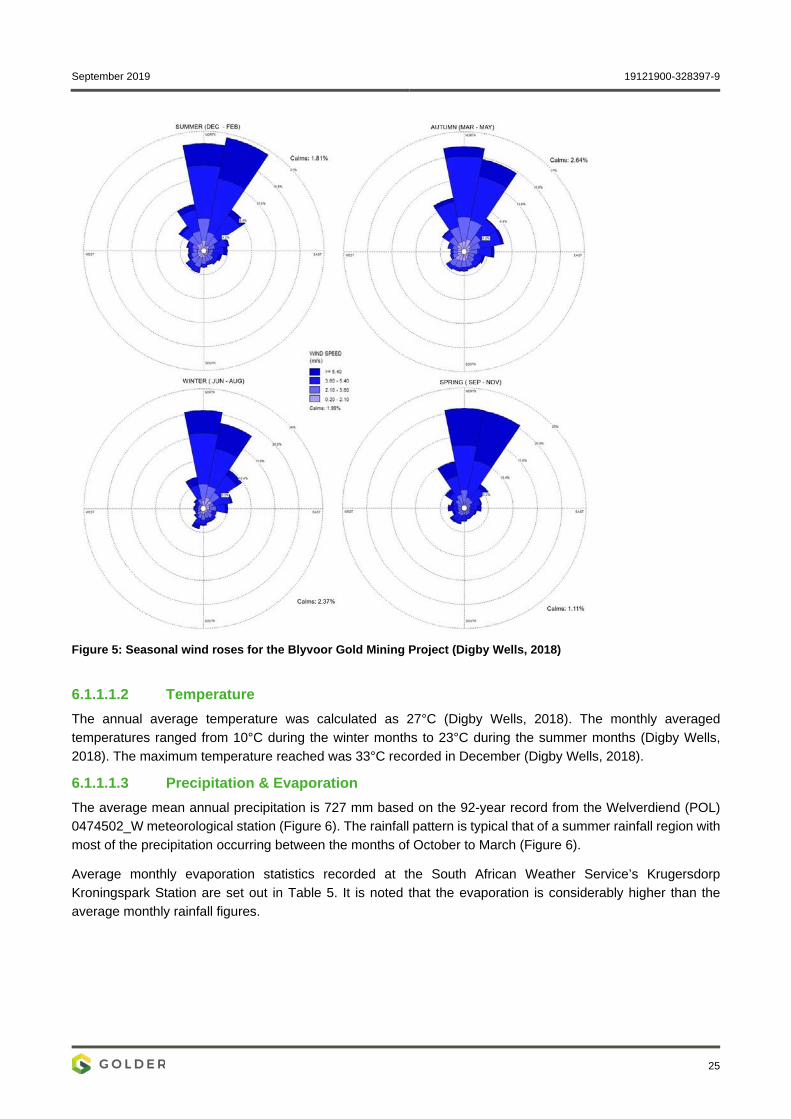
Figure 5: Seasonal wind roses for the Blyvoor Gold Mining Project (Digby Wells, 2018) .................................. 25
Figure 6: Monthly rainfall distribution for Welverdiend (Pol) 0474502_W .......................................................... 26
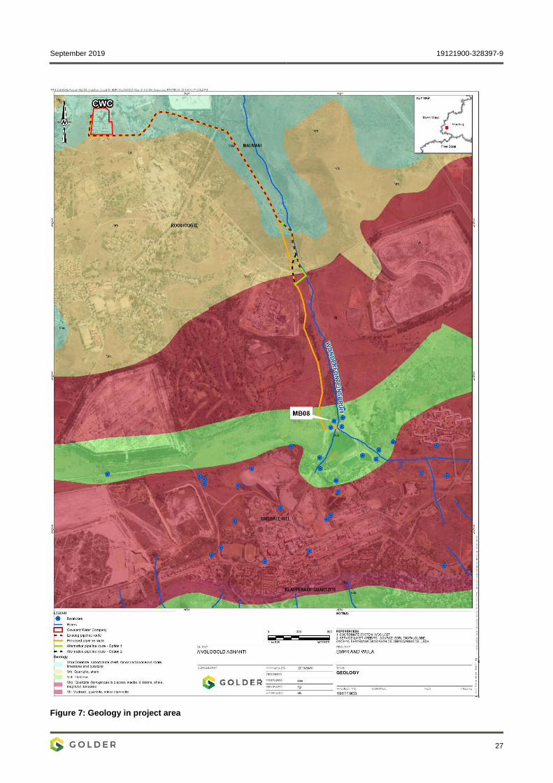
Figure 7: Geology in project area ....................................................................................................................... 27
Figure 8: Hydrogeology Map of Region .............................................................................................................. 29
Figure 9:Dominant land uses and land cover along the proposed pipeline route .............................................. 33
Figure 10: Habitats along the proposed pipeline corridor ................................................................................... 34
Figure 11: Preliminary desktop delineation of suspected wetlands within 500m of the proposed pipeline ....... 38
Figure 12: HGM1 Channelled valley bottom – level of ecosystem service provision ......................................... 40
Figure 13: HGM2 hillslope seep - level of ecosystem service provision ............................................................ 40
Figure 14: Site sensitivity composite map .......................................................................................................... 65
APPENDICES
APPENDIX A I&AP Database
APPENDIX B Announcement Documents
APPENDIX C Advertisement and site notices
APPENDIX D Registered I&APs
APPENDIX E Noise Impact Assessment
September 2019 19121900-328397-9
vii
APPENDIX F Geology and Hydrogeology
APPENDIX G Surface Water Impact Assessment and Floodline Delineation
APPENDIX H Biodiversity Impact Assessment
APPENDIX I Social Scoping Report
APPENDIX J Visual Impact Assessment
APPENDIX K Heritage Impact Assessment
APPENDIX L Palaeontological Impact Assessment: Phase 1 Field Study
APPENDIX M Closure Cost Estimate and Report
APPENDIX N Comment & Responses Report (CRR)
APPENDIX O Document Limitations

September 2019 19121900-328397-9
8
1.0 DETAILS OF APPLICANT Name of applicant: AngloGold Ashanti;
Telephone number: 0184786550;
Fax number: 0865641034;
Postal address: Carletonville – Fochville Road R500, Carletonville, Gauteng, 2501, South Africa;
Physical address: Carletonville – Fochville Road R500, Carletonville, Gauteng, 2501, South Africa; and
File reference number:
2.0 DETAILS OF THE ENVIRONMENTAL ASSESSMENT PRACTITIONER (EAP)
AngloGold Ashanti (Pty) Ltd (AGA) appointed Golder Associates Africa (Pty) Ltd (Golder) as the independent Environmental Assessment Practitioner (EAP) to undertake the Basic Assessment (BA) and Water Use Licensing (WUL) process.
Golder Associates Africa is a member of the world-wide Golder Associates group of companies, offering a variety of specialised engineering and environmental services. Employee owned since its formation in 1960, the Golder Associates group employs more than 6 000 people who operate from more than 160 offices located throughout Africa, Asia, Australasia, Europe, North America and South America. Golder has offices in Midrand, Pretoria, Florida, Durban, Rustenburg, Cape Town, Maputo and Accra. Golder has more than 300 skilled employees and is able to source additional professional skills and inputs from other Golder offices around the world.
Golder has no vested interest in the proposed project and hereby declares its independence as required by the EIA Regulations.
2.1 Details of the EAP Name of the Practitioner: Adam Bennett
Tel No.: +27 11 254 4800
Fax No.: +27 86 582 1561
e-mail address: [email protected]
2.2 Expertise of the EAP 2.2.1 Qualifications of the EAP
BSc (Hons) Environmental Sciences/Geography, University of the Witwatersrand, 2002;
BSc Environmental Sciences, University of the Witwatersrand, 2000; and
Professional registered with SACNASP (# 400142/08) – Environmental Science.

September 2019 19121900-328397-9
9
2.2.2 Summary of the EAP’s past experience Adam Bennett is a senior environmental consultant with widespread environmental management experience (over 15 years consulting experience) in both the private and public sectors in South Africa, with in-depth knowledge of the regulatory requirements relating to integrated environmental management. Project experience includes:
Integrated environmental authorisation processes including: full EIAs, basic assessments, Water Use Licencing (WUL), DMR Section 53 surface rights applications etc. and the compilation of Environmental Management Plans (EMPs) and Environmental Management Programme Reports (EMPrs) in support of the respective environmental authorisation processes;
Environmental and social due diligence auditing against local and IFC performance standards;
General environmental compliance auditing and monitoring;
Pollution assessments and rehabilitation monitoring;
Chemical incident commanding and response (refer below);
Air quality management projects including: the establishment, operation, maintenance and calibration of numerous ambient, passive, dust fallout and meteorological monitoring networks for industries, the mines and various government departments; atmospheric emission licensing (AEL) and environmental performance auditing against licence conditions; specialist air quality impact assessments, air quality management planning;
Noise and vibration impact assessments and monitoring;
GHG assessments;
Stakeholder engagement processes and facilitation thereof; and
Authority liaison with the various government departments and regulators (i.e. national, provincial and local).
His project experience includes: South Africa, Zambia, Ghana, Mozambique, Ethiopia, Botswana, Congo, Malawi, Uganda, Senegal, Ivory Coast, Cameroon, Tanzania, Kenya, Democratic Republic of the Congo, Rwanda, Mongolia, United Kingdom and the United Aram Emirates.
Additional skills – Chemical incident commanding and response: Adam has extensive experience regarding incident response and incident commanding, clean-up and rehabilitation at major chemical incidents and spillages involving organic chemicals, inorganic chemicals and hydrocarbons. Operations level trained in HAZMAT response from SASOL (Pty) Limited in association with the Southern African Emergency Services Institute, as well as chemical emergency preparedness planning training by the United States Environmental Protection Agency (US EPA) and disaster management training by the Southern Business School. A flagship project involved the development of the Protocol on Management of Incidents on Major Transport Routes in the Kwa-Zulu Natal Province that may result in significant pollution or degradation of the environment for the Department of Agriculture and Environmental Affairs in 2004 and 2005.
Market sector experience Air quality management, Environmental management, Project management, Industry (light and heavy), Energy and Power sectors, Transport, Waste management (i.e. general, hazardous and medical waste), Natural resources utilization and management (i.e. mining, ore processing and refining); Urban development, Oil and

September 2019 19121900-328397-9
10
gas, Petrochemical, Contaminated land and rehabilitation; HAZMAT including emergency incident response and incident commanding.
3.0 PROJECT INFORMATION AND DESCRIPTION 3.1 Location of the activity The proposed pipeline and associated infrastructure is located approximately 80 km west of Johannesburg and originates at Blyvooruitzicht 4 Shaft approximately 3.3 km south-east of Carletonville and ends at AngloGold Ashanti’s North Boundary Dam (NBD) approximately 6 km south-south-west of Carletonville in Blyvooruitzicht, Merafong City Local Municipality, West Rand District Municipality in the Gauteng Province of South Africa. Further details are provided in Table 1 below.
Table 1: Location details
Full Name: AngloGold Ashanti (AGA) operations in the West Wits mining lease areas on the farm Blyvooruitzicht 116, portions 10, 13, 15, 26, 51, & 89
Application area (Ha):
Linear pipeline development within an approximate length of 5 km within a servitude of approximately 20 m wide. The approximate development footprint is thus ±10 ha
Magisterial district:
West Rand District Municipality
Distance and direction from nearest town:
Start: Approximately 3 km south-west of Carletonville End: Approximately 6 km south-south-east of Carletonville
21-digit Surveyor General Code for each farm portion:
T0IQ00000000011600089
T0IQ00000000011600015
T0IQ00000000011600026
T0IQ00000000011600051
T0IQ00000000011600010
T0IQ00000000011600013
3.2 Locality map Figure 1 provides the regional location of the proposed AGA pipeline and Figure 2 the local location.

September 2019 19121900-328397-9
11
Figure 1: Regional location of the proposed AGA pipeline

September 2019 19121900-328397-9
12
Figure 2: Local location of the proposed AGA pipeline

September 2019 19121900-328397-9
13
3.3 Description of the scope of the proposed overall activity The AGA operations in the West Wits mining lease areas are at risk of flooding due to ingress of fissure water from surrounding mining operations. About 24 Mℓ/day of fissure water flows into the underground workings of the defunct Blyvooruitzicht Mine, which spans a strike of 6 km along the boundary with AGA. If dewatering at the Old Blyvooruitzicht #4 and #6 (BLV #4 & #6) shafts were to cease, fissure water would report to the AGA operations in about 13 days, which would pose a serious risk to the health and safety of AGA personnel and the mining operations.
After the liquidation of the Blyvooruitzicht (BLV) Mine in 2013, AGA established a wholly owned subsidiary, the Covalent Water Company (CWC), to manage the BLV Mine water and the impacts thereof on the West Wits operations. AGA/CWC has a 25-year lease to maintain water management infrastructure at the BLV shafts #4 and #6.
Prior to September 2016, CWC abstracted 20 Mℓ/d of relatively good quality water from BLV shafts #4 and #6 and discharged it into the Wonderfonteinspruit under a directive. About 5 Mℓ/d of Acid Mine Drainage (AMD) water containing elevated levels of heavy metals and salts has been accumulating in the lower, mined out areas of BLV shaft #5 (BLV #5). Pumping was initiated at the Savuka mine when this water reached a critical level. Savuka mine pumps the BLV #5 water from 81 level to surface, where it is used as make-up water in the Savuka plant circuit. In terms of the current Life of Mine (LoM) for the Savuka plant, this source of make-up water will be required for the next 10 years.
In summary, AGA thus propose to install a pipeline from the BVL mine to the North Boundary Dam (NBD) to allow for dewatering, treatment and reuse of the treated AMD as make-up water to the Savuka plant circuit.
AGA appointed Golder as the Independent Environmental Assessment Practitioner (EAP) to conduct the Environmental Authorisation (EA) and Water Use Licensing (WUL) process for the proposed water pipeline and associated surface infrastructure.
3.4 Listed and specified activities The proposed activities that will require authorisation from the Department of Mineral Resources are listed in Table 2.
Table 2: Listed activities
NAME OF ACTIVITY EXTENT OF ACTIVITY (ha or m2)
LISTED ACTIVITY APPLICABLE LISTING NOTICE
Development of a ±5 km pipeline in excess of 1 000 m long with a diameter in excess or equal to 0.36 m, with a peak throughput of ±120 L/sec or more. Note: average throughput is expected to be ±7.52 l/sec.
±10 ha (based on 20 m servitude)
Activity 10: The development and related operation of infrastructure exceeding 1 000 m in length for the bulk transportation of sewage, effluent, process water, wastewater, return water industrial discharge or slime – i. with an internal diameter of 0,36 m
or more; or ii. with a peak throughput of 120 litres
per second or more.
GN R.327 (07 April 2017)
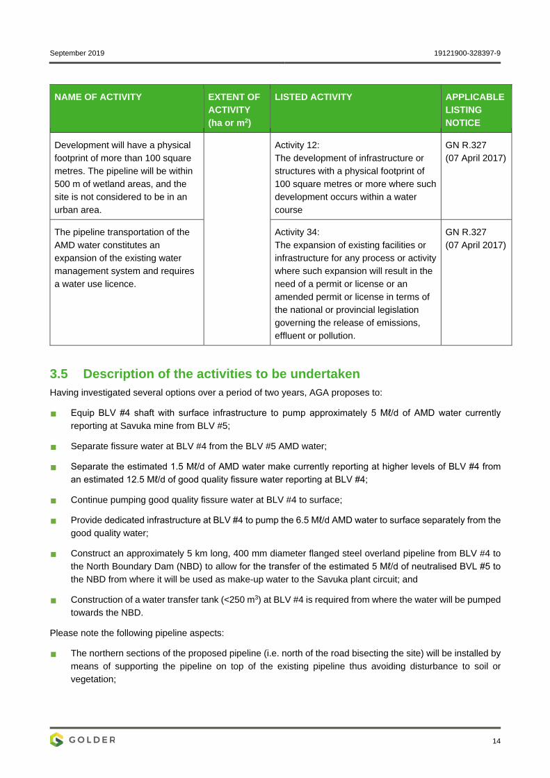
September 2019 19121900-328397-9
14
NAME OF ACTIVITY EXTENT OF ACTIVITY (ha or m2)
LISTED ACTIVITY APPLICABLE LISTING NOTICE
Development will have a physical footprint of more than 100 square metres. The pipeline will be within 500 m of wetland areas, and the site is not considered to be in an urban area.
Activity 12: The development of infrastructure or structures with a physical footprint of 100 square metres or more where such development occurs within a water course
GN R.327 (07 April 2017)
The pipeline transportation of the AMD water constitutes an expansion of the existing water management system and requires a water use licence.
Activity 34: The expansion of existing facilities or infrastructure for any process or activity where such expansion will result in the need of a permit or license or an amended permit or license in terms of the national or provincial legislation governing the release of emissions, effluent or pollution.
GN R.327 (07 April 2017)
3.5 Description of the activities to be undertaken Having investigated several options over a period of two years, AGA proposes to:
Equip BLV #4 shaft with surface infrastructure to pump approximately 5 Mℓ/d of AMD water currently reporting at Savuka mine from BLV #5;
Separate fissure water at BLV #4 from the BLV #5 AMD water;
Separate the estimated 1.5 Mℓ/d of AMD water make currently reporting at higher levels of BLV #4 from an estimated 12.5 Mℓ/d of good quality fissure water reporting at BLV #4;
Continue pumping good quality fissure water at BLV #4 to surface;
Provide dedicated infrastructure at BLV #4 to pump the 6.5 Mℓ/d AMD water to surface separately from the good quality water;
Construct an approximately 5 km long, 400 mm diameter flanged steel overland pipeline from BLV #4 to the North Boundary Dam (NBD) to allow for the transfer of the estimated 5 Mℓ/d of neutralised BVL #5 to the NBD from where it will be used as make-up water to the Savuka plant circuit; and
Construction of a water transfer tank (<250 m3) at BLV #4 is required from where the water will be pumped towards the NBD.
Please note the following pipeline aspects:
The northern sections of the proposed pipeline (i.e. north of the road bisecting the site) will be installed by means of supporting the pipeline on top of the existing pipeline thus avoiding disturbance to soil or vegetation;
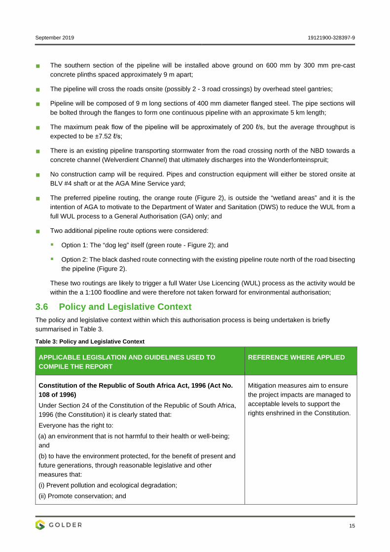
September 2019 19121900-328397-9
15
The southern section of the pipeline will be installed above ground on 600 mm by 300 mm pre-cast concrete plinths spaced approximately 9 m apart;
The pipeline will cross the roads onsite (possibly 2 - 3 road crossings) by overhead steel gantries;
Pipeline will be composed of 9 m long sections of 400 mm diameter flanged steel. The pipe sections will be bolted through the flanges to form one continuous pipeline with an approximate 5 km length;
The maximum peak flow of the pipeline will be approximately of 200 ℓ/s, but the average throughput is expected to be ±7.52 ℓ/s;
There is an existing pipeline transporting stormwater from the road crossing north of the NBD towards a concrete channel (Welverdient Channel) that ultimately discharges into the Wonderfonteinspruit;
No construction camp will be required. Pipes and construction equipment will either be stored onsite at BLV #4 shaft or at the AGA Mine Service yard;
The preferred pipeline routing, the orange route (Figure 2), is outside the “wetland areas” and it is the intention of AGA to motivate to the Department of Water and Sanitation (DWS) to reduce the WUL from a full WUL process to a General Authorisation (GA) only; and
Two additional pipeline route options were considered:
Option 1: The “dog leg” itself (green route - Figure 2); and
Option 2: The black dashed route connecting with the existing pipeline route north of the road bisecting the pipeline (Figure 2).
These two routings are likely to trigger a full Water Use Licencing (WUL) process as the activity would be within the a 1:100 floodline and were therefore not taken forward for environmental authorisation;
3.6 Policy and Legislative Context The policy and legislative context within which this authorisation process is being undertaken is briefly summarised in Table 3.
Table 3: Policy and Legislative Context
APPLICABLE LEGISLATION AND GUIDELINES USED TO COMPILE THE REPORT
REFERENCE WHERE APPLIED
Constitution of the Republic of South Africa Act, 1996 (Act No. 108 of 1996) Under Section 24 of the Constitution of the Republic of South Africa, 1996 (the Constitution) it is clearly stated that: Everyone has the right to: (a) an environment that is not harmful to their health or well-being; and (b) to have the environment protected, for the benefit of present and future generations, through reasonable legislative and other measures that: (i) Prevent pollution and ecological degradation; (ii) Promote conservation; and
Mitigation measures aim to ensure the project impacts are managed to acceptable levels to support the rights enshrined in the Constitution.

September 2019 19121900-328397-9
16
APPLICABLE LEGISLATION AND GUIDELINES USED TO COMPILE THE REPORT
REFERENCE WHERE APPLIED
(iii) Secure ecologically sustainable development and use of natural resources while promoting justifiable economic and social development
National Environmental Management Act, 1998 (Act No. 107 of 1998) (NEMA) NEMA as amended was set in place in accordance with Section 24 of the Constitution. Certain environmental principles under NEMA have to be adhered to, to inform decision making for issues affecting the environment. Section 24 (1)(a) and (b) of NEMA state that: The potential impact on the environment and socio-economic conditions of activities that require authorisation or permission by law and which may significantly affect the environment, must be considered, investigated and assessed prior to their implementation and reported to the organ of state charged by law with authorizing, permitting, or otherwise allowing the implementation of an activity. The Minister published the EIA Government Notice Regulations (GNR on 4 December 2014, comprising of the EIA Regulations GN R.982, and three Listing Notices:
GN R.983 (Listing Notice 1);
GN R.984 (Listing Notice 2); and
GN R.985 (Listing Notice 3) in terms of Sections 24(2) and 24D of the NEMA, as amended. The EIA Regulations were amended in April 2017. The amended Regulations are:
EIA Regulations GN R 982 (as amended by GN R.326);
GN R 983 Listing Notice 1(as amended by GN R.327);
GN R 984 Listing Notice 2 (as amended by GN R.325); and
GN R 985 Listing Notice 3 (as amended by GN R.324).
The proposed pipeline triggers listed activities as listed in NEMA. In terms of GN 983 the proposed development exceeds 1000 m in length and will be for the transport of waste water, this conforms with Activity 10, the development footprint could exceed 100 m2 within the regulated area of a water course conforming to Activity 12 and the facilities will be expanded with the associated infrastructure and the pipeline itself conforming to Activity 34. These activities require authorisation supported by a basic assessment process, which must be undertaken in accordance with the EIA Regulations GN R.982 of 4 December 2014. The appendices of GN R.982 (as amended) stipulate the contents of a report for which the DMR prescribed templates. Appendix 3 of GN R.982 (as amended) prescribes the scope of assessment and content of EIA reports. Appendix 4 prescribes the content of the EMP report. The DMR provided a template which combines the EIA and EMP into a single document.
Mineral and Petroleum Resource Development Act. 2002 (Act No. 28 of 2002) (MPRDA) The MPRDA sets out the requirements relating to the development of South Africa’s mineral and petroleum resources. It also aims to ensure the promotion of economic and social development through exploration and mining related activities. In addition, the MPRDA requires that mining companies assess the socio-economic impacts of their activities from start to closure and beyond.
AGA holds a Mining Right and operates with an Environmental Management Programme Report (EMPr) and is regulated by the Department of Mineral Resources (DMR).

September 2019 19121900-328397-9
17
APPLICABLE LEGISLATION AND GUIDELINES USED TO COMPILE THE REPORT
REFERENCE WHERE APPLIED
Companies must develop and implement a comprehensive Social and Labour Plan (SLP) to promote socio-economic development in their host communities and to prevent or lessen negative social impacts.
Mine Health and Safety Act, 1996 (Act No. 29 of 1996) The objects of the act are to:
Protect the health and safety of persons at mines;
Require employers and employees to identify hazards and eliminate, control and minimise the risks relating to health and safety at mines;
Give effect to the public international law obligations of the Republic that concern health and safety at mines;
Provide for employee participation in matters of health and safety through health and safety;
Provide for effective monitoring of health and safety conditions at mines;
Provide for enforcement of health and safety measures at mines;
Provide for investigations and inquiries to improve health and safety at mines; and
Promote: A culture of health and safety in the mining industry; Training in health and safety in the mining industry; and Co-operation and consultation on health and safety between the
State, employers, employees and their representatives.
AGA holds a Mining Right and operates with an Environmental Management Programme Report (EMPr). The operations are thus subject to the requirements of the Act.
National Water Act (Act No. 36 of 1998) (NWA) The NWA provides for the sustainable and equitable use and protection of water resources. It is founded on the principle that the National Government has overall responsibility for and authority over water resource management, including the equitable allocation and beneficial use of water in the public interest, and that a person can only be entitled to use water if the use is permissible under the NWA.
The proposed project triggers Water Use Licence (WUL) activities and thus the NWA is applicable.
National Heritage Resources Act, 1999 (Act No. 25 of 1999) (NHRA) The NHRA is the overarching legislation that protects and regulates the management of heritage resources in South Africa. The Act requires that Heritage Resources Agency’s in this case the South African Heritage Resources Agency (SAHRA) be notified as early as possible of any developments that may exceed certain minimum thresholds. This act is enforced through the National Heritage Regulations GN R.548 of 2000.
Based on the proposed project description, the project exceeds some of these minimum thresholds and thus the NHRA is applicable. In addition, the proposed project area has an extensive mining history, some of the mining infrastructure may be older than 60

September 2019 19121900-328397-9
18
APPLICABLE LEGISLATION AND GUIDELINES USED TO COMPILE THE REPORT
REFERENCE WHERE APPLIED
Subject to the provisions of subsections (7), (8) and (9), any person who intends to undertake a development categorised as:
(a) the construction of a road, wall, power line, pipeline, canal or other similar form of linear development or barrier exceeding 300 m in length; (b) the construction of a bridge or similar structure exceeding 50 m in length; (c) any development or other activity which will change the character of a site; (d) the re-zoning of a site exceeding 10 000 m² in extent; and (e) or any other category of development provided for in regulations by SAHRA or a PHRA authority.
years and as such are considered as heritage sites under the act.
National Environmental Management: Biodiversity Act, 2004 (Act No. 10 of 2004) (NEM:BA) The NEM:BA regulates the management and conservation of the biodiversity of South Africa within the framework provided under NEMA. This Act also regulates the protection of species and ecosystems that require national protection and also takes into account the management of alien and invasive species
The proposed project may impact on the local biodiversity and thus NEM:BA is applicable to amongst other things protected and threatened flora & fauna and alien invasive species.
Conservation of Agricultural Resources Act (Act No. 43 of 1983) (CARA)
Management of invasive species which occur within the project footprint.
National Forests Act (Act No. 84 of 1998) (NFA) Management of protected trees which occur within the project footprint.
Gauteng Nature Conservation Ordinance (Ordinance 12 of 1983) The management of specially protected and protected flora and fauna which occur within the project footprint.
3.7 Need and desirability of the proposed activities AGA operations in the West Wits mining lease areas are at risk of flooding due to ingress of fissure water from surrounding mining operations. This project aims to dewater the mining area to allow for the separation of “clean water” from contaminated AMD. The AMD will be treated and then re-used as make-up water for the Savuka plant circuit. The project thus serves as an environmental improvement project benefiting the Savuka plant and addresses the treatment of AMD reporting to AGA’s operations.
In addition to the environmental benefits, the project also provided for social benefits to the local community by providing job security and financial stability to a number of previously disadvantaged individuals and thus by

September 2019 19121900-328397-9
19
extension to their family members. If the project is authorised, this would create and/or maintain continued employment for local community members and thus contribute to economic development in the area. Furthermore, the authorisation would ensure that operations can safely continue without added risk to the health and safety of its employees and the operation.
3.8 Motivation for the overall preferred site, activities and technology alternative
Treatment of AMD reporting to AGA’s operations: The project aims to dewater the mining area to allow for the separation of “clean water” from contaminated AMD. The pumped AMD will be re-used as make-up water in the Savuka plant circuit which will benefit the Savuka plant and address the treatment of the AMD reporting to AGA’s operations;
Capital expenditure: The cost saving is realised through the closure of Savuka Shaft, that AGA currently need to maintain (i.e. pumping 5 Ml/d of AMD water from BLV #5);
Reduction of environmental footprint: The preferred pipeline routing allows for 50% of the pipeline to be laid (i.e. “piggy backed”) on top of the existing pipeline in the project area. The remaining 50% of the pipeline to be laid directly on the ground on plinths. The project footprint on the ground is thus reduced, which will result in lower environmental impacts compared to other routes where a free-standing pipeline would be required;
Environmental status: The project area is highly disturbed due to a long history of mining activities. The proposed activity is therefore anticipated to have less of an environmental impact in a disturbed environment compared to other areas where the environment is less disturbed; and
Safety and Security: Alternative locations were not deemed viable due to safety concerns associated with the illegal Zama Zama miners who pose a security risk to the project and AGA employees. The preferred route was selected to minimise these security risks.
4 FULL DESCRIPTION OF THE PROCESS FOLLOWED TO REACH THE PROPOSED PREFERRED ALTERNATIVE WITHIN THE SITE
4.1 Details of the development footprint alternatives considered 4.1.1 Location of activity The proposed activity is confined to the farm Blyvooruitzicht 116, portions 10, 13, 15, 26, 51, & 89 as the project aims at addressing the water (i.e. clean water and AMD) reporting to AGA’s operations. Alternative locations were not deemed viable due to safety concerns associated with the illegal Zama Zama miners who pose a security risk to the project and AGA employees.
4.1.2 Type of activity to be undertaken Dewatering of AGA’s operations is not financially viable and/or practical by any other means than a pipeline.
4.1.3 The design or layout of the activity Two alternative pipeline routings were considered:
The black routing linking to the existing pipeline route north of the road bisecting the site (Figure 2); and
The green routing where the pipeline would follow the “dog leg” and pass through the road culvert and wetland area (Figure 2).

September 2019 19121900-328397-9
20
These routings were considered as unfavourable for the project as both routings include the pipeline being located within the wetland areas, which would trigger a full WUL and significantly delay AGA addressing the water issues onsite.
4.1.4 The technology to be used in the activity Dewatering of AGA’s operations is not financially viable and/or practical by any other means than a pipeline.
4.1.5 The operational aspects of the activity The concept of alternative operational aspects does not apply as dewatering of AGA’s operations is not financially viable and/or practical by other means other than a pipeline.
4.1.6 The option of not implementing the activity. Doing nothing (i.e. the “No Go”’ alternative) was not considered as a viable option as fissure water would report to the AGA operations in about 13 days, which would pose a serious risk to the health and safety of AGA personnel and the mining operations.
5 PUBLIC PARTICIPATION PROCESS This section provides an overview of the public participation process undertaken to date in this BA and water use licence application process.
5.1 Objectives of public participation The principles that determine communication with interested and affected parties (I&APs) are included in the principles of the NEMA and are elaborated upon in the Department of Environmental Affairs (2017), Public Participation guideline in terms of NEMA EIA Regulations, Department of Environmental Affairs, Pretoria, South Africa, which states that: “Public participation process means a process in which potential interested and affected parties (I&APs) are given an opportunity to comment on, or raise issues relevant to, specific matters.”
Public participation is an essential and regulatory requirement for an environmental authorisation process and must be undertaken in terms of Regulations 39 to 44 of the Environmental Impact Assessment (EIA) Regulations, 2014 (as amended). Public participation is a process that is intended to lead to a joint effort by stakeholders, technical specialists, authorities and the proponent/developer who work together to produce better decisions than if they had acted independently.
The public participation process is designed to provide enough and accessible information to I&APs in an objective manner and enable them to:
Raise issues of concern and make suggestions for enhanced benefits;
Verify that their issues have been recorded;
Assist in identifying reasonable alternatives;
Contribute relevant local information and traditional knowledge to the environmental assessment; and
Comment on the findings of the environmental impact assessment and the mitigation measures proposed.
Once the DMR has announced its decision, the registered I&APs will be notified of the outcome and the appeal procedure.

September 2019 19121900-328397-9
21
5.2 Identification of interested and affected parties (I&APs) I&APs were initially identified through a process of networking and referral, obtaining information from Golder’s existing stakeholder database, liaison with potentially affected parties in the study area, newspaper advertisements and a registration process involving completion of a registration and comment sheet. The registration sheet encouraged I&APs to indicate the names of their colleagues and friends who may also be interested in participating in the public participation process.
The initial stakeholder database used to announce proposed project for the construction of the pipeline comprised a total of 90 I&APs (See APPENDIX A) representing the various sectors of society listed below:
Government (national, provincial and local);
Environmental non-governmental organisations (NGOs);
Conservation agencies;
Agricultural bodies;
Community representatives and community-based organisations;
Business and commerce; and
Other.
Further efforts to identify I&APs included the following:
Accessing records of landowners obtained from the Surveyor General’s office by Golder;
Verifying where possible, the contact information of landowners and obtaining information from CIPC on the farms that are registered as business entities;
Telephonically verifying contact information for various municipal officials and ward councillors;
Telephonically verifying contact information for relevant local, provincial and national organs of state;
Contacting chairpersons of local ratepayers or community-based organisations in the proposed application area with a request to distribute the project information to their members; and
Responding in writing to I&APs who contacted the Public Participation Office.
5.3 Register of I&APs The EIA Regulations, 2014 (as amended) distinguish between I&APs and registered I&APs. I&APs, as contemplated in Section 24(4)(d) of the NEMA include: “(a) any person, group of persons or organisation interested in or affected by an activity; and (b) any organ of state that may have jurisdiction over any aspect of the activity”.
In terms of the Regulations:
“An EAP managing an application must open and maintain a register which contains the names, contact details and addresses of:
a) All persons who; have submitted written comments or attended meetings with the applicant or EAP; b) All persons who; have requested the applicant or EAP managing the application, in writing, for their
names to be placed on the register; and c) All organs of state which have jurisdiction in respect of the activity to which the application relates.

September 2019 19121900-328397-9
22
Stakeholders were encouraged to register as I&APs and participate in the consultation processes by completing a registration and comment sheet and returning it to the Golder Public Participation Office. I&APs were also encouraged to register by sending an email request to the Public Participation Office email address at [email protected]; via ordinary post to Golder Public Participation Office, P O Box 6001, Halfway House, 1685; by calling the Golder Public Participation Office at 011 254 4800; or via fax at 086 582 1561
A Register for I&APs has been opened and currently comprises of 78 registered I&APs (See APPENDIX A).
As per the EIA Regulations, future consultation during the BA process will take place with registered I&APs. The I&AP register will be updated throughout the process.
5.4 Public participation process undertaken to date This section provides a summary of the public participation process followed to date.
5.4.1 Announcement of the Proposed Project The proposed project was announced on Thursday, 10 October 2019 and stakeholders were invited to participate in the public participation process.
The proposed project was announced as follows:
Distribution of a background information letter, locality map and registration and comment sheet to all identified I&APs with email and postal addresses. A bulk SMS was sent to identified I&APs with mobile phone numbers. The announcement documents provided information about the proposed project, how I&APs could register and how to access the Draft BA/EMPr Report should they wish to comment. Copies of the announcement documents as well as evidence of postal delivery and bulk SMSs are attached as APPENDIX B and APPENDIX C;
Printed copies of the Draft BA/EMPr Report were distributed to public places, the DMR, Department of Human Settlements, Water and Sanitation (DHSWS) and several other commenting authorities (Please refer to the stakeholder engagement report in the appendix of the Draft BA/EMPr. (Please note this report will be included after the stakeholder engagement phase);
An advertisement was published in the Carletonville Herald newspaper on Thursday, 10 October 2019 (see newspaper advert tearsheet in APPENDIX C); and
Site notices were placed at the entrance to the proposed project site and at visible places at the boundary of the property. See APPENDIX C for photographic evidence and a detailed map indicating placement of the site notices).
5.4.2 Draft Basic Assessment and EMPr Report The Draft BA/EMPr Report was made available for public review for a 30-day comment period from Thursday, 10 October 2019 to Monday, 11 November 2019 (see Table 4).
Table 4: Public places
Public Place Contact Person Contact Number
Carletonville Library, corner of Celestine and Emerald Streets, Carletonville
Mr Lungile Letshekha Library Manager
018 788 9541
Wedela Library, 5378 Hawk Street, Wedela, Carletonville Mr Lungile Letshekha Library Manager
018 788 9541

September 2019 19121900-328397-9
23
Public Place Contact Person Contact Number
Golder Associates Africa, Midrand, Building 1, Maxwell Office Park, Magwa Crescent West, Waterfall City, Midrand
Mrs Antoinette Pietersen 011 254 4800
Copies of the Draft BA/EMPr Report were submitted to the DMR, the DHSWS and several other commenting authorities (see APPENDIX C).
5.4.3 Final BA/EMPr Report The Draft BA/EMPr Report will be updated after the expiry of the public review period and submitted to the DMR.
5.4.4 Summary of Issues Raised by I&APs All issues raised by I&APs, together with responses provided by the proponent and the environmental assessment practitioner, will be recorded in the Comments and Responses Report (CRR) in APPENDIX N.
6 ENVIRONMENTAL ATTRIBUTES ASSOCIATED WITH THE ALTERNATIVES
6.1 Baseline Environment The current, pre-project environmental characteristics of the pipeline are described in this section, as required by the prescribed DMR format for a basic assessment report.
6.1.1 Type of environment affected by the proposed activity 6.1.1.1 Meteorological aspects Note: The meteorological overview presented below is based on the meteorological data provided in the Environmental Impact Assessment and Environmental Management Plan Report for the Environmental Authorisation for the Blyvoor Gold Mining Project near Carletonville, Gauteng, as compiled by Digby Wells in October 2018. The proposed CWC pipeline project falls within the Blyvoor Gold Mining Project mining rights area. The meteorological data is deemed as acceptable for the CWC pipeline as there are no significant topographical features which may create meteorological interference. The meteorological conditions described in the Digby Wells report are thus considered to be representative of those observed along the proposed CWC pipeline route.
6.1.1.1.1 Meteorology Wind roses summarise the occurrence of winds at a specified location by representing their strength, direction and frequency. Calm conditions are defined as wind speeds of less than 0.2 m/s which are represented as a percentage of the total winds in the centre circle. Each directional branch on a wind rose represents wind originating from that specific cardinal direction (16 cardinal directions). Each cardinal branch is divided into segments of different colours which represent different wind speed classes.
Winds are predominantly from the northerly sector during the monitoring period (Figure 3). A slight diurnal variation in wind was observed. During the night and morning, winds are predominantly from the north-north-easterly sector (Figure 4). During the afternoon, winds are predominantly from the north-north-westerly sector and to a lesser degree from the south-westerly sector (Figure 4). During the evening, winds are predominantly from the northerly sector and to a lesser degree from the southerly sector (Figure 4). An insignificant seasonal variation in wind was also observed during the monitoring period. Winds are predominantly from the northerly sector through all seasons (Figure 5).

September 2019 19121900-328397-9
24
Figure 3: Period wind rose for the Blyvoor Gold Mining Project (Digby Wells, 2018)
Figure 4: Diurnal wind roses for the Blyvoor Gold Mining Project (Digby Wells, 2018)
September 2019 19121900-328397-9
25
Figure 5: Seasonal wind roses for the Blyvoor Gold Mining Project (Digby Wells, 2018)
6.1.1.1.2 Temperature The annual average temperature was calculated as 27°C (Digby Wells, 2018). The monthly averaged temperatures ranged from 10°C during the winter months to 23°C during the summer months (Digby Wells, 2018). The maximum temperature reached was 33°C recorded in December (Digby Wells, 2018).
6.1.1.1.3 Precipitation & Evaporation The average mean annual precipitation is 727 mm based on the 92-year record from the Welverdiend (POL) 0474502_W meteorological station (Figure 6). The rainfall pattern is typical that of a summer rainfall region with most of the precipitation occurring between the months of October to March (Figure 6).
Average monthly evaporation statistics recorded at the South African Weather Service’s Krugersdorp Kroningspark Station are set out in Table 5. It is noted that the evaporation is considerably higher than the average monthly rainfall figures.

September 2019 19121900-328397-9
26
Figure 6: Monthly rainfall distribution for Welverdiend (Pol) 0474502_W
Table 5: Average evaporation in the area
Oct Nov Dec Jan Feb Mar Apr May Jun Jul Aug Sept Total
S-pan (mm)
167 166 172 169 139 131 103 87 70 79 112 148 1 544
6.1.1.2 Topography The natural topography of the landscape is flat to gently undulating, with a few elevated rises and hills. Elevations in the local area range from 1 515 mamsl in the north to 1 735 mamsl in the south of the area.
6.1.1.3 Geology Approximately the first half of the pipeline will be constructed on the Malmani dolomites as seen in Figure 7. The lithology for the Malmani dolomites is predominately calcareous rocks which consist of limestone, dolomite and calcarenite and forms part of the Chuniespoort Group and the Transvaal Supergroup.
The Malmani dolomites comprise a succession of stromatolitic carbonate rocks, with interbedded chert and subordinate shale and quartzite, occurring throughout the Transvaal basin.
The second half of the pipeline will run southeast, underlain by quartzite, shale, magnetic ironstone and diabase, which all form part of the Pretoria Group and the Transvaal Supergroup. The Timeball Hill formation forms part of the Pretoria Group and consists of one or more beds of shale at the base and at the top of the geological unit. The Rooisloot Formation comprises mainly of shales and occurs in the Crocodile River fragment, where it is equivalent to the Timeball Hill formation.
September 2019 19121900-328397-9
27
Figure 7: Geology in project area

September 2019 19121900-328397-9
28
6.1.1.4 Groundwater According to 1:500 000 General Hydrogeological Map of Johannesburg 2526 by H.C Barnard (2000), the dolomites of the Chuniespoort Group represent the most important aquifer in South Africa. They have a high to very high storage capacity and often highly permeable characteristics. The groundwater occurrence for Malmani dolomites is Karst, with borehole yields which are often greater than 5 l/s.
There is a potential risk for sinkholes in the Malmani dolomite formation due to the dewatering of groundwater from mining activities, but the area is believed to have stabilized.
The quartzite of the Timeball Hill formation has been identified as a fractured aquifer rather than an intergranular and fractured aquifer. Elsewhere this formation is grouped together with the Rooisloot formation as an intergranular and fractured aquifer. Lesser and/or more isolated groundwater occurrences are associated with fault and associated shear zones and with contact zones between diabase sills, dykes, shale and quartzite. Water may also occur in occasional joints and fractures in fresh diabase. The expected yield in the formation is between 0.5 and 2 l/s as seen in Figure 8.
The groundwater yield potential in the Timeball Hill and Rooisloot formation is classed as low, and less than 2 l/s has been recorded in 70% of boreholes observed.

September 2019 19121900-328397-9
29
Figure 8: Hydrogeology Map of Region

September 2019 19121900-328397-9
30
6.1.1.5 Surface Water The AGA operations in the West Wits lease area lie in the Wonderfonteinspruit catchment which falls in the C drainage region of the Vaal River Catchment. The Wonderfonteinspruit is a tributary of the Mooi River which joins the Vaal River below the Vaal Barrage (within the Upper Vaal Water Management Area (WMA)). The spruit flows from south to north along the eastern side of the mine boundary past the North Boundary Dam and the West Wits site.
The source of the Upper Wonderfonteinspruit comprises a diffuse seepage 1 – 2 km upstream of Lancaster Dam. This dam is now largely filled with gold tailings eroded from the surrounding tailings dams. The Upper Wonderfonteinspruit catchment is severely impacted by mining and industrial activities as well as urbanisation. There are a number of tailings dams and waste rock dumps located in this area. There is virtually no flow emanating from the seepage source of the drainage upstream of Lancaster Dam, and most of the flow of the Upper Wonderfonteinspruit is sustained by discharges from the Flip Human sewage works and the industrial complexes as well as seepage from the tailings dams.
No recent water quality data for the stream was available, but the water quality data for a Department of Water and Sanitation (DWS) sampling point on the Wonderfonteinspruit downstream of the confluence of the spruit, was available. The data was sourced from the Water Management Systems (WMS) point 90622 – C2H013, on the Wonderfonteinspruit approximately 24 km downstream of the confluence. Data for a 10-year period: December 2009 to January 2019 was available and is captured in Table 6 to give some baseline for the current situation in the area. No monitoring data for metals was available, which is a water quality concern in this area.
The data indicates upstream impacts related to the wastewater treatment works discharges and run-off from industrial and mining activities, indicated by elevated Total Dissolved Solids (TDS). The pH values recorded indicate a slightly alkaline water, showing an increasing trend over time.
The present ecological state of the spruit is a D category due to extensive modification as per the DWS Reserve Determination. The ecological importance and sensitivity is thus considered as low.
Table 6: Water Quality data for the downstream site on the Wonderfonteinspruit (C2H013)
Site Value TDS (mg/l) pH
C2H013 Min 486 6.0
Max 740 8.8
Median 646 8.3
95th 721 8.7
6.1.1.6 Floodlines The 24-hour storm rainfall depths for both the 1 in 50 and 1 in 100-year recurrence intervals were calculated by statistical means. Using the program UPFlood (UPFlood, 2003), the maximum daily rainfall in each water year was plotted and analysed.
The probability distribution with the best fit was found to be the Log Pearson type III (LP3) distribution. This was used to estimate the 1 in 50-year (98th percentile) and the 1 in 100-year (99th percentile) rainfall depths that are presented in Table 7.

September 2019 19121900-328397-9
31
Table 7: 50 year and 100-year 24-hour storm rainfall depths
Return Period (years) 1 in 50 1 in 100
Rainfall Depth (mm) 136 155
6.1.1.7 Biodiversity 6.1.1.7.1 Terrestrial Ecology The project site is located on Gauteng Shale Mountain Bushveld (which occurs in a narrow band along a series of ridges from Carletonville-Westonaria-Lenasia and is characterised by short, semi-open thickets consisting of a variety of fine- and broad-leaf woody species) and Carletonville Dolomite Grasslands (which are predominantly found in the North West Province, in the regions around Potchefstroom, Ventersdorp and Carletonville and these are dominated by many plant species) (Mucina & Rutherford, 2006).
Land cover imagery classifies most land along the proposed pipeline route as ‘natural’, with the remaining small parcels of land classified as ‘mines’, ‘plantations’ and ‘waterbodies’ (Figure 9).
6.1.1.7.2 Flora Habitat types along the proposed pipeline corridor include both grassland and woodland. These display varying degrees of anthropogenic disturbance, from relatively undisturbed to highly modified. A notable feature is a small rocky outcrop. This runs perpendicular to the pipeline corridor and Wonderfonteinspruit and bisects these immediately north of the unnamed tar road, at the midpoint of the proposed pipeline route. The rocky outcrop is grass dominated, with small pockets of woody vegetation (Figure 10).
Grassland Habitats Terrestrial grasslands range from relatively undisturbed grassland (typically associated with rocky habitats), to areas of secondary grassland. The latter have been subject to historic overgrazing, alien species encroachment, and other forms of physical disturbances (e.g. historic earthworks and agriculture).
The Wonderfonteinspruit is characterised by a fairly broad river corridor/floodplain. Portions of the river corridor are infested by the alien invasive Populus x canescens and scattered Salix babylonica trees. Remaining areas are characterised by fairly open, wetland habitat dominated by various Cyperaceae species (sedges), grasses/reeds like Paspalum urvillei, Eragrostis gummiflua and Phragmites australis and the rush Typha capensis.
Woodland Habitats Woodlands comprise small pockets of indigenous trees and larger, more abundant stands of alien invasive trees (designated as ‘plantations’ in land cover imagery)
In terms of indigenous woody species, small pockets of Vachellia karroo trees were noted along the southern portion of the pipeline corridor, while scattered individual Vachellia karroo and Rhus pyroides trees are fairly common throughout the corridor and surrounding land. On the rocky outcrop, multiple woody species are present including inter alia, Buddleja saligna, Diospyros lycioides, Lantana camara*, Rhus pyroides, Senegalia caffra and Solanum mauritianum* (*denotes alien taxa).
Alien trees are abundant along the pipeline corridor and surrounding land. These grow in dense to loose aggregations, with heights ranging from approximately 3 to 6 m. Eucalyptus sp., Acacia dealbata and Acacia mearnsii are the most common taxa, and typically dominate in areas displaying drier soils. Populus x canescens – a species with a proclivity to establish in wet soils – has established dense, monospecific colonies along the Wonderfontein Spruit floodplain and adjacent seeps.

September 2019 19121900-328397-9
32
Although far less abundant than Populus x canescens, Salix babylonica is also a common species along the Wonderfontein Spruit and grows mostly as scattered individuals.
Threatened and Protected Plant Species A search of the (BODATSA, 2016) indicates that 540 plant species have been recorded in the broader Carletonville region. Of these, 23 are listed as protected under the Gauteng Nature Conservation Ordinance, (1983), while three are on the national Red List, namely Habenaria mossii (Endangered), Khadia beswickii (Vulnerable), and the Data Deficient Aloe bergeriana.
6.1.1.7.3 Fauna Considering the security constraints governing the field visit, it was not possible to collect any faunal data. Therefore this section presents a synthesis of relevant information obtained from existing data sources, (mostly the FitzPatrick Institute of African Ornithology's (2019) Virtual Museum1 and SABAP2) focussing specifically on the probability of occurrence of fauna of conservation concern.
It is noted that various past and current anthropogenic activities have caused significant habitat disturbance and fragmentation across the landscape surrounding the proposed pipeline corridor. This, coupled with direct persecution (e.g. hunting), is likely to have significantly impacted local fauna, particularly large mammals. In this context, it is considered probable that faunal abundance and diversity in the area is low, and that land along and adjacent to the pipeline corridor is unlikely to form important life-cycle habitats for fauna.
Mammals According to the MammalMap database, 58 mammal species have been recorded in the 2627AD QDS in which the study area is located. Several of these, including most of the listed antelope, are highly unlikely to be free-roaming and are probably associated with game ranching operations in the area.
Of species likely to be free-roaming, ten taxa are of conservation concern. These are listed in Table 8.
1 MammalMAP, ReptileMAP, FrogMAP, LepiMAP, ScorpionMAP and SpiderMAP.

September 2019 19121900-328397-9
33
Figure 9:Dominant land uses and land cover along the proposed pipeline route

September 2019 19121900-328397-9
34
Figure 10: Habitats along the proposed pipeline corridor

September 2019 19121900-328397-9
35
Table 8: Mammals of conservation concern potentially occurring in the study area.
Family Scientific Name Common Name
Conservation Status Probability of Occurrence Red List
(2016) Draft NEMA ToPS List (2013)
Gauteng Nat. Cons. Ordinance (1984)
Bovidae Pelea capreolus Grey Rhebok Near Threatened
Protected Protected Unlikely
Bovidae Raphicerus campestris
Steenbok - - Protected Possible
Bovidae Redunca fulvorufula
Mountain Reedbuck
- - Protected Unlikely
Felidae Felis nigripes Black-footed Cat
Vulnerable Protected - Possible
Hyaenidae Hyaena brunnea Brown Hyaena Near Threatened
Protected Protected Possible
Protelidae Proteles cristatus Aardwolf - - Protected Possible
Muridae Otomys auratus South African Vlei Rat
Near Threatened
- - Possible
Mustelidae Aonyx capensis Cape Clawless Otter
Near Threatened
Protected - Possible
Nesomyidae Mystromys albicaudatus
African White-tailed Rat
Vulnerable - - Possible
Soricidae Corcidura mariquensis
Swamp Musk Shrew
Near Threatened
- - Probable
Birds The SABAP2 database lists 164 bird species for the relevant pentad, comprising a range of both terrestrial and aquatic species. Three bird species recorded in the pentad are of conservation concern. These, along with their conservation status and probability of occurrence, are detailed in Table 9.
Table 9: Birds of conservation concern occurring in the study area
Family Scientific Name Common Name Conservation Status# Probability of Occurrence
Red List (2016) Draft NEMA ToPS List (2013)
Anatidae Oxyura maccoa Maccoa Duck Near Threatened
- Possible
September 2019 19121900-328397-9
36
Family Scientific Name Common Name Conservation Status# Probability of Occurrence
Red List (2016) Draft NEMA ToPS List (2013)
Laridae Sterna caspia Caspian Tern Vulnerable Protected Possible
Phoenicopteridae Phoenicopterus ruber
Greater Flamingo
Near Threatened
- Unlikely
# All bird species, except those listed under Schedule 2 and 3 of the Gauteng Nature Conservation Ordinance (No. 12 of 1983) are protected in Gauteng Province.
Herpetofauna (Reptiles and Amphibians) Fifteen reptile and 11 amphibian species have been recorded in the 2627AD QDS according to ReptileMAP and FrogMAP, respectively. Of these, only the Cape Gecko (Pachydactylus capensis), which is listed as nationally protected on the Draft NEMBA ToPS List (2013), is of conservation concern. Given the habitats and disturbed nature of the site, the occurrence of these species is considered possible.
Arthropods There is limited arthropod data available on the Virtual Museum database of the FitzPatrick Institute of African Ornithology (2019) for the 2627AD QDS. No records exist on spider and scorpion diversity; however, ButterflyMAP indicates that 62 butterfly species have been recorded, including the Lepidochrysops praeterita (Highveld Blue) which is listed as Endangered. This species favours rocky ridges and it is possible that it is present along the rocky outcrop. The Carletonville area is known as a butterfly hotspot2 (Henning et al., 2009) and other important species known to occur in the region include Aloeides dentastis dentatis and Platylesches dolomitica. It is possible that these two taxa may occur in the area.
Baboon spiders (Family Theraphosidae) are considered of conservation value and a review of baboon spider distribution maps in Dippenaar-Schoeman (2014) suggests that three species occur in western Gauteng, namely Augacephalus breyeri, Brachionopus pretoriae and Harpactira hamiltoni. Little information exists on the habitat requirements of these taxa. Following the precautionary principle, we thus consider it possible that they could occur in the area.
6.1.1.7.4 Wetland A desktop description of the wetlands within the study area in terms of their classification, and the assessment of their health (PES), level of ecosystem services provision, and ecological importance and sensitivity (EIS), is provided in the sections that follow.
Wetland Delineation and Classification The wetlands delineated within a 500 m radius of the proposed pipeline are shown in Figure 11. Six wetlands were identified, namely Hillslope Seepage (HGM 2, HGM 3, HGM 4, HGM 5 and HGM 6) and Channelled Valley Bottom (HGM 1).
2 Hot spots are areas that contain more than one threatened butterfly taxon.
September 2019 19121900-328397-9
37
Present Ecological State In terms of hydrological integrity, all hillslope seepage wetlands, with the exception of HGM 2 (moderately modified) and HGM 5 (moderately modified) are classified as largely natural with a few modifications, while the channelled valley bottom wetland is classified as extensively modified due to various factors such as the dam upstream, the tree plantations etc. (Table 10) . One of the main factors negatively affecting the hydrological integrity of the wetlands is the presence of alien invasive Populus x canescens and scattered Salix babylonica trees, which occur primarily along the corridor of the proposed pipeline, as well as within the wetland downstream of the dam. These alien invasive trees affect the wetland by reducing the water flow. Other factors affecting wetland hydrological integrity include the weirs present along the channelled valley bottom and the trenches or artificial drainage channels observed within the HGM 2 unit. The weirs and trenches affect the wetland through permanent flooding of areas that would otherwise be seasonally or temporarily wet, while the trenches cause minor desiccation in HGM 2.
Ecological Importance and Sensitivity The Ecological Importance and Sensitivity (EIS) scores and categories for the Channelled Valley Bottom wetland (HGM1) and the hillslope seep (HGM 2) that will be affected by the pipeline are presented in Table 11. The above-mentioned wetlands were found to be of Low/Marginal EIS.
The low/marginal ecological importance and sensitivity component score is due to the absence of Red Data species or unique species. The low score for hydro-functional importance reflects the limited role of the wetland in moderating flooding, stream flow and controlling erosion. The importance in terms of direct human benefits is limited as there is little evidence to suggest any reliance on this wetland for water supply, crop production or spiritual services; furthermore the fraught security situation also makes it less likely that local people would depend on the wetlands for resources.
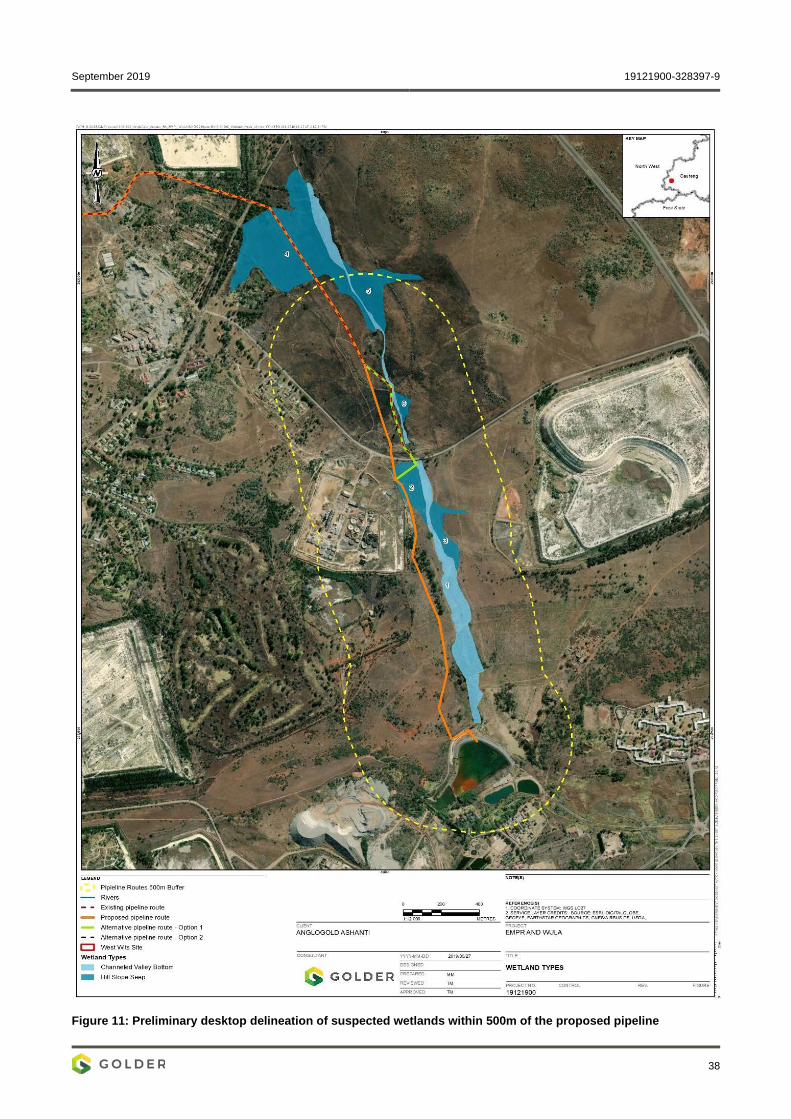
September 2019 19121900-328397-9
38
Figure 11: Preliminary desktop delineation of suspected wetlands within 500m of the proposed pipeline

September 2019 19121900-328397-9
39
Table 10: PES assessment results
HGM Unit Hydrology Geomorphology Vegetation Overall PES Score
Overall PES category Impact
Score Category Impact
Score Category Impact
Score Category
1: Valley-bottom with a channel
6.5 E 3.5 C 0.1 A 3.81 C
2: Hillslope seepage linked to a stream
3.0 C 0.1 A 0.1 A 1.34 B
3: Hillslope seepage linked to a stream
1.0 B 0.1 A 0.1 A 0.49 A
4: Hillslope seepage linked to a stream
1.0 B 0.1 A 0.1 A 0.49 A
5: Hillslope seepage linked to a stream
3.0 C 0.0 A 0.1 A 1.31 B
6: Hillslope seepage linked to a stream
1.0 B 0.0 A 0.0 A 0.53 A
Table 11: EIS score and category for the HGM 1 and HGM 2 which will be crossed
Component Channelled valley bottom (HGM1)
Hillslope seep (HGM 2)
Ecological Importance and Sensitivity 1.0 1.0
Hydro-Functional Importance 1.0 0.9
Direct Human Benefits 0.6 0.4
Overall EIS Score 1.0 1.0
Overall EIS Category Low/Marginal Low/Marginal
Wetland Ecosystem Services Numerous functions are typically attributed to wetlands, which include nutrient removal, sediment trapping, flood attenuation and erosion control. Many of these functions attributed to wetlands are wetland type specific and can be linked to the locations of wetlands in the landscape as well as to the way in which water enters and flows through the wetland. Thus, not all wetlands can be expected to perform all functions, or to perform these functions with the same efficiency.

September 2019 19121900-328397-9
40
Figure 12 and Figure 13 below show the results of the Wetland Ecosystem Services assessment conducted for the Channelled Valley Bottom wetland and the hillslope seepage that will be crossed by the pipeline. The level of ecosystem services provision was generally assessed as low. Erosion control scored the highest (intermediate to moderately high), mostly due to the moderate abundance of vegetation cover buffering the wetland and the expected moderate surface roughness of the wetlands. Carbon storage and streamflow regulation also obtained intermediate scores.
The hillslope seepage HGM2 provides ecosystem services including streamflow regulation, nitrate removal and erosion control, and, to a lesser extent, carbon storage and maintenance of biodiversity (given its likely temporary nature).
Figure 12: HGM1 Channelled valley bottom – level of ecosystem service provision
Figure 13: HGM2 hillslope seep - level of ecosystem service provision
6.1.1.7.5 Aquatic Regional aquatic setting The study area is located within the Vaal Water Management Area (WMA5) and falls within the Highveld (11)– Lower Level 1 Ecoregion (Mucina & Rutherford, 2006), quaternary catchment C23E. One of the options for the proposed pipeline route crosses the non-perennial stream called the Wonderfonteinspruit, which flows north towards the Mooiloopspruit. This stream has been classified as largely modified Present Ecological State - D (Department of Water and Sanitation, 2014).
Based on a preliminary visual assessment of this river system using Google Earth Street View (2019), coupled with observations and photographs taken during the in-field survey, the following key points were observed:
Very low water levels within the Wonderfonteinspruit, as well as limited-no flow conditions;
Sections of the Wonderfonteinspruit display wetland conditions;
The habitat is completely modified along this river reach, particularly at the upstream site (WON_US). Consequently, as aquatic macroinvertebrates and fish are entirely dependent on habitat availability within the system, it is probable that the diversity and abundances of the aquatic macroinvertebrate assemblages and fish populations would be considerably low, resulting in poor biotic integrity within this system. Consequently, limited useful in-field aquatic macroinvertebrate and fish data could be gathered to inform an assessment of the health of the aquatic ecosystem; and

September 2019 19121900-328397-9
41
The lower reaches of the Wonderfonteinspruit channel have been artificially altered with cement to function as a drainage channel.
Aquatic Macroinvertebrate Communities Based on the results from (Clean Stream, 2013a) and (Clean Stream , 2013b), a low diversity of aquatic macroinvertebrates has been recorded in the study area, with 20 taxa recorded in 2007, and 18 taxa recorded in 2013. The aquatic macroinvertebrate community identified was indicative of tolerant taxa, most suited to polluted and/or impaired water quality conditions, coupled with modified and poor habitat availability.
Fish Communities Based on available distribution records and the habitats observed/photographed during the in-field survey, eight indigenous fish species have a high probability of occurrence within the study area (Table 12). None of the expected species are endemic or Red Data listed (Skelton, 2001).
Table 12: Expected ichthyofaunal composition and frequency of occurrence within the AGA study area and current IUCN status
Scientific Name Common Name IUCN Status Intolerance Rating
FROC*
Austroglanis sclateri Rock-Catfish Least Concern 2.7 1
Enteromius anoplus Chubbyhead Barb Least Concern 2.6 1
Enteromius trimaculatus Threespot Barb Least Concern 2.2 1
Enteromius paludinosus Straightfin Barb Least Concern 1.8 1
Enteromius pallidus Goldie Barb Least Concern 3.1 1
Cyprinus carpio Carp Exotic 1.4 1
Clarias gariepinus Sharptooth Catfish Least Concern 1.2 1
Labeo umbratus Moggel Least Concern 2.3 1
Micropterus salmoides Largemouth Bass Exotic 2.2 1
Pseudocrenilabrus philander Southern Mouthbrooder
Least Concern 1.3 3
Tilapia sparrmanii Banded Tilapia Least Concern 1.3 3 Red text indicates exotic species and do not qualify for a FROC score *FROC – Frequency of occurrence where 1 = Present at very few sites (<10% of sites) and 3 = Present at about >25 - 50 % of sites (Kleynhans CJ, Louw MD, Moolman J. 2007)
During previous assessments conducted by Clean Stream (2013b) and (2013a), four of the 11 fish species expected to occur in the study area were recorded. These were Enteromius anoplus, Clarias gariepinus, Tilapia sparrmanii and Pseudocrenilabrus philander. These fish species are mostly tolerant species.The exotic fish species Micropterus salmoides has been recorded in the study area, while the exotic species Cyprinus carpio has the potential to migrate into the Wonderfonteinspruit from the man-made dams in the study area. These exotic fish species both have the potenital to impact on the natural biodiversity of the river systems.

September 2019 19121900-328397-9
42
Diatoms A total of 43 diatom species were recorded from the samples taken during the June 2019 survey, with the following dominant species recorded: Nitzschia sp., Gomphonema sp. Encyonopsis sp. and Navicula sp.
The diatom assemblages at the upstream site (WON-US) were indicative of moderately acidic waters, as well as untreated wastewater and habitats strongly impacted by industrial sewage. These impacts may be associated with upstream point or non-point source pollution or runoff from the surrounding land-use. Furthermore, there is a dam with an inlet just upstream of this monitoring point. This is further supported by the high %PTV score for this site. Consequently, the overall ecological water quality was considered poor (Table 13).
Although the diatom assemblages recorded at the downstream site (WON_DS) were dominated by taxa indicative of organic wastewater, nutrient enriched and calcium-bicarbonate-rich conditions; the %PTV score was relatively low suggesting that there was a relatively low impact associated with organic enrichment at the time of the survey. Consequently, the overall ecological water quality was considered moderate, a slight recovery compared to the upstream site (Table 13).
Table 13: Diatom analysis results and ecological water quality for June 2019
Site No. Species % PTV SPI Ecological Water Quality
WON-US 35 35.2 7.1 Poor
WON-DS 18 3.5 12.5 Moderate
Whole Effluent Toxicity Screening tests conducted on the water samples collected at the upstream and downstream site indicated that there was limited to no acute toxicity (<1 TUa) to any of the trophic levels subjected to the exposures during either seasonal survey, and as a result no definitive testing was required.
At the upstream site (WON_US), Vibrio fischeri, (representing the bacteria) that were exposed to the water samples, expressed 31% stimulation. However, as it did not reach or exceed 50%, it indicated that it was not acutely toxic towards bacteria (Table 14). The Selenastrum capricornutum (representing algae) indicated 27% inhibition which is an indication of a potential long-term change in the sensitive algae species composition found at this site. However, as this sample did not exceed a 50% acute inhibition effect, it was identified not to be acutely toxic towards sensitive algae. The Daphnia pulex and Poecilia reticulate tests expressed zero levels of mortality when exposed to the water samples, which were thus not considered acutely toxic (Table 14).
The downstream site (WON_DS), although it had a lower conductivity, had a much higher expressed toxicity across all the trophic level tests (Table 14). The high inhibition levels with V. fischeri and S. capricornutum indicated acute toxicity towards both sensitive bacteria and algae species respectively. Furthermore, all if not most of the D. pulex and P. reticulate died when exposed to the water samples, consequently resulting in the samples being acutely toxic towards these bioassays (Table 14).
The samples were further classified using the toxicity data of the non-diluted samples as per (Persoone, et al., 2003). Refer to
Table 15 for the hazard classification of each site as per the methodology described above. The upstream site showed a slight acute hazard (Class II), demonstrating that intolerant and sensitive aquatic macroinvertebrate

September 2019 19121900-328397-9
43
taxa would still be able to tolerate the conditions at these sites. However, the downstream site showed a high acute hazard (Class IV), indicating an impact in a downstream direction.
Table 14: Summary of WET testing results
Site Vibrio fischeri Selenastrum capricornutum
Daphnia pulex Poecilia reticulata
WON_US Stimulation Inhibition None None
(+31) (-27) 0 0
WON_DS Inhibition Inhibition High High
(-97) (-99) 100 70
Red writing under V. fisheri and S. capricornutum indicates inhibition levels which exceed the threshold for natural variation (20%) and
which poses a concern
% Mortality: Low (D. pulex and P. reticulata 0 - 9%, V. fischeri and S. capricornutum 0 - 19%), Moderate (D. pulex and P. reticulata 10 -
50%, V. fischeri and S. capricornutum 20 - 50%), High (>50%)
%Stimulation >20% potential for algal blooms
Table 15: Hazard Classification of undiluted samples for June 2018
Site Hazard Classification
WON_US II
WON_DS IV
6.1.1.8 Socio Economic A desktop study was conducted to understand and document the prevailing socio-economic conditions within the proposed study area. The key demographic aspects within the municipality are provided below:
The Merafong population has dropped from 197 520 to 188 843 between the 2011 and 2016, with a negative population growth rate of 1.02;
The dominant population within the municipality group is black African and the dominant language is IsiXhosa;
Approximately 84% of the working persons in Merafong have jobs in the formal sector, nearly 60% of the formally employed persons are semi-skilled. Unemployment rate varies between 17% and 20%; and
The economy of Merafong City is still dominated by the mining sector, which contributed 54.9% to Gross Domestic Product (GDP) in 2011 and 29.1% in 2016.
The provision of social infrastructure and services is relatively good within the municipality, with a majority of the people using electricity for cooking and lighting, 74,7% households living in formal dwellings and the availability of adequate sanitation and waste disposal in formal dwellings. Unfortunately, there is a backlog of water and sanitation in informal settlements, road infrastructure is in poor to fair condition within the MCLM and the crime rate is high. Additionally, Merafong is not a traditional tourism destination with many of its neighbours outperforming the municipality.

September 2019 19121900-328397-9
44
6.1.1.9 Soil, Land Capability and Land Use The project site is highly modified by a long history of mining and related activities (Figure 9). Soils are shallow to deep Mispah resting on top of hard rock strata.
Mispah soils are typically not conducive to agriculture but rather natural grazing, but due to the presence of illegal Zama Zama miners, agricultural activities of this nature are highly unlikely, as any grazing animals are likely to be stolen and/or slaughtered by the illegal miners.
6.1.1.10 Noise The assessment of ambient noise levels in the near vicinity of the proposed mine included:
A review of applicable legislation, policy and standards;
Review and analysis of available historical noise monitoring data from historical noise monitoring reports;
The identification of local noise emission sources; and
The identification and discussion of the potential health effects associated with noise emissions from the proposed mining operations.
6.1.1.11 Visual The local visual resource is characterised by largely flat and gently undulating topography with few elevated rises and hills. The vegetation cover comprises of large tracts of grassland/wetland, with small pockets of woodland/plantations and numerous scattered trees. The Wonderfonteinspruit, which is a small drainage line, is the prominent hydrological feature in the study area and runs parallel to the proposed pipeline route. Mine tailings facilities are common in the landscape and their tall, geometric shapes significantly alter the natural landscape profile. Localised areas of built infrastructure, disturbances and transformation are common in the landscape, and these are typically associated with mining activities. Several residential areas are also present.
6.1.1.12 Heritage The project area is part of a mining landscape which is the result of gold mining activities over a long period of time. Consequently, the area cannot be described as pristine any longer. However, heritage resources still do occur in the area and these include primarily:
Mine landscapes where mine infrastructure older than sixty years still occurs;
Townscapes which comprise whole suburbs of Randfontein and other towns on the West Rand which are older than sixty years; and
Graveyards and graves dating from the nineteenth century to the recent past.
The baseline heritage survey undertaken along the pipeline corridor did not reveal the presence of any of the types and ranges of heritage resources as outlined in Section 3 of the National Heritage Resources Act (Act No. 25 of 1999).
Notes:
Due to security risks posed by illegal mine workers (Zama Zamas), the heritage specialist was required to undertake the baseline survey from a Caspir armoured vehicle along the pipeline corridor;
The survey was limited to the southern part of the pipeline as the northern part of the pipeline will be mounted on top of the existing pipeline and thus no further disturbances will be caused along this part of the pipeline; and
September 2019 19121900-328397-9
45
It is possible that the baseline survey may have missed heritage resources:
Covered with dense vegetation and/or could not be surveyed due to the security risks;
Which are buried underground and may only be exposed once development commences; and
By failure to recognise them.
6.1.1.13 Palaeontology Fossils in South Africa mainly occur in rocks of sedimentary nature and not in rocks from igneous or metamorphic nature. Therefore, if sedimentary rocks are present, the palaeontological sensitivity can range from low to very high.
The proposed pipeline is located on the dolomites of the Malmani Subgroup, Chuniespoort Group of the Transvaal Supergroup which have a high paleontological sensitivity, the Rooihoogte Formation with a low paleontological sensitivity and the Time Ball Hill Formation with a high paleontological sensitivity (SG 2.2 SAHRA APMHOB Guidelines, 2012).
Notes:
Due to security risks onsite posed by illegal mine workers (Zama Zamas), the paleontological specialist was not allowed onsite and thus the baseline assessment of the paleontological resources was undertaken at a desktop level based on available literature; and
The sensitivity level (i.e. Low, Medium, Hight etc.) indicates the possible occurrence of palaeontology resources onsite.
6.1.2 Description of current land uses The dominant land uses directly affected by the proposed pipeline and surface infrastructure include the following:
The CWC surface infrastructure is situated within the existing footprint of historic brownfields mining land; and
The proposed pipeline route is situated on a mixture of open vacant land and historic brownfields mining land. In addition, the pipeline corridor will cross a few roads via steel gantries.
6.1.3 Environmental and current land use map The dominant land uses surrounding the proposed pipeline route (i.e. within 5 km) as seen in Figure 9 include the following:
Mining operations, including active mines and defunct mines in the process of being decommissioned;
Formal and informal residential areas;
Regional and national road infrastructure;
Commercial and industrial activities;
Landing strip;
Open vacant land; and
An extensive network of gravel roads and tracks.

September 2019 19121900-328397-9
46
7 IMPACTS AND RISKS IDENTIFIED, INCLUDING THE NATURE, SIGNIFICANCE, CONSEQUENCE, EXTENT, DURATION AND PROBABILITY
7.1 Methodology used in determining and ranking the nature, significance, consequences, extent, duration and probability of potential environmental impacts and risks
The significance of identified impacts was determined using the approach outlined below (terminology from the Department of Environmental Affairs and Tourism Guideline document on EIA Regulations, April 1998). This approach incorporates two aspects for assessing the potential significance of impacts, namely occurrence and severity, which are further sub-divided as follows (Table 16):
Table 16: Impact classification for impact assessment
Occurrence Severity
Probability of occurrence
Duration of occurrence Scale / extent of impact Magnitude (severity) of impact
To assess each of these factors for each impact, the following ranking scales are used (Table 17)
Table 17: Ranking scales
Probability Duration
5 - Definite/don’t know 5 – Permanent
4 - Highly probable 4 - Long-term
3 - Medium probability 3 - Medium-term (8-15 years)
2 - Low probability 2 - Short-term (0-7 years) (impact ceases after the operational life of the activity)
1 - Improbable 1 – Immediate
0 - None
Scale Magnitude
5 - International 10 - Very high/don’t know
4 - National 8 – High
3 - Regional 6 – Moderate
2 - Local 4 – Low
1 - Site only 2 – Minor
0 - None
After ranking these factors for each impact, the significance of the two aspects, occurrence and severity, was assessed using the following formula:

September 2019 19121900-328397-9
47
SP (significance points) = (magnitude + duration + scale) x probability
The maximum value is 100 significance points (SP). The impact significance was then rated as per Table 18.
Table 18: Categories describing environmental consequence
SP >75 Indicates high environmental significance
An impact which could influence the decision about whether or not to proceed with the project regardless of any possible mitigation.
SP 30 – 75 Indicates moderate environmental significance
An impact or benefit which is sufficiently important to require management and which could have an influence on the decision unless it is mitigated.
SP <30 Indicates low environmental significance
Impacts with little real effect and which should not have an influence on or require modification of the project design.
+ Positive impact An impact that constitutes an improvement over pre-project conditions
Although not explicitly included in the criteria tables, there is uncertainty associated with the information and methods used in an Environmental Impact Assessment (EIA) because of its predictive nature. The certainty with which an impact analysis can be completed depends on a number of factors, including:
Understanding of natural/ecological and socio-economic processes at work now and in the future, and
Understanding of present and future properties of the affected resource.
The level of prediction confidence for an impact analysis will be discussed when there are questions about the factors reviewed above. Where the level of prediction confidence makes a prediction of the impact problematic, a subjective assessment is made based on the available information, the applicability of information on surrogates, and on professional opinion.
The level of prediction confidence is sufficiently low in some cases that an estimate of environmental consequence cannot be made with a sufficient degree of confidence. Undetermined ratings are accompanied by recommendations for research or monitoring to provide more data in the future.
7.2 The positive and negative impacts that the proposed activity (in terms of the initial site layout) and alternatives will have on the environment and the community that may be affected
7.2.1 Layout and alternatives The preferred (i.e. initial) pipeline route (i.e. site layout) will have significantly less environmental impacts compared to the two alternative routes, as the preferred route is further away from the regulated area of a watercourse that runs parallel to the pipeline route (Figure 2). With regard to the community, there will be very little difference in the impacts of the preferred pipeline route versus the alternative pipeline routes, as all pipeline routes traverse the same farm and portions for all options (i.e. farm Blyvooruitzicht 116, portions 10, 13, 15, 26, 51, & 89.
7.2.2 Environmental impacts This dewatering project would allow for the continuation of AGA’s operations and reduce the health and safety risks brought on by fissure water reporting at the #4 and #6 shafts of the defunct Blyvooruitzicht Mine and it would enable the separation of “clean water” from contaminated AMD. The pumped and treated AMD will be re-used as make-up water in the Savuka plant circuit, which will benefit the Savuka plant and address the treatment of the AMD reporting to AGA’s operations.

September 2019 19121900-328397-9
48
Cumulatively, the positive environmental impacts outweigh the negative environmental impacts which will be further mitigated by the implementation of the project’s environmental management programme (see section B of this BA report).
7.2.3 Social impacts Social impacts associated with the project are anticipated to be both positive and negative. Positive impacts are anticipated to include:
Lower health and safety risks for the AGA employees at the AGA operations;
Reduction in unemployment within the local community; and
Contributions to the local economy.
Negative impacts may include social ills associated with the influx of new persons to the local area. Cumulatively, the positive social impacts outweigh the negative social impacts which can be further mitigated by the implementation of the project’s environmental management programme (Please refer to section B for the management and mitigation measures).
7.2.4 Significance rating summary This section is to be completed following the 30-day public review period.
7.3 The possible mitigation measures that could be applied and the level of risk
Please refer to section B for the management and mitigation measures
7.4 Motivation where no alternative sites were considered Alternatives regarding pipeline routing were considered – see section 4. 7.5 Statement motivating the alternative development location within
the overall site The final pipeline routing will be determined by the findings and recommendations of the EAP, specialists and project engineers. The location of infrastructure will be such that sensitive areas are avoided. In addition, an environmental management programme will be implemented to mitigate the identified environmental impacts.
7.6 Full description of the process undertaken to identify, assess and rank the impacts and risks the activity will impose on the preferred site (In respect of the final site layout plan) through the life of the activity
The following steps were taken to identify the potential impacts associated with the proposed pipeline and associated surface infrastructure:
A detailed literature review was undertaken to identify and collate available information relevant to the proposed project and its environmental and social;
Specialist studies were undertaken to verify the baseline environmental and social conditions;
The literature review and specialist studies were used to compile the Draft Basic Assessment Report (DBAR) in the DMR standardised format;

September 2019 19121900-328397-9
49
The stakeholder engagement process is currently being undertaken in a manner designed to be interactive, providing the landowners and identified stakeholders with an opportunity to provide input into the project. This is considered a key focus as the local residents have capabilities of providing site-specific information, which may not be available in desktop research material. Stakeholders were requested to provide their views on the project, and to state any potential concerns they may have. All comments and responses provided will be collated into the Comments and Responses Report, which will be attached to the Final Basic Assessment Report (FBAR) and will also be considered during the final impact assessment process; and
The rating of the identified impacts was undertaken in a quantitative manner as described in section 7.1 (impact rating). The identification of management and mitigation measures was done based on the significance of the impacts and the measures included are considered to be sufficient, appropriate and practical to prevent unacceptable environmental impacts resulting from the proposed project.

September 2019 19121900-328397-9
50
7.7 Assessment of each identified potentially significant impact and risk Table 19, Table 20, Table 21 and Table 22 provides the significance rating for each project activity, a description of the impact, the environmental aspect affected, the project phase the impact relates to, the pre-mitigation significance rating, the type of mitigation applied, and the post-mitigation significance rate.
Table 19: Impact Assessment and Management Type for construction phase
Environmental Aspect
Potential Impact Aspects Affected Significance if Not Mitigated
Mitigation Type Significance if Mitigated
Heritage Damage/disturb heritage resources
Heritage resources Low Chance find procedures to be followed. Low
Biodiversity Loss and disturbance of natural habitat
Natural habitat Moderate Minimisation As far as practical, vehicle access tracks and lay-down areas should be located in already disturbed
areas. Where this is not possible, the disturbance footprints should be kept to a minimum; The preliminarily-defined wetland boundaries should be confirmed in the field prior to construction; All wetlands located within the study area, but not directly crossed by the pipeline should be carefully
demarcated and no construction machinery or any other vehicles should be allowed access to these areas other than along existing roads;
Construction activities should be undertaken during the dry season (if possible); and An Environmental Control Officer (ECO) should manage the vegetation clearing process. Rehabilitation Any areas cleared of vegetation during construction should be stabilised and revegetated using
indigenous grass species.
Low
Loss of plant species of conservation concern
Plant species of conservation concern Low Avoidance Conduct a walk-down of the pipeline route and identify and locate plant species of conservation
concern; Placement of plinths should be undertaken to avoid plant species of conservation concern, as located
during the survey; and Access tracks and laydown areas for construction should be positioned to avoid plant species of
conservation concern.
Low
Soil erosion and sedimentation of the Wonderfonteinspruit
Soil erosion and sedimentation Moderate Avoidance and Minimisation Limit vegetation clearing to the footprint areas to be disturbed by the concrete plinths only. Rehabilitation If incidences of erosion are noticed during or after construction, these should be attended to
immediately using appropriate interventions, such as inter alia physical stabilisation, brush-packing and the placement of berms. In severe cases of erosion, active revegetation using indigenous grass species should be considered.
Low
Alien invasive species establishment
Alien invasive species Moderate Minimisation Actively control all alien invasive species (AIS) that colonise areas that have been disturbed during
the construction phase. Control should include: Annual treatments along the entire length of the pipeline and all sites disturbed during
construction (e.g. vehicle access tracks and lay-down areas); A combined approach using both chemical and mechanical control methods; and Periodic follow-up treatments, with a regularity informed by annual monitoring.
AIS control should continue through all phases of the proposed project until such a time as monitoring indicates AIS are no longer actively establishing.
Low

September 2019 19121900-328397-9
51
Environmental Aspect
Potential Impact Aspects Affected Significance if Not Mitigated
Mitigation Type Significance if Mitigated
Interruption of wetland hydrology
Wetland hydrology Low Minimisation The preliminarily defined wetland boundaries should be confirmed in the field prior to construction; Vegetation clearing should be restricted to the footprint area to be disturbed by the concrete plinths;
and Driving within the wetland areas should be kept to an absolute minimum. Only clearly defined access
routes should be used.
Low
Deterioration in wetland water quality
Water quality Moderate Minimisation Any waste from the construction process should be removed from the construction site; Keep sufficient quantities of spill clean-up materials on site and/or on the construction vehicles to
manage any incidental spills; and Maintenance of construction vehicles is to be undertaken offsite and all vehicles used on site are to
be in good working order without leakage of any oils, greases etc.
Low
Surface water Erosion and Sedimentation Water quality of the stream Low Minimisation Limit area cleared and appropriate disposal of construction material. Rehabilitation Vegetate areas where no concrete structures are built to allow stormwater infiltration.
Low
Ground Water Contamination Ground water quality Low As the pipeline is not expected to have any direct impacts on the groundwater levels or quality, mitigation measures are limited to taking care during construction to avoid unnecessary spillages of fuel, lubricants, cement, and paint or any other potentially harmful contaminants which over time could migrate into the underlying groundwater zone. During operation, regular monitoring of the pipeline should be maintained to avoid leakages from the pipeline, whereas at the end of the life of the pipeline, during decommissioning similar mitigative measures as during construction should be applied to ensure environmentally responsible behaviour.
Low
Visual Aesthetics Visual Low Pipeline expected to not have a significant visual impact and no mitigations recommended. Low
Palaeontology Damage/disturb Palaeontology resources
Fossil heritage High If any palaeontological materials are exposed during construction, operations and/or decommissioning of the pipeline, SAHRA must be notified. All activities must be stopped immediately, and a palaeontologist should be called in to determine proper mitigation measures.
Low
Social & Economic Employment opportunities The construction of the pipeline will create new employment for locals
Positive Recruitment practises should favour local people with the required skills and qualifications (where feasible); and
The recruitment of labourers should be well advertised and documented to ensure a transparent process.
Positive
Small, medium and micro-enterprises (SMME) development
The construction of the pipeline may lead to the growth of SMMEs, due to: Minor land clearing for the
preparation and laying of the pipeline support plinths;
General manual labour related to construction activities; and
The supply of materials.
Positive Procurement policies should favour local suppliers from the community (where feasible). Positive

September 2019 19121900-328397-9
52
Environmental Aspect
Potential Impact Aspects Affected Significance if Not Mitigated
Mitigation Type Significance if Mitigated
Population influx Influx of job seekers would have a negative social impact on the landowners and land occupiers.
Low Recruitment practises should favour local people with the required skills and qualifications (where feasible); and
The recruitment of labourers should be well advertised and documented to ensure a transparent process.
Low
Disruption of movement patterns
Disruption of movement patterns within the project areas.
Low Provision of notice boards in the vicinity of where movement pattern disruptions will occur to notify I&APs ahead of time;
Provision of alternative routes information to bypass any disruptions; and Communication with local communities prior to any disruptions.
Low
Health, safety and security risk
Increased dust levels which may result in respiratory problems for the locals and construction workers;
Increased traffic volumes; Presence of heavy goods vehicles; Road accidents, mainly impacting the
locals who are not accustomed to heavy traffic and heavy vehicles; and
Deterioration of roads, which will pose a safety risk to motorists.
Low Restrict presence of heavy vehicles on the roads to reduce traffic load (where feasible). Low
Noise Noise nuisance at nearby sensitive receptors
Noise levels Low Materials handling activities: A drop height policy should be implemented onsite to reduce the level of noise generation when
handling materials; and All equipment operators should be trained in the policy such that drop height reduction is
implemented onsite. Heavy vehicle/machinery noise:
Using the smallest/quietest equipment for the particular purpose; Ensuring that equipment is well maintained and fitted with the correct and appropriate noise
abatement measures; All vehicles and other equipment should be maintained and serviced regularly to ensure that the
noise levels are controlled; and Vehicles should not be allowed to idle for more than 5 minutes when not in use.
Pump station: The pumps at the CWC plant must be housed within a structure/s designed to include noise
dampening materials and/designs to reduce the noise levels at the plant’s boundaries. Monitoring requirements:
If noise complaints are registered regarding construction activities, noise monitoring should be undertaken to identify the sources and mitigation measures should be implemented to reduce the nuisance impacts;
Any noise complaints should be directed to the site management. Complaints and any actions arising from a complaint must be recorded in a complaints register to be maintained by site management. An investigation should be undertaken to determine the specific activities and or equipment/ machinery which is generating the nuisance noise resulting in the noise complaints.
Low
Please refer to the supporting impact assessments conducted by the specialist EAP’s in APPENDIX E to APPENDIX L.

September 2019 19121900-328397-9
53
Table 20: Impact Assessment and Management Type for operation phase
Name of Activity Potential Impact Aspects Affected Significance if Not Mitigated
Mitigation Type Significance if Mitigated
Heritage Damage/disturb heritage resources
Heritage resources Low Chance find procedures to be followed. Low
Biodiversity Establishment of alien invasive species
Alien invasive species Moderate Minimisation Actively control all alien invasive species (AIS) that colonise areas that have been disturbed during
the construction phase. Control should include: Annual treatments along the entire length of the pipeline and all sites disturbed during
construction (e.g. vehicle access tracks and lay-down areas); A combined approach using both chemical and mechanical control methods; Periodic follow-up treatments, with a regularity informed by annual monitoring; and AIS control should continue through all phases of the proposed project until such a time as
monitoring indicates AIS are no longer actively establishing.
Low
Leaks/spills of contaminated water into the Wonderfonteinspruit
Wonderfonteinspruit Moderate Minimisation Conduct regular (daily) visual inspections to monitor the integrity of the pipeline and ensure that no
vandalism is occurring; In the event of a leak, pipeline repairs should be conducted with alacrity; and Should a leak/spill event occur, a water quality and Whole Effluent Toxicity (WET) sample should be
retrieved immediately upstream and downstream of the spill. This exercise should be repeated one month after the spill to compare to the initial results to ensure maintenance.
Low
Changed flows in wetland due to leaks or pipe failure
Flows in wetland Low Avoidance and Minimisation Regular maintenance of the pipeline must be undertaken during the operational phase. Any identified
leaks should be repaired immediately; and Any damage/erosion caused by pipe failure must be repaired immediately following the incident.
Low
Surface water Leaks from pipeline could lead to pollution of stream (increased metals, low pH)
Water quality of the stream and potentially the Mooi River
Moderate Avoid By monitoring for leaks. Minimisation Fix leaks timeously.
Low
Overflow from North Boundary Dam (NBD)
Water quality of the stream and potentially to the Wonderfonteinsppruitr
Moderate Avoid Maintain 0.8 m freeboard in the NBD. Minimisation Adjust pumping rates
Low
Ground Water Contamination Ground Water Low As the pipeline is not expected to have any direct impacts on the groundwater levels or quality, mitigation measures are limited to taking care during construction to avoid unnecessary spillages of fuel, lubricants, cement, and paint or any other potentially harmful contaminants which over time could over migrate into the underlying groundwater zone. During operation, regular monitoring of the pipelines should be maintained to avoid leakages from the pipeline, whereas at the end of the life of the pipeline, during decommissioning similar mitigative measures as during construction should be maintained to ensure environmentally responsible behaviour.
Low
Treatment of Acid Rock drainage (ARD)
Contamination of the groundwater reserve Positive Dewatering of the shafts and reuse of the water in the Savuka circuit serves as a significant positive benefit of the project as it allows for the treatment of the ARD.
Positive

September 2019 19121900-328397-9
54
Name of Activity Potential Impact Aspects Affected Significance if Not Mitigated
Mitigation Type Significance if Mitigated
Visual Aesthetics Visual Low Pipeline not expected to have a significant visual impact and no mitigations required. Low
Social and Economic
Health and safety of AGA personnel and operations
Reduced risk of flooding Positive Positive
Employment opportunities Locals employment Positive Recruitment practises should favour local people with the required skills and qualifications (where feasible); and
The recruitment of labourers should be well advertised and documented to ensure a transparent process.
Positive
Loss of employment during transition from construction to operational phase
Social and Economic Low Invest in available community development initiatives (where possible) to lessen negative socio-economic impacts associated with poverty in line with the operations SLP during transition from construction to operational phase.
Low
Noise Noise Noise Low Materials handling activities: A drop height policy should be implemented onsite to reduce the level of noise generation when
handling materials; and All equipment operators should be trained in the policy such that drop height reduction is
implemented onsite. Heavy vehicle/machinery noise:
Using the smallest/quietest equipment for the particular purpose; Ensuring that equipment is well maintained and fitted with the correct and appropriate noise
abatement measures; All vehicles and other equipment should be maintained and serviced regularly to ensure that the
noise levels are reduced; and Vehicles should not be allowed to idle for more than 5 minutes when not in use.
Pump station: The pumps at the CWC plant must be housed within a structure/s designed to include noise
dampening materials and/designs to reduce the noise levels at the plant’s boundaries. Monitoring requirements:
If noise complaints are registered regarding construction activities, noise monitoring should be undertaken to identify the source and mitigation measures should be implemented to reduce the nuisance impacts;
During the operational phase, a once off noise monitoring campaign should be undertaken to establish the possible noise nuisance impacts from the operation of the CWC plant on the sensitive receptors. A suitable noise monitoring frequency should be established thereafter (i.e. not required, annually, quarterly etc.); and
Any noise complaints should be directed to the site management. Complaints and any actions arising from a complaint must be recorded in a complaint’s register to be maintained by site management. An investigation should be undertaken to determine the specific activities and or equipment/machinery which is generating the nuisance noise resulting in the noise complaints.
Low
Please refer to the supporting impact assessments conducted by the specialist EAP’s in APPENDIX E to APPENDIX L.

September 2019 19121900-328397-9
55
Table 21: Impact Assessment and Management Type for decommissioning phase
Name of Activity Potential Impact Aspects Affected Significance if Not Mitigated
Mitigation Type Significance if Mitigated
Heritage Damage/disturb heritage resources
Heritage resources Low Chance find procedures to be followed. Low
Biodiversity Alien invasive species establishment
Alien invasive species Low Minimisation Actively control all alien invasive species (AIS) that colonise areas that have been disturbed during
the decommissioning phase. Control should include: Annual treatments along the entire length of the pipeline and all decommissioning areas (access
tracks and lay-down areas); and A combined approach using both chemical and mechanical control methods.
Periodic follow-up treatments, informed by the findings of regular monitoring should be conducted for at least the first three years following decommissioning, or until such a time as monitoring indicates AIS are no longer actively establishing.
Low
Soil erosion and sedimentation of Wonderfonteinspruit
Wonderfonteinspruit Low Rehabilitation Any areas cleared of vegetation during decommissioning should be stabilised and revegetated using
indigenous grass species.
Low
Visual Aesthetics Visual Low Pipeline expected to not have a significant visual impact and no mitigations recommended. Low
Social and Economic
Loss of employment during transition from operational to decommissioning phase
Social and Economic Low Invest in available community development initiatives (where possible) to lessen negative socio-economic impacts associated with poverty in line with the operations SLP during transition from operational to decommissioning phase.
Low
Noise Noise Noise Low Materials handling activities: A drop height policy should be implemented onsite to reduce the level of noise generation when
handling materials; and All equipment operators should be trained in the policy such that drop height reduction is
implemented onsite. Heavy vehicle/machinery noise:
Using the smallest/quietest equipment for the particular purpose; Ensuring that equipment is well maintained and fitted with the correct and appropriate noise
abatement measures; All vehicles and other equipment should be maintained and serviced regularly to ensure that the
noise levels are reduced; and Vehicles should not be allowed to idle for more than 5 minutes when not in use.
Monitoring requirements: If noise complaints are registered regarding construction activities, noise monitoring should be
undertaken to identify the source and mitigation measures should be implemented to reduce the nuisance impacts; and
Any noise complaints should be directed to the site management. Complaints and any actions arising from a complaint must be recorded in a complaint’s register to be maintained by site management. An investigation should be undertaken to determine the specific activities and or equipment/machinery which is generating the nuisance noise resulting in the noise complaints.
Low
Please refer to the supporting impact assessments conducted by the specialist EAP’s in APPENDIX E to APPENDIX L.

September 2019 19121900-328397-9
56
Table 22: Cumulative Impact Assessment and Management Type
Name of Activity Potential Impact Aspects Affected Significance if Not Mitigated
Mitigation Type Significance if Mitigated
Heritage Damage/disturb heritage resources from all phases of the project
Heritage resources Low
Chance find procedures to be followed. Low
Biodiversity Establishment of alien invasive species
Alien invasive species Low Actively control all alien invasive species (AIS) that colonise areas that have been disturbed. Control should include: Annual treatments along the entire length of the pipeline; and A combined approach using both chemical and mechanical control methods.
Periodic follow-up treatments, informed by the findings of regular monitoring should be conducted for at least the first three years following decommissioning, or until such a time as monitoring indicates AIS are no longer actively establishing.
Low
Ground Water Contamination Ground Water Low As the pipeline is not expected to have any direct impacts on the groundwater levels or quality, cumulative impacts are anticipated to be minimal as long as the recommended mitigation measures (as above) are implemented through all project phases.
Low
Treatment of Acid Rock drainage (ARD)
Contamination of the groundwater reserve Positive Dewatering of the shafts and reuse of the water in the Savuka circuit serves as a significant positive benefit of the project as it allows for the treatment of the ARD.
Positive
Social and Economic
Employment opportunities Locals employment Positive Employment creation through all phases of the project. Positive
Please refer to the supporting impact assessments conducted by the specialist EAP’s in APPENDIX E to APPENDIX L.
7.8 Summary of specialist reports. Table 23 provides a summary of the specialist reports which informed the baseline and impact assessment, and includes recommendations made which must be considered by the DMR for authorisation.
Table 23: Specialist Studies
List Of Studies Undertaken Recommendations of Specialist Reports Mark if included in EIA report (X)
Cross-reference relevant section in EIA report
Phase I Heritage Impact Assessment If any heritage resources of significance is exposed during the Project the South African Heritage Resources Authority (SAHRA) should be notified immediately, all activities must be stopped and an archaeologist accredited with the Association for Southern African Professional Archaeologist (ASAPA) should be notify in order to determine appropriate mitigation measures for the discovered finds.
X Part A Section 6.1.1.12 APPENDIX K
Biodiversity Impact Assessment All recommended mitigation measures by the specialist should be implemented. X Part A Section 7.7 APPENDIX H
Surface Water Impact Assessment and Floodline Delineation
Rather than the implementation of an instream water quality sampling programme, for the surface water component, monitoring of the operation of the pipeline and dam levels should be routinely undertaken. Should a leak or spill occur, a water quality sample should be taken at various points downstream, weekly until an improvement is noted.
X APPENDIX G
Palaeontology Assessment There is no objection to the development, and it is not necessary to request a Phase 2 Palaeontological Impact Assessment: Mitigation to determine whether the development will affect fossiliferous outcrops. The palaeontological sensitivity is HIGH so caution is recommended. A Phase 2 Palaeontological Mitigation will be required if a fossil is found during construction (for example a stromatolite);
This project may benefit the economy, the growth of the community, the need for housing, and social development in general;
X APPENDIX L

September 2019 19121900-328397-9
57
List Of Studies Undertaken Recommendations of Specialist Reports Mark if included in EIA report (X)
Cross-reference relevant section in EIA report
Preferred choice: The potential for impact on the palaeontological heritage is HIGH. Care must be taken during grading, digging, and removing topsoil, subsoil and overburden; and
The following should be conserved: if any palaeontological material is exposed during digging, excavating, drilling or blasting SAHRA must be notified. All construction activities must be stopped, and a palaeontologist should be called in to determine proper mitigation measures.
Geology and Hydrogeology During operation, regular monitoring of the pipelines should be maintained to avoid leakages from the pipeline, whereas at the end of the life of the pipeline, during decommissioning similar mitigative measures as during construction should be maintained to ensure environmentally responsible behaviour.
X Part A Section 7.7 APPENDIX F
Visual impact assessment The visual impacts of the proposed pipeline are not expected to be significant thus no mitigation measures are recommended. X APPENDIX J
Groundwater Pipeline not expected to have a significant impact on groundwater thus no mitigations are recommended. X APPENDIX F
Noise Impact assessment The following recommended mitigation measures and considered best practice and should be implemented during the construction phase and/or operational phase: Materials handling activities:
A drop height policy should be implemented onsite to reduce the level of noise generation when handling materials; and All equipment operators should be trained in the policy such that drop height reduction is implemented onsite.
Heavy vehicle/machinery noise: Using the smallest/quietest equipment for the particular purpose; Ensuring that equipment is well maintained and fitted with the correct and appropriate noise abatement measures; All vehicles and other equipment should be maintained and serviced regularly to ensure that the noise levels are reduced; and Vehicles should not be allowed to idle for more than 5 minutes when not in use.
Pump station: The pumps at the CWC plant must be housed within a structure/s designed to include noise dampening materials and/designs to
reduce the noise levels at the plant’s boundaries. Monitoring requirements:
If noise complaints are registered regarding construction activities, noise monitoring should be undertaken to identify the source and mitigation measures should be implemented to reduce the nuisance impacts;
During the operational phase, a once off noise monitoring campaign should be undertaken to establish the possible noise nuisance impacts from the operation of the CWC plant on the sensitive receptors. A suitable noise monitoring frequency should be established thereafter (i.e. not required, annually, quarterly etc.); and
Any noise complaints should be directed to the site management. Complaints and any actions arising from a complaint must be recorded in a complaint’s register to be maintained by site management. An investigation should be undertaken to determine the specific activities and or equipment/ machinery which is generating the nuisance noise resulting in the noise complaints.
X APPENDIX E
Social & Economic Scoping All recommended mitigation measures by the specialist should be implemented. X APPENDIX I
Please refer to the supporting specialist reports in APPENDIX E to APPENDIX M for further details
September 2019 19121900-328397-9
58
7.9 Environmental impact statement The sections below provide a summary and consolidated view of the impact assessment process appropriate to this particular project scope.
7.9.1 Summary of the key findings of the environmental impact assessment
Potential impacts which cannot be adequately mitigated (i.e. those with a significance rating of Medium/High post mitigation) are considered key findings of the environmental impact assessment. All post mitigation impacts from the proposed pipeline are assessed to have a Low significance level of impact. In addition, there are several positive environmental and social impacts resulting from the project including:
Employment creation through all phases of the project;
Addressing AMD by reuse of the contaminated water in the Savuka Gold Plant circuit; and
Reduced health and safety risks for AGA personnel and operations with a reduced risk of flooding.
Based on the impact assessment, no key findings were identified, and no fatal flaws were observed which would preclude the development of the project.
7.9.2 Final Site Map Please refer to Figure 2 which provides the location of the proposed pipeline which serves as the final site map.
7.9.3 Summary of the positive and negative impacts and risks of the proposed activity and identified alternatives
The proposed project is an environmental improvement project and the only relevant risk of an alternative will be if the No-Go alternative is applied. This would have the following consequences:
The continued reporting of fissure water at the #4 and #6 shafts of the defunct Blyvooruitzicht Mine, which poses significant health and safety risks for AGA’s operations;
Contaminated AMD water will continue to negatively impact on the groundwater quality;
The Savuka plant circuit will be required to source make-up water from an alternative source and probably at higher operational costs; and
The benefits of employment creation and stimulation of the local economy will not materialise.
7.10 Proposed impact management objectives and the impact management outcomes for inclusion in the EMPr;
An EMPr seeks to achieve a required end state and describes how activities that have, or could have, an adverse impact on the environment and surrounding communities will be mitigated, controlled and monitored. The EMPr must address the environmental impacts and possible unplanned events during each phase of the Project (Construction, Operational, and Decommissioning). Due regard must be given to environmental protection during the entire project life cycle. Environmental recommendations are made to achieve environmental protection. These recommendations are aimed at ensuring that there is adequate control over the project to:
Minimise the extent of an impact during the life of the project;
Ensure appropriate restoration of areas affected by the project; and
September 2019 19121900-328397-9
59
Prevent long term environmental degradation.
7.11 Final proposed alternatives The proposed pipeline route as per Figure 2 is the only viable alternative for the project.
7.12 Aspects for inclusion as conditions of Authorisation. This is provided in detail in section 7.14.2 below.
7.13 Description of any assumptions, uncertainties and gaps in knowledge.
Due to the presence of illegal Zama-Zamas in the vicinity of the site and the associated safety concerns, ground truthing of the specialist studies was either limited and/or not possible. As a result, several of the specialist studies were conducted at a desktop level with reliance on past reports of the area and national information databases.
7.14 Reasoned opinion as to whether the proposed activity should or should not be authorised
This section details the EAP’s opinion regarding the authorisation of this application.
7.14.1 Reasons why the activity should be authorised or not The EAP is of the opinion that the application should be authorised as this project serves as an environmental improvement project. The associated negative environmental and social impacts of the project are limited and can be easily mitigated to an acceptable level. In addition, there are significant positive benefits associated with the project which will serve to improve the environmental and social conditions in the area. The authorisation should be granted subject to the inclusion of the conditions of authorisation listed in section 7.14.2 below.
7.14.2 Conditions that must be included in the authorisation The following conditions are recommended in support of Environmental Authorisation being granted:
Heritage:
If any heritage resources are exposed during the Project the South African Heritage Resources Authority (SAHRA) should be notified immediately, all activities must be stopped and an archaeologist accredited with the Association for Southern African Professional Archaeologists (ASAPA) should be notified in order to determine appropriate mitigation measures for the discovered finds. The chance find procedures as outlined in the report (APPENDIX K) should be followed. This may include obtaining the necessary authorisation (permits) from SAHRA to implement the mitigation measures.
Palaeontological:
If any palaeontological material is exposed during the project, SAHRA must be notified. All activities must be stopped, and a palaeontologist should be called in to determine proper mitigation measures. (APPENDIX L); and
The topsoil and subsoil must always be examined for fossils during construction. Special care must be taken during construction to avoid intruding on fossiliferous layers. This can be done by the Environmental Control Officer.
Surface Water:

September 2019 19121900-328397-9
60
Rather than the implementation of an instream water quality sampling programme for the surface water component, monitoring of the operational pipeline and NBD free board levels should be routinely undertaken. Should a leak or spill occur, a water quality sample should be taken at various points downstream, weekly until an improvement is noted. (APPENDIX G).
Biodiversity:
Recommended mitigation and management measures (as mentioned in Table 19, Table 20, Table 21 and Table 22) should be included in the overall Environmental Management Plan (EMP) for this project (APPENDIX H).
Noise:
The following recommended mitigation measures are considered best practice and should be implemented during the construction phase and/or operational phase:
Materials handling activities:
− A drop height policy should be implemented onsite to reduce the level of noise generation when handling materials; and
− All equipment operators should be trained in the policy such that drop height reduction is implemented onsite.
Heavy vehicle/machinery noise:
− Using the smallest/quietest equipment for the particular purpose;
− Ensuring that equipment is well maintained and fitted with the correct and appropriate noise abatement measures;
− All vehicles and other equipment should be maintained and serviced regularly to ensure that the noise levels are controlled; and
− Vehicles should not be allowed to idle for more than 5 minutes when not in use.
Pump station:
− The pumps at the CWC plant must be housed within a structure/s designed to include noise dampening materials and/designs to reduce the noise levels at the plant’s boundaries.
Monitoring requirements:
− If noise complaints are registered regarding construction activities, noise monitoring should be undertaken to identify the source and mitigation measures should be implemented to reduce the nuisance impacts;
− During the operational phase, a once off noise monitoring campaign should be undertaken to establish the possible nuisance noise impacts from the operation of the CWC plant on the sensitive receptors. A suitable noise monitoring frequency should be established thereafter (i.e. not required, annually, quarterly etc.); and
− Any noise complaints should be directed to the site management. Complaints and any actions arising from a complaint must be recorded in a complaints register to be maintained by site management. An investigation should be undertaken to determine the specific activities and or equipment/

September 2019 19121900-328397-9
61
machinery which is generating the nuisance noise resulting in the noise complaints (APPENDIX E).
EMPr:
− The EMPr is to be implemented and adhered to throughout the project lifecycle.
7.15 Period for which the Environmental Authorisation is required The scope of this application is focused on improving the local environmental conditions.
The proposed project is an environmental improvement project which needs to be operational for the life of the AGA operations and therefore the applicant requires environmental authorisation until the end of 2040 (i.e. 20 years).
7.16 Undertaking It is confirmed that the undertaking required to meet the requirements of this section is provided at the end of the EMPr and is applicable to both the Basic assessment report and the Environmental Management Programme report.
7.17 Financial Provision The total estimated scheduled closure costs for AGA’s proposed pipeline, as at June 2019, amounts to R1 438 949,32 (including Ps&Gs and contingencies and excluding VAT), as summarised in Table 24.
Table 24: Closure costs for the proposed pipeline
Closure Costs, as at June 2019
Closure components Scheduled Closure (2040
1 Infrastructural aspects R 787 608,30
2 Mining aspects R -
3 General surface rehabilitation R 375 156,05
Sub-Total 1 R 1 162 764,35
5 Post-Closure Aspects
5,1 Rehabilitation monitoring R 3 042,50
5,2 Care and maintenance R 17 334,31
Sub-Total 2 R 20 376,81
6 Additional Allowances
6,1 Preliminary and general (12%) R 139 531,72
6,2 Contingencies (10%) R 116 276,44
Sub-Total 3 R 255 808,16
Grand Total Excl. VAT. (Sub-total 1 +2 +3) R 1 438 949,32
September 2019 19121900-328397-9
62
Note: For further detail, please refer to the Closure cost assessment in APPENDIX M.
7.17.1 Explain how the aforesaid amount was derived The unit rates for general rehabilitation and closure measures/activities were obtained from Golder’s existing closure costing database, which is regularly updated in consultation with demolition and earthworks contractors, as well as with rehabilitation practitioners. Golder undertakes a thorough review of its unit rate database, as follows:
Minor unit rates are adjusted with standard inflation at least once a year;
Key rates for the dismantling of infrastructure are benchmarked at least annually by a specialised demolition contractor, to ensure that they remain market-related and take account of the latest dismantling and demolition techniques. It is noted that as these technologies improve, these rates are trending downwards in real terms;
Earthworks rates are benchmarked against recent tenders available to Golder as well as benchmarking by discussion with contractors; and
Aggregated rates dependent on base infrastructure or earthworks-related rates are recalculated given the latest base rates.
7.17.2 Confirm that this amount can be provided for from operating expenditure The total estimated closure cost for the pipeline is R1 438 949,32 (including rehabilitation and closure). The applicant hereby confirms that the total mentioned will be an operational cost.
7.18 Specific Information required by the competent Authority To comply with the provisions of Sections 24(4)(a) and (b) read with Section 24 (3) (a) and (7) of the National Environmental Management Act, 1998 (Act No. 107 of 1998) the EIA report must include the relevant plans providing details of the environment to be impacted by the proposed, project, ensure that relevant organs of state are informed of the project, and all relevant information pertaining to the project activities, associated impacts, and environmental management plan. All report plans are attached in APPENDIX A to APPENDIX M as shown in Table 25.
Table 25: List of appendices
Appendix Report
APPENDIX A I&AP Database
APPENDIX B Announcement Letter
APPENDIX C Advertisement and site notices
APPENDIX D Registered I&APs
APPENDIX E Noise Impact Assessment
APPENDIX F Geology and Geohydrology
APPENDIX G Surface Water and Floodline Delineation
APPENDIX H Biodiversity
APPENDIX I Social & Economic Scoping
September 2019 19121900-328397-9
63
Appendix Report
APPENDIX J Visual Impact Assessment
APPENDIX K Heritage Impact Assessment
APPENDIX L Palaeontological Assessment
APPENDIX M Closure Cost Estimation and Report
APPENDIX N Comment & Responses Report (CRR)
7.18.1 Impact on the socio-economic conditions of any directly affected person The direct impacts of the proposed project are generally positive for the directly affected individuals. Benefits include the creation of employment opportunities, SMME development, and reduced health and safety risks to AGA personnel and operations as an operational pipeline will protect against flooding. Where negative impacts may occur, they can be easily mitigated. The impacts and associated issues have been investigated and discussed throughout the report.
The socio-economic baseline is contained in section 6.1.1.8, the impact assessment in section 7.2.3 and the full report is available in APPENDIX I.
7.18.2 Impact on any national estate referred to in section 3(2) of the National Heritage Resources Act
The scope of the heritage assessment included a desktop investigation and a site visit to determine whether any heritage sites are present along the pipeline route. The baseline heritage survey undertaken along the pipeline corridor did not reveal the presence of any of the types and ranges of heritage resources as outlined in Section 3 of the National Heritage Resources Act (Act No. 25 of 1999).
The paleontological assessment was based on a desktop investigation due to the security risks onsite. The proposed pipeline is located on the dolomites of the Malmani Subgroup, Chuniespoort Group of the Transvaal Supergroup which have a High paleontological sensitivity, the Rooihoogte Formation with a Low paleontological sensitivity and the Time Ball Hill Formation with a High paleontological sensitivity (SG 2.2 SAHRA APMHOB Guidelines, 2012). However, with the implementation of suitable mitigation measures the significance of the impact will be reduced to Low
A Notice of Intent to Develop was compiled and will be submitted on SAHRIS when the Draft EIA/EMP is submitted for public comment.
Heritage and palaeontology reports were compiled and are attached in APPENDIX K and APPENDIX L.
7.19 Other matters required in terms of Sections 24(4)(a) and (b) of the Act
The only feasible alternative investigated is the No-Go alternative and the impacts associated with the project not proceeding section 4.1).Other discussions, pertaining to the potential alternatives shown in Figure 2, considered the location, type of activity to be undertaken, design or layout of the activity, technology to be used, and operational aspects. This has been discussed at length throughout the report in terms of socio-economic impacts and environmental impacts. Refer to section 7.14 for the discussion regarding the reasoned opinion whether the proposed activities should be authorised.
September 2019 19121900-328397-9
64
PART B ENVIRONMENTAL MANAGEMENT PROGRAMME REPORT a) Details of the EAP (Confirm that the requirement for the provision of the details and expertise of the EAP
are already included in PART A, section 1(a) herein as required). Refer to Part A, Section 1(a) of this document;
b) Description of the Aspects of the Activity (Confirm that the requirement to describe the aspects of the activity that are covered by the draft environmental management programme is already included in PART A, section (1)(h) herein as required). The EAP confirms that the requirement to describe the aspects of the activity that are covered by the draft environmental management programme is already included in PART A, section (1)(h) herein as required; and
c) Composite Map: (Provide a map (Attached as an Appendix) at an appropriate scale which superimposes the proposed activity, its associated structures, and infrastructure on the environmental sensitivities of the preferred site, indicating any areas that any areas that should be avoided, including buffers)
Figure 14 below provides the site sensitivity composite map.

September 2019 19121900-328397-9
65
Figure 14: Site sensitivity composite map

September 2019 19121900-328397-9
66
d) Description of Impact management objectives including management statements:
i) Determination of closure objectives (ensure that the closure objectives are informed by the type of environment described). The closure objective of the proposed project is to rehabilitate the site and reinstate it to the land use determined for the overall AGA operations in the mining lease areas as per the Closure Cost Estimate Report attached as APPENDIX M;
ii) Volumes and rate of water use required for the operation. Apart from the small amounts required for concrete mixing and dust suppression, no water will be necessary for the construction, operation and/or decommissioning of the proposed pipeline. The pipeline will serve purely to dewater the Old Blyvooruitzicht #4 and #6 shafts and transfer the water to the North Boundary Dam (NBD). The proposed pipeline will be surface mounted, above a hill slope seep wetland area; and
iii) Has a water use licence been applied for? A General Authorisation application has been submitted to the Department of Water and Sanitation:
• Impacts to be mitigated in their respective phases;
• Measures to rehabilitate the environment affected by the construction phase are listed in Table 26;
• Measures to rehabilitate the environment affected by the operational phase are listed in Table 27; and
• Measures to rehabilitate the environment affected by the decommissioning phase are listed in Table 28.

September 2019 19121900-328397-9
67
Table 26: Impacts to be mitigated during construction phase
ACTIVITIES PHASE SIZE AND SCALE OF DISTURBANCE
MITIGATION MEASURES COMPLIANCE WITH STANDARDS
TIME PERIOD FOR IMPLEMENTATION
STANDARDS TO BE ACHIEVED
Vegetation clearing, and earth works during construction could damage / disturb heritage resources
Construction Pipeline corridor and access tracks to the pipeline corridor
Minimisation Chance finds procedure to be followed; and Limit area cleared.
Compliance with SAHRA and National Heritage Resources Act, Act 25 of 1999
On commencement of the activity and throughout the life cycle of the construction phase
Handling of chance finds in accordance with the requirements of the National Heritage Resources Act, Act 25 of 1999.
Loss and disturbance of natural habitat
Construction Limited to the plinth footprints, pipeline corridor and access tracks to the pipeline
Minimisation As far as practical, vehicle access tracks and lay-down areas
should be located in already disturbed areas. Where this is not possible, the disturbance footprints should also be kept to a minimum;
The preliminarily defined wetland boundaries should be confirmed in the field prior to construction;
All wetlands located within the study area, but not directly crossed by the pipeline should be carefully demarcated and no construction machinery or any other vehicles should be allowed access to these areas other than along existing roads;
Construction activities should be undertaken during the dry season; and
An Environmental Control Officer (ECO) should manage the vegetation clearing process.
Rehabilitation Any areas cleared of vegetation during construction should be
stabilised and revegetated using indigenous grass species.
All recommendations within this document will comply with applicable NEMA and DMR regulations. AGA environmental policies will be applicable to this project.
On commencement of the activity and throughout the life cycle of the construction phase
No/little habitat loss and disturbance within project area
Loss of plant species of conservation concern
Construction Limited to the plinth footprints, pipeline corridor and access tracks to the pipeline
Avoidance Conduct a walk-down of the pipeline route and identify and
locate plant species of conservation concern; Placement of plinths should be undertaken to avoid plant
species of conservation concern, as located during the survey; and
Access tracks and laydown areas for construction should be positioned to avoid all plant species of conservation concern.
All recommendations within this document will comply with applicable NEMA and DMR regulations. AGA environmental policies will be applicable to this project.
On commencement of the activity and throughout the life cycle of the construction phase
No loss or disturbance of plant species of conservation concern within project area
Soil erosion and sedimentation of the Wonderfonteinspruit
Construction Limited to the plinth footprints, pipeline corridor and access tracks to the pipeline
Avoidance and Minimisation Minimise vegetation clearing to the footprint areas to be
disturbed by the concrete plinths only. Rehabilitation If incidences of erosion are noticed during or after construction,
these should be attended to immediately using appropriate interventions, such as inter alia physical stabilisation, brush-packing and the placement of berms. In severe cases of erosion, active revegetation using indigenous grass species should be considered.
All recommendations within this document will comply with applicable NEMA and DMR regulations. AGA environmental policies will be applicable to this project.
On commencement of the activity and throughout the life cycle of the construction phase
Minimal soil erosion and sedimentation along the Wonderfonteinspruit

September 2019 19121900-328397-9
68
ACTIVITIES PHASE SIZE AND SCALE OF DISTURBANCE
MITIGATION MEASURES COMPLIANCE WITH STANDARDS
TIME PERIOD FOR IMPLEMENTATION
STANDARDS TO BE ACHIEVED
Establishment and spread of alien invasive species
Construction Pipeline corridor and access tracks to the pipeline
Minimisation Actively control all alien invasive species (AIS) that colonise
areas that have been disturbed during the construction phase. Control should include: Annual treatments along the entire length of the pipeline
and all sites disturbed during construction (e.g. vehicle access tracks and lay-down areas);
A combined approach using both chemical and mechanical control methods;
Periodic follow-up treatments, with a regularity informed by annual monitoring; and
AIS control should continue through all phases of the proposed project until such a time as monitoring indicates AIS are no longer actively establishing.
All recommendations within this document will comply with applicable NEMA and DMR regulations. AGA environmental policies will be applicable to this project.
On commencement of the activity and throughout the life cycle of the construction phase
Minimal spread of alien invasive species; No ecological impact from alien invasive within the project area
Interruption of wetland hydrology
Construction Limited to the wetlands found on and near the site
Minimisation The preliminarily defined wetland boundaries should be
confirmed in the field prior to construction; Vegetation clearing should be restricted to the footprint area to
be disturbed by the concrete plinths; and Driving within the wetland areas should be kept to an absolute
minimum. Clearly defined access routes should be used only.
All recommendations within this document will comply with applicable NEMA and DMR regulations. AGA environmental policies will be applicable to this project.
On commencement of the activity and throughout the life cycle of the construction phase
No change inf wetland hydrology from baseline conditions
Deterioration in wetland water quality
Construction Limited to the wetlands found on and near the site
Minimisation Any waste from the construction process should be removed
from the construction site; Keep sufficient quantities of spill clean-up materials on site
and/or on the construction vehicles to manage any incidental spills; and
Maintenance of construction vehicles is to be undertaken offsite and all vehicles used on site are to be in good working order without leakage of any oils, greases etc.
All recommendations within this document will comply with applicable NEMA and DMR regulations. AGA environmental policies will be applicable to this project.
On commencement of the activity and throughout the life cycle of the construction phase
No change from baseline conditions in wetland water quality
Erosion and Sedimentation
Construction Limited to the streams found on and near the site
Minimisation Limit area cleared and appropriate disposal of construction
material. Rehabilitation Vegetate areas where no concrete structures are built to allow
stormwater infiltration
All recommendations within this document will comply with applicable NEMA and DMR regulations. AGA environmental policies will be applicable to this project.
On commencement of the activity and throughout the life cycle of the construction phase
Minimal soil erosion and sedimentation into surface water streams
Damage/disturb Palaeontology resources
Construction Limited to the plinth footprints, pipeline corridor and access tracks to the pipeline
If any palaeontological materials are exposed during construction of the pipeline, SAHRA must be notified. All activities must be stopped immediately, and a palaeontologist should be called in to determine proper mitigation measures.
Compliance with SAHRA and National Heritage Resources Act, Act 25 of 1999
On commencement of the activity and throughout the life cycle of the construction phase
National Heritage Resources Act, Act 25 of 1999

September 2019 19121900-328397-9
69
ACTIVITIES PHASE SIZE AND SCALE OF DISTURBANCE
MITIGATION MEASURES COMPLIANCE WITH STANDARDS
TIME PERIOD FOR IMPLEMENTATION
STANDARDS TO BE ACHIEVED
Employment creation Construction N/A Recruitment practises should favour local people with the required skills and qualifications (where feasible); and
The recruitment of labourers should be well advertised and documented to ensure a transparent process.
All recommendations within this document will comply with applicable NEMA and DMR regulations. AGA employment policies will be applicable to this project.
On commencement of the activity and throughout the life cycle of the construction phase
Unskilled labour force to comprise of a high percentage (i.e. >60%) from the local community
Procurement of services
Construction N/A Procurement policies should favour local suppliers from the community (where feasible).
All recommendations within this document will comply with applicable NEMA and DMR regulations. AGA procurement policies will be applicable to this project.
On commencement of the activity and throughout the life cycle of the construction phase
Procurement policies should favour local suppliers from the community (where feasible).
Population influx Construction Influx of job seekers will have a negative social impact on the landowners and land occupiers
Recruitment practises should favour local people with the required skills and qualifications (where feasible); and
The recruitment of labourers should be well advertised and documented to ensure a transparent process.
All recommendations within this document will comply with applicable NEMA and DMR regulations. AGA employment policies will be applicable to this project.
On commencement of the activity and throughout the life cycle of the construction phase
No incidences of project induced social conflict due to population influx recorded
Disruption of movement patterns
Construction Disruption of movement patterns within the project areas
Provision of notice boards in the vicinity of where movement pattern disruptions will occur to notice I&APs ahead of time;
Provision of alternative routes information to bypass any disruptions; and
Communication with local communities prior to any disruptions.
All recommendations within this document will comply with applicable NEMA and DMR regulations.
On commencement of the activity and throughout the life cycle of the construction phase
No incidences or complaints of project induced disruption of movement patterns recorded
Health, safety and security risk
Construction Increased dust levels and health related complaints from construction workers and nearby sensitive receptors Increased traffic volumes near the pipeline route; Increased presence of heavy goods vehicles in the vicinity of the project site; Increased frequency of road traffic accidents on roads surrounding the project site; and Deterioration of roads, which will pose a safety risk to motorists.
Restrict presence of heavy vehicles on the roads to reduce traffic load (where feasible)
All recommendations within this document will comply with applicable NEMA and DMR regulations.
On commencement of the activity and throughout the life cycle of the construction phase
No incidences of project induced health, safety and security risks recorded
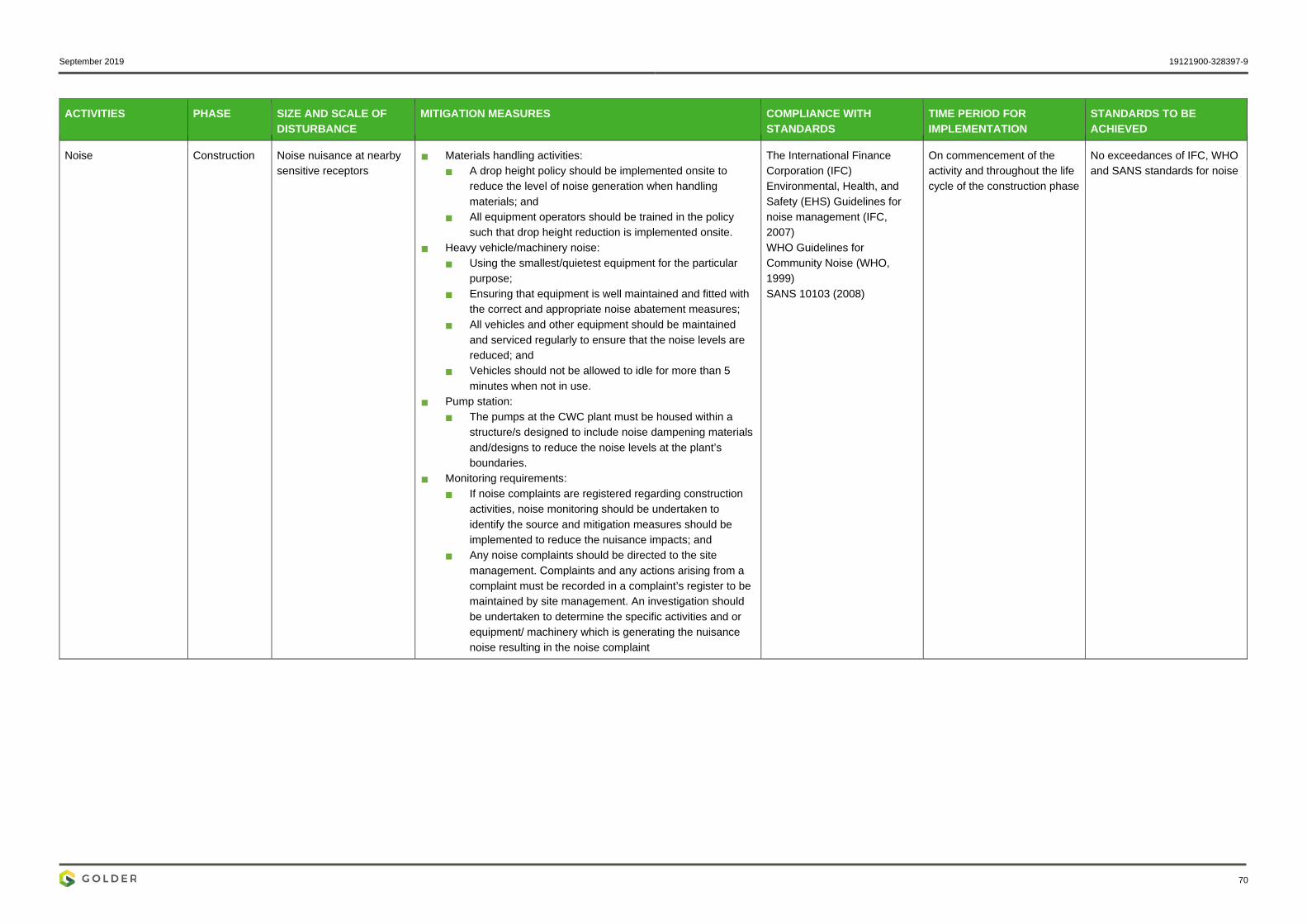
September 2019 19121900-328397-9
70
ACTIVITIES PHASE SIZE AND SCALE OF DISTURBANCE
MITIGATION MEASURES COMPLIANCE WITH STANDARDS
TIME PERIOD FOR IMPLEMENTATION
STANDARDS TO BE ACHIEVED
Noise Construction Noise nuisance at nearby sensitive receptors
Materials handling activities: A drop height policy should be implemented onsite to
reduce the level of noise generation when handling materials; and
All equipment operators should be trained in the policy such that drop height reduction is implemented onsite.
Heavy vehicle/machinery noise: Using the smallest/quietest equipment for the particular
purpose; Ensuring that equipment is well maintained and fitted with
the correct and appropriate noise abatement measures; All vehicles and other equipment should be maintained
and serviced regularly to ensure that the noise levels are reduced; and
Vehicles should not be allowed to idle for more than 5 minutes when not in use.
Pump station: The pumps at the CWC plant must be housed within a
structure/s designed to include noise dampening materials and/designs to reduce the noise levels at the plant’s boundaries.
Monitoring requirements: If noise complaints are registered regarding construction
activities, noise monitoring should be undertaken to identify the source and mitigation measures should be implemented to reduce the nuisance impacts; and
Any noise complaints should be directed to the site management. Complaints and any actions arising from a complaint must be recorded in a complaint’s register to be maintained by site management. An investigation should be undertaken to determine the specific activities and or equipment/ machinery which is generating the nuisance noise resulting in the noise complaint
The International Finance Corporation (IFC) Environmental, Health, and Safety (EHS) Guidelines for noise management (IFC, 2007) WHO Guidelines for Community Noise (WHO, 1999) SANS 10103 (2008)
On commencement of the activity and throughout the life cycle of the construction phase
No exceedances of IFC, WHO and SANS standards for noise

September 2019 19121900-328397-9
71
Table 27: Impacts to be mitigated during operational phase
ACTIVITIES PHASE SIZE AND SCALE OF DISTURBANCE
MITIGATION MEASURES COMPLIANCE WITH STANDARDS
TIME PERIOD FOR IMPLEMENTATION
STANDARDS TO BE ACHIEVED
Establishment and spread of alien invasive species
Operation Pipeline corridor and access tracks to the pipeline
Minimisation Actively control all alien invasive species (AIS) that colonise
areas that have been disturbed during the construction phase. Control should include: Annual treatments along the entire length of the pipeline
and all sites disturbed during construction (e.g. vehicle access tracks and lay-down areas);
A combined approach using both chemical and mechanical control methods; and
Periodic follow-up treatments, with a regularity informed by annual monitoring.
AIS control should continue through all phases of the proposed project until such a time as monitoring indicates AIS are no longer actively establishing.
All recommendations within this document will comply with applicable NEMA and DMR regulations. AGA environmental policies will be applicable to this project.
On commencement of the activity and throughout the life cycle of the operational phase
Minimal spread of alien invasive species; No ecological impact from alien invasive within the project area.
Leaks/spills of contaminated water into the Wonderfonteinspruit.
Operation The site footprint, the channelled valley bottom and hill slope seeps on and close to site
Minimisation Conduct regular (weekly) visual inspections to monitor the
integrity of the pipeline and ensure that no vandalism is occurring;
In the event of a leak, pipeline repairs should be conducted with alacrity; and
Should a leak/spill event occur, a water quality and WET sample should be retrieved immediately upstream and downstream of the spill. This exercise should be repeated one month following the spill to compare to the initial results to ensure maintenance.
All recommendations within this document will comply with applicable NEMA and DMR regulations. AGA environmental policies will be applicable to this project.
On commencement of the activity and throughout the life cycle of the operational phase
No leaks/ spills of contaminated water into the Wonderfonteinspruit.
Increased flows in wetlands due to leaks or pipe failure
Operation The site footprint, the channelled valley bottom and hill slope seeps on and close to site
Avoidance and Minimisation Regular maintenance of the pipeline must be undertaken during
the operational phase. Any identified leaks should be repaired immediately; and
Any damage/erosion caused by pipe failure must be repaired immediately following the incident.
All recommendations within this document will comply with applicable NEMA and DMR regulations. AGA environmental policies will be applicable to this project.
On commencement of the activity and throughout the life cycle of the operational phase
No increases in wetland flows due to pipe leaks
Loss of employment during transition from construction to operational phase
Operational Retrenchment of most labour and/or termination of their fixed term contracts
Invest in community development initiatives to lessen negative socio-economic impacts associated with poverty in line with their SLP.
AGA human resources policies will be applicable to this project.
On commencement of the activity and throughout the life cycle of the operational phase
Minimal negative socio-economic impacts associated with employment loss
Employment creation Operational N/A Recruitment practises should favour local people with the required skills and qualifications (where feasible); and
The recruitment should be well advertised and documented to ensure a transparent process.
All recommendations within this document will comply with applicable NEMA and DMR regulations. AGA employment policies will be applicable to this project.
On commencement of the activity and throughout the life cycle of the operational phase
Unskilled operational workforce to comprise of a high percentage (i.e. >60%) from the local community
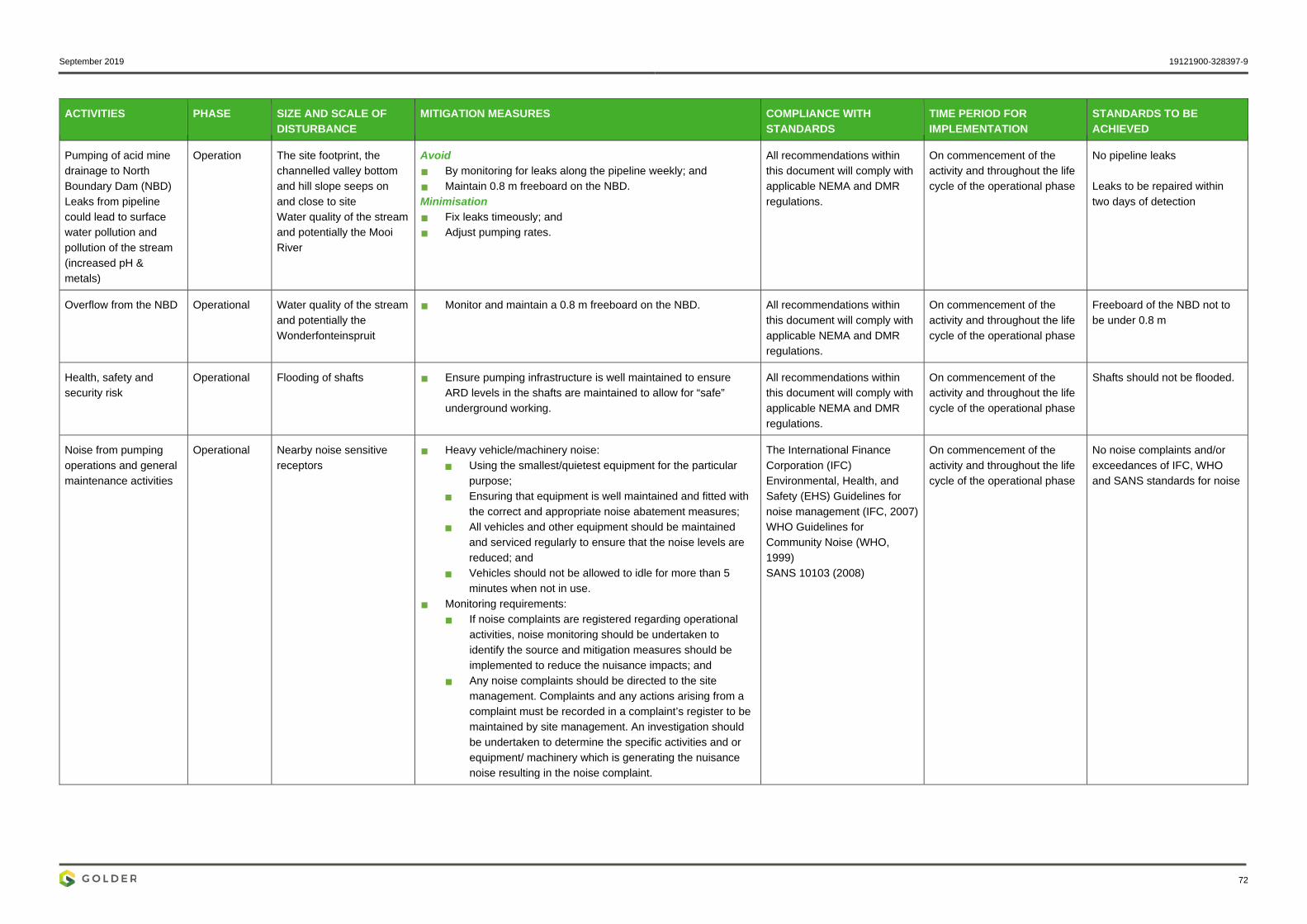
September 2019 19121900-328397-9
72
ACTIVITIES PHASE SIZE AND SCALE OF DISTURBANCE
MITIGATION MEASURES COMPLIANCE WITH STANDARDS
TIME PERIOD FOR IMPLEMENTATION
STANDARDS TO BE ACHIEVED
Pumping of acid mine drainage to North Boundary Dam (NBD) Leaks from pipeline could lead to surface water pollution and pollution of the stream (increased pH & metals)
Operation The site footprint, the channelled valley bottom and hill slope seeps on and close to site Water quality of the stream and potentially the Mooi River
Avoid By monitoring for leaks along the pipeline weekly; and Maintain 0.8 m freeboard on the NBD. Minimisation Fix leaks timeously; and Adjust pumping rates.
All recommendations within this document will comply with applicable NEMA and DMR regulations.
On commencement of the activity and throughout the life cycle of the operational phase
No pipeline leaks Leaks to be repaired within two days of detection
Overflow from the NBD Operational Water quality of the stream and potentially the Wonderfonteinspruit
Monitor and maintain a 0.8 m freeboard on the NBD. All recommendations within this document will comply with applicable NEMA and DMR regulations.
On commencement of the activity and throughout the life cycle of the operational phase
Freeboard of the NBD not to be under 0.8 m
Health, safety and security risk
Operational Flooding of shafts Ensure pumping infrastructure is well maintained to ensure ARD levels in the shafts are maintained to allow for “safe” underground working.
All recommendations within this document will comply with applicable NEMA and DMR regulations.
On commencement of the activity and throughout the life cycle of the operational phase
Shafts should not be flooded.
Noise from pumping operations and general maintenance activities
Operational Nearby noise sensitive receptors
Heavy vehicle/machinery noise: Using the smallest/quietest equipment for the particular
purpose; Ensuring that equipment is well maintained and fitted with
the correct and appropriate noise abatement measures; All vehicles and other equipment should be maintained
and serviced regularly to ensure that the noise levels are reduced; and
Vehicles should not be allowed to idle for more than 5 minutes when not in use.
Monitoring requirements: If noise complaints are registered regarding operational
activities, noise monitoring should be undertaken to identify the source and mitigation measures should be implemented to reduce the nuisance impacts; and
Any noise complaints should be directed to the site management. Complaints and any actions arising from a complaint must be recorded in a complaint’s register to be maintained by site management. An investigation should be undertaken to determine the specific activities and or equipment/ machinery which is generating the nuisance noise resulting in the noise complaint.
The International Finance Corporation (IFC) Environmental, Health, and Safety (EHS) Guidelines for noise management (IFC, 2007) WHO Guidelines for Community Noise (WHO, 1999) SANS 10103 (2008)
On commencement of the activity and throughout the life cycle of the operational phase
No noise complaints and/or exceedances of IFC, WHO and SANS standards for noise

September 2019 19121900-328397-9
73
Table 28: Impacts to be mitigated during decommissioning phase
ACTIVITIES PHASE SIZE AND SCALE OF DISTURBANCE
MITIGATION MEASURES COMPLIANCE WITH STANDARDS
TIME PERIOD FOR IMPLEMENTATION
STANDARDS TO BE ACHIEVED
Pipeline decommissioning
Decommissioning Pipeline plinths, pipeline and access tracks to the pipeline corridor
Minimisation Limit decommissioning lay down areas to a minimum; All decommissioning wastes are to be disposed of at permitted
waste disposal facilities; and Records of all disposal of waste are to be maintained by AGA. Rehabilitate/Repair Scarify compacted areas and revegetate the disturbed areas
with local indigenous grass species; and Monitoring of the rehabilitation success must be undertaken to
ensure the rehabilitation is successful.
All recommendations within this document will comply with applicable NEMA and DMR regulations. AGA environmental policies will be applicable to this project.
On commencement of the activity and throughout the life cycle of the operational phase
Decommissioning to be done in accordance with a decommissioning and rehabilitation plans. Such plans may be within the wider closure plan for the operation.
Soil erosion and sedimentation of the Wonderfonteinspruit
Decommissioning Pipeline plinths, pipeline and access tracks to the pipeline corridor
Rehabilitation Any areas cleared of vegetation during decommissioning
should be stabilised and revegetated using indigenous grass species.
All recommendations within this document will comply with applicable NEMA and DMR regulations. AGA environmental policies will be applicable to this project.
On commencement of the activity and throughout the life cycle of the operational phase
Minimal soil erosion and sedimentation along the Wonderfonteinspruit
Establishment and spread of alien invasive species
Decommissioning Pipeline corridor and access tracks to the pipeline
Minimisation Actively control all alien invasive species (AIS) that colonise
areas that have been disturbed during the decommissioning phase. Control should include: Annual treatments along the entire length of the pipeline; A combined approach using both chemical and
mechanical control methods; and Periodic follow-up treatments, with a regularity informed by
annual monitoring. AIS control should continue through the decommissioning
phase and post decommissioning until such a time as monitoring indicates AIS are no longer actively establishing.
All recommendations within this document will comply with applicable NEMA and DMR regulations. AGA environmental policies will be applicable to this project.
On commencement of the activity and throughout the life cycle of the decommissioning phase
Minimal spread of alien invasive species; No ecological impact from alien invasive within the project area
Employment creation for pipeline disassembly and rehabilitation
Decommissioning N/A Recruitment practises should favour local people with the required skills and qualifications (where feasible); and
The recruitment of labourers should be well advertised and documented to ensure a transparent process.
All recommendations within this document will comply with applicable NEMA and DMR regulations. AGA employment policies will be applicable to this project.
On commencement of the activity and throughout the life cycle of the decommissioning phase
Unskilled labour force to comprise of a high percentage (i.e. >60%) from the local community
Loss of employment during transition from operational to decommissioning phase
Decommissioning Retrenchment of most labour and/or termination of their fixed term contracts
Invest in community development initiatives to lessen negative socio-economic impacts associated with poverty in line with their SLP
AGA human resources policies will be applicable to this project.
On commencement of the activity and throughout the life cycle of the decommissioning phase
Minimal negative socio-economic impacts associated with employment loss
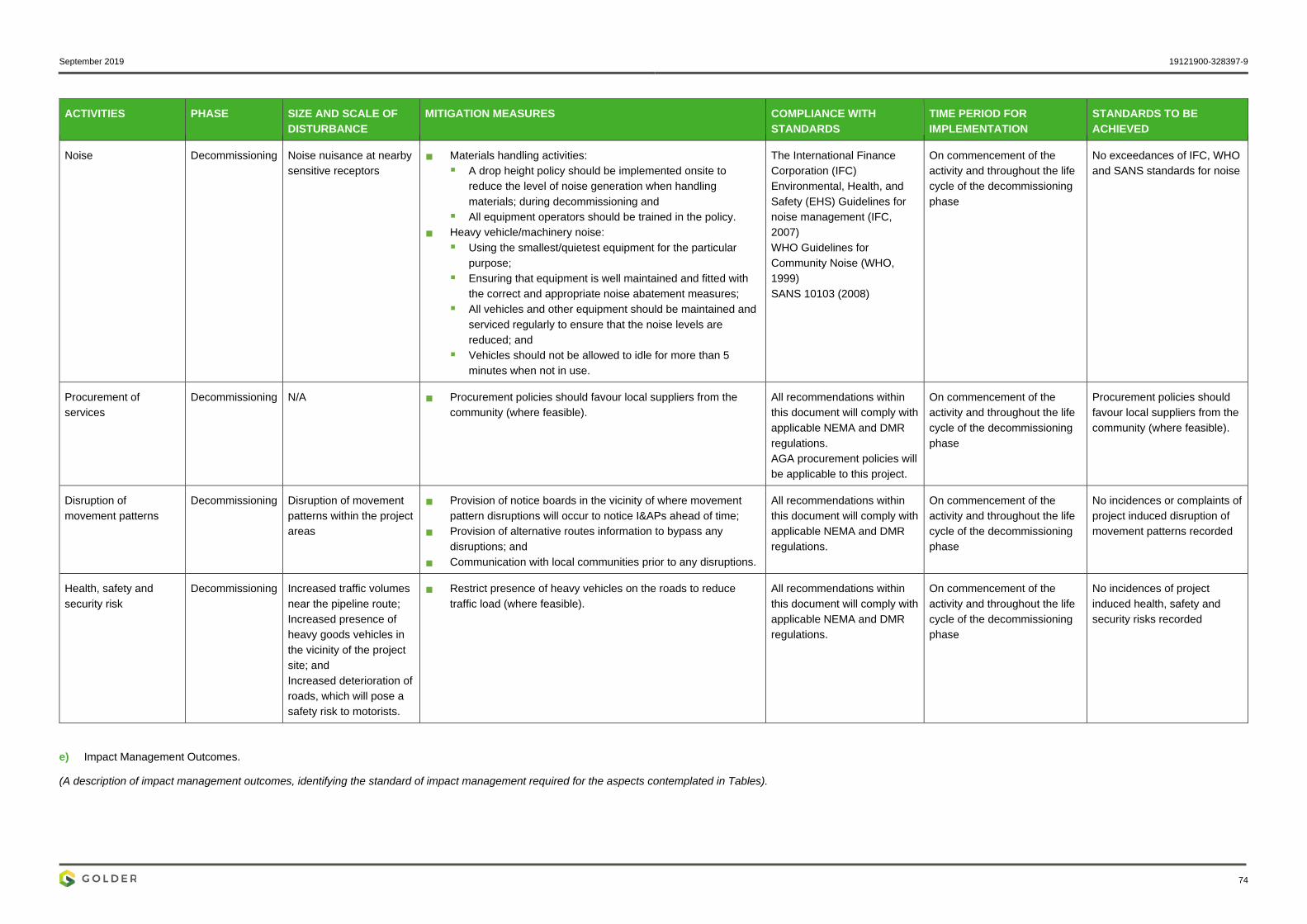
September 2019 19121900-328397-9
74
ACTIVITIES PHASE SIZE AND SCALE OF DISTURBANCE
MITIGATION MEASURES COMPLIANCE WITH STANDARDS
TIME PERIOD FOR IMPLEMENTATION
STANDARDS TO BE ACHIEVED
Noise Decommissioning Noise nuisance at nearby sensitive receptors
Materials handling activities: A drop height policy should be implemented onsite to
reduce the level of noise generation when handling materials; during decommissioning and
All equipment operators should be trained in the policy. Heavy vehicle/machinery noise:
Using the smallest/quietest equipment for the particular purpose;
Ensuring that equipment is well maintained and fitted with the correct and appropriate noise abatement measures;
All vehicles and other equipment should be maintained and serviced regularly to ensure that the noise levels are reduced; and
Vehicles should not be allowed to idle for more than 5 minutes when not in use.
The International Finance Corporation (IFC) Environmental, Health, and Safety (EHS) Guidelines for noise management (IFC, 2007) WHO Guidelines for Community Noise (WHO, 1999) SANS 10103 (2008)
On commencement of the activity and throughout the life cycle of the decommissioning phase
No exceedances of IFC, WHO and SANS standards for noise
Procurement of services
Decommissioning N/A Procurement policies should favour local suppliers from the community (where feasible).
All recommendations within this document will comply with applicable NEMA and DMR regulations. AGA procurement policies will be applicable to this project.
On commencement of the activity and throughout the life cycle of the decommissioning phase
Procurement policies should favour local suppliers from the community (where feasible).
Disruption of movement patterns
Decommissioning Disruption of movement patterns within the project areas
Provision of notice boards in the vicinity of where movement pattern disruptions will occur to notice I&APs ahead of time;
Provision of alternative routes information to bypass any disruptions; and
Communication with local communities prior to any disruptions.
All recommendations within this document will comply with applicable NEMA and DMR regulations.
On commencement of the activity and throughout the life cycle of the decommissioning phase
No incidences or complaints of project induced disruption of movement patterns recorded
Health, safety and security risk
Decommissioning Increased traffic volumes near the pipeline route; Increased presence of heavy goods vehicles in the vicinity of the project site; and Increased deterioration of roads, which will pose a safety risk to motorists.
Restrict presence of heavy vehicles on the roads to reduce traffic load (where feasible).
All recommendations within this document will comply with applicable NEMA and DMR regulations.
On commencement of the activity and throughout the life cycle of the decommissioning phase
No incidences of project induced health, safety and security risks recorded
e) Impact Management Outcomes.
(A description of impact management outcomes, identifying the standard of impact management required for the aspects contemplated in Tables).
September 2019 19121900-328397-9
75
Table 29: Impact Management Actions
ACTIVITY
POTENTIAL IMPACT
MITIGATION TYPE
TIME PERIOD FOR IMPLEMENTATION .
COMPLIANCE WITH STANDARDS
Please refer to Section D above, Table 26, Table 27, and Table 28.

September 2019 19121900-328397-9
76
i) Financial Provision (1) Determination of the amount of Financial Provision The closure costs presented in this report have been determined according to the requirements of the National Environmental Management Act (NEMA, Act No. 107 of 1998) Financial Provisioning Regulations (GN R.1147, Regulations Pertaining to the Financial Provision for Prospecting, Exploration, Mining or Production Operations – as amended), promulgated on 20 November 2015.
(a) Describe the closure objectives and the extent to which they have been aligned to the baseline environment described under the Regulation Based on the current state of the environment within the project area, the proposed project will not have significant impacts on the condition of the environment. Therefore, the closure objective of the proposed project will tie into the AngloGold Ashanti operations closure objectives. It is, however, an aim of AGA to rehabilitate the proposed area to its current state or as close as practicable to this.
(b) Confirm specifically that the environmental objectives in relation to closure have been consulted with landowner and interested and affected parties The Closure report is attached in APPENDIX M and is subject to public comment. Any comments received during the public review period will be included in the comments and responses report.
(c) Provide a rehabilitation plan that describes and shows the scale and aerial extent of the main mining activities, including the anticipated mining area at the time of closure Refer to APPENDIX M for the complete Rehabilitation and Closure Report. Table 30 provides a summary of the closure measures.
Table 30: Closure measures
Aspect Closure measures
Infrastructure areas
Pipeline Dismantle pipeline; Remove concrete plinths; and Remove contaminated soil associated with any leaks from the pipeline (if
applicable) up to 1 m below natural ground level.
Demolition waste Crush concrete demolition waste to suitable size and dispose of within BLV #4 Shaft prior to sealing.
*Ensure the necessary waste licence (as/if required) for the above disposal is acquired prior to disposal. It is assumed that the costs for this aspect will be included in the relevant AGA operation’s mine closure costs.
General surface rehabilitation
Shaping, ripping and vegetation establishment
Shape and level overall disturbed area resulting from the removal of concrete plinths;
Rip footprint area to be free draining; Load and haul topsoil from nearby stockpile(s) for placement at 350 mm
depth; and Establish vegetation using a suitable indigenous seed mix.

September 2019 19121900-328397-9
77
Aspect Closure measures
Post-closure aspects
Rehabilitation monitoring
Conduct rehabilitation monitoring over the rehabilitated area for a period of 5 years post-closure.
Care and maintenance Undertake care and maintenance over the rehabilitated area for a period of 5 years post-closure.
(d) Explain why it can be confirmed that the rehabilitation plan is compatible with the closure objectives The closure costs reflected in this report were based on information provided by AngloGold Ashanti. In those cases where the required information was not available, estimates were made based on Golder’s experience in closure cost estimations. Unit rates for the costing were obtained from Golder’s database.
The reflected costs provide a good indication of the closure costs as at June 2019, providing a sound basis for making the required financial provision.
(e) Calculate and state the quantum of the financial provision required to manage and rehabilitate the environment in accordance with the applicable guideline. Table 31 provides the financial quantum of the closure estimate for which a provision must be made by AGA.
Table 31: Closure cost
Closure Costs, as at June 2019
Closure components Scheduled Closure (2040
1 Infrastructural aspects R 787 608,30
2 Mining aspects R -
3 General surface rehabilitation R 375 156,05
Sub-Total 1 R 1 162 764,35
5 Post-Closure Aspects
5,1 Rehabilitation monitoring R 3 042,50
5,2 Care and maintenance R 17 334,31
Sub-Total 2 R 20 376,81
6 Additional Allowances
6,1 Preliminary and general (12%) R 139 531,72
6,2 Contingencies (10%) R 116 276,44
Sub-Total 3 R 255 808,16

September 2019 19121900-328397-9
78
Closure Costs, as at June 2019
Grand Total Excl. VAT. (Sub-total 1 +2 +3) R 1 438 949,32
(f) Confirm that the financial provision will be provided as determined. AngloGold Ashanti holds the mining right and is liable for the financial provisioning.
Mechanisms for monitoring compliance with and performance assessment against the environmental management programme and reporting thereon, including: g) Monitoring of Impact Management Actions Refer to Part B Environmental Management Programme Report (EMPr), Table 26, Table 27, Table 28, Table 29 and Table 32.
h) Monitoring and reporting frequency Refer to Part B Environmental Management Programme Report (EMPr), Table 26, Table 27, Table 28, Table 29 and Table 32.
i) Responsible persons Refer to Part B Environmental Management Programme Report (EMPr), Table 32.
j) Time period for implementing impact management actions Refer to Part B Environmental Management Programme Report (EMPr), Table 32.
k) Mechanism for monitoring compliance Refer to Part B Environmental Management Programme Report (EMPr), Table 26, Table 27, Table 28, Table 29 and Table 32.

September 2019 19121900-328397-9
79
Table 32: Monitoring
SOURCE ACTIVITY IMPACTS REQUIRING MONITORING PROGRAMMES
FUNCTIONAL REQUIREMENTS FOR MONITORING
ROLES AND RESPONSIBILITIES (FOR THE EXECUTION OF THE MONITORING PROGRAMMES)
MONITORING AND REPORTING FREQUENCY and TIME PERIODS FOR IMPLEMENTING IMPACT MANAGEMENT ACTIONS
Heritage Damage/disturb heritage resources
No activities should take place in areas of archaeological importance Should any chance finds be unearthed, the ECO must be notified
Environmental Control officer (ECO)
Continuously
Biodiversity Vegetation clearing, and earth works during the construction phase
Monitor the extent of vegetation loss due to clearing and earth works Implement plans to reduce the amounts of vegetation cleaning
ECO Continuously during the construction phase
Loss and disturbance of natural habitat
Monitor the levels of disturbance experienced by the natural habitat Implement plans to reduce the amounts of habitat loss
ECO Quarterly
Loss of plant species of conservation concern
Conduct a visual monitoring programme to document the species and locations of flora Delineate protected areas where plant species of conservation concern are found or likely to be found
ECO Quarterly
Soil erosion and sedimentation of the Wonderfonteinspruit
Monitor the levels of soil erosion and sedimentation along the Wonderfonteinspruit
ECO Quarterly

September 2019 19121900-328397-9
80
SOURCE ACTIVITY IMPACTS REQUIRING MONITORING PROGRAMMES
FUNCTIONAL REQUIREMENTS FOR MONITORING
ROLES AND RESPONSIBILITIES (FOR THE EXECUTION OF THE MONITORING PROGRAMMES)
MONITORING AND REPORTING FREQUENCY and TIME PERIODS FOR IMPLEMENTING IMPACT MANAGEMENT ACTIONS
Alien invasive species establishment
Monitor the extent of alien vegetation encroachment Implement plans for alien invasive species eradication
ECO Quarterly
Interruption of wetland hydrology
Monitor wetland water levels and flow rates for changes as project progresses
ECO Quarterly
Deterioration in wetland water quality
Monitor the quality of wetland water Inspect vehicles and equipment for possible leakages Ensure proper rehabilitation measures are adhered to in order to return the water quality to its previous state
ECO Quarterly Daily Continuously
Leaks/spills of contaminated water into the Wonderfonteinspruit
Monitor and inspect spills/ leak contamination; Inspect vehicles and equipment for possible leakages Ensure proper rehabilitation measures are adhered to in order to return the water quality to its previous state
ECO Continuously Daily Continuously
Changed flows in wetland due to leaks or pipe failure
Monitor and inspect pipes for leaks or failure and repair if required
ECO Daily

September 2019 19121900-328397-9
81
SOURCE ACTIVITY IMPACTS REQUIRING MONITORING PROGRAMMES
FUNCTIONAL REQUIREMENTS FOR MONITORING
ROLES AND RESPONSIBILITIES (FOR THE EXECUTION OF THE MONITORING PROGRAMMES)
MONITORING AND REPORTING FREQUENCY and TIME PERIODS FOR IMPLEMENTING IMPACT MANAGEMENT ACTIONS
Surface water Erosion and Sedimentation Monitor the levels of soil erosion and sedimentation along the nearby streams
ECO Quarterly
Leaks from pipeline could lead to pollution of stream (increased metals, low pH)
Monitor and inspect spill contamination Inspect vehicles and equipment for possible leakages Ensure proper rehabilitation measures are adhered to in order to return the water quality to its previous state
ECO Daily Quarterly Continuously
Overflow from North Boundary Dam (NBD)
Monitor and inspect the North Boundary Dam for overflow
ECO Continuously
Palaeontology Damage/disturb Palaeontology resources
Frequent inspection of activities taking place in areas of Paleontological importance Should any chance finds be unearthed, the ECO must be notified
ECO Continuously
Noise Noise If noise complaints are registered regarding construction activities, noise monitoring should be undertaken to identify the source and mitigation measures should be implemented to reduce the nuisance impacts Any noise complaints should be directed to the site management.
ECO If noise complaints are received, then immediately to determine a suitable frequency of noise monitoring thereafter thereafter upon receipt of complaints
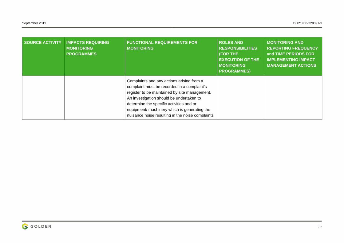
September 2019 19121900-328397-9
82
SOURCE ACTIVITY IMPACTS REQUIRING MONITORING PROGRAMMES
FUNCTIONAL REQUIREMENTS FOR MONITORING
ROLES AND RESPONSIBILITIES (FOR THE EXECUTION OF THE MONITORING PROGRAMMES)
MONITORING AND REPORTING FREQUENCY and TIME PERIODS FOR IMPLEMENTING IMPACT MANAGEMENT ACTIONS
Complaints and any actions arising from a complaint must be recorded in a complaint’s register to be maintained by site management. An investigation should be undertaken to determine the specific activities and or equipment/ machinery which is generating the nuisance noise resulting in the noise complaints

September 2019 19121900-328397-9
83
l) Indicate the frequency of the submission of the performance assessment/ environmental audit report Annual environmental performance audits are to be undertaken.
m) Environmental Awareness Plan (1) Manner in which the applicant intends to inform his or her employees of any environmental risk which may result from their work Employees on site will be notified of environmental risks through the following processes:
Induction – staff will be inducted prior to commencement of any work. Visitors will also be inducted upon arrival to site. Induction procedures already implemented within the AGA mines will be utilised;
Environmental awareness training of staff as and when required, based on the environmental risks and incidents identified within the site and surrounds; and
Daily toolbox talks at the start of a shift.
(2) Manner in which risks will be dealt with in order to avoid pollution or the degradation of the environment. As discussed above, employees will be informed of the possible risks which may result from their work, and employees will be informed of best possible ways to avoid environmental risks from occurring.
Induction and environmental awareness undertaken will address all possible consequences of the environmental risk and mitigation measures to be implemented in order to address the risks. This EMPr will be used as a guide on site to avoid or reduce the impacts that may result from possible risks.
n) Specific information required by the Competent Authority It is confirmed that the financial provision will be reviewed annually. See also section 7.18.
2) UNDERTAKING The EAP herewith confirms
a) the correctness of the information provided in the reports b) the inclusion of comments and inputs from stakeholders and I&APs; c) the inclusion of inputs and recommendations from the specialist reports where relevant; and d) that the information provided by the EAP to interested and affected parties and any responses by the EAP to comments or inputs made by interested and affected. parties are correctly reflected herein. Signature of the environmental assessment practitioner: Name of company: Date
September 2019 19121900-328397-9
84
Signature Page
Golder Associates Africa (Pty) Ltd.
Adam Bennett Etienne Roux Environmental Consultant Senior Review
AB/ER/jep
Reg. No. 2002/007104/07 Directors: RGM Heath, MQ Mokulubete, SC Naidoo, GYW Ngoma Golder and the G logo are trademarks of Golder Associates Corporation
c:\users\mledwaba\documents\pp projects 2019\aga\draft ba report\19121900-328397-9_rep_aga_nema_dmr_ba_rep_draft_2oct19_v3.docx

September 2019 19121900-328397-9
APPENDIX A
I&AP Database

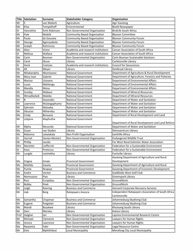
Title Salutation Surname Stakeholder Category Organisation
Mr E van Niekerk Agriculture Agri Gauteng
Ms Elise Tempelhoff Environmental Beeld Newspaper
Dr Hanneline Smit‐Robinson Non Governmental Organisation BirdLife South Africa
Mr Pule Molefe Community Based Organisation Blyvoor Committee
Mr Paulo de Gouveia Community Based Organisation Blyvoor Community Forum
Mr George Kgoroyabolo Community Based Organisation Blyvoor Community Forum
Mr Joseph Rammusa Community Based Organisation Blyvoor Community Forum
Ms Alice Victor Academia and research institutions Cancer Association of South Africa
Dr Melissa Wallace Academia and research institutions Cancer Association of South Africa
Ms Carin Bosman Non Governmental Organisation Carin Bosman Sustainable Solutions
Ms Carol Skuce Library Carletonville Library
Dr Henk Coetzee Academia and research institutions Council for Geoscience
Ms AK Meyer Library Deelkraal Library
Mr Nhlakanipho Nkontwana National Government Department of Agriculture & Rural Development
Ms Mary Jean Gabriel National Government Department of Agriculture, Forestry and Fisheries
Ms Masina Litsoane National Government Department of Environmental Affairs
Mr Lucas Mahlangu National Government Department of Environmental Affairs
Mr Mandla Mona National Government Department of Environmental Affairs
Mr Sunday Mabaso National Government Department of Mineral Resources
Ms Mmadikeledi Malebe National Government Department of Mineral Resources
Mr B Govender National Government Department of Water and Sanitation
Mr Lawrence Mulangaphuma National Government Department of Water and Sanitation
Mr Ephraim Matseba National Government Department of Water and Sanitation
Mr Sibusiso Mthembu National Government Department of Water and Sanitation
Ms Cindy Benyane National Government Department of Rural Development and Land
Mr Lebjane Maphutha National Government
Department of Rural Development and Land Reform
Mr Mpho Nevondo National Government Department of Water and Sanitation
Ms Susan van Staden Library Dienssentrum Library
Ms Makoma Lekalakala Non Profit Organisation Earthlife Africa
Dr Harriet Davies‐Mostert Non Governmental Organisation Endangered Wildlife Trust
Mr Phillip Jacobs Far West Rand Dolimitic Water Association
Mrs Mariette Liefferink Non Governmental Organisation Federation for a Sustainable Environment
Dr Koos Pretorius Non Governmental Organisation Federation for a Sustainable Environment
Mr Lungile Letshekha Library Fochville Library
Ms Zingisa Smale Provincial Government
Gauteng Department of Agriculture and Rural
Development
Ms Matilda Gasela Provincial Government Gauteng Department of Agriculture and Rural
Ms Pumla Ncapayi Provincial Government Gauteng Department of Economic Development
Mr Andre Venter Business and Commerce Goldfields West Golf Club
Ms Nomvuyiso Piyo Library Greenspark Library
Mr Rico Euripidou Non Governmental Organisation GroundWork
Mr Bobby Peek Non Governmental Organisation GroundWork
Mr Leigh Roering Business and Commerce Harvard Corporate Recovery Services
Mr Izak Berg Ratepayers Associa Independent Ratepayers Association of South Africa
Carletonville
Ms Samantha Chapman Business and Commerce Johannesburg Skydiving Club
Mr Eugene Potgieter Business and Commerce Johannesburg Skydiving Club
Ms Mandi Busakwe Library Khutsong South Library
Mr Dani Moreku Library Kokosi Library
Prof Gaigher Ian Non Governmental Organisation Lajuma Environmental Research Centre
Mr Michael Clements Non Governmental Organisation Lawyers for Human Rights
Ms Jessica Lawrence Non Governmental Organisation Lawyers for Human Rights
Ms Naseema Fakir Non Governmental Organisation Legal Resource Centre
Mr Elvis Mphithikezi Local Municipality Merafong City Local Municipality
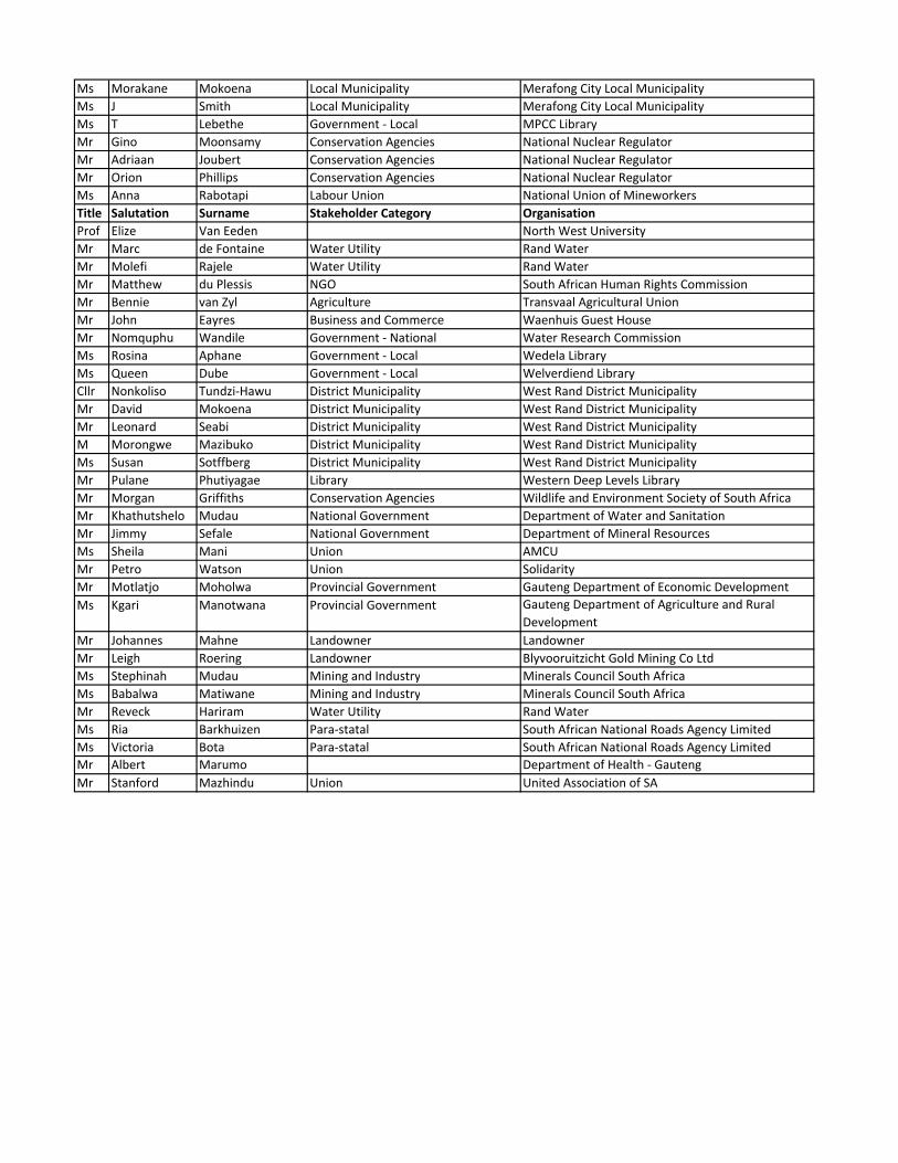
Ms Morakane Mokoena Local Municipality Merafong City Local Municipality
Ms J Smith Local Municipality Merafong City Local Municipality
Ms T Lebethe Government ‐ Local MPCC Library
Mr Gino Moonsamy Conservation Agencies National Nuclear Regulator
Mr Adriaan Joubert Conservation Agencies National Nuclear Regulator
Mr Orion Phillips Conservation Agencies National Nuclear Regulator
Ms Anna Rabotapi Labour Union National Union of Mineworkers
Title Salutation Surname Stakeholder Category Organisation
Prof Elize Van Eeden North West University
Mr Marc de Fontaine Water Utility Rand Water
Mr Molefi Rajele Water Utility Rand Water
Mr Matthew du Plessis NGO South African Human Rights Commission
Mr Bennie van Zyl Agriculture Transvaal Agricultural Union
Mr John Eayres Business and Commerce Waenhuis Guest House
Mr Nomquphu Wandile Government ‐ National Water Research Commission
Ms Rosina Aphane Government ‐ Local Wedela Library
Ms Queen Dube Government ‐ Local Welverdiend Library
Cllr Nonkoliso Tundzi‐Hawu District Municipality West Rand District Municipality
Mr David Mokoena District Municipality West Rand District Municipality
Mr Leonard Seabi District Municipality West Rand District Municipality
M Morongwe Mazibuko District Municipality West Rand District Municipality
Ms Susan Sotffberg District Municipality West Rand District Municipality
Mr Pulane Phutiyagae Library Western Deep Levels Library
Mr Morgan Griffiths Conservation Agencies Wildlife and Environment Society of South Africa
Mr Khathutshelo Mudau National Government Department of Water and Sanitation
Mr Jimmy Sefale National Government Department of Mineral Resources
Ms Sheila Mani Union AMCU
Mr Petro Watson Union Solidarity
Mr Motlatjo Moholwa Provincial Government Gauteng Department of Economic Development
Ms Kgari Manotwana Provincial Government Gauteng Department of Agriculture and Rural
Development
Mr Johannes Mahne Landowner Landowner
Mr Leigh Roering Landowner Blyvooruitzicht Gold Mining Co Ltd
Ms Stephinah Mudau Mining and Industry Minerals Council South Africa
Ms Babalwa Matiwane Mining and Industry Minerals Council South Africa
Mr Reveck Hariram Water Utility Rand Water
Ms Ria Barkhuizen Para‐statal South African National Roads Agency Limited
Ms Victoria Bota Para‐statal South African National Roads Agency Limited
Mr Albert Marumo Department of Health ‐ Gauteng
Mr Stanford Mazhindu Union United Association of SA

September 2019 19121900-328397-9
APPENDIX B
Announcement Letter

1
10 October 2019 19121900_Let001_BIL
BASIC ASSESSMENT, ENVIRONMENTAL MANAGEMENT PROGRAMME REPORT AND WATER USE APPLICATION FOR THE PROPOSED CONSTRUCTION OF A PIPELINE BETWEEN THE COVALENT WATER COMPANY (OLD BLYVOORUITZICHT MINE WORKINGS) AND NORTH BOUNDARY DAM,
ANGLOGOLD ASHANTI LIMITED, CARLETONVILLE, GAUTENG PROVINCE
Draft Basic Assessment (BA) and Environmental Management Programme (EMPr) Report available for public review from Thursday, 10 October 2019 to Monday, 11 November 2019
Dear Stakeholder This letter serves to notify interested and affected parties (I&APs) that AngloGold Ashanti Limited (AGA) is proposing to install an approximately 5km long pipeline and associated surface infrastructure between the Covalent Water Company (old Blyvooruitzicht Mine workings) and the North Boundary Dam. The construction of the proposed pipeline and surface infrastructure is intended to allow for dewatering, treatment and reuse of treated acid mine drainage water as make-up water in the AGA Savuka Gold plant.
Background
The AGA operations in the West Wits mining lease areas are at risk of flooding due to ingress of fissure water from surrounding mining operations. About 24 Mℓ/day of fissure water flows into the underground workings of the defunct Blyvooruitzicht (BLV) Mine, which spans a strike of 6km along the boundary with AGA. If dewatering at the BLV Four and Six Shafts were to cease, fissure water would report to the AGA operations in about 13 days, which would pose a serious risk to the health and safety of AGA personnel and the mining operations.
After the liquidation of the BLV Mine in 2013, AGA established a wholly owned subsidiary, the Covalent Water Company to manage the BLV Mine water and the impacts thereof on the West Wits operations. Covalent Water Company has a 25-year lease to maintain water management infrastructure at the BLV Four and Six Shafts.
Prior to September 2016, Covalent Water Company abstracted 20 Mℓ/d of relatively good quality water from BLV Four and Six Shafts and discharged it into the Wonderfontein Spruit under a directive. About 5 Mℓ/d of acid mine drainage water containing elevated levels of heavy metals and salts has been accumulating in the lower, mined out areas of BLV Shaft Five. Pumping was initiated at the AGA Savuka plant when this water reached a critical level. Savuka plant pumps the BLV Shaft Five water from 81 level to surface, where it is used as make-up water in the Savuka plant circuit. In terms of the current life of mine for the Savuka plant, this source of make-up water will be required for the next 10 years.
Golder Public Participation Office Tel: 011 254 4800
P.O. Box 6001, Halfway House, 1685 Fax: 086 582 1561
Email: [email protected]
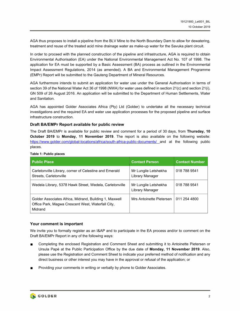
19121900_Let001_BIL
10 October 2019
2
AGA thus proposes to install a pipeline from the BLV Mine to the North Boundary Dam to allow for dewatering, treatment and reuse of the treated acid mine drainage water as make-up water for the Savuka plant circuit.
In order to proceed with the planned construction of the pipeline and infrastructure, AGA is required to obtain Environmental Authorisation (EA) under the National Environmental Management Act No. 107 of 1998. The application for EA must be supported by a Basic Assessment (BA) process as outlined in the Environmental Impact Assessment Regulations, 2014 (as amended). A BA and Environmental Management Programme (EMPr) Report will be submitted to the Gauteng Department of Mineral Resources.
AGA furthermore intends to submit an application for water use under the General Authorisation in terms of section 39 of the National Water Act 36 of 1998 (NWA) for water uses defined in section 21(c) and section 21(i), GN 509 of 26 August 2016. An application will be submitted to the Department of Human Settlements, Water and Sanitation.
AGA has appointed Golder Associates Africa (Pty) Ltd (Golder) to undertake all the necessary technical investigations and the required EA and water use application processes for the proposed pipeline and surface infrastructure construction.
Draft BA/EMPr Report available for public review
The Draft BA/EMPr is available for public review and comment for a period of 30 days, from Thursday, 10 October 2019 to Monday, 11 November 2019. The report is also available on the following website: https://www.golder.com/global-locations/africa/south-africa-public-documents/ and at the following public places.
Table 1: Public places
Public Place Contact Person Contact Number
Carletonville Library, corner of Celestine and Emerald Streets, Carletonville
Mr Lungile Letshekha Library Manager
018 788 9541
Wedela Library, 5378 Hawk Street, Wedela, Carletonville Mr Lungile Letshekha Library Manager
018 788 9541
Golder Associates Africa, Midrand, Building 1, Maxwell Office Park, Magwa Crescent West, Waterfall City, Midrand
Mrs Antoinette Pietersen 011 254 4800
Your comment is important
We invite you to formally register as an I&AP and to participate in the EA process and/or to comment on the Draft BA/EMPr Report in any of the following ways:
Completing the enclosed Registration and Comment Sheet and submitting it to Antoinette Pietersen or Ursula Papé at the Public Participation Office by the due date of Monday, 11 November 2019. Also, please use the Registration and Comment Sheet to indicate your preferred method of notification and any direct business or other interest you may have in the approval or refusal of the application; or
Providing your comments in writing or verbally by phone to Golder Associates.
19121900_Let001_BIL
10 October 2019
3
Way forward
After closure of the public review period, the Draft BA/EMPr Report will be updated with any comments received and will be submitted to the Gauteng Department of Mineral Resources for consideration. The authorities will have 107 days to review the reports and decide whether to authorise the proposed project. Upon receipt of the authority’s decision, stakeholders will be notified of the decision and the appeal process.
Please contact the Public Participation Office if you have any questions, would like more information, to obtain a copy of the draft report, or would like to contribute any comments. You can reach us at the Public Participation Office on the following contact number and/or email addresses: Tel: (011) 254 4800 or email: [email protected].
We look forward to your participation in the project and receiving your comments!
Sincerely,
Golder Associates Africa (Pty) Ltd.
Antoinette Pietersen Adam Bennett Stakeholder Engagement Lead Project Manager
Attachments: Registration and Comment Sheet
Locality Map
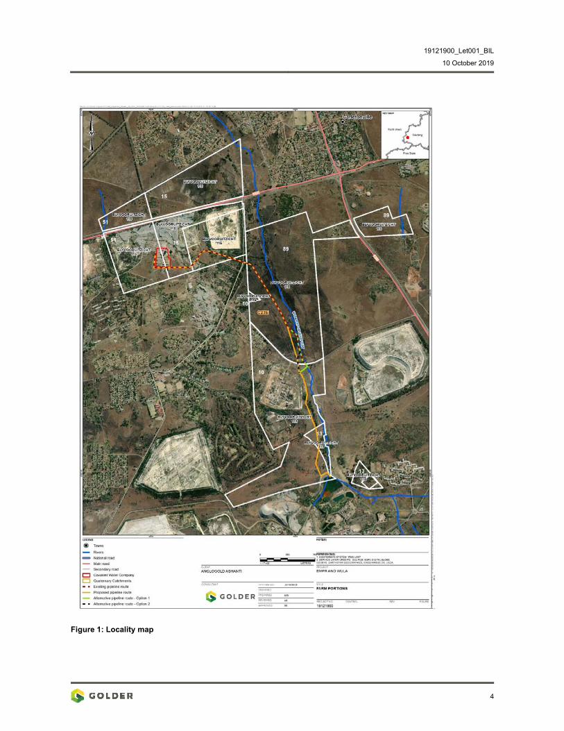
19121900_Let001_BIL
10 October 2019
4
Figure 1: Locality map
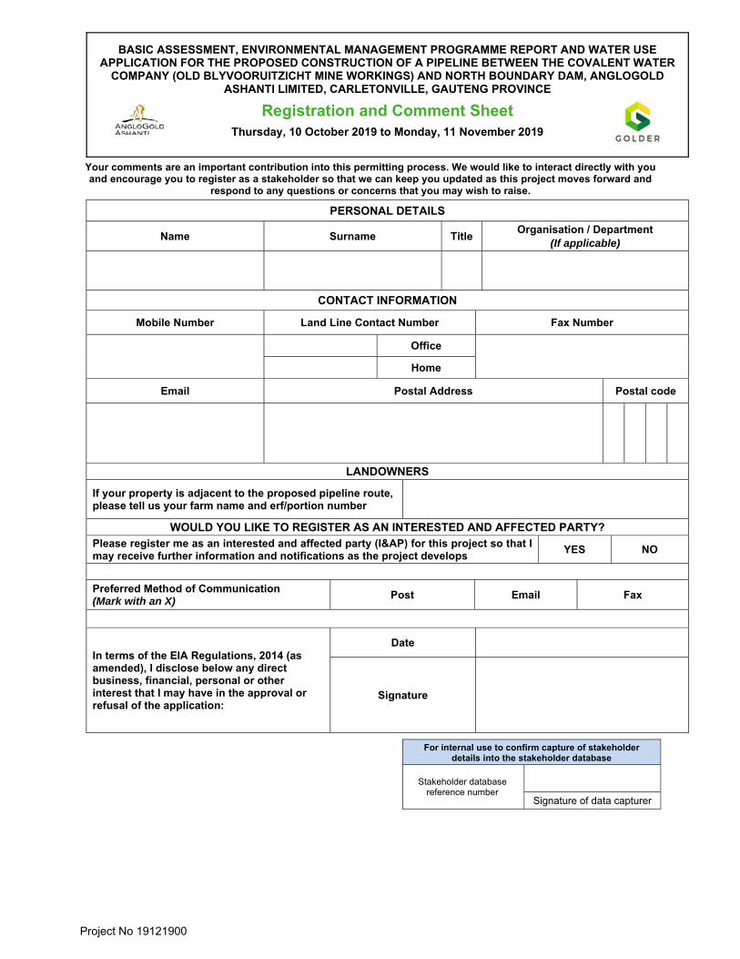
Project No 19121900
BASIC ASSESSMENT, ENVIRONMENTAL MANAGEMENT PROGRAMME REPORT AND WATER USE APPLICATION FOR THE PROPOSED CONSTRUCTION OF A PIPELINE BETWEEN THE COVALENT WATER
COMPANY (OLD BLYVOORUITZICHT MINE WORKINGS) AND NORTH BOUNDARY DAM, ANGLOGOLD ASHANTI LIMITED, CARLETONVILLE, GAUTENG PROVINCE
Registration and Comment Sheet Thursday, 10 October 2019 to Monday, 11 November 2019
Your comments are an important contribution into this permitting process. We would like to interact directly with you and encourage you to register as a stakeholder so that we can keep you updated as this project moves forward and
respond to any questions or concerns that you may wish to raise.
PERSONAL DETAILS
Name Surname Title Organisation / Department
(If applicable)
CONTACT INFORMATION
Mobile Number Land Line Contact Number Fax Number
Office
Home
Email Postal Address Postal code
LANDOWNERS
If your property is adjacent to the proposed pipeline route, please tell us your farm name and erf/portion number
WOULD YOU LIKE TO REGISTER AS AN INTERESTED AND AFFECTED PARTY? Please register me as an interested and affected party (I&AP) for this project so that I may receive further information and notifications as the project develops
YES NO
Preferred Method of Communication (Mark with an X)
Post Email Fax
In terms of the EIA Regulations, 2014 (as amended), I disclose below any direct business, financial, personal or other interest that I may have in the approval or refusal of the application:
Date
Signature
For internal use to confirm capture of stakeholder details into the stakeholder database
Stakeholder database reference number
Signature of data capturer

Project No 19121900
COMMENT(S)
You are welcome to use different pages should you so wish.
I have the following comments to make regarding this project and/or the public consultation process:
Please ask the following of my colleagues / friends to register as Interested and Affected Persons for this environmental authorisation process:
NAME CONTACT DETAILS
PLEASE RETURN THE REGISTRATION AND COMMENT SHEET TO:
Golder Associates Africa
PUBLIC PARTICIPATION OFFICE
Antoinette Pietersen / Ursula Papé
P.O. Box 6001, Halfway House, 1685
Tel: +27(11) 254 4800
Fax: (086) 582 1561
E-mail: [email protected]
THANK YOU

September 2019 19121900-328397-9
APPENDIX C
Advertisement and Site Notices


NOTICE
BASIC ASSESSMENT, ENVIRONMENTAL MANAGEMENT PROGRAMME REPORT AND WATER USE APPLICATION FOR THE PROPOSED
CONSTRUCTION OF A PIPELINE BETWEEN THE COVALENT WATER COMPANY (OLD BLYVOORUITZICHT MINE WORKINGS) AND NORTH
BOUNDARY DAM, ANGLOGOLD ASHANTI LIMITED, CARLETONVILLE, GAUTENG PROVINCE
INVITATION TO REGISTER AS INTERESTED AND AFFECTED PARTY AND TO COMMENT
AngloGold Ashanti Limited (AGA) is proposing to install an approximately 5km long pipeline and associated surface infrastructure from the old Blyvooruitzicht Mine to the North Boundary Dam. The proposed project will be undertaken by Covalent Water Company, a wholly owned subsidiary of AGA established to manage the Blyvooruitzicht Mine water and impacts thereof on the West Wits operations. The construction of the proposed pipeline and surface infrastructure is intended to allow for dewatering, treatment and reuse of treated acid mine drainage water as make-up water in the AGA Savuka Gold plant.
In order to proceed with the planned construction of the pipeline and infrastructure, AGA is required to obtain Environmental Authorisation (EA) under the National Environmental Management Act No. 107 of 1998. The application for EA must be supported by a Basic Assessment (BA) process as outlined in the Environmental Impact Assessment Regulations, 2014 (as amended). A BA and Environmental Management Programme (EMPr) Report will be submitted to the Gauteng Department of Mineral Resources.
AGA furthermore intends to submit an application for water use under the General Authorisation in terms of section 39 of the National Water Act 36 of 1998 (NWA) for water uses defined in section 21(c) and section 21(i), GN 509 of 26 August 2016. An application will be submitted to the Department of Human Settlements, Water and Sanitation.
AGA has appointed Golder Associates Africa (Pty) Ltd (Golder) to undertake all the necessary technical investigations and the required EA and water use application processes for the proposed pipeline and surface infrastructure construction.
DRAFT BA/EMPr REPORT AVAILABLE FOR COMMENT
The Draft BA/EMPr is available for public review and comment for a period of 30 days, from Thursday, 10 October 2019 to Monday, 11 November 2019. The report is also available on the following website: https://www.golder.com/global-locations/africa/south-africa-public-documents/ and at the following public places:
Public Place Contact Person Contact Number
Carletonville Library, corner of Celestine and Emerald Streets, Carletonville
Mr Lungile Letshekha Library Manager
018 788 9541
Wedela Library, 5378 Hawk Street, Wedela, Carletonville
Mr Lungile Letshekha Library Manager
018 788 9541
Golder Associates Africa, Midrand, Building 1, Maxwell Office Park, Magwa Crescent West, Waterfall City, Midrand
Mrs Antoinette Pietersen
011 254 4800
For more information and to register as an I&AP, please contact: Antoinette Pietersen / Ursula Papé
Public Participation Office: Golder Associates Africa (Pty) Ltd;
P O Box 6001, Halfway House, 1685 Tel: (011) 254 4800; Fax (086) 582 1561;
Email: [email protected]
Date of advert: 10 October 2019
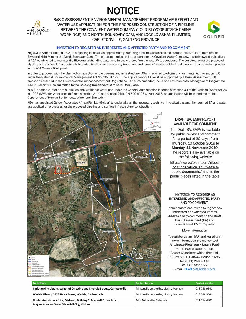
INVITATION TO REGISTER AS INTERESTED AND AFFECTED PARTY
AND TO COMMENT:
Stakeholders are invited to register as Interested and Affected Parties
(I&APs) and to comment on the Draft Basic Assessment (BA) and consolidated EMPr Reports.
More Information
To register as an I&AP and /or obtain more information please contact
Antoinette Pietersen / Ursula PapéPublic Participation Office:
Golder Associates Africa (Pty) Ltd.PO Box 6001, Halfway House, 1685,
Tel: (011) 254 4800, Fax: 086 582 1561
E-mail: [email protected]
BASIC ASSESSMENT, ENVIRONMENTAL MANAGEMENT PROGRAMME REPORT AND WATER USE APPLICATION FOR THE PROPOSED CONSTRUCTION OF A PIPELINE
BETWEEN THE COVALENT WATER COMPANY (OLD BLYVOORUITZICHT MINE WORKINGS) AND NORTH BOUNDARY DAM, ANGLOGOLD ASHANTI LIMITED,
CARLETONVILLE, GAUTENG PROVINCE
AngloGold Ashanti Limited (AGA) is proposing to install an approximately 5km long pipeline and associated surface infrastructure from the old Blyvooruitzicht Mine to the North Boundary Dam. The proposed project will be undertaken by Covalent Water Company, a wholly owned subsidiaryof AGA established to manage the Blyvooruitzicht Mine water and impacts thereof on the West Wits operations. The construction of the proposed pipeline and surface infrastructure is intended to allow for dewatering, treatment and reuse of treated acid mine drainage water as make-up water in the AGA Savuka Gold plant.
In order to proceed with the planned construction of the pipeline and infrastructure, AGA is required to obtain Environmental Authorisation (EA) under the National Environmental Management Act No. 107 of 1998. The application for EA must be supported by a Basic Assessment (BA) process as outlined in the Environmental Impact Assessment Regulations, 2014 (as amended). A BA and Environmental Management Programme(EMPr) Report will be submitted to the Gauteng Department of Mineral Resources.
AGA furthermore intends to submit an application for water use under the General Authorisation in terms of section 39 of the National Water Act 36 of 1998 (NWA) for water uses defined in section 21(c) and section 21(i), GN 509 of 26 August 2016. An application will be submitted to the Department of Human Settlements, Water and Sanitation.
AGA has appointed Golder Associates Africa (Pty) Ltd (Golder) to undertake all the necessary technical investigations and the required EA and water use application processes for the proposed pipeline and surface infrastructure construction.
.
INVITATION TO REGISTER AS INTERESTED AND AFFECTED PARTY AND TO COMMENT
DRAFT BA/EMPr REPORT AVAILABLE FOR COMMENT
The Draft BA/EMPr is available for public review and comment
for a period of 30 days, from Thursday, 10 October 2019 to Monday, 11 November 2019. The report is also available on
the following website
https://www.golder.com/global-locations/africa/south-africa-public-documents/ and at the
public places listed in the table.
Public Place Contact Person Contact Number
Carletonville Library, corner of Celestine and Emerald Streets, Carletonville Mr Lungile Letshekha, Library Manager 018 788 9541
Wedela Library, 5378 Hawk Street, Wedela, Carletonville Mr Lungile Letshekha, Library Manager 018 788 9541
Golder Associates Africa, Midrand, Building 1, Maxwell Office Park,
Magwa Crescent West, Waterfall City, Midrand
Mrs Antoinette Pietersen 011 254 4800
September 2019 19121900-328397-9
APPENDIX D
Registered I&APs


September 2019 19121900-328397-9
APPENDIX E
Noise Impact Assessment


September 2019 19121900-328397-9
APPENDIX F
Geology and Hydrogeology


September 2019 19121900-328397-9
APPENDIX G
Surface Water Impact Assessment and Floodline
Delineation


September 2019 19121900-328397-9
APPENDIX H
Biodiversity Impact Assessment


September 2019 19121900-328397-9
APPENDIX I
Social Scoping Report


September 2019 19121900-328397-9
APPENDIX J
Visual Impact Assessment


September 2019 19121900-328397-9
APPENDIX K
Heritage Impact Assessment

September 2019 19121900-328397-9
APPENDIX L
Palaeontological Impact Assessment: Phase 1 Field Study


September 2019 19121900-328397-9
APPENDIX M
Closure Cost Estimate and Report


September 2019 19121900-328397-9
APPENDIX N
Comment & Responses Report (CRR)


September 2019 19121900-328397-9
APPENDIX O
Document Limitations


golder.com