DRAFT REVISIONS TO PLAN TEXT (For October 3 … · (For October 3 Advisory Group Discussion) ......
57
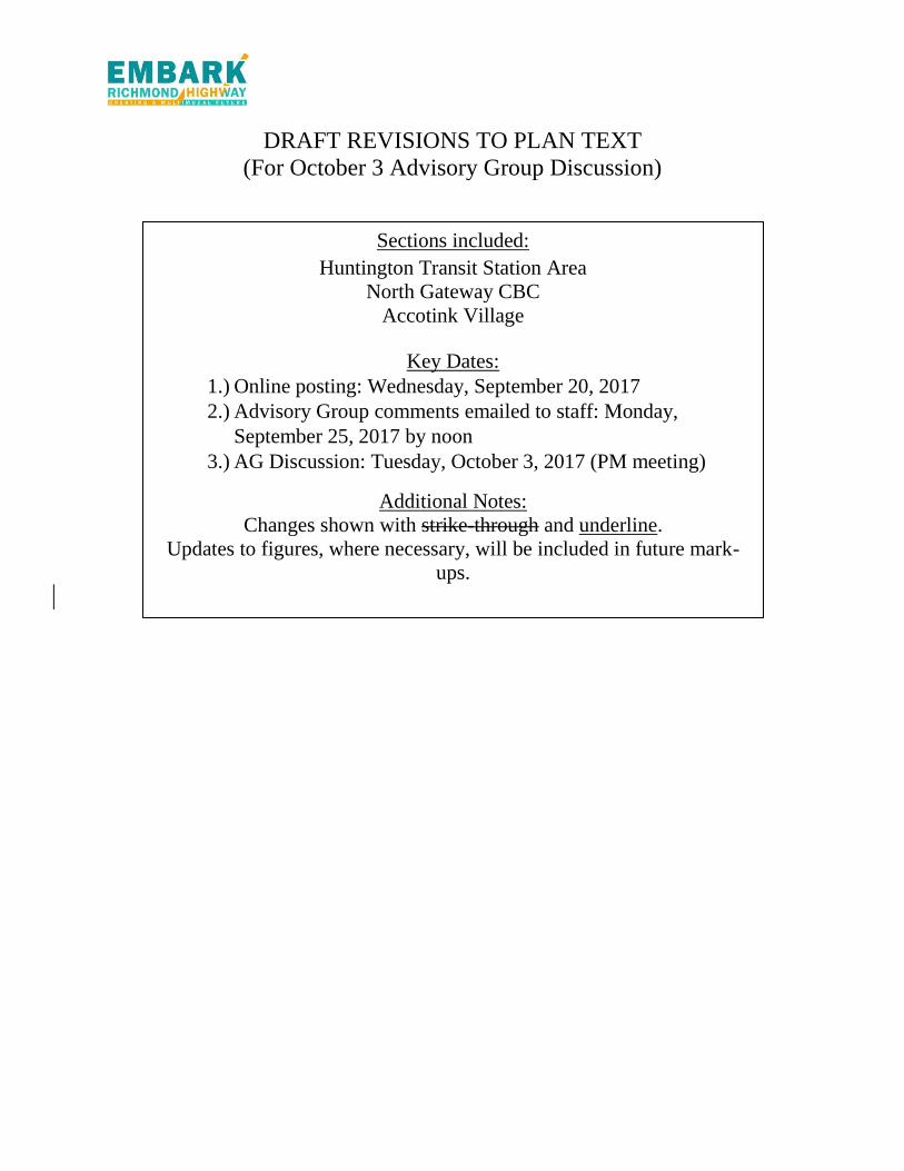
DRAFT REVISIONS TO PLAN TEXT (For October 3 Advisory Group Discussion) Sections included: Huntington Transit Station Area North Gateway CBC Accotink Village Key Dates: 1.) Online posting: Wednesday, September 20, 2017 2.) Advisory Group comments emailed to staff: Monday, September 25, 2017 by noon 3.) AG Discussion: Tuesday, October 3, 2017 (PM meeting) Additional Notes: Changes shown with strike-through and underline. Updates to figures, where necessary, will be included in future mark- ups.
Transcript of DRAFT REVISIONS TO PLAN TEXT (For October 3 … · (For October 3 Advisory Group Discussion) ......
DRAFT REVISIONS TO PLAN TEXT
(For October 3 Advisory Group Discussion)
Sections included:
Huntington Transit Station Area
North Gateway CBC
Accotink Village
Key Dates:
1.) Online posting: Wednesday, September 20, 2017
2.) Advisory Group comments emailed to staff: Monday,
September 25, 2017 by noon
3.) AG Discussion: Tuesday, October 3, 2017 (PM meeting)
Additional Notes:
Changes shown with strike-through and underline.
Updates to figures, where necessary, will be included in future mark-
ups.

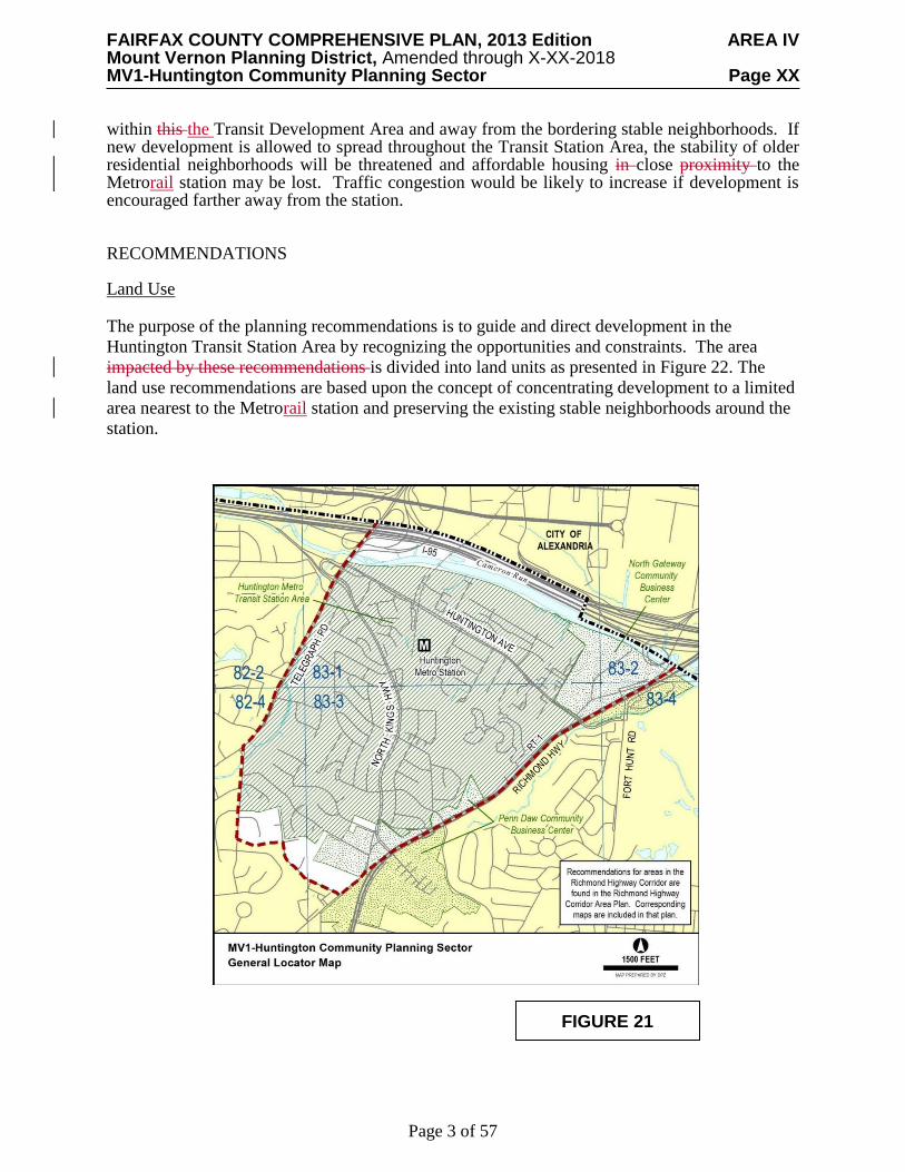
FAIRFAX COUNTY COMPREHENSIVE PLAN, 2013 Edition AREA IV Mount Vernon Planning District, Amended through X-XX-2018 MV1-Huntington Community Planning Sector Page XX
Page 2 of 57
MV1 HUNTINGTON COMMUNITY PLANNING SECTOR
CHARACTER
The majority of the Huntington Community Planning Sector comprises the Huntington
Transit Station Area (TSA). The planning sector is generally bounded by the Capital Beltway/Interstate 95/495 (I-95/I-495), Telegraph Road, Furman Lane, South Kings Highway, and Richmond Highway (Route 1) as shown in Figure 21.
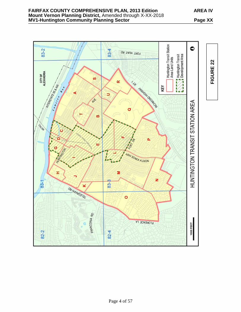
The TSA is divided into land units with specific recommendations made for each land unit.
The area closest to the Metrorail station, where there is the greatest opportunity for transit-oriented redevelopment, is designated as a Transit Development Area. The boundaries of the Huntington TSA and the Transit Development Area are outlined on the area maps in Figure 22. The Huntington Community Planning Sector also contains portions of the North Gateway and Penn Daw Community Business Centers (CBCs) located on the west side of Richmond Highway. Plan recommendations for these CBCs can be found in the Area IV Volume of the Comprehensive Plan Richmond Highway Corridor Area, Area IV Volume of the Comprehensive Plan.
The Huntington Metrorail Station is located south of the City of Alexandria in the triangle of
land bounded by between Huntington Avenue, Richmond Highway and North Kings Highway (Route 241). The station lies near the center of a developed area which consists primarily of residential uses. Residential development ranges from single-family detached units and duplexes in stable neighborhoods to high-rise apartments and condominiums. There are also clusters of local retail development located at major intersections
CONCEPT FOR FUTURE DEVELOPMENT
The Huntington Transit Station Area (TSA) is recommended by the The Concept for Future Development recommends the Huntington TSA as one of several mixed-use centers that are located around the fourteen Metrorail stations in Fairfax County. They are shown as part of the Adopted Regional System for Metrorail. These Metrorail stations provide the opportunity for non-automobile dependent development to occur in a manner that is compatible with the existing nearby land uses. As recommended in the Concept, the intention of this designation is to capitalize on the opportunity to provide transit-focused housing and employment locations, while still maintaining the viability of existing, nearby land uses.
A Bus Rapid Transit (BRT) system with the potential for nine stations is planned to connect
Huntington Metrorail Station to Fort Belvoir. The BRT station in the Huntington area is generally
planned in Land Unit E as shown in Figure X. The BRT system is envisioned to eventually connect
to Woodbridge in Prince William County, which would include additional stations in Fairfax
County. An additional transportation analysis will need to be completed for this extension.
Additional details about the BRT system are contained in the Richmond Highway Corridor Area,
Area IV Volume of the Comprehensive Plan
The Transit Development Area is a smaller area within the TSA located within a 5 to 7 minute walk of the transit station, and planned for higher-density, mixed-use development. This concept of the Transit Development Area is appropriate for the Huntington Metro Station Area in particular. Within the Transit Station Area, most Most of the redevelopable land is located within a 5 to 7 minute walking distance from the Huntington Metrorail Station, which corresponds to the Transit Development Area boundary. New development should be channeled into land units
FAIRFAX COUNTY COMPREHENSIVE PLAN, 2013 Edition AREA IV Mount Vernon Planning District, Amended through X-XX-2018 MV1-Huntington Community Planning Sector Page XX
Page 3 of 57
within this the Transit Development Area and away from the bordering stable neighborhoods. If new development is allowed to spread throughout the Transit Station Area, the stability of older residential neighborhoods will be threatened and affordable housing in close proximity to the Metrorail station may be lost. Traffic congestion would be likely to increase if development is encouraged farther away from the station. RECOMMENDATIONS Land Use The purpose of the planning recommendations is to guide and direct development in the
Huntington Transit Station Area by recognizing the opportunities and constraints. The area
impacted by these recommendations is divided into land units as presented in Figure 22. The
land use recommendations are based upon the concept of concentrating development to a limited
area nearest to the Metrorail station and preserving the existing stable neighborhoods around the
station.
FIGURE 21
FAIRFAX COUNTY COMPREHENSIVE PLAN, 2013 Edition AREA IV Mount Vernon Planning District, Amended through X-XX-2018 MV1-Huntington Community Planning Sector Page XX
Page 4 of 57
FIG
UR
E 2
2

FAIRFAX COUNTY COMPREHENSIVE PLAN, 2013 Edition AREA IV Mount Vernon Planning District, Amended through X-XX-2018 MV1-Huntington Community Planning Sector Page XX
Page 5 of 57
Where substantial parcel consolidation is specified, it is intended that such consolidations will provide for projects that function in a well-designed and efficient manner and provide for the development of unconsolidated parcels in conformance with the Area Plan.
The Huntington Sector has areas of stable residential neighborhoods. Infill development
within this sector should be of a compatible use, type and intensity in accordance with the guidance provided by the Policy Plan under Land Use Objectives 8 and 14.
By its distinct character, the Huntington Transit Station Area warrants special development
conditions and incentives that may not be applied elsewhere in the county. Implementation strategies may include special transit zoning, urban design guidelines, parking policies and funding mechanisms for roads and other public improvements. For the most part, these conditions and other implementation strategies only come into effect for development at the higher densities and intensities recommended by the Plan.
Traffic reduction measures such as ride-sharing, transit incentives and other transportation systems management strategies are applicable to this area. While the county is striving to implement the planned road improvements and encouraging the use of transportation systems management strategies, the development community must address the concerns of traffic congestion for any new development within the Transit Station Area. This may be addressed by any number of responses, including transportation systems management, financing for road improvements and/or the deferral of development until adequate road improvements have been implemented. Outside of the Huntington Transit Station Area, existing stable residential neighborhoods should be preserved. Commercial areas existing near the Huntington Transit Station Area should be encouraged to improve.
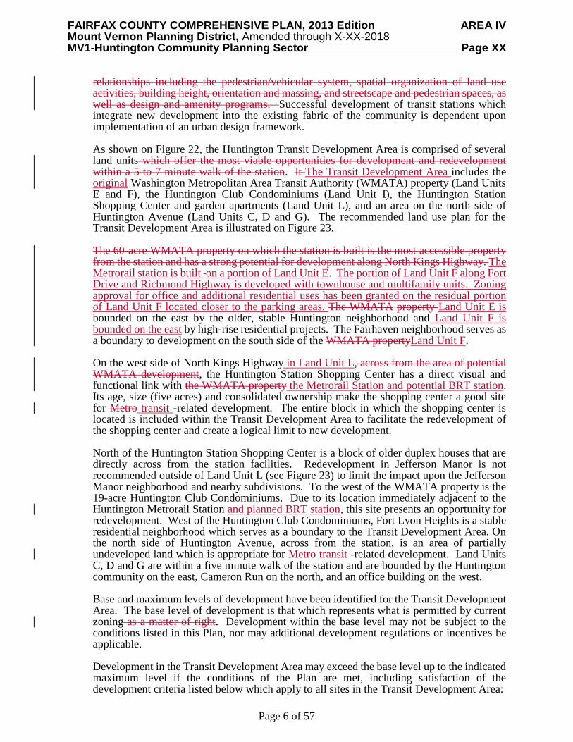
Transit Development Area Conditions and Recommendations An area determined to be appropriate for higher intensity, mixed-use development within the Huntington Transit Station Area is identified as the "Transit Development Area." As illustrated in Figure 22, the Transit Development Area is comprised of several land units which offer the most viable opportunities for development and redevelopment. The concentration of development in the Transit Development Area recognizes the well-founded criterion that the greatest impact of a mass transportation facility occurs in areas within a 5 to 7 minute walk of the station. Development within this convenient walking distance would generate a substantial number of walk-on BRT and Metrorail riders, while development beyond this distance would generate less ridership and more vehicle trips, thereby exacerbating road congestion in the vicinity of the Metrorail station. In suburban locations such as the Huntington Transit Development Area, mixed-use development with a predominance of residential uses is highly appropriate. The residential component will contribute most of the Metrorail and BRT commuters, while the nonresidential use will encourage off-peak and reverse ridership, provide a variety of activities and enhance the economics of land development. The Transit Development Area provides a strong visual and functional focus due to its central location on a topographically prominent site in the Transit Station Area. Development in this area will enhance the character of the community, increase patronage for existing local business, and lead to reinvestment in the surrounding neighborhoods. The area will become a place where county residents can live, work and shop without excessive dependence upon the automobile, thus realizing some of the county's key policy objectives. Special planning and development guidelines for the Transit Development Area ensure that this area effectively serves the multiple activities associated with a major commuter environment. These activities within the Transit Development Area represent a variety of
FAIRFAX COUNTY COMPREHENSIVE PLAN, 2013 Edition AREA IV Mount Vernon Planning District, Amended through X-XX-2018 MV1-Huntington Community Planning Sector Page XX
Page 6 of 57
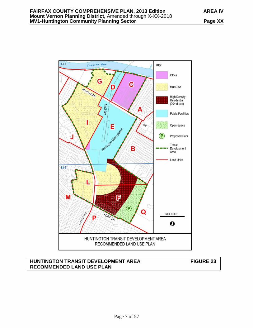
relationships including the pedestrian/vehicular system, spatial organization of land use activities, building height, orientation and massing, and streetscape and pedestrian spaces, as well as design and amenity programs. Successful development of transit stations which integrate new development into the existing fabric of the community is dependent upon implementation of an urban design framework. As shown on Figure 22, the Huntington Transit Development Area is comprised of several land units which offer the most viable opportunities for development and redevelopment within a 5 to 7 minute walk of the station. It The Transit Development Area includes the original Washington Metropolitan Area Transit Authority (WMATA) property (Land Units E and F), the Huntington Club Condominiums (Land Unit I), the Huntington Station Shopping Center and garden apartments (Land Unit L), and an area on the north side of Huntington Avenue (Land Units C, D and G). The recommended land use plan for the Transit Development Area is illustrated on Figure 23. The 60-acre WMATA property on which the station is built is the most accessible property from the station and has a strong potential for development along North Kings Highway. The Metrorail station is built on a portion of Land Unit E. The portion of Land Unit F along Fort Drive and Richmond Highway is developed with townhouse and multifamily units. Zoning approval for office and additional residential uses has been granted on the residual portion of Land Unit F located closer to the parking areas. The WMATA property Land Unit E is bounded on the east by the older, stable Huntington neighborhood and Land Unit F is bounded on the east by high-rise residential projects. The Fairhaven neighborhood serves as a boundary to development on the south side of the WMATA propertyLand Unit F. On the west side of North Kings Highway in Land Unit L, across from the area of potential WMATA development, the Huntington Station Shopping Center has a direct visual and functional link with the WMATA property the Metrorail Station and potential BRT station. Its age, size (five acres) and consolidated ownership make the shopping center a good site for Metro transit -related development. The entire block in which the shopping center is located is included within the Transit Development Area to facilitate the redevelopment of the shopping center and create a logical limit to new development. North of the Huntington Station Shopping Center is a block of older duplex houses that are directly across from the station facilities. Redevelopment in Jefferson Manor is not recommended outside of Land Unit L (see Figure 23) to limit the impact upon the Jefferson Manor neighborhood and nearby subdivisions. To the west of the WMATA property is the 19-acre Huntington Club Condominiums. Due to its location immediately adjacent to the Huntington Metrorail Station and planned BRT station, this site presents an opportunity for redevelopment. West of the Huntington Club Condominiums, Fort Lyon Heights is a stable residential neighborhood which serves as a boundary to the Transit Development Area. On the north side of Huntington Avenue, across from the station, is an area of partially undeveloped land which is appropriate for Metro transit -related development. Land Units C, D and G are within a five minute walk of the station and are bounded by the Huntington community on the east, Cameron Run on the north, and an office building on the west.
Base and maximum levels of development have been identified for the Transit Development Area. The base level of development is that which represents what is permitted by current zoning as a matter of right. Development within the base level may not be subject to the conditions listed in this Plan, nor may additional development regulations or incentives be applicable. Development in the Transit Development Area may exceed the base level up to the indicated maximum level if the conditions of the Plan are met, including satisfaction of the development criteria listed below which apply to all sites in the Transit Development Area:
FAIRFAX COUNTY COMPREHENSIVE PLAN, 2013 Edition AREA IV Mount Vernon Planning District, Amended through X-XX-2018 MV1-Huntington Community Planning Sector Page XX
Page 7 of 57
HUNTINGTON TRANSIT DEVELOPMENT AREA FIGURE 23 RECOMMENDED LAND USE PLAN

FAIRFAX COUNTY COMPREHENSIVE PLAN, 2013 Edition AREA IV Mount Vernon Planning District, Amended through X-XX-2018 MV1-Huntington Community Planning Sector Page XX
Page 8 of 57
HUNTINGTON TRANSIT DEVELOPMENT AREA FIGURE 24
PEDESTRIAN CIRCULATION
FAIRFAX COUNTY COMPREHENSIVE PLAN, 2013 Edition AREA IV Mount Vernon Planning District, Amended through X-XX-2018 MV1-Huntington Community Planning Sector Page XX
Page 9 of 57
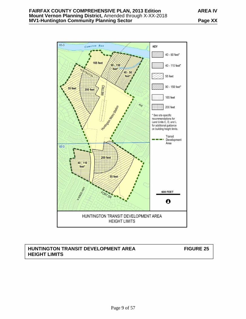
HUNTINGTON TRANSIT DEVELOPMENT AREA FIGURE 25 HEIGHT LIMITS

FAIRFAX COUNTY COMPREHENSIVE PLAN, 2013 Edition AREA IV Mount Vernon Planning District, Amended through X-XX-2018 MV1-Huntington Community Planning Sector Page XX
Page 10 of 57
HUNTINGTON TRANSIT DEVELOPMENT AREA FIGURE 26
OPEN SPACE AND LANDSCAPED BUFFERS
FAIRFAX COUNTY COMPREHENSIVE PLAN, 2013 Edition AREA IV Mount Vernon Planning District, Amended through X-XX-2018 MV1-Huntington Community Planning Sector Page XX
Page 11 of 57
1. Development in accordance with the Urban Design Concept Plan for the Transit
Development Area as illustrated in Figures 24, 25 and 26. 2. Proffer of Commitment to a development plan that provides high quality site design,
streetscaping, urban design and development amenities. 3. Provision of off-site public road improvements, or funding of such improvements,
associated with the development traffic impact and/or a commitment to reduce development traffic through transportation systems management strategies, especially those which encourage the use of transit.
4. Compatibility in style, scale, and materials with the adjacent development and the
surrounding community. 5. Provision of energy conservation features that will benefit future residents of the
development.
6. In areas planned for residential development, provision of moderately-priced housing that will serve the needs of the county's population. Housing development should only be approved for the maximum level of development if a minimum of 15 percent of the dwelling units are provided for low- and moderate-income households.
7. Land consolidation and/or coordination of development plans with adjacent
development to achieve Comprehensive Plan objectives. 8. The provision of structured parking (above or below grade). If surface parking is
permitted it should be screened at the street level. 9. Consolidation of vehicular access points to minimize interference with commuter
access to the Metrorail and BRT stations. 10. Identification and preservation of significant heritage resources.
In addition to these ten general development criteria, development must also respond to site-specific conditions. These conditions are listed in the following sections for the individual sites composing the Transit Development Area. The maximum level of development for the Transit Development Area is an interpretation of the aggregate development potential for the Transit Development Area. Refer to specific land units for guidance on the recommended square feet of development, number of dwelling units, and other conditions. For the maximum level of development, the following must be met:
• All site-specific conditions; • Criteria #1, #2 and #3 of the general development criteria listed above; and • All of the remaining applicable general development criteria.
The maximum level of development for the Transit Development Area is the following: • 1,470,000 gross square feet of office space;
- Up to 120,000 square feet of office space may be converted to hotel use in Land Unit I;
• 105,000 gross square feet of retail space;
FAIRFAX COUNTY COMPREHENSIVE PLAN, 2013 Edition AREA IV Mount Vernon Planning District, Amended through X-XX-2018 MV1-Huntington Community Planning Sector Page XX
Page 12 of 57
• 3,462 dwelling units; • 200-room hotel with conference facilities or an additional 250 dwelling units on Land
Unit E; and In Land Unit L, an additional 50,000 to 85,000 gross square feet of retail and office space.
(Land Units E and F) The WMATA Property
The 60-acre WMATA property is occupied by the Huntington Metrorail Station and associated parking facilities, townhouse and multifamily uses, and Mount Eagle Park. A potential BRT station is generally planned in this area as shown in Figure X. There is also a privately-owned parcel associated with the WMATA property; Parcel 83-1((7))1A is a .34-acre lot along North Kings Highway planned for office use. The portion of Land Unit E which is occupied by the Metrorail station, the parking garage, and the parking lot along Huntington Avenue is planned for public facilities. Air rights development over the station and the parking facilities may have long-term potential. For the 35-acre area south of the station, the following mix of uses is recommended within the maximum levels shown:
• 250,000 gross square feet of office space; • 30,000 gross square feet of retail space; • 600 dwelling units; and • 200-room hotel with conference facilities or 250 additional dwelling units.
In addition, the following uses should be incorporated into this development: • The existing 900+ space Metro surface parking lot should be reconfigured into an
on-site underground or above-ground facility up to six stories. Adequate buffering and landscaping around the parking structure should be provided adjacent to nearby neighborhoods;
• To support the development, aApproximately 9 to 12 X acres of the WMATA property should be was dedicated to Fairfax County for Mount Eagle Park in order to provide needed park facilities in this high density area and to buffer Metrorail-related development from the existing community. The development of both passive and active recreation facilities is suggested; and
The development of the WMATA property should be in accordance with the urban design concept plan shown in Figures 24, 25 and 26. The commercial uses, including the optional hotel, should be clustered around a public plaza near the Metrorail station and planned BRT station and North Kings Highway. Residential use should be located east and south of this cluster to provide a transition to surrounding residential development. As shown in Figure 26, Mount Eagle Park and/or open space should be accessible to, and provide buffering for, the Huntington community, the high-rise residential projects located east of the WMATA property, and the Fairhaven community.
FAIRFAX COUNTY COMPREHENSIVE PLAN, 2013 Edition AREA IV Mount Vernon Planning District, Amended through X-XX-2018 MV1-Huntington Community Planning Sector Page XX
Page 13 of 57
In order to develop except at the base level, all the applicable general development criteria listed for all sites in the Transit Development Area should be satisfied, except that in lieu of criterion #6, affordable housing should be provided in accordance with the county’s Affordable Dwelling Unit Ordinance. In addition, the following site-specific conditions must be met:
• Development should be coordinated under one planning program for the entire site; • Retail uses should be limited to the ground level of proposed buildings along the main
pedestrian access routes to the Metrorail station; • Nonresidential uses should be clustered around the public space near the Metrorail
station. Residential development should occur towards the south and east of the station in order to provide an appropriate transition to adjacent neighborhoods;
• Provision of integrated pedestrian and bicycle systems with features such as covered and secure bicycle storage facilities, walkways, trails and sidewalks, enhanced crosswalks providing connections to adjacent neighborhoods, and amenities such as street trees, benches, bus shelters, and adequate lighting;
• Creation of usable open spaces such as pocket parks, plazas, common greens and recreation-focused urban parks on the site;
• Provision of environmental elements into the design, including buildings designed to meet the criteria for LEED Silver (or comparable rating system) green building certification and innovative stormwater management techniques;
• Buildings should be designed to accommodate telecommunications antennas and equipment cabinets in a way that is compatible with the building’s architecture and conceals the antennas and equipment from surrounding properties and roadways;
• Underground parking, or parking built into the slope, is preferred to minimize visual intrusion and create a pedestrian oriented atmosphere. Architectural detailing, screening, lighting, and landscaping that is aesthetically appealing should be employed along exposed parking levels to mitigate negative impacts. Efforts should be taken to face above ground parking structures to service streets, and they should be designed to be consistent with surrounding buildings. On-street and incidental surface parking shall be allowed consistent with urban design guidelines; and
• Vehicular access to private development should be separated from vehicle access to the Metrorail station.
Land Unit I Land Unit I is planned for 16-20 dwelling units per acre and is presently predominantly developed with the Huntington Club Condominiums. This land unit presents an opportunity for redevelopment due to its location within the Transit Development Area, adjacent to the Huntington Metrorail Station and planned BRT station. As an option, redevelopment of Land Unit I with transit-oriented mixed-use up to an intensity of 3.0 FAR is planned. Tax Map parcel 83-1((1))32 should be consolidated with the Huntington Club Condominiums (Tax Map parcels 83-1((23)) ALL) to redevelop under this option. The land use mix should consist of approximately to 75 percent residential use and 25 percent office use, with ground floor retail use. Approximately 120,000 square feet of office use may be converted to hotel use. To reduce the visual impact of new development

FAIRFAX COUNTY COMPREHENSIVE PLAN, 2013 Edition AREA IV Mount Vernon Planning District, Amended through X-XX-2018 MV1-Huntington Community Planning Sector Page XX
Page 14 of 57
upon the surrounding community, development height should taper as shown in Figure 25. A maximum height of 200 feet is recommended for the northeastern portion of the land unit, adjacent to the Metrorail property. Building heights are recommended to taper down to 55 feet along the western and southern edges of the site to be compatible with the existing residential development. Well-designed, publicly accessible urban plazas and parks that are integrated with the sloping terrain should enhance recreational options and create a sense of place for the development, consistent with the Urban Park Framework document, as modified by the Fairfax County Park Authority. Internal roadways, trails, sidewalks, and street crossings should connect buildings and open spaces. Streetscape treatments should include trees, landscaping, sidewalks, bicycle facilities, street furniture, and various paving textures, to the extent possible. Redevelopment should address the Guidelines for Neighborhood Redevelopment and be phased in accordance with guidance set forth within the Guidelines for Transit-Oriented Development contained in Appendix 8 and 11, respectively, of the Land Use Element of the Policy Plan. Phasing should be done in such a way as to accommodate the relocation of existing residents of the Huntington Club Condominiums. Given the projected capacity issues in the Huntington Transit Station Area, the number of single occupancy vehicle (SOV) trips made to the subject site should be reduced. Steps should be taken to encourage carpooling, vanpooling, ridesharing, bicycle and pedestrian use, transit use, teleworking, flexible work schedules, and alternative work schedules. Integrated pedestrian and bicycle systems with features such as, walkways, trails and sidewalks, amenities such as street trees, benches, bus shelters, and adequate lighting should be provided. To more easily facilitate transit ridership, a new direct pedestrian and bicycle connection to the Huntington Metrorail Station should be constructed from within the site. In accordance with the Guidelines for Transit-Oriented Development, a higher level of delay may be acceptable as a result of redevelopment within Land Unit I. If the necessary transportation improvements are found to be in conflict with pedestrian and bicycle access recommendations found in the Guidelines for Transit-Oriented Development, improvements, measures and/or monetary contributions to a fund to enable the application of techniques to reduce vehicle trips by an appropriate amount in and around the area should be made. As a component of transportation mitigation, a substantial Transportation Demand Management (TDM) program should be implemented within Land Unit I. The following TDM program elements should be considered: • A TDM trip reduction goal of 45 percent TDM goal should be sought for both the
residential and office components of the site; • TDM program components appropriate for a moderate to full TDM plan; • A substantial monitoring and reporting program which would include annual traffic
counts and model split surveys every three years; • Annual reports, to be submitted to the Fairfax County Department of Transportation,
relaying the results of the monitoring and any programmatic highlights; • Monetary contributions to an incentive fund and a remedy fund, as well as fees for non-
compliance; • Parking reductions, providing less parking than required by code; and

FAIRFAX COUNTY COMPREHENSIVE PLAN, 2013 Edition AREA IV Mount Vernon Planning District, Amended through X-XX-2018 MV1-Huntington Community Planning Sector Page XX
Page 15 of 57
• Bicycle amenities, including multi-use trails and bicycle lanes, covered and secure bicycle storage facilities, and shower/locker facilities.
Stormwater quantity and quality control measures that are substantially more extensive than minimum requirements should be provided, with the goal of reducing the total runoff volume. The emphasis should be on low impact development (LID) techniques and best management practices (BMPs) that evapotranspire water, filter water through vegetation and/or soil, and return water in to the ground or reuse it and should include such features as rooftop landscaping. Stormwater management measures that are sufficient to attain the stormwater design-quantity control credit and stormwater design-quality control credit of the most current version of the Leadership in Energy and Environmental Design for New Construction (LEED®-NC) or Leadership in Energy and Environmental Design for Core and Shell (LEED®-CS) rating system (or third party equivalent of these credits) should be provided. If this goal is demonstrated not to be achievable, all measures should be implemented to the extent possible in support of this goal. In addition to the satisfaction of Criterion 6 of the Transit Development Area general development criteria and Criterion 3 of the Guidelines for Neighborhood Redevelopment, consideration should be given to providing affordable housing in partnership with a non-profit organization. Affordable housing units should be provided on-site and dispersed throughout the development to the extent feasible. The provision of a portion of the affordable units as accessible units is strongly encouraged. A phasing plan should be a component of any rezoning application to ensure a viable, well-designed mixed-use project. The phasing plan should establish the ultimate vision for redevelopment of the site and address each phase of development. Commitments to priorities, such as parks, open spaces, and connectivity through the site and to the Metrorail station, should be made as part of the phasing plan. The plan should be reviewed for conformance with the overall vision and the county’s transit-oriented development policies, with careful consideration given to interim conditions. Land Unit L The Jefferson Manor Conservation Plan, adopted by the Fairfax County Board of Supervisors on June 17, 1991 and amended on September 27, 2011 includes Land Unit L. See the Plan text for Land Unit M for further explanation of the Jefferson Manor Conservation Area. This area is envisioned to redevelop into a vibrant and walkable mixed-use transit oriented development (TOD) with a significant residential component, supporting local-serving retail, and office uses. An opportunity should be provided for the residents of the Jefferson Manor Conservation Area to review the design and development of Land Unit L. Development on Land Unit L should reinforce the design, character and quality of the proposed development on the WMATA site as well as the existing residential character of the Jefferson Manor Conservation Area. Proximity to the Huntington Metrorail Station and planned BRT stations encourages the implementation of safe, attractive, and logical pedestrian and bicycle connections to adjacent residential streets and the metro stations. The redevelopment of Land Unit L should provide a pedestrian-oriented urban plaza or other similar type of public space. Well-designed and strategically located public spaces along with other features such as high quality streetscapes and architectural design elements should enhance the character of the community and foster a unique identity.
FAIRFAX COUNTY COMPREHENSIVE PLAN, 2013 Edition AREA IV Mount Vernon Planning District, Amended through X-XX-2018 MV1-Huntington Community Planning Sector Page XX
Page 16 of 57
The approximately 7.1 acre area [Tax Map parcels 83-3 ((1)) 87; 83-3 ((3)) A, B, 18; 83-3 ((2)) (13) 1A and 1B] is planned for residential mixed-use development an intensity up to 2.15 FAR, or a maximum of approximately 664,000 gross square feet of development. Development should consist primarily of residential uses with a moderate amount of office use and supporting retail and services. These complementary uses should provide for residents’ and workers’ daily needs such as basic shopping and services. Land Uses A range of 300 to 600 residential units is recommended for Land Unit L. The provision of workforce housing and/or affordable dwelling units should satisfy Criterion 6 of the Transit Development Area Conditions and Recommendations. Additionally, workforce and/or affordable residential units should be provided on-site and dispersed throughout the development to the extent possible. The provision of a portion of the affordable units as accessible units is strongly encouraged. A range of 50,000 to 85,000 square feet of retail, office, and similar uses is encouraged. Community-serving retail uses should be located in places that would encourage public use and activate the street. These retail uses may include but are not limited to cafes, restaurants, a small grocery store, or book stores. Office uses may include but are not limited to financial, legal and medical professional offices. Drive-through uses are not envisioned. The land use range is intended to be sufficiently flexible to implement the vision for redevelopment, and the appropriate mix of uses will be evaluated during the development review process. The Guidelines for Transit Oriented Development as found in Appendix 11 of the Policy Plan should be used in conjunction with relevant Area Plans and Policy Plan guidance during the review of redevelopment proposals under the Plan option. Land Unit Consolidation Full consolidation of Land Unit L is preferred. If full consolidation is not achieved, Land Bay A is encouraged to be redeveloped first to establish an east-west pedestrian connection through the site to the metro station. If Land Bays A and B shown in Figure 27 are redeveloped separately, the development plan should effectively demonstrate how a coordinated development could be achieved with the remaining land bay in the future. High quality architecture and site design as well as a pedestrian-oriented character is expected with the initial phase of development. Usable and publicly accessible parks and/or recreation spaces and pedestrian connections to the adjacent neighborhood and transit station should be included in the first phase of development.

FAIRFAX COUNTY COMPREHENSIVE PLAN, 2013 Edition AREA IV Mount Vernon Planning District, Amended through X-XX-2018 MV1-Huntington Community Planning Sector Page XX
Page 17 of 57
Urban Design, Parks, Streetscape, and Parking Guidelines
Buildings High quality architectural design features of windows, facades, and building details are encouraged. Architectural elements should be varied to add visual interest and character. To the extent possible, the buildings should also reflect similar features and/or materials as the Courts at Huntington Station development across from Land Unit L to create a sense of cohesion. To protect the stable residential neighborhoods, minimize the impact of the development, and provide suitable transitions, development is recommended to taper in building height as shown in Figure 25. Building height is limited to ten stories or approximately 110 feet. The tallest structures should be oriented to and have frontage on North Kings Highway. Structures along the edges of Land Unit L are limited to a maximum of 4 stories or approximately 40 feet. Screening, buffering, and tapering of building heights towards the interior of the site and along the edges of Land Unit L should be used, and buildings along the interior of Land Bay L should fall within the recommended building height range as shown in Figure 25. In general, building height should be varied to provide visual interest, allow for greater amounts of sunlight, and avoid a looming effect. Visible loading areas and blank walls should be avoided. Where visible loading areas and blank walls are unavoidable, screening, architectural details and landscaping that is aesthetically appealing should be employed to mitigate negative effects. Buildings along North Kings Highway and those internal to the site should foster an active streetscape with features such as multiple entrance points, display windows, arcades, and awnings to support the pedestrian realm. Blank walls or facades should be avoided. Structures should be oriented to and aligned with the street on which the building is located
LAND BAYS IN LAND UNIT L FIGURE 27
FAIRFAX COUNTY COMPREHENSIVE PLAN, 2013 Edition AREA IV Mount Vernon Planning District, Amended through X-XX-2018 MV1-Huntington Community Planning Sector Page XX
Page 18 of 57
to frame the street and visually reinforce the building line on the street. Buildings along North Kings Highway and those internal to the site should have minimal setbacks from the sidewalk and/or property line, taking into consideration the need to accommodate entranceways, browsing zones for window shopping, arcades, sidewalk cafes, or other urban design amenities. Rear facades should be treated in a way that does not detract from the pedestrian experience or adjacent residential areas. Development should consider the sloping topography along adjacent residential streets and explore building configurations that would lessen the overall visual impact to these residential properties. Buildings should be designed to accommodate telecommunications antennas and equipment cabinets in a way that is compatible with the building’s architecture and conceals the antennas and equipment from surrounding properties and roadways. Parks and Recreational Amenities A well-designed central civic plaza or square oriented to the Huntington Metrorail Station is recommended to provide a publicly accessible gathering place for residents, employees, and shoppers. This pedestrian-oriented space should also provide visual enhancement and a sense of identity to the site. Hardscape elements, trees and other landscaping, and public art and/or water features should be provided. This space could support open air markets, concerts, outdoor exercise classes, or other special events. The civic plaza should include and connect to a landscaped east-west linear park or pedestrian and bicycle corridor to provide access between Huntington Metrorail Station and Monticello Road. In addition to a central gathering space, other reasonably distributed and publicly accessible urban recreation spaces such as pocket parks are recommended. Consideration should be given to implement enhanced pedestrian and bicycle linkages between onsite parks and those in the vicinity of the site to the extent possible. Non-traditional locations for recreational space such as publicly accessible rooftops should be explored. Indoor program space within private buildings is also desirable, which may include space for exercise and fitness classes and community meeting space. Urban park spaces should be consistent with the Urban Parks Framework document, as modified by the Fairfax County Park Authority. Streetscape Street trees and planting strips should form barriers between vehicular and pedestrian traffic as shown in Figure 24. Street trees and other landscaping should be planted in an environment that promotes healthy root growth. A consistent line of street trees and landscaping elements is preferable to provide continuous shading. Consideration should be given to the use of a broad palette of native and drought tolerant species. Street lighting should maintain the overall identity, character and quality of the area, providing adequate lighting levels that ensure public safety without creating glare or light spillage. Street furnishings such as benches, water fountains and bike racks should reflect a unified design. Bicycle storage should be located in a safe and visible place. Parking Parking should be consolidated and provided either underground and/or in structures with underground parking given preference. If above-ground structured parking is necessary, facades should be attractive and inviting from both the pedestrian and vehicular perspectives. Architectural elements and screening and/or buffering should be incorporated to achieve these goals. Surface parking lots should be avoided. Creative approaches to reduce the amount of parking provided on site should be considered. Accompanied by a parking analysis, reductions to parking standard minimums should be encouraged with an appropriate mixed use project.

FAIRFAX COUNTY COMPREHENSIVE PLAN, 2013 Edition AREA IV Mount Vernon Planning District, Amended through X-XX-2018 MV1-Huntington Community Planning Sector Page XX
Page 19 of 57
Transportation Proximity of Land Bay Unit L to the Huntington Metrorail Station and planned BRT stations should be maximized by creating safe, attractive, and logical pedestrian and bicycle connections to adjacent residential streets and the Metro transit stations. Enhanced pedestrian connectivity from the site to the Metrorail and planned BRT stations is essential to the redevelopment of this site. A well-designed east-west connection should provide direct pedestrian and bicycle access between the site and the Metro station stations. A pedestrian circulation plan is also recommended. The number of vehicular access points along North Kings Highway should be minimized to enhance pedestrian and bicycle accessibility, reduce interruptions to traffic flow, and improve safety. The main vehicular access to the site on North Kings Highway should be reconfigured to align with the Huntington Metro Access Road. Vehicular access is not recommended on Farmington Drive and Monticello Road. Limiting vehicular access to ingress only is the preferred approach on Fort Drive. Consultation with the Fairfax County Department of Transportation (FCDOT), Virginia Department of Transportation (VDOT), and other appropriate agencies will be required to determine whether limited access on Fort Drive is feasible. In accordance with the Guidelines for Transit Oriented Development, a lower standard for level of delay of Level of Service (LOS) E may be acceptable as a result of redevelopment. If the necessary transportation improvements are found to be in conflict with pedestrian and bicycle access recommendations found in the Guidelines for Transit Oriented Development, improvements, measures and/or monetary contributions to a fund enabling the application of techniques to reduce vehicle trips by an appropriate amount in and around the area should be made. Given the projected roadway capacity issues in the Huntington Transit Station Area, the number of single occupancy vehicle (SOV) trips made to and from this site should be reduced while encouraging transit ridership. A transportation demand management (TDM) program that includes a TDM trip reduction goal of 30-40 percent should be pursued for the residential and office components of the site. Steps should be taken to encourage carpooling, ridesharing, bicycle and pedestrian use, transit use, teleworking, flexible work schedules, alternative work schedules, parking management and other TDM strategies. Environment The Policy Plan’s Environment section provides guidance for green building practices and standards applicable to Transit Station Areas. Redevelopment should include sustainable practices in accordance with the Environment section of the Policy Plan. Stormwater quantity and quality control measures that are substantially more extensive than minimum requirements should be provided, with the goal of reducing the total runoff volume. The emphasis should be on low impact development (LID) techniques and best management practices (BMPs) that evapotranspire water, filter water through vegetation and/or soil, return water into the ground or reuse it, and should include such features as rooftop landscaping. Stormwater management measures that are sufficient to attain the stormwater design-quantity control credit and stormwater design-quality control credit of the most current version of the Leadership in Energy and Environmental Design for New Construction (LEED-NC) or the Leadership in Energy and Environmental Design for Core and Shell (LEED-CS) rating system (or third party equivalent of these credits) should be provided. If
FAIRFAX COUNTY COMPREHENSIVE PLAN, 2013 Edition AREA IV Mount Vernon Planning District, Amended through X-XX-2018 MV1-Huntington Community Planning Sector Page XX
Page 20 of 57
this goal is demonstrated not to be achievable, all measures should be implemented to the extent possible in support of this goal.
Land Units C and D
Land Unit C is located on the north side of Huntington Avenue across from the Metrorail station parking lot. Land Unit D is a four-acre strip that is planned for public facility use and serves as the right-of-way for the Metrorail guideway which passes over Huntington Avenue and Cameron Run. Any development on Land Units C and D should be coordinated and access to development should be designed to conform with General Development Criterion #9 since these land units are located across the street from the Huntington Avenue entrance to the Metrorail station. The southern portion of Land Units C and D is planned for and developed with 450 dwelling units in a mix of townhouse units and high-rise multifamily units. This development was subject to the following site-specific conditions: • In lieu of criterion #6, affordable housing should be provided in accordance with the
county’s Affordable Dwelling Unit Ordinance. • In order to foster high quality development, any residential development proposed
under this option should satisfy the criteria required to merit the high end of the density range as stated in Appendix 9 of the Land Use section of the Policy Plan.
• Taper building heights by placing the townhouse portion of the development with
maximum heights of 40’ on the eastern portion of the Land Unit and building heights up to a maximum height of 150 feet for the high-rise residential on the western portion of the land units nearest the Metrorail guideway to reduce the visual impact of new development upon the surrounding community while providing a strong physical image for the Huntington Transit Station Area.
• Development should be coordinated and integrated to the greatest extent possible to
address and provide adequate internal circulation and effective buffering as shown on Figure 26, for the adjacent neighborhood conservation area.
• No vehicle access should be provided directly on Huntington Avenue. Access to the
property from Huntington Avenue should be coordinated via Metroview Parkway that borders the western edge of the land unit.
• Adequate measures should be provided to mitigate undue environmental impacts. The
related floodplain and wetland areas should be protected in accordance with Plan objectives, as well as other applicable guidelines and regulations such as the Chesapeake Bay Act.
• This area possesses a high potential for significant archaeological and/or heritage
resources. A field survey should precede any development and the preservation and recovery of significant archaeological and/or heritage resources should be incorporated into development plans.
The northern portion of Land Units C and D is planned for a maximum of 200,000 gross square feet of office space including a service retail component. This use will provide screening for the residences to the east from Metrorail's elevated tracks to the west. Development should satisfy all applicable general development criteria and address each of the following site-specific conditions:
• To reduce the visual impact of new development upon the surrounding community

FAIRFAX COUNTY COMPREHENSIVE PLAN, 2013 Edition AREA IV Mount Vernon Planning District, Amended through X-XX-2018 MV1-Huntington Community Planning Sector Page XX
Page 21 of 57
while providing a strong physical image for the Huntington Transit Station Area, it is recommended that development should taper in building heights as shown in Figure 25. A maximum height of 90 feet is recommended for the portion of the land units nearest the Metrorail guideway. Outside this area, building heights are recommended to taper down to 50 feet along the eastern edge of the site to be compatible with the existing residential development and to minimize the impact upon the adjacent neighborhood conservation area.
• Provide appropriate developer contributions for highway improvements and amenities
which would offset the additional impacts generated by the development. • Development should be coordinated and integrated to the greatest extent possible to
address and provide adequate internal circulation, effective buffering as shown on Figure 26 for the adjacent neighborhood conservation area and mitigation of the environmental impacts associated with existing soils conditions and stormwater impacts on Cameron Run.
• Development affecting Land Units C and D should provide adequate measures to
mitigate adverse environmental impacts. Floodplain, wetland and other environmentally-sensitive areas should be considered within the context of Policy Plan guidance regarding EQCs, as well as other applicable guidelines and requirements, such as the Chesapeake Bay Preservation Ordinance.
• Development affecting the subject property offers a unique opportunity to benefit from
its adjacency to Cameron Run. Site design should seek to provide features that allow future residents to interact with the Cameron Run environment. Facilities, which could include nature observation points or interpretation features, should be sensitively designed to integrate with the delicate ecology of the site.
• This area possesses a high potential for significant archaeological and/or heritage
resources. A field survey should precede any development and the preservation and recovery of significant archaeological and/or heritage resources should be incorporated into development plans.
• No vehicle access should be provided directly on Huntington Avenue. Access to the
property from Huntington Avenue should be coordinated via Metroview Parkway that borders the western edge of the land unit.
As an option, residential use up to a maximum of approximately 360 dwelling units may be appropriate for the northern portion of Land Units C and D, provided that all the applicable general development criteria are met. In addition, residential development should also satisfy the following site-specific conditions: • In order to foster high quality development, any residential development proposed
under this option should satisfy the criteria required to merit the high end of the density range as stated in Appendix 9 of the Land Use section of the Policy Plan.
• To reduce the visual impact of new development upon the surrounding community
while providing a strong physical image for the Huntington Transit Station Area, it is recommended that development should taper in building heights as shown in Figure 25. A maximum height of 150 feet is recommended for the portion of the land units nearest the Metrorail guideway. Outside this area, building heights are recommended to taper down to 40 to 50 feet along the eastern edge of the site to be generally consistent with the existing residential development to the south, minimizing the impact upon the adjacent neighborhood conservation area to the east. Any proposed building height between 40 to 50 feet may be acceptable if it can be demonstrated through the rezoning

FAIRFAX COUNTY COMPREHENSIVE PLAN, 2013 Edition AREA IV Mount Vernon Planning District, Amended through X-XX-2018 MV1-Huntington Community Planning Sector Page XX
Page 22 of 57
process that a suitable transition to the neighborhood to the east can be achieved. • Development should be coordinated and integrated to the greatest extent possible to
address and provide adequate internal circulation and effective buffering as shown on Figure 26 for the adjacent neighborhood conservation area.
• No vehicle access should be provided directly on Huntington Avenue. Access to the
property from Huntington Avenue should be coordinated via Metroview Parkway that borders the western edge of the land unit.
• Adequate measures should be provided to mitigate adverse environmental impacts.
Floodplain, wetland and other environmentally-sensitive areas should be considered within the context of Policy Plan guidance regarding EQCs, as well as other applicable guidelines and requirements, such as the Chesapeake Bay Preservation Ordinance.
• Development affecting the subject property offers a unique opportunity to benefit from
its adjacency to Cameron Run. Site design should seek to provide features that allow future residents to interact with the Cameron Run environment. Facilities, which could include nature observation points or interpretation features, should be sensitively designed to integrate with the delicate ecology of the site.
• This area possesses a high potential for significant archaeological and/or heritage
resources. A field survey should precede any development and the preservation and recovery of significant archaeological and/or heritage resources should be incorporated into development plans.
Land Units A, B and T (Huntington Conservation Area)
The land use recommendations for the Huntington community seek to preserve the stability of this residential area, upgrade local community shopping facilities, improve parklands and provide better pedestrian linkage to the Metrorail station. The Huntington Conservation Area is comprised of Land Units A, B and T as shown in Figure 28. A neighborhood improvement program and the Huntington Conservation Plan were adopted for the community by the Board of Supervisors in March, 1976. The basic goal of that document is the conservation and development of a viable and sound residential community in the Huntington neighborhood. First, the neighborhood improvement program lists a series of publicof public improvement projects that will be necessary to improve the livability of Huntington. Second, the Conservation Plan provides the legal mechanisms for carrying out the activities of the neighborhood improvement program; it firmly establishes land use densities for the Conservation Area; and it sets standards for future development and rehabilitation in the community. Land Unit A comprises most of the northern portion of the Huntington Conservation Area. The developed area of duplex residential units is planned for residential use at 8-12 dwelling units per acre. The undeveloped land along the south side of Cameron Run, north of the rear property line of parcels on the north side of Arlington Terrace, should be acquired for additional public park use to serve the residents of the Huntington area. It is suggested that the park be developed with passive and active recreation facilities.

FAIRFAX COUNTY COMPREHENSIVE PLAN, 2013 Edition AREA IV Mount Vernon Planning District, Amended through X-XX-2018 MV1-Huntington Community Planning Sector Page XX
Page 23 of 57
HUNTINGTON CONSERVATION AREA FIGURE 28

FAIRFAX COUNTY COMPREHENSIVE PLAN, 2013 Edition AREA IV Mount Vernon Planning District, Amended through X-XX-2018 MV1-Huntington Community Planning Sector Page XX
Page 24 of 57
Land Unit B comprises most of the southern portion of the Huntington Conservation Area. It is developed with duplex residential units and is planned for residential use at 8-12 dwelling units per acre. Pedestrian facilities from the terminal points of Blaine Drive and Biscayne Drive should be provided to facilitate pedestrian movement between the Huntington community and the Metrorail station and Mount Eagle Park. In the center of the Huntington Conservation Area on either side of Huntington Avenue is Land Unit T, an area developed with duplexes, garden apartments and local retail uses. This 10-acre area is planned for residential use at 16-20 dwelling units per acre with a retail component of up to 20,000 gross square feet to provide local services to the neighborhood (see Figure 28). Substantial consolidation of parcels is required in order to attain this level of development. To maintain the scale and character of the adjacent residential neighborhood, redevelopment of Land Unit T should:
• Respect a building height limit of three stories on the north side of Huntington Avenue;
on the south side of Huntington Avenue, buildings should be within a three-story height as established along Glendale Terrace due to the sloping topography;
• Provide landscaping between the existing residential uses and areas redeveloped with
nonresidential uses or parking facilities to buffer the residential areas from adverse impacts;
• Encourage the retention and rehabilitation of existing garden apartments on the site;
and
• Coordinate building design, massing and open spaces on both sides of Huntington Avenue.
As an option, provided this option is in conformance with the Huntington Conservation Plan, the area bounded by Huntington Avenue, Biscayne Drive, Glendale Terrace and Blaine Drive is planned for transit oriented mixed use with an FAR up to a maximum of 3.0, incorporating approximately 75% residential, 20% office, and 5% retail uses with a significant portion of workforce housing. Building heights adjacent to Huntington Avenue closest to the Metrorail station should not exceed 120 feet, transitioning to lower building heights toward Glendale Terrace. High rise residential and office buildings along Huntington Avenue should incorporate street level community retail uses and a pedestrian friendly streetscape with convenient sidewalk access to the Metrorail station. Buildings along Glendale Terrace limited in height to 40 feet or less should be used as a transition to the adjacent neighborhood. Development along Glendale Terrace should be compatible in scale and architectural treatments to the surrounding residential neighborhood, incorporating sidewalk connections to the Metrorail and a pedestrian friendly streetscape. To encourage consolidation, portions may seek rezoning without the need for the entire block to be included at one time, provided that the applicant can demonstrate that any unconsolidated parcels would be able to develop in conformance with the Plan. Development within this area should also include the following:
• Creative stormwater management techniques; • Green building design to meet the criteria for certification as LEED Silver; • Integration of urban park features within the site; and • Consistency with the Policy Plan, Parks and Recreation, Objective 6 Policies.

FAIRFAX COUNTY COMPREHENSIVE PLAN, 2013 Edition AREA IV Mount Vernon Planning District, Amended through X-XX-2018 MV1-Huntington Community Planning Sector Page XX
Page 25 of 57
Land Units G, H, J, and K (Telegraph Road/North Kings Highway/Huntington Avenue Area) This area is comprised of land units that lie generally to the south and east of the intersection of Telegraph Road and North Kings Highway (Land Units G, H, I, J, and K). The major land uses in this area are highway-oriented retail uses and stable residential subdivisions. Land Unit G is a triangle of land that is bounded by Huntington Avenue, Cameron Run and the Metrorail guideway. It is developed with office and industrial uses and, except as noted below, is planned for redevelopment to office use with an FAR up to .30 and a maximum height of 40 feet. This reflects the majority of current development in this land unit. The portion of Parcel 83-1 ((1)) 42 within this land unit is planned for office use with an option for residential use as noted in the recommendations for Land Units C and D. The uses on Parcel 45 are currently industrial uses. A significant portion of this lot may be acquired for right-of-way for planned roadway and interchange improvements to the Telegraph Road/North Kings Highway/Huntington Avenue intersections. If any publicly owned land remains after the interchange is built, it should be retained as public open space. Parcel 83-1 ((1)) 34C falls within the Transit Development Area. This parcel is planned for a mixture of residential, office and restaurant/retail uses at 2.0 to 3.0 FAR, and a maximum height of 165 feet. The residential component should be limited to approximately one-half of the total development. Redevelopment of the site should include, at a minimum, the following elements: • Provision of high-quality architecture and pedestrian focused site design, which should
include street oriented building forms and mitigation of visual impacts of structured parking;
• Provision of on-site affordable and workforce housing; • Restoration and revegetation of the Resource Protection Area; • Integration of an urban park as a wayside area along the planned Cameron Run Trail; • Provision of integrated pedestrian and bicycle systems with features such as covered
and secure bicycle storage facilities, walkways, trails and sidewalks, amenities such as street trees, benches, bus shelters, and adequate lighting;
• Provision of environmental elements into the design, including buildings designed to
meet the criteria for LEED Silver green building certification; • Buildings should be designed to accommodate telecommunications antennas and
equipment cabinets in a way that is compatible with the building’s architecture and conceals the antennas and equipment from surrounding properties and roadways by flush mounting or screening antennas and concealing related equipment behind screen walls or building features;
• The impact on parks and recreation should be mitigated per policies contained in
Objective 6 of the Parks and Recreation section of the Policy Plan; and • Adherence to the adopted Transit Oriented Development Guidelines contained in
Appendix 11 of the Land Use section of the Policy Plan. Land Unit H contains highway-oriented retail use located at the intersections of Telegraph Road with North Kings Highway and Huntington Avenue. Land Unit H is planned for retail

FAIRFAX COUNTY COMPREHENSIVE PLAN, 2013 Edition AREA IV Mount Vernon Planning District, Amended through X-XX-2018 MV1-Huntington Community Planning Sector Page XX
Page 26 of 57
use up to .35 FAR. A significant portion of this land unit may be required as right-of-way for the planned roadway and interchange improvements of the Telegraph Road/North Kings Highway/ Huntington Avenue intersections. Therefore, no substantial redevelopment or new development should occur prior to the construction of the planned road improvements.
South and east of the Telegraph Road/North Kings Highway/Huntington Avenue intersection is an area of stable residential development, shown as Land Units I and J in Figure 22. The Crider Park subdivision is located along Kathryn Street between North Kings Highway and Huntington Avenue and should be maintained as a stable neighborhood at a planned density of 3-4 dwelling units per acre. The use of Kathryn Street for non-local “cut-through” traffic should be discouraged. The remainder of Land Unit J is comprised of Fort Lyon Heights subdivision on the west side of North Kings Highway. This subdivision of single-family detached homes is planned for residential use at a density of 3-4 dwelling units per acre. Both of these subdivisions should be maintained as stable residential neighborhoods. At the intersection of Telegraph Road and Farmington Drive, Land Unit K is planned for retail use up to .25 FAR where retail uses currently exist and residential use at 3-4 dwelling units per acre where existing residential development is located and as shown on the Plan map.
Land Unit M (Jefferson Manor Conservation Area) Located between Telegraph Road and North Kings Highway is the Jefferson Manor Conservation Area, a stable neighborhood of primarily duplex units that is planned for 8-12 dwelling units per acre. Pedestrian facilities within this neighborhood should be improved to provide better access to the Metrorail stationand planned BRT stations. Non-local "cut-through" traffic on Farmington Drive should be discouraged. The Jefferson Manor Conservation Plan was adopted by the Board of Supervisors on June 17, 1991. The goal of the Jefferson Manor Conservation Plan is to preserve the Jefferson Manor neighborhood as a stable residential community, to prevent the area from further deterioration, and to provide for its improvement in the future. The Jefferson Manor Conservation Area includes Land Unit M, the adjoining commercial properties in Land Unit L, as well as the adjoining single-family detached homes in Land Unit K. In the southwest corner of Land Unit M is an area of garden apartments planned at 16-20 dwelling units per acre. An adjacent four-acre parcel of vacant land (Tax Map 83-3((2))(7)B and C) should also be developed at 16-20 dwelling units per acre if it can be demonstrated that the new development will have adequate parking and the additional traffic generated by the development will not have a negative impact on the Jefferson Manor community. Development at the high-end of the density range should be considered if the new development includes the rehabilitation of the adjacent garden apartments. Building heights should not exceed four stories. Land Unit N (Penn Daw Area) Land Unit N, located north and west of the Penn Daw Shopping Center, includes Mount Eagle School which is planned for public facilities use and Penn Daw Village which is a subdivision of single-family homes planned for residential use at 3-4 dwelling units per acre. The balance of Land Unit N, is an area of largely undeveloped land at or adjacent to the terminus of Poag Street and includes Parcels 83-3((11))7, 8, 9, 10; 83-3((1))5; 83-3((4))B; 82-4((1))24. With substantial consolidation, these parcels are planned for residential use at 3-4 dwelling units per acre. Development should be designed and specially engineered to address sensitive environmental areas, including steep slopes, marine clays and drainage

FAIRFAX COUNTY COMPREHENSIVE PLAN, 2013 Edition AREA IV Mount Vernon Planning District, Amended through X-XX-2018 MV1-Huntington Community Planning Sector Page XX
Page 27 of 57
problems. Poag Street should be improved to include resurfacing and drainage management. Poag Street should serve as the principal access to these parcels with no connection of Poag Street to Shaffer Drive. Land Unit O (Wilton Woods Neighborhood) This land unit is located at the western edge of the sector and primarily consists of stable single-family residential neighborhoods. Infill development in these neighborhoods should be of a compatible use, type and intensity in accordance with guidance provided by the Policy Plan under Land Use Objectives 8 and 14. The Browne Academy located on the east side of Telegraph Road is allowed by special permit and should be retained. However, if redevelopment of this site is proposed, it should conform to the general land use recommendation for infill development. The planned density for this area (TM 82-4((1))30A) is for residential use at 2-3 dwelling units per acre. Most of the western portion of Parcel 30A (TM 82-4((1))30A) is within a Chesapeake Bay Resource Protection Area. Any development should be at the low end of the Plan range and should avoid the environmentally sensitive area. The density of development may be reduced due to the extent of environmental constraints.
Land Unit P (Fairhaven Neighborhood)
The Fairhaven neighborhood is located south of the Metrorail station and is generally bounded by Fort Drive on the north, commercial uses along Richmond Highway on the east, Jamaica Drive on the south and North Kings Highway on the west. The land use recommendations for this area (Land Unit P) encourage the preservation of the Fairhaven community. Fairhaven (Land Unit P) is a stable neighborhood of single-family detached dwellings that is planned for 3-4 dwelling units per acre. As an option, mixed-use development on Tax Map Parcels 83-3 ((9)) (1) A, 1, 2, 3 and 4 to include midrise multifamily residential use with ground floor retail and office uses may be appropriate (see Subunit F-1 for detailed recommendations). Land Units Q, R, S and U (North Gateway Area) The area south of Huntington Avenue and west of Richmond Highway is built-out. Land Unit Q is designated for residential use at 35-40 dwelling units per acre, reflecting the build-out of the Montebello and Belle Haven Towers high-rise residential projects. The Berkshire townhouse developments which comprise Land Unit U have been built in conformance with the planned density of 8-12 dwelling units per acre. Near the intersection of Richmond Highway and Huntington Avenue, one portion of Land Unit R has been developed with the Hunting Creek condominiums at the planned density of 16-20 dwelling units per acre. The other portion of this land unit, approximately 9 acres, is developed with a mixed-use project of 443 dwelling units and 39,200 gross square feet of commercial space. This site (Tax Map 83-3((1))76) is planned for residential development at 52 dwelling units per acre, plus a full service hotel up to 200,000 square feet to replace the existing commercial uses, in the event that the following conditions are met:
• Project design, building materials, and layout provides a high quality development and
pedestrian focused site design which should include street-oriented building forms;
FAIRFAX COUNTY COMPREHENSIVE PLAN, 2013 Edition AREA IV Mount Vernon Planning District, Amended through X-XX-2018 MV1-Huntington Community Planning Sector Page XX
Page 28 of 57
• Buildings should be designed in a way that unifies the site and minimizes negative impacts on the adjacent uses;
• Building height and orientation shall be coordinated to minimize blockage of river views from the adjoining residential units;
• Buildings should be designed to accommodate telecommunications antennas and
equipment cabinets in a way that is compatible with the building’s architecture and conceals the antennas and equipment from surrounding properties and roadways;
• Underground structured parking is provided to serve the development; • Implementation of an effective transportation demand management (TDM) program to
reduce auto travel in the area, which could include coordinated shuttle service to Huntington Metrorail Station for both residents and hotel users;
• Provision of integrated pedestrian and bicycle systems with features such as covered and secure bicycle storage facilities, walkways, trails and sidewalks, amenities such as street trees, benches, bus shelters and adequate lighting;
• Creation of usable open spaces such as pocket parks, plazas, common greens and
recreation-focused urban parks on the site; • Provision of environmental elements into the design, including buildings designed to
meet the criteria for LEED Silver green building certification; • The impact on parks and recreation should be mitigated per county policies contained
in Objective 6 of the Parks and Recreation section of the Policy Plan; • Development is screened to provide an adequate transition toward the lower residential
densities existing and planned south of Richmond Highway and west of Fort Hunt Road;
• Mixed-use is encouraged provided that the traffic impact is thoroughly analyzed and
mitigated so that Huntington Avenue and Richmond Highway adjacent to the site will operate at levels of service acceptable to the Virginia Department of Transportation and the county;
• There is an internal circulation system to allow connection with adjacent parcels; • Vehicular access points are limited to locations as far from the Richmond
Highway/Huntington Avenue intersection as possible; • The site access points will operate at levels of service acceptable to the Virginia
Department of Transportation and the county; and • Adequate right-of-way is provided for the improvement of the intersection of
Huntington Avenue and Richmond Highway as planned, or other improvements found to be necessary.
In the area north of Huntington Avenue and west of Richmond Highway, in Land Unit S, is a group of older single-family detached dwellings and undeveloped land that is mostly a designated Resource Protection Area (RPA). This area is planned for residential use at 3-4 dwelling units per acre. As a redevelopment option, if substantial consolidation, which shall be defined as 75 percent of the parcels outside the Resource Protection Area (RPA) and all the RPA, less publicly owned land, is accomplished, redevelopment at a density up to 16-20 dwelling units per acre may be appropriate.

FAIRFAX COUNTY COMPREHENSIVE PLAN, 2013 Edition AREA IV Mount Vernon Planning District, Amended through X-XX-2018 MV1-Huntington Community Planning Sector Page XX
Page 29 of 57
An alternative redevelopment option at a density up to 16-20 dwelling units per acre may be appropriate if at least 10 percent of the RPA, less publicly owned land, and 75 percent of the parcels outside the RPA portion is consolidated, and the following conditions are met: • In order to foster a transition from the high rise buildings east and the lower density
residential units to the west, the area fronting Huntington Avenue may be developed as multifamily units provided that building height does not exceed 50 feet. The remainder of the area outside the RPA should be developed as townhouse style units at least 22 feet in width;
• Development should provide adequate measures to mitigate against undue
environmental impact. The related Environmental Quality Corridor and RPA areas should be protected in accordance with Plan objectives, as well as other applicable guidelines and regulations such as the Chesapeake Bay Act; and
• Effective screening should be provided to all unconsolidated areas. In addition, a buffer
of at least 75 feet in width that is planted with trees should be provided along the northern boundary of the area to be developed. This buffer area may include amenities such as pathways, a tot lot or passive recreation areas.
Due to environmental constraints, RPA properties that are not consolidated as a part of the alternative redevelopment option may not be able to achieve the planned baseline of 3-4 du/ac. Area Outside of the Huntington Transit Station Area The Kings Garden Apartments (Tax Map Parcels 83-3((1))7A and 82-4((1))21) are planned for residential use at 16-20 dwelling units per acre.
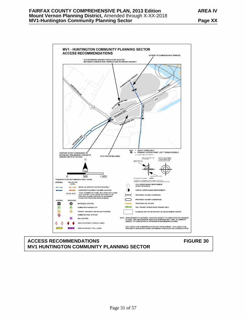
Transportation Transportation recommendations for this sector are shown in Figures 29X, 30X, 31 X and 32X. In some instances, site-specific transportation recommendations are included in the land use recommendations section. The figures show access orientation, circulation plans, interchange impact areas and generalized locations of proposed transit facilities. The recommendations contained in the Area Plan text and maps, the Policy Plan and Transportation Plan map, policies and requirements in the Public Facilities Manual, the Zoning Ordinance, and other standards will be utilized in the evaluation of development proposals.
Design plans for improvement of Telegraph Road south of Franconia Road should reflect the
historic, environmentally sensitive, and stable single-family nature of this corridor. Environmental issues such as marine clay soils, should be considered carefully in any plan for widening Telegraph Road. These sensitive areas should be left undisturbed to the extent possible during any construction.
Because of these environmental concerns and development patterns and due to the need for
access for existing residents from the large number of driveways, cul de sacs and feeder streets, a maximum width of three lanes should be the primary consideration for any improvement of the section of Telegraph Road between Franconia Road and South Kings Highway. The use of Telegraph Road as an alternative to through traffic on I-95 and Richmond Highway should be discouraged.

FAIRFAX COUNTY COMPREHENSIVE PLAN, 2013 Edition AREA IV Mount Vernon Planning District, Amended through X-XX-2018 MV1-Huntington Community Planning Sector Page XX
Page 30 of 57
*NOTE: TRANSPORTATION FIGURES WILL BE UPDATED
TRANSPORTATION RECOMMENDATIONS FIGURE 29
FAIRFAX COUNTY COMPREHENSIVE PLAN, 2013 Edition AREA IV Mount Vernon Planning District, Amended through X-XX-2018 MV1-Huntington Community Planning Sector Page XX
Page 31 of 57
ACCESS RECOMMENDATIONS FIGURE 30
MV1 HUNTINGTON COMMUNITY PLANNING SECTOR

FAIRFAX COUNTY COMPREHENSIVE PLAN, 2013 Edition AREA IV Mount Vernon Planning District, Amended through X-XX-2018 MV1-Huntington Community Planning Sector Page XX
Page 32 of 57
ACCESS RECOMMENDATIONS FIGURE 31 MV1 HUNTINGTON COMMUNITY PLANNING SECTOR
FAIRFAX COUNTY COMPREHENSIVE PLAN, 2013 Edition AREA IV Mount Vernon Planning District, Amended through X-XX-2018 MV1-Huntington Community Planning Sector Page XX
Page 33 of 57
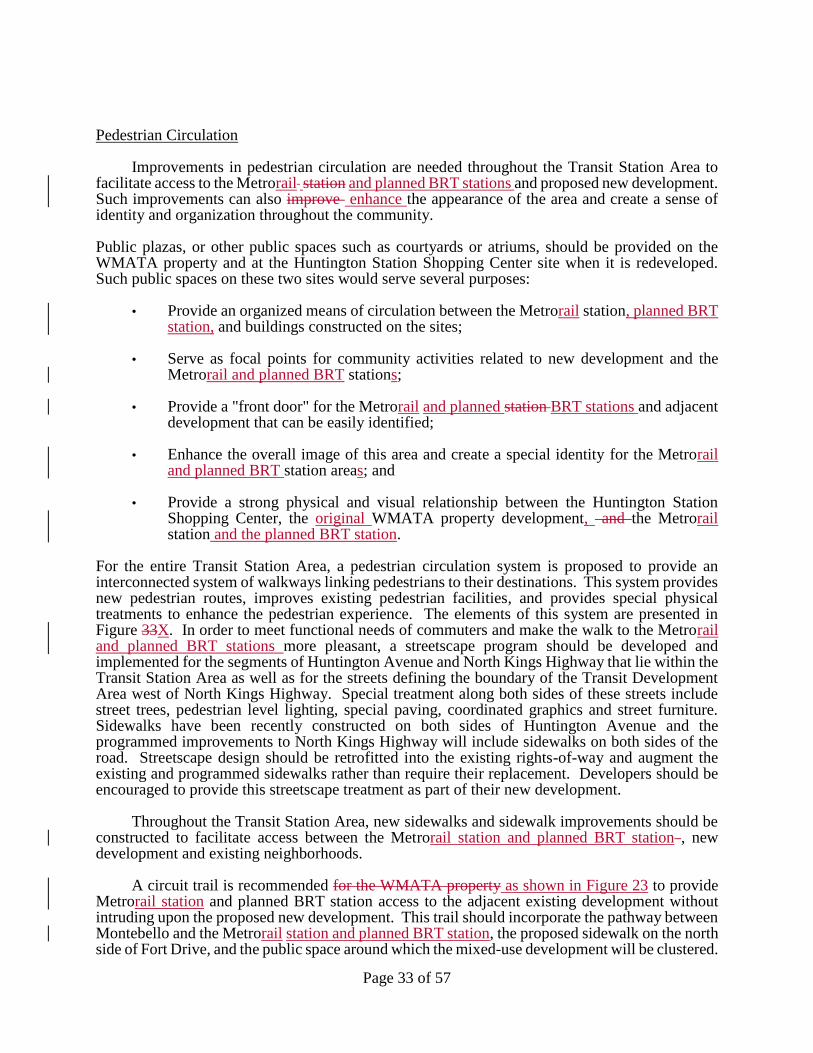
Pedestrian Circulation
Improvements in pedestrian circulation are needed throughout the Transit Station Area to facilitate access to the Metrorail station and planned BRT stations and proposed new development. Such improvements can also improve enhance the appearance of the area and create a sense of identity and organization throughout the community.
Public plazas, or other public spaces such as courtyards or atriums, should be provided on the WMATA property and at the Huntington Station Shopping Center site when it is redeveloped. Such public spaces on these two sites would serve several purposes:
• Provide an organized means of circulation between the Metrorail station, planned BRT station, and buildings constructed on the sites;
• Serve as focal points for community activities related to new development and the
Metrorail and planned BRT stations; • Provide a "front door" for the Metrorail and planned station BRT stations and adjacent
development that can be easily identified; • Enhance the overall image of this area and create a special identity for the Metrorail
and planned BRT station areas; and • Provide a strong physical and visual relationship between the Huntington Station
Shopping Center, the original WMATA property development, and the Metrorail station and the planned BRT station.
For the entire Transit Station Area, a pedestrian circulation system is proposed to provide an interconnected system of walkways linking pedestrians to their destinations. This system provides new pedestrian routes, improves existing pedestrian facilities, and provides special physical treatments to enhance the pedestrian experience. The elements of this system are presented in Figure 33X. In order to meet functional needs of commuters and make the walk to the Metrorail and planned BRT stations more pleasant, a streetscape program should be developed and implemented for the segments of Huntington Avenue and North Kings Highway that lie within the Transit Station Area as well as for the streets defining the boundary of the Transit Development Area west of North Kings Highway. Special treatment along both sides of these streets include street trees, pedestrian level lighting, special paving, coordinated graphics and street furniture. Sidewalks have been recently constructed on both sides of Huntington Avenue and the programmed improvements to North Kings Highway will include sidewalks on both sides of the road. Streetscape design should be retrofitted into the existing rights-of-way and augment the existing and programmed sidewalks rather than require their replacement. Developers should be encouraged to provide this streetscape treatment as part of their new development.
Throughout the Transit Station Area, new sidewalks and sidewalk improvements should be constructed to facilitate access between the Metrorail station and planned BRT station , new development and existing neighborhoods.
A circuit trail is recommended for the WMATA property as shown in Figure 23 to provide Metrorail station and planned BRT station access to the adjacent existing development without intruding upon the proposed new development. This trail should incorporate the pathway between Montebello and the Metrorail station and planned BRT station, the proposed sidewalk on the north side of Fort Drive, and the public space around which the mixed-use development will be clustered.
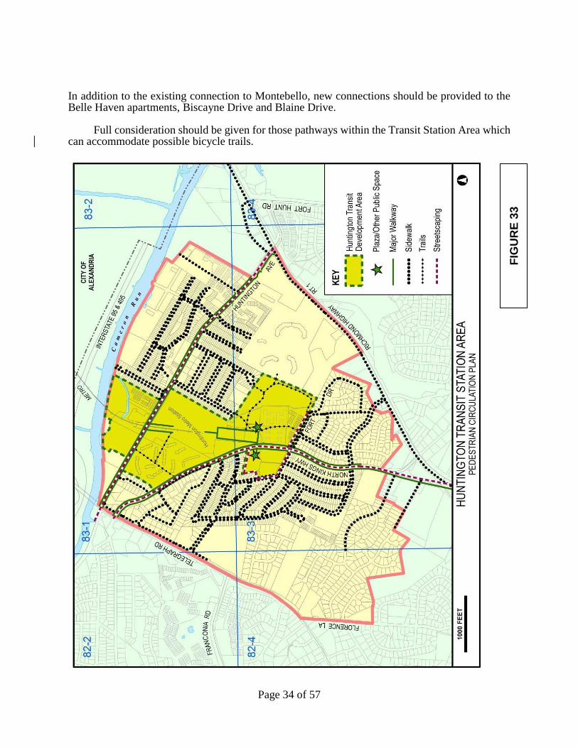
FAIRFAX COUNTY COMPREHENSIVE PLAN, 2013 Edition AREA IV Mount Vernon Planning District, Amended through X-XX-2018 MV1-Huntington Community Planning Sector Page XX
Page 34 of 57
In addition to the existing connection to Montebello, new connections should be provided to the Belle Haven apartments, Biscayne Drive and Blaine Drive.
Full consideration should be given for those pathways within the Transit Station Area which
can accommodate possible bicycle trails.
FIG
UR
E 3
3
FAIRFAX COUNTY COMPREHENSIVE PLAN, 2013 Edition AREA IV Mount Vernon Planning District, Amended through X-XX-2018 MV1-Huntington Community Planning Sector Page XX
Page 35 of 57
Heritage Resources The Browne Academy "Greystone" building at 5917 Telegraph Road and Tax Map 8 Map 8-24((1))32 82-4 ((1)) 32 should be evaluated for inclusion in the Fairfax County Inventory of Historic Sites. Single family dwellings built prior to 1940 should also be evaluated for potential inclusion in the Inventory if they are unaltered and embody the distinctive characteristics of a type, period, and/or method of construction.
Any development or ground disturbance in this sector, both on private and public land, should be preceded by heritage resource studies, and alternatives should be explored for the avoidance, preservation or recovery of significant heritage resources that are found. In those areas where significant heritage resources have been recorded, an effort should be made to preserve them. If preservation is not feasible, then, in accordance with countywide objectives and policies as cited in the Heritage Resources section of the Policy Plan, the threatened resource should be thoroughly recorded and in the case of archaeological resources, the artifacts recovered. Public Facilities 1. Two activity rooms are planned to be added to the Huntington Community Center located
in Sector MV1 between Arlington Terrace and Farrington Avenue to meet future community needs.
Parks and Recreation
Park and recreation recommendations for this sector are shown on Figure 34. The column "Park Classification" includes existing park facilities. The "Recommendations" column includes entries for both existing and proposed facilities. Prior to developing parkland, the Fairfax County Park Authority initiates a master planning process to determine the appropriate facilities and design for that park. This process involves extensive citizen review and participation. If an existing park is listed but no recommendation appears on that line, it means the park has been developed in accordance with its master plan.
Trails and Bicycle Facilities Trails planned for this sector are delineated on the 1”:4,000’ Countywide Trails Plan Map which is referenced as Figure 2 in the Transportation element of the Policy Plan and is available from the Department of Transportation. Trails in this sector are an integral part of the overall county system. While some of the segments have already been constructed, the Countywide Trails Plan Map portrays the ultimate system for the sector and the county at large. In addition, the map specifies a classification for each segment, which represents the desired ultimate function and surface type of the trail. Specific construction requirements are detailed in the Public Facilities Manual.
Bicycle Facilities for this sector are delineated on the 1”:4000’ Fairfax Countywide Bicycle Network Map which is referenced as Figure 3 in the Transportation element of the Policy Plan and is available from the Department of Transportation.

FAIRFAX COUNTY COMPREHENSIVE PLAN, 2013 Edition AREA IV Mount Vernon Planning District, Amended through X-XX-2018 MV1-Huntington Community Planning Sector Page XX
Page 36 of 57
FIGURE 34
PARKS AND RECREATION RECOMMENDATIONS
SECTOR MV1
PARK CLASSIFICATION
RECOMMENDATIONS
NEIGHBORHOOD PARKS:
Farrington
Plan and develop Urban Parks within the Huntington
Transit Station Area and Penn Daw Community Business
Center.
Neighborhood Park facilities should be provided in
conjunction with new residential development.
COMMUNITY PARKS:
Huntington
Jefferson Manor
Mt. Eagle
Acquire the Fairfax County Water Authority parcel
which bisects this park site; revise approved master plan
and implement accordingly. (Also noted in land use
recommendations.)
Acquire Mt. Eagle Park site as presently configured, in
conjunction with development of Huntington Transit
Station Area. Develop park with a mix of active and
passive recreational facilities in accordance with
approved master plan. (Also noted in land use
recommendations.)
DISTRICT PARKS:
This sector lies within the service area of Lee District
Park.

FAIRFAX COUNTY COMPREHENSIVE PLAN, 2013 Edition AREA IV Mount Vernon Planning District, Amended through X-XX-2018 MV1-Huntington Community Planning Sector Page XX
Page 37 of 57
Richmond Highway Corridor Area– Community Business Centers
North Gateway Community Business Center
Figure X indicates the geographic location of land use recommendations for the North Gateway Community Business Center.
The high-rise residential area located on the west side of Richmond Highway south of
Huntington Avenue, including Huntington Gateway, Montebello and Belle Haven Towers is located within the Huntington Transit Station Area and is addressed in Area IV, Mount Vernon Planning District, MV1 Huntington Community Planning Sector. The remainder of the west side of northern Richmond Highway is addressed below.
This area CBC is characterized by the Riverside high-rise residential buildings, auto
dealerships, gas stations, hotels/motels and mid-rise office buildings. Its proximity to the Capital Beltway, Huntington Transit Metrorail Station and Fort Hunt Road makes this portion of the Richmond Highway Corridor a major transportation-oriented center and presents opportunities for well-designed, transit-accessible redevelopment.
Environmentally-sensitive areas exist along Cameron Run and in the shallow lots along the
east side of Richmond Highway. Highway improvements, including the redesign of the Woodrow Wilson Bridge and Richmond Highway/Capital Beltway interchange may further impact this area. As development occurs, adequate measures should be provided to mitigate environmental impacts and restore degraded areas to more natural conditions.
The North Gateway Community Business Center serves as an entry point to historic Richmond Highway from points north including the Nation's Capital, the City of Alexandria and the Capital Beltway, providing an initial impression of Fairfax County, not only to visitors but to those who live in the southern other part of the county. An improved Improving the identity and appearance of the area using urban design principles and revitalization strategies are especially important. An attractive and efficient mix of land uses improves the image, economic viability and circulation along the Richmond Highway Corridor.
Redevelopment in this area is anticipated to occur adjacent to the Capital Beltway primarily
at the location of the auto dealerships. This area is planned to redevelop as a mixed-use project including residential, office, hotel and retail uses. These planned uses complement the advantageous location near rail and planned bus rapid transit and are compatible with the surrounding character and density.
Due to the prominent gateway location,
high quality urban design is especially important in any redevelopment that occurs. Quality building materials, patterns and architectural design, which are compatible and complementary to surrounding uses, especially Huntington Gateway, are desirable. Landscaping should be used to soften the vertical built environment.

FAIRFAX COUNTY COMPREHENSIVE PLAN, 2013 Edition AREA IV Mount Vernon Planning District, Amended through X-XX-2018 MV1-Huntington Community Planning Sector Page XX
Page 38 of 57
Sub-unit A-1
The area along located on the northwest side of Richmond Highway between I-495 and Huntington Avenue is planned for retail, office and/or residential uses up to .50 FAR.
Sub-units A-1 and A-2 may be appropriate for redevelopment at a higher intensity in the future as recommended by the optional level of development when area-wide transportation issues can be addressed. The plan for the mixture of uses and higher intensity should be evaluated following the completion of transportation studies for the Huntington area and the Richmond Highway Corridor, when mitigation strategies are identified.
As an option, mixed-use development to include residential, office, hotel and retail uses at an intensity up to 1.65 FAR may be appropriate as part of a unified redevelopment with substantial consolidation of sub-units A-1 and A-2. If substantial consolidation is not achievable, an alternative may be pursued that logically consolidates parcels in Sub-unit A-1 and/or Sub-unit A-2 in order to provide the extension of Fort Hunt Road to Cameron Run Terrace in the initial phase. Further, a master plan for redevelopment of both Sub-units should be prepared to demonstrate how the future integration of unconsolidated parcels can be achieved. In either option, the following conditions should be met:
• Urban design elements incorporating the rRecommendations found at the end of the
Richmond Highway Corridor section, in the Parks, Recreation and Open Space, Urban Design and Urban Street Network Design sections are incorporated. For example, such as complete streets, public art, pedestrian plazas, cultural/recreation facilities, landscaped open space, landmarks and/or building designs which will should denote this area as a focal point of the North Gateway Community Business Center are included;
• A pedestrian circulation system is provided. Circulation should encourage pedestrian
traffic within the development, and to and from adjacent developments, the Huntington Metrorail Station, and existing and planned pedestrian and bicycle routes, such as the Cameron Run Trail and other planned facilities. Streetscaping that includes elements such as space for outdoor dining, pedestrian sidewalks, landscaping, crosswalks, bicycle facilities, on-street parking, lighting, and/or transit accommodations, should be incorporated in the internal transportation network within the development. Adequate, well-positioned and safe pedestrian crossings across Richmond Highway and Huntington Avenue, with ramps, pavement markings and pedestrian countdown signals, should also be provided;
• A parking management program is prepared that may include parking reductions,
providing less parking than required by codeis prepared; • Parking is consolidated into structures and follows the Parking Design
Recommendations contained in the Urban Design section. integrated into the streetscape in order to avoid adverse visual impacts to major pedestrian, bicycle, or vehicular corridors. Façade treatment of parking structures should contribute to the visual appeal of the streetscape. Surface parking lots should be avoided or located in the rear of the buildings when necessary;
FAIRFAX COUNTY COMPREHENSIVE PLAN, 2013 Edition AREA IV Mount Vernon Planning District, Amended through X-XX-2018 MV1-Huntington Community Planning Sector Page XX
Page 39 of 57
• A thorough traffic impact analysis of the proposed development is conducted with appropriate mitigation identified. Grade separated interchanges, new or extended roadways, roadway widening, and/or intersection turn lane improvements should be considered to assist in alleviating traffic congestion through the immediate area;
• An efficient, pedestrian friendly, internal grid design for vehicular circulation is
provided; • Old Richmond Highway is vacated between Cameron Run Terrace and Richmond
Highway, and the extension of Fort Hunt Road from Richmond Highway to Cameron Run Terrace is constructed with any redevelopment of the subject area as shown on Figure X;
• Access points are consolidated. Adequate storage capacity at the site access points
should be provided to accommodate anticipated turn lane demands, into and out of the site;
• Adequate right-of-way is provided for the planned, grade-separated interchange at
Richmond Highway and Huntington Avenue/Fort Hunt Road or for suitable, at-grade alternative mitigation developed through further study, and for any adjacent intersection, bicycle/pedestrian improvements, and/or road widenings to be defined through further study;
• Any proposed site design is coordinated with existing and planned transit in the area
with bus shelters; • A substantial Transportation Demand Management (TDM) program should be
implemented as a component of the transportation mitigation. The TDM program should consider, but is not limited to, the following elements:
o A TDM trip reduction goal of 30 percent should be sought for the office component
of the site; o A TDM coordinator; o A commuter center/kiosk; o Incentives for residents and office workers to use alternative modes, such as transit,
carpools, vanpools, bicycles and walking and to participate in flexible work schedules, alternative work schedules and teleworking;
o Provision of, or funding for, long-term shuttle service and/or enhanced transit
connections between the site, other area development, and the Huntington Metrorail Station; and
o Covered and secure bicycle storage facilities and shower/locker facilities.
• A contribution for area-wide transportation improvements, including roadway and
other multi-modal improvements that are generally proportional to the share of trips generated by the proposed development is provided at each improvement location. The

FAIRFAX COUNTY COMPREHENSIVE PLAN, 2013 Edition AREA IV Mount Vernon Planning District, Amended through X-XX-2018 MV1-Huntington Community Planning Sector Page XX
Page 40 of 57
contribution at each improvement location should be calculated based on a comparison of site generated trips versus regional/through trips;
• A linear park along the shoreline of Cameron Run that includes wayside areas with
benches and construction of a portion of the proposed Cameron Run trail is provided; • The Cameron Run floodplain is re-vegetated and the Resource Protection Area restored
to the maximum extent possible; • The amount of impervious surfaces is reduced to the maximum extent possible; if this
is not achievable, there is no net increase in impervious surfaces; • Applicable stormwater management measures are incorporated as described in the
Environment section under Corridor-Wide Guidelines.
• The total volume of stormwater runoff released from the site post-development for the 2-year, 24-hour storm should be at least 25% less than the total volume of runoff released in the existing condition for the same storm;
• Stormwater runoff is controlled such that either (a) the total phosphorus load for the
property is no greater than what would be required for new development pursuant to Virginia’s Stormwater Regulations and the county’s Stormwater Management Ordinance; or (b) an equivalent level of water quality control is provided;
• As an alternative to the previous two bullets, stormwater management measures may
be provided sufficient to attain the Rainwater Management credit(s) of the most current version of LEED-New Construction or LEED-Core and Shell rating system;
• As an alternative to the previous three bullets, stormwater management measures/and
or downstream improvements may be pursued to optimize site-specific stormwater management and/or stream protection/restoration efforts, consistent with the adopted watershed management plan(s) that is/are applicable to the site. Such efforts should be designed to protect downstream receiving waters by reducing stormwater runoff volumes and peak flows from existing and proposed impervious surfaces to the maximum extent practicable, consistent with watershed plan goals; and
• A noise study is prepared to determine the extent of noise impacts and appropriate mitigation measures for interior areas of any residential, hotel and office uses and if necessary, outdoor activity areas.
Sub-unit A-2 The redevelopment of the "island" formed by Richmond Highway and Old Richmond Highway would enhance the "gateway" character of this area and should be encouraged. Consolidation of all parcels within this "island" and redevelopment of this area with neighborhood-serving retail use up to .25 FAR is recommended. Building orientation should be to Richmond Highway but access should be to Old Richmond Highway.
As an option, if Sub-unit A-2 is substantially consolidated and included in a unified mixed-use development plan with Sub-unit A-1, then Sub-unit A-2 may be appropriate for mixed-

FAIRFAX COUNTY COMPREHENSIVE PLAN, 2013 Edition AREA IV Mount Vernon Planning District, Amended through X-XX-2018 MV1-Huntington Community Planning Sector Page XX
Page 41 of 57
use development at an intensity up to 1.65 FAR. If substantial consolidation with Sub-unit A-1 is not achievable, an alternative option for logical consolidation of Sub-unit A-2 with at least Tax Map Parcel 83-2((1))2A is recommended for mixed-use development to include residential, office, hotel and retail uses at a lower intensity than the maximum of 1.65 FAR. In addition to meeting the same conditions stated in the land use recommendation for Sub-unit A-1, as part of this mixed-use development, Old Richmond Highway should be vacated between Cameron Run Terrace and Richmond Highway and access should be provided from Sub-unit A-1. Sub-unit A-3
The Riverside Apartments complex, located on the north side of Huntington Avenue between Cameron Run Terrace and Hunting Creek Road, is planned for mid-rise and high-rise residential use with up to 40,000 square feet of a mix of first floor retail, restaurant use and/or office use with structured parking at a density up to 61 dwelling units per acre and an overall FAR of 1.60. The site is almost entirely covered by impervious surfaces, includes outdated stormwater management facilities, little to no useable open space for residents, and minimal landscaping. Any redevelopment of the site should be designed to substantially re-vegetate the Cameron Run floodplain, providing additional open space and park land to serve the recreational needs of residents and the surrounding community, and provide stormwater management facilities that address long standing water quantity and quality issues associated with the site and its impacts to Cameron Run and neighboring properties. Any proposed redevelopment should be subject to the following conditions: • Provision of substantial, useable, additional open space areas and urban park amenities
for residents and a linear park along the shoreline of Cameron Run that includes wayside areas with benches;
• Re-vegetation of the Cameron Run floodplain to the maximum extent possible; • The proposed trail that appears on the county Trails Plan Map should be constructed
within the linear park. It is not necessary for the trail to be constructed directly along Cameron Run; this is particularly relevant should flood controls (e.g., a levee) impact the area shown on the Trails Map. The trail should provide a link to the planned trail east of the site, and linkages to the existing Huntington Park and any new park that may be constructed by the Park Authority on land dedicated by the abutting property to the west;
• Provision of stormwater quantity and quality control measures that are substantially
more extensive than minimum requirements, with the goal of reducing the total runoff volume if appropriate. The emphasis should be on low impact development (LID) techniques and best management practices (BMPs) that evapotranspire water, filter water through vegetation and/or soil, and return water in to the ground or reuse it and should include such features as rooftop landscaping on the proposed parking structures. Stormwater management measures that are sufficient to attain the stormwater design-quantity control credit if appropriate and the stormwater design-quality control credit of the most current version of the Leadership in Energy and Environmental Design for New Construction (LEED-NC) or Leadership in Energy and Environmental Design for Core and Shell (LEED-CS) rating system (or third party equivalent of these credits) should be provided. If this goal is demonstrated not to be achievable, all measures should be implemented to the extent possible in support of this goal;
FAIRFAX COUNTY COMPREHENSIVE PLAN, 2013 Edition AREA IV Mount Vernon Planning District, Amended through X-XX-2018 MV1-Huntington Community Planning Sector Page XX
Page 42 of 57
• No freestanding retail and/or restaurant uses; • Provision of high quality architecture in mid-rise structures; • Provision of structured parking, incidental surface parking shall be allowed consistent
with urban design guidelines; • Provision of pedestrian oriented site design which should include buildings oriented to
internal streets and mitigation of visual impacts of structured parking, internal streets, walkways, trails, sidewalks and street crossings should connect buildings and open spaces, and amenities such as street trees, benches, bus shelters, adequate lighting and various paving textures;
• Provision of integrated pedestrian linkages to nearby streets should be provided and
bicycle systems with features such as covered and secure bicycle storage facilities; • Provision of a coordinated circulation system that will accommodate vehicular and
pedestrian access among sub-units A-1, A-2 and A-3 of the North Gateway Community Business Center;
• Building design should accommodate telecommunications antennas and equipment
cabinets in a way that is compatible with the building’s architecture, and conceals the antennas and equipment from surrounding properties and roadways by flush mounting or screening antennas and concealing related equipment behind screen walls or building features;
Sub-unit B-1
The area northwest of Belle Haven Country Club along Richmond Highway from the Beltway to Fort Hunt Road is developed with several commercial uses. The most northern portion of this sub-unit is planned for hotel use up to .60 FAR with a maximum of 8 stories. Office use up to .50 FAR with a maximum of 8 stories is planned for Parcels 83-4((1))10 and 11. The remainder of this sub-unit is planned for neighborhood-serving retail use up to .25 FAR. This recommendation reflects current uses which should be retained. Future highway improvements may impact the accessibility of this sub-unit.
Sub-unit B-2
The triangle-shaped area bounded by Richmond Highway on the northwest, Fort Hunt Road on the east and Huntington Avenue on the south is planned for community-serving retail use up to .35 FAR. Complete consolidation of these parcels is encouraged for a coordinated development. Screening and buffering should be provided along Huntington Avenue to mitigate any impacts on the townhouse community located across Huntington Avenue. Right-of-way needed for interchange improvements at Huntington Avenue, Richmond Highway and Fort Hunt Road should be dedicated. In the event that highway improvements impact part or all of this land unit, this is an appropriate location for a gateway park or identifying features. In addition, impacts on sensitive environmental features located here should be mitigated.
As an option, if Sub-unit B-2 is fully consolidated and included in a unified development plan with Sub-units A-1 and A-2, then Sub-unit B-2 may be appropriate for mixed use

FAIRFAX COUNTY COMPREHENSIVE PLAN, 2013 Edition AREA IV Mount Vernon Planning District, Amended through X-XX-2018 MV1-Huntington Community Planning Sector Page XX
Page 43 of 57
development up to 1.0 FAR provided that it is preserved in its entirety as an open space area and the development potential is transferred to Sub-units A-1 and A-2.
Lower Potomac Planning District, LP4 - Fort Belvoir Community Planning Sector
LP4 FORT BELVOIR COMMUNITY PLANNING SECTOR CHARACTER
Fort Belvoir Community Planning Sector is generally bounded on the north by Telegraph Road, on the east by Pole Road and Dogue Creek, on the south by Gunston Cove, and on the west by Old Colchester Road. The planning sector is largely coincidental with Fort Belvoir Main Post property lines and Humphreys Engineer Center property.
Fort Belvoir is a federally owned property. The fort is one of the largest employers in Fairfax County, housing diverse tenants and satellite organizations, and is one of the major traffic generators within the Lower Potomac Planning District.
The Fort Belvoir Community Planning Sector contains Fort Belvoir Elementary School.
This school is operated by the county under a special agreement between Fort Belvoir and the Fairfax County School Board. Other facilities such as parks, fire stations and on-post roads are provided by the U.S. Army. Mutual aid agreements between Fort Belvoir and the county provide for police and fire support to be provided to each other in times of emergency.
The planning sector includes the Village of Accotink which has a wide variety of land uses,
such as single-family homes, garden apartments, mid-rise apartments, commercial and institutional uses. The village is located at the intersection of Backlick Road and Richmond Highway.
Fort Belvoir has conducted a thorough heritage resource survey and assessment of its
sensitivity areas. Although the numerous resources recorded are on federal property, they are a significant part of Fairfax County's heritage. Fort Belvoir's managers are pursuing an aggressive preservation effort concerning the fort’s heritage resources which is consistent with county policy. Fort Belvoir Historic District is listed in the Virginia Landmarks Register, and the district, along with individual sites within the district, is listed in the Fairfax County Inventory of Historic Sites. A list and map of heritage resources are included in the Lower Potomac Planning District Overview section, Figures 4 and 5. Additional historic sites in this planning sector are also included in the inventory.
Numerous locally and nationally significant heritage resources are recorded from this
planning sector and the potential exists for others. The Fort Belvoir Planning Sector contains hundreds of prehistoric archaeological resources dating as far back as the county's earliest human occupation. These resources range in function from small hunting and gathering sites to larger settlements. The county's earliest known English plantation, the Owsley Plantation, also is located on Fort Belvoir property along with Belvoir Plantation which was the home of the Fairfax family. Both sites are archaeological ruins under the stewardship of Fort Belvoir. Fort Belvoir abuts three Historic Overlay Districts: Pohick Church, Woodlawn, and Mount Air.

FAIRFAX COUNTY COMPREHENSIVE PLAN, 2013 Edition AREA IV Mount Vernon Planning District, Amended through X-XX-2018 MV1-Huntington Community Planning Sector Page XX
Page 44 of 57
Fort Belvoir has designated two sites as wildlife preserves for a total of approximately 1,450 acres. The larger site, the Accotink Bay Wildlife Refuge, straddles the Accotink Creek and its delta into Accotink Bay. The second site, which includes most of the wetlands between Pole and Telegraph Roads, east of Woodlawn Road, is the Jackson Miles Abbott Wetland Refuge. CONCEPT FOR FUTURE DEVELOPMENT The Fort Belvoir Community Planning Sector is recommended in the Concept for Future Development as a Large Institutional Land Area. The boundaries of the designation of Large Institutional Land Area are coincidental with the planning sector boundaries. The Concept recommends that the federal government develop or redevelop these areas only when plans are coordinated with the county and consistent with the county goals and the Comprehensive Plan. A Bus Rapid Transit (BRT) system with the potential for nine stations is planned to connect
Huntington Metrorail Station to Fort Belvoir. The potential BRT station in the Fort Belvoir area is
shown in Figure X. The BRT system is envisioned to eventually connect to Woodbridge in Prince
William County, which would include additional stations in Fairfax County. An additional
transportation analysis will need to be completed for this extension. Details about the BRT system
are contained in the Richmond Highway Corridor Area, Area IV Volume of the Comprehensive
Plan. RECOMMENDATIONS Land Use
Figure 40 indicates the geographic location of land use recommendations for this sector. Where recommendations are not shown on the General Locator Map, it is so noted. 1. Proposed development or redevelopment on Fort Belvoir should be undertaken in
cooperation with the county. Development or redevelopment plans should be supported only if they are consistent with the county goals and Comprehensive Plan. [Not shown]
2. In the event that parts or all of the land area now owned by the federal government should
be declared excess, a task force should be formed that includes federal government representatives to comprehensively plan for future uses, and to preclude piecemeal consideration of new land uses. Some portions should be considered for acquisition and conversion to park use, possibly by the Fairfax County Park Authority. It is recommended that, prior to any disturbance or improvement to the historic site, the Fairfax County historic preservationist and archaeologist be consulted and provide comments regarding the protection of existing historic materials and artifacts. [Not shown]
3. Consideration should be given to the construction of on-post housing to meet the needs of
military families in southern Fairfax County. On-post housing for military families reduces the competition for affordable housing in the county. The on-post homes should be well-designed and buffered, and not located near the frontage of Richmond Highway. [Not shown]
4. The 107-acre area of land located on the northeast corner of Richmond Highway and
Telegraph Road (Tax Map 108-1((1)) 47, 47A and 47B) is planned for housing for the elderly
FAIRFAX COUNTY COMPREHENSIVE PLAN, 2013 Edition AREA IV Mount Vernon Planning District, Amended through X-XX-2018 MV1-Huntington Community Planning Sector Page XX
Page 45 of 57
(not to exceed 700 units), nursing care facility (limited to 93,695 square feet) and low-rise office buildings (at a maximum overall FAR of .21 or 495,000 gross square feet). A substantial buffer utilizing existing tree cover along Richmond Highway and Telegraph Road should be part of the site design.
As an option, parcels 47 and 47A may be considered for residential use at 4 to 6 dwelling units per acre subject to the following conditions: the housing for the elderly on Parcel 47B not intensifying above that on the approved development plan; full consolidation of parcels 47 and 47A; the provision of buffering and screening adjacent to the housing for the elderly facility and Fort Belvoir; maintaining parcel 47 as open space; and providing a substantial buffer utilizing existing tree cover along Richmond Highway and Telegraph Road as part of the site design.

FAIRFAX COUNTY COMPREHENSIVE PLAN, 2013 Edition AREA IV Mount Vernon Planning District, Amended through X-XX-2018 MV1-Huntington Community Planning Sector Page XX
Page 46 of 57
FIGURE 40

FAIRFAX COUNTY COMPREHENSIVE PLAN, 2013 Edition AREA IV Mount Vernon Planning District, Amended through X-XX-2018 MV1-Huntington Community Planning Sector Page XX
Page 47 of 57
5. A bus rapid transit (BRT) system is planned to include a station in the Fort Belvoir area as shown in Figure X. Details about the BRT system are contained in the Richmond Highway Corridor Area, Area IV Volume of the Comprehensive Plan. The non-military area known as the Village of Accotink is planned as follows: (See Figure 41 for
Land Bay boundaries)
Base Option
Land Bay
RESIDENTIAL USE
(dwelling units per
acre)
NONRESIDENTIAL
USE (square feet)
RESIDENTIAL
USE
NONRESIDENTIAL
USE
A 20-30 du/ac
Retail: 109-1 ((1)) 3
N/A
N/A
B
2-3 du/ac;
16-20 du/ac: (109-
1((1)) 8, 9, 10)
Retail: 109-1 ((1)) 11,
12
30-40 du/ac
25,000 sf retail;
16,000 sf office as an
alternative to an
equivalent amount of
residential square feet
C
2-3 du/ac: 109-1((1))30
5-8 du/ac: 109-1 ((1))
35, 36, 37 38, 39,41, 42
16-20 du/ac: 109-1
((1)) 31
Retail: 109-1 ((1)) 32,
40 16-20 du/ac
30,000 sf retail
(.1 FAR)
D 2-3 du/ac N/A N/A N/A
E 2-3 du/ac N/A N/A N/A
F 2-3 du/ac N/A N/A N/A
G 2-3 du/ac N/A 5-8 du/ac N/A
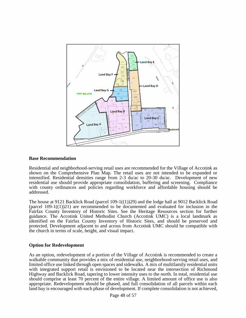
FAIRFAX COUNTY COMPREHENSIVE PLAN, 2013 Edition AREA IV Mount Vernon Planning District, Amended through X-XX-2018 MV1-Huntington Community Planning Sector Page XX
Page 48 of 57
Base Recommendation Residential and neighborhood-serving retail uses are recommended for the Village of Accotink as shown on the Comprehensive Plan Map. The retail uses are not intended to be expanded or intensified. Residential densities range from 2-3 du/ac to 20-30 du/ac. Development of new residential use should provide appropriate consolidation, buffering and screening. Compliance with county ordinances and policies regarding workforce and affordable housing should be addressed. The house at 9121 Backlick Road (parcel 109-1((1))29) and the lodge hall at 9012 Backlick Road (parcel 109-1((1))21) are recommended to be documented and evaluated for inclusion in the Fairfax County Inventory of Historic Sites. See the Heritage Resources section for further guidance. The Accotink United Methodist Church (Accotink UMC) is a local landmark as identified on the Fairfax County Inventory of Historic Sites, and should be preserved and protected. Development adjacent to and across from Accotink UMC should be compatible with the church in terms of scale, height, and visual impact. Option for Redevelopment As an option, redevelopment of a portion of the Village of Accotink is recommended to create a walkable community that provides a mix of residential use, neighborhood-serving retail uses, and limited office use linked through open spaces and sidewalks. A mix of multifamily residential units with integrated support retail is envisioned to be located near the intersection of Richmond Highway and Backlick Road, tapering to lower intensity uses to the north. In total, residential use should comprise at least 70 percent of the entire village. A limited amount of office use is also appropriate. Redevelopment should be phased, and full consolidation of all parcels within each land bay is encouraged with each phase of development. If complete consolidation is not achieved,
FAIRFAX COUNTY COMPREHENSIVE PLAN, 2013 Edition AREA IV Mount Vernon Planning District, Amended through X-XX-2018 MV1-Huntington Community Planning Sector Page XX
Page 49 of 57
the redevelopment design should demonstrate how these parcels can be integrated at the option level. In the interim, unconsolidated parcels should provide interparcel vehicular and pedestrian access. Land Bays B and C: Land Bay B is planned and developed for residential use at a density of 30-40 du/ac with approximately 25,000 square feet of ground floor retail use. In place of an equal amount of residential square feet, office use up to 16,000 square feet located above ground floor retail may be appropriate. Land Bay C is planned for residential use at 16-20 du/ac with approximately 30,000 of ground floor retail use. Buffering and screening should be utilized along property lines that are adjacent to the existing cell tower. In both land bays, the retail component should be of a neighborhood-serving character. Residential buildings should provide convenient access to open space, recreational space, and community-serving retail uses. Building height may be a maximum of 60 feet along Richmond Highway provided the height of structures within the land bay is tapered to create a satisfactory transition to adjoining single-family residences. Affordable and workforce housing should be provided through compliance with the Affordable Dwelling Unit Ordinance and other relevant County policies. Ground floor commercial uses should have direct public access and display windows oriented toward pedestrian walkways, and where appropriate, to vehicular drives and/or streets. Storefront windows along the facades should reflect a pedestrian scale. Blank walls of buildings, loading areas, or rear-facades should be treated in such a way that does not detract from the pedestrian experience. Consideration should be given to accommodate entranceways, sidewalk cafes, or other urban design amenities. In order to foster walkability, single-use, free-standing commercial structures should be avoided. Similarly, drive-through uses are discouraged. In the case where free-standing structures and drive-through uses are beneficial in the short run as interim improvements, the structures should be of an appropriate character and scale. These uses should comply with the Guidelines for Interim Improvement of Commercial Establishments and other applicable county policies. The consolidation guidance in paragraph one under the Option for Redevelopment should be met. Land Bay G: If the land bay is consolidated, residential use at a density of 5-8 du/ac may be appropriate. To the extent possible, building(s) should be oriented to Backlick Road. Parking should be located to the rear away from Backlick Road. The scale, height, and visual impact of development should be compatible with Accotink UMC. Urban Design High quality site design, architecture, landscaping, and lighting should contribute to the visual appeal of the area. With regard to landscaping, the use of native plant species that are common to Fairfax County is strongly encouraged. Buildings should be oriented to and aligned with the street on which they are located. Structures along Backlick Road should have minimal setbacks from the sidewalk to maintain the character of the area and create a walkable environment. Architectural design features such as variations of window and building details should be encouraged. To achieve a compatible transition from higher-density, mid-rise mixed-use development to low-density single-family houses and/or institutional uses, buffering and screening should be utilized in the form of landscaping and/or through building design. Redevelopment adjacent to single-family detached and/or attached residential units should be compatible in terms of height, scale, and visual impact. Surface parking should be limited to on-street or loading spaces. Underground parking is preferred; if structured parking is utilized, it should be consolidated into structures that are integrated into the streetscape in order to avoid adverse visual impacts to pedestrian or vehicular corridors and

FAIRFAX COUNTY COMPREHENSIVE PLAN, 2013 Edition AREA IV Mount Vernon Planning District, Amended through X-XX-2018 MV1-Huntington Community Planning Sector Page XX
Page 50 of 57
unconsolidated parcels. Façade treatments of parking structures should add visual interest to the streetscape. Measures should be incorporated to avoid a canyon-like appearance of structures. Where appropriate, public art, historical markers, and/or interpretive signage should be installed to commemorate the history of the Village of Accotink and provide a public education opportunity as endorsed in the Heritage Resources section of the Policy Plan. Circulation and Access Pedestrian connections are necessary within parcels and between development projects to create a pleasant environment. A walkable environment along Backlick Road and Richmond Highway should be created; this can be achieved through the inclusion of trees, street furniture, appropriate landscaping, wide sidewalks, and minimal buildings setbacks from the sidewalk and/or property line. A pedestrian circulation system should interconnect interior sections of developments with destinations at the edges along Richmond Highway. On the edges of properties, wide sidewalks should be provided to allow for safe and more active pedestrian movement. Each phase of development should include a circulation plan to integrate pedestrian and bicycle movement through the site and between areas exterior to the development. Safe pedestrian and bicycle movement should be complemented through a system of walkways and crossings where possible. Individual vehicular access points onto Richmond Highway should be discouraged. Transportation Transportation demand management strategies should be implemented to mitigate adverse impacts on the adjacent roadway network and provided with each phase during the development review process. A traffic operational analysis of the intersection of Backlick Road and Richmond Highway is recommended prior to any action being taken to redevelop the study area. The Transportation Plan Map recommends widening Richmond Highway to six lanes, adding a median-running BRT system transitway on Richmond Highway, and including bicycle/pedestrian amenities. Coordination with Fairfax County and the Virginia Department of Transportation (VDOT) is needed to ensure that adequate right-of-way is provided to implement projects associated with the widening and other improvements, including placement of utilities. Redevelopment of the study area should accommodate transit operations. Safe and logical access and connectivity should be considered if transit service is expanded in the future. A cul-de-sac located along Backlick Road at some point between the new development at Richmond Highway and the Beulah Road split may be appropriate to manage through traffic and should be analyzed. Resulting impacts to traffic operations due to the cul-de-sac at the intersections of Richmond Highway with the Fairfax County Parkway and Backlick/Pohick Road, in particular, should be evaluated. If a cul-de-sac is supported, ways to employ the cul-de-sac as a community focal point should be considered while respecting the historic context of the area and individual properties. A provision should be made for continuous access for emergency vehicles. Consultation with VDOT, Fort Belvoir, and other appropriate agencies should be undertaken during the study process. Parks and Open Space The option for redevelopment will generate the need for approximately 3 acres of additional parkland within the Village of Accotink. Playgrounds, basketball courts, an off-leash dog park, or other facilities should be included in the development plans for Land Bays B and C, and should be supported by a connected pedestrian network. The provision of publicly accessible outdoor spaces
FAIRFAX COUNTY COMPREHENSIVE PLAN, 2013 Edition AREA IV Mount Vernon Planning District, Amended through X-XX-2018 MV1-Huntington Community Planning Sector Page XX
Page 51 of 57
that are connected to park and recreation opportunities, such as fountains or other focal points of interest is recommended. If trails are proposed within the site, they should be constructed outside of the floodplain. Use of plant species native and common to Fairfax County is strongly encouraged. If on-site recreational needs cannot be accommodated, contributions to constructing a master planned park facility and/or replacing or improving aging park facilities at nearby parks is recommended. Environment Measures to preserve the existing Resource Protection Area (RPA) and Environmental Quality Corridor (EQC) in accordance with applicable county and state policy and guidelines are encouraged. A portion of existing development in Land Bay A encroaches in the RPA. Restoration and reforestation of the RPA is encouraged to the greatest extent possible. Low-Impact Development (LID) measures should be incorporated into stormwater management controls to reduce runoff and improve surface waters over existing conditions. Innovative measures and controls should be used to mitigate the impact of development on water quality and quantity. Redevelopment should also include other sustainable practices in accordance with the Environment section of the Policy Plan. Commitment to LEED certification or equivalent for nonresidential development is strongly encouraged. For residential development, ENERGY STAR® Qualified Homes, or an equivalent residential rating system is recommended. Transportation
Transportation recommendations for this sector are shown on Figures X, X, and X. In some instances, site specific transportation recommendations are included in the land use recommendations section. The figure shows access orientation, circulation plans, interchange impact areas and generalized locations of proposed transit facilities. The recommendations contained in the Area Plan text and maps, the Policy Plan and Transportation Plan map, policies and requirements in the Public Facilities Manual, the Zoning Ordinance, and other standards will be utilized in the evaluation of development proposals.
The two Transit Transfer Centers shown in Figures 42 and 44 are not site specific. Rather, they are meant to take advantage of the rail service between the fort and the Springfield Transportation Hub that Fort Belvoir is planning to establish over the existing military railroad. The Board of Supervisors should enter into agreements with the fort to establish the transit centers when the rail service is initiated.
Heritage Resources
Part of the Pohick Church Historic Overlay District lies within this sector. The provisions of the Pohick Church Historic Overlay District (Appendix 1, A1-100 of the Zoning Ordinance) limit development to single-family residential, local-serving commercial and tourist-oriented uses. All improvements shall be designed to be compatible with the scale and appearance of the church complex. All development must be reviewed by the Architectural Review Board.
The remains of the Belvoir site, which is located in the southern region of Fort Belvoir near
the Potomac River, continue to reflect an important element of local heritage and should be protected.
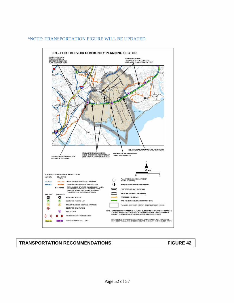
FAIRFAX COUNTY COMPREHENSIVE PLAN, 2013 Edition AREA IV Mount Vernon Planning District, Amended through X-XX-2018 MV1-Huntington Community Planning Sector Page XX
Page 52 of 57
*NOTE: TRANSPORTATION FIGURE WILL BE UPDATED
TRANSPORTATION RECOMMENDATIONS FIGURE 42
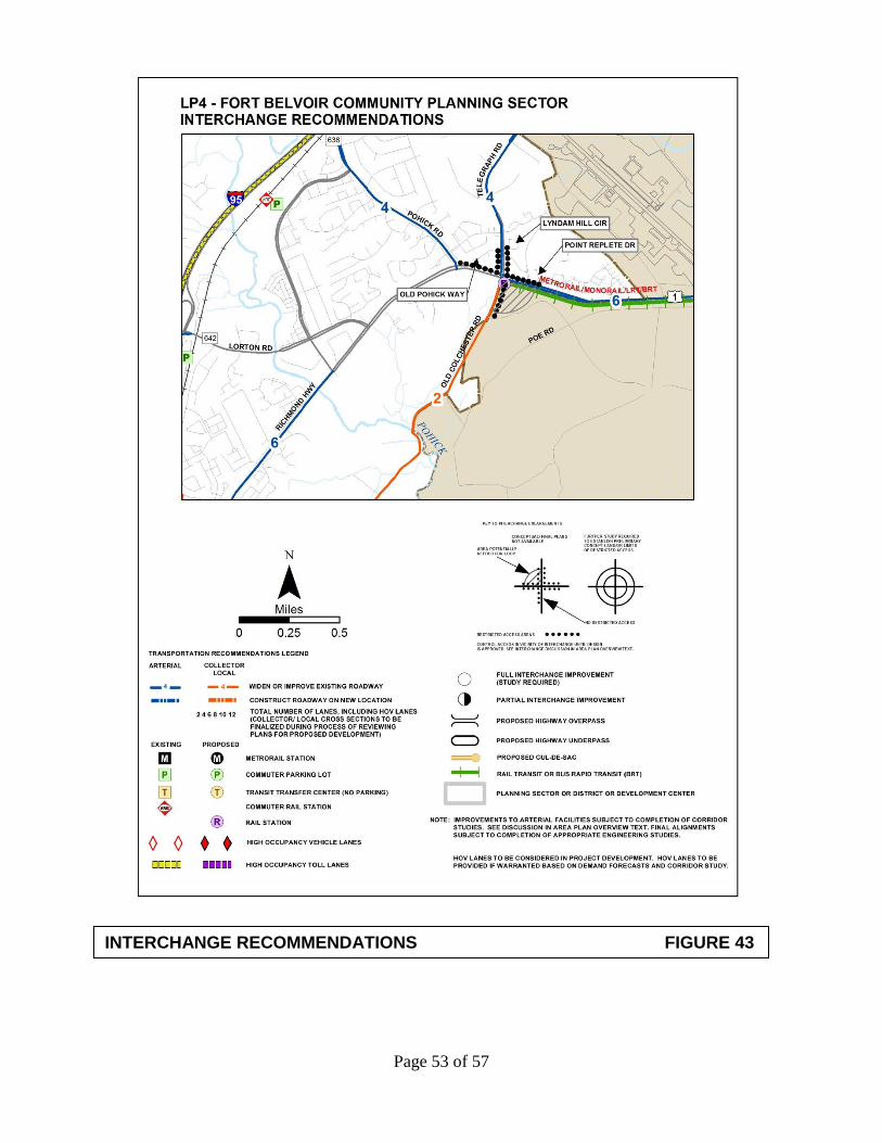
FAIRFAX COUNTY COMPREHENSIVE PLAN, 2013 Edition AREA IV Mount Vernon Planning District, Amended through X-XX-2018 MV1-Huntington Community Planning Sector Page XX
Page 53 of 57
INTERCHANGE RECOMMENDATIONS FIGURE 43

FAIRFAX COUNTY COMPREHENSIVE PLAN, 2013 Edition AREA IV Mount Vernon Planning District, Amended through X-XX-2018 MV1-Huntington Community Planning Sector Page XX
Page 54 of 57
TRANSIT FACILITY RECOMMENDATIONS FIGURE 44 LP4 FORT BELVOIR COMMUNITY PLANNING SECTOR
FAIRFAX COUNTY COMPREHENSIVE PLAN, 2013 Edition AREA IV Mount Vernon Planning District, Amended through X-XX-2018 MV1-Huntington Community Planning Sector Page XX
Page 55 of 57
Pohick Church, Mount Air and Woodlawn Historic Overlay Districts abut Fort Belvoir. Protection of these historic resources should be considered in any redevelopment of the Fort Belvoir property.
Part of the Mount Air Historic Overlay District Lies within this sector. Regulations for this
district are discussed in the Newington Community Planning Sector of the Springfield Planning District.
Part of the Woodlawn Historic Overlay District lies within this sector. Regulations for this
district are discussed in the Woodlawn Community Planning Sector of the Mount Vernon Planning District.
Any development or ground disturbance in this sector, both on private and public land,
should be preceded by heritage resource studies, and alternatives should be explored for the avoidance, preservation or recovery of significant heritage resources that are found. In those areas where significant heritage resources have been recorded, an effort should be made to preserve them. If preservation is not feasible, then, in accordance with countywide objectives and policies as cited in the Heritage Resources section of the Policy Plan, the threatened resource should be thoroughly recorded and in the case of archaeological resources, the artifacts recovered.
Accotink United Methodist Church (Accotink UMC) and cemetery (Parcel 109-1 ((1)) 25) have noted historical significance and are listed in the Fairfax County Inventory of Historic Sites. They should be preserved and protected. Development adjacent to and across from Accotink UMC should be compatible with the church in terms of scale, height, and visual impact. The lodge hall at 9012 Backlick Road (Parcel 109-1 ((1)) 21) and a house at 9121 Backlick Road (Parcel 109-1 ((1)) 29) are recommended to be documented and evaluated for inclusion in the Fairfax County Inventory of Historic Sites. If the house at 9121 Backlick Road is determined eligible for listing in the inventory, restoration and reuse of the house should be explored. Where appropriate, public art, historical markers, and/or interpretive signage should be installed to commemorate the history of the Village of Accotink and provide a public education opportunity as endorsed in the Heritage Resources section of the Policy Plan.
Prior to any zoning action, the Department of Planning and Zoning should be consulted as to
what architectural surveys are necessary to document any on-site cultural resources. There are known or predicted archaeological resources in this area related to Native American and historic occupation or use. There is a high potential that such resources may remain undisturbed. Staff from the Cultural Resource Management and Protection Section of the Park Authority should be consulted to develop a scope of work for any on-site archaeological surveys prior to any development or ground disturbing activity. Should archaeological resources be discovered that are potentially eligible for inclusion in the National Register, further archaeological testing should occur to evaluate these resources as to their eligibility. If such resources are found to be eligible, mitigation measures should be developed that may include avoidance or data recovery excavation and interpretation. Public Facilities 1. Construct a new elementary school on Fort Belvoir to replace the existing Fort Belvoir
schools.

FAIRFAX COUNTY COMPREHENSIVE PLAN, 2013 Edition AREA IV Mount Vernon Planning District, Amended through X-XX-2018 MV1-Huntington Community Planning Sector Page XX
Page 56 of 57
Parks and Recreation
Park and recreation recommendations for this sector are shown on Figure X. The column "Park Classification" includes existing park facilities. The "Recommendations" column includes entries for both existing and proposed facilities. Prior to developing parkland, the Fairfax County Park Authority initiates a master planning process to determine the appropriate facilities and design for that park. This process involves extensive citizen review and participation. If an existing park is listed but no recommendation appears on that line, it means the park has been developed in accordance with its master plan. Trails and Bicycle Facilities Trails planned for this sector are delineated on the 1”:4,000’ Countywide Trails Plan Map which is referenced as Figure 2 in the Transportation element of the Policy Plan and is available from the Department of Transportation. Trails in this sector are an integral part of the overall county system. While some of the segments have already been constructed, the Countywide Trails Plan Map portrays the ultimate system for the sector and the county at large. In addition, the map specifies a classification for each segment, which represents the desired ultimate function and surface type of the trail. Specific construction requirements are detailed in the Public Facilities Manual.
Bicycle Facilities for this sector are delineated on the 1”:4000’ Countywide Bicycle Network Map which is referenced as Figure 3 in the Transportation element of the Policy Plan and is available from the Department of Transportation.

FAIRFAX COUNTY COMPREHENSIVE PLAN, 2013 Edition AREA IV Mount Vernon Planning District, Amended through X-XX-2018 MV1-Huntington Community Planning Sector Page XX
Page 57 of 57
FIGURE 45
PARKS AND RECREATION RECOMMENDATIONS
SECTOR LP4
PARK CLASSIFICATION
RECOMMENDATIONS
COMMUNITY PARKS:
Active recreation facilities are available in adjacent sectors
at Mason Neck West Park and the Noman M. Cole, Jr.
Pollution Control Plant Ballpark.
DISTRICT PARKS:
This sector lies within the service area of the Grist Mill
District Park, which is in the Mount Vernon Planning
District.
COUNTYWIDE PARKS:
Accotink Stream Valley
Pohick Stream Valley
Dogue Creek Stream Valley
Ensure protection of the Environmental Quality Corridor
and public access to stream valley parks through
acquisition and/or donation/dedication of land or open
space easements to the Fairfax County Park Authority.
Complete development of countywide stream valley trail.
STATE/FEDERAL:
Protect the Accotink Bay shore line by developing the
former float bridge training area as the Tompkins Basin
National Capital Region Recreation Area.
Develop the Fort Belvoir trail system in concert with the
Fairfax County trail system.