Draft Project Overview | Mass.gov
28
RESILIENT MASSACHUSETTS ACTION TEAM (RMAT) DRAFT CLIMATE RESILIENCE DESIGN STANDARDS & GUIDELINES SECTION 1: PROJECT OVERVIEW DRAFT DOCUMENT FOR PUBLIC COMMENT PERIOD DRAFT DATE: AUGUST 24, 2020 CONTRACT NUMBER: ENV 19 CC 02 OWNER: Massachusetts Executive Office of Energy and Environmental Affairs (EEA) IN PARTNERSHIP WITH: Massachusetts Emergency Management Agency (MEMA) RMAT TECHNICAL ASSISTANCE CONSULTANT TEAM: Weston & Sampson AECOM Woods Hole Group ONE Architecture & Urbanism Dr. Jennifer Jacobs
Transcript of Draft Project Overview | Mass.gov
RESILIENT MASSACHUSETTS ACTION TEAM (RMAT)
DRAFT CLIMATE RESILIENCE DESIGN STANDARDS & GUIDELINES
SECTION 1: PROJECT OVERVIEW
DRAFT DOCUMENT FOR PUBLIC COMMENT PERIOD
DRAFT DATE: AUGUST 24, 2020
CONTRACT NUMBER: ENV 19 CC 02
OWNER: Massachusetts Executive Office of Energy and Environmental Affairs (EEA)
IN PARTNERSHIP WITH: Massachusetts Emergency Management Agency (MEMA)
RMAT TECHNICAL ASSISTANCE CONSULTANT TEAM: Weston & Sampson
AECOM Woods Hole Group
ONE Architecture & Urbanism Dr. Jennifer Jacobs
RMAT Climate Resilience Design Standards and Guidelines – Draft Project Overview
westonandsampson.com
RMAT CLIMATE RESILIENCE DESIGN STANDARDS AND GUIDELINES
Section 1 Table of Contents
1. DRAFT PROJECT OVERVIEW .............................................................................................. 1
1.1 OVERALL PROJECT GOALS/OBJECTIVES ................................................................1
1.2 OVERALL APPROACH ................................................................................................1
1.3 INTENDED USER/REVIEWER .....................................................................................3
1.4 OVERALL LIMITATIONS ..............................................................................................5
1.5 STAKEHOLDER ENGAGEMENT HISTORY ................................................................5
1.6 DRAFT GLOSSARY OF TERMINOLOGY ....................................................................7
1.6.1 ACRONYM LIST ..................................................................................................20
1.7 FREQUENTLY ASKED QUESTIONS (FAQs) .............................................................22
1.7.1 OVERALL PROJECT SCOPE QUESTIONS........................................................22
1.7.2 ASSET RELATED QUESTIONS ..........................................................................23
1.7.3 SEA LEVEL RISE/STORM SURGE DESIGN STANDARDS QUESTIONS ..........23
1.7.4 PRECIPITATION DESIGN STANDARDS QUESTIONS ......................................23
1.7.5 HEAT DESIGN STANDARDS QUESTIONS ........................................................24
1.7.6 EXPOSURE RATING RELATED QUESTIONS ...................................................25
1.7.7 CLIMATE RISK RATING RELATED QUESTIONS...............................................25
1.7.8 MISCELLANEOUS ..............................................................................................25

RMAT Climate Resilience Design Standards and Guidelines – Draft Project Overview | Page 1
westonandsampson.com
1. DRAFT PROJECT OVERVIEW 1.1 OVERALL PROJECT GOALS/OBJECTIVES
Led by the Executive Office of Energy and Environmental Affairs (EEA) and the Massachusetts
Emergency Management Agency (MEMA), the Resilient Massachusetts Action Team (RMAT) is
an inter-agency team comprised of representatives from each Secretariat, called Climate Change
Coordinators, who are supported by agency staff, stakeholders, and subject matter experts. The
RMAT is tasked with monitoring and tracking the State Hazard Mitigation and Climate Adaptation
Plan (SHMCAP) implementation process, making recommendations and supporting agencies on
plan updates, and facilitating coordination across State government and with stakeholders,
including businesses, cities, and towns.
The “Climate Resilience Design Standards and Guidelines” project is advancing prioritized global
(or cross-agency) actions from the SHMCAP. This effort will develop climate resilience design
standards and guidance for State agencies in order to incorporate climate resilience into the
State’s capital planning process. The project deliverables for State agencies include developing:
• a web-tool for agencies that provides a preliminary climate risk screening output and
climate resilience design standards for State projects with physical assets
• guidelines with best practices for State agencies to implement climate resilience design
standards;
This project aims to develop climate resilience design standards, guidelines, and a project
screening tool grounded in scientific methodology using the best available climate science data
in Massachusetts, which predictably and regularly improves over time to incorporate new science,
additional or changing climate hazards, and on-going stakeholder feedback.
The focus of this project is to integrate climate resilience in projects with physical assets owned
and maintained by state agencies. When complete in early 2021, these tools will be accessible at
ResilientMA.org, and are likely to become relevant to state grant-funded projects throughout the
Commonwealth.
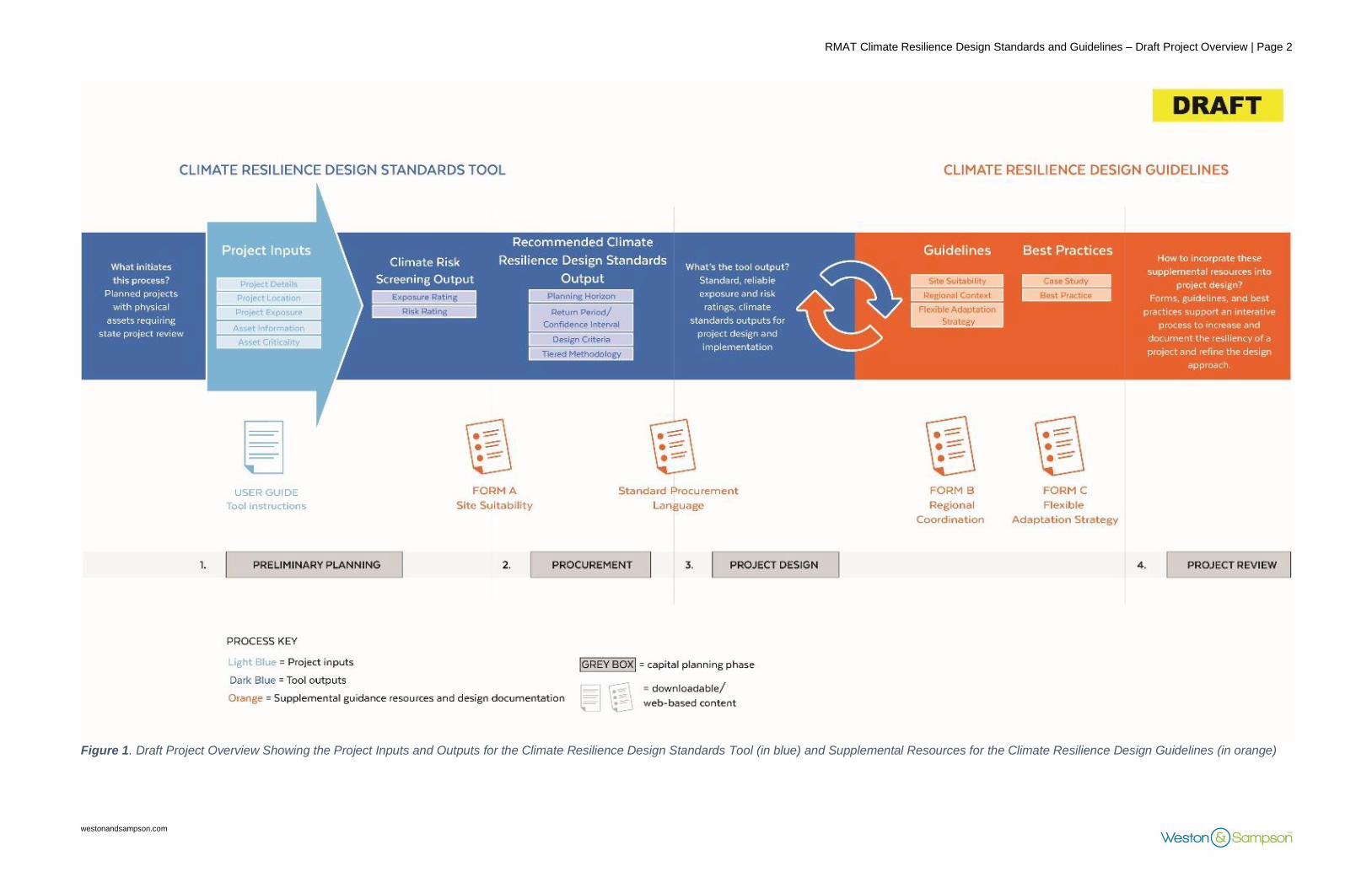
1.2 OVERALL APPROACH
The draft Climate Resilience Design Standards & Guidelines are intended to be applied to State
projects with physical assets and incorporated into the process from preliminary planning to
project review. Each component is connected and related as illustrated in the project overview
graphic presented in Figure 1.
RMAT Climate Resilience Design Standards and Guidelines – Draft Project Overview | Page 2
westonandsampson.com
Figure 1. Draft Project Overview Showing the Project Inputs and Outputs for the Climate Resilience Design Standards Tool (in blue) and Supplemental Resources for the Climate Resilience Design Guidelines (in orange)

RMAT Climate Resilience Design Standards and Guidelines – Draft Project Overview | Page 3
westonandsampson.com
The process starts with preliminary project planning and identification of physical assets that will
be designed during the project. Physical assets in a project are assigned to three main asset
categories: Infrastructure, Natural Resources, and Buildings. Users will provide Project Inputs to
the Climate Resilience Design Standards Tool and answer questions related to overall project
details, project location, project exposure, asset information (including type and useful life), and
asset criticality. The required Project Inputs to the Tool are further described in Section 2.
Based on these Project Inputs, the Tool will provide two outputs: Climate Risk Screening
(inclusive of preliminary project exposure ratings and asset preliminary risk ratings), and Climate
Resilience Design Standards for each asset. These outputs for a project and its physical assets
are provided for each of the following applicable climate parameters: sea-level rise/storm surge,
extreme precipitation, and extreme heat. The Climate Resilience Design Standards include
recommended planning horizons, return period/confidence interval, design criteria (by climate
parameter), and tiered methodology for developing site-specific design criteria values.
The Climate Resilience Design Guidelines will be provided as web-based materials on
ResilientMA.org, and will include downloadable forms and case studies, as well as links to other
best practices. Only the forms will be provided as downloadable PDF documents directly through
the Tool outputs.
The Tool output package can also be included in Requests for Proposals (RFPs) for agencies to use for design projects, and in standard procurement language that will be provided as part of this project.
1.3 INTENDED USER/REVIEWER
The resulting process of using the Climate Resilience Design Standards Tool will be combined in
a review package that will document the Project Inputs, Outputs (Climate Risk Screening Output
and Recommended Climate Resilience Design Standards Output), and Guidelines (through use
of forms). The Tool Outputs and supplemental resources part of the Climate Resilience Design
Guidelines should be used by the responsible project planning and design team.
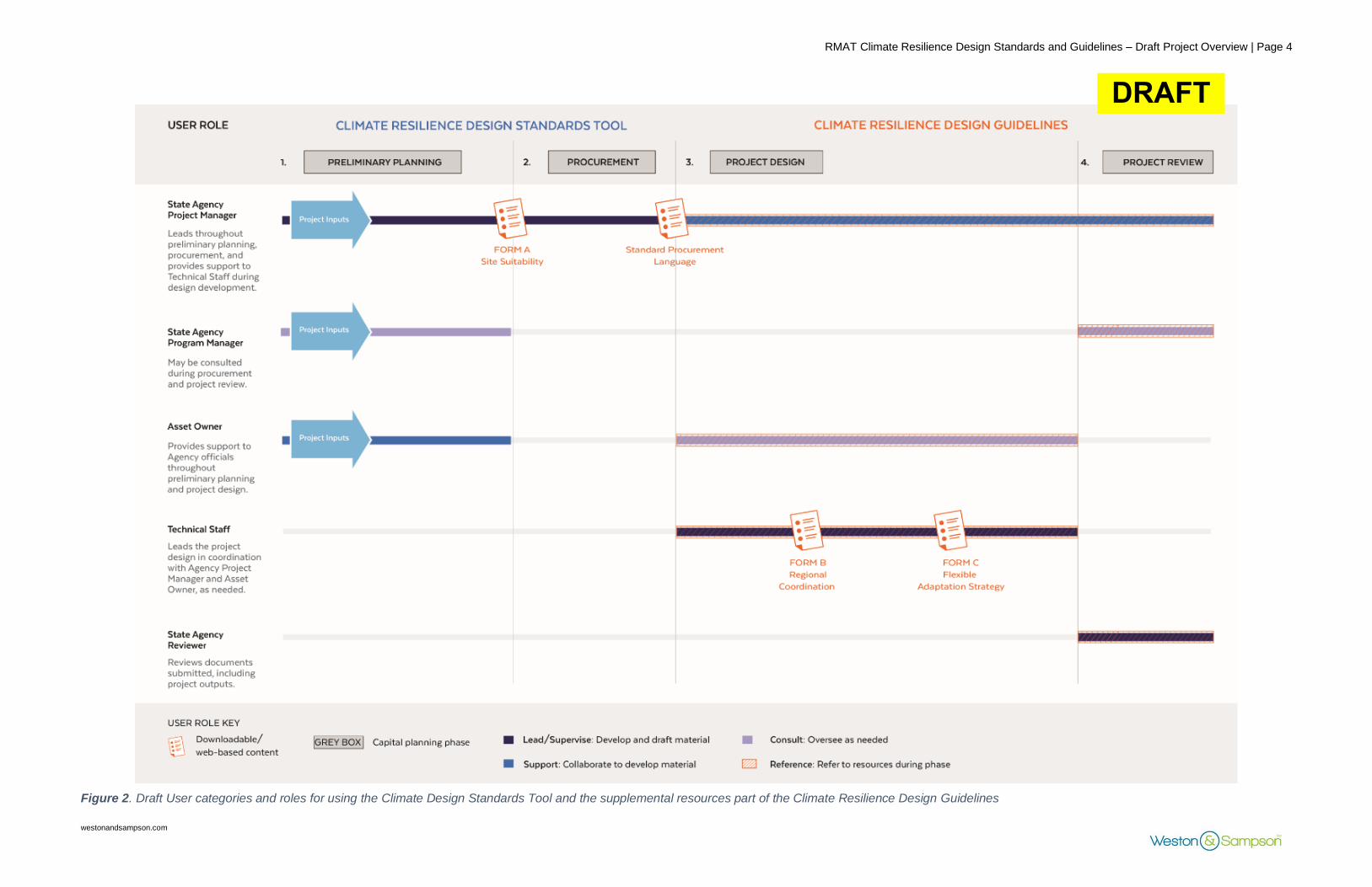
There are five expected users of the Climate Resilience Design Standards and Guidelines, with
four categorical roles, as illustrated in Figure 2, below.
The State Agency Project Manager’s role is to provide Project Inputs to the Tool, review Outputs,
and solicit Technical Staff to design physical assets using the Standards and Guidelines. They
lead throughout preliminary planning, procurement, and provide support to Technical Staff during
design development. The Technical Staff’s role is to apply the Standards and Guidelines to the
design of physical assets (as identified through the Tool). They lead the project design in
coordination with the State Agency Project Manager and Asset Owner, as needed. They are
responsible for documenting use of Standards and Guidelines. The Asset Owner’s role is to
support and collaborate with the State Agency Project Manager and Technical Staff throughout
the preliminary planning and project design. The State Agency Program Manager’s role is to
oversee the Tool (Project Inputs and Outputs) as needed, and may be consulted during
procurement and project review. The State Agency Reviewer’s role is to review the project design,
and may include State Agency Program Managers, the Executive Office of Administration and
Finance, and grant administrators.
RMAT Climate Resilience Design Standards and Guidelines – Draft Project Overview | Page 4
westonandsampson.com
Figure 2. Draft User categories and roles for using the Climate Design Standards Tool and the supplemental resources part of the Climate Resilience Design Guidelines
DRAFT

RMAT Climate Resilience Design Standards and Guidelines – Draft Project Overview | Page 5
westonandsampson.com
It is expected that the users of the Climate Resilience Design Standards Tool will apply the
determined project exposure and risk ratings and design standards to develop, support, and
consult on project design.
1.4 OVERALL LIMITATIONS
The deliverables generated in this project are draft and considered a “Version 1.0,” that can be
updated with feedback and new climate data over time.
The recommended Climate Resilience Design Standards & Guidelines do not replace existing
practices, regulatory requirements, or codes, and are intended to supplement them. They are not
intended to replace existing standards required by agencies. For example, if a 25-year return
period is recommended through the Tool, but the infrastructure asset may be designed to a 10-
year return period based on other regulatory policy, this would be reflected in the forms presented
in the Climate Resilience Design Guidelines (refer to the Climate Resilience Design Guidelines
overview documents in Section 4 for additional information). The Climate Risk Screening and
Resilience Design Standards also do not replace detailed risk and vulnerability assessments,
engineering alternatives analyses, or cost-benefit analyses.
1.5 STAKEHOLDER ENGAGEMENT HISTORY
The development of the draft Climate Resilience Design Standards and Guidelines included
active engagement and regular feedback from representatives from each Secretariat and key
State Agencies, as well as subject matter experts. Five (5) internal working groups were
established for the project for the following sub-topics: Scientific, Buildings, Infrastructure, Natural
Resources, and Capital Planning. A Technical Advisory Group (TAG) comprised of consultants,
academics, municipalities, regional planning organizations, non-profit agencies, and federal
agencies reviewed preliminary draft materials. Stakeholder engagement and feedback were
incorporated into the development of the draft materials during the following meetings:
1. November 12, 2019 – Scientific Working Group – Introduction to the project, proposed tiered
methodology, review of available climate data, existing methodologies for translating climate
science into design criteria.
2. November 13, 2019 – Asset-based Working Group – Introduction to the project, proposed
tiered methodology, proposed asset categorization, proposed initial criticality considerations
and framework for risk-based methodology.
3. December 11, 2019 – Capital Planning Working Group – Introduction to the project, proposed
evaluation framework (project resilience score methodology and resilience benefits score
methodology).
4. January 2020 through March 2020 - Bi-weekly working meetings with the Executive Office of
Administration and Finance (A&F) and the RMAT leadership team to advance development
of the Tool.
5. February 4, 2020 – Scientific Working Group – Revisit framework of project inputs, outputs,
and relationships, and tiered methodologies with proposed data sources and methods for
Precipitation.
6. February 11, 2020 – Building Asset Working Group – Proposed asset categories and types,
case studies, proposed design criteria and relationships, and criticality questions.

RMAT Climate Resilience Design Standards and Guidelines – Draft Project Overview | Page 6
westonandsampson.com
7. February 11, 2020 – Infrastructure Asset Working Group – Proposed asset categories and
types, case studies, proposed design criteria and relationships, and criticality questions.
8. February 14, 2020 – Natural Resource Asset Working Group – Proposed asset categories
and types, case studies, proposed design criteria and relationships, and criticality questions.
9. March 9, 2020 – Scientific Working Group – Updated input/outputs and relationships, draft
tiered methodologies for precipitation, sea level rise/storm surge, and heat.
10. March 25, 2020 – State Agency Focus Group - Presentation of draft Excel prototype, updated
relationships and proposed methodologies.
11. April 17, 2020 – Capital Planning Working Group – Exposure rating, risk rating, evaluation
framework (standards score and project resilience score), and excel prototype demonstration.
12. May 21, 2020 – Asset-based Working Group – Draft guidelines, best practices, case studies.
13. May 27, 2020 – Technical Advisory Group Workshop – Inputs/outputs and relationship tables,
draft tiered methodologies with case study example for precipitation, sea level rise/storm
surge, and heat; exposure rating, risk rating, evaluation framework (standards score and
project resilience score) and Excel prototype demonstration.
14. June 12, 2020 – Project Management Team (PMT) Review Meeting – Draft materials were
reviewed and distributed to the PMT. Following the PMT Review, it was determined by EEA
that the evaluation framework (including the project resilience score, standards score, and
resilience benefits) would not be included in Version 1.0 of the Tool.

RMAT Climate Resilience Design Standards and Guidelines – Draft Project Overview | Page 7
westonandsampson.com
1.6 DRAFT GLOSSARY OF TERMINOLOGY
The terms provided in the table below are used in the Climate Resilience Design Standards and
Guidelines Project and in the Climate Resilience Design Standards Tool. Options or examples
are provided where applicable. The definitions used in this Glossary are tailored for this specific
project and are not inclusive of more general industry definitions.
Glossary Legend:
Climate Resilience Design Standards and Guidelines Project-specific terms
Industry-accepted climate resilience terms
Terms Description Options or Examples
100-year floodplain
Area with a 1% annual chance of flooding (or 1 in 100 chance)1. Also known as a 1% Annual Exceedance Probability (AEP) flood event (see definition for Annual Exceedance Probability below).
Flood Insurance Rate Maps (FIRM) show the extent of the FEMA-defined 100-year floodplain. See definition for Flood Insurance Rate Map below.
500-year floodplain
Area with a 0.2% annual chance of flooding (or 1 in 500 chance).1 Also known as a 0.2% Annual Exceedance Probability (AEP) flood event (see definition for Annual Exceedance Probability below).
Flood Insurance Rate Maps (FIRM) show the extent of the FEMA-defined 500-year floodplain. See definition for Flood Insurance Rate Map below.
Accommodate
Adaptation strategy that mitigates the potential impact of a hazard by making space for, or buffering, the associated climate condition.
Wet floodproofing, elevation of critical infrastructure.
Adaptation An action that seeks to reduce vulnerability and risk to an anticipated climate impact.
Flood barriers, stormwater infiltration, living shorelines, elevated infrastructure, increased tree canopy.
Annual Exceedance Probability (AEP)
Probability of a flood event being equaled or exceeded in a given year.
The 0.2% AEP flood event has a 1 in 500 chance of being equaled or exceeded in any
1 Federal Emergency Management Agency (FEMA), “Flood Zones.” https://efotg.sc.egov.usda.gov/references/public/NM/FEMA_FLD_HAZ_guide.pdf

RMAT Climate Resilience Design Standards and Guidelines – Draft Project Overview | Page 8
westonandsampson.com
Terms Description Options or Examples
year (return period of 500 years, “500-year flood”).
Anticipated Useful Life
An estimated number of years an asset will be in use before needing reinvestment to continue performing its normal function(s). The anticipated useful life assumes regular and adequate maintenance is implemented. This differs from the design life, which is typically shorter
(see definition below). Considering
the anticipated useful life of an asset can help inform decisions about resilience-related investments.
A park's typical anticipated useful life is 30 years.
Asset
Assets are major physical components of a project and organized into three main Asset Categories (see definition below). Also known as Physical Assets (see definition below).
In the Draw 7 Park project, the park and living shoreline are assets.
Asset Category Division of Physical Assets into high-level primary groups for a project.
Building/Facility, Infrastructure, and Natural Resources.
In the Draw 7 Park project, both the park and living shoreline belong to the Natural Resources Asset Category.
Asset Type Assets organized by Asset Categories (Buildings, Infrastructure, or Natural Resources)
Buildings: typically occupied/unoccupied.
Infrastructure: Transportation, utility, flood control, etc.
Natural Resources: coastal resource area, forested ecosystem, aquatic ecosystem, etc.
In the Draw 7 Park project, the living shoreline is an example of a coastal wetland resource area Asset Type.
Asset Sub-Type Sub-categories or sub-classes under each Asset Type
Buildings: hospitals, maintenance facility, etc.

RMAT Climate Resilience Design Standards and Guidelines – Draft Project Overview | Page 9
westonandsampson.com
Terms Description Options or Examples
Infrastructure: roads, culverts, dams, etc.
Natural Resources: salt marsh, upland forest, streams, etc.
In the Draw 7 Park project, the living shoreline is an example of a coastal wetland Asset Sub-Type.
Base Flood Elevation (BFE)
The still water elevation associated with a design storm. This does not include freeboard or wave action. See definitions for design storm, freeboard, and wave action below.
The BFE is typically provided within the 100-year flood extent shown on FEMA Flood Insurance Rate Maps (FIRM).
Best Practices
Case studies and/or existing published resources that exemplify the Guidelines. Available to provide examples for how the Guidelines relate to a project.
Downloadable resources and case studies, such as Boston Public Works Department Climate Design Guidelines, or the Draw 7 Park project example.
Boston Harbor Flood Risk Model (BH-FRM)
A hydrodynamic model created in 2015 to identify projected flood risk and depth from coastal storms and sea level rise.2
Not applicable.
Buildings Structures that are typically occupied or unoccupied. Buildings are an asset category in the Tool.
Typically Occupied asset sub-types: Hospitals
Typically Unoccupied asset sub-types: Pump Station
Case Study Real-world project that was used to illustrate application of guidelines.
DCR’s Draw Seven Park in Somerville, MA
Climate Change
According to SHMCAP, climate change refers to “a change in the state of the climate that can be identified by statistical changes of its properties that persist for an extended period, whether due to
Temperatures are increasing, rainfall events are becoming more frequent and intense, and sea levels are rising.
2 MassDOT Environmental Services (2020). Climate Change Resiliency: Central Artery and Tunnel Pilot Project. https://www.mass.gov/info-details/climate-change-resiliency
RMAT Climate Resilience Design Standards and Guidelines – Draft Project Overview | Page 10
westonandsampson.com
Terms Description Options or Examples
natural variability or as a result of human activity.”3
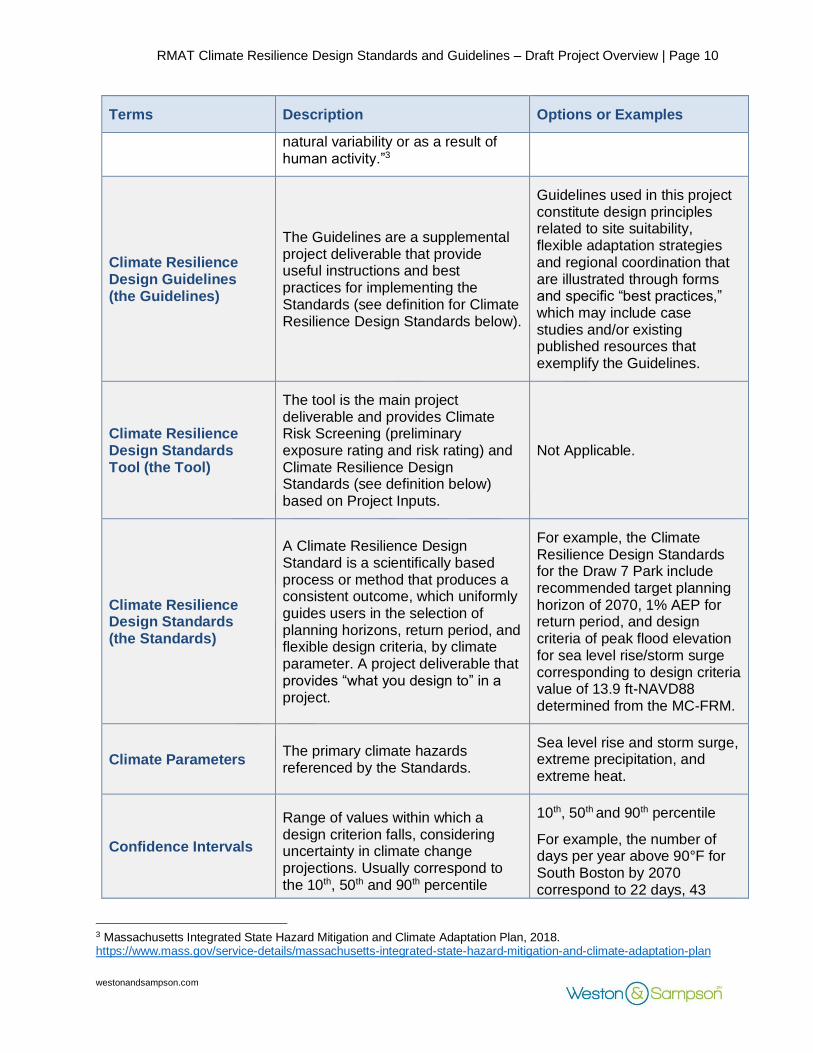
Climate Resilience Design Guidelines (the Guidelines)
The Guidelines are a supplemental project deliverable that provide useful instructions and best practices for implementing the Standards (see definition for Climate Resilience Design Standards below).
Guidelines used in this project constitute design principles related to site suitability, flexible adaptation strategies and regional coordination that are illustrated through forms and specific “best practices,” which may include case studies and/or existing published resources that exemplify the Guidelines.
Climate Resilience Design Standards Tool (the Tool)
The tool is the main project deliverable and provides Climate Risk Screening (preliminary exposure rating and risk rating) and Climate Resilience Design Standards (see definition below) based on Project Inputs.
Not Applicable.
Climate Resilience Design Standards (the Standards)
A Climate Resilience Design Standard is a scientifically based process or method that produces a consistent outcome, which uniformly guides users in the selection of planning horizons, return period, and flexible design criteria, by climate parameter. A project deliverable that provides “what you design to” in a project.
For example, the Climate Resilience Design Standards for the Draw 7 Park include recommended target planning horizon of 2070, 1% AEP for return period, and design criteria of peak flood elevation for sea level rise/storm surge corresponding to design criteria value of 13.9 ft-NAVD88 determined from the MC-FRM.
Climate Parameters The primary climate hazards referenced by the Standards.
Sea level rise and storm surge, extreme precipitation, and extreme heat.
Confidence Intervals
Range of values within which a design criterion falls, considering uncertainty in climate change projections. Usually correspond to the 10th, 50th and 90th percentile
10th, 50th and 90th percentile
For example, the number of days per year above 90°F for South Boston by 2070 correspond to 22 days, 43
3 Massachusetts Integrated State Hazard Mitigation and Climate Adaptation Plan, 2018. https://www.mass.gov/service-details/massachusetts-integrated-state-hazard-mitigation-and-climate-adaptation-plan

RMAT Climate Resilience Design Standards and Guidelines – Draft Project Overview | Page 11
westonandsampson.com
Terms Description Options or Examples
values based on climate change projections.
days, and 63 days, respectively.
Consequence of Impact
According to SHMCAP, Consequence is defined as “the effect of a hazard occurrence. Consequence is demonstrated by the impact on population, physical property (e.g., state facilities, local jurisdiction assets and general building stock, and critical facilities), responders, operations, the environment, the economy, and public confidence in state governance. A consequence analysis meets the EMAP standard for hazards identified in state plans.”4
Consequence of Impact is evaluated as part of Severity in the Criticality calculation of the Tool.
For example, the public health and safety impact for an infrastructure asset could be that loss of infrastructure may result in severe injuries, possible loss of life.
Construction Type Proposed type of project related to asset construction.
Reconstruction, Rehabilitation, New Construction, Major Repairs
Criticality
A function of scope, time, and severity for building and infrastructure assets, and ecosystem services for natural resources assets.
A hospital located in the 100-year floodplain would have a higher criticality.
Cumulative Probability
Cumulative probability is the measure of the total probability that a certain event will happen during a given period of time. (Commonly referred to as cumulative risk.)
For a 1% annual chance flood event (the 100-year flood) the cumulative probability during the average 30-year mortgage is actually about 25% (or a 1 in 4 chance).
Design Criteria A qualitative criterion generated by the Climate Resilience Design Standards as an output.
Base flood elevation, cooling degree days, 24-hour rainfall depth, and more.
4 Massachusetts Integrated State Hazard Mitigation and Climate Adaptation Plan, 2018. https://www.mass.gov/service-details/massachusetts-integrated-state-hazard-mitigation-and-climate-adaptation-plan

RMAT Climate Resilience Design Standards and Guidelines – Draft Project Overview | Page 12
westonandsampson.com
Terms Description Options or Examples
Design Criteria Value
A numeric value calculated by the user, based on the Climate Resilience Design Standards methodology.
Example: the projected 2070, 24-hr rainfall depth is 8.2 inches.
Design Flood Elevation (DFE)
The anticipated flood elevation to which an asset should be designed, to protect the asset.
DFE is typically at least “BFE” with freeboard, as required by building codes. In the MC-FRM, the DFE considers freeboard and wave height. See definition for freeboard and MC-FRM below.
Design Life The life expectancy of a project as typically used for design.
This is also known as service life, and is generally less than a project’s “anticipated useful life” (see definition above).
Design Storm
The magnitude and temporal distribution of precipitation from a storm event defined by probability of occurrence (e.g., five-year storm) and duration (e.g., 24 hours), used in the design and evaluation of stormwater management systems.5
The present day 10-year 24-hour design storm for Worcester, MA is 4.9 inches of rainfall depth according to NOAA Atlas 14.
Ecosystem Services The direct and indirect benefits as a result of ecosystems provided by natural resources.
Flood protection, stormwater infiltration, pollution protection, oxygen production, wildlife habitat, etc.
Environmental Justice Populations
Defined by the MA Executive Office
of Energy and Environmental Affairs and based on 2010 American Community Survey data by census tract.6
Environmental Justice populations include areas where:
• 25% or more of the population identifies as a person of color
• 25% or more of households have limited English fluency
5 Philadelphia Stormwater Management Guidance Manual, Version 3.1. (2018). By the Philadelphia Water Department. https://www.pwdplanreview.org/manual/appendices/a.-glossary 6 Massachusetts Executive Office of Energy and Environmental Affairs (EOEEA; 2020). Environmental Justice Communities in Massachusetts. https://www.mass.gov/info-details/environmental-justice-communities-in-massachusetts

RMAT Climate Resilience Design Standards and Guidelines – Draft Project Overview | Page 13
westonandsampson.com
Terms Description Options or Examples
• Households with an annual median income equal to or less than 65% of the state median
Exposure
The extent to which something is in direct contact with climate parameters or their related climate change impacts. Exposure is often determined by examining the number of people or assets that lie within a geographic area affected by a climate parameter, or by determining the magnitude of the climate change impact.
For example, measurements of flood depth outside a building or number of heat waves experienced by a county are measurements of exposure.
Exposure Rating
The exposure rating is calculated based on the project location, useful life, and questions related to exposure.
Not exposed (for coastal and riverine only), low exposure, moderate exposure, and high exposure.
Exposure Service Life
Length of time within the design life or anticipated useful life that the asset is projected to be exposed to coastal flooding.
Exposure Service Life can be easily determined by evaluating the MC-FRM probability flood risk maps. For example, if a building with a 50-year anticipated useful is proposed to be built in 2020, but is not exposed to flooding until 2050, has an exposure service life of 20 years. See definition for MC-FRM below.
Freeboard
Freeboard is a factor of safety usually expressed in feet above a flood level for purposes of floodplain management.7
Freeboard is typically recommended to be at least 1 ft., but FEMA regulations may require additional freeboard requirements based on criticality and asset type.
Flexible Adaptive Pathways (AP)
Guideline category aimed at evaluating project design strategies that are able to adapt over time and respond to changing climate conditions, while encouraging
Imagine a major coastal roadway that needs to be elevated in the short-term. The design for this site could also include long-term approaches
7 NH Coastal Flood Risk Science and Technical Advisory Panel (2020). New Hampshire Coastal Flood Risk Summary, Part II: Guidance for Using Scientific Projections. Report published by the University of New Hampshire, Durham, NH.

RMAT Climate Resilience Design Standards and Guidelines – Draft Project Overview | Page 14
westonandsampson.com
Terms Description Options or Examples
climate mitigation, prioritizing nature-based solutions, and preparing for current and future operations and maintenance needs.
such as reducing impervious area, increasing tree canopy, and creating a living shoreline. Learn more by checking out the “Route 28 and Falmouth Harbor” RMAT Case Study.
Flood Insurance Rate Map (FIRM)
Maps created by FEMA that show special flood hazard areas, including the 100- and 500-year floodplains.8 See definitions for 100- and 500-year floodplains above.
FIRMs are available on the FEMA Flood Map Service Center online.
Flood Protection Measures taken to mitigate exposure of the asset to flooding.
Constructing a vegetated berm at key flood pathway locations
Forms
Questions provided to guide users through design considerations, document design, and decision-making based on Guidelines. Serves as documentation for inputs/outputs from the Tool, the design criteria values calculated from recommended tiered methodology, and overall project information and costs.
An example of a Form question related to site suitability is, “Does the site currently function as the primary asset type?”
Infrastructure Infrastructure is an Asset Category in the Tool. Refer to definition for Asset Category above.
Examples of infrastructural asset sub-types include transportation, flood control, utilities, solid and hazardous waste.
Intermediate Planning Horizon
With the Standards for the sea level rise and storm surge climate parameter, this planning horizon is provided as an interim planning horizon if the Target Planning Horizon is not achievable in design. (See Planning Horizon definition below for further details.)
For example, the recommended Intermediate Planning Horizon might be 2050 when the Target Planning Horizon is 2070.
8 Federal Emergency Management Agency (FEMA; 2020). Flood Map Products. https://www.fema.gov/flood-maps/tools-resources/flood-map-products

RMAT Climate Resilience Design Standards and Guidelines – Draft Project Overview | Page 15
westonandsampson.com
Terms Description Options or Examples
Natural Resources Natural Resources is Asset Category in the Tool. Refer to definition for Asset Category above.
Examples of natural resources asset sub-types include coastal resource areas, forested ecosystems, aquatic ecosystems, wetland resource areas (inland), agricultural resources, open space, and urban forest.
Nature-based Solutions
The International Union for Conservation of Nature (IUCN) defines nature-based solutions as “actions to protect, sustainably manage, and restore natural or modified ecosystems, that address societal challenges effectively and adaptively, simultaneously providing human well-being and biodiversity benefits.”9 Generally, they refer to design that incorporates natural, green elements, rather than traditional “gray solutions.”
For example, a traditional engineered solution for urban flooding due to extreme precipitation may be retrofitted urban storm-water drainage systems. An alternative nature-based solution would be green roofs, bio swales, or rain gardens to filter, absorb, and manage stormwater runoff, further reducing flows into a main drainage system.
NOAA Atlas 14 Precipitation frequency estimates data server, provided by NOAA.10
Not applicable.
Physical Assets See definition for Assets above. See examples for Assets above.
Planning Horizon
A future date to which a project can be designed, which allows the project to incorporate anticipated climate change projections.
Present (2030), Mid-Century (2050), Mid-late Century (2070), End of Century (2090/2100)
Project Inputs Information provided by the user about the project and project assets.
Inputs could include project details and location, asset information, project exposure questions, and project criticality questions
9 International Union for Conservation of Nature (IUCN, 2016). “IUCN Global Standard for Nature-based Solutions.” https://www.iucn.org/theme/ecosystem-management/our-work/iucn-global-standard-nature-based-solutions 10 NOAA Atlas 14 Point Precipitation Frequency Estimates: Northeastern States; NOAA Atlas 14, Volume 10, Version
3
RMAT Climate Resilience Design Standards and Guidelines – Draft Project Overview | Page 16
westonandsampson.com
Terms Description Options or Examples
Protect Adaptation strategy that blocks/prevents the climate parameter from impact.
Flood barrier, dry floodproofing, reflective roofs, lighter colored paver materials, bio retention basins, infiltration trenches, underground storage tank.
Recurrence Intervals Also known as return period. Please refer to definition of return period.
Not Applicable.
Regional Coordination (RC)
Guideline category aimed at understanding how coordination and collaboration across regions, as well as State Agencies and jurisdictions, can help strengthen resilient designs and implementation.
Imagine a park sited at a major flood pathway impacting two cities and critical state infrastructure. Resilience design and implementation would need to be coordinated across agencies and jurisdictions. Learn more by checking out the “Draw Seven Park” RMAT Case Study.
Representative Concentration Pathways (RCP)
Representative Concentration Pathways (RCPs) are four greenhouse gas concentration (not emissions) trajectories adopted by the Intergovernmental Panel on Climate Change (IPCC) for its Fifth Assessment Report in 2014. The Representative Concentration Pathways (RCPs), which are used for making projections based on these factors, describe four different 21st century pathways of greenhouse gas emissions and atmospheric concentrations, air pollutant emissions and land use.11
The RCPs include a stringent greenhouse gas mitigation scenario (RCP 2.6), two intermediate scenarios (RCP 4.5 and RCP 6.0) and one scenario with very high greenhouse gas emissions (RCP 8.5).
Resilience Massachusetts Action Team (RMAT)
An inter-agency team tasked with implementing the State Hazard Mitigation and Climate Adaptation Plan (SHMCAP).12
Not Applicable.
11 Climate Change 2014: Synthesis Report. (2014). Intergovernmental Panel on Climate Change. https://www.ipcc.ch/site/assets/uploads/2018/02/SYR_AR5_FINAL_full.pdf 12 Executive Office of Energy and Environmental Affairs (EOEEA; 2019). “Baker-Polito Administration Launches Resilient MA Action Team.” https://www.mass.gov/news/baker-polito-administration-launches-resilient-ma-action-team

RMAT Climate Resilience Design Standards and Guidelines – Draft Project Overview | Page 17
westonandsampson.com
Terms Description Options or Examples
Return Period Annual probability of occurrence of an event. Also known as recurrence interval.
10-year (10% AEP) or 100-year (1% AEP), etc.
Risk
According to SHMCAP, risk is defined as “the potential for an unwanted outcome resulting from a hazard event, as determined by its likelihood and associated consequences; and expressed, when possible, in dollar losses. Risk represents potential future losses, based on assessments of probability, severity, and vulnerability.”13
For example, if a state highway is flooded that also serves as an evacuation route, it will have a high probability of flooding and its consequence of flooding (as measured by its severity, with respect to geographic area and people affected, economic impacts and cascading impacts to other infrastructure) will also be high, which would lead to a high risk rating.
Risk Rating
A preliminary asset-specific screening based on the project’s exposure rating and asset’s criticality, by climate parameter.
Low, Moderate, or High Risk.
Sea level rise (SLR)
The worldwide average rise in mean sea level, which may be due to a number of different causes, such as the thermal expansion of sea water and the addition of water to the oceans from the melting of glaciers, ice caps, and ice sheets; contrast with relative sea-level rise.14
The Massachusetts Coastal Flood Risk Model (MC-FRM) for Northern Massachusetts Grid (North of Cape Cod) incorporates 1.29 ft. of SLR by 2030, 2.49 ft. of SLR by 2050, and 4.29 ft. of SLR by 2070.
Scope
Scope is used to evaluate criticality of an asset and is defined as the geographic area and population that would be affected by the loss or inoperability of that asset.
Affects greater than 10,000 people and vulnerable populations.
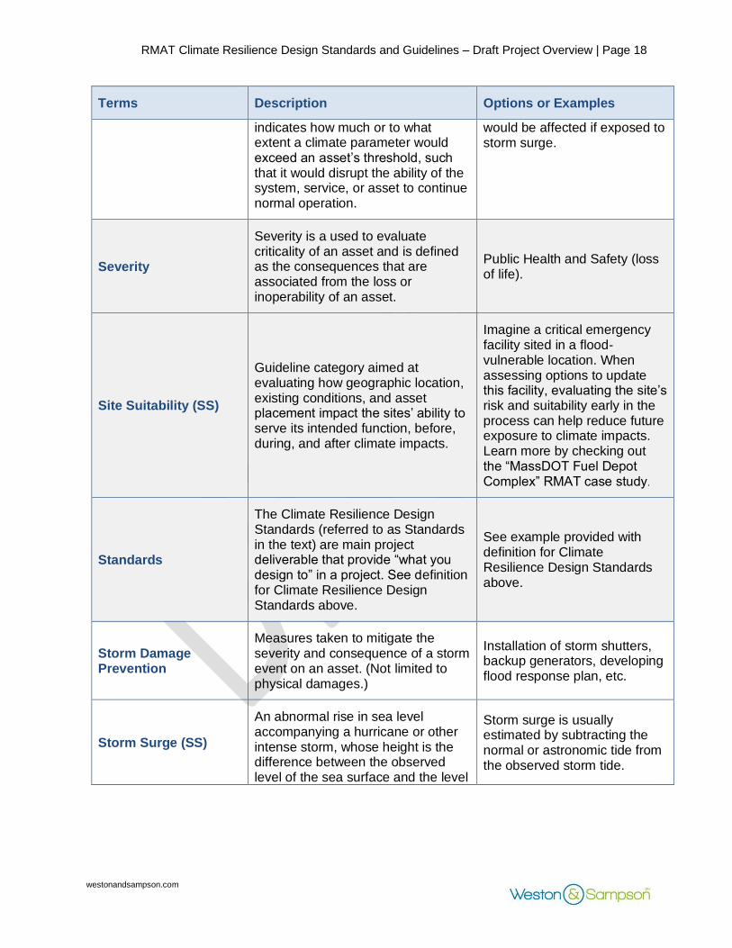
Sensitivity The impact on a system, service, or asset when exposed to climate parameters. The level of sensitivity
For example, how much a facilities ability to function
13 Massachusetts Integrated State Hazard Mitigation and Climate Adaptation Plan, 2018. https://www.mass.gov/service-details/massachusetts-integrated-state-hazard-mitigation-and-climate-adaptation-plan 14 NH Coastal Flood Risk Science and Technical Advisory Panel (2020). New Hampshire Coastal Flood Risk Summary, Part II: Guidance for Using Scientific Projections. Report published by the University of New Hampshire, Durham, NH.
RMAT Climate Resilience Design Standards and Guidelines – Draft Project Overview | Page 18
westonandsampson.com
Terms Description Options or Examples
indicates how much or to what extent a climate parameter would exceed an asset’s threshold, such that it would disrupt the ability of the system, service, or asset to continue normal operation.
would be affected if exposed to storm surge.
Severity
Severity is a used to evaluate criticality of an asset and is defined as the consequences that are associated from the loss or inoperability of an asset.
Public Health and Safety (loss of life).
Site Suitability (SS)
Guideline category aimed at evaluating how geographic location, existing conditions, and asset placement impact the sites’ ability to serve its intended function, before, during, and after climate impacts.
Imagine a critical emergency facility sited in a flood-vulnerable location. When assessing options to update this facility, evaluating the site’s risk and suitability early in the process can help reduce future exposure to climate impacts. Learn more by checking out the “MassDOT Fuel Depot Complex” RMAT case study.
Standards
The Climate Resilience Design Standards (referred to as Standards in the text) are main project deliverable that provide “what you design to” in a project. See definition for Climate Resilience Design Standards above.
See example provided with definition for Climate Resilience Design Standards above.
Storm Damage Prevention
Measures taken to mitigate the severity and consequence of a storm event on an asset. (Not limited to physical damages.)
Installation of storm shutters, backup generators, developing flood response plan, etc.
Storm Surge (SS)
An abnormal rise in sea level accompanying a hurricane or other intense storm, whose height is the difference between the observed level of the sea surface and the level
Storm surge is usually estimated by subtracting the normal or astronomic tide from the observed storm tide.
RMAT Climate Resilience Design Standards and Guidelines – Draft Project Overview | Page 19
westonandsampson.com
Terms Description Options or Examples
that would have occurred in the absence of the cyclone.15
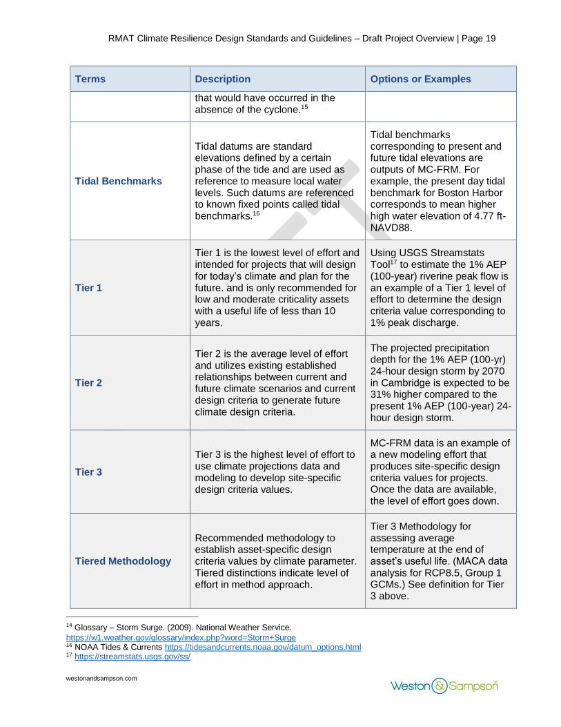
Tidal Benchmarks
Tidal datums are standard elevations defined by a certain phase of the tide and are used as reference to measure local water levels. Such datums are referenced to known fixed points called tidal benchmarks.16
Tidal benchmarks corresponding to present and future tidal elevations are outputs of MC-FRM. For example, the present day tidal benchmark for Boston Harbor corresponds to mean higher high water elevation of 4.77 ft-NAVD88.
Tier 1
Tier 1 is the lowest level of effort and intended for projects that will design for today’s climate and plan for the future. and is only recommended for low and moderate criticality assets with a useful life of less than 10 years.
Using USGS Streamstats Tool17 to estimate the 1% AEP (100-year) riverine peak flow is an example of a Tier 1 level of effort to determine the design criteria value corresponding to 1% peak discharge.
Tier 2
Tier 2 is the average level of effort and utilizes existing established relationships between current and future climate scenarios and current design criteria to generate future climate design criteria.
The projected precipitation depth for the 1% AEP (100-yr) 24-hour design storm by 2070 in Cambridge is expected to be 31% higher compared to the present 1% AEP (100-year) 24-hour design storm.
Tier 3
Tier 3 is the highest level of effort to use climate projections data and modeling to develop site-specific design criteria values.
MC-FRM data is an example of a new modeling effort that produces site-specific design criteria values for projects. Once the data are available, the level of effort goes down.
Tiered Methodology
Recommended methodology to establish asset-specific design criteria values by climate parameter. Tiered distinctions indicate level of effort in method approach.
Tier 3 Methodology for assessing average temperature at the end of asset’s useful life. (MACA data analysis for RCP8.5, Group 1 GCMs.) See definition for Tier 3 above.
14 Glossary – Storm Surge. (2009). National Weather Service.
https://w1.weather.gov/glossary/index.php?word=Storm+Surge 16 NOAA Tides & Currents https://tidesandcurrents.noaa.gov/datum_options.html 17 https://streamstats.usgs.gov/ss/
RMAT Climate Resilience Design Standards and Guidelines – Draft Project Overview | Page 20
westonandsampson.com
Terms Description Options or Examples
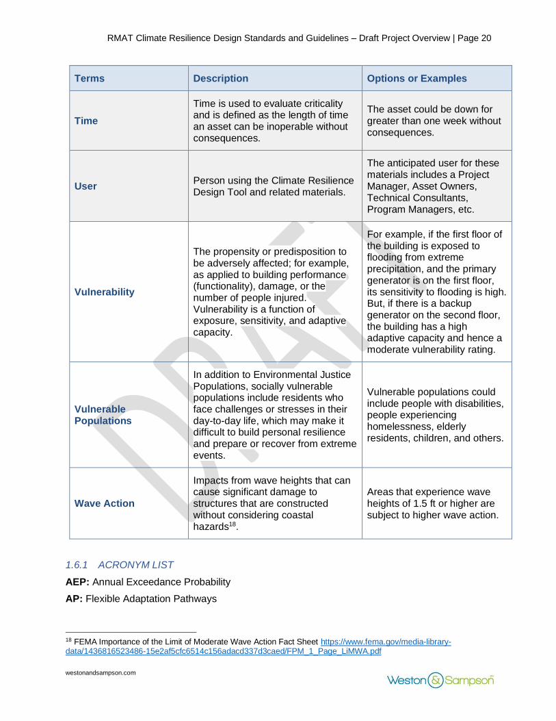
Time
Time is used to evaluate criticality and is defined as the length of time an asset can be inoperable without consequences.
The asset could be down for greater than one week without consequences.
User Person using the Climate Resilience Design Tool and related materials.
The anticipated user for these materials includes a Project Manager, Asset Owners, Technical Consultants, Program Managers, etc.
Vulnerability
The propensity or predisposition to be adversely affected; for example, as applied to building performance (functionality), damage, or the number of people injured. Vulnerability is a function of exposure, sensitivity, and adaptive capacity.
For example, if the first floor of the building is exposed to flooding from extreme precipitation, and the primary generator is on the first floor, its sensitivity to flooding is high. But, if there is a backup generator on the second floor, the building has a high adaptive capacity and hence a moderate vulnerability rating.
Vulnerable Populations
In addition to Environmental Justice Populations, socially vulnerable populations include residents who face challenges or stresses in their day-to-day life, which may make it difficult to build personal resilience and prepare or recover from extreme events.
Vulnerable populations could include people with disabilities, people experiencing homelessness, elderly residents, children, and others.
Wave Action
Impacts from wave heights that can cause significant damage to structures that are constructed without considering coastal hazards18.
Areas that experience wave heights of 1.5 ft or higher are subject to higher wave action.
1.6.1 ACRONYM LIST
AEP: Annual Exceedance Probability
AP: Flexible Adaptation Pathways
18 FEMA Importance of the Limit of Moderate Wave Action Fact Sheet https://www.fema.gov/media-library-data/1436816523486-15e2af5cfc6514c156adacd337d3caed/FPM_1_Page_LiMWA.pdf

RMAT Climate Resilience Design Standards and Guidelines – Draft Project Overview | Page 21
westonandsampson.com
ASHRAE: American Society of Heating, Refrigerating and Air-Conditioning Engineers
BFE: Base Flood Elevation
BH-FRM: Boston Harbor Flood Risk Model
C.I: Confidence Interval
CSSR: Climate Science Special Report
CZM: Coastal Zone Management
DCAMM: Division of Capital Asset Management and Maintenance
DCR: Department of Conservation & Recreation
DFE: Design Flood Elevation
DHCD: Department of Housing and Community Development
EOEEA: Executive Office of Energy and Environmental Affairs
FEMA: Federal Emergency Management Agency
FIRM: Flood Insurance Rate Map
GCM: Global Climate Models
GIS: Geographic Information System
GEV: Generalized Extreme Value Distribution
HEC-2: Hydrologic Engineering Center's -2
HEC-RAS: Hydrologic Engineering Center's-River Analysis System
IPCC: Intergovernmental Panel on Climate Change
LOCA dataset: Localized Constructed Analogs
MACA: Multivariate Adaptive Constructed Analogs
MassDOT: Massachusetts Department of Transportation
MC-FRM: Massachusetts Coast Flood Risk Model
MEMA: Massachusetts Emergency Management Agency
NCA4: Fourth National Climate Assessment
NOAA: National Oceanic and Atmospheric Administration
RC: Regional Coordination
RCP: Representative Concentration Pathway
RMAT: Resilient Massachusetts Action Team
SCS: Soil Conservation Service
SHMCAP: Massachusetts State Hazard Mitigation and Climate Adaptation Plan (2018)
SLR: Sea Level Rise
SS: Site Suitability
USGS: United States Geological Survey
RMAT Climate Resilience Design Standards and Guidelines – Draft Project Overview | Page 22
westonandsampson.com
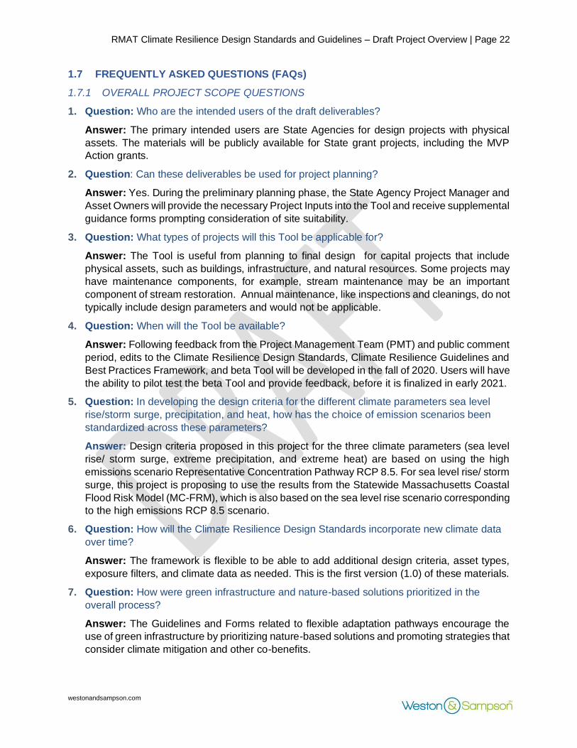
1.7 FREQUENTLY ASKED QUESTIONS (FAQs)
1.7.1 OVERALL PROJECT SCOPE QUESTIONS
1. Question: Who are the intended users of the draft deliverables?
Answer: The primary intended users are State Agencies for design projects with physical
assets. The materials will be publicly available for State grant projects, including the MVP
Action grants.
2. Question: Can these deliverables be used for project planning?
Answer: Yes. During the preliminary planning phase, the State Agency Project Manager and
Asset Owners will provide the necessary Project Inputs into the Tool and receive supplemental
guidance forms prompting consideration of site suitability.
3. Question: What types of projects will this Tool be applicable for?
Answer: The Tool is useful from planning to final design for capital projects that include
physical assets, such as buildings, infrastructure, and natural resources. Some projects may
have maintenance components, for example, stream maintenance may be an important
component of stream restoration. Annual maintenance, like inspections and cleanings, do not
typically include design parameters and would not be applicable.
4. Question: When will the Tool be available?
Answer: Following feedback from the Project Management Team (PMT) and public comment
period, edits to the Climate Resilience Design Standards, Climate Resilience Guidelines and
Best Practices Framework, and beta Tool will be developed in the fall of 2020. Users will have
the ability to pilot test the beta Tool and provide feedback, before it is finalized in early 2021.
5. Question: In developing the design criteria for the different climate parameters sea level
rise/storm surge, precipitation, and heat, how has the choice of emission scenarios been
standardized across these parameters?
Answer: Design criteria proposed in this project for the three climate parameters (sea level
rise/ storm surge, extreme precipitation, and extreme heat) are based on using the high
emissions scenario Representative Concentration Pathway RCP 8.5. For sea level rise/ storm
surge, this project is proposing to use the results from the Statewide Massachusetts Coastal
Flood Risk Model (MC-FRM), which is also based on the sea level rise scenario corresponding
to the high emissions RCP 8.5 scenario.
6. Question: How will the Climate Resilience Design Standards incorporate new climate data
over time?
Answer: The framework is flexible to be able to add additional design criteria, asset types,
exposure filters, and climate data as needed. This is the first version (1.0) of these materials.
7. Question: How were green infrastructure and nature-based solutions prioritized in the
overall process?
Answer: The Guidelines and Forms related to flexible adaptation pathways encourage the
use of green infrastructure by prioritizing nature-based solutions and promoting strategies that
consider climate mitigation and other co-benefits.

RMAT Climate Resilience Design Standards and Guidelines – Draft Project Overview | Page 23
westonandsampson.com
1.7.2 ASSET RELATED QUESTIONS
8. Question: Explain how this Tool applies to the green infrastructure assets that the
Commonwealth owns and manages.
Answer: This Tool provides the standards for design of new green infrastructure assets and
retrofit of existing green infrastructure and/or natural resource assets that the Commonwealth
owns and manages.
9. Question: Can the planning tool inputs be modified to also request information on energy
use, in the context of building efficiency?
Answer: This is not factored in the current version of the Tool but can be considered as an
opportunity for future revisions of the Tool.
10. Question: How is site suitability and/or site alternatives analysis of an asset considered in
this project?
Answer: Site suitability is factored into the guidelines form. The project proponent will be
prompted to answer the site suitability form questions prior to getting the design standards.
11. Question: Can this tool be used to provide design standards and criteria for specific
building system sub-assets/components?
Answer: This Tool is not recommended to be used to provide design standards and criteria
for specific building system sub-assets/components (e.g., HVAC, Fire Protection, Structural,
etc.) However, the design guidelines/forms include guidance that can be used beyond an
individual asset scale.
1.7.3 SEA LEVEL RISE/STORM SURGE DESIGN STANDARDS QUESTIONS
12. Question: Will the Climate Resilience Design Standards include at least two design choices
(“worst case conditions possible in 2070 or in 2050”) and emphasize need for flexible
adaptive design?
Answer: We are recommending an intermediate and target planning horizon for projects with
useful life greater than 50 years. Flexible adaptive design considerations are provided in the
guidelines/forms.
13. Question: Are all projects required to model their return period storm/flood conditions for
coastal response?
Answer: All the data already exists through the MC-FRM regardless of tier designation.
Criticality and exposure service life affect return period recommendations. There is a
methodology that details how to get the data (currently request based).
1.7.4 PRECIPITATION DESIGN STANDARDS QUESTIONS
14. Question: How do these recommendations affect current practices recommended for
recurrence intervals?
Answer: These standards are recommended, but not required. They are not intended to
replace existing standards required by agencies. If a 25-year return period is recommended
for design through the standards tool, but the existing infrastructure is only designed to handle
a 10-year return period storm based on existing practice, requirements or other policy, this
would be reflected in the forms/checklists from the Guidelines.

RMAT Climate Resilience Design Standards and Guidelines – Draft Project Overview | Page 24
westonandsampson.com
15. Question: How do the current Climate Resilience Design Standards affect the design of
culverts?
Answer: Culverts should still be designed to meet MassDOT river and stream crossing
standards that are based on bank full width measurements, which are more stringent
compared to design storm requirements.
16. Question: How do the Climate Resilience Design Standards consider cloud bursts or rainfall
events that are less than or greater than 24-hours?
Answer: Design standards/criteria for stormwater management and drainage infrastructure
improvement projects (that include both gray and green infrastructure assets) typically use
the 24-hour design storms as the basis of design and to determine level of service (LOS)
requirements. Since the intent of this project is to determine how these design standards and
criteria are likely to change in the future, we focused establishing consistent methodology to
estimate future 24-hour design storms. Other design storm, both shorter and longer duration,
can be added in future versions of the Climate Resilience Design Standards.
1.7.5 HEAT DESIGN STANDARDS QUESTIONS
17. Question: Impacts from flooding are episodic, whereas impacts from heat are more regular.
How is this addressed in the heat standards?
Answer: For heat standards, we are recommending using confidence intervals instead of
recurrence intervals. While recurrence intervals are related to frequency of occurrence of
extreme events, confidence intervals, such as the 10 th, 50th (median) and 90th percentiles,
which represent a range of plausible values for a certain parameter. For heat design criteria,
we are proposing to use parameters, such as annual and seasonal average temperatures,
average heat index, heating and cooling degree days that are more representative of regular
or “new normal” conditions in the future. Assets that have a higher Criticality score are
recommended to use higher confidence intervals.
18. Question: Clarify if areas that are experiencing heat island effect are incorporated into risk
factors.
Answer: Exposure is based on impervious surfaces, increased days above 90 degrees, and
proximity to a water body. Heat Island mapping is not provided statewide, so it is not a filter,
but could be added in the future.
19. Question: Are heat wave duration and humidity factored in the heat standards?
Answer: Yes, average duration of heat wave and heat index (factoring ambient air
temperature and relative humidity) are included in the design criteria for heat.
20. Question: ASHRAE design criteria for cooling loads refer to parameters, such as 99% or
1% design temperature and the hours above that temperature, which is a slightly different
metric than CDD/HDDs. Why is this project not considering these criteria?
Answer: We reviewed the ASHRAE standards, such as Cooling dry bulb and mean coincident
wet bulb (0.4%, 1% and 2%) temperature (wet bulb, dry bulb, etc.) and considered these as
criteria that could be included in future round of updates of the Standards. Some concerns
have been raised by engineers that if HVAC systems are designed based on future climate
criteria, they could end up being less energy efficient in the short run and produce more GHG
emissions.
RMAT Climate Resilience Design Standards and Guidelines – Draft Project Overview | Page 25
westonandsampson.com
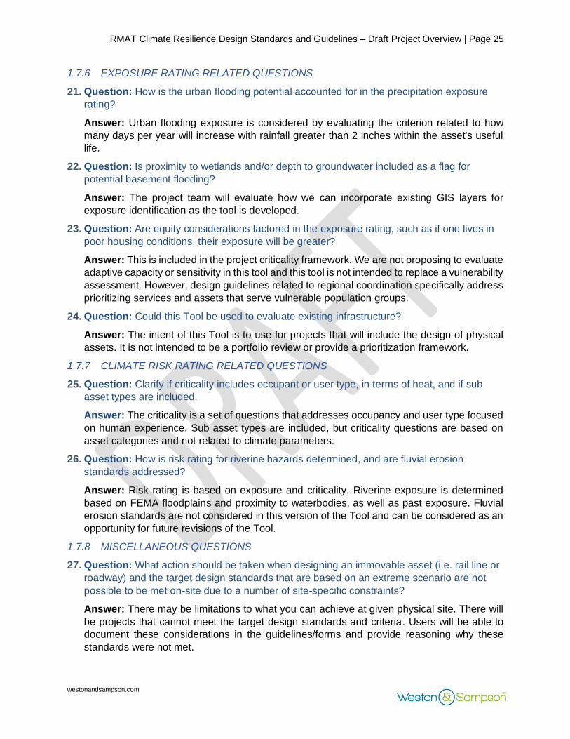
1.7.6 EXPOSURE RATING RELATED QUESTIONS
21. Question: How is the urban flooding potential accounted for in the precipitation exposure
rating?
Answer: Urban flooding exposure is considered by evaluating the criterion related to how
many days per year will increase with rainfall greater than 2 inches within the asset's useful
life.
22. Question: Is proximity to wetlands and/or depth to groundwater included as a flag for
potential basement flooding?
Answer: The project team will evaluate how we can incorporate existing GIS layers for
exposure identification as the tool is developed.
23. Question: Are equity considerations factored in the exposure rating, such as if one lives in
poor housing conditions, their exposure will be greater?
Answer: This is included in the project criticality framework. We are not proposing to evaluate
adaptive capacity or sensitivity in this tool and this tool is not intended to replace a vulnerability
assessment. However, design guidelines related to regional coordination specifically address
prioritizing services and assets that serve vulnerable population groups.
24. Question: Could this Tool be used to evaluate existing infrastructure?
Answer: The intent of this Tool is to use for projects that will include the design of physical
assets. It is not intended to be a portfolio review or provide a prioritization framework.
1.7.7 CLIMATE RISK RATING RELATED QUESTIONS
25. Question: Clarify if criticality includes occupant or user type, in terms of heat, and if sub
asset types are included.
Answer: The criticality is a set of questions that addresses occupancy and user type focused
on human experience. Sub asset types are included, but criticality questions are based on
asset categories and not related to climate parameters.
26. Question: How is risk rating for riverine hazards determined, and are fluvial erosion
standards addressed?
Answer: Risk rating is based on exposure and criticality. Riverine exposure is determined
based on FEMA floodplains and proximity to waterbodies, as well as past exposure. Fluvial
erosion standards are not considered in this version of the Tool and can be considered as an
opportunity for future revisions of the Tool.
1.7.8 MISCELLANEOUS QUESTIONS
27. Question: What action should be taken when designing an immovable asset (i.e. rail line or
roadway) and the target design standards that are based on an extreme scenario are not
possible to be met on-site due to a number of site-specific constraints?
Answer: There may be limitations to what you can achieve at given physical site. There will
be projects that cannot meet the target design standards and criteria. Users will be able to
document these considerations in the guidelines/forms and provide reasoning why these
standards were not met.
RMAT Climate Resilience Design Standards and Guidelines – Draft Project Overview | Page 26
westonandsampson.com
28. Question: Is there is a “factor of safety” built into these standards?
Answer: The design standards and criteria are based on future climate projections based on
high-emission scenario (RCP 8.5). As such, an inherent “factor of safety” that considers future
climate is built into these standards. However, for any additional factor of safety, users will still
need to design to meet codes and required factors of safety.