
PHYSICAL PROPERTIES OF TITANIUM NITRIDE THIN FILM PREPARED ...
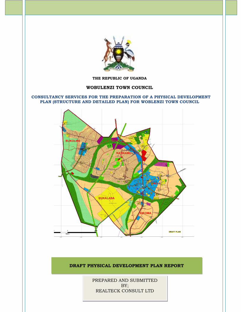
THE REPUBLIC OF UGANDA
WOBULENZI TOWN COUNCIL
CONSULTANCY SERVICES FOR THE PREPARATION OF A PHYSICAL DEVELOPMENTPLAN (STRUCTURE AND DETAILED PLAN) FOR WOBLENZI TOWN COUNCIL
DRAFT PHYSICAL DEVELOPMENT PLAN REPORT
PREPARED AND SUBMITTEDBY;
REALTECK CONSULT LTD
Page | 2
TABLE OF CONTENTS
ACRONYMS ........................................................................................................................................ 5
LIST OF TABLES ............................................................................................................................. 6
1. INTRODUCTION AND BACKGROUND TO THE PROJECT .............................................................. 9
1.1 Document Overview ...................................................................................................................91.2 Back ground to the Planning area .........................................................................................91.3 Background to the activity ......................................................................................................91.4 Location ..........................................................................................................................................91.5 Objective of the assignment..................................................................................................101.6 Scope of Work .............................................................................................................................10
1.6.1 General Requirements ................................................................................................... 10
1.6.2 Detailed Outline of Activities ................................................................................. 10
1.7 METHODOLOGY .........................................................................................................................101.7.1 Mobilisation and Preliminary Client Consultations..................................................101.7.2 Field Reconnaissance Visits ..............................................................................................101.7.3 Literature Review ..................................................................................................................101.7.4 Consultative Meetings .........................................................................................................111.7.5 Physical Surveys ....................................................................................................................111.7.6 Topographic survey...............................................................................................................111.7.7 Preparation of Base Maps ...................................................................................................111.7.8 Generation of Structure Plan alternatives ...................................................................11
1.7.10 Plan Presentation for approval ............................................................................................................12
1.7.11 Previous Planning Intervention in the planning area................................. 12
2. LEGAL AND INSTITUTIONAL FRAMEWORK ............................................................. 142.1 Legal Framework............................................................................................................................................142.1.1 The Constitution of the Republic of Uganda 1995 ..........................................................................142.1.2 The Physical Planning Act 2010............................................................................................................142.1.3 The Local Governments Act, 1997 .......................................................................................................142.1.4 The Uganda Land Act Cap 227 1998...................................................................................................152.1.5 The Public Health Act Cap.269 .............................................................................................................152.1.6 The Forest Act 1999 ..................................................................................................................................162.1.7 National Environment Statute, Cap 153 1998 .................................................................................162.1.8 Water Act, Cap 152 ...................................................................................................................................162.1.9 The 1942 Markets Act ..............................................................................................................................172.1.10 Waste Management Regulations 1999 .............................................................................................182.1.11 Investment Code Act, Cap 92 ..............................................................................................................18
2.2 Institutional Frame Work .......................................................................................................182.2.1 The Ministry of Local Government .......................................................................................................182.2.2 National Planning Authority (NPA) .......................................................................................................182.2.3 The National Physical Planning Board ................................................................................................182.2.4 Ministry of Lands, Housing and Urban Development ....................................................................193.2.5 Ministry of Water and Environment (MWE) ......................................................................................192.2.6 National Environment Management Authority (NEMA) .................................................................192.2.7 The Uganda Wildlife Authority...............................................................................................................192.2.8 Directorate of Water Development........................................................................................................192.2.10. The Uganda Land Commission ..........................................................................................................192.2.12. The District Land Board.......................................................................................................................20

Page | 3
3. SITUATIONAL ANALYSIS OF WOBULENZI TOWN COUNCIL ............................. 21
3.1 The Physical Environment.....................................................................................................213.2.2 Topography ..................................................................................................................................................213.2.3 Geology and seismicity .............................................................................................................................213.2.4 Soils ................................................................................................................................................................223.2.5 Hydrology: ....................................................................................................................................................22
3.3 Ecological Resources...........................................................................................................223.4.1 Human Population ....................................................................................................................................233.4.3 Major Economic activities........................................................................................................................243.3.4 Tribes and Languages...............................................................................................................................243.3.5 Level of Education .....................................................................................................................................253.3.7 Health and Diseases in the Town Council .........................................................................................263.3.8 Educational facilities in the Town Council ........................................................................................273.3.9 Sources of Energy in the Town Council..............................................................................................283.3.10 Sanitation...................................................................................................................................................293.3.11 Poverty and livelihood analysis ...........................................................................................................303.3.12 Gender and HIV Aids issues in the Town Council ........................................................................313.3.12.1 Gender .....................................................................................................................................................313.4.1 Commercial ..................................................................................................................................................323.4.2 The residential Landuse ..........................................................................................................................333.4.3 Religious places of worship.....................................................................................................................353.4.6 The civic and administration areas ......................................................................................................363.4.7 Transport infrastructure..........................................................................................................................373.4.8 The abattoir .................................................................................................................................................383.4.9 Utility Services in the Town ....................................................................................................................384.2.1 Sustainable technology ............................................................................................................................404.2.2 Management of non-biodegradable materials...................................................................................404.2.3 Collection costs...........................................................................................................................................40
The existing Landuse Map .............................................................................................................41Figure 27: Existing Landuse Map ................................................................................................413.5 DEVELOPMENT POTENTIALS AND CONSTRAINTS .......................................................41
3.5.1 Potentials ......................................................................................................................................................413.5.2 Constraints to development in the Town Council ...........................................................................41
3.5.3 SWOT analysis.........................................................................................................................42
4. STRATEGIC PLANNING INTERVENTIONS IN THE PLANNING PROCESS....... 44
4.1 Integration of the Uganda Vision 2040 into the Physical Planning of Wobulenzi.................................................................................................................................................................44
4.1.3 Key flagship projects to streamline the Implementation of the Vision .....................................44
4.2 THE PHYSICAL PLANNING VISION......................................................................................444.2.1 Mission ..........................................................................................................................................................44
4.2.2 Planning Goal ..........................................................................................................................454.3 PLANNING PRINCIPLES AND CONCEPTUAL DEVELOPMENT ....................................45
4.3.1 Planning Principles....................................................................................................................................454.3.2 Conceptual development of the plan ...................................................................................................46
4.4 THE PHYSICAL DEVELOPMENT PLAN PROPOSALS .....................................................484.4.2 The Alternative Physical Development Proposals ............................................................................484.4.3 The Proposed Physical Development Plan .........................................................................................504.4.2.21.1 Alternative Technologies for a Suitable ETP............................................................................56
5. THE PROPOSED DETAILED PLAN ................................................................................ 59
5.1 Introduction ................................................................................................................................595.2 Objectives of the detailed plan.............................................................................................59

Page | 4
5.3 Area Coverage and detailed plan area................................................................................595.4 The Proposed Detailed Plan ...................................................................................................596.1 ENVIRONMENTAL IMPACTS AND PROPOSED MITIGATION MEASURES ..............616.2 Drainage ........................................................................................................................................616.3 Wetland degradation and pollution of water ...................................................................616.4 Loss of food crops......................................................................................................................666.5 Loss of vegetation cover, and increase in volume of storm-water and soilerosion ..................................................................................................................................................666.6 Disruption of public utilities .................................................................................................676.7 Air pollution ................................................................................................................................67
7. DEVELOPMENT SPECIFICATIONS ................................................................................ 68
7.1 Setbacks for dwellings .............................................................................................................687.2 Site Standards for residential Development ...................................................................687.3 Vehicle parking requirements...............................................................................................697.4 Key Issues to Consider during development approval.................................................70
8. IMPLEMENTATION GUIDELINES ................................................................................... 71
8.1 Introduction ................................................................................................................................718.2 Legal and Institutional Frame Work for plan Implementation.................................718.3 Actors in the Implementation Process ..............................................................................718.4 Implementation Strategies ....................................................................................................728.5 MONITORING AND EVALUATION STRATEGY..................................................................7710. RECOMMENDATIONS AND CONCLUSIONS..................................................................7810.1 RECOMMENDATIONS ............................................................................................................7810.2 CONCLUSIONS..........................................................................................................................79
ANNEX ............................................................................................................................................... 81
Attendance list for the consultative meetings.......................................................................82
Page | 5
ACRONYMS
CBD Central Business DistrictCBOs Community Based OrganisationsDWD Directorate of Water DevelopmentEIA Environmental Impact AssessmentEMP Environment Management Plan
GIS Geographical Information SystemsGPS Global Positioning SystemMTN Mobile Telecommunication NetworkMoLG Ministry of Local GovernmentMoLHUD Ministry of Land Housing and Urban DevelopmentNGOs Non-Governmental OrganisationsUTL Uganda Telecom LimitedDWD Directorate of Water DevelopmentRGC Rural Growth CentreRTK Real Time Kinetic (GPS)GPS Global Positioning SystemPC Personal Computer

Page | 6
LIST OF TABLES
TABLE 1 : A RECORD OF SOME OF THE MAJOR EARTHQUAKE OCCURRENCES INUGANDA (1945 TO DATE) ............................................................................... 21
TABLE 2: POPULATION OF WOBULENZI TOWN COUNCIL........................................ 23TABLE 3: PROJECTED POPULATION TO 2026....................................................... 23TABLE 4: THE WARDS AND CELLS OF WOBULENZI TOWN COUNCIL ...................... 24TABLE 5: EDUCATIONAL LEVELS ......................................................................... 25TABLE 6: SHOWING THE RELIGIOUS AFFILIATIONS OF THE POPULATION OF
WOBULENZI TOWN......................................................................................... 25TABLE 7: SHOWING ACCESS TO HEALTH CARE FACILITIES IN THE TOWN .................... 26TABLE 8: SHOWING EDUCATIONAL FACILITIES IN THE PLANNING AREA .............. 28TABLE 9: PROBLEMS ASSOCIATED WITH SANITARY FACILITIES IN THE TOWN
COUNCIL ....................................................................................................... 29TABLE 10: POVERTY DIMENSIONS AS EXPERIENCED BY DIFFERENT GROUPS IN
WOBULENZI TOWN COUNCIL. ......................................................................... 30TABLE 11: SHOWING THE HOUSING TYPES IN THE TOWN .................................... 33TABLE 12: TYPE OF RESIDENTIAL UNITS IN THE TOWN COUNCIL ........................ 33TABLE 13: SHOWING THE SOURCES OF WATER IN THE TOWN COUNCIL .............. 39TABLE 14: MAJOR METHODS OF GARBAGE DISPOSAL......................................... 40TABLE 15: SWOT ANALYSIS OF THE TOWN .......................................................... 42TABLE 16: SHOWING WISH LIST OF STAKEHOLDERS........................................... 43TABLE 17: PROPOSED ROAD TYPES AND SIZE ..................................................... 54TABLE 18: ADVANTAGES AND DISADVANTAGES OF THE VARIOUS SEWAGE
TREATMENT SYSTEMS .................................................................................. 57TABLE 19: COMPARISON OF THE VARIOUS SEWAGE TREATMENT SYSTEMS ........ 58TABLE 20: SETBACKS OF DWELLINGS ................................................................. 68TABLE 21: PARKING SPACE REQUIREMENTS FOR OFF STREET PARKING ............ 70TABLE 22: THE KEY ACTORS IN A PLANNING PROCESS AND THEIR ROLES.......... 72TABLE 23: DETAILED PLAN IMPLEMENTATION DEVELOPMENT OPTIONS ............. 73TABLE 24: IMPLEMENTATION STRATEGY ............................................................ 74

Page | 7
LIST OF FIGURES
FIGURE 1: A MAP OF LUWERO DISTRICT SHOWING THE LOCATION OF WOBULENZITOWN.............................................................................................................. 9
FIGURE 2: SHOWING CONSULTATIONS WITH KEY STAKEHOLDERS...................... 11FIGURE 3: 2004-2014 WOBULENZI TOWN COUNCIL STRUCTURE PLAN ................. 12FIGURE 4: 2004-2014 WOBULENZI TOWN COUNCIL DETAILED PLAN .................... 13FIGURE 5: SEISMIC ZONING OF UGANDA ............................................................. 21FIGURE 6: SHOWING MAJOR EMPLOYMENT SOURCES IN THE TOWN. .................. 24FIGURE 7: SHOWING THE TRIBES IN THE PLANNING AREA .................................. 25FIGURE 8: SHOWING THE PREVALENT DISEASES WOBULENZI TOWN ................... 26FIGURE 9: SHOWING PROBLEMS ASSOCIATED WITH THE HEALTH FACILITIES IN
THE TOWN COUNCIL...................................................................................... 27FIGURE 10: SHOWING THE MEANS OF TRANSPORT TO EDUCATION FACILITIES... 28FIGURE 11: SHOWING THE SOURCES OF ENERGY FOR COOKING......................... 29FIGURE 12: SHOWING THE SOURCES OF ENERGY FOR LIGHTING IN THE TOWN ............ 29FIGURE 13:SHOWING THE CENTRAL BUSINESS DISTRICT OF WOBULENZI TOWN
COUNCIL ....................................................................................................... 33FIGURE 14: SHOWING THE ROOFING MATERIALS FOR THE HOUSING UNITS IN THE
TOWN............................................................................................................ 34FIGURE 15: SHOWING THE WALL MATERIAL FOR THE HOUSING UNITS IN THE
TOWN COUNCIL ............................................................................................. 34FIGURE 16: TYPE OF FLOOR MATERIAL FOR THE HOUSING STRUCTURES IN THE
TOWN COUNCIL ............................................................................................. 35FIGURE 17: A SHOWS ST. KIZITO CATHOLIC CHURCH AND B ST. PAUL’S COU
WOBULENZI................................................................................................... 35FIGURE 18: BLUE ARROW BUKALASA HEALTH CENTRE III AND RED ARROW
BUKOLWA HEALTH CENTRE II ....................................................................... 36FIGURE 19: GOOGLE MAP SHOWING THE LOCATION OF EXISTING PLAY FIELD (A, B,
C,D) AND RED ENCLOSED AREA SHOWS PROPOSED SITE FOR STADIUMDEVELOPMENT .............................................................................................. 36
FIGURE 2021: CIVIC INSTITUTIONS IN THE PLANNING AREA ............................... 37FIGURE 22: SHOWING WOBULENZI TAXI PARK .................................................... 37FIGURE 23: THE WTC ABATTOIR IN KIGULU CELL, KATIKAMU WARD................... 38FIGURE 2425: RED ARROW SHOWING ELECTRICITY TRANSMISSION LINES AND
BLUE ARROW SHOWING SOLAR POWER INSTALLATION AT BUKOLWA HEALTHCENTRE II ..................................................................................................... 38
FIGURE 26: PIPED WATER EXTRACTION AREA AT KATIKAMU.............................. 39FIGURE 27: EXISTING LANDUSE MAP .................................................................. 41

Page | 8
FIGURE 28: MULTIFUNCTIONAL SPATIAL DEVELOPMENT .................................... 46FIGURE 29: SLOPE SETTLEMENT ANNALYSIS ...................................................... 46FIGURE 30: OBSERVATION OF THE EXISTING SETTLEMENT PATTERN ................ 47FIGURE 31: CONSOLIDATED DEVELOPMENT AS OPPOSED TO SPARSE
DEVELOPMENT.............................................................................................. 47FIGURE 32: SHOWS ACTION PLAN ON NATIONAL ROADS...................................... 48FIGURE 33: SHOWING ALTERNATIVE PHYSICAL PLAN ONE .................................. 49FIGURE 34: SHOWING ALTERNATIVE PHYSICAL PLAN TWO.................................. 49FIGURE 35: SHOWING THE PROPOSED PHYSICAL DEVELOPMENT PLAN.............. 51FIGURE 36: WOBULENZI (KATIKAMU AND BUKOLWA) DETAILED PLAN ................. 60FIGURE 36: CHANGES IN RUNOFF FLOWS RESULTING FROM PAVED SURFACES
(SOURCE: LIVINGSTON AND MCCARRON, 1992).............................................. 64FIGURE 37: INTEGRATION OF THE STORMWATER MANAGEMENT PLAN INTO WTC
MANAGEMENT STRUCTURES ......................................................................... 65FIGURE 38: SHOWING THE SITE DEVELOPMENT STANDARDS FOR A COMMERCIAL
AREA............................................................................................................. 68FIGURE 39: SHOWING THE SITE DEVELOPMENT STANDARDS FOR THE
RESIDENTIAL AREAS (SOURCE NATIONAL PHYSICAL PLANNING STANDARDS2011) ............................................................................................................ 69
Page | 9
1. INTRODUCTION AND BACKGROUND TO THE PROJECT
1.1 Document Overview
This Physical Plan Report has been prepared in response to the provision of consultancyservices for the preparation of a physical Development Plan for Wobulenzi Town Council.
1.2 Back ground to the Planning area
Wobulenzi started as a small township in 1925 and during the 1960s and 70s the areasaw the emergence of the Indian community who prospered development through theestablishment of agro processing factories. The Town however attained a Town Councilstatus in 1997 being curved from Katikamu Sub County with the coming into force of theDecentralization statute (1993). To date Wobulenzi remains an important township alongKampala Gulu Highway and it is the main business catchment centre in the greaterLuweero District.
1.3 Background to the activityWobulenzi Town Council realized the need to prepare a new physical development Plan forthe town after the expirely of the previous one. In an effort to perform the aforementioned,the Town Council therefore, mobilized and secured funds the activity and contractedRealtek Consults Ltd. to execute the assignment.
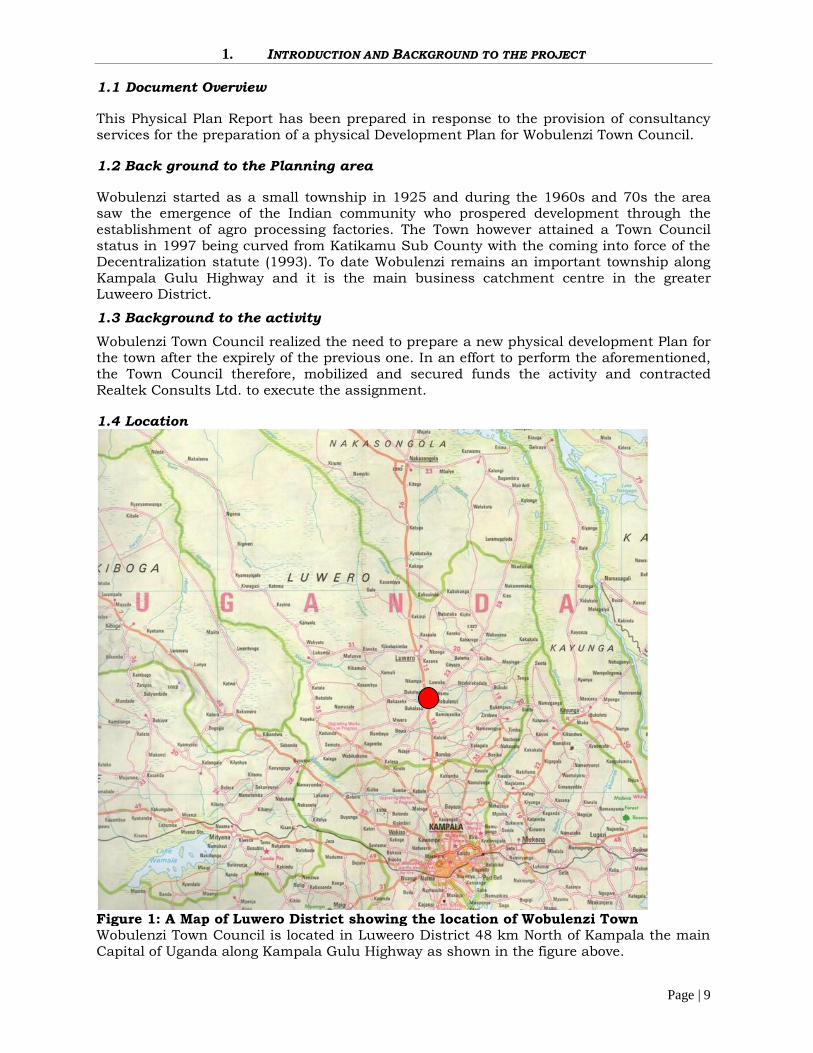
1.4 Location
Figure 1: A Map of Luwero District showing the location of Wobulenzi TownWobulenzi Town Council is located in Luweero District 48 km North of Kampala the mainCapital of Uganda along Kampala Gulu Highway as shown in the figure above.
Page | 10
1.5 Objective of the assignmentThe major objective of this assignment is to guide the spatial landuse development ofWobulenzi Town council through a physical development plan.
1.6 Scope of Work
1.6.1 General Requirements
The consultant shall undertake all necessary consultations to include the following;
1. Mobilize and consult stakeholders in the planning process2. Develop and support appropriate participatory methodology to ensure communication,
consultation and consensus building among stakeholders3. Prepare a Physical development plan for the town. The plan will be a guide to
investment area priorities, while providing a basis for coordinating decisions.4. Prepare a detailed Local physical development plan for the town through a
consultative process.
1.6.2Detailed Outline of Activities
The scope of activities to be performed by the consultant include among others thefollowing;
a) Come up with appropriate methodology for the assignmentb) Survey and mapping of the site and project boundary, all permanent
structure/buildings, roads, physical and natural physical features among othersc) Carry out socio economic analysis surveys and analysisd) Conduct Environmental studies for the areae) Prepare topographic maps, produce base maps, existing land-use maps and thematic
drawings relating to the townf) Propose alternative physical and local physical development plan and accompanying
reportsg) Proposal for solid waste material and waste water disposalh) Proposals for water supply to the town and the routingi) Prepare guidelines for implementation of the physical development planj) Deposition of the plans for the required statutory period andk) Presentation to the stakeholders for approval.
1.7 METHODOLOGY
The methodology to executing the assignment shall comprise of the following;
1.7.1 Mobilisation and Preliminary Client ConsultationsAfter contract signing, Realtek Consult Ltd, mobilized the key personnel and madepreliminary consultations with the client. A meeting was arranged for the Client to briefthe consultant team with emphasis on project deliverables and timeliness.
1.7.2 Field Reconnaissance VisitsReconnaissance surveys will be done to establish the administrative boundaries of theplanning area. The consultants together with key personnel in the Town Council shallconduct transect walks to establish the physical planning boundaries of the area.
1.7.3 Literature ReviewDocuments and literature including Wobulenzi Town Council Five Year Development Plan(2015-2016-2019-20), the Cadastre surveys of the planning area, Google Image of theplanning area, the National Physical Planning Standards and Guidelines 2011and the

Page | 11
Physical Planning Act 2010 and other laws governing physical planning in Uganda werereviewed by the consultant.
1.7.4 Consultative MeetingsConsultative meetings were held with both the Town Council technocrats and with thecommunity stakeholders at all levels at agreed venues. The meetings were aimed atidentifying key physical issues affecting the communities so as to furnish the planningteam with the required information (wish list) needed for the planning of the area.Community participation formed a basis for community involvement, acceptance whichwill necessitate adherence to the prepared plans during the implementation stage.
Figure 2: Showing Consultations with key stakeholders1.7.5 Physical SurveysThese comprised of both the topographic and the landuse surveys. The physical plannerstraversed the planning area and established the planning boundaries and the existinglanduses of the area.
1.7.6 Topographic survey
The land surveyor conducted the topographic surveys and updated the physical features ofthe planning area. This aided the preparation of the topographic map that was used in thepreparation of the base Map.
1.7.7 Preparation of Base MapsThe base maps were prepared from the topographic maps comprising of the existing landuse situation and various thematic maps.
1.7.8 Generation of Structure Plan alternativesStructure plan alternatives were prepared and presented to the stakeholders for selectionof the preferred alternative. Enhancements were done on the preferred alternative to comeup with a draft Structure plan for deposit.
1.7.9 Detailed plan Preparation

Page | 12
After the preparation of the structure plan, the Consultant embarked on the preparation ofthe detailed plan. The area for the detailed plan was delineated and agreed upon by all theconcerned parties.A detailed plan area was delineated based on the draft structure planand subsequently a detailed plan was evolved.
1.7.10 Physical Plan DepositThe plans were put on deposit at convenient places within the town Council for amandatory period of 90 days (structure Plan) and six weeks (detailed plan). The aim isfor the Public to view and make comments/suggestions for improvements in the final plan.
1.7.10 Plan Presentation for approvalUpon completion of the deposit period, the consultant incorporated the comments raisedduring the deposit period and made arrangements for presentation of the plan for approvalto the Physical Planning Committee and the Wobulenzi Town Council Committee forapproval and subsequent recommendation to the National Physical Planning Board. Uponadoption of the plan by the Council the plan will then be forwarded to the NationalPhysical Planning Board for approval consideration.
1.7.11 Previous Planning Intervention in the planning area
The 2004-2014 Wobulenzi Structure Plan and detailed plan (shown in figure 3 and 4below) was the main planning tool being used by the Town Council in implementing thelanduse decisions. The plan was found obsolete as it lacked up-to-date information toguide the planning exercise. Never the less other key features like the roads the schools,some cadastre information and other public infrastructure could be referenced on thePlan. This plan was reviewed and incorporated in to the newly proposed physicaldevelopment plan of the town council.
Figure 3: 2004-2014 Wobulenzi Town Council Structure Plan

Page | 13
Figure 4: 2004-2014 Wobulenzi Town Council Detailed Plan
Page | 14
2. LEGAL AND INSTITUTIONAL FRAMEWORK
2.1 Legal Framework
The various laws that guide physical planning activities in Uganda were reviewed by theConsultant during the preparation of Wobulenzi Physical Development Plan (2016 – 2026).These are subsequently presented as follows
2.1.1 The Constitution of the Republic of Uganda 1995This is the supreme law of the Republic of Uganda. It has several provisions that arerelevant to Physical planning in the country. The constitution stipulates that, “the stateshall take all the necessary steps to involve the people in the formulation andimplementation of development plans and programs in relation to matters that affectthem”. This forms the basis for community participation in the planning process.Article 39 provides that every Ugandan has a right to a clean and healthy environment.Article 245 stipulates that Parliament shall by law provide measures intended to protectand preserve the environment from abuse, pollution and degradation and to manage theenvironment for sustainable development. Therefore physical planning of Wobulezi TownCouncil is within the requirements of the Constitution as it aims at improving the livingenvironment of the town.
Article 237 of the Constitution makes provision for land ownership. Clause 2 of the samearticle creates a trust over particular kinds of land. Article 237(2)(b) stipulates that theGovernment or a local government as determined by Parliament by law shall hold in trustfor the people and protect natural features like lakes, rivers, wetlands, forest reserves,game reserves, national parks and any land to be reserved for ecological and tourismpurposes for the common good of all citizens.Article 237(7) of the constitution gives Parliament the mandate to make laws to enableurban authorities to enforce and implement planning and development.
2.1.2 The Physical Planning Act 2010This is the major Act relating to physical Planning in Uganda. This act is a revision of theTown and Country Planning Act Cap 30 (1964). The law aims at consolidating theprovisions for the orderly and progressive development of land, towns and other areaswhether rural or urban.Like the Town and Country Planning Act, the Physical Planning Act 2010, also encouragesparticipatory planning through the representations made by the public during the depositof both the structure and detailed Plans. Section 20 of the Physical planning Act providesthat the Physical planning Board shall publish a notice in the gazette and any othermanner as it may consider appropriate for the display of the completed draft physicaldevelopment plans. This notice serves to invite the public to inspect the prepared plansand give their comments or representations against the draft plan in writing or throughopen hearing within a period of 90 days from the date of publication or by the datespecified in the notice.The Act also allows for the establishment of physical planning committees at all levels oflocal authority governance.
2.1.3 The Local Governments Act, 1997
This Act defines the structures, powers and functions of local governments. The Actinfluences planning in several ways. It makes the provisions for planning powers in thedistrict and lower boardsPart IV of the local Government Act sections 31(3) 36(1,3) gives urban boards planningautonomy and further defines the planning authority in the district as the district boardand how it shall carry out planning in relation to guide lines of The National PlanningAuthority which provides: -
Page | 15
31 (3) Urban boards shall have autonomy over their planning and financial managementwhen carrying out the functions and services specified under part 3 of the secondschedule.36 (1). The district board shall be the planning authority of a district.36(3). The district board shall prepare comprehensive and integrated development plansincorporating plans for lower local governments for submission to the national planningauthority, and lower local governments shall prepare plans incorporating plans of lowerboards in their respective areas of jurisdiction.Part 3 of the Local Governments Act provides for the Functions and services, for whichurban boards are responsible to include but not limited to,(1) Establish, acquire, erect, maintain, promote, assist or control with participation of thecitizens-Lighting of streets and public places.Clinics, dispensaries, health and inoculation centersc) Sanitary services for the removal and disposal of night soil, rubbish and carcasses ofdead animals and all kinds of refuse.(2) Establish, maintain or control public parks, gardens and recreation grounds on anyland vested in connection with or for purposes of that public park, garden, or recreationground to: - Reserve any portion of the Public Park, garden, or recreation ground for anyspecific purposes, exclude the public from those portions and provide for the renting andhiring to the public, clubs or other organizations.
2.1.4 The Uganda Land Act Cap 227 1998
This Act provides for the management and tenure of land. It spells out the land tenuresystems and all other procedures relating to land management in country.According to section 42, the government or local government may acquire land inaccordance with articles 26 and 237 (2) of the constitution. This section is especiallyrelevant to compulsory acquisition of land as spelt out in the 1995 constitution of theRepublic of Uganda.Section 43 provides for a person who owns or occupies land to manage and utilize the landin accordance with the Forest Act, the mining Act, the National Environment Act, theWater act, the Uganda wildlife Act and any other law.As regards section 44, the government or local government shall hold in trust for thepeople and protect natural lakes, rivers, ground water, natural ponds, natural streams,forest reserves, national park sand any other land reserved for ecological and touristicpurposes for the common good of the citizens of Uganda. Physical planning is one of thepreliminary steps through which this mandate can be exercised.Section 45 reinstates the Town and Country Planning Act 1964 as the major law relatingto use of land. The section states that, “any use of land shall conform to the provisions ofthe Town and Country Planning Act 1964 and any other law relating to the use of land.”Section 70 (2) of the land Act states that nothing in shall prevent the reasonable use by anoccupier of land of any waters referred in subsection (1) for domestic, small-scaleagricultural, or pastoral purposes. This section is relevant since physical planning involvesplanning for the sustainable use and conservation of such waters.According to the land Act section 73 (1), where it is necessary to execute public works onany land, an authorized undertaker shall enter into mutual agreement with the occupieror owner of the land in accordance with this Act; and where no agreement is reached, theminister may compulsorily acquire the land in accordance with section 42.sections 73(2) to73(4) provide for the rights of the authorized undertakers and the issues relating tocompensation.
2.1.5 The Public Health Act Cap.269
The objective of the Act is to consolidate the law regarding conservation and preservationof public health. In particular, it deals with building regulations, sanitation and the controlof nuisances.

Page | 16
The Act empowers the local authorities to ensure that the general health standardsstipulated by the Act are adhered to through specific regulations.The Act empowers the minister of health to prohibit erection of premises, which do notmeet the minimum standards stipulated in the Act and other regulations. The Act is ofrelevance to Planning because it spells out minimum standards and ensures proper publichealth through the various sections.
2.1.6 The Forest Act 1999
This Act provides for the protection, management and proper utilization of forestresources.Section 3 of the Act empowers the minister by statutory order to declare anyarea to be a central forest reserve or a local forest reserve or to have an adequate forestestate after instituting such inquiries, as he or she may deem fit. Section 9(2) empowersthe local authority with the approval of the minister to make rules for protection,management and utilization of any village forest reserve within its area of jurisdiction.
2.1.7 National Environment Statute, Cap 153 1998The National Environment Act provides tools for environmental management that hithertohad not been deployed, including EIAs. The Act imposes a mandatory duty on a projectdeveloper to have an Environmental Impact Assessment (EIA) conducted before a project iscommenced. The Third Schedule to the Act made under section 18 of the Act specifies thetypes of projects to be subjected to EIAs. An EIA should be conducted for plannedactivities that may, are likely to, or will have significant impacts on the environment. TheEIA required should be appropriate to the scale and possible effects of the project, andtherefore the National Environment Act and the Environment Impact AssessmentRegulations, 1998 recognises three levels of EIA: an environment impact review shall be required for small scale activities that may have
significant impact; Environmental impact evaluation for activities that are likely to have significant impacts;
and Environmental impact study for activities that will have significant impacts.
Determination of the level of the EIA required is done through the screening stage, and theEIA Guidelines provide a checklist where environmental factors potentially affected arelisted.
Section 35 of the Environment Act prohibits any activity not being a traditional activity, ina wetland without the prior written approval of the Authority given in consultation with thelead agency responsible. The National Environment (Wetlands, River Banks and LakeShores Management) Regulations, 2000 stipulates in regulation 34 that a developer whodesires to conduct a project which may have adverse impacts on a wetland, river bank orlake shore shall carry out an environmental impact assessment in accordance with theprovisions of the Environment Act. Such developer is required in terms of regulation 34(2)to carry out annual audits and monitoring on such activities. A permit must be obtainedbefore any of the activities listed in the Second Schedule to the Regulations can beundertaken (regulation 12). Cultivation, drainage, commercial exploitation of wetlandresources and sewerage filtration are some of the activities listed in the second schedule.River banks and lake shores are held in trust by Government for the common good of thecitizens of Uganda (regulation 18). Government is prohibited from leasing or otherwisealienating any river bank or lake shore. According to regulation 19, the provisions of theseregulations seek to give effect to Article 237(2) of the Constitution.
2.1.8 Water Act, Cap 152
The Water Act, Cap 152 provides for the use, protection and management of waterresources and supply. The objectives of the Act are to promote the rational managementand use of waters of Uganda through the introduction and application of standards andtechniques, the coordination of all public and private activities that may influence water
Page | 17
quality and quantity and to allow for the orderly development and use of water resourcesfor such activities as generation of hydro-electric or geothermal energy. Promotion of theprovision of a clean, safe and sufficient supply of water for domestic purposes to allpersons is a major objective of the Act (section 4).
The Act gives general rights to use water that naturally exists on the land to the occupierof that land for domestic use, fire fighting or irrigating a subsistence garden. Water thatexists under the land occupied may be used by the occupier with the approval of the waterauthority responsible for the area. The general rights to use water do not as suchauthorize a person to construct any works. According to section 6 of the Act, no personacquires any rights to use water or to construct or operate any works unless authorizedunder Part II of this Act. Water is defined to include surface waters whether contained in ariver, stream, lakes, swamp or elsewhere on the surface of land, groundwater, and suchwater as the Minister may from time to time declare to be water (Section 7). Thus, unless aperson is an occupier of land on which surface water exists, water may not be used for anypurpose without the approval of an authority. The general rights to use surface water arelimited to domestic use and fire fighting once again indicating the importance attached towater supply for domestic purposes.
Section 18 makes it clear that a person is not allowed to construct or operate any worksunless he has a permit granted for that purpose by the Director, DWD. Construction isdefined to include alteration, improvement, maintenance and repair. The Act ensures thecontrol of water pollution and promotes the safe storage, treatment, discharge anddisposal of waste which may pollute waters or otherwise harm the environment andhuman health. This Act is relevant to this study by way of safeguarding potentialsignificant impact on water resources in the proposed project area, highlighting thepriority accorded to domestic use which is widely defined, and other regulatoryrequirements. The detailed provisions regarding acquisition of permits are contained inThe Water Resources Regulations, 1998.
As regards industrial and other activities that would result in the generation of effluentand waste water, the provisions of The Water (Waste Discharge) Regulations, 1998 thatmakes provision for waste water discharge permits and related matters should beconsidered, in addition to the effluent discharge standards prescribed under the NationalEnvironment Act, Cap 153. In the event that the developer seeks to construct a privatesewer or establish a sewerage works, the provisions of The Sewerage Regulations, 1999should be taken into account.
2.1.9 The 1942 Markets ActThe Act provides for the establishment and management of markets.It states that no person or authority other than1) the administration of a district;2) a municipal council;3) a town council, shall establish or maintain a market .
The administration of a district may establish and maintain markets within the area ofits jurisdiction and shall control and manage such markets or shall vest their controland management in such person or authority as it may deem fit; except that in theurban areas mentioned in the Schedule to this Act, markets shall be established,maintained, controlled and managed by the municipal council or town council, as thecase may be, established in the area.
2. Any authority specified in subsection (1) may in its discretion disestablish anymarket established by it.
3. The person or body managing or controlling a market shall be known as the marketauthority.
Page | 18
4. The Minister may, if he or she considers it expedient so to do, by statutoryinstrument vary the Schedule to this Act by adding or removing the name of anyurban area.
2.1.10 Waste Management Regulations 1999Regulation 12 (1) prohibits industries from discharging or disposing wastes into theenvironment unless the wastes are treated and in a manner approved by the lead agencyin consultation with the authority.Regulation 14 (3) gives the location specifications of the waste treatment plant or disposalsite shall and that it shall among others ensure the following; The waste treatment plant or disposal site should be located within a radius of at least
1km away from a residential, commercial and water sources. The waste treatment plant or disposal site must be enclosed and secure from scavengers. Disposal site has hazard and safety signs at appropriate places indicating the Nature of
operations it carries out.The above conditions ought to be considered both during the locating and setting out thesite for waste disposal.
2.1.11 Investment Code Act, Cap 92The Investment Code Act sets out the procedure for acquisition of an investment licenseand the kind of information to be included therein in Part III of the Act. It makes provisionfor the Investment Authority as a corporate body and distinguishes between foreign andnon-foreign investors. The Act in section 18 (2) (d) requires the investor to take necessarysteps to ensure that the operations of the business enterprise do not cause injury to theecology or environment.
2.1.12. The National Policy for the Conservation and Management of WetlandResources 1995The National Policy for the Conservation and Management of Wetland Resources 1995 wasput in place to curtail the rampant loss of wetland resources and ensure that benefits fromwetlands are sustainable and equitably distributed to all the people of Uganda.Among other things and in line with the National Environment Management Policy 1995,the wetland policy calls for the application of environmental impact assessmentprocedures on all activities to be carried out in a wetland to ensure that wetlanddevelopment is well planned and managed. This policy is applicable to the situation wherewetlands exist.
2.2 Institutional Frame Work
2.2.1 The Ministry of Local Government
The Ministry of Local Government supervises, regulates and advises the Urban Boards onmatters of Finance, Planning and Control of development Projects. This is the overallbody/agency that regulates and coordinates the activities of local authorities.
2.2.2 National Planning Authority (NPA)The Authority is mandated to coordinate and harmonize development planning in thecountry (Part II of the NPA Act 2002). The body prepares National Development Plans thatare supposed to be followed when implementing projects.
2.2.3 The National Physical Planning BoardThe Physical Planning act 2010 provides for the establishment of National PhysicalPlanning (NPPB) Board. The board is responsible for overseeing physical planning activitiesin the country and recommend to the Minister for approval of structure plans.

Page | 19
2.2.4 Ministry of Lands, Housing and Urban DevelopmentThe Ministry is responsible for physical planning activities in Uganda. It is the technicalarm of physical planning in the country and the all local authorities work in consultationwith the ministry on issues related to physical planning. The Ministry of lands Housingand Urban development Provides essential services for Local Governments such asmappings, cadastres and Development Plans
3.2.5 Ministry of Water and Environment (MWE)Ministry of Water, Lands and Environment is the parent ministry as far as environmentalissues are concerned. The Ministry has a lot of interests in this project since land usechange is likely to lead to environmental impacts both positive and negative ones. TheMinistry is responsible for overseeing the development and management of the waterresources and enforces environment protection measures.
2.2.6 National Environment Management Authority (NEMA)Under the National Environment Statute, 1995 (GoU, 1995) the National EnvironmentManagement Authority (NEMA) is the principal agency in Uganda responsible for themanagement of the environment. The institution coordinates monitors and supervises allactivities in the field of the environment (GoU, 1995). NEMA falls under the Ministry ofWater, Lands and Environment, but has a cross-sectoral mandate to review and approveEnvironmental Impact Studies submitted to it. NEMA has issued guidelines on EIAs(NEMA 1997), and the Environmental Impact Assessment Regulations (GoU, 1998) wasapproved by the Act of Parliament. The actual implementation of the EIA process remainsa function of the relevant line ministries and departments, the private sector, NGOs andthe general public. NEMA is therefore the institution responsible for overseeing andconducting all aspects of the environment and in the country.
2.2.7 The Uganda Wildlife AuthorityThis is a body corporate responsible for the management of wildlife in Uganda. Amongothers UWA is responsible for identifying and recommending areas for declaration aswildlife conservation areas and the revocation of such declaration. UWA is therefore thelead agency when it comes to wildlife management issues. These guidelines make EIAcompulsory for any investor intending to implement any development policy, program orproject in protected area.
2.2.8 Directorate of Water DevelopmentThe Water Statute, 1995 (GoU- 1995b) created the Directorate of Water Developmentwhich provides for the use, protection and management of water resources and supply inUganda.The main function of the water regulatory body is to promote the rational managementand use of the waters of Uganda through the introduction and application of standardsand techniques, the coordination of all public and private activities that may influencewater quality and quantity and to allow for the orderly development and use of waterresources including such activities as irrigation and water for industrial use.
2.2.9 Wobulenzi Town CouncilAccording to the local Government Act 1997 Urban Councils are responsible for provisionof urban services in their area of jurisidiction. The Organisation of the Town Council issuch that at the top of the administration is the Town Clerk and the political head is themayor (Chair person LC III). The functions of the Town Council among others include;Development control, management of public markets, Taxi Park collection of local revenue,administering public health, provision of Educational services and opening up andmaintenance of roads etc.
2.2.10. The Uganda Land CommissionThis is the institution responsible for the sustainable management of land in Uganda. Thefunctions of the commission include among others to hold and manage land in Uganda,which is vested in or acquired by the Government in accordance with the Constitution.

Page | 20
2.2.12. The District Land BoardThis is the institution is responsible for land issues at the local government level. Theseallocate and settle land disputes with in their areas of jurisdiction. According to the LandAct CAP 227 District Land Boards are composed of 5 persons and one third of thesepersons ought to be women. The board is mandated with the following roles;
To hold and allocate land in the district To facilitate the registration and transfer of interests in land. To cause surveys, plans, maps, drawings and estimates to be made by its officers or
agents. To compile maintain and review annually a list of rates of compensation To convert leaseholds to other types of land tenure holdings within the Law.

Page | 21
3. SITUATIONAL ANALYSIS OF WOBULENZI TOWN COUNCIL
Under this chapter the current state of the environment of WTC and surrounding areaswere studied. This chapter provides information on the findings including physical,biological and the socio-economic/cultural environment of the area. Evaluation of theenvironmental impacts of the Plan activities was carried out on the basis of this chapter.
3.1 The Physical Environment
3.1.1 Temperature
Wobulenzi Town Council experiences both a wet and dry temperature with the maximumdry mean temperature of 29.5o
3.7.9.2 Rainfall
Normally Wobulenzi Town Council experiences two rainfall seasons a year twice thus inthe month of April – May and October to November. The dry months are January –February and July to August.However, of recent unpredicted variations have occurred,hence altering traditional patterns. The Annual rainfall is above 1300 mm peak.
3.2.2 Topography
The Council is endowed with flat-bottomed valleys and relatively hilly areas; hilly areasinclude Katikamu, Kisaawe and Bukalasa.
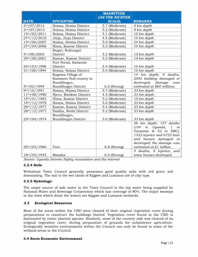
3.2.3 Geology and seismicityFigure 5 below shows that the site lies within an earthquake zone of very low intensityand frequency (“Seismic code of practice for Structural designs”, Uganda National Bureauof Standards, First Edition: June 2003).
Figure 5: Seismic Zoning of Uganda
Uganda has experienced a series of earthquakes of varying magnitude during the pastcentury; the major ones are given in Table 3.1 below.
Table 1 : A Record of some of the Major Earthquake Occurrences in Uganda (1945 toDate)
WTC
Page | 22
DATE EPICENTRE
MAGNITUDE(ON THE RICHTER
SCALE) REMARKS3rd/07/2013 Hoima, Hoima District 5.7 (Moderate) 9 km depth2nd/07/2013 Hoima, Hoima District 5.2 (Moderate) 9 km depth15th/03/2011 Hoima, Hoima District 5.1 (Moderate) 10 km depth27th/12/2010 Jinja, Jinja District 4.5 (Moderate) 10 km depth15th/06/2007 Hoima, Hoima District 5.9 (Moderate) 24 km depth27th/04/2006 Hima, Kasese District 5.2 (Moderate) 10 km depth
5th/08/2003Bugiri, RukungiriDistrict 5.2 (Moderate) 10 km depth
29th/06/2001 Kasese, Kasese District 5.3 (Moderate) 10 km depth
24th/03/1996Fort Portal, KabaroleDistrict 5.4 (Moderate) 10 km depth
31st/08/1994 Hoima, Hoima District 5.0 (Moderate) 10 km depth
5th/02/1994
Kagoma Village ofKisomoro Sub-county inBundibugyo,Bundibugyo District 6.2 (Strong)
14 km depth; 8 deaths,2693 building damaged ordestroyed; damage wasestimated at $60 millions.
9th/10/1991 Hoima, Hoima District 5.7 (Moderate) 33 km depth11th/08/1990 Njeru, Bwiikwe District 4.4 (Moderate) 33 km depth15th/01/1983 Hima, Kasese District 5.2 (Moderate) 10 km depth14th/12/1979 Hoima, Hoima District 5.0 (Moderate) 33 km depth29th/12/1977 Kasese, Kasese District 5.4 (Moderate) 33 km depth28th/12/1977 Paidha, Nebbi District 5.2 (Moderate) 33 km depth
25th/04/1974Bundibugyo,Bundibugyo District 5.0 (Moderate) 33 km depth
20th/03/1966 Toro 6.8 (Strong)
36 km depth; 157 deaths(104 in Uganda, 1 inTanzania & 52 in DRC),1323 injuries and 6752 hutsand houses damaged ordestroyed; the damage wasestimated at £1 million.
18th/05/1945 Masaka 6.0 (Strong)5 deaths, 8 injuries, andsome houses destroyed.
Source: Uganda Seismic Safety Association and the internet
3.2.4 Soils
Wobulenzi Town Council generally possesses good quality soils with red grave soildominating. The soil in the wet lands of Kiggwe and Lumansi are of clay type.
3.2.5 Hydrology:
The major source of safe water in the Town Council is the tap water being supplied byNational Water and Sewerage Corporation which has coverage of 80%. The major swampsin the town which drain the waters are Kiggwe and Lumansi wetlands.
3.3 Ecological Resources
Most of the areas within the CBD were cleared of their original vegetation cover duringpreparations to construct the buildings thereof. Vegetation cover found in the CBD isdominated by exotic planted species. Similarly, most of the country side was cleared of itsoriginal vegetation cover, during preparation of grounds for subsistence agriculture.Ecologically sensitive environments within the Council can only be found in some of thewetland areas in the Council.
3.4 Socio-Economic Environment

Page | 23
3.4.1 Human Population
According to the 2014 population and housing Census survey, Wobulenzi has a Populationof 27,027 persons comprising of 14,750 females and 12,277 males. The total number ofhousehold is 6,992 and the average household size is 3.8 (see table below).
Table 2: Population of Wobulenzi Town Council
WOBULENZI T.C.HOUSEHOLDS POPULATION
Number Average Size Males Females Total6,992 3.8 12,277 14,750 27,027
3.4.1.1 Population Projection
Based on the 2014 results a ten year population projection of the Town Council wasdeveloped using the exponential growth formula below;
PN=PO (1+r %) n
Where;
r = annual rate of growth (3.0%)Pn = Projected populationPo = population in the base yearn = number of intermediary years.
Table 3: Projected Population to 2026Wobulenzi T/C Current Population
2016Total2016
ProjectedPopulation
2026
Total 2026
Male Female Male Female12,277 14,750 27,027 17826 21417 39243
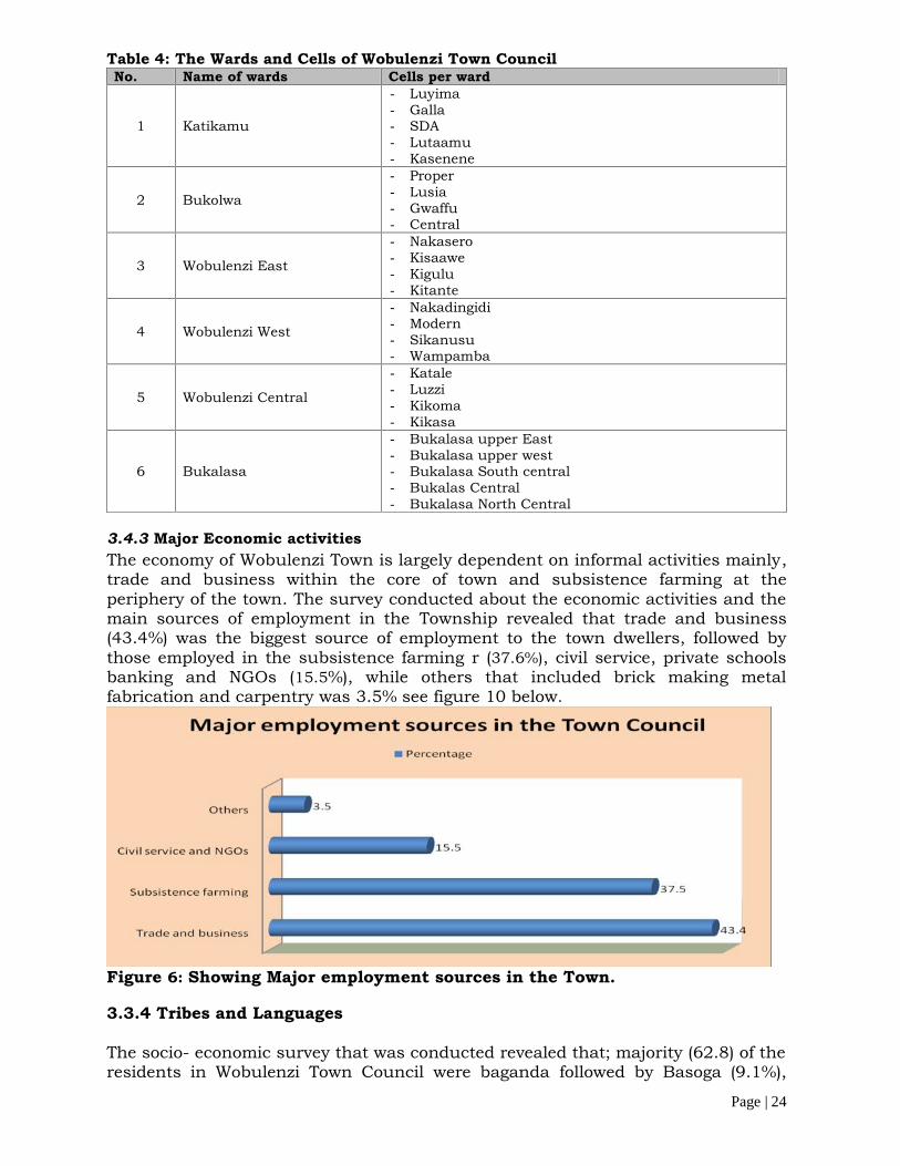
3.4.2 Administrative Units of the planning areaWobulenzi Town Council (WTC) is divided into 6(six),administrative units (Wards) namely:Wobulenzi East, Wobulenzi West, Bukalasa Parish, Katikamu Parish, Bukolwa parish andWobulenzi Central Parish. Further still, the Town Council is sub-divided into 27 LCIVillages (see Table 1.1 below). The Headquarters of the Town are located in KatikamuProper of Bukolwa Parish.
Page | 24
Table 4: The Wards and Cells of Wobulenzi Town CouncilNo. Name of wards Cells per ward
1 Katikamu
- Luyima- Galla- SDA- Lutaamu- Kasenene
2 Bukolwa
- Proper- Lusia- Gwaffu- Central
3 Wobulenzi East
- Nakasero- Kisaawe- Kigulu- Kitante
4 Wobulenzi West
- Nakadingidi- Modern- Sikanusu- Wampamba
5 Wobulenzi Central
- Katale- Luzzi- Kikoma- Kikasa
6 Bukalasa
- Bukalasa upper East- Bukalasa upper west- Bukalasa South central- Bukalas Central- Bukalasa North Central
3.4.3 Major Economic activitiesThe economy of Wobulenzi Town is largely dependent on informal activities mainly,trade and business within the core of town and subsistence farming at theperiphery of the town. The survey conducted about the economic activities and themain sources of employment in the Township revealed that trade and business(43.4%) was the biggest source of employment to the town dwellers, followed bythose employed in the subsistence farming r (37.6%), civil service, private schoolsbanking and NGOs (15.5%), while others that included brick making metalfabrication and carpentry was 3.5% see figure 10 below.
Figure 6: Showing Major employment sources in the Town.
3.3.4 Tribes and Languages
The socio- economic survey that was conducted revealed that; majority (62.8) of theresidents in Wobulenzi Town Council were baganda followed by Basoga (9.1%),

Page | 25
Banyankole 4.7%, Nubians 4.3, Bakiga 3.6%, Itesots and Banyarwanda bothconstituted 2.0% Lugbara, 1.6% while the other tribes that included Samya, Jaluo,Japadola, Langi and Batoro comprised of 3.6%. See figure 7 below;
Figure 7: Showing the tribes in the Planning area
3.3.5 Level of Education
The level of education of the respondents was conducted and the results obtained revealedthat; majority 39.1% of the respondents had attained secondary education, 31.2% hadattained primary education, 20.2% had attained post secondary education, while 9.5% hadnot attained any level of education.
Table 5: Educational levelsSchool attendance/Level of education Frequency PercentagesPrimary 79 31.2
Secondary 99 39.1
Post-secondary / Technical level 51 20.2
None 24 9.5
Total 253 100.0Source: Analyzed by the Consultant
3.3.6 Religious sects
There are several religious sects in the Town Council, a survey conducted about thereligious affiliations of the people of Wobulenzi revealed that majority of the towninhabitants were Catholics (36.0%) followed by the Anglicans with 28.5%, Born againChristians constituted 12.3% while the seventh day Adventists were 4.3% and the othersthat included the believers in the African Tradition and the pagans comprised of 1.2% seetable below
Table 6: Showing the religious affiliations of the population of Wobulenzi TownReligion Frequency PercentCatholic 91 36.0

Page | 26
Protestant 72 28.5Moslem 46 18.2Born Again Christians 31 12.3SDA 9 3.6Others 5 1.6Total 253 100
3.3.7 Health and Diseases in the Town Council
A survey was undertaken to investigate the nature of diseases that have grossly affectedthe population of Wobulenzi Town in the last five years and the following was established;majority (66.0%) of the survey population said that Malaria had grossly affected them,9.9% said typhoid had affected them, 9.1% of the responds said that it was flue and coldthat had affected them most, 5.1% said that HIV/AIDS had grossly affected theirhouseholds, 4.3% said that it was Tuberculosis that had affected them most, while 3.2%said it was High blood pressure and 2.4% said they had not suffered from any of thediseases (see figure 13 below)
Figure 8: Showing the Prevalent diseases Wobulenzi town
3.3.7.1 Level of use of the Health care facilities
The study investigated into the health facilities that are mainly used by the TownCouncil residents and the following was established; majority of the respondents(51.0%) accessed their health services through private clinics, 48.2used theGovernment health units, for health services while 0.8% used other services such asthe local herbalists for health services provision see table below.
Table 7: Showing access to Health care facilities in the TownHealth Facility Frequency PercentGovernment health unit 122 48.2
Private clinic 129 51.0
others 2 0.8
Total 253 100.0
3.3.7.2 Problems associated with the health facilities in the Town Council
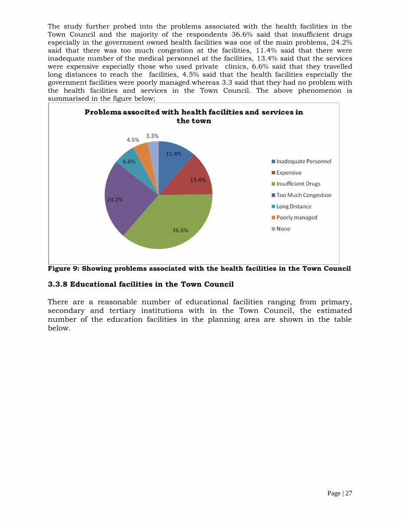
Page | 27
The study further probed into the problems associated with the health facilities in theTown Council and the majority of the respondents 36.6% said that insufficient drugsespecially in the government owned health facilities was one of the main problems, 24.2%said that there was too much congestion at the facilities, 11.4% said that there wereinadequate number of the medical personnel at the facilities, 13.4% said that the serviceswere expensive especially those who used private clinics, 6.6% said that they travelledlong distances to reach the facilities, 4.5% said that the health facilities especially thegovernment facilities were poorly managed whereas 3.3 said that they had no problem withthe health facilities and services in the Town Council. The above phenomenon issummarised in the figure below;
Figure 9: Showing problems associated with the health facilities in the Town Council
3.3.8 Educational facilities in the Town Council
There are a reasonable number of educational facilities ranging from primary,secondary and tertiary institutions with in the Town Council, the estimatednumber of the education facilities in the planning area are shown in the tablebelow.
Page | 28
Table 8: showing educational facilities in the Planning areaType of the education facility No of facilityPrimary 35
Secondary 10
Tertiary 05
University 35
the education facilities most especially the primary and secondary schools within thecurrent boundaries of the town Council are adequate
Kindergartens are needed The vocational training institutes are needed to impart skills to the youthful population
and contribute to their development.
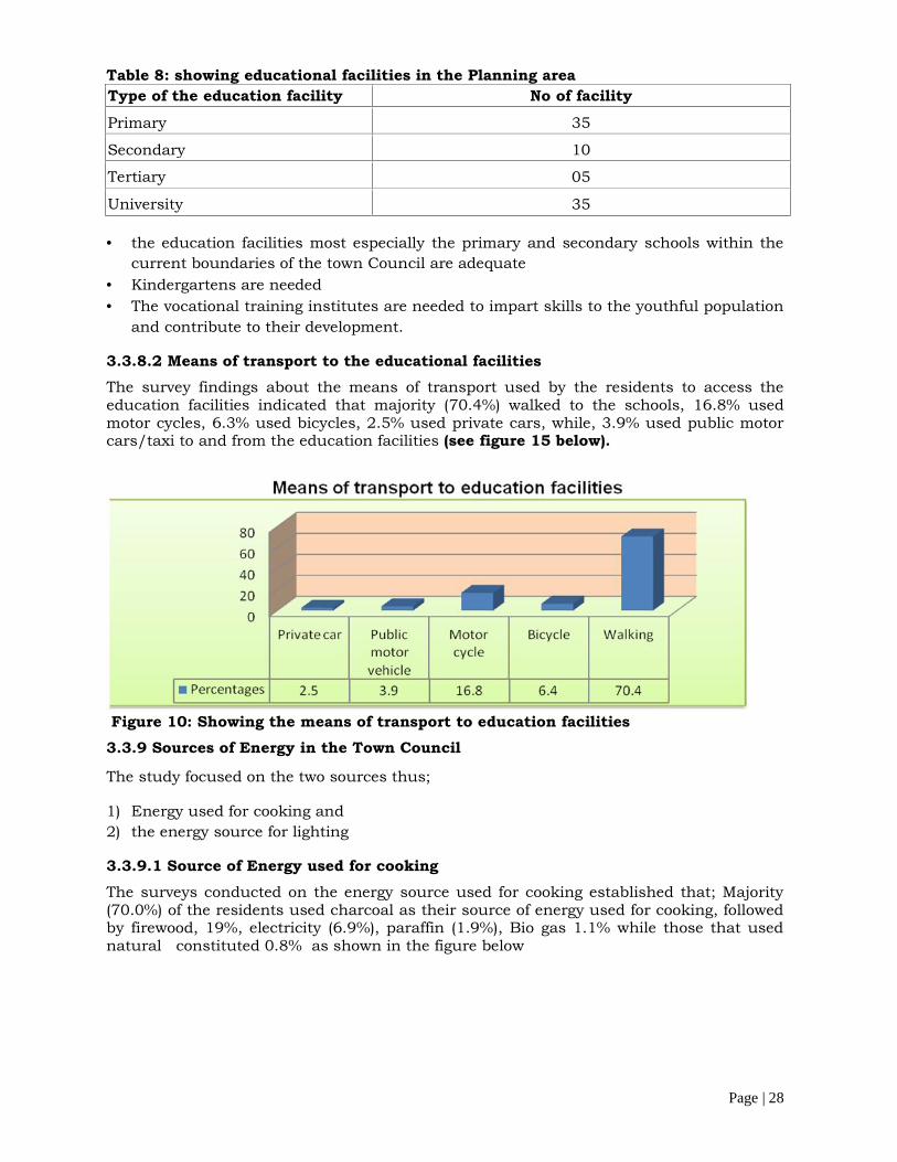
3.3.8.2 Means of transport to the educational facilitiesThe survey findings about the means of transport used by the residents to access theeducation facilities indicated that majority (70.4%) walked to the schools, 16.8% usedmotor cycles, 6.3% used bicycles, 2.5% used private cars, while, 3.9% used public motorcars/taxi to and from the education facilities (see figure 15 below).
Figure 10: Showing the means of transport to education facilities3.3.9 Sources of Energy in the Town Council
The study focused on the two sources thus;
1) Energy used for cooking and2) the energy source for lighting
3.3.9.1 Source of Energy used for cookingThe surveys conducted on the energy source used for cooking established that; Majority(70.0%) of the residents used charcoal as their source of energy used for cooking, followedby firewood, 19%, electricity (6.9%), paraffin (1.9%), Bio gas 1.1% while those that usednatural constituted 0.8% as shown in the figure below

Page | 29
Figure 11: Showing the sources of energy for Cooking3.3.9.2 Source of Energy used for lightingAs far as the sources of energy for lighting are concerned majority (54.7) used electricity,41.2% used paraffin, 1.7% while 1.7 comprised of other lighting sources that includecandles, torches and solar lamps.
Figure 12: Showing the sources of energy for lighting in the town3.3.10 Sanitation
The sanitation coverage in the Town Council has been fluctuating with changes inweather. It often improves during dry season and decreases during the rainy season. Theaverage household latrine coverage and safe Water is yet to be established. Further asurvey that was conducted about the key problems associated with the sanitary facilitiesrevealed that in households where pit latrines exist, their state left a lot to be desired anda good number of latrines are a health hazard. The table below explains the abovephenomenon.
Table 9: Problems associated with sanitary facilities in the Town Council
Problem associated to the facility Frequency PercentagesCrowded 53 20.9Full 19 7.5Dirty 81 32.0Dangerous structure 25 9.9No privacy 8 3.2None 67 26.5Total 253 100
Page | 30
3.3.11 Poverty and livelihood analysis
Poverty is viewed as lack of means to satisfy basic material and social needs, as well as afeeling of powerlessness. There is gender and location specific variations in the way thelocal people define poverty. Source of monetary livelihood and comfort of accommodationlike good sanitation are paramount in urban areas while possession of productive assetslike land and livestock are more critical in the rural areas. Women are concerned morewith lack of land, water, family planning services resulting in large family size, lackingassistance, household food and poor welfare of children when they define poverty. Menrelate poverty mostly to the inability to engage in meaningful employment and lack ofproductive assets. To the youth, the degree and extend of social connectedness and familywelfare indicate the level of poverty. Therefore, the strategy to address poverty requiresmulti-faceted approaches. The indicators of poverty in Wobulenzi Town Council includethe following; lack of food, clothing, shelter, money and inability to send children to schoolor access to health services. The major causes of poverty in the household include;
Natural calamities like drought, flood, and hail storms. Drunkardness and drug abuse among the community especially the youth. Corruption tendencies in both government and community levels High unemployment levels among the youths Poor health among the population caused by high morbidity and mortality Extended families and polygamous life with large family sizes Poor conditions of social infrastructure and other amenities like electricity and water Ignorance and low levels of education with in Wobulenzi Town Council, High levels of unemployment: Negative attitudes towards government programmes, such as universal education, and
end up having uneducated children Lack of control over property especially for the case of women, some of the traditional
cultures have also contributed to poverty increase since women are not entitled toproperty ownership and you find in some place women are more educated than men,but since they are denied that chance they end up remaining behind.
Laziness is also a problem to our community more especially among the youth whospend most of their time involved in gambling, activities mainly in the areas of Modern,Nakadingidi in Wobulenzi Trading Centre,
Table 10: Poverty dimensions as experienced by different groups in Wobulenzi Towncouncil.Social Group Poverty trend
/ IndicatorCause Effect Possible Intervention
Women(mainly thosewithoutformalemploymentand with noeducation atall).
Lack of accessto productiveresource e.gLand, capitaland realresidentialproperty.
Culture wheremen own andcontrol land.Men control theproduce.Secondlywomen havelagged behinddue toeducation levelsand exposure.
Thosecategorieslive in theviscous cycleof povertythus they arethe poorestof the poor
- Fairdistribution ofland andenforcing theland law
- Sensitizationand advocacyfor culturalchange
PWDs, andElderly
Poor Healthand physicalweaknessdeteriorates all
HIV/AIDs hasleft elderly andchildren andchildren headed
Increasedependencyon theincomes of
Sensitization onHIV/AIDS preventivemeasures. Put in placeorphanage centres to
Page | 31
Social Group Poverty trend/ Indicator
Cause Effect Possible Intervention
the time andtheir incomesare not stable.
families in thearea. Causingthe depletion inthe already lowincomes andhence deeppoverty
the elderlyand childheadedfamilies.
assist the childheaded families.EmbracingBonnabaggawale
Women Genderwomen areexcessivelypoor comparedto men
Lack of accessto productiveresources land,culture, womendon’t ownresourceswomen havesmallerbusinessescompared tomen
There is alikely hood ofwomenremainingbackward.
Gender awarenesscampaigns. Womenempowermentmicrofinance.
OVCs,Women,Elderly
Dependencysyndrome andapathy of thecommunitiesare hamperingthe would beproductivecommunitiesas they alwayshope they willget free things
People neglectwork ignorancehoping that thegovernment willgive themthings
Sensitization andmobilization of peopleto work and to engagein Governmentprogrammes.
3.3.12 Gender and HIV Aids issues in the Town Council
3.3.12.1 GenderThere is lack of ownership and access to productive assets that is to say house, domesticanimals, utensils such as hoes, televisions, land to mention but a few. In most cases menmore control and power women over assets at home because. For instance if a mandivorces a woman, she’s told to leave with nothing meaning that she does not ownanything in a marital home. Thus a gender gap arises due to lack of ownership ofproductive assets.
There is also limited participation in decision making that is to say women are not allowedto participate in any matters concerning power relations for example if it comes saywanting to sell something that is a goat, cow. She has to first ask permission from thehusband and his the one to decide whether the goat should be sold or not. Therefore she islimited to decide on what she wants to do.
There is also a heavy workload for woman for example the women are perform almost allthe house work which includes digging, cooking, washing clothes, taking children toschool and cleaning the house whereas the men are just resting
3.3.12.2 HIV/AIDSThe current status and trends of HIV/AIDs epidemics in urban areas in Uganda poses asignificant challenge to the national AIDS response, epidemic trends over the last 5 years

Page | 32
show that HIV Prevalence has been persistently higher 20 to 50% in urban areascompared to rural areas. (UNAIDS African cities and HIV 2009)
Wobulenzi Town Council recognizes the steady increase in HIV/AIDs prevalencespecifically among the most risk populations (orphans, children and women). HIV/AIDSposes a big challenge to the development of the Town Council. Every household has atleast lost a member, relative, or a friend to HIV and AIDS. Despite the high level ofawareness about the scourge, there is still a big gap between knowledge and desired thebehavioral change.
Wobulenzi Town Council committed to supporting HIV/AIDs prevention interventionsthrough the following ways;
1. The Town Council has created a budget line for HIV/ AIDs in the administrative workplans and budgets for Wobulenzi
2. Mobilised and allocated resources from different sources to support HIV/ AIDsprogrammes in Wobulezi Town Council communities.
3. Condoms are regularly distributed to individuals at Health Centres, market places,entertainment places, hotels, lodges and guest houses, taxi operators and Boda Bodacyclists to ensure safety and strengthening the response of the community to theepidemic.
4. Voluntary counseling and Testing. This is often done at Katikamu Health Centrewhere counseling and Testing facilities have been established.
5. The Town Council has in partnership with the civil based organizations has developeda mechanism for identifying of households that require support.
6. Designed interventions that can end affected households to improve their householdincome.
7. Lobbied the corporate enterprise and other private agencies to provide the requiredsupport to the affected household.
8. The council under AMICALL Programme has strengthened and boosted the activities ofAIDS TASK FORCE after the official of the AMICALL Programme in Wobulenzi TownCouncil.
3.3.12.2.1 WAY FORWARD ON THE POSSIBLE ACTION OR RESPONSE.
1. Train Wobulenzi Town Council technical staff and Councilors on HIV/AIDsmainstreaming/ control.
2. Establish Wobulenzi Town Council HIV/AIDs data bank.3. Reports on HIV Performance and appraise HIV Focal person on HIV/AIDs work.4. Formulate and disseminate HIV/AIDs related policies (bye- laws) to all stake holders
in Wobulenzi Town Council.5. Collect, analyze and disseminate HIV/AIDs related data to stake holders for planning
purposes and decision making.
3.4.4 EXISTING LANDUSE
The major landuse in the planning area entail: Commercial, residential, institutional,Industrial, civic and subsistence agriculture.
3.4.1 Commercial
The activities carried out in the Central Business District of Wobulenzi are typical of thosefound in major towns of Uganda; The CBD consists of administrative and civic uses,institutional, Taxi Park, Petrol staions, Banks, commercial and residential buildings androads. Other significant land-uses include service lines, such as optic fibre, water mainsand power lines

Page | 33
Figure 13:Showing the Central Business District of Wobulenzi Town Council3.4.2 The residential Landuse
Residential areas form a major landuse in the Town Council. Most of the residentialsettlements have grown organically without any form of planning. The areas of KiguluZone, Katale, Luzzi Kikoma,Kikasa Nakadingidi Katikamu Proper are the most affectedplaces with informal settlements. Some of the planned settlements are those within theimmediate vicinity of the CBD. The residential settlements existed in form of temporary,semi permanent and permanent within the Town Council.
3.4.2.1 Nature of HousingWobulenzi town has a mixture of housing settlements comprising of permanent, semipermanent and temporary housing structures (see figure below). A survey that wasconducted about the nature of housing in the Town Council identified that permanenthousing structures were the majority in the town and comprised of 89.7%, followed by thesemi permanent housing structures that comprised of 8.3% while the temporary housingstructures were the least and comprised of 2.0% as shown in the table below.
Table 11: Showing the housing types in the townNature of shelter Frequency PercentagesPermanent 227 89.7Semi-permanent 21 8.3Temporary 5 2.0Total 253 100.0Source: Analysed by the consultant
3.4.2.2 Type of housing units
A survey that was carried out to establish the housing conditions in the town with a focuson the housing characteristics such as typology, nature, and materials used forconstruction revealed that tenements were the most dormant (49.8%) type of housingunits, followed by Bungalows 49.4% and others to include detached units 0.8% asindicated in the table below;
Table 12: Type of residential units in the Town CouncilType of unit Frequency PercentTenements (Muzigo) 126 49.8
Bungalow 125 49.4
Others 2 0.8
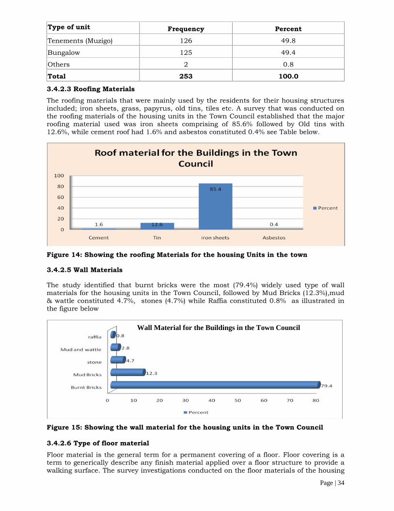
Page | 34
Type of unit Frequency PercentTenements (Muzigo) 126 49.8
Bungalow 125 49.4
Others 2 0.8
Total 253 100.0
3.4.2.3 Roofing MaterialsThe roofing materials that were mainly used by the residents for their housing structuresincluded; iron sheets, grass, papyrus, old tins, tiles etc. A survey that was conducted onthe roofing materials of the housing units in the Town Council established that the majorroofing material used was iron sheets comprising of 85.6% followed by Old tins with12.6%, while cement roof had 1.6% and asbestos constituted 0.4% see Table below.
Figure 14: Showing the roofing Materials for the housing Units in the town
3.4.2.5 Wall Materials
The study identified that burnt bricks were the most (79.4%) widely used type of wallmaterials for the housing units in the Town Council, followed by Mud Bricks (12.3%),mud& wattle constituted 4.7%, stones (4.7%) while Raffia constituted 0.8% as illustrated inthe figure below
Figure 15: Showing the wall material for the housing units in the Town Council
3.4.2.6 Type of floor materialFloor material is the general term for a permanent covering of a floor. Floor covering is aterm to generically describe any finish material applied over a floor structure to provide awalking surface. The survey investigations conducted on the floor materials of the housing
Wall Material for the Buildings in the Town Council
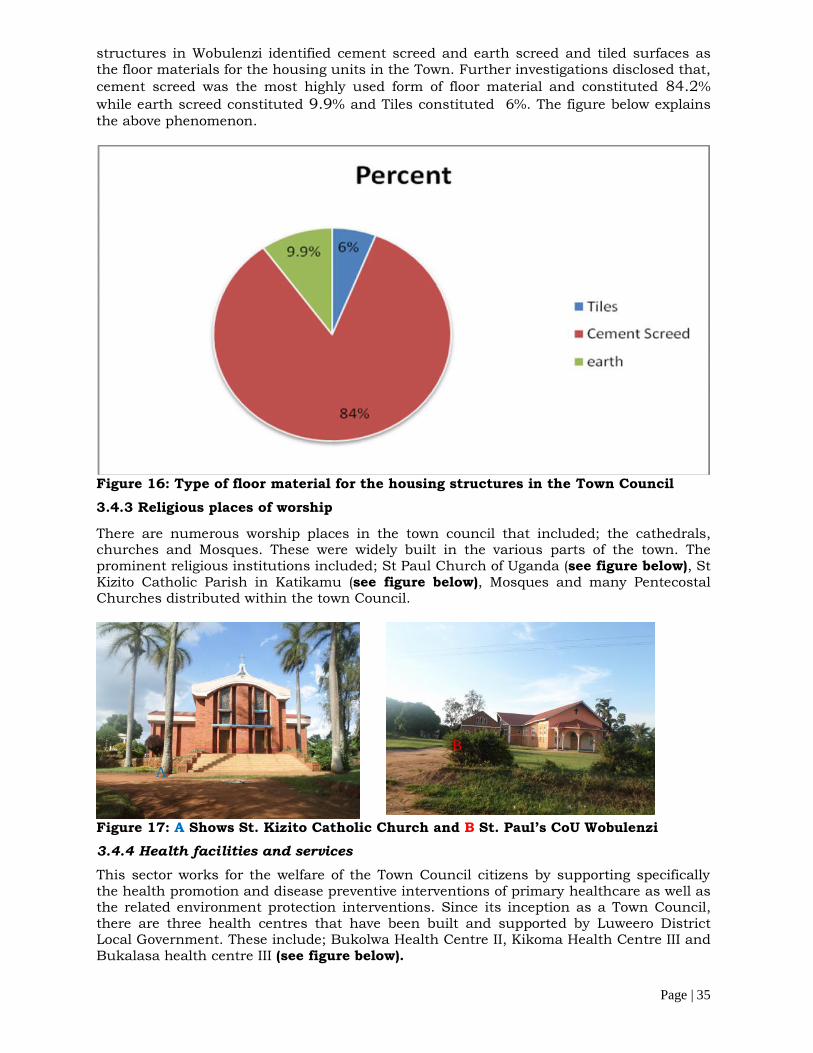
Page | 35
structures in Wobulenzi identified cement screed and earth screed and tiled surfaces asthe floor materials for the housing units in the Town. Further investigations disclosed that,cement screed was the most highly used form of floor material and constituted 84.2%while earth screed constituted 9.9% and Tiles constituted 6%. The figure below explainsthe above phenomenon.
Figure 16: Type of floor material for the housing structures in the Town Council3.4.3 Religious places of worship
There are numerous worship places in the town council that included; the cathedrals,churches and Mosques. These were widely built in the various parts of the town. Theprominent religious institutions included; St Paul Church of Uganda (see figure below), StKizito Catholic Parish in Katikamu (see figure below), Mosques and many PentecostalChurches distributed within the town Council.
Figure 17: A Shows St. Kizito Catholic Church and B St. Paul’s CoU Wobulenzi3.4.4 Health facilities and servicesThis sector works for the welfare of the Town Council citizens by supporting specificallythe health promotion and disease preventive interventions of primary healthcare as well asthe related environment protection interventions. Since its inception as a Town Council,there are three health centres that have been built and supported by Luweero DistrictLocal Government. These include; Bukolwa Health Centre II, Kikoma Health Centre III andBukalasa health centre III (see figure below).
A
B
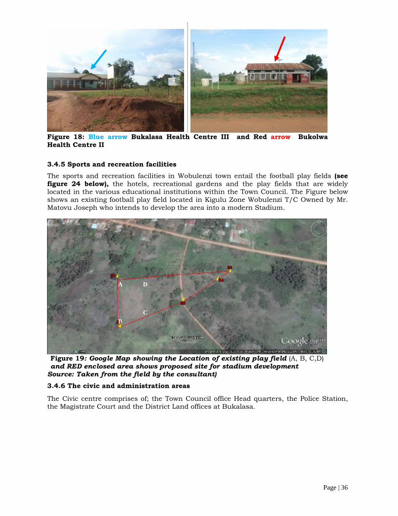
Page | 36
Figure 18: Blue arrow Bukalasa Health Centre III and Red arrow BukolwaHealth Centre II
3.4.5 Sports and recreation facilitiesThe sports and recreation facilities in Wobulenzi town entail the football play fields (seefigure 24 below), the hotels, recreational gardens and the play fields that are widelylocated in the various educational institutions within the Town Council. The Figure belowshows an existing football play field located in Kigulu Zone Wobulenzi T/C Owned by Mr.Matovu Joseph who intends to develop the area into a modern Stadium.
Figure 19: Google Map showing the Location of existing play field (A, B, C,D)and RED enclosed area shows proposed site for stadium development
Source: Taken from the field by the consultant)3.4.6 The civic and administration areas
The Civic centre comprises of; the Town Council office Head quarters, the Police Station,the Magistrate Court and the District Land offices at Bukalasa.
A
BC
D
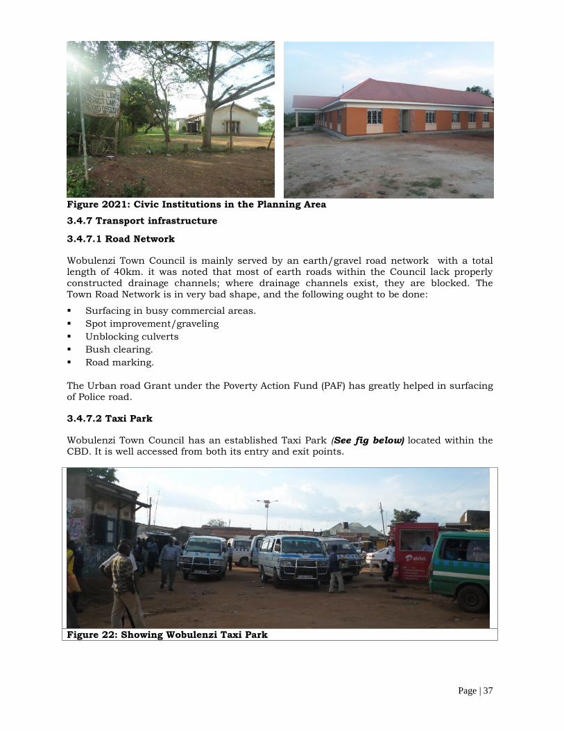
Page | 37
Figure 2021: Civic Institutions in the Planning Area3.4.7 Transport infrastructure
3.4.7.1 Road Network
Wobulenzi Town Council is mainly served by an earth/gravel road network with a totallength of 40km. it was noted that most of earth roads within the Council lack properlyconstructed drainage channels; where drainage channels exist, they are blocked. TheTown Road Network is in very bad shape, and the following ought to be done:
Surfacing in busy commercial areas. Spot improvement/graveling Unblocking culverts Bush clearing. Road marking.
The Urban road Grant under the Poverty Action Fund (PAF) has greatly helped in surfacingof Police road.
3.4.7.2 Taxi Park
Wobulenzi Town Council has an established Taxi Park (See fig below) located within theCBD. It is well accessed from both its entry and exit points.
Figure 22: Showing Wobulenzi Taxi Park

Page | 38
3.4.8 The abattoir
The abattoir is located in Kigulu Cell, Katikamu Ward of WTC (see figure below); co-ordinates: 36 N 448682 m E 80354 m N. On average, 7 heads of cattle and 1 goat areslaughtered at this abattoir per day and about 90 jerry cans (1,800 litres) of water areused to clean this abattoir daily. Presently, all liquid wastes flow down to the bushes andwind up into Nambaga wetland located in the valley below the abattoir.
Figure 23: The WTC Abattoir in Kigulu Cell, Katikamu Ward
3.4.9 Utility Services in the Town
3.4.9.1 Electricity power supply
Wobulenzi Town Council is hooked to the national Power grid. Infrastructure for thedistribution of electricity is well laid along all the major access roads within the town (seefigure below). In addition generators and solar energy is also used by the residents tosupplement the erratic the Hydro-electricity power supply.
Figure 2425: Red arrow Showing Electricity transmission lines and blue arrowshowing solar power installation at Bukolwa Health Centre II
3.4.9.2 Water supply sources and Water resourcesWobulenzi Town Council has a piped water system supplied by the National Water andSewerage Corporation (NWSC). Piped water is extracted at Katikamu which is locatedwithin the confines of the Town council (see figure below). Although piped water exists,other water sources that include; borehole, protected springs, open wells, swamps etc arealso widely used by the residents of Wobulenzi. However, sometimes access and theamount needed for piped water are compromised due to the problem of affordability of thewater tariff as a result people resort to other sources mentioned above, which sometimes
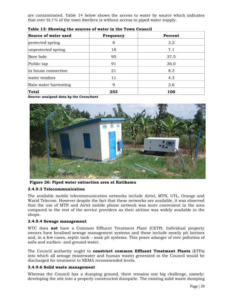
Page | 39
are contaminated. Table 14 below shows the access to water by source which indicatesthat over 55.7% of the town dwellers is without access to piped water supply.
Table 13: Showing the sources of water in the Town CouncilSource of water used Frequency Percentprotected spring 8 3.2
unprotected spring 18 7.1
Bore hole 95 37.5
Public tap 91 36.0
in house connection 21 8.3
water vendors 11 4.3
Rain water harvesting 9 3.6
Total 253 100Source: analysed data by the Consultant
Figure 26: Piped water extraction area at Katikamu3.4.9.3 TelecommunicationThe available mobile telecommunication networks include Airtel, MTN, UTL, Orange andWarid Telecom. However despite the fact that these networks are available, it was observedthat the use of MTN and Airtel mobile phone network was more convenient in the areacompared to the rest of the service providers as their airtime was widely available in theshops.
3.4.9.4 Sewage managementWTC does not have a Common Effluent Treatment Plant (CETP). Individual propertyowners have localised sewage management systems and these include mostly pit latrinesand, in a few cases, septic tank – soak pit systems. This poses adanger of over pollution ofsoils and surface- and ground-water.
The Council authority ought to construct common Effluent Treatment Plants (ETPs)into which all sewage (wastewater and human waste) generated in the Council would bedischarged for treatment to NEMA recommended levels.
3.4.9.6 Solid waste managementWhereas the Council has a dumping ground, there remains one big challenge, namely:developing the site into a properly constructed dumpsite. The existing solid waste dumping

Page | 40
site is also located next to the town abattoir thus the need to relocate the dump site toanother area since the two are incompatible landuses that cannot coexist in closeproximity.
Table 14: Major methods of garbage disposalDisposal Methods Frequency Percentagepolythene bags 18 7.1dust bin 39 15.4open dump 40 15.8mobile skip 9 3.6fixed skip 4 1.6kerb side 11 4.3Garbage burning 79 31.2Disposing in the garden 53 20.9Total 253 100.0
Ways of managing waste dumping sitesThere are two possible ways of managing wastes, namely:
Through construction of a landfill; or Through construction of a composting plant
4.2.1 Sustainable technologyPresently, a number of towns in the country have adopted and acquired composting plantsas opposed to landfills. Realtek Consultants Ltd., therefore, proposes that a similartechnology be adopted because it is sustainable: wastes are turned into useful manurewhich would be bought by the local people in the country side which would translate intomore income for the Council. Irrespective of adopted technology, however, there willremain two other challenges, namely:
Management of non-biodegradable materials at the compost plant; and
The high costs of collection of wastes throughout the entire Council.
4.2.2 Management of non-biodegradable materialsWhen waste materials are brought at the compost Plant, they are sorted by the Plant staffinto biodegradables and non-biodegradables. The biodegradables are composted intomanure while the non- biodegradables are left heaped at the compound for the Plant.
There is ready market for most of the non-biodegradable materials: metals are sought afterby scrap dealers while plastics are sought after by quite a number of manufacturingcompanies that deal in plastics. The Council would turn this into a source of revenue.
4.2.3 Collection costsThe Council’s Environment Management Plan highlights a number of challenges as far aswaste management practices are concerned and gives recommendations.
It is hereby further recommended that on implementation of the proposed Plan, theCouncil adopts KCCA style: affluent zones and industrial areas would manage their wasteson a self basis; facility owners/managers would hire private garbage managers/collectorswho would dispose of such wastes at waste dumpsite / Compost Plant in Kigulu Zone,Katikamu Parish. The Council would only manage wastes generated in zones for the poor.
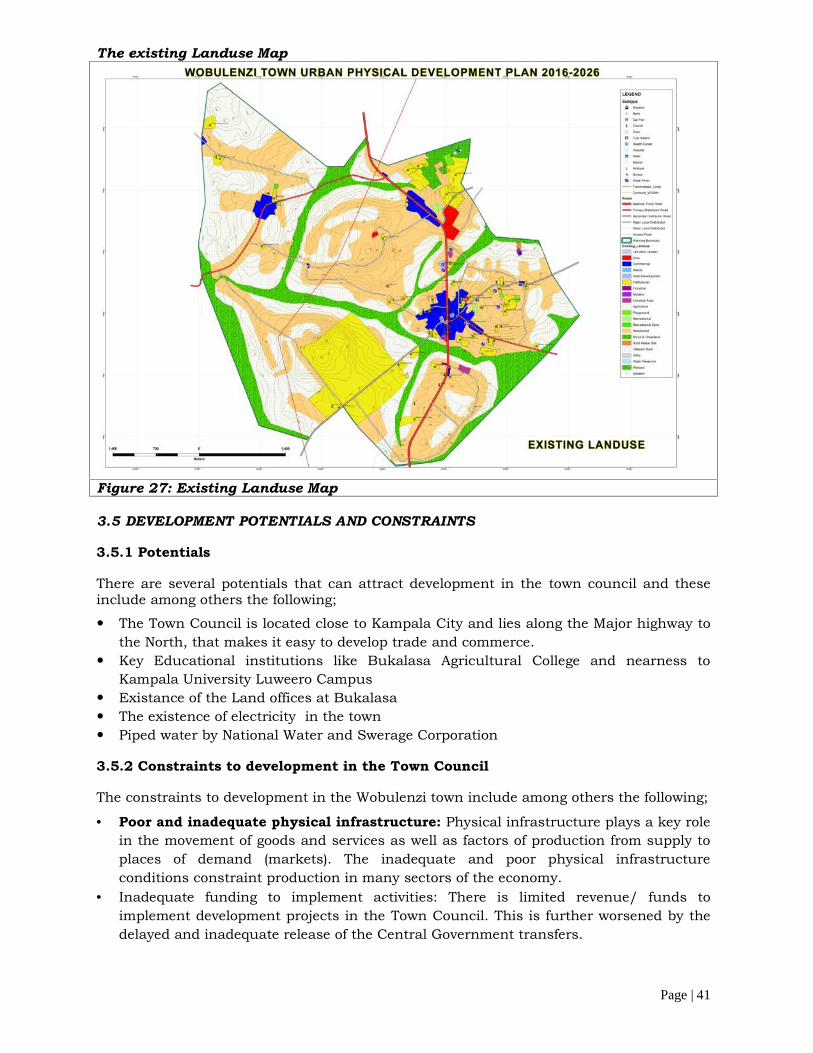
Page | 41
The existing Landuse Map
Figure 27: Existing Landuse Map
3.5 DEVELOPMENT POTENTIALS AND CONSTRAINTS
3.5.1 Potentials
There are several potentials that can attract development in the town council and theseinclude among others the following;
The Town Council is located close to Kampala City and lies along the Major highway tothe North, that makes it easy to develop trade and commerce.
Key Educational institutions like Bukalasa Agricultural College and nearness toKampala University Luweero Campus
Existance of the Land offices at Bukalasa The existence of electricity in the town Piped water by National Water and Swerage Corporation
3.5.2 Constraints to development in the Town Council
The constraints to development in the Wobulenzi town include among others the following;
Poor and inadequate physical infrastructure: Physical infrastructure plays a key rolein the movement of goods and services as well as factors of production from supply toplaces of demand (markets). The inadequate and poor physical infrastructureconditions constraint production in many sectors of the economy.
Inadequate funding to implement activities: There is limited revenue/ funds toimplement development projects in the Town Council. This is further worsened by thedelayed and inadequate release of the Central Government transfers.

Page | 42
Low Business and Entrepreneurial Skills: The poor business and entrepreneurial
attitudes of our people which must be fought in order to achieve socio-economic
transformation
3.5.3 SWOT analysisThe table SWOT analysis of the town is presented in the below;Table 15: SWOT Analysis of the townStrengths Weaknesses Opportunities Threats Availability of some
infrastructure suchas roads, Taxi parkand Market
Vibrant commercialactivities
Existence of a GuluHighway
Proximity to lakeKampala City
Availability of landfor town expansion
It has committedtechnical staff toensure orderlydevelopment
Educationalinstitutions
Has an establishedCBD
Ready Market forfresh fruits especiallyMangoes andPineapples
Poor garbagemanagement
Delayedimplementation of projectsdue to delayedrelease offunds.
Limited localrevenuesgenerated
Poor drainageof the town
No gazettedIndustrial area
Funding of projectsby NGOs
Existence of theNational road fund.
Internal revenuecollection
Has favorableclimate foragriculture
The town isconnected to theNational PowerGrid.
Availability of PipedWater
Proximity toKampala UniversityLuweero Branch
Beneficiary of theLuweero RuwenzoriProgram
Large alien population Health hazards such
as HIV/AIDS Unfavorable land
tenure system Increasing crime levels Reliance on Grants for
implementation ofPrograms.
Rampant growth ofSlums.
Unemployment mostespecially among theyouth.
High populationgrowth rate
Encroachment onwetlands fordevelopment

Page | 43
Table 16: Showing wish list of stakeholdersStakeholders Identified Planning Problems Wish List of Stakeholders Focused
GroupDiscussionsandCommunitydialogues withtheCommunityand resultsobtained fromthe Socio-economicSurveysduring fieldwork surveys
High rates of poverty No solid waste disposal
system No street light Poor condition of roads Insufficient drainage system taxi park On street parking of trailers No Public Cemetery Limited funds to implement
the plans Insufficient recreation
facilities Un employment most
especially among the youth
Development of a good roadnetwork; Creation of parks and play
grounds for children; Provision of Drainage network; Planning for more access roads Planning for designated areas
for residential, Commercial andIndustrial Garbage collection centres Rehabilitation of public toilets Provision and Tightening of
Security improve on the education
system Equip existing health facilities sensitization of people about
hygiene Extension of electricity to areas
that are not serviced Job creation for the unemployed
residents Provision of more public toilets Planning for piped water
extension to all areas Job creation Provision of good quality
Education Provision of street lights
/security lights Introduction of public garbage
bins Restrict noise polluters
especially public speakers
4. STRATEGIC PLANNING INTERVENTIONS IN THE PLANNING PROCESS
4.1 Integration of the Uganda Vision 2040 into the Physical Planning of Wobulenzi4.1.1 Vision Statement
‘‘A Transformed Ugandan Society from a Peasant to a Modern and Prosperous Countrywithin 30 years”.
4.1.2 Opportunities for development as per the VisionAccording to Vision 2040 the following are highlighted as key opportunities fordevelopment of Uganda’s economy;
Oil and gas, tourism, minerals, ICT business, abundant labour force, geographical location and trade, water resources, Industrialization and agriculture.
Whilst providing the required Infrastructure for (energy, transport, water, oil and gas)
4.1.3 Key flagship projects to streamline the Implementation of the VisionUganda Vision 2040 identified the following key core projects that need to be streamlinedfor the implementation of the Vision.
Five regional cities (Gulu, Mbale, Kampala, Mbarara, and Arua) and five strategic cities(Hoima, Nakasongola, Fortportal, Moroto, and Jinja);
Four international airports; A standard gauge railway network with high speed trains; Oil Refinery and associated pipeline infrastructure; Multi-lane paved national road network linking major towns, cities and other strategic
locations; Globally competitive skills development centres; Science and Technology parks in each regional city; International and national referral hospitals in each regional cities
4.1.4 Key issues to note from Vision 2040 that apply to the physical planning ofWobulenzi Town CouncilBased on the Vision 2040 the physical planning of Wobulenzi needs to consider thefollowing;
Agro processing industries It is strategically located to excel in Agriculture trade competitive skills development centers to empower the youth A good road network the links the National Roads
4.2 THE PHYSICAL PLANNING VISION
The vision is to ‘’plan Wobulenzi town as a Town to excel in Agricultural trade andcommerce within Greater Luwero Sub region4.2.1 MissionThe mission is to “facilitate the equitable distribution of basic public infrastructure tostimulate sustainable growth of the town.
Page | 45
4.2.2 Planning Goal
To achieve, an economically viable, livable, well serviced and accessible town that willenhance people’s livelihoods translate and spur tourism development.
4.3 PLANNING PRINCIPLES AND CONCEPTUAL DEVELOPMENT
4.3.1 Planning PrinciplesThe preparation of this physical development plan is based on but not limited to thefollowing planning principles;
Community participation: Basing on this principle, stakeholders and the generalcommunity of Wobulenzi were consulted right from the project inception, the draftalternative stage, and Plan deposit stage to the approval stage. project. This processenabled to produce an output generally accepted and owned by general community ofthe Town Council.
Neighborhood concept: This principle is applied to promote self-sustaining landusezones and neighborhoods.
Interconnectivity: Different parts of the planning area are connected through theroad hierarchy. That is, Secondary roads, local roads and access roads.
Environmental Quality: The plan takes into consideration the well being of theenvironment addressing issues on preservation, conservation and improvement of thephysical environment.
Promotion of employment opportunities: Employment centers planned to include acommercial area and industrial areas. Accessibility has been created by the newproposed roads to promote easy transportation of agricultural produce to the market.
Compatibility of uses: This principle has been applied in the detailed plan bylocating land uses that derive some benefits from the other next to each other forinstance residential use next to the commercial area since the commercial acts as anemployment centre to the residents
Places for people: For places to be well-used and well-loved, they must be safe,comfortable, varied and attractive. They also need to be distinctive and offer choice,and variety. Vibrant places offer opportunities for meeting people; such spaces includepublic open spaces, community centers, markets and institutions among others.
Enrich the existing: New development should enrich the quality of existing urbanplaces. This means encouraging a distinctive response that arises from andcomplements its setting.
Make connections: Places need to be easy to get to and integrated physically andvisually with their surroundings. This requires attention of how to get around on foot,by bicycle, public transport and the car – in that order.
Design for change: New development needs to be flexible enough to respond to futurechanges in use, life style and demography. This means designing for energy andresource efficiency, creating flexibility in the use of property, public spaces and serviceinfrastructure and introducing new approaches to transportation, traffic managementand parking.

Page | 46
4.3.2 Conceptual development of the planApplication of the concept; Based on the existing settlement pattern, transportconnectors in peripheral of planning boundary, the slope analysis of the planning area andother urban planning principles, were used to generate the planning concepts forWobulenzi physical plan. The figures below explain the above phenomenon.
Figure 28: Multifunctional spatial Development
Figure 29: Slope settlement annalysis
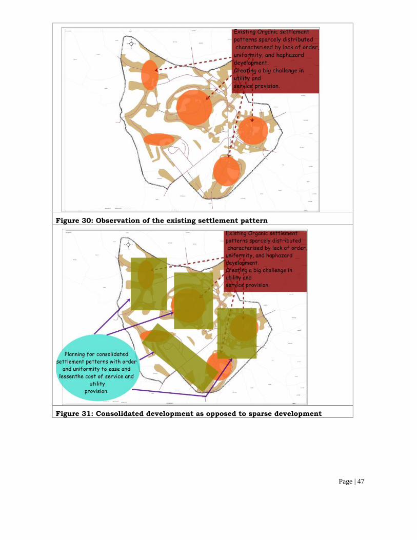
Page | 47
Figure 30: Observation of the existing settlement pattern
Figure 31: Consolidated development as opposed to sparse development
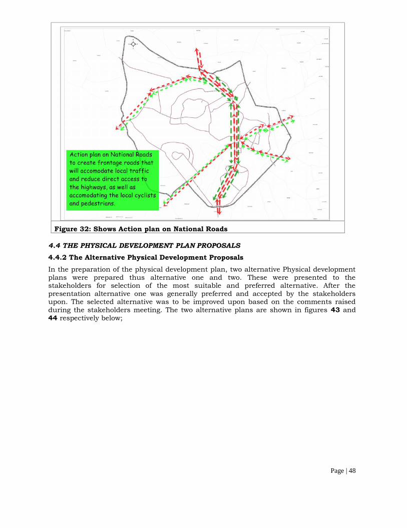
Page | 48
Figure 32: Shows Action plan on National Roads
4.4 THE PHYSICAL DEVELOPMENT PLAN PROPOSALS4.4.2 The Alternative Physical Development ProposalsIn the preparation of the physical development plan, two alternative Physical developmentplans were prepared thus alternative one and two. These were presented to thestakeholders for selection of the most suitable and preferred alternative. After thepresentation alternative one was generally preferred and accepted by the stakeholdersupon. The selected alternative was to be improved upon based on the comments raisedduring the stakeholders meeting. The two alternative plans are shown in figures 43 and44 respectively below;

Page | 49
Figure 33: Showing Alternative Physical Plan One
Figure 34: Showing Alternative Physical Plan TWO

Page | 50
4.4.3 The Proposed Physical Development PlanHaving selected Alternative two of the physical development plan, enhancements wereundertaken based on the comments raised by the stakeholders and further consultationsmade by the consultant. The result of which was the proposed physical development plangiven below
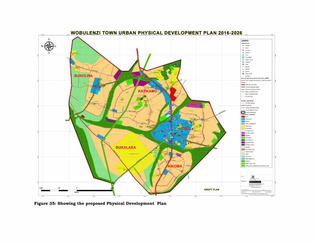
Figure 35: Showing the proposed Physical Development Plan
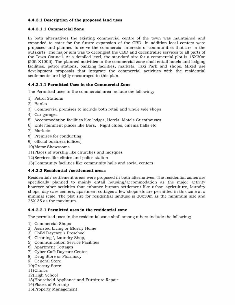
4.4.3.1 Description of the proposed land uses
4.4.3.1.1 Commercial Zone
In both alternatives the existing commercial centre of the town was maintained andexpanded to cater for the future expansion of the CBD. In addition local centers wereproposed and planned to serve the commercial interests of communities that are in theoutskirts. The major aim was to decongest the CBD and decentralize services to all parts ofthe Town Council. At a detailed level, the standard size for a commercial plot is 15X30m(50ft X100ft). The planned activities in the commercial zone shall entail hotels and lodgingfacilities, petrol stations, banking facilities, markets, Taxi Park and shops. Mixed usedevelopment proposals that integrate the commercial activities with the residentialsettlements are highly encouraged in this plan.
4.4.2.1.1 Permitted Uses in the Commercial ZoneThe Permitted uses in the commercial area include the following;
1) Petrol Stations2) Banks3) Commercial premises to include both retail and whole sale shops4) Car garages5) Accommodation facilities like lodges, Hotels, Motels Guesthouses6) Entertainment places like Bars, , Night clubs, cinema halls etc7) Markets8) Premises for conducting9) official business (offices)10)Motor Showrooms11)Places of worship like churches and mosques12)Services like clinics and police station13)Community facilities like community halls and social centers
4.4.2.2 Residential /settlement areasResidential/ settlement areas were proposed in both alternatives. The residential zones arespecifically planned to mainly entail housing/accommodation as the major activityhowever other activities that enhance human settlement like urban agriculture, laundryshops, day care centers, apartment cottages a few shops etc are permitted in this zone at aminimal scale. The plot size for residential landuse is 20x30m as the minimum size and25X 35 as the maximum.
4.4.2.2.1 Permitted uses in the residential zoneThe permitted uses in the residential zone shall among others include the following;
1) Commercial Shops2) Assisted Living or Elderly Home3) Child Daycare \ Preschool4) Cleaning \ Laundry Shop,5) Communication Service Facilities6) Apartment Cottages7) Cyber Café Daycare Center8) Drug Store or Pharmacy9) General Store10)Grocery Store11)Clinics12)High School13)Household Appliance and Furniture Repair14)Places of Worship15)Property Management

Page | 53
16)Public Transport Facility
4.4.2.3 Industrial zone
Industrial zones were proposed in both of the physical development Plan alternatives. Inalternative one, two industrial zones were proposed, surrounding the site for the sewagelagoon site. The proposal for the industrial zones was aimed at directing the futureindustrial development needs of the town council and also to increase the employmentopportunities in the planning area. The recommended plot sizes/standards in theindustrial zone are to be not less than 30X60m (100ft x200ft).
4.4.2.4 Civic
In both alternatives the existing land zoned for CIVIC development was maintained andthese included; the land that hosts the Town Council, Land Offices and Magistrate Courtare maintained while a new area for the location of a police station was proposed.
4.4.2.5 Educational facilities
The existing educational facilities were maintained in both alternatives and new ones wereproposed as shown in the plan alternatives given above.
4.4.2.6 Health InstitutionsThe existing Health centers were maintained in both plan alternatives and new proposalswere made to cater for the future development of the health institutions in the TownCouncil.
4.4.2.7 Religious centers and places of worship
The existing religious institutions were maintained and integrated into the physicaldevelopment plan. These institutions are planned to continue providing the same servicesas before.
4.4.2.8 Parks/ Recreational groundsThe primary uses in these areas include playgrounds, recreational parks, and other areasfor outdoor activities, sports centers, sports pitches, outdoor recreation and landscapedareas. High standards of accessibility are essential in this zone. Accessibility standard isrelated to the use of that particular open space. For example, local amenity areas andplaygrounds may require emphasis on access for pedestrians and cyclists. Sports Centersserving a wider catchments area like stadia and the golf course will require accessibility bypublic transport and car users. Recreational grounds are shaded green color on thePhysical Development Plan
4.4.2.8.1 Purpose of Parks and recreational zones
The purpose of this zone is:
1) To provide for the active and passive recreational needs of the City and the protectionof its bountiful natural resources as well as to protect the natural and aestheticqualities of the area for the general welfare of the community.
2) To provide for, protect and improve the provision, attractiveness, accessibility andamenity value of public open space and amenity areas.
3) To provide for, protect and improve the provision, attractiveness and accessibility ofpublic open space intended for use of recreational or amenity purposes. Only
Page | 54
development that is incidental to, or contributes to the enjoyment of open space,amenity or recreational facilities will be permitted within this zone.
4) To preserve and provide for recreational amenities. The objective seeks to providerecreational and amenity resources for urban and rural populations subject to strictdevelopment controls. Only community facilities and other recreational uses will beconsidered and encouraged by the Planning Authority.
4.4.2.9. Roads and transport Infrastructure
The proposed physical plan provides for an efficient and sustainable road net work thatlinks to the existing ones. All existing roads in the town councilwere mapped, aligned andintegrated into the proposed physical development plan. Other new roads were proposedwith a purpose of improving accessibility to all parts of the town (see figure below) inaddition some of the existing foot paths were upgraded into motorable roads. Service lanesand walkways are to be developed in the Commercial zone (CBD) of the town to easeloading, offloading and provision of service utilities. The table below shows the proposedroad types and sizes.Table 17: Proposed road types and size
S/No Road type Road width (m) Carriage way (m)1 Primary road 50 302 Secondary road 30 203 Local distributor/ tertiary 30 104 Access commercial 20 105 Access residential 15 86 Cul-de- sacs 10 58 Service lane 6 69 Foot paths/ precincts 2 2
Source Analyzed by the Consultant
4.4.2.10 Waste managementSolid waste management was identified as one of the key challenges faced by the TownCouncil. As regards waste management, the town council has a solid waste dumpingground located at Kigulu zone near the abattoir site. However the new proposal suggestsfor the relocation of the solid waste dumping ground to an area that shall be acquiredoutside the town Council boundaries.
4.4.2.11 WaterThe plan takes care of the distribution of piped water to all parts of the town; in additionall new piped water connections and extensions are proposed to follow the existing and theproposed roads. It should be noted however that all the other existing water sources likethe protected springs, the borehole etc. were mapped and included in the plan.
4.4.2.12 Green Energy Proposals and the environmental Plan
Proposal for the green energy sustainability of the town were put in to considerationduring the preparation of this physical development plan. The plan supports thedevelopment of green energy proposals as follows;
Inclusion of buffer zones on environmentally sensitive areas Tree lined avenues Public parks and open spaces were proposed with a purpose of enhancing the
environment. Planting of trees at house compounds and at all public facilities
Page | 55
The use of solar energy mainly for lighting and biogas energy for cooking is encouragedin the town council
4.4.2.13 Environment and Natural ResourcesThe plan takes into account of the environmental issues and extra precautions were putinto consideration to protect and preserve the natural resources in the Town Council (seefigure below). Further buffer zones were proposed on all the natural resources within theplanning area. The figure below shows the proposed environmental and natural resourcePlan.
4.4.2.14 Electricity / power
The Power infrastructure is planned to be incorporated along the existing and proposedroads. Additionally, other sources of energy such as use of solar energy and biogas areencouraged to supplement the existing power supply.

Page | 56
4.4.2.16 Markets
The markets that exist in the Town Council were mapped and integrated into the newphysical development Plan. Additionally the Friday Market that has previously been takingplace along the reserve of Kampala Gulu Highway was relocated to a new permanentsettlement as indicated in the plan. The plan also makes proposals for local markets in thevarious wards of Town Council as a means to enhance the economic livelihoods of theresidents
4.4.2.17 Town abattoir siteThe abattoir site was maintained at its current location and an industrial has beenproposed next to it for compatibility reasons.
4.4.2.18 Cemetery
This was one of the landuses that were largely lacking in the Town Council. During thefeasibility consultations it was identified that land for a Cemetery was largely needed by thecommunities of the Town Council. The Physical Plan provides land for the location of theCemetery and it is to be located in Bukolwa.
4.4.2.20 Tourism Development ProposalsThe tourism development proposals in this plan include; the green belts, the tree linedavenues most especially within the streets of the CBD, proposed Hotel sites and the bufferzones on the environmentally sensitive areas
4.4.2.21 Sewerage system
The Town Council lacks a sewer system; however based on the field surveys made by theconsultant, an alternative site for the establishment of a sewer lagoon was identified asindicated in the physical development plan. Further studies would, however, have to betaken to identify the most suitable sites for construction of ETPs. Before construction ofthe proposed ETP at the selected site, WTC would have to carry out EIA; properconsideration to the health risks and quality restrictions would have to be a part of theassessment. Amongst the issues to be considered in the EIA would be land ownership,odour management, soil and vegetation protection, groundwater protection, prevention ofpublic health risks, ecologically sustainable development and water quality managementfor any adjacent waterways.The proposed ETP design would be based on at least 0.08kg of BOD5 and 0.09kg ofsuspended solids per capita per day, unless information is got (preferably from similartowns in Uganda) to justify alternate designs.
4.4.2.21.1 Alternative Technologies for a Suitable ETP
The consultant critically looked at the available technologies for an ETP; below is theanalysis and recommendations.
Tables 18 and 19 below summarise the advantages of the various wastewater treatmenttechnologies. In general, the advantages of using natural biological processes relate totheir "low-tech/no-tech" nature, which means that these systems are relatively easy toconstruct and operate, and to their low cost, which makes them attractive to communitieswith limited budgets. However, their simplicity and low cost may be deceptive in that thesystems require frequent inspections and constant maintenance to ensure smoothoperation. Concerns include hydraulic overloading and excessive plant growth. For thisreason, and also because of the land requirements for biologically based technologies,
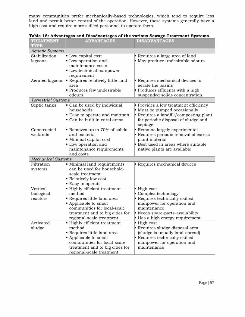
Page | 57
many communities prefer mechanically-based technologies, which tend to require lessland and permit better control of the operation. However, these systems generally have ahigh cost and require more skilled personnel to operate them.
Table 18: Advantages and Disadvantages of the various Sewage Treatment SystemsTREATMENTTYPE
ADVANTAGES DISADVANTAGES
Aquatic SystemsStabilizationlagoons
Low capital cost Low operation and
maintenance costs Low technical manpower
requirement
Requires a large area of land May produce undesirable odours
Aerated lagoons Requires relatively little landarea Produces few undesirable
odours
Requires mechanical devices toaerate the basins Produces effluents with a high
suspended solids concentrationTerrestrial SystemsSeptic tanks Can be used by individual
households Easy to operate and maintain Can be built in rural areas
Provides a low treatment efficiency Must be pumped occasionally Requires a landfill/composting plant
for periodic disposal of sludge andseptage
Constructedwetlands
Removes up to 70% of solidsand bacteria Minimal capital cost Low operation and
maintenance requirementsand costs
Remains largely experimental Requires periodic removal of excess
plant material Best used in areas where suitable
native plants are available
Mechanical SystemsFiltrationsystems
Minimal land requirements;can be used for household-scale treatment Relatively low cost Easy to operate
Requires mechanical devices
Verticalbiologicalreactors
Highly efficient treatmentmethod Requires little land area Applicable to small
communities for local-scaletreatment and to big cities forregional-scale treatment
High cost Complex technology Requires technically skilled
manpower for operation andmaintenance Needs spare-parts-availability Has a high energy requirement
Activatedsludge
Highly efficient treatmentmethod Requires little land area Applicable to small
communities for local-scaletreatment and to big cities forregional-scale treatment
High cost Requires sludge disposal area
(sludge is usually land-spread) Requires technically skilled
manpower for operation andmaintenance

Page | 58
Table 19: Comparison of the various Sewage Treatment Systems
Criteria
PackagePlant
Activated
SludgePlant
Extended
Aeration
Activated
Sludge
Biological
Filter
Oxidation
Ditch
Aerated
Lagoon
Waste
Stabilization PondSystem
PlantPerformance
BOD removal F F F F G G GFC removal P P F P F G GSS removal F G G G G F FHelminth removal P F P P F F GVirus removal P F P P F G G
EconomicFactors
Simple and cheapconstruction P P P P F F GSimple operation P P P F F P GLand requirement G G G G G F PMaintenance costs P P P F P P GEnergy demand P P P F P P GSludge removalcosts P F F F P F G
Key: FC = Faecal Coliforms; SS = Suspended Solids; G = Good; F = Fair; and P = Poor
Clearly, Tables 18 & 19 above show that the best sewage treatment system for theproposed Plan would be a waste stabilisation pond system.
Waste Stabilization Ponds (WSPs) would be the most suitable option; WSPs are large,shallow basins in which raw sewage is treated entirely by natural processes involving bothalgae and bacteria. They represent one of the most cost-effective, reliable and easily-operated methods for treating domestic and industrial wastewater. Waste stabilizationponds are very effective in the removal of faecal coliform bacteria. Sunlight energy is theonly requirement for its operation. Further, it requires minimum supervision for dailyoperation, by simply cleaning the outlets and inlet works. The temperature and duration ofsunlight in tropical countries offer an excellent opportunity for high efficiency andsatisfactory performance for this type of water-cleaning system. They are well-suited forlow-income tropical countries where conventional wastewater treatment cannot beachieved due to the lack of a reliable energy source. Further, the advantage of thesesystems, in terms of removal of pathogens, is one of the most important reasons for itsuse. The common practice in the design of the WSP is not based on nutrient removal;rather, it is based on BOD and faecal coliform removal. It must be noted that the choice ofthe ETP to be used always winds in the consideration of the receptor of the final effluent ofthe system.
Page | 59
5. THE PROPOSED DETAILED PLAN
5.1 IntroductionThe detailed plan is prepared in conformity with the proposed Structure plan. The detailedplan is based on the existing town layout with minimal alterations made to align theexisting access roads to conform to the acceptable standards.
5.2 Objectives of the detailed planThe development of this detailed plan was based on the following aims and objectives:
To Streamline the implementation of the structure plan
To avert the upsurge of unplanned developments in the town.
To clearly demarcated plot area boundaries
To define plot densities (floor area ratio, plot coverage, setbacks, frontage)
To ease access to property
5.3 Area Coverage and detailed plan areaThe Detailed Plan area is approximately 8.5 square kilometers. It comprehensively coversthe areas of Katikamu, Bukolwa, and part of the CBD as shown in figure 48 below.
5.4 The Proposed Detailed PlanThe proposed detailed plan is given in 48 below;

Figure 36: Wobulenzi (Katikamu and Bukolwa) Detailed Plan
6. EVALUATION OF THE ENVIRONMENTAL ISSUES
6.1 ENVIRONMENTAL IMPACTS AND PROPOSED MITIGATION MEASURES
This chapter identifies and evaluates significant environmental consequences of theproposed land development. A number of positive impacts have been identified and wouldbe enhanced during project implementation. Where potentially significant adverse impactswere identified, mitigation measures to avoid, reduce and minimise these impacts havebeen suggested; some of them would be incorporated into the designs while others wouldbe implemented during other phases of the proposed development. Monitoring initiativeshave also been suggested.
6.2 DrainageAs mentioned earlier, most of the roads within the Council lack drainage facilities,resulting into rapid damage of such roads.
WTC authorities ought to come up with a Drainage Master Plan which would beincorporated in the Physical Plan.
6.3 Wetland degradation and pollution of waterWetlands serve vital functions including storing runoff, regenerating groundwater, filteringsediments and pollutants, and providing habitat for aquatic species and wildlife. All theswamps in WTC (including Lumansi, Nakagolo, Kiggwe, Nambaga and Nakijalu) are alldegraded through the following ways:
Construction of buildings (residential, commercial houses and Pentecostal churchesespecially in Kiggwe swamp).
Some of the local people carryout subsistent farming in these swamps while those livingnear or within these wetlands deposit their garbage therein. This has not only chokedthe flow of water but also polluted the swamp water which is also used by thesurrounding residents.
Many wetlands / swamps have been encroached on by brick makers who normally leavegaping holes which act as breeding grounds for mosquitoes.
Many of these wetlands / swamps are used as dumping grounds for human excretathereby contaminating the water, a health risk for the surrounding communities.
The Council has been taking the following measures (and the Consultant hereby calls forsustained efforts to continue the same) to curb wetland degradation:
Constant sensitisation of the affected communities through all stakeholders. Issuance of letters of eviction to would be developers to leave. Constant monitoring by the Planning and Health departments to improved the
surveillance drive.
It must be noted, however, that site clearance and subsequent construction works (of sayroads during the Implementation of the proposed Plan) could damage the surroundingwetlands in the following ways:
Heavy machinery could crush wetland vegetation and wetland soils.
Wetland soils, especially very peaty soils could easily be compacted, increasing runoff,blocking flows, and greatly reducing the wetland’s water holding capacities.
The construction of roads could change the quantity or direction of water flow, causingpermanent damage to wetland soils and vegetation.
Page | 62
Construction and maintenance equipment could stir up sediments, endangering fishand other aquatic life.
Vehicles and construction equipment could introduce exotic plant species. With fewnatural controls, these species could out-compete high-quality native vegetation,destroying valuable wildlife habitat; the wetlands within WTC are habitats to herps andamphibians.
Any of these activities would impair or limit wetland functions and compromise the qualityof water in wetlands. Organic soils consist of layers of decomposed plant material thatformed very slowly. Disturbed wetland soils are not easily repaired. Severe soildisturbances could permanently alter the affected wetland hydrology. A secondary effect ofdisturbance would be the opportunistic spread of invasive weedy species which providelittle food and habitat for aquatic life. Besides, some of the local people collect their water(for home consumption) from these swamps.
6.3.1 Suggested Mitigation Measures
The design and management of the construction process will ensure that the normal flowin these wetlands would be maintained. A Soil and Water Management Plan complyingwith erosion and sediment control guidelines will be prepared and implemented. Keysediment runoff control initiatives will include the following:
The construction area footprint will be restricted as much as practical to minimisingareas of disturbance and much of the construction will be carried out in staked outareas of the wetlands.
Key phase of the construction sequence will be timed to coincide with lower rainfallperiods (January – February and June – July) as much as is practical.
Directional bunds and grades would be used to direct runoff water to appropriately-sized sediment retention ponds.
The water detained in sediment ponds would be reused on the construction site wherepossible, or progressively released back into the wetlands under a water qualitymanagement plan.
Stockpiled top soil would be kept at a practical distance from the wetlands and would beprotected by bunded and lined enclosures.
Vegetation on banks or steep slopes would be cut just above base height to maintain theroot mass.
Vegetation clearing would be staged so that only the area required for constructionworks would initially be cleared then the remainder would be cleared progressively andas late as possible in the construction sequence.
The construction footprint area would be progressively reshaped and re-vegetated withnative species as work phases would be completed.
The Project Contractor would, wherever possible:
Span such wetlands.
Page | 63
Limit construction to months of limited growth (droughts e.g January to February andJuly to August) because during such times the plants that get to new areas will mostlikely dry out.
Carefully clean construction equipment after working in areas infested by waterhyacinth or other known invasive, exotic species. The Project Contractor would prepareand implement a program to monitor and control declared and aggressive aquaticweeds, such as Water Hyacinth. This program would include a survey to determine thedistribution and abundance of declared weeds within the project area.
Introduce snag habitats in appropriate places within the wetlands; this would involvethe placement of hollow snags and piles of logs in areas identified as most potentiallysuitable for fish and other species, such as snakes. The Project Contractor woulddevelop a fish transfer system in conjunction with experts from the FisheriesDepartment of the Ministry of Agriculture, Animal Industry and Fisheries (MAAIF). Thiswould include physical translocation of specimens of the species of interest. The ProjectContractor would regularly monitor the efficacy of the fish transfer process to ensure hisobjectives would be achieved.
Prepare and implement a program to identify operational activities that could aid in themanagement of habitat diversity.
Considering that the local people in WTC rely, to some extent, on the swamps in the areaas their source of water, it is imperative that the Council formulates a Stormwater QualityControl bylaw. The bylaw would aim at encouraging and requiring, in some cases, theimplementation of structural stormwater treatment measures on new development sites.This bylaw could be developed with consideration to existing bylaws (if any) of a similarnature, particularly those of Luwero District. The bylaw would affect the large majority ofnew commercial, industrial and multi-unit residential developments to be built in theCouncil during the implementation of the proposed Plan. WTC authorities could integratethe bylaw provisions into a Development Control Plan for the Council.
It must also be noted that it is the responsibility of WTC to formulate and achieveconsistent stormwater management objectives for developments in their area ofjurisdiction so as to achieve a coordinated approach to stormwater management, andhence, good quality water in the swamps found within the confines of the Council. Hence,WTC ought to formulate a Stormwater Management Plan (SMP) which would incorporatethe following:
Surface drainage and flood protection;
The preservation or rehabilitation of natural systems;
Protection of aquatic habitat and biota;
Reduction of stormwater pollutants;
Erosion and sediment controls;
Enhanced aesthetics and recreational opportunities;
Reuse of stormwater as a valuable resource (surface water quality);

Page | 64
Environmental and ecological protection and management;
The management of existing stormwater structures within the Council;
A comprehensive community education (awareness raising and action) program;
Adequate allocation of funds (by WTC) to the sector; and
A commitment (by WTC) to manage Stormwater.
The primary goal of the proposed SMP would be to facilitate the coordinated managementof stormwater within WTC so as to maximise ecological sustainability and the socio-economic benefits of sound stormwater management practices. Ensuring that any newdevelopments in the area fulfil the objectives of the SMP would provide the Council withsignificant leverage in accomplishing catchment-wide stormwater management objectives.
The Council Engineering Department would plan, design and operate a stormwaterdrainage system based on the varying flow rates and pollutant loads in the different partsof the Council, (as illustrated in Figure 36 below) so as to achieve the above mentionedobjectives. It must be noted that the more impervious a catchment, the greater the energyin the runoff and the greater can be its potential to mobilise pollutants as it flows.
Figure 37: Changes in Runoff Flows Resulting from Paved Surfaces (Source: Livingstonand McCarron, 1992)
All actions from each Stormwater Management Plan would have to be ranked before beinglisted in the Management Plan and included within the Council’s annual capital worksprogramme for funding.
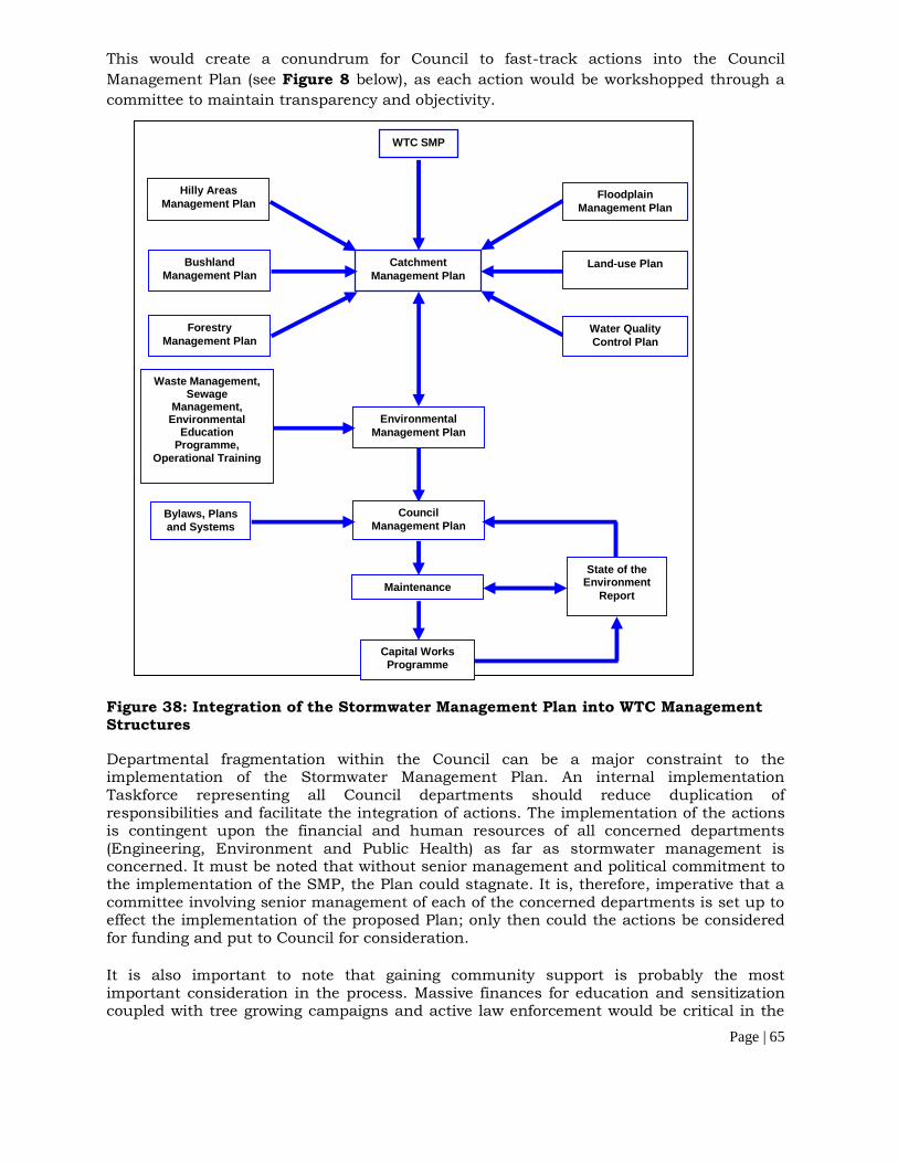
Page | 65
This would create a conundrum for Council to fast-track actions into the CouncilManagement Plan (see Figure 8 below), as each action would be workshopped through acommittee to maintain transparency and objectivity.
Figure 38: Integration of the Stormwater Management Plan into WTC ManagementStructures
Departmental fragmentation within the Council can be a major constraint to theimplementation of the Stormwater Management Plan. An internal implementationTaskforce representing all Council departments should reduce duplication ofresponsibilities and facilitate the integration of actions. The implementation of the actionsis contingent upon the financial and human resources of all concerned departments(Engineering, Environment and Public Health) as far as stormwater management isconcerned. It must be noted that without senior management and political commitment tothe implementation of the SMP, the Plan could stagnate. It is, therefore, imperative that acommittee involving senior management of each of the concerned departments is set up toeffect the implementation of the proposed Plan; only then could the actions be consideredfor funding and put to Council for consideration.
It is also important to note that gaining community support is probably the mostimportant consideration in the process. Massive finances for education and sensitizationcoupled with tree growing campaigns and active law enforcement would be critical in the
WTC SMP
FloodplainManagement Plan
Hilly AreasManagement Plan
Land-use PlanBushlandManagement Plan
CatchmentManagement Plan
Water QualityControl Plan
ForestryManagement Plan
Waste Management,Sewage
Management,Environmental
EducationProgramme,
Operational Training
EnvironmentalManagement Plan
Bylaws, Plansand Systems
CouncilManagement Plan
State of theEnvironment
ReportMaintenance
Capital WorksProgramme
Page | 66
successful implementation of the Plan. However, local people participation emerges as acomplex issue relating to considerations of empowerment and social justice, communitycapacity building, patriotism, human and social capital, and collaborative local action. Itmust be noted, though, that all of these considerations are inextricably linked to conceptsof sustainability and the common good.
The benefits of the Stormwater Management Plan would include the following: Increased Council’s capacity in managing the stormwater quality; Increased recognition of stormwater as an issue in the Council; Increased focus on source control and preventative action solutions; Development of catchment-based relationships between Officers in different Council
Departments; Ownership of the process by Officers and commitment to see that it proceeds effectively.
6.4 Loss of food cropsOne of the first major activities, during the implementation phase, would be clearances.This could result in the removal/destruction of food crops on especially some remote areas(far from the town centre) of WTC.
6.4.1 Suggested Mitigation MeasuresPeople who planted food crops within the confines of the Council, especially in areas to beimmediately cleared, would be allowed to harvest it but no one would be allowed to plantany new crops in such areas; fortunately, the local people are well informed about theproposed development and welcomed it. Hence no annual food crop losses are expected asa result of the proposed development; WTC would, however, compensate the local peoplefor any perennial crop losses. WTC authorities would carry out mass sensitisationcampaigns (in churches, mosques, markets, and on radios) during which the local peoplewould be urged to stop practicing agriculture within the confines of the Council.
6.5 Loss of vegetation cover, and increase in volume of storm-water and soil erosionThe existing green cover within the confines of WTC decreases the speed of run-off andeventually encourages some rainwater to infiltrate into the ground after a storm. Theremoval of the green cover during the implementation of the proposed land developmentPlan, therefore, would increase surface run-off from the cleared areas, which could resultin increased soil erosion in the Council.
6.5.1 Suggested Mitigation Measures
The vegetation within WTC is composed of mostly plant species that are similar to those inthe surrounding areas. Its loss, therefore, would have no impact on the local/nationalecology.
WTC could develop by-laws requiring that all developers within the confines of the Councilseek NEMA approval before seeking approval by the Council authorities. This move wouldgive the Council authorities more power to regulate developments on slopes of hills foundin the Town Council thereby minimising massive green cover loss and possible mudslidesin the area. Hence, prior to implementation of any project within the Council, anEnvironmental Impact Assessment would have to be carried out in which detailed erosionand sediment control plans would be prepared. A Certificate of Approval from NEMA wouldhave to be attached to the Drawing Plans forwarded for approval in the Physical PlanningDepartment of WTC, short of which no approval would be granted. Projects would bedeveloped in a manner that would minimise the potential for soil erosion and water
Page | 67
pollution and also place less strain on the immediate ecosystems. This would also meanless impact on residents surrounding the developments.
6.6 Disruption of public utilities
Considering that land within the Council would be zoned (and demarcated into plots) forvarious specific uses and that some of the existing service lines (such as piped watermains from NWSC and electricity power lines for UMEME) pass through private and/orpublic properties within the Council, the proposed programme would require that serviceproviders (existing and new – such as telecommunication companies which may beinterested in laying optic fibre internet cables) align their service networks along the roadsin WTC. This exercise could result in temporary disconnection of the respectivesurrounding communities from such services.
6.6.1Suggested Mitigation Measures
The service providers (UMEME and NWSC) would forewarn the surrounding communitiesof impending disconnections so as to minimise annoyance.
The service providers would ensure that the period of disconnection would be as short aspossible.
The timing of disconnection would have to be such that only a few people would beaffected.
6.7 Air pollution
Air pollution issues would arise from agitation of dust due to construction trucks’movements along haulage routes within WTC; loading / unloading of earth materialswithin the TC; and exhaust emissions from construction vehicles and equipment.
6.7.1 Suggested Mitigation Measures
The Contractor would:
Take advantage of trucks destined for collection of materials to take away solid wastes.This would reduce on the level of emissions due to use of a large fleet of vehicles on site.
Sprinkle the stockpiles of soil on site with water and re-vegetate unused opened areas.Water sprinkling of re-vegetated areas would continue until complete nurturing of thegreen cover would be ensured.
Use techniques such as the use of ultra low sulphur diesel, fitting all machinery withDiesel Particulate Filters (DPF), and use energy saving methods whilst operating themachinery.
Cover earth materials with tarpaulin during transportation to minimise their falling offtrucks.
Fill trucks only up to the maximum recommended levels. Ensure that his construction trucks and/or equipments are regularly serviced to
minimise exhaust emissions.
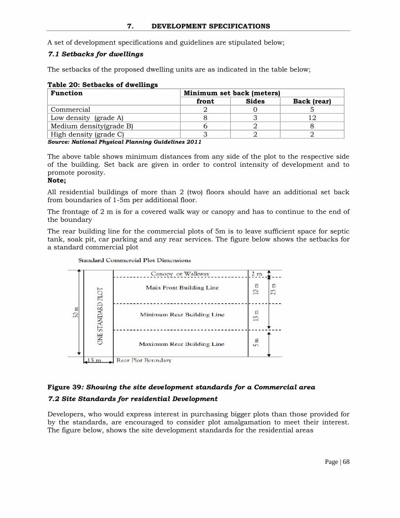
Page | 68
7. DEVELOPMENT SPECIFICATIONS
A set of development specifications and guidelines are stipulated below;
7.1 Setbacks for dwellings
The setbacks of the proposed dwelling units are as indicated in the table below;
Table 20: Setbacks of dwellingsFunction Minimum set back (meters)
front Sides Back (rear)Commercial 2 0 5Low density (grade A) 8 3 12Medium density(grade B) 6 2 8High density (grade C) 3 2 2
Source: National Physical Planning Guidelines 2011
The above table shows minimum distances from any side of the plot to the respective sideof the building. Set back are given in order to control intensity of development and topromote porosity.Note;All residential buildings of more than 2 (two) floors should have an additional set backfrom boundaries of 1-5m per additional floor.
The frontage of 2 m is for a covered walk way or canopy and has to continue to the end ofthe boundary
The rear building line for the commercial plots of 5m is to leave sufficient space for septictank, soak pit, car parking and any rear services. The figure below shows the setbacks fora standard commercial plot
Figure 39: Showing the site development standards for a Commercial area7.2 Site Standards for residential Development
Developers, who would express interest in purchasing bigger plots than those provided forby the standards, are encouraged to consider plot amalgamation to meet their interest.The figure below, shows the site development standards for the residential areas

Page | 69
Figure 40: Showing the site Development standards for the residential areas(Source National Physical Planning Standards 2011)
7.3 Vehicle parking requirements
7.3.1 On street Parking
It is a common practice to park vehicles on the street. This is acceptable if the street iswide enough and lightly trafficked. Elsewhere on street parking should be discouragedbecause it leads to reduced flow of traffic and is likely to cause accidents. In order topractice on street parking it is advised that the council clearly marks out the parkingspaces on the carriage way in the color specified by the town engineer.
7.3.2 Off street parking
The parking lot requirements for off street parking are given in the table below;

Page | 70
Table 21: Parking Space Requirements for off street parkingActivity area ConsiderationResidential A minimum of two parking spaces for each low density plot
should be provided and one car parking space for a mediumdensity plot whereas it is not mandatory to provide parkingspaces for high density plots, these settlements should have acommon parking lot.
Commercial Four parking spaces for every 100sqm of floor area
Industrial Development Three (3) car parking lots for the first 750 m2 and one carparking lot for every additional 609.5 m2
Hotels and motels One car parking lot for every three bed rooms of the hotel andone parking space for every three managerial staff areadequate. However if the hotel has bars, restaurants and is alsoused for functions the parking spaces used for these functionsshould be assessed separately and added on
Restaurants and clubhouses
One car lot for every sixth seat of a patron
Community centre andplace of worship
One car parking space for every 10 people
Warehouses One car parking space per 30m2 of gross floor space plus oneadditional space for every two employees on the largest workshift.
7.4 Key Issues to Consider during development approval
For every Low density domestic plots the setbacks should be increased by 10 to 20percent.
Fence or boundary walls and hedges should be sited on the property line on the front ofthe plot boundary.
Gates on any fence or boundary walls ought to open inwards and not outwards on theaccess road
Boundary walls facing the road should not exceed a height of 150cm and no garageramp should encroach on the road reserve.
All buildings containing more than four flours must have provision for an elevator All Public buildings must have ramps to facilitate PWD accessibility and mobility. Residential Direct access on primary and secondary roads is prohibited

Page | 71
8. IMPLEMENTATION GUIDELINES
8.1 Introduction
Wobulenzi Town Council Physical Development plan 2014-2024 is a specific landuseproposal for the aimed at realizing orderly development of the town. A strategy for theimplementation is therefore needed to guide the implementation exercise.
Implementation of projects depends upon the resources available to the Town Councilauthority. Therefore a resource analysis for the Local authority is necessary if a realisticimplementation strategy is to be identified.
Implementation of the plan begins at a time when the plan has been approved by theNational Physical Planning Board (NPPB) and it will be spearheaded by the local authority(Wobulenzi Town Council).
8.2 Legal and Institutional Frame Work for plan Implementation
As far as the preparation and implementation of the physical development plan isconcerned, there are various institutions and laws that are important.
8.2.1 Legal frame work
The legal frame work gives guidelines for the implementation of physical development planin a legal context. It thus provides a set of laws that are of specific relevance to physicalplanning. These laws include but are not limited to; The Constitution o f the Republic ofUganda, 1995, The Physical Planning Act 2010, The Local Governments Act, 1997, TheUganda Land Act Cap 227 1998, The Public Health Act Cap.269, Waste ManagementRegulations 1999. Understanding the above laws is important for a smoothimplementation process. It is also advised that the Town Council involves in capacitybuilding for its technical staff to properly understand these laws as this will make theirwork easier. A step should also be taken further to sensitize the local community aboutthe relevant laws concerning physical planning.
8.2.2 Institutional frame work for implementationThe following institutions have a stake in the implementation of the plan. Their duties,powers and obligations can be applied in physical planning. These institutions include;MoLHUD, MoLG, land boards, National Physical planning Board administration andrespective local council land committees, Physical Planning Committees, Non GovernmentOrganizations, NEMA, and National Planning Authority.
8.3 Actors in the Implementation ProcessThe implementation of the plan will involve both the public and private sector. There istherefore need for interdependence of both the public and private sector agencies duringthe implementation process of the plan. The duty of the public sector is to provide anenabling environment for the active participation of the private sector.
The role of Non Government Organizations as well as donor funding will provide importantstarting points for successful plan implementation. The Town Council needs to makeefforts to attract donors and NGOs to participate in implementation of the plan. The tablebelow shows the various actors and their roles in the implementation process.
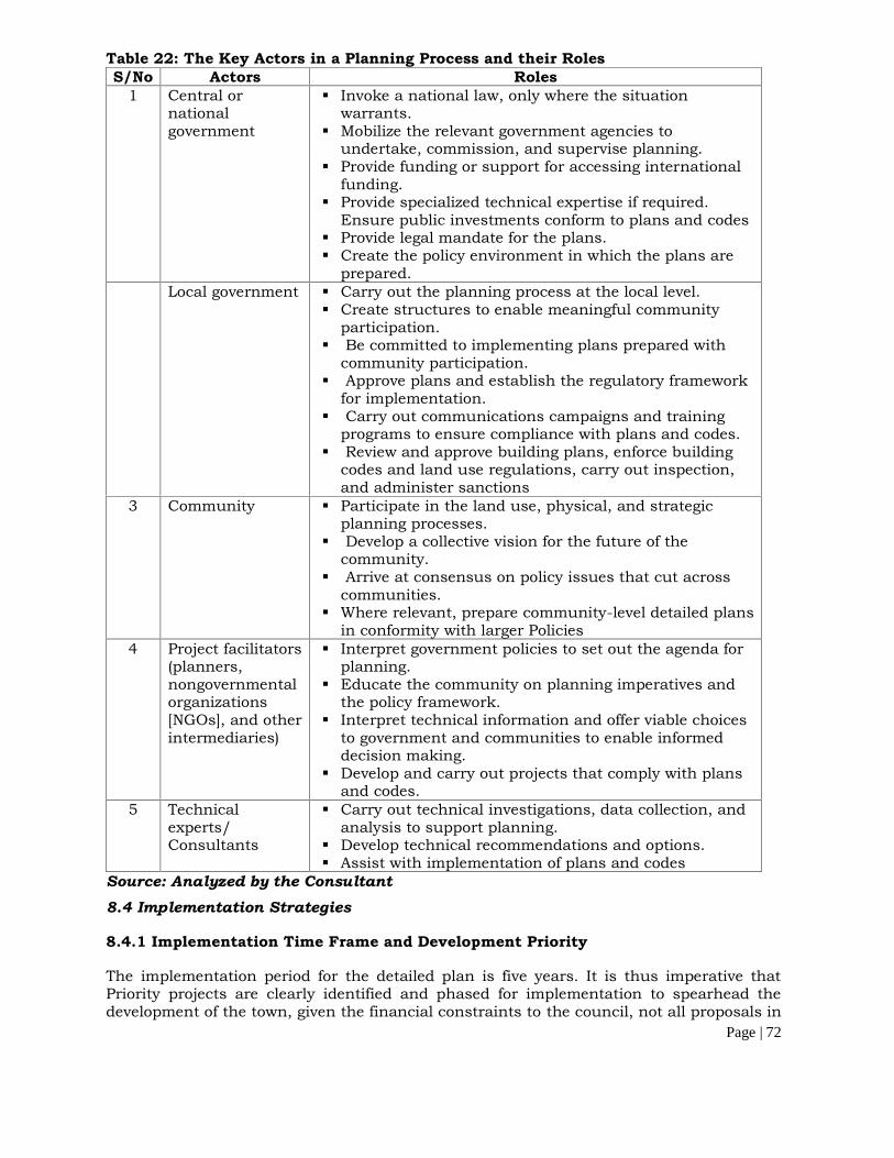
Page | 72
Table 22: The Key Actors in a Planning Process and their RolesS/No Actors Roles
1 Central ornationalgovernment
Invoke a national law, only where the situationwarrants.
Mobilize the relevant government agencies toundertake, commission, and supervise planning.
Provide funding or support for accessing internationalfunding.
Provide specialized technical expertise if required.Ensure public investments conform to plans and codes
Provide legal mandate for the plans. Create the policy environment in which the plans are
prepared.Local government Carry out the planning process at the local level.
Create structures to enable meaningful communityparticipation.
Be committed to implementing plans prepared withcommunity participation.
Approve plans and establish the regulatory frameworkfor implementation.
Carry out communications campaigns and trainingprograms to ensure compliance with plans and codes.
Review and approve building plans, enforce buildingcodes and land use regulations, carry out inspection,and administer sanctions
3 Community Participate in the land use, physical, and strategicplanning processes.
Develop a collective vision for the future of thecommunity.
Arrive at consensus on policy issues that cut acrosscommunities.
Where relevant, prepare community-level detailed plansin conformity with larger Policies
4 Project facilitators(planners,nongovernmentalorganizations[NGOs], and otherintermediaries)
Interpret government policies to set out the agenda forplanning.
Educate the community on planning imperatives andthe policy framework.
Interpret technical information and offer viable choicesto government and communities to enable informeddecision making.
Develop and carry out projects that comply with plansand codes.
5 Technicalexperts/Consultants
Carry out technical investigations, data collection, andanalysis to support planning.
Develop technical recommendations and options. Assist with implementation of plans and codes
Source: Analyzed by the Consultant8.4 Implementation Strategies
8.4.1 Implementation Time Frame and Development Priority
The implementation period for the detailed plan is five years. It is thus imperative thatPriority projects are clearly identified and phased for implementation to spearhead thedevelopment of the town, given the financial constraints to the council, not all proposals in
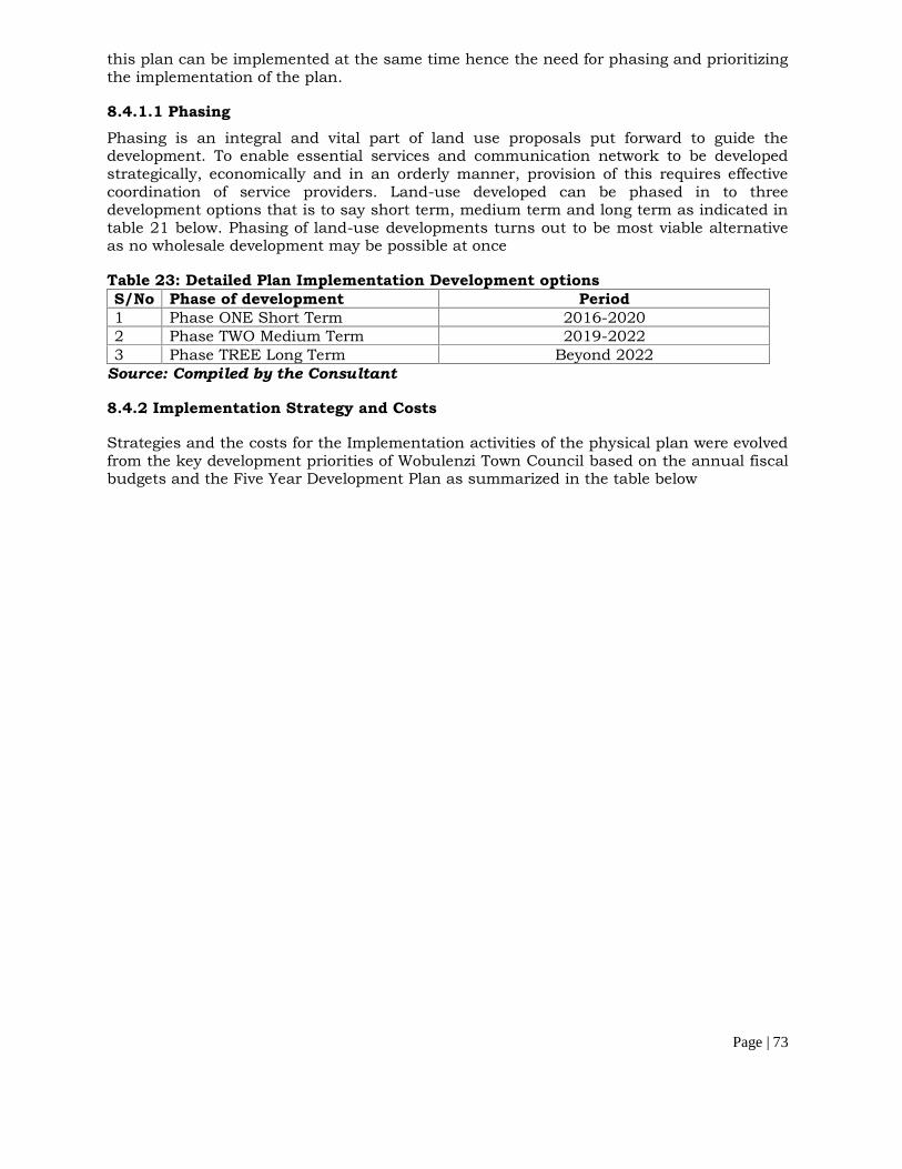
Page | 73
this plan can be implemented at the same time hence the need for phasing and prioritizingthe implementation of the plan.
8.4.1.1 PhasingPhasing is an integral and vital part of land use proposals put forward to guide thedevelopment. To enable essential services and communication network to be developedstrategically, economically and in an orderly manner, provision of this requires effectivecoordination of service providers. Land-use developed can be phased in to threedevelopment options that is to say short term, medium term and long term as indicated intable 21 below. Phasing of land-use developments turns out to be most viable alternativeas no wholesale development may be possible at once
Table 23: Detailed Plan Implementation Development optionsS/No Phase of development Period1 Phase ONE Short Term 2016-20202 Phase TWO Medium Term 2019-20223 Phase TREE Long Term Beyond 2022
Source: Compiled by the Consultant
8.4.2 Implementation Strategy and Costs
Strategies and the costs for the Implementation activities of the physical plan were evolvedfrom the key development priorities of Wobulenzi Town Council based on the annual fiscalbudgets and the Five Year Development Plan as summarized in the table below
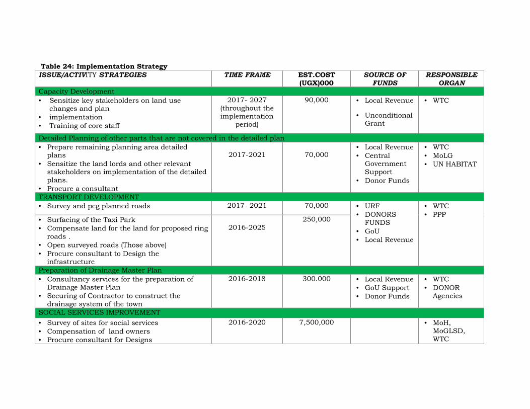
Table 24: Implementation StrategyISSUE/ACTIVITY STRATEGIES TIME FRAME EST.COST
(UGX)000SOURCE OF
FUNDSRESPONSIBLE
ORGANCapacity Development Sensitize key stakeholders on land use
changes and plan implementation Training of core staff
2017- 2027(throughout theimplementation
period)
90,000 Local Revenue
UnconditionalGrant
WTC
Detailed Planning of other parts that are not covered in the detailed plan Prepare remaining planning area detailed
plans Sensitize the land lords and other relevant
stakeholders on implementation of the detailedplans.
Procure a consultant
2017-2021 70,000 Local Revenue Central
GovernmentSupport
Donor Funds
WTC MoLG UN HABITAT
TRANSPORT DEVELOPMENT Survey and peg planned roads 2017- 2021 70,000 URF
DONORSFUNDS
GoU Local Revenue
WTC PPP
Surfacing of the Taxi Park Compensate land for the land for proposed ring
roads . Open surveyed roads (Those above) Procure consultant to Design the
infrastructure
2016-2025250,000
Preparation of Drainage Master Plan Consultancy services for the preparation of
Drainage Master Plan Securing of Contractor to construct the
drainage system of the town
2016-2018 300.000 Local Revenue GoU Support Donor Funds
WTC DONOR
Agencies
SOCIAL SERVICES IMPROVEMENT Survey of sites for social services Compensation of land owners Procure consultant for Designs
2016-2020 7,500,000 MoH,MoGLSD,WTC

Page | 75
Procure contractor to implement project PPP, PSIMPROVEMENT IN URBAN LOCAL ECONOMY Survey land for commercial, industrial land
uses Encourage PPP Establish industrial parks Instituting mechanisms on urban agriculture
2021-2027 70,000 Local Revenue
WTC PPP PSF UIA
DEVELOPMENT OF RECREATIONAL FACILTIES Survey all planned public spaces, play
grounds, and sporting sites Compensate land Encourage private developer to invest in this
sector
2017-2021 100,000350,0000
LocalRevenue
WTC PPP
DEVELOPMENT of PROPOSED MARKETS Purchase of land for the proposed markets Preparation of architectural plans Construction of the markets
2017-2027(throughoutimplementation
period)2016-2020
240,000
250,000
Local Revenue WTC PPP
PROMOTION OF ENVIRONMENT SUSTAINABILITY Map out and survey environmental fragile sites Plant trees along all major roads, open spaces
and in buffer zones. Have policy on green coverage on individual
plot development
2017-2021(Short Term) 100,000
Local Revenue Environmental
ProtectionFunds
NEMA WTC PPP MoWE NGOS
DEVELOPMENT OF SANITATION Survey sewer lines, lagoon site, Water mains Design water treatment plant Prepare waste water master plans
2021-2025(Mid Term) 500.000
WB Local Revenue Grants
NWSC WTC
MONITORING AND EVALUATION OF THE PHYSICAL DEVELOPMENT PLANS

Page | 76
Note: Sources of financing the physical Development PlanThe financing of this Physical Development Plan will be mainly by Wobulenzi Town Council Local Government, CBOs, developmentpartners and the private sector. The resources to include; conventional and innovative non-conventional means of financingincluding; tax and non-tax revenues, Public Private Partnerships, concessional loans and grants, borrowing from domestic andinternational markets.
Annual Monitoring and Evaluation 60.000 Local Revenue Grants
WTC MLHUD

8.5 MONITORING AND EVALUATION STRATEGY8.5.1 MonitoringMonitoring plays an integral part in the plan implementation process and itinvolves continuous and systematic checking on the progress of theimplementation process. Monitoring ensures implementation of the plan as per thedesired objectives. Monitoring is usually done through a systematic and continuousdata collection and analysis exercise. The information obtained is used for decisionmaking and management control.
8.5.1.1 Purpose of MonitoringMonitoring ensures the following;
Keeping track and progress towards achieving the set objectives Ensures the most effective and efficient use of resources (human, financial, time
and material) Reducing waste of resources and time by taking corrective measures Enable one to solve emerging project short falls and problems Helps in making informed decisions regarding operations management and
service delivery Provides accountability and greater transparency for beneficiaries and
stakeholders Motivation of staff and volunteers by knowing their out puts and achievements
8.5.1.2 Proposed Strategies for monitoring. Observing and noting how the project is proceeding. Identification of problems or setbacks. Provision of feedback. Identifying and documenting inputs and outcomes. Field visits.
8.5.2 EvaluationEvaluation is an exercise that assesses, appraises or determines the worth, value,quality and impact of the project, program or plan. It involves comparing thepresent situation with the past baseline position in order to find out the extent towhich the plan has achieved its intended purpose. Results of the evaluation will bean important input in the design and formulation of a new development plan sinceit helps to check if the goals and objectives are being achieved and if the problemshave been solved.
8.5.2.1 Purpose of EvaluationEvaluation enables the plan implementers to establish the following;
Check if the established objectives are being achieved or about to be achieved Find out if the objectives are still relevant to the situation and the needs of the
target beneficiaries To make sure project implementers are accountable to the community
beneficiaries
8.5.2.2 Strategies proposed for evaluation.The strategies proposed for plan evaluation are as listed below; Progress reports. Audit and Accountability reports. Logical frame work matrices
Page | 78
10. RECOMMENDATIONS AND CONCLUSIONS
10.1 RECOMMENDATIONS
Physical Planning is a continuous process and cyclic in nature. This implies thatthe activity requires constant field checks for effective development Control. Thefollowing recommendations are crucial for the implementation of the plan.
10.1.1 Technical Recommendations
There is need for the Town Council Technical Planning Committee to prepareannual work plans linked to the implementation strategy outlined in thisphysical Development Plan report.
Developing institutionalized coordination mechanisms particularly to link thedecision making processes about budgets and infrastructure improvement anddevelopment with those of land management. This will also help in ensuringtransparency as well as accountability;
All development within the jurisdiction of the Town Council should besubmitted to the council for scrutiny and approval by the physical planningcommittee. In regard of the above there is thus a need to carry out siteinspection before the plan approvals are made.
As far as addressing Urban Sprawl is concerned the following is recommended1) The Design principle of densification is recommended to address urban
sprawl2) Mixed use as opposed to segregation3) Urban regeneration or renewal in areas which are already existing for
specific zoned landuses can be converted to suitable urban uses
As far as preserving the proposed forests is concerned, the local Authority willhave to purchase the land earmarked for forest development and propose byelaws to govern their existence.
There is need for the Town Council to secure funds for the detailed planning ofother areas that are not covered by the detailed plan
Drainage was identified as a key problem in the town, there is therefore need forthe Town Council authority to prepare a drainage master plan
It is also recommended that the Council carries out sensitization campaignsabout the physical planning out activities.
Environmentally sensitive areas ought to be preserved and conserved as per theplan and any developments therein must go through Environmental screeningto identify possible project consequences and develop mitigation measures.
To minimize the cost of development and compensation, Wobulenzi TownCouncil ought to involve the land owners in the development process. This canbe achieved by declaring some of the developing corridors as concession fordevelopment through people’s participation where landowners will become
Page | 79
development partners and share the development cost through contribution of aportion of their land.
Lobbying and soliciting for funds from donors communities to implement theplans is necessary to avail the local authority with adequate funds to implementthe plans.
All implementation of the planned projects should go through Environmentimpact assessment screening to identify possible consequences and developmitigation measures.
Small home based industries can also be permitted in residential zones as partof the premises given the fact that they are not likely to cause interference,nuisance or annoyance to the neighbors. This is allowed for economic andconvenience reasons.
Wobulenzi Town Council should take initiatives to review the performance andfunctioning of the plan during the planning period (2016-2026). It should alsomake arrangement for regular updating of the plan. Provision should also bemade to prepare fresh plans on expiry of a plan period.
10.1.2 General Recommendations During the surveys it was established that malaria was the major disease
affecting the community of Wobulenzi Town, there is thus need for the councilto lay strategies to reduce the spread of malaria; these may entail the following;
Campaigns to use Mosquito Nets Clearing of Bushes Desilting the drainage channels to avoid stagnant water
Generating political will to have due regard to the proposals of the new Planthrough orientation/briefing to the elected representatives about the PhysicalPlanning and its role in achieving the desired quality of life of Wobulenzi townresidents and future generations, dissemination of progress on implementationof the plan, and creating awareness among the communities;
Lobbying and soliciting for funds from donors communities to implement theplans is necessary to avail the Town Council with adequate funds to implementthe plans.
10.2 CONCLUSIONS
This Physical Development Plan gives a broad framework of landuse proposals,strategies and policy recommendations for the orderly and improved developmentof Wobulenzi Town, geared at meeting the development needs of the area by theyear 2025.
The main factor considered during the preparation of this physical Developmentplan was consultation of the key stakeholders/plan beneficiaries. This was in a bidto popularize the planning exercise and gain meaningful planning proposals thatwould aid the future development of the town, thus the Contents of plan is a truerepresentation of the planning needs of the inhabitants of Wobulenzi Town Council
Page | 80
This plan takes into account the existing situation and makes new and betterproposals to modify on the existing conditions. This was geared at making low costsustainable plans that can easily be developed and implemented using the limitedavailable resources.
This Physical Development plan will facilitate the creation of good urban livingenvironment beneficial to all socio-income groups. The put forward proposalshowever, provide a framework on which a more comprehensive development ofWobulenzi Town will be based.
The plan shall be a guide to investment area priorities, policy frame work fororderly development, and shall provide a basis for coordinating planning decisions.The plan shall also serve as a basis for development permissions in WobulenziTown and thus all development procedures in the town ought to adequately followthe proposed plan so as to achieve orderly developmentThe capacity of Town Council’s Sector Departments needs to be strengthened byproviding the required staffing and training. The capacities of these agencies needto be strengthened for plan implementation, participatory approaches, resourcemobilization, project planning, implementation, monitoring, review and evaluation.
In summary the Physical Development Plan (Structure Plan) shall become a policyframework that will guide land use development in the town for the next ten years(2016 - 2026) and is subject for review at the end of the said planning period.

Page | 81
ANNEX

Page | 82
Attendance list for the consultative meetings

Page | 83