DRAFT Noosa Coastal Hazards Adaptation Plan
107
DRAFT Noosa Coastal Hazards Adaptation Plan for second round consultation Special Meeting Agenda 8 October 2021 Attachment 1 to Item 1
Transcript of DRAFT Noosa Coastal Hazards Adaptation Plan

DRAFT
Noosa Coastal Hazards Adaptation Plan
for second round consultation
Special Meeting Agenda8 October 2021Attachment 1 to Item 1

© Noosa Council 2021 www.noosa.qld.gov.au General Enquiries: By telephone: (07) 5329 6500 By email: [email protected] Fax: (07) 5329 6501 Street Address: 9 Pelican Street, TEWANTIN Postal address: PO Box 141, TEWANTIN QLD 4565
Disclaimer Information contained in this document is based on available information at the time of writing. All figures and diagrams are indicative only and should be referred to as such. While the Noosa Council has exercised reasonable care in preparing this document it does not warrant or represent that it is accurate or complete. Council or its officers accept no responsibility for any loss occasioned to any person acting or refraining from acting in reliance upon any material contained in this document. Endorsed by Noosa Council [DRAFT] for further
consultation

Noosa Council – Coastal Hazards Adaptation Plan Page 2
Executive Summary It is widely acknowledged that local governments across Australia are on the front line when it comes to experiencing and responding to the impacts of climate change, and Noosa is no different. It is likely that many natural hazard risks will worsen, and some new ones may emerge, as a result of climate change. Therefore, it is critical that all local governments, including Noosa Council, ensure these risks are better understood, and plans are developed to respond to these where required, consistent with existing risk management frameworks. Noosa Council is responding to potential climate change-induced risks by undertaking a multi-year project to develop a climate change response program in order to build adaptive capacity and respond to climate risks within Council and across the community. The coastal hazards component of the program is guided by this Coastal Hazards Adaptation Plan (CHAP). The CHAP is funded by a grant agreement with the Local Government Association of Queensland (LGAQ), under the Queensland Department of Environment and Science’s (DES) QCoast2100 initiative. The QCoast2100 initiative has been designed to assist Queensland coastal local governments with funding and technical guidance to support the preparation of plans that identify and respond to potential changes in coastal hazard risks caused by rising sea levels. This plan is intended to guide decision-making across key areas of Council, including:
Corporate and operational planning and financial planning;
Land use planning and development assessment;
Infrastructure planning, design and management including roads, stormwater and foreshores;
Management of non-infrastructure assets including conservation and recreational areas;
Community resilience planning and emergency management Work on the CHAP commenced in early 2017, and has progressed over that time in stages, guided by important input from the Noosa community and Council staff. Several background studies were completed and used to inform this plan, in alignment with technical requirements provided by DES. These studies reveal Noosa should expect impacts to increase as a result of a range of coastal hazards, particularly towards the latter half of this century, and that proactive and well considered actions are required to prepare and manage these risks. Specifically, these technical studies indicate that without an appropriate response to the projected rise in sea level, increasing impacts from coastal erosion are likely for the open coast areas (i.e. Peregian Beach to Sunshine Beach, Noosa Heads, and Noosa North Shore), having an impact on some privately-owned assets and Council infrastructure (e.g. roads and recreational areas), as well as the beaches themselves. Areas along the Lower Noosa River (Noosa Heads, Tewantin, and in particular Noosaville and Noosa North Shore) will be increasingly at risk due to inundation associated with rising sea levels. With inundation, the greatest level of exposure and impacts are expected to be felt by Council infrastructure (e.g. stormwater networks, open space, roads), some private property, as well as indirect consequences for adjacent retail and commercial activities. These studies also highlight a range of adaptation options to help reduce risks to an acceptable level. This plan presents a summary of the findings of each of these studies, as well as a set of preferred long-term adaptation outcomes and short-term actions for the areas of most concern within Noosa’s coastal zone.

Noosa Council – Coastal Hazards Adaptation Plan Page 3
Introduction
Purpose
Noosa Council is responding to the potential effects of coastal hazards over time, and has prepared this CHAP to provide a comprehensive and coordinated adaptation program in response to changing coastal risks caused by a changing climate. This plan specifically deals with the potential impacts of coastal erosion along the open beach areas and inundation of low-lying areas from storm tides and higher tides, and how these existing hazards are projected to change over time due to sea level rise. The core objectives for the program are to:
Improve Noosa Council and the community’s understanding of current and future risks from coastal hazards and how they might change through time as a result of climate change;
Consult with the community clearly and sensitively throughout key stages of the project so the community understands the implications and contributes to the decision making;
Identify what actions are required to avoid, reduce or adapt to these risks to people, property, assets and the environment;
Provide mapping and visual products and deliverables that are useful for a range of purposes across Council departments and functions and within the community (e.g. planning scheme, asset management, community awareness, disaster management and financial planning); and
Provide direction for a coordinated approach for Council and the community to adapt to climate change and coastal hazards.
The plan is based on a detailed assessment of coastal hazards for present day and 2040, 2070 and 2100 including hazard modelling, risk assessments and socio-economic analysis of options. It provides a set of recommended actions for implementation over the next 1-5 years, and presents a potential pathway for responding to these changing risks over the long term.
Context
The majority of Noosa’s population, and private and public built assets, as well as significant areas designated for conservation purposes are located within Noosa’s coastal zone. Many assets and locations of particular interest to the local community and visitors have historically been exposed to the effects of coastal erosion and inundation. This includes private residences, commercial premises, parks and recreational facilities, as well as service infrastructure such as roads and stormwater networks. Therefore, close attention is required to any effect that climate change – particularly sea level rise – is likely to have in worsening risks associated with these existing hazards. This plan has been developed in consideration of the principles and strategies outlined in Noosa Council’s Corporate Plan 2017-2037, Environment Strategy 2019, Social Strategy 2015, and Local Economic Plan 2015. It is critical that Council adopts a long-term proactive approach regarding climate-related risks to help improve and build the adaptive capacity of our coast. This means, monitoring and planning for changes to coastal hazard risks including ensuring appropriate and effective development requirements, infrastructure planning (including roads and drainage), disaster management, asset management and governance systems are established and implemented. This planning needs to be adaptable, measured and take account of new information including local monitoring results. It

Noosa Council – Coastal Hazards Adaptation Plan Page 4
also needs to be supported by strong Council effort towards ensuring that natural foreshores are as healthy and resilient as they can be to help reduce coastal hazard risks. Council acknowledges that climate change poses a serious challenge to Noosa Shire – and ultimately to the planet. Council believes that the responsibility for responding to the causes and risks associated with climate change is shared by many stakeholders and thus requires a collaborative approach. Council acknowledges its responsibility to understand and consider local risks, and to work with the community, government agencies and other partners to improve its knowledge and capability to respond. That response will involve not only adaptive and pragmatic planning for development and infrastructure, but also localised emissions reductions.
Reference Box #1
What is ‘adaptation’? Despite ongoing international efforts to reduce greenhouse gas emissions, climate change is likely to have significant effects on coastal communities across Australia. One of the most significant changes, rising sea-levels rise, has the potential to impact the livelihoods and lifestyles of coastal residents and the natural environment. Decisions and actions that help to prepare for the adverse consequences of climate change, as well as to take advantage of the opportunities, are known as climate change adaptation. In this context, coastal hazards adaptation means understanding what effect sea level rise may have on the behaviour on coastal hazards, and taking appropriate action to prevent or minimise the damage they could cause in the future to the built environment, human health and safety, and our natural systems. It can also mean taking advantage of any opportunities that may arise to transform Noosa into something better. Robust adaptation planning takes into account the timing of any proposed actions. Because the future is almost always uncertain, acting too soon can risk locking councils and communities into inappropriate outcomes. But acting too late (or not at all) could risk locking Noosa into impacts that are costly or unavoidable. Local monitoring will therefore continue to inform future coastal hazards modelling and mapping and timely adaptation responses.

Noosa Council – Coastal Hazards Adaptation Plan Page 5
Approach
QCoast2100
The CHAP has been developed through an eight-phase process (Figure 1) as outlined in the QCoast2100 Minimum Standards and Guidelines (LGAQ and DEHP 2016). The QCoast2100 program has been coordinated by the Local Government Association of Queensland (LGAQ) on behalf of the Queensland Department of Environment and Science (DES). Incorporating regular community engagement and consultation, the process has included the following key steps:
Scope coastal hazard issues for the area of interest
Identify areas exposed to current and future coastal hazards
Identify key hazards potentially impacted
Conduct risk assessments of key assets in coastal hazard areas
Identify potential adaptation options and determine actions, costs, priorities and timeframes.
Figure 1 - Process for developing a Coastal Hazards Adaptation Plan
The outputs of each project phase have been subject to review and approval by LGAQ and DES. Uncertainty is a key characteristic of climate change and long-term coastal management, and can be viewed as a barrier to progressing important adaptation actions. This uncertainty should not however be an excuse to delay planning or action. The appropriate approach to managing uncertainty is to plan over multiple time horizons, and incorporate options that can be attuned to needs as they change over time. This plan takes a risk-based ‘monitor-review-manage’ approach

Noosa Council – Coastal Hazards Adaptation Plan Page 6
to dealing with uncertainties in preparing Noosa for changes to local coastal hazards. It provides a fit-for-purpose plan based on the best available scientific data and information, noting the need for flexibility and iterative review over time as new locally specific information arises.
Guiding principles
Guiding principles have been created to assist in the development of Noosa’s response to coastal hazards. These principles (shown below) were developed to clearly articulate how Noosa Council’s existing strategies and objectives apply in a coastal hazards adaptation context. The Noosa Environment
1. Adaptation does not adversely impact upon the natural assets of Noosa.
2. Adaptation supports the resilience of native flora and fauna, natural dune system and
beaches.
3. Adaptation maintains the natural landscape character of places and provides for attractive
natural solutions that harmonise with local environmental features.
The Noosa Community 4. Adaptation increases the community's safety and resilience to natural hazard risks.
5. Adaptation responses maintain or enhance accessibility to existing local landscapes in a
way that does not adversely impact on natural values.
6. Adaptation responses seek to maintain the functionality of key community spaces where
appropriate though some areas may experience reduced functionality.
7. Adaptation responses seek to minimise disruption to the community from natural hazard
events.
8. Adaptation planning incorporates community involvement in early planning, policy, design
and decision making.
9. Adaptation considers the potential financial burden on the community in short, medium and
long term, whilst also considering the rights and interests of individuals.
The Noosa Economy
10. Adaptation seeks to support the ongoing functionality of key economic zones.
11. Adaptation supports the goals of Council’s economic strategy where possible.
Long term planning for Noosa Shire
12. Adaptation is incorporated into capital works programs, including asset designs.
13. Adaptation responses are flexible and adaptable over time to changing needs and new
information including local area specific data.
14. Adaptation must be intra- and inter-generationally equitable.
Excellence as a Council
15. Adaptation responses are driven by scientific evidence, risk management principles and
community consultation with residents and businesses.
16. Adaptation responses reduce risk and create other benefits wherever possible.
17. Adaptation seeks to minimise futures financial costs to Council.

Noosa Council – Coastal Hazards Adaptation Plan Page 7
Our Coastal zone Covering an area of 870km2, Noosa Shire is home to more than 55,000 people (ABS, 2017). Two thirds of the population live within the coastal area that takes in Peregian to Sunshine Beach, Noosa Heads, Noosaville and Tewantin. The Traditional Owners are the Kabi Kabi people (Gubbi Gubbi people) who have lived in and cared for the coastal area for millennia and continue to maintain a deep connection with the natural environment, landscape and sea. Noosa Shire has over 45 kilometres of coastline extending from Peregian Beach north to Teewah and Great Sandy National Park on Noosa North Shore (Figure 2). Famous for its open surf beaches, protected north-facing bays, river systems and everglades, Noosa’s coastal zone is at the fragile interface of land and sea. Extending landward from the ocean, many kilometres of estuaries and waterways connect the hinterland to the coast. This network of rivers, tributaries and lakes plays an important role in supporting marine and aquatic life. The Noosa River system also functions as an important temporary storage of flood waters during flood events, thereby absorbing the impact of ocean-related impacts such as storm surges. The natural character of Noosa’s coastline and surrounding vegetated landscape is a key attractor and point of difference for the local economy. It attracts businesses, investors and residents who wish to enjoy the nature-based, casual lifestyle and take advantage of Noosa’s clean, green reputation, innovative culture and attractive beaches.
Coastal Landscape
The coastal zone is the interface between land and sea and includes coastal waters and areas landwards. Coastal land includes land under tidal waters, erosion prone areas, land at risk from storm tide inundation or permanent inundation due to sea level rise, and parcels of land adjacent to the foreshore. In Noosa Shire, this includes coastal waters and land adjacent to the open beaches, rivers and lakes that are influenced by the tides. Coastal hazards will affect localities to varying extents depending on geographic position and topography. For instance, the open coast will be most affected by coastal erosion and shoreline recession. Open coast communities include Peregian Beach, Marcus Beach, Castaways Beach, Sunrise Beach, Sunshine Beach, Noosa Heads, Noosa North Shore and Teewah. Contrastingly, riverine areas including Noosaville and Tewantin will be most affected by periodic storm tide inundation and permanent sea level rise. Further information on coastal hazards can be found in Section 4. Open coast The beaches along Noosa’s coastline are dynamic wave-dominated sandy beaches that naturally experience phases of erosion and accretion that operate over a range of timescales including seasons1. Most beaches in Noosa are ‘dynamically stable’ and have benefited from long periods of sand accretion in recent decades (largely due to the general absence of major storm activity as compared to historical erosion events of the 1970s). Noosa Main Beach and Dog Beach are notable exceptions experiencing more regular erosion. The open beaches are shaped and maintained by coastal processes of erosion and accretion, as well as longshore drift which transports sediments northward along Australia’s east coast2. The supply of sand needed to keep the beach at a ‘healthy’ state is reliant on longshore drift processes which is influenced by prevailing winds, swells, and sediment supply, mostly driven from the south east.
1 Thom, B.G. and Hall, W. 1991 OZCOASTS 2 BMT WBM (2013), Sunshine Coast Regional Council: Coastal Processes Study

Noosa Council – Coastal Hazards Adaptation Plan Page 8
Figure 2 - Noosa's coastal zone and CHAP study area

Noosa Council – Coastal Hazards Adaptation Plan Page 9
Riverine areas Riverine areas are low-lying areas that are adjacent to river and lake systems and are exposed to potential inundation from periodic storm tide inundation and/or permanent tidal inundation. The Noosa River’s headwaters begin in the hinterland west of Kin Kin and the Cooloola section of the Great Sandy National Park in the north of the shire. On its journey to the sea, the river passes through a number of shallow coastal lakes and past low key residential and tourist areas before entering Laguna Bay at its mouth. Most of the Noosa River catchment is relatively flat with a change in elevation of only 80 metres from the headwaters to the mouth. This small gradient means that changes to mean sea level, and in turn the river level, has the potential to affect significant areas of low-lying land adjacent to the river. The tidal limit of the Noosa River encompasses the shallow lakes of Cootharaba, Cooroibah, Doonella, and Weyba, and their shores, and will consequently be affected by future sea level rise. Localities within the tidal zone of the Noosa River are Noosa Heads, Noosaville, Tewantin and Cooroibah, Cootharaba, Boreen Point, and Noosa North Shore.
Coastal values
Coastal zones are highly valued for the social, environmental and economic benefits they provide. Noosa’s coastal zone supports a mix of land use types including conservation areas, recreation and amenity spaces, urban development and critical infrastructure that all provide value to the community and economy. Feedback received from the community (see Section 3) in the development of this plan emphasised the need to uphold a set of core natural asset and lifestyle values within the coastal zone to ensure the desired attributes of Noosa Shire are maintained and available to future generations.

Noosa Council – Coastal Hazards Adaptation Plan Page 10
Community Engagement Engaging with the Noosa community and other stakeholders has formed an important part of the development of this plan. This engagement has provided for a two-way shared understanding of the risks Council and the community face from coastal hazards, and has helped to create a plan that reflects a vision for Noosa shared by many. Several rounds of stakeholder engagement were carried out during the course of this plan’s development with members of the public, industry experts, State government representatives, and specialists within Council. Identifying coastal values, coastal hazard risks and adaptation options were topics of focus for this consultation process, with feedback yielding valuable insights into Noosa’s most valued assets and preferred adaptation options. These activities included multiple online and in-person surveys, pop-up events, static displays, workshops, and meetings with groups of stakeholders with a range of special interests. An important aspect of this CHAP has been working with members of the community to understand the values, wants and needs of Noosa Shire residents, business owners and other stakeholders. Knowing that adaptation decisions have the potential to be politically sensitive, this process has required complex stakeholder engagement in order to build upon existing knowledge within the community regarding coastal hazards, and ensure community stakeholders are meaningfully involved in the planning process. These actions were critical to identifying the locations and assets the local community deems to be of most importance and why, as well as the extent to which the community is able to tolerate damage or other impairments to these due to coastal hazards. These perspectives were vital in appropriately determining the risks and areas of most concern, as well as for assessing adaptation options. The most prominent messages from the Noosa community received during the plan’s development have been:
Natural and scenic amenity assets are considered to have the highest intrinsic value to the community
Short term disruptions to public access are tolerable, with a strong emphasis on restoring accessibility quickly and safely
There is a general acceptance that temporary interruptions are reasonably likely to occur and that these are forecast to increase/worsen, but there is a low tolerance for more permanent impacts.
There is a strong preference for nature-based solutions that fit with the look and feel of Noosa, and that minimize impacts to natural environments.
There is a preference for protection and active on-ground management of local beaches, dunes, habitats and waterways to help build coastal resilience and manage erosion risks.
There is a need for scientific monitoring that provides for local area specific data to inform future adaptation responses.
The CHAP needs to take a flexible pathways approach that is staged, evolves over time, and takes advantage of new information and technological advancements.
The CHAP should make clear the relationship with the planning scheme, and not direct planning scheme changes that adversely affect private property or conflict with the State Planning Policy for coastal hazards.

Noosa Council – Coastal Hazards Adaptation Plan Page 11
Developing this plan This section discusses Phases 2 to Phase 7 of the CHAP’s development, including the methods used to complete each phase, as well as their respective outputs.
Understanding climate change & sea level rise
The Earth’s atmosphere has warmed significantly over the past 200 years, and this is largely due to human activities that have significantly increased the amount of greenhouse gases (GHG) in the atmosphere. The rise in the concentration of greenhouse gases in the atmosphere is trapping more heat within the Earth’s climate system than would otherwise have occurred without the increases in these gases. This is in turn causing land and oceans to warm at a rate much faster than has occurred naturally in the past3. Based on the available science, the factor with the most influence on coastal hazards due to climate change is rising sea levels. Sea level rise is the elevation of global and local mean sea level caused by the expansion of the ocean as it warms, and the transfer of water currently stored on land to the ocean, particularly from melting glaciers and ice sheets. Global sea levels are rising at an increasingly higher rate than in the past 2000 years. Sea levels started rising at the 1800s following the industrial revolution and as a result of increased dependency on fossil fuels. Between 1901 and 1990 the rate of global average sea level rise was 1.3-1.7mm annually, increasing to 1.8-3.6 mm per year between 1993 and 2010 (IPCC 2014). The result of this sea level rise is more land area exposed to coastal erosion and inundation over time.
Phase 2 – 3: Identifying the hazards
The first stage in developing a risk-based plan to respond to coastal hazards is to model and map the expected behaviour of each hazard. Modelling of a range of hazard events was performed by expert consultants, consistent with the QCoast2100 guidelines and Queensland Government technical guidelines. The future climate scenario underpinning the hazard modelling is based upon a high global greenhouse gas emissions scenario known as ‘RCP 8.5’, which is often referred to as ‘business as usual’ because it broadly represents an emissions pathway based on our current trajectory of minimal emissions reduction. This scenario results in a projected rise in regional mean sea level of approximately +0.8 meters by the year 21004. This scenario represents minimal action being taken globally to reduce global greenhouse emissions between now and the year 2100. The adoption of this scenario is a requirement of the QCoast2100 program. Council acknowledges the need to consider a range of possible climate change scenarios as well as sources of local data in coastal hazard modelling and for these to be incorporated as part of future modelling reviews where appropriate. Ongoing localised monitoring and data collection are important inputs to managing coastal hazard
risks, and are discussed further in Section 6 of this plan.
Noosa already experiences periodic tidal inundation and coastal erosion events. The first stage of the project sought to understand how Noosa may be affected by changes in tidal water, storm
3 https://climate.nasa.gov/evidence/ 4 Intermediate projections for sea level rise are +0.2m by the year 2040, and +0.5m by the year 2070.

Noosa Council – Coastal Hazards Adaptation Plan Page 12
tides, and coastal erosion events due to rising sea levels. These events were modelled using specialised software across four planning horizons – present day, 2040, 2070 and 2100. Coastal hazard map layers produced as part of the development of this plan show potential inundation and coastal erosion extents for each of these time steps. These map layers should not be relied upon for making detailed design decisions as part of the development of buildings, infrastructure or other structures at the individual lot scale. The mapping has been prepared to identify areas of interest that require further investigation for mitigating potential risks.
What is coastal erosion?
Coastal erosion is the wearing away of land or the removal of beach or dunes by wave action, tidal currents, drainage or high winds. Coastal erosion leads to the recession of shorelines inland and the destabilisation of dune systems if the system is not able to rebuild before another erosive event occurs. Beaches in south-east Queensland typically consist of sand particles that can be easily eroded by waves. These deposits comprise terrestrial sediment delivered to the coast by rivers, sediment produced by the erosion of coastal landforms by waves, and marine sediment that has been reworked from offshore deposits onto the coast. Coastal erosion occurs when high winds, waves and tides combine to remove sand away from the shoreline and dunes. This can be a short-term movement (called a ‘storm bite’), where the sand gets pulled offshore and gradually returns the beach during calm conditions over many months. Erosion sometimes occurs more gradually as water levels and currents change, causing the shoreline to recede further inland relative to a previous position; this is called ‘shoreline recession’. It can also occur when a hard structure is built within the active beach zone, and instead of dissipating the wave energy like a sand dune would, it simply reflects that energy in-front (i.e. seaward) of the structure, thereby preventing the sand to settle in that area and build up. Figure 3 shows what happens during a storm event to the shore of the beach, as well as the likely effect of significant increases in mean sea level. That is, as the local sea level increases so to does the ocean’s ability to erode our sandy shorelines impacting the frontal dunes that form a protective buffer between the force of the ocean and coastal development.

Noosa Council – Coastal Hazards Adaptation Plan Page 13
Figure 3 – Example of coastal erosion processes and projections at Peregian Beach (this image is not to scale and is for indicative purposes only).
Noosa Council – Coastal Hazards Adaptation Plan Page 14
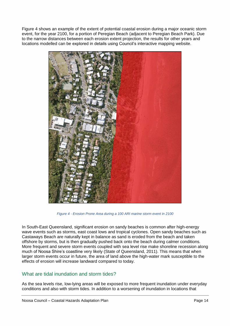
Figure 4 shows an example of the extent of potential coastal erosion during a major oceanic storm event, for the year 2100, for a portion of Peregian Beach (adjacent to Peregian Beach Park). Due to the narrow distances between each erosion extent projection, the results for other years and locations modelled can be explored in details using Council’s interactive mapping website.
Figure 4 - Erosion Prone Area during a 100 ARI marine storm event in 2100
In South-East Queensland, significant erosion on sandy beaches is common after high-energy wave events such as storms, east coast lows and tropical cyclones. Open sandy beaches such as Castaways Beach are naturally kept in balance as sand is eroded from the beach and taken offshore by storms, but is then gradually pushed back onto the beach during calmer conditions. More frequent and severe storm events coupled with sea level rise make shoreline recession along much of Noosa Shire’s coastline very likely (State of Queensland, 2011). This means that when larger storm events occur in future, the area of land above the high-water mark susceptible to the effects of erosion will increase landward compared to today.
What are tidal inundation and storm tides?
As the sea levels rise, low-lying areas will be exposed to more frequent inundation under everyday conditions and also with storm tides. In addition to a worsening of inundation in locations that

Noosa Council – Coastal Hazards Adaptation Plan Page 15
already experience it, some areas not previously exposed to inundation will also be affected. This plan deals with two types of inundation hazard – permanent tidal inundation and storm tide. In subsequent sections of this plan, these will collectively be referred to as ‘periodic tidal inundation’.
Permanent tidal inundation As sea levels rise, the level of tidal waters increases in elevation in relation to the shoreline, covering low-lying areas with sea water. In practice this will look like a very significant ‘king tide’. Though instead of occurring every so often as occurs with ‘king tides’ today, it will instead occur from two to three days per month in some locations, and almost every day in others (i.e. locations close to the present-day shoreline) when the tide peaks. In the absence of any adaptation response, this frequent or permanent inundation will mean in some areas the ground will be near-permanently saturated, and in other areas, periods of reduced access to recreational areas, roads and footpaths will cause nuisance to residents and visitors alike. To understand how far this water may travel inland, tidal waters were modelled to show the maximum extent under calm conditions. The results of this for the year 2100 can be seen in Figure 5. Additional images of permanent tidal inundation extent for the entire Noosa coastal zone across other years can be found in Appendix 3. These map layers can also be explored in greater detail using Council’s interactive mapping website.

Noosa Council – Coastal Hazards Adaptation Plan Page 16
Figure 5 - Area of land subject to permanent tidal inundation in 2100

Noosa Council – Coastal Hazards Adaptation Plan Page 17
Storm tide inundation A storm tide occurs when a marine storm approaches the coast and a storm surge combines with the expected tide to create a storm tide (see Figure 6). These are infrequent events that can cause significant damage to land-based assets. Because of sea level rise, storm tides will have the ability to push further inland than they currently do, inundating a greater area and affecting more infrastructure and other publicly- and privately-owned built assets (see Figure 7).
Figure 6 - Normal tide versus Storm tide (source: Cassowary Coast Regional Council)

Noosa Council – Coastal Hazards Adaptation Plan Page 18
Figure 7 – Indicative example of increasing extent of storm tide inundation at Gympie Terrace from 2020 to 2100, due to sea level rise (this image is not to scale and is for indicative purposes only).

Noosa Council – Coastal Hazards Adaptation Plan Page 19
For this plan, a range of storm tides of differing magnitudes were modelled for each of the four planning horizons. As a result of the topography of the lower Noosa River, the project found that the area of land exposed to major storm tide event is less than that which would be expected to occur during a major catchment flood event following major rainfall5. Figure 8 shows an example of storm tide extent, for the year 2100. Additional images showing the 100 ARI storm tide extent across the entire coastal zone for other years can be found in Appendix 3. These map layers can also be explored in greater detail (including for other scales of storm tide event) using Council’s mapping website.
Figure 8 - Area of land subject to a 100 ARI storm tide event in 2100
5 As described in the 2016 flood study undertaken by Noosa Council.

Noosa Council – Coastal Hazards Adaptation Plan Page 20
Phase 4 – 5: Identifying assets of importance and their risks
The next stage in the project was to identify which important Council, community and natural assets are expected to be exposed to each of the hazard scenarios, and then determine what the overall risks are to each. This stage of the project was performed in alignment with national standards for risk assessment. Identifying areas and assets at risk In order to assess the future erosion and inundation risks throughout the Noosa region, it is necessary to understand which areas and key assets are presently at risk and which areas may become threatened in the future. The 2040, 2070 and 2100 planning horizons are used to assess risk which provides insight into the urgency of adaptation planning. For instance, an asset which is threatened in 2040 may have more urgency for an adaptation response than an asset which is not expected to be at high risk until 2100. Contrastingly, assets with a long useful life (e.g. buildings and bridges) may require replacement or retrofitting significantly earlier than would have otherwise occurred (i.e. in the absence of sea level rise) to ensure their safety and functionality. By prioritising assets, Council is able to commit resources accordingly based on likely asset life, desired function (including safety), and vulnerability to coastal hazards. Assets were identified by comparing the hazard modelling results with existing data on public and private asset types and locations across the coastal zone. It’s important to acknowledge that not all assets require a specific response in this plan. For example, a single barbecue in a foreshore park is considered an asset, but given its low cost of replacement and relatively short life, it is not worth developing a specific response for this asset. In contrast, the entire park itself is considered important, both from Council’s perspective (as it owns and manages that asset), as well as from the community’s viewpoint (as it provides recreational and economic benefits). Using a range of different criteria based on Council’s existing approach to asset management, and feedback provided by community stakeholders, a database of built assets, infrastructure, and natural areas that are considered most important to the community and/or Council was created. Further information on the results of this process can be found in the Locality Risk & Action Plans in Section 5. Identifying the level of risks to areas and assets A risk management approach has been applied to assessing all three coastal hazards risks. The Australian Standard for identifying and managing risks is outlined in AS/NZ ISO 31000:2018 Standard Risk Management Principles and Guidelines and this guideline has been applied in the performing of the risk assessment used in the CHAP’s development. This risk assessment approach has been designed to provide a process to incorporate improved data and risk knowledge over time. It provides an important basis for focusing effort and resources towards those assets or areas at greatest risk from coastal hazards now and in future (i.e. prioritising high risk areas and assets) and then determining responses that reduce these risks where feasible to an acceptable or tolerable level. It should be noted, that many assets for which a specific risk assessment was not performed can still benefit from adaptation actions taken for those assets that were, due to their proximity to these. For example, foreshore works that seek to prevent inundation from impacting a park will also benefit the barbeque and playground facilities within the park. More descriptions of each of the criteria used can be found in the Phase 5 – Risk Assessment Report6.
6 BMT, 2020. Noosa Shire Council – Coastal Hazard Adaptation Plan Risk Assessment

Noosa Council – Coastal Hazards Adaptation Plan Page 21
Reference Box #2
Understanding ‘hazard’ and ‘risk’ The risk from a natural hazard is determined by the combined understanding of the nature of the hazard, how likely it is to occur, and what the consequences if it did occur might be. A hazard is a natural or man-made event that has the potential to cause impacts to people, buildings, infrastructure, agriculture, environmental assets and communities. Hazard modelling helps us understand a hazard's intensity (or magnitude), frequency and source. It is typically underpinned by mathematical models that describe the propagation of the hazard across the landscape. We use historical data and other information in a mathematical model to estimate the probability of the hazard event occurring. Understanding the impacts of the event relies on determining the ‘exposure’ – that is what things will the hazard interact with (e.g. people, buildings, infrastructure, habitat etc.); and how the level of ‘vulnerability’ of each – that is, how will it cope when it is exposed to that hazard? For the purposes of the CHAP, five difference criteria were used to determine the possible consequences in line with Council’s risk management guidelines. These were:
Community – Social
Community – Economic
Environmental
Council – Financial
Council – Other
The ‘risk’ to an asset/value is worked out by combining the likelihood of the event occurring (in this case, a coastal hazard event), combined with the expected consequence (impacts) of the event on that particular asset/value (e.g. infrastructure asset, recreational facility, etc). Table 1 shows an example of how risk is calculated using likelihood and consequence.
LIKELIHOOD CONSEQUENCE
Insignificant Minor Moderate Major Catastrophic
Almost Certain Low Medium High Very High Very High
Likely Low Medium High High Very High
Possible Low Medium Medium High Very High
Unlikely Low Low Medium High Very High
Rare Low Low Low Medium High
Table 1: Calculating risk
Estimating risk is has always been an uncertain science as it involves forecasting events for which the exact time and location might be largely unknown, but is still critical for making sure decisions are appropriately informed by best available information.

Noosa Council – Coastal Hazards Adaptation Plan Page 22
Determining tolerability to risks
Ultimately, determining which coastal hazard risks to respond to and how we do that is based upon Council and the Noosa community’s tolerance to risk and appetite for certain adaptation actions. Generally, lower risk levels are more tolerable and require less intensive management actions (e.g. ongoing monitoring) with less urgency than higher risk levels. The risk tolerance scale in Table 2 outlines how the risk categories may be interpreted or acted upon. Many risks that are considered low or tolerable today, are expected to become intolerable as the level of risks increases over time. Some may take quite some time to reach an intolerable level (e.g. not until the year 2100), whereas others may be reasonably expected to transition from tolerable to intolerable within the next twenty years.
Tolerability and Timescales
Risk Level Action required Tolerance
Extreme / High Eliminate or Reduce the risk Intolerable
Medium Reduce the risk or accept the risk (provided
residual risk level is understood) Tolerable
Low Accept the risk Acceptable
Table 2 - Risk tolerance scale applied in Phase 5

Noosa Council – Coastal Hazards Adaptation Plan Page 23
Phases 6 – 7: Assessing potential adaptation actions for Noosa
There are numerous adaptation options that may be considered for adapting to coastal hazards in Noosa’s coastal zone. Each of these has a range of costs and other implications that require careful consideration before implementing. A key aspect of adaptation planning is avoiding a course of action that once begun, cannot be altered. In addition, it’s also important to avoid pursing actions that simply transfer or make the same problem worse elsewhere. With these considerations in mind, a hierarchy of potential adaptation responses has been adopted for this plan, shown in Figure 9.
Figure 9 Hierarchy of preferred coastal management responses for areas vulnerable to coastal hazards
Based on expert technical advice and feedback received through a series of community surveys and workshops, a range of criteria were applied to a list of 53 potential adaptation options for assets and locations where risks are considered high or very high. These criteria are shown in Table 3. The purpose of this stage of the project was to determine which of these adaptation options are likely suitable for Noosa or which might work but for one reason or another require further work to determine their feasibility, as well as those that are very likely to be ineffective or unfeasible for inclusion in this plan. Reference Box #3 explains how each of the options were assessed and categorised.

Noosa Council – Coastal Hazards Adaptation Plan Page 24
Criteria Criteria Description
Cost Monetary costs to build/implement an adaptation option (further detailed studies to confirm costs may be required), either by Council or private land owners
Environmental Impact
Whether an adaptation option will have adverse impacts on environmental values e.g. Matters of State Environmental Significance
Social Impact Whether an adaptation option will have adverse impacts on other social values or is likely to have community support e.g. access, amenity, property values
Reversible/ adaptable
Whether an option is able to be ‘reversed’ or adapted to cater for future needs
Effectiveness
Whether an option is technically feasible (i.e. is effective in mitigating the risk and is implementable)
Whether an option is able to be readily approved (i.e. is consistent with current planning policy or legislative requirements)
Whether an option provides a long-term solution to the coastal hazard risk, or is suitable for use as an interim option
Table 3 - Adaptation options assessment criteria
Reference Box #3
Assessing adaptation options Using the criteria set out in Table to score each option, a “traffic light” system was then used to group the options for deliberation as follows:
Proceed (‘GO’): an option is considered suitable with no other adverse impacts, and requires no further development (i.e. studies, design etc). These could also be defined as “No Regrets” options
Investigate Further (‘SLOW’): an option may be suitable, but should be subject to further detailed assessment at specific locations e.g. cost-benefit analysis or lot-scale surveys
Unfeasible (‘STOP’): an option is not considered suitable at a location and may not be considered for further detailed analysis.
Having gathered information on potential adaptation options, an important next step in the project was to undertake more detailed and rigorous socio-economic analyses (known as a cost-benefit analysis) of the short-listed options using a range of social, environmental and economic criteria, data and other information. This component was critical to informing the selection of the adaptation actions presented in this plan. For the most part, options included for this final stage of analysis were those that scored highly within the ‘Investigate Further’ category. In addition, based on feedback from Council staff and the community, it was determined that a number of options rated as ‘Unfeasible’ should also be included to provide greater certainty and confidence that these actions should not form part of a coastal hazards adaptation plan for Noosa.

Noosa Council – Coastal Hazards Adaptation Plan Page 25
Reference Box #4
Understanding ‘cost-benefit analysis’
A cost benefit analysis is a method by which organizations can analyse and compare competing investment opportunities or decisions. To do this, a model is built that incorporates the benefits of a particular action (e.g. investing in specific adaptation measure), as well as the associated costs, and subtracts the costs from the benefits. An example of such a model is shown in the figure below. When completed, a cost benefit analysis will yield results that can be used to inform reasonable decisions regarding the feasibility of a particular course of action. Organizations rely on cost benefit analysis to support decision making because it provides an objective, evidence-based view of the issue being evaluated—without the influences of opinion, politics, or bias. By providing an unclouded view of the consequences of a decision, cost benefit analysis is an invaluable tool for councils allocating significant resources, making decisions that have significant consequences, and creating long-term plans. The cost-benefit analyses performed as part of the CHAP’s development have been done in alignment with the requirements prescribed under the QCoast2100 program.
The analysis of adaptation options completed as part of Phases 6 and 7 revealed a common set of preferred adaptation measures across localities with similar risks, as well as those that would not be feasible or considered unsuitable for the Noosa coastal zone.

Noosa Council – Coastal Hazards Adaptation Plan Page 26
Options for responding to coastal erosion risks
Beach conditions naturally change over time as a result of various tide, waves and wind and conditions combining to erode and replenish sand. However, due to sea level rise a trend of continuous, gradual erosion of sand from the beach resulting in long-term shoreline recession is expected. Development and other disturbance of the natural dune system by human activities increases the erosion potential by interrupting the natural beach and coastal processes of erosion and sand replenishment. Therefore, eroded coastlines may increasingly fail to rebuild fully following extreme events, increasingly the likelihood of permanent loss of beach areas and dunes if appropriate adaptation measures are not undertaken. Decisions made today may have ramifications for several decades or more, depending on the asset type and the life of the asset, or the adaptation measure pursued. For example, it is reasonable to expect a house built today to still be in place in as much as 40 years’ time, with some modifications. A public amenities block or picnic facilities may have an asset life of just 10 years until renewal is considered. Therefore, consideration of short, medium, and long-term timeframes (i.e. as far as the years 2070 and 2100) is important when assessing appropriate response to coastal erosion risks. Local government has a responsibility to make well considered decisions and land use policy that takes account of longer time horizons using the best information available at the time and to review this as more information develops. Taking an adaptable and staged approach to managing coastal erosion risks is essential to managing these risks across both the short and long term on behalf of Noosa’s present and future community. The technical studies performed throughout phases two through seven of this project, as well as multiple rounds of community input, have revealed a set of adaptation options deemed most appropriate for responding to coastal erosion risks in Noosa. These include:
Dune revegetation and management
Beach nourishment, dune augmentation and management
Planning scheme response (development controls)
Redesign and relocation of key recreational and infrastructure assets. Options relating to the ‘Construction of hard-engineered seawalls’ and ‘Acquisition of private residential properties’ were not deemed appropriate or feasible. Dune revegetation and management. This option includes revegetation and maintenance of at-risk dune areas, including weed and pest control and fencing. This nature-based option is considered a preferred and feasible response for mitigating coastal erosion risks due to the relatively low cost, high community support, ease of implementation, consistency with the current scenic amenity of Noosa’s coastline, and lack of adverse impacts. Importantly, this low-risk management response provides benefits by providing support for existing beach uses (e.g. recreation), supporting ecological values (beach and dune system), visual amenity, as well as offering some level of protection against the effects of a coastal erosion event. Ongoing efforts to support dune growth and recovery are expected to delay any potential damage to properties and assets by helping to preserve the dune profile and stability for longer than if no management intervention were made.

Noosa Council – Coastal Hazards Adaptation Plan Page 27
The cost benefit analysis7 found there is a positive net present value of $63m for the area between Peregian Beach and Sunshine Beach, and $0.3m at Teewah. This is due to the very low costs of action and the short-term benefits that the revegetation and dune management would provide. While some amount of dune revegetation and management is underway that has important benefits in slowing erosion, this work needs ongoing and enhanced resources and needs to involve larger sections of beach than currently targeted to mitigate projected increases in erosion risks. This management response is a critical and immediate priority for Council and the community in helping to build climate resilience. Beach nourishment, dune augmentation and management This option involves a whole-of-beach management approach and includes repeated cycles of sand nourishment, dune building and revegetation. Sand nourishment and dune building requires a supply of additional sand to be added to the beach, in this case from an offshore resource. Earthmoving equipment is used to shape the beach and dunes prior to revegetation work. For Teewah Beach, this option is not considered feasible due to the high implementation costs relative to the small number of properties affected by coastal erosion prior to 2100. For the area between Peregian Beach and Sunshine Beach, the cost-benefit analysis found there is a positive net present value of $239 million for this option. The increase in benefits is significant and is attributed to the high property and asset values that exist along this stretch of beach that would benefit from this option, relative to the cost of implementation. As such, this option is considered a feasible option for implementation in the areas of high erosion risk. It is important to note however that the costs associated with undertaking sand nourishment (approximately $220 million to 2100) are significant. There is also significant uncertainty regarding these costs due to the incomplete information on a reliable sand supply. In addition, the direct beneficiaries of this option comprise a relatively small number of private landholders (relative to the whole local government area). Therefore, as part of the CHAP implementation, Council will further investigate sand supply, costs and potential funding options including consideration of who should pay to ensure equitability for the Noosa community. Planning scheme response (development controls) Planning controls are currently in place for coastal development to limit the encroachment of buildings and structures into the vegetated dune areas to preserve natural coastal processes of erosion and sand accumulation. This includes building setbacks from the seaward boundary of lots through the Noosa Plan 2020, as well as State coastal building lines for some lots under the Coastal Protection and Management Act. These planning controls are supported by maintenance of existing vegetated dune areas by Council and local bushcare groups to enhance these vital buffer areas including active management of weeds and pests, and fencing and replanting. Further planning in underway to enhance this on-ground foredune management. However, this current approach does not fully account for the increased erosion risk anticipated over the coming decades as a result of sea level rise and projected increases in extreme weather. Changes to the Noosa Plan 2020 are therefore needed to better plan for coastal erosion risks, consistent with the State Planning Policy for coastal hazards.
7 Aither, 2020. Noosa Shire Council – Coastal Hazard Adaptation Plan Cost Benefit Analysis
Noosa Council – Coastal Hazards Adaptation Plan Page 28
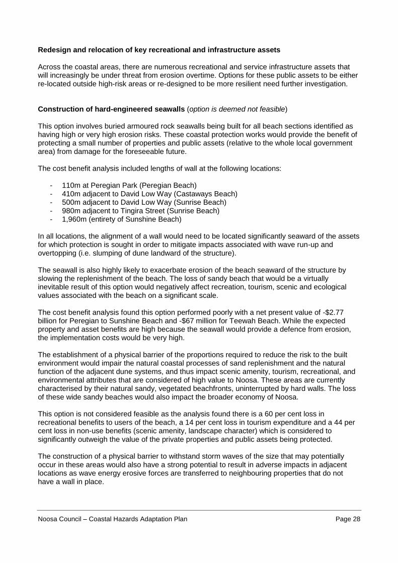
Redesign and relocation of key recreational and infrastructure assets Across the coastal areas, there are numerous recreational and service infrastructure assets that will increasingly be under threat from erosion overtime. Options for these public assets to be either re-located outside high-risk areas or re-designed to be more resilient need further investigation. Construction of hard-engineered seawalls (option is deemed not feasible) This option involves buried armoured rock seawalls being built for all beach sections identified as having high or very high erosion risks. These coastal protection works would provide the benefit of protecting a small number of properties and public assets (relative to the whole local government area) from damage for the foreseeable future. The cost benefit analysis included lengths of wall at the following locations:
- 110m at Peregian Park (Peregian Beach) - 410m adjacent to David Low Way (Castaways Beach) - 500m adjacent to David Low Way (Sunrise Beach) - 980m adjacent to Tingira Street (Sunrise Beach) - 1,960m (entirety of Sunshine Beach)
In all locations, the alignment of a wall would need to be located significantly seaward of the assets for which protection is sought in order to mitigate impacts associated with wave run-up and overtopping (i.e. slumping of dune landward of the structure). The seawall is also highly likely to exacerbate erosion of the beach seaward of the structure by slowing the replenishment of the beach. The loss of sandy beach that would be a virtually inevitable result of this option would negatively affect recreation, tourism, scenic and ecological values associated with the beach on a significant scale. The cost benefit analysis found this option performed poorly with a net present value of -$2.77 billion for Peregian to Sunshine Beach and -$67 million for Teewah Beach. While the expected property and asset benefits are high because the seawall would provide a defence from erosion, the implementation costs would be very high. The establishment of a physical barrier of the proportions required to reduce the risk to the built environment would impair the natural coastal processes of sand replenishment and the natural function of the adjacent dune systems, and thus impact scenic amenity, tourism, recreational, and environmental attributes that are considered of high value to Noosa. These areas are currently characterised by their natural sandy, vegetated beachfronts, uninterrupted by hard walls. The loss of these wide sandy beaches would also impact the broader economy of Noosa. This option is not considered feasible as the analysis found there is a 60 per cent loss in recreational benefits to users of the beach, a 14 per cent loss in tourism expenditure and a 44 per cent loss in non-use benefits (scenic amenity, landscape character) which is considered to significantly outweigh the value of the private properties and public assets being protected. The construction of a physical barrier to withstand storm waves of the size that may potentially occur in these areas would also have a strong potential to result in adverse impacts in adjacent locations as wave energy erosive forces are transferred to neighbouring properties that do not have a wall in place.
Noosa Council – Coastal Hazards Adaptation Plan Page 29
The analysis also noted that the analysis did not factor in the interruptions to beach use and adverse effects for adjacent properties during construction which may increase the costs of this option. In addition, there remains uncertainty regarding material costs and construction costs, and material supply in term of access to feasible rock supply. Even without these broader socio-economic costs, the financial cost of implementation would be significant given the level of protection required to withstand a major storm event such as a 100 year ARI storm event. The required height, required length, land tenure arrangements (where should it be located, who would maintain it), would lead to excessive construction and ongoing maintenance costs. Depending on the funding arrangements, a portion of the costs would likely be borne by the broader community through general rates or other government funds, even though the works are expected to have negative impacts for the community and economy given the loss of beach values. It is important to note that the Eastern Beaches and Teewah Beach are unlike Noosa Main Beach, has access to (and uses via the sand recycling system) sand entering the river mouth as it moves northwards along the coast for replenishing the beach when it becomes eroded. This recycled sand is used to cover the seawall along Noosa Main Beach. For the Eastern Beaches and Teewah, there is no readily available sand supply to continually recycle sand back onto the beach in front of a rock wall. As discussed in the sand nourishment option, and nourishment of the area between Peregian and Sunshine Beach would provide a net benefit, however its effectiveness is not expected to continue beyond the year 2070. In addition, there are material uncertainties regarding a reliable long-term sand supply in the nearshore and offshore environment (i.e. adjacent to these localities). The analysis undertaken for the sand nourishment option assumed this sediment would remain available until the end of the planning period (2100). The analysis demonstrates that the construction of hard-engineered revetment walls would be unviable as it is unable to demonstrate sufficient public benefit to justify the economic, social and environmental costs involved. This option is therefore considered not feasible from a socio-economic perspective. Acquisition of private residential properties (option is deemed not feasible) This option looked at what opportunities could be available for Council to acquire properties impacted by coastal erosion. This also included options for temporary lease back to the property owners. The cost benefit analysis demonstrated that this option does not deliver sufficient benefits and therefore is not feasible for further consideration for any of the localities. Fact sheets about the adaptation options subject to a cost-benefit analysis, including those described above, can be found on the project page on Your Say Noosa.
Options for responding to coastal inundation risks
Water levels in the lower Noosa River and its tributaries (including the lakes) can become elevated due to a number of factors including rainfall across the catchment area, a storm tide, or during sunny days as a result of higher-than-average tides. The area of land subject to the effects of storm tides is expected to increase as a result of sea level rise. In addition, the reach of tidal waters is going to increase beyond what we currently identify as the shoreline and this is also due to increases in sea level.

Noosa Council – Coastal Hazards Adaptation Plan Page 30
Flood management measures are currently in place in Noosa Shire to help manage the risks of flooding as a result of high rainfall in the catchment (referred to as catchment flooding). These include:
stormwater drainage works and flood mitigation works in high-risk flood prone areas
planning controls through the Noosa Plan 2020 that set development requirements such as minimum levels for new buildings and filling limits for land subdivisions and other works
flood modelling and mapping identifying areas at risk for different flood severities
Disaster management responses during major flood events. These catchment flooding measures will also help Noosa manage and adapt to changes to storm tide inundation. For example, the minimum floor levels for new houses or units in Noosaville will ensure that these developments are safeguarded from direct physical damage from storm tide inundation. However, the impacts of frequent tidal inundation of low-lying areas (particularly the parks, road reserves and some private properties around the Noosa River) require further management action overtime. Some riverside areas are already affected by infrequent events such as catchment flooding and storm tide inundation. The relatively long periods of time between events allow for clean-up, recovery and repairs to be undertaken, and normal activities to resume unimpeded. However, activities and assets in these areas are unlikely to cope with impacts caused by frequent tidal inundation. As sea levels rise, some low-lying areas will be regularly covered with shallow sea water. In the absence of any adaptation response, this inundation will likely restrict access to roads, footpaths and recreational areas and cause nuisance to residents, business owners and visitors. The cost benefit analysis of coastal inundation risks8 assessed that a number of adaptation options are likely to be both suitable and feasible for responding to the risks associated with frequent tidal inundation in Noosa’s coastal zone. These include:
Continuing existing measures for responding to risks of catchment flooding and storm tide inundation
Protecting buried infrastructure (stormwater and sewerage assets) through installation of innovative technologies
Reducing the frequency of inundation to roads, pathways, parks and business areas through the creation of adaptive landscape measures. This includes low rise levies (see Factsheet #1) and landscaped walls along some foreshore edges, elevated footpaths and improvements to drainage
Ensuring asset plans and upgrades appropriately consider inundation risks. Fact sheets for these adaptation measures can be found on the project page on Your Say Noosa.
8 Aither, 2020. Noosa Shire Council CHAP – Phase 7, Noosaville Cost Benefit Analysis

Noosa Council – Coastal Hazards Adaptation Plan Page 31
Locality Risks and Adaptation Outcomes
Introduction
This section presents the risks and preferred adaptation outcomes for each locality within the Noosa coastal zone. A summary for each locality is provided covering the projected behaviour of each coastal hazard – coastal erosion, storm tide inundation, and permanent tidal inundation – likely effects of each event, any risk mitigation measures already in place, and the recommended adaptation responses for each. Figure 10 shows the location and name of each locality in this context. The risks discussed in this section, unless otherwise specified, are aggregated to the locality scale based on the highest risks within each locality and are for land use planning, infrastructure services planning, and public and natural areas management purposes. At a smaller scale, each locality is subject to a range of risks from coastal hazards from ‘no risk’ to ‘very high risk’, depending on the particular location or asset within that locality. Decision makers at the individual private asset or lot scale are encouraged to review the supporting technical reports and make their own determination regarding any risks and how to mitigate these with the information available to them. The preferred adaptation outcomes and recommended actions (short-term) for the most at-risk assets are shown for each locality. In addition to the locality specific outcomes and actions, there are a range of actions that are applicable to all or most localities within the coastal zone. These are:
Improve the awareness and understanding of coastal hazard risks and adaptation measures amongst the Noosa community and other key stakeholders
Ensure coastal hazard information is publicly available and understandable
Ensure disaster management plans and procedures are considering changes to coastal hazard risks where necessary
Engage local business owners and operators in understanding what coastal hazard risk information may mean for them and how they may contribute to achieving Noosa’s adaptation outcomes
Assess availability of offshore sand supply for use in beach nourishment, including ecological impact of using this resource [beach locations only]
Implement relevant actions from Coastal Foreshores Management Plan once developed [beach locations only]
Ensure the Noosa Plan 2020 adequately considers natural hazards and appropriately regulates land use and development
Environmental acquisitions in high-risk areas are closely considered and/or avoided, and are instead made in locations that support long-term resilience of ecological values.
Pursue dune management and revegetation in high-risk erosion areas as a critical and immediate priority for Council and the community in helping to build coastal resilience and management erosion risks.

Noosa Council – Coastal Hazards Adaptation Plan Page 32
Figure 10 - Coastal localities by type of hazards each is exposed to

Noosa Council – Coastal Hazards Adaptation Plan Page 33
Reference Box #5
Adaptation Pathways and their benefits Developing and implementing a coastal hazards adaptation plan requires a responsive, flexible, and long-term approach that considers the effectiveness, acceptability, and consequences of a range of responses. For Noosa, the ability to maintain the look and functionality of our current beachfront and river foreshore areas is likely to become increasingly difficult due to increasing coastal hazard risks. Utilising an adaptation pathways approach allows Council and the community to understand, plan for, prioritise, and appropriately sequence adaptation options. A pathways approach responds to changes in coastal hazard risks by using trigger points to indicate when a preferred action or set of actions is likely to be implemented. A trigger can be based on one or more of three things:
- Environmental conditions (e.g. sea levels have risen to a certain point) - Public asset functionality (e.g. an asset can longer function to an acceptable standard) - Community tolerance (e.g. the interruptions to lifestyle are no longer acceptable).
The illustrative graph below (Figure 11) shows the benefits of adopting an adaptation pathways approach in reducing risks. Without a response, the risks from coastal hazards for Noosa are likely to rise and become intolerable in many locations.
Figure 11 - Effect of adaptation actions on risk profile over time
Noosa Council – Coastal Hazards Adaptation Plan Page 34
Reference Box #6
Understanding the locality risk tables The risk to a range of key assets was determined through the development of the CHAP. For ease of reading these have been grouped into six broad asset types:
Tourism – assets whose primary function is to provide tourism services, particularly
accommodation
Business – commercial and retail assets (including restaurants) and operations
Residential – any place of residence, whether detached housing, townhouse, or unit/apartment
Infrastructure – All service assets owned and/or operated by Council or another utility provider
such as Energex or Unitywater. The majority of infrastructure assets exposed to coastal hazards
are stormwater, footpaths, beach accesses, and road networks, as well as some other buried
assets including wastewater and telecommunications networks
Recreational – parks and foreshore areas, as well as any assets within these (e.g. BBQs, toilets).
Surf-life saving clubs are also included in this grouping
Natural – refers to all natural areas, whether privately owned or government owned/controlled.
Each locality section below contains a table, showing the expected progression of coastal hazard risks faced by the broad asset types from present day through to year 2100. Additional information on how risk levels are determined can be found in Section 4, as well as the Phase 5 Risk Assessment Report.9
9 BMT, 2020. Noosa Shire Council – Coastal Hazard Adaptation Plan Risk Assessment

Noosa Council – Coastal Hazards Adaptation Plan Page 35
PEREGIAN BEACH
Setting
Peregian Beach is the southern-most township in Noosa Shire. The locality has a four-kilometre beach frontage with a vegetated dune area between the developed areas and the sea. Peregian Beach maintains the scale and character and atmosphere of a village that provides local convenience shopping, business and employment services for residents and visitors within the locality.
Risks to Peregian Beach Peregian Beach has historically experienced short term erosion on beaches after strong swells and tropical storms with sand naturally replenishing through coastal processes such as longshore drift. The low profile of the beach and dunes and vegetated buffer mean only some areas of the beach and dune foreshore are exposed to coastal erosion. An increasing number of other assets may be exposed to future coastal erosion over time. Appendix 4 shows the projected change in the erosion prone area due to sea level rise across various parts of Peregian Beach during a major storm event. Table 4 provides a summary of the changing risk profile for six broad asset types within the locality that are projected to be exposed to the effects of coastal erosion between present day and 2100. The main assets at risk by mid-late century (2070 – 2100) in Peregian Beach are natural assets (beaches and vegetated dunes); beach accesses; Peregian Park and the various community and visitor recreation assets it contains (picnic tables, skate park, footpaths); and the backyards of a small number of residential lots at the very southern end of Peregian Beach. The Peregian Beach Surf Life Saving Club itself is not expected to be directly impacted during a major erosion event, however operations are likely to be impaired due to damage to the park and beach accesses. Impacts to these assets may also have indirect impacts on adjacent commercial and retail businesses. A moderate amount of buried stormwater and sewerage infrastructure is also likely to be at high risk by 2100, along some streets south of Peregian Park. Victory Park carpark and amenities block is also likely to be impacted.
Asset Type Erosion Risks by Year Present Day 2040 2070 2100
Tourism Low
Business Low
Residential Low Medium
Infrastructure Low Medium High
Recreational Low Medium10 High
Natural Low Medium High
Table 4 - Change in Peregian Beach asset risk profiles across planning horizons
At present, the only methods for mitigating the risks in Peregian Beach are:
- Maintaining and enhancing vegetated dune areas, which act as a natural buffer to erosion by dispersing wave energy during storm events
10 The recreational asset at risk in this case is beach use due to exposure of beach accesses by 2040.

Noosa Council – Coastal Hazards Adaptation Plan Page 36
- Planning controls on coastal development that prevent encroachment into the vegetated dune areas, thereby preserving natural coastal processes of erosion and accretion.
Preferred adaptation outcomes and associated actions for Peregian Beach The assessment of erosion risks in Peregian Beach shows that the level of risk to some recreation and infrastructure asset types may become intolerable by mid-late century. Analysis of economic, social, and environmental considerations, as well as multiple legal and governance constraints and input from the Noosa community indicates the most suitable and feasible adaptation pathway in this locality is one that provides continuous support for natural coastal processes and existing beach use, amenity, and adjacent recreational values by implementing natural coastal protection solutions and a medium- to long-term transition of recreational and infrastructure assets away from high erosion risk areas. As a result, the preferred adaptation outcomes for this locality are:
- Implement measures that support and enhance dunes, beach health and natural coastal processes as soon as possible
- Prevent the construction of hard protective structures where possible that are likely to exacerbate erosion risk, impact on preferred outcomes for dune and beach health, impair natural coastal processes, and lead to adverse impacts on neighbouring areas
- Re-locate important recreational and infrastructure assets outside the projected high risk coastal erosion prone area by 2070
- Where important recreational and infrastructure assets cannot be feasibly re-located, seek to accommodate the risks by adapting the design of these assets to be more resilient during and after a major erosion event.
Figure 12 shows the expected progression of actions to support these preferred outcomes
between years 2020 and 2100. Table 5 provides a breakdown of actions in support of these
outcomes, to be pursued within the five year life of this plan.

Noosa Council – Coastal Hazards Adaptation Plan Page 37
Figure 12 - Preferred long-term adaptation pathway response to projected coastal erosion risks in Peregian Beach

Noosa Council – Coastal Hazards Adaptation Plan Page 38
The following actions will help progress the achievement of these outcomes:
MANAGEMENT
RESPONSE
AREA
ACTIONS FOR PEREGIAN BEACH – THE NEXT 5 YEARS
Land Use
Planning Amend the Noosa Plan 2020 to ensure it aligns with State Planning Policy requirements regarding coastal erosion risks. .
Public
recreational,
built, and
Infrastructure
assets
Assess options for relocating small recreational assets (e.g. BBQ, picnic
tables, amenities) to landward of current position at end of current life
Investigate alternative designs for beach accesses so as to accommodate
coastal processes of erosion and accretion
Review emergency event response (storm erosion) plans for surf lifesaving
club and update where appropriate
Investigate opportunities to avoid risks to the Victory Park carpark and
amenities block
Investigate alternative locations for buried infrastructure along Lorikeet Drive
and Shearwater St
Investigate alternative locations for skate park outside of high erosion risk area
Beaches and
Dunes
Expand native vegetation coverage to support frontal dune stabilisation
Re-design beach accesses to deter foot traffic across nearby dunes
Install signage for increasing beach user understanding of importance of
healthy dune systems
Assess options for relocating fencing on seaward boundary of Peregian Park
to permit dune movement
Investigate options of managed alignment of coastal creeks and other natural
drainage locations
Other Investigate impact of illegal encroachment by private asset owners into
publicly-owned dune areas on dune health and natural coastal processes
Table 5 - Five year action plan for responding to projected coastal erosion risks in Peregian Beach
Other shire wide actions are also identified at the beginning of this Section 5.

Noosa Council – Coastal Hazards Adaptation Plan Page 39
MARCUS BEACH AND CASTAWAYS BEACH
Setting Marcus Beach and Castaways Beach are localities set in undulating coastal dunes and vegetation. They are located midway along what is locally known as the ‘Eastern Beaches’. Both localities each have beachfront totalling approximately two kilometres in length. Protected by vegetated dune buffers, both localities predominately provide housing for permanent residents, with some short-term visitor accommodation, and commercial or retail uses. Two coastal creeks, Marcus Creek, Castaways Creek, and Burgess Creek flow through the coastal dunes to the beach and out to sea. David Low Way represents the primary means of entering and exiting these localities from the South and the North. For much of this area, David Low Way is situated between residential areas and the dune zone and beachfront. Risks to Marcus Beach and Castaways Beach The beachfront in this area has historically experienced short term erosion along the beach and frontal dunes after large swells and tropical cyclones, with recovery occurring through natural coastal processes gradually over time. Appendix 4 shows the projected change in the erosion prone area due to sea level rise across various parts of Marcus Beach and Castaways Beach during a severe storm event. Table 6 provides a summary of the changing risk profile for six broad asset types within the locality that are projected to be exposed to the effects of coastal erosion between present day and 2100. Due to the ongoing presence of wide vegetated dune systems in this locality, much of the risk from erosion is only likely to affect natural assets, with some potential for risks to David Low Way and the parking area at Castaways Beach toward the end of the century. Damage to David Low Way in this locality could present an accessibility hazard to the community in Castaways Beach, as this road provides the only access to this suburb from the north and south. Costs associated with repairing this damage would be significant and involve lengthy construction times.
Asset Type Erosion Risks by Year
Present Day 2040 2070 2100
Tourism Low
Business Low
Residential Low
Infrastructure11 Low Medium High Very High
Recreational Low Medium
Natural Low Medium
Table 6 - Change in Marcus Beach and Castaways Beach asset risk profiles across planning horizons
At present, the only methods for mitigating coastal erosion risks in Marcus Beach and Castaways Beach are:
- Maintaining and enhancing vegetated dune areas, which act as a natural buffer to erosion by dispersing wave energy during storm events
- Planning controls on coastal development that prevent encroachment into the vegetated dune areas, thereby preserving natural coastal processes of erosion and accretion.
Adaptation outcomes and associated actions for Marcus Beach and Castaways Beach
11 Some buried infrastructure is at risk, however the primary infrastructure concern in this locality is David Low Way

Noosa Council – Coastal Hazards Adaptation Plan Page 40
The assessment of erosion risks in Marcus Beach and Castaways Beach show the level of risk to most assets is acceptable, however the risk to a section of David Low Way may become intolerable by the year 2070. Therefore, the most suitable adaptation pathway for this locality is one that supports the provision of accessibility to residential communities currently dependent on David Low Way. As a result, the preferred adaptation outcomes for this locality are:
- Implement measures that support and enhance dunes, beach health and natural coastal processes as soon as possible
- Prevent the construction of hard protective structures where possible that are likely to exacerbate erosion risk, impact on preferred outcomes for dune and beach health, impair natural coastal processes, and lead to adverse impacts on neighbouring areas
- Seek to accommodate the risk to major infrastructure through (i.e. David Low Way) adaptive design in order to increase resilience during a major erosion event, and ensure continued functionality post-event.
Figure 13 shows the expected progression of these preferred outcomes between 2020 and 2100.
Table 7 provides a breakdown of actions in support of these outcomes, to be pursued within the
five year life of this plan.
Figure 13 - Preferred long-term adaptation pathway response to projected coastal erosion risks in Marcus Beach and
Castaways Beach

Noosa Council – Coastal Hazards Adaptation Plan Page 41
The following actions will help progress the achievement of these outcomes:
MANAGEMENT
RESPONSE
AREA
ACTIONS FOR MARCUS BEACH AND CASTAWAYS BEACH – THE NEXT
5 YEARS
Land Use
Planning
Amend the Noosa Plan 2020 to ensure it aligns with State Planning Policy
requirements regarding coastal erosion risks.
Public
recreational,
built, and
Infrastructure
assets
Investigate opportunities to reduce risks to the beach carpark (including
amenities block) and David Low Way at Castaways Beach through adaptive
design as part of asset renewal program updates
Beaches and
Dunes
Expand native vegetation coverage to support frontal dune stabilisation
Redesign beach accesses to deter foot traffic across nearby dunes
Install signage for increasing beach user understanding of importance of
healthy dune systems
Investigate options of managed alignment of coastal creeks and other natural
drainage locations
Other No actions proposed
Table 7 - Five year action plan for responding to projected coastal erosion risks in Marcus Beach and Castaways Beach
Other shire wide actions are also identified at the beginning of this Section 5.

Noosa Council – Coastal Hazards Adaptation Plan Page 42
SUNRISE BEACH AND SUNSHINE BEACH
Setting Sunrise Beach and Sunshine Beach are the northern-most localities in the Eastern Beaches. Bordered by Burgess Creek in the south, and Noosa National Park at the northern end, this locality has around 3.2 kilometres of beach frontage with a vegetated dune area between development and the sea. These localities, particularly the beaches and foreshore recreational areas, are popular with locals and visitors. They contain a range of assets and activities, from residential and tourist accommodation, to popular restaurants and the Sunshine Beach Surf Life Saving Club (SLSC). Despite their popularity these localities maintain the aesthetics and atmosphere of a small village.
Risks to Sunrise Beach and Sunshine Beach Both Sunrise and Sunshine Beach have experienced erosion and loss of the frontal dunes during powerful swell events and tropical cyclones. Like the other Eastern Beaches localities, the beaches have typically recovered through natural coastal processes over time. The low height of the frontal dunes, backed by very steep vegetated dunes, in this section of the coastline mean some areas of the beach and dune foreshore may be at risk from a major coastal erosion event. Appendix 4 shows the projected change in erosion prone area due to sea level rise across various parts of Sunrise Beach and Sunshine Beach during a severe storm event. Tables 8 and 9 below provide a summary of the changing risk profile for six broad asset types within the localities that are projected to be exposed to the effects of coastal erosion between present day and 2100. The main public assets at risk in Sunrise and Sunshine Beach are natural assets (beaches and vegetated dunes); beach accesses; carparks and roads; buried infrastructure, and the Sunshine Beach SLSC and Ed Webb Park. As well as these, a significant number of beachfront private dwellings may be affected. The capacity to provide and maintain coastal protection works (e.g. seawalls) for protection from erosion risks is impaired given the steep profile of the dune system upon which the majority of high-risk locations are developed (such as private dwellings along Seaview Terrace, Park Road, and Tingira Crescent) and the scale of many of these structures relative to their lot size. Impacts to the public assets (e.g. carparks, roads) may also have indirect impacts on adjacent commercial and retail businesses.

Noosa Council – Coastal Hazards Adaptation Plan Page 43
Asset Type Sunrise Beach Erosion Risks by Year Present Day 2040 2070 2100
Tourism Low
Business Low
Residential Low High Very High
Infrastructure12 Low Very High
Recreational Low
Natural Medium High Very High
Table 8 - Change in Sunrise Beach asset risk profiles across planning horizons
Asset Type Sunshine Beach Erosion Risks by Year Present Day 2040 2070 2100
Tourism Low Medium High
Business Low
Residential13 Medium Very High
Infrastructure Medium High
Recreational14 Medium High Very High
Natural Medium High Very High
Table 9 - Change in Sunshine Beach asset risk profiles across planning horizons
At present, the only methods for mitigating the risks in Sunrise Beach and Sunshine Beach are:
- Maintaining and enhancing vegetated dune areas, which act as a natural buffer to erosion by dispersing wave energy during storm events
- Planning controls on coastal development that prevent encroachment into the vegetated dune areas, thereby preserving natural coastal processes.
Adaptation outcomes and associated actions for Sunrise Beach and Sunshine Beach The assessment of erosion risks in Sunrise Beach and Sunshine Beach show the level of risk to some residential, recreational, and natural assets could become intolerable within 20 years, with risks to tourism and service infrastructure assets currently expected to remain tolerable until late century due to their distance from the projected erosion prone areas. Analysis of economic, social, and environmental considerations, as well as multiple legal and governance constraints and input from the Noosa community indicates the most suitable and feasible adaptation pathway in this locality is one that supports natural coastal processes and existing beach use and amenity values by implementing natural coastal protection solutions and a medium- to long-term transition of development and public assets away from high erosion risk areas.
12 These results are driven by exposure of David Low Way as it crosses Burgess Creek. 13 These risk results are being driven by the potential high level of exposure of private assets along Arakoon and Seaview Tce. Properties on beachfront streets south of the Sunshine Beach SLSC have a lower risk rating. 14 The recreational asset most at risk in Sunshine Beach is Ed Webb Park.

Noosa Council – Coastal Hazards Adaptation Plan Page 44
As a result, the preferred adaptation outcomes for this locality are:
- Implement measures that support and enhance dunes, beach health and natural coastal processes as soon as possible
- Prevent the construction of hard protective structures where possible that are likely to exacerbate erosion risk, impact on preferred outcomes for dune and beach health, impair natural coastal processes, and lead to adverse impacts on neighbouring areas
- Begin re-locating recreational assets outside the project high risk coastal erosion prone area by 2040, such as seating and footpaths
- Re-locate service infrastructure assets to areas outside the high-risk area by 2070 - Where important recreational and service infrastructure assets cannot be feasibly located,
seek to accommodate the risks by adapting the design of these assets to be more resilient during and after a major erosion event.
- Ensure development in erosion prone areas mitigates the risk to people and property to an acceptable or tolerable level, consistent with the State Planning Policy – natural hazards risk and resilience.
Figure 14 shows the expected progression of these preferred outcomes between 2020 and 2100.
Table 10. provides a breakdown of actions in support of these outcomes, to be pursued within the
five year life of this plan.
Figure 14 - Preferred long-term adaptation pathway response to projected coastal erosion risks in Sunrise Beach and
Sunshine Beach

Noosa Council – Coastal Hazards Adaptation Plan Page 45
The following actions will help progress the achievement of these outcomes:
MANAGEMENT
RESPONSE
AREA
ACTIONS FOR SUNRISE BEACH AND SUNSHINE BEACH – THE NEXT 5
YEARS
Land Use
Planning
Amend the Noosa Plan 2020 to ensure it aligns with State Planning Policy
requirements regarding coastal erosion risks.
Public
recreational,
built, and
Infrastructure
assets
Assess relocation options for small recreational and infrastructure assets
(seating, footpaths, and viewing platforms along Tingira Crescent, Belmore
Terrace, The Esplanade, and Ed Webb Park) to landward of current position at
end of current life
Investigate alternative designs for beach accesses so as to accommodate
coastal processes of erosion and accretion
Develop options for minimising risks to Sunshine Beach SLSC prior to 2070
Support review of emergency event response (storm erosion) plans for surf
life-saving club and update where appropriate
Investigate opportunities to avoid risks to the carpark and amenities block on
Tingira Crescent, Sunrise Beach
Investigate long term opportunities for reducing risk to –– Tingira Crescent,
Ross Crescent, Park Crescent, Belmore Terrace, The Esplanade, Arakoon
Crescent, and Seaview Terrace. This includes any buried service network
assets.
Beaches and
Dunes
Expand native vegetation coverage to support frontal dune stabilisation
Redesign beach accesses to deter foot traffic across nearby dunes
Investigate options for managing foot traffic within frontal dune areas, including
fencing design.
Install signage for increasing beach user understanding of importance of
healthy dune systems
Investigate options of managed alignment of coastal creeks and other natural
drainage locations where creeks consistently erode incipient dunes
Other Investigate impact of illegal encroachment by private asset owners into
publicly-owned dune areas on dune health and natural coastal processes
Table 10 - Five year action plan for responding to projected coastal erosion risks in Sunrise Beach and Sunshine Beach.
Other shire wide actions are also identified at the beginning of this Section 5.

Noosa Council – Coastal Hazards Adaptation Plan Page 46
NOOSA NORTH SHORE AND TEEWAH
Setting Noosa North Shore and the Teewah township lay in the north-eastern part of Noosa Shire. Noosa North Shore boasts outstanding natural beauty with pristine beaches, dramatic sand dune systems, as well as coastal lowlands and wetlands adjacent to the Noosa River. The dynamics of its open coast beaches is similar to those between Peregian Beach and Sunshine Beach, consisting of approximately six kilometres of open sandy beach stretching between the Noosa River Mouth and Second Cutting. Noosa North Shore provides residential and rural style home sites, as well as significant areas zoned for environmental conservation. Noosa North Shore Beach Campground sits directly behind the frontal dune with campsites close to the beachfront. Teewah is the northern-most township along Noosa’s coastline. The township has undergone low-levels of development in the form of single detached houses15, and sits adjacent to beach frontage with a moderately vegetated dune area between the developed areas and the shoreline. Despite having access constraints (due to the beach being the only official means of access), Teewah is enjoyed by residents and visitors alike for the atmosphere that it provides of a semi-remote coastal village of years gone by.
Erosion risks to Noosa North Shore and Teewah The beach adjacent to the Teewah township historically experiences erosion after large swell events and tropical cyclones, temporarily exposing indurated sediments (commonly referred to as ‘coffee rock) beneath the frontal dunes. This beach has historically recovered well after these events via natural coastal processes. The low height frontal dunes mean the vegetated dune may become increasingly at risk from coastal erosion events over time. By the year 2070 the beach accesses, the Esplanade (including the portion of beach used to reach the township), and eventually a portion of private beachfront lots may be exposed to the effects of coastal erosion. The southern portion of Teewah Beach experiences periodic episodes of short term beach erosion, with sand naturally replenishing over time. The wide beach and dune profiles means much of the beach is considered low risk from coastal erosion. However, the backyards (beach-facing) of approximately 102 lots may be exposed to erosion risks by the year 2070. In addition, the camp ground may be increasingly exposed to erosion over the coming decades. By the year 2070 beach-fronting camp sites and other minor infrastructure may be within the high erosion risk area. Appendix 4 shows the projected change in erosion prone area due to sea level rise across various parts of Teewah Beach during a severe storm event.Table 11 provides a summary of the changing risk profile for six broad asset types within the locality that are projected to be exposed to the effects of coastal erosion between present day and 2100.
15 There are approximately 102 dwellings in Teewah, many of which are leased as tourist accommodation.

Noosa Council – Coastal Hazards Adaptation Plan Page 47
Asset Type Erosion Risks by Year Present Day 2040 2070 2100
Business Low
Residential Low Medium High
Tourism16 Low Medium High
Infrastructure17 Medium High
Recreational Low
Natural Low Medium
Table 11 - Change in Teewah and Noosa North Shore asset erosion risk profiles across planning horizons
At present, the only methods for mitigating the risks at Teewah and along Teewah Beach are:
- Existing vegetated dune areas, which act as a natural buffer to erosion by dispersing wave energy during storm events
- Planning controls on coastal development that prevent encroachment into the vegetated dune areas, thereby preserving natural coastal processes of erosion and accretion.
Erosion adaptation outcomes and associated actions for Noosa North Shore and Teewah The assessment of erosion risks along the open beaches of Noosa North Shore and at the Teewah township show the level of risk to most assets is acceptable for much of the planning period. However, there may be intolerable risks to the camp ground and Teewah road access by mid-century, as well as to some private houses by 2100. Analysis of economic, social, and environmental considerations, as well as input from the Noosa community indicates the most suitable adaptation pathway in this locality for responding to coastal erosion is one that supports natural coastal processes and existing beach use and amenity values by implementing natural coastal protection solutions and transitioning public recreational and infrastructure away from high erosion risk areas over the medium term. As a result, the preferred adaptation outcomes in response to these erosion risks are:
- Implement measures that support and enhance dunes, beach health and natural coastal processes as soon as possible
- Prevent the construction of hard protective structures where possible that are likely to exacerbate erosion risk, impact on preferred outcomes for dune and beach health, impair natural coastal processes, and lead to adverse impacts on neighbouring areas
- Avoid risks to camp ground infrastructure by relocating these out of the high-risk area by mid-century
- - Ensure development in erosion prone areas mitigates the risk to people and property to an
acceptable or tolerable level, consistent with the State Planning Policy – natural hazards risk and resilience.
16 This public tourism asset is referring to the Noosa North Shore Campground. 17 The infrastructure of concern is the use of the beach as the Esplanade and the primary access method for the Teewah township, thus representing an accessibility risk for the community.

Noosa Council – Coastal Hazards Adaptation Plan Page 48
Figure 15 shows the expected progression of these preferred outcomes between 2020 and 2100.
Table 12. provides a breakdown of actions in support of these outcomes, to be pursued within the
five year life of this plan.
Figure 15 - Preferred long-term adaptation pathway response to projected coastal erosion risks along Teewah Beach

Noosa Council – Coastal Hazards Adaptation Plan Page 49
The following actions will help progress the achievement of these outcomes:
MANAGEMENT
RESPONSE
AREA
ACTIONS FOR NOOSA NORTH SHORE AND TEEWAH – THE NEXT 5
YEARS
Land Use
Planning Maintain land use planning approach and ensure the Noosa Plan 2020 aligs with State Planning Policy requirements regarding coastal erosion risks
Public
recreational,
built, and
Infrastructure
assets
Ensure asset management plans for the Noosa North Shore Campground
address coastal erosion risks as part of any asset renewals
Beaches and
Dunes
Expand native vegetation coverage to support frontal dune stabilisation
Redesign beach accesses to deter foot traffic across nearby dunes
Investigate options for managing foot traffic within frontal dune areas, including
fencing design
Investigate opportunities for more effective control of vehicle access to dunes
and turtle nesting areas
Install signage for increasing beach user understanding of importance of
healthy dune systems
Other No actions proposed
Table 12 - Five year action plan for responding to projected coastal erosion risks along Teewah Beach
Other shire wide actions are also identified at the beginning of this Section 5.

Noosa Council – Coastal Hazards Adaptation Plan Page 50
Inundation risks to Noosa North Shore The main coastal hazard risk of concern for Noosa North Shore is periodic tidal inundation, both from low frequency-high magnitude (i.e. depth and extent) storm tide events, and high frequency-low magnitude. Table 13 shows those asset types within this locality that are projected to be exposed to the effects of tidal inundation between present day and 2100 (map versions available in Appendix 3). Whilst there has been very limited and low intensity development to date, a significant proportion of the development is private dwellings located along the shores of the Noosa River. This area is prone to flooding and inundation events today, and these hazards are projected to increase in severity and frequency over the life of this plan. There are limited publicly-owned assets in this locality, consisting primarily of unsealed road network, with little expansion of development areas anticipated.
Asset Type Tidal Inundation Risks by Year Present Day 2040 2070 2100
Tourism Low
Business Low
Residential Low High Very High
Infrastructure Low High Very High
Recreational Low
Natural Low Medium High
Table 13 - Change in Noosa North Shore asset inundation risk profiles across planning horizons
At present, the only methods for mitigating the erosion and inundation risks in Lower Noosa North Shore are:
- Existing vegetated dune areas, which act as a natural buffer to erosion by dispersing wave energy during storm events
- Planning and land use regulations are in place to control further land subdivision, and building floor heights for new buildings
- Major portion of Noosa North is designated for conservation.

Noosa Council – Coastal Hazards Adaptation Plan Page 51
Inundation adaptation outcomes and associated actions for Noosa North Shore The assessment of inundation risks within Noosa North Shore shows the level of risk to residential and road network assets may become intolerable within approximately 20 years. Intolerable risks to natural areas and biodiversity are more likely than not to eventuate by the year 2070. Assessment of a range of socio-economic, environmental, and governance considerations, as well as community feedback during the development of this plan, determine the most appropriate adaptation pathway for responding to frequent inundation risks in this locality is one that supports existing accessibility services, visual amenity values and natural ecological processes. Therefore, the preferred adaptation outcomes are:
- The increased inundation risk to service infrastructure assets is accommodated through adaptive design.
Figure 16 shows the expected progression of these preferred outcomes between 2020 and 2100.
Table 14. provides a breakdown of actions in support of these outcomes, to be pursued within the
five year life of this plan.
Figure 16 - Preferred long-term adaptation pathway response to projected coastal inundation risks in Noosa North Shore
The following actions will help progress the achievement of these outcomes:
MANAGEMENT
RESPONSE
AREA
ACTIONS FOR NOOSA NORTH SHORE – THE NEXT 5 YEARS
Land Use
Planning
Maintain land use planning approach and alignment with State Planning Policy.
Public
recreational,
built, and
Infrastructure
assets
Ensure road asset plans and upgrades on Noosa North Shore appropriately
consider periodic tidal inundation risks
Investigate opportunities for maintaining functional road access to ferry
landing area

Noosa Council – Coastal Hazards Adaptation Plan Page 52
Foreshores and
Natural Areas
Review and update Council’s Conservation Land Guideline that supports
environmental land acquisition, to ensure the risks to Noosa’s biodiversity
assets from periodic tidal inundation are appropriately considered
Other Liaise with Local Disaster Management Group to ensure emergency
response planning for the rural fire brigade asset on the Homeport Track
appropriately considers increasing inundation risks in that area
Work with Unitywater to commence investigation of options for reducing
inundation risks to residential wastewater systems, including alternatives to
on-site septic treatment/holding tanks.
Table 14 - Five year action plan for responding to projected coastal inundation risks in Noosa North Shore
Other shire wide actions are also identified at the beginning of this Section 5.

Noosa Council – Coastal Hazards Adaptation Plan Page 53
NOOSA HEADS
Setting The Noosa Heads locality encompasses the southern side of the mouth of the Noosa River (‘the spit’) and Noosa Main Beach in the north, the northern shore of Lake Weyba to the south, Noosa Junction, and is framed by Culgoa Point and Weyba Creek to the west.
The Noosa Heads locality provides a diverse coastal urban area with a strong focus on tourism, business uses, apartment living and low density housing. The locality has a low rise, coastal character framed by a vegetated backdrop to the built environment. Development has a strong relationship to the coast, watercourses and the iconic Noosa National Park with distinctive views and high accessibility to these natural assets.
The topography of the locality is varied and includes Noosa Hill and nearby elevated areas, as well as low-lying areas adjacent to Noosa River and Laguna Bay. Much of the natural landform and landscape is retained including the vegetated backdrop of Noosa Hill and areas of natural foreshore.
The low elevation and proximity to the coastline and riverfront exposes some parts of the locality to coastal hazards. Noosa Main Beach consistently experiences erosion on an annual basis, with Noosa Heads Lions Park occasionally experiencing inundation due to storm tides. Under future climate conditions, both of these hazards are expected to worsen, with permanent tidal inundation due to rising sea levels also expected to occur in Lions Park and along recreational parklands along the rear-side of Claude Batten Drive. Erosion risks for Noosa Heads Noosa Main Beach is susceptible to erosion on a regular basis due to the shape of the beach (including its north-easterly orientation) and the slow rate of sand movement onto the beach via natural processes due to the headland. Whilst sand can naturally replenish the beach, this process is complemented through the use of the sand recycling system commissioned in 2012. Recession of the shoreline is limited by the presence of the buried bouldered seawall (more commonly referred to as the ‘rockwall’) installed in the 1960s. The low and narrow profile of the beach and lack of vegetated dunes mean the developed foreshore adjacent to the beach is at risk of erosion today. Given the age of the seawall, there is a material level of uncertainty regarding its ability to withstand wave attack or limit a relative increase in the frequency and intensity of wave-overtopping as the sea level rises. The sand recycling system is the most significant infrastructure asset located within the erosion prone area, as well as carparking and shower assets along Claude Batten Drive. Appendices3 and 4 show the change in risk profile across various parts of Noosa Heads as the area exposed to the effects of coastal erosion and periodic tidal inundation respectively, increases due to projected changes in sea level. The potential consequences of an event in this location are particularly high relative to others give the major socio-economic value of this location to Noosa, and therefore high-risk ratings are not unexpected. Tables 14 and 16 provide a summary of the changing risk profile for six broad asset types within the locality that are projected to be exposed to the effects of coastal erosion and periodic tidal inundation between present day and 2100.

Noosa Council – Coastal Hazards Adaptation Plan Page 54
Asset Type Erosion Risks by Year
Present Day 2040 2070 2100
Tourism Very High
Business Very High
Residential Low
Infrastructure Very High
Recreational High
Natural Medium High
Table 14 - Change in Noosa Heads asset erosion risk profiles across planning horizons
At present, the measures for mitigating the erosion risks in Noosa Heads are:
- Recycling of sand from the open coast side of Noosa Spit, to the southern end of Noosa Main Beach
- Groyne walls to slow the northward movement of sand, making it available for sand recycling
- The seawall on the seaward side of Hastings Street (beneath the boardwalk).
Erosion adaptation outcomes and associated actions for Noosa Heads
The assessment of coastal erosion risks in Noosa Heads show the level of risk to all built assets along the Noosa Main Beach beachfront is already considered intolerable. In addition, risks to the natural assets within the Noosa Woods area will be become intolerable by 2070. Analysis of economic, social, and environmental considerations, as well as multiple legal and governance constraints and significant input from the Noosa community indicates the most appropriate adaptation pathway for responding to high coastal erosion risks in this locality is one that seeks to provide support for existing beach uses, amenity values, key public services, and economic activities by continuing (and enhancing where feasible) existing coastal protection measures in this locality whilst prohibiting further intensification of urban development over the short- to long-term. As a result, the preferred adaptation outcomes for this locality are:
- Implement measures that support and enhance dunes, beach health and natural coastal processes as soon as possible
- Re-locate service infrastructure assets to areas outside the high-risk area by 2070 - Where important recreational and service infrastructure assets cannot be feasibly located,
seek to accommodate the risks by adapting the design of these assets to be more resilient during and after a major erosion event
- Avoid increasing the exposure and vulnerability of people and property in high-risk erosion areas.
Figure 17 shows the expected progression of these preferred outcomes between 2020 and 2100.
Table 15. provides a breakdown of actions in support of these outcomes, to be pursued within the
five year life of this plan.

Noosa Council – Coastal Hazards Adaptation Plan Page 55
Figure 17 - Preferred long-term adaptation pathway response to projected coastal erosion risks in Noosa Heads
The following actions will help progress the achievement of these outcomes:
MANAGEMENT
RESPONSE
AREA
ACTIONS FOR NOOSA HEADS – THE NEXT 5 YEARS
Land Use
Planning
Amend the Noosa Plan 2020 to ensure it aligns with State Planning Policy
requirements regarding coastal erosion risks.
Public
recreational,
built, and
Infrastructure
assets
Investigate opportunities for optimising use of existing sand recycling system
for enhancing beach resilience prior to erosive events
Assess possible alternative locations outside the high-risk area for re-
positioning the sand recycling system pumping station
Investigate design requirements for the existing buried seawall to ensure it
meets current and future coastal risk conditions, and prescribe any
requirements for an upgrade or replacement of this structure if required
Beaches and
Dunes
Redesign beach accesses to deter foot traffic across nearby dunes along the
Noosa Spit
Investigate options for managing foot traffic within frontal dune areas of Noosa
Spit, including fencing design
Install signage for increasing beach user understanding of importance of
healthy dune systems along the Noosa Spit
Other Liaise with beachfront asset owners to ensure their natural disaster
management plans are mitigating erosion event risks where possible

Noosa Council – Coastal Hazards Adaptation Plan Page 56
Table 15 - Five year action plan for responding to projected coastal erosion risks in Noosa Heads
Other shire wide actions are also identified at the beginning of this Section 5.
Inundation risks to Noosa Heads
Inundation due to storm tide and increases in tidal extents present risks to public assets throughout the planning horizon of this plan. In the present day, areas and assets at risk due to storm tide include low-lying parks, road networks and buried infrastructure (e.g. stormwater networks), and natural areas within Noosa Spit. Permanent tidal inundation exposes many of the same assets that are subject to the effects of storm tide inundation, however these events are lesser in area and depth, albeit on a much more regular basis. It is this regularity that results in permanent tidal inundation representing a significant risk to some assets within Noosa Heads. These assets include natural and recreational foreshore assets along the river-side of Noosa Spit, Lions Park, as well as road and other network infrastructure along Noosa Parade and Noosa Drive. A small number of private commercial and tourism assets at the Hastings Street end of Noosa Drive are expected to be exposed by 2100. Other private assets along Noosa Parade and Noosa Drive are not considered at high risk from inundation due to elevated land and building floor heights as a result of planning controls in place through successive planning schemes.
Asset Type Tidal Inundation Risks by Year Present Day 2040 2070 2100
Tourism Low Very High
Business Low Very High
Residential Low
Infrastructure Low High Very High
Recreational18 Low Medium Very High
Natural Low
Table 16 - Change in Noosa Heads asset inundation risk profiles across planning horizons
At present, the only method for mitigating inundation risks in Noosa Heads is:
- Planning and land use regulations are in place for new development including minimum floor heights for new buildings.
Inundation adaptation outcomes and associated actions for Noosa Heads
The assessment of inundation risks across Noosa Heads show the level of risk to some tourism, business, recreational and infrastructure assets is projected to become intolerable in the later decades of the century. Given a range of socio-economic, environmental, and governance considerations, as well as community feedback during the development of this plan, determine the most appropriate adaptation pathway for responding to frequent inundation risks in this locality is one that supports
18 This result is due to risks to ‘Dog Beach’ and surrounds. Lions Park was rated medium risk by 2100.

Noosa Council – Coastal Hazards Adaptation Plan Page 57
existing accessibility and infrastructure services, as well as current levels of residential, commercial and retail development. In response to these risks, the preferred adaptation outcomes are:
- Use adaptive landscape design measures to mitigate risk to open space recreation and road network areas. This may include low level walls, seat and garden beds used to prevent periodic tidal inundation from spreading into parks and road areas.
- Increasing inundation risks to service infrastructure assets are mitigated through adaptive design.
Figure 18 shows the expected progression of these preferred outcomes between 2020 and 2100.
Table 17. provides a breakdown of actions in support of these outcomes, to be pursued within the
five year life of this plan.
Figure 18 - Preferred long-term adaptation pathway response to projected coastal inundation risks in Noosa Heads
The following actions will help progress the achievement of these outcomes:
MANAGEMENT
RESPONSE
AREA
ACTIONS FOR NOOSA HEADS – THE NEXT 5 YEARS
Land Use
Planning
Review and update the Noosa Plan 2020 to ensure it aligns with State
Planning Policy requirements for inundation risks and to ensure development
is appropriately planned for and considered in the design and siting of new
development.
Public
recreational,
Investigate a range of backflow prevention methods and technology for parts
of the stormwater network identified as vulnerable

Noosa Council – Coastal Hazards Adaptation Plan Page 58
built, and
Infrastructure
assets
Investigate approach location, scale and design of adaptive landscape
structures (e.g. non-intrusive levees and raised foreshore footpaths19) to
prevent frequent, shallow and low flow tidal inundation of parks and road
corridors.
Foreshores and
Natural Areas
Ensure landscaping and species management/selection appropriately
considers inundation risks
Other No actions proposed.
Table 17 - Five year action plan for responding to projected coastal inundation risks in Noosa Heads
Other shire wide actions are also identified at the beginning of this Section 5.
19 Depending on the location requirements, these may range in height up to 300mm in the case of raised footpaths, or a height consistent with safety regulations in the case of barriers (e.g. approximately waist high)

Noosa Council – Coastal Hazards Adaptation Plan Page 59
NOOSAVILLE
Setting The Noosaville locality is a vibrant urban setting defined by watercourses and bushland edges including the Noosa River, Eenie Creek, Lake Weyba, and Noosa National Park. Noosaville provides much of the commercial, retail, administrative, industrial and social needs of the coastal urban portion of Noosa Shire and is a major focus area for visitor accommodation and services. The Noosa River foreshore adjacent to Gympie Terrace is an important recreational space for the local community and visitors. The area is popular for passive recreation, walking, dog exercise and access to the Noosa River including ferry stops.
Noosaville is topographically quite flat with much of the locality having an elevation of only a few meters above present-day high tide levels. For this reason, low-lying parts of Noosaville already see inundation at king tides, and “daylight flooding” (due to overflowing stormwater systems) after heavy rainfall events. Risks to Noosaville Significant areas of Noosaville adjacent to the Noosa River and other waters is considered at high to very high risk from tidal inundation by the end of the planning period. The low topography of the locality means many assets are likely to be exposed to frequent inundation. The most prominent of these are publicly owned assets, namely foreshore recreation areas, the road network (including footpaths) and the gravity-based stormwater network. Some residential lots are projected to be partially inundated, though this is unlikely to include the dwellings themselves, only gardens and driveway areas. A small number of tourism and commercial operations may also be affected by inundation. Environmental values present across natural foreshore areas of the river20 and the conservation parks will be affected. Appendix 3 shows the change in risk profile across various parts of Noosaville as the area exposed to the effects of periodic tidal inundation increases over time. Table 18 provides a summary of the changing risk profile for six broad asset types within the locality that are projected to be exposed to the effects of periodic tidal inundation between present day and 2100. The most significant concerns in this locality relate to the risks to foreshore parks, given the reliance of locals, visitors and adjacent businesses alike on them to create safe and attractive places to spend time. Some areas of Quota and Apex Parks are can almost certainty expect to be inundated under normal tidal conditions to depths of 10cm for at least 1 hr per day for up to 300 days per years. The exposure of Council-managed infrastructure, in particular the stormwater network, is of significant concern as this network already affected by intrusion of saline tidal waters onto the stormwater pipes. As sea levels increase, this is expected to occur on a daily basis. This salt water intrusion presents two key problems. Firstly, the salt water may damage assets that are not expected to be regularly exposed to salt water and these waters may lead to sedimentation of the network. Secondly, the network is designed to carry a specified volume of overland flows of water during rainfall away from developed areas and into the Noosa River. If the network capacity is taken up by tidal waters, these overland flows cannot enter the network and flow out the river, thus potentially leading to some increased flooding in the road network during minor rainfall events. From mid-century onwards, it is very likely that tidal waters may flow back up the network and into the street even under sunny day conditions. As a result, both of these scenarios may create nuisance and disruption to the community, health and safety risks to residents and visitors, as well as possibly leading to minor damage to public and private assets.
20 Including Keyser Island, Hay Island, and Ross Island.

Noosa Council – Coastal Hazards Adaptation Plan Page 60
Asset Type Inundation risks by year Present Day 2040 2070 2100
Tourism Low High Very High
Business Low Medium High Very high
Residential Low Medium High
Infrastructure Medium High Very High
Recreational Low Medium Very High
Natural Low Medium High
Table 18 - Change in Noosaville asset risk profiles across planning horizons
The existing methods for mitigating inundation risks in Noosaville are:
- Planning and land use regulations are in place including minimum floor heights for new buildings
- Minor revetment walls along the Noosa River shoreline. Adaptation outcomes and associated actions for Noosaville The assessment of inundation risks in Noosaville show the level of risk across all asset types in areas adjacent to the Noosa River is likely to become intolerable by the year 2070. Given a range socio-economic, environmental, and governance considerations, as well as significant levels of community feedback throughout the CHAP’s development, the most suitable and feasible adaptation pathway for responding to inundation risks in this locality is one that supports existing recreational and visual amenity values, accessibility and infrastructure services, and current levels of residential, commercial and retail development. As a result, the preferred adaptation outcomes for this locality are:
- Implement measures that protect important recreational areas, stormwater network, road and footpath assets from periodic tidal inundation
- Where possible, re-locate major recreational and infrastructure assets (e.g. amenities blocks) outside the project high risk foreshore areas by 2070
- Where important recreational assets (e.g. Apex Park) cannot be feasibly re-located, seek to accommodate the risks by adapting the design of these assets (e.g. tolerant vegetation types) to be more resilient during and after inundation events
- Re-design important service infrastructure networks (e.g. road corridors) to be more resilient to projected changes in hazard extents.

Noosa Council – Coastal Hazards Adaptation Plan Page 61
Figure 19 shows the expected progression of these preferred outcomes between 2020 and 2100.
Table 19. provides a breakdown of actions in support of these outcomes, to be pursued within the
five year life of this plan.
Figure 19 - Preferred long-term adaptation pathway response to projected coastal inundation risks in Noosaville
The following actions will help progress the achievement of these outcomes:
MANAGEMENT
RESPONSE
AREA
ACTIONS FOR NOOSAVILLE – THE NEXT 5 YEARS
Land Use
Planning
Maintain land use planning approach and alignment with State Planning Policy.
Public
recreational,
built, and
Infrastructure
assets
Investigate a range of backflow prevention methods and technology for parts
of the stormwater network identified as vulnerable
Investigate location, scale and design of adaptive landscape structures (e.g.
non-intrusive levees, innovative design features for garden beds, public
furniture, park design and raised foreshore footpaths21) to prevent frequent,
shallow and low flow tidal inundation of parks and road corridors
Investigate road corridor designs that are more resilient to frequent wet/dry
scenarios and incorporate into asset renewal plans where appropriate
21 Depending on the location requirements, these may range in height up to 300mm in the case of raised footpaths, or a height consistent with safety regulations in the case of barriers (e.g. approximately waist high)

Noosa Council – Coastal Hazards Adaptation Plan Page 62
Ensure road asset plans and upgrades for Lake Weyba Drive appropriately
consider inundation risks
Ensure landscaping and species management/selection appropriately
considers inundation risks
Foreshores and
Natural Areas
No actions proposed.
Other No actions proposed.
Table 19 - Five year action plan for responding to projected coastal inundation risks in Noosaville.
Other shire wide actions are also identified at the beginning of this Section 5.

Noosa Council – Coastal Hazards Adaptation Plan Page 63
TEWANTIN
Setting Tewantin is a small riverside town strongly influenced by its heritage and riverside setting and framed by national park. It is an important gateway to the Noosa River, hinterland areas and Noosa North Shore. Tewantin town centre provides a wide range of commercial, retail, civic and community activities, local employment, parks and sporting facilities.
The areas of Tewantin that are exposed to inundation include parks and natural areas on low-lying land adjacent to the Noosa River and Lake Doonella, as well as Sheep, Goat, and Makepeace Islands. Risks to Tewantin The topography of Tewantin rises enough in many areas to put public and private assets beyond the projected tidal inundated area. However, there are risks to low-lying recreational parks such as the Tewantin water park and skate park, the Noosa Marina and associated vehicle parking areas, the boat ramp, and low lying areas surrounding and approaching the Noosa North Shore Ferry crossing. Appendix 3 shows the change in risk profile across various parts of Tewantin as the area exposed to the effects of periodic tidal inundation increases over time. Table 20 provides a summary of the changing risk profile for six broad asset types within the locality that are projected to be exposed to the effects of periodic tidal inundation between present day and 2100. Frequent tidal inundation is very likely to present risks to sections of the stormwater network and road network, including Moorindil Street leading up to the ferry, and the eastern approach to Doonella Bridge. The tourism and commercial businesses associated with Noosa Marina, as well as the accommodation on Makepeace Island, are also expected to be at risk without intervention. Some existing vegetation communities along natural foreshore locations and Sheep and Goat Island are at risk, however, it is likely that these will naturally transition to more saltwater tolerant species.
Asset Type Inundation risk by year Present Day 2040 2070 2100
Tourism Low Medium High
Business Low Medium High
Residential Low High
Infrastructure Low Medium High Very High
Recreational Low Medium High Very High
Natural Low Medium High
Table 20 - Change in Tewantin asset risk profiles across planning horizons
The existing methods for mitigating inundation risks in Tewantin are:
- Planning and land use regulations are in place including minimum floor heights for new buildings
- A small number of revetment walls along the Noosa River shoreline, primarily in and adjacent to Noosa Marina.

Noosa Council – Coastal Hazards Adaptation Plan Page 64
Adaptation outcomes and associated actions for Tewantin The assessment of inundation risks to Tewantin show the level of risk across all asset types in areas adjacent to the Noosa River will very likely become intolerable within 50 years. Analysis of socio-economic, environmental, and governance considerations, as well as community input received throughout the CHAP’s development, indicate the most appropriate adaptation pathway for responding to inundation risks in this locality is one that supports existing recreational and visual amenity values, as well as accessibility and infrastructure services. Therefore, the preferred adaptation outcomes for this locality are:
- Implement measures that protect important recreational areas, stormwater network, road and footpath assets from periodic tidal inundation
- Where possible, re-locate major recreational and infrastructure assets (e.g. amenities blocks, the Tewantin water park) outside the projected high-risk foreshore areas by 2070
- Where important recreational assets cannot be feasibly re-located, seek to accommodate the risks by adapting the design of these assets (e.g. adaptive landscape design) to be more resilient
- Re-design important road and buried service infrastructure networks to be more resilient to inundation hazards.
Figure 20 shows the expected progression of these preferred outcomes between 2020 and 2100.
Table 21. provides a breakdown of actions in support of these outcomes, to be pursued within the
five year life of this plan.
Figure 20 - Preferred long-term adaptation pathway response to projected coastal inundation risks in Tewantin

Noosa Council – Coastal Hazards Adaptation Plan Page 65
The following actions will help progress the achievement of these outcomes:
MANAGEMENT
RESPONSE
AREA
ACTIONS FOR TEWANTIN – THE NEXT 5 YEARS
Land Use
Planning
Maintain land use planning approach and alignment with State Planning Policy.
Public
recreational,
built, and
Infrastructure
assets
Investigate a range of backflow prevention methods and technology for
stormwater network assets identified as vulnerable
Investigate location, scale and design of adaptive landscape structures (e.g.
non-intrusive levees, innovative design features for garden beds, public
furniture, park design and raised foreshore footpaths22) to prevent frequent,
shallow and low flow tidal inundation of Ward Park, RSL Memorial Park, and
Tewantin Park and adjacent parking areas.
Investigate road corridor designs that are more resilient to frequent wet/dry
scenarios and incorporate into asset renewal plans where appropriate
Investigate opportunities for maintaining functional approaches to Doonella
Bridge and the ferry to Noosa North Shore
Foreshores and
Natural Areas
Ensure landscaping and species management/selection appropriately
considers inundation risks
Other No actions proposed.
Table 21- Five year action plan for responding to projected coastal inundation risks in Tewantin.
Other shire wide actions are also identified at the beginning of this Section 5.
22 Depending on the location requirements, these may range in height up to 300mm in the case of raised footpaths, or a height consistent with safety regulations in the case of barriers (e.g. approximately waist high)

Noosa Council – Coastal Hazards Adaptation Plan Page 66
COOROIBAH, COOTHARABA, COMO, AND BOREEN POINT
Setting This locality (a grouping of multiple localities with similar hazard exposure levels) focuses on the shores of the two lakes and their surrounds (including Boreen Point township). The surrounding areas of Lake Cooroibah and Lake Cootharaba that are exposed to coastal hazards are restricted to the low-lying areas adjacent to both lakes, and adjacent to the section of Noosa River connecting the two lakes. Boreen Point, located approximately 2.8 km upstream from Noosa River mouth, is the key activity centre at Lake Cootharaba and remains a small, secluded, lakeside village with a casual and leisurely atmosphere focused on water activities which attracts visitors and tourists to the area in holiday periods. As well as being home to a community that appreciates the low key lifestyle, it serves as a popular visitor destination and a gateway to the scenic wilderness of the upper Noosa River. At an elevation of only a few metres, the two lakes provide environmental, economic, social and cultural values. Both waterbodies are influenced by tides and experience minor inundation along the lakeshore under ‘king tides’. This is likely to be moderately exacerbated under future conditions with sea level rise elevating the lake water level. Risks within these localities The risks posed by inundation in these localities are considered low, relative to other areas of Noosa’s coastal zone. Due to the narrow tidal range, and distance from the rivermouth, the area of land projected to be inundated is low. Some private lots along McKinnon Drive are likely to be inundated periodically with very shallow waters, along with some intrusion of the stormwater network in this area. A significant area of land designated as conversation is projected to be inundated on a frequent basis. These areas include parts of Great Sandy National Park, Wooroi Creek Bush Reserve, Moorindil Reserve, Harry Spring Conservation Park, Cooroibah Environmental Reserve, and Una Corbould Nature Reserve. Appendix 3 shows the change in risk profile across various parts of these localities as the area exposed to the effects of periodic tidal inundation increases over time. Table 22 provides a summary of the changing risk profile for six broad asset types across these localities that are projected to be exposed to the effects of periodic tidal inundation between present day and 2100.
Asset Type Inundation risks by year Present Day 2040 2070 2100
Tourism Low
Business Low
Residential Low Medium
Infrastructure Low Medium
Recreational Low
Natural Low High
Table 22 - Change in locality asset risk profiles across planning horizons
At present, the only method for mitigating the risks from tidal inundation in this area is:
- Planning and land use regulations are in place including minimum floor heights for new buildings.

Noosa Council – Coastal Hazards Adaptation Plan Page 67
Adaptation outcomes and associated actions
The assessment of inundation risks to these localities show the level of risk to most asset type is acceptable, with the exception of risks to natural areas expected to become intolerable by 2070. Analysis of socio-economic, environmental, and governance considerations, as well as community input, indicate the most appropriate adaptation pathway for responding to inundation risks in this locality is one that seeks the continuing provision of key infrastructure services over the medium- to long-term. As a result, the preferred adaptation outcome23 for this locality is:
- Service infrastructure assets accommodate the increase in inundation risk through adaptive design.
Figure 21 shows the expected progression of these preferred outcomes between 2020 and 2100.
Table 23. provides a breakdown of actions in support of these outcomes, to be pursued within the
five year life of this plan.
Figure 21 - Preferred long-term adaptation pathway response to projected coastal inundation risks in these localities
The following actions will help progress the achievement of these outcomes:
MANAGEMENT
RESPONSE
AREA
ACTIONS FOR THESE LOCALITIES – THE NEXT 5 YEARS
Land Use
Planning
Maintain land use planning approach and alignment with State Planning Policy.
Public Assets and
Infrastructure
Investigate a range of backflow prevention methods and technology for
stormwater network assets identified as vulnerable
Foreshores and
Natural Areas
No actions proposed.
Other No actions proposed.
Table 23 - Five year action plan for responding to projected coastal inundation risks in these localities.
Other shire wide actions are also identified at the beginning of this Section 5.
23 The risk to natural assets in this locality will be addressed via Shire-wide adaptation outcomes

Noosa Council – Coastal Hazards Adaptation Plan Page 68
Implementation, Monitoring and Review A summary of implementation actions will be developed to assist with the implementation of the CHAP, covering:
Timeframes for delivery
Cost estimates (where available), as well as potential external funding sources
Identification of various tools and processes necessary for delivery of adaptation outcomes
Methods for monitoring and evaluation of action success as well as coastal hazard behaviour
Review of other Council strategies, plans, and policies that may require an update to ensure consideration of coastal hazards risks is appropriate
Opportunities for working with the community and other key stakeholders where required. Climate change is an evolving issue. Our understanding of what the future holds is likely to always be developing, requiring frequent updates as more information comes to hand. In addition, the needs of Council and the Noosa community are also likely to evolve over time. Therefore, it is important that an adaptive risk management approach be taken to a plan such as this, requiring it to be reviewed and updated periodically to ensure it remains fit for purpose. Council recognises the important role of the United Nations Intergovernmental Panel on Climate Change (IPCC) in reviewing and summarising the latest climate change science for public use. Due to slow global progress on reducing carbon emissions, Council will use, as a minimum, regional climate projections that are based on a low-moderate global emissions reduction trend to inform its climate risk analysis (commonly referred to as “business as usual” or BAU)24. Council will also use climate change projections that are consistent with those used or supported by the Queensland Government. In the absence of either of these, we will seek to apply climate projections published by the Commonwealth Scientific and Industrial Research Organisation (CSIRO). Council will commence a review of its climate response plans and actions within 12 months of the publication date of new regional climate projections from the above organisations.
Adapting to coastal hazards is a shared responsibility for all stakeholders within the Noosa community. Success requires the community, Council, and other key agencies to work together to respond and overcome the challenges we’re likely to face in the future as a result of rising sea levels. This CHAP is the first step in an ongoing process of monitoring and adapting to changes in our coastal zone over time. The adaptation pathways and actions proposed for each locality in Section 5 will be continually reviewed and informed by ongoing monitoring of hazards, new knowledge and technology, and importantly, community input. Noosa Council encourages all stakeholders to consider how they can prepare themselves to enhance their resilience and adapt to rising sea levels.
Monitoring
A critical component of any adaptive management program is monitoring. Council already utilises a
range of monitoring techniques to survey and assess beach width and volume, offshore sand
24 Widely acknowledged as correlating with RCP 8.5 in the IPCC’s Fifth Assessment Report (2013)
Noosa Council – Coastal Hazards Adaptation Plan Page 69
movement, and vegetative cover on dunes. Methods include land surveys, aerial image analysis,
boat-mounted surveys, vegetation counts, and bathymetric surveys.
To support the objectives of the CHAP, the following monitoring activities are to commence within
five years of adoption of this plan by Council:
Monitoring of tide levels within the Noosa River (already commenced)
Perform seasonal monitoring of shorelines, as well as annual monitoring of dune shape and
extent, as well as vegetative cover in open coast locations using innovative drone-based
technology
Monitoring any impacts of intrusion of the stormwater network by tidal waters, including
expression of these waters beyond inflow points, within Noosa Heads, Noosaville, and
Tewantin
Investigate methods for increasing the contribution to monitoring projects via ‘citizen science’ programs (e.g. CoastSnap25).
Council will continue to enhance its program of monitoring local conditions and Noosa-specific data
collection to improve our understanding of current and future coastal hazards, and inform future
adaptation responses in partnership with the Queensland Government, research agencies, CSIRO
and the Bureau of Meteorology (BOM) where able.
Financial Sustainability
Council has a responsibility to ensure that it has sufficient resources now and into the future to provide levels of service that are both affordable and at a level considered appropriate by the community. A key objective of adaptation planning is to avoid reactive measures where they may result in adverse financial implications to Council and the community that are more onerous compared to carefully considered, well planned intervention measures. The CHAP, as well as related information, shall be used to support the following objectives of Council's Financial Sustainability Policy 2019:
Council operates in an efficient and effective manner, minimising general rate increases Appropriate collection of cash funds for ongoing infrastructure and asset replacement and
renewal Future trunk infrastructure financial obligations can be met Informed decisions are made on discretionary new operating or capital investment proposals Infrastructure and assets are maintained to required service levels.
Where exposure to intolerable coastal hazard risks exists, Council will also ensure that operational and strategic decisions with a period of effect that overlaps with future periods of intolerable risk (e.g. such as in the case of an asset with a long-life expectancy) give adequate consideration to minimising the exposure of future councils to potential financial risk. In addition, revisions to the 10-year financial plan and the annual budget process should consider achieving the adaptation outcomes identified in the CHAP, where the implementation of the outcome occurs within the relevant planning period.
25 Example: http://www.wrl.unsw.edu.au/research/coastsnap
Noosa Council – Coastal Hazards Adaptation Plan Page 70
Future Studies and Assessments
Throughout the development of this CHAP, a number of opportunities to further our knowledge of coastal hazards and the effects these may have on a range of assets have been identified. Some of these have already been funded by Council and completed (e.g. stormwater network vulnerability assessment) separate to the CHAP studies. Opportunities for further research include:
Investigation into offshore sand supply, movement patterns including a shire wide coastal processes study that builds on the Sunshine Coast Council (2013) coastal process study
Review existing and emerging research that discusses future wave climate projections, and assess the impact this may have on coastal process assumptions underpinning existing hazard models
Modelling of additional coastal erosion events such as: o A single 20 ARI and a 500 ARI erosion event across all planning horizons
o Two successive 20 ARI scale erosion events on beachfronts where risk is considered
High or Very High by 2040 to understand the effect more frequent events of a smaller
scale may have on ongoing beach and dune management activities
Understanding the potential for saline intrusion into groundwater networks due to rising sea levels and the effects this may have on residential water use and groundwater-dependent ecosystems (initial research underway)
Identify vulnerable biodiversity areas, opportunities for enhanced connectivity, risks from land use, and areas for improving the resilience of Noosa’s natural assets
Perform audit of building materials and floor heights (inundation areas only) to inform future revision of hazard risk assessment, cost-benefit analysis, and non-coastal hazard modelling (e.g. extreme wind impact study).

Noosa Council – Coastal Hazards Adaptation Plan Page 71
Appendices

Noosa Council – Coastal Hazards Adaptation Plan Page 72
Appendix 1: Glossary
Accept: An adaptation approach that recognises the validity of climate science and the intensifying threats of climate change, subsequently acknowledging there is a need to implement adaptive strategies. Accommodate: An adaptation approach that seeks to allow the continued or extended use of vulnerable areas by reducing the sensitivity and/or exposure to sea level rise and other coastal hazards. For example, elevated floor requirements, increased setback requirements, hazard insurance, improved drainage and the preparation of emergency evacuation plans. Accommodation measures are often cost effective in a transitional strategy and are particularly suitable for areas with modest to higher value assets where exposure to climate change risk is low to medium. Adaptation pathways: A series of adaptation choices involving trade-offs between short-term and long-term goals and values. These are processes of deliberation to identify solutions that are meaningful to people in the context of their daily lives and to avoid potential maladaptation. Avoid: An adaptation approach where planned actions are taken to avoid the impacts of climate change and coastal hazards on assets. For example, to avoid the impacts of coastal and estuarine flooding and inundation, building codes and regulations can be implemented. Early acceptance of climate change impacts is needed so that planners and decision makers have sufficient time to adjust legislation and building codes. Carbon Reduction (emissions reduction): Human interventions to reduce the sources or enhance the sinks of greenhouse gases. Climate: What we experience as the day-to-day state of the atmosphere at a particular place and time regarding heat, rain, wind, cloudiness, humidity etc. is the ‘weather’ and it is recorded at hourly or daily timeframes. Climate is the weather of a particular place averaged over a period of time, most often 30 years (though sometimes longer). Climate Change: A change in the state of the climate that can be identified (e.g. using statistical tests) by changes in the mean and/or variability of its properties, and that persists for an extended period. Defend: An adaptation approach where actions are taken to physically protect assets. See protect. Greenhouse Gas: Gases in the atmosphere, both natural and anthropogenic, that absorb infrared radiation and trap the heat from the sun, contributing to the greenhouse effect (the warming of Earth’s surface and the air above it). Maladaptation: Actions that may, as an unintended consequence, lead to increased risk of adverse climate-related outcomes, including via increased GHG emissions, increased vulnerability to climate change, or diminished welfare, now or in the future. Protect: An adaptation approach which involves the continuation of use of vulnerable areas and assets from inundation and sea level rise by using hard or soft defensive measures. Hard defensive measures include sea walls, breakwaters, storm tide barriers; and ‘soft’ defensive measures include beach nourishment, dune management and restoration. Resilience: The capacity of social, economic, and environmental systems to cope with a hazardous event, trend, or disturbance, responding or reorganising in ways that maintain their

Noosa Council – Coastal Hazards Adaptation Plan Page 73
essential function, identity, and structure, while also maintaining the capacity for adaptation, learning, and transformation. Sea-level rise: The rise of global and local mean sea level caused by the expansion of the ocean as it warms, and the transfer of water currently stored on land to the ocean, particularly from melting glaciers and ice sheets. Sea levels are projected to rise disproportionally on a global scale with regions closest to the equator seeing more rapid and extreme changes.
Trigger point (or triggers): A decision-point which initiates adaptive actions before coastal hazards reach an adaptation-threshold beyond which undue harm occurs and costs of adaptation increase. Triggers are preceded by signals that provide an early warning of the emergence of the trigger.

Noosa Council – Coastal Hazards Adaptation Plan Page 74
Appendix 2: Frequently Asked Questions
How will the plan affect future development on my land? The CHAP has an important role in identifying and mapping future erosion and inundation hazards. It also identifies in Section 5 the area-specific options and recommendations for managing these risks. This includes what measures are already in place such as planning regulations and protective infrastructure such as foreshore revetment walls. For many areas, new actions are proposed to investigate improvements to infrastructure or other public assets (e.g. stormwater networks, roads, pathways, emergency service buildings). For some areas affected by coastal erosion along the open coast beaches between Peregian and Sunshine Beach and at Noosa Main Beach and Noosa North Shore, there are also recommendations to review and update the Noosa Plan 2020 (planning scheme) where appropriate to ensure it is consistent with the State Planning Policy for erosion risks. Changes to the Noosa Plan 2020 (i.e. to respond to coastal erosion) were also part of the Ministerial conditions accompanying approval of the Noosa Plan 2020, and will be subject to a separate community consultation process. Changes to a planning scheme are called an 'amendment', and must be done in accordance with the Queensland Planning Act 2016. Why has Council used a projected sea-level rise figure of 0.8m for the year 2100 and not a higher / lower figure? The QCoast2100 Minimum Standards & Guideline, and the Queensland Government’s State Planning Policy
2017, currently require all participating local governments in Queensland use a projected sea level rise figure
of +0.8 mAHD by the year 2100.
Are other councils doing this? Yes, there are over 30 other coastal councils in Queensland participating in the QCoast2100 program.
Nearly half of all participating councils have already completed their plans.
How reliable are the mapping results? Each of the coastal hazards have been modelled in compliance with the QCoast2100 Minimum Standards
and Guidelines, and the Queensland Coastal Hazards Technical Guideline (2013). Local governments have
a duty of care to obtain information regarding natural hazards, to the best of their capability, and ensure this
information is publicly available and is used to inform council policies and decisions where required.
Why is the new mapping different to the State mapping and planning scheme mapping?
The CHAP project updates the State Government erosion prone areas mapping (released in 2013). The
State mapping is suitable for a ‘first pass’ assessment of erosion prone areas and uses a simpler
methodology than the CHAP project. The State’s mapping does not provide sufficient information regarding
likelihood and consequence used for the more detailed risk assessments required by local governments for
planning purposes. Further, it provides mapping results for the year 2100 but not the intervening years (i.e.
2040 and 2070). These knowledge gaps have been addressed as part of the CHAP project and its coastal
erosion mapping.
What about other climate change risks? Council has performed a first-pass assessment of risks from other climate change-related hazards such as heatwaves, flooding, and drought as part of the development of its Climate Change Response Plan 2021. This plan was recently endorsed by Council, and can be viewed on Your Say Noosa. What about mitigation of greenhouse gases? Council’s commitment to reducing greenhouse gases has been incorporated into the recently endorsed
Noosa Climate Change Response Plan 2021, which can be viewed Your Say Noosa.

Noosa Council – Coastal Hazards Adaptation Plan Page 75
Appendix 3: Coastal Hazard Maps – Storm Tide Inundation and Permanent Tidal Inundation
(Please also refer to Council’s online mapping for inundation extents

Noosa Council – Coastal Hazards Adaptation Plan Page 76

Noosa Council – Coastal Hazards Adaptation Plan Page 77

Noosa Council – Coastal Hazards Adaptation Plan Page 78

Noosa Council – Coastal Hazards Adaptation Plan Page 79

Noosa Council – Coastal Hazards Adaptation Plan Page 80

Noosa Council – Coastal Hazards Adaptation Plan Page 81

Noosa Council – Coastal Hazards Adaptation Plan Page 82

Noosa Council – Coastal Hazards Adaptation Plan Page 83
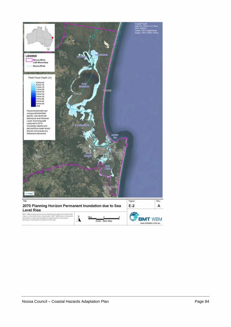
Noosa Council – Coastal Hazards Adaptation Plan Page 84

Noosa Council – Coastal Hazards Adaptation Plan Page 85

Noosa Council – Coastal Hazards Adaptation Plan Page 86
Appendix 4: Coastal Hazard Maps - Coastal Erosion
(Please also refer to Council’s online mapping for Coastal Erosion extents)

Noosa Council – Coastal Hazards Adaptation Plan Page 87

Noosa Council – Coastal Hazards Adaptation Plan Page 88

Noosa Council – Coastal Hazards Adaptation Plan Page 89

Noosa Council – Coastal Hazards Adaptation Plan Page 90

Noosa Council – Coastal Hazards Adaptation Plan Page 91

Noosa Council – Coastal Hazards Adaptation Plan Page 92

Noosa Council – Coastal Hazards Adaptation Plan Page 93

Noosa Council – Coastal Hazards Adaptation Plan Page 94
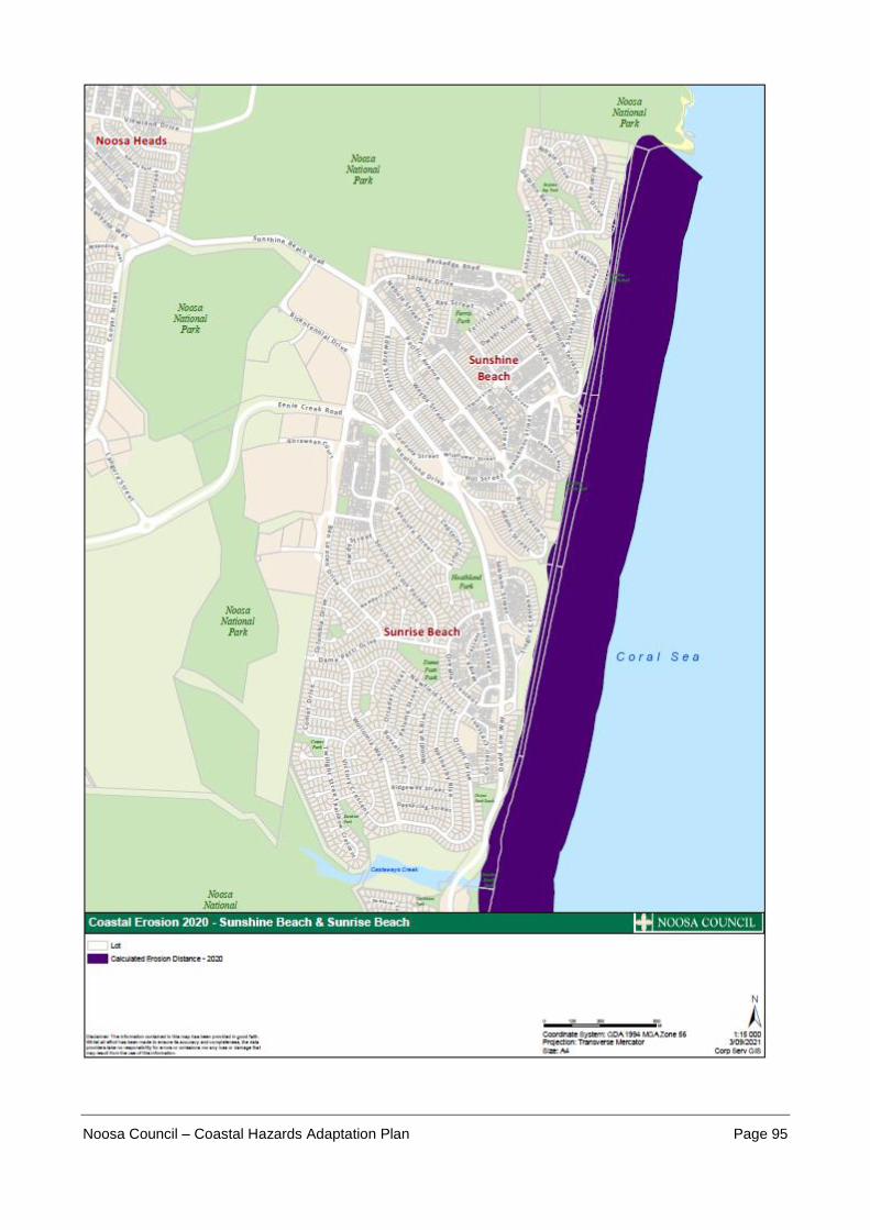
Noosa Council – Coastal Hazards Adaptation Plan Page 95

Noosa Council – Coastal Hazards Adaptation Plan Page 96

Noosa Council – Coastal Hazards Adaptation Plan Page 97

Noosa Council – Coastal Hazards Adaptation Plan Page 98

Noosa Council – Coastal Hazards Adaptation Plan Page 99

Noosa Council – Coastal Hazards Adaptation Plan Page 100

Noosa Council – Coastal Hazards Adaptation Plan Page 101

Noosa Council – Coastal Hazards Adaptation Plan Page 102

Noosa Council – Coastal Hazards Adaptation Plan Page 103

Noosa Council – Coastal Hazards Adaptation Plan Page 104

Noosa Council – Coastal Hazards Adaptation Plan Page 105

Noosa Council – Coastal Hazards Adaptation Plan Page 106