Draft MM rezoning Report 16 Feb 2010 - Durban · rezoning approved. However, the then Town and...
65
Mount Moreland Motivation for Rezoning 11 August 2009
Transcript of Draft MM rezoning Report 16 Feb 2010 - Durban · rezoning approved. However, the then Town and...

Mount Moreland
Motivation for Rezoning
11 August 2009

Mount Moreland
Motivation for Rezoning
August 2009

Motivation for Rezoning Mount Moreland
August 2009
i
Contents
1 INTRODUCTION AND SUMMARY ..................................................................................................... 1 1.1 The Applicant ............................................................................................................................ 1 1.2 The Application Site ................................................................................................................. 1 1.3 Current Zoning ........................................................................................................................... 1 1.4 The Proposal .............................................................................................................................. 2 1.5 Purpose of the Rezoning ......................................................................................................... 2
1.6 The Owners ................................................................................................................................ 2 1.7 Current Use ................................................................................................................................ 2 1.8 Purpose of this Motivation and outline of report ................................................................ 2 1.9 Consultation .............................................................................................................................. 3
2 HISTORY TO THE DEVELOPMENT OF MOUNT MORELAND AND BACKGROUND TO THIS
APPLICATION .............................................................................................................................................. 4
3 THE APPLICATION AREA ................................................................................................................... 6 3.1 Locality ....................................................................................................................................... 6 3.2 Access ........................................................................................................................................ 8 3.3 Ownership .................................................................................................................................. 9 3.4 Cadastral Description & Extent .............................................................................................. 9
3.5 Existing Zoning, Land Use and Population ........................................................................... 9 3.6 Infrastructure Servicing ............................................................................................................ 9 3.7 Future Development Considerations .................................................................................. 12
4 THE DEVELOPMENTAL PROPOSAL ................................................................................................ 17 4.1 Development Area under Consideration .......................................................................... 18 4.2 Proposed Zoning ..................................................................................................................... 18
4.3 Access and Traffic Proposals ................................................................................................ 37 4.4 Engineering Requirements .................................................................................................... 40 4.5 Environmental Proposals ....................................................................................................... 41
5 PLANNING MOTIVATION IN SUPPORT OF APPLICATION ........................................................... 42 5.1 Need for Rezoning .................................................................................................................. 42 5.2 Desirability of Rezoning Proposals ....................................................................................... 42
6 CONCLUSION ................................................................................................................................... 44 ANNEXURE A: RECORD OF COMMUNITY CONSULTATION ............................................................... 45 ANNEXURE B: PROPOSED ZONING OF EACH ERF ............................................................................. 46 ANNEXURE C: LIST OF TITLE DEEDS AND S.G. DIAGRAMS ................................................................ 54
LIST OF TABLES
Table 1: Areas under consideration for rezoning ............................................................................... 18
Table 2: Properties proposed to be subject to a Split Zoning of Conservation and Mixed Use,
Conservation and Undetermined and Conservation Only ..................................................... 20 Table 3: Properties proposed to be Zoned Conservation and acquired by the Municipality for
Conservation Purposes ................................................................................................................... 23 Table 4: Potential Development Yields ................................................................................................ 24 Table 5: Potential Land Use Split ............................................................................................................ 24
Table 6: Proposed Scheme Tables ........................................................................................................ 25

Motivation for Rezoning Mount Moreland
August 2009
ii
LIST OF FIGURES
Figure 1: Area expunged and included into Umhlanga Town Planning Scheme No. 1 in
course of preparation and the subject of this Rezoning Application ..................................... 1 Figure 2: Location of Mount Moreland in relation to Durban CBD ................................................... 6
Figure 3: Location of Mount Moreland in relation to the new International Airport ..................... 7 Figure 4: Current Access to Mount Moreland ...................................................................................... 8 Figure 5: Existing Land Use ..................................................................................................................... 11 Figure 6: Development Considerations ............................................................................................... 14 Figure 7: Natural Environmental Considerations ................................................................................ 15 Figure 8: New International Airport Averaged Day- Night Noise Contours .................................. 16
Figure 9: Mount Moreland Proposed Zoning ...................................................................................... 19 Figure 10: Mount Moreland Proposed Heights ................................................................................... 34 Figure 11: Mount Moreland Proposed FAR .......................................................................................... 35 Figure 12: Mount Moreland Proposed Coverage .............................................................................. 36 Figure 13: Access Proposals ................................................................................................................... 38 Figure 14: 20m Road Cross Section ....................................................................................................... 39
Figure 15: 30m Road Cross Section ....................................................................................................... 39

Motivation for Rezoning Mount Moreland
August 2009
1
1 INTRODUCTION AND SUMMARY
1.1 The Applicant
The application is submitted by the eThekwini Municipality in terms of Section 47 of the Town
Planning Ordinance, Ordinance No. 27 of 1949, as amended.
1.2 The Application Site
The application site is the township, known as Mount Moreland comprising 157 residential
sites and 2 park sites, located north of Durban near the southern border of the new
International Airport (Figure 1).
Figure 1: Area expunged and included into Umhlanga Town Planning Scheme No. 1 in course
of preparation and the subject of this Rezoning Application
1.3 Current Zoning
The area is zoned “Agricultural” with a residential land use, as provided under Part 5 of the
Development Service Board Regulations. The area was administered by the erstwhile
Development and Services Board through Part 5 of the Development and Services Board

Motivation for Rezoning Mount Moreland
August 2009
2
Regulations and associated Scheme maps. At a meeting of the Economic Development and
Planning Committee of the eThekwini Municipality held on 17 July 2008 it was resolved that
the Mount Moreland area be expunged and included in the Umhlanga Town Planning
Scheme No. 1 in course of preparation. The Development and Services Board Regulations
are still applicable pending the successful rezoning of the area in terms of the above
mentioned scheme.
1.4 The Proposal
The proposal is to
• Rezone the area described as Mount Moreland from “Agriculture with a residential
use” to “Mixed Use: ezinkonjaneni (Place of the Swallows)”, Conservation and
Undetermined.
• To amend the Umhlanga Town Planning Scheme No.1 to include the following new
Zones to facilitate this rezoning:
- Mixed Use: ezinkonjaneni (Place of the Swallows) A, B, C, D and E
- Conservation
1.5 Purpose of the Rezoning
The purpose of the proposed rezoning is to permit the development of land uses that are
more compatible with the adjacent airport use to
• mitigate noise impacts from the new airport on an existing residential area
• create value for current residents by enhancing the development opportunities of
the existing sites
• provide opportunity for complimentary development opportunities on land adjacent
to the airport site to support the development of the airport and thereby contribute
to economic growth
1.6 The Owners
The area has multiple owners as listed in Annexure B and C.
1.7 Current Use
The predominant land use in the application site is residential with limited sugar cane farming
and market gardening.
1.8 Purpose of this Motivation and outline of report
The purpose of this report is to provide the motivation for the rezoning of the application site
to a use compatible with the new international airport located to the north of the settlement

Motivation for Rezoning Mount Moreland
August 2009
3
and an amendment to the Umhlanga Town Planning Scheme No. 1 to include the Mixed
Use: ezinkonjaneni (Place of the Swallows) A to E and Conservation zones.
The report is structured as follows:
• Section 1: Introduction and a summary of the application;
• Section 2: History of the development of Mount Moreland and background to this
application;
• Section 3: Information on the application area;
• Section 4: The proposal;
• Section 5: The motivation for the change of use – need and desirability
• Section 6: Conclusion
This motivation has been prepared in conjunction with a Precinct Plan for Mount Moreland
(TPI and R Hansmann, July 2009) which should be used to guide future development in the
area. The motivation is supported by a number of specialist studies which provide important
supporting information for this application:
• Mount Moreland Rezoning: Report on the Results of the Future Land Use Survey,
October 2008
• Traffic Impact Assessment for the Proposed Block Rezoning of Mount Moreland,
Aurecon July 2009
• Status Quo Report for Civil Engineering Services and Infrastructure at Mount Moreland
June 2008
• Report for Civil Engineering Services and Infrastructure at Mount Moreland, Virtual
Consulting Engineers, July 2009
• Environmental Assessment of the Proposed Rezoning of Mount Moreland, Institute of
Natural Resources, July 2009
1.9 Consultation
The TPI team was appointed to develop proposals and prepare the documentation for this
rezoning in July 2008. In the process of preparing the proposal the local community has been
consulted on a number of occasions as listed in Annexure A. This consultation included
regular meetings with the Residents and Ratepayers Association and the Lake Victoria
Conservancy and 4 meetings to which all community members were invited held on 2 April
2008, 29 July 2008, 4 February 2009 and ....August 2009. A survey of the community was also
undertaken in August 2008 to establish community views on alternative land uses for the
area.

Motivation for Rezoning Mount Moreland
August 2009
4
2 HISTORY TO THE DEVELOPMENT OF MOUNT MORELAND AND BACKGROUND
TO THIS APPLICATION
Mt. Moreland was established in 1850 by a group of Byrne settlers dissatisfied with land
officially allocated to them. After initial settlement of one house and a church, no significant
development occurred until 1978. Development in the area grew substantially after 1989. The
area was proclaimed a Development Area in 1977 via proclamation No. 183 of 1977 and
was administered by the Development Services Board until it was incorporated into the
Northern entity of the Durban Metropolitan area and ultimately the eThekwini Municipality.
According to the Surveyor General Diagram originally prepared in 1935, Mt. Moreland was
laid out with 137 lots and 22 larger lots probably set aside for market gardening, as well
as Lake Victoria and a Marsh area. Several subdivisions of the original properties have
subsequently taken place. An analysis of aerial photography illustrates that there were a few
houses in Mt Moreland in 1973 when the airport site was being levelled. By 1994 there were 48
houses in Mt Moreland and a count from recent aerial photographs indicates that there are
now 92 houses.
The new international airport was first mooted for development in the 1960’s and earthworks
for its development were undertaken in the 1970’s. Development was then put on hold until
the 1990’s. The site was now within the Northern Operational Entity of the eThekwini
Municipality and an application to rezone the site to “Special Zone 10 (Airport)” and
“Undetermined” to cater for future airport expansion was made in 1997/98. The Mount
Moreland residents appealed against the rezoning. The appeal was overturned and the
rezoning approved. However, the then Town and Regional Planning Commission (now
Provincial Planning and Development Commission) suggested that Mount Moreland may not
be suitable for residential purposes once the airport is operational and may need to be
rezoned. In terms of a Section 48 Order invoked through the Natal Town Planning Ordinance,
Ordinance No. 27 of 1949 as amended, in a letter to the Municipality dated 21 January 1998
the Town and Regional Planning Commission (now the Provincial Planning and Development
Commission) directed the Municipality to rezone the area to a suitable special zone that
would admit the use of airport warehousing, this zoning to become effective one year after
the awarding of the last contract that would permit the airport to become operational.. The
Municipality appealed against this order on the grounds that it is not the responsibility of the
Local Authority to rezone the area and that the residents have not been afforded an
adequate opportunity to express their views on what they would prefer the zoning of the
area to be. The Appeal has subsequently been withdrawn.

Motivation for Rezoning Mount Moreland
August 2009
5
The development of the airport gained impetus as the Dube TradePort project, initiated by
the Department of Economic Development (KwaZulu-Natal). The KwaZulu-Natal Cabinet
committed itself in 2001 to supporting the relocation of Durban International Airport to La
Mercy and to developing the Dube TradePort, which would incorporate the international
airport. South Africa’s National Cabinet decided in 2002 to proceed with the implementation
of the Dube TradePort and the relocated International Airport.
In 2005 an Environmental Impact Assessment (EIA) for the development of the airport and
supporting use, known as the Dube TradePort was initiated. Within this process the potential
impact of noise from the new airport on Mount Moreland was identified. The EIA process
concluded that “Whilst there are numerous examples of residential settlements in South
Africa and internationally as close to an airport if not closer (including settlements around the
current Durban International Airport) than Mt. Moreland to the proposed site, it has been
established that the settlement falls within the 55 LRdn where, according to the SANS
guidelines 10103 of 2004, no member of the community should be required to reside in areas
where the equivalent continuous day/night rating levels exceed 55 LRdn. Furthermore the
Valuation report ......has noted that this area is likely to experience a drop in residential value
if the airport is developed. It is therefore recommended that one of the primary mitigation
measures should be to allow the area to be rezoned to a more suitable use. This will not only
improve the land use compatibility of the area with the proposed development but should
allow current residents to sell their properties for an equivalent, if not higher, value should
they wish to move....... Discussions with the eThekwini Development Planning Department
have confirmed that they would be willing to consider a rezoning from residential to a more
compatible land use” (Specialist Planning Report of the EIA, INR 2007).
The Record of Decision giving authorisation to the development was issued on 23 August
2007 and a revised ROD was issued on 29 October 2008. On the basis of the
recommendations contained in the EIA it was agreed that the rezoning should be pursued.
The Dube TradePort Co., ACSA and Tongaat-Hulett Development agreed to jointly fund the
preparation of the application documents and the Municipality would submit the
application on the basis that it would be acting in the public good.

Motivation for Rezoning Mount Moreland
August 2009
6
3 THE APPLICATION AREA
3.1 Locality
Mount Moreland is located approximately 30 kilometres north of the Durban CBD (Figure 2),
just to the south of the new International Airport and approximately 4km inland from Umdloti
(Figure 3).
Figure 2: Location of Mount Moreland in relation to Durban CBD

Motivation for Rezoning Mount Moreland
August 2009
7
Figure 3: Location of Mount Moreland in relation to the new International Airport

Motivation for Rezoning Mount Moreland
August 2009
8
3.2 Access
The main access to the settlement is from the N2 Umdloti interchange via the M27 and then
the P99/D575 which is a gravel road that crosses a low lying single lane bridge over the
Umdloti River before climbing up to the settlement. Alternate access can also be gained
along the P99 from the R102 to the west. This is also a gravel road (Figure 4).
Figure 4: Current Access to Mount Moreland

Motivation for Rezoning Mount Moreland
August 2009
9
3.3 Ownership
There are multiple private owners in Mount Moreland as listed in Appendix C.
3.4 Cadastral Description & Extent
Mount Moreland covers 49.7 hectares, with a total of 180 erven subject to this rezoning
application. A map is provided and cadastral descriptions are listed in Appendix B and C.
3.5 Existing Zoning, Land Use and Population
Mount Moreland was zoned as Agricultural with a residential land use, as provided under
Part 5 of the Development Service Board Regulations. This zoning was carried forward into
the Umhlanga Town Planning Scheme No. 1 in course of preparation when the area was
expunged. The existing controls for the area relate to the sanitation services levels provided,
which consist of septic tanks. This service level permits a coverage of 25% and a FAR of 0.25.
Should service levels be upgraded to off-site sanitation then a higher coverage of 35% and
FAR of 0.35 would be permitted.
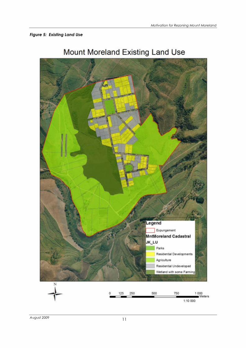
The predominant land use within Mount Moreland is residential, with some agriculture (sugar
cane farming) taking place in the surrounding areas. To the west of the settlement is Lake
Victoria, a wetland that functions as a Barn Swallow roosting site in summer and to the east is
a wetland known as Froggy Pond. Figure 5 illustrates existing land use.
Of the 156 residential sites in Mount Moreland, 92 have been developed. Assuming 3 persons
per dwelling unit the estimated population living in Mount Moreland is 276 people.
3.6 Infrastructure Servicing
Current servicing levels were assessed in a report compiled by Virtual Consulting “Status Quo
Report For: Civil Engineering Services and Infrastructure at Mount Moreland, June 2008. The
findings were as follows:
• The general condition of the roads within Mount Moreland is reasonable. All roads are
within 20 metre road reserves with a 4 metre paved surface. The visual assessment
indicated that roads serve the current needs of Mount Moreland, however certain
areas require maintenance. There is a single point of access to Mount Moreland via a
gravel road and low level bridge. The access road requires improvements. The DTP
support zone development allows for a future road link to Mount Moreland. While the
roads have been constructed to a standard lower than the current municipal
standards, the road reserve widths are sufficient to enable the roads to be upgraded
where necessary.

Motivation for Rezoning Mount Moreland
August 2009
10
• The existing stormwater arrangement works adequately. While there is no piped road
drainage network, the combination of narrow pavement widths and grassed verges
sufficiently manage current stormwater flows. Upgrading of the stormwater
management system would be required to facilitate further development.
• Potable water is obtained from the La Mercy reservoir. The water reticulation
infrastructure is aged and needs repair or replacement. A new bulk supply reservoir is
to be constructed by the eThekwini Municipality in conjunction with the new airport
development. This will have sufficient capacity to supply the airport and adjacent
areas and will be upgradeable once demand increases. Bulk mains from this reservoir
are under construction to the support zone adjacent to Mount Moreland. The design
includes for a 200mm diameter spur that will allow for a future link to Mount Moreland.
The eThekwini Municipality have an ongoing programme of water reticulation
upgrades and the Water Department have confirmed that Mount Moreland is
included in the scope of work, however, dates have not been set for the upgrade
programme in this area.
• Mount Moreland does not have a water-borne sewerage system. The residential plots
are served by private septic tank / soakaway systems. There is no bulk sewer
infrastructure at present, but a new STW is being planned by eThekwini Municipality
and a new trunk main is being planned by DTP that will accommodate the needs of
Mount Moreland.
• The current 11kV electricity supply is from the Umdloti large substation. Future supply
can be from either the new substation on the airport site or the existing Umdloti
substation.
• Telecommunications infrastructure for all major fixed and wireless providers is being
provided for the airport development. Coverage can readily be extended to Mount
Moreland.
• The eThekwini Municipality supplies a solid refuse removal service to the area.
• A postal service is supplied to the area.
Motivation for Rezoning Mount Moreland
August 2009
11
Figure 5: Existing Land Use

Motivation for Rezoning Mount Moreland
August 2009
12
3.7 Future Development Considerations
• Topography
The settlement sits on 2 hill tops almost surrounded by wetlands (Figure 6). This
provides a unique opportunity for organising future development around the hill tops,
views of the hinterland, river valleys and the wetlands. Access is however, constrained
to two points one from the north and one to the south which limits the development
potential of the area.
• Servicing levels
Current servicing levels are adequate for residential development, however,
redevelopment of the area will require the upgrading of services and improved
access.
• Green Environment
The green environment (wetlands, fauna and flora including the swallow roosting site,
river valleys, vegetated areas) provides a number of valuable assets which offer
significant opportunities that can enhance the character of the area. The area must
however, be appropriately planned and managed to minimise and mitigate impact
on the natural environment. An environmental assessment of the area was
undertaken by INR as part of the planning process to prepare the rezoning
documents. This assessment took into account floodlines, drainage lines, the
eThekwini Municipality Environmental Management System and an assessment of
rivers, wetlands, fauna and flora. Using a scientific method buffers to protect and
enhance the wetlands and habitat of important species were determined. This
analysis has been used in the preparation of the rezoning proposals. The areas
where development ought to be restricted or managed are illustrated in Figure 7.
• Noise
Mount Moreland West falls within the 50-55 LRdn and Mount Moreland east falls within
the direct flight path of runway 1 at the new international airport and within the 55- 60
LRdn noise contour (Figure 8) where according to the SANS guidelines 10103 as a general
guideline, no member of the community should be required to reside in areas where
the equivalent continuous day/night rating levels exceed 55 LRdn. Future
development will be required to take the potential impact of noise into account.
• Restrictive Conditions of Title
The properties within Mount Moreland are subject to a number of restrictive
Conditions of Title. Those which are of concern for rezoning the area i.e. limitation of
development for residential proposes, one dwelling per site and restrictions on

Motivation for Rezoning Mount Moreland
August 2009
13
building materials have however been deleted by the KwaZulu-Natal Planning and
Development Act, 2008 (Act No. 6 of 2009)Act with effect from 1 March 2009 [section
60(4) read with item 3 of Schedule 5].
“These conditions of title have been deleted because there are sufficient other legal
instruments which regulate the same subject matter, for example the National
Building Regulations and Building Standards Act, 1977 (Act No. 103 of 1977), schemes
and municipal by-laws. Conditions of title which are deleted by the Act must be in
favour of the Administrator, Premier, a MEC or the general public and must prohibit
the subdivision of land, restrict the use of a property to one dwelling house, restrict the
use of land to residential purposes, prohibit the use of certain building materials for
the erection of buildings or require the submission of building plans.” (Extract from
Guideline on the Alteration, Suspension and Deletion of Restrictive Conditions in Terms
of the Kwazulu-Natal Planning and Development Act, 2008 (Act No. 6 Of 2008)
prepared by G. Roos March 2009, Legal Services KZNLGTA)

Motivation for Rezoning Mount Moreland
August 2009
14
Figure 6: Development Considerations

Motivation for Rezoning Mount Moreland
August 2009
15
Figure 7: Natural Environmental Considerations

Motivation for Rezoning Mount Moreland
August 2009
16
Figure 8: New International Airport Averaged Day- Night Noise Contours

Motivation for Rezoning Mount Moreland
August 2009
17
4 THE DEVELOPMENTAL PROPOSAL
As indicated in the Precinct Plan prepared for the area it is proposed that the area be
rezoned to facilitate the redevelopment of the area as follows:
• An Urban Eco-village with a strong link to the green environment within which it is
located, maximising opportunities the opportunities that exist – views, swallows, biking,
etc.
• Supporting and linked to Support Precinct 1 on the airport site with strong public
transport links to the airport
• Mixed use including some hospitality, residential and office
• Organised around two hill tops
• Higher densities around hilltop public space
Due to the location of the new international airport, it is argued that the land use in Mount
Moreland needs to adapt to the potential impact of it both in terms of noise and an
increased demand for development around the airport that is likely to emerge. The airport
will create markets not necessarily catered for on site. It is envisaged that some form of short
and medium term hotel/ bed and breakfast accommodation will need to be provided both
for tourists/ business people coming into the area, as well as those actually involved in air
travel who would frequently come to the airport (such as pilots and air hostesses).
Furthermore, longer term residential amenity would need to be supplied to provide housing
for those working in and around the Dube TradePort. This would not be accommodated on
the airport site due to higher land values and noise impact. There is also likely to be a
demand for office space and conference/meeting and other business and travel support
facilities that does not need to be in close proximity to the airport i.e. within the Support
Precincts, but which will be benefit from good proximity to the airport. The survey of existing
residents indicated that 40% of those interviewed wished to remain in the area indicating an
ongoing need for residential options in the area. There was also support for a mixed use type
of redevelopment with 57% of those wishing to stay in the area wanting to use their
properties for both business and residential purposes (Mount Moreland Rezoning: Report on
the Results of the Future Land Use Survey, October 2008).
The proposed development concept as explained in the precinct plan can be described as
consisting of two related nodes, Mount Moreland West and Mount Moreland East. Mount
Moreland West, closest to the airport, would have the northern park as its focal point with a
higher order and intensity of uses around the focal point and would provide a mix of uses

Motivation for Rezoning Mount Moreland
August 2009
18
supporting the airport development e.g. shops, hotels, conference and meeting facilities and
restaurants to cater for people working at the airport and passengers. Mount Moreland East
would have the southern park as its focal point with a lower intensity of development,
offering amenity for medium and long term stay in Bed and Breakfasts, Boutique Hotels, and
maximising tourist and leisure activities relating to Barn Swallow watching. Accommodation,
offices and residential development would be accommodated in the rest of the settlement.
4.1 Development Area under Consideration
The portion of Mount Moreland suitable for development/redevelopment purposes is
contained within the existing cadastral layout of Mount Moreland. Development may be
extended in one area but is largely constrained to the existing layout by environmental
considerations. Additional development opportunities and those beyond the rezoning
boundary being considered in this application are discussed more fully in the Precinct Plan
for the Mount Moreland Area. The area under consideration for rezoning is as follows:
Table 1: Areas under consideration for rezoning
Use Area (m2) Area (Hectares) % of Total
Current residential sites
(vacant and developed)
417 810 m2 42 ha 26 %
Agricultural use 683 975 m2 68 ha 42 %
Open Space 524 819 m2 52 ha 32 %
Total 1 626 604 m2 162 ha 100 %
4.2 Proposed Zoning
In line with the necessity to rezone Mount Moreland due to the new airport it is proposed that
the zoning of the area be changed to a mixed use zone with differing built form controls for
specific areas, with a conservation zone applied to significant areas of environmental
sensitivity and an undetermined zone over existing agricultural use.
The mixed use zoning should accommodate various building typologies (relating to density,
height, building lines, side and rear spaces), and has thus been named Mixed Use:
ezinkonjaneni (Place of the Swallows) A - E (Figure 9 and Table 6).

Motivation for Rezoning Mount Moreland
August 2009
19
Figure 9: Mount Moreland Proposed Zoning

Motivation for Rezoning Mount Moreland
August 2009
20
The proposed zoning would take into account the environmental amenity and constraints of
the area. As such, the riverine habitats, as well as the wetlands and important habitat for
endangered species will be protected and emphasised as key aspects of the future
development of Mount Moreland. To achieve this it is proposed that the wetland areas are
zoned for “Conservation” purposes and that a split Conservation Zone along with the related
Mixed Use Zone be declared over portions of properties that already have development
rights but which need to be protected to maximise opportunities for environmental
sustainability of the wetlands and significant habitats. No development will be allowed within
the environmentally sensitive portion of the split zone, however, residents will be able to apply
for a rates rebate for these portions of their properties. The delineation of the Conservation
Zone has been based on the buffers determined in the environmental assessment and an
analysis of existing development rights and existing development. It is noted that the land
owners of the wetland areas (i.e. TH and ACSA) have consented to the areas being zoned
for Conservation purposes on the basis that these areas may be deemed as offsets for
development in other areas that may impact on wetlands in a ratio that is to be determined.
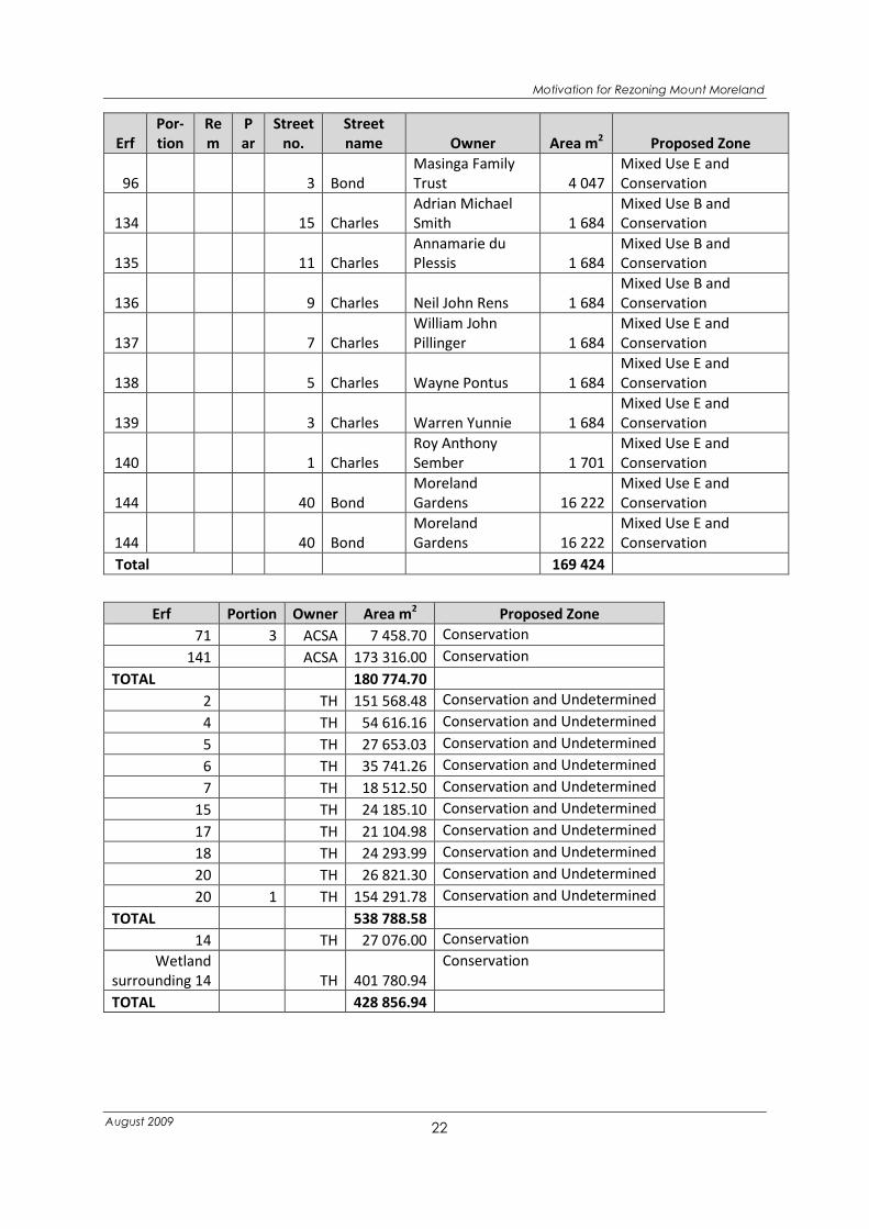
Thirty-nine sites that are currently used for residential purposes are proposed to be subject to
a split zone i.e. Mixed Use and Conservation Zone, which will cover an area of approximately
33 hectares. The affected properties are listed in Table 2.
Table 2: Properties proposed to be subject to a Split Zoning of Conservation and Mixed Use,
Conservation and Undetermined and Conservation Only
Erf
Por-
tion
Re
m
P
ar
Street
no.
Street
name Owner Area m2 Proposed Zone
27 2 48 Bond
Tongaat Hullett
Group Limited 4 046
Mixed Use E and
Conservation
27 1 19 High
Moreland
Development PTY
LTD 4 049
Mixed Use E and
Conservation
27 4 17 High
Gerhard
Kellerman 4 046
Mixed Use E and
Conservation
28 15 High Ian Jowett 4 046
Mixed Use E and
Conservation
29 11 High
David Charles
Barske 4 046
Mixed Use E and
Conservation
30 9 High
Jason Prior
Pratsch 4 083
Mixed Use E and
Conservation
45 31 Bond
Richard John
Gaylord 4 046
Mixed Use E and
Conservation
46 29 Bond
Robin Arthur
Johnson 4 047
Mixed Use E and
Conservation

Motivation for Rezoning Mount Moreland
August 2009
21
Erf
Por-
tion
Re
m
P
ar
Street
no.
Street
name Owner Area m2 Proposed Zone
56 15 Agnes
Zululand Sugar
Miller Limited 4 047
Mixed Use E and
Conservation
57 17 Agnes
Zululand Sugar
Miller Limited 4 047
Mixed Use E and
Conservation
58 19 Agnes
The Tongaat-
Hulett Group
Limited 4 047
Mixed Use E and
Conservation
59 21 Agnes
The Tongaat-
Hulett Group
Limited 4 047
Mixed Use E and
Conservation
60 23 Agnes
Kenneth Brett
Matthew 4 050
Mixed Use E and
Conservation
69 14 Agnes Mark Milne Gilroy 4 094
Mixed Use E and
Conservation
70 16 Agnes
Kumlucky Farm
(Proprietary)
Limited 4 047
Mixed Use E and
Conservation
71 1 18 Agnes Prudence Barlase 4 392
Mixed Use E and
Conservation
71 2 20 Agnes
Brett Frederick
Wilkinson 5 066
Mixed Use E and
Conservation
71 R 22 Agnes Prudence Borlase 6 135
Mixed Use E and
Conservation
79 5 Alfred
Brett Frederick
Wilkinson 3 960
Mixed Use E and
Conservation
80 3 Alfred Warren Yunnie 4 122
Mixed Use E and
Conservation
82 4 Bond Ray van der Poll 4 293
Mixed Use E and
Conservation
84 8 Bond
Gerald Allan
Beales 4 047
Mixed Use B and
Conservation
85 10 Bond
Merlindren
Govender 4 047
Mixed Use B and
Conservation
86 12 Bond Colin Bentley 4 046
Mixed Use B and
Conservation
91 15 Bond
Russell McKenzi
Currie Brayshaw 4 047
Mixed Use B and
Conservation
92 11 Bond
Tongaat
Properties
(Pty)Limited 4 046
Mixed Use B and
Conservation
93 9 Bond
Bernhard Meil
Josef Manock 4 047
Mixed Use B and
Conservation
94 7 Bond
Kumlucky Farm
(Proprietary)
Limited 4 046
Mixed Use E and
Conservation
95 5 Bond
Masinga Family
Trust 4 046
Mixed Use E and
Conservation
Motivation for Rezoning Mount Moreland
August 2009
22
Erf
Por-
tion
Re
m
P
ar
Street
no.
Street
name Owner Area m2 Proposed Zone
96 3 Bond
Masinga Family
Trust 4 047
Mixed Use E and
Conservation
134 15 Charles
Adrian Michael
Smith 1 684
Mixed Use B and
Conservation
135 11 Charles
Annamarie du
Plessis 1 684
Mixed Use B and
Conservation
136 9 Charles Neil John Rens 1 684
Mixed Use B and
Conservation
137 7 Charles
William John
Pillinger 1 684
Mixed Use E and
Conservation
138 5 Charles Wayne Pontus 1 684
Mixed Use E and
Conservation
139 3 Charles Warren Yunnie 1 684
Mixed Use E and
Conservation
140 1 Charles
Roy Anthony
Sember 1 701
Mixed Use E and
Conservation
144 40 Bond
Moreland
Gardens 16 222
Mixed Use E and
Conservation
144 40 Bond
Moreland
Gardens 16 222
Mixed Use E and
Conservation
Total 169 424
Erf Portion Owner Area m2 Proposed Zone
71 3 ACSA 7 458.70 Conservation
141 ACSA 173 316.00 Conservation
TOTAL
180 774.70
2 TH 151 568.48 Conservation and Undetermined
4 TH 54 616.16 Conservation and Undetermined
5 TH 27 653.03 Conservation and Undetermined
6 TH 35 741.26 Conservation and Undetermined
7 TH 18 512.50 Conservation and Undetermined
15 TH 24 185.10 Conservation and Undetermined
17 TH 21 104.98 Conservation and Undetermined
18 TH 24 293.99 Conservation and Undetermined
20 TH 26 821.30 Conservation and Undetermined
20 1 TH 154 291.78 Conservation and Undetermined
TOTAL
538 788.58
14 TH 27 076.00 Conservation
Wetland
surrounding 14 TH 401 780.94
Conservation
TOTAL
428 856.94
Motivation for Rezoning Mount Moreland
August 2009
23
To achieve the required environmental system it is also proposed that certain sites are
acquired by the eThekwini Municipality and zoned for “Conservation” purposes as listed in
Table 3.
Table 3: Properties proposed to be Zoned Conservation and acquired by the Municipality for
Conservation Purposes
Erf
Port
ion
Street
number
Street
name Owner
Site Area
m2
Existing
Building
Proposed
Municipal
Buy-out
1 71 3 Agnes ACSA 7 459 Vacant Yes
2 98 Church TH 4 051 Vacant Yes
3 97 Church TH 2 190 Vacant Yes
4 87 3 2B Church
George Herbert
Rossiter 3 345
Vacant Yes
5 87 2 2A Church
George Herbert
Rossiter 2 820
Vacant Yes
6 52 1 Church Pierre Jevon 3 236 Vacant Yes
7 53 18 Church Eugene Maree 4 887 Vacant Yes
8 54 Church TH 6 413 Vacant Yes
Total 34 401
The rezoning proposal will result in the overall intensity of use within the area increasing.
Proposed maximum heights (Figure 10) have been designed to promote a sense of place
around the urban parks and to create a street boulevard. Thus, the highest buildings are
proposed to occur along the main spine (generally 3 stories) and around the two public
parks (4 stories on the bigger park to the north-west and 3 stories on the smaller park to the
south-east). These heights drop as one moves away from these points to heights of 2 stories in
the rest of the area and the interfaces with the open space system.
The proposed Floor Area Ratio range is set out in Table 6: Proposed Scheme Tables and
limited to a maximum of 1 as illustrated in Figure 11. Proposed coverage is illustrated in Figure
12. The denser land uses are proposed to occur around the parks and along the spine. This
will help to create a sense of place within these areas.
The proposed Zonings have the potential to generate the following development yield:

Motivation for Rezoning Mount Moreland
August 2009
24
Table 4: Potential Development Yields
FAR
Coverage
% Height
Site Area
m2
Floor Area
m2
Undetermined 0.0 0 0 683 975 0
Mixed Use A - Sites fronting onto
urban place north 1.0 40 4 56 657 56 657
Mixed Use B - sites fronting onto
urban place south and parts of main
road 1.0 40 3 59 995 59 995
Mixed Use C - urban place north 0.8 20 4 16 192 12 954
Mixed Use D - urban place south 0.6 20 3 10817 6490.6
Mixed Use E - remainder of area 0.7 35 2 253 238 177 267
Proposed Mixed Use E 0.7 35 2 22 662 15 863
Conservation 0.0 0 0 545 730 0
Total 1 649 266 329 226
Table 5: Potential Land Use Split
Building floor area Office
Commercial / Retail Hotel Residential
m2 25% 5% 20% 50%
Current floor area estimate 90 000 0 0 0 90 000
Potential floor area under
current zoning 204 000 0 0 0 204 000
proposed by 2030 329 226 82 307 16 461
65 845 164 613

Motivation for Rezoning Mount Moreland
August 2009
25
The proposed zoning of the area is outlined in the following Scheme Tables.
Table 6: Proposed Scheme Tables
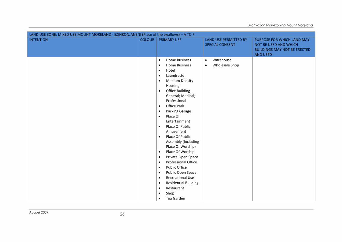
LAND USE ZONE: MIXED USE MOUNT MORELAND - EZINKONJANENI (Place of the swallows) – A TO F
INTENTION COLOUR PRIMARY USE LAND USE PERMITTED BY
SPECIAL CONSENT
PURPOSE FOR WHICH LAND MAY
NOT BE USED AND WHICH
BUILDINGS MAY NOT BE ERECTED
AND USED
• The Mount Moreland Mixed Use Zone is intended to
facilitate a vibrant mixed use area
- That allows for the development of a range of
complimentary land uses including residential,
business, offices, civic and social uses that have been
designed to take account of potential noise from the
nearby airport
- Fully linked to the support precinct 1 on the airport site
that
- Is focused around the urban spaces and the main
boulevard and
- Maximises the environmental opportunities associated
with the wetlands, fauna, flora and views
Blue • Art Gallery
• Arts And Craft
Workshop
• Bed & Breakfast
Establishment
• Boarding House
• Canteen
• Childminder Service
• Clinic
• Conference Facility
• Conservancy
• Convenience Shop
• Convention Centre
• Cottage Industry
• Crèche
• Dwelling House With
Ancillary Unit
• Educational Building
• Exhibition Centre
• Fast Food Outlet
• Flea Market
• Guest House
Establishment
• Health Club
• Agricultural Activity
• Agricultural Building
• Agricultural Land
• Base
Telecommunication
and Transmission
Station
• Bottle Store
• Builders Yard
• Business Park
• Car Wash
• Casino
• Cellular Mast
• Communication Tower
• Crèche
• Game Reserve
• Garage or Petrol
Filling Station
• Institution
• Nature Reserve
• Service Industry
• Sports Bar
• Tavern
• Totalizer
• Caravan Park
• Cemetery
• Children’s Home
• Commercial Workshop
• Container Depot
• Correctional Facility
• Crematorium
• Extractive Industry
• Frail Care Centre
• Funeral Parlour
• General Industry
• Hospital
• Industrial Hive
• Light Industry
• Mobile Home
• Mobile Home Park
• Mortuary
• Quarantine Area
• Restricted Building
• Retirement Centre
• Special Industry
• Undertaker
Motivation for Rezoning Mount Moreland
August 2009
26
LAND USE ZONE: MIXED USE MOUNT MORELAND - EZINKONJANENI (Place of the swallows) – A TO F
INTENTION COLOUR PRIMARY USE LAND USE PERMITTED BY
SPECIAL CONSENT
PURPOSE FOR WHICH LAND MAY
NOT BE USED AND WHICH
BUILDINGS MAY NOT BE ERECTED
AND USED
• Home Business
• Home Business
• Hotel
• Laundrette
• Medium Density
Housing
• Office Building –
General; Medical;
Professional
• Office Park
• Parking Garage
• Place Of
Entertainment
• Place Of Public
Amusement
• Place Of Public
Assembly (Including
Place Of Worship)
• Place Of Worship
• Private Open Space
• Professional Office
• Public Office
• Public Open Space
• Recreational Use
• Residential Building
• Restaurant
• Shop
• Tea Garden
• Warehouse
• Wholesale Shop

Motivation for Rezoning Mount Moreland
August 2009
27
DEVELOPMENT PARAMETERS: DENSITY
MIXED USE A- Sites fronting onto urban place north
BUILDING
LINES
BUILDING SPACES No. OF
UNITS/HA
MINIMUM
LOT SIZE
HEIGHT COVERAGE FAR PARKING PRIVATE
OPEN SPACE
ADDITIONAL CONTROLS
STREET SIDE REAR • All development shall be
substantially in
accordance with the
Precinct Plan prepared
for the Mount Moreland
area as amended from
time to time.
• A Site Development Plan
is required for
consideration of each
development. The SDP
will relate to the Precinct
Plan.
• A Landscaping Plan is
required and should be
prepared in accordance
with the Municipal
Landscaping Guidelines.
• A Lighting Plan is
required.
• A Parking Plan is
required.
• Each development shall
be treated acoustically to
the satisfaction of the
Council. An acoustics
report detailing how each
5m on Bond
Street with
20m reserve.
Nil once road
is upgraded
to 30m.
Rest 7,5m
N/A 4 40% 1 In terms of
Clause 6.5 of
the Scheme
No less than
25% of the
site shall
have a
permeable
surface and
include
landscaping.
MIXED USE B- sites fronting onto urban place south and parts of main road
BUILDING
LINES
BUILDING SPACES No. OF
UNITS/HA
MINIMUM
LOT SIZE
HEIGHT COVERAGE FAR PARKING PRIVATE
OPEN SPACE
STREET SIDE REAR
5m on
Charles Street
with 20m
reserve.
Nil once road
is upgraded
to 30m.
Rest 7,5m
N/A 3 40 % 1 In terms of
Clause 6.5 of
the Scheme
No less than
25% of the
site shall
have a
permeable
surface and
include
landscaping.
MIXED USE C- urban place north
BUILDING
LINES
BUILDING SPACES No. OF
UNITS/HA
MINIMUM
LOT SIZE
HEIGHT COVERAGE FAR PARKING PRIVATE
OPEN SPACE
STREET SIDE REAR
Nil
N/A 4 20% 0.8 In terms of
Clause 6.5 of
No less than
50% of the

Motivation for Rezoning Mount Moreland
August 2009
28
the Scheme site shall
have a
permeable
surface and
include
landscaping.
development type is to
be treated will be
submitted with each SDP.
• No building plan will be
considered without the
acoustics report being
approved.
• Upon completion of the
development, no
completion certificate
may be issued unless an
independent acoustics
officer and the EHD are
satisfied that the
recommendations as
contained in the
Acoustics report have
been complied with.
• All redevelopment
subject to the provision
of sewage disposal to the
satisfaction of the
Municipality.
• All redevelopment will
require a storm water
management plan.
• Coverage may be relaxed
by Consent of the
Municipality in certain
instances where this is
required to achieve an
enclosure of space along
the main roads and
around the parks and on
MIXED USE D- urban place south
BUILDING
LINES
BUILDING SPACES No. OF
UNITS/HA
MINIMUM
LOT SIZE
HEIGHT COVERAGE FAR PARKING PRIVATE
OPEN SPACE
STREET SIDE REAR
Nil
N/A 3 20% 0.6 In terms of
Clause 6.5 of
the Scheme
No less than
50% of the
site shall
have a
permeable
surface and
include
landscaping.
MIXED USE E- remainder of area
BUILDING
LINES
BUILDING SPACES No. OF
UNITS/HA
MINIMUM
LOT SIZE
HEIGHT COVERAGE FAR PARKING PRIVATE
OPEN SPACE
STREET SIDE REAR
7,5m
N/A 2 35% 0.7 In terms of
Clause 6.5 of
the Scheme
No less than
25% of the
site shall
have a
permeable
surface.

Motivation for Rezoning Mount Moreland
August 2009
29
corner sites in particular
• Redevelopment may
trigger an EIA in terms of
the relevant
environmental legislation.
The Municipality may also
call for an Environmental
Assessment where an EIA
is not triggered.
• All redevelopment will be
subject to an
environmental
management plan
approved by the
Municipality.

Motivation for Rezoning Mount Moreland
August 2009
30
LAND USE ZONE: UNDETERMINED
INTENTION COLOUR PRIMARY
USE
LAND USE PERMITTED BY SPECIAL CONSENT PURPOSE FOR WHICH LAND
MAY NOT BE USED AND
WHICH BUILDINGS MAY NOT
BE ERECTED AND USED
Provides for land where is in not
possible or undesirable to zone
land for any particular use at the
time of scheme preparation.
Green
Hatch
Agricultural
Land
Agricultural
building
Development may be considered in this zone subject to the Special
Consent of the Municipality being granted and subject to the proposed
development being in accordance with any future use that may be
contemplated by the Municipality in accordance with any spatial plans
that may have been prepared.
DEVELOPMENT PARAMETERS: DENSITY
UNDETERMINED Additional Controls
BUILDING
LINES
BUILDING SPACES No. OF
UNITS / HA
MINIMUM
LOT SIZE
HEIGHT COVERAGE FAR PARKING PRIVATE OPEN SPACE
STREET SIDE REAR
2000m2 2 15% 0.15 In terms of
Clause 6.5 of
the Scheme
Motivation for Rezoning Mount Moreland
August 2009
31
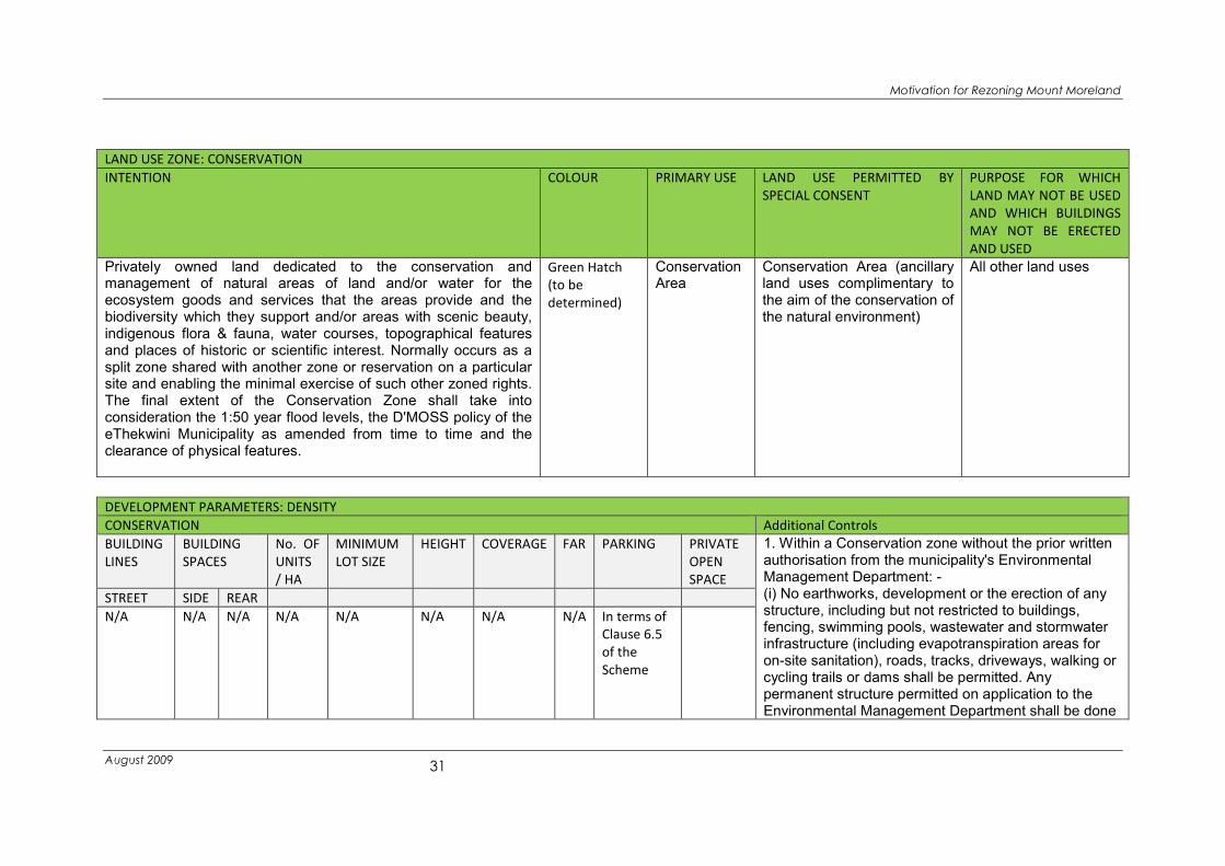
LAND USE ZONE: CONSERVATION
INTENTION COLOUR PRIMARY USE LAND USE PERMITTED BY
SPECIAL CONSENT
PURPOSE FOR WHICH
LAND MAY NOT BE USED
AND WHICH BUILDINGS
MAY NOT BE ERECTED
AND USED
Privately owned land dedicated to the conservation and management of natural areas of land and/or water for the ecosystem goods and services that the areas provide and the biodiversity which they support and/or areas with scenic beauty, indigenous flora & fauna, water courses, topographical features and places of historic or scientific interest. Normally occurs as a split zone shared with another zone or reservation on a particular site and enabling the minimal exercise of such other zoned rights. The final extent of the Conservation Zone shall take into consideration the 1:50 year flood levels, the D'MOSS policy of the eThekwini Municipality as amended from time to time and the clearance of physical features.
Green Hatch
(to be
determined)
Conservation Area
Conservation Area (ancillary land uses complimentary to the aim of the conservation of the natural environment)
All other land uses
DEVELOPMENT PARAMETERS: DENSITY
CONSERVATION Additional Controls
BUILDING
LINES
BUILDING
SPACES
No. OF
UNITS
/ HA
MINIMUM
LOT SIZE
HEIGHT COVERAGE FAR PARKING PRIVATE
OPEN
SPACE
1. Within a Conservation zone without the prior written authorisation from the municipality's Environmental Management Department: - (i) No earthworks, development or the erection of any structure, including but not restricted to buildings, fencing, swimming pools, wastewater and stormwater infrastructure (including evapotranspiration areas for on-site sanitation), roads, tracks, driveways, walking or cycling trails or dams shall be permitted. Any permanent structure permitted on application to the Environmental Management Department shall be done
STREET SIDE REAR
N/A N/A N/A N/A N/A N/A N/A N/A In terms of
Clause 6.5
of the
Scheme
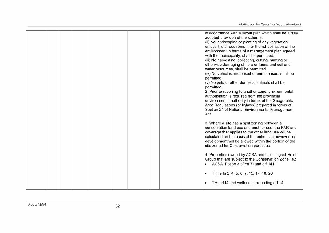
Motivation for Rezoning Mount Moreland
August 2009
32
in accordance with a layout plan which shall be a duly adopted provision of the scheme. (ii) No landscaping or planting of any vegetation, unless it is a requirement for the rehabilitation of the environment in terms of a management plan agreed with the municipality, shall be permitted. (iii) No harvesting, collecting, cutting, hunting or otherwise damaging of flora or fauna and soil and water resources, shall be permitted.. (iv) No vehicles, motorised or unmotorised, shall be permitted. (v) No pets or other domestic animals shall be permitted. 2. Prior to rezoning to another zone, environmental authorisation is required from the provincial environmental authority in terms of the Geographic Area Regulations (or bylaws) prepared in terms of Section 24 of National Environmental Management Act. 3. Where a site has a split zoning between a conservation land use and another use, the FAR and coverage that applies to the other land use will be calculated on the basis of the entire site however no development will be allowed within the portion of the site zoned for Conservation purposes. 4. Properties owned by ACSA and the Tongaat Hulett Group that are subject to the Conservation Zone i.e.:
• ACSA: Potion 3 of erf 71and erf 141
• TH: erfs 2, 4, 5, 6, 7, 15, 17, 18, 20
• TH: erf14 and wetland surrounding erf 14

Motivation for Rezoning Mount Moreland
August 2009
33
• TH: erfs 58, 59, 92
• TH: portions 1 and 2 of erf 27
Being approximately 18 hectares owned by ACSA and 98 hectares owned by the Tongaat Hulett Group shall be acknowledged as areas that may be used as off-sets for the loss of wetlands in other development areas at ratios to be determined.

Motivation for Rezoning Mount Moreland
August 2009
34
Figure 10: Mount Moreland Proposed Heights

Motivation for Rezoning Mount Moreland
August 2009
35
Figure 11: Mount Moreland Proposed FAR

Motivation for Rezoning Mount Moreland
August 2009
36
Figure 12: Mount Moreland Proposed Coverage

Motivation for Rezoning Mount Moreland
August 2009
37
4.3 Access and Traffic Proposals
Currently there is only one access into Mount Moreland. This is a single lane, two way gravel
road which narrows into a single lane bridge that runs over the wetland. This road will not be
able to cope with any increase of traffic into the area.
A traffic impact assessment of the proposed development has been undertaken (Traffic
Impact Assessment for the Proposed Block Rezoning of Mount Moreland, Aurecon July 2009).
Improved access will need to phased in to cater for growth in the area that may result from
the rezoning proposals as illustrated in
Motivation for Rezoning Mount Moreland
August 2009
38
Figure 13.
• Phase 1: Mount Moreland is within 3 kilometres of the Airport Terminal. The ROD for the
airport site requires that ACSA/DTP build a road from Support Precinct 1 to the
boundary of their site. This road will need to be extended, with the permission of
Tongaat-Hulett Development over whose land it passes, to link into the existing road in
Mount Moreland.
• Phase 2: A new link by-passing Mount Moreland should be developed to take airport
traffic around the development rather than through it which would increase traffic
through the area considerably and result in unacceptable service levels. This should
link to the M27 in the first instance and ultimately to a new link from the R102 through
to Cornubia.

Motivation for Rezoning Mount Moreland
August 2009
39
Figure 13: Access Proposals
The traffic impact assessment has indicated that a two way, two lane access to the north
and to the south will be sufficient to cater for ultimate development. Internal to the
settlement the main roads in Mount Moreland (Charles and Bond Streets) will become the
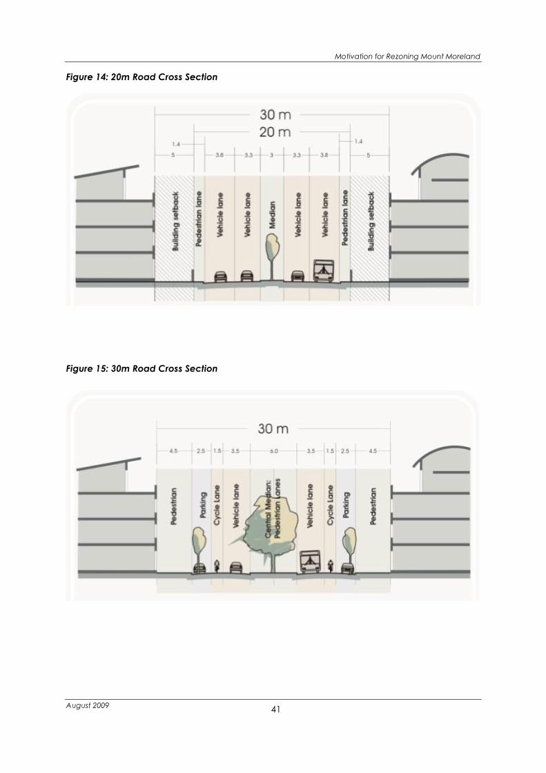
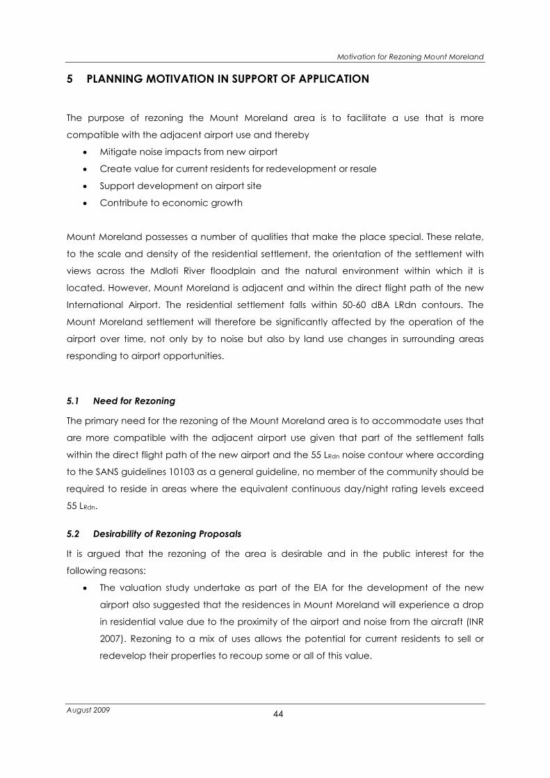
central boulevard of the development. In the shorter term the 20m road reserves can
accommodate 1 or 2 lanes in each direction with a small median and parking along sections
as well as pavements on both sides. As densification of the area occurs this may need to be
widened to 30m to form a High Street. It is therefore proposed that along the High Street
building lines are set at 5m which will then allow a nil building line once the road is widened
creating a pleasing urban framework. Possible cross sections are illustrated in

Motivation for Rezoning Mount Moreland
August 2009
40
Figure 14 and Figure 15.
Motivation for Rezoning Mount Moreland
August 2009
41
Figure 14: 20m Road Cross Section
Figure 15: 30m Road Cross Section

Motivation for Rezoning Mount Moreland
August 2009
42
4.4 Engineering Requirements
See Report for Civil Engineering Services and Infrastructure at Mount Moreland, Virtual
Consulting Engineers, July 2009
• Stormwater
Interventions will need to be taken to ensure that there is no net impact on the
surrounding environment, in particular the adjacent wetlands. It is envisaged that
stormwater management will be undertaken on a development-by-development (if
not site-by-site) basis rather than by provision of major precinct wide infrastructure
(e.g. a stormwater pipe network and single large attenuation pond.) Additional
controls have been included in the zoning tables.
• Water
The eThekwini Municipality’s planning for the Mt Moreland area indicates that in
future the bulk water supply will be from the new Inyaninga reservoir located west of
KSIA. This is initially a 6Ml reservoir, upgradeable in a modular form to 18Ml. This
reservoir will link to Mt Moreland via a new 500mm diameter bulk supply to KSIA.
Included in the reticulation for SP1 north of Mt Moreland is a capped 200mm
diameter Tee which is reserved for a future link to Mt Moreland. As part of the airport
environmental ROD requirements, DTP have committed to extending this 200mm
diameter water main to the edge of their boundary adjacent to Mt Moreland. This
capacity will be sufficient for the ultimate planned development, although the
requirement for a secondary reservoir to cater for peak flows will need to be
assessed. The current reticulation infrastructure will need to be completely replaced
as the new bulk supply will have higher pressures for which it is unlikely that the original
network was designed for. This replacement exercise should take into account the
new town planning scheme to ensure the reticulation network can deliver the
necessary capacity. eThekwini Municipality have an ongoing water network
maintenance programme in which Mt Moreland is included. It is strongly
recommended that instead of simply upgrading the existing infrastructure, the
network should be reconfigured as described above in order to maximise the benefit
of this work.
• Waste Water Drainage
A new bulk sewer pipeline is to be provided by DTP to link a temporary treatment
works on the airport site to the proposed new Umdloti Regional Wastewater
Treatment Works (WWTW). This line will be routed past the eastern edge of Mt
Moreland and will be sized to accommodate future wastewater flows arising from Mt
Moreland. Preliminary design has commenced on this work and the EIA for this is

Motivation for Rezoning Mount Moreland
August 2009
43
scheduled to commence in July 2009. This line will however only be operational once
eThekwini Municipality have completed the new Umdloti WWTW which is expected to
be operational by 2012-2015. Mt Moreland currently has no wastewater reticulation
network. In order to obtain use of the bulk infrastructure, a new sewer network will
have to be constructed. Due to the reasonably low levels of development at present,
retrofitting a network should be reasonably straightforward. As for the water
reticulation, planning of this network should taken into account the future town
planning scheme.
• Electricity
A new 132 kV overhead power line and substation is being constructed on the
northern part of the ACSA site adjacent to the R102. This will feed the airport
development including the support zone. The eThekwini Electricity Department has
confirmed that there is sufficient capacity for either a feed off a substation in the
support zone or a dedicated link from the new large substation. It is also possible (and
may be preferable) to maintain the feed from the Umdloti substation, which
eThekwini Electricity Department have confirmed has sufficient spare capacity at
present.
4.5 Environmental Proposals
See Environmental Assessment of the Proposed Rezoning of Mount Moreland, Institute of
Natural Resources, July 2009
The natural environmental assets that exist in Mount Moreland offer a unique opportunity to
enhance the quality of the built environment and thus form a central component of the
rezoning proposal. An assessment of the environmental assets was undertaken and buffers
identified for wetland, riverine and important habitats. These areas have either been
excluded from development through zoning for Conservation purposes. The environmental
assessment of the zoning proposals has concluded that the zoning proposals are likely to
have a positive impact on the receiving environment as they manage and potentially
impacts that are currently negative (e.g. high e-coli counts in the wetlands due to inefficient
septic tanks) and entrench a management mechanisms within the scheme proposals
(zoning of environmental significant areas to secure non-development into the future).
Motivation for Rezoning Mount Moreland
August 2009
44
5 PLANNING MOTIVATION IN SUPPORT OF APPLICATION
The purpose of rezoning the Mount Moreland area is to facilitate a use that is more
compatible with the adjacent airport use and thereby
• Mitigate noise impacts from new airport
• Create value for current residents for redevelopment or resale
• Support development on airport site
• Contribute to economic growth
Mount Moreland possesses a number of qualities that make the place special. These relate,
to the scale and density of the residential settlement, the orientation of the settlement with
views across the Mdloti River floodplain and the natural environment within which it is
located. However, Mount Moreland is adjacent and within the direct flight path of the new
International Airport. The residential settlement falls within 50-60 dBA LRdn contours. The
Mount Moreland settlement will therefore be significantly affected by the operation of the
airport over time, not only by to noise but also by land use changes in surrounding areas
responding to airport opportunities.
5.1 Need for Rezoning
The primary need for the rezoning of the Mount Moreland area is to accommodate uses that
are more compatible with the adjacent airport use given that part of the settlement falls
within the direct flight path of the new airport and the 55 LRdn noise contour where according
to the SANS guidelines 10103 as a general guideline, no member of the community should be
required to reside in areas where the equivalent continuous day/night rating levels exceed
55 LRdn.
5.2 Desirability of Rezoning Proposals
It is argued that the rezoning of the area is desirable and in the public interest for the
following reasons:
• The valuation study undertake as part of the EIA for the development of the new
airport also suggested that the residences in Mount Moreland will experience a drop
in residential value due to the proximity of the airport and noise from the aircraft (INR
2007). Rezoning to a mix of uses allows the potential for current residents to sell or
redevelop their properties to recoup some or all of this value.
Motivation for Rezoning Mount Moreland
August 2009
45
• The rezoning proposals have taken full account of the environmentally sensitive
nature of the development and the environmental assessment has concluded that
the rezoning of the area and the upgrading of infrastructure that would be required
to service the area will have an overall positive impact on the receiving environment.
• Whilst upgrading and additional services will be required to facilitate development in
terms of the proposed zoning, the infrastructure assessment has concluded that all
services are potentially available to the area.
• The traffic impact assessment concluded that the road network to access Mount
Moreland will be sufficient to accommodate redevelopment in terms of the
proposed zone however, this will require connection to the new road network that is
being proposed for the northern area at a regional scale to accommodate the
development expected in response to the location of the new airport.
• A survey undertaken in 2008 of the Mount Moreland residents as well as interactions in
public meetings indicates that the majority of the residents are in favour of mixed use
development taking place in Mount Moreland. Many of the residents understand the
impact of the airport on their living environment and thus feel that a land use more
compatible with the airport is required.
• There is a likely to be demand for short and medium term accommodation and
hospitality facilities in support of the new international airport. Accommodation both
for passengers (business and leisure) and for those working at the airport (as well as
the pilots and air hostesses who will frequently visit the area) will be required.
• 40 % of residents who responded to the survey have indicated that they wish to stay
in Mount Moreland once the airport is open and have indicated that future
residential development should be allowed in the area. Given that the area will be
impacted on by noise future residential development should only be allowed if sound
mitigation is adequately addressed and clauses have been included in the
additional controls proposed for the Mixed Use Zone to account for this.

Motivation for Rezoning Mount Moreland
August 2009
46
6 CONCLUSION
The proposed rezoning of Mount Moreland to facilitate a mixed use development offers
much opportunity not only for the residents of Mount Moreland, capitalising on the
opportunities offered by the new international airport. Furthermore, whilst infrastructural
upgrades will be needed to facilitate development according to the proposed zoning, the
proposed development will offer increased rates to eThekwini Municipality and value to the
current residents and owners.
It respectfully submitted that it is both needed and desirable in the public interest for teh
Council to approve the following:
1. Rezoning of Mount Moreland to
• Mixed Use Mount Moreland - ezinkonjaneni (Place of the swallows) – A TO E,
• Conservation and
• Undetermined
as per Figure 9: Mount Moreland Proposed Zoning and Table 6 contained in this
report;
2. The amendment of Umhlanga Town Planning Scheme No. 1 in course of preparation
to include the following new Zones to facilitate this rezoning:
• Mixed Use Mount Moreland: ezinkonjaneni (Place of the Swallows) A, B, C, D and
E
• Conservation
3. The Amendment of the Umhlanga Town Planning Scheme No. 1 in course of
preparation to include new land use definitions according to the dictionary of
definitions approved by Council and dated April 2005
4. For the properties listed in Table 3 of this report be to acquired by the Municipality for
Conservation purposes

Motivation for Rezoning Mount Moreland
August 2009
47
ANNEXURE A: RECORD OF COMMUNITY CONSULTATION
REPRESENTATIVE BODY VENUE DATE /TIME
Community Meetings
Mount Moreland Gazebo 2 April 2008
Mount Moreland Gazebo 29 July 2008
Mount Moreland Gazebo 4 February 2009
....August 2009
Residents and Ratepayers
Association and Victoria Lake
Conservancy
Representatives
Mount Moreland Gazebo 18 March 2008
Mount Moreland Gazebo 27 May 2008
Mount Moreland Gazebo 1 July 2008
Mount Moreland Gazebo 29 July 2008
Mount Moreland Gazebo 19 August 2008
Mount Moreland Gazebo 16 September 2008
Mount Moreland Gazebo 14 October 2008
Mount Moreland Gazebo 12 November; 2008
Mount Moreland Gazebo 20 January 2009
Mount Moreland Gazebo 17 February 2009
Mount Moreland Gazebo 17 March 2009
Mount Moreland Gazebo 27 May 2009
Mount Moreland Gazebo 24 June 2009
Mount Moreland Gazebo 28 July 2008 Meetings With Municipality
All service providers invited 3 September 2008
Waste Water and
Environment
5 November 2008
All Service Providers invited 21 January 2009
Framework Planning 18 March 2009
Environment Department 25 May 2009

Motivation for Rezoning Mount Moreland
August 2009
48
ANNEXURE B: PROPOSED ZONING OF EACH ERF

Motivation for Rezoning Mount Moreland
August 2009
49

Motivation for Rezoning Mount Moreland
August 2009
50
Erf
Por-
tion Proposed Zone
Heigh
t Site Area
Cover
age
Floor
area FAR Owner
2
Undetermined/
Conservation 0 151568 0 0 0 Tongaat Hulett
3 1 Undetermined 0 3210 0 0 0 Not registered
3 1 Undetermined 0 3183 0 0 0 Not registered
4 1 Undetermined 0 702 0 0 0 Not registered
4 1 Undetermined 0 686 0 0 0 Not registered
4
Undetermined/
Conservation 0 54616 0 0 0 Julia Ann Kenah
5
Undetermined/
Conservation 0 27653 0 0 0 Not registered
6
Undetermined/
Conservation 0 35741 0 0 0 Tongaat Hulett
7
Undetermined/
Conservation 0 18512 0 0 0 Tongaat Hulett
8 Undetermined 0 14152 0 0 0 Herman Bauer
9 Undetermined 0 13393 0 0 0 Tongaat Hulett
10 Undetermined 0 37142 0 0 0 Multiple Owners
12 Undetermined 0 46532 0 0 0 Tongaat Hulett
14 Conservation 0 27076 0 0 0 Tongaat Hulett
15
Undetermined/
Conservation 0 24185 0 0 0 Not registered
16
Undetermined/
Conservation 0 19695 0 0 0 Multiple Owners
17
Undetermined/
Conservation 0 21105 0 0 0 Tongaat Hulett
18
Undetermined/
Conservation 0 24294 0 0 0 Tongaat Hulett
20
Undetermined/
Conservation 0 26821 0 0 0 Tongaat Hulett
20 Undetermined 0 154292 0 0 0 Tongaat Hulett
22 Mixed Use B 3 2533 40 2533 1 David Barlow
22 1 Mixed Use B 3 1522 40 1522 1 Not registered
23 Mixed Use B 3 1637 40 1637 1 Eugene Eman
24 1 Mixed Use E 2 1331 35 932 0.7 Antonio Reginfo
24 3 Mixed Use E 2 991 35 694 0.7 Antonio Reginfo
24 2 Mixed Use E 2 1712 35 1198 0.7 Antonio Reginfo
25 Mixed Use E 2 4029 35 2820 0.7 Renade Suzanne Bartlett
27 1
Mixed Use E/
Conservation 2 4046 35 2832 0.7 Moreland Development
27 2
Mixed Use E/
Conservation 2 4049 35 2834 0.7 Tongaat Hulett
27 4
Mixed Use E/
Conservation 2 4046 35 2832 0.7 Gerhard Kellerman
28
Mixed Use E/
Conservation 2 4046 35 2832 0.7 Ian Jowett
29 Mixed Use E/ 2 4046 35 2832 0.7 David Charles Barske

Motivation for Rezoning Mount Moreland
August 2009
51
Erf
Por-
tion Proposed Zone
Heigh
t Site Area
Cover
age
Floor
area FAR Owner
Conservation
30
Mixed Use E/
Conservation 2 4083 35 2858 0.7 Jason Prior Pratsch
31 Mixed Use E 2 1330 35 931 0.7 Deborah Ann
31 2 Mixed Use E 2 1303 35 912 0.7 Not registered
31 1 Mixed Use E 2 1424 35 997 0.7 Not registered
32
Mixed Use E
2 4004 35 2803 0.7
Ann Bernce Clarabel
Bolleurs
33 Mixed Use B 3 2120 40 2120 1 Joy Therese Spencer
33 Mixed Use A 4 967 40 967 1 Joy Therese Spencer
33 1 Mixed Use A 4 962 40 962 1 Joy Therese Spencer
34 Mixed Use B 3 1934 40 1934 1 Susanna Christina Gabe
34 1 Mixed Use A 4 2113 40 2113 1 Andre Deon Buys
36
Mixed Use E
2 4047 35 2833 0.7
Charlene Vivienne
Baxendale
37 Mixed Use E 2 4048 35 2834 0.7 Bruce Alfred Jones
38 1 Mixed Use E 2 3237 35 2266 0.7 Bruce Alfred Jones
38 2 Mixed Use E 2 679 35 475 0.7 Kim Giraudeaux
38 Mixed Use E 2 1125 35 788 0.7 David Clifford Blakemore
38 7
Mixed Use E
2 1119 35 783 0.7
Casparus Johannes
Reynhardt Nel
38 4
Mixed Use E
2 1101 35 771 0.7
Theminkosi Peter
Nxumalo
38 5 Mixed Use E 2 904 35 633 0.7 Tervor Milton haigh
38 6 Mixed Use E 2 900 35 630 0.7 Christopher William Kew
38 3 Mixed Use E 2 902 35 631 0.7 Hayley Esteves
38 2 Mixed Use E 2 552 35 386 0.7 Kim Giraudeaux
39 Mixed Use E 2 4043 35 2830 0.7 Richard Joe Venning
40 1 Mixed Use A 4 2030 40 2030 1 Annamarie Du Plessis
40 2 Mixed Use A 4 934 40 934 1 Jason Prior Pratsch
40 Mixed Use A 4 1088 40 1088 1 Chris Robert Hattingh
43 1 Mixed Use E 2 4053 35 2837 0.7 Richard John Gaylord
43 2 Mixed Use E 2 4047 35 2833 0.7 Richard John Gaylord
44 Mixed Use E 2 4046 35 2832 0.7 Richard John Gaylord
45
Mixed Use E/
Conservation 2 4046 35 2832 0.7 Richard John Gaylord
46
Mixed Use B/
Conservation 3 4047 40 4047 1 Robin Arthur Johnson
47 Mixed Use A 4 4047 40 4047 1 Dawn Linda Bauer
48 Mixed Use A 4 4047 40 4047 1 Jolene Breytenbach
49 Mixed Use A 4 4048 40 4048 1 Frances Denise Hall
50 Mixed Use A 4 2200 40 2200 1 Darren Bowler
50 1 Mixed Use A 4 1847 40 1847 1 Darren Bowler
51 Mixed Use E 2 4046 35 2832 0.7 Anthony Abel Gounden
52 Conservation 2 3236 35 2265 0.7 Pierre Jevon

Motivation for Rezoning Mount Moreland
August 2009
52
Erf
Por-
tion Proposed Zone
Heigh
t Site Area
Cover
age
Floor
area FAR Owner
53 Conservation 0 4887 0 0 0.7 Eugene Maree
54 Conservation 0 6413 0 0 0.7 Tongaat Hulett
55 Mixed Use E 2 4046 35 2832 0.7 Sarah Ann Everitt
56
Mixed Use E/
Conservation 2 2064 35 1445 0.7
Zululand Sugar Miller
Limited
56
Mixed Use E/
Conservation 2 1983 35 1388 0.7
Zululand Suger Miller
Limited
57
Mixed Use E/
Conservation 2 4047 35 2833 0.7 Sandra Beverley le Roux
58
Mixed Use E/
Conservation 2 4047 35 2833 0.7 Tongaat Hulett
59
Mixed Use E/
Conservation 2 4047 35 2833 0.7 Tongaat Hulett
60
Mixed Use E/
Conservation 2 4050 35 2835 0.7 Kenneth Brett Matthew
65 Mixed Use A 4 4031 40 4031 1 Glenn William Evans
66 Mixed Use A 4 4047 40 4047 1
Antonio Julio da Silva
Mendonca
67 Mixed Use A 4 4062 40 4062 1
Elizabeth Suzanna
Mostert
68 Mixed Use E 2 4047 35 2833 0.7 Dirk Jacobus Mostert
69
Mixed Use E/
Conservation 2 4094 35 2866 0.7 Mark Milne Gilroy
70
Mixed Use E/
Conservation 2 4047 35 2833 0.7 Kumlucky Farm
71 3 Conservation 2 7459 35 5221 0.7 ACSA
71 2
Mixed Use E/
Conservation 2 4392 35 3074 0.7 Brett Frederick Wilkinson
71
Mixed Use E/
Conservation 2 5066 35 3546 0.7 Prudence Borlase
71 1
Mixed Use E/
Conservation 2 6135 35 4294 0.7 Prudence Barlase
77 Mixed Use E 2 4041 35 2829 0.7 Willem Francois Marais
78 Mixed Use E 2 4048 35 2834 0.7 Sandra Ann Hammond
79
Mixed Use E/
Conservation 2 3960 35 2772 0.7 Brett Frederick Wilkinson
80
Mixed Use E/
Conservation 2 4122 35 2885 0.7 Warren Yunnie
81 1 Mixed Use E 2 1562 35 1093 0.7 Kirsten Carol Cunningham
81 2 Mixed Use E 2 1289 35 902 0.7 Raymond John Bray Lyle
81 Mixed Use E 2 1414 35 990 0.7 Ray van der Poll
82
Mixed Use E/
Conservation 2 4293 35 3005 0.7 Ray van der Poll
83
Mixed Use E
2 4046 35 2832 0.7
Delive Kristina Eleonora
Baker-Duly
84
Mixed Use B/
Conservation 3 4047 40 4047 1 Gerald Allan Beales
85
Mixed Use B/
Conservation 3 4047 40 4047 1 Merlindren Govender

Motivation for Rezoning Mount Moreland
August 2009
53
Erf
Por-
tion Proposed Zone
Heigh
t Site Area
Cover
age
Floor
area FAR Owner
86
Mixed Use B/
Conservation 3 4046 40 4046 1 Colin Bentleey
87 3 Conservation 2 3345 35 2342 0.7 George Herbert Rossiter
87 2 Conservation 2 2820 35 1974 0.7 George Herbert Rossiter
87 1 Mixed Use E 2 915 35 640 0.7 George Herbert Rossiter
88
Mixed Use E
2 2018 35 1413 0.7
Martha Magdalena van
Wyk
88 1 Mixed Use E 2 2024 35 1417 0.7 George herbert Rossiter
89 Mixed Use A 4 4046 40 4046 1 Neville Filton-Taylor
90 Mixed Use A 4 4047 40 4046 1
Louis Marie Ignace Marc
Koenig
91
Mixed Use B/
Conservation 3 2188 40 2188 1
Rusell McKenzi Currie
Brayshaw
91
Mixed Use B/
Conservation 3 1858 40 1858 1 Russell Brayshaw
92
Mixed Use B/
Conservation 3 2190 40 2190 1 Tongaat Hulett
92
Mixed Use B/
Conservation 3 1856 40 1856 1 Tongaat Hulett
93
Mixed Use B/
Conservation 3 4047 40 4047 1
Bernhard Meil Josef
Manock
94
Mixed Use E/
Conservation 2 2063 35 1444 0.7 Kumlucky Farm
94
Mixed Use E/
Conservation 2 1983 35 1388 0.7 Kumlucky Farm
95
Mixed Use E/
Conservation 2 4046 35 2832 0.7 Masinga Family Trust
96
Mixed Use E/
Conservation 2 4047 35 2833 0.7 Masinga Family Trust
97 Conservation 0 2190 0 0 0 Tongaat Hulett
98 Conservation 2 4051 35 2836 0.7 Tongaat Hulett
100 Mixed Use E 2 2855 35 1998 0.7 Angela Wilkin
101 Mixed Use E 2 3111 35 2178 0.7 Sarah June Amozig
105
Mixed Use E
2 2030 35 1421 0.7
Mount Moreland
Proprietary Limited
106 Mixed Use E 2 2037 35 1426 0.7 Aniello Di Matteo
107 Mixed Use E 2 2038 35 1427 0.7 Craig David Boulle
108 Mixed Use E 2 2037 35 1426 0.7 Pierre Mathe Jevon
109 Mixed Use E 2 1105 35 774 0.7 Tongaat Hulett
109 Mixed Use E 2 959 35 671 0.7 Tongaat Hulett
110 3 Mixed Use E 2 1597 35 1118 0.7 Gordon Killin Johnston
110 2 Mixed Use E 2 1035 35 724 0.7 Gordon Killin Johnston
110 Mixed Use E 2 2016 35 1411 0.7 Douglas Keith Diesel
111 2 Mixed Use E 2 1308 35 916 0.7 Neville Anthony Zammit
111 3 Mixed Use E 2 1004 35 703 0.7 Edwin Lawrence Forbes
111 1 Mixed Use E 2 2026 35 1418 0.7 Arnold Stanley Bosman
111 4 Mixed Use E 2 2657 35 1860 0.7 Not registered

Motivation for Rezoning Mount Moreland
August 2009
54
Erf
Por-
tion Proposed Zone
Heigh
t Site Area
Cover
age
Floor
area FAR Owner
112 Mixed Use E 2 2024 35 1417 0.7 Sandra Beverley Le Roux
113 Mixed Use B 3 1741 40 1741 1 Tongaat Hulett
114 Mixed Use B 3 2804 40 2084 1 Tongaat Hulett
115 Mixed Use B 3 1380 40 1380 1 Tongaat Hulett
116 Mixed Use B 3 1000 40 1000 1
Daniel Coenraad
Rademeyer
117 Mixed Use B 3 1439 40 1439 1 Runtham Govender
118 Mixed Use E 2 1701 35 1191 0.7 Lesley Ray Raubenheimer
119 Mixed Use E 2 1701 35 1191 0.7 Norman Harold Symonds
120
Mixed Use E
2 1701 35 1191 0.7
Donovan Stephen
Mcloughlin
122 Mixed Use B 3 1701 40 1701 1 Manuel Franco
123 Mixed Use B 3 1701 40 1701 1 Jakob van Kiftrik
124 Mixed Use B 3 1702 40 1702 1 Tongaat Hulett
125 Mixed Use B 3 1778 40 1778 1 Richard John Gaylord
125 Mixed Use B 3 1625 40 1625 1 Edward John Vickers
126 Mixed Use E 2 1702 35 1191 0.7 Edward john Vickers
127 1
Mixed Use E
2 1382 35 967 0.7
Allistair Patrick Dendy
Starke
127
Mixed Use E
2 1951 35 1366 0.7
Preben Hegelund
Kristensen
128 Mixed Use E 2 1669 35 1168 0.7 Sherleen Claire Llewellin
129 Mixed Use E 2 1701 35 1191 0.7 Kunlucky Farm
130
Mixed Use E
2 1065 35 746 0.7
Ruthman Rangasamy
Govender
130 Mixed Use E 2 958 35 671 0.7 Keith Doyle
131 Mixed Use D 3 1690 20 1014 0.6 Tongaat Hulett
132 Mixed Use D 0 1690 0 0 0 Tongaat Hulett
133 Mixed Use D 0 1666 0 0 0 Kumlucky Farm
134
Mixed Use B/
Conservation 3 1684 40 1684 1 Adrian Michael Smith
135
Mixed Use B/
Conservation 3 893 40 893 1 Annamarie du plessis
135
Mixed Use B/
Conservation 3 791 40 791 1 Annamarie du Plessis
136
Mixed Use B/
Conservation 3 1684 40 1684 1 Neil John Rens
137
Mixed Use E/
Conservation 2 1684 35 1179 0.7 William John Pottinger
138
Mixed Use E/
Conservation 2 1684 35 1179 0.7 Wayne Pontus
139
Mixed Use E/
Conservation 2 1684 35 1179 0.7 Warren Yunie
140
Mixed Use E/
Conservation 2 1701 35 1191 0.7 Roy Anthony Sember
141 Conservation 0 173316 0 0 0 Not Registered
143 Mixed Use E 2 3622 35 2535 0.7 Hendrick Marthinus

Motivation for Rezoning Mount Moreland
August 2009
55
Erf
Por-
tion Proposed Zone
Heigh
t Site Area
Cover
age
Floor
area FAR Owner
Wilken
144
Mixed Use E/
Conservation 2 4088 35 2862 0.7 Moreland Gardens
144
Mixed Use E/
Conservation 2 4061 35 2843 0.7 Moreland Gardens
144
Mixed Use E/
Conservation 2 4014 35 2810 0.7 Moreland Gardens
144
Mixed Use E/
Conservation 2 4059 35 2841 0.7 Moreland Gardens
145 Mixed Use A 4 2332 40 2332 1 Uvongo Prop Limited
145 Mixed Use A 4 1776 40 1776 1 Uvongo Prop Limited
145 Mixed Use A 4 2253 40 2253 1 Uvongo Prop Limited
145 Mixed Use A 4 1612 40 1612 1 Uvongo Prop Limited
145 Mixed Use A 4 2036 40 2036 1 Uvongo Prop Limited
145 Mixed Use A 4 2132 40 2132 1 Uvongo Prop Limited
Conservation 0 310937 0 0 0
Undetermined 0 6493 0 0 0
Mixed Use D 3 5771 20 3463 0.6
Mixed Use C 4 16192 20 12954 0.8
Motivation for Rezoning Mount Moreland
August 2009
56
ANNEXURE C: LIST OF TITLE DEEDS AND S.G. DIAGRAMS
ERF/LOT Building on site SV/SG Number Title Owner
2 SG 280/851 T1331/90 Tongaat-Hulett Group Limited
4 T25679 Julia Ann Kenah
5 Does not exist Not Registered
6
T3832/199
0 Tongaat-Hullett Group Limited
7 T3826/90 Tongaat-Hullett Group Limited
8
T1983/198
4 Herman Bauer
9
T1332/199
0 Tongaat-Hullett Group Limited
10 T162/876 Multiple Owners- See title deeds
12 T4833/90 Tongaat-Hullett Group Limited
13 T600/851 Multiple Owners- See title deeds
14 T3829/90 Tongaat- Hullett Group Limited
15 Not Registered
16 SG 12459/935 Multiple Owners- See title deeds
17 T1333/90 Tongaat- Hullett Group Limited
18 T4831/90 Tongaat- Hullett Group Limited
19 SV25/107 T4836/90
The Tongaat-Hulett Group
Limited
20 SV25F106 T3833/90 Tongaat -Hulett Group Limited
20 SV25F106 T3829/90 Tongaat -Hulett Group Limited
22 Yes SV11/72 T0417179 David Barlow
23 Yes SV38F17 T40558/95 Eugene Eman
25 SV11/60A T0517935 Renade Suzanne Bartlett
26 Yes- see subs T11396/96 Gerhard Kellerman
28 Yes SV11/65 T7276790 Ian Jowett
29 Yes SV11/66 T26061/90 David Charles Barske
30 SV11/67
T001581/0
7 Jason Prior Pratsch
31 Yes SV11/69 T0448185 Deborah Ann
32 SV11/71 T 31184/93 Ann Bernice Clarabel Bolleurs
33 Yes SV11F73 T15871/92 Joy Therese Spencer
34 Yes SV11/74 T0616308 Susanna Christina Grabe
36 Yes SV 11/ 76 T 31904/94 Charlene Vivienne Baxendale
37 Yes SR 1605/1974 T04092/03 Bruce Alfred Jones
38 Yes SG1605/1974 T0437066 David Clifford Blakemore
39 SV11/77
T00002255
6/2001 Richard Joe Venning
40 Yes SV11/81
T00000543
7/2002 Chris Robert Hattingh
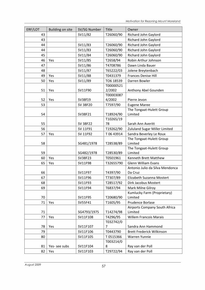
Motivation for Rezoning Mount Moreland
August 2009
57
ERF/LOT Building on site SV/SG Number Title Owner
43 SV11/82 T26060/90 Richard John Gaylord
43 Richard John Gaylord
44 SV11/83 T26060/90 Richard John Gaylord
44 SV11/83 T26060/90 Richard John Gaylord
45 SV11/84 T26060/90 Richard John Gaylord
46 Yes SV11/85 T2658/94 Robin Arthur Johnson
47 SV11/86 T4708786 Dawn Linda Bauer
48 SV11/87 T65222/03 Jolene Breytenbach
49 Yes SV11/88 T0431379 Frances Denise Hill
50 Yes SV11/89 TO6 18539 Darren Bowler
51 Yes SV11F90
T00000521
2/2002 Anthony Abel Gounden
52 Yes SV38f19
T00003087
4/2002 Pierre Jevon
53 SV 38F20 T7597/90 Eugene Maree
54 SV38F21 T18924/90
The Tongaat-Hulett Group
Limited
55 SV 38F22
T10265/19
78 Sarah Ann Averitt
56 SV 11F91 T19262/90 Zululand Sugar Miller Limited
57 Yes SV 11F92 T 06 43914 Sandra Beverley Le Roux
58 SG481/1978 T28538/89
The Tongaat-Hulett Group
Limited
59 SG482/1978 T28530/89
The Tongaat-Hulett Group
Limited
60 Yes SV38F23 T0501961 Kenneth Brett Matthew
65 Yes SV11F98 T32655790 Glenn William Evans
66 SV11F97 T4397/90
Antonio Julio da Silva Mendonca
Da Cruz
67 SV11F96 T7307/89 Elizabeth Suzanna Mostert
68 SV11F93 T28517/92 Dirk Jacobus Mostert
69 SV11F94 T6837/94 Mark Milne Gilroy
70 SV11F95 T20680/90
Kumlucky Farm (Proprietary)
Limited
71 Yes SV55F41 T1605/95 Prudence Borlase
71 SG4793/1975 T14274/98
Airports Company South Africa
Limited
77 Yes SV11F108 T4296/95 Willem Francois Marais
78 Yes SV11F107
T032742/0
7 Sandra Ann Hammond
79 SV11F106 T0443790 Brett Frederick Wilkinson
80 SV11F105 T 0515366 Warren Yunnie
81 Yes- see subs SV11F104
T003214/0
8 Ray van der Poll
82 Yes SV11F103 T29722/94 Ray van der Poll

Motivation for Rezoning Mount Moreland
August 2009
58
ERF/LOT Building on site SV/SG Number Title Owner
83 Yes SV 11f102
T00002547
2/2000
Delive Kristina Eleonora Baker-
Duly
84 Yes SV11F101 T13152791 Gerald Allan Beales
85 SV11F100 T 34567/95 Merlindren Govender
86 SV11F99 T06 46822 Colin Bentley
87
T003548/0
7 Amarnath Misra
88 Yes SV11F119 T22746/86 Martha Magdalena van Wyk
89 SV11F111
T11172/19
84 Neville Filton-Taylor
90 SV11F112
T31259/19
83 Loius Marie Ignace Marc Koenig
91 Yes SV11F113
T24411/19
81 Russell McKenzi Currie Brayshaw
92 SV11F114 T18498/90 Tongaat Properties (Pty)Limited
93 SV11F113
T2340/198
0 Bernhard Meil Josef Manock
94 SV11F116 T18706/90
Kumlucky Farm (Proprietary)
Limited
95 SV11F117
T00000898
9/2002 Masinga Family Trust
96 Yes Masinga Family Trust
97 SV38F32 T18497/90 Tongaat-Hulett Sugar Limited
98 SV38F33 T19261/90 Tongaat-Hulett Sugar Limited
100 Yes SV38F37 T28518/92 Angela Wilkin
101 Yes SV 38F36 T31460/90 Sarah June Amozig
105 SV11F121
T18336/19
73
Mount Moreland (Proprietary)
Limited
106 Yes SV17F239 T3524/91 Aniello Di Matteo
107 Yes SV38F43 T4841/92 Craig David Boulle
108 Yes SV38F42 T1123/89 Pierre Matthe Jevon
109 SG 483/1978 T28531/89 Tongaat-Hulett Group Limited
110 Yes SV38F41 T05 02978 Douglas Keith Deisel
112 Yes SV38F39 T04 62679 Sandra Beverley Le Roux
113 SG485/1978 T28533/89
The Tongaat-Hulett Group
Limited
114 SG 484/1978 T28532/89 Tongaat-Hulett Group Limited
115 SG 486/1978 T28534/89 Tongaat-Hulett Group Limited
116 Yes SV38F44 T0558861 Daniel Coenraad Rademeyer
117 Yes Tt36360/03 Runtham Rangasamy Govender
118 Yes SV38F51 T0451488 Lesley Ray Raubenheimer
118 4459/1935 Chetty Family
119 Yes SV38F50
T10568/19
24 Norman Harold Symomds
120 SV38F49 T04 43383 Donovan Stephen McLoughlin

Motivation for Rezoning Mount Moreland
August 2009
59
ERF/LOT Building on site SV/SG Number Title Owner
122 Yes SV17F222
T045715/2
003 Manuel Franco
123 Yes SV38F48 T3511/95 Jakob van Niftrik
124 SG 487/1978 T28537/89 Tongaat-Hulett Group Limited
125 SV38F47 T35626/03 Edward John Vickers
126 Yes SV 38F46 T32310/89 Edward John Vickers
127 Yes SV38F45 T6944/92 Preben Hegelund Kristensen
128 Yes SV17F237 T27526/89 Sherleen Claire Llewellin
129 SV38F52 T23127/90
Kumlucky Farm (Proprietary)
Limited
130 yes SV 11F122 T5152/94 Keith Doyle
130 Yes SV11F122 T36360/03 Ruthnam Rangasamy Govender
131 SG 488/1978 T28536/89 Tongaat-Hulett Group Limited
132 SG489/1978 T28535/89
The Tongaat-Hulett Group
Limited
133 SV17F238 T18707/90
Kumlucky Farm (Proprietary)
Limited
134 Yes SV38F53 T59440/06 Adrian Michael Smith
135 Yes SV30F145 T0608600 Annamarie du Plessis
136 Yes SV25F212 T18105/91 Neil John Rens
137 SV17F231 T26616/95 William John Pillinger
138 Yes SV 38F54 T13773/96 Wayne Pontus
139 Yes SV38F55 T0507199 Warren Yunnie
140 Yes SV38F56 T31609/93 Roy Anthony Sember
141 Not Registered
143 Yes SG3932/1995 T0417082 Hendrik Marthinus Wilken
144 Yes T11396/96 Moreland Gardens
145 Yes SG 1731/1996 T22524/96 Uvongo (Proprietary) Limited
210 Sub G 8652/1964 Multiple Owners- See title deeds
210 Sub G 8653/1964 Multiple Owners- See title deeds
210 Sub G 8653/194 Multiple Owners- See title deeds
144B SERVITUDE T19497/93 Canelands Trust
4 of 111
Pipeline
Servitude SG 649/1956 16436/69
PORTION 1
OF 87 Yes SG1654/1997 T8235/92 George Herbert Rossiter
PORTION 2
OF 87 SG1655/1997 George Herbert Rossiter
PORTION 3
OF 87 SG1656/1997 George Herbert Rossiter
Servitude SG 709/1958
T2510/193
4
sub 1 of
127 SG232/1993
T011867/0
8 Allister Patrick Dendy Starke

Motivation for Rezoning Mount Moreland
August 2009
60
ERF/LOT Building on site SV/SG Number Title Owner
SUB 1 OF
111 Yes SV74F5
T9699/198
3 Arnold Stanley Bosman
Sub 1 OF 22 Not Registered
SUB 1 OF
24 Yes SG68/1996 T11783/96 Antonio Reginfo
Sub 1 of 27 T480/884 Moreland Development PTY LTD
Sub 1 of 31 Not registered
SUB 1 OF
34 Yes SG1425/1995 T19177/97 Andre Deon Buys
SUB 1 OF
34 Yes SG 1425/1995 T19177/97 Andre Deon Buys
SUB 1 OF
38 Yes SV212/30 T06424/03 Bruce Alfred Jones
Sub 1 of 40 Yes SV11/123
T020129/0
7 Annamarie du Plessis
SUB 1 OF
50 SG 4099/1995 T8390/96
Baptist Bible Fellowship
International of South Africa
Sub 1 of 81 Yes SG2842/1992 T0447763 Kirsten Carol Cunningham
SUB 1 OF
88 SV581/79 T22747/86 George Herbert Rossiter
SUB 1 OF
LOT 24 Yes SG 68/1996 T11783/96 Antonio Reginfo
SUB 1 of lot
27
Consolidate
d with 144
SUB 2 OF
110 SG137/1996 T66561/02 Gordon Killin Johnston
Sub 2 of
111 Yes SV674F58 T5903/88 Neville Anthony Zammit
SUB 2 OF
24 SG 69/199 T1790/91 Parlay Project CC
Sub 2 of 27 T18496/90 Tongaat Hullett Group Limited
Sub 2 of 31 Not Registered
SUB 2 OF
38 Yes SV212/31 T05 04262 Kim Giraudeaux
Sub 2 of 40 Yes SG2448/1993
T001581/0
7 Jason Prior Pratsch
SUB 2 OF
71 SV55F42 T25341/88 Brett Frederick Wilkinson
SUB 2 OF
81 Yes SG2843/1992 T36286/95 Raymond John Bray Lyle
SUB 3 OF
110 SG138/1996 T66561/02 Gordon Killin Johnston
sub 3 of
111 Yes SV674F58 T30959791 Edwin Lawrence Forbes
SUB 3 OF Yes SG 3645/1993 T0460006 Hayley Esteves

Motivation for Rezoning Mount Moreland
August 2009
61
ERF/LOT Building on site SV/SG Number Title Owner
38
SUB 321 of
1000 SV38F108 T28539/89 Tongaat-Hulett Group Limited
Sub 4 of 27 T35/888 Gerhard Kellerman
SUB 4 of 38 Yes SG 3646/1993 T6525/97 Theminkosi Peter Nxumalo
Sub 5 of38 SG 3647/1993 T 0611602 John Trevor Milton Haigh
Sub 6 of 38 SG3648/1993 T0611601 Christopher William Kew
Sub 7 of 38 SG 3649/1993 T06 11600 Casparus Johannes Reynhardt Nel
ERF not
given
T1983/198
4 Herman Bauer
ERF not
given
T25679/19
92 Julia Ann Kenah
Subs of 26 Consolidated with
144