DRAFT MEMORANDUM OF AGREEMENT FOR ... the adverse effect will be resolved, they shall execute an...
24
North Metro Final Environmental Impact Statement – Memorandum of Agreement 1 DRAFT MEMORANDUM OF AGREEMENT FOR RECOVERY OF SIGNIFICANT INFORMATION FROM HISTORIC PROPERTIES ASSOCIATED WITH THE NORTH METRO CORRIDOR PREFERRED ALTERNATIVE IMPACTS TO: 5AM2111: QUIMBY RAILROAD STOP 5AM2114: EASTLAKE RAILROAD STOP 5AM2158: 124 TH AVENUE FARMSTEAD The Parties to this Memorandum of Agreement (MOA) are the Federal Transit Administration (FTA); the Advisory Council on Historic Preservation (ACHP); the Colorado State Historic Preservation Officer (SHPO); and the Denver Regional Transportation District (RTD), a regional transit authority organized and existing under the laws of the State of Colorado. WHEREAS, Section 106 of the National Historic Preservation Act (NHPA, 16 U.S.C. 470 et seq.) requires any federal agency having direct or indirect jurisdiction over a proposed Federal or federally assisted undertaking to take into account the effect of the undertaking on historic properties and afford the ACHP a reasonable opportunity to comment on such undertaking; and WHEREAS, the proposed federally assisted undertaking is the construction and operation of the North Metro Corridor (the Project), for which the National Environmental Policy Act (NEPA) process is currently underway; and WHEREAS, the Project consists of the construction of an electric multiple unit (EMU) commuter rail line on single-track with passing track. Beginning near Denver Union Station, the Project alignment is east of the BNSF Railway mainline (Brush Subdivision) to a point where it crosses over the BNSF Railway and is adjacent to the O’Brian Canal (Burlington Ditch) to approximately 70 th Avenue where it connects with the UP Boulder Branch and continues north, terminating in the 162 nd Avenue area north of State Highway 7. The Project passes through Denver and Adams counties, a distance of approximately 18 miles; and WHEREAS, the FTA has determined that the construction of the North Metro Corridor Project in Denver and Adams counties, Colorado, will have adverse effects on historic properties (5AM2111, 5AM2114, and 5AM2158), which are sites that are included in or determined to be eligible for inclusion in the National Register of Historic Places; and has consulted with the SHPO, consulting parties, and the ACHP pursuant to 36 CFR Part (§) 800, regulations implementing Section 106 of the NHPA (16 U.S.C. § 470f); and WHEREAS, the SHPO is authorized to enter into this MOA in order to fulfill its role of advising and assisting Federal agencies in carrying out their Section 106 responsibilities under the following Federal statutes: Sections 101 and 106 of the NHPA of 1966, as amended; 16 U.S.C. § 470f; and regulations implementing Section 106 at 36 CFR §§ 800.2 (c)(1)(i) and 800.6(b); and WHEREAS, 36 CFR § 800.6 (b)(iv) provides that if the agency official and the SHPO agree on how the adverse effect will be resolved, they shall execute an MOA; and
Transcript of DRAFT MEMORANDUM OF AGREEMENT FOR ... the adverse effect will be resolved, they shall execute an...
North Metro Final Environmental Impact Statement – Memorandum of Agreement 1
DRAFT MEMORANDUM OF AGREEMENT FOR RECOVERY OF SIGNIFICANT INFORMATION FROM HISTORIC PROPERTIES ASSOCIATED WITH THE NORTH METRO CORRIDOR PREFERRED ALTERNATIVE IMPACTS TO:
5AM2111: QUIMBY RAILROAD STOP
5AM2114: EASTLAKE RAILROAD STOP
5AM2158: 124TH AVENUE FARMSTEAD The Parties to this Memorandum of Agreement (MOA) are the Federal Transit Administration (FTA); the Advisory Council on Historic Preservation (ACHP); the Colorado State Historic Preservation Officer (SHPO); and the Denver Regional Transportation District (RTD), a regional transit authority organized and existing under the laws of the State of Colorado. WHEREAS, Section 106 of the National Historic Preservation Act (NHPA, 16 U.S.C. 470 et seq.) requires any federal agency having direct or indirect jurisdiction over a proposed Federal or federally assisted undertaking to take into account the effect of the undertaking on historic properties and afford the ACHP a reasonable opportunity to comment on such undertaking; and WHEREAS, the proposed federally assisted undertaking is the construction and operation of the North Metro Corridor (the Project), for which the National Environmental Policy Act (NEPA) process is currently underway; and WHEREAS, the Project consists of the construction of an electric multiple unit (EMU) commuter rail line on single-track with passing track. Beginning near Denver Union Station, the Project alignment is east of the BNSF Railway mainline (Brush Subdivision) to a point where it crosses over the BNSF Railway and is adjacent to the O’Brian Canal (Burlington Ditch) to approximately 70th Avenue where it connects with the UP Boulder Branch and continues north, terminating in the 162nd Avenue area north of State Highway 7. The Project passes through Denver and Adams counties, a distance of approximately 18 miles; and WHEREAS, the FTA has determined that the construction of the North Metro Corridor Project in Denver and Adams counties, Colorado, will have adverse effects on historic properties (5AM2111, 5AM2114, and 5AM2158), which are sites that are included in or determined to be eligible for inclusion in the National Register of Historic Places; and has consulted with the SHPO, consulting parties, and the ACHP pursuant to 36 CFR Part (§) 800, regulations implementing Section 106 of the NHPA (16 U.S.C. § 470f); and WHEREAS, the SHPO is authorized to enter into this MOA in order to fulfill its role of advising and assisting Federal agencies in carrying out their Section 106 responsibilities under the following Federal statutes: Sections 101 and 106 of the NHPA of 1966, as amended; 16 U.S.C. § 470f; and regulations implementing Section 106 at 36 CFR §§ 800.2 (c)(1)(i) and 800.6(b); and WHEREAS, 36 CFR § 800.6 (b)(iv) provides that if the agency official and the SHPO agree on how the adverse effect will be resolved, they shall execute an MOA; and

2 North Metro Final Environmental Impact Statement – Memorandum of Agreement
WHEREAS, RTD has participated with the FTA and consulting parties, in the consultation with the SHPO and has been invited to concur in the MOA to reflect its commitment to the measures described in the agreement: NOW THEREFORE, FTA, ACHP, SHPO, and RTD hereto agree to a resolution of the adverse effects of the undertaking to be implemented in accordance with the following stipulations:
STIPULATIONS
Adverse Effects
The FTA has determined, in consultation with the SHPO, that the construction of the North Metro Preferred Alternative will have an adverse effect on the following resources:
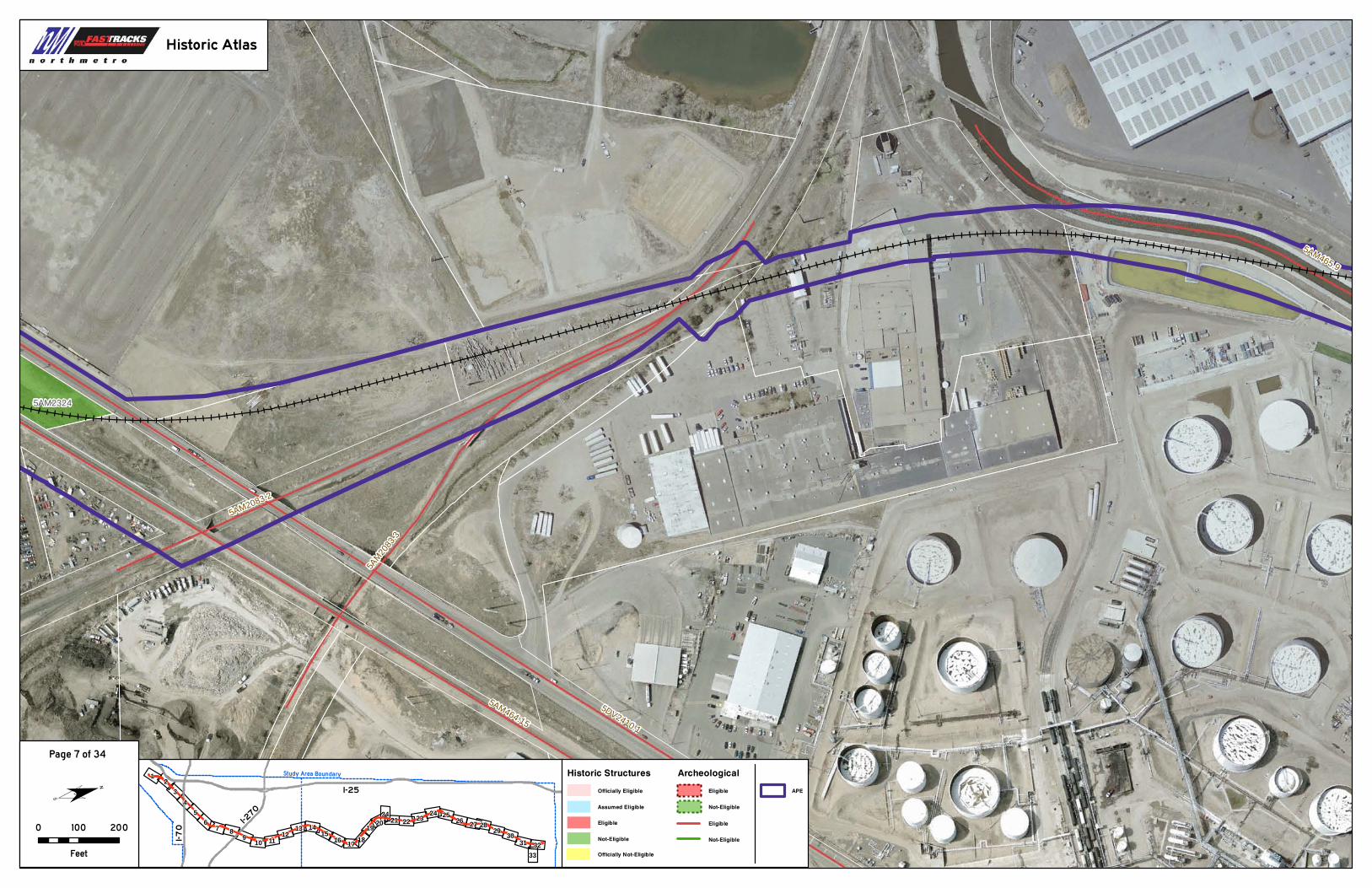
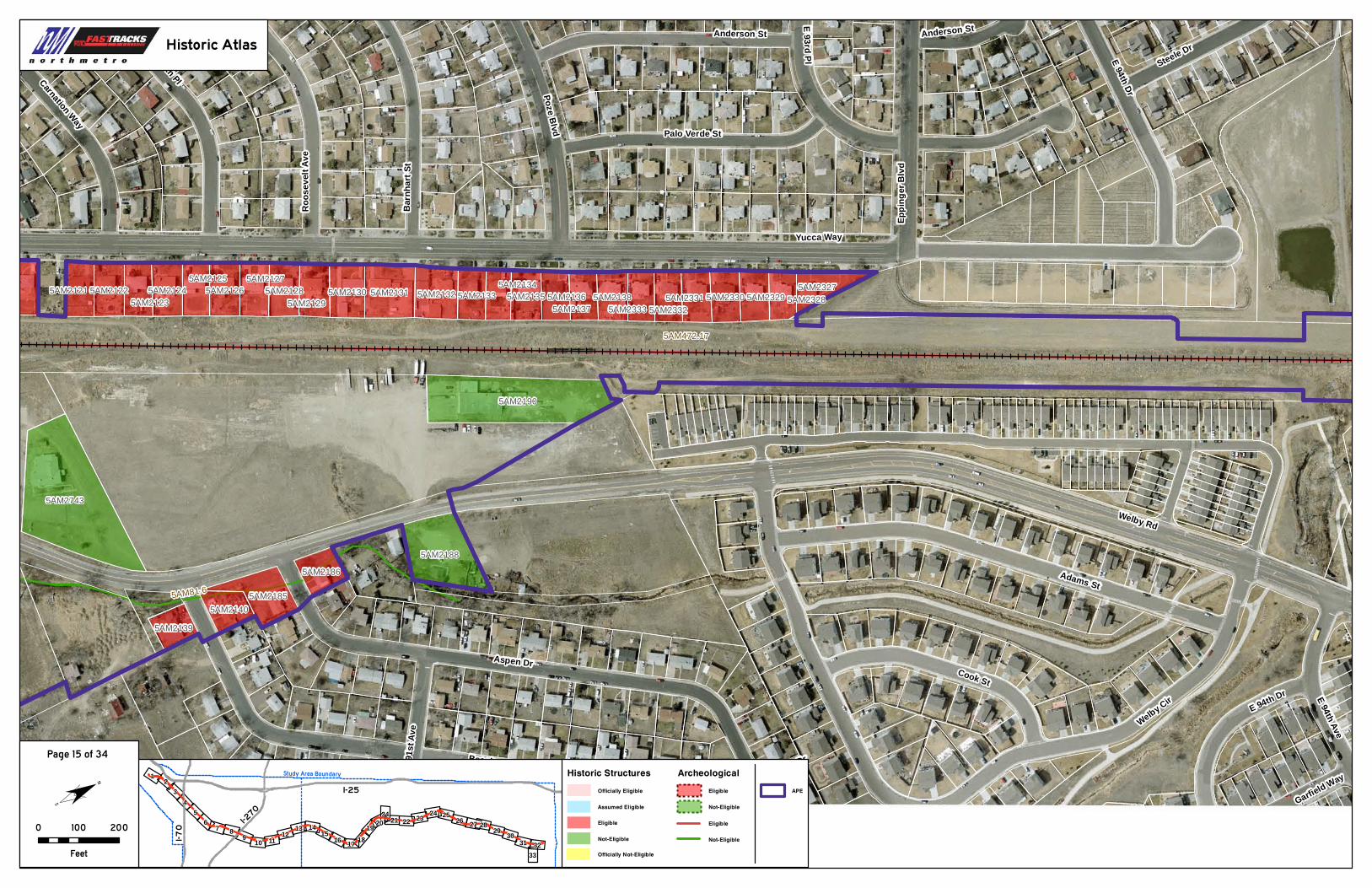
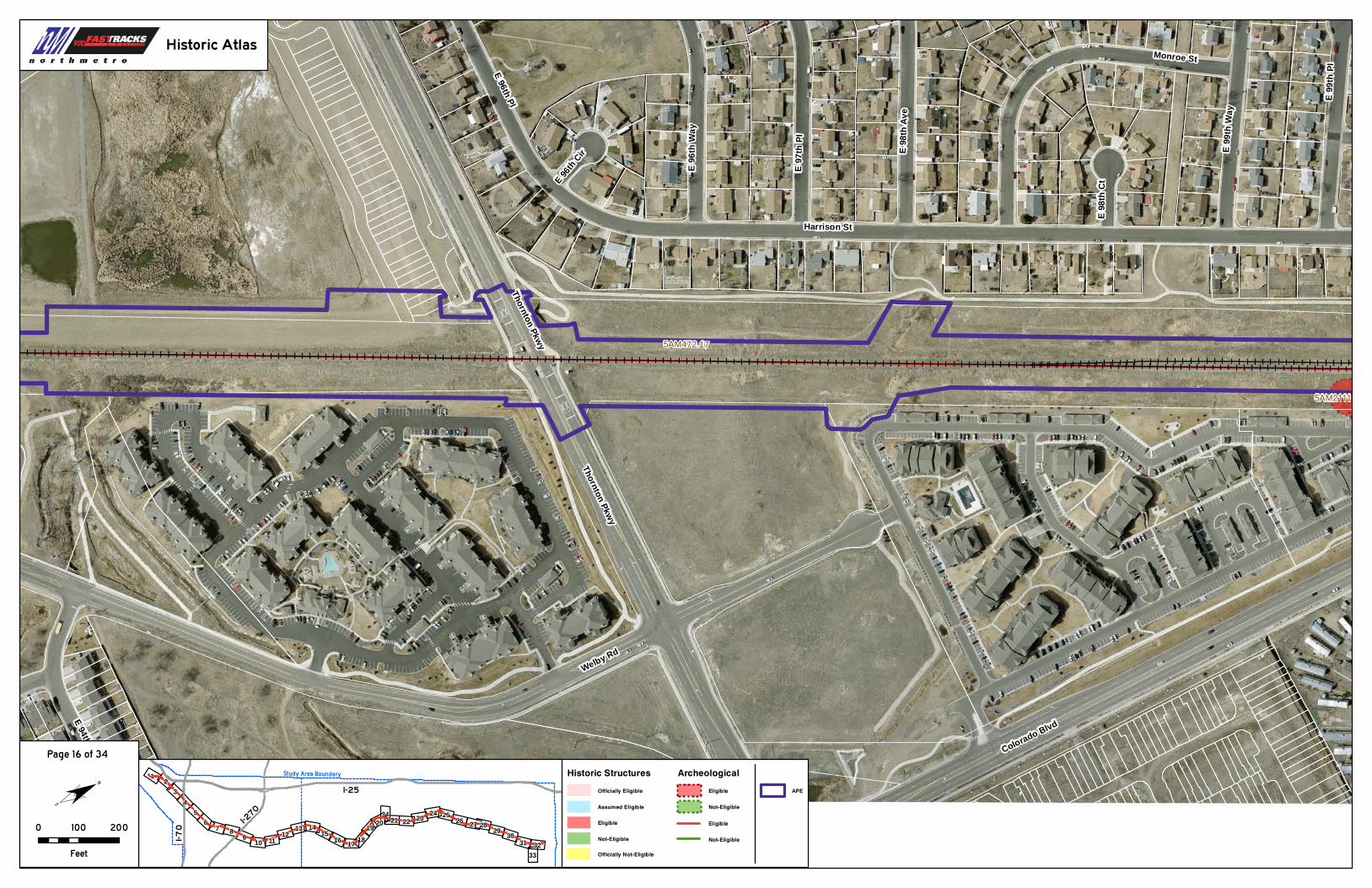
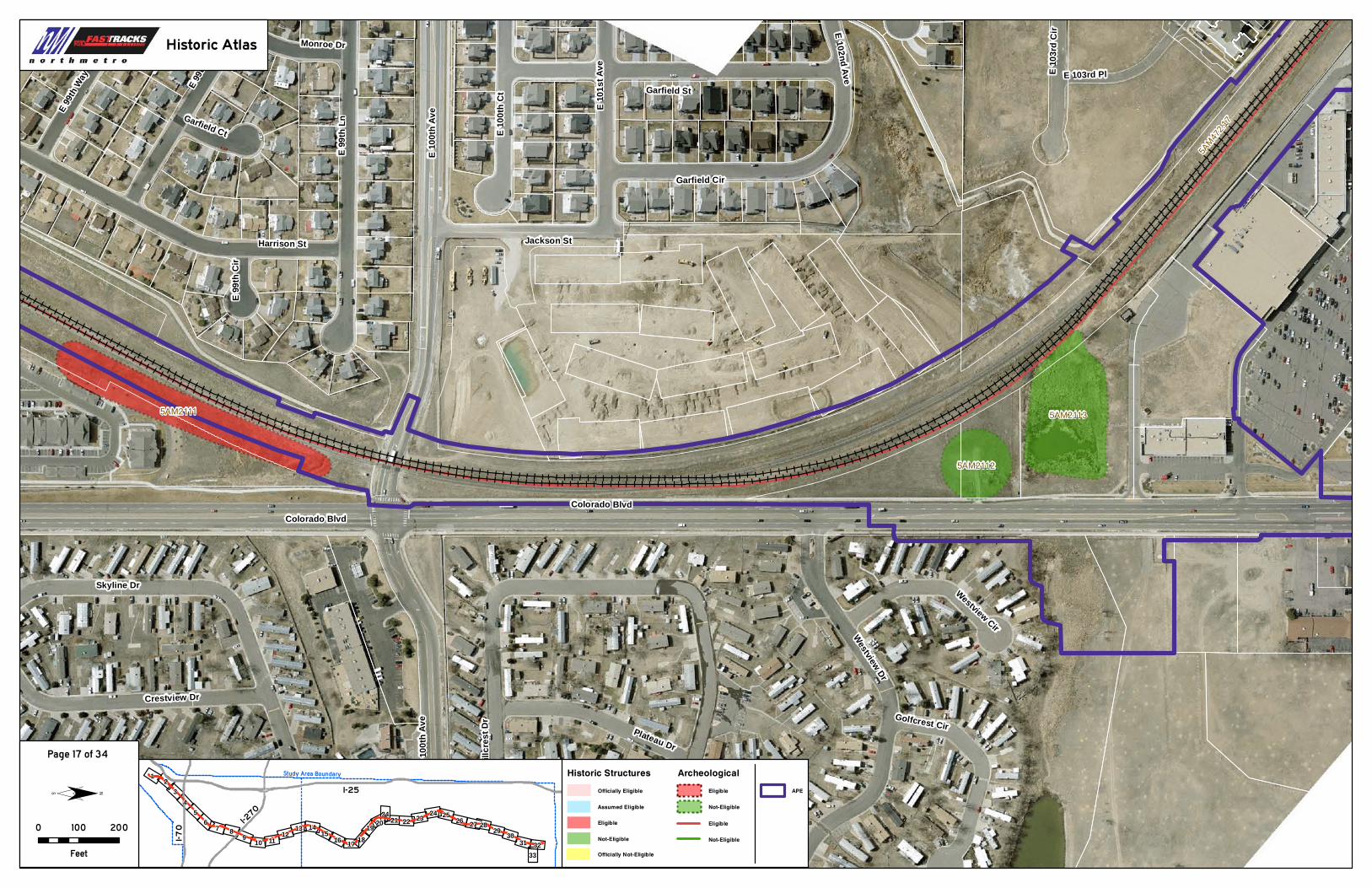
5AM2111: Quimby Railroad Stop – The remains of the Quimby Railroad Stop includes three concentrations of artifacts east of the existing railroad tracks; there is also a small concrete sub-surface vault located south of the artifact concentrations. The Project would shift the track slightly west of the current alignment and add a new passing track on the west adjacent to the site. The Project’s fencing and drainage improvements would impact the site. These improvements would impact one of the artifact concentrations within this site and could impact features and artifact concentrations that have not been identified. This is an adverse effect to the resource.
5AM2114: Eastlake Railroad Stop – The site contains several foundation remnants and historic artifact concentrations on both sides of the existing railroad track and additional sub-surface features and artifact concentrations may be present. Identified features at the site are avoided, but power poles for the catenary system would impact the site directly. The station construction would also encroach into the site. Construction may impact additional subsurface features or artifacts that have not been identified. This is an adverse effect to this resource. 5AM2158: 124th Avenue Farmstead – None of the structures associated with this site would be impacted by the Project’s124th Avenue/Eastlake Station, but development of parking for the station and the realignment of Claude Court would impact 4.25 acres of the landscape north of 124th Avenue. Approximately 15 percent of the site would be incorporated into the station ROW. As a result, the continuity of the historic landscape would be disrupted and diminish those characteristics that qualify the site for inclusion in the NRHP. This is an adverse effect to this resource.
FTA shall ensure the following measures are implemented:
I. MITIGATION
A. RESOURCE PROTECTION The parties have developed the following mitigation measures to reduce or minimize the identified adverse effects on the properties:
1. Quimby Railroad Stop (5AM2111) a) The new track alignment will be shifted west of existing track
alignment near 100th Avenue to minimize impacts. b) The new passing track will be built along the west side of the re-
aligned existing track to minimize impacts. c) The eastern set of catenary poles will be moved to the center of
the alignment in between the two tracks to minimize impacts. d) Construction access will be provided from the west side of the
existing track at this location to minimize impacts. 2. Eastlake Railroad Stop (5AM2114)
a) The bus loop will be designed to avoid impact to Feature E.

North Metro Final Environmental Impact Statement – Memorandum of Agreement 3
3. 124th Avenue Farmstead (5AM2158) a) The 2035 parking structure will be built within the footprint of the
2020 surface parking area to minimize impact to the site. B. ARCHAEOLOGICAL DATA RECOVERY
1. Treatment Plan – A detailed treatment plan shall be prepared that describes the data recovery to be completed at all sites
2. Data Recovery Efforts a) Quimby Railroad Stop (5AM2111)
1) Background research will be conducted to identify the probable locations of buildings and other features associated with the operations of the railroad stop.
2) In the areas of direct impact, systematic shovel testing, coupled with the application of ground-penetrating radar (GPR), will be used to identify the location(s) of buried cultural features and/or structural remains.
3) Where such buried features or remains are discovered, then excavations will be expanded to expose the nature and location of these features/remains. All excavations will be completely and properly documented.
b) Eastlake Railroad Stop (5AM2114) 1) Background research will be conducted to identify the
probable locations of buildings and other features associated with the operations of the railroad stop.
2) In the areas of direct impact, systematic shovel testing, coupled with the application of ground-penetrating radar (GPR), will be used to identify the location(s) of buried cultural features and/or structural remains.
3) Where such buried features or remains are discovered, then excavations will be expanded to expose the nature and location of these features/remains. All excavations will be completely and properly documented.
C. ARCHIVAL DOCUMENTATION 1. 124th Avenue Farmstead (5AM2158)
a) Background research will be conducted to define clearly the full extent of the historic farmstead and associated buildings and features.
b) The existing property will be thoroughly recorded using Colorado Historical Society Office of Archaeology and Historic Preservation Level II documentation, which includes the following measures:
1) Historical narrative 2) Detailed drawings 3) Medium-format photography
D. REVIEW AND COMMENT The FTA shall afford the SHPO thirty (30) days from the date of receipt to review and respond to any reports, plans, specifications, or other documentation provided for review pursuant to this MOA.
II. DURATION
This MOA shall be null and void if the terms are not carried out within twenty (20) years from the date of its execution. Before such time, FTA may consult with the other signatories to reconsider the terms of the MOA and amend it in accordance with the Stipulation V below. This MOA shall be effective upon signing by all parties (FTA, ACHP, SHPO, and RTD).
4 North Metro Final Environmental Impact Statement – Memorandum of Agreement
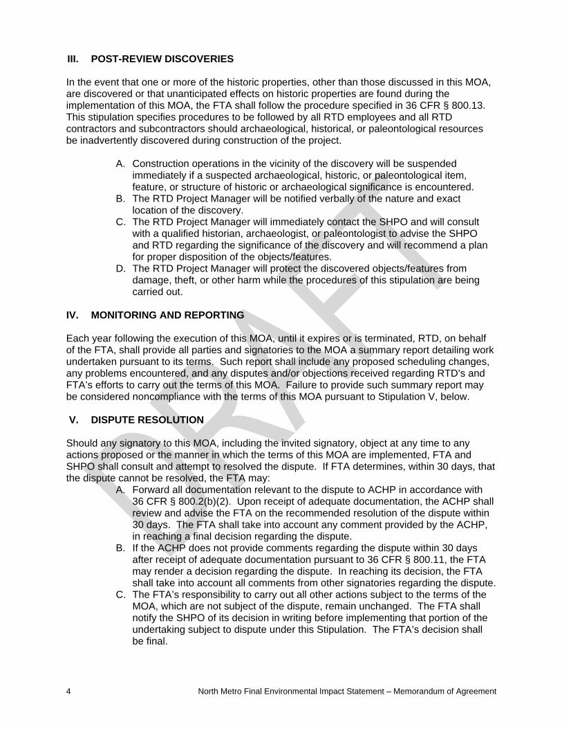
III. POST-REVIEW DISCOVERIES In the event that one or more of the historic properties, other than those discussed in this MOA, are discovered or that unanticipated effects on historic properties are found during the implementation of this MOA, the FTA shall follow the procedure specified in 36 CFR § 800.13. This stipulation specifies procedures to be followed by all RTD employees and all RTD contractors and subcontractors should archaeological, historical, or paleontological resources be inadvertently discovered during construction of the project.
A. Construction operations in the vicinity of the discovery will be suspended immediately if a suspected archaeological, historic, or paleontological item, feature, or structure of historic or archaeological significance is encountered.
B. The RTD Project Manager will be notified verbally of the nature and exact location of the discovery.
C. The RTD Project Manager will immediately contact the SHPO and will consult with a qualified historian, archaeologist, or paleontologist to advise the SHPO and RTD regarding the significance of the discovery and will recommend a plan for proper disposition of the objects/features.
D. The RTD Project Manager will protect the discovered objects/features from damage, theft, or other harm while the procedures of this stipulation are being carried out.
IV. MONITORING AND REPORTING Each year following the execution of this MOA, until it expires or is terminated, RTD, on behalf of the FTA, shall provide all parties and signatories to the MOA a summary report detailing work undertaken pursuant to its terms. Such report shall include any proposed scheduling changes, any problems encountered, and any disputes and/or objections received regarding RTD’s and FTA’s efforts to carry out the terms of this MOA. Failure to provide such summary report may be considered noncompliance with the terms of this MOA pursuant to Stipulation V, below. V. DISPUTE RESOLUTION
Should any signatory to this MOA, including the invited signatory, object at any time to any actions proposed or the manner in which the terms of this MOA are implemented, FTA and SHPO shall consult and attempt to resolved the dispute. If FTA determines, within 30 days, that the dispute cannot be resolved, the FTA may:
A. Forward all documentation relevant to the dispute to ACHP in accordance with 36 CFR § 800.2(b)(2). Upon receipt of adequate documentation, the ACHP shall review and advise the FTA on the recommended resolution of the dispute within 30 days. The FTA shall take into account any comment provided by the ACHP, in reaching a final decision regarding the dispute.
B. If the ACHP does not provide comments regarding the dispute within 30 days after receipt of adequate documentation pursuant to 36 CFR § 800.11, the FTA may render a decision regarding the dispute. In reaching its decision, the FTA shall take into account all comments from other signatories regarding the dispute.
C. The FTA’s responsibility to carry out all other actions subject to the terms of the MOA, which are not subject of the dispute, remain unchanged. The FTA shall notify the SHPO of its decision in writing before implementing that portion of the undertaking subject to dispute under this Stipulation. The FTA’s decision shall be final.

North Metro Final Environmental Impact Statement – Memorandum of Agreement 5
VI. AMENDMENTS AND NONCOMPLIANCE If any signatory to this MOA, including the invited signatory, determines that its terms shall not or cannot be carried out, or that an amendment to its terms must be made, that party shall immediately consult with other parties to develop an amendment to this MOA, pursuant to 36 CFR §§ 800.6(c)(7) and 800.6(c)(8). The amendment shall be effective on the date a copy signed by all of the original signatories is filed with the ACHP. If the signatories cannot agree to appropriate terms to amend the MOA, any signatory may terminate the MOA in accordance with Stipulation VII below. VII. TERMINATION If the MOA is not amended following the consultation set forth in Stipulations V and VI above, it may be terminated by any signatory. Within 30 days following the termination, the FTA shall notify the SHPO whether or not it shall initiate consultation to execute a new MOA under 36 CFR § 800.6(c)(1) or request the comments of the ACHP under 36 CFR § 800.7(a) and proceed accordingly. Execution of this MOA by the FTA, SHPO, ACHP, and the other parties, submission of this MOA to the ACHP pursuant to 36 CFR § 800.6(b)(l)(iv) before the FTA’s approval of this undertaking, and implementation of its terms provides evidence that the FTA has taken account the effects if this undertaking on historic properties and afforded an opportunity to comment.

6 North Metro Final Environmental Impact Statement – Memorandum of Agreement
VIII. SIGNATORIES: FEDERAL TRANSIT ADMINISTRATION, REGION VIII By: Date: Terry J. Rosapep, Regional Administrator, Region 8 COLORADO STATE HISTORIC PRESERVATION OFFICER By: Date: Edward C. Nichols, SHPO ADVISORY COUNCIL ON HISTORIC PRESERVATION By: Date: John M. Fowler, Executive Director IX. INVITED SIGNATORIES:
REGIONAL TRANSPORTATION DISTRICT By: Date: Phillip A. Washington, General Manager

5DV6247.6
5DV6247
23rd St
Denargo St
Fox St
Huron St
Delgany St
Wewatta St
Denargo Market
W 29th Ave
Broadway
E 30th Ave
McDuffee Ct
22nd
St
Potter Ct
Galapago St
Divis
ion St
Fox St
Delgany St
I-25
I-270
I-7
0
Study Area Boundary
17
34 21 22
33
2
7 8 9
31
45
6
111012 13 14 15 16 18
19 20 23 24 25 26 27 28 29 3031 32
0 100 200
Feet
¨
Historic Atlas
Historic Structures
Officially Not-Eligible
Officially Eligible
EligibleAssumed Eligible
Not-Eligible
ArcheologicalEligibleNot-Eligible
APE
EligibleNot-Eligible
Page 1 of 34

5DV6247
5DV10619
5DV10618
I 25
Globeville Rd
31st
St
Arkins Ct
Weston St
Perkins St
Denargo Market
29th
St
Denargo St
I 25
I 25
I-25
I-270
I-7
0
Study Area Boundary
17
34 21 22
33
2
7 8 9
31
45
6
111012 13 14 15 16 18
19 20 23 24 25 26 27 28 29 3031 32
0 100 200
Feet
¨
Historic Atlas
Historic Structures
Officially Not-Eligible
Officially Eligible
EligibleAssumed Eligible
Not-Eligible
ArcheologicalEligibleNot-Eligible
APE
EligibleNot-Eligible
Page 2 of 34

5DV6247
5DV10620
5DV10618
5DV10603
5DV10604
Arkins Ct
Ringsby Ct
Chestnut Pl
Pearl St
E 44th Ave
I 70
E 45th Ave
38th
St
Logan St
Pennsylvania St
Washington St
Sherman StE 43rd Ave
36th
St
Grant St I 70
I-25
I-270
I-7
0
Study Area Boundary
17
34 21 22
33
2
7 8 9
31
45
6
111012 13 14 15 16 18
19 20 23 24 25 26 27 28 29 3031 32
0 100 200
Feet
¨
Historic Atlas
Historic Structures
Officially Not-Eligible
Officially Eligible
EligibleAssumed Eligible
Not-Eligible
ArcheologicalEligibleNot-Eligible
APE
EligibleNot-Eligible
Page 3 of 34

5DV6247.35DV6247.1
5DV10601
5DV10600
5DV6247
5DV10050
5DV9162
5DV3815
I 70
Arkins Ct
E 47th Ave
E 46th Ave
National Western Dr
Marion St
46th Ave
Humboldt St
Baldwin Ct
N Lafayette St
Franklin
St
44th
St
Alley
Washington St
I 70
Washington St
I-25
I-270
I-7
0
Study Area Boundary
17
34 21 22
33
2
7 8 9
31
45
6
111012 13 14 15 16 18
19 20 23 24 25 26 27 28 29 3031 32
0 100 200
Feet
¨
Historic Atlas
Historic Structures
Officially Not-Eligible
Officially Eligible
EligibleAssumed Eligible
Not-Eligible
ArcheologicalEligibleNot-Eligible
APE
EligibleNot-Eligible
Page 4 of 34
5DV10050
5DV11033

5DV6247.3
5DV10617.1
5AM10599.1
5DV10974
5DV10602
5DV10050
5DV10608
5DV10609
5DV10611
5DV10610
5DV106075DV10612
5DV10605
5DV10606
5DV10613
State Hwy 265
Race St
Alley
Race Ct
High St
National Western Dr
E 48th Ave
E 49th AveBald
win Ct
Williams S
t
York St
E 47th Ave
I-25
I-270
I-7
0
Study Area Boundary
17
34 21 22
33
2
7 8 9
31
45
6
111012 13 14 15 16 18
19 20 23 24 25 26 27 28 29 3031 32
0 100 200
Feet
¨
Historic Atlas
Historic Structures
Officially Not-Eligible
Officially Eligible
EligibleAssumed Eligible
Not-Eligible
ArcheologicalEligibleNot-Eligible
APE
EligibleNot-Eligible
Page 5 of 34

5DV2410.1
5DV6247.3
5AM464.155DV10617.1
5DV10616
5AM2324
5DV10613 5DV10614
5DV10615
State Hwy 265
Columbine St
York
St
E 51st Ave
York St
I-25
I-270
I-7
0
Study Area Boundary
17
34 21 22
33
2
7 8 9
31
45
6
111012 13 14 15 16 18
19 20 23 24 25 26 27 28 29 3031 32
0 100 200
Feet
¨
Historic Atlas
Historic Structures
Officially Not-Eligible
Officially Eligible
EligibleAssumed Eligible
Not-Eligible
ArcheologicalEligibleNot-Eligible
APE
EligibleNot-Eligible
Page 6 of 34
5DV2410.1
5AM464.15
5AM2083.2
5AM
2083
.3
5AM465.9
5AM2324
State Hwy 265
E 56th
Ave
I-25
I-270
I-7
0
Study Area Boundary
17
34 21 22
33
2
7 8 9
31
45
6
111012 13 14 15 16 18
19 20 23 24 25 26 27 28 29 3031 32
0 100 200
Feet
¨
Historic Atlas
Historic Structures
Officially Not-Eligible
Officially Eligible
EligibleAssumed Eligible
Not-Eligible
ArcheologicalEligibleNot-Eligible
APE
EligibleNot-Eligible
Page 7 of 34

5AM465.9
I 270
Fillmore St
Steele S
t
E 60th Ave I 270
I-25
I-270
I-7
0
Study Area Boundary
17
34 21 22
33
2
7 8 9
31
45
6
111012 13 14 15 16 18
19 20 23 24 25 26 27 28 29 3031 32
0 100 200
Feet
¨
Historic Atlas
Historic Structures
Officially Not-Eligible
Officially Eligible
EligibleAssumed Eligible
Not-Eligible
ArcheologicalEligibleNot-Eligible
APE
EligibleNot-Eligible
Page 8 of 34
5AM465.9
5AM2178
5AM22155AM2217
5AM2216
I 270
E 64th Ave
Monroe St
I 270
I-25
I-270
I-7
0
Study Area Boundary
17
34 21 22
33
2
7 8 9
31
45
6
111012 13 14 15 16 18
19 20 23 24 25 26 27 28 29 3031 32
0 100 200
Feet
¨
Historic Atlas
Historic Structures
Officially Not-Eligible
Officially Eligible
EligibleAssumed Eligible
Not-Eligible
ArcheologicalEligibleNot-Eligible
APE
EligibleNot-Eligible
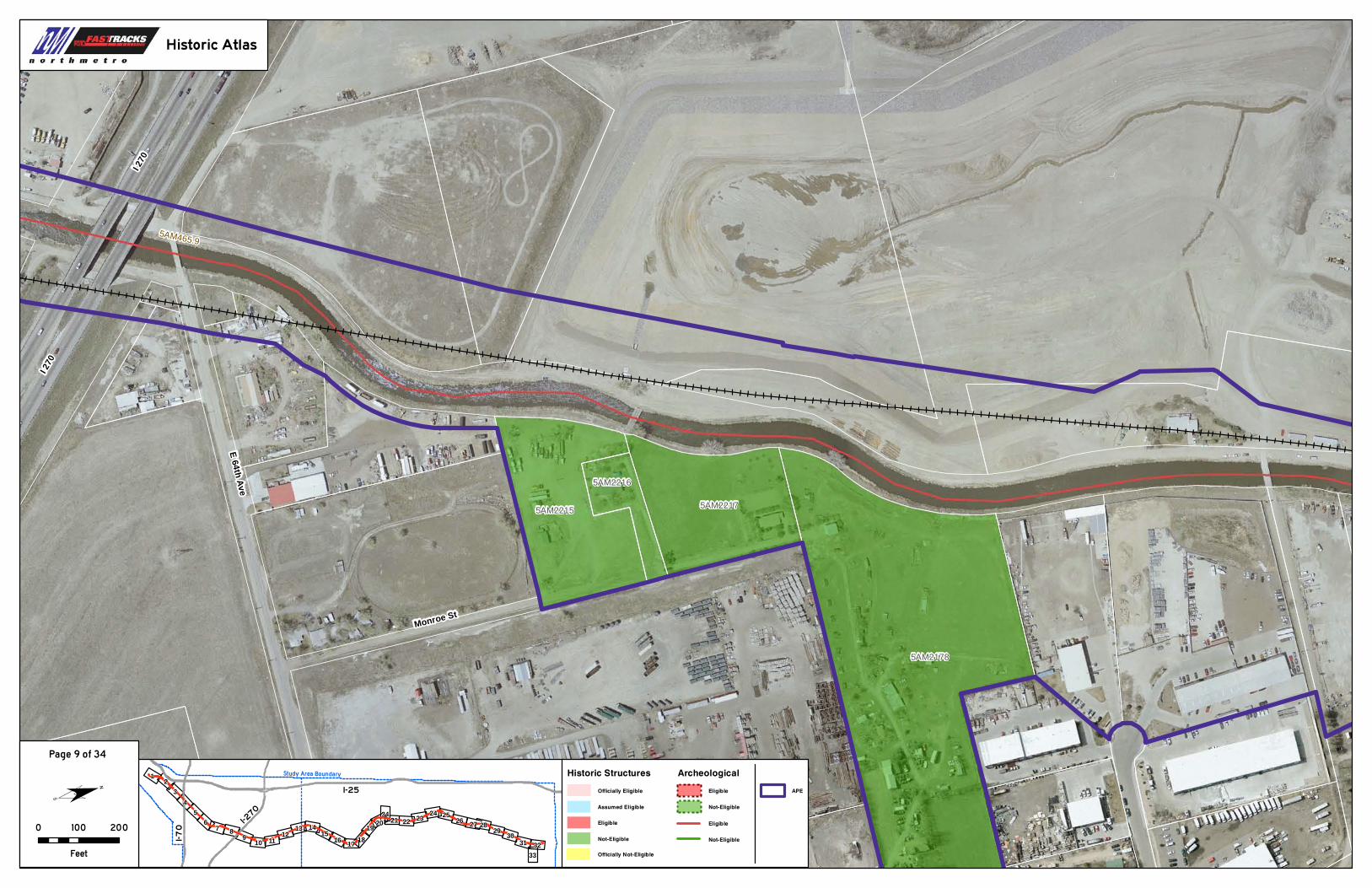
Page 9 of 34

5AM465.9
5AM472.17
5AM2110
Colorado Blvd
Ash St
I 76
E 70th Ave
E 71st Ave
E 68th Ave
Albion St
I 76
E 68th Ave
I-25
I-270
I-7
0
Study Area Boundary
17
34 21 22
33
2
7 8 9
31
45
6
111012 13 14 15 16 18
19 20 23 24 25 26 27 28 29 3031 32
0 100 200
Feet
¨
Historic Atlas
Historic Structures
Officially Not-Eligible
Officially Eligible
EligibleAssumed Eligible
Not-Eligible
ArcheologicalEligibleNot-Eligible
APE
EligibleNot-Eligible
Page 10 of 34

5AM472.17
5AM465.9 I 76
State
Hwy
224
I 76 Service Rd
E 74th
Ave
I 76
State
Hwy
224
I-25
I-270
I-7
0
Study Area Boundary
17
34 21 22
33
2
7 8 9
31
45
6
111012 13 14 15 16 18
19 20 23 24 25 26 27 28 29 3031 32
0 100 200
Feet
¨
Historic Atlas
Historic Structures
Officially Not-Eligible
Officially Eligible
EligibleAssumed Eligible
Not-Eligible
ArcheologicalEligibleNot-Eligible
APE
EligibleNot-Eligible
Page 11 of 34
5AM472.17
5AM2099.1
5AM
21
01.1
Steele St
E 80th
Ave
E 78th
Ave
I-25
I-270
I-7
0
Study Area Boundary
17
34 21 22
33
2
7 8 9
31
45
6
111012 13 14 15 16 18
19 20 23 24 25 26 27 28 29 3031 32
0 100 200
Feet
¨
Historic Atlas
Historic Structures
Officially Not-Eligible
Officially Eligible
EligibleAssumed Eligible
Not-Eligible
ArcheologicalEligibleNot-Eligible
APE
EligibleNot-Eligible
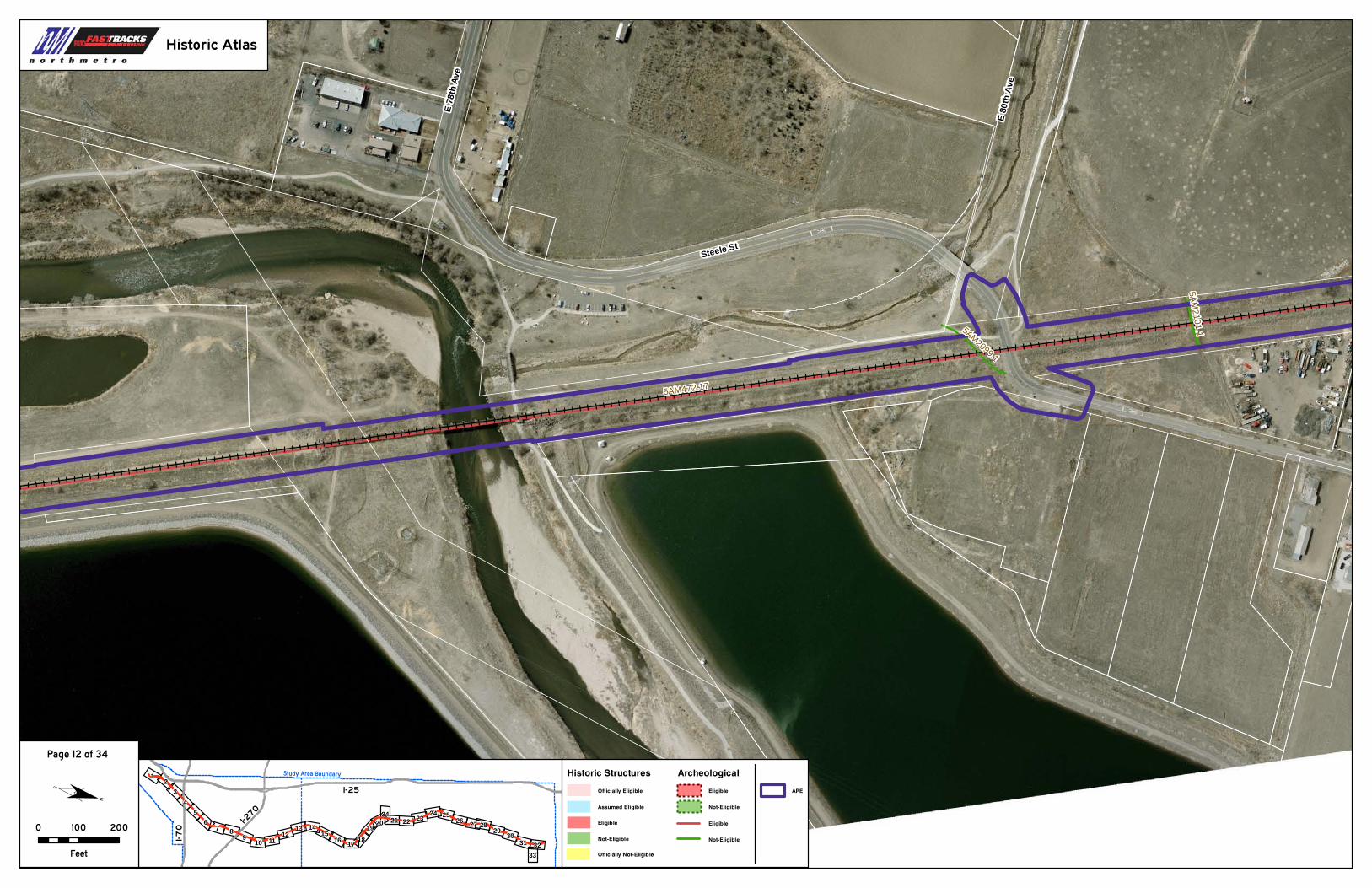
Page 12 of 34

5AM81.1
5AM472.17
5AM80.1
5AM472.17
5AM
21
02.
2
5AM
80.7
5AM81.6
5AM
2102
.1
5AM
81
.5
5AM2746
Steele St
Welby RdHope Ct
E 86th
Ave
Devonshire Blvd
McDougal St
E 84th
Ave
Clayton Ct
McEl
wain
Blvd
E 83rd
Ave
I-25
I-270
I-7
0
Study Area Boundary
17
34 21 22
33
2
7 8 9
31
45
6
111012 13 14 15 16 18
19 20 23 24 25 26 27 28 29 3031 32
0 100 200
Feet
¨
Historic Atlas
Historic Structures
Officially Not-Eligible
Officially Eligible
EligibleAssumed Eligible
Not-Eligible
ArcheologicalEligibleNot-Eligible
APE
EligibleNot-Eligible
Page 13 of 34

5AM81.65AM472.17
5AM2141
5AM27445AM2325
5AM2376
5AM2743
5AM2745
5AM2187
5AM2187
5AM2374
5AM21195AM2120
5AM2121
5AM2139
5AM2185
5AM2123
Welby Rd
E 88th Ave
Devonshire Blvd
E 86th Ave
Cher
yl Dr
Moon C
t
Bradley Pl
Rainb
ow Dr
Hope Ct
Carnation Way
Yucca Way
Devonshire Ct
Mobile Home Park
McDougal St
I-25
I-270
I-7
0
Study Area Boundary
17
34 21 22
33
2
7 8 9
31
45
6
111012 13 14 15 16 18
19 20 23 24 25 26 27 28 29 3031 32
0 100 200
Feet
¨
Historic Atlas
Historic Structures
Officially Not-Eligible
Officially Eligible
EligibleAssumed Eligible
Not-Eligible
ArcheologicalEligibleNot-Eligible
APE
EligibleNot-Eligible
Page 14 of 34
5AM472.17
5AM81.6
5AM2743
5AM2190
5AM2188
5AM2131
5AM2185
5AM21325AM2327
5AM21305AM2126 5AM21285AM21245AM2122
5AM2129
5AM21215AM2127
5AM2140
5AM2330
5AM2186
5AM2135 5AM21385AM2123 5AM2331 5AM2329
5AM2125
5AM2133 5AM2136
5AM2332
5AM2139
5AM23335AM21375AM2328
5AM2134
Yucca Way
Aspen Dr
Welby Rd
Adams St
Welby Cir
Beechwood Dr
Palo Verde St
Cook St
E 90th Pl
Poze Blvd
Anderson St
E 94th Dr
Cypress Dr
E 91s
t Ave
Barn
hart
St
E 94th Ave
Roos
evelt
Ave
Steele Dr
Eppin
ger B
lvd
Carnation Way
Garfield Way
E 93rd Pl
Beachwood Dr
Anderson St
E 94th Dr
I-25
I-270
I-7
0
Study Area Boundary
17
34 21 22
33
2
7 8 9
31
45
6
111012 13 14 15 16 18
19 20 23 24 25 26 27 28 29 3031 32
0 100 200
Feet
¨
Historic Atlas
Historic Structures
Officially Not-Eligible
Officially Eligible
EligibleAssumed Eligible
Not-Eligible
ArcheologicalEligibleNot-Eligible
APE
EligibleNot-Eligible
Page 15 of 34
5AM472.17
5AM2111
Harrison St
Thornton Pkwy
Monroe St
E 94th Ave
Welby Rd
E 99th
Pl
E 97
th Pl
E 96th Pl
E 98
th Av
e
E 99th
Way
E 96
th Wa
y
E 98
th Ct
Garfield Way
E 96th
Cir
Thornton PkwyColorado Blvd
I-25
I-270
I-7
0
Study Area Boundary
17
34 21 22
33
2
7 8 9
31
45
6
111012 13 14 15 16 18
19 20 23 24 25 26 27 28 29 3031 32
0 100 200
Feet
¨
Historic Atlas
Historic Structures
Officially Not-Eligible
Officially Eligible
EligibleAssumed Eligible
Not-Eligible
ArcheologicalEligibleNot-Eligible
APE
EligibleNot-Eligible
Page 16 of 34
5AM
472.
17
5AM2111 5AM2113
5AM2112
Colorado Blvd
E 10
0th Av
e
Skyline Dr
E 99
th Ln
Garfield St
Harrison St
Westview DrHi
llcre
st Dr
E 99th
Pl
Courier Ln
Plateau Dr
Crestview Dr
E 10
1st A
ve
Garfield Cir
E 10
0th C
t
Jackson St
E 99th
Way E 103rd Pl
Hillcrest Cir
E 102nd Ave
Golfcrest Cir
Westview Cir
E 10
3rd C
ir
Monroe Dr
Garfield Ct
E 99
th Ci
r
Colorado Blvd
E 10
0th Av
e
I-25
I-270
I-7
0
Study Area Boundary
17
34 21 22
33
2
7 8 9
31
45
6
111012 13 14 15 16 18
19 20 23 24 25 26 27 28 29 3031 32
0 100 200
Feet
¨
Historic Atlas
Historic Structures
Officially Not-Eligible
Officially Eligible
EligibleAssumed Eligible
Not-Eligible
ArcheologicalEligibleNot-Eligible
APE
EligibleNot-Eligible
Page 17 of 34

5AM472.17
5AM
21
03.1
5AM2113
5AM2112
State Hwy 44
E 103rd Pl E 104th Ave
Colorado Blvd
Madison St
Madison Way
Adams St
Fox Run Pkwy
E 105th Ct
Fox Run Cir
E 105th Pl
E 103rd Dr
Garfield St
Cook
Ct
E 103rd Cir
E 104th Pl
Kimblewyck Cir
E 106th Ct
Cook Way
Adam
s Cir
E 104th Ave
I-25
I-270
I-7
0
Study Area Boundary
17
34 21 22
33
2
7 8 9
31
45
6
111012 13 14 15 16 18
19 20 23 24 25 26 27 28 29 3031 32
0 100 200
Feet
¨Historic Atlas
Historic Structures
Officially Not-Eligible
Officially Eligible
EligibleAssumed Eligible
Not-Eligible
ArcheologicalEligibleNot-Eligible
APE
EligibleNot-Eligible
Page 18 of 34