Draft Envision Municipal Plan - City Of St. John's...City of St. John’s Draft Envision St. John's...
75
Envision St. John’s Municipal Plan DraŌ
Transcript of Draft Envision Municipal Plan - City Of St. John's...City of St. John’s Draft Envision St. John's...

Envision St. John’s Municipal Plan
Dra
maryb
Typewritten Text
maryb
Typewritten Text
maryb
Typewritten Text
July 2, 2014

City of St. John’s Draft Envision St. John's Municipal Plan i
Contents
CHAPTER 1 Introduction .............................................................................................................. 1
1.1 Purpose of the Municipal Plan ............................................................................................ 1
1.2 Plan Review Process............................................................................................................ 1
1.3 Legal Basis ........................................................................................................................... 3
1.4 Conformity with Provincial, Regional and City Policy ......................................................... 3
1.5 Review and Amendment of the Municipal Plan ................................................................. 4
1.6 Plan Organization ................................................................................................................ 4
CHAPTER 2 Framework for Growth .............................................................................................. 5
2.1 Managing Growth – Our Vision to 2023 ............................................................................. 5
2.2 Growth and Development Strategy .................................................................................... 5
2.3 City Vision ........................................................................................................................... 6
2.4 Key Themes ......................................................................................................................... 6
CHAPTER 3 Environmental Systems ............................................................................................ 12
3.1 Protecting Natural Areas .................................................................................................. 13
3.2 Water Systems .................................................................................................................. 15
3.3 Climate Change ................................................................................................................. 16
3.4 Hazard Areas ..................................................................................................................... 16
3.5 Brownfields ....................................................................................................................... 17
CHAPTER 4 Healthy Neighbourhoods ......................................................................................... 18
4.1 Housing ............................................................................................................................. 20
4.2 Childcare and Eldercare Services ...................................................................................... 21
4.3 Enhancing Neighbourhood Character .............................................................................. 21
4.4 Good Neighbours: Reducing Land Use Conflict ................................................................ 22
4.5 Access to Healthy Food ..................................................................................................... 22
4.6 Parks, Recreation and Open Space ................................................................................... 22
4.7 Heritage ............................................................................................................................ 24
4.8 Historic Resources ............................................................................................................. 27
CHAPTER 5 A Strong Economy .................................................................................................... 28
5.1 Economic Diversification ................................................................................................... 29
5.2 Maintaining a Supply of Diverse Lands for Commerce ..................................................... 29
5.3 The Port............................................................................................................................. 30
5.4 Institutions ........................................................................................................................ 30
5.5 Retail ................................................................................................................................. 31

City of St. John’s Draft Envision St. John's Municipal Plan ii
5.6 Tourism ............................................................................................................................. 32
5.7 Agribusiness ...................................................................................................................... 32
CHAPTER 6 Urban Design ........................................................................................................... 33
6.1 General .............................................................................................................................. 34
6.2 Secondary Plans ................................................................................................................ 35
6.3 Development in the Downtown ....................................................................................... 38
6.4 Building Height .................................................................................................................. 38
6.5 Separation Buffers ............................................................................................................ 41
6.6 Art and the City ................................................................................................................. 41
6.7 Signage and Wayfinding ................................................................................................... 42
CHAPTER 7 Transportation and Infrastructure ............................................................................ 43
7.1 Regional Transportation ................................................................................................... 44
7.2 Transportation Network ................................................................................................... 45
7.3 Public Transit..................................................................................................................... 49
7.4 Airport ............................................................................................................................... 49
7.5 Water and Wastewater Servicing ..................................................................................... 50
7.6 Limit of Servicing ............................................................................................................... 50
7.7 Goulds Ultimate Service Area ........................................................................................... 51
7.8 Torbay Road North Commercial Area ............................................................................... 52
7.9 Emergency Services .......................................................................................................... 52
7.10 Solid Waste Managment ................................................................................................... 52
7.11 Telecommunications and Utilities .................................................................................... 52
CHAPTER 8 Land Use .................................................................................................................. 53
8.1 Land Use Districts.............................................................................................................. 53
8.2 Interpretation of Land Use District Boundaries ............................................................ 54
8.3 Non-Conforming Uses ....................................................................................................... 54
8.4 Residential Land Use District ............................................................................................ 55
8.5 Commercial Land Use District ........................................................................................... 57
8.6 Mixed-use Zones ............................................................................................................ 58
8.7 Industrial Land Use District ............................................................................................... 59
8.8 Airport Land Use District ................................................................................................... 61
8.9 Institutional Land Use District ........................................................................................... 61
8.10 Rural Land Use District ...................................................................................................... 62
8.11 Rural Residential Uses ....................................................................................................... 63

City of St. John’s Draft Envision St. John's Municipal Plan iii
8.12 Agriculture ........................................................................................................................ 63
8.13 Watershed Land Use District ............................................................................................ 65
8.14 Restricted Development ................................................................................................... 65
8.15 Urban Expansion Land Use District ................................................................................... 65
8.16 Open Space Land Use District ........................................................................................... 66
CHAPTER 9 Implementation ....................................................................................................... 67
9.1 Municipal Plan Review ...................................................................................................... 68
9.2 Secondary Plans and Development Schemes ................................................................... 68
9.3 Public Engagement and Consultation ............................................................................... 68
9.4 Development Regulations ................................................................................................. 68
9.5 Considerations for Rezonings ........................................................................................... 68
9.6 Development Review Process ........................................................................................... 69
9.7 The Land Use Report ......................................................................................................... 69
9.8 Development Appeals ....................................................................................................... 70
9.9 Infrastructure Investment ................................................................................................. 70
Municipal Plan Maps
1 Environmentally Valuable Areas
2 Floodplains
3 Heritage Areas Map
4 Planning Areas Map
5 Intensification Areas Map
6 Public View Planes and Street End Views
7 Road Classifications Map
8 Downtown Parking Area Map
9 Goulds Ultimate Service Area
10 Future Land Use Map (Appendix A)
11 Regional Waste Management Protection Area
12 St. John’s Agricultural Development Area

City of St. John’s Draft Envision St. John's Municipal Plan 1
CHAPTER 1 INTRODUCTION
1.1 Purpose of the Municipal Plan Envision St. John’s Municipal Plan is the City’s principle planning document. The Plan sets out a
vision for the City that reflects input gathered from extensive public consultations. Goals,
strategic objectives, and policies support the vision and will help guide the City’s growth and
development over the next decade.
Development in the City was first guided by a Zoning By-Law adopted in 1955. The City’s first
municipal plan was approved under the Urban and Rural Planning Act in 1984. The Plan has
undergone previous reviews, most recently in 2003, and has been subject to numerous
amendments since its adoption. Envision St. John’s, prepared as a result of a comprehensive
review, will replace the current St. John’s Municipal Plan (2003).
1.2 Plan Review Process In 2012, Envision St. John’s was introduced to the general public, through a year-long intensive,
public engagement process designed to bring together various stakeholders from the
community to create a unified vision for the City’s future.
The public engagement process included the following components:
Municipal Plan Review Advisory Group: established to guide the Municipal Plan review
process. The committee was comprised of 7 representatives from stakeholder
organizations, 2 members of the general public, a member of Council who chaired the
group, supported by staff from the Department of Planning.
City- wide brochure was mailed to St. John’s residents, outlining the Municipal Plan
review process, inviting them to ward meetings, open houses and forum, and
encouraged written submissions.
A background discussion document was prepared to provide information about the city,
its changes, challenges and opportunities to provide a context for public discussion.
Press releases and public notices were placed in The Telegram and posted on the City’s
website to advertise meetings and invite citizen input.
Public Forums and Meetings:
- Two city- wide forums were held; The Mayor’s Symposium - the kick-off event for the
Municipal Plan review process - and a Downtown Forum. Both were open to the

City of St. John’s Draft Envision St. John's Municipal Plan 2
general public and drew about 100 participants each. The forums provided the
citizens an opportunity to comment on a future vision for the city, express opinions
and concerns around issues pertaining to future development.
- Forums were held on topics of Affordable Housing, Heritage, and the Environment.
Attendance was by invitation, bringing together key organizations and agencies to
discuss future goals, objectives and policies.
- Open houses followed by a public meeting were held in each Ward. The informality
of the open house provided citizens an opportunity to speak with City staff regarding
ideas and concerns for the future of the city. Public meetings following each open
house provided further opportunities for discussion.
- Public meetings were held with two neighbourhood organizations in The Narrows
and Georgetown areas. These meetings included discussion about neighbourhood
concerns and future steps needed to create specific neighbourhood plans.
Summer of 2012 polling and discussion questions regarding key planning topics were
posted on Facebook. This method engaged a wider audience outside public meetings,
and received a high level of interest and input.
Organizations and agencies were invited to meet with City Council and staff, providing
an opportunity to comment on issues concerning future growth and development.
Referrals were sent to City departments, neighbouring municipalities and government
agencies for comment regarding the City’s Municipal Plan review.
Staff compiled public input and prepared a Draft Plan for the consideration of Council
and the Public.

City of St. John’s Draft Envision St. John's Municipal Plan 3
1.3 Legal Basis The Municipal Plan is a statutory document, prepared and approved by Council in accordance
with the Urban and Rural Planning Act (2000) for a ten-year period. The Plan applies to all land
within the boundaries of the City. As required by the Urban and Rural Planning Act, the
Municipal Plan includes:
A set of objectives for land use;
Policies to be implemented;
Lands classified into districts indicating intended uses;
Proposals for land use zoning regulations;
Proposals for implementation; and
Provisions for existing uses that do not conform to the Plan.
The Urban and Rural Planning Act also allows a Municipal Plan to address other areas relating
to the physical, social, economic and natural environment, including:
Existing and proposed street and transportation networks;
Land areas for comprehensive development;
A program of public works;
Protection, use and development of environmentally sensitive lands;
Stormwater and erosion control;
Protection and use of natural resources;
Excavating, filling in, or reclaiming land;
Protecting trees and vegetation, and other environmental matters;
Building height and location for various types of development;
Use and conservation of energy;
Attracting, locating, and diversifying economic activity;
Garden suites and back-lot development;
Housing and other facilities for senior citizens; and
Other proposals considered necessary by Council.
1.4 Conformity with Provincial, Regional and City Policy Municipal Plans must be consistent with provincial policy and law and with any Regional Plan in
place that affects the Planning Area. The City lies within the area included in the St. John’s
Urban Region Regional Plan, which is currently under review by the Province and the fourteen
municipalities in the Northeast Avalon Region.
The Plan supports and incorporates City policies included in various plans approved by Council,
including, for example, the Integrated Community Sustainability Plan, the Economic Roadmap
2021, Recreation Facilities Master Plan, and Comprehensive Development Area Plans. It also
incorporates approved recommendations from a variety of studies on built heritage, recreation,
transportation and so on.

City of St. John’s Draft Envision St. John's Municipal Plan 4
1.5 Review and Amendment of the Municipal Plan The Urban and Rural Planning Act requires Municipal Plans to undergo a comprehensive review
every ten years to ensure that its goals, objectives and policies remain consistent with
community values, growth and market trends.
The Municipal Plan may be amended to respond to changing circumstances, including the
needs of the city with regards to the economy, housing demand, changing demographics or
environment. The process to amend the Plan is established in the Urban and Rural Planning
Act.
1.6 Plan Organization Envision St. John’s Municipal Plan consists of three parts organized as follows:
1. Chapters I and II Introduce the Plan, its purpose, and the context for the vision and
strategy for growth of the City.
2. Chapter III through VIII contain the goals, objectives and policies in five key theme areas
and the land use districts identified on the Future Land Use Map.
3. Chapter IX addresses how the Plan will be implemented.
The Plan consists of this document and the Future Land Use Map. Supporting maps and
graphics included in the Plan are for illustration purposes only.

City of St. John’s Draft Envision St. John's Municipal Plan 5
CHAPTER 2 FRAMEWORK FOR GROWTH
2.1 Managing Growth – Our Vision to 2023 The City recognizes that growth presents many opportunities and challenges. The economic
prosperity resulting from a robust provincial economy has created employment and attracted
new investment and citizens to theSt. John’s . At the same time, growth has resulted in pressure
on the City to provide new and improved infrastructure and services. To manage growth in a
sustainable manner, the City needs to balance the pace, location, extent and form of
development in a manner that continues to improve the quality of life for all citizens.
The important public input received as part of the Municipal Plan Review consultations indicate
that citizens want a city that fosters healthy neighbourhoods, safeguards and enhances
environmental systems, and maintains a strong and diverse economy. They recognize the
unique qualities and character of the City’s neighbourhoods and the role that the historic
downtown plays in their sense of place and identity.
2.2 Growth and Development Strategy The strategy for growth set out in this Plan is one that attempts to balance the pressures and
need for growth and a strong, diverse economy, with a desire by citizens for greater
environmental stewardship, recognition of the importance of heritage to the culture and
economy of the City, and healthy and complete neighbourhoods with easy access to amenities
such as parks, open space, and services.
The balance is achieved through the identification of undeveloped areas to accommodate
future, well-planned growth, and an emphasis on encouraging intensification and a greater mix
of uses through investment in infrastructure that supports higher densities along major
transportation/transit corridors and centres where there are opportunities for redevelopment.
Within developed urban areas, balance is further achieved by preserving the pattern and scale
of development in established residential neighbourhoods and working to improve amenities
such as parks, recreation and pedestrian trail networks. The role of the historic downtown is
recognized for its importance to our culture, heritage and economy.
On a city-wide level, environmental stewardship – the protection of waterways, wetlands,
coastlines and rural areas, for their ecological and amenity value – is achieved by identifying a

City of St. John’s Draft Envision St. John's Municipal Plan 6
natural open space system and ensuring that development occurs around it, yet is connected to
it.
2.3 City Vision
The vision for the City that has emerged through the Plan Review Process, research and public
consultations is:
The strategy and vision are consistent with the vision set out in Roadmap 2021: A Strategic
Economic Plan for St. John’s:
St. John’s is a vibrant city capitalizing on its energy, creativity and distinctiveness to embrace
economic progress and enhance quality of life.
2.4 Key Themes The vision reflects five key themes that emerged from the public consultation process:
Valuing Environmental Systems
Vibrant, Complete Neighbourhoods
Strong, Diversified Economy
Quality Urban Design
Investment in Transportation and Services
The following sections outline the context for goals, objectives and policies presented in
Chapters III to VII which are also arranged according to these key themes.
Valuing Environmental Systems
The City of St. John’s identified environmentally valuable waterways and wetlands in the mid
1990s. Over the course of the past decade, these areas have provided an important component
of the City’s open space system. This Plan continues the protection of the City’s river systems –
the Waterford, Rennies and Virginia Rivers, among others – and recognizes their important
ecological functions.
A future of continued economic prosperity and diversity, where citizens
have a strong sense of identity embodied in their understanding and
appreciation for their cultural, natural and built heritage and the arts. A
city of active, healthy citizens, living in affordable, accessible, complete
neighbourhoods. A city that attracts and welcomes investment,
residents and visitors from within the region, the province, and around
the world.

City of St. John’s Draft Envision St. John's Municipal Plan 7
Bay Bulls Big Pond, Petty Harbour-Long Pond, Windsor Lake, Thomas Pond and their
associated watersheds are protected as the source of the City’s potable water. Continuing to
protect these watersheds will ensure long term sustainability of the quantity and quality of the
drinking water supply.
The City is in the process of developing an open space Master Plan that will define an
integrated system of linked natural heritage encompassing waterways, wetlands and woodlands
that will be incorporated into future urban developments.
The impacts of global climate change are being felt locally. Rising sea levels, more intense and
frequent storms are leading to eroding coastal shorelines and ever expanding flood zones along
our rivers and streams. The Plan recognizes the need to anticipate and adapt to climate change
impacts.
Lands within the City support a stable, prosperous agricultural industry. As concerns over
availability of and access to locally produced foods increases, the importance of protecting this
finite resource becomes even more important. Agricultural areas contribute to the City’s open
space and provide a rural landscape within the City. They complement natural heritage areas by
providing environmental benefits as well as their contribution to the local economy and food
production.
Vibrant, Complete Neighbourhoods
Input from public consultations on the Plan
indicate a desire for a city of healthy,
walkable, neighbourhoods with access to
neighbourhood services. There was also
recognition that a greater mix of uses and
higher density of residential development
will be required to support this. At the same
time, there are concerns about how such
development could be achieved and how it
might affect established residential
neighbourhoods.
Many of the City’s neighbourhoods have been established at low densities with consistent
building size, height and lot size. Homeowners have invested heavily in upkeep and
renovations. It is also recognized that neighbourhoods change and evolve over time. It is the
City’s intent to implement policies to maintain the essential character of these areas while
managing change to accommodate changing needs.
The City will re-invest in planning at the neighbourhood planning level to identify ways to
improve the built environment for better mobility, access to goods, services, open space,
employment and opportunities to increase the range of housing.

City of St. John’s Draft Envision St. John's Municipal Plan 8
New areas identified for development will be planned in a manner that provides for
neighbourhood services within walking distance of where people live. This will be achieved
through high quality urban design, a transit oriented, connected street and pedestrian network,
and provision of a mix of forms of housing at densities that can support neighbourhood
commercial services.
The City’s goal is to increase the number of people who live and work within the City and to “re-
capture” those individuals and families who have moved to suburban locations outside the City.
This will be accomplished by improving the quality of residential areas and their accessibility to
goods and services in mixed-use, pedestrian-friendly commercial centres. The aim is to reduce
traffic congestion, support transit, and improve quality of life in the City.
Sustainable communities have a range of housing choice so that people of all ages, abilities and
incomes can find quality, affordable shelter. While the range of housing choices is greater today
than it has been in the past, more needs to be done to address issues of affordability. To
encourage housing and employment opportunities in close proximity to each other, the City will
encourage higher density, mixed-use housing in areas identified for intensification along transit
corridors.
Increasing the supply of affordable housing over the planning period is an important goal for the
City. To do this, policies have been developed to require new residential and mixed-use
developments to include a variety of housing forms, including housing units that are affordable
to people with a range of incomes.
A Strong, Diversified Economy
Economic Roadmap 2021 identifies
five goals for economic development in
the City over the next decade. These
include:
A location of choice for
business investment
A magnetic and desirable city
for newcomers and young
professionals
A global leader in ocean
technology and a global centre
for offshore energy expertise
A destination of choice for
people seeking authentic visitor
experiences.
A leading Canadian artistic metropolis
The goals, objectives and policies of the Municipal Plan are consistent with and support the
goals of the Economic Roadmap.

City of St. John’s Draft Envision St. John's Municipal Plan 9
The City will retain and build on its success as a major employment centre within the province
and the St. John’s Urban Region. Through the provisions of this Plan, Council will ensure
continued opportunities for businesses of all types, including industrial, retail, warehousing,
office and service employment uses.
The City recognizes the economic importance of supporting the ocean technology and offshore
oil and gas sectors, and the need for industrial lands and office space to support them. Office
buildings will be encouraged in key development areas – along major roadways and transit
corridors. Industrial use will be encouraged around the regional transportation networks – the
airport and the Outer Ring Road/Trans Canada Highway.
The Downtown will remain an important employment and retail centre. The City recognizes the
importance of preserving the historic character of the downtown and the contribution that it
makes to the local economy through tourism and the arts. Through detailed urban design
studies, the City will determine the appropriate size, scale and location of new development that
can be accommodated within the historic built heritage of the downtown to increase
opportunities for new development and re-use of existing structures to accommodate a mix of
retail, service, office and residential uses.
C.A. Pippy Park, established as an institutional land bank, includes the major institutions in the
City. The University is a significant contributor to the local economy, as a major employer,
purchaser of goods and services, its ability to attract significant investment in research and
through outreach activities, enriching the community through its contribution to arts and culture.
Together with the Health Sciences Centre and buildings of the provincial government, these
uses constitute a major regional employment centre. The City will continue to support this
important area by working to ensure that it is well connected to residential neighbourhoods,
retail and recreation opportunities, and accessible by multiple modes of transportation.
Retail and service sectors incorporated into complete neighbourhoods contribute to a strong
economy. Opportunities for new retail and services will be provided for in areas identified for
intensification.
Quality Urban Design
The City’s ability to achieve intensification and
redevelopment with a mix of land uses within
the built-up areas of the City will require high
quality urban design. The City will utilize the
process to prepare Secondary Plans for
identified Planning Areas and work with
citizens to develop guidelines that support
development of attractive buildings,
pedestrian-friendly streets with access to
parks, trails and public spaces.

City of St. John’s Draft Envision St. John's Municipal Plan 10
Areas identified for intensification in the City will be characterized by compact development that
provides a variety of opportunities for working, living, enjoying culture and recreation. Quality
public spaces and pedestrian-friendly streetscapes will provide additional amenity. Care will be
taken with the design of new buildings to provide appropriate buffers and design solutions to
minimize the impact on adjoining established residential neighbourhoods.
In new neighbourhoods, development will be planned around a parks and open space network,
with an emphasis on compact, walkable residential neighbourhoods with mixed-use and
employment areas along the main streets and transit corridors.
The City’s Heritage Area (including the
Ecclesiastical Precinct) will continue to be
protected. Residential districts in the
downtown will be preserved to retain the
blocks of row housing, streetscapes,
laneways and public spaces that are
unique to the City. Detailed Urban Design
Guidelines will be prepared for commercial
areas in the downtown, addressing such
things as site specific parameters for
height, bulk and form of buildings, as well
as exterior design elements and materials
so that development can occur without
controversy.
Investment in Transportation and Services
Since the 1970s when the regional road network was established, its implementation has
facilitated outward growth in the region. Today, that growth has placed pressure on regional
roads and city streets. The City will work with the province and the region’s municipalities to
review the regional network and develop an active transportation plan to address regional
transportation issues.
The airport is a critical piece of the City’s and the province’s transportation infrastructure. Land
use in and around the airport will be managed to ensure that the airport continues to provide for
the movement of people and goods to, from, and within the province.
The Port of St. John’s also plays an important role in the City’s transportation infrastructure,
particularly as a gateway for the movement of goods to and from the province. Ensuring that the
port continues to have convenient access to the regional road network is a priority.
Great streets make great communities. Today, that means “Complete Streets”; streets designed
not only for automobiles but for all users. In some areas, that means streets that make people,
rather than vehicles the focus of street activity. The City will work towards improving the city

City of St. John’s Draft Envision St. John's Municipal Plan 11
street network to incorporate Complete Street considerations where major retrofits are
underway.
Within the City, investment in transportation/transit infrastructure will be directed to areas
targeted for intensification along the main transit corridors. In these areas, planning will
emphasize walkable streets, pedestrian connectivity with adjoining neighbourhoods, cycling and
transit infrastructure and access.
New development areas will be designed to be served by transit, accessible by pedestrians and
cyclists. In the Downtown, improved transit service will be used to reduce the demand for
downtown parking.
Over the next decade, the City will concentrate on upgrading and replacing aging municipal
infrastructure. This will include improving the water distribution system to reduce leakage,
upgrades to water treatment plants, the upgrading and, where necessary, replacement of
sewers and stormwater retention infrastructure.

City of St. John’s Draft Envision St. John's Municipal Plan 12
CHAPTER 3 ENVIRONMENTAL SYSTEMS
Landforms, watercourses and coastline serve important ecological functions within the City and
the broader regional ecosystem. Watersheds such as that of the Waterford River, encompass
several municipal jurisdictions. The rugged coastline provides protection from the sea as well as
unique and spectacular scenic vistas. Public consultations for the Municipal Plan Review show
that citizens recognize the importance of the natural environment for its amenity, ecological and
recreational values and the contribution that natural areas make to health and quality of life.
They also want a greater integration of the natural and built environment, including better
connectivity and access to natural areas through pedestrian trails, and parks.
Over the years, the City has done much to identify and protect important waterways, wetlands
and natural areas which support healthy populations of fish, birds and mammals. Since
Hurricane Igor in 2010, considerable effort has also been spent studying the hydrology of the
City’s watersheds and major river systems and their capacity to safely accommodate
stormwater runoff. As climate change promises to bring shorter, more intense storms, protecting
the City’s river systems for their hydrologic function becomes even more important.
Forested lands within the City provide wildlife habitat, amenity space and opportunities for
recreation and resource use. Forest management, in rural areas and within the built up areas of
the City are recognized as an important component of a healthy city environment. A healthy
urban forest will be more resilient to the effects of climate change which are expected to bring
longer, drier summers, and increased risk of damage from forest insects and disease.
Throughout the region there is a growing recognition of the need for measures to manage
surface and groundwater resources. This is needed to protect the quality and quantity of potable
water in both surface and groundwater supplies, and for reducing pollution that is carried by
stormwater runoff.
GOAL To conserve, protect and enhance the City’s natural environment – its waterways, wetlands, coastline and forested areas - for their ecological function, aesthetic and economic value.

City of St. John’s Draft Envision St. John's Municipal Plan 13
3.1 Protecting Natural Areas
Policies
Environmentally Valuable Areas
1. Identify, protect, maintain, and enhance important elements or features of the natural
environment including:
lands and waters to support natural resources (fish stocks, vegetation, woodlands, or
other valuable flora and fauna);
ecologically vulnerable lands and waters (coastal areas, riparian lands, lakes, and
wetlands);
physically unstable lands (steep slopes, areas of high relief, and/or unstable soil, and
areas susceptible to flooding);
valuable landscape features (valleys, hills, and ridges, groups of trees, bodies of water);
lands required for storm water management; or
other lands or waters considered environmentally significant by Council.
2. Protect Environmentally Valuable Areas identified on Map I that include significant ponds
and wetlands, significant tributaries of the Rennies, Waterford, and Virginia Rivers; Outer
Cove River Systems; Leamy’s Brook; and significant waterways and their tributaries flowing
into Fourth, Third, and Second Ponds; and significant waterways flowing from the City to
Conception Bay, such as Nut Brook and Manuels River, and the protected public water
supply areas.
3. Undertake appropriate studies to define more precisely the edges of wetlands in the Goulds
identified in Map 1.
4. Update the 1993 Significant Waterways and Wetlands Study.
Strategic Objectives:
Protect the City’s public water supply watersheds to ensure a safe, clean and
reliable source of drinking water.
Protect the hydrologic functions of waterways and wetlands as a critical component
of the City’s stormwater management system.
Establish a city-wide parks and open space system that protects and enhances
natural heritage, hydrologic functions, biodiversity and visual amenity.
Improve the City’s urban forest through best management practices and
incorporation of green infrastructure in public spaces and private developments.
Manage development to reduce risk in hazard areas.
City of St. John’s Draft Envision St. John's Municipal Plan 14
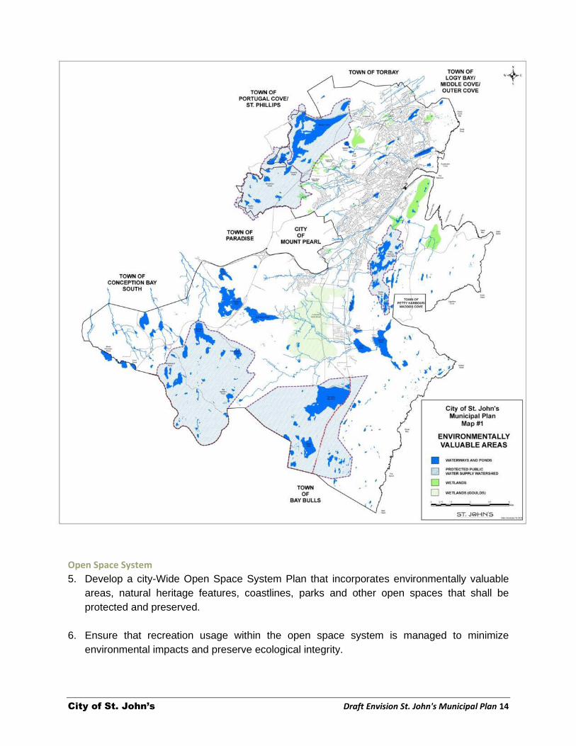
Open Space System
5. Develop a city-Wide Open Space System Plan that incorporates environmentally valuable
areas, natural heritage features, coastlines, parks and other open spaces that shall be
protected and preserved.
6. Ensure that recreation usage within the open space system is managed to minimize
environmental impacts and preserve ecological integrity.

City of St. John’s Draft Envision St. John's Municipal Plan 15
7. Work with other municipalities to develop a consistent approach for the protection of natural
features and areas in the Northeast Avalon in the form of a regional greenway system.
8. Encourage the retention of natural features, including hilltops, that are not included in
Environmentally Valuable Areas or in the Open Space System Plan and their incorporation
into the planning and design of proposed development wherever possible.
The Urban Forest
9. Protect and expand the urban forest in existing City neighbourhoods and integrate it into
new neighbourhoods as they are planned and developed, consistent with the City’s Urban
Forest Plan.
10. Enhance the urban forest through tree planting and landscaping on public lands in the urban
areas of the City and provide for ongoing monitoring and maintenance.
11. Ensure a healthy forest cover within Protected Water Supply Areas and within the City’s
Parks and Open Space System to preserve fish and wildlife habitat, maintain streamflows
and water quality, and provide amenity value to the City.
12. Require quality landscaping in new developments including consideration for the
incorporation of street trees.
3.2 Water Systems Policies
1. Continue to work in cooperation with the Province, regional municipalities, and non-
government organizations in the Northeast Avalon Region to:
Monitor and implement measures to manage stormwater flows to reduce the impact on
water quality in regional waterway systems, particularly those flowing into and out of the
City.
Where appropriate, prepare joint watershed management plans to address inter-
jurisdictional interests and approaches to planning and land management in identified
watersheds.
Stormwater
2. Ensure that new development in the City is planned, designed and constructed in
accordance with the City’s Policy on Stormwater Detention.
3. Ensure that development sites have adequate erosion and sediment control measures in
place to prevent pollution of the City’s waterways.
Groundwater
4. Work with the Water Resources Management Division of the Department of Environment
and Conservation and other municipalities in the region to develop a regional groundwater

City of St. John’s Draft Envision St. John's Municipal Plan 16
model that can be used to inform land use planning decisions to ensure that groundwater
resources are protected.
5. Ensure that private on-site septic systems, where permitted, shall be properly designed,
installed and maintained to protect groundwater supplies.
6. Require an assessment of groundwater quantity and quality where development on the
basis of on-site wells is permitted, in accordance with the Provincial Department of
Environment and Conservation Groundwater Supply Assessment and Reporting Guidelines
for Subdivisions Serviced by Individual Private Wells.
3.3 Climate Change The City recognizes that the impacts of climate change are already occurring. Anticipating and
addressing the impacts of climate change will become increasingly important over the planning
period. Of particular importance is the identification of lands that are susceptible to hazards
such as in low-lying coastal areas, areas of steep slopes and floodplains. Longer, drier
summers mean that the potential for forest fires will increase. While measures are being taken
to address increased stormwater flows by upgrading stormwater management systems, other
measures can be taken to continue to increase the City’s resilience to climate change impacts.
Policy
1. Anticipate the potential for increased risk of damage from storm surges and rising sea
levels, in coastal areas and in particular St. John’s Harbour and Quidi Vidi. Ensure that
structures and buildings in these vulnerable areas are designed to anticipate and withstand
the risks associated with climate induced impacts.
3.4 Hazard Areas The complex and often rugged topography of the City presents a challenge for new urban
development. With rising land values and fewer suitable sites available, development on more
marginal sites is proposed. It is important for the City to ensure the safety of residents by
preventing development in areas where it is not desirable, such as on steep or unstable slopes,
in coastal areas vulnerable to storm surges, or in floodplains.
Areas that are subject to periodic flooding are a risk to public safety and can result in
considerable damage to property. With predictions of more frequent and intense storms as a
result of climate change, preventing development in areas that are subject to flooding is one
way to minimize damage. Natural buffers separating developed areas and the 1:100 year
floodways can function as part of the city’s open space system and can accommodate low
intensity uses such as trails and recreational playing fields. Public uses such as utilities, flood
control structures, and other public works can also be placed in these areas. On private
properties that are within a floodway buffer, it is reasonable to accommodate property
improvements that include landscaping and fencing for example.

City of St. John’s Draft Envision St. John's Municipal Plan 17
Policies
Hazard Lands
1. Prevent development, particularly in undeveloped rural areas including along coastal cliffs,
low lying coastlines, or areas where steep topography make the land unsuitable for
development.
2. Where development is proposed in an area identified as a potential hazard, the City may
require a site specific study to determine the level of hazard and acceptable measures to
mitigate identified risks.
Lands Adjoining Bodies of Water and Flood Hazard Areas
3. Prevent development within the 100-year high water mark and an additional 15m buffer area
of ponds, wetlands, rivers, or major tributaries of rivers or within Flood Hazard Areas
identified on Map 2, Floodplain Areas, or any Flood Risk Areas identified by the Department
of Environment and Conservation.
4. Notwithstanding Policy 3.4.3, passive recreation uses including pedestrian trails or other
open space uses, can occur within required buffers of designated bodies of water, provided
the impact and/or extent of such development on the waterbody is determined by Council to
be minimal. Requirements for other minor uses that may be considered will be established in
the Development Regulations.
5. A Land Use Report shall be required for a proposed development that may be considered in
an Environmentally Valuable Area or within a required buffer around a designated
waterbody or floodplain, and where permitted, a Conservation Plan shall be required.
3.5 Brownfields Vacant sites of known or suspected environmental contamination (brownfields), represent
opportunities for the City. From an environmental perspective, remediation of such sites
contributes to the environmental health of the City. Once cleanup has been achieved, these
sites provide opportunities for redevelopment.
Policy
1. Actively facilitate discussion with community groups, property owners and other levels of
government and the development industry to identify opportunities for redevelopment of
brownfield sites in a manner that is consistent with this Plan and any applicable Secondary
Plan.

City of St. John’s Draft Envision St. John's Municipal Plan 18

City of St. John’s Draft Envision St. John's Municipal Plan 19
CHAPTER 4 HEALTHY NEIGHBOURHOODS
A city that is recognized for the quality of life that its citizens enjoy is a city of well designed
neighbourhoods in which people have access to local shops and services and quality public
spaces. Older, established neighbourhoods in the City have distinct histories, character and
form that contribute to the city’s culture and heritage. Changing demographics and rising costs
of housing are creating demand for a greater range of housing options.
Within the existing urban areas of the City, there are opportunities to address housing need, and
improve the health and vibrancy of neighbourhoods. This can be accomplished by providing for
a greater mix of uses in underutilized commercial areas, particularly those served by transit. In
considering new areas for development, there are opportunities to plan for and design
neighbourhoods that are less reliant on the automobile.
Policies of this Plan support the strengthening of neighbourhoods by encourage a diversity of
housing, investment in infrastructure, parks, open spaces, arts and culture, and the protection of
our heritage and archaeological resources.
GOAL To design complete and interconnected, walkable neighbourhoods with efficient infrastructure, facilities and services, including a range of housing options.

City of St. John’s Draft Envision St. John's Municipal Plan 20
4.1 Housing Access to adequate and affordable housing is a fundamental component of the quality of life in
a city. Many factors influence access to housing including price, supply and location. The
housing market and different levels of government play a role in influencing whether housing
choice exists for people with varying needs and income levels.
The City, along with not-for-profit housing partners and other levels of government are working
to increase the supply of and access to affordable housing. Through this Plan and its
implementation, the City will work to produce, protect and promote affordable housing by
ensuring a choice of housing forms, tenures and affordability to accommodate the needs of
current and future residents of the City.
Policies
1. Enable a wide range of housing to create diverse neighbourhoods that include:
A mix of housing types and tenures, including single and semi-detached, town houses,
medium and higher density and mixed-use residential developments.
2. Promote a broad range of housing choice for all ages, income groups, and family types by:
Supporting development of housing that is appropriate, accessible and affordable for low
and moderate income households;
Strategic Objectives:
Facilitate thoughtfully designed mixed-use development, that provides access to various
housing options, amenities and employment opportunities in the same neighbourhood.
Encourage a range of housing options that contribute to community health, sustainable
growth and economic security.
Promote higher density development in and around transit serviced corridors to support
increased access to housing and transportation options to reduce service and
infrastructure costs.
Identify appropriate areas for future growth and development that take advantage of
existing infrastructure and services, which would in turn create financial efficiencies and
limit urban sprawl.
Protect established neighbourhoods, heritage districts and employment areas.
Celebrate St. John’s unique character by protecting cultural and heritage resources,
significant landmarks.
Create vibrant, well-designed public spaces where people can connect with each other
and their community.
Address long term climate change impacts through the introduction of green infrastructure
(water, waste, energy), use of innovative technology, resource conservation and
environmentally sustainable construction standards.

City of St. John’s Draft Envision St. John's Municipal Plan 21
3. Partner with developers, other levels of government and non-governmental agencies to
achieve construction of affordable, “age-friendly” housing.
4. Implement incentives for the provision of affordable housing units in new developments or
re-development projects;
5. Identify surplus lands that could be used for affordable housing projects;
6. Work with other agencies and levels of government to identify and plan for the
redevelopment of surplus institutional lands in a manner that helps to achieve municipal and
provincial affordable housing policy objectives.
4.2 Childcare and Eldercare Services In today’s society, the care of children and the elderly is increasingly needed to support working
families. Age-friendly communities provide services and facilities for people of all ages.
Policies
1. Accommodate childcare services in appropriate locations within residential neighbourhoods
and workplace contexts; and
2. Accommodate eldercare in the form of adult daycares in appropriate locations in residential
and mixed-use areas.
4.3 Enhancing Neighbourhood Character The City is made up of a number of distinct neighbourhoods. A function of their history,
landscape, built form and people, these neighbourhoods contribute to our unique city culture
and heritage.
Over the next decade, more growth will be encouraged within already developed areas of the
City through intensification and redevelopment in targeted areas along identified street and
highway corridors and commercial nodes. Such change can impact adjacent established
residential neighbourhoods. As a result, attention to higher standards of urban design will be
required so that development can be achieved in a manner that enhances and adds value to the
character of existing neighbourhoods.
Policies
1. Recognize the character of existing established low-density residential areas;
2. Ensure that infill development complements the existing character of the area;
3. Ensure an appropriate transition in intensity, use and form of development between low-
density residential areas and multi-residential, mixed-use or commercial areas, particularly
in those areas that have been identified for intensification.
4. Use the planning process for preparing Secondary Plans to engage citizens to define
neighbourhood needs and appropriate transition areas.

City of St. John’s Draft Envision St. John's Municipal Plan 22
4.4 Good Neighbours: Reducing Land Use Conflict Conflict often arises where a land use or building is proposed next to a residential or open
space use, or where a building is proposed that is considered out of scale or character with the
form of adjoining buildings. Yet many different uses and building forms can co-exist next to each
other provided proper consideration is given to site and building design and the implementation
of measures to reduce or eliminate potential conflicts.
Policies
1. Ensure that the review of development proposals considers how new development may
affect abutting properties and uses.
2. Include, in the Development Regulations, requirements that address compatibility between
land uses, buildings and sites, including such things as shadow impacts on adjacent
residential, parks and open space, separation distances, odours, lighting, traffic and noise.
4.5 Access to Healthy Food A growing interest in food security has lead to an interest in small-scale urban agriculture and
food activities within the urban area. The City recognizes that urban agriculture contributes to
the local economy, improves access to healthy foods and contributes to population health.
Policies:
1. Support the production of local foods, by urban farms, community gardens, and local food
sourcing programs for municipal facilities and events.
2. Include provisions for community gardens in public parks and open spaces where
appropriate.
3. Through the process of preparing Secondary Plans for Planning Areas, identify sites
appropriate for community gardens in or near residential neighbourhoods.
4. Identify appropriate locations for the sale of locally produced agricultural produce in the City,
particularly in or near neighbourhoods that are underserviced by, or have poor access to
supermarkets.
4.6 Parks, Recreation and Open Space Parks and open spaces are integral to the liveability of cities. One of the defining features of St.
John’s is the availability of, and accessibility to, parks, plazas, open spaces and wilderness
areas. The open space system includes parks, natural corridors, pathways and trail systems
that play an important role in the quality of life, health, transportation and social well-being of
residents.
Other levels of government develop and manage parks that are part of the City’s open space
system including the National Historic Sites at Cape Spear and Signal Hill, and the C.A. Pippy
Park. Our trailway systems such as the Grand Concourse, the East Coast and Rennies River

City of St. John’s Draft Envision St. John's Municipal Plan 23
Trails have been developed by volunteer organizations and have been recognized nationally
and internationally for their quality and the amenity values they provide to the City.
With the preparation of a Recreation Master Plan, the City has invested in the renewal of
existing recreational facilities and parks. New facilities and parks are being developed and
planned in new neighbourhoods and future expansion areas.
As the City grows outward and looks for opportunities for intensification within built up areas,
there is a need to identify and strengthen the system of parks and open spaces to support the
growing population. Recognizing this, the City is preparing an Open Space Master Plan to
provide a framework for the provision of parks and open space to meet the current and future
needs of the City, and to recommend standards for the provision of open space in existing and
new neighbourhoods.
Policies
Parks System
1. Establish and maintain a hierarchy of parks and public spaces in accordance with the St.
John’s Open Space Master Plan.
2. Create a high quality park and open-space system for the City that links neighbourhoods,
public parks, river valleys and major employment centres.
3. Ensure that the open space system is accessible to all citizens and levels of mobility.
4. Protect the basic function of city parks and public open spaces and prevent parkland
conversions to other uses.
5. Ensure that plans for new development areas include a hierarchy of parks and public
spaces interconnected to adjacent neighbourhoods by pathways and complete streets.
6. Work with regional municipalities to plan and develop a regional park, open space and
pathway system plan.
Trails and Pathways
7. Recognize and protect the City’s system of pathways and trails, including the Grand
Concourse, the East Coast Trail, Rennies River Trail and the Newfoundland Trailway as part
of the City’s open space trailway system.
8. Ensure that new development supports the trail system, by providing appropriate buffers
and, where possible, connections to it.
9. Require, where appropriate that sidewalks, paths and lanes provide access to and from bus
stops, schools, churches, shopping areas, and places of employment.

City of St. John’s Draft Envision St. John's Municipal Plan 24
Acquisition of Open Space Lands
10. Acquire, through the development approval process, lands required for public open space.
Where a proposed development includes lands identified as part of the City’s Open Space
System Plan, those lands shall become part of the open space required for the
development.
11. Consider proposals for development of a park or open space on lands adjacent to or near a
proposed development where it can be shown that the proposal meets the open space
requirements for the development.
12. Co-ordinate with the Province and the Government of Canada so that municipal parks and
facilities complement the activities available at Pippy Park, Signal Hill National Historic Site,
Cape Spear National Historic Site, and other parks.
13. Encourage the retention and use of existing privately-owned recreation facilities and open
space to supplement municipal parks and facilities.
14. Encourage the shared use of trails, where appropriate, within the City.
Hilltop Protection
15. Ensure that new development is planning in a manner that retains wherever possible,
forested hilltops and ridgelines as part of the natural landscape
4.7 Heritage The history and heritage of St. John’s is significant to the history of the province and the early
settlement of North America. The remains of our early heritage are evident in the patterns of
streets and buildings and their orientation to the harbour established in the early settlement of
St. John’s. Historic institutional buildings such as the churches and the court house, for
example, and the blocks of row housing defined by narrow streets, laneways and parks are
unique to the City. This historic fabric – particularly in the Downtown – has resulted in interesting
streetscapes and scenic views that have a high social, cultural and economic value.
Over the years, the City carried out a number of studies that examined ways to preserve our
built heritage. Many of these early studies considered how to encourage economic development
so that historic buildings would continue to be used. Today, different economic pressures –
rising land values and the desirability and demand for office uses in the Downtown— have the
potential to change this historic landscape.
Preserving historic buildings maintains a human scale of structure and detail that are not often
achieved in new development. Historic districts enhance our perspective, understanding and
awareness of our past and contribute to our sense of identity and pride. Preservation of historic
districts provides tremendous economic benefits stimulating commercial activity through
increased tourism activity and spending.

City of St. John’s Draft Envision St. John's Municipal Plan 25
Balancing the desire to retain our built heritage with opportunities for new development in
heritage areas has, and will continue to be a challenge for the City. Ultimately, cultural heritage
resources are a fragile gift from past generations and are not a renewable resource. We
preserve them because they have value to the City – qualities that make our place important or
significant for past, present and future generations.
Policies
1. Identify and protect heritage areas, streetscapes and buildings that have historic value, for
the benefit and enjoyment of residents and visitors.
2. Ensure the preservation of the City’s built heritage by encouraging appropriate renovation,
and adaptive reuse of historic buildings.
Heritage Advisory Committee
3. Consult with and seek the advice of the Heritage Advisory Committee on matters related to
the designation of heritage buildings, areas and districts, and the impact of development
proposals on heritage buildings, structures or Heritage Areas established by the City.
Heritage Buildings
4. Designate buildings of historic or architectural significance as heritage buildings, including
those that are unique, rare, or exceptional, as well as those that represent examples of
common or ordinary buildings of historic significance.
5. Permit a range of potential and appropriate uses for designated heritage structures as a
means of encouraging their preservation.
6. Ensure that exterior renovations or alterations to a designated heritage structure retain the
heritage character of the building including the façade or other physical features of
architectural or historical significance in accordance with the St. John’s Development
Regulations.
7. Encourage the renovation of existing buildings to or near their original designs. In this
regard, the National Building Code and other related codes and regulations will be used to
permit maximum conservation of heritage buildings while still ensuring the health and safety
of the public.
Heritage Preservation Area
8. Continue to recognize the St. John’s Heritage areas shown on Map 3 that contain the
majority of the City’s historic built heritage.
9. Encourage local utility companies to place equipment and devices in locations that do not
detract from the visual character or integrity of heritage resources in the Heritage Area.

City of St. John’s Draft Envision St. John's Municipal Plan 26

City of St. John’s Draft Envision St. John's Municipal Plan 27
10. Develop detailed urban design guidelines to facilitate new development within the
designated Heritage Area in a manner that contributes to the quality of the area by
respecting heritage features, form and scale of development.
New Buildings in Heritage Areas
11. Ensure that new development in designated Heritage Areas is complementary with adjoining
buildings and the streetscape in terms of style, scale, height, architectural detail, and in
accordance with urban design policies to be developed for the Downtown.
Special Heritage Areas
12. Recognize special areas, both within and outside the Heritage Area which merit recognition
and preservation, including but not limited to
The Battery Neighbourhood
Quidi Vidi Village; and
The Ecclesiastical National Historic District
13. Adopt, through the preparation of Secondary Plans, appropriate policies and guidelines to
ensure the preservation of identified heritage assets in Special Heritage Areas.
4.8 Historic Resources The City recognizes the potential for the disturbance and discovery of historic resources as
lands are developed or public works undertaken. Under the Historic Resources Act, a historic
resource is a work of nature or of humans that is primarily of value for its archaeological,
prehistoric, historic, cultural, natural, scientific or aesthetic interest, including an archaeological,
prehistoric, historic or natural site, structure or object. A study prepared for the City identified
areas where historic resources are likely to be found, including areas in the downtown, around
the harbour, along the coastline, in and around Quidi Vidi Village, the cemeteries and older
burial grounds of the city.
Policies
1. Consider, in the review of proposals for development, the potential for discovery and
disturbance of historic resources in areas identified in the document entitled “Submerged
History: Archaeological Master Plan for the City of St. John’s”, Gerald Penney Associates
Limited. December 2009.
2. Require a developer, in accordance with recommendations of the Archaeological Master
Plan, to implement a means of commemorating or interpreting the past use of a property
where significant archaeological resources are uncovered which must be removed from the
site. The means of commemoration or interpretation shall be done in consultation with the
Heritage Advisory Committee.
3. Work with the Provincial Archaeology Office to ensure that historic resources within the City
are managed in accordance with the Provincial Historic Resources Act.

City of St. John’s Draft Envision St. John's Municipal Plan 28
CHAPTER 5 A STRONG ECONOMY
Over the past decade, St. John’s has been energized as a hub of economic activity. Fuelled by
offshore petroleum and other natural resource industries, the city’s economy has made
significant strides forward.
Public and private investments have reached record levels, personal disposable income is on
the rise, unemployment levels are at a low, and business development opportunities are the
best in years. All this, combined with the fact that the City is a safe and caring place, has made
St. John’s a very attractive place to live, visit and do business.
The City has developed an Economic Roadmap which recognizes that business and investment
activity bring employment, opportunities and innovation. Retaining and nurturing business is key
to generating long‐term, predictable economic activity.
The key to ensuring economic prosperity over the
long term is to foster and retain a diversified
economy, one that consists of a mix of local,
regional, national and even international
businesses, as well as a diversity of business types
and sizes. Ensuring that sufficient lands are
identified to accommodate diverse business sizes
and sectors, encouraging mixed-use
neighbourhoods and supporting the growth of
home-based businesses will help to achieve this.
The policies of this Plan support the goals and
objectives of the Economic Roadmap.
GOAL To continue to strengthen the City’s role as the centre for commerce and employment in the region and the province in a manner consistent with the strategic directions in the Economic Roadmap. .

City of St. John’s Draft Envision St. John's Municipal Plan 29
5.1 Economic Diversification Policies
1. Promote economic development and competitiveness by:
Providing an appropriate supply of lands for industrial, commercial and institutional uses
to meet long term needs;
Ensuring that necessary infrastructure is in place to support economic development.
2. Promote economic growth in order to maintain the City’s tax base and provide opportunities
for employment for City residents.
5.2 Maintaining a Supply of Diverse Lands for Commerce Increasing employment in the City requires an appropriate supply of lands for industry and
commerce. Such lands, if not developed, are often proposed to be converted to residential use.
Lands set aside for institutions, retail and the service sectors support the needs of the
population and create employment.
Policies
1. Recognize the importance of industry such as manufacturing, warehousing and processing
as contributors to a diverse economy and to ensure an appropriate supply of lands to
accommodate such uses.
2. Identify lands for industry where there is direct and convenient access to regional
transportation networks such as major highway arterials, the port and the airport.
3. Encourage retail, service and office uses in designated commercial areas and areas
identified for intensification.
Strategic Objectives
Accommodate a balanced and diverse range of opportunities for commerce.
Facilitate growth in the knowledge sector and attraction of knowledge workers to the City.
Facilitate redevelopment of vacant sites and building renovations in the downtown to
support its continuation as the City’s central business district.
Ensure that the employment centres within C.A.Pippy Park – the University, the Health
Sciences Centre and Confederation Building – are serviced by and connected to an efficient
road network and other modes of transportation, to quality residential neighbourhoods,
surrounding retail and recreation opportunities.

City of St. John’s Draft Envision St. John's Municipal Plan 30
Protecting Lands for Commerce
4. Ensure that lands designated for future industrial and commercial uses shall not be
considered for conversion to non-industrial or commercial uses except where:
There is a demonstrated need for the conversion;
There is existing or planned infrastructure to accommodate the proposed conversion;
The lands will not be required over the long term for the industrial and commercial uses
for which they were designated; and
An amendment to this Plan is made to accommodate the conversion.
5.3 The Port 1. Recognize the importance of the Port of St. John’s as a marine industrial area and support
its continuation as a working port within the City.
2. Work with the St. John’s Port Authority to ensure the continued operation of the Port
catering to the fishery, offshore oil and gas industry, the movement of goods through the
container terminal, ship repair facilities, Coast Guard operations sea-based research and
testing and a growing volume of cruise ship and recreational boating traffic.
3. Ensure that land use around the harbour is planned in a manner that is compatible with a
working harbour environment.
4. Support the functioning of the Port through access to municipal services and connections to
the regional transportation network and work with the Port Authority to ensure that access to
and egress from the port are protected.
5. Increase the number of visiting cruise ships to the City by working with the St. John’s Port
Authority to continue to improve infrastructure, facilities and services to meet the needs of
the cruise ship industry.
5.4 Institutions Memorial University is a significant contributor to the local economy. It is a major employer and
purchaser of goods and services. It attracts significant investment in research, engages in
outreach activities, fosters innovation and the creation of new business, and enriches the
community through its contribution to arts and culture. The College of the North Atlantic, is also
is also a significant employer and contributor to the local economy.
These and other institutions such as Confederation Building and the Health Sciences Centre are
all located in C.A. Pippy Park, an area established by the Province as a land bank for
institutional uses as well as a recreational and wilderness park.
Institutional changes have and continue to occur within the City. Closures or planned closures of
central city public schools and hospitals, as well as relocation or consolidation of government
buildings has created opportunities for a number of sites to be redeveloped in a manner that
could achieve multiple municipal and provincial policy objectives for such things as affordable

City of St. John’s Draft Envision St. John's Municipal Plan 31
housing, culture and recreation, energy conservation and so on. Left vacant, they represent lost
opportunities and “dead zones” for the neighbourhoods that surround them.
Policies
1. Work with the University, colleges, the Province, the Pippy Park Commission and Eastern
Health District to ensure the continued success of institutions in Pippy Park by:
Providing efficient public transit, safe streets, pedestrian and cycling networks to service
the area;
Providing opportunities for increasing the supply of housing, retail and services near
these institutions.
2. Actively plan for the redevelopment of former hospitals, decommissioned public schools and
other similar sites within the City to take advantage of the opportunities these sites may offer
for achieving the goals and objectives of this Plan for mixed-use development, including
public open space. Council will approach the provincial government, agencies and the
community in planning for the future of these sites and areas.
5.5 Retail The City has a range of retail that include the Avalon and Village Shopping Malls, the
Downtown, and big box development located east of the airport and at Kelsey Drive. Smaller
retail clusters consisting of low rise commercial buildings, some associated with larger anchor
stores such as supermarkets, are located along the City’s main throughfares.
Some of retail sites have underutilized or vacant space, typically large parking lots, and are
located adjacent to residential neighbourhoods. Opportunities exist to revitalize these areas, by
encouraging redevelopment with a mix of uses that includes residential, office and supporting
retail and personal services similar to the Churchill Square neighbourhood for example.
Older neighbourhoods in the City have retail and service uses such as corner stores integrated
into the established urban fabric. Public consultations on the Municipal Plan indicate that
residents want access to local retail and service uses closer to where they live and particularly
within walking distance.
Policies
1. Provide for a greater mix and integration of new retail and service uses in commercial areas.
2. Encourage redevelopment of underutilized single-use, single storey retail and service sites,
particularly in areas identified for intensification.
3. Encourage redevelopment of retail shopping centres into multi-use commercial areas that
accommodate complementary retail, service and office uses.

City of St. John’s Draft Envision St. John's Municipal Plan 32
5.6 Tourism Tourism makes a significant contribution to the City’s economy, providing business opportunities
and jobs. The City is a major provincial tourist destination and promoted as providing “authentic”
visitor experiences. A key piece of this experience is the vibrant cultural heritage of the City
within the context of a unique built heritage, particularly in the downtown.
Policies
1. Protect and enhance the City’s cultural and built heritage resources, particularly in the
downtown, as assets that are critical to the continued success and future growth of the
tourism sector.
2. Continue to implement recommendations of the Downtown St. John’s Strategy for Economic
Development and Heritage Preservation.
3. Recognize and support the arts as a key component and contributor to the success of the
tourism industry in the City.
4. Ensure that St. John’s has the infrastructure, amenities and products necessary to enhance
the visitor experience and support the continued development of tourism.
5.7 Agribusiness The St. John’s Agriculture Development Area, established and regulated by the Province to
protect agricultural lands in the Northeast Avalon, affects over 20,000 ha of land within the City
including almost 14,000 within protected water supply areas. Today, the area supports a thriving
agricultural industry that provides local foods and employment to City residents.
Policies
1. Support the continued growth of the agriculture industry within the City by:
Recognizing and supporting the Provincially designated St. John’s Agriculture
Development Area (ADA);
Proactively redesignating/rezoning any lands outside the ADA that are acquired by the
Province, to an appropriate land use district supportive of agricultural uses.
2. Promote efficient operations and economic viability of farming activities in the City by:
Encouraging value-added uses and activities that support agricultural businesses such
as on-farm markets, small-scale local food processing and agri-tourism; and
Promoting the use of best management practices to ensure a high level of land
stewardship and environmental protection.

City of St. John’s Draft Envision St. John's Municipal Plan 33
CHAPTER 6 URBAN DESIGN
Citizens and organizations consulted as part of the review of this Plan called for measures that
will result in greater comfort and walkability in the City, the preservation of natural areas, scenic
views and other cultural features, and buildings designed to fit appropriately into the urban and
rural landscape, including more mixed-use areas.
These speak to a desire for improved design in our Downtown, commercial areas and
neighbourhoods, and indeed in all areas of the City. Good urban design is about making
connections between people and places, movement and urban form, nature and the built
environment. It is about place-making, incorporating environmental stewardship, social equity
and economic viability into the creation of places with distinct beauty and identity.
While principles of good urban design
can be applied throughout the City, it
will be of particular importance in
areas that are identified for future
intensification. It is also needed in the
Downtown, where there is a desire to
preserve heritage values and assets
as well as encouraging and
accommodating new development.
GOAL Improve quality of life through excellence in urban design of buildings, streets, neighbourhoods and public spaces throughout the City.

City of St. John’s Draft Envision St. John's Municipal Plan 34
6.1 General Policies
1. Make St. John’s a more beautiful city with a commitment to excellence in urban design
appropriate to the context of the City.
2. Promote and recognize excellence, creativity and innovation and sustainability in
architecture, landscape architecture, site and neighbourhood design in the City.
3. Develop comprehensive urban design guidelines to guide new development,
redevelopment, streetscape improvements, built form, height and massing of buildings,
parks and open space consistent with the objectives and policies of this Plan.
Built Form
4. Promote high standards of urban design and construction that ensure development adds
value to the existing character of neighbourhoods and the City.
5. Ensure that ground and lower levels of buildings contribute positively to the public realm and
streetscape.
6. Require new development and redevelopment of existing sites to be integrated into the
fabric of surrounding neighbourhoods.
7. Ensure that tall buildings are designed and sited to
contribute positively to the skyline of the City
have a pedestrian scale at the base and a prominent roofline
be integrated with adjacent areas by stepping down to lower-scale buildings and
neighbourhoods;
Consider the shadow impacts on adjacent residential areas, streets and open spaces;
and
increase safety and security in the City by incorporating principles for crime prevention
through environmental design (CPTED) into the development review and approval
process.
8. Use creative urban design solutions to provide for snow storage in higher elevation areas
where greater snow volumes occur.
Strategic Objectives
Maintain the City’s unique heritage and character, with a particular emphasis on downtown,
by balancing preservation of existing heritage structures and streetscapes with new
appropriate development.
Incorporate “complete streets” approach in the design and retrofit of city streets.
Develop urban design guidelines for areas identified for intensification.
Ensure a high quality of design in areas identified for future urban growth.
Utilize green infrastructure to enhance the quality of public spaces throughout the City.
Increase safety and security in the City by incorporating principles for crime prevention
through environmental design into the development review and approval process.

City of St. John’s Draft Envision St. John's Municipal Plan 35
Public Realm
10. Ensure that new developments and redevelopment contribute to the public realm through:
Appropriate attention to architectural design and detail particularly in areas of heavy
pedestrian traffic such as commercial areas, areas identified for intensification and the
downtown.
Provision of connections designed to encourage pedestrian activity.
6.2 Secondary Plans Secondary plans or neighbourhood plans are used in many cities to engage in more detailed
planning and analysis within the framework of their broader City Plans. During the public
consultations on the Plan, citizens expressed an interest in more discussion about decisions
that affect their neighbourhoods and a need for greater planning at the local level. The City has
identified 22 Planning Areas shown in Map 4 and has in the past prepared plans for 6 of them. It
is the Council’s intention to place greater emphasis on reviewing and preparing secondary plans
and to use the planning process to refine and plan for the general areas that have been
identified for intensification.
Map 5 identifies 8 areas that have been identified as having potential for future redevelopment
and intensification for a mix of commercial, residential and other uses. These areas are typically
commercial areas located on transit-serviced roadways that are characterized by vacant and
underutilized sites, including large parking areas.
Policies
Planning Areas
1. Undertake the preparation or updating of Secondary Plans for Planning Areas shown on
Map 4, to form part of, and be read with the Municipal Plan.
2. Where areas for intensification have been identified in a Planning Area, Secondary Plans
shall be required to address ways to achieve intensification, consistent with the policies of
this Plan including:
defining specific boundaries of the areas targeted for intensification,
design requirements; and
appropriate zoning to facilitate intensification objectives.
Intensification Areas
3. Encourage redevelopment in these areas to achieve a mix of residential, employment
and retail uses, increased development density and high quality public spaces, including
incorporation of public art.
4. Ensure an appropriate transition of building scale between developments in areas
identified for intensification and adjacent residential neighbourhoods.
5. Reduce the presence of and appearance of parking lots along the street and ensure that
site layout, vehicular circulation and loading zones minimize the impact of vehicles on
the pedestrian realm.

City of St. John’s Draft Envision St. John's Municipal Plan 36

City of St. John’s Draft Envision St. John's Municipal Plan 37

City of St. John’s Draft Envision St. John's Municipal Plan 38
6.3 Development in the Downtown The Downtown St. John’s Strategy for Economic Development and Heritage Preservation
prepared in 2001, set out a vision for the Downtown:
- An internationally recognized, historical, old port city in which residents, businesses and
visitors are welcome;
- Desirable residential neighbourhoods, with fully rehabilitated housing stock, looking as
attractive as its original builders intended;
- An unforgettable commercial core featuring authentic, traditional buildings, well
conserved and rehabilitated, which create a highly competitive retail sector along Water
and Duckworth Streets;
- A desirable office/commercial location, with a solid supply of Class A and Class B office
space to meet the needs and expectations of the corporate community;
- Low-rise buildings which do not obstruct the irreplaceable views of the Harbour;
- A vibrant entertainment area centered on George Street;
- A revitalized, pedestrian-friendly harbourfront;
- A “people place” which forms the soul of the city.
Over a decade later, this vision is still valid and the Downtown is recognized as the significant
defining feature of the City for built heritage, unique residential neighbourhoods, culture, the
arts, tourism, and a centre for employment and commerce.
Policies
1. Recognize and protect established downtown residential neighbourhoods and support the
retention of housing stock, or moderate intensification in a form that respects the scale and
character of the neighbourhood.
2. Develop detailed urban design guidelines specifically for the downtown that addresses built
form, the height and bulk of buildings and their relationship to the street and to each other,
the design of public spaces, and the provision of parking and transit facilities.
Considerations may be given to developing building design standards that would establish
general parameters for development on specific sites or blocks.
3. Encourage development of mixed-use buildings in the downtown that contribute to the
Downtown as a “people place.”
Urban Design Panel
4. Consider establishing an interdisciplinary Urban Design Review Panel to advise Council on
development proposals in the Downtown in accordance with urban design guidelines to be
prepared for the Downtown.
6.4 Building Height Some of the most contentious issues in the City involve the height of buildings, particularly in
the Downtown. The City’s built form consists largely of low-rise buildings. Mid-rise buildings

City of St. John’s Draft Envision St. John's Municipal Plan 39
include office towers and hotels in the Downtown, institutional buildings in Pippy Park, several
multi-unit residential buildings, and more recently hotels, dispersed throughout the City.
In the Downtown, many studies conducted over the years have recommended that building
height be limited to four storeys to retain the historic character of the downtown as well as views
of the Narrows, Signal Hill and the Harbour from various public vantage points.
In other areas, concerns about increasing the height and bulk of buildings revolves around how
taller buildings will affect privacy and shadowing on adjoining properties, and generally whether
taller buildings “fit” into the landscape, including at the street level.
Policy
1. The height of buildings within the city shall be generally consistent with:
a. Low Density Residential Neighbourhoods – the height of buildings shall continue
to be low-rise dwelling units. New development shall be assessed to ensure that new
dwellings fit into the neighbourhood in terms of form, height and setback.
b. Areas identified for Intensification – In areas identified for future intensification
through redevelopment of vacant or underutilized sites, the height of buildings shall
generally be greater than the existing built form. In these areas, mid-rise buildings
are appropriate and desirable.
The height of buildings must be scaled down where development in commercial,
mixed-use, or high density residential zones are proposed next to existing residential
neighbourhoods. The City will develop urban design guidelines to set out how this
can be achieved and the Planning Area Development Process will be used to define
the transition areas between residential neighbourhoods and higher density, mixed-
use areas.
c. Commercial and Industrial Areas – Building height in major commercial areas
outside the Downtown, including industrial parks and commercial land use districts
along major arterials such as Kenmount Road, can be greater than those that
currently exist. In areas around the St. John’s International Airport, building height
will be limited to that necessary for airport operations safety set out by Transport
Canada.
d. The Downtown – It shall be a priority of Council to protect public views, including
street-end views identified in the 2006 Heritage Areas, Heritage Buildings and Public
Views Report and shown in Map 6. Building height will be controlled and generally
limited to low and mid-rise buildings, and be consistent with the existing built form in
the downtown and height of adjacent buildings. The objective in the Downtown is to
retain the existing urban form and human scale in residential areas and along the
commercial corridors of Duckworth and Water Street, particularly in those areas east
of Adelaide Street. In the west end of the Downtown, (west of Adelaide Street) higher
buildings can be constructed but must protect street-end views through appropriate
building orientation, setbacks, public space and parking.

City of St. John’s Draft Envision St. John's Municipal Plan 40

City of St. John’s Draft Envision St. John's Municipal Plan 41
e. Downtown residential neighbourhoods – The unique form of the downtown
residential neighbourhoods shall be retained, including the historic block pattern of
residential row, townhouse and single detached dwellings surrounding the resulting
internal courtyards. Building height will be consistent with the existing built form and
applicable heritage regulations.
f. Battery Development Area – Height of buildings shall be in accordance with the
guidelines established in the Battery Development Study.
g. Quidi Vidi Village Development Area – An overlay zone shall be established for
the Quidi Vidi Village Development Area which will set out acceptable building forms,
including height.
h. Areas surrounding the Downtown – In areas bordering the downtown along
LeMarchant Road to the west of Harvey Road, building height can be increased to
allow for higher buildings. Increased building height will also be encouraged in
developing areas, such as in Pleasantville, and in areas identified for urban
expansion, in accordance with approved comprehensive development plans.
i. Rural Areas – In rural areas, building height will be considered in the development
review process. Development should “fit in” with the landscape by not extending
above scenic ridgelines for example.
j. Building Height - General – It is recognized that proposals for tall buildings may be
received for development on sites outside areas described above. In considering
such proposals, Council shall take into account whether the building and the
proposed use advances the goals and objectives of this Plan and contributes
positively to the surroundings.
6.5 Separation Buffers Good urban design incorporates the use of measures to provide a separation or screen
between potentially conflicting uses. Buffers can be used to visually screen uses from each
other, and reduce impacts from exterior lighting, noise, odours and so on.
Policies
1. Set out in the Development Regulations standards for buffers, screening, landscaping and
noise attenuation features that may be required as part of a development.
2. Ensure that required buffers are maintained by the property owner.
6.6 Art and the City The arts community in St. John’s contributes significantly to the culture and economy of the city
and enriches the lives of citizens through visual and performing arts. Through its Arts Plan and
Art Procurement Program, the City supports the arts community as well as individual artists.
Policies
1. Integrate works of art within the public realm, particularly when designing new public
buildings, infrastructure and public spaces;

City of St. John’s Draft Envision St. John's Municipal Plan 42
2. Encourage the incorporation of public art into the design and construction of private
developments;
3. Encourage incorporation into the design of public spaces, features that can accommodate
use by the visual and performing arts.
6.7 Signage and Wayfinding Signage is an important but often overlooked aspect of cities. It helps us find our way around,
and locate products and services that we seek. It can enhance the visual quality of a city and
our experience within it. It is important for the City to manage signage to ensure that it does not
create sign clutter or safety hazards for motorists.
Policies
1. Ensure that signage is designed, constructed and placed in a manner that enhances
wayfinding, safety, and the visual appearance of the City.
2. Retain signage-free green corridors along Columbus Drive and major roadways where
speed limits exceed 70km/hour.

City of St. John’s Draft Envision St. John's Municipal Plan 43
CHAPTER 7 TRANSPORTATION AND INFRASTRUCTURE
The provision of infrastructure is a key consideration in city planning.
Municipal infrastructure – roads, water and wastewater systems and treatment - are the
underlying building blocks that support growth and liveability in the City. How we plan and
develop them affects our daily lives as well as how and where new growth in the City can occur
and when.
Within the City, efforts to integrate transportation planning and land use are needed to support
more balanced mobility, while increasing other modes of transportation such as walking, cycling,
increased use of transit and carpooling. The City’s objective is to increase mobility options for all
users by addressing the imbalance that exists which emphasizes and accommodates the car.
Today, more and more cities are re-imagining the street as an important component of
increasing mobility options. This can be accomplished by creating walkable streets surrounded
by higher density, mixed-use development at key locations along major transit corridors and
ensuring that neighbourhoods are connected to these areas by the network of local streets,
sidewalks, pathways and trails. Council recognizes the role that the transportation network can
play in community building and that urban streets can be an important component of “place
making.”
The City plans, builds and maintains the municipal water supply, sanitary sewers, storm sewers
and treatment plants that provide for the distribution of safe drinking water and collection of
wastewater throughout the City. Through the Regional Services Board, the City manages the
Bay Bulls Big Pond Regional Water Supply.
GOAL Support growth and development in the City through an efficient and effective transportation network and investment in water and wastewater infrastructure.

City of St. John’s Draft Envision St. John's Municipal Plan 44
Over the past decade, the City has undertaken a number of measures to improve stormwater
management, wastewater collection and treatment. Significant upgrades to water treatment
plants at Bay Bulls Big Pond, Windsor Lake and Petty Harbour Long Pond have been
undertaken. Significant efforts have also been taken to conserve water, including an analysis of
the water distribution system to reduce leaks.
Upgrades have been made to increase the capacity of the storm sewer system to accommodate
increased flows that are being experienced from shorter, more intense storms, and to upgrade
and maintain older sanitary sewers in the City.
Over the Planning period, the City will focus infrastructure investment on renewal and
maintenance of existing infrastructure. At the same time, monitoring and planning for future
needs will also be undertaken, particularly with respect to regional systems.
7.1 Regional Transportation As the City has grown, so too has the City’s street network. The regional road network, set out
in a plan developed in the 1970s, will be completed with the final segment of the Team Gushue
Highway. The regional road network provides convenient access into and out of the City, to the
airport, the harbour, and major employment centres. It has also facilitated the growth of
communities beyond the City’s boundaries. Within the region, travel modes are almost entirely
auto-dependent, resulting in increasing traffic on highway arterials and major collector streets
within the City.
Strategic Objectives
Increase transit ridership by supporting public transit initiatives through development of
higher density, mixed-use and supportive housing options in identified areas located along
main transit corridors.
Ensure that areas for urban expansion have transit supportive design.
Update the 1998 St. John’s Transportation Study.
Participate with the region’s municipalities to undertake a regional transportation study.
Work with various partners to expand and create new pedestrian and bicycle routes, which
create an accessible, safe and interconnected system by identifying new trails, sidewalks,
open spaces and cycling lanes.
Facilitate the creation of road networks that support and connect neighbourhoods, provide
options for active transportation.
Focus infrastructure investment on the upgrading and replacement of aging infrastructure
including water (potable water, wastewater, stormwater), recreation and streets.
Ensure that urban expansion is carried out in a manner that does not add a financial
burden to the City.

City of St. John’s Draft Envision St. John's Municipal Plan 45
Transportation planning at the regional level requires collaboration between the region’s
municipalities and the province to address growing regional traffic issues and impacts on the
City. Solutions need to focus on moving people, as opposed to vehicles.
Policies
1. Work with other regional municipalities and the Province to undertake a Regional
Transportation Plan that will
Identify regional traffic patterns;
Include a regional traffic model for use in evaluating the impact of proposed
developments on regional transportation and City street networks;
Evaluate the potential for increasing modal share of transit, cycling and other means of
transportation within the region as a means of reducing the reliance on the automobile
as the primary mode of travel to, from, and within the City;
Identify necessary improvements in the regional road network;
Update the 1998 Transportation Study
7.2 Transportation Network The major elements of the City’s road network are identified in Map 7. These includefreeways,
major and minor arterial roads, collector and local streets. Over the planning period, emphasis
will be placed on developing “complete streets” - where the emphasis is on the movement of
people instead of vehicles only, increasing safety for all users and resulting in attractive
streetscapes. This will be achieved through the development of new standards for streets in
new developments, as well as the retrofitting of existing streets as part of the City’s ongoing
capital works programs, spent annually on street upgrades including measures to increase
pedestrian safety.
Policies
1. Revise standards for the development of new streets and rights of way, to improve the
balance of safety, accessibility, convenience and comfort of all street users.
2. Ensure that lands are acquired through the development approvals process for required
street rights-of-way, lands required for features such as intersection widening, transit
infrastructure, improved sightlines, or other identified streetscape improvements.
3. Improve the City street network in accordance with a review of the St. John’s Transportation
Study (1998).
4. Ensure that development maximizes the potential for street and pedestrian connectivity. In
new residential developments, the use of cul de sacs shall be discouraged where street
connections would otherwise be possible.
5. Ensure that roads, walkways and trails are not closed to the public and remain in the public
realm wherever possible.

City of St. John’s Draft Envision St. John's Municipal Plan 46

City of St. John’s Draft Envision St. John's Municipal Plan 47
6. Continue to work with Memorial University, Eastern Health and the Province to address
traffic congestion in the area of Memorial University and the solutions recommended in the
Memorial University Area Traffic Study.
7. Require new development to anticipate and implement traffic calming measures consistent
with the principles and objectives of the City’s Traffic Calming Policy so that proactive
measures can be applied before traffic problems arise.
Active Transportation
8. Work with schools, the University and private educational institutions to provide alternatives
to car travel by improving conditions that encourage students to travel to school on foot, by
public transit or by bicycle.
9. Continue the implementation of the City Cycling Plan.
10. Create a more pedestrian-friendly environment that is inter-connected by a network of safe,
comfortable routes.
11. Ensure that the design and construction of new streets and the retrofit of existing streets,
where appropriate, incorporate the needs of pedestrians, cyclists, and persons with
disabilities to create streets that are safe, accessible, and comfortable for all users.
Parking
12. Establish parking standards that:
Maintain the requirements for parking in the Downtown Parking Area shown on Map 8,
as established in the Downtown Parking Study (2009);
Address requirements for parking in areas identified for intensification;
Permit lower levels of parking in new mixed-use development projects where shared
parking among compatible uses is possible and desirable.
Address the design and placement of off-street parking and loading facilities for delivery
vehicles.
Include provisions for bicycle parking areas and facilities.
13. Require that the planning and design for parking in large, commercial and mixed-use
developments incorporate measures to ensure the safe movement of pedestrians within and
between retail sites, including the provision of appropriately sited facilities to support transit.
14. Require that parking facilities including parking lots and above-grade parking garages or
other structures are designed in accordance with urban design policies of this Plan to
ensure that they enhance the visual quality of the City.
15. Work with Metrobus and major employers in the City’s employment centres to develop
measures to reduce the demand for all-day commuter parking, particularly in the Downtown.

City of St. John’s Draft Envision St. John's Municipal Plan 48

City of St. John’s Draft Envision St. John's Municipal Plan 49
7.3 Public Transit The City recognizes the role that an efficient public transit system contributes to personal
mobility and health of residents. Increasing ridership both within, and to and from the City, is
one way of reducing the number of single vehicle trips and traffic congestion on City streets.
Investment in the Metrobus transit system has been made in the development of a new bus
depot and purchase of additional buses for the fleet.
Policies
1. Increase ridership on public transit by:
Working closely with Metrobus on transit supportive planning;
Improving transit infrastructure to support an efficient and effective transit service;
Providing for increased development density and land use mix in identified areas along
the main transit corridors, intersections, commercial and employment centres;
Reducing parking requirements (where it can be demonstrated that the required parking
is not needed) for commercial, residential and institutional developments proposed along
existing transit routes.
Working with the region’s municipalities to develop park-and-ride lots in appropriate
locations to encourage ride sharing and transit use;
Continuing to support a regional ParaTransit service.
7.4 Airport The St. John’s International Airport is a significant piece of the provincial transportation network,
providing for the movement of people and goods to, from and within the province. Over the past
decade, the airport has experienced significant growth in air traffic, for both passenger and
freight, leading to corresponding improvements to navigational systems, the terminal building
and other facilities.
Urban development around the airport has included residential development in the area of
Clovelly Trails to the east and Airport Heights to the west, with commercial and industrial
development occurring along Torbay Road/Stavanger Drive and to the south along Major’s
Path. Improvements at the Robin Hood Bay Regional Landfill have significantly reduced bird
hazards.
Policies
1. Maintain road access from the airport to the regional highway system, the harbour, and
other industrial lands to facilitate the movement of goods.
2. Manage land use to reduce conflicts arising out of noise from air traffic and residential
neighbourhoods by:
preventing residential development above the 30 Noise Exposure Forecast (NEF)
Contour prepared by Transport Canada and amended from time to time, and in
accordance with the policies of the St. John’s Urban Region Regional Plan.

City of St. John’s Draft Envision St. John's Municipal Plan 50
Limiting the height of buildings around the airport in accordance with the requirements of
Transport Canada for airplane safety.
7.5 Water and Wastewater Servicing The cost of constructing and maintaining water and wastewater systems within the City is
significant. Efficient utilization of the existing system helps to reduce costs. Ensuring that
development, particularly in areas identified for urban expansion, occurs in a manner that will
not result in future public costs, is a priority for Council.
Policies
1. Work with the Province and municipalities in the region to:
Review the regional water supply to confirm whether existing water supplies are
sufficient to meet projected economic growth.
Identify additional water sources to meet future needs.
Continue to implement the regional water conservation policy; and
Reduce leakage from the municipal water distribution systems to further conserve the
supply of potable water.
2. Require new development within the urban area of the City, including lands identified for
future development to be connected to, or be designed to be capable of being connected to,
full municipal water and wastewater services;
3. Nothwithstanding Policy 7.5.2 above, residential development may occur on the basis of on-
site services where:
Lands are considered infill along an existing publicly maintained street;
Soil conditions, are suitable to support the development;
The water table is of sufficient depth to support the development;
The wastewater system and private well are installed and maintained so as to protect
groundwater resources.
4. Incorporate an integrated design approach and use of best practices for stormwater
management as part of City infrastructure projects.
5. Continue to improve water and wastewater infrastructure to increase capacity of the system
to accommodate new serviced development.
7.6 Limit of Servicing Water and wastewater infrastructure, including stormwater systems were originally designed to
accommodate development up to the 190 metre contour elevation. Over the years, the City has
undertaken studies to re-assess capacity to accommodate development at higher elevations
and to increase capacity of systems where possible. However, some limitations remain.

City of St. John’s Draft Envision St. John's Municipal Plan 51
Policy
Unless appropriate improvements are carried out to accommodate development, urban
expansion shall be limited to lands below:
1. The 130 meter contour elevation in the Kilbride area;
2. The 185 meter contour elevation in Airport Heights;
3. The 190 meter contour elevation in the Kenmount/Southwest Development Area.
7.7 Goulds Ultimate Service Area Development in the Goulds is limited
by capacity in the existing wastewater
system. Although the City has
invested in upgrades to the system,
there is still limited capacity to
accommodate new development. The
Goulds Ultimate Service Area shown
on Map 9 identifies the currently
serviced area which forms an urban
core in the community, and lands
identified for future urban expansion.
Policies
1. Continue to upgrade and improve
capacity of the wastewater system
in the Goulds urban core to its
initial design capacity and City
standards.
2. Support extension of infrastructure
into the urban expansion area to
accommodate fully serviced
development within the Goulds
Ultimate Service Area, once the
existing wastewater system is
capable of accommodating it.

City of St. John’s Draft Envision St. John's Municipal Plan 52
7.8 Torbay Road North Commercial Area Lands in the developing Torbay Road North Commercial Area have been studied to determine
the capacity of existing roads, water and sewer services and stormwater infrastructure to handle
the development as it is built out. Some limitations exist and as a result, development in this
area must be carefully managed.
Policy
1. Policy to be determined
7.9 Emergency Services Policy 1. Ensure that new development and redevelopment in St. John’s is done in a manner that
provides access to emergency services, including the provision of adequate fire flows.
7.10 Solid Waste Managment Policy 1. Require design solutions in new multi-storey residential buildings that provide opportunities
for residents to participate in the City’s waste diversion program.
7.11 Telecommunications and Utilities The provision of utilities and telecommunications infrastructure is important to the City’s
economy, safety and security.
Policies
1. Coordinate with utility providers the location, maintenance and renewal of utilities and
services within public right-of-ways.
2. Work with utility providers to ensure appropriate utility design and placement (including
underground placement) to minimize the visual impact of utilities, particularly in heritage
areas, new development areas and areas identified for intensification.
3. Encourage telecommunication service and data network providers to
Co-locate cellular towers to minimize their visual impacts;
Utilize existing support structures such as light poles, roof tops etc. where co-location of
cellular transmission facilities is not possible.
Small-Scale Wind Turbines
It is recognized that small-scale wind turbines are being used to supplement energy supply for
commercial and industrial uses as a means of reducing reliance on fossil fuels and
hydroelectricity.
Policy
4. Support the use of alternate energy production by permitting small-scale wind turbine
structures in appropriate land use districts subject to a Land Use Report.

City of St. John’s Draft Envision St. John's Municipal Plan 53
CHAPTER 8 LAND USE
8.1 Land Use Districts The City will continue to manage growth and development by designating lands within the
Planning Area into land use districts. Each Land Use District is shown on the Future Land Use
Map 10 in Appendix A, and is linked to policies outlined in this Chapter which provide guidance
regarding permitted uses, building and development forms.
The Land Use Districts and policies are organized according to the following categories:
Residential Open Space
Commercial Agriculture
Industrial Protected Public Water Supply Area
Airport Restricted Development
Institutional Urban Expansion
Rural Pippy Park
GOAL To promote a pattern of growth and land use that will encourage orderly, efficient, and
environmentally sound development.
Objectives
To enable land uses to develop in a compatible manner while ensuring sufficient land is
made available for future growth;
To support commerce and industry by providing opportunities for businesses to operate.
To make provision for future infrastructure servicing as the basic framework around which
the City will grow; and
Protect the City’s public water supply watersheds to ensure a safe, clean and reliable
source of drinking water.

City of St. John’s Draft Envision St. John's Municipal Plan 54
8.2 Interpretation of Land Use District Boundaries For the purposes of administering this Plan, the Future Land Use Map shall be read in
conjunction with the Goals, Objectives and Policies outlined in this document.
The boundaries between land use designations as shown on the Future Land Use Map are not
intended to be rigid, except where they coincide with physical features (such as roads, rivers,
steams). Where boundaries do not coincide with physical features or there is any uncertainty
concerning the intended land use designation, the exact determination of the boundaries will be
the decision of Council.
Policies
General 1. The following uses shall be permitted in any Land Use District:
Public works and services;
Municipal transportation facilities;
Utilities (not including cellular towers)
Open space uses, including parklands, walkways and trails.
Buildings or structures that are normally incidental or essential to a permitted use.
Cemeteries
2. A Land Use Zone shall be established to recognize existing and planned cemeteries within
the City, regardless of the Land Use District in which they are located. Standards and
requirements for their development/expansion will be set out in the Development
Regulations.
Home Based Business
3. Home based businesses as an accessory use to a residential use, such as Bed and
Breakfast accommodations for example, may be permitted in a residential unit in
accordance with requirements set out in the Development Regulations.
Special Uses
4. Council may establish in the Development Regulations, the conditions for consideration of a
land use that in Council’s opinion, requires specific standards for development, and may do
so without amendment to this Plan.
Development Standards
5. Unless otherwise identified in this Plan, Council shall establish in the Development
Regulations, the standards and conditions for development in each land use zone.
8.3 Non-Conforming Uses The City recognizes that there are a number of existing uses that do not conform to this Plan.
Over the planning period, it is Council’s intention that non-conforming uses, should they be
discontinued, will be converted to uses that are appropriate to the Land Use District in which
they are located.

City of St. John’s Draft Envision St. John's Municipal Plan 55
Policy
1. In accordance with the Section 108 of the Urban and Rural Planning Act 2000, Council shall
recognize that any development or land use that legally exists on the day that this Plan
comes into effect, may continue. Where a building or use exists which does not comply with
the intent of the Plan and the designated use, it shall not be substantially expanded. Minor
extensions may be approved provided there will be no adverse effects on surrounding
properties or the environment. A change from one non-conforming use to another, more
acceptable use, may be permitted.
8.4 Residential Land Use District The Residential Land Use District of the Plan applies to established and developing residential
neighbourhoods of the City. The City’s pattern of residential development is one of primarily low-
rise single detached, townhouse and rowhouse dwellings in the Downtown and surrounding
older neighbourhoods of Georgestown and RabitTown, transitioning to a greater proportion of
single detached dwellings that characterize post-war neighbourhoods in the Churchill Square
and east and west ends of the City. Single – detached dwellings are the predominant form of
housing in developing areas in Southlands and northeast areas of the City.
Higher density development in the form of apartment buildings are located in areas off arterials
such as Columbus Drive, Torbay and New Cove Roads. A mix of residential densities and
housing forms is developing in the Pleasantville area.
Developed residential areas are those neighbourhoods that have been built out and are at
various stages of their life cycle – as stable, residential communities or those experiencing
some redevelopment activity. The challenge for the City is to ensure the stability of developed
neighbourhoods while at the same time recognizing that neighbourhoods experience change
over time and evolve through cycles associated with changes in the population. Accommodating
change within neighbourhoods as they evolve and need change, requires detailed planning and
collaboration with residents at the local level.
Ultimately, the City’s goal is to ensure that residential neighbourhoods are inclusive and support
people of different age, ability and incomes. This means accommodating needs for a variety of
residential options, for public spaces and for transportation infrastructure that evolve as
neighbourhoods change over time.
Policies
Residential Neighbourhoods
1. It shall be a policy of Council to recognize and protect established, predominantly low
density, residential areas and support the retention of housing stock, or moderate
intensification, in a form that respects the scale and character of the neighbourhood.

City of St. John’s Draft Envision St. John's Municipal Plan 56
Residential Land Use Zones
2. Council shall establish the following types of residential land use zones within the
Residential Land Use District:
a. Residential Low Density zones – applied to existing and developing residential
neighbourhoods where single detached dwellings are, and will continue to be, the
predominant housing form. Multi-family dwellings in the form of duplexes and semi-
detached dwellings may be considered in these neighbourhoods, provided the dwellings
are designed so that they resemble the style and scale of surrounding single detached
dwellings.
b. Special Residential Land Use Zone – Residential areas on Lower Circular Road, Shaw
Street, Waterford Bridge Road, Winter Avenue, Dublin Road, and Pringle Place are
recognized as single use neighbourhoods where only single detached dwellings are
permitted.
c. Residential Medium Density zones – applied to existing and developing residential
neighbourhoods where there is a mix of single, duplex, semi-detached and townhouse
development. In these areas, small multiple unit buildings in the form of boarding houses
and apartment buildings up to and including 6 residential units may also be considered.
d. Residential High Density zones – Characterized by multi-unit residential buildings
such as apartment buildings, townhouses and assisted living complexes. To encourage
a mix of residential building forms, consideration may be given for lower density housing
forms, provided the majority of the development consists of multi-unit buildings.
Rezoning Lands within the Residential Land Use District
3. Lands within the Residential Land Use District may be considered for re-zoning from one
residential use zone to another where a Land Use Report demonstrates how:
The change and proposed development is consistent with the policies of this Plan and
any applicable Secondary Plan approved by Council;
Proposed buildings fit into the surrounding neighbourhood and contribute positively to
the streetscape.
Commercial Uses
4. Within the Residential Land Use District, commercial uses such as convenience stores and
personal service shops may be considered where:
The proposed use is a small - scale, commercial use;
The site is re-zoned to an appropriate neighbourhood/local commercial use zone.
Planned Unit Developments
5. Planned Unit Developments may be considered in the Residential Land Use District where:
The development is consistent with the goals and objectives of this Plan;
Streets and services are constructed to standards established by Council;
The development is not a “gated community”.

City of St. John’s Draft Envision St. John's Municipal Plan 57
Residential Mobile Home Parks
6. Well planned, multiple unit residential mobile or mini home park developments may be
considered in the Residential land use district as an acceptable form of affordable housing
subject to a Land Use Report and rezoning to the Residential Mobile Home land use zone.
8.5 Commercial Land Use District The Commercial Land Use District applies to existing areas of commercial development within
the City. These range from small-scale commercial sites serving residential neighbourhoods, to
larger city and regional commercial centres at the Village and Avalon Malls, the developing
areas of Stavanger Drive/Torbay Road, and Kelsey Drive, and smaller concentrations of
commercial uses along the City’s arterial roads. The Downtown is also included in this district,
recognizing its importance as a commercial centre in the City.
Policies
1. Designate lands for commercial use in appropriate locations along arterial corridors and
intersections and in the downtown to support the need for commerce.
2. Ensure that new development areas are planned to include sites for business and retail
opportunities.
Commercial Land Use Zones
3. The City will encourage commerce by establishing land use zones to recognize and
accommodate local/neighbourhood serving commercial enterprises, offices,
accommodations, business that caters to highway travelers and the need for regional
shopping centres. Other commercial zones that recognize and accommodate appropriate
mixes of offices, retail and service uses will also be established. The Downtown is a special
multi-use commercial area that also includes residential, institutional, entertainment and
public space uses as well as retail and service uses.
4. Generally, land use zones will be established to recognize and accommodate:
a. Neighbourhood retail – Uses serving residential areas will typically be located at the
edges of the neighbourhoods they serve, along or at intersections of arterials or collector
streets. Enterprises that contribute to quality of life in a neighbourhood by providing
access to food, personal services, the care of children or adults and convenience items
will be encouraged.
b. Community retail – A wide range of commercial enterprises catering to the broader
community exist throughout the City and include the regional shopping centres, and a
variety of retail and service businesses. They are generally located around the
intersections of, or along arterial and collector streets. Zones will be established within
the Commercial Land Use district to accommodate a broad range of retail uses and an
appropriate mix of other related and complementary uses that fit into a commercial
context.

City of St. John’s Draft Envision St. John's Municipal Plan 58
c. Commercial Highway – Zones will be established to accommodate commercial
enterprises that require highly visible locations along arterial roadways and cater to
travelers offering such things as food, accommodation, retail and automotive services.
d. Commerce in the Downtown – The commercial areas of the Downtown include a wide
range and mix of retail, service, office, accommodations, as well as institutional and
entertainment facilities which will continue to be encouraged.
Proposals for Commercial Development
5. To ensure that redevelopment or expansion of commercial sites is done in a manner that
addresses compatibility with adjoining residential uses; a Land Use Impact Assessment
Report shall be required where:
A larger neighbourhood shopping facility is proposed adjacent to the Residential Land
Use District.
A proposal is received to rezone lands within the Commercial Land Use District to
another Commercial Zone.
Commercial Atlantic Place
6. Recognize Civic 215 Water Street (Atlantic Place) to which the following will apply:
Uses permitted in the Commercial Downtown District Land Use Zone shall be
permitted; and
Development on this property shall not be required to provide off-street parking spaces.
A.P. Parking Garage
7. Recognize the existing Atlantic Place Parking Garage site located at Civic Number 1 Clift’s-
Baird’s Cove, where the City may allow a zone in which a parking garage for public use is
the only permitted use. Uses appropriate to the commercial downtown may also be
considered.
Commercial Developments within the Heritage Area
8. Heritage Area Policies in Section 4.5 of this Plan apply to commercial development in the
Downtown.
8.6 Mixed-use Zones Within the City, there are a number of areas where a mix of residential, commercial and other
uses currently co-exist. It is the City’s intention to encourage additional areas where there is
greater mix of uses and building forms, creating mixed-use neighbourhoods where commercial
functions are combined along with housing, office employment, community services, arts and
entertainment facilities, and quality public open space, particularly in areas identified for
intensification.
Policies
1. Establish land use zones to accommodate a mix of uses, building forms and public spaces
intended for residential, office, retail, restaurant and service uses that contribute to complete
communities.

City of St. John’s Draft Envision St. John's Municipal Plan 59
2. Implement mixed-use zones in appropriate areas within residential and commercial districts,
along the primary street corridors within areas identified for intensification shown on Map 5.
3. Use the process for preparing Secondary Plans to determine the depth of mixed-use zones
relative to adjoining neighbourhoods and the appropriate mix of uses to be accommodated.
4. Within zones, require buildings to be multi-story and mixed-use, with commercial, retail and
service uses at the ground floor level.
5. Ensure mixed-use zones are included in the Comprehensive Development Plans for future
urban development areas.
8.7 Industrial Land Use District Cities require lands for industries such as manufacturing and the storage, handling and
transportation of the goods produced. The Industrial Land use District applies to lands around
the harbour, to lands around and including the Robin Hood Bay Waste Management Site,
O’Leary Industrial Park, undeveloped lands at Freshwater Bay set aside for marine industrial
use in the St. John’s Urban Region Regional Plan, the St. John’s International Airport including
lands south of the airport along Major’s Path, and smaller existing industrial sites at various
locations within the City.
The Industrial Land Use District is intended to accommodate industrial uses, including light and
general industry, aviation and marine industrial uses.
Policies
Industrial Land Use Zones
1. Accommodate the use of land for industry in the following land use zones:
a. Light Industry – Will encourage industrial uses that are generally free of hazards such
as wholesale, warehousing, distribution and transportation, and are suitable in mixed-
use context with offices and commercial services.
b. General Industry – Established to provide for major and heavy industry, transportation,
marine/harbour related uses.
Robin Hood Bay Waste Management Area
2. The City will manage land use in the area surrounding the Robin Hood Bay Waste
Management Facility shown in Map 11, in a manner that prevents land use conflicts and
ensures its continued operation as a regional waste management facility.

City of St. John’s Draft Envision St. John's Municipal Plan 60

City of St. John’s Draft Envision St. John's Municipal Plan 61
Harbour Development
3. The focus for Industrial lands around the Port of St. John’s will be primarily related to marine
uses - transportation, the fishery, the supply and servicing of offshore oil and gas industries,
marine recreation, tourism and shipping.
Marine Uses at Quidi Vidi Village
4. At the harbourfront in Quidi Vidi Village, traditional marine industry uses such as those
associated with the fishery will be encouraged. Other uses along the waterfront, such as
those associated with tourism or recreational boating, may also be considered where they
are consistent with the Quidi Vidi Village Overlay Zone.
Freshwater Bay
5. The City shall recognize the possible future industrial use of Freshwater Bay in accordance
with the St. John’s Urban Region Regional Plan.
Impacts on Residential Neighbourhoods
6. Require measures to reduce or minimize potential for conflicts and impacts between
proposed industrial and commercial land use and abutting residential neighbourhoods.
8.8 Airport Land Use District The Airport Land Use District includes all lands owned and managed by the St. John’s
International Airport Authority.
Policy
1. Land use within the Airport Land Use District shall be in accordance with the requirements
of the St. John’s International Airport Authority.
8.9 Institutional Land Use District The Institutional Land Use District applies to lands owned and used by other levels of
government and institutions such as hospitals, churches, educational institutions and cultural
facilities. It also includes C.A. Pippy Park, established by the Province as a park and land bank
to accommodate institutional needs, and includes Memorial University, the Health Sciences
Centre, Confederation Building, the College of the North Atlantic, other office buildings of the
Provincial Government as well as a significant area of parkland and recreational facilities. Lands
are managed by the C.A. Pippy Park Commission.
Policies
1. Establish an Institutional Land Use Zone to accommodate the need for land for institutional
uses such as offices of government, churches and their associated halls and residences,
community, cultural, recreational and residential centres, schools and colleges, funeral
homes, hospitals, libraries, nursing and senior citizen homes including assisted living
facilities.
City of St. John’s Draft Envision St. John's Municipal Plan 62
C.A. Pippy Park
2. Identify a Land Use District that encompasses the legal boundaries of C.A. Pippy Park
where any development will be in accordance with the requirements of the C.A. Pippy Park
Commission, and generally include institutional, recreational open space and conservation
uses.
8.10 Rural Land Use District Rural and resource lands include large areas that encompass current and planned future public
water supply watersheds, lands in the provincially protected St. John’s Agricultural Development
Area, lands designated for Forestry uses in the St. John’s Urban Region Regional Plan, and
areas that are unsuitable for development. Rural areas also include lands where municipal
servicing is not available or planned. In these areas, where road access is available, there are
rural residential and other rural uses such as pits and quarries, industrial uses that require large
land areas or are more suited to rural locations, and tourism and recreation uses that require
scenic rural areas.
Policies
1. Accommodate within the Rural Land Use District a variety of rural uses, including agricultural,
forestry, open space, and conservation uses.
Mineral Workings
2. Identify in the Development Regulations a Mineral Working Land Use Zone applied to
existing mineral working areas within the City, including at Incinerator Road, along the Trans
Canada Highway, and East White Hills.
3. Allow expansion of existing mineral working areas subject to a Land Use Report and
rezoning of the expansion area.
Industrial, Commercial and Tourism Uses
4. Industrial, Commercial and Tourism uses may be considered in the Rural Land Use District
where:
The type of use is appropriate for, or essential to, a rural site.
The proposed site is appropriate for the proposed use.
The use will not impair the visual integrity and views from roads that are generally
considered by the public to be of scenic value, and views from major historic and scenic
landscapes.
Commercial uses are limited to locations near major arterial highways to serve regional
highway traffic.
Forestry Uses
5. A Forestry Land Use Zone shall be established and applied to all Productive Forest Lands
identified in the St. John’s Urban Region Regional Plan. Development within this zone shall
be accordance with the policies of the Regional Plan.

City of St. John’s Draft Envision St. John's Municipal Plan 63
8.11 Rural Residential Uses The City recognizes several forms of rural residential development typically occurring along
existing rural roads, as low density residential development on large rural lots that are not
serviced by municipal water and sewer services, and the small residential village of Blackhead.
Policy
Rural Residential Infill Development 1. Allow rural residential development in the Rural Land Use district only where:
The location constitutes infill development – development between an existing pattern of
residential development – along an existing public road1,
Lots have sufficient frontage on the public road, with dwellings placed on the lot to permit
future subdivision should municipal services become available, or to accommodate the
installation of an alternate septic disposal field;
The development is zoned Rural Residential in the Development Regulations.
A Land Use Report has been prepared to assess:
- The suitability of soils, groundwater tables and drainage patterns for development
and long term use of private water supply and sewage disposal systems.
- The long range impacts of private sewage disposal systems on private water
systems in nearby areas, and the contingency plans for water supply in case of
groundwater pollution.
8.12 Agriculture The Agricultural Land Use District includes those lands designated by the Province as the St.
John’s Urban Region Agriculture Development Area Map 12. Land use within this area is
regulated by the Department of Natural Resources, Agrifoods Branch - Land Development
Advisory Authority. The purpose of the Agricultural Development Area is to encourage and
support agricultural production and prevent the conversion of agricultural lands to other uses.
Policies
Land Development Advisory Authority
1. The City shall not permit a development in the Agricultural Land Use District unless the use
has been approved by the Land Development Advisory Authority and the development is in
accordance with the provisions of this Plan and the standards set out in the Development
Regulations.
2. Encourage agricultural and horticultural operations and their related uses which can include
forestry, markets, veterinary clinics, and accommodations. For the purposes of this Plan,
aquaculture or fish farming is considered an agricultural use.
1 Roads that were in existence and approved as public roads in 1992.

City of St. John’s Draft Envision St. John's Municipal Plan 64

City of St. John’s Draft Envision St. John's Municipal Plan 65
3. Provide for consideration of other uses such as agri-tourism enterprises, heavy equipment
storage, personal care homes, indoor riding arenas, and small-scale wind turbines and
cellular towers within the Agriculture Land Use District.
Residential Uses
4. Residential uses shall only be permitted where:
The use is an accessory use to an established agricultural operation;
It has been approved by the Land Development Advisory Authority;
The dwelling constitutes infill housing within an existing development pattern along an
existing public road; or, if adjacent to urban development, is serviced at the outset by
municipal water and sewer.
8.13 Watershed Land Use District The Watershed Land Use District applies to the Windsor Lake, Petty Harbour Long Pond, Bay
Bulls Big Pond and Thomas Pond protected public water supply watersheds.
Policies
1. Retain protected water supply watersheds in their natural state. Consider sustainable forest
management practices and limited harvesting to maintain forest health in the watersheds
subject to a Land Use Report.
2. Manage lands designated under the Water Resources Act, as a Protected Public Water
Supply in accordance with the policies of the St. John’s Urban Region Regional Plan and
where applicable, the City of St. John’s Act.
8.14 Restricted Development The Restricted Development Land Use District applies to undeveloped lands that are not
suitable for urban development. These include areas of steep slopes, unstable soils, poor
drainage, areas susceptible to flooding or other environmental hazards.
Policies
1. Prevent development of lands in the Restricted Land Use District except where they may be
suitable for passive recreational activities such as hiking trails or required for erosion and
flood control.
8.15 Urban Expansion Land Use District Lands for future urban expansion are located in the west and southwest areas of the City in the
Southlands area, to the north and south of Kenmount Road and in the Kilbride area. Lands in
the Goulds are also identified for future serviced urban development when infrastructure is
upgraded to accommodate it.

City of St. John’s Draft Envision St. John's Municipal Plan 66
Policies
1. Lands identified for future urban development in Kilbride, the Southlands and Kenmount
Road areas shall be zoned for Comprehensive Development, Existing uses shall be
permitted to continue in a manner that will not prevent future development, until such time
as a Comprehensive Development Plan is prepared and approved by Council.
2. Lands in the Urban Expansion District in the Goulds may be developed in accordance with
Policy 7.7 for the Goulds Ultimate Service Area.
8.16 Open Space Land Use District The Open Space Land Use District includes parks, recreational lands, trailways, facilities and
open space within the City.
Policies
1. Retain an adequate supply of open space recreation lands to meet the recreational
needs of the citizens of St. John’s.
2. Manage open space and recreation lands in accordance with the policies of the City’s
Recreation and Open Space Master Plan (in Progress).

City of St. John’s Draft Envision St. John's Municipal Plan 67
CHAPTER 9 IMPLEMENTATION
This Plan serves as the City’s blueprint for future growth. While development will occur primarily
through private investment, the City's role is to guide investment in a manner that achieves the
goals and objectives set out in the Plan.
Successful implementation of the Plan involves:
Effective administration;
Appropriate investment in infrastructure;
Adoption of Development Regulations;
Preparation and adoption of Secondary Plans and Development Schemes;
Preparation of and incorporation of recommendations from research and studies;
A consistent procedure for considering amendments to the Plan; and
An effective and fair appeal process.
GOAL To ensure that growth in the City over the planning period is achieved in an efficient, financially and
environmentally responsible manner achieved through continued involvement of citizens, community
partners and regional cooperation.
Strategic Objectives
Develop an effective framework to engage citizens in planning processes.
Utilize a variety of tools to achieve a high level of citizen participation in an open and
transparent decision making process.
Integrate planning and development into all aspects of municipal design, management and
operations.
Ensure a clear and efficient approach to the development review and approval process.
.

City of St. John’s Draft Envision St. John's Municipal Plan 68
9.1 Municipal Plan Review Council will undertake a comprehensive review of the Municipal Plan at least every ten years in
accordance with the requirements of the Urban and Rural Planning Act.
Municipal Plan Amendments
Council may consider amendments to the Municipal Plan when:
There is an apparent need to change policy due to changing circumstances;
Studies have been undertaken which contain recommendations or policies which should
be incorporated into the Municipal Plan;
A Provincial Land Use Policy has been released that requires a change in policy by the
City; or
There is a development proposal which provides sufficient information and rationale to
support a change in the Municipal Plan.
9.2 Secondary Plans and Development Schemes Council will use the preparation of Secondary Plans and Development Schemes to implement
the goals and objectives of the Plan. Such Plans become part of the Municipal Plan, and are
prepared and approved in the same manner as the Municipal Plan in accordance with the
provisions of the Urban and Rural Planning Act.
9.3 Public Engagement and Consultation The City is committed to engaging citizens in planning and decision-making processes at the
City, neighbourhood and site planning level. Through the Office of Strategy and Engagement,
tools and processes will be implemented to inform citizens and facilitate and encourage their
input into planning processes.
9.4 Development Regulations Development Regulations are one of the main vehicles through which Plans are implemented.
The City will review, revise and adopt Development Regulations pursuant to Section 35 of the
Urban and Rural Planning Act.
9.5 Considerations for Rezonings This Plan provides flexibility for change within the framework for growth and development in the
City by enabling, under certain circumstances, amendments to the Development Regulations
without amendment to the Municipal Plan. In considering requests for rezoning, Council shall
consider all appropriate policies set out in this Plan and have regard for the following:
The adequacy of municipal water and sewer services, or where on-site services are
proposed, the adequacy of the physical site conditions to accommodate it;
The adequacy and proximity of public transit, recreation and community facilities;
The adequacy of the road network in, adjacent to, or leading to the development;
The potential for the contamination or sedimentation of watercourses or for erosion;
Environmental impacts such as air, water and soil pollution and noise impacts;
Previous uses of the site which may have caused soil or groundwater contamination;

City of St. John’s Draft Envision St. John's Municipal Plan 69
Suitability of the site in terms of grades, soil and bedrock conditions, location of
watercourses, marshes, swamps, or bogs;
Potential for restoration, rehabilitation, damage or destruction of historic buildings or
sites;
Compatibility of the development in terms of height, scale, lot coverage and bulk with
adjacent properties;
Whether the proposed use will alter the intended mix of land uses in the district or
neighbourhood;
Whether the proposal is in conformance with the intent of this Plan, any applicable
Secondary Plan or other scheme in place, and with the requirements of other City by-
laws and regulations.
Lands shall not be considered for rezoning where the development is premature by
virtue of being beyond the limits of servicing.
9.6 Development Review Process As development pressures on the City have increased in recent years, the City has reviewed its
development approval process to ensure that the City’s duty of care to protect the public interest
is maintained through the review and approval of new development, and to ensure processes
are as efficient and effective as possible. The City will continue to improve the review process to
ensure the Plan and Regulations are administered effectively and in accordance with the
policies of the Municipal Plan.
9.7 The Land Use Report The Land Use Report (LUR) is a valuable tool in the review of proposals for a development or
use that cannot be adequately evaluated by City staff. A Land Use Report is a report prepared
by suitably qualified person(s) to assess any significant impacts a use or development may
have on the urban environment and/or surrounding lands or neighbourhood. The City may
require an LUR to be prepared to determine the significance of the impacts and include
recommendations on measures to control and mitigate the identified impacts where appropriate.
The following policies apply to the requirements for an LUR:
1. Where determined by Council, Land Use Report(s) may be required as part of the
development application review process.
2. Council shall prepare and approve a Terms of Reference setting out the matters that would
require assessment in an LUR.
3. The LUR and any supporting studies shall be prepared at the expense of the applicant.
Notwithstanding this requirement, Council may deem that a Staff Report constitutes a Land
Use Impact Assessment where the scale or circumstances of a proposed change or
development proposal do not merit extensive analysis.
4. The City shall provide adequate time for a public review of an LUR prior to its consideration
for approval.

City of St. John’s Draft Envision St. John's Municipal Plan 70
9.8 Development Appeals Any person may appeal any decision of Council or authorized officer of Council made under the
City of St. John’s Development Regulations in accordance with Section 4.2 of the Urban and
Rural Planning Act.
The City will establish in the Development Regulations procedures for appointing a Local Board
of Appeal and the procedures for hearing appeals arising from their enforcement in accordance
with the Act.
9.9 Infrastructure Investment Council will adopt and carry out a program of capital works in a manner consistent with the
goals and objectives of this Plan.

CBCL Limited Draft Appendices
Appendix A