Draft Agricultural Impact Assessment (AIA) … guidance document provides municipalities,...
111
Draft Agricultural Impact Assessment (AIA) Guidance Document March 2018
Transcript of Draft Agricultural Impact Assessment (AIA) … guidance document provides municipalities,...
Draft Agricultural Impact Assessment (AIA) Guidance Document
March 2018

1
1.0 Overview ........................................................................................................................................... 3
1.1 The Importance of Agriculture in Ontario ............................................................................................... 3
1.2 Purpose and Scope of this Guidance Document ..................................................................................... 4
1.3 What is an AIA?...................................................................................................................................... 5
1.4 When is an AIA required?....................................................................................................................... 5
1.5 Components of an AIA ........................................................................................................................... 8
1.6 AIA Approvals, Roles and Responsibilities .............................................................................................. 9
1.7 Peer Review ......................................................................................................................................... 10
1.8 Qualified Professional(s) / Practitioner(s) (QPs) .................................................................................... 10
1.9 AIAs and the Agricultural System ......................................................................................................... 11
2.0 Technical AIA Guidelines .................................................................................................................. 12
2.1 Introduction ......................................................................................................................................... 12
2.2 AIA Study Components ........................................................................................................................ 12
3.0 Mitigation Measures ....................................................................................................................... 32
3.1 Introduction ......................................................................................................................................... 32
3.2 Avoiding, Minimizing and Mitigating Impacts ....................................................................................... 33
3.2.1 Avoiding Impacts .............................................................................................................................. 33
3.2.2 Minimizing and Mitigating Impacts ................................................................................................... 35
3.3 Impacts on the Agricultural System ...................................................................................................... 39
3.4 Description of Mitigation Measures ..................................................................................................... 41
Settlement Area Boundary Expansions ............................................................................................. 41
Increasing the safety of roads used by farm vehicles and equipment ............................................... 43
Mineral Aggregate Extraction ........................................................................................................... 44
3.5 Rehabilitation – Mineral Aggregate Resource Extraction within Prime Agricultural Areas ..................... 45
3.5.1 Introduction ............................................................................................................................ 45

2
3.5.2 Summary of Steps Recommended for Agricultural Rehabilitation ............................................ 45
4.0 Background for the Technical AIA Guidelines ................................................................................... 49
4.1 Introduction ......................................................................................................................................... 49
4.2 Background: Settlement Area Boundary Expansions ............................................................................ 49
Provincial Plans ................................................................................................................................ 50
Avoiding Impacts to the Agricultural System .................................................................................... 51
Minimizing and Mitigating Impacts to the Agricultural System ......................................................... 53
4.3 Background: Mineral Aggregate Resource Extraction ....................................................................... 54
Provincial Plans ................................................................................................................................ 54
4.4 Background: Infrastructure .............................................................................................................. 58
Provincial Plans ................................................................................................................................ 59
4.5 Background: Other Non-Agricultural Uses........................................................................................ 64
4.6 Other Provincial Requirements ................................................................................................... 68
Appendix A: Resources ...................................................................................................................... 69
Appendix B: Rehabilitation Information and Resources ......................................................................... 74
3
1.0 Overview
1.1 The Importance of Agriculture in Ontario The agri-food sector is a significant contributor to the province’s prosperity. Ontario’s farmland represents approximately 5.5 per cent of Ontario’s total land area, also helps to support biodiversity and locally grown food to a large and growing population. Ontario’s 49,600 farms produce more than 200 different commodities with a total production value of $13 billion. Roughly 65 per cent of agricultural production is directed towards Ontario’s agri-food processing industry.
Ontario’s farmers are the hardworking foundation of a thriving agri-food sector that supports more than 800,000 jobs, represents 11.5 per cent of the provincial labour force, and adds $37.6 billion in Gross Domestic Product to our economy. The GGH is one of the most dynamic and fastest growing regions in North America, home to one of Canada’s most productive agricultural areas. With a climate moderated by its proximity to the Great Lakes, fertile soils, and access to value chains and major markets, the GGH supports a diverse and dynamic agri-food sector that is one of the GGH’s most significant economic contributors.
Farmland in Ontario is a finite and valuable resource that provides significant social, economic and environmental benefits that must be protected for future generations. Efforts to avoid the loss of farmland, minimize land fragmentation, and achieve compatibility between agricultural and non-agricultural uses are therefore vital to the long-term viability and prosperity of the agri-food sector. These efforts are particularly important in the Greater Golden Horseshoe (GGH), where a large and growing population places significant pressures for development when compared to other areas of the province.
The Growth Plan for the Greater Golden Horseshoe, 2017 (the Growth Plan) provides a framework for a comprehensive approach to managing growth in the GGH. The Growth Plan aims to:
Support complete communities with more options for living, working, learning, shopping and playing
Reduce traffic gridlock by improving access to a greater range of transportation choices
Provide housing options to meet the needs of people at any age
Curb sprawl and protect farmland and green spaces
Promote long-term economic growth
4
The policy framework in the Growth Plan and the Greenbelt Plan, 2017 (Greenbelt Plan), support the long-term protection of farmland and the long-term sustainability of the agri-food sector in the GGH by providing direction on the identification and protection of a provincially mapped Agricultural System for the GGH. The Agricultural System for the GGH includes a continuous and productive agricultural land base, comprised of prime agricultural areas, including specialty crop areas, and rural lands, as well as a complementary agri-food network that together enable the agri-food sector to thrive. The Growth Plan and Greenbelt Plan provide explicit direction to municipalities on how to implement, protect and enhance the Agricultural System.
The four provincial land use plans (Growth Plan, Greenbelt Plan, Oak Ridges Moraine Conservation Plan, 2017 and the Niagara Escarpment Plan, 2017) have policy requirements for Agricultural Impact Assessments (AIAs) that provide support for the long term prosperity of agriculture. AIAs are required for certain types of development within the GGH. Where an AIA is not required in land use policies (e.g. in areas outside of the GGH), it is encouraged as an effective tool to assess, avoid, minimize and mitigate impacts to agriculture. The goal is to ensure that farmland, farm operations and supporting infrastructure, services and assets are sustained to support a prosperous agri-food sector and strong rural communities.
1.2 Purpose and Scope of this Guidance Document This guidance document provides municipalities, agricultural and environmental assessment professionals, aggregate producers, development and infrastructure proponents and landowners with:
A clear definition of an AIA and related provincial requirements
Technical guidelines and relevant information to include to ensure consistency when undertaking AIAs (or an equivalent analysis as part of an environmental assessment) and
A suite of mitigation measures and resources to avoid, minimize and mitigate impacts on agriculture and support the implementation of AIA recommendations.
This document is to be referenced together with all applicable legislation, policies, regulations and standards.
Planning References
References to provincial plans means the four provincial plans: the Growth Plan, Greenbelt Plan, Oak Ridges Moraine Conservation Plan, 2017 (ORMCP) and the Niagara Escarpment Plan, 2017 (NEP). The Provincial Policy Statement, 2014 (PPS) is also referenced. Italicized terms,
5
other than the titles of acts and other documents, refer to land use planning terms as defined in the PPS and/or other provincial plans. Appendix A provides links to the plans and PPS for the glossary of planning definitions italicized in this document.
1.3 What is an AIA? An AIA is a tool to identify and evaluate the impacts of non-agricultural uses to avoid, and where avoidance is not possible, minimize and mitigate impacts on agriculture. The Growth Plan and Greenbelt Plan have the following definition of an AIA:
“a study that evaluates the potential impacts of non-agricultural development on agricultural operations and the Agricultural System and recommends ways to avoid or, if avoidance is not possible, minimize and mitigate adverse impacts.” (Greenbelt Plan and Growth Plan).
This definition supports various policies found within the provincial plans. For example, in the Growth Plan area,1 Growth Plan policies for a settlement area boundary expansion direct that an AIA needs to assess impacts to the Agricultural System.2
1.4 When is an AIA required? Land use planning requirements for completing an AIA vary depending on the proposed type of non-agricultural use and other factors including the scale of the proposed development, its location and the relevant land use designation(s). There are also some policies that do not expressly require an AIA, but stipulate other policy outcomes such as mitigating impacts on agricultural operations and lands, or the Agricultural System. Where an AIA is not required, an AIA may still be an effective tool to satisfy the direction in these other policies.
Depending on the nature of the non-agricultural use, multiple provincial requirements may be applicable. For example, regarding mineral aggregate resource extraction applications, the Aggregate Resources Act and regulations, and their associated standards and policies, would apply, along with land use planning requirements. Section 4.0 Background for Technical AIA Guidelines provides more details on the relevant provincial requirements.
1 Provincial mapping of the agricultural land base only includes land within the portion of the Niagara Escarpment Plan that is within the GGH, Growth Plan area. 2 The Agricultural System is defined in the four provincial land use plans. Provincial mapping and Implementation Procedures are available to assist in explaining the concept, outline procedures for refinements to mapping and provide guidance on implementing the Agricultural System to support a thriving agri-food sector in the GGH.

6
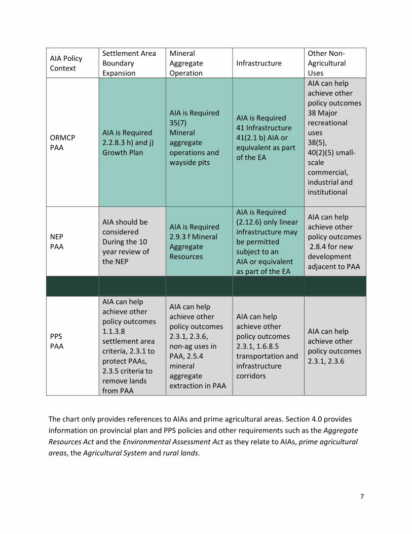
The following table provides a summary of the key land use planning policies in three scenarios: where an AIA is required, where an AIA should be considered and where an AIA is not required but where an AIA could be completed to satisfy other policies.
Table 1: Policy Direction for AIAs
Provincial plan policies that require an AIA
Provincial plan policies that direct that an AIA should be considered
Provincial plan or PPS policies that do not require an AIA but where an AIA can be an effective tool to satisfy other policies
AIA Policy Context
Settlement Area Boundary Expansion
Mineral Aggregate Operation
Infrastructure Other Non-Agricultural Uses
Growth Plan Prime Agricultural Areas (PAA)
AIA is required 2.2.8.3 h) and j) criteria for determining feasibility and location of settlement area boundary expansion
AIA is required 4.2.8.3 Mineral Aggregate Resources
AIA is Required 3.2.5.1 c) Development optimization, or expansion of existing and planned corridors and supporting facilities. AIA or an equivalent analysis as part of an Environmental Assessment (EA)
AIA can help achieve other policy outcomes 4.2.6.3 Agricultural System policies; achieving compatibility
Greenbelt Plan PAA
AIA is Required Growth Plan s. 2.2.8.3 h) and j)
AIA is Required 4.3.2.4 Non-Renewable Resource Policies, 3.1.2.2 specialty crop area (SCA) and 3.1.3.3 PAA
AIA is Required 4.2.1.2 g) General Infrastructure Policies, AIA or equivalent as part of an EA, 3.1.2.2 SCA, 3.1.3.3 PAA and 3.4.3.2 extension of services to settlement areas
AIA is Required 3.1.2.2, 3.1.3.3, non-agricultural uses are generally discouraged subject to policies 4.2 – 4.6 and only permitted after completion of AIA
7
AIA Policy Context
Settlement Area Boundary Expansion
Mineral Aggregate Operation
Infrastructure Other Non-Agricultural Uses
ORMCP PAA
AIA is Required 2.2.8.3 h) and j) Growth Plan
AIA is Required 35(7) Mineral aggregate operations and wayside pits
AIA is Required 41 Infrastructure 41(2.1 b) AIA or equivalent as part of the EA
AIA can help achieve other policy outcomes 38 Major recreational uses 38(5), 40(2)(5) small-scale commercial, industrial and institutional
NEP PAA
AIA should be considered During the 10 year review of the NEP
AIA is Required 2.9.3 f Mineral Aggregate Resources
AIA is Required (2.12.6) only linear infrastructure may be permitted subject to an AIA or equivalent as part of the EA
AIA can help achieve other policy outcomes 2.8.4 for new development adjacent to PAA
PPS PAA
AIA can help achieve other policy outcomes 1.1.3.8 settlement area criteria, 2.3.1 to protect PAAs, 2.3.5 criteria to remove lands from PAA
AIA can help achieve other policy outcomes 2.3.1, 2.3.6, non-ag uses in PAA, 2.5.4 mineral aggregate extraction in PAA
AIA can help achieve other policy outcomes 2.3.1, 1.6.8.5 transportation and infrastructure corridors
AIA can help achieve other policy outcomes 2.3.1, 2.3.6
The chart only provides references to AIAs and prime agricultural areas. Section 4.0 provides information on provincial plan and PPS policies and other requirements such as the Aggregate Resources Act and the Environmental Assessment Act as they relate to AIAs, prime agricultural areas, the Agricultural System and rural lands.

8
1.5 Components of an AIA Section 2.0 AIA Technical Guidelines provides information on the structure and content for an AIA which include the following ten components:
1. An Introduction
2. Process
3. Study Area Identification
4. Study Methodology
5. Description of soils, land use etc.
6. Assessment of Impacts
7. Mitigation Measures
8. Net Impacts
9. Study Recommendations and Conclusion and
10. Appendices
Depending on the nature, scale and extent of the development, an AIA may vary in the details and type of information provided in order to satisfy applicable provincial requirements. For example, where a new mineral aggregate operation in a prime agricultural area is required to rehabilitate the land back to an agricultural condition, an AIA may include detailed pre-extraction information of the mineral aggregate site.
In some cases, if sound reasons are provided, it may be appropriate for streamlining an AIA with other processes and studies being undertaken. Reasons may include:
Similar comprehensive agricultural impact studies or other directly applicable analyses relevant to the application under consideration have already been completed in the area;
In circumstances where an EA is required to evaluate a broad range of potential impacts (e.g. social, water, noise), studies assessing these other impacts may include information applicable to the assessment and mitigation of potential agricultural impacts. Where this is the case, applicable information from these other studies (including recommendations on ways to avoid, or where avoidance is not possible, minimize and mitigate impacts to agriculture) should be cross-referenced as part of the AIA.
9
1.6 AIA Approvals, Roles and Responsibilities Approval processes, roles and responsibilities, will vary depending on the nature, scale and location of the non-agricultural use being proposed and the relevant legislation, regulations, standards or policies that might apply. For example the following applies for approvals related to a settlement area boundary expansion, mineral aggregate operation and infrastructure within the GGH based on provincial plan policies:
For a settlement area boundary expansion, as part of a municipal comprehensive review undertaken by an upper- or single-tier municipality, the AIA must be submitted to the province as part of the land use planning approvals process under the Planning Act.
For mineral aggregate resource extraction applications, as part of land use planning approvals, the AIA will be submitted to the applicable municipality. It is recommended that in addition to providing the municipality with a completed AIA, the proponent also share the AIA with agencies whose mandates may be potentially affected by information in the report, including the Ontario Ministry of Agriculture Food and Rural Affairs (OMAFRA). Where an AIA is required as a result of a planning application, it is recommended that the AIA also be submitted as part of an Aggregate Resources Act application for information purposes as the Province will not be the decision maker on the planning application.
For infrastructure, as part of the EA process, provincial land use planning requirements will be addressed through the application of an AIA or equivalent analysis. Approvals for the AIA as part of an infrastructure process depend on the legislation that the AIA is being completed under. If the AIA is being done as part of a Class EA, the project will not have associated approvals unless a Part II Order request/bump-up request is requested. In the case of a Part II Order/bump-up request on a Class EA, the proponent completing the AIA, as part of a Class EA, will have to await a decision on the request by the Minister of the Environment and Climate Change. If the AIA is being done as part of an Individual EA, the project will have to be approved by the Minister of the Environment and Climate Change. When the Ministry of Environment and Climate Change (MOECC) carries out its review of EA projects for the Minister’s approval (where applicable), it is common practice to have other ministries review technical studies that are under their mandate (e.g. OMAFRA for AIAs).
Outside of the GGH, although not required in the PPS, an AIA may still be undertaken to satisfy the direction in other policies. Where an AIA is to be undertaken, depending on type of non-agricultural use the approvals will vary and may be similar to approval processes as outlined above within the GGH. It is important to refer to all applicable legislation and regulations, and associated standards and policies and to work with those who requested the AIA to clarify approval processes, roles and responsibilities.
10
1.7 Peer Review Where an AIA is not being approved by the Province and is required for municipal purposes, at the discretion of the municipality, the AIA could be peer reviewed by Qualified Professional(s) or by the municipality if in-house capacity to available to perform. Peer review should be done by a Qualified Professional(s) with appropriate qualifications and experience related to Ontario agriculture, the type of development proposed, AIAs, and mitigation measures.
It is recommended that municipalities keep a list of qualified peer reviewers to conduct AIA reviews. As part of their reporting, peer reviewers must also confirm that they are fully qualified to complete such a review and that they have no perceived or actual conflicts of interest associated with reviewing the AIA. They should also attest to their own objectivity. As appropriate, findings of a peer review need to be incorporated into the final AIA.
1.8 Qualified Professional(s) / Practitioner(s) (QPs) Qualified Professionals’ qualifications should include knowledge in:
Agri-businesses, agricultural supply chain linkages, rural/agricultural economic development in Ontario, and within the GGH, the agri-food network, where relevant
Rural and agricultural land use planning
Canada Land Inventory (CLI) classifications of capability for agriculture assessment and, where relevant a practical understanding of soil science, including the ability to review technical information from non-agricultural disciplines and assess its relevance and utility in identifying potential agricultural impacts and
Assessment and evaluation of the potential effectiveness of agricultural impact mitigation measures to reduce impacts.
The QP(s) should have demonstrable experience evaluating and assessing agricultural impacts and university or college degree(s) in one or more of the following: agriculture, soil science, geoscience, landscape architecture, resource management-related disciplines, environmental-related disciplines, agricultural engineering, or land use planning.
Depending on the nature and potential impacts of the proposed development, it may also be useful to involve professionals with expertise in other areas (e.g. micro-climatology, hydrogeology, ecology, agricultural engineering, accounting and economics) to obtain an appropriate breadth of relevant skills and experience. All professionals contributing to the AIA should have a relevant academic base, Ontario experience, and preferably membership in a professional organization with a code of ethics and ongoing professional development

11
requirements (e.g. a professional agrologist (P.Ag.) registered with the Ontario Institute of Agrologists, a registered professional planner (RPP) who is a full member of the Ontario Professional Planners Institute, a professional geoscientist (P. Geo) who is a practicing member of the Association of Professional Geoscientists of Ontario, a professional engineer (P.Eng.) licensed by Professional Engineers Ontario in a discipline relevant to work completed for the AIA, or a landscape architect who is a full member of the Ontario Association of Landscape Architects. QPs should also have demonstrated experience providing objective, professional judgment, advice, and testimony as an expert witness.
Contributions of all QPs to the AIA should be clearly and individually identified and relevant technical studies should be referenced and, where possible, appended to the AIA report. Curriculum vitae identifying the report’s authors and all contributors and their relevant qualifications should also be added to the AIA report.
1.9 AIAs and the Agricultural System The concept of an Agricultural System was first adopted by the Province in the Greenbelt Plan, 2005. In 2017, as part of the Coordinated Plan Review, the concept was enhanced to provide policies to support both the protection of farmland and the viability of the agri-food sector. All four provincial plans outline that an Agricultural System is comprised of an agricultural land base (prime agricultural areas, including specialty crop areas, and rural lands) and an agri-food network (including infrastructure, services and assets important to the viability of the agri-food sector). Some provincial plans policies require an AIA to assess impacts on the Agricultural System. (See the summary chart in section 1.4 and section 4.0 Background.)
To carry out an AIA, it is important to use municipal agricultural land base mapping, official plan policies, and in the GGH, OMAFRA’s Agricultural System portal. The portal includes the agricultural land base mapping, which can be used to support AIA work in a number of ways, including assessing impacts to agricultural lands and operations and evaluating alternative locations for non-agricultural uses. The portal also has information on the agri-food network and will support the assessment of economic and community impacts of the proposed non-agricultural use on the Agricultural System. Where available, QPs and municipalities should use additional local or regional data and local knowledge to further understand and evaluate potential impacts on the agri-food network. Visit the Agricultural System in Ontario’s Greater Golden Horseshoe for provincial mapping, Implementation Procedures and to use the Agricultural System portal.

12
2.0 Technical AIA Guidelines
2.1 Introduction Section 2.0 provides the Technical AIA Guidelines outlining the structure and content of an AIA. Depending on the nature, scale and location of the development, detailed work completed for an AIA may vary, but each of the components should be completed. Information in section 4.0 outlines requirements for AIAs and other relevant policies, in relation to different types of development including: settlement area boundary expansions, non-agricultural uses such as mineral aggregate operations, infrastructure and other non-agricultural uses (e.g. institutional, recreational). It is recommended that the structure and content of an AIA be consistent with these Technical AIA Guidelines.
2.2 AIA Study Components
1. Introduction
The introduction of an AIA should provide a description of the proposal, including details about its location, and clearly identify why the AIA is required (i.e. what triggers the need for an AIA), and any additional provincial and municipal requirements that apply. The proponent should also be identified along with the scope of the retainer (i.e. who commissioned the report and when), as well as the author(s) of the AIA.
Purpose of the Study
Based on the type of proposed development, the scale, and location, the purpose of the study should include details on why the AIA is being undertaken and what the AIA will do. Information should include:
An explanation (details are to be outlined below) of how the AIA will satisfy provincial and municipal planning requirements and other provincial requirements as applicable.
Objectives of the AIA (e.g. to assess potential impacts to agriculture, develop recommendations and mitigation measures to mitigate potential impacts to agriculture, farm operations and the surrounding area and within the GGH this includes the Agricultural System).
An explanation of how the AIA will satisfy these objectives. For example, the following may be worth highlighting, as applicable and relevant to the development being undertaken:
13
An evaluation of alternative locations will be undertaken
The site will be rehabilitated back to an agricultural condition
Minimum Distance Separation (MDS) II requirements3 will be met
Net impacts (i.e. impacts that will result from the development even after mitigation measures are implemented) will be assessed and recommendations will be provided to mitigate impacts and
A monitoring plan and/or performance measures will be developed to ensure mitigation measures have long-term effectiveness.
Description and Location
This sections should describe the nature of, and rationale for, the application. Information should include the type and purpose of the development proposal, the location, maps that are of an appropriate scale and detail, a general description of agriculture in the area, and explain if the PPS and/or provincial plan policies apply along with any relevant applicable designations. For example, within the GGH, confirm if the Agricultural System has been implemented (i.e. the agricultural land base is mapped and designated and the agri-food network is identified).
For a settlement area boundary expansion, include the following:
A description of the proposed settlement area boundary expansion and details on how and why alternative location(s) have been evaluated, the rationale for the selected location(s) and its extent and include maps. In the GGH, locations are to be evaluated across upper- and single-tier municipalities. Once alternative location(s) have been selected, maps of appropriate scale and detail for each of these areas i.e. study area(s), should be provided. Evaluating alternative locations should include information on applicable land use designations and zoning, and a description of the prime agricultural area designations or, if applicable, the agricultural land base, being considered for redesignation.
For a mineral aggregate operations the following should be included:
A description of the proposed mineral aggregate operation and an explanation on whether this is a new site or an expansion of an existing operation. The description should include: the type of operation (e.g. pit, quarry, above water table extraction,
3 MDS is required for some types of development but not all. It is required for settlement area boundary expansions but not for mineral aggregate operations and infrastructure.

14
etc.), information on the resources to be extracted (e.g. quality and quantity), an outline of the maximum extraction rate (tonnes/year), the proposed after use and an appropriate justification for the proposed after use (e.g. rehabilitation of the site back to an agricultural condition). If the site is being rehabilitated back to an agricultural condition, then a brief description should be provided on the proposed sequencing and phasing of the operation, and the areas to be progressively rehabilitated.
Details on the proposed mineral aggregate operation location, its extent and maps of appropriate scale and detail. A legal description, lot and concession, and the address of the site, the proposed licensed boundary and the proposed limits of extraction, where possible should be provided and applicable land use designations and zoning, and a description of the prime agricultural area designations or, if applicable, the agricultural land base, being considered for redesignation.
For infrastructure the following should be included:
A description of the infrastructure project and details of the proposed infrastructure location, its extent, maps of appropriate scale and detail, and an outline of the study area(s) that are being evaluated, information on applicable land use designations and zoning and a description of the prime agricultural area designations or, if applicable, the agricultural land base designation(s) (this may include prime agricultural areas and/or rural lands) being considered for redesignation. Do this for each location (i.e. study area) being evaluated.
For proposed non-agricultural uses similar information should be provided as outlined for settlement area boundary expansions.
Requirements
This section should outline the policy and regulatory framework (provincial and municipal) to explain why an AIA is required and what needs to be done to comply with the requirements.
Provincial Requirements
A description of the relevant provincial requirements related to the proposed settlement area boundary expansion or non-agricultural use and agriculture should be provided along with an explanation on how the proposal is consistent and/or conforms to the PPS, provincial plans and other applicable requirements (e.g. Aggregate Resources Act and Environmental Assessment Act). Section 4.0 Background of this document, provides more information on provincial requirements for completing an AIA, but it is important to refer directly to relevant legislation, regulations, standards and policies.
15
Where applicable, and following these AIA Technical Guidelines, only one AIA should need to be completed to satisfy multiple provincial requirements. For example, if other technical studies (e.g. dust, hydrological, transportation and haul route studies) are undertaken and they assess impacts to agriculture and provide mitigation measures, then relevant information from these studies can be used to inform an AIA. It is important to note that the extent of other technical studies may vary from the AIA study area. The relevant information from these other studies should be explained and cross-referenced in order to integrate the information into the AIA.
Municipal Requirements
The AIA should also provide a description of the relevant agricultural policies and requirements contained in municipal, regional, or local official plans and zoning by-laws and explain how the proposed development is consistent with these policies. Municipalities are encouraged to add AIAs’ to their list of reports or studies required to support a complete application (e.g. for a consent, official plan amendment, zoning by-law application etc.).
2. Process
This section should provide details about the AIA process (e.g. pre-consultation, nature of the retainer, who commissioned the report, authors of the AIA, consultations, review and/or approvals and AIA recommendations and their implementation). Where an AIA is required, qualified professional(s)/practitioner(s) (QPs) with technical agricultural and land use planning expertise and credentials (see section 1.8 of this document) should undertake an AIA.
Pre-consultation
It is recommended that a pre-consultation meeting take place prior to initiating an AIA. The meeting should include as appropriate, the QP(s) preparing the AIA, municipal, and other regulatory agency staff as relevant. The goal of the meeting should be to review the terms of reference for the study including objectives, parameters, and timelines of the AIA prior to undertaking the work. The meeting would provide an opportunity for the invited participants to provide relevant information important to the AIA and identify any specific concerns regarding the proposed development. The meeting should inform those who are undertaking the AIA of any additional local and regional matters that should be addressed in the AIA. If other meetings are being held as part of other regulatory processes if appropriate, the AIA could be discussed as part of these meetings.
The pre-consultation meeting should confirm details that will go in the introduction of the AIA, and include highlights of the pre-consultation meeting discussion and agreed upon outcomes. If a pre-consultation meeting is not held, then the QP(s) undertaking the AIA should confirm the AIA work to be undertaken and the study areas with the appropriate approval authority.

16
Consultation
Consultation on the AIA for the proposed development should be undertaken based on meeting provincial (e.g. Planning Act, Aggregate Resources Act, and EA) and municipal requirements. Where potential impacts to agriculture have been identified, it is advisable to consult with local agricultural organizations (e.g. municipal agricultural advisory committee, local farm organization). Agricultural organizations can often provide valuable input about agricultural operations, the farm service and supply network, and other components of the local agri-food sector which can help inform the work to be done to assess agricultural impacts. They can also provide helpful suggestions on how to avoid, where possible, minimize and mitigate potential impacts from the proposed development on agriculture that may not otherwise be considered. In addition, surrounding landowners can provide valuable local knowledge and understanding of the farming community and potential impacts the proposed development may have on agriculture, and where applicable the Agricultural System, both locally and regionally.
Approvals
Approval for an AIA will vary depending on the nature and location of the development. It is important to refer to the specific legislation, regulations, standards and policies for direction and the most up-to-date information. See section 1.6 AIA Approvals, Roles and Responsibilities for more information.
3. Study Areas
The primary and secondary study areas should be confirmed at the pre-consultation meeting along with a list of local landowners, farmers, farming organizations and agricultural advisory committees that should be engaged in the AIA to help, among other things, provide information on the economic and community significance of agriculture in the primary and secondary study area(s). If the proposed development is large and has identified potential impacts to agriculture, as a best practice it is recommended at a minimum to seek feedback from a local agricultural advisory committee where possible. If no pre-consultation meeting is held, then confirmation of the study area(s) should be done with those who will be approving the AIA and based on meeting provincial and municipal requirements.
The focus of work in the primary study area is to understand the current status of agriculture in the area and the impact of removing agricultural lands (permanently or temporarily) for development. The secondary study area focuses on understanding agriculture in the surrounding area and how this area will be impacted from the new development and from removing agricultural land within the primary study area.

17
Primary Study Area (subject lands)
The primary study area includes the subject lands (i.e. the lands where the development is taking place). For example:
For settlement area boundary expansions, the primary study area(s) should include the area where expansion(s) is (are) being considered. That is the potential settlement area boundary expansion location(s) that correspond with the amount of land area that has been justified and identified as necessary to accommodate growth, also referred to as the subject lands. The primary study area evaluation will include an analysis of impacts based on this area being re-designated to accommodate urban development.
If more than one location is being considered, then each of these areas will need to be identified as a primary study area. For example a municipality may have two primary study areas. In this case an AIA must include an evaluation of alternative locations to determine which of the two primary study areas would have the least amount of impact on agriculture, noting other land use policies and requirements also need to be factored in when selecting a settlement area boundary expansion location.
For mineral aggregate resource extraction the primary study area (i.e. subject land) is the proposed licensed area.
For infrastructure projects other legislation and processes such as the EA process will determine the study area(s). The extent of the study area is dependent upon the extent of potential impacts, and this could vary by category of impact (for example, impacts to groundwater resources may have a different influence area than impacts to air quality). Study Areas should be confirmed during a pre-consultation meeting if one is held or if not, with the applicable approval authority.
For transportation corridors, the primary study area is defined as all lands to be impacted/disturbed by proposed highway construction within the existing and proposed highway Right-of-Way plus any specified access roads, detours, staging and storage areas, and areas of other works and activities associated with the construction of the highway.
For non-agricultural uses, a similar approach to what is described above for settlement area boundary expansions, may be appropriate depending on the nature, scale and location of the proposed non-agricultural use.

18
Secondary Study Area
The secondary study area will include lands that will be potentially impacted by the development. The secondary study area should, at a minimum, include lands adjacent to the primary study area and depending on the nature, scale and potential impacts the development will have on agriculture in the surrounding area, the secondary study area will vary on its extent. Each AIA should therefore define and justify the extent of the secondary study area taking into account the potential impacts of the development, as well as the sensitivity of agricultural lands and farm operations in the area. The following recommendations are offered as a starting point and best practice:
For settlement area boundary expansions, a 1.5 km radius is recommended for a secondary study area(s). (See Figure 1.) This aligns with other provincial guidance (i.e. Minimum Distance Separation Guidelines and OMAFRA’s Guidelines on Permitted Uses in Ontario’s Prime Agricultural Areas). For example, Minimum Distance Separation (MDS) Guidelines use 1.5 km as an “investigation distance” (e.g. if a settlement area boundary expansion is being proposed, you need to look at all barns within 1.5 km of the proposed expansion, and if appropriate, complete an MDS I setback calculation). The rationale for 1.5 km as the investigation distance is tied to the size of MDS I setbacks. Generally MDS 1 setbacks deal sufficiently with odour issues and therefore can be a good basis for investigating other impacts such as noise, traffic and hydrological changes. Furthermore a 1.5 km radius will provide an appropriate area to assess community and economic impacts and within the GGH impacts to the Agricultural System using the OMAFRA’s Agricultural System portal, along with local data and knowledge to assist with the analysis.
For mineral aggregate operations, the extent of the secondary study area will vary depending on the scale and extent of the proposed mineral aggregate operation and on agriculture in the surrounding area (and within the GGH the Agricultural System). For example, for a small to medium-sized gravel pit, agricultural land and operations adjacent to the proposed mineral aggregate operation may be sufficient, whereas a large, limestone quarry with blasting and dewatering, may have a potentially larger affected area meaning the extent of the secondary study area should be greater. In the
Figure 1 Proposed primary and secondary study areas for a settlement area boundary expansion

19
case of the latter example and with larger proposed extraction sites, it is recommended that a 1 km radius from the proposed licensed area be a starting point for the investigation area for the secondary study area. Depending on the scale of the proposed extraction and potential impacts on agriculture, the study area can then be appropriately increased or decreased. Factors such as the anticipated impacts from blasting and/or potential changes to the regional groundwater system and impacts of haul routes should be considered.
Within the GGH, components of the agri-food network will also need to be included to determine if the mineral aggregate operation proposal may have potential impacts to surrounding infrastructure, services and assets. For example a haul route may impact the movement of farm vehicles and machinery or an agri-tourism business may be impacted by increased traffic on haul routes or noise from blasting.
For Infrastructure, primary and secondary study areas should be determined based on the information provided above under primary study area and in accordance with EA processes.
For other non-agricultural uses, and in general, the secondary study area will vary and the extent of the area should be confirmed during a pre-consultation meeting if applicable, or if no pre-consultation meeting is held, with those who are approving the AIA. Within the GGH, the Agricultural System portal, along with local data and knowledge, should help inform the extent of the secondary study area (e.g. if there is key infrastructure, assets and services that will be removed or impacted by the non-agricultural use, these components should be included in the secondary study area as appropriate).
4. Study Methodology Identification
Background Data Collection and Review
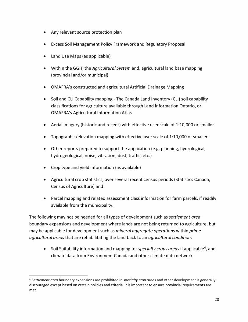
This section should include details on the background and data collected to carry out the AIA. A complete list of the background materials reviewed, their sources, literature cited and dates should be provided (for formatting purposes this could be included in an appendix or its own section following the conclusions). The list should include the following subject to availability (but not be limited to):
Relevant provincial land use plans and policy documents (e.g. PPS, the Growth Plan, Greenbelt Plan, ORMCP, NEP, etc.)
Municipal planning documents (official plans and zoning by-laws), as well as municipal drains and/or other types of public works or legal instruments such as easements
20
Any relevant source protection plan
Excess Soil Management Policy Framework and Regulatory Proposal
Land Use Maps (as applicable)
Within the GGH, the Agricultural System and, agricultural land base mapping (provincial and/or municipal)
OMAFRA’s constructed and agricultural Artificial Drainage Mapping
Soil and CLI Capability mapping - The Canada Land Inventory (CLI) soil capability classifications for agriculture available through Land Information Ontario, or OMAFRA’s Agricultural Information Atlas
Aerial imagery (historic and recent) with effective user scale of 1:10,000 or smaller
Topographic/elevation mapping with effective user scale of 1:10,000 or smaller
Other reports prepared to support the application (e.g. planning, hydrological, hydrogeological, noise, vibration, dust, traffic, etc.)
Crop type and yield information (as available)
Agricultural crop statistics, over several recent census periods (Statistics Canada, Census of Agriculture) and
Parcel mapping and related assessment class information for farm parcels, if readily available from the municipality.
The following may not be needed for all types of development such as settlement area boundary expansions and development where lands are not being returned to agriculture, but may be applicable for development such as mineral aggregate operations within prime agricultural areas that are rehabilitating the land back to an agricultural condition:
Soil Suitability information and mapping for specialty crops areas if applicable4, and climate data from Environment Canada and other climate data networks
4 Settlement area boundary expansions are prohibited in specialty crop areas and other development is generally discouraged except based on certain policies and criteria. It is important to ensure provincial requirements are met.

21
Information from on-site investigations within the primary study area (e.g. bore hole logs from resource evaluations and hydrogeological investigations)
Any plans that set out the existing conditions and operational and rehabilitation aspects of the proposal (e.g. Site Plans to include the Existing Conditions Plan, Operational Plan, and Rehabilitation Plan) and
Site plans and AIAs if applicable and available, for adjacent and/or surrounding aggregate operations.
Data and Information for the Land Use Survey
This section should explain the agricultural lands and operations that are within the proposed study area(s). The land use survey should identify and describe the land use history and existing conditions of the lands in the primary and secondary study area(s) including:
Schedule from the municipal official plan indicating the land use designation(s) (e.g. for upper-, single- and lower-tier official plans if applicable)
Schedule from the municipal comprehensive zoning by-law illustrating the municipal zoning
The Canada Land Inventory (CLI) soil capability classifications for agriculture available through Land Information Ontario, or OMAFRA’s Agricultural Information Atlas
Agricultural resource inventory map combining existing aerial imagery with parcel fabric and identifying the following features within the study area
Farmsteads, the location and type of operation with historical and recent information if available (e.g. cluster of farm buildings, with or without dwellings, livestock facilities)
Farm fields with type of crop (e.g. pasture, hay, field or horticultural crop, etc.)
Agri-food businesses (e.g. chemical, seed, or fertilizer input suppliers, agricultural sales or service, farmers markets, grain dryers, food processors or distributors, etc.)
Non-farm development (e.g. commercial, industrial, institutional, residential, recreational, etc.)
Other land uses and features (e.g. fencerows, roadways, ditches, riparian areas, rough land areas, forests, wetlands, etc.)

22
Agricultural drainage map indicating location of municipal drains, tile outlets and field tile (random or systematic) within the study area(s)
Where available, the specific type and relative level of investment in farm infrastructure (farm related buildings and structures and manure handling/storage facilities) and land improvements (e.g. tile drainage, irrigation) and
Within the GGH, information on the Agricultural System5 must be included for both the agricultural land base and the agri-food network (infrastructure, services and assets).
Local Knowledge and Input
To gain an understanding of agriculture in the primary and secondary study areas, where feasible, information may be supplemented by farm interviews or meetings to obtain specific information directly from local farmers, farm organization or the local agricultural advisory committee within the primary and secondary study areas. If interviews or meetings are undertaken, additional information could include:
The potential impacts of proposed development (if any) on farm operations on adjacent lands/secondary study area
Whether the proposed development will result in the fragmentation of agricultural lands
Details on the importance of the farmland within the potential primary study area and whether the loss of these lands from production will impact the long-term viability of farming in the surrounding area and
Details on farm operations and associated infrastructure, services or other assets, their importance to agriculture, whether there are permanent losses and if they can be replaced or not (e.g. if they are in the primary study area) or if they would be negatively impacted by the proposed development (if they are in the secondary study area).
5 Municipalities are to implement the Agricultural System within the GGH based on provincial mapping, implementation procedures and the Agricultural System portal. Municipal data, agri-food business data and information, and local knowledge should be used to add additional information about the agri-food sector and the agri-food network where available.

23
Field Investigations
Field investigations may also be used to augment background and primary data in assessments of agriculture. For example:
Verification of background data pertaining to agricultural land uses
Active farm locations, and the type of operation at each location
Farm buildings and other key permanent facilities at each location
Directly linked operations at different locations (such as where multiple farm properties support one farm operation)
Active farm communities (could be on rural lands)
Heritage buildings and features
Contaminated property and
Verification of soil capability, crop patterns, farm operations and Specialty Crop status of lands in the study area(s).
Access to Farmland
Where applicable, access to farmlands to complete the required assessment studies must be negotiated with the landowner. If there are any environmental impacts from field investigations that cannot be avoided, their mitigation shall be part of the negotiation with the landowner.
5. Description (Soils, Land)
This section should provide a general description of the physiographic setting(s) and land uses in the primary and secondary study areas.
Soil Resources
A good understanding of the soil resources within the study areas is necessary in order to document information needed to evaluate alternative locations, assess impacts, and support the mitigation measures to minimize and mitigate impacts, including rehabilitation of the land back to an agricultural condition if applicable.
Assess the CLI Capability of the soil and describe the limitations for common field crop production. Include a CLI Capability map that shows the CLI Classes assigned to
24
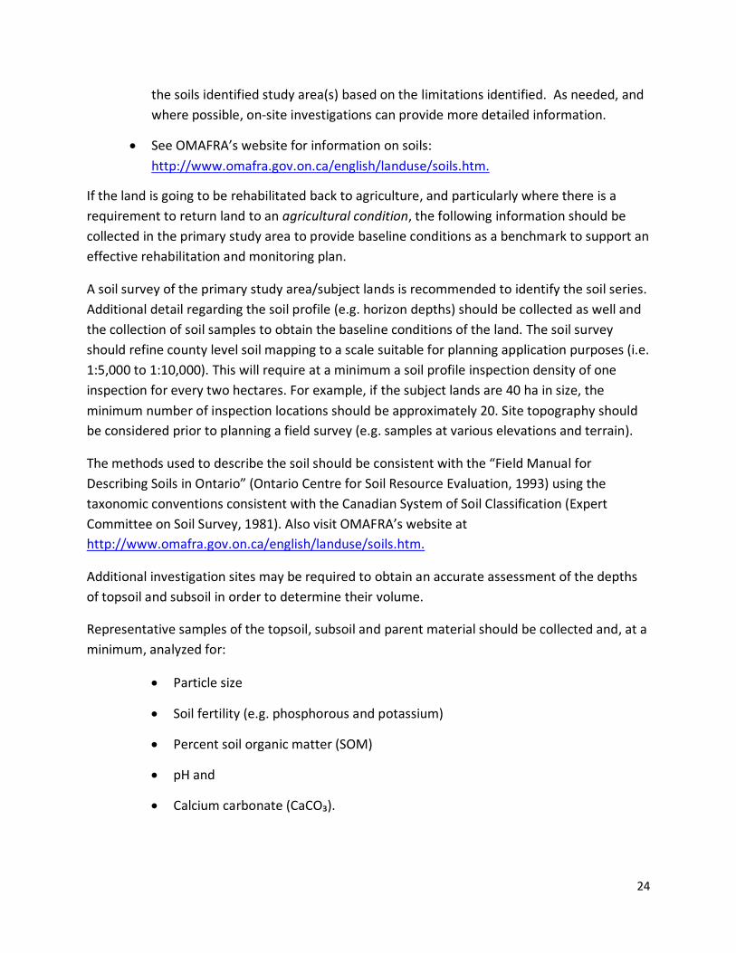
the soils identified study area(s) based on the limitations identified. As needed, and where possible, on-site investigations can provide more detailed information.
See OMAFRA’s website for information on soils: http://www.omafra.gov.on.ca/english/landuse/soils.htm.
If the land is going to be rehabilitated back to agriculture, and particularly where there is a requirement to return land to an agricultural condition, the following information should be collected in the primary study area to provide baseline conditions as a benchmark to support an effective rehabilitation and monitoring plan.
A soil survey of the primary study area/subject lands is recommended to identify the soil series. Additional detail regarding the soil profile (e.g. horizon depths) should be collected as well and the collection of soil samples to obtain the baseline conditions of the land. The soil survey should refine county level soil mapping to a scale suitable for planning application purposes (i.e. 1:5,000 to 1:10,000). This will require at a minimum a soil profile inspection density of one inspection for every two hectares. For example, if the subject lands are 40 ha in size, the minimum number of inspection locations should be approximately 20. Site topography should be considered prior to planning a field survey (e.g. samples at various elevations and terrain).
The methods used to describe the soil should be consistent with the “Field Manual for Describing Soils in Ontario” (Ontario Centre for Soil Resource Evaluation, 1993) using the taxonomic conventions consistent with the Canadian System of Soil Classification (Expert Committee on Soil Survey, 1981). Also visit OMAFRA’s website at http://www.omafra.gov.on.ca/english/landuse/soils.htm.
Additional investigation sites may be required to obtain an accurate assessment of the depths of topsoil and subsoil in order to determine their volume.
Representative samples of the topsoil, subsoil and parent material should be collected and, at a minimum, analyzed for:
Particle size
Soil fertility (e.g. phosphorous and potassium)
Percent soil organic matter (SOM)
pH and
Calcium carbonate (CaCO₃).
25
For baseline information, soil density measurements should be taken at a minimum of three levels within the soil profile representing the three major soil horizons (e.g. topsoil, subsoil & overburden/parent material).
Depending on the depth of the subsoil overlying the parent material, the depth to the aggregate resource and the type of aggregate resource (i.e. sand & gravel or bedrock) additional samples may be required from within the soil profile to obtain truly representative bulk density measurements throughout the soil profile.
It is important that a qualified person (QP) with a strong background in soil science be involved in describing the soil profile on-site and determining the number of samples and the depths at which they are to be taken. Soil density measurements can be taken using soil cores, a penetrometer, nuclear moisture/density gauge or other suitable methods. If soil cores are to be collected, a minimum of three cores from each horizon should be collected and analyzed to obtain statistically relevant results. The soil density information will be a useful comparison when determining the success of attempts to alleviate compaction during post-rehabilitation monitoring.
Measuring the microbial biomass of the soil to (i.e. collect samples at depths of 0 – 10 cm, 10 – 20 cm & 20 – 30 cm) should also be considered. Soil microbial biomass is a measure of the mass of the living component of soil organic matter and is important to the release of essential plant nutrients and the maintenance of good soil structure.
Slope / Topography
A general description of slope and topographic features including contour mapping of the site and surrounding area should be provided. If there are CLI notations regarding topography, an assessment of this information should be completed. A description of any limitations to agricultural capability based on slope should be included.
Hydrology, Hydrogeology and Drainage
Management of water resources is an important consideration for farm operations. Changes to the hydrologic and/or hydrogeological conditions in the area surrounding the site can have a negative impact on water quality and quantity and on the productivity of farmland and farm operations. It is therefore necessary to review and note any relevant information contained in supporting hydrological and hydrogeological studies prepared for the application to understand potential impacts.
Information should include details on drainage; surface drainage features, if drainage infrastructure exists or not, as well as existing or past improvements. If tile drainage exists a description of the system and its status should be provided.

26
Climate (only required for specialty crop areas)
A general description of climatic features including Crop Heat Units, number of frost-free days, and the general climatic patterns of the area should be provided. A description of any microclimatic conditions particular to the site should be included (e.g. frost pockets). This information is only required for specialty crop areas and where a non-agricultural use may be permitted, noting for example that settlement area boundary expansions are not allowed within specialty crop areas.
Soil suitability and microclimate
In specialty crop areas, the Soil Suitability Ratings for crop types historically grown on site or common in the surrounding area should be assessed. The soil suitability ratings should be consistent with the ratings assigned by OMAFRA to the soil series identified on site and as contained in Ontario Soil Survey reports (e.g. The Soil Survey of the Regional Municipality of Niagara, Report No. 60); and
For specialty crop areas, the most important microclimate variables are derived from temperature data. It is important to know first and last frost dates, the frost-free period, Crop Heat Units (CHU), etc. and where lands have topographic features which enhance the microclimatic advantages of the site for specialty crop production (e.g. elevation, slopes, slope aspect, etc.).
Land Use Characteristics
Based on information collected from the background and primary data review and land use survey, this section should include:
A description and map of the land use, and information on farm operations with historical (e.g. recommended ten years) and existing recent information where available including:
Farmsteads (e.g. cluster of farm buildings, with or without dwellings, livestock facilities)
Farm fields with type of crop (e.g. pasture, hay, field or horticultural crop, etc.)
Parcel size and form and limitations/opportunities for farming and
Points of access to farm operations and fields for farm machinery
Information on whether or not the proposed development will fragment any farmland or operations and where applicable, the historic severance activity and level of fragmentation by severance, natural features or infrastructure (e.g. roads, easements).

27
Information on Infrastructure and land improvements:
Type, condition and use of buildings and structures on-site
The level of investment in agricultural facilities and farm infrastructure (farm related buildings and structures, manure handling/storage facilities)
Description of the improvements (irrigation, tile drainage, land forming, fencing, recent land clearing or stone removal, investment in root stocks, wind machines) and
Agricultural drainage map indicating location of municipal drains, tile outlets and field tile (random or systematic).
In the GGH, provide information on the Agricultural System6 for both the agricultural land base and the agri-food network — for example, agri-food businesses (e.g. chemical, seed, or fertilizer input suppliers, agricultural sales or service, farmers markets, grain dryers and food processors)
Information on existing and potential constraints to agriculture e.g. MDS II where applicable, such as traffic impacts
Information on any operational relationships between primary study area (i.e. subject lands) and adjoining parcels and
A description of other relevant features (e.g. fencerows, roadways, ditches, riparian areas, rough land areas, forests, wetlands, etc.).
In the secondary study area, there may be challenges to describing and mapping all the information listed above. In cases where detailed information is not available, the Qualified Professional(s) must use their best judgment/interpretation to determine information outlined.
Economic and Community Benefits of Agriculture
Understanding the economic and community benefits associated with agriculture in the study areas is important to assess the impacts associated with the proposed settlement area boundary expansion or non-agricultural use.
6 Municipalities are to implement the Agricultural System within the GGH based on provincial mapping, implementation procedures and the Agricultural System portal. Municipal data and information should be used to add additional information about the agri-food sector and the agri-food network where available.
28
This section should provide information and a description of the local and regional significance of agriculture in terms of economic and community benefits they provide. For example:
Quantify the economic impact of agricultural production in the study areas with census of agriculture data
Consider the social and economic benefits the agricultural land and related activities bring through such operations as local farm markets and pick-your own operations that generate tourism revenue and employ local residents.
Within the GGH, the Agricultural System portal and mapping can provide information to support the analysis. Local and regional data and information where available and local knowledge should support the analysis.
6. Assessment of Impacts
The assessment of potential impacts and development of mitigation measures is a multidisciplinary exercise that requires knowledge of land use planning, agriculture (soils, the industry and its economic and community contributions) to fully examine the impacts that may occur due to non-agricultural uses. How to avoid, minimize and mitigate impacts to agriculture (and within the GGH to the Agricultural System) are to be assessed and included as part of the AIA and to inform recommendations. If during the assessment, it is determined that there are steps that can be taken to mitigate impacts, then assuming these are implemented, describe the net impacts to agriculture. Findings of other technical studies and information related to potential changes in e.g. water resources, air quality, traffic, etc. should be considered in the assessment of potential impacts to agriculture and for the development of mitigation measures.
Consideration should also be given to the potential local and regional impacts of removing the primary study area lands (permanently or temporarily) on agricultural lands, operations and the agri-food sector within the surrounding area and within the GGH to the Agricultural System (the extent of the assessment is based on the secondary study area). For example consider the potential impacts from:
Interim or permanent loss of agricultural land, including the quality and quantity of farmland lost
Fragmentation of agricultural lands and operations

29
The type of agricultural, agriculture-related or on-farm diversified uses being lost and the significance this has for supporting other agricultural production in the surrounding area
The loss of existing and future farming opportunities
Minimum Distance Separation changes (where applicable) that will constrain future farm operations
The loss of infrastructure, services or assets important to the surrounding agricultural community and agri-food sector
The loss of agricultural investments in structures and land improvements (e.g. artificial drainage)
The disruption or loss of function to artificial drainage and irrigation installations
Changes to the soil drainage regime
Changes to surface drainage features which could have an effect on adjacent lands
Changes to landforms, elevations and slope that could alter microclimatic conditions (e.g. modification to slopes that may reduce or improve cold air drainage opportunities and changes to elevation may have an impact on diurnal temperatures)
Changes to hydrogeological conditions that could affect neighboring municipal or private wells, sources of irrigation water and sources of water for livestock
Disruption to surrounding farm operations, activities and management (e.g. temporary loss of productive agricultural lands, cultivation, seeding, spraying, harvesting, field access, use of road network)
The potential effects of noise, vibration, dust, and traffic on agricultural operations and activities
Potential compatibility concerns such as normal farm practices facing challenges with e.g. nuisance complaints, vandalism and trespassing that may occur with the new development being established and
The inability or challenges to move farm vehicles and equipment along roads due to increased traffic caused by haul routes, changes in road design.
30
Economic and Community Impacts
Potential impacts in terms of economic and community impacts that the surrounding area and agri-food sector may face as a result of the settlement area boundary expansion or non-agricultural use should be assessed. The potential economic and community impacts should be described in terms of their magnitude and extent (locally or regionally) and help inform measures and recommendations to address the impacts. For example consider:
The loss of farmland or fragmentation of the agricultural land base and potential associated economic challenges
Consider if the farm operation is a critical economic generator in the area, or if there are significant acreages being lost that are important to maintaining the contiguity of farmland in the area (the agricultural land base in the GGH)
The removal of investments (in agricultural supportive infrastructure, services or assets) and the significance this has to the agri-food sector
Consider if the agricultural, agriculture-related and/or on-farm diversified uses has infrastructure upon which other farms rely and/or services important to the surrounding farm community
Consider if the agricultural, agriculture-related or on-farm diversified uses produce a commodity or service that surrounding agricultural community is dependent upon. Examples include the raising of dairy heifers for surrounding dairy operations, weaners for feeder hog operations, day-old chicks for broiler operations, indoor riding facilities for equestrian operations, grain dryer facilities, farm machinery dealerships, and fruit and vegetable processing facilities
Examine if any agricultural losses can be replaced or if other farms will struggle economically as a result of the loss
Loss of community use of and support for surrounding infrastructure, services and assets important to the agri-food sector
Consider community benefits such as agri-tourism, products for the retail market/local food or educational benefits that are being lost and the impact this will have on the community

31
7. Mitigation Measures
This section should outline what mitigation measures are required to avoid, minimize or mitigate impacts from the settlement area boundary expansions or non-agricultural uses on agriculture and within the GGH to the Agricultural System.
Mitigation measures vary depending on the scale, type and location of development. They should be proportional to the estimated potential impact or risk. Where required, mitigation measures include rehabilitation of lands to an agricultural condition. Refer to section 3.0 for more information.
8. Net Impacts
Assuming that the recommendations of measures to avoid, minimize and mitigate impacts of the development are implemented, this section should describe the anticipated net impacts, after mitigation measures have been put in place, of the proposed settlement area boundary expansion or non-agricultural uses on agricultural land and agricultural operations and the surrounding area (within the GGH on the Agricultural System).
Net impacts should be described with respect to their magnitude and extent in the context of the lifespan of the settlement area boundary expansion or non-agricultural uses. Where net impacts are dependent on specific mitigation and performance measures, these dependencies should be clearly identified.
9. Study Conclusions and Recommendations
Recommendations specific to the proposed settlement area boundary expansion or non-agricultural use including requirements for mitigation measures, including rehabilitation if applicable, that should be implemented to reduce impacts from the proposed development should be outlined in this section. Recommendations should include mitigation measures that can be put in place pre-development, during development and post-development as appropriate. Monitoring and performance measures are recommended to ensure that the mitigation measures have been successfully implemented.
In conclusion explain how the objectives of the AIA have been fulfilled, the net impacts of the settlement area boundary expansion or non-agricultural uses and state whether the proposal is consistent with the relevant provincial requirements.
32
10. Recommended Appendices
Include appendices as needed to support the AIA. Suggestions for items to be included in an appendix of the AIA include:
Curriculum Vitae of Study Team
All background and study data sources; a description of the methodologies and survey techniques employed in the study, including a description of soil sampling techniques and method of viability assessment, soil survey site investigation data (e.g. soil profile descriptions and slope measurements
As appropriate, a list of people contacted during the AIA study
Monitoring Plan for implementing the recommendations and mitigation measures and
List of References Cited
3.0 Mitigation Measures
3.1 Introduction A key objective of an AIA is to identify recommendations to avoid, and if avoidance is not possible, minimize and mitigate impacts to agriculture throughout the province and to the Agricultural System within the GGH. For each AIA, it is expected that appropriate best management practices and recommended options for implementing mitigation measures will be identified and evaluated based on site- or area- specific conditions.
The following information provides explanations of these terms and gives examples of how to avoid, minimize and mitigate impacts to agriculture and the Agricultural System. A selection of mitigation measures are provided as examples, but does not constitute an exhaustive or complete list of potential measures. The tables, are followed by a few detailed examples of mitigation measures for settlement area boundary expansions, road safety and education, and mineral aggregate extraction.
References providing more information on some of the mitigation measures listed here can be found in Appendix A: Resources. Appendix B: Rehabilitation Information and Resources provides information for mineral aggregate operations located within prime agricultural areas to rehabilitate the site back to an agricultural condition, however this information can be applied more generally where lands are being rehabilitated back to agriculture.

33
3.2 Avoiding, Minimizing and Mitigating Impacts It is important to refer to the policies of the provincial plans to understand the outcome a mitigation measure is trying to achieve. For example, Growth Plan policy 2.2.8.3h) directs that prime agricultural areas should be avoided where possible. An agricultural impact assessment will be used to determine the location of the expansion based on avoiding, minimizing and mitigating the impact on the Agricultural System and evaluating and prioritizing alternative locations across the upper- or single-tier municipality in accordance with certain criteria; and Growth Plan policy 4.2.6.3 directs – where agricultural uses and non-agricultural uses interface, outside of settlement areas, land use compatibility will be achieved by avoiding or where avoidance is not possible, minimizing and mitigating adverse impacts on the Agricultural System. Depending on the type of development, the policy requirement and the outcome to be achieved, the mitigation measure may vary. The following charts are designed to provide a suite of mitigation measures that could be used to help satisfy policy requirements and avoid, minimize and mitigate impacts on agriculture. Section 4.0 provides more policy details.
3.2.1 Avoiding Impacts Avoiding impacts does not mean that a settlement area boundary expansion, or a non-agricultural use cannot proceed. It means that locations are considered and developments are planned at the outset with the goal of avoiding impacts. Avoidance is a necessary first priority and may be fully or partially successful at preventing adverse impacts on agriculture. Where full avoidance is not possible, the next step is to minimize impacts, followed by implementing measures to mitigate adverse impacts.
Avoiding impacts in the selection of a preferred development location should also involve the consideration of mitigation measures that can be implemented. For example, based on a general assessment of impacts, one alternative may appear to have more significant impacts than another and thus, the alternative with the least impact may be preferred. However, if the potential for mitigation of agricultural impacts is also considered, the preference may be reversed. The following table provides examples of how potential agricultural impacts can be avoided.
The following table provides information on how to integrate avoiding impacts from a development on agriculture and/or the Agricultural System into an AIA. Mitigation measures are provided as examples but the list is not exhaustive.

34
Table 2: Avoiding Impacts
Avoiding Impacts
Objective Measures Description
Avoid the loss and fragmentation of agricultural land
Identify and select alternative locations
Evaluate alternative locations and give preference to locations where the settlement area boundary expansion or non-agricultural uses avoid prime agricultural areas (or lands within the agricultural land base within the GGH).
Also consider MDS in this analysis.
Direct the location of non-agricultural uses to settlement areas or rural lands not used for agriculture
As appropriate, direct non-agricultural uses (e.g. public facilities) to locate within existing settlement areas; and if this is not possible, on rural lands not used for agriculture.
Consider if a mitigation measure(s) can be implemented to avoid impacts.
Avoid impacts from increased non-agricultural road use in agricultural areas
Use alternate routes or roads
Avoid roads that are used by farm vehicles and equipment, where possible.
E.g. requiring use of alternate haul routes for trucks transporting goods to/from the non-agricultural land use site; locating subdivision access roads away from farms and roads relied on by farm vehicles and equipment.
Avoid impacts from changes in water quality and quantity
Maintain permeable surfaces and drainage patterns
Avoid the loss of permeable surfaces and changes to drainage patterns as a result of development which may have impacts for adjacent agricultural lands and water resources.
Maintain or enhance existing groundwater and surface water supplies used by agricultural operations.
Maintain or enhance agricultural drainage and irrigation infrastructure.
Avoid water erosion through effective storm water management, this may be achieved by e.g:
for settlement area boundary expansions using subdivision design and buffer areas to minimize impermeable surfaces and maximize vegetated areas in settlement boundaries; or
for mineral aggregate operations, implementing a groundwater monitoring and mitigation program to asses and ensure water sources for farm livestock and irrigation is maintained.

35
3.2.2 Minimizing and Mitigating Impacts Minimizing Impacts
Where impacts are unavoidable, minimizing impacts is the next priority to reduce the overall impact from a settlement area boundary expansion, mineral aggregate operations, infrastructure or non-agricultural uses. Mitigation measures should try to remove or alleviate to some degree an adverse impact on agriculture to eliminate, reduce or control adverse impacts. Minimizing impacts can be achieved in a number of ways including proactive planning to remove impacts through design of subdivisions and the zoning and separation of land uses, for example. If impacts have been minimized, mitigation efforts may also be reduced.
Mitigating Impacts
After avoiding and minimizing adverse impacts to agriculture, the next priority is mitigation to help further reduce impacts. Measures may be done before or during development and may involve ongoing education and awareness about agriculture in the area.
Mitigation is required when impacts are predicted and should be proportional to the estimated degree of impact or risk7. Mitigation approaches will vary depending on the nature of the proposed development. A simple measure could include using a natural heritage feature or a road to separate agricultural and non-agricultural uses. A more expensive, larger measure would be to build a barrier or a wall.
Mitigation measures can vary in cost and duration of implementation; mitigation must also be economically reasonable to the outcome achieved. To mitigate potential trespassing on an adjoining farm, installing fencing and signage along the property line may be feasible, whereas a 5 m high brick wall may not be. Similarly, creating an underpass to allow farm vehicles and equipment to access farm properties may be feasible, whereas constructing another road to serve the new non-agricultural use may not be.
7 OMAFRA’s Guidelines on Permitted Uses in Prime Agricultural Areas (p.38) explains this term and provides some examples.

36
Table 3: Minimize and Mitigate Impacts
Minimizing
Objective Mitigation Measure Description
Minimize the loss of agricultural land
Select areas with less agricultural land and lower priority agricultural lands
If a settlement area boundary expansion or a non-agricultural use is to be located within a prime agricultural area or within the agricultural land base of the GGH, then select areas that minimize the loss of agricultural land, and impacts on the agri-food network within the GGH, and locate on lower priority agricultural lands.
Rehabilitate the land
Rehabilitate land back to agriculture and to an agricultural condition where possible.
Phase development Phase development of settlement areas to accommodate forecasted growth, while supporting agricultural production in undeveloped areas.
Phase development of mineral aggregate operations through phasing the extraction of the mineral aggregate resource and progressively rehabilitating the site.
Minimize the fragmentation of agricultural land
Maintain farm parcels
Follow farm property lines where possible.
Maintain connectivity within farming operations by ensuring access to fields and properties (i.e. build over- and under-passes when designing roads).
Minimize impacts on farmland and agricultural operations
Edge Planning (see more details below under settlement area boundary expansions)
Implement edge planning along the interface of the proposed settlement area boundary expansion and agricultural lands and operations.
Create a zone along both sides of the boundary where mitigation measures can be implemented as needed to minimize impacts to farmland and operations when development occurs.
Use roads and/or natural heritage features to separate development and agriculture.
As development occurs other mitigation measures can be implemented as outlined in this table below.
Minimum Distance Separation (MDS)
Ensure MDS guidelines are followed and implemented.
Select compatible land uses; put lower impact development adjacent to farmland and operations
Limit the area being developed and number of residents or employees adjacent to agricultural lands and operations.
Locate low occupancy uses on the developed lands adjacent to farmland and operations.
Use a road or a natural heritage features to buffer non-agricultural uses and agriculture.
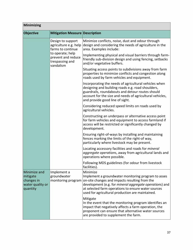
37
Minimizing
Objective Mitigation Measure Description
Design to support agriculture e.g. help farms to continue to operate; help prevent and reduce trespassing and vandalism
Minimize conflicts, noise, dust and odour through design and considering the needs of agriculture in the area. Examples include:
Implementing physical and visual barriers through farm-friendly sub-division design and using fencing, setbacks and/or vegetative buffers.
Situating access points to subdivisions away from farm properties to minimize conflicts and congestion along roads used by farm vehicles and equipment.
Incorporating the needs of agricultural vehicles when designing and building roads e.g. road shoulders, guardrails, roundabouts and detour routes should account for the size and needs of agricultural vehicles, and provide good line of sight.
Considering reduced speed limits on roads used by agricultural vehicles.
Constructing an underpass or alternative access point for farm vehicles and equipment to access farmland if access will be restricted or significantly changed by development.
Ensuring right-of-ways by installing and maintaining fences marking the limits of the right-of way, particularly where livestock may be present.
Locating accessory facilities and roads for mineral aggregate operations, away from agricultural lands and operations where possible.
Following MDS guidelines (for odour from livestock facilities).
Minimize and mitigate changes in water quality or quantity
Implement a groundwater monitoring program
Minimize Implement a groundwater monitoring program to asses on-site changes and impacts resulting from the development (e.g. for mineral aggregate operations) and at selected farm operations to ensure water sources used for agricultural production are maintained.
Mitigate In the event that the monitoring program identifies an impact that negatively affects a farm operation, the proponent can ensure that alternative water sources are provided to supplement the farm.

38
Minimizing
Objective Mitigation Measure Description
Mitigating impacts during construction or operations e.g. mitigate dust, noise
Adjust operational procedures to accommodate agriculture in the area
Consider modifying operation hours and methods to reduce impacts on nearby agriculture uses (e.g. livestock and crop production).
Create consistent blasting hours to manage noise (based on engagement with local farmers and providing notices to surrounding operations to reduce and manage impacts on agricultural production in the area.)
Consider the use of processing equipment with dust suppressing or dust collection devices
Vegetative berms Create a vegetative berm for dust control to reduce impacts on surrounding livestock or crops.
Minimize the area of soil exposed (non-vegetated) to limit the potential for wind erosion.
Maintain, restore or construct farm infrastructure
Maintain the contour and efficiency of farm drainage (municipal drains).
Install and/or reconnect agricultural field tile
If access to fields is affected during construction provide alternative access points to the property.
Mitigate ongoing impacts from the new development
Implement measures that can be in place post development to support compatibility with agriculture
Use best salt management practices near agricultural operations that may be adversely impacted.
Use salt resistant plantings in windbreaks.
Use non-invasive plant species for landscaping.

39
Minimizing
Objective Mitigation Measure Description
Education to achieve greater compatibility between agricultural and non-agricultural uses
Education and Awareness
Provide public education and information to increase understanding and awareness of agriculture and normal farm practices in the area, such as road signage to inform road users about and enhance safety for, farm vehicle and equipment users.
Identify notices that could be included as conditions of development to ensure that the presence of surrounding agricultural operations are recognized and to advise future land owners that those operations may be subject to future expansion or shifts in production.
Identify information/notices for landowners or visitors in cases of recreational developments, about normal farm practices in the areas and the need to respect farm properties and activities.
Provide education and awareness about the potential financial, resource and biosecurity impacts that could result from trespassing and vandalism.
Provide a communication forum for ongoing engagement with local farmers and the community to manage and respond to concerns.
Organize farm education opportunities.
Educate farmers on ‘good neighbour’ relationships and mitigation measures to help minimize nuisance complaints.
3.3 Impacts on the Agricultural System Within the GGH, there are provincial plan policies requirements related to avoiding, and where avoidance is not possible minimizing and mitigating impacts on the Agricultural System. Both the agricultural land base and the agri-food network need to be assessed as far as impacts and to implement mitigation measures. For example, mitigation could involve supporting local economic development opportunities for the agri-food sector as a way to offset some of the negative impacts a development may have for agriculture in the area.
The following chart provides some examples of mitigation measures. Also see OMAFRA’s Agricultural System in Ontario’s Greater Golden Horseshoe for provincial mapping, Implementation Procedures, to use the Agricultural System portal and more information on agricultural economic development.
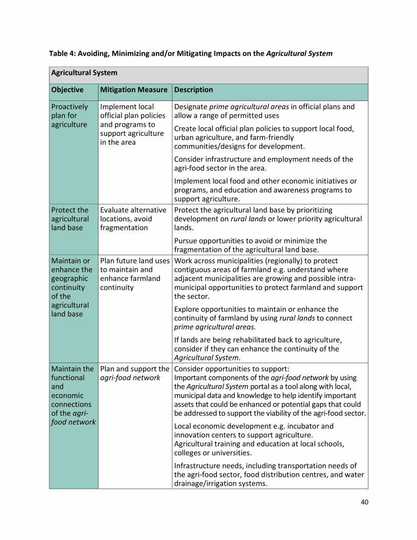
40
Table 4: Avoiding, Minimizing and/or Mitigating Impacts on the Agricultural System
Agricultural System
Objective Mitigation Measure Description
Proactively plan for agriculture
Implement local official plan policies and programs to support agriculture in the area
Designate prime agricultural areas in official plans and allow a range of permitted uses
Create local official plan policies to support local food, urban agriculture, and farm-friendly communities/designs for development.
Consider infrastructure and employment needs of the agri-food sector in the area.
Implement local food and other economic initiatives or programs, and education and awareness programs to support agriculture.
Protect the agricultural land base
Evaluate alternative locations, avoid fragmentation
Protect the agricultural land base by prioritizing development on rural lands or lower priority agricultural lands.
Pursue opportunities to avoid or minimize the fragmentation of the agricultural land base.
Maintain or enhance the geographic continuity of the agricultural land base
Plan future land uses to maintain and enhance farmland continuity
Work across municipalities (regionally) to protect contiguous areas of farmland e.g. understand where adjacent municipalities are growing and possible intra-municipal opportunities to protect farmland and support the sector.
Explore opportunities to maintain or enhance the continuity of farmland by using rural lands to connect prime agricultural areas. If lands are being rehabilitated back to agriculture, consider if they can enhance the continuity of the Agricultural System.
Maintain the functional and economic connections of the agri-food network
Plan and support the agri-food network
Consider opportunities to support: Important components of the agri-food network by using the Agricultural System portal as a tool along with local, municipal data and knowledge to help identify important assets that could be enhanced or potential gaps that could be addressed to support the viability of the agri-food sector.
Local economic development e.g. incubator and innovation centers to support agriculture. Agricultural training and education at local schools, colleges or universities.
Infrastructure needs, including transportation needs of the agri-food sector, food distribution centres, and water drainage/irrigation systems.

41
3.4 Description of Mitigation Measures
Settlement Area Boundary Expansions
Edge Planning
The implementation of edge planning may be recommended to support the mitigation of a settlement area boundary expansion on nearby agriculture. The purpose of edge planning is to investigate land uses at the urban-agricultural interface, become familiar with existing and potential land use conflicts and identify practical means to improve land use compatibility.
Edge planning can be implemented using a variety of planning tools including official plans, secondary plans, subdivision design, bylaws, signage and other means. In order to achieve high levels of compatibility and greater land use certainty, the urban-agricultural interface should be recognized as a distinct ‘edge planning area’ where specific policies and management techniques can be fairly applied for urban and agricultural land users alike. The need for edge planning and buffering would be greatest along permanent agricultural boundaries, however additional locations could be identified through an AIA. The BC Guide to Edge Planning recommends an edge planning area of 300 meters on each side of the urban-agricultural interface to assess the application of edge planning techniques (i.e. mitigation measures).
Different types and intensities of use will require differences in the type and scope of edge planning. For example, commercial, industrial and recreational uses along the urban-agricultural interface do not require the same level of edge planning that more sensitive land uses, such as residential uses, would require. It is important for edge planning requirements to be tailored to the local and regional context. Therefore each community will need to craft a package of edge planning tools that best suits their needs. Three key tools that can be implemented within an Edge Planning Area are:
Secondary Planning and Subdivision Design
Farm-Friendly urban development can play a significant role in promoting compatibility and stabilizing the urban-agricultural interface. This can be achieved through secondary plans and subdivision plan design. Secondary plans may include policies and maps that provide direction on topics including land use, infrastructure, transportation, design and the natural environment. Additionally they may be utilized as a means to implement the recommendations that have been provided in an AIA. Subdivision plan design offers opportunities to improve compatibility between farming and other uses. Parcel size, configuration, building setbacks, road patterns, location of park and school sites, drainage patterns and location of sewer and water lines and other services all have implications for agriculture. Where there are opportunities for design control, the subdivision design as well as the site and building design layout should aim to alleviate potential land use conflicts.
42
Design elements that could be incorporated into subdivision in the fringe areas include:
Road design to direct traffic away from farming areas
Increased lot depths/sizes along the urban-agriculture boundary to allow for greater separation between uses
Planting vegetation buffers and/or installing fences to protect residential areas from possible spray drift, dust and noise
Recognition that a road right of way may be an adequate buffer and planting vegetation to improve the existing roadway buffer and
Increased building setback provisions in the zoning by-law to increase the separation between uses.
Helpful resources on farm friendly subdivision design include:
“Guide to Edge Planning – Promoting Compatibility along Urban-Agricultural Edges”
Planning Subdivisions Near Agriculture...A Guide for Approving Officers
Planning Subdivisions Near Agriculture
Vegetative Buffers and Fencing
Vegetative buffers establish both a physical and visual barrier between urban and agricultural activities. The buffer reduces impacts and achieves compatibility between agricultural and non-agricultural uses. When designed and implemented properly buffers can mitigate negative impacts from noise, light and dust. They are also extremely effective at preventing trespassing and associated problems such as litter, vandalism, trespassing and pets at large. The most effective buffers to mitigate impacts from both agricultural and urban activities combine separation of uses, vegetation and fencing. For a detailed outline on the design of a vegetative buffer, refer to “Landscaped Buffers Specifications“ by the B.C. Agricultural Land Commission (ALR) in 1993. Key design aspects for effective vegetative buffers include:
Total minimum separation of 30m, 15m of which is vegetative buffer
Must reach a finished height of 6m to create a visual barrier and effectively capture dust/spray drift
Mixed deciduous and coniferous planting with foliage from base to crown to effectively capture dust and spray
Crown density of 50-75% to allow adequate airflow to reduce odours and
43
Two meter separation distance between the vegetative buffer and the boundary to ensure less shading, more air circulation and more maneuverability for farm equipment.
Education and Outreach
Education and outreach tools can be used to enhance compatibility between famers and non-farm residents, specifically by reducing nuisance complaints regarding normal farm practices. Education and outreach tools include but are not limited to disclosure statements, signage, information packages and on-farm education. A disclosure statement would notify a potential purchaser of a property that they are buying land that is in proximity to a farm operation and may experience periods of dust, noise and odour and other impacts associated with nearby farms during certain times of the year. Signage informs residents they are in proximity to agricultural operations and highlights possible associated activities. An information package or brochure could be distributed to surrounding non-farm residents to explain the types of agricultural operations in the area, provide an over view of normal farm practices and highlight the benefits of a vegetation buffer. When possible, these tools should be used with the compatibility mechanisms listed above. Local farm operations can help to educate the public by hosting on-farm education days — activities including open houses and educational talks for non-farm neighbours can highlight farm business operations.
Increasing the safety of roads used by farm vehicles and equipment
Road Safety Education
Education can improve road safety where agricultural vehicles share the road. Road safety education is not limited to but may include educating both farmers and non-farmers on the rules for agricultural vehicles, posting signage and developing a “share the road” campaign.
Road Design
Increased traffic volume can create conflicts with slow-moving farm equipment causing safety concerns as well as making it difficult and time-consuming for farmers to move equipment between fields. These impacts can be mitigated by designing roads and traffic controls to accommodate wide, slow-moving farm equipment (e.g. wide shoulders, no curbs, reduced speed limits, designing traffic circles to safely accommodate large farm equipment) and controlling traffic access to e.g. new or expanding settlement areas or recreational uses, and mitigated by ensuring signage is used on slow-moving farm vehicles at all times (as required by the Highway Traffic Act, 1990) and along roads frequently used by farm vehicles.
44
Mineral Aggregate Extraction
Mitigation measures for mineral aggregate operations can be extremely effective in avoiding impacts on adjacent properties (e.g. design of a site plan can alleviate incompatibility concerns) and long-term impacts on the property itself (e.g. rehabilitation to avoid the loss of agricultural land in the long-term).
Air Quality
Excessive amounts of dust from blasting, crushing and/or other activities may affect plant physiology, and change soil pH. To manage air quality and dust generation, the proposed aggregate extraction operation must satisfy established provincial standards. This requires that dust be mitigated on-site. Methods include:
Using processing equipment with dust suppressing or dust collection devices
Using dust suppressants on internal haul routes and processing areas and
Minimizing the area of exposed soil to limit wind erosion.
Additional mitigation measures may be required when mineral aggregate extraction operations are near farm operations that are sensitive to dust (e.g. dust-sensitive crops and U-Pick operations that may be affected by the visual quality or produce, processing operations, etc.).
Noise
Noise impacts should be considered in relation to potential impacts on livestock or agri-tourism businesses. Review any noise study prepared for the aggregate extraction operation required to be submitted with the application. In consultation with the acoustic engineer, confirm that the Ministry of Environment and Climate Change Noise Guidelines have been met. Review the proposed noise control procedures in the noise report and confirm that sensitive farm operations have been considered and appropriate mitigation have been incorporated.
Blasting & Vibration
In consultation with the blasting expert, review the blasting impact assessment prepared for the proponent as per the Ministry of Environment and Climate Change Blasting Guidelines. Ensure that potentially sensitive farm operations are considered in the report and that the blasting controls recommended have addressed any farm buildings and livestock potentially impacted by blasting and vibration.
45
It is also recommended that the proponent establish a protocol that could be used by farmers in the area to contact the aggregate operator and notify them of where and when certain farm practices may take place so operational adjustments can take place to avoid potential conflicts. The protocol could also deal with complaints and an effective process to address them.
The aggregate operator can also minimize and mitigate noise impacts by adjusting blasting schedules to accommodate the needs of the surrounding farm operations.
Rehabilitation
Where required, rehabilitating an aggregate operation back to an agricultural condition is an effective way to avoid, or minimize long-term impacts to agriculture. The next section provides detailed information on how to rehabilitate lands.
3.5 Rehabilitation – Mineral Aggregate Resource Extraction within Prime Agricultural Areas
3.5.1 Introduction
This information provides guidance for mineral aggregate resource extraction operations that are located in prime agricultural areas and are required to rehabilitate the land back to an agricultural condition. More detailed information is found in Appendix B. This information should complement and should be reviewed when preparing an Agricultural Impact Assessments (AIAs) and developing mitigation measures and rehabilitation plans for agricultural after uses. Although focused on mineral aggregate operations within prime agricultural areas, the information provided is based on best practices for pre-extraction, during operations and post-extraction processes and can be adapted for other types of development where relevant and appropriate.
3.5.2 Summary of Steps Recommended for Agricultural Rehabilitation
Step 1. Undertake an Agricultural Impact Assessment
Follow the Technical AIA Guidelines and complete an AIA.
Building on data and information collected from the AIA e.g. soil conditions, climate, and crop production, develop a soil management plan and provide baseline data to be able to compare with the lands when they have been rehabilitated back to an agricultural condition.
46
Step 2. Planning and Progressive Rehabilitation
Create a site plan and determine the extraction, depths and benching and start/end points of different locations on the site. Account for any proposed processing and accessory uses on the site, where applicable.
Based on the AIA information for the primary study area (i.e. the licensed area) develop a plan for the topsoil, subsoil, overburden availability, berm requirements (e.g. height, length, slope/form and footprint) and the timing.
Develop a plan for the final landform, slopes, floor elevations and grades, and outlets for surface waters and flow.
Plan the phases of extraction to determine the area to be rehabilitated annually and ensure soil resource volumes are available for proposed annual rehabilitation. Understand the sources of soil material and movements to minimize storage and maximize direct movement for use in progressive agricultural rehabilitation.
Step 3. Strip and Handle Soil Resources Separately
Know your depths of topsoil, subsoil and overburden (provided in soil budget prepared in the AIA for your application).
Carefully monitor depths of soil being removed during stripping.
Maximize volume of topsoil and subsoil salvaged without significantly mixing.
Strip soils only under dry conditions (not saturated).
Soil removal during frozen conditions is not recommended.
Minimize the area being stripped; don’t exceed area to be extracted in one operational season. Strip area well back from anticipated excavation faces.
Establish a vegetation cover well in advance of stripping to minimize erosion, loss of important soil resources, and degradation of soil structure and increase soil organic matter content.
Remove woody vegetation (roots, stumps, etc.) stone piles, fencing and any deleterious materials prior to stripping.
Minimize use of herbicides and pesticides prior to stripping.

47
Step 4. Retain All Topsoil for Rehabilitation
Avoid or minimize soil storage by moving stripped soil directly to rehabilitation areas.
Develop progressive rehabilitation plans to avoid substantial storage volumes and duration.
Use subsoil and parent material for long-term perimeter berming where possible.
Lower profile topsoil stockpiles of short duration are preferred.
Implement erosion protection including establishment of vegetation, silt fencing, irrigation and/or mulch.
Step 5. Create an Appropriate Post Extraction Landform
Non-agricultural side slopes should meet legislative requirements (pits 3:1, quarries 2:1) or steeper (if justified to minimize side slope area) or reduced and incorporated into rehabilitated agricultural areas:
For forage crops (hay & pasture) maximum grade for side slopes should not exceed 15:1 (6.7%).
For tree fruit and grape production maximum side slopes should not exceed 8.3:1 (12%) and 16.6:1 (6%), respectively.
Rip side slopes to alleviate compaction.
Reduce use of soil resources on non-agricultural side slopes.
Grade and contour floor with no irregular undulations or depressions.
Grade floor slope to promote surface runoff and cold air drainage. Slopes of 50:1 (2%) to 20:1(5%) are preferred.
Create large regularly shaped fields.
Limit depth of extraction to 1.5 metres or 2.0 metres above established ground water table for pits and quarries respectively. Understand extent and duration of seasonal fluctuations (4.5).
*Within the Oak Ridges Moraine Conservation Plan area, follow the landform conservation requirements if subject lands are located within landform conservation areas (Category 1 or 2).

48
Step 6. Address Soil Compaction – Minimize and Remediate
Minimize compaction by handling soils under dry conditions using wide track equipment or other equipment designed to minimize compaction, and minimize travel over soils and rehabilitated areas to the extent possible.
Remediate soil compaction after spreading each soil layer. Alleviate compaction during dry conditions. Limit depth of ripping to avoid mixing of materials, i.e. do not rip below the upper most (latest applied) soil horizon.
Step 7. Replace Soil Separately and in Reverse Order
Replace and handle topsoil, subsoil and overburden separately.
Handle when dry (non-saturated).
Pay attention to soil depths being replaced on slope versus pit floor and ensure balance between total soils available and required.
Step 8. Condition the Soil
Remove stones, debris and deleterious materials.
Final grading and seed bed preparation.
Fertility analysis and fertilize.
Consider soil amendments to increase organic matter.
Step 9. Establish Cover Crops
Establish grass-legume cover crop.
Maintain up to five years for best results.
Plow under green manure.
Overseed if persistence of certain species diminishes.
Eliminate areas dominated by weed growth and reseed grass-legume mix.
Step 10. Monitor and Manage
Annual reporting on all stages or rehabilitation process.
Soil testing.
Implement recommendations for soil condition and cropping.

49
4.0 Background for the Technical AIA Guidelines
4.1 Introduction The provincial requirements for AIAs depend upon a number of factors, including but not limited to the type and location of development. In situations where there are multiple requirements to consider impacts to agriculture, the expectation is that a single AIA could be used to satisfy these requirements. Section 1.4 When an AIA is required, provides a summary table of AIA requirements for land use planning. This section contains the following subsections: 4.2 Settlement Area Boundary Expansions; 4.3 Mineral Aggregate Resource Extraction; 4.4 Infrastructure; and 4.5 Other Non-Agricultural Uses, which outline relevant provincial plan policies, PPS policies, and if applicable, information on other legislation such as the Aggregate Resources Act (for mineral aggregate operations) and the Environmental Assessment Act (for infrastructure). Appendix A: Resources provides links to applicable legislation and documents outlined in this section.
Planning Act
The Planning Act sets out the ground rules for land use planning in Ontario and describes how land uses may be controlled, and who may control them. The Province, among other roles, issues the PPS under the Planning Act. Requirements under the Planning Act need to be met where applicable. Depending on the location of a development, the PPS and/or Provincial Plan policies will apply.
4.2 Background: Settlement Area Boundary Expansions Introduction
This section provides background for when an AIA is required for settlement area boundary expansion applications. The authority for AIAs and settlement area boundary expansions are provided by provincial plans’ and the legislation that enables them. The Growth Plan provides the overarching policy direction as it relates to settlement area boundary expansions for the GGH, and includes additional requirements to be met in the Greenbelt Plan area. The ORMCP also defers to the Growth Plan for policy direction on settlement area boundary expansions. The NEP does not speak to settlement area boundary expansions directly, but the Niagara Escarpment Planning and Development Act does state that the redesignation of land to Minor Urban Centre or Urban Area designations can only occur during the 10 year review of the NEP. The four provincial plans along with the PPS are discussed below in relation to AIA requirements and other relevant policies.
50
Provincial Plans
Growth Plan
The Growth Plan regulates decision-making regarding growth management and environmental protection in the GGH. Within the Growth Plan area, an AIA is required for a settlement area boundary expansion which can only occur at the time of an upper- or single-tier municipal comprehensive review.
Growth Plan Subsection 2.2.8
The Growth Plan provides direction on settlement area boundary expansions. Policy 2.2.8.1 requires settlement area boundaries to be delineated in official plans. Policy 2.2.8.2 directs that a settlement area boundary expansion may only occur through a municipal comprehensive review where an upper- or single-tier municipality demonstrates that criteria have been met, including meeting minimum density and intensification targets and undertaking a land needs assessment based on the standard methodology issued by the Minister of Municipal Affairs. Where a need for a settlement area boundary expansion has been justified in accordance with policy 2.2.8.2, the feasibility of the proposed expansion will be determined and the most appropriate location for the proposed expansion will be identified based on criteria set out in policies 2.8.3.3. Policy 2.2.8.4 provides an ability for upper- and single-tier municipalities in the outer ring that have identified excess lands to undertake a settlement area boundary expansion.
Policy 2.2.8.3 contains criteria that upper- and single-tier municipalities will need to meet such as for existing or planned infrastructure to support growth, including transit and water and wastewater servicing, etc. Upper- and single-tier municipalities will need to balance provincial priorities when selecting where potential settlement area boundary expansions may be appropriate. The following information only discusses the criteria related to settlement area boundary expansions and AIAs.
Criteria related to agriculture and AIAs include policies 2.2.8.3 h), i), j) which read:
h) prime agricultural areas should be avoided where possible. An agricultural impact assessment will be used to determine the location of the expansion based on avoiding, minimizing and mitigating the impact on the Agricultural System and evaluating and prioritizing alternative locations across the upper- or single-tier municipality in accordance with the following:
i. expansion into specialty crop areas is prohibited;
ii. reasonable alternatives that avoid prime agricultural areas are evaluated; and

51
iii. where prime agricultural areas cannot be avoided, lower priority agricultural lands are used;
i) the settlement area to be expanded is in compliance with the minimum distance separation formulae;
j) any adverse impacts on agricultural operations and on the agri-food network from expanding settlement areas would be avoided or, if avoidance is not possible, minimized and mitigated as determined through an agricultural impact assessment;
Upper- and single-tier municipalities are required to designate prime agricultural areas in accordance with provincial mapping of the agricultural land base of the Agricultural System. Only once the Agricultural System has been implemented, can upper- and single-tier municipalities complete an AIA, to determine a preferred location of a settlement area boundary expansion. As part of the AIA, an evaluation of alternative locations is to be done in order to avoid, minimize and mitigate impacts on the Agricultural System. See section 1.10 for information on the Agricultural System.
Avoiding Impacts to the Agricultural System
Evaluating Alternative Locations
Upper- and single-tier municipalities must evaluate alternative locations across the entire municipality, working with lower-tier municipalities as applicable, to avoid impacts to the Agricultural System. Where possible, the agricultural land base must be evaluated to avoid impacts by selecting the lowest priority agricultural lands. The agri-food network must be evaluated to avoid impacts to components of the network where possible. As part of the AIA, an analysis of impacts should consider the interplay of these two parts of the Agricultural System to determine a preferred location for a proposed settlement area boundary expansion that would result in fewer adverse impacts on the Agricultural System in accordance with Growth Plan policy 2.2.8.3. Guidance on evaluating the agricultural land base and the agri-food network is included below.
The Agricultural Land Base
Given the criterion of avoiding and minimizing impacts on the Agricultural System, subject to other criteria in policy 2.2.8.3 the areas that should first be considered for a preferred settlement area boundary expansion, are rural lands outside of the agricultural land base. Upper- and single-tier municipalities need to evaluate alternative locations based on the hierarchy for protection set out in policy 2.2.8.3 h) – no expansions in specialty crop areas, avoiding prime agricultural areas and where prime agricultural areas cannot be avoided, using lands that are lower priority agricultural lands for agriculture (e.g. not in agricultural production). In evaluating alternatives, preferred sites are those which avoid the loss and fragmentation of lands mapped as part of the agricultural land base.

52
The Agri-food Network
Growth Plan policy 2.2.8.3 j) requires that a proposal for a settlement area boundary expansion demonstrate that any adverse impacts on agricultural operations and on the agri-food network from expanding settlement areas be avoided or, if avoidance is not possible, minimized and mitigated as determined through an AIA.
To avoid impacts where possible, it is important to evaluate alternative locations across the upper- and single-tier municipalities. Elements of the agri-food network must be evaluated to identify areas that have components of the agri-food network and other areas that do not. Consideration should also be given to the important role or function the various agri-food network components have in supporting surrounding farm operations and the local economy. The Agricultural System portal can be used to help identify, components of the agri-food network, and opportunities to work collaboratively across municipalities. It is also recommended that municipal data and local knowledge be used where possible, to provide information about the agri-food network’s components and the role they play in the community.
The Agricultural System portal will also support the examination of the provincial agricultural land base mapping and components of the agri-food network together. Understanding the relationship between the agricultural land base and the agri-food network is important. For example, if there is an area that has a high concentration of agri-food network components and is also identified as a prime agricultural area, this may not be a preferred location for a settlement area boundary expansion.
Figure 2 Settlement Area Boundary Expansion: Examples of Preferred Locations to Avoid Impacts on the Agricultural System
Upper- or Single-tier AIA evaluation of alternative locations across the entire municipality for a potential settlement area boundary expansions OPTION 1
PREFERRED
OPTION 2
PREFERRED
OPTION 3
NOT PREFERRED
OPTION 4
PROHIBITED
Location with rural lands outside of the agricultural land base with few agri-food network components and investments
Location with rural lands available that are part of the agricultural land base with few agri-food network components and investments
Location with only prime agricultural areas available and a high concentration of agri-food network components
Specialty crop areas

53
Minimizing and Mitigating Impacts to the Agricultural System
Where impacts to the Agricultural System cannot be avoided, then recommendations should be provided in the AIA on how to minimize and mitigate impacts. Where a proposed settlement area boundary expansion has been approved, mitigation measures will need to be implemented to minimize and mitigate impacts to the Agricultural System. See section 2.0 AIA Technical Guidelines and 3.0 Mitigation Measures for more information.
The Growth Plan’s Greenbelt Specific Policies
The expansion of Towns/Villages in the Greenbelt Plan area, is subject to the Growth Plan policies in subsection 2.2.8 and the Growth Plan municipal comprehensive review process. Growth Plan policy 2.2.8.3 i) requires the proposed settlement area boundary expansion meet any applicable requirements of the Greenbelt, Oak Ridges Moraine Conservation, Niagara Escarpment, and Lake Simcoe Protection Plans and any applicable source protection plan. Also, policy 2.2.8.3 m) has Greenbelt-specific policies that apply and which permit only modest expansions to Towns/Villages within the Protected Countryside area. Expansions must also support the achievement of complete communities or the local agricultural economy. Using the Agricultural System portal and assessing potential adverse impacts that may result from the expansion can help inform recommendations that can support the local agricultural economy.
Greenbelt Plan
3.4.3 Town/Village and 3.4.4 Hamlets
There are Greenbelt-specific policies regarding settlement area boundary expansions within the Protected Countryside, in Growth Plan policy 2.2.8.3 m). In addition to these Growth Plan policies, the Greenbelt Plan’s General Settlement Area policies found in section 3.4.2, must be considered when a settlement area boundary expansion is proposed and should be considered when undertaking an AIA. Policies direct that settlement areas outside the Greenbelt are not permitted to expand into the Greenbelt (policy 3.4.2.1) and that municipalities should collaborate to support components of the Agricultural System and access to local, healthy food when possible (policy 3.4.2.4). To support access to local food, for example an AIA could assess the impacts of removing lands capable of producing food and the overall impact that reducing the concentration of farming in the region might have on local communities, among other things. An AIA could also provide recommendations to support planning for agriculture across municipal borders, and opportunities to support complete communities and access to healthy, local and affordable food options.
54
ORMCP
An upper-tier or single-tier municipality may consider the need to change or refine the boundaries of settlement areas as part of a undertaken in accordance with policy 2.2.8 of the Growth Plan. Settlement area boundaries are not permitted to expand into Natural Core Areas or Natural Linkage Areas. AIA requirements as found in the Growth Plan also apply within the ORMCP for settlement area boundary expansions.
NEP
The NEP doesn’t speak to settlement area boundary expansions directly, but the Niagara Escarpment Planning and Development Act does state that the redesignation of land to a Minor Urban Centre or an Urban Area can only occur during the 10 year review of the NEP.
PPS
While there is no specific requirement for an AIA in the PPS, an AIA is an effective tool to, evaluate alternative locations, assess impacts to agriculture and help identify what mitigation measures are needed. As such, an AIA could be used to satisfy the direction of other policies such as PPS policy 1.1.3.8 for new or expanding settlement areas in prime agricultural areas. Information in this AIA guidance document can be used to help guide work undertaken to satisfy the direction in PPS policies. Additionally, it is recommended reference be made to OMAFRA’s Guidelines on Permitted Uses, Section 3, Beyond Permitted Uses, which has information on PPS policies related to settlement area boundary expansions and AIAs.
4.3 Background: Mineral Aggregate Resource Extraction
Introduction
This section provides background for when an AIA is required for mineral aggregate operation applications. The application of the provincial plans, PPS and the Aggregate Resource Act will be outlined below. When reviewing land use policies, it is important to keep in mind that the requirements of the Aggregate Resources Act and its associated regulations, standards and policies also apply and need to be met.
Provincial Plans
Growth Plan
Growth Plan policy 4.2.8.3 directs that within prime agricultural areas, applications for new mineral aggregate operations will be supported by an AIA and, where possible, will seek to maintain or improve connectivity of the Agricultural System. When considering opportunities to maintain and improve the connectivity of the Agricultural System, it is important to refer to the
55
municipal mapping of prime agricultural areas in official plans according to the Agricultural System, municipal official plan policies that support the agri-food network, OMAFRA’s Agricultural System portal, and any additional local data and knowledge that may be available.
Rural Lands
There are no requirements in the Growth Plan to complete an AIA for a mineral aggregate operation on rural lands.
Rehabilitation
Growth Plan policy 4.2.8.4 provides some direction for the rehabilitation of new mineral aggregate operation sites related to prime agricultural areas. Additionally, for the Growth Plan area, PPS policies apply. Policies related to rehabilitation are important to consider when completing an AIA because an AIA is an effective tool to gather information to support a rehabilitation plan, where one is required. For example, where mineral aggregate operations are required to restore land back to an agricultural condition, collecting pre-extraction information (e.g. information on soil, crop production, drainage and infrastructure etc.) would provide baseline data that can be used as part of a rehabilitation plan to help measure if the land has been successfully restored back to an agricultural condition. See section 2.0 AIA Technical Guidelines and Appendix B: Rehabilitation Information and Resources for more information.
Greenbelt Plan
Similar to the Growth Plan, the Greenbelt Plan policy 4.3.2.4 directs, in prime agricultural areas, applications for new mineral aggregate operations shall be supported by an AIA and, where possible, shall seek to maintain or improve connectivity of the Agricultural System. The Greenbelt Plan specialty crop areas, prime agricultural areas and rural lands sections also have policies requiring AIAs for non-agricultural uses. These are outlined below.
Specialty Crop Areas
The Greenbelt Plan, policy 3.1.2.2 directs that specialty crop areas shall not be re-designated for non-agricultural uses. Subject to policies in sections 4.2 to 4.6 of the Greenbelt Plan, non-agricultural uses, which include mineral aggregate operations, may be permitted but they are generally discouraged and may only be permitted after the completion of an AIA.
Additionally there are policies that apply for specialty crop areas in Niagara. Policies in 4.3.2.9 provide direction on where new mineral aggregate operations, wayside pits, and quarries are not permitted, and where they may be permitted, if certain criteria are met. When undertaking an AIA for a mineral aggregate operations within specialty crop areas, policy requirements outlined in 4.3.2.9 must also be met.
56
Prime Agricultural Areas
Policies 3.1.3.2 and 3.1.3.3 provide direction for non-agricultural uses in prime agricultural areas. For mineral aggregate operations, these policies have the same policy requirement as specialty crop area policy 3.1.2.2.
Rural Lands
In accordance with Greenbelt Plan policy 3.1.4.4 an AIA is not required for mineral aggregate operations within rural lands.
Rehabilitation
Where a mineral aggregate operation is required to rehabilitate prime agricultural areas, including specialty crop areas, back to an agricultural condition (e.g. 4.3.2.7 and 4.3.2.9), then it is recommended that an AIA collect information and provide recommendations that can support satisfying these policy requirements. For example, the AIA should include relevant information about prime agricultural or specialty crop areas before mineral aggregate operations extract resources from the site. This pre-extraction information can provide baseline information that can be used once extraction is completed, to inform how to restore the land back to substantially the same agricultural condition allowing for the same range and productivity of specialty crops common in the area. It is important to ensure other relevant policies are met such as policies in 4.3.2 related to rehabilitation within prime agricultural areas. The AIA information can inform operation and rehabilitation activities on the land. See section 2.0 AIA Technical AIA Guidelines and Appendix B: Rehabilitation Information and Resources for more information.
ORMCP
ORMCP s. 35(7) directs that within prime agricultural areas, an application for a mineral aggregate operation will not be approved without an AIA. As part of the AIA, it must be demonstrated that there would be no adverse impacts to the prime agricultural area. If there would be adverse impacts they are to be minimized and mitigated to the extent feasible. As such the AIA recommendations should ensure that mitigation measures are implemented to minimize and reduce impacts.
Rehabilitation
ORMCP s. 35(1)(b)(i) outlines rehabilitation requirements within a prime agricultural area as follows:
35(1) an application for a mineral aggregate operation or wayside pit shall not be approved unless the applicant demonstrates,
57
b) that as much of the site as possible will be rehabilitated,
i) in the case of land in a prime agricultural area, by returning substantially all the land to a condition in which the soil capacity for agriculture is on average the same as it was before the mineral aggregate operation or wayside pit began operation, and
To help satisfy these policy requirements, as noted above under the Growth Plan and Greenbelt Plan rehabilitation headings, AIA information can help inform rehabilitation plans. See section 2.0 AIA Technical AIA Guidelines and Appendix B: Rehabilitation Information and Resources for more information.
NEP
The NEP, 2.9 Mineral Aggregate Resources states that the objective is to ensure that mineral aggregate operations and their accessory uses are compatible with the Escarpment environment and to support a variety of approaches to rehabilitation of the natural environment and provide for redesignation to land use designations compatible with the adjacent land uses. The policy requirement for an AIA, policy 2.9 f) directs:
in prime agricultural areas, undertake an Agricultural Impact Assessment to determine how to avoid, minimize and mitigate impacts on agricultural lands and operations.
Rehabilitation
NEP 2.9 policies have requirements for rehabilitation of mineral aggregate resource extraction sites and they must be referred to in the entirety. Examples of policies relevant for agriculture include: NEP policy 2.9.11 g) which directs that within prime agricultural areas, Mineral Resource Extraction Areas shall be returned or rehabilitated to a condition in which substantially the same areas and the same average soil capability for agriculture are restored; and policy 2.9.11 h) provides additional criteria for specialty crop areas. To help satisfy these policy requirements, AIA information can help inform rehabilitation plans. See the Growth Plan and Greenbelt Plan rehabilitation sections above, section 2.0 AIA Technical AIA Guidelines, and Appendix B: Rehabilitation Information and Resources for more information
PPS
While there is no explicit requirement for an AIA in the PPS, an AIA may still be used as an effective tool to help satisfy other policies. For example, PPS policy 2.5.4.1 permits mineral aggregate resource extraction within prime agricultural areas, on prime agricultural land, as an interim use provided that the site will be rehabilitated back to an agricultural condition8, with certain exceptions. An AIA, can provide useful information to help inform mitigation measures
8 PPS Policy 2.5.4.1 also provides circumstances where complete rehabilitation is not required.
58
and rehabilitation plans. See the Growth Plan and Greenbelt Plan sections on rehabilitation and section 2.0 Technical AIA Guidelines and Appendix B: Rehabilitation Information and Resources for more information.
Aggregate Resources Act (ARA)
The Ministry of Natural Resources and Forestry (MNRF) oversees the rules governing aggregate management including; issuing licences, permits and changes to existing approvals; inspecting aggregate operations and responding to complaints; enforcing compliance; and ensuring rehabilitation is carried out on sites. Most of Ontario, where there are mineral aggregate operations, is regulated under the Aggregate Resources Act. The purposes of the Act, as set out in section 2, are:
Purposes of Act
a) to provide for the management of the aggregate resources of Ontario
b) to control and regulate aggregate operations on Crown and private lands
c) to require the rehabilitation of land from which aggregate has been excavated and
d) to minimize adverse impact on the environment in respect of aggregate operations. R.S.O.1990, c.A.8, s.2.
4.4 Background: Infrastructure
Introduction
This section provides background for when an AIA is required for proposed infrastructure, specifically existing and planned corridors such as highways and transitways.
As provided in the Growth Plan, The Greenbelt Plan and the PPS, infrastructure:
Means physical structures (facilities and corridors) that form the foundation for development. Infrastructure includes: sewage and water systems, septage treatment systems, stormwater management systems, waste management systems, electricity generation facilities, electricity transmission and distribution systems, communications/telecommunications, transit and transportation corridors and facilities, oil and gas pipelines and associated facilities.
The Growth Plan defines planned corridors:
Corridors or future corridors which are required to meet projected needs, and are identified through this Plan, preferred alignment(s) determined through the

59
Environmental Assessment Act process, or identified through planning studies where the Ministry of Transportation (MTO), Ministry of Energy, Metrolinx, or Independent Electricity System Operator (IESO) or any successor to those Ministries or entities, is actively pursuing the identification of a corridor. Approaches for the protection of planned corridors may be recommended in guidelines developed by the Province.
It is important to note that infrastructure and existing and planned corridors (as opposed to facilities) are the focus of this guidance document, but in some cases, site specific infrastructure such as landfill projects are mentioned. Where needed, there is specific reference to transit and transportation corridors to align with the MTO processes and requirements. Most importantly, section 3.0 can be modified to apply to other types of infrastructure development as appropriate.
Provincial Plans
The Growth Plan, the Greenbelt Plan, ORMCP and NEP include AIA policy requirements for proposed infrastructure. These policies seek to avoid or, if avoidance is not possible, minimize and mitigate impacts on agriculture.
The Growth Plan
The Growth Plan policy 3.2.5.1 directs, in planning for the development, optimization or expansion of existing and planned corridors and supporting facilities, the Province, other public agencies and upper- and single-tier municipalities will:
c) where applicable, demonstrate through an agricultural impact assessment or equivalent analysis as part of an environmental assessment, that any impacts on the Agricultural System have been avoided or, if avoidance is not possible, minimized and to the extent feasible mitigated.
In policy 3.2.5.1 c) where applicable, means where there is no current existing study of impacts on agriculture that would meet the policy requirement, and where an infrastructure project has the potential to impact the Agricultural System.
Where an AIA is required, demonstrating that impacts to the Agricultural System have been avoided where possible, can be achieved by evaluating alternative locations based on assessing potential impacts to the agricultural land base and agri-food network. If avoidance is not possible, then impacts would be minimized and to the extent feasible mitigated. (See settlement area boundary expansions Growth Plan policy 2.2.8.3 Avoiding impacts on the Agricultural System, Evaluation of Alternative Locations and section 3.0 Mitigation measures for more information).

60
The Greenbelt Plan
The Greenbelt Plan policies related to AIAs and infrastructure are found in the specialty crop areas, prime agricultural areas, rural lands, general infrastructure and Towns/Villages policy sections. Specialty crop area policy 3.1.2.2 and prime agricultural area policy 3.1.3.3 directs that non-agricultural uses may be permitted subject to the policies in section 4.2 to 4.6 and that non-agricultural uses are generally discouraged and may only be permitted after the completion of an AIA. Section 4.2 covers policies on infrastructure.
Greenbelt Plan policy 4.2.1.2 f) directs that new or expanding infrastructure shall avoid specialty crop areas and other prime agricultural areas in that order of priority, unless need has been demonstrated and it has been established that there is no reasonable alternative. Part g) of the policy directs where infrastructure crosses prime agricultural areas, including specialty crop areas, an agricultural impact assessment or equivalent analysis as part of an environmental assessment shall be undertaken.
The evaluation of alternative locations as part of an AIA needs to demonstrate that avoiding higher quality agricultural land and selecting lower priority lands where possible, was considered. An AIA should also consider other factors, including the agri-food network, when demonstrating there are no reasonable alternatives. See settlement area boundary expansions Growth Plan policy 2.2.8.3 Avoiding impacts on the Agricultural System, Evaluation of Alternative Locations for more information. Section 2.0 AIA Technical Guidelines provides information on how to complete an AIA and Section 3.0 Mitigation Measures provides examples of how to avoid, minimize and mitigate impacts on agriculture.
Rural Lands
On rural lands, policy 3.1.4.4 directs that other uses may be permitted subject to the policies of sections 4.1 to 4.6. Where non-agricultural uses are proposed, with the exception of a mineral aggregate operation, the completion of an AIA should be considered. Where an AIA is to be completed, as a best practice, the evaluation of alternative locations, should first consider where possible, rural lands outside of the agricultural land base.
Towns/Villages Policies
Greenbelt Plan policy 3.4.3.2 directs that extensions or expansions of services to settlement areas within the Protected Countryside shall be subject to the infrastructure policies of section 4.2 of the Plan, including the requirements regarding environmental assessments and agricultural impact assessments.

61
ORMCP
The ORMCP states in s. 41 (2.1):
An application for the development of infrastructure in or on land in a prime agricultural area shall not be approved unless, (a) the need for the project has been demonstrated and there is no reasonable alternative that could avoid the development occurring in a prime agricultural area; and (b) an agricultural impact assessment or equivalent analysis carried out as part of an environmental assessment, is undertaken that demonstrates that there will be no adverse impacts to the prime agricultural area or that such impacts will be minimized and mitigated to the extent possible.
NEP
Infrastructure is addressed in the NEP. In particular, section 2.12.6 states:
Infrastructure should avoid prime agricultural areas wherever possible. Where infrastructure is proposed in a prime agricultural area, only linear facilities shall be permitted and the proponent shall demonstrate, through an agricultural impact assessment or equivalent analysis as part of an environmental assessment, how prime agricultural areas will be protected or enhanced, including an examination of alternative locations that would better protect the agricultural land base.
Provincial Policy Statement
While there is no explicit policy requirement for an AIA in the PPS, an AIA can still be undertaken as a best practice to address certain PPS policy directions including, policies: 1.1.5.7 protecting agricultural and other resource-related uses and directing non-related development to areas where it will minimize constraints on these uses; 1.6.8.5 when planning for corridors and rights-of-way for significant transportation, electricity transmission, and infrastructure facilities, consideration will be given to the significant resources in section 2 which includes prime agricultural areas; 2.3.6.1 b) justifying limited non-residential, non-agricultural uses in prime agricultural areas, 2.3.6.2 mitigating impacts to the extent feasible, and 2.3.1 to protect prime agricultural areas for the long term use for agriculture.
Environmental Assessment Act
Environmental Assessments (EAs) in Ontario proceed under the Environmental Assessment Act (EA Act) (and amendments and regulations thereto), which is a provincial statute that sets out a planning and decision-making process to evaluate the potential environmental effects of a proposed undertaking. Proponents wishing to proceed with an undertaking must document their planning and decision-making process and where applicable, submit the results from their EA to the Minister of the Environment and Climate Change for approval.

62
There are two types of environmental assessments: individual EAs and streamlined EAs. Individual EAs are prepared for large-scale, complex projects with the potential for significant environmental effects. They are approved by the Minister of the Environment and Climate Change. Streamlined EAs (through regulation or approved Class EA documents) are prepared for routine projects that have predictable and manageable environmental effects. Proponents of streamlined EAs projects follow a self-assessment and decision-making process that has been previously approved by the Minister of the Environment and Climate Change. In addition to provincial EA requirements, federal EA process may also apply.
The EA Act defines environment as:
a) air, land or water
b) plant and animal life, including human life
c) the social, economic and cultural conditions that influence the life of humans or a community
d) any building, structure, machine or other device or thing made by humans
e) any solid, liquid, gas, odour, heat, sound, vibration or radiation resulting directly or indirectly from human activities or,
f) any part or combination of the foregoing and the interrelationships between any two or more of them.
Given the broad definition of environment under the act, the scope of potential environmental effects that need to be assessed in an EA process may include impacts to agriculture. An AIA can be a useful tool for gathering information needed for completing an EA when both are required for an undertaking or project. There are opportunities for coordination in satisfying the requirements and timelines under these two processes to avoid duplication of study effort, consultation and documentation.
For help in determining if a project or undertaking is subject to requirements under the EA Act or to obtain guidance on the environmental assessment process, check the MOECC EA webpage at https://www.ontario.ca/page/environmental-assessments.
EAs and Infrastructure
An EA is a study that assesses the potential environmental impacts of a project, including an infrastructure project. Examples of infrastructure projects include public roads and highways, waste management, water and wastewater infrastructure, and transit projects. Key components of an EA include consultation with government agencies and the public, consideration and evaluation of alternative ways to implement the project, and mitigation of
63
potential environmental effects. Conducting an EA promotes good environmental planning before decisions are made about proceeding with a proposal.
The EA process in Ontario is iterative and includes evidence-based evaluations that are responsive to the results of consultation. Engagement with the public, stakeholders, Indigenous and regulatory agencies is required throughout any EA process. The results of consultation are used to assess the potential environmental impacts of projects including the proposed measures to mitigate environmental impacts.
AIAs and EAs
Legislation and the provincial land use planning framework have policies and processes to ensure that environmental impacts from development are considered. As noted above, environment is defined broadly and includes agriculture. Therefore, an AIA requirement can be satisfied through the existing EA framework. As such, existing requirements, such as those within parent Class EAs like municipal EAs, GO Transit and MTO Class EAs should be aligned with the guidance found in section 2.0 AIA Technical Guidelines. In relation to AIAs, the alignment and integration with the EA Act requirements is critical. This guidance document should be used when an AIA requirement is fulfilled as part of an EA.
For example, section 2.0 Technical AIA Guidelines can be used to support work undertaken as part of an EA, and by doing this should also help satisfy relevant land use planning policy requirements such as Growth Plan policy 3.2.5.1. Use of section 2.0 to support EA work is recommended so that a separate AIA will not be required. If a proposed project includes a provincial plan policy requirement to assess potential impacts to agriculture, and the AIA guidelines are not used, a separate AIA or additional analysis may be required to satisfy the policy requirement.
Municipal EAs
Municipalities may want to consider integrating planning and EA requirements into their municipal class EA document and use information outlined in this AIA guidance document. The Municipal Engineers’ Association Municipal Class EA is a process set out under the EA Act that applies to municipal road, water, wastewater and transit projects in Ontario. The "parent" Municipal Class EA document lays out a pre-approved procedure which, if followed correctly, enables the planning of municipal infrastructure to be undertaken without approval by the Minister of the Environment and Climate Change. Where an AIA is required under the Municipal Class EA process, municipalities are encouraged to use information outlined in these AIA guidelines when preparing the AIA.
64
Class Environmental Assessment for Provincial Transportation Facilities
The EA Act provides for the preparation at Class EA. MTO’s Class EA document is an approved planning document that defines groups of projects and activities and the EA processes that MTO follows for each of these types of undertakings.
Environmental Reference for Highway Design (ERD)
The Environmental Reference for Highway Design (ERD) addresses EA issues relating to preliminary design and detail design transportation projects. Information in this document has been developed in cooperation with the Ministry of Transportation (MTO) Regional Environmental Offices and is meant to be used as a component of the ERD.
Section 2.0 AIA Technical Guidelines should be read along with the ERD document which provides more details. For instance, the ERD outlines requirements for staff qualifications and the scope of work, as well as specific timing and documentation to be conducted for each environmental specialty area. Consultants may use the ERD to enhance the quality and accuracy of their proposals by ensuring that they are aware of and fully understand the legislated obligations, technical quality, and program delivery expectations of MTO for highway design.
Environmental Guides
MTO has a number of Environmental Guides that provide process and technical information and direction on environmental factors (e.g. Environmental Guide for Fish and Fish Habitat, an Environmental Guide on Noise, etc.). OMAFRA has developed this guidance document in collaboration with MTO and other provincial ministries to be used as an Environmental Guide to accompany the ERD. Section 2.0 Technical AIA Guidelines provide information on how to assess impacts to agriculture from proposed transportation works (e.g. highways) and how to avoid, and where avoidance is not possible, minimize and mitigate impacts on agricultural lands and operations, and the Agricultural System where applicable.
4.5 Background: Other Non-Agricultural Uses
Introduction
Non-agricultural uses include mineral aggregate operations and infrastructure. Background regarding AIAs for these uses are found in sections 4.3 and 4.4 respectively. This section focuses on other non-agricultural uses such as institutional/public service facilities and recreational uses. In some circumstances, even if an AIA is not required, an AIA may be an effective tool to satisfy other policy outcomes. For example, some policies require that compatibility shall be achieved within prime agricultural areas, or shall be promoted on rural
65
lands, or other policies may not require an AIA but require impacts be minimized and mitigated to the extent feasible. Using the section 2.0 AIA Technical Guidelines and section 3.0 Mitigation Measures of this guidance document can help determine how best to satisfy these policies.
Growth Plan
The Growth Plan does not require an AIA for other proposed non-agricultural uses but policies require compatibility and also encourage some non-agricultural uses to be directed to settlement areas. Details are described below.
Growth Plan policy 4.2.6.3 directs where agricultural uses and non-agricultural uses interface outside of settlement areas, land use compatibility will be achieved by avoiding, or where avoidance is not possible, minimizing and mitigating adverse impacts on the Agricultural System. Where mitigation is required, measures should be incorporated as part of the non-agricultural uses, as appropriate, within the area being developed. One way to demonstrate that impacts to the Agricultural System have been avoided is through the evaluation of alternative locations. Depending on the nature and scale of the proposed non-agricultural use, other mitigation measures may effectively avoid or minimize impacts. Section 3.0 Mitigation Measures provides more information.
Referring to other policies also is important as policy direction generally states other non-agricultural uses should be located within settlement areas or on rural lands. For example:
Growth Plan subsection 3.2.8 directs that new public service facilities, including hospitals and schools, should be located in settlement areas and preference should be given to sites that are easily accessible by active transportation and transit, where that service is available.
Growth Plan policy 2.2.9.3 Rural Areas permits development on rural lands for: the management or use of resources; resource-based recreational uses; and other rural land uses not appropriate in settlement areas based on set criteria which includes but is not limited to; that the use will not adversely affect the protection of agricultural uses and other resource-based uses such as mineral aggregate operations.
In some circumstances, for example if a non-agricultural use is large-scale or has the potential to adversely impact the Agricultural System, then an AIA, although not required, may be a useful tool to satisfy the direction in policy 4.2.6.3.

66
Greenbelt Plan
See section 4.3 Background: Mineral Aggregate Resource Extraction, under the Greenbelt Plan which outlines specialty crop area, prime agricultural area policies related to non-agricultural uses and AIA requirements and for rural lands where AIAs should be considered. Below is additional information that is relevant to non-agricultural uses.
Rural Lands
Rural lands of the Protected Countryside are intended to continue to accommodate a range of commercial, industrial and institutional (including cemetery) uses serving the rural resource and agricultural sectors. They also support a range of recreation and tourism uses including trails, parks, golf courses, bed and breakfasts and other tourism-based activities. Greenbelt Plan section 3.1.4 rural lands policies provide the policy direction for these areas.
Other policies in section 4.1 Non-Agricultural Uses are to be read along with other non-agricultural use policies (e.g. 3.1.2.2 specialty crop areas, 3.1.3.3 prime agricultural areas and 3.1.4.4 rural lands). Greenbelt Plan policy 4.1.1 directs that non-agricultural uses are not permitted in the specialty crop areas as shown on Schedule 2 and Schedule 3 of the Plan or within prime agricultural areas in the Protected Countryside with the exception of those uses permitted under sections 4.2 to 4.6 of this Plan.
Greenbelt Plan policy 4.1.1.2 provides direction to ensure that it is demonstrated that the proposed non-agricultural use satisfies certain criteria such as that the use is appropriate for location on rural lands. Greenbelt Plan policy 4.1.1.3 directs that for except for mineral aggregate operations, the completion of an agricultural impact assessment should be considered where non-agricultural uses are proposed on rural lands.
Compatibility
Greenbelt Plan 3.1.2.5 specialty crop areas and 3.1.3.5 prime agricultural areas policies direct that where non-agricultural and agricultural uses interface, land use compatibility shall be achieved and impacts to the Agricultural System avoided where possible and minimized and mitigated where avoidance is not possible. These policies are the same as the Growth Plan policy 4.2.6.3 and interpretation is as outlined above.
Greenbelt Plan policy 3.1.4.7 for rural lands, directs that where agricultural uses and non-agricultural uses interface, land use compatibility shall be promoted, as opposed to being achieved.

67
ORMCP
The ORMCP under Section 34 directs that non-agricultural uses shall not have an adverse impact on agricultural uses or its adverse impacts shall be minimized and mitigated to the extent possible. Overall the goal is to achieve the compatibility of agricultural and non-agricultural uses.
For major recreational uses, section 38(5) directs that an application to establish or expand a major recreational use shall demonstrate that the new or expanded major recreational use will have no adverse impacts on surrounding agricultural operations or that any such impacts will be minimized and mitigated to the extent possible.
For small-scale commercial, industrial or institutional use, section 40(5) directs that an application to establish or expand a small-scale commercial, industrial or institutional use shall demonstrate that the new or expanded use will have no adverse impacts on surrounding agricultural operations and lands or that such impacts will be minimized and mitigated to the extent possible.
In these cases, depending on the scale, nature and potential impact of the development on agriculture, an AIA may be an effective tool to use to assess impacts to agriculture and demonstrate that there would be no adverse impacts, or if there would be adverse impacts, to identify what measures can be taken to minimize and mitigate impacts to the extent possible. If an AIA is deemed not necessary, then the proposal must include documentation that satisfies these policies and include a process to implement measures to minimize and mitigate impacts where applicable.
NEP
The Niagara Escarpment Plan section 2.8.4 directs:
That new development adjacent to prime agricultural areas may only be permitted where the new development incorporates suitable methods to avoid, minimize and mitigate land use conflicts.
Depending on the scale, nature, and potential impact of the development, an AIA may be an effective tool to inform what measures can avoid, minimize and mitigate land use conflicts. Determining how to document and implement measures to satisfy this policy requirement should be discussed with the Niagara Escarpment Commission staff and other applicable agencies.
68
PPS
While there is no specific requirement for an AIA in the PPS, an AIA is an effective tool to assess impacts to agriculture, understand what mitigation measures are needed. As such, an AIA could be used to satisfy the direction in PPS policy 2.3.6 related to non-agricultural uses and 2.3.6.2 related to mitigating impacts to extent feasible. Refer to the OMAFRA’s Guidelines on Permitted Uses, Section 3, Beyond Permitted Uses for information on PPS policies.
4.6 Other Provincial Requirements
All relevant legislation, regulations, standards and policies must be considered and applied according the type of development being undertaken. Land use planning requirements were the focus of this guidance document with some discussion on the Aggregate Resources Act and the Environmental Assessment Act included. Other provincial requirements, including the Excess Soil Management Policy Framework and associated measures, below, may also apply.
Excess Soil Management Policy Framework and Regulatory Proposal
In December 2016, Ontario finalized the Excess Soil Management Policy Framework (Framework). The Framework included a series of actions guided by key goals and principles. To support Framework delivery, in April 2017, the MOECC and partner ministries released a regulatory proposal including a new excess soil reuse regulation, new reuse standards (including soil movements to agricultural properties) and complementary regulatory amendments related to several actions in the Framework document. See Appendix A: Resources for links to the Excess Soil Regulatory Proposal, 2017 and the final Excess Soil Management Policy Framework, 2016.
69
Appendix A: Resources
Background Provincial Legislative and Policy Documents (*Glossary)
*For the italicized terms used in the document, the glossary in the Provincial Plans and Provincial Policy Statement
PPS, 2014 http://www.mah.gov.on.ca/Page10679.aspx
Places to Grow Act https://www.ontario.ca/laws/statute/05p13
Growth Plan, 2017 http://placestogrow.ca/index.php?option=com_content&task=view&id=430&Itemid=14
Greenbelt Act https://www.ontario.ca/laws/statute/05g01
Greenbelt Plan, 2017 http://www.mah.gov.on.ca/Page13783.aspx
Oak Ridges Moraine Conservation Act https://www.ontario.ca/laws/statute/01o31
Oak Ridges Moraine Conservation Plan, 2017 http://www.mah.gov.on.ca/Page13788.aspx
Niagara Escarpment Planning and Development Act https://www.ontario.ca/laws/statute/90n02
Niagara Escarpment Plan, 2017 https://www.escarpment.org/resource/dm/721153202989054200.pdf?n=MNRF_17-084_Niagara_e_ACCESS_revised2.pdf
Aggregate Resources Act https://www.ontario.ca/laws/statute/90a08
Environmental Assessment Act https://www.ontario.ca/laws/statute/90e18
Excess Soil Regulatory Proposal, 2017 https://www.ebr.gov.on.ca/ERS-WEB-External/displaynoticecontent.do?noticeId=MTMyMzMw&statusId=MjAwOTA2&language=en
Final Excess Soil Management Policy Framework, 2016 https://www.ebr.gov.on.ca/ERS-WEB-External/displaynoticecontent.do?noticeId=MTI2OTM0&statusId=MTk2MTA1
70
OMAFRA Resources
Ontario Ministry of Agriculture, Food and Rural Affairs. (2016).The Minimum Distance Separation (MDS) Document – Publication 853. Toronto, Ontario. http://www.omafra.gov.on.ca/english/landuse/mds.htm
Ontario Ministry of Agriculture, Food and Rural Affairs. (2016). Guidelines on Permitted Uses in Ontario’s Prime Agricultural Areas – Publication 851. Toronto, Ontario. http://www.omafra.gov.on.ca/english/landuse/permitteduses.htm
Ontario, Ministry of Agriculture, Food and Rural Affairs. (2016). Importation of Soil onto Agricultural Land. See: http://www.omafra.gov.on.ca/english/engineer/facts/16-055.htm
Ontario Ministry of Agriculture, Food and Rural Affairs. (2017). Classifying Prime and Marginal Agricultural Soils and Landscapes: Guidelines for Application of the Canada Land Inventory in Ontario. See: http://www.omafra.gov.on.ca/english/landuse/classify.htm
Ontario Ministry of Agriculture, Food and Rural Affairs. (2017). Agricultural Information Atlas. See: http://www.omafra.gov.on.ca/english/landuse/gis/portal.htm
Ontario Ministry of Agriculture, Food and Rural Affairs. (2014). Land Information Ontario. See: https://www.ontario.ca/page/land-information-ontario
Ontario Ministry of Agriculture, Food and Rural Affairs. (2017). Agricultural System. http://www.omafra.gov.on.ca/english/landuse/agsys-ggh.htm
Settlement Area Boundary Expansions and Non-Agricultural Uses British Columbia Ministry of Agriculture and Provincial Agricultural Land Commission. (1997). Planning Subdivisions Near Agriculture. See: http://www2.gov.bc.ca/assets/gov/farming-natural-resources-and-industry/agriculture-and-seafood/agricultural-land-and-environment/strengthening-farming/800-series/820500-2_planning_subdivisions_near_agriculture.pdf
British Columbia Ministry of Agriculture, Fisheries and Food and Provincial Agricultural Land Commission. (1996). Subdivision Near Agriculture.....A Guide for Approving Officers. See http://www2.gov.bc.ca/assets/gov/farming-natural-resources-and-industry/agriculture-and-seafood/agricultural-land-and-environment/strengthening-farming/800-series/820500-1_subdivision_a_guide_for_approving_officers.pdf
British Columbia Agricultural Land Commission. (1993). Landscaped Buffer Specifications. See: http://www.alc.gov.bc.ca/assets/alc/assets/library/land-use-planning/landscape_buffer_specifications_1993.pdf

71
British Columbia Ministry of Agriculture and Lands. (2015). Guide to Edge Planning: Promoting Compatibility Along Urban-Agricultural Edges. Abbotsford, British Columbia. See: http://www2.gov.bc.ca/assets/gov/farming-natural-resources-and-industry/agriculture-and-seafood/agricultural-land-and-environment/strengthening-farming/800-series/823100-3_edge_guide_2015.pdf
Department of Natural Resources, Queensland. (1997). Planning Guideline: Separating Agricultural and Residential Land Uses. Department of Local Government and Planning. Queensland, Australia
Handel, Mary E. (1998) Conflicts Arise on the Urban Fringe. California Agriculture 52(3) 11-16.
McGinnis, Gillian. (2009). Urban-Rural Edge Area Nuisance Mitigation Strategies in Kings County, Nova Scotia. See: https://www.architectureandplanning.dal.ca/planning/research/moptheses/download/PLAN6000-2009/GM-Independent_Project.pdf
The City of Abbotsford. (November 2014). Development Permit Guidelines for the Development Permit Application Process in the City of Abbotsford. See: https://www.abbotsford.ca/Assets/2014+Abbotsford/Planning+and+Development/Planning/FAQs+$!26+Guides/Development+Permit+Guide.pdf
The City of Kelowna. (May 2011). Kelowna 2030 Official Community Plan: Greening our Future. See: https://www.kelowna.ca/city-hall/city-government/bylaws-policies/kelowna-2030-official-community-plan
The City of London. (June, 2015). The London Plan – Second Draft. See: https://www.thelondonplan.ca/
The City of San Jose (N.D.) Urban Growth Boundary – The Greenline Initiative. See: http://www.sanjoseca.gov/DocumentCenter/View/716
Infrastructure Ministry of the Environment and Climate Change. 2014. Preparing and reviewing environmental assessments in Ontario. https://www.ontario.ca/document/preparing-and-reviewing-environmental-assessments-ontario-0
Ministry of the Environment and Climate Change. Class Environmental Assessments: Approved Class EA Information. https://www.ontario.ca/page/class-environmental-assessments-approved-class-ea-information
72
Mineral Aggregate Resources Aggregate Producers Association of Ontario. 2003. Rehabilitation Workbook – Pit/Quarry Rehabilitation Manual. https://www.ossga.com/multimedia/9/rehabilitation2010.pdf
Bradshaw, A. & N. Coppin. 1982. A Guide to Quarry Reclamation.
Bransden, B.E., 1991. Soil protection as a component of gravel raising. Soil use and management, 7(3), pp.139-144.
Larney, F.J. and Angers, D.A., 2012. The role of organic amendments in soil reclamation: A review. Canadian Journal of Soil Science, 92(1), pp.19-38.
McLellan, A.G., 1985. Government regulatory control of surface mining operations—new performance guideline models for progressive rehabilitation. Landscape Planning, 12(1), pp.15-28.
Ohsowski, B.M., Klironomos, J.N., Dunfield, K.E. and Hart, M.M., 2012. The potential of soil amendments for restoring severely disturbed grasslands. Applied Soil Ecology, 60, pp.77-83.
Ontario Ministry of Natural Resources. 1982 Agriculture and the Aggregate Industry. E.E. Mackintosh & E.J. Mozuraitus Ministry of Natural Resources. See: http://www.toarc.com/pdfs/Agri_Aggre.pdf
Ontario Ministry of Natural Resources. 1985 Rehabilitation of Sand and Gravel Pits for Fruit Production in Ontario. E.E. Mackintosh & M.K. Hoffman. See: http://www.toarc.com/pdfs/RSGPFPLayout.pdf
Ontario Ministry of Natural Resources. 1979 A Study of Pit and Quarry Rehabilitation in Southern Ontario. W.E. Coates & O.R. Scott
Ontario Ministry of Natural Resources. 1984. Pit & Quarry Rehabilitation – The State of the Art in Ontario. See: http://www.toarc.com/pdfs/Pit_Quarry.pdf
Ontario Ministry of Natural Resources. 2009. A State of Aggregate Resource in Ontario Study (SAROS) Paper 6 – Rehabilitation. Skelton Brumwell and Associates Inc. & Savanta. See: http://files.ontario.ca/environment-and-energy/aggregates/aggregate-resource-in-ontario-study/stdprod_067739.pdf
Ontario Stone, Sand & Gravel Association. 2010. Study of Aggregate Site Rehabilitation in Ontario – 1971-2009 Part I. See: http://www.aggman.com/wp-content/uploads/sites/3/2012/06/OSSGA-Rehabilitation-Study-Part-1-1971-20091.pdf.

73
Stephen, M. and Reeve, M., 2000. Evaluation of mineral and landfill sites restored to agriculture. Quarry Management.
The Ontario Aggregate Resources Corporation. 2013. Interim Report – From Aggregates to Agriculture. See: http://www.toarc.com/pdfs/Interim%20Report%20-%20From%20Aggregates%20to%20Agriculture.pdf

74
Appendix B: Rehabilitation Information and Resources
1. Details to Support the Implementation of a Rehabilitation Plan
Planning and Rehabilitation
A key component of a successful agricultural rehabilitation program is site planning. This involves the planning and design of extraction activities and after use. The primary objective is to ensure orderly extraction and restoration according to a comprehensive plan developed prior to initiation of extraction. The operator can then plan the most efficient use of machinery and labour to economically maximize resource extraction and progressively return the site to an agricultural condition.
The development of a good operational plan requires comprehensive information about site conditions, agricultural resources to be rehabilitated and operational objectives. This is a multidisciplinary exercise requiring consideration of numerous and sometimes competing objectives. For example, soil management may have to account for berming requirements associated with noise mitigation and visual screening. Geology (e.g. depth, quality and quantity of aggregate resources), location of the water table, production requirements such as processing and blending, and market conditions are going to affect the sequences of extraction and rate of progressive rehabilitation. The design process involves a balancing of considerations and determining which objectives should be assigned a priority when there is some compromise required.
Progressive rehabilitation is a requirement and a best practice that will contribute to successful agricultural rehabilitation. A good progressive rehabilitation plan will balance the availability of stripped soil with the need for soils in areas being rehabilitated. Best practice is for stripped soils to be moved directly to depleted areas where it can immediately be used for agricultural rehabilitation. Stripping areas should be limited to what is required for a season of operations. This practice reduces the area that is disturbed at any one time and reduces the time that land is out of agricultural production. It reduces the need for and time of soil storage. It reduces double handling of soil materials. Ongoing progressive rehabilitation, combined with an effective monitoring program, provides for continuing adjustments to the rehabilitation plan to achieve optimal results.
Suggested information to include in a site plan:
Progressive Rehabilitation
The sequence and direction of progressive rehabilitation

75
Details on how the overburden and topsoil will be used to facilitate progressive rehabilitation
The location, design and type of vegetation (e.g. grasses, legumes, shrubs and trees, etc.) that will be established on the site during progressive rehabilitation
Details on how the slope will be established on the excavation faces and the pit floor
Details on how progressive rehabilitation will be conducted in relation to the operational sequences and
If proposed, details on the importation of topsoil or inert material to facilitate rehabilitation of the site.
Final Rehabilitation
If proposed, details on the importation of topsoil or inert material to facilitate rehabilitation of the site
Details on how the final slopes will be established on all excavation faces and the pit floor
The location, design and type of vegetation (e.g. grasses, legumes, shrubs and trees, etc.) that will be established on the site during final rehabilitation
Any building(s) or structure(s) to remain on the site
Any internal haul roads that will remain on the site
Final surface water drainage and drainage facilities on the site and
The final elevations of the rehabilitated areas of the site illustrated by a one or two metre contour interval, expressed as metres above mean sea level.
A typical operational sequence or phasing plan includes:
1. Start Up: establishment of initial extraction area and processing areas with associated perimeter berming requirements or soil storage areas. During these stages of operation, soils will be placed in perimeter berms or temporary storage until there is sufficient depleted areas ready for rehabilitation. Information on soil depths and distribution is used to develop a soil budget which will inform what the interim storage requirements might be or what shortfalls may exist. The direction and sequence of extraction should strive to reach limits of extraction (depth and area) in order to reach the point where rehabilitated side slopes can be established and opportunities for

76
progressive rehabilitation are created. During these initial stages of operation, the disturbed areas will be increasing.
2. Ongoing Operations: once there are depleted areas of the operation that are no longer required for extraction or associated uses, progressive rehabilitation can start whereby soils from areas being prepared for extraction can be moved directly into areas that are ready for rehabilitation. In some cases, sites may need subsequent stages of berm construction. Operational phases do not represent any specific time period such that one phase may represent several years of extraction. However, best practice for effective progressive rehabilitation is to limit stripping to the area that is required for an operational season. Where depth of soil being removed is the same depth of soil being replaced then the stripped and rehabilitated areas are approximately equal. During these stages of rehabilitation the area being stripped or added to the disturbed areas should be approximately offset by equivalent areas being rehabilitated so that the total disturbed area remains fairly constant as regular progressive rehabilitation continues.
3. Final Rehabilitation: as the resource becomes depleted and extraction rates decline, the areas required for extraction and production generally decline and the rate of rehabilitation can usually be accelerated. Pit or quarry infrastructure and product inventory are removed. Soils that were stored in interim berms or storage areas are made available to complete rehabilitation. During these stages there is no or minimal new extraction areas being disturbed and rehabilitation exceeds new disturbance so that the total disturbed area declines and eventually reaches zero.
Best Management Practices for Agricultural Rehabilitation
This section presents the best management practices for successful agricultural rehabilitation that will lead to rehabilitation of extraction sites back to an agricultural condition including the restoration and improvement of soil capability, where feasible. The recommended sequential steps are intended to be applicable to most situations. However, site specific considerations based on pre-extraction investigations may lead to variations in these best practices. Ongoing monitoring may also result in modifications to improve results.

77
Soil Stripping
In most cases, all topsoil and subsoil must be retained on site and used for rehabilitation purposes. There may be limited exceptions where there are surplus soils that could be removed from the site which could be dealt with as exceptions through site plan variations.
Removing and replacing the topsoil is most important to the overall success of rehabilitation. Maintaining the topsoil’s organic content, fertility and structural integrity is important to the successful restoration of soil capability. The appropriate use of subsoil to re-establish a soil profile is also recommended whenever feasible as it is an important soil resource for plant growth and will contribute to the success of rehabilitation efforts.
The depths of the topsoil and subsoil to be stripped across the site should be known prior to the start of the stripping process. This information, as well as detailed descriptions of the important soil characteristics and an overall soil budget developed to determine the volumes available for rehabilitation, should be included in the pre-extraction soil investigations. Soil profile and depth information need to be referred to in order to properly plan this stage of operations.
Topsoil, subsoil and overburden must be stripped and handled separately. The depth and uniformity of the major soil horizons (A, B and C) can vary significantly across a site due to changes in soil type, topography and cultivation practices. The depth of soils being removed should be carefully monitored and adjusted as it varies across the area being stripped. The objective is to maximize the volumes of topsoil and subsoil that is retained for rehabilitation without significantly mixing the two resources together or with the underlying parent material.
The soil layers are usually readily identifiable. The darker topsoil usually corresponds to the cultivated portion of the soil profile on agricultural lands. Subsoil is the weathered portion of the soil profile lying below the topsoil and above the unweathered parent material or overburden. Where the soil is derived from or includes significant quantities of limestone, dolostone and shale material, the subsoil and parent material can be easily distinguished from each other by applying a weak solution of hydrochloric acid (HCl) to the soil. If no reaction is observed, it is likely that the material is subsoil. If a reaction is observed, the material is likely to be the unweathered parent material or overburden. Other pedological characteristics, such as changes to soil texture, soil structure, density, colour, coarse fragment content, will also help distinguish between the subsoil from overburden.
Heavy equipment that is often required to strip the soil resources can damage soil structure as it is moved and as a result of compaction and rutting. The soils become more susceptible to compaction and rutting when they are at or near the saturation point. Soil materials should
78
only be handled under dry (not saturated) conditions and a wet weather shutdown procedure should be put in place to deal with soil moisture conditions during stripping operations.
In some cases, stripping may occur when the soil is frozen. This is generally not recommended as it becomes more difficult to strip the topsoil from the subsoil. The potential for mixing of topsoil and subsoil increases which is undesirable. The areas being stripped should be small and not exceed the area that would be extracted in an operational season. This will help to retain as much land in agricultural production as possible, reducing the area disturbed and exposed to wind and water erosion, minimizing the loss of biological activity, decreasing the need for interim storage and double handling. The area being stripped should be large enough that there will be no interference with the excavation and operation of the aggregate operation. A suitable setback from the extraction face (e.g. 5 m) will also minimize the potential for the loss or degradation of the important soil resources.
Vegetation cover over the area to be stripped should be considered. Where the lands to be stripped are in a perennial cover (such as a hay field) the area may need to be mowed and the vegetation removed prior to stripping and incorporating the sod into the topsoil.
Strip and Handle Soil Resources Separately
Know your depths of topsoil, subsoil and overburden (provided in soil budget prepared in AIA for your application).
Carefully monitor depths of soil being removed during stripping.
Maximize volume of topsoil and subsoil salvaged without significantly mixing.
Strip soils only under dry conditions (not saturated).
Soil removal during frozen conditions is not recommended.
Minimize area being stripped; don’t exceed area to be extracted in one operational season. Strip area well back from anticipated excavation faces.
Establish a vegetation cover well in advance of stripping to minimize erosion, loss of important soil resources, and degradation of soil structure and increase soil organic matter content.
Remove woody vegetation (roots, stumps, branches, etc.), stone piles, fencing and any deleterious materials prior to stripping.
Minimize use of herbicides and pesticides prior to stripping.

79
In cases where the soil is bare or crop residue is minimal (e.g. a harvested corn field), planting the area with a perennial cover crop well in advance of stripping may be beneficial. It will add organic matter to the soil, improve soil structure, minimize the potential for erosion, and in some cases, improve the soil moisture conditions through evapotranspiration.
Where stripping incorporates wooded areas and hedgerows, it is important to remove all large woody vegetation prior to stripping. Stones should be removed from the site prior to stripping. All large roots, stumps and stones encountered during stripping should be removed from the topsoil being placed in stockpiles or used directly in progressive rehabilitation. The use of herbicides and pesticides should be minimized and only considered in specific circumstance (e.g. noxious weed control).
Soil Storage
Soils are typically stored in stockpiles or in perimeter berms. Best practice is to avoid or minimize soil storage by moving stripped soil directly to areas being rehabilitated. However, this is not always possible for all stages of the operation, and the need for some soil storage is inevitable for most operations. By employing progressive rehabilitation procedures, operators will be able to avoid substantial storage of topsoil and minimize storage of subsoil.
Soil storage affects soil quality particularly for topsoil through the degradation of soil structure as a result of compaction and a reduction in the soil fertility through the loss of organic matter and by creating anaerobic conditions that are not favourable for microbial activity. There is also a greater chance of losing important soil resources as a result of erosion and transportation of the resource to and from stockpiles. As a result, materials stored for long periods will require longer recovery time.
Soil stockpiles that are lower in profile and less compacted by the pressure of the weight of the soil will provide more favourable storage conditions. Research suggests that stockpile heights of a metre or less will minimize the potential negative impacts associated with soil storage. However, there may be practical limitations for such a stockpile height due to space restrictions and perimeter berm height requirements for sound attenuation. In such cases, an operator should try to minimize the time the material is placed in storage. Whenever feasible, berms required for long-term purposes should be constructed of overburden materials.
Retain all Topsoil and Subsoil for Rehabilitation
Avoid or minimize soil storage by moving stripped soil directly to rehabilitation areas. Develop progressive rehabilitation plans to avoid substantial storage volumes and duration.
Use subsoil and parent material for long-term perimeter berming where possible.
80
Lower profile topsoil stockpiles of short duration are preferred.
Implement erosion protection including establishment of vegetation, silt fencing, irrigation and/or mulch.
Stockpiles and berms should be immediately treated for erosion protection. Silt fencing or equivalent should be erected along the base of the stockpile/berm to minimize the loss of the material by erosion. Materials that are to be stored for a month or more during the growing season should be vegetated with a suitable seed mix to stabilize the soil and control weed growth. Irrigating the stockpile during the heat of summer may be necessary to promote germination and seedling growth. Material placed in stockpiles and berms outside of the growing season should be stabilized by applying a straw mulch with a tackifier, or other methods to protect the soil from erosion until it can be seeded in the spring.
Site Preparation and Landform
Once the topsoil, subsoil and in some cases, overburden, are stripped from the surface and aggregate material has been extracted to the approved depth/limit(s), the progressive rehabilitation process can be initiated as the new landform begins to take shape. The landform will consist of two main components: perimeter side slopes and the base or floor of the aggregate operation. The latter will constitute the majority of the site and in many cases, the only area that will be rehabilitated to an agricultural condition.
Pit Operations
Perimeter Side Slopes
For sand and gravel pit operations, the side slopes and pit floor are generally comprised of the coarse aggregate material being excavated. In some cases, imported excess soil9 has been used to form the side slopes. The maximum permitted side slope for a pit is 3:1 as specified in the Aggregate Resources Act provincial standards (33%). These slopes have significant topographic limitations for agriculture. Slopes in this range of steepness are generally considered to have a CLI Capability rating of CLI Class 5 to 6 and are too steep for most forms of agriculture and are best suited to permanent pasture lands for grazing livestock.
The side slopes should be graded to the desired slope prior to replacement of topsoil (and subsoil if required by plan). Where it can be undertaken safely, the slopes should be ripped using a bulldozer to alleviate any compaction and to minimize the potential for erosion. Since the main limitation for agriculture on side slopes will be steep slopes, soil resources should not
9 Refer to the Ministry of Environment and Climate Change’s (MOECC) information on the Excess Soil Management Policy Framework, 2016 and the Excess Soil Regulatory Proposal to ensure all provincial requirements are met. See Appendix A for links to MOECC’s website.

81
be utilized in the same manner as on the pit floor. In most cases, on steep slopes, the goal will be to establish a permanent vegetative cover that will stabilize the slopes. To achieve this, the topsoil can be placed directly on the overburden.
Given the difficulties in applying topsoil uniformly on these steep slopes and because of the high potential for erosion, the recommended steep slope depth of the topsoil ranges from 10 to 15 cm. Adequate topsoil on the side slopes will help to establish a vigorous, perennial vegetative cover. At sites where topsoil quantities are scarce, the topsoil depth should be a minimum of 5 cm.
Pit Floor
The pit floor will generally consist of material similar to the aggregate material being extracted. This material will form the base of the pit floor. It needs to be graded and contoured to an elevation height slightly less than the final grade (to then be covered by topsoil and subsoil). The slope contours should be as uniform as possible. Grading should ensure that there are no irregular undulations and depressional areas on the pit floor.
The slopes created should be in the range of 2% to 5% (50:1 to 20:1). This will provide for adequate surface water drainage towards an outlet or infiltration area with coarse materials that will allow for rapid infiltration. If there is no potential outlet for surface water drainage, the operator can consider the creation of a small pond that can be used as a source of water for irrigation or for livestock.
Ideally, the pit floor will comprise a large, regularly shaped field or fields that are most suitable for mechanized farming.
Quarry Operations
Perimeter Side Slopes
In most quarry operations, the extraction face is vertical (as opposed to pits) and side slopes need to be constructed. In some cases, an excess of overburden material will have been removed to expose the underlying bedrock. The side slopes are typically constructed using the overburden material.
The maximum permitted side slope for an above water quarry is 2:1 as specified in the Aggregate Resources Act Provincial Standards (50%). These slopes have significant topographic limitations for agriculture.
As constructed, the side slopes should be graded to the desired slope (e.g. 2:1 or 50%) prior to replacement of topsoil (and subsoil if required by plan). Where it can be undertaken safely, the

82
slopes should be ripped using a bulldozer to alleviate compaction and minimize erosion risk. Since the main limitation for agriculture on side slopes will be adverse topography, soil resources should not be utilized in the same manner as on the quarry floor. In most cases, on steep slopes, the goal is to establish a permanent vegetative cover to stabilize the slopes. Topsoil can be placed directly on the overburden and then seeded immediately.
Create an Appropriate Post Extraction Landform
Non-agricultural side slopes should meet legislative requirements (pits 3:1, quarries 2:1) or steeper (if justified to minimize side slope area) or reduced and incorporated into rehabilitated agricultural areas:
For forage crops (hay & pasture) maximum grade for side slopes should not exceed 15:1 (6.7%)
For tree fruit and grape production maximum side slopes should not exceed 8.3.1 (12%) and 16.6.1 (6%), respectively
Rip side slopes to alleviate compaction
Reduce use of soil resources on non-agricultural side slopes
Grade and contour floor with no irregular undulations or depressions
Grade floor slope to promote surface runoff and cold air drainage. Slopes of 50:1 (2%)
to 20:1 (5%) are preferred
Create large regularly shaped fields.
Quarry Floor
The rehabilitated quarry floor will generally consist of a bedrock surface with removed overburden placed on top of the bedrock. It needs to be treated as an important soil resource and conserved in order to construct a new floor with elevations and slope grades that will restore the site to an agricultural condition. The minimum depth of the overburden should be at least one metre above the average high water table. Thinner depths of material may be considered should there be sufficient quantities of subsoil and topsoil to achieve a total thickness of at least one metre above the elevation of the average high water table.
The maximum thickness of the overburden will be controlled by the amount of material required to create slopes across the site in the range of 2% to 5% (50:1 to 20:1). The elevation of the overburden should be approximately 0.5 to 1 m less than the final rehabilitated grade in
83
order to accommodate the topsoil and subsoil. The slope contours should be as uniform as possible. Grading should ensure that there are no irregular undulations and depressional areas on the quarry floor. This will provide for adequate surface water drainage towards an outlet. If there is no potential outlet for surface water drainage, the operator can consider the creation of a small pond that can be used as a source of water for irrigation or for livestock. Ideally, the quarry floor will comprise a large, regularly shaped field or fields which are most conducive for mechanized farming.
Options to Maximize Agricultural Area
The PPS requires that substantially the same area will be restored for agriculture. This recognizes that the side slope areas cannot usually be returned to the same quality agricultural land and therefore the agricultural use of the side slopes is limited. There are however, two approaches that can be considered which may result in a greater land area being restored to an agricultural use.
For a pit, increasing the side slope to 2:1 (50%) will reduce the area of side slope and increase the floor area available for agriculture. The significance will depend on the geometry of the excavation and depth of extraction. (e.g. for a 40 hectare (100 acre) lot with standard setbacks the additional pit floor area made available by increasing the side slope to 2:1 (50%) is about 4 hectares (10 acres) for a 15 metre (50 feet) deep pit.)
Reducing the slope or grade of the side slope so that a wider range of agricultural uses can occur on the side slopes. Where permitted, this could involve importation of clean, inert fill that can be used to augment available onsite overburden. A slope of 10:1 (10%) or gentler would be suitable for agriculture which is preferred to a slope of 2:1 (50%) or 3:1 (33%).
Specialty Crop Microclimate Landform Considerations
Additional considerations are required for aggregate applications proposed in specialty crop areas.
Cold Air Drainage Requirements
The landform created should minimize obstacles to the down slope flow, eliminate or avoid any depressions where cold air can pond on the site, and avoid across-slope constrictions along the flow pathway. There should be a pathway for cold air to drain from the site. Grade the rehabilitated pit floor and surrounding terrain to a sufficient slope to produce tangible benefits from air drainage.
84
Slope Guidelines
For orchard purposes, slopes in the range of 10:1 (10%) are generally the maximum that is satisfactory for mechanized harvesting. The desirability of grading rehabilitated slopes to 10:1 (10%) must be assessed against site characteristics. For grape production, the mechanized equipment used to harvest most grapes crops in Ontario restrict slope grades to approximately 6% (17:1).
Soil Depth
A minimum of 1.2 m of soil above the water table is required for fruit tree production. Two metres is recommended for optimal production.
Hydrogeology
The provincial standards for above water aggregate operations is to limit the depth of extraction to 1.5 m and 2 m above the established groundwater table for pits and quarries, respectively. Groundwater tables fluctuate depending on precipitation and are generally established based on a monitored seasonally high condition taking into account long-term precipitation trends. It is understood (and still in accordance with provincial standards) that the groundwater table may temporarily rise in some conditions to reduce the 1.5 m or 2 m buffer.
Separation between the water table and rehabilitated agricultural land will be additionally increased by the amount of overburden, subsoil and topsoil that is replaced on top of the pit or quarry floor.
By following the provincial standards which restricts the depth of extraction and by replacing overburden and soils on the pit or quarry floor, an adequate separation will be established between rehabilitated agricultural land and the water table.
The hydrogeological report prepared for the aggregate operation should be reviewed to understand the expected extent of seasonal fluctuation and duration of the water table. This will provide the information necessary to determine the thickness and volume of material needed to achieve a 1.5 m or 2 m buffer.
Create an Appropriate Post Extraction Landform
Limit depth of extraction to 1.5 metres or 2.0 meters above established ground water table for pits and quarries, respectively.
Understand extent and duration of seasonal fluctuations.
85
Minimizing and Alleviating Compaction
Compaction is a common concern in agricultural rehabilitation given the amount and type of heavy equipment operating on the floor during the operation as well as the equipment used in the rehabilitation itself. Compacted soil layers can restrict drainage and root penetration, impeding agricultural operations and soil capability.
It is important to handle (strip and replace) soils under dry conditions in order to reduce the extent of compaction. When soil is in a dry condition it can sustain higher axle loads and higher contact pressures with fewer adverse effects than when the soils are at or above field capacity (i.e. the amount of water a certain volume of soil can hold).
Additionally, it is recommended that wide track equipment be used, as opposed to rubber tired vehicles, as the weight of the vehicle is dispersed more evenly across the soil limiting the amount of compaction. That is, the pressure (PSI) exerted on the soil by tracked vehicles is often less than the pressure exerted by tired vehicles. When it is necessary to use vehicles with tires (e.g. when subsoiling), the following options are recommended:
Reduce tire pressure
Use flotation tires
Use direct-axle dual wheels
The amount of equipment moving over the site should be minimized to the extent possible. Traffic should be restricted to temporary access ways through the rehabilitation area. In most rehabilitation projects, the soils will be compacted through the handling and replacement process, although in some operations, there will be a significant amount of compaction in the overburden upon which the subsoil and topsoil are to be placed due to the movement, transport and stockpiling of aggregate resources. Remediation is a fairly straightforward mechanical process that needs to be completed in stages. Each of the primary soil horizons need to be treated individually. Methods to reduce compaction include the use of equipment referred to as rippers, subsoilers, paraploughs or deep tillage cultivators. The effectiveness depends on several factors including the soil’s moisture content, texture and bulk density (i.e. the extent of compaction). The success of alleviating soil compaction depends on the type and configuration of the equipment used, the soil conditions and the speed of which the equipment is pulled through the soil.

86
Address Soil Compaction – Minimize and Remediate
Minimize compaction by handling soils under dry conditions using wide track equipment or other equipment designed to minimize compaction, and minimize travel over soils and rehabilitated areas to the extent possible.
Remediate soil compaction after spreading each soil layer.
Alleviate compaction during dry conditions. Limit depth of ripping to avoid mixing of materials, i.e. do not rip below the upper most (latest applied) soil horizon.
No single piece of equipment or specific configuration works best to alleviate compaction in all situations or soil conditions. On a site-by-site basis, some trial and error may be required before an effective method and choice of equipment is confirmed. Some adjustments will likely be required throughout the rehabilitation process. The equipment manufacturers’ specifications should be confirmed to determine the appropriate speed at which the subsoiler should be pulled.
As with handling of soil resources, alleviating compaction should be done under relatively dry conditions. If the soil is too wet, the shanks smear the sides of the soil (particularly in finer textured soils) and will not relieve compaction. On the other hand, under very dry conditions, pulling a subsoiler through the soil can become very difficult and create large clods that will be difficult to breakup.
Prior to the placement of subsoil on the overburden, compaction in the soil (i.e. overburden) should be relieved. Commonly a bulldozer is used with a three-shank subsoiler to relieve compaction in the overburden. Shank spacing should range between 0.75 to 1 m. The overburden should be ripped diagonally across the site and if necessary repeated in the opposite direction to form a cross hatch. The shanks should reach depths of up to 0.6 m (2 ft). Large stones in the overburden that may interfere with ripping should be removed prior to ripping and once again afterwards.
Following replacement of subsoil, the floor should be ripped using a multi-shank subsoiler pulled behind a tractor to a maximum depth equal to the depth of the subsoil. Ripping should not extend to the depth of the overburden to avoid mixing of the two materials. It is important that compaction be relieved in this horizon to promote root penetration, infiltration, and development of soil structure. The subsoil should be frequently probed to ensure that compaction is relieved and identify areas where further treatment is necessary or whether changes to the equipment or configuration are necessary. The subsoil surface should be worked to break up large lumps, roughly level any ridges and ensure there are no depressions. Any large stones should also be removed at this time.
87
Once the subsoil has been prepared, the topsoil can be reapplied. Again, subsoiling should only take place within the topsoil layer to avoid mixing with the underlying subsoil. Generally, compaction in the topsoil can be alleviated with the use of a chisel plough or similar piece of equipment pulled behind a tractor. To avoid compacting the subsoil, it is important not to be overly concerned with breaking up compaction in the topsoil unless it is significant. Any residual compaction in the topsoil will be further alleviated as a result of seed bed preparation, plant roots and normal biological activity, and through the freeze-thaw process. Activity in the topsoil layer is much more dynamic than in the underlying soil horizons and is therefore better able to overcome compaction during the soil conditioning phase of the rehabilitation process.
Soil Replacement
Sequence
Topsoil, subsoil and where necessary, overburden, should be handled and replaced in the opposite sequence in which they were stripped. When replacing these soil resources, the same provisions to minimize and alleviate damage from handling and compaction apply (e.g. handle dry soils, use wide tracked equipment, minimize travel, etc.).
Redistribution
It is necessary to pay attention to the soil depths being spread and relating this back to the pre-extraction soil depths and soil budget provided in the Agricultural Impact Assessment (AIA) to ensure that the right balance is achieved. Spreading soil too deep in early stages of progressive rehabilitation will result in shortfalls of available soils during the final stages.
When assessing the volumes of the soil resources and the redistribution of resources to areas to be rehabilitated, the operator should aim for a 90% recovery rate of materials. An operator can expect a certain amount of loss of topsoil and subsoil as a result of:
Erosion (wind and water) of stockpiled material and where soil remains in an unvegetated state for a period of time;
Soil mixing during the stripping process; and
Incomplete recovery of materials from storage areas.
While it is expected that if best management practices are followed throughout the rehabilitation process that losses will be minimal, an operator should estimate that 10% of each soil resource will be lost and unavailable for rehabilitation. The total volume of material available for rehabilitation after the 10% loss should give the operator a conservative estimate of the amount of material available for replacement. It is more important to ensure that the
88
more valuable soil resources (topsoil and subsoil) are replaced at recommended depths on the floor of the aggregate operation.
Replace Soil Separately and in Reverse Order
Replace and handle topsoil, subsoil and overburden separately.
Handle when dry (non- saturated)
Pay attention to soil depths being replaced on slope versus pit floor and ensure balance between total soils available and required.
There will be circumstances where the areas being rehabilitated are not equal to the areas being extracted such as where a portion of the site is extracted below water (a surplus soil situation) or there are adjacent legacy pit areas requiring rehabilitation and there is insufficient available/retained soil. In these cases there will need to be a volume calculation completed in order to develop a plan that will balance available soils over the area to be rehabilitated. This should be assessed through the AIA.
Post-Rehabilitation Management
While the replacement of the soil resources represents a significant milestone in the rehabilitation process, there remains important soil remediation and management stages to be completed before the land can be considered rehabilitated and soils restored to the same average capability or better, where feasible. Post rehabilitation management should include the following three main components:
a soil conditioning phase
cropping phase and
a post-extraction monitoring and reporting component.
Soil Conditioning Phase
The soil conditioning phase is as important as the earlier stages of the rehabilitation process. It can take several years to restore the lands to the same average soil capability or better, where feasible. It takes time to restore soil structure and porosity (i.e. permeability), organic matter content, fertility levels and conditions suitable for biologic activity, and to alleviate residual compaction using non-mechanical methods. The length of time is dependent on how well each of the proceeding stages were carried out, how issues were addressed and the patience and commitment of the operator to a post-rehabilitation management program.
89
Most of the tasks involved in the soil conditioning phase should be completed by someone with the experience and suitable equipment such as a local farmer. In many situations, the aggregate operator may enter into a long-term lease with a farmer to manage the lands as per the post rehabilitation management plan developed for the site.
The following sections describe the tasks that should be completed as part of the soil conditioning phase. It is important to remember that these tasks should only be completed when the soils are in a dry condition and that suitably sized and equipped machinery be used to minimize potential for compaction.
Seedbed Preparation
Removal of Stones, Debris and Deleterious Materials
It is not uncommon for there to be a high coarse fragment content in the replaced soil. In fact, for some sand and gravel deposits, a high proportion of stones (>250 mm) and/or cobbles (75-250mm) in the topsoil can interfere with the formation of a good seedbed and limit the productivity of the soil.
Prior to preparing the seedbed for the initial crop selected for the site, all stones in excess of 150 mm should be removed as they could damage farm equipment. Depending on the site conditions, stone removal may be required again following cultivation practices. Where there is a very high proportion of cobbles in the soil, it may be necessary to remove all coarse fragments greater than 75 mm in order to create a seedbed. Mechanical stone pickers can remove coarse fragments up to 50 mm in size. Caution should be taken to ensure that the load generated by the stone picking equipment does not cause soil compaction.
In addition to naturally occurring coarse fragments, large roots and woody debris should be removed from the soil. It is also not uncommon to encounter farm-related debris such as fencing, drainage tile and plastics in the soil. This debris can interfere with the formation of a good seedbed and damage farm machinery. It should also be removed.
Final Grading and Cultivation
The replacement of the overburden, subsoil and topsoil will not always result in a soil with a consistent bulk density throughout the soil profile and some subsidence may occur. Activities such as stone removal and subsequent prescribed subsoiling to deal with residual compaction can create an uneven surface.
Final grading of the site may therefore be necessary to level the surface, smooth out uneven areas and fill small depressional areas. Where final rehabilitation is occurring immediately

90
adjacent to lands previously rehabilitated, the new rehabilitated surface should be graded to form a consistent boundary between the two areas.
Once the site has been properly graded, and stones and debris have been removed, the site is ready for tillage in order to prepare a seed bed. Soils can be tilled using various equipment including a mouldboard plow, chisel plow or disk harrows. The choice of equipment should depend on soil conditions (texture, moisture content, stoniness, etc.) and which method will require the least number of passes across the site (to reduce the potential for compaction). Tillage should also occur across the slope to minimize the potential for erosion.
Condition the Soil
Remove stones, debris and deleterious materials
Final grading and seed bed preparation
Fertility analysis and fertilize
Consider soil amendments to increase organic matter
Cropping Phase
Assess Fertility Requirements
It is recommended that the lands initially be planted in a grass-legume mix. Depending on the time of year, a nurse or temporary crop may need to be planted. It may be necessary to establish a temporary, late season crop to ensure that the soil is stabilized. Specific crop recommendations are provided in the following section.
To ensure that the selected seed mix successfully germinates and effectively covers the soil, make sure soil fertility levels can support germination and seedling growth. Soil samples should be collected for the newly rehabilitated surface (i.e. the topsoil) using methods consistent with OMAFRA’s soil fertility sampling guidelines (Soil Fertility and Nutrient Use: Soil Testing).
The fertility analysis should include all of the soil parameters sampled and analyzed from the samples collected to obtain pre-extraction conditions. At a minimum, the soils should be analyzed for primary and secondary nutrients, pH, CaCO₃ and soil organic matter (SOM).
The samples should be sent to an accredited laboratory which should provide a complete analysis of the soil fertility levels and recommendations for fertilizer applications. To promote seed germination and vigorous seedling growth, it is recommended for most soils that a triple super phosphate be used (less important with perennial woody crops). It is also recommended that a band-seeder be used to apply the fertilizer and the seed mix to the soil.

91
In addition to ensuring the soil fertility can support the selected seed mix, it is important to ensure that the SOM content is adequate. Low levels of SOM often leads to lower organic carbon levels and a reduction in biologic activity. This in turn can result in the breakdown of soil structure, a decrease in the water-holding capacity of the soil, an increase in the susceptibility to erosion and a reduction in soil fertility; all of which can ultimately result in lower crop yields. To offset these problems, farmers try to maintain organic carbon levels by applying manure and other organic material to the soil. For those soils with depleted soil organic carbon levels, this process can take several years and is influenced by the tillage practices employed by the farmer.
In most cases there will be a need to increase the SOM content of the soil on most rehabilitated sites to improve soil fertility, soil structure and drainage. The use of animal manure and/or compost has the added benefit of improving microbial activity and levels of certain nutrients (Calcium (Ca), Magnesium (Mg)), cation exchange capacity (CEC), SOM content and total carbon (C) compared to soils where synthetic fertilizer was applied (Bulluck et al. 2002).
Improved fertility is just one of the expected benefits of an increase in organic matter content. Other important benefits include an improvement in tilth, aggregation (stabilization of soil particles), moisture holding capacity and resistance to erosion. The extensive root systems of grasses and legumes improve soil structure and will help to break up any residual compaction in the soil.
Other potential soil amendments include:
Inoculating soil with arbuscular mycorrhizal fungi (AMF) may improve crop growth on rehabilitated land, due to a lack of an existing AMF community.
Spread Non-Agricultural Source Materials (NASM) on the area under rehabilitation with a bulldozer or manure spreader and work the materials into the soil by plowing or disking.
Agricultural lime can be used to raise soil pH where acidity is a problem and can be used to establish a cover crop or an initial planting or to correct acidity caused by organic matter.
Usage of municipal sewage biosolids to increase soil organic matter (SOM).
There are several matters to consider before selecting the appropriate soil amendment such as site attributes, location and legislative requirements.
Selection of Seed Mix
Grass-Legume Mix
92
It is recommended that a seed mix be selected that will persist over the soil conditioning phase of the rehabilitation plan. The soil conditioning phase is important because once established a vegetative cover comprised of grasses and legumes will have several positive effects on the soil’s chemical (fertility) and physical conditions. These positive effects will ultimately improve the suitability of the soil for continued crop production (both common field crop production and specialty crop production).
To be most effective, a self-sustaining vegetative crop should be in place post- soil replacement. By establishing a vegetative cover, it is expected that several pedological benefits can be achieved. For example, the levels of the availability of macronutrients for plants will increase as the biomass generated annually at the surface (e.g. thatch) and within the soil (i.e. roots) dies off, decomposes and becomes incorporated into to the soil. The decomposing organic matter becomes food for soil biota beneficial to plants. It is expected that the populations of these soil microbes will increase as organic matter content increases. The soil fauna and flora include microorganisms that help to transform the organic material into products that are usable by plants. The establishment of a vegetative cover over the rehabilitated soil is expected to improve the conditions for soil fauna. Improved conditions will lead to an increase in abundance and diversity of soil biota, such as earthworms and bacteria. This in turn will lead to an improvement in soil fertility over the long term. As a result, it is expected that the soil’s physical, chemical and biologic properties will improve considerably.
Establishing a vegetative cover will minimize the potential for droughty site conditions, improve the internal drainage of the soil and decrease the potential for soil crusting and sheet erosion.
The optimum seeding period for planting in Southern Ontario is in the spring up to May 10 and up to mid-June in Northern Ontario. A seeding technique known as “band-seeding” is recommended for seeding the pit/quarry floor. Band seeding enhances seed germination and establishment of a thick vigorous crop by placing the seed and fertilizer in the optimum position in the soil.
Establish Cover Crops
Establish grass-legume cover crop:
Maintain up to five years for best results
Plow under green manure
Overseed if persistence of certain species diminishes
Eliminate areas dominated by weed growth and reseed grass-legume mix.

93
The site should be seeded as soon as possible to stabilize the soil and reduce the potential for erosion. The seed mix selected depends on the time of year that the soil replacement procedures take place. It is recommended that a grass-legume mix be used throughout the soil conditioning phase of the rehabilitation process.
In the summer during hot and dry conditions, seeding may need to be delayed until soil moisture content returns to more suitable levels. In the fall, it may be necessary to use a quick germinating seed such as annual rye grass and reseed with the selected grass-legume mix when conditions are more appropriate in the spring. The annual rye grass will be tilled in to the soil as a green manure.
The seed mix can be used both on the agricultural area and on the side slopes. On the side slopes it is important to monitor conditions frequently to be sure that the seed mix is well established to protect against erosion and suppress weeds. Spot applications of the seed mix may be necessary from time to time.
Legumes
The proposed seed mix should include at least one legume (e.g. red or white clover, Birdsfoot trefoil, alfalfa, etc.). In addition to being deep rooting, legumes are nitrogen fixers. Properly inoculated legumes host microorganisms, such as Rhizobium bacteria, in root nodules. These bacteria convert atmospheric nitrogen (N2) into nitrogen compounds that can be used by plants. Using legumes in a crop rotation can increase nitrogen levels in the soil. Adding a legume in the seed mix will provide the grass species with sufficient levels of nitrogen to sustain the vegetative cover crop and provide an N source for use by bacteria and other microorganisms that are part of a healthy soil profile.
Grasses
Grasses have fine, fibrous root systems that help to develop a granular structure in the topsoil and are sod forming. Grass roots are generally shallower than the roots of legume but are important because the roots help to bind soil particles together, add organic matter and improve soil structure. The seed mix should include both species of both bunch grasses and spreading grasses. Bunch grasses typically have simple fibrous root systems that support the plant, whereas spreading grasses have rhizomes or stolons that spread by sending out new shoots, allowing the grass to spread. These grasses tend to form good sod layers.
Once established, most suitable grass species are fast growing and relatively persistent. Some species are relatively slow to establish but are good soil builders that should be part of the seed mix. To compensate for the slow establishment of some species, fast establishing options should also be included in the seed mix.
94
The root system is important because it helps to hold soil in place and reduce the potential for erosion. Grass species are not nitrogen fixers like legumes but rather they do accumulate large quantities of nitrogen produced from the legumes in the soil which is released to the soil once the plant dies and decomposes.
Seed Mixes
It is important that the anticipated soil conditions be considered when choosing a seed mix as one recipe may be appropriate for one site but not another due to the differences in soil texture, drainage, geographic location, time of year, etc. Two examples of suitable seed mixes are provided below.
Seed Mix for Rehabilitated Lands:
16.8 kg/ha Bird’s Foot Trefoil (15lbs/ac)
2.2 kg/ha Timothy (2 lbs/ac)
11.2 kg/ha Canada Blue (10 lbs/ac)
5.6 kg/ha Creeping Red Fescue (5 lbs/ac) and
2.2-5.6 kg/ha Red Clover (2-5 lbs/ac).
In addition to the seed mix recommended for the pit/quarry floor (above), the seed mix below is appropriate for controlling erosion on the steep side slopes.
Seed Mix for Side Slopes
5.6 kg/ha Kentucky Bluegrass (5 lbs/ac)
5.6 kg/ha Creeping Red Fescue (5 lbs/ac)
7.8 kg/ha Meadow Fescue (7 lbs/ac)
5.6 kg/ha Chewings Fescue (5 lbs/ac)
7.8 kg/ha Turf Type Perennial Rye (7 lbs/ac)
4.5 kg/ha White Dutch clover (4 lbs/ac) and
2.2 kg/ha Bird’s-foot Trefoil (2 lbs/ac)
Progressive Rehabilitation
Progressive rehabilitation best practice will balance the availability of stripped soil with the need for soils in areas being rehabilitated. Best practice is for stripped soils to be moved
95
directly to depleted areas where it can immediately be used for agricultural rehabilitation. Stripping areas should be limited to what is required for a season of operations. This practice reduces the area that is disturbed at any one time and reduces the time that land is out of agricultural production. It reduces the need for and time of soil storage. It reduces double handling of soil materials. Ongoing progressive rehabilitation combined with an effective monitoring program provides an opportunity for continuing adjustments to the rehabilitation plan in order to achieve optimal results.
Monitoring Program
Monitoring of agricultural rehabilitation is an important part of a rehabilitation plan. Monitoring is a best practice that serves to inform and improve the ongoing site specific management of rehabilitated areas and upcoming stages of progressive rehabilitation. Monitoring is also necessary to improve the documentation and database of rehabilitated agricultural land in Ontario which can provide valuable inputs to future policy review, research and revisions to best practice guidelines.
Monitoring is also important because it informs operators and farmers of the productivity of rehabilitated land, which can then be used to improve the techniques used in the rehabilitation process (if needed). Higher agricultural productivity can be achieved through continued improvement of the rehabilitation process.
The AIA prepared for the aggregate application will include important baseline soil data which should be reviewed and assessed in the context of the monitoring program. This will allow for a comparison of pre- and post-extraction characteristics. The AIA will also have provided monitoring recommendations which should be carried forward. Where recommended monitoring is included in a site plan under the ARA, this monitoring must be followed. For details on the content of an AIA and soil testing requirements, please refer to the Section 2.0 Technical AIA Guidelines.
An agricultural rehabilitation monitoring program should include an annual report prepared by a Qualified Professional on that reports on all stages of the rehabilitation process (including soil removal, storage and handling), evaluates the results of ongoing post rehabilitation management and documents agricultural condition including soil capability. The report would consist of observational documentation, records of activity as well as quantitative information on soil conditions.
Include in a monitoring report:
An overview of current operations and stage of rehabilitation
A description and evaluation of the annual soil removal and storage
96
A description and evaluation development of the rehabilitated landform
Documentation of soil compaction, drainage provisions and hydrogeology
A description and evaluation of soil replacement
A review of post-rehabilitation management activities and field conditions
A report of soil test results
A report of crop yields
Since progressive rehabilitation is a requirement monitoring should occur throughout the duration of the aggregate operation. Following final rehabilitation, monitoring should confirm that soil capability has been restored in accordance with the PPS. This may necessitate several years of monitoring or less if progressive rehabilitation has demonstrated that soil capability has been restored.
3. Rehabilitation Resources Agricultural rehabilitation strives to restore or improve, where possible, the total area of agricultural lands, soil capability and climatic conditions which support crops typically grown in the area surrounding the proposed application. In agricultural terms, soil capability is synonymous with soil quality, also often referred to as soil health, which is defined as the soil’s ability to support crop growth without becoming degraded or otherwise harming the environment (D.F. Acton and L.J. Gregorich, Environment Canada, 1995).
Soil degradation is the process, or processes that cause a decline in soil quality, reducing its ability to maintain crop production at normal levels. At aggregate extraction sites, soil degradation may occur due to soil compaction, soil erosion, improper soil handling and storage, and other factors. Soil degradation can be minimized with good planning and the implementation of best management practices established before, during and after extraction. To minimize soil degradation and restore soil quality, it is important to understand the interrelated soil and climatic characteristics and procedures when preparing and implementing the rehabilitation plan.
Soil Resources
The Canadian System of Soil Classification defines soil as “the naturally occurring, unconsolidated mineral or organic material at least 10 cm thick that occurs at the earth’s surface and is capable of supporting plant growth.” For the purposes of this guide, all naturally occurring soil to be used for agricultural rehabilitation will be considered ‘soil’ and the taxonomic terminology used in the classification and description of soils will be applied.

97
The smallest three dimensional unit of a soil is called a pedon. This is a 1 m² area with a depth of approximately 1 m. The pedon concept applies to the classification of all soils. The development of soil profile as a result of soil forming processes should be evident within the pedon. The Canadian System of Soil Classification is used to describe the soil characteristics within the pedon. For disturbed lands such as rehabilitated areas, similar concepts will be used to describe the soil characteristics recognizing that the rehabilitation process cannot restore soils to the exact condition that has taken thousands of years to create. Agricultural rehabilitation can however restore the productivity of the lands to a similar condition.
Soil Horizons
The soil forming process is influenced by the interaction between the rock type from which the mineral soil originates (i.e. the parent material), climate, living organisms, and relief acting on soil. Over time, the soil formation process results in the development of a soil profile with distinct layers called soil horizons. The soil profile can be seen as a vertical section of a soil that extends from the surface to the parent material from which the soil has developed. The soil horizons are often distinguished from each other by characteristics such as colour, texture, structure, consistency, and gleying and/or mottling. Soil horizons can differ slightly or substantially within a field or across a region depending on the origin and type of material, the various soil formation and erosion processes, the effects of cultivation and compaction, and potential displacement or movement of soil.
The primary soil horizons in a mineral soil profile are usually identified as the A, B, and C horizons. These horizons are also referred to as topsoil, subsoil and parent material or overburden, respectively.
Topsoil
The topsoil or A horizon is the upper most layer in the soil profile. This is the layer that contains the majority of plant roots and soil biota. Typically in agricultural soils, this horizon consists of a single, mainly homogeneous layer, having a consistent colour, texture and structure. It is easily distinguishable by its darker colour relative to the underlying soil layers. This horizon is also referred to as the plough layer because on lands that have been cultivated, it represents that portion of the soil that has been “turned” through ploughing and cultivation. The plough layer is referred to as the Ap horizon and commonly ranges in depth from 15 to 30 cm.
The topsoil is enriched in organic matter which gives the layer its dark colouration. The organic matter content in the soil is very important as it influences several soil characteristics such as soil fertility, structure, strength and the soil’s water holding capacity. This layer is the most valuable of the soil resources for successful agricultural rehabilitation.

98
Under natural conditions, a light coloured Ae (eluviated horizon) commonly occurs below the dark coloured, organic rich surface. Under cultivation, this light coloured horizon often disappears as it becomes mixed with the darker surface material. However, some evidence of this layer may still exist in the soil profile.
Under forested conditions, an LFH horizon may be present at the surface of the soil above the A horizon. This is a relatively thin organic horizon that forms in forested environments. It is comprised of leaves, twigs, roots, and woody materials that have accumulated on the forest floor. This horizon is not typically encountered when rehabilitating agricultural lands unless forested areas are to be returned to an agricultural condition. The LFH is an important horizon for rehabilitation projects that include a naturalization component as this layer often contains a valuable natural seedbank that can be used to kick start re-vegetation of a rehabilitated naturalized area.
Subsoil
As a result of the soil forming processes and like the overlying topsoil layer, the subsoil is considered to be a “weathered” horizon. It is composed of one or more layers or subdivisions of the B horizon (e.g. the Bt, Bm, Bg and Bh horizons). The subsoil can be recognized as the brownish to reddish brown layer beneath the topsoil (or in some cases the Ae horizon). The thickness of the subsoil can vary considerably depending on the soil characteristics such as soil texture, permeability, mode of deposition and the extent of erosion. In some cases such as on eroded knolls there may be very little subsoil whereas in other areas the thickness can exceed one metre.
Although the organic matter content in subsoil is generally low and the material is less fertile as a result, it is an important soil resource. This weathered horizon is generally well-structured. Good soil structure improves the permeability of the soil and allows soil water to infiltrate through the soil profile and plant roots to penetrate into the subsoil to access soil water stored at depth. During the drier parts of the growing season, the subsoil acts as an important soil moisture reservoir for plants.
Parent Material
The parent material, or C horizon, is the un-weathered material from which the soil has developed. It is generally encountered within one metre of the soil surface, although in some cases such as for deep sands, it is not uncommon to encounter the parent material beyond a depth of one metre. The effects of the soil forming processes such as weathering, translocation and leaching, are not as pronounced if at all in the parent material. The condition of the material is very similar to its original composition and structure. In comparison to the topsoil and subsoil,

99
the presence of roots and evidence of biologic activity (e.g. worm holes) is significantly lower in the parent material.
The parent material can often be easily identified by a change of colour, consistency and/or structure. Another simple way to identify the parent material is to apply a dilute acid solution to the soil. An observable reaction to the acid solution will be evident in most cases when applied to the parent material of soils that are derived from material contain calcium carbonate (e.g. limestone, dolostone and some shales). There is typically no reaction when this solution is applied to the overlying soil horizons (i.e. the A and B horizons). This method would apply to the majority of soils located in southern Ontario, areas in eastern Ontario east of the Precambrian Shield and in some northern Ontario locations (e.g. Clay Belt areas).
The parent material is of limited value for agricultural crop production. Plants derive very little of their nutrient requirements from the parent material although it can act as a reservoir of soil water for deep rooted plants. Where there is a relatively high calcium carbonate content in the parent material, it is important not to mix this material with the topsoil and subsoil as it can significantly increase the soil’s pH and negatively affect soil fertility if it becomes too alkaline.
For rehabilitation purposes, the parent material is generally used to form the pit or quarry floor and slopes and is the base material for the reapplication of the subsoil and/or topsoil.
In the case of soils overlying sand and gravel deposits, the parent material is often aggregate resources, whereas for bedrock deposits, the parent material is often referred to as the overburden which must be removed to access aggregate resources such as limestone. The term overburden is sometimes used to describe all of the material lying above the aggregate resource. For the purposes of these Guidelines, the term overburden is used interchangeably with the term parent material and does not include the topsoil and subsoil.
Soil Depth
In most cases, the rehabilitated soil profile will include all three of the major soil horizons (i.e. the A, B and C horizons). It is important that rehabilitation efforts also ensure that there is sufficient depth of soil material over compacted, constricting or consolidated (e.g. bedrock) layers in the soil. A deep soil profile provides a good medium for plant roots to anchor and allow roots to access nutrients and soil moisture. The volume of soil over compacted, constricting or consolidated layers influences the amount of soil moisture that can be stored. Shallow soil profiles (i.e. less than 1 m) can reduce the ability of plants to anchor effectively, and extract nutrients and soil moisture. This can become a problem for crop production under normal weather conditions and more serious during droughty periods due to the reduced soil volume and limited amount of soil moisture available to plants.

100
The depth of the soil profile is one of the limiting factors considered by the Canada Land Inventory (CLI) classification system when assessing the agricultural capability of soils. For example, for very shallow soil profiles with a depth less than 20cm, the CLI capability rating would be 6R; shallow soil profiles between 20-50 cm would have a CLI capability rating of 4R; moderately deep soil profiles between 50 to 100 cm would have a CLI capability rating of 3R; and deep soil profiles greater than 100 cm would have a CLI capability rating of 1. This is based on the assumption that there are no other limitations affecting soil capability and the R referencing the shallowness of the bedrock limitation.
Soil Texture
For a mineral soil, the Canadian System of Soil Classification uses a set of terms to describe soil texture. Soil texture refers to the relative proportion of sand, silt and clay in a soil.
The soil texture is determined by the percentage of sand, silt and clay in the soil. For example, a topsoil (Ap horizon) consisting of 15% clay and 60% sand (and 25% silt) is considered to be a sandy loam. Soil texture can be estimated in the field by hand and, if necessary to ensure accuracy, the particle size analysis can be done by a laboratory to confirm soil texture.
Coarse fragments such as stones, cobbles and gravel are considered to be textural modifiers. Using the same example as above, a soil with 15 -35% stones is considered to be a stony sandy loam. A soil with a combination of gravel, cobbles and stones ranging from 20 – 50% is referred to as gravelly. If the percentage is greater than 50% it is very gravelly.
The soil texture has a significant influence on the chemical and physical properties of a soil and needs to be understood when developing a rehabilitation plan. For example, soils with high sand and gravel contents are often well to rapidly drained, are highly permeable, which increases the infiltration rate of surface waters, and as a result have a low moisture holding capacity. Sandy and silty soils are often highly erodible on gentle to steep slopes (>5%). Silty and clayey soils have a higher moisture holding capacity than sands and soils with high clay contents are often poorly drained, have undesirable soil structure, are difficult to till, and absorb and release water very slowly. These soils may be susceptible to ponding, swelling and slaking, cracking and shrinking. The structure of silty and clayey soils is more susceptible to compaction as a result of applied mechanical forces however they have higher inherent fertility levels compared to sandy soils.
During dry periods even poorly drained clayey soils can become droughty even though they may have a higher water content than coarser textured soils. Clay particles have relatively higher surface areas per particle compared to larger sand and silt particles and due to the strong adhesive properties of water molecules, water is held more tightly in micropores and can be unavailable to plant roots during droughty conditions.
101
Soil Moisture
Crop growth is highly dependent on available moisture in the soil. Without an adequate amount of soil moisture available, crops can fail. The same can be said for too much soil moisture. As discussed in the previous sections, the availability of soil moisture for crop growth is influenced by soil depth (i.e. the volume of the soil reservoir), soil structure and soil texture. Soil moisture is more than the total amount of water in the soil profile. It is a measure of the amount of water in the profile that is available to crops that can be extracted from the soil by the plants’ roots.
Available soil water can be thought of as the difference between field capacity (i.e. the amount of water a certain volume of soil can hold) and the permanent wilting point (the point at which the water content in the soil is too low for the plant's roots to extract water).
As shown in Table 3, the available soil water differs depending on the soil texture. For example, in comparison to finer textured soils, sands have relatively low field capacity. The permanent wilting point is also relatively low and the available soil water is low by percent volume. Therefore these soils are more susceptible to drought conditions. Clayey soils on the other hand, because they can hold more water in soil pores, have a high field capacity. However, they also have a high permanent wilting point due to the attraction of clay particles to water molecules which limits the availability of water to plant roots.
What this means for plants grown on soils with low available water content is that plant roots will have to extend deeper into the soil profile to extract the water needed to survive and grow. This is why it is important to have a restored soil depth of at least 1 m consisting of a combination of topsoil, subsoil and if needed, parent material. Unless the water table is relatively close to the surface, for coarse textured soils, a soil depth of greater than 1 m may be required to provide a suitable soil moisture reserve, particularly for tree fruits, grapes and other specialty crops. Irrigation will also benefit most crops.
Crop failure can also occur when there is too much soil moisture in the soil profile. This happens when soil water displaces air (oxygen) in soil pores and soils reach their saturation point. Plant roots require oxygen and without it for an extended period of time most crops will die (some crops are more susceptible than others).
Soil Structure
Soil structure refers to the physical arrangement and stability of mineral and organic particles and the pores spaces that develop between them. In many soils the particles aggregate and form different shapes and sizes often called granules, peds or clods. These aggregates are bound together by several means. Sand and silt particles do not bind well to each other. These

102
particles require a surface coating of clay and/or organic particles to hold these coarser particles together. Other binding agents include iron oxides and aluminum oxides, residues from biologic activity (bacteria and other living organisms) and plant roots. Of these binding agents, the living portion of the organic matter may be the most important especially in soils that are not clay rich.
The soil structure controls the amount of water and air present in soil. In fact, the movement of water through the soil profile, the transfer of heat, root penetration, aeration, and porosity are all influenced by soil structure. Under ideal conditions, approximately 50 to 60% of the soil volume consists of pores or voids which are filled by air and soil water. These pore spaces are essential for plant growth as they provide the air and moisture required by the plant and they provide the plant with spaces between the soil particles through which their roots can penetrate. Most agricultural crops perform poorly and may not grow when the pore space in the soil falls to less than 35 to 40% (Mackintosh and Mozuraitus 1982).
There are several forms of soil structure; granular (or spherical), platy, blocky (angular or subangular blocky), prismatic, and massive. In some cases, such as a soil horizon consisting of coarse sands and gravels, aggregation is very weak or non-existent. Such soil horizons are comprised solely of single grains and are considered to be structureless.
More detailed descriptions of soil structure can be found in Ontario Institute of Pedology 1993 publication ‘Field Manual for Describing Soils, 4th ed.’ and in Agriculture Canada’s ‘The Canada Soil Information System (CanSIS): Manual for Describing Soils in the Field, 1982 Revised’.
Porosity and Bulk Density
Soil porosity is the amount and configuration of pore space between the solid particles in a soil. As previously mentioned, the ideal pore volume should be 50 to 60% in a soil in order to permit the movement of soil, air and water through the soil profile and allow plant roots to penetrate to depths necessary to access soil moisture reserves. Soils with good soil structure generally have pore volumes in this range and will also have a corresponding relatively low bulk density in comparison to soils that have been compacted.
Porosity is a value that expresses the relative amount of pore space in the soil. It is not measured directly but is calculated from the bulk density and particle density (Brady & Weil, 1996). Bulk density is the weight of soil in a given volume and is influenced by the soil texture. For example, coarse textured soils (e.g. sand and loamy sands) generally have higher bulk densities than moderate and fine textured soils. This is mainly because there are fewer voids in coarse textured soils.

103
Soil samples can be taken in the field by filling soil rings of known volume with soils in situ. The sample is dried to remove soil moisture which only leaves the empty pore spaces and the solid particles. The particle density is estimated to be 2.65 g/cm³ which is the density of quartz (SiO₄) and commonly used to determine soil porosity. The soil porosity is calculated using the following formula: Porosity = 1 - (bulk density / particle density).
Bulk density is an indicator of soil porosity and may be a reasonable indicator of soil health. Soil bulk density affects several soil characteristics such as infiltration, rooting depth/restrictions, available soil water, soil porosity, plant nutrient availability, and soil microorganism activity, which influence key soil processes and productivity.
Compaction
Soil compaction is the result of the pressing together of soil particles which results in a reduction of pore spaces between the soil particles. Compaction directly reduces the agricultural productivity of a soil. It damages the soil structure, increases the bulk density, reduces soil porosity (percent soil air and water), reduces the available soil water and the permeability or infiltration rate. It can significantly reduce the availability of nutrients to plants and can form constricting layers that directly affect the rooting depth and ability of roots to access soil moisture reserves at depth.
On agricultural soils, compaction is the result of downward pressure of heavy farm machinery on the soil during cultivation, seeding, crop spraying, harvesting and other normal farm practices. Machinery used to strip and replace soil during rehabilitation causes soil compaction. In fact, soil compaction is one of the main factors that limit the productivity of rehabilitated lands.
The structural integrity of a soil is often lost or weakened as it is handled. Soil compaction is more likely to occur when the soils are at or above field capacity (e.g. saturated conditions) when the soil structure is weak. All handling of soils including stripping, stockpiling and replacement should be undertaken during dry soil conditions. Operators should refrain from working the soil under wet conditions.
As shown in Table 4, bulk density can be used to describe the degree of compaction in the soil. It is clear that the soil texture influences the ideal bulk density for plant growth. For sands and loamy sands, the ideal bulk density is 1.60 g/cm³. For more moderately textured soils (loams) the ideal bulk density is approximately 1.40 g/cm³ and 1.10 g/cm³ for finely textured soils (clays).
As the bulk density of a soil increases root growth is restricted. Again, the degree of compaction is different depending on the soil texture. However, on pit floors, it is not uncommon for bulk

104
densities to reach or exceed 2.0 g/cm³ due to soil compaction by heavy machinery (Mackintosh and Mozuraitus 1982). No matter what the soil texture is, bulk densities in this range will have a negative effect on plant growth.
Soil compaction must be dealt with in the rehabilitation plan with the goal of restoring the bulk density of the soil to a condition that does not negatively affect plant growth.
Stoniness
Stoniness is described in Agriculture Canada’s ‘The Canada Soil Information System (CanSIS): Manual for Describing Soils in the Field, 1982 Revised’ as:
“Rock fragments on the surface of a soil or those protruding above ground have important effects on soil use and management. The limitations they impose are related to their number, size and spacing at the surface.”
Stones can cause damage to farm equipment, and are a hindrance to cultivation and the preparation of a suitable seed bed for crops. Stones can also affect the quality and quantity of the soil by limiting the amount of soil available for rehabilitation and the amount of nutrients and available soil water in the soil. Stoniness is a common problem in agricultural areas that overlay coarse aggregate deposits.
The rehabilitation plan should ensure that stoniness does not negatively affect cultivation and the soil quality. Opportunities to improve the agricultural condition of the soils should also be considered through stone removal. Stone removal can take place mechanically or by hand. The operator should choose the best method after considering the number of stones, their size and the potential for negatively impacting restored soil horizons.
Surface Drainage
Surface water does not infiltrate into the soil but rather flows across the surface often as sheet flow until it collects in drainage channels and flows away or is captured in a depressional landscape and slowly infiltrates into the soil or evaporates. Surface drainage is most evident during the spring freshet and during intense precipitation events when the soil is saturated and/or internal drainage is very slow.
Ponding on the surface can result in a delay in cultivation, planting and harvesting of crops. Surface water that collects and then freezes can cause damage to forage and winter wheat crops. On newly rehabilitated lands, the soil structure is very weak which can lead to erosion and sedimentation along and within constructed drainage channels.
105
The rehabilitation plan should ensure that the grading plan eliminates the potential for surface ponding and erosion along surface drainage channels.
Internal Drainage
Internal drainage refers to the vertical flow of water downwards through the soil profile. Soil characteristics such as texture, structure, porosity, permeability and compaction all affect internal drainage.
Coarse textured soils are generally well drained soils and are highly permeable. Although these soils tend to have lower porosity and higher bulk densities, the voids are larger and well-connected which allows water to pass through the soil at relatively fast rates. Droughty conditions are more likely to occur on these soils.
Generally the permeability of the soil will decrease the finer the soil texture. Good soil structure is important in finer textured soil as the voids between soil peds allow waters to infiltrate into the soil. Clayey soils tend to be very dense and massive structures are more common. Clay soils are generally slowly permeable and water flows through the soil profile very slowly.
There are seven recognized drainage classes; very rapid, rapid, well, moderately well, imperfect, poor and very poor (Field Manual for Describing Soils, 4th ed., 1993. Ontario Institute of Pedology). These drainage classes are suggestive of the duration of time it takes excess soil water to drain internally. Very coarse textured soils are often very rapidly to rapidly drained as excess soil water quickly flows downward through the soil profile. As the permeability of a soil decreases and drainage becomes imperfect, mottles form in the soil profile. Under poor and very poor drainage conditions, the permeability is very slow and gleyed horizons form (as indicated by grayish and/or bluish coloured hues in the soil profile).
Rehabilitation of agricultural lands should restore the original drainage class or improve conditions by installing tile drainage, if necessary and feasible (e.g. consider whether suitable drainage outlets are available). For common field crops, tile drainage may be required for soils that are imperfectly to very poorly drained or for lands where the groundwater table periodically rises within the rooting zone. Most tree fruits, grapes and other specialty crops require good drainage to produce good yields. In specialty crop areas, the rehabilitation plan should ensure that there is at least 1.2 m of well-drained soil overlying the groundwater table. Under certain conditions an agrologist may recommend the installation of drainage tiles no matter the drainage condition.
The groundwater table has an impact on the soils’ ability to drain excess water from the soil profile. When the elevation of the average groundwater table is within the upper metre of the soil profile for prolonged periods of the growing season, the soils’ internal drainage slows or

106
stagnates as it reaches the groundwater table. Air voids are replaced with water and oxygen becomes depleted in the soil. The soil becomes saturated and an anaerobic environment forms in the soil as it becomes devoid of oxygen. The effective root zone is also reduced.
In some cases a perched water table may form above a dense clay layer or other confining or constricting layer (e.g. plough pan or a compacted layer). The voids above the constricting layer can become saturated and an anaerobic environment can develop and negatively affect plant growth.
Plants require oxygen and without it for an extended period of time they will die. Plant roots for many agricultural crops are susceptible to disease, fungus and rot when in a prolonged saturated environment. This can result in low productivity or death of the plant.
Soil Fertility
Soil fertility refers to the ability of the soil to supply essential plant nutrients in adequate amounts and proportions to sustain plant growth. There are 17 essential nutrients required by plants. They are classified as macronutrients, secondary nutrients and micronutrients. Macronutrients include nitrogen, phosphorous and potassium. There are three secondary nutrients (calcium, sulphur and magnesium) and eight micronutrients (including boron, chlorine, manganese, iron, zinc, copper, molybdenum and nickel). In addition to these 14 elements, plants also require hydrogen, oxygen and carbon.
Organic matter is also a very important constituent in the soil. Soil organic matter (SOM) includes decomposed plant and animal matter, cells, tissues and substances produced from bacteria, soil microbes and other organisms living in the soil. These substances in organic matter help convert elemental nutrients into a form that can be taken up by plant roots.
Another important factor affecting soil fertility is soil pH. The soil pH controls the chemical processes that take place in the soil which make the essential plant nutrients available to the plants. Soil pH is a measure of the acidity or alkalinity of the soil. The soil pH levels range from 0 to 14 with a pH of 7 considered to be neutral. Acidic soils range from 0 up to 7 while alkaline soils range from above 7 to 14. For most crops, the optimal soil pH range lies between 5.5 and 7.0 as pH levels in this range make available more of the essential plant nutrients. The rehabilitation plan should ensure that the pH of the topsoil and subsoil is not negatively affected by mixing with alkaline or acidic parent materials.
Site Contours and Relief
Invariably aggregate extraction will result in a change in the relief of the area within the limit of extraction. Without the importation of a volume of fill equal to the amount of aggregate extracted, the elevation of land will be lowered and a new surface area will need to be created.
107
The majority of this area should be contoured to allow for the production of field crops without the obstacle of adverse topography.
Topographic limitations for common field crops become a concern as slopes exceed 5% (20:1). Steep and/or irregular slopes can hinder the safe use of farm machinery, decrease the uniformity of crop growth and maturity, and increase the potential for erosion. Farming costs increase as slope steepness and irregularity increase.
The main considerations for the new surface are:
Elevation change
Slope grade
Uniformity of slope (i.e. simple or complex) and
Direction or aspect.
The size of the new surface is directly proportional to the steepness of the side slopes and the change of elevation. As the depth of aggregate extraction increases, there will be a corresponding decrease in the resulting surface area of the pit or quarry floor, because more land is needed along the perimeter for side slopes (typically 3:1 or 33%). The side slopes generally have limited value for crop production because of their steepness. The area of the floor can be increased to maximize agricultural land if the grade of the side slopes increases (e.g. 2:1 from 3:1 or 50% from 33%).
In most cases there will be an opportunity to choose the grade of the new rehabilitated land surface through the management of aggregate extraction depths, the replacement of overburden and in some cases where permitted, the importation of fill. The new floor gradient or slope should be relatively uniform and range between 2% to 5% (50:1 to 20:1). Slopes in this range are desirable as they promote good surface drainage with minimal potential for erosion and they provide opportunities for infiltration of surface water. The slopes also provide positive drainage for cold air flow. The minimum slope across the rehabilitated lands should not be less than 1% (100:1).
The grade of the rehabilitated agricultural area should be relatively uniform. There should be no shallow or depressional areas where surface waters and cold air can collect to avoid ponding and the formation of frost pockets, respectively.
An outlet for surface waters and cold air should be provided, where possible. It is generally more desirable to direct surface flows to surface drainage features within the same catchment area. However, when opportunities for this are limited and depending on the expected volume

108
of surface waters to remain within the extraction area, consideration should be given to the creation of irrigation ponds for high value crops (specialty crops) or ponds which can act as a source of drinking water for livestock. These ponds should be limited in their surface area in order maximize the future cropping area and minimize evaporation.
In some cases, slopes greater than 5% (20:1) may be considered for the rehabilitated agricultural lands. If the post-rehabilitation agricultural use is to return the lands to perennial field crops such as for pasture or hay crops, slopes up to 15% (6.5:1) may be considered. On soils with limited potential for erosion and desirable slope aspect relative to sun exposure, slopes greater than 5% (20:1) may be considered for grape and tree fruit production. In both cases the ability of mechanical farm equipment to operate on the slopes becomes the limiting factor (Mackintosh and Mozuraitus 1985).
Other considerations may include compatibility of the new landform with adjacent lands. For example, on lands within the Oak Ridges Moraine, there is a requirement for the landform character of the rehabilitated area to blend in with the landform patterns of the adjacent land.
Specialty Crops
Specialty crops include fruit crops such as tree fruits, grapes, berries, and vegetable crops. Most specialty crops require the same care and management of soil resources required for common field crops. However in Ontario, many of these specialty crops are grown near the northern limits of their range and for tender fruits (e.g. peaches, apricots, cherries, and grapes), cold winter and spring temperatures are typically limiting factors. The physiological requirements of the crop must be matched to the available climate.
Critical Temperatures
Assessment of possible crops for use on rehabilitated land should include knowledge of the typical timing of the last spring and first fall frosts along with a comparison of the crop’s heat requirements during the growing season to the climate of the location (e.g. required versus available growing degree days).
The timing of the last spring frost must be compared to the typical bloom period for the crop. The winter temperature limits below which crop damage occurs must also be known and compared to the climatic records.
Site Contours and Relief
Tender fruit production in Southern Ontario often requires the special microclimate created by sloping terrain. On the clear, calm nights that result in lowest spring and winter temperatures, the air temperature increases with height in the lowest layer of the atmosphere. This is the
109
reverse of the daytime situation where temperature decreases with height, and is therefore called a temperature “inversion.” During such nights on sloping terrain, the coldest, heaviest air near the ground slides toward lower elevations, creating a flow that mixes the warmer air aloft down to the crop and increases the minimum temperature.
Therefore, key considerations of primary importance for tender fruit production when designing final grading for a rehabilitated site are:
Provide sufficient elevation change across the rehabilitated site to promote adequate down-slope drainage
Ensure the percent slope and slope length along the air drainage pathway will promote adequate cold air drainage. Cross-slope obstructions and narrowing along the flow path should be avoided whenever possible and
Ensure there is an outlet for the down-slope flow so the flow does not stagnate and cold air does not accumulate at low elevations on the site.
Exposure to Sun and Prevailing Winds
For tender fruit production on sloping terrain, final grading should expect the crop rows to be oriented along lines from highest to lowest elevation so the spaces between the rows are parallel to the down-slope night flow and the crop provides minimum blockage to this flow. This is usually more important than considering the prevailing large-scale wind directions at the site since these winds are typically calm on nights that provide the most severe cold damage risk.
If there is a choice of possible directional orientations for slopes in the rehabilitation plan, maximizing exposure of the expected crop to sun should be considered. For example, west-facing slopes may be desirable because lack of morning sun will allow slower thawing, and therefore less plant damage, after a spring frost.
Where a beneficial down-slope flow existed before extraction, but it is not feasible to recreate the necessary terrain during rehabilitation, using wind machines may mitigate extreme cold temperatures. These replicate the stirring action of the slope wind and bring warmer air down from aloft on nights with strong temperature inversions. The successful use of wind machines on nearby lands would support their possible use at a rehabilitated site. Otherwise, the typical inversion strength at the site would need to be determined to assess the feasibility of using wind machines. The number of wind machines required for a site would be determined by the manufacturer.

110
Acknowledgements
The authors would like to thank partner ministries for their contributions to this publication and MacNaughton Hermsen Britton Clarkson Planning Limited (MHBC) for their past work conducted for the ministry which has helped inform various components.