Draft Acid Sulfate Soil and Dewatering Management Plan · 2017-01-23 · and Dewatering Management...
90
AECOM Balannup Wastewater Pressure Main Supporting Documentation Appendix E Draft Acid Sulfate Soil and Dewatering Management Plan
Transcript of Draft Acid Sulfate Soil and Dewatering Management Plan · 2017-01-23 · and Dewatering Management...

AECOM Balannup Wastewater Pressure Main Supporting Documentation
C:\Users\atkinsb0\AppData\Local\Open Text\DM\Temp\PM-#10993598-v3-Balannup_Wastewater_Pressure_Main_-_Draft_s38_referral_supporting_documentation.DOCX Revision Rev 0 – 05-Sep-2014 Prepared for – Water Corporation – ABN: 28 003 434 917
Appendix E
Draft Acid Sulfate Soil and Dewatering Management Plan

AECOM Balannup Wastewater Pressure Main Supporting Documentation
C:\Users\atkinsb0\AppData\Local\Open Text\DM\Temp\PM-#10993598-v3-Balannup_Wastewater_Pressure_Main_-_Draft_s38_referral_supporting_documentation.DOCX Revision Rev 0 – 05-Sep-2014 Prepared for – Water Corporation – ABN: 28 003 434 917
This page has been left blank intentionally.
Water Corporation
Keane Road Pressure Main, Balannup Draft Acid Sulfate Soil and Dewatering Management Plan
April 2014
GHD | Report for Water Corporation - Keane Road Pressure Main, Balannup, 61/29471 | i
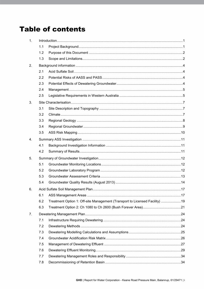
Table of contents
1. Introduction..................................................................................................................................... 1
1.1 Project Background .............................................................................................................. 1
1.2 Purpose of this Document ................................................................................................... 2
1.3 Scope and Limitations.......................................................................................................... 2
2. Background information ................................................................................................................. 4
2.1 Acid Sulfate Soil ................................................................................................................... 4
2.2 Potential Risks of AASS and PASS ..................................................................................... 4
2.3 Potential Effects of Dewatering Groundwater ...................................................................... 4
2.4 Management ........................................................................................................................ 5
2.5 Legislative Requirements in Western Australia ................................................................... 5
3. Site Characterisation ...................................................................................................................... 7
3.1 Site Description and Topography ........................................................................................ 7
3.2 Climate ................................................................................................................................. 7
3.3 Regional Geology ................................................................................................................ 8
3.4 Regional Groundwater ......................................................................................................... 9
3.5 ASS Risk Mapping ............................................................................................................. 10
4. Summary ASS Investigation ........................................................................................................ 11
4.1 Background Investigation Information ............................................................................... 11
4.2 Summary of Results ........................................................................................................... 11
5. Summary of Groundwater Investigation ....................................................................................... 12
5.1 Groundwater Monitoring Locations .................................................................................... 12
5.2 Groundwater Laboratory Program ..................................................................................... 12
5.3 Groundwater Assessment Criteria ..................................................................................... 13
5.4 Groundwater Quality Results (August 2013) ..................................................................... 14
6. Acid Sulfate Soil Management Plan ............................................................................................. 17
6.1 ASS Management Areas ................................................................................................... 17
6.2 Treatment Option 1: Off-site Management (Transport to Licensed Facility) ..................... 19
6.3 Treatment Option 2: Ch 1080 to Ch 2600 (Bush Forever Area) ........................................ 21
7. Dewatering Management Plan ..................................................................................................... 24
7.1 Infrastructure Requiring Dewatering .................................................................................. 24
7.2 Dewatering Methods .......................................................................................................... 24
7.3 Dewatering Modelling Calculations and Assumptions ....................................................... 25
7.4 Groundwater Acidification Risk Matrix ............................................................................... 26
7.5 Management of Dewatering Effluent ................................................................................. 27
7.6 Dewatering Effluent Monitoring .......................................................................................... 29
7.7 Dewatering Management Roles and Responsibility .......................................................... 34
7.8 Decommissioning of Retention Basin ................................................................................ 34
ii | GHD | Report for Water Corporation - Keane Road Pressure Main, Balannup, 61/29471
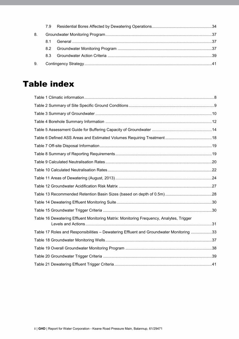
7.9 Residential Bores Affected by Dewatering Operations ...................................................... 34
8. Groundwater Monitoring Program ................................................................................................ 37
8.1 General .............................................................................................................................. 37
8.2 Groundwater Monitoring Program ..................................................................................... 37
8.3 Groundwater Action Criteria .............................................................................................. 39
9. Contingency Strategy ................................................................................................................... 41
Table index
Table 1 Climatic information ..................................................................................................................... 8
Table 2 Summary of Site Specific Ground Conditions ............................................................................. 9
Table 3 Summary of Groundwater ......................................................................................................... 10
Table 4 Borehole Summary Information ................................................................................................ 12
Table 5 Assessment Guide for Buffering Capacity of Groundwater ...................................................... 14
Table 6 Defined ASS Areas and Estimated Volumes Requiring Treatment .......................................... 18
Table 7 Off-site Disposal Information ..................................................................................................... 19
Table 8 Summary of Reporting Requirements ....................................................................................... 19
Table 9 Calculated Neutralisation Rates ................................................................................................ 20
Table 10 Calculated Neutralisation Rates .............................................................................................. 22
Table 11 Areas of Dewatering (August, 2013) ....................................................................................... 24
Table 12 Groundwater Acidification Risk Matrix .................................................................................... 27
Table 13 Recommended Retention Basin Sizes (based on depth of 0.5m) .......................................... 28
Table 14 Dewatering Effluent Monitoring Suite ...................................................................................... 30
Table 15 Groundwater Trigger Criteria .................................................................................................. 30
Table 16 Dewatering Effluent Monitoring Matrix: Monitoring Frequency, Analytes, Trigger Levels and Actions .................................................................................................................. 31
Table 17 Roles and Responsibilities – Dewatering Effluent and Groundwater Monitoring ................... 33
Table 18 Groundwater Monitoring Wells ................................................................................................ 37
Table 19 Overall Groundwater Monitoring Program .............................................................................. 38
Table 20 Groundwater Trigger Criteria .................................................................................................. 39
Table 21 Dewatering Effluent Trigger Criteria ........................................................................................ 41

GHD | Report for Water Corporation - Keane Road Pressure Main, Balannup, 61/29471 | iii
Figure index
Figure 1 Site Locality Plan
Figure 2 Published Geological Information
Figure 3 Groundwater Contours and August 2013 Groundwater Levels
Figure 4 Acid Sulfate Soil Risk Mapping
Figure 5 Geotechnical and ASS Investigation Locations
Figure 6 Groundwater Well Locations
Appendices
Appendix A - Figures
Appendix B – Preliminary Design Drawings
Appendix C – Site Investigation Results
Appendix D – Dewatering Schematic
Appendix E – Contractor Daily Record Sheets

GHD | Report for Water Corporation - Keane Road Pressure Main, Balannup, 61/29471 | 1
1. Introduction
1.1 Project Background
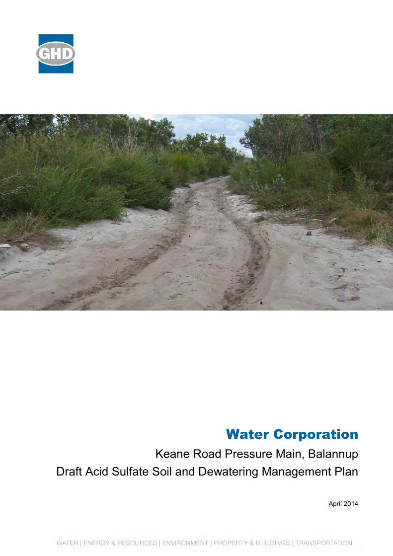
The Water Corporation (WC) is proposing an M&E upgrade of the Balannup Wastewater Sewerage Pump Station (WWPS) and to construct a new rising pressure main along Keane Road to the Waterworks Road WWPS in Haynes, 22km south of Perth in Western Australia. The site locality is depicted on Figure 1. The construction upgrade will be undertaken in a phased approach and Stage 1 (the remit of this ASSDMP) will comprise the following tasks:
1. Section 1: Construction of approximately 1km (Chainage (Ch) 0 to 1080) of pressure main at an assumed invert between 2m and 2.5m depth (Ch 0 to Ch 522) and 1m to 1.5m depth (Ch 522 to Ch 1080). The pressure main will commence at the existing DN375 pressure main located on Welcome Meander in Harrisdale to the start of Bush Forever area at the intersection of Skeet Road and Keane Road. The pressure main is anticipated to be installed utilising open excavation techniques.
2. Section 2: Installation of approximately 1.5km (Ch 1080 to 2600) DN450 PE pressure main at an invert level of 1.5m to 2m depth utilising trenchless methods (Eco-Ploughing) through the Bush Forever area to the Anstey Road and Keane Road intersection in Forrestdale.
3. Section 3: Construction of approximately 2km (Ch 2600 to Ch 4557) DN375 pressure main at an invert between 1m and 2m depth from the Anstey Road and Keane Road intersection to the Waterworks Road WWPS utilising open excavation techniques.
4. Three (3) road crossings have been identified during the installation; two (2) of these crossings will be undertaken utilising trenchless techniques, one (Anstey Road) will be open excavated. A DN450 PE100 pipe is anticipated to be installed for all road crossings outlined below at an invert between 3m and 3.5m depth.
a. Armadale Road (trenchless);
b. Tonkin Highway (trenchless); and
c. Anstey Road/ Damper to Bunbury Natural Gas Pipeline (open excavation).
The general arrangement of the infrastructure outlined above is indicated in the GHD plan and longitudinal section drawings (i.e. Drawing No: HW91-085-01A1 to HW91-085-002-15A, Appendix B).
GHD was commissioned by Water Corporation to prepare an Acid Sulfate Soil and Dewatering Management Plan (ASSDMP) based upon the recommendations of the geotechnical and acid sulfate soil (ASS) investigations performed as part of the geotechnical consulting services for the project.
The dewatering requirements have not yet been fully identified, and this document is therefore not considered to be the final ASS Dewatering Management Plan (ASSDMP). At the time of writing the detailed design has not been completed and the construction contractor procurement process has not yet commenced.
This document has been prepared using information available at the time of preparation (engineering design drawings). This document should be updated as additional information becomes available on construction elements requiring dewatering and dewatering designs are developed.

2 | GHD | Report for Water Corporation - Keane Road Pressure Main, Balannup, 61/29471
1.2 Purpose of this Document
This document and content has been prepared on a draft basis and requires to be finalised prior to the commencement of construction. The construction methodology and management strategies are based upon assumed construction methods and these methods are required to be finalised before the management strategies are valid and suitable for the works.
When finalised, the aim of this document is to summarise the results of the ASS and groundwater investigations and document the findings of those investigations (where relevant) to assist in the preparation of the ASSDMP. This document is considered to address the ASS management and dewatering requirements for the pressure main alignment.
This document addresses the key construction issues that may impact on groundwater, environmental receptors and groundwater users within the vicinity of the site and includes:
A framework for the treatment and management of excavated/disturbed material defined as ASS during construction of the pressure main.
A framework for management of dewatering effluent and groundwater, specifically with regards to managing the groundwater quality and levels, during development works.
The likely depth to groundwater within the vicinity of the pressure main alignment and highlight areas, which may require dewatering; and
An indication of further detailed groundwater investigation work required.
This document contains an ASSDMP that will be used to inform the Contractor constructing the proposed infrastructure and provide appropriate management and action criteria during the treatment and dewatering operations to minimise potential impacts to the local groundwater, surface water systems, ecology and other groundwater users.
This document should be read in conjunction with the following geotechnical, ASS and contaminated sites investigation report for the site. The document is referenced below:
GHD, 2013. Report on the Geotechnical, Acid Sulfate Soils and Contaminated Sites Investigation, Balannup A WWPS and Keane Road Pressure Main (Document number 134551, Rev 0). November, 2013.
1.3 Scope and Limitations
This report has been prepared by GHD for Water Corporation and may only be used and relied on by Water Corporation for the purpose agreed between GHD and the Water Corporation as set out in section 1.2 of this report.
GHD otherwise disclaims responsibility to any person other than Water Corporation arising in connection with this report. GHD also excludes implied warranties and conditions, to the extent legally permissible.
The services undertaken by GHD in connection with preparing this report were limited to those specifically detailed in the report and are subject to the scope limitations set out in the report.
The opinions, conclusions information reviewed at the date of preparation of the report. GHD has no responsibility or obligation to update this report to account for events or changes occurring subsequent to the date that and any recommendations in this report are based on conditions encountered and the report was prepared.
The opinions, conclusions and any recommendations in this report are based on assumptions made by GHD described in this report where and as they are required. GHD disclaims liability arising from any of the assumptions being incorrect.
GHD | Report for Water Corporation - Keane Road Pressure Main, Balannup, 61/29471 | 3
GHD has prepared this report on the basis of information provided by Water Corporation and others who provided information to GHD (including Government authorities), which GHD has not independently verified or checked beyond the agreed scope of work. GHD does not accept liability in connection with such unverified information, including errors and omissions in the report which were caused by errors or omissions in that information.
The opinions, conclusions and any recommendations in this report are based on information obtained from, and testing undertaken at or in connection with, specific sample points. Site conditions at other parts of the site may be different from the site conditions found at the specific sample points.
Investigations undertaken in respect of this report are constrained by the particular site conditions, such as the location of buildings, services and vegetation. As a result, not all relevant site features and conditions may have been identified in this report.
Site conditions (including the presence of hazardous substances and/or site contamination) may change after the date of this Report. GHD does not accept responsibility arising from, or in connection with, any change to the site conditions. GHD is also not responsible for updating this report if the site conditions change.
4 | GHD | Report for Water Corporation - Keane Road Pressure Main, Balannup, 61/29471
2. Background information
2.1 Acid Sulfate Soil
The classification of ASS includes both actual acid sulfate soils (AASS) and potential acid sulfate soils (PASS). AASS are soils that are generating acidity and may still have residual potential acidity, whereas PASS are soils that have the potential to generate acidity.
ASS are soils containing naturally-occurring, fine-grained metal sulfides typically pyrite (FeS2), formed under saturated, anoxic/reducing conditions. They generally occur in Quaternary (1.8 Ma – Present) marine or estuarine sediments, predominantly confined to coastal lowlands (elevations generally below 5 m Australian Height Datum (AHD)). Within these sediments, the majority of soils that present an environmental risk are generally confined to Holocene aged material (<10 000 years). Where these materials have oxidised, they commonly have a mottled appearance (orange and yellow discolouration) due to the presence of oxidised iron minerals.
Although soils described above represent typical conditions where ASS occurs, the presence of ASS materials is not limited to these soil types. In Western Australia, ASS materials have been identified in other soil types such as leached sands and silts. Accordingly, for areas where no data is available, the extent of ASS materials should be established through field investigations.
2.2 Potential Risks of AASS and PASS
When PASS are disturbed, either by excavation or lowering of the water table below natural seasonal levels, sulfides present are exposed to air, allowing oxidisation and consequently, the formation of sulfuric acid (H2SO4). AASS are capable of generating acidity in situ in their natural state; disturbance is not required for acidic discharges to develop.
As a result of the presence of AASS, or the oxidation of PASS, surrounding land (soil) and nearby waterways may become acidic (pH<6.5). Under acidic conditions, metals such as aluminium (generally at pH<4.5) and iron, as well as trace heavy metals (including arsenic), become more mobile in the environment and can be taken up by infiltrating waters.
Disturbance of ASS impacted areas may release hydrogen sulfide gas which typically settles within confined spaces and excavations such as trenches and/or depressions. Hydrogen sulfide gas has the potential to reach toxic levels and appropriate occupational health and safety measures may require to be implemented within areas of depressions and/ or during excavation of confined spaces.
2.3 Potential Effects of Dewatering Groundwater
2.3.1 Water Quality
Dissolved metals including iron and aluminium may cause environmental issues, if the dewatering effluent is discharged prior to retention. Discharge without retention may cause iron hydroxides to precipitate out where effluent is discharged into water bodies (particularly surface water). These chemical reactions may release large quantities of acid and consume oxygen causing de-oxygenation of the water column in nearby ecosystems or the local groundwater system and decreasing local buffering capacity (alkalinity), where available. In cases where alkalinity can no longer buffer acidity, then acidification of the groundwater may occur.
Acidic conditions generated by ASS can also corrode concrete and steel (pipes, bridge abutments, underground services, and other infrastructure) and can result in the rapid deterioration of asphalt surfaces where they overlie AASS or PASS. Acidic groundwater plumes can impact on vegetation health of deep rooted vegetation, and affect the water quality of any

GHD | Report for Water Corporation - Keane Road Pressure Main, Balannup, 61/29471 | 5
downstream groundwater receptors including surface water bodies and domestic and industrial water supply bores.
2.4 Management
2.4.1 Management of ASS
Avoiding or minimising disturbance of ASS is the primary methods of management. Where avoiding disturbance is not possible, management techniques available for ASS can include:
Chemical neutralisation (use of pure fine agricultural lime (AgLime) or a similar neutralising agent).
Anoxic storage or placement of PASS below the water table and beneath clean non-ASS fill; and
Hydraulic separation of pyrite from the soil (high maintenance process suitable for coarse grained sediment).
The addition of agricultural lime is the most common amelioration technique applied to acidic soils, where mechanical mixing is completed by plough or excavator to provide adequate homogeneity of the soil/sediment-lime mix.
2.4.2 Management of Dewatering Effluent
The groundwater conditions at the site are indicative of an area which may be vulnerable to acidification and therefore the risk of the water quality impacts outlined within Section 2.3.1 occurring is high. Dewatering operations should be undertaken with appropriate management measures, monitoring trigger actions and contingency strategies to prevent the degradation of groundwater during construction.
The management strategies implemented within this document are in accordance with the appropriate legislative requirements and guidelines outlined within Section 2.5.
2.5 Legislative Requirements in Western Australia
The following legislative requirements may apply to works involving dewatering activities:
2.5.1 Western Australian Planning Commission Bulletin 64/2009
The recently amended Planning Bulletin 64/2009 (PB 64/09) aims to provide advice and guidance on matters that should be taken into account in the rezoning, subdivision and development of land containing acid sulfate soils. PB 64/09 requires the identification, assessment and management of soils where:
The surface elevation is ≤ 5m AHD, and it is proposed to excavate ≥ 100m3 of soil;
Where the surface elevation is ≥ 5m AHD, and it is proposed to excavate ≥ 100m3, and the excavation depth is ≥ 2m; or
Where any dewatering works are to be undertaken.
2.5.2 Environmental Protection Act 1986
The Environmental Protection Act 1986 (EP Act 1986) provides for an Environmental Protection Authority, for the prevention, control and abatement of pollution and environmental harm, for the conservation, preservation, protection, enhancement and management of the environment and for matters incidental to or connected with the foregoing.
To prevent environmental harm, the EP Act 1986 established under Section 50A, states that:

6 | GHD | Report for Water Corporation - Keane Road Pressure Main, Balannup, 61/29471
A person who –
a. causes serious environmental harm; or
b. allows serious environmental harm to be caused - commits an offence.
Accordingly, all parties to a development must show that the environmental risk associated with the development has been assessed and minimised where possible.
2.5.3 Rights in Water and Irrigation Act (1914)
In accordance with the ‘Water Corporation Acid Sulfate Soil and Dewatering Management Strategy’ (Water Corporation, July 2007) the Water Corporation is not required to obtain either a Section 5C or Section 26D license under the Rights in Water and Irrigation Act (1914) in regards to dewatering. The power given to the Water Corporation by Section 83(2)(b) of the Water Agencies (Powers) Act 1984 overrides the generic requirements of Sections 5C and 26D of the Rights in Water and irrigation Act and therefore the Water Corporation is exempt from the requirement to obtain a dewatering license.
GHD | Report for Water Corporation - Keane Road Pressure Main, Balannup, 61/29471 | 7
3. Site Characterisation
The information presented below has been abstracted from the geotechnical and acid sulfate soil and contaminated sites investigation report (GHD, 2013) and has been utilised to assist with the preparation of this ASSDMP.
3.1 Site Description and Topography
3.1.1 Section 1: Ch 0 to C 1080
Section 1 extends from the north west corner of the project area in Harrisdale to Skeet Road. The pressure main will connect to an existing pressure main within a recently developed subdivision (Heron Park).
This portion of the alignment gently declines in elevation from the initial starting point at Turtledove Road to the Bush Forever Area located at the intersection of Skeet Road and Keane Road. Elevation typical ranges between 26.5m AHD to 25.6m AHD.
3.1.2 Section 2: Ch 1080 to Ch 2600
Section 2 extends the length of the Bush Forever designated land (Figure 1). Section 2 is characterised by a loose sandy track approximately following the Keane Road reserve alignment. The track is boarded on either side by scrub which becomes less dense towards the east. At the far east of the Bush Forever area the scrub gives way to grass/weeds along a Water Corporation easement.
The Bush Forever area typically gently slopes north west to south east with elevations ranging from 25m AHD to 22.2m AHD. The south eastern end of the road reserve track was characterised by standing water covering most of the track during the investigation undertaken in June and July 2013. Freestanding water to approximately 0.5 m was observed from approximately Ch. 2170 to Ch. 2600 during this period.
3.1.3 Section 3: Ch 2600 to Ch 4557
Section 3 between Ch. 2600 and Ch. 4557 extends along the south east continuation of Keane Road and into Hanlin Road beyond the Armadale Road intersection before crossing Tonkin Highway and terminating within the Water Corporation depot at the WWPS.
The proposed pressure main terminates inside the Water Corporation depot at the waterworks site. The Water Corporation grounds between Tonkin Highway and the waterworks generally consist of sandy tracks, defined by derelict wire fences and low lying grasses and shrubs. The waterworks and surrounding infrastructure are located within a paved area bordered by trees.
Elevation from the Bush Forever area typically inclines from Anstey Road to the Tonkin Highway with a few gently undulations. Elevation ranges from 22.2m AHD to 25.2m AHD, with the undulations to a minimum of 23.5m AHD. Elevation at the WWPS is typically 27.3 mAHD.
3.2 Climate
The Gosnells area (closest weather station with long-term recording information within the proximity to Armadale) has a Mediterranean climate of cool, wet winters and hot, dry summers. Climatic information collected from the Gosnells meteorological monitoring station is presented in Table 1.
8 | GHD | Report for Water Corporation - Keane Road Pressure Main, Balannup, 61/29471
Table 1 Climatic information
Station Mean Annual Minimum Temperature Range (ºC)
Mean Annual Maximum Temperature Range (ºC)
Annual Rainfall (mm)
Gosnells City (09106)
17.3 (July) – 30.5 (Jan.) 20.1 (July) – 36.3 (Feb.) 640.01
Source: Bureau of Meteorology Climatic Averages of Australian Sites, 2014.
3.3 Regional Geology
3.3.1 Published Information
The 1:50,000 Environmental Geology Series “Armadale” Part Sheets 2033 1 and 2133 IV indicate that the site is predominantly underlain by the Bassendean Sand unit (as indicated in Figure 2). Bassendean Sand is described as a ‘white to pale grey at surface, yellow at depth, fine to medium grained, moderately sorted, subangular to subrounded, minor heavy minerals, of eolian origin’. A thin layer of friable variably cemented iron and/or organic rich sands colloquially known as ‘coffee rock’ is commonly encountered within the vicinity of the water table.
Coffee rock forms by the precipitation of humates and iron from groundwater, mainly in the zone of water table fluctuations, and may vary between bright orange, orange brown and dark brown to black. Coffee rock horizons contain stored potential acidity in a number of forms including inorganic sulfides such as di-sulfides (pyrites) and poorly crystalline and easily hydrolysable iron and manganese oxides.
The Bassendean Sand is underlain at variable depth by alluvial clayey, silty and sandy soils of the Guildford Formation. The Guildford Formation consists of clay, sand and gravel and is variably laterised and podsolised.
Small pockets of peaty clay associated with swamps (subject to seasonal flooding) are likely to be encountered at or near surface to the south east of Skeet Road. The peaty clay found in this region is formed from swamp deposits and is described as ‘grey to black, fine to medium grained, moderately sorted quartz sand, slightly peaty of lacustrine origin’.
3.3.2 Site Specific Ground Conditions
The soils intersected during execution of the geotechnical site investigation are generally consistent with the 1:50,000 Environmental Geology map for the region. The local ground conditions along the pressure main alignment where ASS and/or dewatering management is required is described in Table 2.
1 Annual rainfall for 2012, rainfall data for 2013 not available.

GHD | Report for Water Corporation - Keane Road Pressure Main, Balannup, 61/29471 | 9
Table 2 Summary of Site Specific Ground Conditions
Section Chainage Subsurface Conditions Depth (m bgl)
Section 1 0 to 1080 Topsoil: black/brown medium grained sand. 0.1 – 0.2 m
Fill: pale yellow/brown sand with fine to medium grained limestone gravel.
0.9 – 3.5 m
Bassendean Sand: grey/brown poorly graded sand.
Max. 3.3 m
Guildford Formation: black medium grained silty sand/sand with gravel and weakly iron cemented clasts.
>3.5 m
Section 2 1080 to 1400 Bassendean Sand: grey to brown, fine to medium grained, poorly graded sand with trace organics.
1.5 – 2.5 m
Guildford Formation: dark brown/black, low plasticity silty sand/sandy silts.
1.5 – 3.0 m
1400 to 2600 Bassendean Sand: grey to brown, medium grained, poorly graded sand with trace organics.
0.5 – 2.0 m
Guildford Formation: grey/brown clayey sand, medium grained.
>2.0 m
Section 3 2600 to 4557 Fill: pale yellow/brown sand with fine to medium grained gravel.
0 - 0.5 m
Bassendean Sand: grey/white fine to medium grained poorly graded sand, trace organics and silt.
0 – 3.4 m
Guildford Formation: grey to brown with medium grained sand.
>0.7 m
3.4 Regional Groundwater
The Hydrogeological Atlas of Western Australia indicates two aquifers in the area, Perth Superficial Swan and Leederville Aquifer. The Bassendean Sand geological units make up the superficial aquifer within the study area. The Leederville Aquifer is deep relative to the proposed construction and is not relevant to this ASSDMP.
Review of the Department of Water’s Perth Groundwater Atlas provides information in regards to the groundwater level (May, 2003) and the historical maximum groundwater levels for the pressure main alignment. Table 3 below summarises this information.
10 | GHD | Report for Water Corporation - Keane Road Pressure Main, Balannup, 61/29471
Table 3 Summary of Groundwater
Section Chainage May (2003)
(m AHD)
Historical maximum
(m AHD)
Section 1 0 to 1080 23.5 to 22.5 25.5 to 24.5
Section 2 1080 to 2600 23.0 to 21.0 25.0 to 23.0
Section 3 2600 to 4557 21.0 to 22.0 23.0 to 25.0
The Perth Groundwater Atlas historical maximum contours are presented on Figure 3, along with the groundwater monitoring data obtained during the monitoring program in August, 2013.
3.4.1 Site Specific Groundwater
Groundwater was encountered along the pressure main alignment during the June/July 2013 site investigation and the groundwater monitoring program in August 2013. Groundwater levels were estimated during the geotechnical investigation using groundwater depth data and estimates of surface elevations obtained from contour data are presented below.
The information below presented the maximum and minimum groundwater levels observed for each alignment section.
Section 1 - 23.5 m AHD to 25.2 m AHD;
Section 2 - 19.5 m AHD to 24 m AHD; and,
Section 3 - 20 m AHD to 23.2 m AHD.
3.5 ASS Risk Mapping
Review of the Department of Environment Regulation (DER), formerly Department of Environment and Conservation (DEC) ASS risk mapping available through the Landgate Shared Land Information Portal (SLIP) indicates that the majority of the alignment overlies an area of ‘Moderate to low risk of ASS occurring within 3 m of natural soil surface but high to moderate risk of ASS beyond 3 m of natural soil surface’. Additionally there are three small areas of ‘High to moderate risk of ASS occurring within 3 m of natural surface soil’. These areas correspond to the following chainages:
Section 2: Chainage 1640 – 1780;
Section 2: Chainage 2445 – 2653; and
Section 2: Chainage 2305 – 3612.
These areas are associated with peaty clay (Cps) sediments as depicted on the published geological information and were also targeted during the geotechnical site investigation.
The ASS risk and the environmental constraints for the pressure main alignment are presented on Figure 4.

GHD | Report for Water Corporation - Keane Road Pressure Main, Balannup, 61/29471 | 11
4. Summary ASS Investigation
4.1 Background Investigation Information
In consideration of the moderate risk of ASS, a site walkover, visual assessment and site investigation was undertaken in conjunction with the geotechnical investigation. The site works were undertaken in accordance with the Water Corporation Acid Sulfate Soil and Dewatering Management Strategy, prepared by Parsons Brinkerhoff (Rev. C, July 2007).
The site investigation was undertaken in conjunction with the geotechnical and contamination investigation in June and July 2013 to establish the ASS risk within the footprint of the proposed works and the risk associated with potential dewatering operations associated with construction.
Additionally, a review of photographs obtained from the geotechnical investigation (where available) and logs were undertaken to identify any additional ASS indicators.
4.2 Summary of Results
The ASS investigation is reported within the geotechnical and ASS investigation report (GHD, 2013) and the below information provides a summary of the results obtained. The site investigation results are provided with Table 1, Appendix C for information purposes and to assist with the preparation of this ASSDMP. The investigation locations are provided on Figure 5.
ASS was identified in samples collected from fifteen (15) of the twenty eight (28) push probing locations drilled during the site investigation. PASS material is associated with the black silty sands, grey silty/clayey sands, black/brown sandy silt and coffee rock horizons, generally at or below the water table.
The maximum inferred RL of PASS encountered during the investigation was 23.5 m AHD within the brown silty sand horizon at BH15, located within the Bush Forever section.
Based on the proposed pipeline invert levels, it is likely that ASS material will be disturbed as part of the construction works. An Acid Sulfate Soil Management Plan (ASSMP) will be required prior to commencing earthworks to guide the treatment and management of ASS material during construction.
12 | GHD | Report for Water Corporation - Keane Road Pressure Main, Balannup, 61/29471
5. Summary of Groundwater
Investigation
The groundwater investigation was undertaken as part of the geotechnical, ASS and contaminated sites investigation in August 2013 and is reported within the geotechnical and ASS investigation report (GHD, 2013), however to assist with the preparation of this ASSDMP, the groundwater investigation has been outlined below.
5.1 Groundwater Monitoring Locations
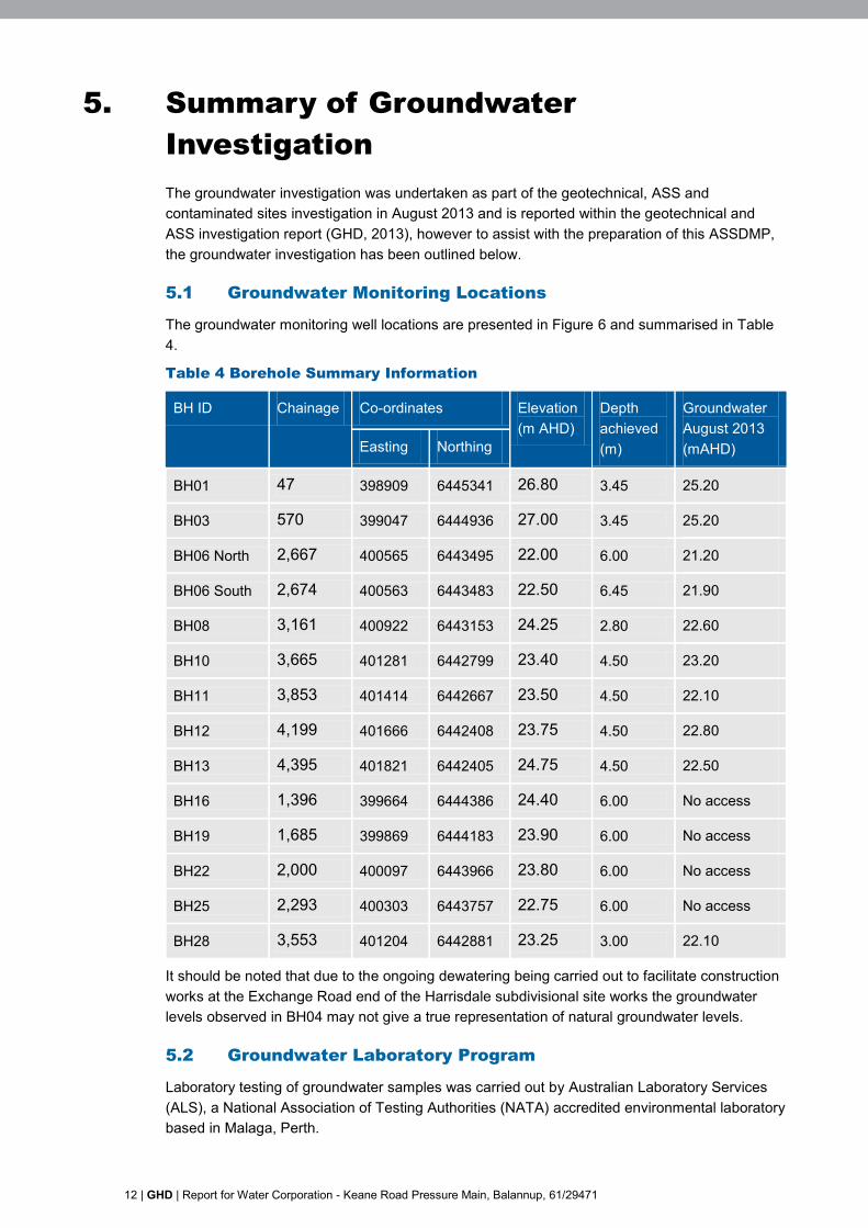
The groundwater monitoring well locations are presented in Figure 6 and summarised in Table 4.
Table 4 Borehole Summary Information
BH ID Chainage Co-ordinates Elevation (m AHD)
Depth achieved (m)
Groundwater August 2013 (mAHD) Easting Northing
BH01 47 398909 6445341 26.80 3.45 25.20
BH03 570 399047 6444936 27.00 3.45 25.20
BH06 North 2,667 400565 6443495 22.00 6.00 21.20
BH06 South 2,674 400563 6443483 22.50 6.45 21.90
BH08 3,161 400922 6443153 24.25 2.80 22.60
BH10 3,665 401281 6442799 23.40 4.50 23.20
BH11 3,853 401414 6442667 23.50 4.50 22.10
BH12 4,199 401666 6442408 23.75 4.50 22.80
BH13 4,395 401821 6442405 24.75 4.50 22.50
BH16 1,396 399664 6444386 24.40 6.00 No access
BH19 1,685 399869 6444183 23.90 6.00 No access
BH22 2,000 400097 6443966 23.80 6.00 No access
BH25 2,293 400303 6443757 22.75 6.00 No access
BH28 3,553 401204 6442881 23.25 3.00 22.10
It should be noted that due to the ongoing dewatering being carried out to facilitate construction works at the Exchange Road end of the Harrisdale subdivisional site works the groundwater levels observed in BH04 may not give a true representation of natural groundwater levels.
5.2 Groundwater Laboratory Program
Laboratory testing of groundwater samples was carried out by Australian Laboratory Services (ALS), a National Association of Testing Authorities (NATA) accredited environmental laboratory based in Malaga, Perth.
GHD | Report for Water Corporation - Keane Road Pressure Main, Balannup, 61/29471 | 13
Samples were submitted for the following analytes:
Acidity, pH, electrical conductivity (EC), total dissolved solids (TDS), total suspended solids (TSS);
Major anions (Cl, SO4, alkalinity);
Major cations (Ca, Mg, Na, K);
Dissolved metals (Al, As, Cd, Cr, Fe, Mn, Ni, Se, Zn);
Total metals (Al, Fe);
Nutrients (nitrogen and phosphorus); and
Sulfide.
5.3 Groundwater Assessment Criteria
The following assessment criteria have been adopted for a preliminary assessment of pre-existing contamination (if present) and ASS groundwater indicators at the Site and are referred to in the DER Assessment Levels for Soil Sediment and Water (DEC, 2010, Version 4.1).
Fresh Water
Short Term Irrigation (STI)
DER ASS indicator criteria
5.3.1 Freshwater Guidelines
Guidelines for the protection of ecological receptors are provided in Australian and New Zealand Guidelines for Fresh and Marine Water Quality (ANZECC and ARMCANZ, 2000), and adopted by DER in Assessment Levels for Soil, Sediment and Water (DEC, 2010, Version 4.1).
The site is located within the vicinity of natural wetland receptors and the freshwater guidelines are considered appropriate criteria to determine whether dewatered effluent may have a detrimental effect on the wetland water quality. The freshwater guidelines present various assessment criteria depending upon the surrounding environs. It is considered for this site that where more than one assessment criterion has been made available, the Wetland values will be selected.
5.3.2 Short Term Irrigation Water Guidelines
In consideration of the potential for infiltration to be used as a method for dewatering effluent disposal, groundwater quality was compared to the STI guidelines specified in the Australian and New Zealand Guidelines for Fresh and Marine Water Quality (ANZECC and ARMCANZ, 2000).
5.3.3 DER ASS Indicator Criteria
The DER ASS Guideline Series (DEC, 2013) outline chemical indicators that may indicate the groundwater is being affected by, or has already been affected by, the oxidation of sulfides. These indicators are outlined below.
An alkalinity: sulfate ratio of less than 5 (Swedish EPA, 2002);
A pH of less than 5 and/or
A soluble aluminium concentration greater than 1 mg/L.
14 | GHD | Report for Water Corporation - Keane Road Pressure Main, Balannup, 61/29471
It should be noted that the above criteria are indicators only and do not necessarily denote that the oxidation of ASS materials has occurred. Any exceedence of the criteria should be identified and compared to other analytes prior to drawing conclusions on ASS.
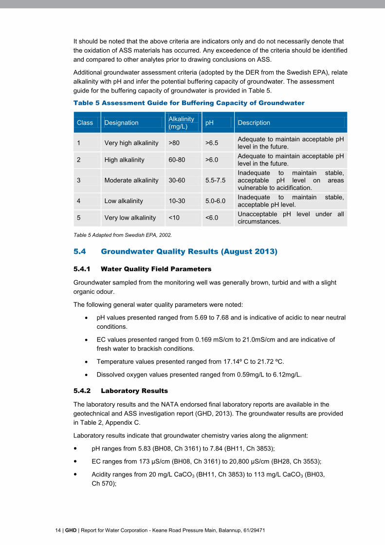
Additional groundwater assessment criteria (adopted by the DER from the Swedish EPA), relate alkalinity with pH and infer the potential buffering capacity of groundwater. The assessment guide for the buffering capacity of groundwater is provided in Table 5.
Table 5 Assessment Guide for Buffering Capacity of Groundwater
Class Designation Alkalinity (mg/L) pH Description
1 Very high alkalinity >80 >6.5 Adequate to maintain acceptable pH level in the future.
2 High alkalinity 60-80 >6.0 Adequate to maintain acceptable pH level in the future.
3 Moderate alkalinity 30-60 5.5-7.5 Inadequate to maintain stable, acceptable pH level on areas vulnerable to acidification.
4 Low alkalinity 10-30 5.0-6.0 Inadequate to maintain stable, acceptable pH level.
5 Very low alkalinity <10 <6.0 Unacceptable pH level under all circumstances.
Table 5 Adapted from Swedish EPA, 2002.
5.4 Groundwater Quality Results (August 2013)
5.4.1 Water Quality Field Parameters
Groundwater sampled from the monitoring well was generally brown, turbid and with a slight organic odour.
The following general water quality parameters were noted:
pH values presented ranged from 5.69 to 7.68 and is indicative of acidic to near neutral conditions.
EC values presented ranged from 0.169 mS/cm to 21.0mS/cm and are indicative of fresh water to brackish conditions.
Temperature values presented ranged from 17.14º C to 21.72 ºC.
Dissolved oxygen values presented ranged from 0.59mg/L to 6.12mg/L.
5.4.2 Laboratory Results
The laboratory results and the NATA endorsed final laboratory reports are available in the geotechnical and ASS investigation report (GHD, 2013). The groundwater results are provided in Table 2, Appendix C.
Laboratory results indicate that groundwater chemistry varies along the alignment:
pH ranges from 5.83 (BH08, Ch 3161) to 7.84 (BH11, Ch 3853);
EC ranges from 173 µS/cm (BH08, Ch 3161) to 20,800 µS/cm (BH28, Ch 3553);
Acidity ranges from 20 mg/L CaCO3 (BH11, Ch 3853) to 113 mg/L CaCO3 (BH03, Ch 570);

GHD | Report for Water Corporation - Keane Road Pressure Main, Balannup, 61/29471 | 15
Alkalinity (present as bicarbonate) ranges from 11 mg/L CaCO3 (BH08, Ch 3161) to 415 mg/L CaCO3 (BH06 North, Ch 2667); and
Sulfate concentrations range from 23 mg/L (BH08, Ch 3161) to 727 mg/L (BH28, Ch 3553).
DER ASS Indicator Criteria
The following groundwater indicators were noted:
Seven of the samples recorded alkalinity:sulfate ratios < 5. These include: BH01, BH03, BH06 North, BH08, BH10, BH11, BH12, BH13 and BH28. The remaining samples collected from BH10 and BH11 contain alkalinity:sulfate ratios > 5.
None of the groundwater samples present pH value < 5
None of the groundwater samples present soluble aluminium concentrations > 1 mg/L.
Acidity ranges from 20 mg/L CaCO3 (BH11, Ch 3853) to 113 mg/L CaCO3 (BH03, Ch 570);
It should be noted that the above criteria are indicators only and do not necessarily denote that the oxidation of ASS materials has occurred. Any exceedance of the criteria should be identified and compared to other analytes prior to drawing conclusions on ASS.
ANZECC and ARMCANZ (2000) Fresh Water Ecosystem Protection Guideline
The following heavy metal concentrations exceeding the adopted assessment criteria were noted:
Total aluminium concentrations exceeded the criteria (0.027 mg/L) in all nine (9) wells with exceedances ranging from 0.51 mg/L (BH01) up to 540 mg/L (BH13);
Dissolved aluminium concentrations exceeded the criteria (0.027 mg/L) in seven (7) wells - BH01 (0.08 mg/L), BH03 (0.35 mg/L), BH06 North (0.11 mg/L), BH08 (0.2 mg/L), BH10 (0.85 mg/L), BH12 (0.81 mg/L) and BH13 (0.04 mg/L);
Dissolved chromium concentrations exceeded the criteria (0.00001 mg/L) in five (5) wells – BH06 North (0.005 mg/L), BH08 (0.002 mg/L), BH10 (0.001 mg/L), BH12 (0.004 mg/L) and BH28 (0.006 mg/L);
Dissolved copper concentrations exceeded the criteria (0.001 mg/L) in seven (7) wells – BH01 (0.002 mg/L), BH08 (0.002 mg/L), BH10 (0.005 mg/L), BH11 (0.003 mg/L), BH12 (0.006 mg/L), BH13 (0.002 mg/L) and BH28 (0.006 mg/L);
Dissolved lead concentrations exceeded the criteria (0.001 mg/L) in two (2) wells – BH01 (0.002 mg/L) and BH12 (0.004 mg/L);
Dissolved manganese concentrations exceeded the criteria (1.2 mg/L) in one (1) well – BH28 (1.5 mg/L);
Dissolved nickel concentrations exceeded the criteria (0.008 mg/L) in one (1) well – BH28 (0.021 mg/L); and
Dissolved zinc concentrations exceeded the criteria (0.0024 mg/L) in five (5) wells – BH03 (0.007 mg/L), BH08 (0.025 mg/L), BH10 (0.008 mg/L), BH12 (0.008 mg/L) and BH28 (0.024 mg/L).
No exceedances were recorded for dissolved arsenic, cadmium, cobalt or selenium concentrations in the nine (9) groundwater wells monitored.

16 | GHD | Report for Water Corporation - Keane Road Pressure Main, Balannup, 61/29471
Short Term Irrigation Water Guidelines
The following total metal concentrations exceeding the adopted assessment criteria were noted:
Total aluminium concentrations exceeded the STI criteria (20 mg/L) in four (4) wells – BH06 North (68.7 mg/L), BH10 (184 mg/L), BH12 (26.1 mg/L) and BH13 (540 mg/L); and
Total iron concentrations exceeded the STI criteria (10 mg/L) in four (4) wells – BH06 North (32.1 mg/L), BH10 (52.6 mg/L), BH11 (18.5 mg/L) and BH12 (76 mg/L).

GHD | Report for Water Corporation - Keane Road Pressure Main, Balannup, 61/29471 | 17
6. Acid Sulfate Soil Management Plan
The management strategies outlined below and within the Flow Chart 1 will be required to ensure that there are no adverse impacts to sensitive environmental receptors within the vicinity of the site. The management practices below will be implemented to ensure that soils identified as ASS are managed accordingly.
As the tender for earthworks has not yet been awarded, the following text includes generic terms for the parties that will be involved, as defined below.
Contractor: Contractor to be appointed by the Water Corporation.
Principal’s Environmental Consultant: Environmental consultant appointed by the Water Corporation.
Superintendent: Supervising engineer appointed by the Water Corporation.
The Contractor will be responsible for ensuring that all management measures outlined in this section (or as agreed otherwise) are adhered to for the duration of their contract.
6.1 ASS Management Areas
The following ASS management areas are based on the ASS laboratory results obtained by GHD (2013) and the ASS management strategies are in accordance with the DER ASS Guideline Series (DEC, 2011) and the Water Corporation Acid Sulfate Soil and Dewatering Management Strategy’ (Water Corporation, July 2007).
6.1.1 Topsoil
No ASS treatment or management of topsoils (0 - 0.3 m bgl) is necessary during construction.
For the purpose of this project, topsoil is defined as material up to the first 300 mm of the soil profile generally containing organic and vegetative matter. It is routine practice to remove the topsoil before excavation and stockpile until it is needed for top-dressing.
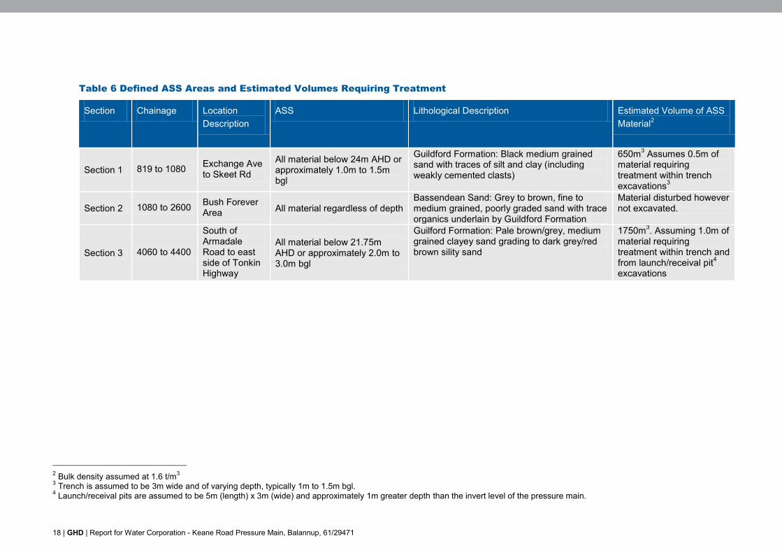
6.1.2 Defined ASS Areas
Table 6 below defines the areas within the pressure main alignment which are deemed to be ASS. Any soil material excavated from the areas outlined Table 6 must be managed in accordance with this section.
The treatment method for ASS has yet to be defined and therefore ASS management may be undertaken via off-site or on-site treatment operations. However due to space constraints, it is assumed that off-site disposal is the preferred management option. The sections below outline the requirements for off-site management.
6.1.3 Estimated ASS Volumes Requiring Treatment
The total volume of material excavated from the pressure main alignment will be dependent on the finalised method of construction. Table 6 below identifies the anticipated volume and type of material to be excavated.
18 | GHD | Report for Water Corporation - Keane Road Pressure Main, Balannup, 61/29471
Table 6 Defined ASS Areas and Estimated Volumes Requiring Treatment
Section Chainage Location Description
ASS Lithological Description Estimated Volume of ASS Material2
Section 1 819 to 1080 Exchange Ave to Skeet Rd
All material below 24m AHD or approximately 1.0m to 1.5m bgl
Guildford Formation: Black medium grained sand with traces of silt and clay (including weakly cemented clasts)
650m3 Assumes 0.5m of material requiring treatment within trench excavations3
Section 2 1080 to 2600 Bush Forever Area All material regardless of depth
Bassendean Sand: Grey to brown, fine to medium grained, poorly graded sand with trace organics underlain by Guildford Formation
Material disturbed however not excavated.
Section 3 4060 to 4400
South of Armadale Road to east side of Tonkin Highway
All material below 21.75m AHD or approximately 2.0m to 3.0m bgl
Guilford Formation: Pale brown/grey, medium grained clayey sand grading to dark grey/red brown sility sand
1750m3. Assuming 1.0m of material requiring treatment within trench and from launch/receival pit4 excavations
2 Bulk density assumed at 1.6 t/m3 3 Trench is assumed to be 3m wide and of varying depth, typically 1m to 1.5m bgl. 4 Launch/receival pits are assumed to be 5m (length) x 3m (wide) and approximately 1m greater depth than the invert level of the pressure main.

GHD | Report for Water Corporation - Keane Road Pressure Main, Balannup, 61/29471 | 19
6.2 Treatment Option 1: Off-site Management (Transport to
Licensed Facility)
6.2.1 Excavation, storage and transport offsite
Excavated ASS intended for off-site treatment will be dispatched to a licensed ASS treatment facility after excavation at the end of each excavation day.
Excavated soils not able to be dispatched at the end of each day must be stored on a limestone pad constructed to the requirements of Section 6.2.5 and should comply with the temporary storage requirements outlined in Section 6.2.4.
As a minimum, the ASS treatment facility must be provided with details of the materials they are being requested to accept (i.e. volume of material, predominant texture, the maximum net acidity value for the ASS material) which is contained in Table 7. Different facilities have varying information requirements before accepting material, and it is critical to ensure that acceptance of the material is approved prior to commencing excavation.
Table 7 Off-site Disposal Information
ASS Information (Treatment Facility)
Material Type Section 1: Black medium grained sand with traces of silt and clay (including weakly cemented clasts)
Section 3: Pale brown/grey, medium grained clayey sand grading to dark grey/red brown sility sand
Maximum Net Acidity Section 1: 220 mol H+/t
Section 3: 36 mol H+/t
Indicative Liming Rate Section 1: 35kg/m3 (including Section 6.2.3)
Section 3: 6kg/m3 (including Section 6.2.3)
Daily records must be kept of excavation and transport volumes, as well as records of receipt at the licensed facility.
6.2.2 Offsite Treatment: Summary of Reporting Requirements
The Contractor will prepare and maintain a daily log of all ASS material disposed off-site to the nominated licensed facility. Table 8 provides a summary of the reporting requirements.
Table 8 Summary of Reporting Requirements
Action Item Report to Timeframe
Contractor Letter of approval from the operators of the treatment facility indicating that they are aware of the nature of the soil they are receiving (i.e. ASS).
Superintendent & WC Environmental Officer
Prior to commencement of construction
Contractor Daily log of all ASS excavated and transported offsite. Log to contain information of the location
Superintendent & WC Environmental Officer
Fortnightly during construction

20 | GHD | Report for Water Corporation - Keane Road Pressure Main, Balannup, 61/29471
Action Item Report to Timeframe and volume of ASS removed, as well as transport destination(s).
WC Environmental Officer
Inclusion of the letter of approval and ASS delivery receipts in the Initial Closure Report.
WC Project Manager
(& DER if elected by WC Project Manager)
To be prepared within 4-6 weeks of completion of all earthworks and dewatering operations.
6.2.3 Neutralisation Rate for Excavated ASS
The Contractor should provide the following information to the licensed facility operator(s) prior to excavation.
The following uncorrected liming rate calculation assumes the following variables and is adopted from the DER ASS Guideline Series (DEC, 2013):
Maximum Net Acidity (See relevant section along alignment) ;
Safety Factor of 2.0;
Conservative bulk density5 of 1.6 t/m3; and
Effective Neutralising Value (ENV) of neutralising material is assumed to be 100%
Table 9 provides a summary of the neutralisation rate for the site.
Table 9 Calculated Neutralisation Rates
ASS Unit Maximum Net Acidity Result
Assumed Bulk Density (tonne/m3)
Uncorrected Liming Rate (kg/m3)6
Section 1: Ch 819 to Ch 1080 0.35%S (220 mol H+/tonne)
1.6 35
Section 3: Ch 4060 to Ch 4400 0.06%S (36 mol H+/tonne)
1.6 6
6.2.4 Temporary Storage Time Restriction
Temporary storage of ASS onsite pending treatment off-site disposal may be for a maximum of fourteen (14) days.
Excavated ASS soils may be temporarily stockpiled pending off-site disposal on the bunded treatment pad. Based on the texture of the identified ASS material (worse case consists of sands with less than 5% clay content), temporary storage of ASS pending treatment may be for a maximum of fourteen (14) days.
6.2.5 ASS Storage and Treatment Area (Limestone Pad)
Excavated soils deemed to be ASS must be stockpiled on a bunded limestone treatment pad after excavation if transport to an off-site facility cannot be achieved at the end of each excavation day.
5 Bulk density derived from GHD (2013) 6 Uncorrected liming rate assumes Aglime has 100% ENV, liming rate to be corrected prior to construction.

GHD | Report for Water Corporation - Keane Road Pressure Main, Balannup, 61/29471 | 21
The treatment/ holding pad will consist of the following components:
Constructed of compacted crushed limestone of not less than 300mm in thickness. The pad shall be graded to ensure good drainage towards the back of the pad to ensure runoff and any leachate is collected within a lined stormwater collection basin.
Three (3) sides will be bunded with limestone or similar alkaline material to a minimum height of approximately 150mm above the surface of the pad to prevent lateral run-off. A leachate collection and treatment system will also be required to manage run-off during winter periods or rainfall events.
The stormwater collection basin should be lined with a low permeability liner (clay or synthetic). The leachate collection basin should be of sufficient size to retain the first 10mm of runoff from the bunded area, and should overflow to a separate unlined infiltration area or basin after treatment (if monitoring indicates treatment is required).
Stockpiles should not exceed 2.5m in height.
The Contractor is to provide a description of their proposed methodology including the location of the proposed storage area, if required prior to the commencement of works. The method and location is to be approved by the WC Environmental Officer prior to the commencement of excavation and may require adjustment during works.
6.3 Treatment Option 2: Ch 1080 to Ch 2600 (Bush Forever Area)
The area within the Bush Forever area has been defined as containing ASS material within varying depth throughout the proposed pressure main alignment however is predominately located from between 1m and 1.5m bgl. ASS was detected within the termination depth of sample locations to a maximum depth of 6.45m bgl.
The Water Corporation has indicated that Eco-Ploughing through this area is considered their preferred option after consultation with the Department of Parks and Wildlife (DPaW) and Department of Environmental Regulation (DER) to preserve the Bush Forever area.
The below management strategy can only be applied to an Eco-Ploughing method and should not be applied to any other area of the pressure main to be constructed. The following assumptions and construction limitations apply to this management strategy option:
Eco-Ploughing will consist of a two stage process:
Stage 1: Soils will firstly be ‘ripped’ from the natural ground surface with a bull dozer tyne. This method is considered to loosen (by vibration) and displace soil and rocks (if present).
Stage 2: The second pass will insert the pipe (DN450 PE) at the required depth typically between 1.5 and 2m depth.
No material will be removed from the site during the installation of the pipe.
No dewatering will be undertaken during the installation of the pipeline.
6.3.1 Stage 1: Initial Ripping of Natural Soil Surface
Prior to ‘ripping’ the ground surface, a layer of AgLime should be applied to the surface at a rate of 11kg per linear meter of ripped trench (uncorrected liming rate).
AgLime should be placed directly over the area to be ripped, to a maximum of 1m wide.
The rate of AgLime application is based upon the maximum net acidity encountered along this section of the pressure main alignment during the investigations undertaken in June/ July 2013. The liming rate is considered the equivalent of neutralising material required, if material was excavated and stockpiled for neutralisation.

22 | GHD | Report for Water Corporation - Keane Road Pressure Main, Balannup, 61/29471
Once AgLime has been applied to the area to be ripped, the bull dozer tyne should then rip the proposed alignment (through the neutralising material) and therefore blend the neutralising material whilst ripping the ground surface. The vibration from the tyne is also considered to assist the blending of the neutralising material to the deeper invert depths.
Photographs of the application of the neutralising material to verify the application volume and successful ripping process should be taken every 250m along the pressure main alignment.
Neutralisation Rate for Bush Forever
The Contractor should inform the WC Environmental Officer prior to commencement of construction and provide the Product Information Sheet (PIS) provided by the AgLime supplier to ensure the liming rate can be corrected prior to application.
The following uncorrected liming rate calculation assumes the following variables and is adopted from the DER ASS Guideline Series (DEC, 2013):
Maximum Net Acidity - 0.35%S (equivalent 220 mol H+/tonne);
Safety Factor of 2.0;
Conservative bulk density7 of 1.6 t/m3; and
Effective Neutralising Value (ENV) of AgLime of 100%
Table 10 provides a summary of the neutralisation rate for the Eco-Plough area.
Table 10 Calculated Neutralisation Rates
ASS Unit Maximum Net Acidity Result
Assumed Bulk Density 8(tonne/m3)
Uncorrected Liming Rate (kg/m2)
Section 2: Ch 1080 to Ch 2600 0.35%S (220 mol H+/tonne)
1.6 11
Note: Uncorrected liming rate has been converted from m3 into kg per linear meter. The rate will require to be corrected once the ENV value of the imported material is provided
6.3.2 Stage 2: Insertion of Pipe Alignment
The insertion of the pipeline and backfill of natural material (including neutralising material) within one pass.
No material will be removed from the site during installation.
Photographs will be obtained of the finished alignment at 250m intervals.
8 Bulk density derived from GHD (2013)

GHD | Report for Water Corporation - Keane Road Pressure Main, Balannup, 61/29471 | 23
Flow Chart 1 Summary of ASS Off-Site Disposal Procedure
Excavation of ASS material for off-site disposal
Locate and provide ASS treatment facility with details of disposal
material (Section 6.2.1)
Obtain letter of approval from treatment facility
(Section 6.2.2)
Immediate transport of ASS material to treatment facility
(i.e. End of each day)
Maintain log of disposed material
(Section 6.2.2)
Transport ASS material within 14 days of excavation
Store on treatment area ready for transport (maximum storage time 14 days)
(Section 6.2.4)
Maintain log of disposed material
(Section 6.2.2) Contractor responsibility
24 | GHD | Report for Water Corporation - Keane Road Pressure Main, Balannup, 61/29471
7. Dewatering Management Plan
Baseline groundwater investigations undertaken during August 2013 indicate that groundwater is classified as “Class 1: Very high alkalinity - Adequate to maintain acceptable pH level in the future” at most locations along the alignment (BH01, BH03, BH06 North, BH28, BH10, BH11 and BH12). Two (2) locations, BH08 and BH13 were designated as: “Class 4: Low alkalinity - Inadequate to maintain stable, acceptable pH level” as per the DER ASS Guideline Series (DEC, 2011).
However it should be noted that this assessment criteria does not take into account the acidity within the groundwater and the geochemistry changes that may take place during potential dewatering within identified PASS zones.
Dewatering operations should aim to maintain the current groundwater quality rather than allowing groundwater to degrade during abstraction operations. On this basis, trigger criteria and actions to manage the groundwater quality should be implemented and monitored on a daily basis during dewatering operations.
7.1 Infrastructure Requiring Dewatering
The geotechnical investigation outlined areas which have been identified as potentially requiring dewatering, determined from the maximum levels observed during the June to July investigations and August 2013 monitoring program. Dewatering is expected to be required where the observed groundwater level is either above the invert or less than 0.25 m below the invert level.
The following locations (Table 11) have been identified as potentially requiring dewatering, determined from the maximum levels observed during the June to July and August observations.
Table 11 Areas of Dewatering (August, 2013)
Section Chainage Comments
Section 1 Ch 0 to Ch 200 Ch 450 to 700 Ch 950 to Ch 1080
-
Section 2 - Eco-Plough area, dewatering not required during installation. Eco-Ploughing to be undertaken when dewatering not required.
Section 3 Ch 2600 to Ch 3300 Ch 3500 to Ch 4316
High total metal concentrations exceeding short term irrigation criteria (filtration required).
Due to the seasonal fluctuation of groundwater, during construction additional areas may be identified where dewatering is required. Scheduling work for drier periods of the year will reduce the requirement for dewatering.
7.2 Dewatering Methods
The dewatering methodology would depend on the finalised construction method employed by the Contractor. However, it is likely that the following dewatering methods, or a combination thereof, could be utilised during construction.
Dewatering spears - likely to be used for localised areas and/or trenches.
Sump pumps - for localised dewatering inside pits and/or caissons.

GHD | Report for Water Corporation - Keane Road Pressure Main, Balannup, 61/29471 | 25
7.3 Dewatering Modelling Calculations and Assumptions
GHD has estimated, using empirical modelling methods, the required abstraction rates and the potential extent of drawdown from dewatering of the excavated trenches for the pressure main. The following groundwater modelling has been based open-cut trench excavation methods with no hydraulic containment based upon the typically shallow depths of dewatering.
7.3.1 Methodology
Estimations of groundwater abstraction and the likely cones of depression have been calculated in accordance with the DER ASS Series Guideline (DEC, 2013).
The radius of influence can be estimated utilising Sichardt’s equation:
Groundwater elevation resulting from dewatering activities is related to the pumping rate, hydraulic conductivity of the aquifer matrix and the radius of influence of pumping by the following equation:
The pumping time required for the cone of depression to reach the full extent of water table drawdown is calculated utilising the Cooper-Jacob empirical relationship:
As a minimum, a preliminary assessment of the radial extent of the cone of depression for dewatering operations in ASS areas should be estimated.
7.3.2 Assumptions and Limitations
The scale of dewatering is subject to many assumptions such as trench dimensions (i.e. length, width, depths of excavation) and local hydrogeological conditions (i.e. connectivity to surficial aquifer, proximity of surface water bodies, precipitation).
For the purposes of these estimates, open trenching scenario within a groundwater drawdown of 1m below the groundwater table (August, 2013).
7.3.3 Calculation Assumptions
Trench width = 3 m
26 | GHD | Report for Water Corporation - Keane Road Pressure Main, Balannup, 61/29471
Trench length = 25 m
Saturated thickness of the aquifer (H): 31 m
Saturated thicknesses at maximum drawdown (h): 30 m
Maximum groundwater drawdown: 1.0 m
Dewatering depth: +0.5 m below trench invert
Default hydraulic conductivities of the aquifer matrix (k): 1.91x10⁻⁴ to 9.49x10⁻⁵ m/sec (16.5 to 8.2 m/day) (Davidson, 1995)
Specific yield of superficial aquifer (S): 0.1 (Davidson, 1995)
The above modelling assumptions have been utilised to provide the results outlined in Table 12.
Table 12 Estimated Abstraction Rate and Radius of Drawdown Estimation
Predominant Lithology
Hydraulic conductivity (m/s)*
Drawdown (m)
Cone of Depression (R0)
(m)
Estimated Abstraction Rate
(L/s)
Time taken to establish required drawdown (hours)
Medium grain SAND 1.91 x10⁻⁴ 1.5 41 17 4
Fine to medium grain SAND
9.49 x10⁻⁵ 1.5 29 10 4
Initial abstraction rates may be high to cause mass groundwater drawdown and reduce the necessary pumping time to achieve the desired dewatering invert level however GHD expect maintenance abstraction rates to be in the vicinity of 12 L/s for the project.
These abstraction rate and volume estimates are approximations only and will vary according to (but are not limited) the following:
groundwater levels (subject to seasonal variations from rainfall events, abstraction by local residents, mounding caused by onsite re-infiltration);
changes in ground conditions which affect the hydraulic conductivity of the soil profile;
any construction schedule changes; and
any sewer invert level changes.
7.4 Groundwater Acidification Risk Matrix
GHD classified the potential groundwater acidification risk at the well locations using groundwater laboratory data. Parameters assessed include acidity, alkalinity, pH, ORP, sulfate, total aluminium and iron concentrations. The likelihood of dewatering being required within 50 m was also taken into consideration.
A summary of this matrix is presented in Table 13 to characterise the risk of groundwater acidification and determine the likelihood of the groundwater (dewatering effluent once abstracted) requiring lime dosing to adjust the pH of the effluent.

GHD | Report for Water Corporation - Keane Road Pressure Main, Balannup, 61/29471 | 27
Table 13 Groundwater Acidification Risk Matrix
Well ID Chainage Groundwater Acidification Risk Likelihood groundwater treatment
BH01 47 Low Possible
BH03 570 High Highly Likely
BH05 North Unable to be sampled
BH05 South Unable to be sampled
BH06 North 2,667 Moderate Likely
BH06 South 2,674 Moderate Likely
BH08 3,161 High Highly Likely
BH10 3,665 Moderate Likely
BH11 3,853 Low Possible
BH12 4,199 Moderate Likely
BH13 4,395 High High Likely
BH16 Unable to be sampled
BH19 Unable to be sampled
BH22 Unable to be sampled
BH25 Unable to be sampled
BH28 3,553 Moderate Likely
7.5 Management of Dewatering Effluent
Monitoring of the dewatering effluent and groundwater will be undertaken in accordance with Table 17 and the trigger levels provided within this table are based upon the DER ASS Guideline Series (DEC, 2011) and the baseline water quality parameters obtained during August 2013.
7.5.1 Dewatering Effluent Management
Dewatering effluent should be directed to a retention basin or holding tank immediately after abstraction. The retention basin will be constructed as per the following requirements to enable monitoring of the effluent and flocculation of metals prior to discharge.
Dewatering effluent will be initially directed to an impermeable retention basin or holding tank (similar to a sea container), to allow sufficient time for the mixing (if applicable) and aeration process to flocculate and settle solids, subject to space constraints.
The retention area will be of sufficient size to contain the dewatering effluent and allow the filtration of metals and Total Suspended Solids (TSS) prior to discharge.
Table 14 outlines the recommended dimensions of the retention area and is based on an abstraction rate (and ultimately the construction method) proposed by the Contractor.
It is important to note that prior to the basin size being set by the Contractor the assumptions behind the dewatering volume calculated in this report will require validating (i.e. dewatering section dimensions, groundwater depth, dewatering rate, etc.).
The Contractor is responsible for the construction and modification (if required) of the retention area.
28 | GHD | Report for Water Corporation - Keane Road Pressure Main, Balannup, 61/29471
A schematic of the dewatering effluent management system considered suitable for the site is presented in Appendix D. Variations of the effluent management system must be discussed with the WC Environmental Officer prior to commencement.
Table 14 Recommended Retention Basin Sizes (based on depth of 0.5m)
Discharge Rate (L/S)* Approx. Area (m2) Approx. Length (m) Approx. Width (m)
1.60 12.25 4.95 2.48
3.00 24.51 7.00 3.50
6.00 49.01 9.90 4.95
12.00 98.03 14.00 7.00
18.00 147.04 17.15 8.57
Table 14, adapted from Table 3.1 of DoE, 2004)
* Assuming one hour of effluent storage capacity.
7.5.2 Dewatering Effluent Disposal Options
The dewatering disposal options will depend on the dewatering rate, infiltration rates and the abstracted groundwater quality.
The currently identified disposal options and in order of preference, are:
Re-infiltration within close proximity to the dewatering operations (i.e completed service trenches) identified on Figure 6;
Discharge into sewer network (permit required); and
Discharge into stormwater system (permit required).
Re-infiltration
Re-infiltration is the preferred method of disposing of effluent subject to water quality and the trigger criteria outlined in Table 17.
Re-infiltration on-site may be a feasible dewatering discharge disposal option, if a suitable area is available during construction. Re-infiltration (post retention) may be viable over completed service trenches, however the re-infiltration rate would depend on the dewatering rates/volume and the infiltration capacity and depth to groundwater level at the time of construction.
Abstraction in some areas may exceed infiltration rate and the infiltration of effluent over completed services may not be a sole viable option. In this instance excess dewatering effluent can either be stored in holding tanks for infiltration over a period of time during the construction period or the construction of infiltration basin located to the east of Ch 0 to 1080 (subject to permission from the land owner). The construction of basins or disturbance of any Bush Forever area is not permitted.
Discharge to Sewer
Disposal to the sewer may be a feasible option, however, the following should be considered:
Approval would be required from the Water Corporation by lodging a “one-off discharge of industrial waste”.
The disposal volume is normally restricted by the sewer capacity, which would need to be discussed with the Water Corporation and would depend on the expected discharge rates and volumes.
GHD | Report for Water Corporation - Keane Road Pressure Main, Balannup, 61/29471 | 29
This disposal option would require limited on-site treatment (pH adjustment and Total Suspended Solids (TSS) given the groundwater quality information obtained in August 2013.
Discharge to sewer may also be considered as a contingency measure as a backup to other selected disposal option(s) such as re-infiltration.
7.5.3 Treatment of Dewatering Effluent
Baseline groundwater data obtained during August 2013 provides an indication of the quality of the effluent likely to be abstracted during dewatering, however water quality can change during the dewatering process (as groundwater is drawn down in from within the cone of depression, subjected to increased aeration/oxygen).
Neutralisation via a Lime Dosing Unit (LDU) prior to discharge is likely to be required during construction and dewatering. As such a LDU should be sort and all effluent should pass through the LDU and neutralised on an ‘as required’ basis.’
7.5.4 Filtration of Dewatering Effluent
Baseline groundwater quality indicates the dewatering effluent is likely to have a dissolved metal concentration (particularly iron and aluminium) below the STI and DER ASS Criteria (10mg/L (STI) and 1mg/L DER ASS Criteria respectively) indicating that filtration of dewatered effluent is not required during the dewatering operations.
Groundwater quality information indicates exceedances when compared to Freshwater Guidelines, these are considered conservative criteria, however effluent should not be discharged directly to surface water bodies without retention and/or consultation with the WC Environmental Officer.
A schematic of the recommended dewatering effluent treatment system is presented as Appendix D.
7.6 Dewatering Effluent Monitoring
7.6.1 Dewatering Effluent Monitoring Locations
Dewatering effluent will be monitored at the following locations throughout the dewatering program and analysed for the parameters outline in Table 15.
Monitor Point 1: Monitoring effluent prior to entering the retention basin (before LDU if this is required).
Monitor Point 2: Monitoring effluent prior to entering the infiltration area.
7.6.2 Dewatering Effluent Monitoring Suite
Dewatering effluent should be tested for the parameters and analytes outlined in Table 15.
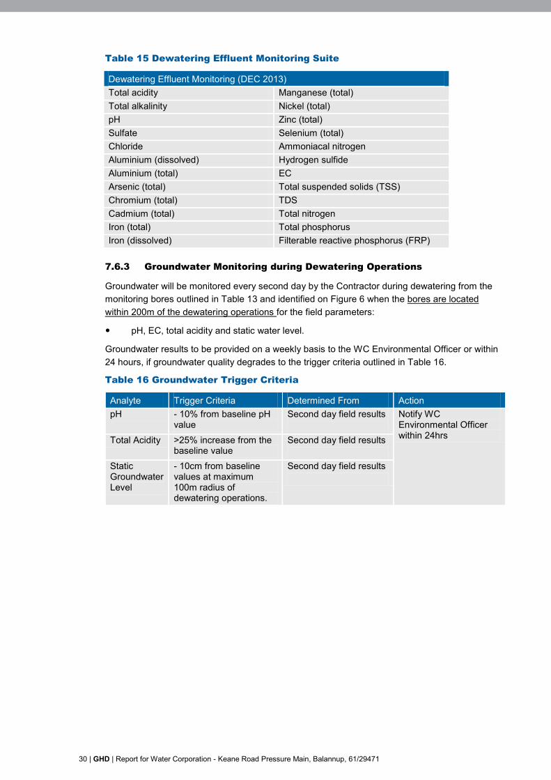
30 | GHD | Report for Water Corporation - Keane Road Pressure Main, Balannup, 61/29471
Table 15 Dewatering Effluent Monitoring Suite
Dewatering Effluent Monitoring (DEC 2013) Total acidity Manganese (total) Total alkalinity Nickel (total) pH Zinc (total) Sulfate Selenium (total) Chloride Ammoniacal nitrogen Aluminium (dissolved) Hydrogen sulfide Aluminium (total) EC Arsenic (total) Total suspended solids (TSS) Chromium (total) TDS Cadmium (total) Total nitrogen Iron (total) Total phosphorus Iron (dissolved) Filterable reactive phosphorus (FRP)
7.6.3 Groundwater Monitoring during Dewatering Operations
Groundwater will be monitored every second day by the Contractor during dewatering from the monitoring bores outlined in Table 13 and identified on Figure 6 when the bores are located within 200m of the dewatering operations for the field parameters:
pH, EC, total acidity and static water level.
Groundwater results to be provided on a weekly basis to the WC Environmental Officer or within 24 hours, if groundwater quality degrades to the trigger criteria outlined in Table 16.
Table 16 Groundwater Trigger Criteria
Analyte Trigger Criteria Determined From Action pH - 10% from baseline pH
value Second day field results
Notify WC Environmental Officer within 24hrs Total Acidity >25% increase from the
baseline value Second day field results
Static Groundwater Level
- 10cm from baseline values at maximum 100m radius of dewatering operations.
Second day field results
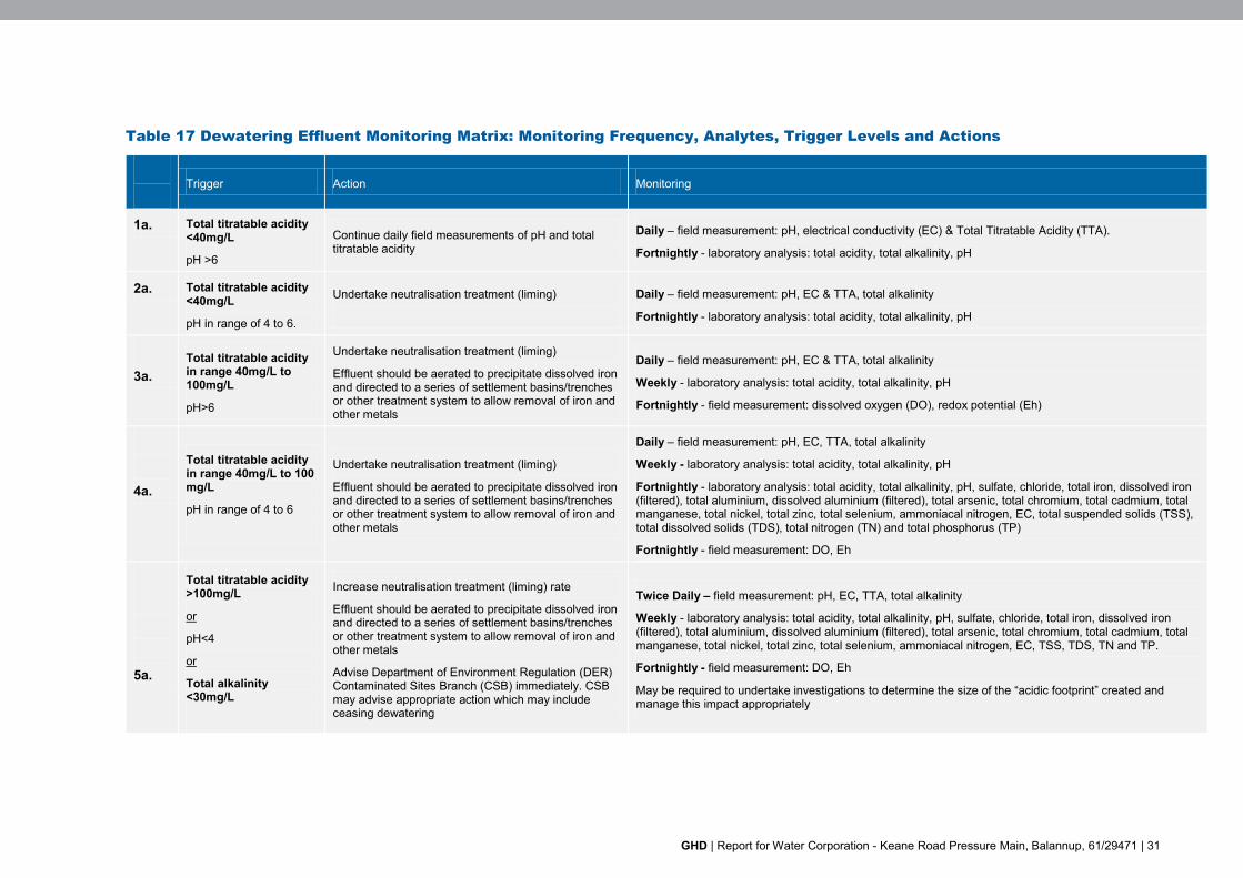
GHD | Report for Water Corporation - Keane Road Pressure Main, Balannup, 61/29471 | 31
Table 17 Dewatering Effluent Monitoring Matrix: Monitoring Frequency, Analytes, Trigger Levels and Actions
Trigger Action Monitoring
1a. Total titratable acidity <40mg/L
pH >6
Continue daily field measurements of pH and total titratable acidity
Daily – field measurement: pH, electrical conductivity (EC) & Total Titratable Acidity (TTA).
Fortnightly - laboratory analysis: total acidity, total alkalinity, pH
2a. Total titratable acidity <40mg/L
pH in range of 4 to 6.
Undertake neutralisation treatment (liming)
Daily – field measurement: pH, EC & TTA, total alkalinity
Fortnightly - laboratory analysis: total acidity, total alkalinity, pH
3a. Total titratable acidity in range 40mg/L to 100mg/L
pH>6
Undertake neutralisation treatment (liming)
Effluent should be aerated to precipitate dissolved iron and directed to a series of settlement basins/trenches or other treatment system to allow removal of iron and other metals
Daily – field measurement: pH, EC & TTA, total alkalinity
Weekly - laboratory analysis: total acidity, total alkalinity, pH
Fortnightly - field measurement: dissolved oxygen (DO), redox potential (Eh)
4a.
Total titratable acidity in range 40mg/L to 100 mg/L
pH in range of 4 to 6
Undertake neutralisation treatment (liming)
Effluent should be aerated to precipitate dissolved iron and directed to a series of settlement basins/trenches or other treatment system to allow removal of iron and other metals
Daily – field measurement: pH, EC, TTA, total alkalinity
Weekly - laboratory analysis: total acidity, total alkalinity, pH
Fortnightly - laboratory analysis: total acidity, total alkalinity, pH, sulfate, chloride, total iron, dissolved iron (filtered), total aluminium, dissolved aluminium (filtered), total arsenic, total chromium, total cadmium, total manganese, total nickel, total zinc, total selenium, ammoniacal nitrogen, EC, total suspended solids (TSS), total dissolved solids (TDS), total nitrogen (TN) and total phosphorus (TP)
Fortnightly - field measurement: DO, Eh
5a.
Total titratable acidity >100mg/L
or
pH<4
or
Total alkalinity <30mg/L
Increase neutralisation treatment (liming) rate
Effluent should be aerated to precipitate dissolved iron and directed to a series of settlement basins/trenches or other treatment system to allow removal of iron and other metals
Advise Department of Environment Regulation (DER) Contaminated Sites Branch (CSB) immediately. CSB may advise appropriate action which may include ceasing dewatering
Twice Daily – field measurement: pH, EC, TTA, total alkalinity
Weekly - laboratory analysis: total acidity, total alkalinity, pH, sulfate, chloride, total iron, dissolved iron (filtered), total aluminium, dissolved aluminium (filtered), total arsenic, total chromium, total cadmium, total manganese, total nickel, total zinc, total selenium, ammoniacal nitrogen, EC, TSS, TDS, TN and TP.
Fortnightly - field measurement: DO, Eh
May be required to undertake investigations to determine the size of the “acidic footprint” created and manage this impact appropriately

32 | GHD | Report for Water Corporation - Keane Road Pressure Main, Balannup, 61/29471
Additional notes:
1 A slurry made from crushed limestone is the generally preferred neutralisation material. Other neutralising agents,
such as hydrated lime or quick lime can be used, however they quickly increase the receiving waters’ pH and can result
in pH overshoot.
2 Measurement of metal concentrations in dewatering effluent should be as total concentrations from an unfiltered water
sample. These concentrations should then be used to determine appropriate treatment options for the effluent and to
identify any emerging trends in groundwater quality. It is not the intention that these values for total metals be directly
compared against environmental or health-based criteria for dissolved metals. However, when determining treatment
options, it should be borne in mind that: a) any metals contained within suspended solids have the potential to be
mobilised if pH and/or REDOX conditions change (which is obviously fairly common in ASS environments); and b) if
dewatering effluent is to be discharged into a receiving environment then these suspended solids will be discharged
along with the water.
Adapted from (DEC 2011).
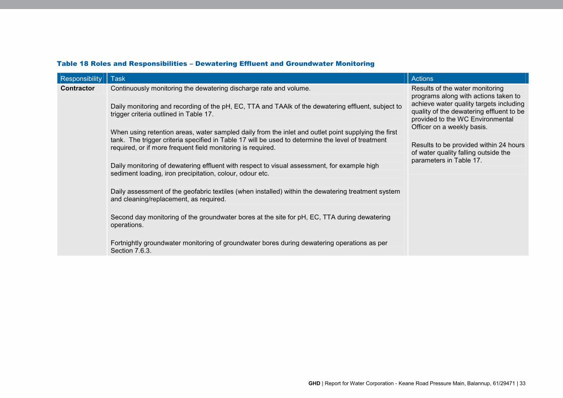
GHD | Report for Water Corporation - Keane Road Pressure Main, Balannup, 61/29471 | 33
Table 18 Roles and Responsibilities – Dewatering Effluent and Groundwater Monitoring
Responsibility Task Actions Contractor Continuously monitoring the dewatering discharge rate and volume.
Daily monitoring and recording of the pH, EC, TTA and TAAlk of the dewatering effluent, subject to trigger criteria outlined in Table 17. When using retention areas, water sampled daily from the inlet and outlet point supplying the first tank. The trigger criteria specified in Table 17 will be used to determine the level of treatment required, or if more frequent field monitoring is required. Daily monitoring of dewatering effluent with respect to visual assessment, for example high sediment loading, iron precipitation, colour, odour etc. Daily assessment of the geofabric textiles (when installed) within the dewatering treatment system and cleaning/replacement, as required. Second day monitoring of the groundwater bores at the site for pH, EC, TTA during dewatering operations. Fortnightly groundwater monitoring of groundwater bores during dewatering operations as per Section 7.6.3.
Results of the water monitoring programs along with actions taken to achieve water quality targets including quality of the dewatering effluent to be provided to the WC Environmental Officer on a weekly basis. Results to be provided within 24 hours of water quality falling outside the parameters in Table 17.
34 | GHD | Report for Water Corporation - Keane Road Pressure Main, Balannup, 61/29471
7.7 Dewatering Management Roles and Responsibility
The water monitoring program including roles and responsibilities, outlined in Table 18, will be undertaken during dewatering operations.
A flow chart outlining the Actions and Responsibilities in relation to dewatering effluent and is included as Flow Chart 2. It is anticipated that this flow chart will be distributed amongst the Contractors at the start of the construction phase to compliment and disseminate the information contained within this management plan.
Example checklists for groundwater and dewatering effluent monitoring for the Contractor are included in Appendix E. The daily field sheet outlines all daily field measurements that are required to be recorded by the appointed Contractor and submitted to the Water Corporation on a weekly basis.
7.8 Decommissioning of Retention Basin
At the completion of the works, the WC Environmental Officer (or Principal’s Environmental Consultant on formal delegation from the WC Environmental Officer) will be responsible for collection of samples of the accumulated sediments at the base of the retention basin (if utilised instead of the holding tank). The results will be used to determine the appropriate decommissioning requirements and disposal method for the accumulated sediments.
Accumulated sediments at the base of the holding tank should be disposed of by the Contractor to an appropriate facility. Sediments should not be disposed of on-site without prior consultation with the WC Environmental Officer.
Sample analyses will include, but not be limited to:
SPOCAS; and
Metals (Al, As, Cr, Cu, Fe, Mn, Pb, Ni, Se and Zn).
Once laboratory analysis is completed, sediments will be classified based upon the Landfill Waste Classification and Waste Definitions (DoE, 1996, as amended December 2009) and disposed offsite at an appropriate waste disposal facility.
7.9 Residential Bores Affected by Dewatering Operations
A search of the Department of Water (DoW) borehole database (WIN) was carried out to identify any registered bores within close proximity of the Site in March 2014.
Two (2) registered bores are located within a 500m radius of the site, both of these bores are located >100m from any dewatering operations and are operated by the City of Kwinana. The bores are licensed to abstract water from the superficial aquifer, the aquifer intended to be dewatered during construction.
Additionally some properties within and adjoining the works may have bores for producing water for their gardens. As the functionality of these bores and the quality of water may be affected by the dewatering works required for the construction of the infrastructure property owners/occupiers will have to be notified of the works prior to commencement.
The dewatering operations are not anticipated to extend beyond 100m of the dewatering site and therefore bores on the WIN database should remain unaffected.
7.9.1 Inspections of Bore and Reticulation Systems
When dewatering is to commence at the pump station site, the Contractor shall:
GHD | Report for Water Corporation - Keane Road Pressure Main, Balannup, 61/29471 | 35
Request a list from the Superintendent identifying the owners and occupiers of known bores within 100m radius of the dewatering operations.
Request an inspection of all properties within a 100m radius of the pump station to determine, if there is a bore on the property;
Obtain the owner/occupiers permission and test the bore to confirm whether the bore is in operational or not;
If the bore is operational then confirm which of the sprinkler or other outlets are in working order;
Obtain the owner/occupiers signature on a ‘pro forma’ letter and plan of the sprinkler system to confirm they agree with results of the inspection;
Leave the original signed letter and plan with owner/occupier, and retain a copy for the Contractor records;
Leave a letter with the owner/occupier advising them of the start and finish date of dewatering work that will affect their property and advising them that they should not use the bore until advised by the Contractor;
Reinspect each property with a working bore following completion of dewatering work and confirm that what equipment was working satisfactorily before, is still working satisfactorily;
Obtain the owner/occupiers signature on the ‘pro forma’ letter and plan of the sprinkler system to confirm they are satisfied with results of the final inspection.
7.9.2 Records of Bore and Reticulation System Inspections
The Contractor shall maintain a file of copies of the ‘bore and reticulation system’ letters endorsed by the owner/occupier. A copy of the letters shall be provided to the Superintendent at the kick-off meeting.
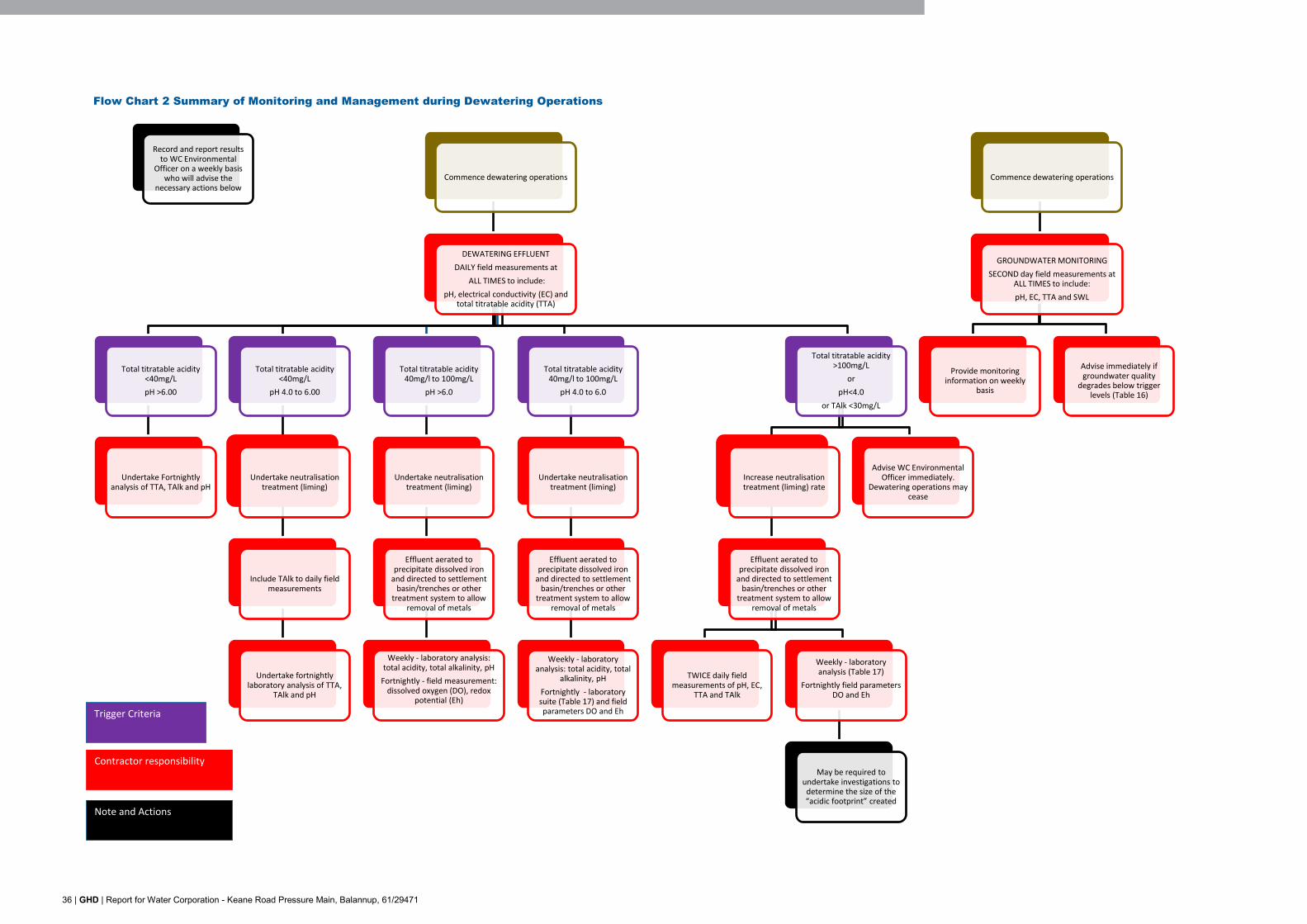
36 | GHD | Report for Water Corporation - Keane Road Pressure Main, Balannup, 61/29471
Flow Chart 2 Summary of Monitoring and Management during Dewatering Operations
Commence dewatering operations
DEWATERING EFFLUENT
DAILY field measurements at
ALL TIMES to include:
pH, electrical conductivity (EC) and total titratable acidity (TTA)
Total titratable acidity <40mg/L
pH >6.00
Undertake Fortnightly analysis of TTA, TAlk and pH
Total titratable acidity <40mg/L
pH 4.0 to 6.00
Undertake neutralisation treatment (liming)
Include TAlk to daily field measurements
Undertake fortnightly laboratory analysis of TTA,
TAlk and pH
Total titratable acidity 40mg/l to 100mg/L
pH >6.0
Undertake neutralisation treatment (liming)
Effluent aerated to precipitate dissolved iron
and directed to settlement basin/trenches or other
treatment system to allow removal of metals
Weekly - laboratory analysis: total acidity, total alkalinity, pH
Fortnightly - field measurement: dissolved oxygen (DO), redox
potential (Eh)
Total titratable acidity 40mg/l to 100mg/L
pH 4.0 to 6.0
Undertake neutralisation treatment (liming)
Effluent aerated to precipitate dissolved iron
and directed to settlement basin/trenches or other
treatment system to allow removal of metals
Weekly - laboratory analysis: total acidity, total
alkalinity, pH
Fortnightly - laboratory suite (Table 17) and field parameters DO and Eh
Total titratable acidity >100mg/L
or
pH<4.0
or TAlk <30mg/L
Increase neutralisation treatment (liming) rate
Effluent aerated to precipitate dissolved iron
and directed to settlement basin/trenches or other
treatment system to allow removal of metals
TWICE daily field measurements of pH, EC,
TTA and TAlk
Weekly - laboratory analysis (Table 17)
Fortnightly field parameters DO and Eh
May be required to undertake investigations to determine the size of the “acidic footprint” created
Advise WC Environmental Officer immediately.
Dewatering operations may cease
Commence dewatering operations
GROUNDWATER MONITORING
SECOND day field measurements at ALL TIMES to include:
pH, EC, TTA and SWL
Provide monitoring information on weekly
basis
Advise immediately if groundwater quality
degrades below trigger levels (Table 16)
Record and report results to WC Environmental
Officer on a weekly basis who will advise the
necessary actions below
Trigger Criteria
Contractor responsibility
Note and Actions
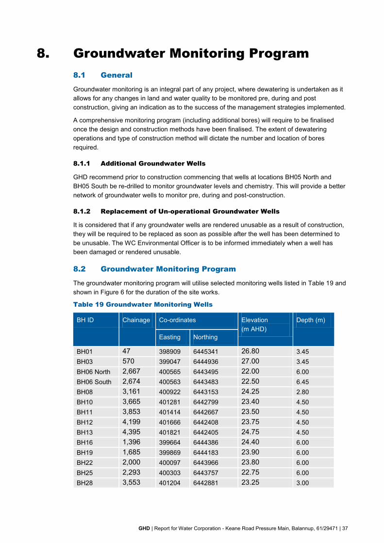
GHD | Report for Water Corporation - Keane Road Pressure Main, Balannup, 61/29471 | 37
8. Groundwater Monitoring Program
8.1 General
Groundwater monitoring is an integral part of any project, where dewatering is undertaken as it allows for any changes in land and water quality to be monitored pre, during and post construction, giving an indication as to the success of the management strategies implemented.
A comprehensive monitoring program (including additional bores) will require to be finalised once the design and construction methods have been finalised. The extent of dewatering operations and type of construction method will dictate the number and location of bores required.
8.1.1 Additional Groundwater Wells
GHD recommend prior to construction commencing that wells at locations BH05 North and BH05 South be re-drilled to monitor groundwater levels and chemistry. This will provide a better network of groundwater wells to monitor pre, during and post-construction.
8.1.2 Replacement of Un-operational Groundwater Wells
It is considered that if any groundwater wells are rendered unusable as a result of construction, they will be required to be replaced as soon as possible after the well has been determined to be unusable. The WC Environmental Officer is to be informed immediately when a well has been damaged or rendered unusable.
8.2 Groundwater Monitoring Program
The groundwater monitoring program will utilise selected monitoring wells listed in Table 19 and shown in Figure 6 for the duration of the site works.
Table 19 Groundwater Monitoring Wells
BH ID Chainage Co-ordinates Elevation (m AHD)
Depth (m)
Easting Northing
BH01 47 398909 6445341 26.80 3.45 BH03 570 399047 6444936 27.00 3.45 BH06 North 2,667 400565 6443495 22.00 6.00 BH06 South 2,674 400563 6443483 22.50 6.45 BH08 3,161 400922 6443153 24.25 2.80 BH10 3,665 401281 6442799 23.40 4.50 BH11 3,853 401414 6442667 23.50 4.50 BH12 4,199 401666 6442408 23.75 4.50 BH13 4,395 401821 6442405 24.75 4.50 BH16 1,396 399664 6444386 24.40 6.00 BH19 1,685 399869 6444183 23.90 6.00 BH22 2,000 400097 6443966 23.80 6.00 BH25 2,293 400303 6443757 22.75 6.00 BH28 3,553 401204 6442881 23.25 3.00
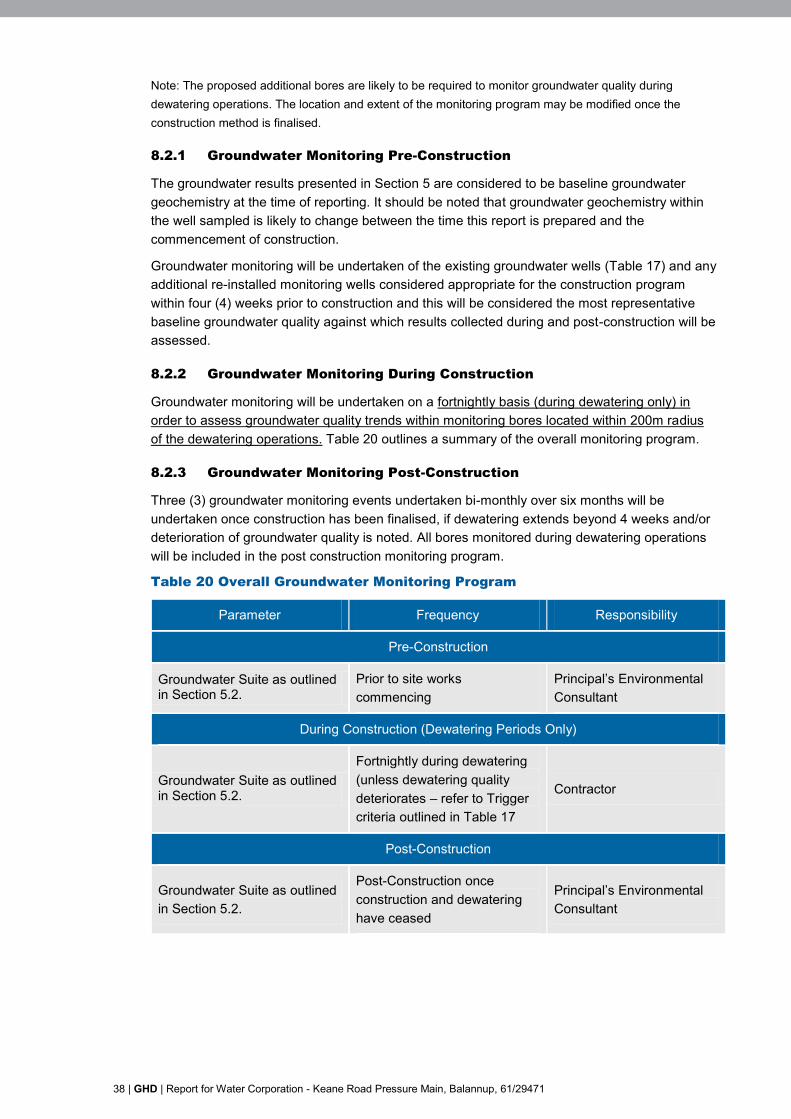
38 | GHD | Report for Water Corporation - Keane Road Pressure Main, Balannup, 61/29471
Note: The proposed additional bores are likely to be required to monitor groundwater quality during dewatering operations. The location and extent of the monitoring program may be modified once the construction method is finalised.
8.2.1 Groundwater Monitoring Pre-Construction
The groundwater results presented in Section 5 are considered to be baseline groundwater geochemistry at the time of reporting. It should be noted that groundwater geochemistry within the well sampled is likely to change between the time this report is prepared and the commencement of construction.
Groundwater monitoring will be undertaken of the existing groundwater wells (Table 17) and any additional re-installed monitoring wells considered appropriate for the construction program within four (4) weeks prior to construction and this will be considered the most representative baseline groundwater quality against which results collected during and post-construction will be assessed.
8.2.2 Groundwater Monitoring During Construction
Groundwater monitoring will be undertaken on a fortnightly basis (during dewatering only) in order to assess groundwater quality trends within monitoring bores located within 200m radius of the dewatering operations. Table 20 outlines a summary of the overall monitoring program.
8.2.3 Groundwater Monitoring Post-Construction
Three (3) groundwater monitoring events undertaken bi-monthly over six months will be undertaken once construction has been finalised, if dewatering extends beyond 4 weeks and/or deterioration of groundwater quality is noted. All bores monitored during dewatering operations will be included in the post construction monitoring program.
Table 20 Overall Groundwater Monitoring Program
Parameter Frequency Responsibility
Pre-Construction
Groundwater Suite as outlined in Section 5.2.
Prior to site works commencing
Principal’s Environmental Consultant
During Construction (Dewatering Periods Only)
Groundwater Suite as outlined in Section 5.2.
Fortnightly during dewatering (unless dewatering quality deteriorates – refer to Trigger criteria outlined in Table 17
Contractor
Post-Construction
Groundwater Suite as outlined in Section 5.2.
Post-Construction once construction and dewatering have ceased
Principal’s Environmental Consultant

GHD | Report for Water Corporation - Keane Road Pressure Main, Balannup, 61/29471 | 39
8.3 Groundwater Action Criteria
GHD recommends the following groundwater trigger criteria (Table 21) are implemented during monitoring events and during dewatering to assess groundwater quality trends and ensure groundwater quality is not degraded.
Table 21 Groundwater Trigger Criteria
Analyte Trigger Criteria Responsibility Determined From pH - 10% baseline
value WC Environmental Officer Daily field results
AND Fortnightly laboratory results
Total Acidity
>25% increase from the baseline value
WC Environmental Officer Daily field results AND Fortnightly laboratory results
Soluble Aluminium
>1 mg/L (or >25% increase from the baseline value)
WC Environmental Officer Fortnightly laboratory results
Soluble Iron
>1 mg/L (or >25% increase from the baseline value)
WC Environmental Officer Fortnightly laboratory results
The pH and acidity will be compared to background results obtained from monitoring well baseline monitoring and the trigger values given in Table 21 (frequency of monitoring should be altered accordingly by the WC Environmental Officer).
The Flow Chart 3 provides a summary of the groundwater monitoring program and responsible parties for the monitoring.
Contingency measures outlined within Section 9 should be adhered to if the groundwater trigger criteria are exceeded.

40 | GHD | Report for Water Corporation - Keane Road Pressure Main, Balannup, 61/29471
Flow Chart 3 Summary of Groundwater Monitoring
Inform WC Environmental Officer of
damage to wells immediately
Groundwater monitoring of all wells
four weeks prior to construction (Pre-
construction)
Dewatering commences
Fortnightly monitoring (subject to groundwater quality) and sent to WC
Environmental Officer to review
Post-construction monitoring once
groundwater table disturbance ceased
Contractor responsibility
Principals Environmental Consultant responsibility
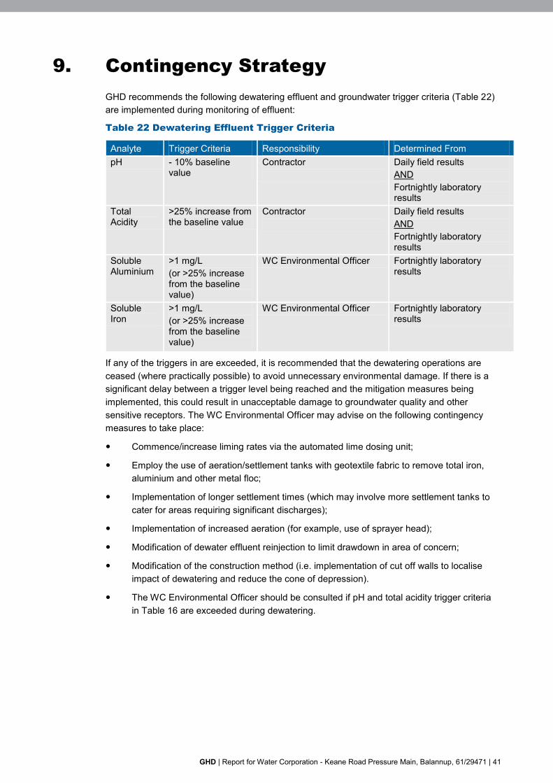
GHD | Report for Water Corporation - Keane Road Pressure Main, Balannup, 61/29471 | 41
9. Contingency Strategy
GHD recommends the following dewatering effluent and groundwater trigger criteria (Table 22) are implemented during monitoring of effluent:
Table 22 Dewatering Effluent Trigger Criteria
Analyte Trigger Criteria Responsibility Determined From pH - 10% baseline
value Contractor
Daily field results AND Fortnightly laboratory results
Total Acidity
>25% increase from the baseline value
Contractor
Daily field results AND Fortnightly laboratory results
Soluble Aluminium
>1 mg/L (or >25% increase from the baseline value)
WC Environmental Officer Fortnightly laboratory results
Soluble Iron
>1 mg/L (or >25% increase from the baseline value)
WC Environmental Officer Fortnightly laboratory results
If any of the triggers in are exceeded, it is recommended that the dewatering operations are ceased (where practically possible) to avoid unnecessary environmental damage. If there is a significant delay between a trigger level being reached and the mitigation measures being implemented, this could result in unacceptable damage to groundwater quality and other sensitive receptors. The WC Environmental Officer may advise on the following contingency measures to take place:
Commence/increase liming rates via the automated lime dosing unit;
Employ the use of aeration/settlement tanks with geotextile fabric to remove total iron, aluminium and other metal floc;
Implementation of longer settlement times (which may involve more settlement tanks to cater for areas requiring significant discharges);
Implementation of increased aeration (for example, use of sprayer head);
Modification of dewater effluent reinjection to limit drawdown in area of concern;
Modification of the construction method (i.e. implementation of cut off walls to localise impact of dewatering and reduce the cone of depression).
The WC Environmental Officer should be consulted if pH and total acidity trigger criteria in Table 16 are exceeded during dewatering.

GHD | Report for Water Corporation - Keane Road Pressure Main, Balannup, 61/29471
Appendices

GHD | Report for Water Corporation - Keane Road Pressure Main, Balannup, 61/29471
Appendix A - Figures Figure 1 Site Locality Plan
Figure 2 Published Geological Information
Figure 3 Groundwater Contours and August 2013 Groundwater Levels
Figure 4 Acid Sulfate Soil Risk Mapping
Figure 5 Geotechnical and ASS Investigation Locations
Figure 6 Groundwater Well Locations
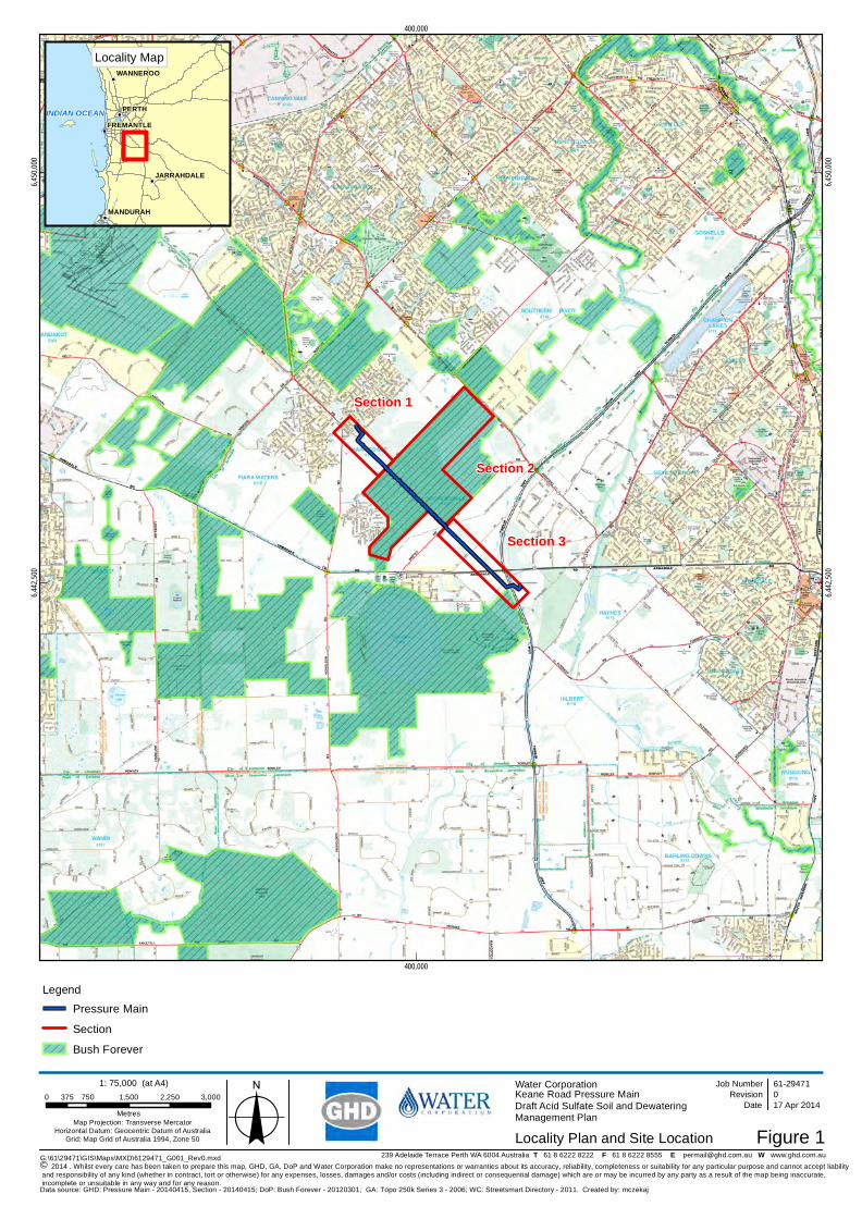
Section 1
Section 3
Section 2
400,000
400,000
6,442,
500
6,442,
500
6,450,
000
6,450,
000
Figure 1G:\61\29471\GIS\Maps\MXD\6129471_G001_Rev0.mxd© 2014 . Whilst every care has been taken to prepare this map, GHD, GA, DoP and Water Corporation make no representations or warranties about its accuracy, reliability, completeness or suitability for any particular purpose and cannot accept liability and responsibility of any kind (whether in contract, tort or otherwise) for any expenses, losses, damages and/or costs (including indirect or consequential damage) which are or may be incurred by any party as a result of the map being inaccurate, incomplete or unsuitable in any way and for any reason.
Job NumberRevision 0
61-29471
Date 17 Apr 2014
Water CorporationKeane Road Pressure MainDraft Acid Sulfate Soil and DewateringManagement Plan
Locality Plan and Site Location
Data source: GHD: Pressure Main - 20140415, Section - 20140415; DoP: Bush Forever - 20120301; GA: Topo 250k Series 3 - 2006; WC: Streetsmart Directory - 2011. Created by: mczekaj
239 Adelaide Terrace Perth WA 6004 Australia T 61 8 6222 8222 F 61 8 6222 8555 E [email protected] W www.ghd.com.au
Map Projection: Transverse MercatorHorizontal Datum: Geocentric Datum of Australia
Grid: Map Grid of Australia 1994, Zone 50
!
!
!
!
!
PERTH
MANDURAH
WANNEROO
FREMANTLE
JARRAHDALE
INDIAN OCEAN
Locality Map
1: 75,000 (at A4)
o0 750 1,500 2,250 3,000375
Metres
Legend
Pressure Main
Section
Bush Forever

Section 1
Section 3
Section 2
S8 S10
S10
S10
S10
Ms4S10
S8
S8
S8
S8
S8
S8
S8
S8
S8
S8 S8Sp1 Sp1 CsS10
S8Sp1 Sp2Sp1
S8
Sp1 Sp1Sp1 S8 S8Sp1 Sp1
S8
Sp1 Sp1
S8
S8Sp1 S8S8 Sp1
Sp1
Sp1 Sp1 Sp1S8Sp2 S8
Sp1Sp1
Sp1S8S8Sp1 Sp1Sp1
S8 Sp1S8Sp1Sp1 Sp1
S8
S8
CsS10
Sp1Sp2 Sp2Sp1 Sp1
Sp2Sp1 Sp1
S8
S8Sp1Sp1 Sp1
Sp1
Sp2Sp1
S10
Cs
Cs
S10
S10
S8Sp2
Sp1
S8
Sc
Sp1 S8Sp1S8Sp1 Sp1
S10
S8Sp1 S10
S8
S8 Sp1Sp1Sp1
S8Cs Sp1Sc S8Sp2 Sp1
S10S10S10 Sp1
Sp1 S8
Sp1
Sp1
Ms4
Sp1 S8S8S10
S8
S8S8S8Sp1 S8Sp1 S8
S8
S8S8
Sp1Sp1 Sc
S8 S8Sp1Sp1 Sp1
Sp1
Sp1Sp2
S8
S8
Sp1
S8
S8Sp1 Sp1
Sp1
Sp1 S10Sp1Sp2 Sp1Sp1 S10
Sp1Sp1 Sp2Sp1 Sp1
S10 S10Sp1
Sp1
S8
Sp1Sp1
Sp2 Sp1
LS5
S8Sp2
Sp1
S10
S10
Water
Sp1Sp1
S9 S10S8Sp1S10
S10S8 S8
S8ScSp1
Sp1Sp1
S8Cs S10
Sp2 S10Sp1 S8S8 S10Sp1
S8Sp1
Sp1
S10
S8Sp1
Sp1
Sp1
S8
S10
S10Sp1
S8Sp1
S10S9S8 S8
S10
Sp1 Sp1Sp1Sp1Sp1 Sp1
S8Msc1S10Sp1
Sp1
Sp1
Sp2Sp2 S8
Sp1S10
S8Sp1
Sp1 S8Sp1 Sp1
Sp1Sp1
S10
Sp1 Sp1S8 Sp1Sp1
Sc
S8S8 S9Sp1 S8Sp1 Sp1
S8 S8 S10S10Sp1S8 S8Sp1
400,000
400,000
405,000
405,000
6,440,
000
6,440,
000
6,445,
000
6,445,
000
Figure 2G:\61\29471\GIS\Maps\MXD\6129471_G002_Rev0.mxd© 2014 . Whilst every care has been taken to prepare this map, GHD, DMP, Landgate and Water Corporation make no representations or warranties about its accuracy, reliability, completeness or suitability for any particular purpose and cannotaccept liability and responsibility of any kind (whether in contract, tort or otherwise) for any expenses, losses, damages and/or costs (including indirect or consequential damage) which are or may be incurred by any party as a result of the mapbeing inaccurate, incomplete or unsuitable in any way and for any reason.
Job NumberRevision 0
61-29471
Date 17 Apr 2014
Water CorporationKeane Road Pressure MainDraft Acid Sulfate Soil and DewateringManagement Plan
Published Geological Information
Data source: GHD: Pressure Main - 20140415, Section - 20140415; Landgate: Virtual Mosaic - 20140416; DMP: Geology 50k - 20120612. Created by: mczekaj
239 Adelaide Terrace Perth WA 6004 Australia T 61 8 6222 8222 F 61 8 6222 8555 E [email protected] W www.ghd.com.au
Map Projection: Transverse MercatorHorizontal Datum: Geocentric Datum of Australia
Grid: Map Grid of Australia 1994, Zone 50
1: 50,000 (at A4)
o0 500 1,000 1,500 2,000250
Metres
LegendPressure Main
Section
Geology 50kSp1 - PEATY SAND - grey to black, fine to medium-grained,moderately sorted quartz sand, slightly peaty, of lacustrine origin
Sp2 - PEAT-RICH SAND - fine to medium-grained quartz sandwith much brown to black organic material, grades to peat,of lacustrine origin
Ms4 - SANDY SILY - cream to pale brown alluvium, clayeyin part, fine to medium-grained sand, of alluvial origin
Msc1 - CLAYEY SANDY SILT - pale brown, angularto rounded sand, low cohesion, of alluvial origin
S9 -LS5 - LIMESTONE - white to cream, fine-grained,algal lamination common
S8 - SAND - white to pale grey at surface, yellow at depth,fine to medium-grained, moderately sorted, subangul0arto subrounded, minor heavy minerals, of eolian origin
S10 - SAND - as S8 over sandy clay to clayeysand of the Guildford Formation, of eolian origin
Sc -
Cs -
Water -

!A
!A
!A!A
!A
!A!A
!A !A
!A
!A
!A
!A
!A
Section 1
Section 3
Section 2
Ton
kin
Hw
y
Armadale Rd
26
25
24
26
22
25
26
26
28
25
25
2726
22.5
24
23
BH16No access
BH19No access
BH22No access
BH25No access
BH0125.2m AHD
BH0325.2m AHD
BH06 North21.2m AHD
BH06 South21.9m AHD
BH0822.6m AHD
BH1023.2m AHD
BH1122.1m AHD
BH1222.8m AHD
BH1322.5m AHD
BH2822.1m AHD
400,000
400,000
402,500
402,500
6,442,
500
6,442,
500
6,445,
000
6,445,
000
Figure 3G:\61\29471\GIS\Maps\MXD\6129471_G003_Rev0.mxd© 2014 . Whilst every care has been taken to prepare this map, GHD, Landgate, DoW and Water Corporation make no representations or warranties about its accuracy, reliability, completeness or suitability for any particular purpose andcannot accept liability and responsibility of any kind (whether in contract, tort or otherwise) for any expenses, losses, damages and/or costs (including indirect or consequential damage) which are or may be incurred by any party as a result ofthe map being inaccurate, incomplete or unsuitable in any way and for any reason.
Job NumberRevision 0
61-29471
Date 17 Apr 2014
Water CorporationKeane Road Pressure MainDraft Acid Sulfate Soil and DewateringManagement PlanMaximum Groundwater Contours (Perth GroundwaterAtlas) and August 2013 Groundwater Levels
Data source: GHD: Pressure Main - 20140415, Section - 20140415, Groundwater Well - 20140416; DoW: Groundwater Contours Maximum - 20050725; Landgate: Virtual Mosaic - 20140416, Road Names - 20140416. Created by: mczekaj
239 Adelaide Terrace Perth WA 6004 Australia T 61 8 6222 8222 F 61 8 6222 8555 E [email protected] W www.ghd.com.au
Map Projection: Transverse MercatorHorizontal Datum: Geocentric Datum of Australia
Grid: Map Grid of Australia 1994, Zone 50
1: 25,000 (at A4)
o0 250 500 750 1,000125
Metres
Legend
!A Groundwater Well
Groundwater Contours Maximum
Pressure Main
Section

Section 1
Section 3
Section 2
Nic
ho
lso
nR
d
War
ton
Rd
Tonk
in H
wy
Armadale Rd
400,000
400,000
405,000
405,000
6,440,
000
6,440,
000
6,445,
000
6,445,
000
Figure 4G:\61\29471\GIS\Maps\MXD\6129471_G004_Rev0.mxd© 2014 . Whilst every care has been taken to prepare this map, GHD, DEC, Landgate and Water Corporation make no representations or warranties about its accuracy, reliability, completeness or suitability for any particular purpose and cannotaccept liability and responsibility of any kind (whether in contract, tort or otherwise) for any expenses, losses, damages and/or costs (including indirect or consequential damage) which are or may be incurred by any party as a result of the mapbeing inaccurate, incomplete or unsuitable in any way and for any reason.
Job NumberRevision 0
61-29471
Date 17 Apr 2014
Water CorporationKeane Road Pressure MainDraft Acid Sulfate Soil and DewateringManagement Plan
Acid Sulfate Soil Risk Mapping
Data source: GHD: Pressure Main - 20140415, Section - 20140415; DEC: Acid Sulfate Soil Risk - 20120229; Landgate: Virtual Mosaic - 20140416, Road - 20140416. Created by: mczekaj
239 Adelaide Terrace Perth WA 6004 Australia T 61 8 6222 8222 F 61 8 6222 8555 E [email protected] W www.ghd.com.au
Map Projection: Transverse MercatorHorizontal Datum: Geocentric Datum of Australia
Grid: Map Grid of Australia 1994, Zone 50
1: 50,000 (at A4)
o0 500 1,000 1,500 2,000250
Metres
Legend
Pressure Main
Section
Road
Acid Sulfate Soil RiskClass 1 - High to moderate risk of ASS occurringwithin 3m of natural soil surface
Class 2 - Moderate to low risk of ASS occuringwithin 3m of natural soil surface but high to moderaterisk of ASS beyond 3m of natural soil surface

!A
!A
!A
!A
!A!A!A
!A
!A
!A
!A
!A
!A
!A !A
!A!A
!A!A
!A!A
!A!A
!A!A!A
!A!A!A
!A
ForestdaleLake
Armadale Rd
Tonk in
Hw
yBH01
BH02
BH03BH04
BH05 North
BH05South
BH06 North
BH06South
BH07
BH08
BH09
BH10BH11
BH12
BH13
BH14BH15
BH16BH17
BH18BH19
BH20BH21
BH22BH23
BH24BH25
BH26BH27
BH28
400,000
400,000
402,000
402,000
6,442,
000
6,442,
000
6,444,
000
6,444,
000
Figure 5G:\61\29471\GIS\Maps\MXD\6129471_G005_Rev0.mxd© 2014 . Whilst every care has been taken to prepare this map, GHD, Landgate and Water Corporation make no representations or warranties about its accuracy, reliability, completeness or suitability for any particular purpose and cannotaccept liability and responsibility of any kind (whether in contract, tort or otherwise) for any expenses, losses, damages and/or costs (including indirect or consequential damage) which are or may be incurred by any party as a result of the mapbeing inaccurate, incomplete or unsuitable in any way and for any reason.
Job NumberRevision 0
61-29471
Date 17 Apr 2014
Water CorporationKeane Road Pressure MainDraft Acid Sulfate Soil and DewateringManagement Plan
Geotechnical and ASS Investigation Locations
Data source: GHD: Balannup A WWPS and Keane Road Pressure Main Works Site - 20140415, Groundwater Well - 20140417; Landgate: Road Names - 20140416, Virtual Mosaic - 20140416. Created by: mczekaj
239 Adelaide Terrace Perth WA 6004 Australia T 61 8 6222 8222 F 61 8 6222 8555 E [email protected] W www.ghd.com.au
Map Projection: Transverse MercatorHorizontal Datum: Geocentric Datum of Australia
Grid: Map Grid of Australia 1994, Zone 50
1: 20,000 (at A4)
o0 200 400 600 800100
Metres
Legend
!A Groundwater Well
Balannup A WWPS and Keane RoadPressure Main Works Site

!A
!A
!A!A
!A
!A!A
!A !A
!A
!A
!A
!A
!A
Section 1
Section 3
Section 2
Ton
kin
Hw
y
Armadale Rd
BH01
BH03
BH06North
BH06South
BH08
BH10BH11
BH12 BH13
BH16
BH19
BH22
BH25
BH28
400,000
400,000
402,500
402,500
6,442,
500
6,442,
500
6,445,
000
6,445,
000
Figure 6G:\61\29471\GIS\Maps\MXD\6129471_G006_Rev0.mxd© 2014 . Whilst every care has been taken to prepare this map, GHD, Landgate and Water Corporation make no representations or warranties about its accuracy, reliability, completeness or suitability for any particular purpose and cannot accept liability and responsibility of any kind (whether in contract, tort or otherwise) for any expenses, losses, damages and/or costs (including indirect or consequential damage) which are or may be incurred by any party as a result of the map being inaccurate, incomplete or unsuitable in any way and for any reason.
Job NumberRevision 0
61-29471
Date 17 Apr 2014
Water CorporationKeane Road Pressure MainDraft Acid Sulfate Soil and DewateringManagement Plan
Groundwater Well Locations
Data source: GHD: Pressure Main - 20140415, Section - 20140415, Selected Groundwater Well - 20140416; Landgate: Virtual Mosaic - 20140416, Road Names - 20140416. Created by: mczekaj
239 Adelaide Terrace Perth WA 6004 Australia T 61 8 6222 8222 F 61 8 6222 8555 E [email protected] W www.ghd.com.au
Map Projection: Transverse MercatorHorizontal Datum: Geocentric Datum of Australia
Grid: Map Grid of Australia 1994, Zone 50
1: 25,000 (at A4)
o0 250 500 750 1,000125
Metres
Legend
!A Selected Groundwater Well
Pressure Main
Section
Bore ID X MGA50 [m] Y MGA50 [m]BH01 398909 6445341BH03 399047 6444936BH06 North 400565 6443495BH06 South 400563 6443483BH08 400922 6443153BH10 401281 6442799BH11 401414 6442667BH12 401666 6442408BH13 401821 6442405BH16 399664 6444386BH19 399869 6444183BH22 400097 6443966BH25 400303 6443757BH28 401204 6442881

| GHD | Report for Water Corporation - Keane Road Pressure Main, Balannup, 61/29471
Appendix B – Preliminary Design Drawings
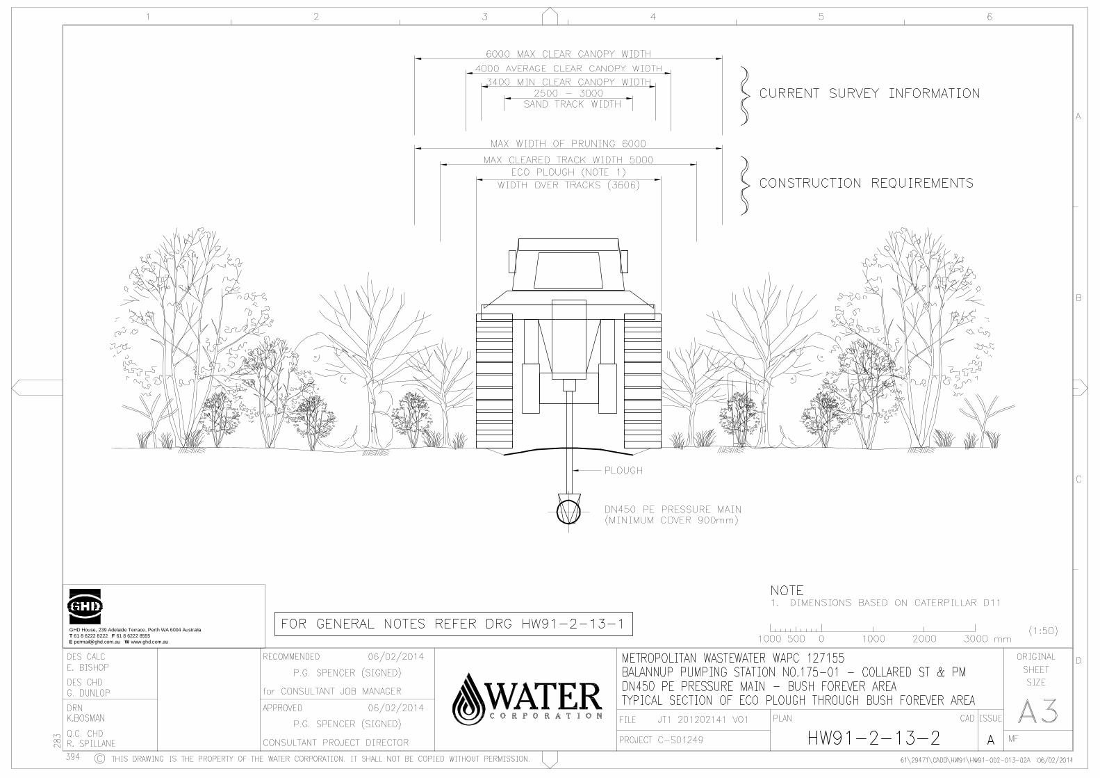
GHD House, 239 Adelaide Terrace, Perth WA 6004 AustraliaT 61 8 6222 8222 F 61 8 6222 8555E [email protected] W www.ghd.com.au

GHD House, 239 Adelaide Terrace, Perth WA 6004 AustraliaT 61 8 6222 8222 F 61 8 6222 8555E [email protected] W www.ghd.com.au
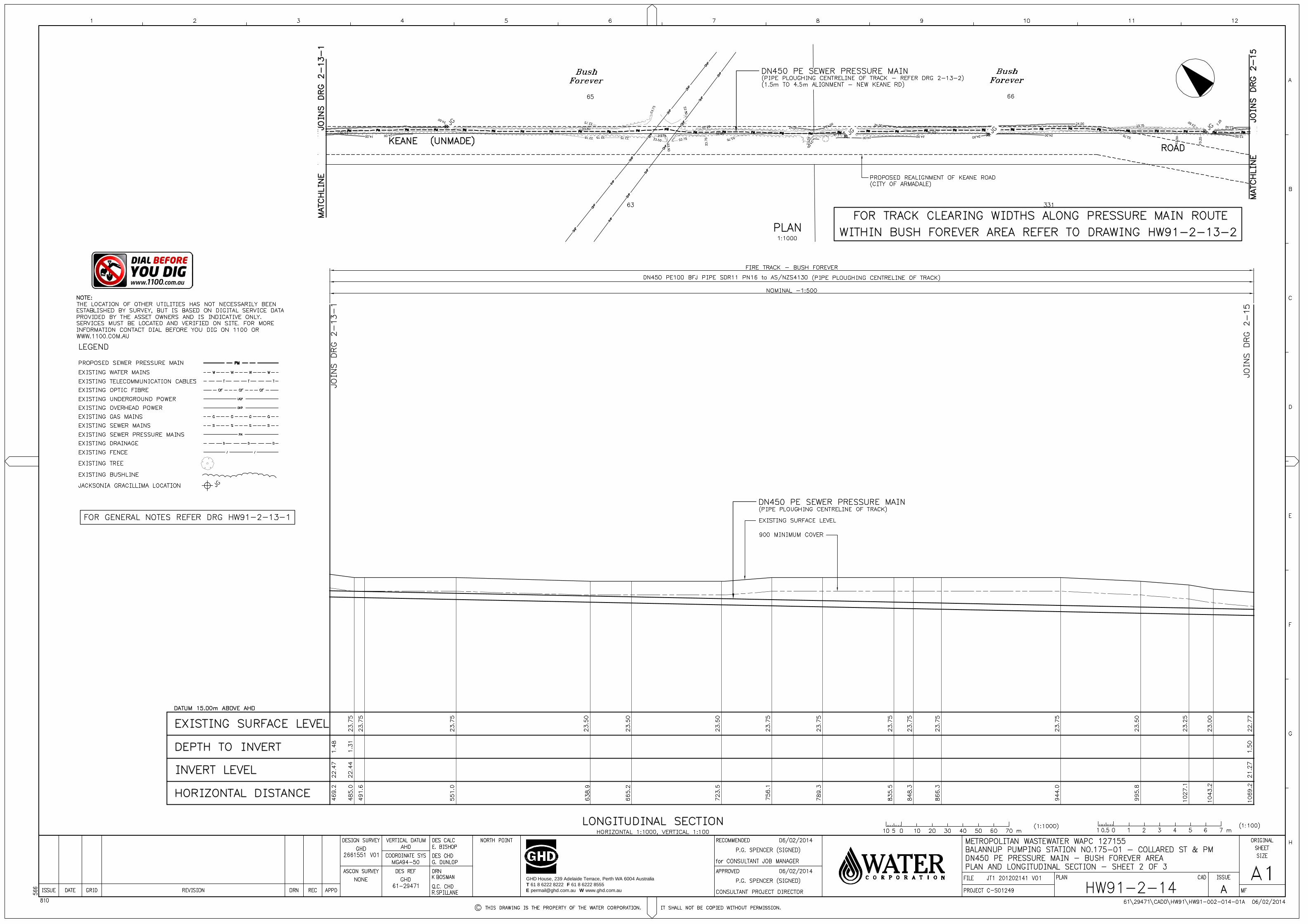
GHD House, 239 Adelaide Terrace, Perth WA 6004 AustraliaT 61 8 6222 8222 F 61 8 6222 8555E [email protected] W www.ghd.com.au
GHD House, 239 Adelaide Terrace, Perth WA 6004 AustraliaT 61 8 6222 8222 F 61 8 6222 8555E [email protected] W www.ghd.com.au

GHD House, 239 Adelaide Terrace, Perth WA 6004 AustraliaT 61 8 6222 8222 F 61 8 6222 8555E [email protected] W www.ghd.com.au
ENGINEERING DESIGN - NOT FOR CONSTRUCTION

GHD House, 239 Adelaide Terrace, Perth WA 6004 AustraliaT 61 8 6222 8222 F 61 8 6222 8555E [email protected] W www.ghd.com.au
ENGINEERING DESIGN - NOT FOR CONSTRUCTION

GHD House, 239 Adelaide Terrace, Perth WA 6004 AustraliaT 61 8 6222 8222 F 61 8 6222 8555E [email protected] W www.ghd.com.au
ENGINEERING DESIGN - NOT FOR CONSTRUCTION
GHD House, 239 Adelaide Terrace, Perth WA 6004 AustraliaT 61 8 6222 8222 F 61 8 6222 8555E [email protected] W www.ghd.com.au
ENGINEERING DESIGN - NOT FOR CONSTRUCTION

GHD House, 239 Adelaide Terrace, Perth WA 6004 AustraliaT 61 8 6222 8222 F 61 8 6222 8555E [email protected] W www.ghd.com.au
ENGINEERING DESIGN - NOT FOR CONSTRUCTION

GHD House, 239 Adelaide Terrace, Perth WA 6004 AustraliaT 61 8 6222 8222 F 61 8 6222 8555E [email protected] W www.ghd.com.au
ENGINEERING DESIGN - NOT FOR CONSTRUCTION
GHD House, 239 Adelaide Terrace, Perth WA 6004 AustraliaT 61 8 6222 8222 F 61 8 6222 8555E [email protected] W www.ghd.com.au
ENGINEERING DESIGN - NOT FOR CONSTRUCTION
GHD House, 239 Adelaide Terrace, Perth WA 6004 AustraliaT 61 8 6222 8222 F 61 8 6222 8555E [email protected] W www.ghd.com.au
ENGINEERING DESIGN - NOT FOR CONSTRUCTION

GHD House, 239 Adelaide Terrace, Perth WA 6004 AustraliaT 61 8 6222 8222 F 61 8 6222 8555E [email protected] W www.ghd.com.au
ENGINEERING DESIGN - NOT FOR CONSTRUCTION

GHD House, 239 Adelaide Terrace, Perth WA 6004 AustraliaT 61 8 6222 8222 F 61 8 6222 8555E [email protected] W www.ghd.com.au
ENGINEERING DESIGN - NOT FOR CONSTRUCTION

GHD House, 239 Adelaide Terrace, Perth WA 6004 AustraliaT 61 8 6222 8222 F 61 8 6222 8555E [email protected] W www.ghd.com.au
ENGINEERING DESIGN - NOT FOR CONSTRUCTION
GHD House, 239 Adelaide Terrace, Perth WA 6004 AustraliaT 61 8 6222 8222 F 61 8 6222 8555E [email protected] W www.ghd.com.au
ENGINEERING DESIGN - NOT FOR CONSTRUCTION
GHD House, 239 Adelaide Terrace, Perth WA 6004 AustraliaT 61 8 6222 8222 F 61 8 6222 8555E [email protected] W www.ghd.com.au
ENGINEERING DESIGN - NOT FOR CONSTRUCTION
GHD House, 239 Adelaide Terrace, Perth WA 6004 AustraliaT 61 8 6222 8222 F 61 8 6222 8555E [email protected] W www.ghd.com.au
ENGINEERING DESIGN - NOT FOR CONSTRUCTION

GHD House, 239 Adelaide Terrace, Perth WA 6004 AustraliaT 61 8 6222 8222 F 61 8 6222 8555E [email protected] W www.ghd.com.au
ENGINEERING DESIGN - NOT FOR CONSTRUCTION
GHD House, 239 Adelaide Terrace, Perth WA 6004 AustraliaT 61 8 6222 8222 F 61 8 6222 8555E [email protected] W www.ghd.com.au

GHD | Report for Water Corporation - Keane Road Pressure Main, Balannup, 61/29471 |
Appendix C – Site Investigation Results
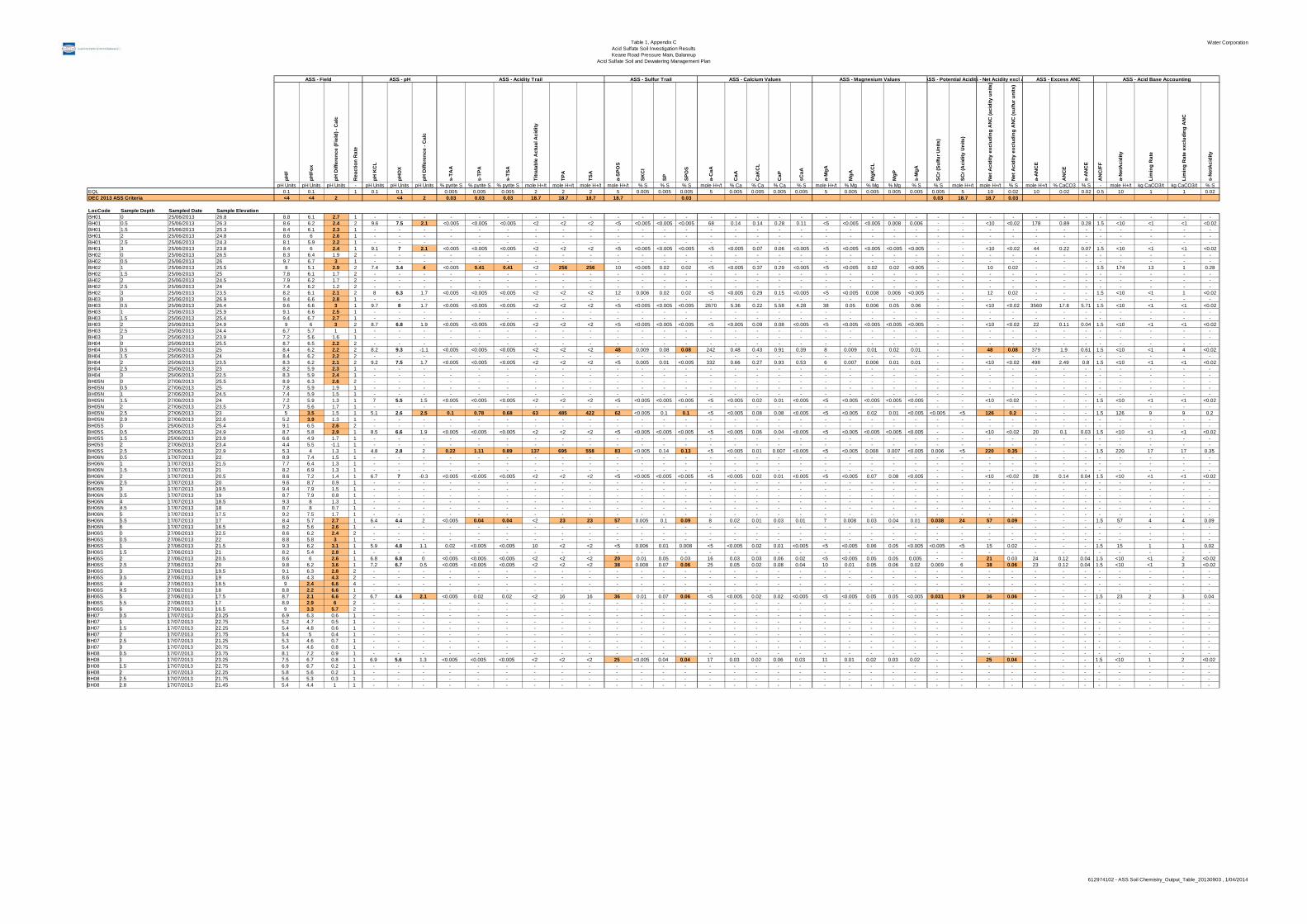
Table 1, Appendix CAcid Sulfate Soil Investigation ResultsKeane Road Pressure Main, Balannup
Acid Sulfate Soil and Dewatering Management Plan
Water Corporation
pH
F
pH
Fo
x
pH
Dif
fere
nc
e (
Fie
ld)
- C
alc
Re
ac
tio
n R
ate
pH
KC
L
pH
OX
pH
Dif
fere
nc
e -
Ca
lc
s-T
AA
s-T
PA
s-T
SA
Tit
rata
ble
Ac
tua
l Ac
idit
y
TP
A
TS
A
a-S
PO
S
SK
Cl
SP
SP
OS
a-C
aA
Ca
A
Ca
KC
L
Ca
P
sC
aA
a-M
gA
Mg
A
Mg
KC
L
Mg
P
s-M
gA
SC
r (S
ulf
ur
Un
its
)
SC
r (A
cid
ity
Un
its
)
Ne
t A
cid
ity
ex
clu
din
g A
NC
(a
cid
ity
un
its
)
Ne
t A
cid
ity
ex
clu
din
g A
NC
(s
ulf
ur
un
its
)
a-A
NC
E
AN
CE
s-A
NC
E
AN
C/F
F
a-N
etA
cid
ity
Lim
ing
Ra
te
Lim
ing
Ra
te e
xc
lud
ing
AN
C
s-N
etA
cid
ity
pH Units pH Units pH Units - pH Units pH Units pH Units % pyrite S % pyrite S % pyrite S mole H+/t mole H+/t mole H+/t mole H+/t % S % S % S mole H+/t % Ca % Ca % Ca % S mole H+/t % Mg % Mg % Mg % S % S mole H+/t mole H+/t % S mole H+/t % CaCO3 % S - mole H+/t kg CaCO3/t kg CaCO3/t % SEQL 0.1 0.1 1 0.1 0.1 0.005 0.005 0.005 2 2 2 5 0.005 0.005 0.005 5 0.005 0.005 0.005 0.005 5 0.005 0.005 0.005 0.005 0.005 5 10 0.02 10 0.02 0.02 0.5 10 1 1 0.02DEC 2013 ASS Criteria <4 <4 2 <4 2 0.03 0.03 0.03 18.7 18.7 18.7 18.7 0.03 0.03 18.7 18.7 0.03
LocCode Sample Depth Sampled Date Sample ElevationBH01 0 25/06/2013 26.8 8.8 6.1 2.7 1 - - - - - - - - - - - - - - - - - - - - - - - - - - - - - - - - - - - BH01 0.5 25/06/2013 26.3 8.6 6.2 2.4 2 9.6 7.5 2.1 <0.005 <0.005 <0.005 <2 <2 <2 <5 <0.005 <0.005 <0.005 68 0.14 0.14 0.28 0.11 <5 <0.005 <0.005 0.008 0.006 - - <10 <0.02 178 0.89 0.28 1.5 <10 <1 <1 <0.02BH01 1.5 25/06/2013 25.3 8.4 6.1 2.3 1 - - - - - - - - - - - - - - - - - - - - - - - - - - - - - - - - - - - BH01 2 25/06/2013 24.8 8.6 6 2.6 1 - - - - - - - - - - - - - - - - - - - - - - - - - - - - - - - - - - - BH01 2.5 25/06/2013 24.3 8.1 5.9 2.2 1 - - - - - - - - - - - - - - - - - - - - - - - - - - - - - - - - - - - BH01 3 25/06/2013 23.8 8.4 6 2.4 1 9.1 7 2.1 <0.005 <0.005 <0.005 <2 <2 <2 <5 <0.005 <0.005 <0.005 <5 <0.005 0.07 0.06 <0.005 <5 <0.005 <0.005 <0.005 <0.005 - - <10 <0.02 44 0.22 0.07 1.5 <10 <1 <1 <0.02BH02 0 25/06/2013 26.5 8.3 6.4 1.9 2 - - - - - - - - - - - - - - - - - - - - - - - - - - - - - - - - - - - BH02 0.5 25/06/2013 26 9.7 6.7 3 1 - - - - - - - - - - - - - - - - - - - - - - - - - - - - - - - - - - - BH02 1 25/06/2013 25.5 8 5.1 2.9 2 7.4 3.4 4 <0.005 0.41 0.41 <2 256 256 10 <0.005 0.02 0.02 <5 <0.005 0.37 0.29 <0.005 <5 <0.005 0.02 0.02 <0.005 - - 10 0.02 - - - 1.5 174 13 1 0.28BH02 1.5 25/06/2013 25 7.8 6.1 1.7 2 - - - - - - - - - - - - - - - - - - - - - - - - - - - - - - - - - - - BH02 2 25/06/2013 24.5 7.9 6.2 1.7 2 - - - - - - - - - - - - - - - - - - - - - - - - - - - - - - - - - - - BH02 2.5 25/06/2013 24 7.4 6.2 1.2 2 - - - - - - - - - - - - - - - - - - - - - - - - - - - - - - - - - - - BH02 3 25/06/2013 23.5 8.2 6.1 2.1 2 8 6.3 1.7 <0.005 <0.005 <0.005 <2 <2 <2 12 0.006 0.02 0.02 <5 <0.005 0.29 0.15 <0.005 <5 <0.005 0.008 0.006 <0.005 - - 12 0.02 - - - 1.5 <10 <1 1 <0.02BH03 0 25/06/2013 26.9 9.4 6.6 2.8 1 - - - - - - - - - - - - - - - - - - - - - - - - - - - - - - - - - - - BH03 0.5 25/06/2013 26.4 9.6 6.6 3 1 9.7 8 1.7 <0.005 <0.005 <0.005 <2 <2 <2 <5 <0.005 <0.005 <0.005 2670 5.36 0.22 5.58 4.28 38 0.05 0.006 0.05 0.06 - - <10 <0.02 3560 17.8 5.71 1.5 <10 <1 <1 <0.02BH03 1 25/06/2013 25.9 9.1 6.6 2.5 1 - - - - - - - - - - - - - - - - - - - - - - - - - - - - - - - - - - - BH03 1.5 25/06/2013 25.4 9.4 6.7 2.7 1 - - - - - - - - - - - - - - - - - - - - - - - - - - - - - - - - - - - BH03 2 25/06/2013 24.9 9 6 3 2 8.7 6.8 1.9 <0.005 <0.005 <0.005 <2 <2 <2 <5 <0.005 <0.005 <0.005 <5 <0.005 0.09 0.08 <0.005 <5 <0.005 <0.005 <0.005 <0.005 - - <10 <0.02 22 0.11 0.04 1.5 <10 <1 <1 <0.02BH03 2.5 25/06/2013 24.4 6.7 5.7 1 1 - - - - - - - - - - - - - - - - - - - - - - - - - - - - - - - - - - - BH03 3 25/06/2013 23.9 7.2 5.6 1.6 1 - - - - - - - - - - - - - - - - - - - - - - - - - - - - - - - - - - - BH04 0 25/06/2013 25.5 8.7 6.5 2.2 2 - - - - - - - - - - - - - - - - - - - - - - - - - - - - - - - - - - - BH04 0.5 25/06/2013 25 8.4 6.2 2.2 2 8.2 9.3 -1.1 <0.005 <0.005 <0.005 <2 <2 <2 48 0.009 0.08 0.08 242 0.48 0.43 0.91 0.39 8 0.009 0.01 0.02 0.01 - - 48 0.08 379 1.9 0.61 1.5 <10 <1 4 <0.02BH04 1.5 25/06/2013 24 8.4 6.2 2.2 2 - - - - - - - - - - - - - - - - - - - - - - - - - - - - - - - - - - - BH04 2 25/06/2013 23.5 8.3 6.2 2.1 2 9.2 7.5 1.7 <0.005 <0.005 <0.005 <2 <2 <2 <5 0.005 0.01 <0.005 332 0.66 0.27 0.93 0.53 6 0.007 0.006 0.01 0.01 - - <10 <0.02 498 2.49 0.8 1.5 <10 <1 <1 <0.02BH04 2.5 25/06/2013 23 8.2 5.9 2.3 1 - - - - - - - - - - - - - - - - - - - - - - - - - - - - - - - - - - - BH04 3 25/06/2013 22.5 8.3 5.9 2.4 1 - - - - - - - - - - - - - - - - - - - - - - - - - - - - - - - - - - - BH05N 0 27/06/2013 25.5 8.9 6.3 2.6 2 - - - - - - - - - - - - - - - - - - - - - - - - - - - - - - - - - - - BH05N 0.5 27/06/2013 25 7.8 5.9 1.9 1 - - - - - - - - - - - - - - - - - - - - - - - - - - - - - - - - - - - BH05N 1 27/06/2013 24.5 7.4 5.9 1.5 1 - - - - - - - - - - - - - - - - - - - - - - - - - - - - - - - - - - - BH05N 1.5 27/06/2013 24 7.2 5.9 1.3 1 7 5.5 1.5 <0.005 <0.005 <0.005 <2 <2 <2 <5 <0.005 <0.005 <0.005 <5 <0.005 0.02 0.01 <0.005 <5 <0.005 <0.005 <0.005 <0.005 - - <10 <0.02 - - - 1.5 <10 <1 <1 <0.02BH05N 2 27/06/2013 23.5 7.3 5.6 1.7 1 - - - - - - - - - - - - - - - - - - - - - - - - - - - - - - - - - - - BH05N 2.5 27/06/2013 23 5 3.5 1.5 1 5.1 2.6 2.5 0.1 0.78 0.68 63 485 422 62 <0.005 0.1 0.1 <5 <0.005 0.08 0.08 <0.005 <5 <0.005 0.02 0.01 <0.005 <0.005 <5 126 0.2 - - - 1.5 126 9 9 0.2BH05N 2.9 27/06/2013 22.6 5.2 3.9 1.3 1 - - - - - - - - - - - - - - - - - - - - - - - - - - - - - - - - - - - BH05S 0 25/06/2013 25.4 9.1 6.5 2.6 2 - - - - - - - - - - - - - - - - - - - - - - - - - - - - - - - - - - - BH05S 0.5 25/06/2013 24.9 8.7 5.8 2.9 1 8.5 6.6 1.9 <0.005 <0.005 <0.005 <2 <2 <2 <5 <0.005 <0.005 <0.005 <5 <0.005 0.06 0.04 <0.005 <5 <0.005 <0.005 <0.005 <0.005 - - <10 <0.02 20 0.1 0.03 1.5 <10 <1 <1 <0.02BH05S 1.5 25/06/2013 23.9 6.6 4.9 1.7 1 - - - - - - - - - - - - - - - - - - - - - - - - - - - - - - - - - - - BH05S 2 27/06/2013 23.4 4.4 5.5 -1.1 1 - - - - - - - - - - - - - - - - - - - - - - - - - - - - - - - - - - - BH05S 2.5 27/06/2013 22.9 5.3 4 1.3 1 4.8 2.8 2 0.22 1.11 0.89 137 695 558 83 <0.005 0.14 0.13 <5 <0.005 0.01 0.007 <0.005 <5 <0.005 0.008 0.007 <0.005 0.006 <5 220 0.35 - - - 1.5 220 17 17 0.35BH06N 0.5 17/07/2013 22 8.9 7.4 1.5 1 - - - - - - - - - - - - - - - - - - - - - - - - - - - - - - - - - - - BH06N 1 17/07/2013 21.5 7.7 6.4 1.3 1 - - - - - - - - - - - - - - - - - - - - - - - - - - - - - - - - - - - BH06N 1.5 17/07/2013 21 8.2 6.9 1.3 1 - - - - - - - - - - - - - - - - - - - - - - - - - - - - - - - - - - - BH06N 2 17/07/2013 20.5 8.6 7.2 1.4 1 6.7 7 -0.3 <0.005 <0.005 <0.005 <2 <2 <2 <5 <0.005 <0.005 <0.005 <5 <0.005 0.02 0.01 <0.005 <5 <0.005 0.07 0.08 <0.005 - - <10 <0.02 28 0.14 0.04 1.5 <10 <1 <1 <0.02BH06N 2.5 17/07/2013 20 9.6 8.7 0.9 1 - - - - - - - - - - - - - - - - - - - - - - - - - - - - - - - - - - - BH06N 3 17/07/2013 19.5 9.4 7.9 1.5 1 - - - - - - - - - - - - - - - - - - - - - - - - - - - - - - - - - - - BH06N 3.5 17/07/2013 19 8.7 7.9 0.8 1 - - - - - - - - - - - - - - - - - - - - - - - - - - - - - - - - - - - BH06N 4 17/07/2013 18.5 9.3 8 1.3 1 - - - - - - - - - - - - - - - - - - - - - - - - - - - - - - - - - - - BH06N 4.5 17/07/2013 18 8.7 8 0.7 1 - - - - - - - - - - - - - - - - - - - - - - - - - - - - - - - - - - - BH06N 5 17/07/2013 17.5 9.2 7.5 1.7 1 - - - - - - - - - - - - - - - - - - - - - - - - - - - - - - - - - - - BH06N 5.5 17/07/2013 17 8.4 5.7 2.7 1 6.4 4.4 2 <0.005 0.04 0.04 <2 23 23 57 0.005 0.1 0.09 8 0.02 0.01 0.03 0.01 7 0.008 0.03 0.04 0.01 0.038 24 57 0.09 - - - 1.5 57 4 4 0.09BH06N 6 17/07/2013 16.5 8.2 5.6 2.6 1 - - - - - - - - - - - - - - - - - - - - - - - - - - - - - - - - - - - BH06S 0 27/06/2013 22.5 8.6 6.2 2.4 2 - - - - - - - - - - - - - - - - - - - - - - - - - - - - - - - - - - - BH06S 0.5 27/06/2013 22 8.8 5.8 3 1 - - - - - - - - - - - - - - - - - - - - - - - - - - - - - - - - - - - BH06S 1 27/06/2013 21.5 9.3 6.2 3.1 1 5.9 4.8 1.1 0.02 <0.005 <0.005 10 <2 <2 <5 0.006 0.01 0.008 <5 <0.005 0.02 0.01 <0.005 <5 <0.005 0.06 0.05 <0.005 <0.005 <5 15 0.02 - - - 1.5 15 1 1 0.02BH06S 1.5 27/06/2013 21 8.2 5.4 2.8 1 - - - - - - - - - - - - - - - - - - - - - - - - - - - - - - - - - - - BH06S 2 27/06/2013 20.5 8.6 6 2.6 1 6.8 6.8 0 <0.005 <0.005 <0.005 <2 <2 <2 20 0.01 0.05 0.03 16 0.03 0.03 0.06 0.02 <5 <0.005 0.05 0.05 0.005 - - 21 0.03 24 0.12 0.04 1.5 <10 <1 2 <0.02BH06S 2.5 27/06/2013 20 9.8 6.2 3.6 1 7.2 6.7 0.5 <0.005 <0.005 <0.005 <2 <2 <2 38 0.008 0.07 0.06 25 0.05 0.02 0.08 0.04 10 0.01 0.05 0.06 0.02 0.009 6 38 0.06 23 0.12 0.04 1.5 <10 <1 3 <0.02BH06S 3 27/06/2013 19.5 9.1 6.3 2.8 2 - - - - - - - - - - - - - - - - - - - - - - - - - - - - - - - - - - - BH06S 3.5 27/06/2013 19 8.6 4.3 4.3 2 - - - - - - - - - - - - - - - - - - - - - - - - - - - - - - - - - - - BH06S 4 27/06/2013 18.5 9 2.4 6.6 4 - - - - - - - - - - - - - - - - - - - - - - - - - - - - - - - - - - - BH06S 4.5 27/06/2013 18 8.8 2.2 6.6 1 - - - - - - - - - - - - - - - - - - - - - - - - - - - - - - - - - - - BH06S 5 27/06/2013 17.5 8.7 2.1 6.6 2 6.7 4.6 2.1 <0.005 0.02 0.02 <2 16 16 36 0.01 0.07 0.06 <5 <0.005 0.02 0.02 <0.005 <5 <0.005 0.05 0.05 <0.005 0.031 19 36 0.06 - - - 1.5 23 2 3 0.04BH06S 5.5 27/06/2013 17 8.9 2.9 6 2 - - - - - - - - - - - - - - - - - - - - - - - - - - - - - - - - - - - BH06S 6 27/06/2013 16.5 9 3.3 5.7 2 - - - - - - - - - - - - - - - - - - - - - - - - - - - - - - - - - - - BH07 0.5 17/07/2013 23.25 6.9 6.3 0.6 1 - - - - - - - - - - - - - - - - - - - - - - - - - - - - - - - - - - - BH07 1 17/07/2013 22.75 5.2 4.7 0.5 1 - - - - - - - - - - - - - - - - - - - - - - - - - - - - - - - - - - - BH07 1.5 17/07/2013 22.25 5.4 4.8 0.6 1 - - - - - - - - - - - - - - - - - - - - - - - - - - - - - - - - - - - BH07 2 17/07/2013 21.75 5.4 5 0.4 1 - - - - - - - - - - - - - - - - - - - - - - - - - - - - - - - - - - - BH07 2.5 17/07/2013 21.25 5.3 4.6 0.7 1 - - - - - - - - - - - - - - - - - - - - - - - - - - - - - - - - - - - BH07 3 17/07/2013 20.75 5.4 4.6 0.8 1 - - - - - - - - - - - - - - - - - - - - - - - - - - - - - - - - - - - BH08 0.5 17/07/2013 23.75 8.1 7.2 0.9 1 - - - - - - - - - - - - - - - - - - - - - - - - - - - - - - - - - - - BH08 1 17/07/2013 23.25 7.5 6.7 0.8 1 6.9 5.6 1.3 <0.005 <0.005 <0.005 <2 <2 <2 25 <0.005 0.04 0.04 17 0.03 0.02 0.06 0.03 11 0.01 0.02 0.03 0.02 - - 25 0.04 - - - 1.5 <10 1 2 <0.02BH08 1.5 17/07/2013 22.75 6.9 6.7 0.2 1 - - - - - - - - - - - - - - - - - - - - - - - - - - - - - - - - - - - BH08 2 17/07/2013 22.25 5.8 5.6 0.2 1 - - - - - - - - - - - - - - - - - - - - - - - - - - - - - - - - - - - BH08 2.5 17/07/2013 21.75 5.6 5.3 0.3 1 - - - - - - - - - - - - - - - - - - - - - - - - - - - - - - - - - - - BH08 2.8 17/07/2013 21.45 5.4 4.4 1 1 - - - - - - - - - - - - - - - - - - - - - - - - - - - - - - - - - - -
ASS - Potential AcidityASS - Net Acidity excl ANC ASS - Excess ANC ASS - Acid Base AccountingASS - Field ASS - pH ASS - Acidity Trail ASS - Sulfur Trail ASS - Calcium Values ASS - Magnesium Values
612974102 - ASS Soil Chemistry_Output_Table_20130903 , 1/04/2014
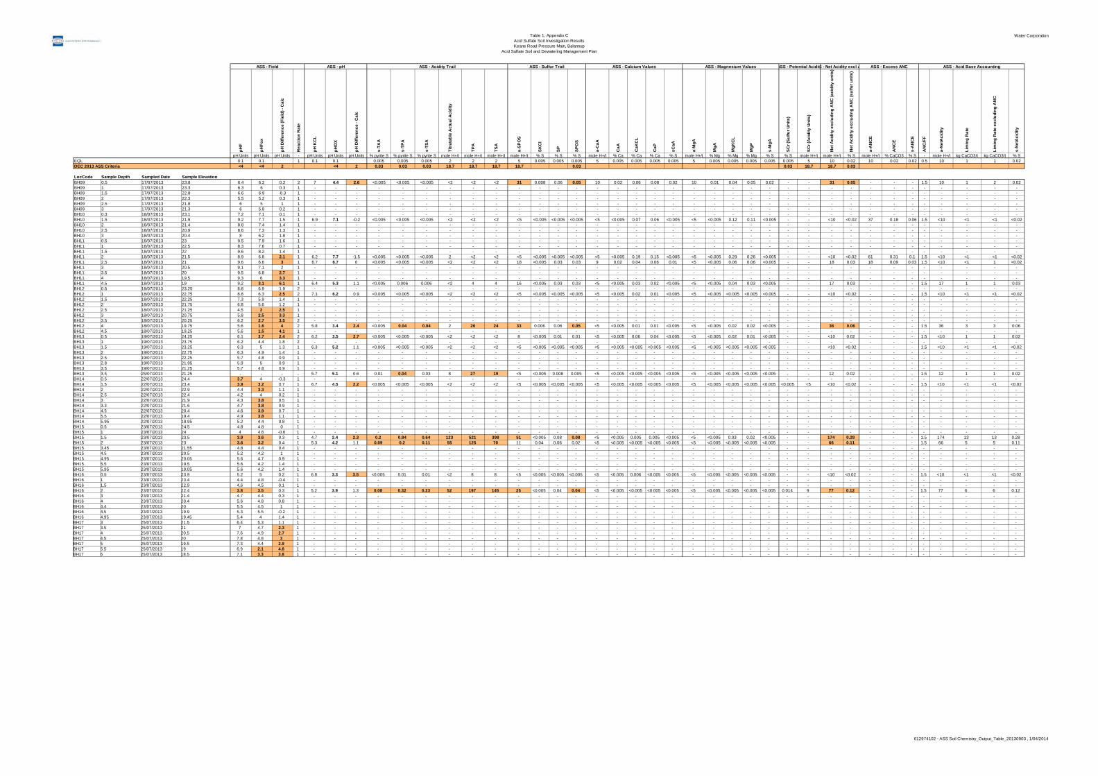
Table 1, Appendix CAcid Sulfate Soil Investigation ResultsKeane Road Pressure Main, Balannup
Acid Sulfate Soil and Dewatering Management Plan
Water Corporation
pH
F
pH
Fo
x
pH
Dif
fere
nc
e (
Fie
ld)
- C
alc
Re
ac
tio
n R
ate
pH
KC
L
pH
OX
pH
Dif
fere
nc
e -
Ca
lc
s-T
AA
s-T
PA
s-T
SA
Tit
rata
ble
Ac
tua
l Ac
idit
y
TP
A
TS
A
a-S
PO
S
SK
Cl
SP
SP
OS
a-C
aA
Ca
A
Ca
KC
L
Ca
P
sC
aA
a-M
gA
Mg
A
Mg
KC
L
Mg
P
s-M
gA
SC
r (S
ulf
ur
Un
its
)
SC
r (A
cid
ity
Un
its
)
Ne
t A
cid
ity
ex
clu
din
g A
NC
(a
cid
ity
un
its
)
Ne
t A
cid
ity
ex
clu
din
g A
NC
(s
ulf
ur
un
its
)
a-A
NC
E
AN
CE
s-A
NC
E
AN
C/F
F
a-N
etA
cid
ity
Lim
ing
Ra
te
Lim
ing
Ra
te e
xc
lud
ing
AN
C
s-N
etA
cid
ity
pH Units pH Units pH Units - pH Units pH Units pH Units % pyrite S % pyrite S % pyrite S mole H+/t mole H+/t mole H+/t mole H+/t % S % S % S mole H+/t % Ca % Ca % Ca % S mole H+/t % Mg % Mg % Mg % S % S mole H+/t mole H+/t % S mole H+/t % CaCO3 % S - mole H+/t kg CaCO3/t kg CaCO3/t % SEQL 0.1 0.1 1 0.1 0.1 0.005 0.005 0.005 2 2 2 5 0.005 0.005 0.005 5 0.005 0.005 0.005 0.005 5 0.005 0.005 0.005 0.005 0.005 5 10 0.02 10 0.02 0.02 0.5 10 1 1 0.02DEC 2013 ASS Criteria <4 <4 2 <4 2 0.03 0.03 0.03 18.7 18.7 18.7 18.7 0.03 0.03 18.7 18.7 0.03
LocCode Sample Depth Sampled Date Sample Elevation
ASS - Potential AcidityASS - Net Acidity excl ANC ASS - Excess ANC ASS - Acid Base AccountingASS - Field ASS - pH ASS - Acidity Trail ASS - Sulfur Trail ASS - Calcium Values ASS - Magnesium Values
BH09 0.5 17/07/2013 23.8 6.4 6.2 0.2 2 7 4.4 2.6 <0.005 <0.005 <0.005 <2 <2 <2 31 0.008 0.06 0.05 10 0.02 0.06 0.08 0.02 10 0.01 0.04 0.05 0.02 - - 31 0.05 - - - 1.5 10 1 2 0.02BH09 1 17/07/2013 23.3 6.3 6 0.3 1 - - - - - - - - - - - - - - - - - - - - - - - - - - - - - - - - - - - BH09 1.5 17/07/2013 22.8 6.6 6.9 -0.3 1 - - - - - - - - - - - - - - - - - - - - - - - - - - - - - - - - - - - BH09 2 17/07/2013 22.3 5.5 5.2 0.3 1 - - - - - - - - - - - - - - - - - - - - - - - - - - - - - - - - - - - BH09 2.5 17/07/2013 21.8 6 5 1 1 - - - - - - - - - - - - - - - - - - - - - - - - - - - - - - - - - - - BH09 3 17/07/2013 21.3 6 5.8 0.2 1 - - - - - - - - - - - - - - - - - - - - - - - - - - - - - - - - - - - BH10 0.3 18/07/2013 23.1 7.2 7.1 0.1 1 - - - - - - - - - - - - - - - - - - - - - - - - - - - - - - - - - - - BH10 1.5 18/07/2013 21.9 9.2 7.7 1.5 1 6.9 7.1 -0.2 <0.005 <0.005 <0.005 <2 <2 <2 <5 <0.005 <0.005 <0.005 <5 <0.005 0.07 0.06 <0.005 <5 <0.005 0.12 0.11 <0.005 - - <10 <0.02 37 0.18 0.06 1.5 <10 <1 <1 <0.02BH10 2 18/07/2013 21.4 8.8 7.4 1.4 1 - - - - - - - - - - - - - - - - - - - - - - - - - - - - - - - - - - - BH10 2.5 18/07/2013 20.9 8.6 7.3 1.3 1 - - - - - - - - - - - - - - - - - - - - - - - - - - - - - - - - - - - BH10 3 18/07/2013 20.4 8 6.2 1.8 1 - - - - - - - - - - - - - - - - - - - - - - - - - - - - - - - - - - - BH11 0.5 18/07/2013 23 9.5 7.9 1.6 1 - - - - - - - - - - - - - - - - - - - - - - - - - - - - - - - - - - - BH11 1 18/07/2013 22.5 8.3 7.6 0.7 1 - - - - - - - - - - - - - - - - - - - - - - - - - - - - - - - - - - - BH11 1.5 18/07/2013 22 9.6 8.2 1.4 1 - - - - - - - - - - - - - - - - - - - - - - - - - - - - - - - - - - - BH11 2 18/07/2013 21.5 8.9 6.8 2.1 1 6.2 7.7 -1.5 <0.005 <0.005 <0.005 2 <2 <2 <5 <0.005 <0.005 <0.005 <5 <0.005 0.19 0.15 <0.005 <5 <0.005 0.29 0.26 <0.005 - - <10 <0.02 61 0.31 0.1 1.5 <10 <1 <1 <0.02BH11 2.5 18/07/2013 21 9.6 6.6 3 1 6.7 6.7 0 <0.005 <0.005 <0.005 <2 <2 <2 18 <0.005 0.03 0.03 9 0.02 0.04 0.06 0.01 <5 <0.005 0.06 0.06 <0.005 - - 18 0.03 18 0.09 0.03 1.5 <10 <1 1 <0.02BH11 3 18/07/2013 20.5 9.1 7.1 2 1 - - - - - - - - - - - - - - - - - - - - - - - - - - - - - - - - - - - BH11 3.5 18/07/2013 20 9.5 6.8 2.7 1 - - - - - - - - - - - - - - - - - - - - - - - - - - - - - - - - - - - BH11 4 18/07/2013 19.5 9.3 6 3.3 1 - - - - - - - - - - - - - - - - - - - - - - - - - - - - - - - - - - - BH11 4.5 18/07/2013 19 9.2 3.1 6.1 1 6.4 5.3 1.1 <0.005 0.006 0.006 <2 4 4 16 <0.005 0.03 0.03 <5 <0.005 0.03 0.02 <0.005 <5 <0.005 0.04 0.03 <0.005 - - 17 0.03 - - - 1.5 17 1 1 0.03BH12 0.5 18/07/2013 23.25 8.8 6.9 1.9 2 - - - - - - - - - - - - - - - - - - - - - - - - - - - - - - - - - - - BH12 1 18/07/2013 22.75 8.8 6.3 2.5 2 7.1 6.2 0.9 <0.005 <0.005 <0.005 <2 <2 <2 <5 <0.005 <0.005 <0.005 <5 <0.005 0.02 0.01 <0.005 <5 <0.005 <0.005 <0.005 <0.005 - - <10 <0.02 - - - 1.5 <10 <1 <1 <0.02BH12 1.5 18/07/2013 22.25 7.3 5.9 1.4 1 - - - - - - - - - - - - - - - - - - - - - - - - - - - - - - - - - - - BH12 2 18/07/2013 21.75 6.8 5.6 1.2 1 - - - - - - - - - - - - - - - - - - - - - - - - - - - - - - - - - - - BH12 2.5 18/07/2013 21.25 4.5 2 2.5 1 - - - - - - - - - - - - - - - - - - - - - - - - - - - - - - - - - - - BH12 3 18/07/2013 20.75 5.8 2.5 3.3 1 - - - - - - - - - - - - - - - - - - - - - - - - - - - - - - - - - - - BH12 3.5 18/07/2013 20.25 6.2 2.7 3.5 2 - - - - - - - - - - - - - - - - - - - - - - - - - - - - - - - - - - - BH12 4 18/07/2013 19.75 5.6 1.6 4 2 5.8 3.4 2.4 <0.005 0.04 0.04 2 26 24 33 0.006 0.06 0.05 <5 <0.005 0.01 0.01 <0.005 <5 <0.005 0.02 0.02 <0.005 - - 36 0.06 - - - 1.5 36 3 3 0.06BH12 4.5 18/07/2013 19.25 5.6 1.5 4.1 1 - - - - - - - - - - - - - - - - - - - - - - - - - - - - - - - - - - - BH13 0.5 19/07/2013 24.25 6.1 3.7 2.4 2 6.2 3.5 2.7 <0.005 <0.005 <0.005 <2 <2 <2 8 <0.005 0.01 0.01 <5 <0.005 0.06 0.04 <0.005 <5 <0.005 0.02 0.01 <0.005 - - <10 0.02 - - - 1.5 <10 1 1 0.02BH13 1 19/07/2013 23.75 6.2 4.4 1.8 2 - - - - - - - - - - - - - - - - - - - - - - - - - - - - - - - - - - - BH13 1.5 19/07/2013 23.25 6.3 5 1.3 1 6.3 5.2 1.1 <0.005 <0.005 <0.005 <2 <2 <2 <5 <0.005 <0.005 <0.005 <5 <0.005 <0.005 <0.005 <0.005 <5 <0.005 <0.005 <0.005 <0.005 - - <10 <0.02 - - - 1.5 <10 <1 <1 <0.02BH13 2 19/07/2013 22.75 6.3 4.9 1.4 1 - - - - - - - - - - - - - - - - - - - - - - - - - - - - - - - - - - - BH13 2.5 19/07/2013 22.25 5.7 4.8 0.9 1 - - - - - - - - - - - - - - - - - - - - - - - - - - - - - - - - - - - BH13 2.8 19/07/2013 21.95 5.9 5 0.9 1 - - - - - - - - - - - - - - - - - - - - - - - - - - - - - - - - - - - BH13 3.5 19/07/2013 21.25 5.7 4.8 0.9 1 - - - - - - - - - - - - - - - - - - - - - - - - - - - - - - - - - - - BH13 3.5 25/07/2013 21.25 - - - - 5.7 5.1 0.6 0.01 0.04 0.03 8 27 19 <5 <0.005 0.008 0.005 <5 <0.005 <0.005 <0.005 <0.005 <5 <0.005 <0.005 <0.005 <0.005 - - 12 0.02 - - - 1.5 12 1 1 0.02BH14 0.5 22/07/2013 24.4 3.7 4 -0.3 1 - - - - - - - - - - - - - - - - - - - - - - - - - - - - - - - - - - - BH14 1.5 22/07/2013 23.4 3.9 3.2 0.7 1 6.7 4.5 2.2 <0.005 <0.005 <0.005 <2 <2 <2 <5 <0.005 <0.005 <0.005 <5 <0.005 <0.005 <0.005 <0.005 <5 <0.005 <0.005 <0.005 <0.005 <0.005 <5 <10 <0.02 - - - 1.5 <10 <1 <1 <0.02BH14 2 22/07/2013 22.9 4.4 3.3 1.1 1 - - - - - - - - - - - - - - - - - - - - - - - - - - - - - - - - - - - BH14 2.5 22/07/2013 22.4 4.2 4 0.2 1 - - - - - - - - - - - - - - - - - - - - - - - - - - - - - - - - - - - BH14 3 22/07/2013 21.9 4.3 3.8 0.5 1 - - - - - - - - - - - - - - - - - - - - - - - - - - - - - - - - - - - BH14 3.3 22/07/2013 21.6 4.7 3.8 0.9 1 - - - - - - - - - - - - - - - - - - - - - - - - - - - - - - - - - - - BH14 4.5 22/07/2013 20.4 4.6 3.9 0.7 1 - - - - - - - - - - - - - - - - - - - - - - - - - - - - - - - - - - - BH14 5.5 22/07/2013 19.4 4.9 3.8 1.1 1 - - - - - - - - - - - - - - - - - - - - - - - - - - - - - - - - - - - BH14 5.95 22/07/2013 18.95 5.2 4.4 0.8 1 - - - - - - - - - - - - - - - - - - - - - - - - - - - - - - - - - - - BH15 0.5 23/07/2013 24.5 4.8 4.8 0 1 - - - - - - - - - - - - - - - - - - - - - - - - - - - - - - - - - - - BH15 1 23/07/2013 24 4 4.6 -0.6 1 - - - - - - - - - - - - - - - - - - - - - - - - - - - - - - - - - - - BH15 1.5 23/07/2013 23.5 3.9 3.6 0.3 1 4.7 2.4 2.3 0.2 0.84 0.64 123 521 398 51 <0.005 0.08 0.08 <5 <0.005 0.005 0.005 <0.005 <5 <0.005 0.03 0.02 <0.005 - - 174 0.28 - - - 1.5 174 13 13 0.28BH15 2 23/07/2013 23 3.6 3.2 0.4 1 5.3 4.2 1.1 0.09 0.2 0.11 55 125 70 11 0.04 0.06 0.02 <5 <0.005 <0.005 <0.005 <0.005 <5 <0.005 <0.005 <0.005 <0.005 - - 66 0.11 - - - 1.5 66 5 5 0.11BH15 3.45 23/07/2013 21.55 4.8 4.4 0.4 1 - - - - - - - - - - - - - - - - - - - - - - - - - - - - - - - - - - - BH15 4.5 23/07/2013 20.5 5.2 4.2 1 1 - - - - - - - - - - - - - - - - - - - - - - - - - - - - - - - - - - - BH15 4.95 23/07/2013 20.05 5.6 4.7 0.9 1 - - - - - - - - - - - - - - - - - - - - - - - - - - - - - - - - - - - BH15 5.5 23/07/2013 19.5 5.6 4.2 1.4 1 - - - - - - - - - - - - - - - - - - - - - - - - - - - - - - - - - - - BH15 5.95 23/07/2013 19.05 5.6 4.2 1.4 1 - - - - - - - - - - - - - - - - - - - - - - - - - - - - - - - - - - - BH16 0.5 23/07/2013 23.9 5.2 5 0.2 1 6.8 3.3 3.5 <0.005 0.01 0.01 <2 8 8 <5 <0.005 <0.005 <0.005 <5 <0.005 0.006 <0.005 <0.005 <5 <0.005 <0.005 <0.005 <0.005 - - <10 <0.02 - - - 1.5 <10 <1 <1 <0.02BH16 1 23/07/2013 23.4 4.4 4.8 -0.4 1 - - - - - - - - - - - - - - - - - - - - - - - - - - - - - - - - - - - BH16 1.5 23/07/2013 22.9 4.6 4.5 0.1 1 - - - - - - - - - - - - - - - - - - - - - - - - - - - - - - - - - - - BH16 2 23/07/2013 22.4 3.8 3.5 0.3 1 5.2 3.9 1.3 0.08 0.32 0.23 52 197 145 25 <0.005 0.04 0.04 <5 <0.005 <0.005 <0.005 <0.005 <5 <0.005 <0.005 <0.005 <0.005 0.014 9 77 0.12 - - - 1.5 77 6 6 0.12BH16 3 23/07/2013 21.4 4.7 4.4 0.3 1 - - - - - - - - - - - - - - - - - - - - - - - - - - - - - - - - - - - BH16 4 23/07/2013 20.4 5.6 4.8 0.8 1 - - - - - - - - - - - - - - - - - - - - - - - - - - - - - - - - - - - BH16 4.4 23/07/2013 20 5.5 4.5 1 1 - - - - - - - - - - - - - - - - - - - - - - - - - - - - - - - - - - - BH16 4.5 23/07/2013 19.9 5.3 5.5 -0.2 1 - - - - - - - - - - - - - - - - - - - - - - - - - - - - - - - - - - - BH16 4.95 23/07/2013 19.45 5.4 4 1.4 1 - - - - - - - - - - - - - - - - - - - - - - - - - - - - - - - - - - - BH17 3 25/07/2013 21.5 6.4 5.3 1.1 1 - - - - - - - - - - - - - - - - - - - - - - - - - - - - - - - - - - - BH17 3.5 25/07/2013 21 7 4.7 2.3 1 - - - - - - - - - - - - - - - - - - - - - - - - - - - - - - - - - - - BH17 4 25/07/2013 20.5 7.6 4.9 2.7 1 - - - - - - - - - - - - - - - - - - - - - - - - - - - - - - - - - - - BH17 4.5 25/07/2013 20 7.8 4.8 3 1 - - - - - - - - - - - - - - - - - - - - - - - - - - - - - - - - - - - BH17 5 25/07/2013 19.5 7.3 4.4 2.9 1 - - - - - - - - - - - - - - - - - - - - - - - - - - - - - - - - - - - BH17 5.5 25/07/2013 19 6.9 2.1 4.8 1 - - - - - - - - - - - - - - - - - - - - - - - - - - - - - - - - - - - BH17 6 25/07/2013 18.5 7.1 3.3 3.8 1 - - - - - - - - - - - - - - - - - - - - - - - - - - - - - - - - - - -
612974102 - ASS Soil Chemistry_Output_Table_20130903 , 1/04/2014
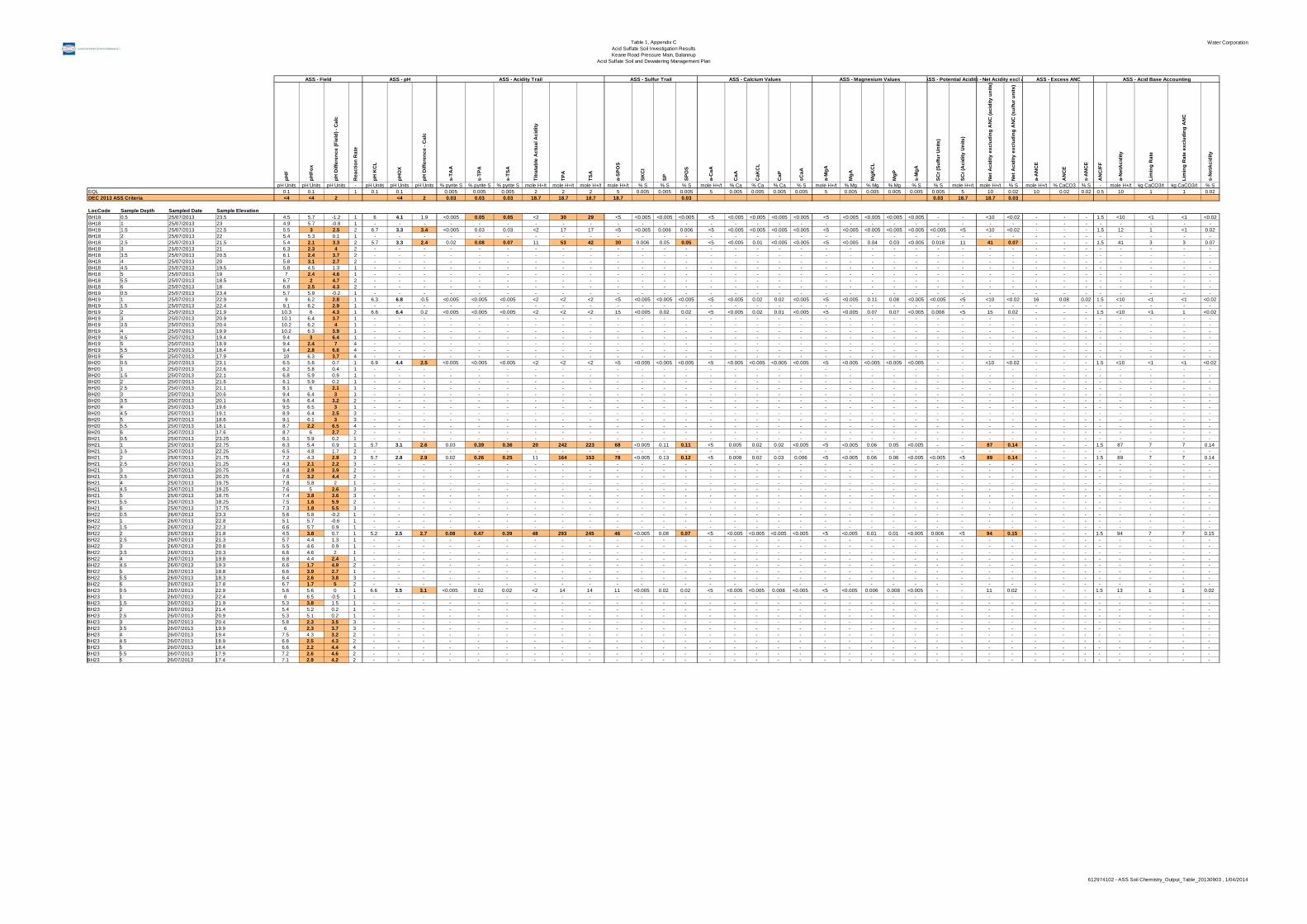
Table 1, Appendix CAcid Sulfate Soil Investigation ResultsKeane Road Pressure Main, Balannup
Acid Sulfate Soil and Dewatering Management Plan
Water Corporation
pH
F
pH
Fo
x
pH
Dif
fere
nc
e (
Fie
ld)
- C
alc
Re
ac
tio
n R
ate
pH
KC
L
pH
OX
pH
Dif
fere
nc
e -
Ca
lc
s-T
AA
s-T
PA
s-T
SA
Tit
rata
ble
Ac
tua
l Ac
idit
y
TP
A
TS
A
a-S
PO
S
SK
Cl
SP
SP
OS
a-C
aA
Ca
A
Ca
KC
L
Ca
P
sC
aA
a-M
gA
Mg
A
Mg
KC
L
Mg
P
s-M
gA
SC
r (S
ulf
ur
Un
its
)
SC
r (A
cid
ity
Un
its
)
Ne
t A
cid
ity
ex
clu
din
g A
NC
(a
cid
ity
un
its
)
Ne
t A
cid
ity
ex
clu
din
g A
NC
(s
ulf
ur
un
its
)
a-A
NC
E
AN
CE
s-A
NC
E
AN
C/F
F
a-N
etA
cid
ity
Lim
ing
Ra
te
Lim
ing
Ra
te e
xc
lud
ing
AN
C
s-N
etA
cid
ity
pH Units pH Units pH Units - pH Units pH Units pH Units % pyrite S % pyrite S % pyrite S mole H+/t mole H+/t mole H+/t mole H+/t % S % S % S mole H+/t % Ca % Ca % Ca % S mole H+/t % Mg % Mg % Mg % S % S mole H+/t mole H+/t % S mole H+/t % CaCO3 % S - mole H+/t kg CaCO3/t kg CaCO3/t % SEQL 0.1 0.1 1 0.1 0.1 0.005 0.005 0.005 2 2 2 5 0.005 0.005 0.005 5 0.005 0.005 0.005 0.005 5 0.005 0.005 0.005 0.005 0.005 5 10 0.02 10 0.02 0.02 0.5 10 1 1 0.02DEC 2013 ASS Criteria <4 <4 2 <4 2 0.03 0.03 0.03 18.7 18.7 18.7 18.7 0.03 0.03 18.7 18.7 0.03
LocCode Sample Depth Sampled Date Sample Elevation
ASS - Potential AcidityASS - Net Acidity excl ANC ASS - Excess ANC ASS - Acid Base AccountingASS - Field ASS - pH ASS - Acidity Trail ASS - Sulfur Trail ASS - Calcium Values ASS - Magnesium Values
BH18 0.5 25/07/2013 23.5 4.5 5.7 -1.2 1 6 4.1 1.9 <0.005 0.05 0.05 <2 30 29 <5 <0.005 <0.005 <0.005 <5 <0.005 <0.005 <0.005 <0.005 <5 <0.005 <0.005 <0.005 <0.005 - - <10 <0.02 - - - 1.5 <10 <1 <1 <0.02BH18 1 25/07/2013 23 4.9 5.7 -0.8 1 - - - - - - - - - - - - - - - - - - - - - - - - - - - - - - - - - - - BH18 1.5 25/07/2013 22.5 5.5 3 2.5 2 6.7 3.3 3.4 <0.005 0.03 0.03 <2 17 17 <5 <0.005 0.006 0.006 <5 <0.005 <0.005 <0.005 <0.005 <5 <0.005 <0.005 <0.005 <0.005 <0.005 <5 <10 <0.02 - - - 1.5 12 1 <1 0.02BH18 2 25/07/2013 22 5.4 5.3 0.1 1 - - - - - - - - - - - - - - - - - - - - - - - - - - - - - - - - - - - BH18 2.5 25/07/2013 21.5 5.4 2.1 3.3 2 5.7 3.3 2.4 0.02 0.08 0.07 11 53 42 30 0.006 0.05 0.05 <5 <0.005 0.01 <0.005 <0.005 <5 <0.005 0.04 0.03 <0.005 0.018 11 41 0.07 - - - 1.5 41 3 3 0.07BH18 3 25/07/2013 21 6.3 2.3 4 2 - - - - - - - - - - - - - - - - - - - - - - - - - - - - - - - - - - - BH18 3.5 25/07/2013 20.5 6.1 2.4 3.7 2 - - - - - - - - - - - - - - - - - - - - - - - - - - - - - - - - - - - BH18 4 25/07/2013 20 5.8 3.1 2.7 2 - - - - - - - - - - - - - - - - - - - - - - - - - - - - - - - - - - - BH18 4.5 25/07/2013 19.5 5.8 4.5 1.3 1 - - - - - - - - - - - - - - - - - - - - - - - - - - - - - - - - - - - BH18 5 25/07/2013 19 7 2.4 4.6 1 - - - - - - - - - - - - - - - - - - - - - - - - - - - - - - - - - - - BH18 5.5 25/07/2013 18.5 6.7 2 4.7 2 - - - - - - - - - - - - - - - - - - - - - - - - - - - - - - - - - - - BH18 6 25/07/2013 18 6.8 2.5 4.3 2 - - - - - - - - - - - - - - - - - - - - - - - - - - - - - - - - - - - BH19 0.5 25/07/2013 23.4 5.7 5.9 -0.2 1 - - - - - - - - - - - - - - - - - - - - - - - - - - - - - - - - - - - BH19 1 25/07/2013 22.9 9 6.2 2.8 1 6.3 6.8 -0.5 <0.005 <0.005 <0.005 <2 <2 <2 <5 <0.005 <0.005 <0.005 <5 <0.005 0.02 0.02 <0.005 <5 <0.005 0.11 0.08 <0.005 <0.005 <5 <10 <0.02 16 0.08 0.02 1.5 <10 <1 <1 <0.02BH19 1.5 25/07/2013 22.4 9.1 6.2 2.9 1 - - - - - - - - - - - - - - - - - - - - - - - - - - - - - - - - - - - BH19 2 25/07/2013 21.9 10.3 6 4.3 1 6.6 6.4 0.2 <0.005 <0.005 <0.005 <2 <2 <2 15 <0.005 0.02 0.02 <5 <0.005 0.02 0.01 <0.005 <5 <0.005 0.07 0.07 <0.005 0.008 <5 15 0.02 - - - 1.5 <10 <1 1 <0.02BH19 3 25/07/2013 20.9 10.1 6.4 3.7 1 - - - - - - - - - - - - - - - - - - - - - - - - - - - - - - - - - - - BH19 3.5 25/07/2013 20.4 10.2 6.2 4 1 - - - - - - - - - - - - - - - - - - - - - - - - - - - - - - - - - - - BH19 4 25/07/2013 19.9 10.2 6.3 3.9 1 - - - - - - - - - - - - - - - - - - - - - - - - - - - - - - - - - - - BH19 4.5 25/07/2013 19.4 9.4 3 6.4 1 - - - - - - - - - - - - - - - - - - - - - - - - - - - - - - - - - - - BH19 5 25/07/2013 18.9 9.4 2.4 7 4 - - - - - - - - - - - - - - - - - - - - - - - - - - - - - - - - - - - BH19 5.5 25/07/2013 18.4 9.4 2.8 6.6 4 - - - - - - - - - - - - - - - - - - - - - - - - - - - - - - - - - - - BH19 6 25/07/2013 17.9 10 6.3 3.7 4 - - - - - - - - - - - - - - - - - - - - - - - - - - - - - - - - - - - BH20 0.5 25/07/2013 23.1 6.5 5.8 0.7 1 6.9 4.4 2.5 <0.005 <0.005 <0.005 <2 <2 <2 <5 <0.005 <0.005 <0.005 <5 <0.005 <0.005 <0.005 <0.005 <5 <0.005 <0.005 <0.005 <0.005 - - <10 <0.02 - - - 1.5 <10 <1 <1 <0.02BH20 1 25/07/2013 22.6 6.2 5.8 0.4 1 - - - - - - - - - - - - - - - - - - - - - - - - - - - - - - - - - - - BH20 1.5 25/07/2013 22.1 6.8 5.9 0.9 1 - - - - - - - - - - - - - - - - - - - - - - - - - - - - - - - - - - - BH20 2 25/07/2013 21.6 6.1 5.9 0.2 1 - - - - - - - - - - - - - - - - - - - - - - - - - - - - - - - - - - - BH20 2.5 25/07/2013 21.1 8.1 6 2.1 1 - - - - - - - - - - - - - - - - - - - - - - - - - - - - - - - - - - - BH20 3 25/07/2013 20.6 9.4 6.4 3 1 - - - - - - - - - - - - - - - - - - - - - - - - - - - - - - - - - - - BH20 3.5 25/07/2013 20.1 9.6 6.4 3.2 2 - - - - - - - - - - - - - - - - - - - - - - - - - - - - - - - - - - - BH20 4 25/07/2013 19.6 9.5 6.5 3 1 - - - - - - - - - - - - - - - - - - - - - - - - - - - - - - - - - - - BH20 4.5 25/07/2013 19.1 8.9 6.4 2.5 3 - - - - - - - - - - - - - - - - - - - - - - - - - - - - - - - - - - - BH20 5 25/07/2013 18.6 9.1 6.1 3 3 - - - - - - - - - - - - - - - - - - - - - - - - - - - - - - - - - - - BH20 5.5 25/07/2013 18.1 8.7 2.2 6.5 4 - - - - - - - - - - - - - - - - - - - - - - - - - - - - - - - - - - - BH20 6 25/07/2013 17.6 8.7 6 2.7 2 - - - - - - - - - - - - - - - - - - - - - - - - - - - - - - - - - - - BH21 0.5 25/07/2013 23.25 6.1 5.9 0.2 1 - - - - - - - - - - - - - - - - - - - - - - - - - - - - - - - - - - - BH21 1 25/07/2013 22.75 6.3 5.4 0.9 1 5.7 3.1 2.6 0.03 0.39 0.36 20 242 223 68 <0.005 0.11 0.11 <5 0.005 0.02 0.02 <0.005 <5 <0.005 0.06 0.05 <0.005 - - 87 0.14 - - - 1.5 87 7 7 0.14BH21 1.5 25/07/2013 22.25 6.5 4.8 1.7 2 - - - - - - - - - - - - - - - - - - - - - - - - - - - - - - - - - - - BH21 2 25/07/2013 21.75 7.2 4.3 2.9 3 5.7 2.8 2.9 0.02 0.26 0.25 11 164 153 78 <0.005 0.13 0.12 <5 0.008 0.02 0.03 0.006 <5 <0.005 0.06 0.06 <0.005 <0.005 <5 89 0.14 - - - 1.5 89 7 7 0.14BH21 2.5 25/07/2013 21.25 4.3 2.1 2.2 3 - - - - - - - - - - - - - - - - - - - - - - - - - - - - - - - - - - - BH21 3 25/07/2013 20.75 6.8 2.9 3.9 2 - - - - - - - - - - - - - - - - - - - - - - - - - - - - - - - - - - - BH21 3.5 25/07/2013 20.25 7.6 3.2 4.4 2 - - - - - - - - - - - - - - - - - - - - - - - - - - - - - - - - - - - BH21 4 25/07/2013 19.75 7.8 5.8 2 1 - - - - - - - - - - - - - - - - - - - - - - - - - - - - - - - - - - - BH21 4.5 25/07/2013 19.25 7.6 5 2.6 3 - - - - - - - - - - - - - - - - - - - - - - - - - - - - - - - - - - - BH21 5 25/07/2013 18.75 7.4 3.8 3.6 3 - - - - - - - - - - - - - - - - - - - - - - - - - - - - - - - - - - - BH21 5.5 25/07/2013 18.25 7.5 1.6 5.9 2 - - - - - - - - - - - - - - - - - - - - - - - - - - - - - - - - - - - BH21 6 25/07/2013 17.75 7.3 1.8 5.5 3 - - - - - - - - - - - - - - - - - - - - - - - - - - - - - - - - - - - BH22 0.5 26/07/2013 23.3 5.6 5.8 -0.2 1 - - - - - - - - - - - - - - - - - - - - - - - - - - - - - - - - - - - BH22 1 26/07/2013 22.8 5.1 5.7 -0.6 1 - - - - - - - - - - - - - - - - - - - - - - - - - - - - - - - - - - - BH22 1.5 26/07/2013 22.3 6.6 5.7 0.9 1 - - - - - - - - - - - - - - - - - - - - - - - - - - - - - - - - - - - BH22 2 26/07/2013 21.8 4.5 3.8 0.7 1 5.2 2.5 2.7 0.08 0.47 0.39 48 293 245 46 <0.005 0.08 0.07 <5 <0.005 <0.005 <0.005 <0.005 <5 <0.005 0.01 0.01 <0.005 0.006 <5 94 0.15 - - - 1.5 94 7 7 0.15BH22 2.5 26/07/2013 21.3 5.7 4.4 1.3 1 - - - - - - - - - - - - - - - - - - - - - - - - - - - - - - - - - - - BH22 3 26/07/2013 20.8 5.5 4.6 0.9 1 - - - - - - - - - - - - - - - - - - - - - - - - - - - - - - - - - - - BH22 3.5 26/07/2013 20.3 6.6 4.6 2 1 - - - - - - - - - - - - - - - - - - - - - - - - - - - - - - - - - - - BH22 4 26/07/2013 19.8 6.8 4.4 2.4 1 - - - - - - - - - - - - - - - - - - - - - - - - - - - - - - - - - - - BH22 4.5 26/07/2013 19.3 6.6 1.7 4.9 2 - - - - - - - - - - - - - - - - - - - - - - - - - - - - - - - - - - - BH22 5 26/07/2013 18.8 6.6 3.9 2.7 1 - - - - - - - - - - - - - - - - - - - - - - - - - - - - - - - - - - - BH22 5.5 26/07/2013 18.3 6.4 2.6 3.8 3 - - - - - - - - - - - - - - - - - - - - - - - - - - - - - - - - - - - BH22 6 26/07/2013 17.8 6.7 1.7 5 2 - - - - - - - - - - - - - - - - - - - - - - - - - - - - - - - - - - - BH23 0.5 26/07/2013 22.9 5.6 5.6 0 1 6.6 3.5 3.1 <0.005 0.02 0.02 <2 14 14 11 <0.005 0.02 0.02 <5 <0.005 <0.005 0.008 <0.005 <5 <0.005 0.006 0.008 <0.005 - - 11 0.02 - - - 1.5 13 1 1 0.02BH23 1 26/07/2013 22.4 6 6.5 -0.5 1 - - - - - - - - - - - - - - - - - - - - - - - - - - - - - - - - - - - BH23 1.5 26/07/2013 21.9 5.3 3.8 1.5 1 - - - - - - - - - - - - - - - - - - - - - - - - - - - - - - - - - - - BH23 2 26/07/2013 21.4 5.4 5.2 0.2 1 - - - - - - - - - - - - - - - - - - - - - - - - - - - - - - - - - - - BH23 2.5 26/07/2013 20.9 5.3 5.1 0.2 1 - - - - - - - - - - - - - - - - - - - - - - - - - - - - - - - - - - - BH23 3 26/07/2013 20.4 5.8 2.3 3.5 3 - - - - - - - - - - - - - - - - - - - - - - - - - - - - - - - - - - - BH23 3.5 26/07/2013 19.9 6 2.3 3.7 3 - - - - - - - - - - - - - - - - - - - - - - - - - - - - - - - - - - - BH23 4 26/07/2013 19.4 7.5 4.3 3.2 2 - - - - - - - - - - - - - - - - - - - - - - - - - - - - - - - - - - - BH23 4.5 26/07/2013 18.9 6.8 2.5 4.3 2 - - - - - - - - - - - - - - - - - - - - - - - - - - - - - - - - - - - BH23 5 26/07/2013 18.4 6.6 2.2 4.4 4 - - - - - - - - - - - - - - - - - - - - - - - - - - - - - - - - - - - BH23 5.5 26/07/2013 17.9 7.2 2.6 4.6 2 - - - - - - - - - - - - - - - - - - - - - - - - - - - - - - - - - - - BH23 6 26/07/2013 17.4 7.1 2.9 4.2 2 - - - - - - - - - - - - - - - - - - - - - - - - - - - - - - - - - - -
612974102 - ASS Soil Chemistry_Output_Table_20130903 , 1/04/2014
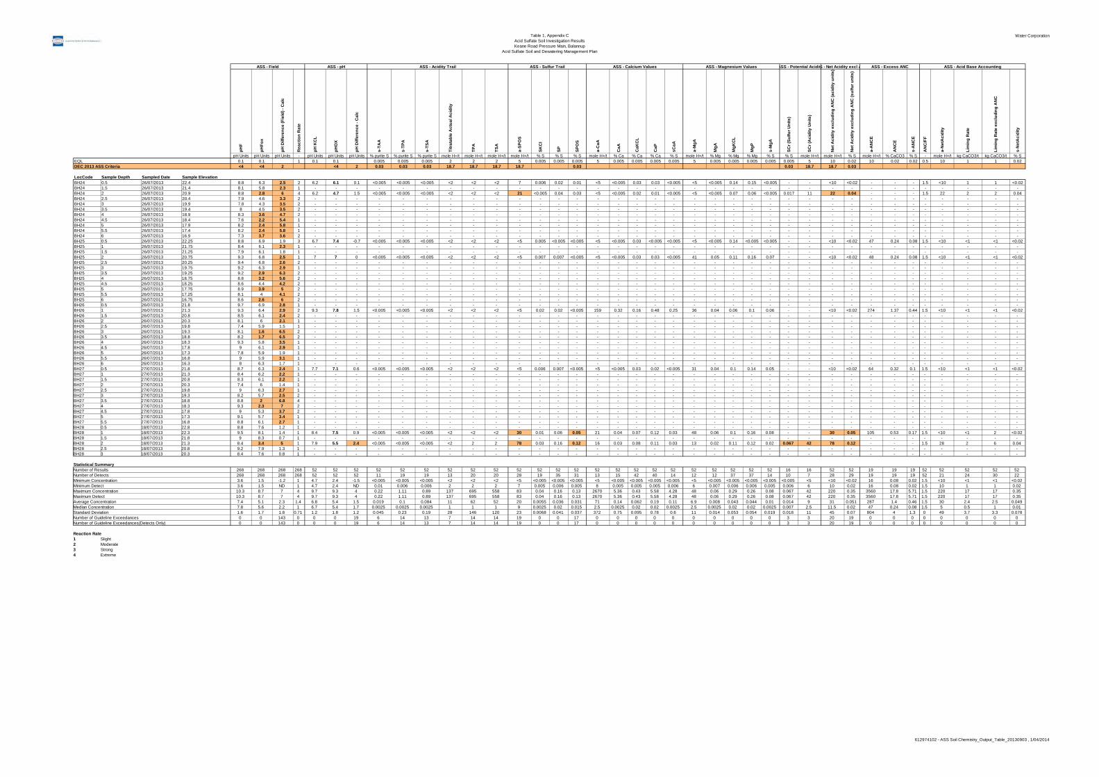
Table 1, Appendix CAcid Sulfate Soil Investigation ResultsKeane Road Pressure Main, Balannup
Acid Sulfate Soil and Dewatering Management Plan
Water Corporation
pH
F
pH
Fo
x
pH
Dif
fere
nc
e (
Fie
ld)
- C
alc
Re
ac
tio
n R
ate
pH
KC
L
pH
OX
pH
Dif
fere
nc
e -
Ca
lc
s-T
AA
s-T
PA
s-T
SA
Tit
rata
ble
Ac
tua
l Ac
idit
y
TP
A
TS
A
a-S
PO
S
SK
Cl
SP
SP
OS
a-C
aA
Ca
A
Ca
KC
L
Ca
P
sC
aA
a-M
gA
Mg
A
Mg
KC
L
Mg
P
s-M
gA
SC
r (S
ulf
ur
Un
its
)
SC
r (A
cid
ity
Un
its
)
Ne
t A
cid
ity
ex
clu
din
g A
NC
(a
cid
ity
un
its
)
Ne
t A
cid
ity
ex
clu
din
g A
NC
(s
ulf
ur
un
its
)
a-A
NC
E
AN
CE
s-A
NC
E
AN
C/F
F
a-N
etA
cid
ity
Lim
ing
Ra
te
Lim
ing
Ra
te e
xc
lud
ing
AN
C
s-N
etA
cid
ity
pH Units pH Units pH Units - pH Units pH Units pH Units % pyrite S % pyrite S % pyrite S mole H+/t mole H+/t mole H+/t mole H+/t % S % S % S mole H+/t % Ca % Ca % Ca % S mole H+/t % Mg % Mg % Mg % S % S mole H+/t mole H+/t % S mole H+/t % CaCO3 % S - mole H+/t kg CaCO3/t kg CaCO3/t % SEQL 0.1 0.1 1 0.1 0.1 0.005 0.005 0.005 2 2 2 5 0.005 0.005 0.005 5 0.005 0.005 0.005 0.005 5 0.005 0.005 0.005 0.005 0.005 5 10 0.02 10 0.02 0.02 0.5 10 1 1 0.02DEC 2013 ASS Criteria <4 <4 2 <4 2 0.03 0.03 0.03 18.7 18.7 18.7 18.7 0.03 0.03 18.7 18.7 0.03
LocCode Sample Depth Sampled Date Sample Elevation
ASS - Potential AcidityASS - Net Acidity excl ANC ASS - Excess ANC ASS - Acid Base AccountingASS - Field ASS - pH ASS - Acidity Trail ASS - Sulfur Trail ASS - Calcium Values ASS - Magnesium Values
BH24 0.5 26/07/2013 22.4 8.8 6.3 2.5 2 6.2 6.1 0.1 <0.005 <0.005 <0.005 <2 <2 <2 7 0.006 0.02 0.01 <5 <0.005 0.03 0.03 <0.005 <5 <0.005 0.14 0.15 <0.005 - - <10 <0.02 - - - 1.5 <10 1 1 <0.02BH24 1.5 26/07/2013 21.4 8.1 5.8 2.3 1 - - - - - - - - - - - - - - - - - - - - - - - - - - - - - - - - - - - BH24 2 26/07/2013 20.9 8.8 2.8 6 4 6.2 4.7 1.5 <0.005 <0.005 <0.005 <2 <2 <2 21 <0.005 0.04 0.03 <5 <0.005 0.02 0.01 <0.005 <5 <0.005 0.07 0.06 <0.005 0.017 11 22 0.04 - - - 1.5 22 2 2 0.04BH24 2.5 26/07/2013 20.4 7.9 4.6 3.3 2 - - - - - - - - - - - - - - - - - - - - - - - - - - - - - - - - - - - BH24 3 26/07/2013 19.9 7.8 4.3 3.5 2 - - - - - - - - - - - - - - - - - - - - - - - - - - - - - - - - - - - BH24 3.5 26/07/2013 19.4 8 4.5 3.5 2 - - - - - - - - - - - - - - - - - - - - - - - - - - - - - - - - - - - BH24 4 26/07/2013 18.9 8.3 3.6 4.7 2 - - - - - - - - - - - - - - - - - - - - - - - - - - - - - - - - - - - BH24 4.5 26/07/2013 18.4 7.6 2.2 5.4 1 - - - - - - - - - - - - - - - - - - - - - - - - - - - - - - - - - - - BH24 5 26/07/2013 17.9 8.2 2.4 5.8 1 - - - - - - - - - - - - - - - - - - - - - - - - - - - - - - - - - - - BH24 5.5 26/07/2013 17.4 8.2 2.4 5.8 1 - - - - - - - - - - - - - - - - - - - - - - - - - - - - - - - - - - - BH24 6 26/07/2013 16.9 7.3 3.7 3.6 2 - - - - - - - - - - - - - - - - - - - - - - - - - - - - - - - - - - - BH25 0.5 26/07/2013 22.25 8.8 6.9 1.9 3 6.7 7.4 -0.7 <0.005 <0.005 <0.005 <2 <2 <2 <5 0.005 <0.005 <0.005 <5 <0.005 0.03 <0.005 <0.005 <5 <0.005 0.14 <0.005 <0.005 - - <10 <0.02 47 0.24 0.08 1.5 <10 <1 <1 <0.02BH25 1 26/07/2013 21.75 8.4 6.1 2.3 1 - - - - - - - - - - - - - - - - - - - - - - - - - - - - - - - - - - - BH25 1.5 26/07/2013 21.25 7.9 6.1 1.8 1 - - - - - - - - - - - - - - - - - - - - - - - - - - - - - - - - - - - BH25 2 26/07/2013 20.75 9.3 6.8 2.5 1 7 7 0 <0.005 <0.005 <0.005 <2 <2 <2 <5 0.007 0.007 <0.005 <5 <0.005 0.03 0.03 <0.005 41 0.05 0.11 0.16 0.07 - - <10 <0.02 48 0.24 0.08 1.5 <10 <1 <1 <0.02BH25 2.5 26/07/2013 20.25 9.4 6.8 2.6 2 - - - - - - - - - - - - - - - - - - - - - - - - - - - - - - - - - - - BH25 3 26/07/2013 19.75 9.2 6.3 2.9 1 - - - - - - - - - - - - - - - - - - - - - - - - - - - - - - - - - - - BH25 3.5 26/07/2013 19.25 9.2 2.9 6.3 2 - - - - - - - - - - - - - - - - - - - - - - - - - - - - - - - - - - - BH25 4 26/07/2013 18.75 8.8 3.2 5.6 2 - - - - - - - - - - - - - - - - - - - - - - - - - - - - - - - - - - - BH25 4.5 26/07/2013 18.25 8.6 4.4 4.2 2 - - - - - - - - - - - - - - - - - - - - - - - - - - - - - - - - - - - BH25 5 26/07/2013 17.75 8.9 3.9 5 2 - - - - - - - - - - - - - - - - - - - - - - - - - - - - - - - - - - - BH25 5.5 26/07/2013 17.25 8.1 4 4.1 2 - - - - - - - - - - - - - - - - - - - - - - - - - - - - - - - - - - - BH25 6 26/07/2013 16.75 8.6 2.6 6 2 - - - - - - - - - - - - - - - - - - - - - - - - - - - - - - - - - - - BH26 0.5 26/07/2013 21.8 9.7 6.9 2.8 1 - - - - - - - - - - - - - - - - - - - - - - - - - - - - - - - - - - - BH26 1 26/07/2013 21.3 9.3 6.4 2.9 2 9.3 7.8 1.5 <0.005 <0.005 <0.005 <2 <2 <2 <5 0.02 0.02 <0.005 159 0.32 0.16 0.48 0.25 36 0.04 0.06 0.1 0.06 - - <10 <0.02 274 1.37 0.44 1.5 <10 <1 <1 <0.02BH26 1.5 26/07/2013 20.8 8.5 6.1 2.4 2 - - - - - - - - - - - - - - - - - - - - - - - - - - - - - - - - - - - BH26 2 26/07/2013 20.3 8.1 6 2.1 1 - - - - - - - - - - - - - - - - - - - - - - - - - - - - - - - - - - - BH26 2.5 26/07/2013 19.8 7.4 5.9 1.5 1 - - - - - - - - - - - - - - - - - - - - - - - - - - - - - - - - - - - BH26 3 26/07/2013 19.3 8.1 1.6 6.5 2 - - - - - - - - - - - - - - - - - - - - - - - - - - - - - - - - - - - BH26 3.5 26/07/2013 18.8 8.2 1.7 6.5 2 - - - - - - - - - - - - - - - - - - - - - - - - - - - - - - - - - - - BH26 4 26/07/2013 18.3 9.3 5.8 3.5 1 - - - - - - - - - - - - - - - - - - - - - - - - - - - - - - - - - - - BH26 4.5 26/07/2013 17.8 9 6.1 2.9 1 - - - - - - - - - - - - - - - - - - - - - - - - - - - - - - - - - - - BH26 5 26/07/2013 17.3 7.8 5.9 1.9 1 - - - - - - - - - - - - - - - - - - - - - - - - - - - - - - - - - - - BH26 5.5 26/07/2013 16.8 9 5.9 3.1 1 - - - - - - - - - - - - - - - - - - - - - - - - - - - - - - - - - - - BH26 6 26/07/2013 16.3 8 6.3 1.7 1 - - - - - - - - - - - - - - - - - - - - - - - - - - - - - - - - - - - BH27 0.5 27/07/2013 21.8 8.7 6.3 2.4 1 7.7 7.1 0.6 <0.005 <0.005 <0.005 <2 <2 <2 <5 0.006 0.007 <0.005 <5 <0.005 0.03 0.02 <0.005 31 0.04 0.1 0.14 0.05 - - <10 <0.02 64 0.32 0.1 1.5 <10 <1 <1 <0.02BH27 1 27/07/2013 21.3 8.4 6.2 2.2 1 - - - - - - - - - - - - - - - - - - - - - - - - - - - - - - - - - - - BH27 1.5 27/07/2013 20.8 8.3 6.1 2.2 1 - - - - - - - - - - - - - - - - - - - - - - - - - - - - - - - - - - - BH27 2 27/07/2013 20.3 7.4 6 1.4 1 - - - - - - - - - - - - - - - - - - - - - - - - - - - - - - - - - - - BH27 2.5 27/07/2013 19.8 9 6.3 2.7 1 - - - - - - - - - - - - - - - - - - - - - - - - - - - - - - - - - - - BH27 3 27/07/2013 19.3 8.2 5.7 2.5 2 - - - - - - - - - - - - - - - - - - - - - - - - - - - - - - - - - - - BH27 3.5 27/07/2013 18.8 8.8 2 6.8 4 - - - - - - - - - - - - - - - - - - - - - - - - - - - - - - - - - - - BH27 4 27/07/2013 18.3 9.3 2.3 7 2 - - - - - - - - - - - - - - - - - - - - - - - - - - - - - - - - - - - BH27 4.5 27/07/2013 17.8 9 5.3 3.7 2 - - - - - - - - - - - - - - - - - - - - - - - - - - - - - - - - - - - BH27 5 27/07/2013 17.3 9.1 5.7 3.4 1 - - - - - - - - - - - - - - - - - - - - - - - - - - - - - - - - - - - BH27 5.5 27/07/2013 16.8 8.8 6.1 2.7 1 - - - - - - - - - - - - - - - - - - - - - - - - - - - - - - - - - - - BH28 0.5 18/07/2013 22.8 8.8 7.6 1.2 1 - - - - - - - - - - - - - - - - - - - - - - - - - - - - - - - - - - - BH28 1 18/07/2013 22.3 9.5 8.1 1.4 1 8.4 7.5 0.9 <0.005 <0.005 <0.005 <2 <2 <2 30 0.01 0.06 0.05 21 0.04 0.07 0.12 0.03 48 0.06 0.1 0.16 0.08 - - 30 0.05 105 0.53 0.17 1.5 <10 <1 2 <0.02BH28 1.5 18/07/2013 21.8 9 8.3 0.7 1 - - - - - - - - - - - - - - - - - - - - - - - - - - - - - - - - - - - BH28 2 18/07/2013 21.3 8.4 3.4 5 1 7.9 5.5 2.4 <0.005 <0.005 <0.005 <2 2 2 78 0.03 0.16 0.12 16 0.03 0.08 0.11 0.03 13 0.02 0.11 0.12 0.02 0.067 42 78 0.12 - - - 1.5 28 2 6 0.04BH28 2.5 18/07/2013 20.8 9.2 7.9 1.3 1 - - - - - - - - - - - - - - - - - - - - - - - - - - - - - - - - - - - BH28 3 18/07/2013 20.3 8.4 7.6 0.8 1 - - - - - - - - - - - - - - - - - - - - - - - - - - - - - - - - - - -
Statistical SummaryNumber of Results 268 268 268 268 52 52 52 52 52 52 52 52 52 52 52 52 52 52 52 52 52 52 52 52 52 52 52 16 16 52 52 19 19 19 52 52 52 52 52Number of Detects 268 268 268 268 52 52 52 11 19 19 13 20 20 28 19 35 31 13 15 42 40 14 12 12 37 37 14 10 7 28 29 19 19 19 52 21 24 30 22Minimum Concentration 3.6 1.5 -1.2 1 4.7 2.4 -1.5 <0.005 <0.005 <0.005 <2 <2 <2 <5 <0.005 <0.005 <0.005 <5 <0.005 <0.005 <0.005 <0.005 <5 <0.005 <0.005 <0.005 <0.005 <0.005 <5 <10 <0.02 16 0.08 0.02 1.5 <10 <1 <1 <0.02Minimum Detect 3.6 1.5 ND 1 4.7 2.4 ND 0.01 0.006 0.006 2 2 2 7 0.005 0.006 0.005 8 0.005 0.005 0.005 0.006 6 0.007 0.006 0.006 0.005 0.006 6 10 0.02 16 0.08 0.02 1.5 10 1 1 0.02Maximum Concentration 10.3 8.7 7 4 9.7 9.3 4 0.22 1.11 0.89 137 695 558 83 0.04 0.16 0.13 2670 5.36 0.43 5.58 4.28 48 0.06 0.29 0.26 0.08 0.067 42 220 0.35 3560 17.8 5.71 1.5 220 17 17 0.35Maximum Detect 10.3 8.7 7 4 9.7 9.3 4 0.22 1.11 0.89 137 695 558 83 0.04 0.16 0.13 2670 5.36 0.43 5.58 4.28 48 0.06 0.29 0.26 0.08 0.067 42 220 0.35 3560 17.8 5.71 1.5 220 17 17 0.35Average Concentration 7.4 5.1 2.3 1.4 6.8 5.4 1.5 0.019 0.1 0.084 11 62 52 20 0.0055 0.036 0.031 71 0.14 0.062 0.19 0.11 6.9 0.008 0.043 0.044 0.01 0.014 9 31 0.051 287 1.4 0.46 1.5 30 2.4 2.5 0.049Median Concentration 7.8 5.6 2.2 1 6.7 5.4 1.7 0.0025 0.0025 0.0025 1 1 1 9 0.0025 0.02 0.015 2.5 0.0025 0.02 0.02 0.0025 2.5 0.0025 0.02 0.02 0.0025 0.007 2.5 11.5 0.02 47 0.24 0.08 1.5 5 0.5 1 0.01Standard Deviation 1.6 1.7 1.8 0.71 1.2 1.8 1.2 0.045 0.23 0.19 28 146 120 23 0.0068 0.041 0.037 372 0.75 0.095 0.78 0.6 11 0.014 0.053 0.054 0.019 0.018 11 45 0.07 804 4 1.3 0 49 3.7 3.3 0.078Number of Guideline Exceedances 0 0 143 0 0 0 19 6 14 13 7 14 14 19 0 0 17 0 0 0 0 0 0 0 0 0 0 3 3 20 19 0 0 0 0 0 0 0 0Number of Guideline Exceedances(Detects Only) 0 0 143 0 0 0 19 6 14 13 7 14 14 19 0 0 17 0 0 0 0 0 0 0 0 0 0 3 3 20 19 0 0 0 0 0 0 0 0
Reaction Rate1 Slight2 Moderate3 Strong4 Extreme
612974102 - ASS Soil Chemistry_Output_Table_20130903 , 1/04/2014
Table 2, Appendix CAcid Sulfate Soil Investigation ResultsKeane Road Pressure Main, Balannup
Acid Sulfate Soil and Dewatering Management Plan
Water Corporation
Acidity
Ele
ctri
cal c
on
du
ctiv
ity
*(la
b)
pH
(L
ab)
Su
lph
ide
To
tal D
isso
lved
So
lids
Am
mo
nia
as
N
Kje
ldah
l Nit
rog
en T
ota
l
Nit
rog
en (
To
tal O
xid
ised
)
Nit
rog
en (
To
tal)
Ph
osp
ho
rus
Rea
ctiv
e P
ho
sph
oru
s as
P
Cal
ciu
m (
Filt
ered
)
Ch
lori
de
Mag
nes
ium
(F
ilter
ed)
Po
tass
ium
(F
ilter
ed)
So
diu
m (
Filt
ered
)
Su
lph
ate
(Filt
ered
)
Aci
dit
y as
CaC
O3
Alk
alin
ity
(Bic
arb
on
ate
as C
aCO
3)
Alk
alin
ity
(Hyd
roxi
de)
as
CaC
O3
Alk
alin
ity
(to
tal)
as
CaC
O3
Car
bo
nat
e A
lkal
init
y as
CaC
O3
Alu
min
ium
Alu
min
ium
(F
ilter
ed)
Ars
enic
(F
ilter
ed)
Cad
miu
m (
Filt
ered
)
Ch
rom
ium
(III
+V
I) (
Filt
ered
)
Co
bal
t (F
ilter
ed)
Co
pp
er (
Filt
ered
)
Iro
n
Iro
n (
Filt
ered
)
Lea
d (
Filt
ered
)
Man
gan
ese
(Filt
ered
)
Nic
kel (
Filt
ered
)
Sel
eniu
m (
Filt
ered
)
Zin
c (F
ilter
ed)
uS/cm pH Units mg/L mg/L µg/L mg/L mg/L µg/L mg/L mg/L mg/L mg/L mg/L mg/L mg/L mg/L mg/L mg/L mg/L mg/L mg/L mg/L mg/L mg/L mg/L mg/L mg/L mg/L mg/L mg/L mg/L mg/L mg/L mg/L mg/LEQL 1 0.01 0.1 10 10 0.1 0.01 100 0.01 0.01 1 1 1 1 1 1 1 1 1 1 1 0.01 0.01 0.001 0.0001 0.001 0.001 0.001 0.05 0.05 0.001 0.001 0.001 0.01 0.005ANZECC 2000 Freshwater 2632 0.027 0.027 0.00006 0.00001 0.001 0.001 1.2 0.008 0.005 0.0024ANZECC 2000 Short-term Irrigation 25000 20 20 2 0.05 1 0.1 5 10 10 10 10 2 0.05 5
Field_ID Date Lab Report NumberBH01 12/08/2013 EP1306149 531 7.43 0.2 398 50 1.2 6.52 7700 <0.05 0.01 84 30 11 6 29 55 22 199 <1 199 <1 0.51 0.08 <0.001 <0.0001 <0.001 <0.001 0.002 0.6 0.08 0.002 0.015 <0.001 <0.01 <0.005BH03 12/08/2013 EP1306149 652 6.09 <0.1 570 880 4.8 12.2 17,000 0.33 0.25 58 80 14 18 51 104 113 100 <1 100 <1 1.42 0.35 0.001 <0.0001 <0.001 0.001 <0.001 1.01 0.6 <0.001 0.086 0.001 <0.01 0.007BH06/N 12/08/2013 EP1306149 10,800 6.84 2.4 9880 140 5 <0.05 5000 0.4 <0.01 47 3470 149 12 1940 146 101 415 <1 415 <1 68.7 0.11 0.002 <0.0001 0.005 0.003 0.001 32.1 1.32 0.001 0.591 0.004 <0.01 <0.005BH08 12/08/2013 EP1306149 173 5.83 <0.1 212 60 1.4 0.28 1700 0.04 <0.01 10 23 3 1 25 57 30 11 <1 11 <1 0.68 0.2 <0.001 <0.0001 0.002 <0.001 0.002 2.66 1.74 <0.001 0.024 0.003 <0.01 0.025BH10 13/08/2013 EP1306178 852 7.31 <0.1 1520 60 10.1 0.1 10,200 0.83 <0.01 11 101 15 2 165 52 40 274 <1 274 <1 184 0.85 0.002 <0.0001 0.001 <0.001 0.005 52.6 0.42 0.001 0.025 0.002 <0.01 0.008BH11 13/08/2013 EP1306178 1580 7.84 <0.1 2180 20 0.9 0.02 900 0.16 <0.01 16 64 22 2 353 84 20 702 <1 702 <1 16.7 0.01 0.003 <0.0001 <0.001 0.001 0.003 18.5 <0.05 <0.001 0.151 0.004 <0.01 <0.005BH12 13/08/2013 EP1306178 628 7.15 <0.1 600 50 4.2 4.31 8500 0.31 <0.01 67 38 20 2 43 97 36 167 <1 167 <1 26.1 0.81 0.004 <0.0001 0.004 0.002 0.006 76 1.07 0.004 0.091 0.006 <0.01 0.008BH13 13/08/2013 EP1306178 375 6.3 <0.1 760 20 9 0.13 9100 8.17 <0.01 13 65 6 6 54 54 98 18 <1 18 <1 540 0.04 <0.001 <0.0001 <0.001 0.005 0.002 9.52 0.23 <0.001 0.097 <0.001 <0.01 <0.005BH28 13/08/2013 EP1306178 20,800 7.12 <0.1 14,300 200 2.7 <0.01 2700 0.1 <0.01 97 7940 478 17 4640 727 65 368 <1 368 <1 3.21 0.02 0.002 <0.0001 0.006 0.014 0.006 9.78 3.79 <0.001 1.5 0.021 <0.01 0.024
Statistical SummaryNumber of Results 9 9 9 9 9 9 9 9 9 9 9 9 9 9 9 9 9 9 9 9 9 9 9 9 9 9 9 9 9 9 9 9 9 9 9Number of Detects 9 9 2 9 9 9 7 9 8 2 9 9 9 9 9 9 9 9 0 9 0 9 9 6 0 5 6 8 9 8 4 9 7 0 5Minimum Concentration 173 5.83 <0.1 212 20 0.9 <0.01 900 0.04 <0.01 10 23 3 1 25 52 20 11 <1 11 <1 0.51 0.01 <0.001 <0.0001 <0.001 <0.001 <0.001 0.6 <0.05 <0.001 0.015 <0.001 <0.01 <0.005Minimum Detect 173 5.83 0.2 212 20 0.9 0.02 900 0.04 0.01 10 23 3 1 25 52 20 11 ND 11 ND 0.51 0.01 0.001 ND 0.001 0.001 0.001 0.6 0.08 0.001 0.015 0.001 ND 0.007Maximum Concentration 20,800 7.84 2.4 14,300 880 10.1 12.2 17,000 8.17 0.25 97 7940 478 18 4640 727 113 702 <1 702 <1 540 0.85 0.004 <0.0001 0.006 0.014 0.006 76 3.79 0.004 1.5 0.021 <0.01 0.025Maximum Detect 20,800 7.84 2.4 14,300 880 10.1 12.2 17,000 8.17 0.25 97 7940 478 18 4640 727 113 702 ND 702 ND 540 0.85 0.004 ND 0.006 0.014 0.006 76 3.79 0.004 1.5 0.021 ND 0.025Average Concentration 4043 6.9 0.33 3380 164 4.4 2.6 6978 1.2 0.033 45 1312 80 7.3 811 153 58 250 0.5 250 0.5 93 0.27 0.0017 0.00005 0.0022 0.0031 0.0031 23 1 0.0012 0.29 0.0047 0.005 0.0091Median Concentration 652 7.12 0.05 760 60 4.2 0.13 7700 0.31 0.005 47 65 15 6 54 84 40 199 0.5 199 0.5 16.7 0.11 0.002 0.00005 0.001 0.001 0.002 9.78 0.6 0.0005 0.091 0.003 0.005 0.007Standard Deviation 7129 0.67 0.78 5097 275 3.3 4.3 5064 2.6 0.081 34 2730 156 6.7 1563 218 37 221 0 221 0 178 0.33 0.0012 0 0.0022 0.0044 0.0021 26 1.2 0.0012 0.49 0.0064 0 0.0091Number of Guideline Exceedances 0 0 0 0 0 0 0 0 0 0 0 0 0 0 0 0 0 0 0 0 0 9 7 0 9 9 0 7 4 0 2 1 1 9 9Number of Guideline Exceedances(Detects Only) 0 0 0 0 0 0 0 0 0 0 0 0 0 0 0 0 0 0 0 0 0 9 7 0 0 5 0 7 4 0 2 1 1 0 5
Inorganics Nutrients Major Ions Alkalinity Metals
61/29471Balanup PS Upgrade and Pressure Main
Groundwater Lab Chemistry Results

GHD | Report for Water Corporation - Keane Road Pressure Main, Balannup, 61/29471 |
Appendix D – Dewatering Schematic
Example of Dewatering Treatment System
Pump
Aerator/Spray to assist with precipitation of dissolved metals.
GROUNDWATER ABSTRACTION
Impermeable Settlement Basin.
Above ground (sea container), above ground and/or below ground bunded area subject to ground conditions.
Monitoring Point 1
Bunded infiltration area
Bunded area can be constructed of soil bunding for containment. Topsoil should be removed prior to construction to assist with infiltration capacity.
GROUND SURFACE
Rising water overflows into second chamber allowing longer settlement time
Geotextile Installation Notes
Geotextile only installed if effluent exceeds STI guideline post-retention (Principal’s Environmental Consultant to advise when/if required.
Geotextile (pore size <0.3 mm) must be installed where either at:
1. At the base of the bunded discharge point OR
2. Within the large settlement tanks to filter for high total Al and/or Fe .metal content within the groundwater.
Notes:
It is the responsibility of the Contractor to construct and maintain adequate capacity bunded discharge area(s) during dewatering.
Lime Dosing Unit (LDU) is required if the pH is less than 6.00.
Schematic is not to scale and is a guide for treatment systems only.
LDU
Monitoring Point 2
Rising water overflows into second chamber allowing longer settlement time

GHD | Report for Water Corporation - Keane Road Pressure Main, Balannup, 61/29471 |
Appendix E – Contractor Daily Record Sheets

pH EC (µS/cm) TTA (mg/L) TTAlk (mg/L) pH EC (µS/cm) TTA (mg/L) TTAlk (mg/L)
Daily Total Volume of Dewatering Effluent (kL)
Water Quality Meter Calibrated?
Dewatering effluent pH is to remain >pH 6.75 and acidity is to be below 40 mg/L. If water quality falls 'outside' the aforementioned criteria, the Superintentendent's Representative (Water Corporation) and the nominated Environmental Consultant should be notified immediately.
DEWATERING FIELD RECORD SHEET
kg of Lime used Comments (filtered for acidity/alkalinity) / observations (colour, sediment load, odour)Aeration/Settlement Tank in use? Inc geotextile fabric?Flow rate (L/s)Date Time
Monitoring Point 1 (Before Treatment) Monitorign point 2 (After Treatment)
Discharge Location
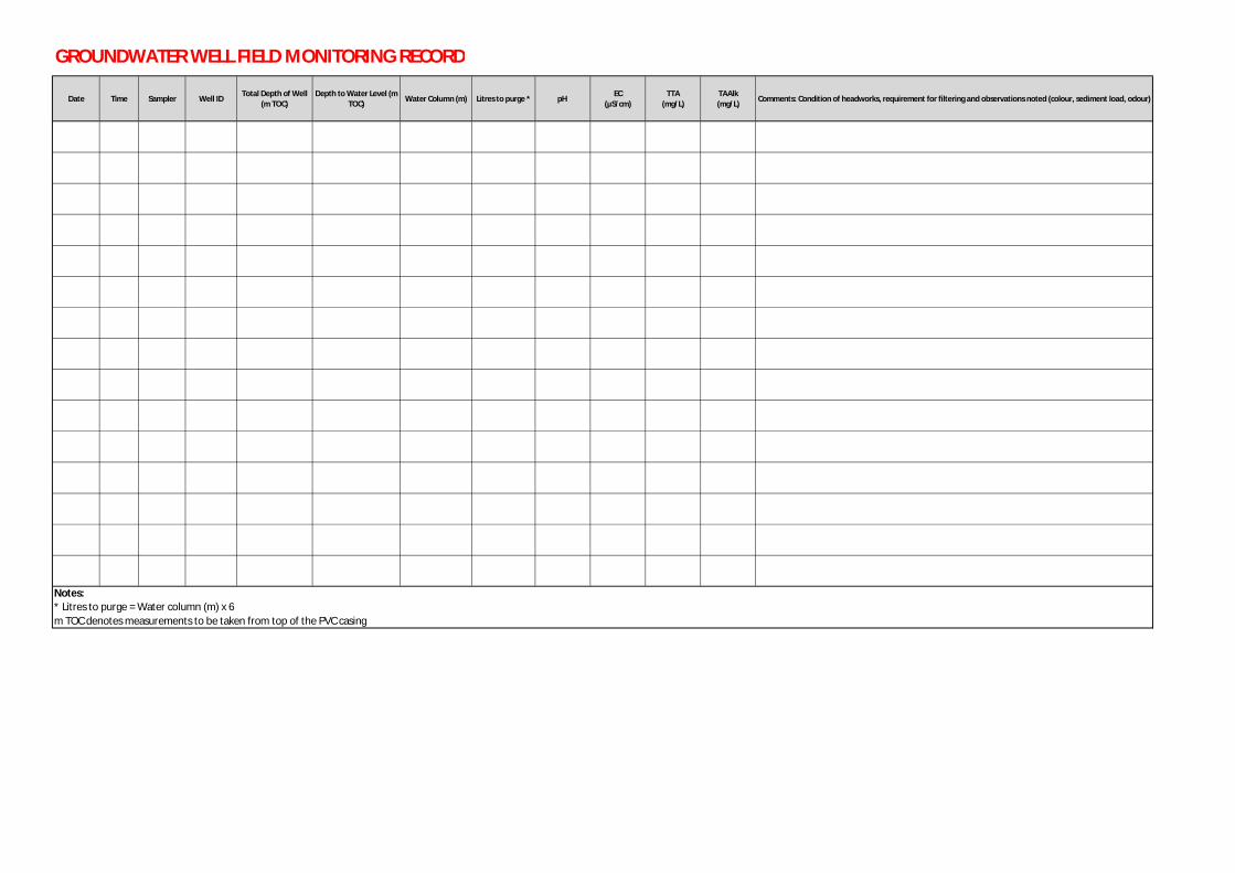
GROUNDWATER WELL FIELD MONITORING RECORD
Date Time Sampler Well IDTotal Depth of Well
(m TOC)Depth to Water Level (m
TOC) Water Column (m) Litres to purge * pH EC
(µS/cm)TTA
(mg/L)TAAlk (mg/L) Comments: Condition of headworks, requirement for filtering and observations noted (colour, sediment load, odour)
Notes: * Litres to purge = Water column (m) x 6m TOC denotes measurements to be taken from top of the PVC casing

Contractor:
Acid Sulfate Soil Stockpile Report
Comments Onsite Person Responsible
Stockpile #
Stockpile Location
Where has the material come from?
When was it first excavated?
What is the volume of the stockpile?
How much ag-lime is needed?
What date was it treated / mixed?
What date was it tested?
Where has it been used for backfill?


www.ghd.com