DP2 ES Chapter 5 Flora and Fauna - iema.net Parrett... · this method. This will involve dredging...
19
River Parrett Dredge – Northmoor Pump Station to Linden Farm: Non-Technical Summary v Non-Technical Summary Introduction This non-technical summary (NTS) describes the findings of an Environmental Impact Assessment (EIA) into the likely significant effects of the River Parrett Dredge - Northmoor Pump Station to Linden Farm (NPS-LF). It provides a description of the existing environment, the likely environmental impacts and the measures which will be implemented to avoid or reduce further impact. This NTS is available to view both as a standalone document, and as part of the Environmental Statement which provides a comprehensive record of the EIA. The locations for the proposed dredging works are shown in Figure 1. Background During the winter of 2013/14 an unprecedented period of prolonged wet weather and subsequent flooding led to over 150 properties and over 11,000 hectares of agricultural land being severely flooded (Plate 1). Over 200 homes in several communities, such as Muchelney, Oath and Thorney were cut off with some unable to return to their homes over a year later. There was major disruption to transport; with several roads, including A-Roads (most notably the A361) impassable, as well as strategic rail routes (i.e. the Taunton to Bristol Rail Line). In order to alleviate the problem and reduce the probability of such scenes reoccurring in future it was decided, as part of a series of measures, to improve the channel capacity of the Rivers Parrett and Tone from downstream of Hook Bridge on the River Tone to Northmoor Pump Station on the River Parrett. Therefore, after the flooding subsided in 2014, approximately 130,000m 3 of silt was removed along this 8km stretch of river and the dredged arisings were reapplied back onto productive farmland or used to reinstate the embankment heights to improve the standard of flood protection. This work, known as the ‘8km Rivers Parrett and Tone Dredge’, was completed in October 2014. Plate 1: Flooding During the Winter of 2013/14
-
Upload
nguyennhan -
Category
Documents
-
view
215 -
download
2
Transcript of DP2 ES Chapter 5 Flora and Fauna - iema.net Parrett... · this method. This will involve dredging...

River Parrett Dredge – Northmoor Pump Station to Linden Farm: Non-Technical Summary v
Non-Technical Summary
Introduction
This non-technical summary (NTS) describes the findings of an Environmental Impact Assessment (EIA) into the likely significant effects of the River Parrett Dredge - Northmoor Pump Station to Linden Farm (NPS-LF). It provides a description of the existing environment, the likely environmental impacts and the measures which will be implemented to avoid or reduce further impact. This NTS is available to view both as a standalone document, and as part of the Environmental Statement which provides a comprehensive record of the EIA.
The locations for the proposed dredging works are shown in Figure 1.
Background
During the winter of 2013/14 an unprecedented period of prolonged wet weather and subsequent flooding led to over 150 properties and over 11,000 hectares of agricultural land being severely flooded (Plate 1). Over 200 homes in several communities, such as Muchelney, Oath and Thorney were cut off with some unable to return to their homes over a year later. There was major disruption to transport; with several roads, including A-Roads (most notably the A361) impassable, as well as strategic rail routes (i.e. the Taunton to Bristol Rail Line).
In order to alleviate the problem and reduce the probability of such scenes reoccurring in future it was decided, as part of a series of measures, to improve the channel capacity of the Rivers Parrett and Tone from downstream of Hook Bridge on the River Tone to Northmoor Pump Station on the River Parrett. Therefore, after the flooding subsided in 2014, approximately 130,000m3 of silt was removed along this 8km stretch of river and the dredged arisings were reapplied back onto productive farmland or used to reinstate the embankment heights to improve the standard of flood protection. This work, known as the ‘8km Rivers Parrett and Tone Dredge’, was completed in October 2014.
Plate 1: Flooding During the Winter of 2013/14

River Parrett Dredge – Northmoor Pump Station to Linden Farm: Non-Technical Summary vi
In January 2015, the Somerset Rivers Authority (SRA) was launched, with funding from the Department of Environment, Food and Rural Affairs (Defra) as part of the Somerset Levels and Moors Flood Action Plan. Following completion of the 8km Rivers Parrett and Tone Dredge the Environment Agency, on behalf of the SRA, investigated a number of potential further dredging locations. The site showing the next greatest physical benefit to people and property was a section immediately downstream of the 8km Rivers Parrett and Tone Dredge. The Environment Agency is now working on behalf of the SRA on this next dredge and is proposing dredging approximately 750m downstream from Northmoor Pump Station to Linden Farm (towards Bridgwater): see Figure 1. These works will aim to further reduce the depth, frequency and duration of flood events and their associated disruption.
The Proposed Scheme
The proposed scheme is to remove the silt that has accumulated along an approximately 750m stretch of the River Parrett, located on the Somerset Levels and Moors. The section of the River Parrett identified for dredging is immediately downstream of previous dredging works undertaken in 2014. The proposed works include:
Increasing flow capacity by generally dredging a single bank. Approximately 14,000m3 of silt will be removed in order to increase the channel capacity to up to 70m2 where physical and environmental constraints allow. The dredge will provide improvements to conveyance, whilst minimising ecological impacts where possible (see ‘Our Approach’).
Dredging will be undertaken once all environmental licences and permits are in place, and programmed maintenance dredging immediately upstream on the River Parrett has been completed. Works are currently programmed between March 2016 and August 2016, however the speed of progress will be determined by the weather, river levels and the actual quantity of silt to be removed (which has currently been estimated from surveys).
The benefits are expected to last up to 5 years depending on the number of large tidal events and any future interventions such as maintenance dredging.
For the purposes of the EIA, a 1km stretch of the River Parrett has been assessed, so that where feasible with regards to time, financial, environmental and safety constraints, the length of the river to be dredged may be increased to maximise the benefits.
Method of Dredging and Spreading
As this section of the river is tidally influenced, it will be possible to work through any season as the river channel is only full for short periods of time. The contractor will still need to adapt to the combination of weather, tide and flow conditions which means dredging might not be continuous and hours of works may be irregular.
Surveys have been undertaken to inform the extent of dredging required. It is estimated that approximately 14,000m3 of material requires removal in order to achieve the desired flow area. This will be achieved by generally only dredging one bank at any location. All dredging works will be undertaken by mechanical plant, either from pontoons within the river or, along a short length (less than 150m), from the river bank.
River Parrett Dredge – Northmoor Pump Station to Linden Farm: Non-Technical Summary vii
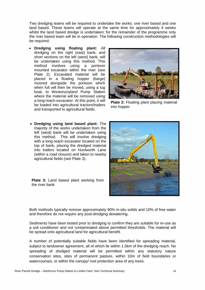
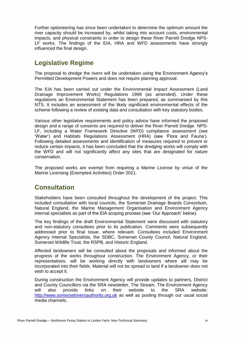
Two dredging teams will be required to undertake the works; one river based and one land based. These teams will operate at the same time for approximately 4 weeks whilst the land based dredge is undertaken; for the remainder of the programme only the river based team will be in operation. The following construction methodologies will be required:
Dredging using floating plant: All dredging on the right (east) bank, and short sections on the left (west) bank, will be undertaken using this method. This method involves using a pontoon mounted excavator within the river (see Plate 2). Excavated material will be placed in a floating hopper (barge) moored alongside the pontoon which when full will then be moved, using a tug boat, to Westonzoyland Pump Station where the material will be removed using a long-reach excavator. At this point, it will be loaded into agricultural tractors/trailers and transported to agricultural fields.
Dredging using land based plant: The majority of the works undertaken from the left (west) bank will be undertaken using this method. This will involve dredging with a long-reach excavator located on the top of bank, placing the dredged material into trailers located on Huntworth Lane (within a road closure) and taken to nearby agricultural fields (see Plate 3).
Both methods typically remove approximately 90% in-situ solids and 10% of free water and therefore do not require any post-dredging dewatering.
Sediments have been tested prior to dredging to confirm they are suitable for re-use as a soil conditioner and not contaminated above permitted thresholds. The material will be spread onto agricultural land for agricultural benefit.
A number of potentially suitable fields have been identified for spreading material,
subject to landowner agreement, all of which lie within 1.5km of the dredging reach. No
spreading of dredged material will be permitted within any statutory nature
conservation sites, sites of permanent pasture, within 10m of field boundaries or
watercourses, or within the canopy/ root protection area of any trees.
Plate 2: Floating plant placing material into hopper
Plate 3: Land based plant working from the river bank

River Parrett Dredge – Northmoor Pump Station to Linden Farm: Non-Technical Summary viii
There may be a requirement to temporarily stockpile the material in the short-term if ground conditions or the dredged material is too wet to allow ploughing in to surrounding land or to suit cropping regimes or other landowner requirements. If stockpiles are required, these will be restricted to 2m in height and be located 25m away from residential properties and 10m away from PRoWs to minimise adverse impacts on views. The requirement for stockpiles will form part of the environmental permit consent and does not require planning permission for change of use.
If material is identified as not suitable for re-use as soil conditioner it will be transported by lorry to landfill in accordance with relevant regulations. Alternatively, depending on the contamination type and levels, the material could be re-used locally under a “use of waste in construction” exemption.
Alternative Options Considered
Dredging forms a key component of the ‘Somerset Levels and Moors Flood Action Plan - A 20 year plan for a sustainable future (2014)’. In particular, the plan refers explicitly to the need to review the effectiveness and identify the locations of further dredging across the Levels and Moors (i.e. in addition to the 8km Rivers Parrett and Tone Dredge in 2014).
It is envisaged that dredging will be undertaken in tandem with other interventions, such as pumping station improvements, to reduce the frequency, duration and extent of flooding for Curry Moor, Hay Moor, Salt Moor and North Moor.
The Environment Agency on behalf of the SRA investigated the effectiveness of dredging elsewhere, with involvement from the local community and the Parrett and Axe Brue Internal Drainage Boards. A further ten potential dredging sites were identified and assessed in more detail. It was concluded that dredging of the River Parrett immediately downstream of Northmoor Pump Station would provide the greatest physical benefit to people and property. The proposed works between Northmoor Pump Station and Linden Farm comprise the upper part of this section; this provides continuity with the upstream 8km Rivers Parrett and Tone Dredge.
Plate 4: Material being spread on agricultural fields, following short-term stockpiling (where necessary)
River Parrett Dredge – Northmoor Pump Station to Linden Farm: Non-Technical Summary ix
Further optioneering has since been undertaken to determine the optimum amount the river capacity should be increased by, whilst taking into account costs, environmental impacts, and physical constraints in order to design these River Parrett Dredge NPS-LF works. The findings of the EIA, HRA and WFD assessments have strongly influenced the final design.
Legislative Regime
The proposal to dredge the rivers will be undertaken using the Environment Agency’s Permitted Development Powers and does not require planning approval.
The EIA has been carried out under the Environmental Impact Assessment (Land Drainage Improvement Works) Regulations 1999 (as amended). Under these regulations an Environmental Statement has been prepared, as summarised by this NTS. It includes an assessment of the likely significant environmental effects of the scheme following a review of existing data and consultation with key statutory bodies.
Various other legislative requirements and policy advice have informed the proposed design and a range of consents are required to deliver the River Parrett Dredge NPS-LF, including a Water Framework Directive (WFD) compliance assessment (see ‘Water’) and Habitats Regulations Assessment (HRA) (see ‘Flora and Fauna’). Following detailed assessments and identification of measures required to prevent or reduce certain impacts, it has been concluded that the dredging works will comply with the WFD and will not significantly affect any sites that are designated for nature conservation.
The proposed works are exempt from requiring a Marine License by virtue of the Marine Licensing (Exempted Activities) Order 2011.
Consultation
Stakeholders have been consulted throughout the development of the project. This included consultation with local councils, the Somerset Drainage Boards Consortium, Natural England, the Marine Management Organisation and Environment Agency internal specialists as part of the EIA scoping process (see ‘Our Approach’ below).
The key findings of the draft Environmental Statement were discussed with statutory and non-statutory consultees prior to its publication. Comments were subsequently addressed prior to final issue, where relevant. Consultees included Environment Agency Internal Specialists, the SDBC, Somerset County Council, Natural England, Somerset Wildlife Trust, the RSPB, and Historic England.
Affected landowners will be consulted about the proposals and informed about the progress of the works throughout construction. The Environment Agency, or their representatives, will be working directly with landowners where silt may be incorporated into their fields. Material will not be spread to land if a landowner does not wish to accept it.
During construction the Environment Agency will provide updates to partners, District and County Councillors via the SRA newsletter, The Stream. The Environment Agency will also provide links on their website to the SRA website: http://www.somersetriversauthority.org.uk as well as posting through our usual social media channels.

River Parrett Dredge – Northmoor Pump Station to Linden Farm: Non-Technical Summary x
Our Approach
We have undertaken scoping to identify which environmental receptors could potentially be affected by the proposal and therefore needed to be included in the EIA.
The receptors scoped-in are:
Population Landscape Character and Visual Amenity
Land Use Historic Environment
Flora and Fauna Traffic and Transport
Water
Cumulative Effects (with known plans, developments or projects within the vicinity)
We scoped out of the assessment any environmental receptors that where considered, by expert opinion, not to be significantly affected by the development. The receptors scoped-out are:
Noise and Vibration (effects on Flora and Fauna and local population have been assessed under other receptors)
Waste (effects of waste disposal have been assessed under other receptors)
Air Quality Soils and Geology (agricultural soils are considered under Land Use)
The EIA (and related environmental assessments such as the HRA and WFD) has influenced the development of the proposed design and the working method, as well as developing mitigation that will be undertaken to ensure that any environmental effects are minimised as far as possible, whilst still achieving the scheme objectives. The final design has included the following measures to minimise environmental impacts:
dredging predominantly only on one bank
retaining a low-level berm 0.5m above bed level
leaving rough rather than smooth banks
avoiding or minimising dredging of the upper bank where it does not contribute to the target flow area as far as possible (this would typically leave 2-4m of bankside habitat undisturbed including the flood defence embankment).

Floating plant (RB)- assumed
Floatingplant (LB)
PROPOSED OFF-LOADING POINTAT WESTONZOYLANDPUMPING STATION
Floatingplant (LB)
Floatingplant (LB)
Landbased plant (LB) Floating
plant (RB)
P:\190
596 Pa
rrett D
redge
Phase
2\100_
GIS\10
8_Work
spaces
\2_Iss
ue_Ma
ps\190
596-B
VL-Z 0
-X X-M
X -V-00
150.P0
1.mxd
mic7
6267
29/01
/2016
Project:
Drawing title:
Drawing scale:
Drawing no.
Sheet size:
Revision
Client Drawing No. Revision
ClientDesigned by:
T he limits, including the height and depths of the Work s, shown inthis drawing are not to be tak en as limiting the obligations of thecontractor under Contract.
Note:
@ A3
190596-BVL -Z 0-X X -DR-V-00150 P01
FIGU RE 1PROPOSED CONST RU CT IONWORKS AND MET HODOL OGY
Date:
© Copyright Black & Veatch L td. 2016
Reproduced by permission of Ordnance Survey on behalf of HMSO.© Crown copyright and database rights 2016. Ordnance Survey L icence number 100026380
1:10,000 A3
Print Version: Print Quality (300dpi @ A3)
0 100 200 300 400 500Metres
Designed by:
Rev Drawn Chkd Rvwd Apprvd Date Description
Date:MMG JAN 2016
P01 MMG
REGISTERED OFFICE: COWLEY BUSINESS PARK, COWLEY, UXBRIDGE, MIDDLESEX, UB8 2AL, UKREGISTERED IN ENGLAND AND WALES: COMPANY NO. 08584398
SCALE 1:10,000
RIVER PARRET T DREDGE –NORT HMOOR PU MP ST AT ION T O L INDEN FARM
L EGEND:PROPOSED SECT ION OFWAT ERCOU RSE T O BEDREDGED (750M)ADDIT IONAL 250MASSESSED
PROPOSED L IKEL YACCESS ROU T ECOMPOU ND
PROPOSED EX T ENT ANDMET HOD OF DREDGINGRB = RIGHT BANKL B = L EFT BANK
POT ENT IAL DEPL OY MENTFIEL D (SU BJECT T OL ANDOWNER AGREEMENTAND SAMPL ING)
L D ES 29/01/2016 SU IT ABL EFOR INFORMAT IONFS

River Parrett Dredge – Northmoor Pump Station to Linden Farm: Non-Technical Summary xii
Left blank for double sided printing.

!(
!(
!(
!(
!(
!(
!(
!(
!(
!(
!(!(
!(
!(
!(
!(!(
!(
!(
!(
!(
!(
!(
!(!(
!(
#*") ")
")")
")
")
")
")
")
")
")
")
")
")
qpqp
qp
Macmillan Way West
Macmillan Way WestRiver Parre
tt Trail
and
River Parrett Trail and
Fordgate WetlandsLWS
North MoorDrain LWS
River Parrett(Middle Moor to
Screech Owl) LWS
NorthmoorPump Station
(Historic Interest)
Linden Farmhouse
Westonzoyland Engine TrustOld Pump Station
Moorland CourtFarmhouse
Huntworth Lane
Evidence of formercanalised channel,
potentially of nationalsignificance
Evidence of formerwatercourse, similar to L1
MacmillanWay West
River Parrett Trail
BW 23/6BW 23/6
BW 36
/2
BW 23/36
BW 36/1
BW 23/28
BW23/69
BW 23/40
BW 23/41
BW23/37
BW 23/30
BW23/91
BW36
/4
BW 36/3
BW 23/83
BW23/83
HER32
HER 32
HER32
HER 32106
1
57
103
101102
134
133
53
10
54
55
125
1193
50
47
4849
51
135
L1
L1
L1
L1
L1
L1
L8L9
L10
L10
L1
L9 Langmead& WestonLevel SSSI
NorthMoor SSSI
332000
332000
334000
334000
1320
0013
4000
P:\190
596 Pa
rrett D
redge
Phase
2\100_
GIS\10
8_Work
spaces
\2_Iss
ue_Ma
ps\190
596-B
V L-Z 0
-X X-M
X -V-00
151.P0
1.mxd
mic7
6267
29/01
/2016
Project:
Draw ing title:
Draw ing scale:
Draw ing no.
S heet size:
Revision
Client Draw ing No. Revision
ClientDesig ned by :
T he limits, including the height and depths of the Work s, shown inthis drawing are not to be tak en as limiting the obligations of thecontractor under Contract.
Note:
@ A3
190596-BV L -Z 0-X X -DR-V -00151 P01
FIGU RE 2ENV IRONMENT AL CONST RAINT S PL AN
Date:
© Copyright Black & V eatch L td. 2016
Reproduced by permission of Ordnance Survey on behalf of HMSO.© Crown copyright and database rights 2015. Ordnance Survey L icence number 100026380
1:12,500 A3
Print V ersion: Print Quality (300dpi @ A3)
0 100 200 300 400 500Metres
Desig ned by :
Rev Draw n Chk d Rvw d Apprvd Date Description
Date:MMG JAN 2016
L D FS 29/01/2016 SU IT ABL E FORINFORMAT IONES
L EGEND:PROPOSED SECT ION OF WAT ERCOU RSET O BE DREDGED (750M)ADDIT IONAL 250M ASSESSED
Reg istered office: Cow ley Business Park , Cow ley , Uxbridg e, Middlesex, UB8 2AL, UKReg istered in Eng land and Wales: Com pany no. 08584398
S CALE1:12,500
P01 MMG
RIV ER PARRET T DREDGE –NORT HMOOR PU MP ST AT ION T O L INDEN FARM
!
TREE USED AS HISTORICNAVIGATIONAL MARKER
!SLURRY PIT
General Constraints:• Potential for w ater vole and otter along the River Parrett and associated drainag e ditches.• No badg er setts recorded in river bank s but several setts present in perim etersof arable fields selected for potential deploy m ent (location of setts confidential). • Him alay an balsam and hem lock w ater-dropw ort present along the River Parrett. Potential forzebra m ussels, floating penny -w ort and Japanese k notw eed invasive species.• Fish associated w ith dow nstream S AC/ Ram sar sites.• Glass eels ty pically present betw een February and May.• King fishers recorded along River Parrett. King fisher identified near Northm oor Pum p S tationduring ecolog ical w alk over survey (2015).• Potential for reptiles in all field boundaries.• Cetaceans, such as harbour porpoises, m ay be present in w ork ing area.
POT ENT IAL DEPL OY MENT FIEL D(SU BJECT T O L ANDOWNER AGREEMENTAND SAMPL ING)FIEL DS NOW NOT T O BE U SED FORDEPL OY MENT DU E T OARCHAEOL OGICAL INT ERESTCOMPOU ND
!( GRADE II L IST ED BU IL DING#* GRADE II* L IST ED BU IL DING
qp T REE WIT H BAT ROOST POT ENT IAL") WAT ER V OL E FIEL D SIGNS (2015)") WAT ER V OL E BU RROW (2015)
PU BL IC RIGHT OF WAY (PROW)L ONG DIST ANCE PAT HNAT IONAL CY CL E NET WORKPONDCONFIRMED GCN POND (2015)REPT IL E HABIT ATL OCAL WIL DL IFE SIT ESIT ES OF SPECIAL SCIENT IFIC INT EREST(SSSI)SOMERSET HIST ORIC ENV IRONMENTRECORD (HER)L IDAR ARCHAEOL OGICAL FEAT U RESWIT HIN POT ENT IAL DEPL OY MENT FIEL DS
ENT RY L EV EL ST EWARDSHIPENT RY L EV EL PL U S HIGHER L EV ELST EWARDSHIPHIGHER L EV EL ST EWARDSHIP

River Parrett Dredge – Northmoor Pump Station to Linden Farm: Non-Technical Summary xiv
Left blank for double sided printing.
River Parrett Dredge – Northmoor Pump Station to Linden Farm: Non-Technical Summary xv
Significant Environmental Impacts and Mitigation
The EIA was carried out to assess the likely significant effects of the proposed scheme. It has been prepared in accordance with all relevant legislation and in consultation with Environment Agency technical specialists and statutory bodies and other consultees. The information used to compile the Environmental Statement includes desktop studies, surveys (including ecological surveys and landscape and visual and archaeological walkovers), local knowledge and data collected as part of the 8km Rivers Parrett and Tone Dredge.
The assessment considered how changes to the existing environment, caused by the proposed dredge and its silt disposal elements, would affect each of the environmental parameters scoped into the EIA (see ‘Our Approach’). The significance of impact was assessed according to the predicted magnitude of the effects and the sensitivity of the receptors affected.
The EIA also contains a range of mitigation measures that will be implemented to prevent or reduce environmental impacts. These measures have been incorporated in to an Environmental Action Plan, which will be delivered during the construction and operation phases and monitored by an Environmental Clerk of Works. This is a live document that will continue to be updated and will be accompanied by an Environmental Constraints Plan to ensure the project team are aware of the location of the key environmental issues (see Figure 2). A summary of the main potential impacts and proposed mitigation is given in the following sections.
Population
The proposed dredging will reduce flood risk to a number of properties, farmland and infrastructure, which will last for up to 5 years without further interventions.
The commercial glass eel fishery season, which runs from 15th February to 25th May, operates in the River Parrett. The works will coincide with this period and therefore there is potential to adversely affect the industry due to changes in water quality during the construction period and the potential to directly remove glass eels whilst dredging. Commercial fishery activity between Northmoor Pump Station and Linden Farm is however very limited. Similarly no angling clubs lease the fishing rights to this stretch of river and therefore it is considered to have little economic or recreational value.
An Ecological Monitoring and Management Plan has been prepared and will be followed to help ensure that the impact on the glass eel fishery is not significant; this includes the requirement to undertake regular checks for the presence of glass eels and stop any works below water level if significant numbers are found.
The proposed construction works will not require any temporary closures or diversion of the River Parrett Trail, Macmillan Way West or other Public Rights of Way (PRoW). There will be some disruption to a short section of the National Cycle Network 339 which runs within Huntworth Lane; this road will be closed to traffic during working hours (see Traffic and Transport), however cyclist and pedestrian use will be maintained at all times through the use of a banksman.
The project will not have any significant adverse effects on human population following the implementation of mitigation.
River Parrett Dredge – Northmoor Pump Station to Linden Farm: Non-Technical Summary xvi
Land Use
The reduction in flood risk will bring benefits to agricultural land and the local road network running through the area.
There are Environmental Stewardship schemes in place offering funding to encourage farmers to adopt agricultural practices to safeguard and enhance land within parts of the country with high landscape, wildlife or historic value. Spreading of the dredged silt in such areas will only be undertaken where this action does not threaten or contravene the individual management and payment options.
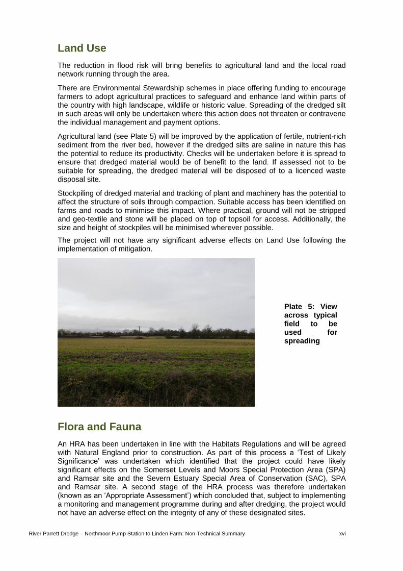
Agricultural land (see Plate 5) will be improved by the application of fertile, nutrient-rich sediment from the river bed, however if the dredged silts are saline in nature this has the potential to reduce its productivity. Checks will be undertaken before it is spread to ensure that dredged material would be of benefit to the land. If assessed not to be suitable for spreading, the dredged material will be disposed of to a licenced waste disposal site.
Stockpiling of dredged material and tracking of plant and machinery has the potential to affect the structure of soils through compaction. Suitable access has been identified on farms and roads to minimise this impact. Where practical, ground will not be stripped and geo-textile and stone will be placed on top of topsoil for access. Additionally, the size and height of stockpiles will be minimised wherever possible.
The project will not have any significant adverse effects on Land Use following the implementation of mitigation.
Flora and Fauna
An HRA has been undertaken in line with the Habitats Regulations and will be agreed with Natural England prior to construction. As part of this process a ‘Test of Likely Significance’ was undertaken which identified that the project could have likely significant effects on the Somerset Levels and Moors Special Protection Area (SPA) and Ramsar site and the Severn Estuary Special Area of Conservation (SAC), SPA and Ramsar site. A second stage of the HRA process was therefore undertaken (known as an ‘Appropriate Assessment’) which concluded that, subject to implementing a monitoring and management programme during and after dredging, the project would not have an adverse effect on the integrity of any of these designated sites.
Plate 5: View across typical field to be used for spreading
River Parrett Dredge – Northmoor Pump Station to Linden Farm: Non-Technical Summary xvii
No works will be required within any Sites of Special Scientific Interest.
The proposed works have the potential to affect sensitive and protected habitats and species. The River Parrett in the Study Area is designated as a Local Wildlife Site (LWS) as it is a catchment seen to be in regular use by otter, and supports other notable species.
Other habitats and species identified in the Study Area include:
The majority of the habitat along the river banks and adjacent rhynes has been identified as suitable for water voles and otters although none have been confirmed to date.
Grassland, hedgerow and marginal vegetation habitats are considered suitable for reptiles.
There are local badger populations but no setts are present in working areas.
Great crested newts have been identified in two ponds near Linden Farm.
Nesting birds, including kingfisher are known to use the River Parrett and banks.
Surrounding farmland provides suitable habitat for ground nesting birds such as lapwing and skylark.
A range of fish and invertebrates associated with the tidally influenced River Parrett, including eels and elvers, salmon, sea trout, allis and twaite shad and various mussel species.
Some mitigation measures have been incorporated into the design of the scheme as described in ‘Our Approach’ above.
Additional mitigation measures will be implemented before, during and after the construction works to avoid or reduce their significance. Mitigation to reduce impacts on protected species that had the potential to be significant prior to mitigation are summarised in Table 1. Mitigation for other species has also been included in the Environmental Action Plan.
It is known that the harmful plant species hemlock water-dropwort (parts of which are toxic and can prove fatal if eaten by cattle) and the invasive Himalayan balsam are frequent throughout the catchment and while they have not been confirmed in working areas to date there is a reasonable likelihood they are present. Other invasive species in the wider local area include Japanese knotweed, floating penny-wort and zebra mussels. To ensure these species are not spread as a result of the works, an Invasive Species Management Plan will be implemented and bio-security measures (such as hosing of plant, equipment and boots) will be provided at site compounds. Spreading will only take place on arable land / land in rotation which does not hold stock at the time of spreading, so that they cannot access dredged material. Following the implementation of mitigation the only adverse effects upon flora and fauna will be the potential for direct and indirect impacts to water voles, their habitats and feeding resources. A water vole mitigation method statement will be agreed with Natural England and a mink control programme funded, which has the potential to provide a significant benefit to the wider water vole population. Impacts on water voles from the River Parrett Dredge NPS-LF scheme alone will be temporary until the bank vegetation recovers.

River Parrett Dredge – Northmoor Pump Station to Linden Farm: Non-Technical Summary xviii
Table 1: Summary of key mitigation measures to minimise potentially significant effects on protected species
SPECIES Water vole Eel, fish and otter (food
source) Great crested newt
(GCN) Nesting birds
Nationally rare/scarce
invertebrates
MIT
IGA
TIO
N T
O R
ED
UC
E S
IGN
IFIC
AN
T E
FF
EC
TS
Undertake pre-construction checks by boat before dredging commences. Mitigation to be agreed with Natural England and a licence obtained but likely to include to mark out 5m buffer zone around any confirmed burrows and dredging to avoid buffer zones until further mitigation has been undertaken.
Ecological mitigation and monitoring will be undertaken including water quality, dissolved oxygen, water temperature, and ammonia. Glass eel numbers will also be monitored. Trigger levels have been set so that if anything is recorded above permitted thresholds, working methodologies will be reviewed and stopped if required. Hydrogen peroxide will be applied if required.
Dredging and deployment fields are at least 150m from ponds found to support GCN and spreading will avoid a 10m field buffer edge which provides the most suitable habitat for GCN.
All vegetation to be cleared prior to the nesting bird season (commences 1st March). If this is not possible checks will be carried out by an Ecologist prior to clearance.
See ‘eel and fish’ plus daily checks will be made of hand dredged material for bivalves, which will be counted and returned to the river.
Provide toolbox talks to advise contractor of risks.
Watching brief of dredged material and direct observations by operatives (training will be given by Toolbox talk). Any fish in distress or dying will be reported to the Environmental Clerk of Works (ECW) who will liaise with Environment Agency Fisheries.
If any newts are encountered on the scheme, works will stop in the immediate vicinity until the newt species has been confirmed by an ecologist and any further mitigation agreed.
Cleared vegetation will be maintained short by repeat strimming or herbiciding.
ECW will be contacted if notable species / numbers found of other species. If European Protected Species found, operations and mitigation will be reviewed and licences applied for if required.

River Parrett Dredge – Northmoor Pump Station to Linden Farm: Non-Technical Summary xix
SPECIES Water vole Eel, fish and otter (food
source) Great crested newt
(GCN) Nesting birds
Nationally rare/scarce
invertebrates
Humane mink control programme to be implemented until water vole population has recovered to pre-dredge levels.
An ecologist will undertake a nesting bird survey in agricultural fields prior to the stockpiling or spreading or establishment of access roads/compounds.
Monitor drainage and take remedial action if inappropriate discharge of water occurs from deployment fields.
Annual walkovers will be undertaken to record ‘field signs’ between North Moor Pump Station and the M5 road bridge to monitor how water vole and the habitat which they utilise is recolonising.
Should a nesting bird be discovered, an exclusion zone will be erected and works shall not continue within this area until young have fledged.
Site compounds will be located at least 5m from hedgerows or trees.
River Parrett Dredge – Northmoor Pump Station to Linden Farm: Non-Technical Summary xx
Water
An assessment has been made in the context of legislation relevant to water most notably the Water Framework Directive (WFD) and Bathing Waters Directive. The section where dredging is proposed is located within the Parrett Estuary which is influenced by both tidal and river flows. This section is called the ‘Parrett Transitional’ water body in the South West River Basin Management Plan (a document required by the WFD).
Dredging will mobilise silt which can lead to a reduction in light penetration and dissolved oxygen levels, particularly if water temperature is elevated during the summer months. This presents a risk to fish health, particularly salmonids, during migratory periods.
Silt mobilised from dredging, particularly during the summer months, can also cause bacteria numbers to flourish. E coli, for example, has the potential to impact on the quality of bathing water downstream in Burnham-on-Sea.
To ensure these impacts are minimised, water temperature will be closely monitored, and water quality tested for elevated bacteria levels. The scheme, with mitigation (embedded in the design and through monitoring) in place, is considered to be compliant with the Water Framework Directive.
Following the implementation of mitigation, including the Ecological Mitigation and Monitoring plan, the project will not have any significant adverse effects on the water environment.
Landscape Character and Visual Amenity
The only effects to the landscape character or visual amenity of the area will be the possible, temporary need to stockpile dredged materials within agricultural fields identified for spreading. Stockpiles will be no higher than 2m and will be located at least 25m away from private households and 10m away from public access routes (such as the River Parrett Trail), however this may still result in some temporary significant adverse impacts on views from a small number of properties and one PRoW (BW23/40; see Figure 2).
Historic Environment
The Somerset Levels are known to have been used by humans since the Neolithic period. The landscape includes large areas of former marshland and reed bed, reclaimed by people since at least the Roman period. The local historic landscape is comprised of remains of various field systems, trackways and settlements. There are also numerous non-designated features listed on the Somerset Historic Environmental Record (HER) and there will inevitably be many other sites that are as yet undiscovered. An Archaeological site walkover and desk-based assessment has been undertaken by archaeological experts to assess the impact of the works, which will arise primarily during construction. Advice has also been sought from the County Archaeologist.

River Parrett Dredge – Northmoor Pump Station to Linden Farm: Non-Technical Summary xxi
Lidar imagery of the area has identified linear features that appear to represent part of a long canalised channel, thought to be of either Roman or Medieval origin. Such features are very rare and, if confirmed, would be considered of national significance. There are two fields in which these features are evident that have been identified as potential spreading locations. In order to avoid the features being obscured or lost by the works, these fields will be avoided. One field also contains further evidence of a Medieval flood bank listed on the Somerset HER. Spreading of dredged material will not be permitted where this feature is visible.
Following the completion of the in channel works a site walkover will be undertaken by an archaeologist to determine, and record where necessary, whether any new archaeological features are uncovered by the works.
Following the implementation of mitigation it is considered that the project will not have any significant adverse effects on the historic environment.
Traffic and Transport
There will be a temporary increase in traffic during the works from construction traffic. The intention is to spread dredged materials as close to their site of extraction as possible, on agricultural land that is within 1.5km of the dredge / off-load location. This will provide localised agricultural benefit and minimise the distance travelled by vehicles. If material is found to be contaminated it will be moved to a suitably licensed waste disposal site a further distance away.
Movement of the dredged silts will generate a number of localised tractor and trailer movements. There will be the requirement for a short-term closure of Huntworth Lane (approximately 4 weeks) but this will be re-opened outside of working hours (including evenings and weekends). This will have a temporarily impact on local traffic. A Traffic Management Plan will be introduced to consider and minimise these effects on local residents. The plan will include measures such as: agreed delivery/haulage routes; delivery schedules to avoid peak traffic times; vehicle control measures (such as the use of ‘banksmen’ and road signage); and measures to reduce dust and mud on roads. Through use of the Traffic Management Plan and communication with the local community, it is considered the project will not have any significant adverse effects on the local road network.
Cumulative Impacts
The main potential for cumulative effects is in relation to on-going maintenance dredging along a 9km stretch of the Rivers Parrett and Tone (i.e. the sections that were dredged as part of the 8km Rivers Parrett and Tone Dredge, plus the approximately 750m River Parrett NPS-LF dredge). The maintenance dredge is on a minimum of a four year rolling programme informed by survey data (i.e. no section of river will be dredged more than once every four years) and will only occur in areas already subject to recent dredging. Maintenance dredging will also be subject to its own environmental assessments including HRA and WFD assessments and identified mitigation. It is therefore not considered to cause additional significant environmental impacts above those already assessed to occur for the River Parrett Dredge NPS-LF. The exception to this is for the River Parrett LWS where maintenance dredging will mean that a longer
River Parrett Dredge – Northmoor Pump Station to Linden Farm: Non-Technical Summary xxii
length of the river is adversely affected at any time (although extents and state of recovery are uncertain).
Summary
Overall, the Environmental Statement has concluded that the proposed works will result in some significant environmental effects. Mitigation and good site management, will help avoid and reduce these impacts as far as possible. The only potentially significant effects after mitigation are:
Potential for direct and indirect impacts to water voles, their habitat and feeding resources. However, a mink control programme to be funded by the project may have an overall benefit to the wider water vole population.
The views of stockpiles from a PRoW and a small number of residential properties.
The cumulative effect on the River Parrett LWS when considered in-combination with maintenance dredging.
There will be a temporary beneficial effect on flood risk to communities, agricultural land and transport links in the area until re-silting occurs.
Next steps
A decision to proceed with the works will be made at the end of this 28 day consultation period, taking into account the Environmental Statement and any responses to it.
Contact Us
This Non-Technical Summary and the full Environmental Statement are available to view at the Environment Agency’s office in Bridgwater. To ensure that queries are dealt with appropriately, it is advisable to make an appointment by contacting the telephone number below.
Environment Agency, Rivers House, East Quay, Bridgwater, Somerset, TA6 4YS.
Telephone: 0370 8506506
For further details of the River Parrett Dredge NPS-LF scheme, please contact:
Andy Hohl or Jess Ager Environment Agency, Manley House, Kestrel Way, Exeter, EX2 7LQ.

River Parrett Dredge – Northmoor Pump Station to Linden Farm: Non-Technical Summary xxiii
E-Mail: [email protected]
E-Mail: [email protected]