Download this report - British Geological Survey
31
RECORDS OF THE GEOLOGICAL SURVEY OF TANGANYll(A. VOLUME V 1955 "" ; ld"'i """ ' ;;:; i ,
Transcript of Download this report - British Geological Survey

RECORDS OF THE GEOLOGICAL SURVEY
OF TANGANYll(A.
VOLUME V 1955
"" ; ld"'i
""" '
;;:; i ~' ,

CONTENTS
PROGRESS REPORTS AND REGIONAL NOTES
L 1lISSBT, C. B.-A reconnaissance in the Kilombero Valley and other parts of Ulanga District
~, AITKEN, W. G.-Notes on the Makangaga-Ruawa anticline, Kilwa District ...
j, MCKINLAY, A. C. M.-Note on the geology of the upper Likongowale Valley, south-west Njombe District
., SAMPSON, D. N.-The Uluguru Mountains (A summary of progress to 1955) ...
ECONOMIC GEOLOGY
#, I'AWLEY, A. P.-An impure gypsum and dolomitic limestone deposit at Msagali, Mpwapwa District ...
ENGINEERING GEOLOGY
FA WLEY, A. P.-Geology and underground water resources of the Makutopora Depression (Dodoma Water Supply Investigation)
I'AwLBY, A. P.-Drainage and/or damming possibilities at Lake Hpe and Ruvu Swamp at Rhino Horn, Moshi District ...
I'AWLEY, A. P.-Evaporation rate at Dodoma, Tanganyika
GEOPHYSICS
PAGE
1
5
18
21
36
41
53
57
KING, A. J.-A geophysical investigation of auriferons reefs in southern Tanganyika ... 60
MINERALOGY AND PETROLOGY
McKINLAY, A. C. M.-Kimberlile intrusions cutting Karroo sediments in the Ruhuhu depression of south-west Tanganyika ... 63
McKm, D.-Notes on some minerals from Tanganyika ... 81
APPENDICES
Publications during 1955.
Limestone Analyses made in 1955.
Complete analyses of rocks carried out in 1955.
95
96 98
-------"""""~"
" " 'I'
\ii

Pbt" VIIJ
A'
S. E,
Engineering Geology
(JICOLOGY AND UNDERGROUND WATER RESOURCES OF THE MAKUTOPORA DEPRESSION
(Dodoma Water Supply Investigation) By ALLAN P. FAWLEY, Milling Geologist
INTRODUCTION LOCATION AND SURFACE CONDITIONS GEOLOGY ..•
(a) Mbuga clay (b) Predominantly clays
CONTENTS
(c) Predominantly calcareous sediment'> (d) Weathered bed~rock (c) Hard bed-rock
NOTE ON RAINFALL AT MAKUTOPORA BOREHOLE LOGS ..• PUMPING TESTS ELEVATIONS OF BOP-EHOLE COLLARS STATIC WATER LEVEL WATER ANALYSIS FROM MAKUTOPORA BOREHOLES BOREHOLE YIELDS .. WATER BEARING STRATA ... NATURAL RECHARGE OF AQUIFERS
ORIG:N OF THE SUB-SURFACE (GROUND) WATER WATER RESERVES AT MAKUTOPORA DEPRESSION OBSERVATION BORFHQLES (WELLS) ARTIFICIAL RECHARGE
RESERVOIR SiTE ON KlTUNDA HILL NOTES ON BOREHOLES AND PUMPING RECOMMENDATIONS AND CONCLUSIONS
ABSTRACT
Drilling in the Makutopora Depression has revealed a maximum thickness of several hundred feet of unconsolidated, or partly consolidated, calcareous, argillaceous and arenaceous sediments overlying weathered granite or gneiss. The weathered granite and gneiss and the calcareous and arenaceous sediments are aquifers and contain a considerable volume of good drinking, though hard, water.
Measurements of the static water level prove: (i) that the sub-surface (ground water) supply is replenished annually; and (it) that the sub-surface water is continuously flowing towards the north-east.
The maximum amount of water available from deep wells in the Makutopora Depression cannot be determined at present, but a maximum continuous safe yield of 400,000 gallons per day seems assured and there are strong indications that much more than this could be obtained.
I. INTRODUCTION
PAGB 41 42 42 42 42 43 44 44 44 44 46 47 48 49 49 50 50 50 50 51 51 51 51 52
history of the water investigation, repeated from preliminary report AF/24, is
"The Water Development Department drilled lwo holes on the north-west flank of the in 1948 and 195L The first hole yielded 2,400 g,p,h" (gallons per hour) and the
1,500 g,p,h" with a salinity of only 41 to 43 g,p.g, (grains per gallon), Because of HIIlis[',ct,ory performance of these two holes and on the assumption that similar conditions
, the entire mbuga, J. C Lambert (1953) recommended that the mbuga b. '~'.~~:u~to~~d"e'termine if it would supply 300,000 gallons of water per day.
is the local term for a swamp or for a low-lying area that becomes a swamp during the rainy
41

A
j N.W. ,
" " "I ~
, , , , " " 6 " 6 6
6 , "I , "
, • , , 6~1
", A t, I + ......... -1-10-
+ + ~ + + " ~ + +
< t·
+ + + +
+ + ... + +
.'~ +
+ + + + +
+ + + t·
+ + + + +
+ + + + +
+ ·f + + + +
+ + + + +
G. S. 727
t· +
I + + +
+ + + + + +
+ + + +
Geology of
Makutopora Del by A. P. Fawley. Geologist, .
24/53
CROSS-SECTION Location shown on plan
fe",500 ,so , '00 ,

Geology of the
Mdkutopora Depression
f,y A. P Faw)ey. Geologist- July 1954.
• ;. +
•
(;110SS~SECTION A~A'
I ,,, ;!lion shown on pian G. S. 726
'1.""""""""'"
g-=:1 "Mbuga" clay
~ Predominontly clay
~ Predomlna'ltly calcareous sedm)enCl
16
t, 1;) Weathered bed-rock
~ Hard bed.rock (gener~lly g,&nite or gneiss)
-:.. Water struck
\ \ \ Fault (approximate position)
l,"6 .• Height above 5ea level of
stat" water 1'1'101),25 May 1954
Plate VllI
A'
S, E .
G~ol<>gic.' Svr>~r Dop."rnent. D"d~fn'

'1
! I
" l
"Following this recommendation, B,H. 17/53, located within the mbug(J, \\'.\', dH, to 246 feet and yielded 4,000 g.p.h. Due to this favourable result the depressi{)11 .\f,-,I
photographed from the air and a further programme, to test the water possihd!lw .. laid out by Mr. Bisset, Director of Geological Survey, Messrs. Land and Lanlhl"ll .. , Public Works Department, and the writer."
A total of 13 boreholcs1 have been sunk and tested in the Makutopora DCP!(""d"fI the sub~surface conditions are now fairly well known.
Acknowledgmcnts.-I wish to thank Mr. H. lames, of the Water DcvclollllU"1I1 Irrigation Department, for carefully collecting samples at five~foot intervals elm!!I!', .Ill
Mr. J. Ambrose, of the Public Works Department, for accurately recording the d!.III' I and yield during extended pumping tests and Mr. F. M. Caster, Engineerjll!~ (, I I .
Water Development and Irrigation Department, for courteous assistance on sevcr;lllllll'"
11. LOCATION AND SURFACE CONDITIONS
The lowest part of the Makutopora Depression is overlain by an elong;llnl I
covering seven square miles. The mbuga is about 15 miles north of Dodolll:\ one~third of the mbuga surface was flooded during the heavy rains of December I')', I1 !
some of this area remained covered with water until May 1954. The entire fIIl}/~":1I 'I I
was dry by 25th May, 1954, Ill. GEOLOGY
The sub~surface geology is shown on cross-sections (see Plates VIII and IX)' 1I1It!
area covered by the njbuga and the location of the Mlemu Fault are shown on Pbk .\ The Mlemu Fault extends south~westwards from the Makutopora Depression {D
a distance of morc than 15 miles. It has a throw of about 260 feet near B.H. 4/"·1 amount of horizontal movement is not known. The approximate location of Illl' I1 Makutopora was determined by drilling (the exact location is not known, but 1111' lies between B.H. 4/54 and B.H. 43/53); its continuation to Kigwe can be observed HI! photographs, The fault probably dips vertically or at a very steep angle,
The sub-surface geology has been interpreted from the sludge and rock-fragmenls (\hlll by boring with a churn drill, which is not nearly as satisfactory as when solid COI't' ' ,
obtained. However the boundaries between the various rock typcs, as ShOWll 1\11
cross~sections, are probably accurate to within a few feet in most cases. A brief description of the various rock classifications used for the cross~$e(ji(lll
longitudinal section follows:-· (a) Mbuga Clay
Mbuga clay (also called "Black Cotton" soil or clay) is plastic when wet. On dl it becomes hard and brittle and is dark grey. In places it is calcareous and/or sandy,
An analysis of mbuga clay from RH, 35/53, depth 0-20 feet, yielded the 1"11,, results :-
Si02 Per cent
R20 3 (Insoluble)
Pcr cent
(S~I~~j,}--I-p~~O-cn-t--'-p-~-'-~~nt--~-;-~-c;-~r~' \1·-~-g~S-i~j-~; .. 1'.
Pcr cent I Pcr cent Per cent
---4-5'-0---:·_-9-'5--:--2-0-'5--1'--1-'6--:--1-.6-+/- -:-1 18·0 I
(R203 estimated to be 83 per cent A120J and 17 per cent FC203)
Analyst: W. K. L. Thomas, Geological Survey of Tanganyika.
(b) Predominantly Clays This category includes light.coloured clays, c1aycrcte, and some calcrete.
are often calcareous or contain considerable colloidal silica. ;:0--- .. '_.-
lDeep water wells in Tanganyika arc customarily called "boreholes" (B.H.) and the Tanganyika tCflllill1!
for such wells is used throughout this report. All except the deeper sections of RH. 12/48 allll 11 34A/51 are eight inches in diameter.
42

Plate IX
~~~~~~~~~~~~~iI~~~~~~~Ii~~~~~~~~~~~~~~~~~~~~~~~~~~~':'·::,,:,~::::~-------! B' N. E.
, t
~~j "M~" dly
~ Predomonantiy <::llys
~ Predomi~ e.klraou~ lediments
! At:. A I W .. thered bed.rock
~ Hard b<td-roc;:t
W~e< Itl"uck
3.«6.9 Hei9ht above IU le~el of
01.-;1<:: wat •• 1 ...... 1. 2S ...... y 19S4

6 6 6
• 6 , • 3- --"'
+ + +
Geology of the
Makutopora Depression
, +
by A P. Fawley, Geologist. July 1954.
6
• 6 , • -, 6 -, --~ 16S , +
+ + +
, + ,
LONGITUDINAL SECTION B -B' Locs tion shown on Plate X

u ' the depression arCH
water possibililit'\, ld and Lamber( 01
topora Depress/oil
Her DcvclopmclII tervals I I :ording the \nginccring 'c on severa I1
an elongated of Dodoma, December 1()51, entire mbuga .~(II
[J and IX), alld )wn on Plate .\
wet. Idlor sandy. ed the
)ss on ni/jon r cent
:ic.
B __ ~_~~_~;: s.w.
" , " , , , ,
~ , -~ , , , ,
, +
+ + , + ., , +
+ +
+ +
'0'-'''1(1,
G. S. 729
"~i_ ----~

/ •
__________________________ !'latc X
-,
" "
1
l 1

( ,j MAKUTOPORA DEPRESSION
DODO MA WATER SUPPLY INVESTIGATION
kale fto! lOOO
L, ~~-,-_~"_oo __ ,ooo __ ~"", ___ """ ___ ,,,,,~ ______ ,ooo ___ .~ooo __ ~oc'O f«'
L£GEND
~ .. Dry ... """ toad f
" / 5t.tIc .... '.'.Iwol COtItour. (S\II>.I<rlKft)"" M.,. 25. 19504. l (EI ...... 1on in 'HI obo-< •••• 1 ..... 1)
~
" '" foulC tPl'>I>obIywlthln 100 ,"I C>f «mKt Ioc."",,> • M ..... 010 cIownthrow .u.
/" C ... ".~aIo<>gA_A.hown ",,,,_;,,,0.S.721 .. / LOtIgitud, ..... «<Ilon.aong ,.' -.. ""* .... i"(10_S.129
/
/ /.
/
/
/ / I \
7 /
• ( I I , I
, • ..
I ,
/ / ." I
, , \ ,
, ,\ , ,. /
, \ , , I \ ;. , I ." " I ~, v, • I
.t' • /
iI/ /
, /-, ,
/ / I , - "- / ,
-'

"Claycrete" and "calcrete" are terms used for distinctive types of sediments which are IlIrgc1y composed of grains of quartz cemented together with clay or calcite; mica and other femic minerals are almost completely absent. Claycrete is generally light olive-grey 111\<1 is bound together by clay, while calcrete is generally white 0' light-yellowish grey and hi cemented together by calcIte. The quartz content of both clay crete and calcrete ranges from about 20 to 70 per cent, the quartz grains are sub-rounded to angular and average Ilhout 1/16 in. in diameter. (When the quartz grains average about t in. the rock is called " cemented or calcareous gravel).
An analysis ofa sample of calcareous clay from B.H. 30A{53, depth 25-135 feet, follows :-
Si02 R20 3 R20 3 Cao MgO Loss on Total (Insoluble) (Insoluble) (Soluble) Percent Per cent ignition Per cent Per cent Per cent Per cent Per cent
44·8 9·7 18'2 6·1 1·3 19'8 99'~
.---~,--~--
Analyst: J. Saileni, Geological Survey of Tanganyika.
(c) Predominantly Calcareous Sediments . This category includes limestone, siliceous limestone, calcrcte, calcareous gravel, and
.ome calcareous clay and c1aycrete.
The limestone at Makutopora is of a very siliceous type. It is white or very light-coloured and is .similar in nature and origin to ca1crete. An empirical division has men made between limestone and calcrete; rocks with considerable calcite and less than 20
cent visible quartz grains! are called "limestone", while those with considerable calcite more than 20 per cent visible quartz grains are called "ca1crete". The rock called
"jlliC<'OtlS limestone" contains less than 20 per cent visible quartz but is high in colloidal
",.,--
Analyses of rocks classified as limestone, or siliceous limestone, follow. (It should noted that some rocks classified as "limestone" by visual methods, and tested with acid,
been named erroneously). White "limestone" from B.H. 30A{53 containing 5 per cent visible quartz--<lepth
86 feet.
SiOz (Insoluble)
Per cent
23'0
R203 (Insoluble)
Per cent
RZ03 (Soluble) Percent
Cao Percent
38·9
Analyst: J. Saileni, Geological Survey of Tanganyika.
MgO Percent
0·3
Loss on ignition Per cent
33·5
Total Per cent
99·9
(ii) White "limestone" from B.H. 39{54 containing 10 pe, cent visible quartz--<lepth feet.
Si02 RZ0 3 Undeter-
(Insoluble) (Soluble) CaO MgO mined
Per cent Per cent Percent Percent
4l'3 9·0 3·0 12·9 1·8 13-5
(Moisture content in loss on ignition 3·4 per cent) Analyst: W. K. L. Thomas, Geological Surxey of Tanganyika.
Loss on ignition Total
Per cent Percent
18-4 99·9
---_.-
IThe various rock types were all examined under a low-power binocular microscope. Quartz graillJ listed as "visible' have a minimum diameter of about 0·1 mm.
43

(iil) The first of the following three samples was classified as "siliceous limestone \\ iflt 15 per cent visible quartz", the second as "white limestone with 5 per cent visible Clll:11 I ! -,
and the third as "white limestone with 3 per cent visible quartz".
Depth in R20 3 CaO MgO Borehole (Soluble) feet Percent
Per cent Per cent
B.H. 43/53 30-50 9·1
I 6·S
I 0·9
S/54 I 155-165 7-2 15·9 1·0 __ .. _S~. __ . 175-215 3·1 34·0 O·S
Analyst: J. Saileni, Geological Survey of Tanganyika.
(d) Weathered Bed-rock
Undetet~
mined (InsolubJe)
Per cent
I 69-4 51·7 I I 29·2
Loss on ignition Per cent
13·8 22·7 31·7
,
I I I I
ToLd Pn\TIII
I!HHI ()H ~
'm-u
The bed-rock penetrated is generally hornblende gneiss, granite, or alaskite (a v;lIu\fy
of granite). The weathered bed-rock zone may be more than 100 feet thick.
(e) Hard Bed-rock The weathered bed-rock gradually became harder at depth and, empirically, whcn Ihp
drilling speed of the churn drill was reduced to a few feet per day the rock was classified JI~ "hard" bed-rock.
IV. NOTE ON RAINFALL AT MAKUTOPORA
No rain gauge is installed at the Makutopora Depression; however, the average mill!":!!l is probably similar to that at Dodoma, which has a 24-year average of 22·93 inches: l
The rainy season of 1952-53 was exceptionally poor and only about 10 inches 0(' lalll
fell. The 1953-54 rainy season started on December 17th and about 8 inches of rain "'11 in the latter half of that month; during January, February and March there were (lldy light rains, but the season ended with heavy rains early in April.
V. BOREHOLE LOGS
All the boreholes except B.H. 12/48 and B.H. 34A/5l were logged by the writer (G.S.I) Notebook No. 17 of A. P. Fawley). Definitions of terms such as "calcrete" have aJrc'.ldy been given under "Geology". A summary of the logs follows:-
B.H.12/4S, feet 0-208 mar!, clays, limestone;
208-232 calcrete; Water struck at a depth of 156 ft.
B.H. 34A/51, feet 0-184 clays, marls, granite brash:
Water struck at depths of 82 and 181 Ft.
B.H.17/53, feet 0- 20 mbuga clay and calcareous clay;
20-150 claycrete and siliceous and calcareous clays; 150-165 calcretc and cemented gravel; 165-200(7) claycrete and calcrete;
200(?)--228 weathered gneiss; 228-246 partly weathered hornblende gneiss;
p- 45 Water struck at a depth of 151 (?) ft. -:c---:-:--;--~-lEast African Meteorological Department. 1953. Summary of Rainfall for the year 1951. Par( 11,
Tanganyika. 44
H/53:
red 0· 10
10- 15 I.~ . 30 :lO 55 ~5 H2 Hl - 9()
()(, . !OO I(JO· 114
1,\4 20H ',i,OH -211
Wal(
11.11. lOA/53, feet 0- 35
J5- 50 50-135
135--! 86
IH6-255 ;1,~5-275
rJ5··2l:l2
Wal'
U.II. )1/53:
feel 0-- 10
10-- 20 20- 30
30- 43 Dril
tUlo 32/53: feet 0- 5 5--125
125 -135
135 "150 150.,160
160---200
'200-220 '220,"228
Wa
11.1 l. )5/53:
feet 0-- 20
20-- 40 40- sO 80-115 115~-140
140-212
W,
11.11. 39/53:
feet 0- 15
15-- 25
25- 75
limestone W!II!
visible quarl/I.
~i~~ I TO(III
cent Per (.:\'111
:78 jl_,OO.1I 9X':-'
~'7 __ ,9H'H
ikite Ca varielY
ally, when 111(1 as classified !PI
verage rainl"illl inches:1
inches of raill les of rain !"cll lere were ollly
",riter (G.S. [) , have already
1952. Par( 11,
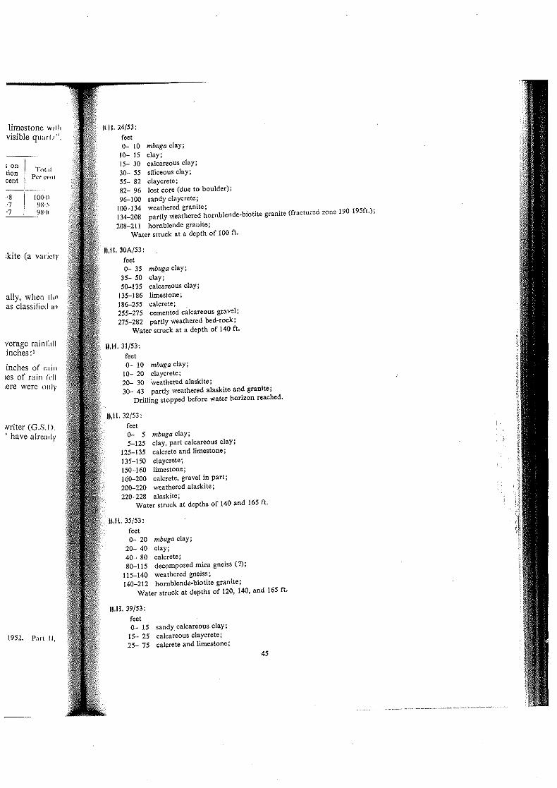
1111. 24/53: feet 0- 10 mbuga clay:
10- 15 clay; 15- 30 calcareous clay; :\0- 55 siliceous clay; 55- 82 c1aycrete ; 82- 96 lost core (due to boulder); % .... 100 sandy c1aycrete:
100-134 weathered granite; 134-208 partly weathered hornblende·biotite granite (fractured zone 190 195ft.):
208-211 hornblende granite; Water struck at a depth of 100 ft.
II,Il,30A/53: root 0-- 35 mbuga clay;
35- 50 clay; SO-135 calcareous clay;
135-186 limestone; 186-255 calcrete; 255-275 cemented calcareous gravel; 275-282 partly weathered bed·rock;
Water struck at a depth of 140 ft.
11.11,31/53: feet 0- 10 mbuga clay;
10- 20 c1aycrete; 20- 30 \veathered alaskite; 30- 43 partly weathered alaskite and granite;
Drilling stopped before water horizon reached.
11,11,32/53: feet 0- 5 mbuga clay; 5-125 clay, part calcareous clay;
125-135 calcrete and limestone; 135-150 claycretc; 150-160 limestone; 160-200 calcrete, gravel in part; 200-220 weathered alaskite; 220-228 alaskite:
Water struck at depths of 140 and 165 ft.
11.11,35/53: reet 0- 20 mbuga clay;
20- 40 clay; 40- 80 calcrete; 80-115 decomposed mica gneiss (1);
115-140 weathered gneiss; 140-212 hornblende·biotite granite;
Water struck at depths of 120, 140, and 165 ft.
11,11,39/53: feet 0- 15 sandycalcareous clay;
15- 25 calcareous claycrete; 25- 75 calcrete and limestone;
45

B.H. 39/53 :-(contd.)
feet 75-100 calcareous claycrete;
100-120 sandy calcrete; 120--130 limestone and clay; 130-155 cemented calcareous gravel; 155-175 calcrete (?) or decomposed bed-rock (?); 175-250 weathered hornblende granite; 250-255 hornblende granite;
Water struck at depths of 105 and 125 ft. B.H.43/53,
feet 0-110 calcrete;
110-130 claycrete; 130-135 cemented gravel; 135-150 claycrete; 150-1S0 clay-gravel mixture; IS0-195 calcrete; 195-205 cemented gravel; 205-220 calcrete; 220-250 cemented gravel;
Water stmck at depths of 117 and 160 ft.
B.H.44/53,
feet 0- 30 claycrete;
30-145 caicrete; 145-1S0 cemented gravel; IS0--210 calcrete; 210-215 cemented calcareous gravel; 215-240 calcrete; 240--243 cemented calcareous gravel;
Water struck at a depth of 160 ft.
B.H.4/54,
feet
0- 13 claycrete and sandy soil; 13-140 weathered granite and alaskite;
140-173 alaskite; Water struck at a depth of 120 ft.
B.H.8/54,
feet 0- 30 sandy clay and claycrete;
30-105 calcrete; 105-155 calcareous clay; 155-175 siliceous limestone; 175-215 limestone; 215-245 calcrete; 245-275 weathered gneiss (?); 275-290 granite and gneiss;
Water struck at depths of 160 and 170 ft.
VI. PUMPING TESTS
The largest pump available had a yield of only 6,000 g.p.h. (gallons per hour) was not possible, therefore, to pump the more successful boreholes at c~;.~~t;r;uw;I::::::: and drawdowns obtained from the various pumping tests are listed below--each is that obtained at the end of the test period, These results have also been plotted
46
I
I V

- --+------1-Plate XI
.. __ . __ .. _ .. --+----
-------- r-
-


.'0,.'''," ,,'I'

(Plate XI) from which any drawdown can be rapidly obtained. Changes due to tlI~ldown during continuous pumping at a constant rate are shown on Plate XIII.
Volume Drawdown Duration
Borehole in g,p,h. in ft. of test in
12/48 ... .. ' .. . 2,500 27(7) 34A/51 ... ... ... ... 800 17
1,760 45 17/53 ... ... ... ... 3,200 16
3,750 19 4,940 32 5,760 51
17/53 (re~test) ... ... ... 4,000 24·5 (\ 4,736 32-4
5,454 39·3 ·f 5.454 4!-6 5,454 41'1
24/53 ... ... .. . 3,750 40(7) 4,300 56( 7) 5,080 68
30A/53 ... ... ... 1,000 5'8 1,565 10·3 2,571 19·2 3,461 26·6 4,285 37·2 5,454 52'1 5,454 55'5 5,454 59·8
31/53 ... ... ... .. . Nil -32/53 ... ... ... .. . 4,000 47 35/53 ... ... ... .. . 1,500 120 (approx.) 39/53 ... ... ... .. . 1,750 135 (approx,) 43/53 ... ... ... .. . 1,200 135 (approx.) 44/53 ... ... ... .. . 540 152
450 III 460 135 670 90'
4/54 ... ... ... .. . 160j 65(7) 8/54 ... ... ... .. . 1,560 I
2,310 1'5 3,300 2-3 3,600 2·5 4,260 3-3
i 4,900 4
I 5,400 4-3 6,000 5
*Borehole surged and cleaned out before thIS test. t A bailing test.
VII, ELEVA nONS OF BOREHOLE CoLLARS
hours
10 0·75 4 4 8
100 336
0·25 0'75 I 4
42 36 4
120 0·5 0·5 0'5 0·5 I I
24 120 -36 48 48 48
0'75 6
20 11 4 I 1'5 1'75
22 '2-25 2'5 3
168
The following elevations have been obtained by converting the surveying results of Messrs, L~mbert and Lineham of the Public Works Department to sea level. _ ... _-
Borehole
12/48 ... 34A/51 ... 17/53 ... 24/53 ... 30A/53 ... 32/53 ... 35/53 ... 39/53 ... 43/53 ... 44/53 ... 4/54 ... 8/54 ...
... .'.
... ..'
...
... .. .
... .. .
... .. '
...
... ..,
... .. .
... ...
... .. .
... .. . 47
I-GroundE~vation of
elevation in top of casing feet in feet
3,522'6 3,524'9 3,528'4 3,528'7 3,522-3 3,523'2(7) 3,523'9 3,525'6 3,523-7 3,524-4(7) 3,522'9 3,524'5 3,524'0 3,526-1 3,526'4 3,527-4( 7) 3,525'6 no casing 3,525'0 no casing 3,551'1 no casing 3,523-4 3,524'9
I,
! :
\ ;'

VIII. STATIC WATER LEVEL
The following table records the elevation of the static water level above sea kll·1 !d va rious periods since the boreholes were completed. It will be noted that (i) the l'ln 011 !fHt fal Is during the dry season and rises during the wet season; and CH) that the elevation'; III 111.\' ar e about two feet higher than they were in 1948 and 1951.
The static water level contours for May 25th, 1954, are shown on Plate X.
Borehole
B.H. 12/48 ...
34A/5Q
17/53 ...
24/53 ...
30A/53
32/53 ...
35/33
39/53 ...
43/53 .. . 44/53 .. .
4/53 8/53
48
Date
1948 22 Aug. 1953
7 Apr. 1954 1951
3 Oct. 1953 18 Dec. 1953 7 Apr. 1954
25 May, 1954 9 July, 1954 3 Oct. 1953
16 Dec. 1953 30 Mar, 1954 25 May, 1954
9 July. 1954 3 Oct. 1953
18 Dec. 1953 30 Mar. 1954 25 May, 1954
9 July. 1954 18 Dec. 1953 30 Mar. 1954 25 May, 1954
9 July, 1954 24 Nov. 1953 18 Dec. 1953 30 Mar. 1954 25 May, 1954 8 June, 1954 9 July, 1954 260ct. 1953 18 Dec. 1953
5 Jan. 1954 28 Jan. 1954
30 Mar. 1954 7 Apr. 1954
14 Apr. 1954 25 May, 1954 8 June, 1954 9 July, 1954
18 Dec. 1953 7 Apr. 1954
25 May, 1954 8 June, 1954 9 July, 1954 5 Jan. 1954
28 Dec. 1953 21 Jan. 1954 2 Feb. 1954 2 Feb. 1954
30 Mar. 1954 14 Apr. 1954
25 May, 1954 8 June, 1954 9 July, 1954
Elevation of static
water level in
feet
3,444 3,446 3,447'6 3,446 3,448'2 3,447'4 3,449-1 3,448'6 3,448'6 3,446 3,444-8 3,446'7 3,446-9 3,446'7 3,446-9 3,445-9 3,447'4 3,447'6 3.447'4 3,444'6 3,445'7 3,446'1 3.446'0 3,447'7 3,447'5 3,448'7 3,448'8 3,448'8 3,448'6 3.446 3,445'3 3.446'7 3,447'6 3,448'1 3,448'2 3,448'1 3,448'0 3.447-9 3,447-9 3,447'2 3,448'8 3,448'6 3,448'4 3,448'3 3,446'6 3,445-9 3,446'4 3,446·7 3.447 3,447 3.447-4 3,447'5 3,447'4 3.447,3
above sea h'l-id #1 at (i) the c!t'VIII(Il/1 ~elevationslll (f_llt
eX.
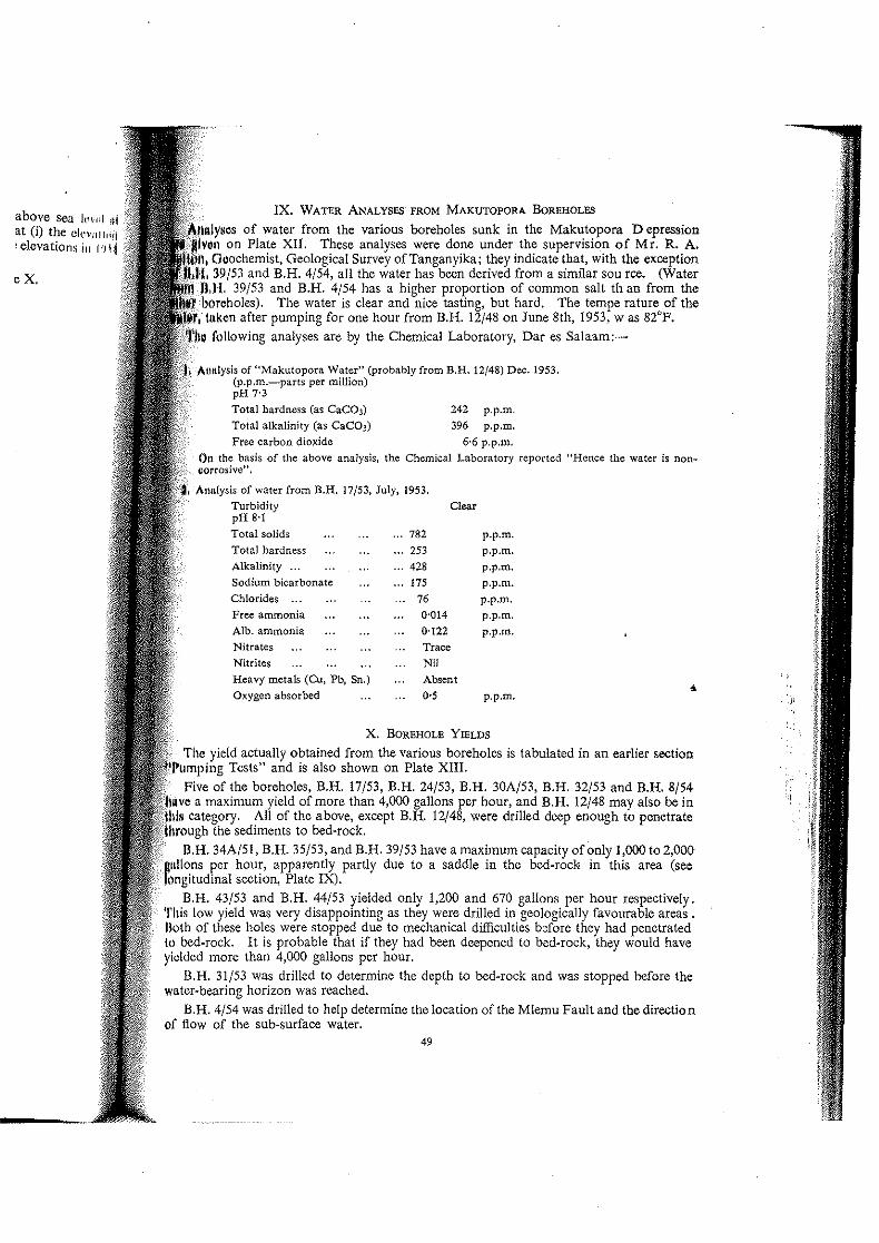
IX. WATER ANALYSES- FROM MAKUTOPORA BOREHOLES
of water from the various boreholes sunk in the Makutopora Depression on Plate XII. These analyses were done under the supervision of Mr. R. A.
Goochemist, Geological Survey of Tanganyika; they indicate that, with the exception ,39/53 and B.H. 4/54, all the water has been derived from a similar sou rce. (Water H. and B.H. 4/54 has a higher proportion of common salt th an from the
The water is clear and nice tasting, but hard. The tempe rature of the tllken after pumping for one hour from B.H. 12/48 on June 8th, 1953, was 82°F.
following analyses are by the Chemical Laboratory, Dar es Salaam:-
Allltlysis of "Makutopora Water" (probably from B.H. 12/48) Dec. 1953. (p.p.m.-parts per million) pH 7'3
Total hardness (as CaC03) Total alkalinity (as CaC03)
Free carbon dioxide
242 p.p.m. 396 p.p.m.
6'6 p.p.m. On the basis of the above analysis, the Chemical Laboratory reported "Hence the water is non"orrosive" .
Annlysis of water from B.H. 17/53, July. 1953. Turbidity Clear pH 8'1 Total solids ... 782 p.p.m. Total hardness ... 253 p.p.m. Alkalinity ... ... 428 p.p.m, Sodium bicarbonate ... 175 p.p.m . Chlorides ... ... 76 p.p.m . Free ammonia 0'014 p.p.m. Alb. ammonia 0'122 p.p.m. Nitrates Trace Nitrites Nil Heavy metals (Cu, Pb, Sn.) Absent • Oxygen absorbed 0·5 p.p.m.
X. BOREHOLE YIELDS
actually obtained from the various boreholes is tabulated in an earlier section 'Pumping Tests" and is also shown on Plate XIII.
Five of the boreholes, B.H. 17/53, B.H. 24/53, B.H. 30A/53, B.H. 32/53 and B.H. 8/54 a maximum yield of more than 4,000 gallons per hour, and B.H. 12/48 may also be in
All of the above, except B.H. 12/48, were drilled deep enough to penetrate sediments to bed-rock.
B.H. 34A/51, B.H. 35/53, and B.H. 39/53 have a maximum capacity of only 1,000 to 2,000 Billions per hour, apparently partly due to a saddle in the bed-rocl< in this area (se. longitudinal section, Plate IX).
B.H. 43/53 and B.H. 44/53 yielded only 1,200 and 670 gallons per hour respectively. This low yield was very disappointing as they were drilled in geologically favourable areas. Bolh of these holes were stopped due to mechanical difficulties before they had penetrated to bed-rock. It is probable that if they had been deepened to bed-rock, they would have yielded more than 4,000 gallons per hour.
B.H. 31/53 was drilled to determine the depth to bed-rock and was stopped before the wuter~bearing horizon was reached.
B.H. 4/54 was drilled to help determine the location of the Mlemu Fault and the direction of flow of the sub-surface water.
49
j:

The yield for drawdowns of 30 to 60 feet (i.e. to depths of 110 to 140 feet bel"", Ii!. mbuga surface) for the boreholes in which casing has been left is given below. Till' 11I'.tll~i were obtained from the graph on Plate XI. B,H. 12/48 is not included as drawdowl1 (il',llItf~ are not available.
Drawdown in feet
Borehole
B.H. 35/53 39/53 34A/51 24/53 32/53 30A/53 17/53 8/54
Total
30 40 50 60
Yield in gallons per hour ----~-----i------·----
880 1,020 1,100 1,180 950 1,120 1,220 1,290
1,250 1,520 1,710 1,860 3,100 3,600 I 4,120 4,600 3,100 I 3,600 4,120 4,600 3,650 i 4,400 5,000! 5,510 4,580 i 5,300 5,800! 6,200
11,000-1, 12,000+1 12,500+j 13,000+
28,5101-! 32,560 + ----;s.s:;o+1 38,240 + XI. WATER BEARING STRATA
Unfortunately pumping tests could not be obtained for the different types of ~,!(tI14 encountered during drilling within each borehole but were only made when the bplclilll, was completed. Hence the amount of water that can be obtained from the differt,;Jl{ IHi'~ strata can only be estimated.
Water in appreciable quantities was not struck until depths of 100 to 180 feel Wlll@
reached so there is little available water in the clay and predominantly clay zones. The predominantly calcareous sediments and the weathered bed~rock are both aqllllll,t,
and both yield a considerable volume of water. Some fissures probably OCcur wdllhl the bed~rock which will also give a considerable volume of water. The most prolific hOI ll!!'\ appears to be at the contact of the weathered bed-rock with the overlying sediment.').
XII. NATURAL RECHARGE OF AQUIFERS
Contours of the static water level (sec Plate X) show that the water pressure dClW,w¥f to the north-east end of the depression and hence the sub-surface waters must flnw nut in this direction. Since water is flowing out but the static water level is even higher Ihllf
than in 1948, water must be flowing in to the sub~surface supply.
XIII. ORIGIN OF THE SUB~SURFA6'E (GROUND) WATER
Soils surrounding the Makutopora Depression have been largely derived from gl':lIIl\@
and are sandy and porous. A large surface run~off does not occur in this area. I )Willft
heavy rains, a considerable proportion of the rainfall probably penetrates to depth'> HlI)
great for evaporation or transpiration; this water would slowly migrate toward,\ tilt under~ground supply below the Makutopora Depression. When the mbuga is !lOOdi1d, some water undoubtedly seeps downwards but, due to the thick clay cover at Makutopollll the amount reaching the aquifer must be small in comparison with the amount of wllh'f entering by means of the sandy soils that surround the mbuga.
Water may also enter the underground supply in the depression area by means of t ", Mlemu Fault which lies along the north-west side of the depression and extends from (hf depression for a distance of more than 15 miles to the south-west.
Analyses of samples of water from each borehole are given on Plate XII. All the S,U!ll\l~ except two are similar and appear to have been derived from a common, or similar, SOllli't.
The two exceptions (from RH, 39/53 and RH. 4/54) contain twice as much sodium clll,,,'dl ·as the other samples and may, in part, have been derived from a different source.
XIV. WATER REsERVES AT MAKUTOPORA DEPRESSION
Nine boreholes were sunk and given pumping tests and two holes were sunk to ohlnln ,geological information during the present investigation. Previously, two boreholcs hllll .been sunk and partially tested. The static water level was measured in all the borcholtlf
50

v1 THE MAKUTOPORA DEPRESSION .nalyses by the Geological Survey Department, Dodoma Plate XII
30A/53 32/53 35/53 39/53 43/53 44/53 4/54 8/54
Dec. 1953 Oct. 1953 Oct. 1953 Nov. 1953 Jan. 1954 Dec. 1953 Feb. 1954 March 1954
636 656 570 1070 590 623 9'3 606
85 fI' '25 288 9. 93 266 "5
82 '0' "7 228 9. '01 • 16 11.
279 - 8. .94 '7' '82 78 '76
16. - .54 .6' 140 140 268 '65
235 606 218 145 232 223 396 181
- - - - - - - -3.5 3.5 2 5.9 . 3.3 4.6 2A 2.2
58 - 54 36 57 55 98 45 -
26.5 - 25 26 23 23 4. 27
52 69 78 175 55 60 '6' 70
.6 57 66 129 5' 57 65 64
1.6 1.6 0.9 2.7 .. , 2.' 1.1 1.0
683 606 485 800 555 555 769 53'
- - - 8 8 8 8 8
D.OKENO O.OKENO D.OKENO D.OKENO D.OKENO D.OKENO D,OKENO D.OKENO
iY REPORT BY ALLAN P. FAWlEY Geolog,cal SurY\l~ Depa'tmal\t, Dodoma 1954.

ANALYSES OF WATER FROM!I" Amounts Shown in Parts Per Million
BORE HOLE No. 12/48 34A/51 17/53 17/53 24/S3 II)A/'
._ .. -,--
DATE SAMPLED Aug. 1953 Jan. 1952 May 1953 Sept. 1953 Aug. 1953
TOTAL SOLIDS (dried at 180°C) 692 582 756 576 636 (.il,
NaCI 1.8 89 129 121 114 11',
.-
Na2 504- 99 165 145 116 115 11/
~ g Ne HC03 - 119 221 - ---.§~
, 0 Mg (HC03)2 - 186 186 - -o 0. -'--0. E ._-- ------r--
0.0 Ca (HC03)2 640 81 243 507 566 «U
11')
J I'.
Si02 - 2. 56 - -
Na F 3.5 - - 2.4 3.3 , " --1--- ------
Ca - - 60 - - '.11
Mg - - 31 - - If, '.
--Cl 90 - 78 74 69 ',I
-SOl 52 - 82 65 65
.. _-- '-T .. _u_~ .
F I 1.6 - - 1.1 1.5 , <,
-f-I
----1- -----!
TOTAL AlKALINITY AS Ca (HC03)2 I 640 402 662 507 566 (,n \
1- _. APPROXIMATE pri
i - - - - " -_. -,
J------f----- --..... ANALYST I R.A. SUTTON RA S_UTTON _L J.$A~~~L_ D, OKENO __ ~~_~~TTON I' "~ I
G.S.703 TO ACC.()MI'M~'>' I'll"' " I 11

6,000
I ~~ c:::-
0\
\
I I Yield In Gallons per hour
I 8.000
r-----~~~ 1--_
--- "-
10,000 12.000 ~-... - ---------,---
- -- ----:.---- . -'"
"- -"-"-
"-'"'- ----- ~It 8/ -----:: -~ r!:: (1)
----... ,._.
"-,,---'._ .. ' .... ~-
"- ~t \~ \r~
'\ . __ ... _ .. ~"n'_
\ \ \
\
\ --- ~ ...
Yield· n of •
Drowdow 80,..1\01, opora 0. M.kut
R,latlons In tII, p,.. .. lon
Dr.wn. -v. J\A~I "M,
\ \
Yield and drawdown m •• lur by A"o ~.wl ~\~t"'ll , A~ II\MIM WorM D~rtmllnt.
~nd H. J.!l1'J, W 11., tJevctMttt ,ltMo.,mfMnt.
° PolOtl <1tl.'"lln.~ I 1/ .. , "/11, NI .. , .. "" , " "
" " " 60<,1>01" 4~/H .. 4/ .. bor.hol ••• ,. 'u.~ ...
"",,,.</11 ,,'''.~O tl Ifl, tM "MI*It* ...... IHluII"uflll •
~ 11<1 '''1IUJh4 • ,11111'"'
" ,"-~,-"',,,,"" ,-._-
, Plate XIll
'4.000 ---
"-
"" '" "'"" " "'",
"', '" "- "-
• f--------- -
f----"- . -." .. _-GtolOllc.1 Svr~'r Otp"tment,Dodoma 19>' .

I I Yield in Gallons per hour
1 6,000 6,000 10.000
\
---- SO H---I--II-I-+----I----+-----f-----I----+-------I-----I
1--- 90 r--- --fH+---I------I-------I----+---~ I· ..... -lOO H----'--I--j--t+---t-----+-----t-----I----+-------j-------i
Yield-Drawdown of Boreholes
Makutopora D.
Drilwn by A.P. fawlay. Yield and drawdown mel$urerne,nts by J. AI
and H. James, Water Develo;
x" ~ " " )O~

imr,letion of drilling, and the level has been measured periodically since then in all in which casing has been left. The information from these boreholes shows
a large volume of water can be obtained from the Makutopora Depression; and underground water is continuously flowing towards the north~east.
maximum amount of water that can be obtained from the depression cannot be I at present, but minimum continuous safe yield of 400,000 gallons per day seems
Indications are strong that far more than this could be obtained.
Ib-surt:ace waters flow out of the depression area to the north-east. It is possible . water level were lowered during pumping by 10-20 feet near the centre
deloressi()n, the flow of water to the north-east might be reversed and water might to this centre section not only from the south-east but from the north-east as
so, the amount of water that could be safely drawn from the depression would increased.
XV. OBSERVATION BOREHOLES (WELLS)
of the boreholes that have been cased are unlikely to be used for the Oodoma but it is strongly recommended that these boreholes be maintained in good
"observation wells" so that changes in the static water level during pumping boreholes can be noted and measured. This, along with the pumping records
pr<)Quclllg boreholes, will make it possible (i) to maintain a current inventory of the water supplies; and (ii) predict the amount of water that will be available in the
XVI. ARTIFICIAL RECHARGE
run-off water that floods much of the depreSSion during heavy rains could be into the underground strata by drilling boreholes in low spots within the depres
allowing the run-off water to flow into the boreholes. As there would be a head 78 feet (from" surface to static level), the flow of water down individual boreholes
be at the rate of several thousand gallons per hour provided the flood waters were from excessive clay and silt.
XVII. RESERVOIR SITE ON KITUNDA HILL
Kitunda Hill lies two and a half miles to the south of the centre of the Makutopora "",essiion and rises almost 450 feet above the level of the mbuga surface. The top
hill is 252 feet higher than the railway line at Oodoma. The top of Kitunda Hill is fairly ftat and is about 90 feet long by 45 feet wide. It consists IIn unweathered block of granite with nearly vertical sides. The block is divided into
sections by an open fissure. Two tanks could be built, one on the east side of the to hold 11,000 gallons per foot of depth, and one on the west side to hold 3,000 gallons
of depth. (A tank should not be constructed across the fissure as there may be some I1llVCD1<ent along it). If tanks, 20 feet deep, were built on both sides of the fissure, to hold
of 280,000 gallons, they would increase the weight of the exposed section of the bare block topping Kitunda Hill by a maximum of only 5 per cent.
Tanks built on top of Kitunda Hill should be quite safe so long as precautions are taken prevent soil erosion around the base of the large granite block. Drains, to carry away
(1IIn-water and any leakage from the tanks, should be constructed.
XVIII. NOTES ON BOREHOLES AND PUMPING
(i) Spacing.-Continuous pumping at a rate of 6,000 g.p.h. for a period of seven day. nom B.H. 8/54 had no effect on the static water level in B.H. 12/48 located 605 feet away. Hence, even though there may be slight interference after prolonged pumping, a spacing of .I(XI feet between the boreholes appears ample. Further tests may prove that a distance of IIXI to 250 feet is all that is necessary but, although a second borehole within 100 feet of Ihe large capacity borehole B.H. 8/54 would have several advantages (e.g. as an auxiliary _upply), a minimum spacing of 500 feet is recommended for the next few years.
SI

CH) Locations.-The two boreholes B.H. 8/54 and B.H. 17/53, in conjwl\ (10111 Yl!~ Dodoma's dams, will probably supply sufficient water to satisfy Dodoma's w.:cd'. (,,! !,jJ next few years. When a larger supply is needed, it is recommended that fUfthcl 1"'I,'lutll. be sunk at intervals of 500 feet along the line of boreholes B.H. 8/54 and B.H. 1'//·[ 11,,[1' holes along this line would intersect the sub-surface water flowing out of the dl'flll'. ,/,111 ~t, approximately, right angles to the line oroow.
(iii) Diameter.-The present boreholes are 8 inches in diameter. If their dl,llll< I"j wl' increased to 24 inches, their capacity would only be increased by 18 per cent. /\1' .... lhEl' is no need to increase the diameter of the boreholes to obtain the desired yield LI Cl IHf~ Deming turbine pump will yield up to 16,000 gallons per hour). Hence S-irKII dl'IHlli,-" boreholes are as wide as required.
(iv) Depth.---The boreholes, B.H. 8/54 and B.H. 17/53, which are prop'".,''' [,,' original supply, have been drilled to hard bed-rock. It is recommended [11;)( .ill 11 I boreholes be bored to hard bed-rock, partly to obtain a maximum yield and panl)' I" iI,. the amount of sand entering the boreholc during pumping,
(v) Borehole (Well) de~'elopmellt,~Thc process of removing silt and sand froll) 1'111'
the borehole casing, by drawing the silt and sand into the boreholc and thcn hllll!'1I to the surface, is known as "developing the well". This is done to increase OH' ',I i -: ,.
of the bore hole and to remove quickly a large amount of the sand and silt that \\'1 ,ul.1 Id
wise enter the borehole during routine pumping operations, Boreholes can h,· ,I, \,'111
by several methods; one method, "surging", was used on B.H. 44}53 and jll"-II',I-,' d yield by about 40 per ccnt (i.e. from about 500 g,p.h. to 700 g.p.b.). In sonw p.III-.• 01 world the yield of a borehole can be doubled or trebled by proper developllH"ltl method of borehole development should be tried on all future Makutopora bOIt'IHiI, i,
(vi) Casing perforations.~The casing for boreholes at the Makutopora I klJlI should be perforated from the horizon where water is first struck to the holl"lll borehole; in particular boreholes located near B.H. 8}54 should be perforated 1'''1 ,I I I
of about 130 feet. The length of perforated casing necessary can be estima!l'd 1111111 cross-section drawing shown on Plate VIII.
(vii) Depth of pump and drawdowl1.-A suitable depth to place the bOldlilll' I would be 120 feet below the mbuga surface (i.e. about 40 feet below the static! 'I"
drawdown of not more than 30 feet is recommended which, even if the holes :IH' I''''''''', .... continuously, should give a safe yield, Less wear on the pumps will be C<tll:"1t'o! I, and silt if the pump is at a depth of 120 feet rather than nearer the bottom or I hI" III , and, of course, more economical pumping costs can be obtained by pumpinr, \\ Hit it
of 110 feet rather than by pumping from a greater depth. The higher the [lIlllql 1!1II
placed in the hole and still give the required yield, the better.
XIX. RECOMMENDATIONS AND CONCLUSION~
By pumping from a depth of 110 feet below the surface (causing a drawdo\\"11 Id IdffiUj 30 feet) RH. 17/53 will yield 4,600 g.p.h.; B.H. 24/53 will yield 3,100 g.p.h.; "'1<[11 11 lilt. will probably yield a minimum of 11,000 g.p,h. This gives a total yield of 1:-:, /Uu 11,dt; from the three boreholes. On continuous and prolonged pumping the yield frOII) Ild'i dtillU. may drop somewhat, but no drastic reduction is expected. To be cautiolls, 1I(1\\("\!'1, Hf~ pumps should be installed at a depth of 120 feet below the surface. (If [he 11)1I'llh ililj installed at a greater depth they wJII be subjected to more wear from silt and ,\;1ltt!!
When a greater volume of water is needed, additional boreholes should 1,,' ',11111, !j
intervals of 500 feet along the line between B.H. 8}54 and B.H. 17/53. 'I'll(' hjJj<'lHdi' should be 8 inches in diameter and deep enough to penetrate to hard granite (ll" !'.lll"i"" I,w # Plate VIII).
Measurements of the static water level prove that the sub~surface water now:. 111\\,11,> f.! the north-east and is replenished annually.
52
--~-
)m the poinl 11/ ;kness of ~I1!1d he sand, tI dllll; Id probably h, 'or about {lU1!i>
above SCIH'IIW~ ;, miles in Hllill
ion would !l1I\
'I two fccllllld )f the dalll !dW le on the nllW
river.
1 the RUYlI HlvH December, (1)11
)lour bctW(,llll rH!
sts of hard, 111111 n a dense rlllllll~ Idspar graill'j ,1111
tbout 40 pCt I Hr! :ks penctnlil'd Ill'
material WII~IIl\i1 grains of OplH1UII
~ trace of gll r rwl~ udge sampll' W'11
gist, Deparfrll"lli
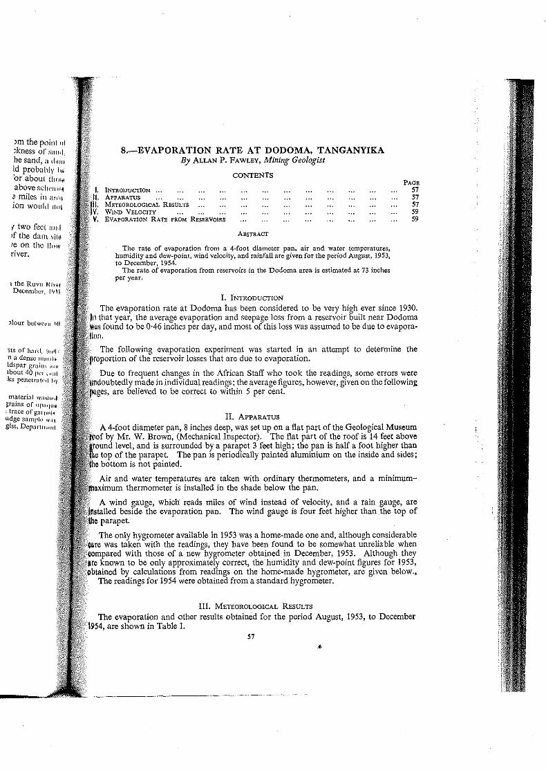
S.-EVAPORATION RATE AT DODOMA, TANGANYIKA By ALLAN P. FAWLEY, Mining Geologist
INTRODUCTION ," ApPARATUS METEOROLOGICAL RESULTS WIND VELOCITY EVAPORATION RATE FROM RESERVOIRS
CONTENTS
ABSTRACT
The rate of evaporation from a 4-foot diameter pan, air and water temperatures, humidity and dewppoint, wind velocity, and rainfall are given for the period August, 1953, to December, 1954.
The rate of evaporation from reservoirs in the Dodoma area is estimated at 73 inches per year.
1. INTRoDuCfION
PAGB 57 57 57 59 59
The evaporation rate at Dodoma has been considered to be very high ever since 1930. In that year, the average evaporation and seepage loss from a reservoir built near Dodoma
;' found to be 0·46 inches per day, and most of this loss was assumed to be due to evapora·
The following evaporation experiment was started in an attempt to determine the ""lOc>fti'on of the reservoir losses that are due to evaporation.
Due to frequent changes in the African Staff who took the readings, some errors were m~~s~b::~\;e~m~a~d~e~in individual readings; the average figures, however, given on the following )11 to be correct to within 5 per cent.
n. ApPARATUS
A 4-foot diameter pan, 8 inches deep, was set up on a flat part of the Geological Museum Mr. W. Brown, (Mechanical Inspector). The flat part of the roof is 14 feet above level. and is surrounded by a parapet 3 feet high; the pan is half a foot higher than
top of the parapet The pan is periodically painted aluminium on the inside and sides; bottom is not painted.
Air and water temperatures are taken with ordinary thermometers, and a minimumno,:imum thermometer is installed in the shade below the pan.
A wind gauge, which fyads miles of wind instead of velocity, and a rain gauge, are beside the evaporation pan. The wind gauge is four feet higher than the top of
parapet.
The only hygrometer available in 1953 was a home-made one and, although considerable was taken with the readings, they have been found to be somewhat unreliable when
CiOI:npareKi with those of a new hygrometer obtained in December, 1953. Although they to be only approximately correct, the humidity and dew-point figures for 1953,
001ta1l1OO by calculatlOlls from readings on the home-made hygrometer, are given below., The readings for 1954 were obtained from a standard hygrometer.
Ill. METEOROLOGICAL REsULTS
The evaporation and other results obtained for the period August, 1953, to December 1954, are shown in Table I.
57

1953 Aug. 10-3Ist.
. Sept. ~ Oct.
VI Nov. . .. 00 Dec. I-15th.
Dec. 16-3Ist.
1954 Jan. Feb. Mar. Apr. May. June July Aug. Sept. Oct. Nov. n<e.
TABLE I
I - 1 I I ---- 1 Evapmation mte
\ Air tern erature !te~a~~:M'1 :r~~~~tl Win~ I . . . ~~ I - (A) 1 B ( p) I. t P between velOCity. Ramfall HumIdity (average) P I1 From E' (d) average . ure I' 4 a.m. &I(averagc), at 4-ft.' stlmate average
(average) 4 1 8 a.m. d t I from large p.m. I la;: er 1 reservoir'"
----1--1----1--1 ! I' , % I ins. per i ins. per I ins. per
o I day I day month
! Max. 1 Mm. I Max. I-----------s.:;;-: Noon! 4 P.m·I---·---I---I---851 581 80 2/10 - Nd -I -I -I' - 0·29 87 60 83 3/10 4'5' Nil' - • -I - -I 0·31 89 62 88 3/10 5-61 Nd 73 47 35 59 0'371 94 I 65 I 90 3/10 6-0 Nil 71 I 40 I 37 1 64 042
97 t 681 95 3/10 I 5-61 0'15 70 1 471 39 1 65 1 0'40 I -I -92 I 66 89 8/10 2'1 6·79 87 71 59 63 0'22 - -
[--89-11'--65----89---6/-10-11--1-.4-1--2.-20----86-'--68-11--71-1--65---0'-20---0'-14---4'-34-
..' 1 92 66 94 6/10 3-3 1 1·33 81 51 41 64 0·27 0'19 5·32 I 91 I 66 94 5/10 3·8 2·51 86 49 I 38 I 65 0'29 0-20 6·20
"'1 89 I 64 89 6/10 3-4 I-50 79 51 ' 44 I 63 0-25 0-18 5-40 871 61 88 5/10 3·9 0-07 80 46 37 i 60 0-24 0-17 5-27 85 57 87 3/10 3·5 Nil 72 42 33 54 0-24 0-17 5·10 831 56 85 2110 3-9 Nil 78 42 33 54 0·25 0-18 5'58 83 58 85 4/10 4·9 Nil 81 42 34 56 0-28 0-20 6'20 86 ! 59 88 3/10 5·8 Nil 75 41 33 56 0-32 0'22 6·60 88 'I 62 91 3/10 6·0 Nil 68 37 30 58 0·38 0'27 8'37 94 65 91 3/10 6·6 Nil 77 45 42 63 0'39 0·27 8·10 95 66 95 3/10 3·8 II~: 78 58 52 64 0·29 0·20 I'~
11·87 I 72-68
OF OF m.p.h. ins.
-'----'--------===-----.. ~ ~. 2::-~~ 2. ~ ~~ cl (\-7 w ~.~ b. CC""":r-- {Al.

",,,,, 'MM ~6o
'" ~ / &;"/ Z..;. ..:..
------
-----. --' 22 j ~~
H ---- 8 ,~
.8 "" " ---- ]
"" " '''' -9 S
----, ~
.~ 6 ,'" ~
" ,. 0
---, E " .g g ~ • '" .~ ". 8: •
$'
) .0
~ 0 •
~
IV. WIND VELOCITY
wind blows at a remarkably steady rate from the east during the dry season, generally of four to six miles per hour. During the wet season the wind is more variable
I,r.w"" and velocity. During both the dry and wet seasons there are a few strong but the average velocity during two-hour periods is seldom more than ten miles per
V. EVAPORATION RATE FROM RESERVOIRS
fixpe,eirrlent' have shown that water evaporates from a small pan at a faster rate than body of water; also if the pan is installed on land, water evaporates from
rate than if the pan is floating in water. Kcmpe (1953)1 gave evidence which the ratio of pan evaporation to that of open reservoirs is between 0'6 and 0'8 the evaporation rate in a reservoir, the evaporation rate in a pan must be reduced
multiplyillg it by from 0·6 to 0·8). pan on the roof of the Geological Museum is somewhat sheltered from the wind wind velocity on the roof is probably less than at either of the reservoirs, but the
water temperature in the pan becomes considerably greater than in the reservoir. OXllmple of the difference in water temperature of the pan and of the surface reservoir
M:,al:,tu Reservoir for September 16th, 1953, follows:-
-----~---------8~~·--r--~-n--··
Air I' Water Air Water Roof pan . 670 F 650 F 770 F 72° F Reservoir 68 68 81 70
4'00 p.m. , Air 1 Water
860 F 860 F 91 76
rate of evaporation from the Dodoma reservoirs, obtained by applying a reduction 0·7 to the results obtained from the evaporation pan for 1954, range from 4·34
inches per month and total 73 inches for the entire year. .
Engineer's YearBook for 1953, Morgan Brothers, London-p.802.
s.