Water Quality Trends in the Genesee River - server79x.net 333_2011.10.31.docx · Web viewIn close...
39
Rochester Committee for Scientific Information P.O. Box 20198 Rochester, NY 14602 ___________________________________________ _________ Bulletin #333 October, 2011 The Saline Water Belt Marginal to Bedded Salt Deposits of the Silurian Salina Group, Western New York State: A Possible Glacial “Pocket” Aquifer William M. Goodman, David J. Gnage, and Peter H. Smith RESPEC Abstract This paper describes an apparent brine aquifer of possible glacial origin situated in the up-dip portions of the Silurian Salina Group subcrop belt, south of the historical salt manufacturing center at Montezuma, Cayuga County, New York. Well completion records report saline formation water in the interbedded shale, carbonate and salt sequence. If accurately reported, fluid emplacement in these strata cannot have occurred vertically; lateral down-dip migration is required to emplace fluid beneath intact salt beds. Increased hydraulic gradients imposed by glacial ice during the Pleistocene Epoch may have promoted enhanced, southward-directed fluid flow along bedding- parallel transmissive horizons in the Salina Group. Saline fluids are reported in Salina Group strata to subsurface depths of about 1,500 feet. At more substantial depths, Salina Group strata are dry. These hydrogeological patterns are in conflict with a Tothian model of basin-scale fluid flow that requires meteoric recharge (rain and snow melt) in the Appalachian Plateau (Southern Tier) Province of western New York to infiltrate as 1
Transcript of Water Quality Trends in the Genesee River - server79x.net 333_2011.10.31.docx · Web viewIn close...

Rochester Committeefor Scientific InformationP.O. Box 20198
Rochester, NY 14602
____________________________________________________Bulletin #333 October, 2011
The Saline Water Belt Marginal to Bedded Salt Deposits of the Silurian Salina Group, Western New York State:
A Possible Glacial “Pocket” Aquifer
William M. Goodman, David J. Gnage, and Peter H. SmithRESPEC
Abstract
This paper describes an apparent brine aquifer of possible glacial origin situated in the up-dip portions of the Silurian Salina Group subcrop belt, south of the historical salt manufacturing center at Montezuma, Cayuga County, New York. Well completion records report saline formation water in the interbedded shale, carbonate and salt sequence. If accurately reported, fluid emplacement in these strata cannot have occurred vertically; lateral down-dip migration is required to emplace fluid beneath intact salt beds. Increased hydraulic gradients imposed by glacial ice during the Pleistocene Epoch may have promoted enhanced, southward-directed fluid flow along bedding-parallel transmissive horizons in the Salina Group. Saline fluids are reported in Salina Group strata to subsurface depths of about 1,500 feet. At more substantial depths, Salina Group strata are dry. These hydrogeological patterns are in conflict with a Tothian model of basin-scale fluid flow that requires meteoric recharge (rain and snow melt) in the Appalachian Plateau (Southern Tier) Province of western New York to infiltrate as deeply as the Salina Group salts before migrating northward and discharging as brine in the Lake Ontario Plain. Instead, water-bearing Salina Group strata are restricted to a belt approximately 18 miles south of, and parallel to, the Onondaga Escarpment. Hence, the saline aquifer, referred to herein as the Montezuma Brine Aquifer System (MBAS), more likely owes its origin to Pleistocene paleohydrological processes that affected the escarpment.
During the period of Pleistocene glacial advance, the MBAS was likely closed-ended along its southern boundary, i.e. the aquifer had no discharge zone. Recharging sub-glacial meltwater simply may have infiltrated farther down-dip through bedding-parallel transmissive zones and remained in storage. The term “pocket” aquifer is proposed for this type of closed-ended, glacio-hydrogeological system. Following glacial retreat, the steepened, southward-directed hydraulic gradient dissipated, and the source of cold water recharge was removed. Thus, according to the glacial pocket aquifer hypothesis, the Salina Group outcrop belt changed behavior over time from a Pleistocene recharge zone to a Holocene discharge zone. Today, the Salina Group outcrop belt is populated by brine springs, confirming its status as a discharge zone for the modern MBAS.
1

In close proximity to the Onondaga Escarpment, a localized, shallow subsurface, topographically controlled flow system contains fresh water. The saline water in the deeper subsurface MBAS, may be driven up-dip to the line of saline springs by gradual release of residual Pleistocene fluid pressure. Fresh water and saline water springs can be closely juxtaposed, and the waters from the shallow and deeper flow systems likely mix in many areas along the southern margin of the Lake Ontario Plain.
The presence of brine in subsurface Salina Group strata south of the Onondaga Escarpment in western New York is commonly reported in vintage scientific literature. Hence, the saline aquifer system is likely more extensive than the Seneca and Cayuga Lake valleys near Montezuma. Nineteenth century descriptions of salt wells in Wyoming, Livingston, Genesee, Erie and Cattaraugus Counties indicate artesian brine conditions in a zone parallel to, and south of, the up-dip terminus of the salt beds in the Salina Group. The salt beds are preserved just south of the Onondaga Escarpment beneath much of western New York. North of the escarpment, the Salina Group strata are so shallow in the subsurface that they are thoroughly leached by actively circulating groundwater, and the salt beds have been fully dissolved.
Introduction
Before discovery of bedded halite deposits north of Warsaw, Wyoming County in 1878, salt manufacturing in New York was based on evaporation of naturally-occurring brines. The main production centers were at Onondaga Lake (Salina, Liverpool, Geddes, and Syracuse from 1797 to 1927), but the Village of Montezuma near the north end of Cayuga Lake also periodically served as a competing salt production site from 1798-1872 (Figure 1).
Whereas the hydrogeology of the aquifer supplying the former Onondaga Salt Springs Reservation is well-described following extensive studies by the U.S. Geological Survey (Kappel, 2000; Kappel and Miller, 2003; 2005), little has been published until recently on the brine aquifer system at Montezuma. In April 2010, Goodman et al. (2010) presented a paper to the Solution Mining Research Institute on the historical development of salt manufacturing and the hydrogeology of the saline springs at Montezuma. Of particular interest was the description of the brine aquifer with a width of 15–30 kilometers (9 miles to 18 miles) in the north-south dimension within the Cayuga Lake valley and adjacent areas (Figure 2). This zone of Salina Group strata containing saline groundwater is referred to herein as the Montezuma Brine Aquifer System (MBAS).
The MBAS discharges, in part, via saline springs north of the Onondaga Escarpment. The springs at Montezuma were known to the local Native Americans by the paths worn to them by animals. Local tribesmen revealed the springs to Comfort Tyler who, in 1788, had become the first white settler to produce salt at Onondaga Lake 44 kilometers (26.4 miles) to the east. Tyler started operations at Montezuma in 1798 with two partners, Mr. Abram Morgan and Dr. Peter Clark (Storke, 1879), apparently to avoid newly established state regulations and duties on salt produced at Onondaga. In 1807, Mr. John Swartwout also set up salt works on the Salt Creek branch of the Seneca River near Montezuma.
The high strength brines (up to 75 percent halite saturation) discharging as springs at both Onondaga Lake and Montezuma owe their origin to dissolution by groundwater of salt beds of
2

3

Figure 1. Outcrop Patterns on the Lake Ontario Plain Portion of the New York Salt District. Inset: U.S. Geological Survey Topographic Maps of the Onondaga Lake and Montezuma Salt Production Centers. Stars on are early nineteenth century salt operations or centers utilizing naturally occurring brines.
4

Figure 2. Montezuma Brine Aquifer System and Progressive Down-Dip Fresh-Brackish-Brine Fluid Salinity Gradients. Brine zone highlighted in yellow.

the Silurian Salina Group. Completion reports for wells drilled as far south of the Salina Group outcrop belt as 18 miles indicate saline water in carbonate and shale strata interbedded with salt. Farther south, the carbonates and shales in the Salina Group are dry according to well completion reports and based on observations in salt mines. The lateral boundary between water-bearing Salina Group strata closer to the outcrop belt and dry Salina Group strata farther down-dip defines the southern limit of the MBAS (see Figure 2). Drilling records for wells in the Cayuga Lake valley indicate brine in Salina Group strata south of (i.e., down dip of) Montezuma to depths approaching 450 meters (about 1,500 feet) (Figure 3).
Interestingly, some reported water-bearing zones in Salina Group shale and dolostone beds are positioned between intact salt beds. See, for example, the water-bearing zones in the Wells College Well at Aurora in Figure 3. How could these fluids have been emplaced below the F1 salt bed when salt beds are soluble but impervious? Clearly, the fluid flow could not have been vertical; the flow had to be laterally down-dip in a bedding parallel direction. This peculiar hydrostratigraphic condition inferred from the well completion records, in conjunction with direct observation of dry Salina Group strata in the state’s deep subsurface salt mines, appears to be in conflict with some commonly-held assumptions regarding the depth to which active subsurface fluid flow systems operate in sedimentary basins. Called into question is the applicability at the basin scale of the Tothian model of fluid flow (Toth, 1963; LaSala, 1964; Noll, 1989) according to which fluids penetrate deeply into the subsurface beneath regional recharge areas before flow vectors flatten out, extend laterally for tens to hundreds of kilometers, and then ultimately become upward-directed beneath regional discharge zones.
A conceptual Tothian flow system for the New York portion of the Appalachian Basin is illustrated in Figure 4. This model invokes (1) regional aquifer recharge via infiltration of rainwater and snow melt (i.e., meteoric water) in the elevated Southern Tier (Appalachian Plateau) physiographic province; (2) vertical migration of recharge to depths of hundreds of meters; and (3) slow northward migration of deep flow vectors toward the Lake Ontario Plain (regional discharge zone) with a concomitant northward increase in dissolved solids content and evolution of the geochemical signature (i.e., facies) from calcium-bicarbonate to calcium-sulfate to sodium chloride. According to this type of model, the well-documented salinity of groundwaters beneath the Lake Ontario Plain can be explained by contact with Salina Group salts and other Silurian marine strata.
There are problems with application of the Tothian model at this scale, however. In the Cayuga Lake Valley, room and pillar salt mining has been on-going near Ludlowville since 1923 (Goodman et al., 2009). At that latitude in the valley, the base of the groundwater-saturated stratigraphic section occurs near the Salina Group-Bertie Group contact (Goodman and Plumeau, 2004) at a depth of about 415 m (1360 feet) below lake level (about 300 meters subsea (975 feet subsea)). The seven or so mappable salt beds that occur within the Salina D-E-F units (Syracuse Formation) as defined by Rickard (1969) are all dry despite complex geologic structure (see Prucha, 1968; Goodman and Plumeau, 2004) (Figure 5). Similarly dry conditions apparently existed in the inactive Morton Salt Himrod Mine on the west side of Seneca Lake. Based on direct observation of these dry salt conditions, any vertically migrating meteoric water entering the groundwater system south of the Finger Lakes Region apparently does not penetrate more deeply than the top of the Salina Group at the latitudes of these mines. The presence of brine in contact with Salina Group salts as reported in well drilling records available from the New York State Department of Environmental Conservation apparently occurs only farther to the north (see Figures 2 and 3).
7

6

Figure 3. Fence Diagram of Salina F-G Interval Showing Northwestward Thinning and Position of Water-Bearing Zones Across the Cayuga Lake Valley.
9

Figure 4. Conceptual Tothian Flow Model for the Northern Appalachian Basin Margin in Central New York.
7

Figure 5. Relation of Early Twentieth Century Cayuga Mine Workings to Complex Structure Beneath the Crest of the Fir Tree Point Anticline. From Goodman and Plumeau (2004).
One could argue that groundwater at the base of a regional-scale Tothian flow system simply glides atop the low permeability shales and gypsum beds of the Salina G (uppermost unit of the Salina G) before penetrating more deeply into the subsurface in the region north of the mines. The reported presence of brine in between salt beds would seem to preclude that possibility, however. To support an interpretation of vertical fluid migration through the upper salts (Salina F), a top-down sequence of salt bed dissolution would have to be demonstrated. Reported brine occurrences in shale and dolostone intervals between intact salt beds in some wells contradict an interpretation of such a top-down dissolution process.
The Glacial Pocket Aquifer Hypothesis
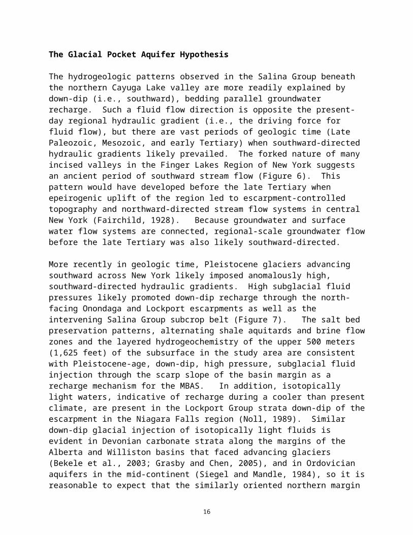
The hydrogeologic patterns observed in the Salina Group beneath the northern Cayuga Lake valley are more readily explained by down-dip (i.e., southward), bedding parallel groundwater recharge. Such a fluid flow direction is opposite the present-day regional hydraulic gradient (i.e., the driving force for fluid flow), but there are vast periods of geologic time (Late Paleozoic, Mesozoic, and early Tertiary) when southward-directed hydraulic gradients likely prevailed. The forked nature of many incised valleys in the Finger Lakes Region of New York suggests an
11

ancient period of southward stream flow (Figure 6). This pattern would have developed before the late Tertiary when epeirogenic uplift of the region led to escarpment-controlled topography and northward-directed stream flow systems in central New York (Fairchild, 1928). Because groundwater and surface water flow systems are connected, regional-scale groundwater flow before the late Tertiary was also likely southward-directed.
More recently in geologic time, Pleistocene glaciers advancing southward across New York likely imposed anomalously high, southward-directed hydraulic gradients. High subglacial fluid pressures likely promoted down-dip recharge through the north-facing Onondaga and Lockport escarpments as well as the intervening Salina Group subcrop belt (Figure 7). The salt bed preservation patterns, alternating shale aquitards and brine flow zones and the layered hydrogeochemistry of the upper 500 meters (1,625 feet) of the subsurface in the study area are consistent with Pleistocene-age, down-dip, high pressure, subglacial fluid injection through the scarp slope of the basin margin as a recharge mechanism for the MBAS. In addition, isotopically light waters, indicative of recharge during a cooler than present climate, are present in the Lockport Group strata down-dip of the escarpment in the Niagara Falls region (Noll, 1989). Similar down-dip glacial injection of isotopically light fluids is evident in Devonian carbonate strata along the margins of the Alberta and Williston basins that faced advancing glaciers (Bekele et al., 2003; Grasby and Chen, 2005), and in Ordovician aquifers in the mid-continent (Siegel and Mandle, 1984), so it is reasonable to expect that the similarly oriented northern margin of the Appalachian Basin shares the same chapter in its fluid history (Bense and Person, 2008).
Goodman et al. (2010) proposed the term “pocket aquifers” to describe water-bearing zones that developed in strata down-dip of the escarpment-controlled outcrop belts as a consequence of subglacial high pressure recharge. The pocket adjective denotes that the aquifers had no down-dip discharge zone; the escarpments into which fluids were injected under high subglacial pressures during ice advance changed hydrological behavior to discharge zones following glacial recession. Once exposed, the escarpments became populated with brine springs allowing the residual high formation pressures to dissipate near the outcrop belt over Holocene (postglacial) time. Goodman et al. (2010) hypothesized that the MBAS, situated beneath, and south of, the Onondaga Escarpment, is such a pocket aquifer of glacial origin.
Superimposed on this regional-scale pocket aquifer system is the local-scale flow system developed in the area along the crest of the Onondaga Escarpment (Figure 8). In this narrow, shallow subsurface flow system hydraulic gradients direct recharge along the topographically high Onondaga Limestone Escarpment to discharge zones along the foot of the escarpment. This localized flow system is karstic and is an important source of fresh water for some parts of western New York where the Onondaga Limestone is cavernous and/or highly fractured. Where the Onondaga Limestone is overlain by low permeability Marcellus Shale, the shallow carbonate aquifer contains sulfur-rich water in association with hydrogen sulfide and/or methane. The deeper, highly saline waters of the regional-scale pocket aquifer (MBAS) reside beneath the fresh water and sulfur water zones of the narrower, shallow, escarpment-parallel, escarpment-controlled flow zone.
Ongoing research on the early solution-mining history in Wyoming, Livingston, and Genesee Counties suggests that a naturally-occurring brine aquifer is also present in these areas. Nineteenth century descriptions of salt wells in the above-referenced counties, as well as those in
12

Figure 6. Forked Drainages Indicative of Pre-Glacial Southerly Stream Flow Patterns South of Montezuma.
10

14
11

Figure 7. Schematic Hydrological Cross-Section Depicting Hypothesized Conditions During Glaciation of the Northern Appalachian Basin Margin..
15
12

Figure 8. Conceptual Flow Vectors and Vertical Geochemical Zonation Beneath the Onondaga Escarpment in Central and Western New York.
17

Erie and Cattaraugus Counties, indicate that artesian brine conditions are prevalent in a zone marginal and up-dip from the subcrop belt (i.e., the up-dip terminus) of the salt beds in the Salina Group. The salt beds are preserved just slightly south of the Onondaga Escarpment. North of the escarpment, the Salina Group strata are so shallow in the subsurface that they have been thoroughly leached by both ancient and modern, actively circulating groundwater.
Mention of naturally occurring brine within about 30–50 meters (98–165 feet) of the top of the Salina B salt is very common in the nineteenth century descriptions of the early solution mining wells in western New York. In the main B salt production district of Livingston, Genesee, and Wyoming Counties, Bishop (1886) recorded brine in Salina Group strata above the B Salt in wells at Perry, Piffard, Pearl Creek, Castile, Caledonia, and Leroy (Figure 9). The early records for wells at Piffard near the flooded Retsof Mine confirm the presence of brine about 30 meters (98 feet) above the uppermost bed in the Salina B (Bishop, 1886; Merrill, 1893). Detailed analysis of available records for local Genesee Valley area wells, both modern and vintage, by Gowan et al. (1999) pinpoints the Salina D salt horizon as a focused brine flow zone that contributed the initial flow of water and gas into the Retsof Mine before the influx of more dilute meteoric water. Gowan et al. (1999) documented a 65 percent salt saturation level in Salina D brines from a modern well drilled in the vicinity of the Cuylerville well (Phoenix Well) that was described by Bishop (1886) to yield brine of comparable strength.
Bishop (1886) also mentions brine in contact with salt in early hydrocarbon exploration wells at Vincent (formerly Muttonville) and a brine well at Clifton Springs in Ontario County. The first of the hydrocarbon exploration wells at Vincent, drilled on the Eli Rice Farm, was completed in 1865, making it the first well to penetrate rock salt in the state. Because the well was drilled for oil exploration, however, the salt was never exploited at this location. The second well, completed for the Ontario Improvement and Gas Company in 1883, also penetrated salt, but was also intended for hydrocarbon exploration. Bishop (1886) notes that both of the Vincent wells were “wet holes” with artesian water and natural gas returns through the uppermost 300 to 335 meters (1,000–1,100 feet) of borehole section. These wells are spudded in Hamilton Group shales (i.e., the shale formation is at the top of rock), penetrate the underlying Bertie-Akron-Onondaga carbonate sequence and terminate roughly 100 meters (325 feet) or more in the Salina Group with salt beds in the bottom portions of the wells.
During 1884, a well drilled about 200 meters deep (650 feet) one mile southeast of Clifton Springs for the Ontario Salt Company, yielded brine at 70 percent salt saturation. This brine encountered in Salina Group shales is on par with the strength of the naturally-occurring brines at Montezuma and Onondaga from which salt was commercially produced.
High strength brines are also apparently present in the Salina Group beyond the limits of the Salina B salt bed in the far western counties of New York. Bishop (1886) noted brines, sometimes under high artesian pressure, in wells drilled in Gowanda, Eden Valley, East Aurora, Gardenville, and Attica (see Figure 8). The precise stratigraphic position of these brines within the Salina Group remains to be established by reference to geophysical logs for modern era wells, but the depths of the brine below the distinctive top of the Onondaga (Cornifereous) Limestone as reported by Bishop (1886) range from 122 meters (400 feet) at Gowanda and Eden Valley to 235 meters (770 feet) at East Aurora. These reported depths below the top of the Onondaga would place the stratigraphic horizons for the brine zones at, or below, the top of the Salina Group.
18

Figure 9. Early Solution-Mining and Mechanical Mining Locations in Genesee, Wyoming, Livingston and Ontario Counties.
14

The descriptions of the Pioneer Well just south of the Village of Wyoming suggest that high sulfur fluids are present in the Lockport Group-Salina A interval beneath well-preserved salt beds in parts of the Oatka Creek valley. The story of the Pioneer Well has been recounted by several students of salt geology and manufacture (Bishop, 1886; Luther, 1898; Werner, 1917), but one important detail on the presence of fluids below the Salina B salt, that was not subsequently repeated, is provided in a History of Wyoming County, N. Y. published by F. W. Beers & Company in 1880. According to all accounts, the well was drilled for the Vacuum Oil Company of Rochester, New York on the C. B. Matthews Farm about one mile south of the Village of Wyoming with a spudding date of about February 1878. Salt was struck at a depth of 386 meters (1,265 feet). The salt bed proved to be 23 meters (75 feet) thick. Then, as F. W. Beers & Company (1880) noted, “Sulphur water being struck below this, further boring was given up and the well was plugged at the bottom of the salt bed”. No later specific mention of this water beneath the Salina B salt is made in the key reports cited herein, but Mathers (1884) made a general reference regarding the hit or miss presence of fluids beneath the salt beds in the Warsaw District. Mathers commented on the matter in the context of added costs of solution-mining arising from the need to add surface water to some wells to produce brine. Mathers (1884) noted, “The stratum of salt having been once pierced, a saturated solution of the saline matter frequently rises in the boring to within eighty feet of the surface. This, however, can not (sic) always be depended upon—and here center the increased difficulty and expense.”
The above-referenced early statements regarding the presence of high sulfur fluids below the Salina B salt bed and the lack of later mention in subsequent salt-related reports was initially confusing. First, sodium chloride brines would be expected in contact with salt, whereas sulfur-rich fluids are typically found in contact with gypsum, anhydrite and/or carbonate (limestone/dolostone) formations. Secondly, the roughly 200-feet- (60-meters-) thick Salina A shale sequence is generally considered to exhibit a low permeability; free water would not be expected in that unit at depths on the order or 450 meters (1,500 feet).
A stratigraphic log for the Pioneer Well published by Merrill (1893) provides a key clue that possibly explains the fluid occurrence and permits assignment of these sulfur-rich waters to the Lockport Group. Merrill (1893) provides documentation that the Pioneer Well was drilled to 58 meters (190 feet) below the base of the Salina B salt. This total depth would be equivalent to the top of the Lockport Group and would explain the sudden upwelling of high sulfur water noted by F. W. Beers & Company (1880). Because calcium sulfate was a nuisance contaminant in manufactured brine, the well was grouted back to the base of the Salina B salt bed.
Clearly, having a naturally-occurring, highly-saturated brine in the wellbore either above or below the Salina B salt bed provided a key economic advantage for the Warsaw producers over the then-dominant Onondaga Lake producers who had to evaporate more dilute brine by slow solar methods or by applied heat with lower salt yields per ton of coal than at Warsaw. Of course, the Warsaw producers also allowed any fresh water encountered at relatively shallow depths (commonly at depths to about 125 meters (405 feet)) in the bore hole to cascade downward to contact the salt deposits and thereby produce artificial brine typically greater than 95 percent saturation.
Bishop (1886) notes fluids in the Salina Group at 70 percent saturation from wells in which the salt beds were missing. Bishop, in fact, used a 95 percent salt saturated brine criterion to determine whether or not a well actually contained rock salt. Viewed from a different perspective, the presence of fluids up to 70 percent saturation beyond the limits of the preserved
20

salt beds across large regions of western New York confirms the extensive nature of the brine aquifer system historically exploited for salt manufacture at Onondaga Lake and Montezuma. The saline fluid zone appears to extend stratigraphically from the B Unit of the Salina Group to the unconformity at the top of the Bertie Group marked by remnants of the Oriskany Sandstone and roughly age-equivalent argillaceous materials (Tristates Group). In addition to the brine aquifer in the Salina Group, a high sulfate brine aquifer in the slightly deeper Lockport Group may exist in the western part of the state.
A Layered Internal System
The pattern that is emerging from this research is a layered hydrostratigraphy beneath western New York involving up-dip brine zones in the Lockport Group, the Salina B, the Salina D-E-F, and “bitter water” (high calcium and magnesium brines) in the Bertie-Akron units. High sulfate waters, in combination with hydrogen sulfide gas, also appear to be prevalent in the Onondaga Limestone where it is overlain by more than 100–150 meters (325–485 feet) of Hamilton Group shales and in the Lockport Group carbonates below the Salina Group. Based on preliminary assessment of gamma ray logs in Rickard (1969) and a composite log for the LeRoy area from a Ph.D. thesis by Hunt (2000), the brine-bearing zones likely correlate with low gamma units that represent leached salt beds, anhydrites and/or carbonate beds (Figure 10). The leached salt beds and the carbonates may have vuggy to cavernous porosity.
The higher gamma units, conversely, are the shale-dominated intervals including the Salina A, C, and G units. These higher gamma, shale-prone units are likely to serve as regional aquitards that confine flow within bedding parallel zones in the deeper subsurface. Fluids from the separate brine-bearing zones may only communicate in the shallow subsurface close to the escarpment belts where fracturing and karstification compromise the integrity of the intervening aquitards.
Analysis of modern downhole geophysical logs and their reconciliation with brine returns reported on well completion records available at the New York State Department of Environmental Conservation (NYSDEC) will assist in better mapping of the thickness and regional extent of the brine-bearing zones. The hydrostratigraphic analysis must be expanded to include neutron porosity, density, resistivity, and caliper logs to further test the pocket aquifer hypothesis and to improve the resolution of the brine aquifer mapping. After the thickness and lateral extent of each brine-bearing zone in the layered aquifer system is mapped, efforts can be undertaken to better understand its physical hydrological properties.
Implications for the Presence of Pleistocene Fossil Groundwater
If the brine aquifer system truly has a glacial origin, the potential may be high for the deeper subsurface, southern regions of the discrete flow zones to be confined and isolated from the shallow subsurface fresh water zone. A tenet of the pocket aquifer hypothesis is that the current discharge zone at the scarp face formerly served as the principal aquifer recharge zone, and that there is little significant vertical communication between key hydrostratigraphic intervals in the area south of (i. e, down-dip of) the escarpments. Based on the commonly observed stratification of formation water types and dry rock conditions in the Salina Group farther south in the Cayuga and Seneca lake basins, basin-scale groundwater flow vectors extending from a recharge zone beneath the Appalachian Plateau, extending as deep as the Salina Group, and directing flow northward toward the Lake Ontario Plain do not appear to exist. The current driving force for
21

high strength brine discharge at the edge of the Montezuma swamp may simply be ongoing relief (i.e., “brine
22

Figure 10. Annotated Composite Gamma Ray Log Modified From Hunt (2000) Showing Alternating Shale-Rich and Salt/Anhydrite/Carbonate Zones.
17

squeeze”) of bedding parallel flow zones that were over-pressurized during the Pleistocene. If true, there may be little cross-formation communication between brine-bearing zones south of the Onondaga Escarpment and the overlying, narrower, escarpment parallel fresh water circulation system. Hence, there may be truly Pleistocene-aged brines present in the deeper parts of the brine aquifer system, particularly near its southern limits.
The fluids encountered under high artesian pressures in the nineteenth century wells may be Pleistocene waters that were trapped by head-loss-induced contraction of the up-dip regions of the aquifer as brine spring discharge allowed depressurization of the zones nearest to the Onondaga and Niagara escarpments. In essence, if the up-dip portions of the aquifer skeleton contracted as pressure was relieved, the permeability and lateral hydraulic gradients in those depressurized zones would likely have decreased. Hence, the southern portions of the aquifer “pocket” could have been sealed, albeit imperfectly, thereby inhibiting release of the fossil waters still present under pressure at the southern regions of the system. An analogy can be drawn between the brine aquifer and a zip-lock bag filled with water. In the case of the MBAS, the zipper of the bag is leaky as evidenced by brine springs that continue to operate along the Salina Group subcrop belt just north of the foot of the Onondaga Escarpment. Similarly high salinity/high sulfate discharges also occur along the foot of the Lockport Escarpment in the area between Monroe and Niagara Counties.
Additional geochemical analyses for major ions and dissolved solids content, as well as tritium and stable isotopic analyses on fluids in the regional-scale brine aquifer system would certainly aid in defining the boundaries between Pleistocene-age brines and mixed fluids containing a modern water component. The validity of the glacial pocket aquifer hypothesis holds only if there is adequate confinement of the system to preclude mixing of modern and Pleistocene fluids in the areas south of the escarpments.
Conclusions
A brine aquifer has been mapped within the Cayuga Lake valley and adjacent areas to the south of the historical salt production sites near the Village of Montezuma, Cayuga County, New York. The brine is referred to herein as the Montezuma Brine Aquifer System (MBAS). The MBAS discharges, in part, via saline springs north of the Onondaga Escarpment.
The high strength brine springs (up to 75 percent halite saturation) at Montezuma owe their origin to dissolution by groundwater of salt beds in the Silurian Salina Group. Completion reports for wells drilled within the Cayuga Lake Valley as far south of the Salina Group outcrop belt as 15–30 kilometers (9 miles to 18 miles) indicate saline water in carbonate and shale strata interbedded with salt. Farther south, the carbonates and shales in the Salina Group are dry. The lateral boundary between water-bearing Salina Group strata closer to the outcrop belt and dry Salina Group strata farther down-dip defines the southern limit of the MBAS. The saline formation waters have been noted in drilling records to depths approaching 450 meters (1,476 feet).
Interestingly, some reported water-bearing zones in Salina Group shale and dolostone beds are positioned between intact salt beds. The intercalation of fluids in the bedded salt, carbonate and shale sequence may be explained by down-dip (i.e., southward), bedding parallel groundwater recharge. Such a pattern is opposite the present-day regional hydraulic gradient, but there are
24

vast periods of past geologic time when southward-directed groundwater flow likely occurred. Pleistocene glaciers advancing southward across New York likely imposed anomalously high, southward-directed hydraulic gradients that enhanced down-dip recharge of fluids through the north-facing Onondaga and Lockport escarpments as well as the intervening Salina Group subcrop belt. The salt bed preservation patterns, alternating shale aquitards and brine flow zones, and the layered hydrogeochemistry of the upper 500 meters (1,625 feet) of the subsurface in the study area are consistent with Pleistocene-age, down-dip, high pressure, subglacial fluid injection through the scarp slope of the basin margin as a recharge mechanism for the MBAS.
The term “pocket aquifers” has been proposed to describe closed-ended water-bearing zones that developed as a consequence of down-dip, subglacial, high pressure recharge in sedimentary basin margin settings. The pocket adjective denotes that the aquifers had no down-dip discharge zone; the escarpments into which fluids were injected under high subglacial pressures during ice advance changed hydrological behavior to discharge zones following glacial recession. Once exposed, the escarpments became populated with brine springs allowing the residual high formation pressures to dissipate near the outcrop belt over Holocene (postglacial) time. The MBAS, situated beneath, and south of, the Onondaga Escarpment, is hypothesized to be such a pocket aquifer of glacial origin.
The scientific community still has work to do in terms of thoroughly documenting and describing subsurface hydrological processes and fluid composition trends in the northern part of the Appalachian Basin. Because the region is resource-rich (natural gas and salt), there is a compelling reason to better understand the origins of associated fluids. Pursuit of that understanding not only requires application of modern investigative techniques (downhole geophysical logging and isotope geochemistry), but review and analysis of the vintage literature published at a time when there was economic incentive for careful observation of water-bearing zone positions, fluid levels, and composition of brines in wells drilled along, and south of, the Onondaga Escarpment.
Acknowledgments
The authors wish to thank Dr. Richard Young (SUNY Geneseo), Dr. John Osnes (RESPEC), Dr. Joe Ratigan (PB ESS) and Mr. Jeff McCartney (Texas Brine Company) for their constructive reviews of this bulletin. The authors also wish to thank Ms. Laura Fairhead (RESPEC) and Ms. Karla Lipp (RESPEC) for their typing and quality control review of the manuscript.
References
Beers, F. W. and Company, 1880. History of Wyoming County, N. Y. with Illustrations, Biographical Sketches and Portraits of Some Pioneers and Prominent Residents, F. W. Beers & Company, New York, New York, 308 p.
Bekele, E. B., B. J. Rostron, and M. A. Person, 2003. “Fluid Pressure Implications of Erosional Unloading, Basin Hydrodynamics and Glaciationin the Alberta Basin, Western Canada,” Journal of Geochemical Exploration, Vol. 78–79, p. 143–147.
Bense, V. F. and Person, M. A., 2008. “Transient Hydrodynamics with Intercratonic Sedimentary Basins During Glacial Cycles,” Journal of Geophysical Research, Vol. 113, F04005, doi:10.1029/2007JF000969, 2008.
25

Bishop, I. P., 1886. “Salt Wells of Western New York, Fifth Report of the New York State Geologist,” pp. 12–47.
Fairchild, H. L., 1928. Geologic Story of the Genesee Valley and Western New York Told in Word and Picture, Scrantoms, Inc., Rochester, New York, 215 p.
Goodman, W. M., D. J. Gnage, P.H. Smith, 2010, “Historical Review of Early Salt Manufacturing from Natural Salines in New York State: Implications for Present-Day Challenges”, Solution Mining Research Institute Spring 2010 Technical Conference, Grand Junction, CO, April 25–28, 31 p.
Goodman, W. M., D. B. Plumeau, J. O. Voigt, and D. J. Gnage, 2009. “The History of Room and Pillar Salt Mines in New York State,” Proceedings, 9th International Symposium on Salt, China National Convention Center, Beijing, China, September 4–6, S. Zuoliang (ed.), Gold Wall Press, Beijing, China, Vol. 2, pp. 1239–1248.
Goodman, W. M. and D. B. Plumeau, 2004. “Appalachian Basin Salt in the Silurian Salina Group: The View from the Mines,” Solution Mining Research Institute Spring Meeting, Wichita, KS, April 18–21, 32 p.
Gowan, S. W., S, M, Trader, and L. L. Van Sambeek, 1999. “The Discovery of an Apparent Brine Pool Associated with Anomalous Closure Patterns and the Eventual Failure of the Retsof Salt Mine” Solution Mining Research Institute Fall 1999 Meeting, Washington D.C., October 3–6, p. 241-272.
Grasby, S., and Z. Chen, 2005. “Subglacial Recharge into the Western Canada Sedimentary Basin—Impact of Pleistocene Glaciation on Basin Hydrodynamics,” Geological Society of America Bulletin, Vol. 117, pp. 500–514.
Hunt, A. G., 2000. Diffusional Release of Helium-4 from Mineral Phases as Indicators of Groundwater Age and Depositional History, doctoral thesis, University of Rochester, Rochester, New York, 140 p.
Kappel, W. M., 2000. “Salt Production in Syracuse, New York (“The Salt City”) and the Hydrogeology of the Onondaga Creek Valley,” United States Geological Survey Fact Sheet, FS 139-00, 8 p.
Kappel, W. M. and T. Miller, 2003. Hydrogeology of the Tully Trough, Southern Onondaga County and Northern Cortland County, New York, United States Geological Survey Water-Resources Investigations Report 03-4112, 16 p.
Kappel, W. M. and T. Miller, 2005. Hydrogeology of the Valley-Fill Aquifer in the Onondaga Trough, Onondaga County, New York, United States Geological Survey Scientific Investigations Report 2005–5007, 13 p.
La Sala, A. M., 1967. Ground-Water Resources of the Erie-Niagara Basin, New York, State of Water Resources Commission, Basin Planning Report ENB-3, prepared by U.S. Department of the Interior Geological Survey in cooperation with the New York State Conservation Department
26

Division of Water Resources, for the State of New York Conservation Department Water Resources Commission, Erie-Niagara Basin Regional Water Resources Board, New York Conservation Department, Albany, NY, 114 p.
Luther, D. D., 1898. “The Brine Springs and Salt Wells of the State of New York, and the Geology of the Salt District,” Geological Survey of the State of New York, 16th Annual Report of the State Geologist, The University of the State of New York, Albany, NY, pp. 175–226.
Mathers, F. G., 1884. “The Salt Deposits of Western New York,” Popular Science Monthly, Vol. XXV, May to October, pp. 530–536.
Merrill, F. J. H., 1893. “Salt and Gypsum Industries of New York.” New York State Museum Bulletin, Vol. 3, No. 11, Albany, NY, 89 p.
Noll, R. S., 1989. Geochemistry and Hydrology of Groundwater Flow Systems in the Lockport Dolomite, near Niagara Falls, New York, master of science thesis, Syracuse University, Syracuse, New York, 142 p.
Prucha, J. J., 1968. “Salt Deformation and Decollement in the Firtree Point Anticline of Central New York,” Tectonophysics, Vol. 6, pp. 273–299.
Rickard, L. V., 1969. Stratigraphy of the Upper Silurian Salina Group, New York, Pennsylvania, Ohio, Ontario, Map and Chart Series, No. 12, MC.12, New York State Museum and Science Service, Albany, NY, 57 p.
Siegel, D. I. and R. J. Mandle, 1984. “Isotopic Evidence for Glacial Meltwater Recharge to the Cambrian-Ordovician Aquifer, North-Central United States,” Quaternary Research, Vol. 22, pp. 328–335.
Storke, E. G., 1879. History of Cayuga County, New York, with Illustrations and Biographic Sketches of Some of Its Prominent Men and Pioneers, D. Mason & Company, Syracuse, NY,518 p.
Toth, J., 1963. “A Theoretical Analysis of Groundwater Flow in a Small Drainage Basin,” Journal of Geophysical Resources, Vol. 68(16), pp. 4795–4812.
Werner, C. J., 1917. A History and Description of the Manufacturing and Mining of Salts in New York State, Tobias A. Wright Press, Huntington, NY, 144 p.
27