DOCKET NO. 479 - ct.gov · DOCKET NO. 479 - Tarpon Towers II, LLC and Cellco Partnership d/b/a...
31
Transcript of DOCKET NO. 479 - ct.gov · DOCKET NO. 479 - Tarpon Towers II, LLC and Cellco Partnership d/b/a...


DOCKET NO. 479 - Tarpon Towers II, LLC and Cellco Partnership d/b/a Verizon Wireless application for a Certificate of Environmental Compatibility and Public Need for the construction, maintenance, and operation of a telecommunications facility located at 380 Horace Street, Bridgeport, Connecticut.
}
}
}
Connecticut
Siting
Council
March 9, 2018
DRAFT Findings of Fact
Introduction
1. Tarpon Towers II, LLC (Tarpon) and Cellco Partnership d/b/a Verizon Wireless (Cellco)
(collectively, the Applicant), in accordance with provisions of Connecticut General Statutes (C.G.S.) § 16-50g, et seq, applied to the Connecticut Siting Council (Council) on September 25, 2017 for a Certificate of Environmental Compatibility and Public Need (Certificate) for the construction, maintenance, and operation of a 90-foot monopole wireless telecommunications facility at 380 Horace Street in Bridgeport, Connecticut. (Applicant 1, pp. 1-2)
2. Tarpon is a Delaware Limited Liability Company with offices in Bradenton, Florida. Tarpon constructs, owns and maintains numerous telecommunications facilities in Connecticut and throughout the U.S. (Applicant 1, p. 2)
3. Cellco is a Delaware Partnership with an administrative office located at 99 East River Drive, East
Hartford, Connecticut. Cellco is licensed by the Federal Communications Commission (FCC) to provide personal wireless communication service to Fairfield County, Connecticut. (Applicant 1, pp. 2-3 and Tab 5)
4. The party in this proceeding is the Applicant. (Transcript 1, January 23, 2018, 3:00 p.m. [Tr. 1], p. 5) 5. The purpose of the proposed facility is to improve wireless voice and data service along portions of
Route 1 and Route 127 in Bridgeport and Stratford. The proposed facility would also provide capacity relief to Cellco’s existing East Bridgeport Relo, Bridgeport Washington Park and North Bridgeport 2 cell sites which are currently operating beyond their respective capacity limits. (Applicant 1, p. i)
6. Pursuant to C.G.S. § 16-50l (b), the applicant provided public notice of the filing of the application that was published in the Connecticut Post on September 21, and September 22, 2017. (Applicant 4)
7. Pursuant to C.G.S. § 16-50l (b), notice of the application was provided to all abutting property owners by certified mail. Notices to Virginia Miller; Laserne Smith; Steve Ampofo; Moses Ogunjimi; Astrid Jean-Louis; and Eddie Ramos and Silvia Flores were returned, i.e. marked undeliverable. Neither the return receipt nor the original notice was returned for the notices sent to 416 Realty LLC or Coggswell Square Condominium Unit 2. Cellco submitted a copy of the notice letter to these identified abutters a second time by regular mail on various dates between October 23, 2017 and November 29, 2017. (Applicant 1, p. 4 and Tab 4; Applicant 5, response 1; Tr. 1, p. 14)
8. On September 25, 2017, the Applicant provided notice to all federal, state and local officials and
agencies listed in C.G.S. § 16-50l (b). (Applicant 1, p. 4 and Tab 2)

Docket No. 479 Findings of Fact Page 2
Procedural Matters
9. Upon receipt of the application, the Council sent a letter to the City of Bridgeport on September 27,
2017 as notification that the application was received and is being processed, in accordance with C.G.S. § 16-50gg. (Record)
10. On October 2, 2017, the Council requested an extension of time to deem the application complete due to the cancellation of the October 12, 2017 Council meeting and the City of Bridgeport’s January schedule not being yet available. On October 4, 2017, the Applicant granted an extension of time until November 15, 2017. (Council Request for Extension for Completeness Review dated October 2, 2017; Applicant Approval of Extension of Time dated October 4, 2017)
11. During a regular Council meeting on November 9, 2017, the application was deemed complete
pursuant to Regulations of Connecticut State Agencies (R.C.S.A.) § 16-50l-1a and the public hearing schedule was approved by the Council. (Record)
12. Pursuant to C.G.S. § 16-50m, on November 13, 2017, the Council sent a letter to the City of
Bridgeport to provide notification of the scheduled public hearing. (Record) 13. Pursuant to C.G.S. § 16-50m, the Council published legal notice of the date and time of the public
hearing in the Connecticut Post on November 20, 2017. (Record)
14. On December 20, 2017, the Council held a pre-hearing teleconference on procedural matters for parties and intervenors to discuss the requirements for pre-filed testimony, exhibit lists, administrative notice lists, expected witness lists, filing of pre-hearing interrogatories and the logistics of the public inspection of the site scheduled for January 23, 2018, at the Office of the Council, 10 Franklin Square, New Britain, Connecticut. (Council Pre-Hearing Conference Memoranda, dated December 13, 2017 and December 21, 2017)
15. In compliance with R.C.S.A. § 16-50j-21, the Applicant installed a four-foot by six-foot sign at the
entrance to the subject property on January 2, 2018. The sign presented information regarding the project and the Council’s public hearing. (Applicant 6; Tr. 1, p. 13)
16. The Council and its staff conducted an inspection of the proposed site on January 23, 2018,
beginning at 2:00 p.m. During the field inspection, the Applicant attempted to fly a 3.5-foot diameter red balloon at the proposed site to simulate the height of the proposed tower. Weather conditions were unfavorable until the end of the field inspection due to heavy rain and winds in the 15 to 20 miles per hour range. Thus, the Applicant was not able to maintain the height of the balloon, which would have been a string height of 95 feet or a height to the top of the balloon of about 98.5 feet above ground level (agl). The Applicant attempted to keep the balloon aloft from approximately 7:00 a.m. to 4:00 p.m. for the convenience of the public. (Council’s Hearing Notice dated November 13, 2017; Council Hearing Procedures Memorandum dated December 21, 2017; Tr. 1, pp. 12-13)
17. Pursuant to C.G.S. § 16-50m, the Council, after giving due notice thereof, held a public hearing on January 23, 2018, beginning with the evidentiary session of the hearing at 3:00 p.m. and continuing with the public comment session at 6:30 p.m. at the Bridgeport City Hall, Council Chambers, 45 Lyon Terrace, Bridgeport, Connecticut. (Council's Hearing Notice dated November 13, 2017; Tr. 1, p. 1; Transcript 2 – 6:30 p.m. [Tr. 2], p. 1)

Docket No. 479 Findings of Fact Page 3
State Agency Comment
18. Pursuant to C.G.S. § 16-50j (g), on November 13, 2017, the following State agencies were solicited by
the Council to submit written comments regarding the proposed facility: Department of Energy and Environmental Protection (DEEP); Department of Public Health (DPH); Council on Environmental Quality (CEQ); Public Utilities Regulatory Authority (PURA); Office of Policy and Management (OPM); Department of Economic and Community Development (DECD); Department of Agriculture (DOAg); Department of Transportation (DOT); Connecticut Airport Authority (CAA); Department of Emergency Services and Public Protection (DESPP); and State Historic Preservation Office (SHPO). (Record)
19. The Council received a response from the DOT’s Bureau of Engineering and Construction on November 16, 2017 indicating that DOT had no comments. (DOT Comments received November 16, 2017)
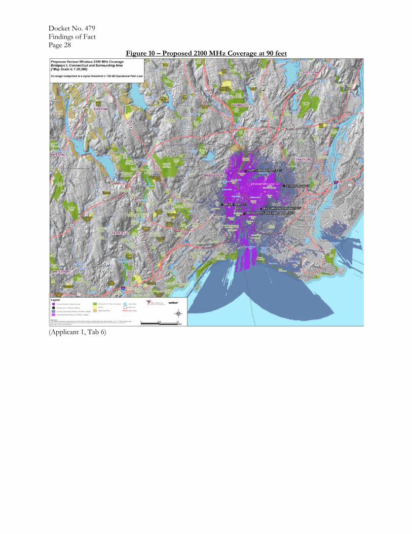
20. The Council received a response from the CAA on November 17, 2017 indicating that CAA appreciates that the Applicant filed a Notice of Proposed Construction or Alteration (Form 7460-1) to the Federal Aviation Administration (FAA), and CAA notes that any changes to the proposed project would require further consultation with FAA. (CAA Comments received November 17, 2017)
21. The following agencies did not respond with comment on the application: DEEP, DPH, CEQ,
PURA, OPM, DECD, DOAg, DESPP, and SHPO. (Record)
Municipal Consultation
22. The Applicant commenced the 90-day pre-application municipal consultation process by Cellco representatives meeting with Max Perez, Senior Economic Development Associate (and designee for then Mayor Bill Finch) for the City of Bridgeport on August 28, 2015. Mr. Perez suggested that the Applicant reach out to the City’s Neighborhood Revitalization Director Deborah Thomas-Sims to discuss the tower proposal and, if needed, to arrange for a neighborhood meeting. (Applicant 1, pp. 19-20)
23. The Applicant’s representatives met with Ms. Thomas-Sims on November 2, 2015 to discuss the
proposed tower project. Ms. Thomas-Sims suggested that a neighborhood meeting might be appropriate and suggested that Tarpon investigate the property to the north as an alternative. This site was investigated and found to be unsuitable. See FOF #56, Alternative c). Following that investigation, Tarpon representatives have attempted to re-connect with Ms. Thomas-Sims to discuss the status of the proposal. Specifically, on January 6, 2016, Tarpon sent a certified letter to Ms. Thomas-Sims to follow up on prior discussions and attempt to schedule a date for a neighborhood meeting. Tarpon did not receive a response. (Applicant 1, p. 20)
24. On June 29, 2017 and September 25, 2017, counsel for the Applicant reached out to Edward Adams
and Daniel Roach from Mayor Ganim’s office to discuss the proposed tower proposal and offered to meet with the Mayor’s representatives about the proposal. No one from the Mayor’s office expressed an interest in meeting to discuss the proposed project. (Applicant 1, p. 20)
25. Tarpon would design the tower to accommodate emergency services antennas if needed. However,
the City of Bridgeport has not expressed an interest in co-locating emergency services antennas on the proposed tower at this time. (Applicant 1, pp. 12-13; Applicant 5, response 43; Tr. 1, p. 21)

Docket No. 479 Findings of Fact Page 4
Public Need for Service
26. In 1996, the United States Congress recognized a nationwide need for high quality wireless
telecommunications services, including cellular telephone service. Through the Federal Telecommunications Act of 1996, Congress seeks to promote competition, encourage technical innovations, and foster lower prices for telecommunications services. (Council Administrative Notice Item No. 4 – Telecommunications Act of 1996)
27. In issuing cellular licenses, the Federal government has preempted the determination of public need for cellular service by the states, and has established design standards to ensure technical integrity and nationwide compatibility among all systems. Cellco is licensed by the Federal Communications Commission (FCC) to provide personal wireless communication service to Fairfield County, Connecticut. (Council Administrative Notice Item No. 4 – Telecommunications Act of 1996; Applicant 1, pp. 5-6 and Tab 5)
28. Section 253 of the Telecommunications Act of 1996 prohibits any state or local statute or regulation, or other state or local legal requirement from prohibiting or having the effect of prohibiting the ability of any entity to provide any interstate or intrastate telecommunications service. (Council Administrative Notice Item No. 4 – Telecommunications Act of 1996)
29. Section 704 of the Telecommunications Act of 1996 prohibits local and state entities from discriminating among providers of functionally equivalent services and from prohibiting or having the effect of prohibiting the provision of personal wireless services. This section also requires state or local governments to act on applications within a reasonable period of time and to make any denial of an application in writing supported by substantial evidence in a written record. (Council Administrative Notice Item No. 4 – Telecommunications Act of 1996)
30. Section 704 of the Telecommunications Act of 1996 also prohibits any state or local entity from
regulating telecommunications towers on the basis of the environmental effects of radio frequency emissions, which include effects on human health and wildlife, to the extent that such towers and equipment comply with FCC’s regulations concerning such emissions. (Council Administrative Notice Item No. 4 – Telecommunications Act of 1996)
31. In February 2009, as part of the American Recovery and Reinvestment Act, Congress directed the
FCC to develop a National Broadband Plan to ensure every American has “access to broadband capability.” Congress also required that this plan include a detailed strategy for achieving affordability and maximizing use of broadband to advance “consumer welfare, civic participation, public safety and homeland security, community development, health care delivery, energy independence and efficiency, education, employee training, private sector investment, entrepreneurial activity, job creation and economic growth, and other national purposes.” (Council Administrative Notice Item No. 19 – The National Broadband Plan)
32. Section 706 of the Telecommunications Act of 1996 requires each state commission with regulatory jurisdiction over telecommunications services to encourage the deployment on a reasonable and timely basis of advanced telecommunications capability to all Americans, including elementary and secondary schools, by utilizing regulating methods that promote competition in the local telecommunications market and remove barriers to infrastructure investment. (Council Administrative Notice Item No. 4 – Telecommunications Act of 1996)

Docket No. 479 Findings of Fact Page 5 33. In December 2009, President Barack Obama recognized cell phone towers as critical infrastructure
vital to the United States. The Department of Homeland Security, in collaboration with other federal stakeholders, state, local, and tribal governments, and private sector partners, has developed the National Infrastructure Protection Plan (NIPP) to establish a framework for securing our resources and maintaining their resilience from all hazards during an event or emergency. (Council Administrative Notice Item No. 11 –Presidential Proclamation 8460, Critical Infrastructure Protection)
34. In February 2012, Congress adopted the Middle Class Tax Relief and Job Creation Act to advance wireless broadband service for both public safety and commercial users. The Act established the First Responder Network Authority to oversee the construction and operation of a nationwide public safety wireless broadband network. Section 6409 of the Act contributes to the twin goals of commercial and public safety wireless broadband deployment through several measures that promote rapid deployment of the network facilities needed for the provision of broadband wireless services. (Council Administrative Notice Item No. 8 – Middle Class Tax Relief and Job Creation Act of 2012)
35. In June 2012, President Barack Obama issued an Executive Order to accelerate broadband infrastructure deployment declaring that broadband access is a crucial resource essential to the nation’s global competitiveness, driving job creation, promoting innovation, expanding markets for American businesses and affording public safety agencies the opportunity for greater levels of effectiveness and interoperability. (Council Administrative Notice Item No. 21 – FCC Wireless Infrastructure Report and Order; Council Administrative Notice Item No. 12 – Presidential Executive Order 13616, Accelerating Broadband Infrastructure Development)
36. Pursuant to Section 6409(a) of the Middle Class Tax Relief and Job Creation Act of 2012, also
referred to as the Spectrum Act, a state or local government may not deny and shall approve any request for collocation, removal or replacement of equipment on an existing wireless tower provided that this does not constitute a substantial change in the physical dimensions of the tower. The Federal Communications Commission defines a substantial change in the physical dimensions of a tower as follows:
a) An increase in the existing height of the tower by more than 10% or by the height of one additional antenna array with separation from the nearest existing antenna not to exceed twenty feet, whichever is greater. Changes in height should be measured from the dimensions of the tower, inclusive of originally approved appurtenances and any modifications that were approved prior to the passage of the Spectrum Act.
b) Adding an appurtenance to the body of the tower that would protrude from the edge of the tower more than twenty feet, or more than the width of the tower structure at the level of the appurtenance, whichever is greater.
c) Installation of more than the standard number of new equipment cabinets for the technology involved, but not to exceed four, or more than one new equipment shelter.
d) A change that entails any excavation or deployment outside the current site. e) A change that would defeat the concealment elements of the tower. f) A change that does not comply with conditions associated with the siting approval of the
construction or modification of the tower, provided however that this limitation does not apply to any modification that is non-compliant only in a manner that would exceed the thresholds identified in (a) – (d).
(Council Administrative Notice Item No. 8 – Middle Class Tax Relief and Job Creation Act of 2012; Council Administrative Notice Item No. 21 – FCC Wireless Infrastructure Report and Order)

Docket No. 479 Findings of Fact Page 6
37. According to state policy, if the Council finds that a request for shared use of a facility by a
municipality or other person, firm, corporation or public agency is technically, legally, environmentally and economically feasible, and the Council finds that the request for shared use of a facility meets public safety concerns, the Council shall issue an order approving such shared use to avoid the unnecessary proliferation of towers in the state. (Conn. Gen. Stat. §16-50aa)
Existing and Proposed Wireless Services
38. Cellco’s proposed facility would provide both coverage and capacity. (Applicant 5, response 28) 39. Cellco’s existing East Bridgeport Relo (Alpha and Gamma sectors), Bridgeport Washington Park
(Alpha sector) and North Bridgeport 2 (Gamma sector) are currently operating beyond their respective capacity limits (i.e. exhausting), and Cellco is experiencing coverage gaps at 700 MHz, 1900 MHz, and 2100 MHz. (Applicant 1, pp. 7-8; Applicant 5, response 39)
40. Cellco would designate the proposed facility as the “Bridgeport East” facility in its network.
(Applicant 5, response 37) 41. Cellco’s proposed facility would interact with the adjacent existing facilities identified in the following
table.
Site Location Cellco
Facility
Name
Distance and Direction from
Proposed Tower
Centerline Height of Cellco’s Antennas agl
Structure Type
2012 Main Street, Bridgeport
Bridgeport 1.4 miles southwest
74 feet Church steeple
120 Huntington Turnpike, Bridgeport
North Bridgeport 2
0.6 miles north 108 feet Rooftop
23 Stonybrook Road, Stratford
Stratford West 1.4 miles east 77 feet Tower
267 Grant Street, Bridgeport
East Bridgeport
Relo
1.2 miles southeast
144 feet Rooftop
480 Barnum Avenue,
Bridgeport
Bridgeport Washington
Park
1.2 miles south 95 feet Rooftop
(Applicant 1, p. 9; Applicant 5, response 26) 42. Cellco would provide service over the 700 MHz, 1900 MHz and 2100 MHz frequency bands at this
time at the proposed site. The 850 MHz frequency band would be reserved for future deployment should there be a need for additional capacity off-loading. (Applicant 5, response 30)
43. For Cellco’s LTE service (i.e. 700 MHz, 1900 MHz and 2100 MHz), Cellco’s design signal strengths
for highway in-vehicle/rural in-building, suburban residential in-building and urban/commercial in-building are -105 dBm, -95 dBm and -85 dBm Reference Signal Received Power (RSRP), respectively. (Applicant 5, response 33; Tr. 1, p. 20)
44. Cellco’s existing signal strength in the area that it seeks to cover from the proposed facility is
approximately -95 dBm RSRP. (Applicant 5, response 34)

Docket No. 479 Findings of Fact Page 7 45. The table below indicates Cellco’s approximate existing coverage gaps along State roads at various
frequencies. See Figures 5, 7 and 9.
Street Name 700 MHz Coverage Gap
1900 MHz Coverage Gap
2100 MHz Coverage Gap
Route 1 0.4 miles 0.2 miles 0.15 miles
Route 127 0.15 miles 0.51 miles 0.3 miles
State Road Total
0.55 miles 0.71 miles 0.45 miles
(Applicant 5, response 39) 46. The tables below indicate the distances that Cellco would cover along State roads in the area of its
proposed facility for various frequencies at the proposed antenna centerline height of 90 feet.
Street Name 700 MHz Coverage at 90
feet
1900 MHz Coverage at 90
feet
2100 MHz Coverage at 90
feet
Route 1 0.8 miles 0.6 miles 0.7 miles
Route 127 0.65 miles 0.5 miles 0.6 miles
Total 1.45 miles 0.11 miles 1.3 miles
(Applicant 1, p. 8) 47. This table indicates the total areas that Cellco would cover from its proposed facility for prescribed
frequencies at the proposed antenna height. See Figures 6, 8 and 10).
Antenna Height Area Coverage with 700 MHz
Area Coverage with 1900 MHz
Area Coverage with 2100 MHz
90 feet 9.18 square miles 6.26 square miles 7.18 square miles
(Applicant 1, p. 8) 48. The 9.18 square miles of service area for the proposed facility at 700 MHz would allow Cellco to
further optimize its surrounding facilities and significantly enhance wireless services in the area. For example, the East Bridgeport Relo (Gamma Sector) antennas are currently “overreaching” to the north due to lack of sufficient service coming from other adjacent facilities including North Bridgeport 2 and Stratford West. Once the proposed facility is activated, Cellco would be able to pull coverage from the East Bridgeport Relo (Alpha and Gamma Sectors) antennas back (to the south) which would reduce its overlapping coverage with the proposed facility. Thus, the Bridgeport East facility could more effectively handle the wireless traffic proximate to its location. (Applicant 5, response 37)
49. The minimum antenna centerline height for Cellco to meet its wireless service objectives is 90 feet.
(Applicant 5, response 31)
50. Cellco primarily focuses on resolving network service issues such as dropped calls (DC), ineffective attempts (IA) and poor data speeds. Cellco’s system performance standard is 0.75% or less for dropped calls and ineffective attempts. All of the sites surrounding the proposed facility are currently meeting Cellco’s voice DC and IA standards. (Applicant 5, response 37)

Docket No. 479 Findings of Fact Page 8 51. Cellco’s system performance standard for network data speeds is 5 Mbps or higher. The data
presented below summarizes each adjacent sector’s data performance.
Cellco Facility Name Sector LTE Data % Ineffective
Attempts*
LTE Data Download
Throughput Speeds (Mbps)
Bridgeport Alpha 0.84 4.95
Bridgeport Washington Park
Alpha 0.12 7.92
East Bridgeport Relo Alpha Gamma
0.13 0.47
5.36 4.88
North Bridgeport 2 Beta Gamma
0.24 0.05
8.03 10.82
Stratford West Gamma 0.05 8.7
*The standard for LTE data IA is also 0.75% or less. (Applicant 5, response 37; Tr. 1, pp. 21-22)
52. Five of the seven sectors identified below are trending towards exhaustion, and two are currently in exhaust as noted below.
Cellco Facility 700 MHz Sectors with capacity relief from proposed site
Projected sector exhaust date
East Bridgeport Relo Alpha Gamma
Currently in exhaust Currently in exhaust
Bridgeport Alpha February 2018
North Bridgeport 2 Gamma End of Year 2018
Bridgeport Washington Park Alpha April 2019
North Bridgeport 2 Beta End of Year 2020
Stratford West Gamma End of Year 2020
(Applicant 5, response 37 – Table 4 and response 41)
53. The proposed Bridgeport East facility would provide the capacity relief to Cellco’s existing East Bridgeport Relo (Alpha and Gamma sectors), Bridgeport Washington Park (Alpha sector) and North Bridgeport 2 (Gamma sector). The proposed facility would also provide some capacity benefit for the existing Bridgeport facility. Notwithstanding, Cellco would continue to monitor and evaluate network performance in the area to determine if additional facilities would be needed in the future. (Applicant 1, pp. 7-8; Applicant 5, responses 37, 39 and 41)
Site Selection
54. Cellco established a search ring for its Bridgeport East facility on June 4, 2013. The search ring was
centered at the subject property at 380 Horace Street in Bridgeport, and the search ring had a radius of approximately 0.8 miles. (Applicant 5, response 27)
55. There are no other existing towers (that Cellco is not already co-located on) or other sufficiently tall structures available within Cellco’s search area. (Applicant 1, p. 12; Tr. 1, pp. 19-20)

Docket No. 479 Findings of Fact Page 9 56. After determining there were no suitable structures within the search area, Cellco searched for
properties suitable for tower development. Cellco investigated six parcels/areas, one of which was selected for site development. The five rejected parcels/areas and reasons for their rejection are as follows:
a) 475 Asylum Street, Bridgeport – This parcel was rejected because the property owner (City of Bridgeport) was not interested in leasing spacing at this former landfill site due to its use as a landfill and lack of available space.
b) 885 Boston Avenue, Bridgeport – This parcel was rejected because Tarpon did not receive a response from the property owner (Lakeview Cemetery Association) regarding its interest in leasing for a tower site.
c) 615 Asylum Street, Bridgeport – This parcel was rejected because the site would be located in wetlands.
d) 1285 Boston Avenue, Bridgeport – This parcel was rejected because the property owner (General Electric) was not interested in leasing space to Tarpon for a tower site.
e) 416 Horace Street, Bridgeport – This parcel was rejected due to current development on the parcel and an existing easement that would restrict development of a tower site.
(Applicant 1, Tab 8 – Site Search Summary, p. 2; Tr. 1, pp. 8, 18-19)
57. While it may be technically or theoretically possible to utilize a distributed antenna system or large number of small cells facilities in the area that could match or closely match the service area of the proposed facility, such an approach would not be economically feasible or consistent with good RF engineering practice. Typically, small cell facilities utilize existing infrastructure (i.e. electric distribution poles) along public rights-of-way in areas where coverage and/or capacity problems exist. In areas where such existing infrastructure does not exist, property rights would need to be obtained, and new poles would need to be installed. Thus, Cellco contends that there are no viable or currently available alternatives than the proposed facility. (Applicant 1, p. 11; Applicant 5, response 32; Tr. 1, p. 19)
Facility Description
58. The proposed site is located on an approximately 13.7-acre parcel at 380 Horace Street in Bridgeport. The parcel is owned by MDL Realty LLC. The proposed site location is depicted on Figure 1 and 2. (Applicant 1, p. i)
59. The subject property is zoned Light Industrial (I-L) and is used for manufacturing purposes. (Applicant 1, p. 18)
60. The tower site is located in the northwestern portion of the property, at an elevation of
approximately 62 feet above mean sea level (amsl). (Applicant 1, Tab 1 – Aerial Photograph and Site Evaluation Report)
61. The Applicant chose its location on the subject property due to availability of access, avoiding an
existing restrictive easement to the north and east, and avoiding an environmental restriction and a large cleanup being performed on the other side of the existing building opposite where the proposed site is located. (Tr. 1, p. 15-16)
62. Land use within the immediate vicinity of the subject property is primarily a mix of dense, urban
commercial and residential development, with a large tract of undeveloped forested land to the east/northeast. The Route 8 transportation corridor is located approximately 0.75 mile to the west. (Applicant 1, Tab 9 – Visibility Analysis, p. 1)

Docket No. 479 Findings of Fact Page 10 63. The proposed facility would consist of a 90-foot monopole within a 62.5-foot by 40-foot leased area.
The tower would be approximately 50 inches wide at the base tapering to 24 inches wide at the top. The tower would be designed to support four levels of wireless carrier antennas (including Cellco’s antennas) as well as municipal emergency services antennas, if needed. See Figure 4. The tower (and its foundation) would be designed to accommodate an expansion in height of at least 20 feet. (Applicant 1, pp. i and 8; Applicant 1, Tab 1 – Sheet A-1 and Facilities and Equipment Specification; Applicant 5, response 13; Tr. 1, pp. 21-22)
64. The monopole would have a gray, galvanized steel finish. (Applicant 5, response 8) 65. Cellco would install 12 panel antennas and nine remote radio heads on a triangular antenna platform
at a centerline height of 90 feet agl. The total height of the facility with antennas would be 94 feet agl. (Applicant 1, pp. i and 2; Applicant 1, Tab 1 – Sheet A-1; Applicant 5, response 7)
66. If Cellco utilized flush-mounted antennas, it would require two or possibly three levels of antennas
which would limit space on the tower for other wireless carries or emergency services providers. The use of flush-mounted antennas could also limit Cellco’s ability to install new technologies and make other cell site enhancements in the future. Cluster-mounted antennas would limit potential future upgrades, e.g. adding antennas and equipment. (Applicant 5, responses 53 and 54)
67. A 62.5-foot by 40-foot fenced equipment compound would be established at the base of the tower.
Cellco would install its equipment on a 16-foot by 9-foot 4-inch elevated steel platform with a canopy roof on top. See Figure 3. (Applicant 1, Tab 1 – Sheets A-1 and A-2)
68. No HVAC units are proposed because an open equipment platform is proposed rather than an
enclosed shelter. (Applicant 1, Tab 1 – Sheet A-2; Tr. 1, pp. 25-26)
69. The proposed equipment compound will be surrounded by an eight-foot high chain-link fence. The fence would have a mesh size of two inches. Privacy slats could be installed, if required by the Council. (Applicant 1, Tab 1 – Sheets A-1 and A-3; Applicant 5, response 9)
70. The Applicant could shift the compound to the west and change its orientation from east-west to
north-south (i.e. the shorter side opposite the existing building) to avoid a rocky area. The monopole could be kept in the same location, but equipment could be located behind the monopole. The final amount of shift of the compound to avoid rock would depend on a geotechnical analysis because some of the rock may be underground. (Tr. 1, pp. 31-36)
71. It may be possible to relocate the compound roughly 40 feet to the east to avoid the rocky outcropping, prevent the removal of two trees and increase the distance from the residence on Kingsbury Road, but the Applicant would have to evaluate the possibility in consultation with the land owner and review any applicable environmental land use restrictions. It would also require an irregular shaped compound. (Tr. 1, pp. 47-49)
72. No other wireless carriers have expressed an interest in co-locating on the proposed tower at this time. Specifically, Sprint notified the Applicant that it did not have an open search ring at this time. T-Mobile notified the Applicant the proposed site could be used in the future to off-load T-Mobile’s traffic. AT&T notified the Applicant that it is a good site, but not within AT&T’s budget plans at this time. (Tr. 1, p. 21)

Docket No. 479 Findings of Fact Page 11 73. Development of the site would require approximately 110 cubic yards of cut associated with
excavation for the monopole’s concrete foundation. Approximately 45 cubic yards would be reused on-site, if suitable, to backfill over the tower foundation. The remainder of the material (or approximately 65 cubic yards of net cut) would be removed from the site. If the project is approved, the final cut and fill numbers would be computed upon completion of a geotechnical survey at the site. (Applicant 5, response 3)
74. Access to the proposed site compound from Horace Street would be provided over an existing paved driveway and parking area on an adjacent parcel* for a total distance of approximately 226 feet. Upgrades to the existing access would not be expected to be necessary. However, Tarpon would repair any damage to the driveway caused during site construction. *The proposed access would cross the 416 Horace Street property to the south and would require an easement. (Applicant 1, p. i and Tab 1 – General Cell Site Description; Applicant 5, response 10)
75. A silt sock would be installed to the west of the access drive and proposed compound to contain potential sediment. (Applicant 1, Tab 1 – Sheet C-3)
76. Electric and telco utilities would be installed underground to the site from Horace Street generally following the access drive route. The natural gas line to supply the backup generator would also be underground generally following the access drive, subject to confirmation from the natural gas utility. (Applicant 1, p. 2 and Tab 1 – Sheet A-1; Applicant 5, response 50)
77. The nearest property boundary from the proposed tower is approximately 37 feet to the south-
southwest (416 Horace Realty LLC property). (Applicant 1, Tab 1 – Sheet C-1) 78. There are approximately 141 residences within 1,000 feet of the proposed tower site. The nearest
off-site residence is located at 110 Kingsbury Road, approximately 111 feet to the west of the proposed tower (Miller residence). (Applicant 1, p. 14 and Tab 1 – Sheet C-1)
79. Site preparation and engineering would commence following Council approval of a Development and Management Plan (D&M Plan) and are expected to be completed within two to four weeks. Installation of the equipment shelter and tower are expected to take another two to four weeks. Equipment installation is expected to take an additional two weeks after the tower and equipment shelter are installed. After the equipment installation, cell site integration and system testing is expected to require about two additional weeks. (Applicant 1, p. 22)
80. The estimated cost of the proposed facility is:
Cell site radio equipment $ 300,000. Tower, foundation, coax and antennas $ 115,000. Power and telco systems $ 30,000. Equipment platform $ 35,000. Miscellaneous (inc. site prep and installation) $ 60,000. Total $ 540,000. (Applicant 1, p. 22)
81. Tarpon would recover tower construction costs through tower lease agreements with wireless carriers that would co-locate on the tower. Cellco would recover the costs of its equipment via the price of its services on a national level. (Tr. 1, pp. 26-27)
Docket No. 479 Findings of Fact Page 12
Public Safety 82. The Wireless Communications and Public Safety Act of 1999 (911 Act) was enacted by Congress to
promote and enhance public safety by making 9-1-1 the universal emergency assistance number, by furthering deployment of wireless 9-1-1 capabilities, and by encouraging construction and operation of seamless ubiquitous and reliable networks for wireless services. (Council Administrative Notice Item No. 6 - Wireless Communications and Public Safety Act of 1999)
83. The proposed facility would be in compliance with the requirements of the 911 Act and would provide Enhanced 911 services. (Applicant 5, response 36; Applicant 1, pp. 5-6)
84. Wireless carriers have voluntarily begun supporting text-to-911 services nationwide in areas where municipal Public Safety Answering Points (PSAP) support text-to-911 technology. Text-to-911 will extend emergency services to those who are deaf, hard of hearing, have a speech disability, or are in situations where a voice call to 911 may be dangerous or impossible. However, even after a carrier upgrades its network, a user’s ability to text to 911 is limited by the ability of the local 911 call center to accept a text message. The FCC does not have the authority to regulate 911 call centers; therefore, it cannot require them to accept text messages. (Council Administrative Notice No. 20 – FCC Text-to-911: Quick Facts & FAQs)
85. Cellco’s facility would be capable of supporting text-to-911 service as soon as the PSAP is capable of
receiving text-to-911. However, no PSAPs in the vicinity of the proposed tower site are able to accept text-to-911 service at this time. (Applicant 5, responses 35)
86. Pursuant to the Warning, Alert and Response Network Act of 2006, “Wireless Emergency Alerts”
(WEA) is a public safety system that allows customers who own certain wireless phone models and other enabled mobile devices to receive geographically-targeted, text-like messages alerting them of imminent threats to safety in their area. WEA complements the existing Emergency Alert System that is implemented by the FCC and FEMA at the federal level through broadcasters and other media service providers, including wireless carriers. (Council Administrative Notice No. 5 – FCC WARN Act)
87. Pursuant to C.G.S. §16-50p(a)(3)(G), the tower and associated tower antenna mounts would be constructed in accordance with the American National Standards Institute “Structural Standards for Steel Antenna Towers and Antenna Support Structures” Revision G. (Applicant 1, Tab 1 – Facilities and Equipment Specification, p. 6)
88. The proposed tower would not exceed obstruction standards and would not be a hazard* to air navigation. Obstruction marking or lighting would not be required. *The No Hazard Determination from the Federal Aviation Administration was based on a tower height of 199 feet to be very conservative. (Applicant 3; Applicant 5, response 14)
89. Per the FAA No Hazard Determination, the Applicant would provide notice to FAA within five days
after construction reaches its greatest height. (Applicant 3; Applicant 5, response 15) 90. Notice to the FAA would not be required for any temporary construction equipment such as a crane
because the height of such equipment would remain well below the requirements for FAA notice. (Applicant 5, response 16)

Docket No. 479 Findings of Fact Page 13 91. Cellco’s equipment shelter would be equipped with silent intrusion and system alarms. Such alarms
would be monitored on a 24-hour basis. (Applicant 1, p. 8)
92. The tower radius extends beyond the property boundary 37 feet to the south. A tower design yield point can be employed. (Applicant 5, response 2; Tr. 1, p. 16)
93. The cumulative worst-case maximum power density from the radio frequency emissions from the operation of Cellco’s proposed antennas is 75.4% of the standard for the General Public/Uncontrolled Maximum Permissible Exposure, as adopted by the FCC, at the base of the proposed tower. This calculation was based on methodology prescribed by the FCC Office of Engineering and Technology Bulletin No. 65E, Edition 97-01 (August 1997) that assumes all antennas in a sector would be pointed at the base of the tower and all channels would be operating simultaneously, which creates the highest possible power density levels. Under normal operation, the antennas would be oriented outward, directing radio frequency emissions away from the tower, thus resulting in significantly lower power density levels in areas around the tower. (Applicant 7; Administrative Notice Item No. 2 – FCC OET Bulletin No. 65)
Emergency Backup Power
94. In response to two significant storm events in 2011, Governor Malloy formed a Two Storm Panel
(Panel) that was charged with an objective review and evaluation of Connecticut’s approach to the prevention, planning and mitigation of impacts associated with emergencies and natural disasters that can reasonably be anticipated to impact the state. (Council Administrative Notice Item No. 46 – Final Report of the Two Storm Panel)
95. In response to the findings and recommendations of the Panel, and in accordance with C.G.S. §16-50ll, the Council, in consultation and coordination with the Department of Energy and Environmental Protection, the Department of Emergency Services and Public Protection and the Public Utilities Regulatory Authority (PURA), studied the feasibility of requiring backup power for telecommunications towers and antennas as the reliability of such telecommunications service is considered to be in the public interest and necessary for the public health and safety. The study was completed on January 24, 2013. (Council Administrative Notice Item No. 26 – Council Docket No. 432)
96. The Council reached the following conclusions in the study: a) “Sharing a backup source is feasible for Commercial Mobile Radio Service (CMRS) providers,
within certain limits. Going forward, the Council will explore this option in applications for new tower facilities;” and
b) “The Council will continue to urge reassessment and implementation of new technologies to improve network operations overall, including improvements in backup power.”
(Council Administrative Notice Item No. 26 – Council Docket No. 432)
97. For backup power, Cellco proposes a 25-kilowatt natural gas-fueled generator for its own use. Barring a breakdown, maintenance shutdown, natural gas service interruption, or DEEP limits on annual runtime hours, the natural gas generator’s runtime would be essentially unlimited because the fuel is pipeline supplied. (Applicant 5, responses 44 through 46)
98. While Cellco prefers to provide reliable backup power to its own cell sites, it would consider the use of a shared generator if one were provided. (Applicant 5, response 47)
Docket No. 479 Findings of Fact Page 14
99. Cellco would also have a battery backup to provide uninterrupted power and avoid a “re-boot”
condition. The battery backup system alone could provide about six to eight hours of backup power. (Applicant 5, response 48)
100. The proposed backup generator unit would have the ability to contain 110 percent of the capacity of
motor oil and coolant fluids. (Applicant 5, response 44) 101. According to R.C.S.A. §22a-69-1.8, noise created as a result of, or relating to, an emergency, such as
an emergency backup generator, is exempt from the State Noise Control Regulations. (R.C.S.A. §22a-69-1.8)
Environmental Considerations
102. The proposed facility would be located outside of the Coastal Boundary, which is located
approximately 0.4 miles to the southwest. (Applicant 5, response 56) 103. There are no prime agricultural soils on the subject property. The state does not retain the
development rights. (Applicant 5, responses 20 and 22)
104. SHPO found that the proposed project would not have an adverse effect on sites eligible for listing as contributing resources to a potential National Register of Historic Places District with the following conditions:
1) The tower, antennas and associated equipment shall be designed and installed to minimize visibility; and
2) If not in use for six consecutive months, antennas, equipment and enclosures shall be removed within 90 days of the end of such six-month period.
(Applicant 1, Tab 3 – SHPO Letter)
105. The proposed tower height (which at 90 feet is considered relatively low for this type of facility) minimizes overall visibility, which is restricted to an area within 0.25 miles or less of the site. The urban nature of the area around the proposed wireless facility, which is characterized by industrial uses, multi-story structures and existing utility infrastructure, combined with the proposed facility’s low height would help the proposed project meet Condition No. 1 from the SHPO. In addition, with the exception of the upper portions of the monopole, the remainder of the facility is not visible from most off-site locations. See FOF #105. (Applicant 5, response 59)
106. The Inland Wetlands and Watercourses Act (IWWA), CGS §22a-36, et seq., contains a specific
legislative finding that the inland wetlands and watercourses of the state are an indispensable and irreplaceable but fragile natural resource with which the citizens of the state have been endowed, and the preservation and protection of the wetlands and watercourses from random, unnecessary, undesirable and unregulated uses, disturbance or destruction is in the public interest and is essential to the health, welfare and safety of the citizens of the state. (CGS §22a-36, et seq.)
107. The IWWA grants regulatory agencies with the authority to regulate upland review areas in its discretion if it finds such regulations necessary to protect wetlands or watercourses from activity that will likely affect those areas. (CGS §22a-42a)
108. The IWWA forbids regulatory agencies from issuing a permit for a regulated activity unless it finds on the basis of the record that a feasible and prudent alternative does not exist. (CGS §22a-41)

Docket No. 479 Findings of Fact Page 15 109. The nearest wetlands on the subject property are located approximately 500 feet to the southeast and
consist of an emergent marsh system associated within an intermittent watercourse that flows south eventually into Yellow Mill Creek. The on-site wetland extends north onto Remington Woods, an approximately 420-acre property formerly owned by Remington Arms Company. Such property is surrounded by a chain-link fence and is not open to the public. (Applicant 1, Tab 11 – Wetland Delineation Field Form, p. 2).
110. The nearest off-site wetland is located approximately 150 feet east of the proposed facility. The
Applicant viewed this off-site wetland from the property line and found that there appears to be a potential cryptic vernal pool associated within the western end of this wetland at a distance of approximately 150 feet from the proposed facility. (Applicant 1, Tab 11 – Wetland Delineation Field Form, p. 2; Applicant 1, Tab 12 – Vernal Pool Analysis, p. 1)
111. Provided that erosion and sedimentation controls are installed in accordance with the 2002 Connecticut
Guidelines for Erosion and Sedimentation Control, no likely adverse impacts to nearby wetlands would be associated with the proposed project. (Applicant 1, Tab 11 – Wetland Delineation Form, p. 2)
112. The proposed project would not be located within the Vernal Pool Envelope (VPE), an area 100 feet from the edge of the vernal pool. (Applicant 1, Tab 12 – Vernal Pool Analysis, p. 2)
113. Since the off-site vernal pool is inaccessible, a conservative priority rating of Tier I was assigned. A Tier I rating is considered to have relatively high breeding activity and relatively intact terrestrial habitat. (Applicant 1, Tab 12 – Vernal Pool Analysis, p. 2)
114. The proposed facility would be located within the vernal pool Critical Terrestrial Habitat (CTH), an area located 100 feet to 750 feet from the edge of a vernal pool. In order to maintain populations of vernal pool obligate amphibian species, development within the CTH should not exceed 25 percent. However, the vernal pool’s CTH has 44 percent development under existing conditions. Since the 25 percent threshold has already been exceeded, this pool would not qualify for conservation priority. The proposed project would increase the percent CTH development by about 0.06 percent, a de minimis increase. See Figure 11. (Council Administrative Notice Item No. 57; Applicant 1, Tab 12 – Vernal Pool Analysis, p. 2)
115. With a Vernal Pool Protection Plan including, but not limited to, contractor awareness of vernal pool
species and inspection of the silt fence erosion and sedimentation control measures (that would prevent herpetofauna from migrating into the construction site), the proposed project would not result in a likely adverse impact to nearby vernal pool resources. (Applicant 1, Tab 12 – Vernal Pool Analysis, p. 3)
116. Shifting the proposed tower compound by up to 50 feet to the east or west would not affect the
vernal pool. (Tr. 1, pp. 61-62)
117. The proposed facility would be located in the Federal Emergency Management Agency (unshaded) Zone X, an area outside of both the 100-year and 500-year flood zones. (Applicant 5, response 5)
118. No negative impacts to State-listed species are expected to result from the proposed project. (Applicant 1, Tab 10, DEEP Letter dated June 27, 2017)
119. The northern long-eared bat, a federally-listed Threatened Species (also a state-listed endangered
species), may occur in the vicinity of the subject property. (Applicant 1, Tab 10 – U.S. Fish and Wildlife Service Letter dated March 3, 2016; Council Administrative Notice Item No. 36)

Docket No. 479 Findings of Fact Page 16 120. The proposed project area is not within 0.25 mile of a known NLEB hibernaculum or within 150
feet of a known occupied NLEB maternity roost tree. Thus, the proposed project would not result in prohibited incidental take of NLEB, and additional consultation with the U.S. Fish and Wildlife Service (UFWS) is not necessary. Therefore, the proposed project may affect, but is not likely to adversely affect, the NLEB. (Applicant 1, p. 15; Applicant 1, Tab 10 – USFWS Letter dated March 3, 2016)
121. The red knot, a federally-listed Threatened Species, is known to occur in the vicinity of the subject
property. However, the subject property, consisting of a developed property with some inland upland forest habitat, does not provide coastal marine or estuarine habitat. The nearest potentially suitable red knot habitat would be located approximately three miles to the south/southeast. Therefore, due to the lack of red knot habitat on or proximate to the subject property and the significant distance to potentially suitable habitat, no further coordination with the USFWS New England Field Office is necessary. (Applicant 5, attachment 5, Section 7 Consultation, pp. 1-5)
122. Approximately eight trees would need to be removed to construct the facility compound or related
improvements. (Applicant 1, Tab 1 – Site Evaluation Report) 123. The proposed facility is not located near an Important Bird Area (IBA), as designated by the
National Audubon Society. The nearest IBA to the proposed tower site is the Milford Point/Wheeler Marsh near the mouth of the Housatonic River in Milford, approximately three miles to the southeast of the proposed tower site. Due to the significant distance, no adverse impact to this resource or the bird species it supports would be expected. (Applicant 5, response 51)
124. The design of the proposed facility would comply with USFWS guidelines for minimizing the potential impact of telecommunications towers to bird species. The guidelines recommend that towers be less than 199 feet tall, avoid the use of aviation lighting, and avoid guy-wires as tower supports. (Council Administrative Notice Item No. 13 – USFWS Recommended Best Practices for Communications Tower Design, Siting, Construction, Operation, Maintenance and Decommissioning; Applicant 5, response 52)
125. The USFWS service guidelines recommend the scheduling of vegetation removal outside of the peak
bird breeding season (April 15 through July 15). However, during the wetland investigation, no active nests were observed at that time in the trees proximate to the proposed compound area. Thus, there would not likely be an adverse impact to nesting birds if construction occurred during the April 15 through July 15 time period. The final construction schedule would depend on the timing of permitting approvals including the D&M Plan approval. If construction were to occur during this time period, the Applicant could check again for active nesting birds at that time. (Council Administrative Notice Item No. 13 – USFWS Recommended Best Practices for Communications Tower Design, Siting, Construction, Operation, Maintenance and Decommissioning; Applicant 5, Attachment 2; Tr. 1, p. 24-25)
126. If the proposed facility is approved, a complete geotechnical survey would be performed.
Notwithstanding, Cellco does not anticipate the need for blasting at the proposed site. Cellco would utilize mechanical chipping to remove rock. (Applicant 5, response 4; Tr. 1, pp. 16-17)
127. The proposed facility would comply with DEEP Noise Control Regulations at the property boundaries. (Applicant 4, response 55)

Docket No. 479 Findings of Fact Page 17
Visibility
128. The proposed tower would be visible year-round from approximately 41 acres within a two-mile radius of the site (8,042 acres). See Figure 12. The tower would be seasonally visible from approximately 40 additional acres within a two-mile radius of the site. (Applicant 1, Tab 9 – Visibility Analysis, p. 5 and Viewshed Map)
129. Generally, year-round views of portions of the facility would be limited to the subject property and
its immediate vicinity (or roughly a 0.25 mile radius). Near-range views within 0.1 mile of the proposed facility would offer an opportunity to see a majority of the length of the monopole. With few exceptions, views from distances beyond 0.1 mile would be limited to upper portions of the monopole. (Applicant 1, Tab 9 – Visibility Analysis, p. 5)
130. Near views of the tower would be slightly above the tree line based on the roughly 70 to 80 foot
existing trees. (Tr. 1, p. 23)
131. Pursuant to CGS § 16-50p(a)(3)(F), the nearest school is the Beardsley School approximately 0.5 miles southwest of the proposed facility. The nearest commercial child day care facility is the Heavenly Blessings Christian Academy approximately 0.25 miles southwest of the proposed facility. (Applicant 1, Tab 9 – Visibility Analysis, p. 6)
132. Visibility of the proposed tower from specific locations within a two-mile radius of the site is
presented in the table below:
Specific Location Photo location on Map*
Approx. Portion of Facility Visible
Approx. Distance & Direction to Tower
Pennsylvania Avenue 1 Seasonal – 20 feet through trees
0.35 mile southeast
Texas Avenue 2 Seasonal – 30 feet through trees
0.24 mile southeast
Nelson Terrace and East Main Street
3 Seasonal – 25 feet through trees
0.24 mile southeast
Alpine Street 4 Year-round – 48 feet 0.14 mile southeast
Foster Square 5 Year-round – 60 feet 0.09 mile southeast
Kingsbury Road 6 Year-round – 60 feet 0.08 mile east
Berkeley Place 7 Year-round – 56 feet 0.11 mile east
York Street at Horace Street 8 Year-round – 48 feet 0.12 mile north
Asylum Street 9 Seasonal – barely discernable through trees
0.25 mile west
Goddard Avenue 10 Year-round – 48 feet 0.20 mile north
Horace Street at Kent Street 11 Year-round – 46 feet 0.23 mile north
Lakeview Cemetery 12 Not visible 1.35 mile northeast
(Applicant 1, Tab 9 – Visibility Analysis, Viewshed Map)
133. Two trail systems occur within the two-mile study area. The CT blue-blazed Housatonic Trail is located approximately 0.5 mile northwest of the proposed tower site. The East Coast Greenway is located approximately 1.8 miles south of the proposed tower site. The proposed facility would not be expected to be visible from either trail system. (Applicant 1, Tab 9 – Visibility Analysis, pp. 3 and 5 and Viewshed Map
134. There are no state-designated scenic roads located within the two-mile study area. (Applicant 1, Tab 9 – Visibility Analysis, p. 3 and Viewshed Map)

Docket No. 479 Findings of Fact Page 18 135. Regarding possible stealth tower designs, a flagpole design was considered by the Applicant. A
flagpole would minimize the visual width at the top of the tower by eliminating the antenna array; however, the diameter of the tower would need to be increased to roughly double that of the proposed tower. In addition, the flagpole would require Cellco to occupy multiple antenna levels on the tower, thereby restricting the number of opportunities for co-location by other carriers or requiring additional tower height. (Applicant 5, response 53)
136. Painting the monopole and antennas could provide softening of views of the facility on certain days,
but it would have its own limitations such as maintenance issues and the possibility of making the view of the tower brighter as opposed to softer on certain days. (Applicant 5, response 53; Tr. 1, pp. 22-23)
137. A tree tower would blend in for some areas and increase visibility in other areas. (Tr. 1, pp. 49-50) 138. The closest abutting residences to the west would have direct views of the facility including the
ground equipment. However, the Applicant is considering installing evergreen plantings west of the proposed compound along the property line to provide screening for homes to the west. (Tr. 1, pp. 23-24; Tr. 2, pp. 8-9)

Docket No. 479 Findings of Fact Page 19
Figure 1 – Aerial Map
(Applicant 1, p. iii – Aerial Photograph

Docket No. 479 Findings of Fact Page 20
Figure 2 – Site Plan
(Applicant 1, Tab 1 – Sheet C-1A)

Docket No. 479 Findings of Fact Page 21
Figure 3 – Compound Plan
(Applicant 1, Tab 1 – Sheet A-1)

Docket No. 479 Findings of Fact Page 22
Figure 4 – Tower Profile Drawing
(Applicant 1, Tab 1 – Sheet C-2)

Docket No. 479 Findings of Fact Page 23
Figure 5 – Existing 700 MHz Coverage
(Applicant 1, Tab 6)

Docket No. 479 Findings of Fact Page 24
Figure 6 – Proposed 700 MHz Coverage at 90 feet
(Applicant 1, Tab 6)

Docket No. 479 Findings of Fact Page 25
Figure 7 – Existing 1900 MHz Coverage
(Applicant 1, Tab 6)

Docket No. 479 Findings of Fact Page 26
Figure 8 – Proposed 1900 MHz Coverage at 90 feet
(Applicant 1, Tab 6)

Docket No. 479 Findings of Fact Page 27
Figure 9 – Existing 2100 MHz Coverage
(Applicant 1, Tab 6)
Docket No. 479 Findings of Fact Page 28
Figure 10 – Proposed 2100 MHz Coverage at 90 feet
(Applicant 1, Tab 6)

Docket No. 479 Findings of Fact Page 29
Figure 11 – Vernal Pool Analysis
(Applicant 1, Tab 12 – Vernal Pool Analysis)

Docket No. 479 Findings of Fact Page 30
Figure 12 – Visibility Analysis
(Applicant 1, Tab 9 – Viewshed Map)


![[Animebanzai] Bleach 479](https://static.fdocuments.us/doc/165x107/568c373b1a28ab02359ae3d4/animebanzai-bleach-479.jpg)