Doc. No. SJS/TS-001 - Cotswold District · PDF fileUpper Ready Field Faringdon Road, Lechlade...
29
Upper Ready Field Faringdon Road, Lechlade Transport Statement June 2014 Doc. No. SJS/TS-001 Helix Transport Consultants Limited 16 Springfield Court, Stonehouse, Gloucestershire, GL10 2JF. Tel: 01453 822625 www.helixtc.co.uk Helix Transport Consultants Limited, Registered in England and Wales No 07359661.
Transcript of Doc. No. SJS/TS-001 - Cotswold District · PDF fileUpper Ready Field Faringdon Road, Lechlade...
Upper Ready Field Faringdon Road, Lechlade
Transport Statement
June 2014
Doc. No. SJS/TS-001
Helix Transport Consultants Limited 16 Springfield Court, Stonehouse, Gloucestershire, GL10 2JF.
Tel: 01453 822625 www.helixtc.co.uk
Helix Transport Consultants Limited, Registered in England and Wales No 07359661.
Upper Ready Field
Faringdon Road, Lechlade
Transport Statement
June 2014
Contents Amendment Record This report has been issued and amended as follows:
Issue Description Date Signed
1 Draft June ’14 JH
Contents
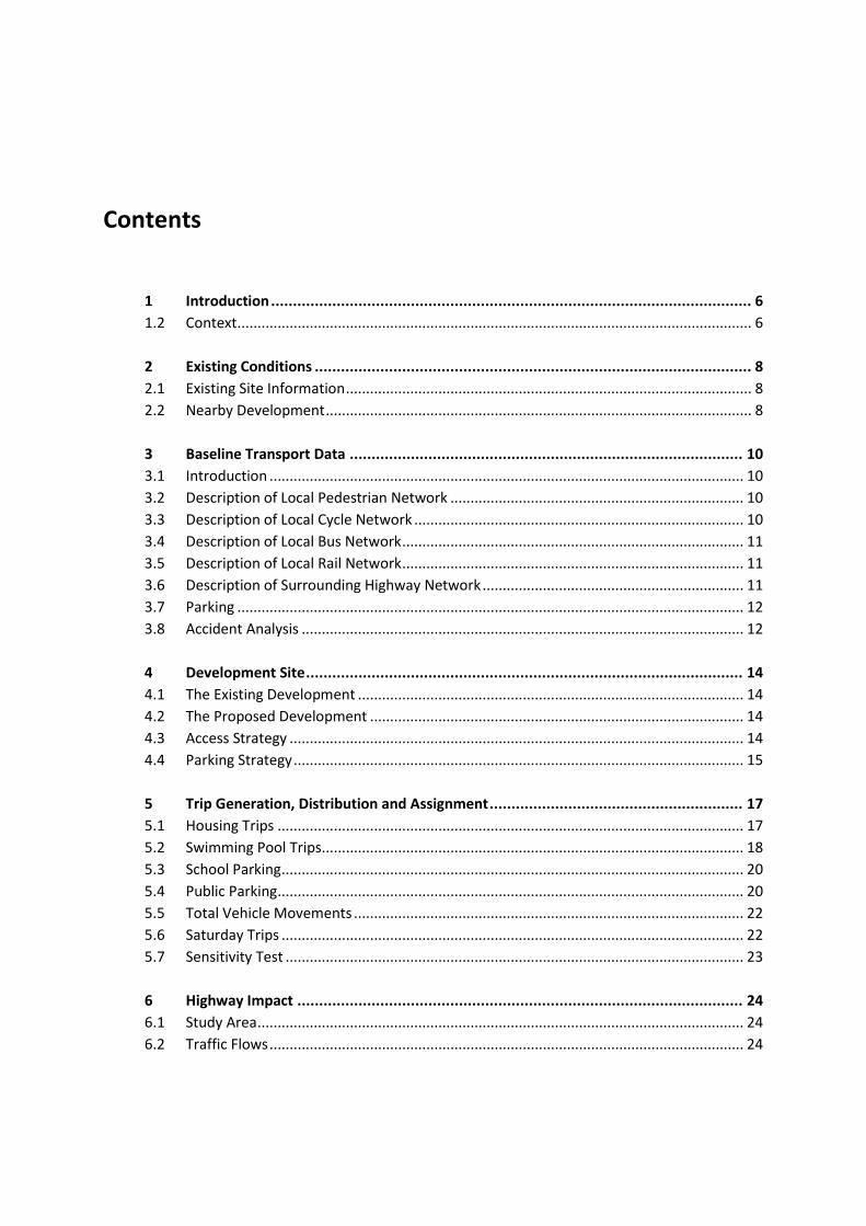
1 Introduction .............................................................................................................. 6
1.2 Context ................................................................................................................................ 6
2 Existing Conditions .................................................................................................... 8
2.1 Existing Site Information ..................................................................................................... 8
2.2 Nearby Development .......................................................................................................... 8
3 Baseline Transport Data .......................................................................................... 10
3.1 Introduction ...................................................................................................................... 10
3.2 Description of Local Pedestrian Network ......................................................................... 10
3.3 Description of Local Cycle Network .................................................................................. 10
3.4 Description of Local Bus Network ..................................................................................... 11
3.5 Description of Local Rail Network ..................................................................................... 11
3.6 Description of Surrounding Highway Network ................................................................. 11
3.7 Parking .............................................................................................................................. 12
3.8 Accident Analysis .............................................................................................................. 12
4 Development Site .................................................................................................... 14
4.1 The Existing Development ................................................................................................ 14
4.2 The Proposed Development ............................................................................................. 14
4.3 Access Strategy ................................................................................................................. 14
4.4 Parking Strategy ................................................................................................................ 15
5 Trip Generation, Distribution and Assignment .......................................................... 17
5.1 Housing Trips .................................................................................................................... 17
5.2 Swimming Pool Trips ......................................................................................................... 18
5.3 School Parking ................................................................................................................... 20
5.4 Public Parking .................................................................................................................... 20
5.5 Total Vehicle Movements ................................................................................................. 22
5.6 Saturday Trips ................................................................................................................... 22
5.7 Sensitivity Test .................................................................................................................. 23
6 Highway Impact ...................................................................................................... 24
6.1 Study Area ......................................................................................................................... 24
6.2 Traffic Flows ...................................................................................................................... 24

6.3 Summary of Traffic Flows ................................................................................................. 25
6.4 Junction Capacity Assessment .......................................................................................... 27
7 Conclusions ............................................................................................................. 29
7.1 Conclusions ....................................................................................................................... 29

Drawings SJS-TS1-001 - Site Location Plan
SJS-TS1-002 - Illustrative Access Layout
14.013.SK1 - Eric Cole Architecture; Indicative Sketch layout
Figures Figure 1 - 2013 AM Peak Existing Flows
Figure 2 - 2013 PM Peak Existing Flows
Figure 3 - 2019 AM Peak Base Flows
Figure 4 - 2019 PM Peak Base Flows
Figure 5 - AM Peak Proposed Housing Trips
Figure 6 - PM Peak Proposed Housing Trips
Figure 7 - AM Peak Proposed Swimming Pool Trips
Figure 8 - PM Peak Proposed Swimming Pool Trips
Figure 9 - AM Peak Diverted School Trips
Figure 10 - PM Peak Diverted School Trips
Figure 11 - AM Peak Public Parking Trips
Figure 12 - PM Peak Public Parking Trips
Figure 13 - AM Peak Total Development Trips
Figure 14 - PM Peak Total Development Trips
Figure 15 - 2019 AM Peak Proposed Flows
Figure 16 - 2019 PM Peak Proposed Flows
Figure 17 - AM Peak Barnwood Development Trips
Figure 18 - PM Peak Barnwood Development Trips
Figure 19 - AM Peak Sensitivity Test Flows
Figure 20 - PM Peak Sensitivity Test Flows
Appendices Appendix A - TRICS Outputs
Appendix B - Calculation Sheets
Appendix C - Junction Capacity Test PICADY Model Outputs

Lechlade, Transport Statement Helix Transport Consultants
SLS/TS-001 6
1 Introduction
1.1.1 Helix Transport Consultants Ltd are appointed by Mr Colin Harris (applicant) to assess
the traffic and transport implications of the proposed mixed-use development on the
field known as Upper Ready, off Faringdon Road in Lechlade, Gloucestershire (site).
1.1.2 The development proposals comprise:
Housing
Public Car Park
Swimming Pool
Walled Allotment Gardens
Open Community Space
1.1.3 This Transport Statement (TS) is based on development details provided by the
applicant, site visits, on-site measurements, traffic surveys, and parking counts.
1.1.4 The sections that follow identify and assess the key transportation impacts and
opportunities resulting from the development, for all modes of transport. Details are
provided of the baseline conditions, effects of the development, mitigation measures
associated with the proposals and any residual effects remaining on completion of
the scheme.
1.2 Context
1.2.1 These development proposals respond to a number of traffic and transportation
issues concerning the local community. Principle amongst these is parking along St
Johns Street and Faringdon Road. The need for a public car park within the vicinity of
the site is set out in the adopted Cotswold District Local Plan, which stated at
paragraph 9.14.3:
“Land at Wharf Lane is allocated as an off-street public car park for around 50 spaces.
The site is close to the town centre, and Shelley’s Walk provides a pleasant footpath
link between them. The car park would also benefit the nearby primary school, as it
would enable parents to drop children off and collect them safely without having to
cross or park on a busy road. The car park would complement the wider proposals for
the town centre, and help to meet the need for car parking provision from the
proposed regeneration of the riverside area.”
1.2.2 A consultation exercise carried out by the Cotswold District Council, entitled The
Future of Lechlade,’ identified, amongst other things a desire for: parking; a
swimming pool; and more public open space.
Lechlade, Transport Statement Helix Transport Consultants
SLS/TS-001 7
1.2.3 It is understood that the local school currently bus students to Cirencester for
swimming lessons. Other local residents travel to Swindon or Faringdon for this
purpose. The proposed swimming pool will therefore reduce this need for Leclade
residents to travel.
1.2.4 It is understood that Lechlade has limited public open space. These proposals will
increase the opportunities for recreational walking and reduce the need for local dog
owners to drive to a suitable park.
Lechlade, Transport Statement Helix Transport Consultants
SLS/TS-001 8
2 Existing Conditions
2.1 Existing Site Information
2.1.1 The site is located on the southern side of Faringdon Road (A417) approximately
250m to the east of Lechlade town centre. The location of the development site is
shown on Drawing SJS-TS1-001
2.1.2 The site, which is currently used for agriculture pasture, is surrounded to the east,
south and west by ‘greenfield’ land. The A417 forms the northern boundary to the
site. Beyond this lies further ‘greenfield’ land. The Lechlade Cricket Club grounds are
to the northeast of the site.
2.1.3 The site benefits from an existing vehicular access in the form of a simple,
uncontrolled, priority junction off Faringdon Road. On-site observations indicate that
visibility at the junction meets the Gloucestershire County Council’s default
requirement for a 30mph road of 2.4m X-distance by 54m Y-distance.
2.1.4 In addition to the main site access, pedestrians can also access the site at the
southwest corner via the Monks Walk public footpath.
2.2 Nearby Development
2.2.1 At the time of writing this report the land to the north of the site is the subject of a
planning appeal which, if successful, would result in the creation of 45 new houses.
This appeal site, (planning reference 13/04265/OUT) is promoted on behalf of
Barnwood Development Securities and is referred to throughout this report as
Barnwood.
2.2.2 Amongst the reasons given by the Local Planning Authority for refusing the
Barnwood application, is a concern over highway safety. It can be seen from the
Local Highway Authority’s comments that this concern relates to the layout of the
proposed Barnwood site access. For all other transport issues, the planning and
highway authority have raised no objection.
2.2.3 The Barnwood planning application, and subsequent appeal, is supported by a
Transport Statement prepared by Peter Brett Associates (PBA). This document is
referred to throughout this report as the Barnwood TS. Given that no concern has
been raised over the validity of the Barnwood TS, it can be taken that the document
contains agreed technical inputs on matters like residential trip generation and trip
distribution. These agreed inputs are adopted within this report.
2.2.4 Until the Barnwood appeal is determined, there can be no certainty as to whether
the development will go ahead or not. For this reason the following report considers

Lechlade, Transport Statement Helix Transport Consultants
SLS/TS-001 9
the effect of the proposed development at Upper Ready Field, both in isolation and
combined with Barnwood.
Lechlade, Transport Statement Helix Transport Consultants
SLS/TS-001 10
3 Baseline Transport Data
3.1 Introduction
3.1.1 This section considers the local transport networks surrounding the proposed
development site.
3.1.2 The principle, all-mode, access between the site and the wider networks is via a
single access point off the A417 Faringdon Road. A secondary, pedestrian only,
access connects the site to the Town Centre via Monks Walk.
3.2 Description of Local Pedestrian Network
3.2.1 Opposite, and to the east of the site, Faringdon Road incorporates a footway running
alongside the eastbound carriageway. This footway measures approximately 1.5m
wide and is separated from the carriageway by a 1.7m wide verge. This arrangement
also continues to the west of the site up to the point where Faringdon Road forms a
junction with Wharf Lane. From this point Fartingdon Road (becoming St John’s
Street) incorporates footways on both sides of the road, without verges. These
footways typically measure 1.8m wide, although there are some significant widening
and pinch points.
3.2.2 A footway link joining the A417 St John’s Street to St Lawrence Road is provided to
the west of the site, opposite Wharf Lane.
3.2.3 Pedestrians can also access the site via the Monks Walk footpath. This footpath
provides a direct link to St Lawrence Primary School and Lechlade Town Centre.
3.2.4 The development site is well located in terms of pedestrian access. With reference to
Table 3.2 of the Institution of Highways and Transportation (IHT) publication;
“Providing for Journeys on Foot”, the key destination of Lechalde Town Centre can be
considered to be within an acceptable walk distances, being 400m from all points
within the site. The nearby primary school is well within the desirable walk distance,
being located just 80m from the site’s boundary.
3.2.5 Access to a wider area can be achieved using a variety of public transport services.
Details of these are given in subsequent sections in this chapter. In terms of
pedestrian access to these services, the most convenient bus stops are within the
recommended maximum distance of 400m from all points within the site.
3.3 Description of Local Cycle Network
3.3.1 There is no specific provision for cyclists within or around Lechlade.
3.3.2 Cycling along the section of Monk’s Walk passing through the grounds of St Lawrence
Church is specifically prohibited.
Lechlade, Transport Statement Helix Transport Consultants
SLS/TS-001 11
3.4 Description of Local Bus Network
3.4.1 Gloucestershire County Council design guidance recommends that bus stops be
positioned no more than 400m from a site’s front door. This can be achieved for all
points within the site.
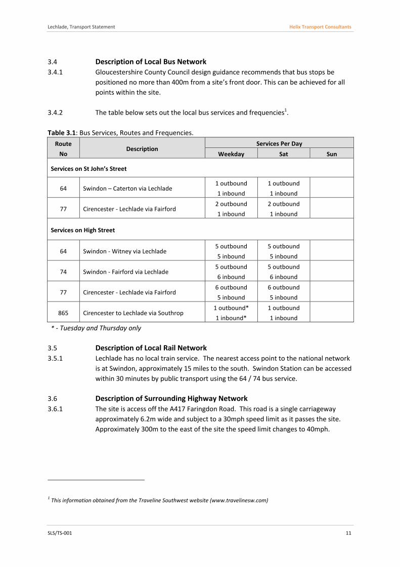
3.4.2 The table below sets out the local bus services and frequencies1.
Table 3.1: Bus Services, Routes and Frequencies.
Route
No Description
Services Per Day
Weekday Sat Sun
Services on St John’s Street
64 Swindon – Caterton via Lechlade 1 outbound
1 inbound
1 outbound
1 inbound
77 Cirencester - Lechlade via Fairford 2 outbound
1 inbound
2 outbound
1 inbound
Services on High Street
64 Swindon - Witney via Lechlade 5 outbound
5 inbound
5 outbound
5 inbound
74 Swindon - Fairford via Lechlade 5 outbound
6 inbound
5 outbound
6 inbound
77 Cirencester - Lechlade via Fairford 6 outbound
5 inbound
6 outbound
5 inbound
865 Cirencester to Lechlade via Southrop 1 outbound*
1 inbound*
1 outbound
1 inbound
* - Tuesday and Thursday only
3.5 Description of Local Rail Network
3.5.1 Lechlade has no local train service. The nearest access point to the national network
is at Swindon, approximately 15 miles to the south. Swindon Station can be accessed
within 30 minutes by public transport using the 64 / 74 bus service.
3.6 Description of Surrounding Highway Network
3.6.1 The site is access off the A417 Faringdon Road. This road is a single carriageway
approximately 6.2m wide and subject to a 30mph speed limit as it passes the site.
Approximately 300m to the east of the site the speed limit changes to 40mph.
1 This information obtained from the Traveline Southwest website (www.travelinesw.com)
Lechlade, Transport Statement Helix Transport Consultants
SLS/TS-001 12
3.6.2 To the west of the site, beyond the junction with Wharf Lane, the A417 becomes St
John’s Street. This section of the A417 is characterised by dwellings fronting directly
onto the footway and informal on-street parking.
3.6.3 Wharf Lane is a cul-de-sac, approximately 5.5m wide, providing access to St Lawrence
Primary School and a number of residential dwellings. Wharf Lane has no footway.
3.6.4 To the west of the site the A417 forms a junction with the A361. The A361 runs
north to south through Lechlade, has footways on both sides, and is subject to a
30mph speed limit.
3.6.5 To the south of the junction with the A417 the A361 is known as Thames Street. This
road has a maximum vehicle length limit of 13m due to a hump-back bridge over the
River Thames, just south of Lechlade.
3.6.6 To the north of the junction with the A417 the A361 is known as Burford Street. This
road has formal on-street parking on both sides of the road. Beyond this the A361
continues as Oak Street with formal on-street parking on the western side only.
Further on, beyond the commercial area, there is no formal on-street parking.
3.7 Parking
3.7.1 St John’s Street and Faringdon Road offer a number of informal on-street parking
spaces. Site observations reveal on-street parking on both sides of St John’s Street.
On Faringdon Road cars have been observed to park within the application site
access, along the westbound verge, and within a more formal lay-by area
immediately east of the junction with Wharf Lane.
3.7.2 A site visit was undertaken between 08:30 and 09:30 on Friday 6th June 2014 in order
to observe the on-street parking during the school drop-off period. During this time
13 cars were observed to park for the purpose of dropping children off at school.
3.7.3 From discussion with the local School Safety Patrol Officer it is understood that the
demand for on-street parking can be higher than that observed on Friday 6th June, to
the extent that it presents a significant inconvenience to through traffic.
3.7.4 It is further understood that the three cars remaining within the surfaced lay-by area
after 09:30, are owned by members of the primary school staff. This lay-by area is
believed to have been originally built to accommodate recycling bins, but that these
were subsequently removed in response to the need for on-street parking.
3.8 Accident Analysis
3.8.1 www.roadsafety-gloucestershire.org.uk web site provides summary information on
Personal Injury Collision (PIC) data recorded in Gloucestershire since 2008. This
resource shows that there have been no recorded incidents within the vicinity of the
site from 2008 to the most recent available date.

Lechlade, Transport Statement Helix Transport Consultants
SLS/TS-001 13
3.8.2 The few PIC’s that are away from the site show no causation patterns, clustering or
trends. It is therefore concluded that, there are no existing highway safety issues
that development on the site might exacerbate.
3.8.3 This conclusion was also reached in the Barnwood TS and there have been no further
reported accidents since that document was prepared.
Lechlade, Transport Statement Helix Transport Consultants
SLS/TS-001 14
4 Development Site
4.1 The Existing Development
4.1.1 The site is currently used for agricultural pasture. There are no structures or parking
areas on the site
4.2 The Proposed Development
4.2.1 This outline application seeks to test the principle of a mixed-use development with
the Local Planning Authority.
4.2.2 If the principal of development is approved the scheme will then be refined. For the
purpose of this report, a quantity of development is assumed in order to calculate
the likely traffic / transport demands. These quantities should be considered the
maximum, within which the final scheme will fall.
Housing – up to 20 new homes
Public Car Park – 50 spaces (no charge)
Swimming Pool – 20m by 8m pool (assumed 400sqm GFA)
Walled Allotment Gardens
Approximately 25 acres of open community space
4.2.3 The need for a public car park in this area is evident from the amount of on-street
parking. It is also identified as a need in the adopted Cotswold District Local Plan.
4.2.4 The proposed swimming pool will add to the local facilities, and offer the opportunity
to remove some longer distance vehicle trips from the network.
4.2.5 Allotment gardens and community open space will further enhance facilities for local
residents, and can be expected to reduce the need to travel from Lechlade for
recreational purposes.
4.3 Access Strategy
Vehicular Access
4.3.1 Access to the site will be in the form of a simple priority junction in the approximate
location of the existing access.
4.3.2 The proposed access has been designed to allow a large refuse vehicle to enter and
exit the site without the need to encroach outside the relevant lane.
4.3.3 As can be seen on the attached illustrative layout plan, the proposed access will meet
Gloucestershire County Council’s minimum default visibility requirement, of 2.4m x-
distance by 54m y-distance, for a 30mph road.

Lechlade, Transport Statement Helix Transport Consultants
SLS/TS-001 15
Non-Vehicular Access
4.3.4 Consideration has been given to providing a pedestrian crossing from the site to the
existing footway along Faringdon Road. However, this is not the focus of non-car
access at this site. Instead, resources will be concentrated on the Monk’s Walk path.
4.3.5 In 2013 the Monks Walk was resurfaced and widened, to approximately two metres,
along the site boundary and beyond this to the east. No works were carried out to
the west of the site, other than the construction of a ‘kissing gate’ where the path
joins Wharf Lane. This gate is consistent with BS5709:2006 and is designed to allow
wheelchair and pushchair access.
4.3.6 Cyclists cannot easily pass through the ‘kissing gate’ and, in any event, are not
permitted to use the path into Lechlade town centre. To encourage cycling to
Lechlade from the east, the site will provide secure cycle parking from where cyclists
can walk into the town centre.
4.3.7 Under these development proposals, pedestrian traffic along the Monk’s Walk is
expected to increase significantly. To improve the current situation the path will be
surfaced and widened within the existing corridor. Low level lighting and CCTV
surveillance would also prove beneficial in maintaining the attractiveness of this
route at all times of the year.
4.3.8 The specific details of improvements to this section of Monk’s Walk will be finalised
and agreed at the detailed design stage; if these development proposals are
approved in principle.
4.4 Parking Strategy
Non-Residential
4.4.1 The proposed public car park will operate as a shared resource. This approach
ensures the most efficient use of the land as it allows, for example: shoppers to reuse
the spaces vacated after the school drop-off; or swimming pool users to use spaces
available after shoppers and workers have left for the day.
4.4.2 The proposed public car park will serve the following uses:
Drop-off and pick-up space for local school
Long Stay Town centre parking
Residential visitor / deliveries parking
Swimming pool parking
Allotment gardens parking
Lechlade, Transport Statement Helix Transport Consultants
SLS/TS-001 16
4.4.3 The proposed parking will be available free of charge. Any other approach is unlikely
to address the existing on-street parking issues.
4.4.4 Disabled parking will be provided at a rate of 5% in accordance with the adopted
Local Plan. This equates to 3 disabled spaces.
4.4.5 The adopted Local Plan also recommends a combined cycle and motorcycle parking
provision of 15%. The Manual for Gloucestershire Streets document recommends
motorcycle parking provision at 5 - 10%. In accordance with these guidance
documents, it is proposed that the non-residential parking will incorporate a
minimum:
3 spaces for disabled drivers;
3 spaces for motorcycles; and
5 spaces for cyclists.
4.4.6 Secure cycle parking facilities will encourage recreational cycling to the east of
Lechlade, as well as provide the town centre with a facility, that is otherwise absent.
Residential
4.4.7 Residential parking will follow the guidance set out in the Communities and Local
Government’s ‘Residential Car Parking Research 2007.’ This report assumes that
residential parking will be allocated, either as a shared resource between a number
of households, or on a unit by unit basis. This approach is designed to avoid the
prospect of public parking overflowing into the residential area. Visitors and
deliveries to the residential area can make use of the public parking.
4.4.8 In accordance with the standards set out in the adopted Local Plan and the Manual
for Gloucestershire Streets, one secure and conveniently located cycle space will be
provided per dwelling. Cycle parking will be accommodated within either garages,
sheds or other secure storage areas. These details are to be determined at the
detailed design stage.

Lechlade, Transport Statement Helix Transport Consultants
SLS/TS-001 17
5 Trip Generation, Distribution and Assignment
5.1 Housing Trips
Generation
5.1.1 The Barnwood TS provides an estimate of the rate and distribution of trips for
residential development in the area. The highway and planning authority have
approved of this estimate so it is prudent for this assessment to adopt the same
approach.
5.1.2 The likely person trip generation, for the proposed residential development, has
been calculated using trip rates derived from the TRICS 2014v7.1.1 database. The
TRICS data search was narrowed to sites totalling between 25 and 100 dwellings
located in England.
Table 5.1 – Housing, Weekday Person Trips
AM Peak (08:00 – 09:00) PM Peak (17:00 – 18:00)
In Out Total In Out Total
TRICS Person Trip
Rates per Dwelling 0.232 0.779 1.011 0.613 0.316 0.929
Person Trips
(20 Dwellings) 5 16 20 12 7 19
5.1.3 An estimate of the number of vehicular trips is based on the 2011 Census ‘journey to
work’ mode share for residents of the Kempsford-Lechlade ward. The raw census
data has been adjusted: firstly by removing non-workers; and secondly by reassigning
those who report rail as their main travel mode, to single occupancy car use. The
adjusted mode shares are shown below.
Table 5.2 – Adjusted 2011 Census Kempsford–Lechlade Ward Journey to Work Mode
Share
Mode
All
wo
rke
rs
Bu
s
Mo
torc
ycle
Car
dri
ver
Car
pas
sen
ger
Bic
ycle
foo
t
No of people 1694 20 16 1385 67 33 167
% Mode Share 100 1 1 82 4 2 10

Lechlade, Transport Statement Helix Transport Consultants
SLS/TS-001 18
5.1.4 Applying the car driver mode share to the person trip generation, results in the
following vehicular trip generation for the proposed housing.
Table 5.3 – Housing, Weekday Vehicle Trips
AM Peak (08:00 – 09:00) PM Peak (17:00 – 18:00)
In Out Total In Out Total
Vehicle Trips
(20 Dwellings) 4 13 17 10 6 16
5.1.5 The methodology described above is considered highly robust, in terms of predicting
car numbers, as it assumes all peak hour trips are journeys to work. In reality the
majority of peak hour trips are for other purposes2. Other peak hour trip purposes
such as education, recreation and retail tend to have much lower single occupancy
car use.
Distribution / Assignment
5.1.6 The distribution of residential trips is taken directly from the agreed Barnwood TS.
This is derived from the 2001 Census ‘origin-destination journey to work data’ for
residents of the Kempston-Lechlade Ward. The resulting assignment of vehicle trips
is:
A417 east 8%
A361 south 42%
A417 west 39%
A361 north 11%
5.1.7 The predicted traffic movements are shown on the attached Figures 5 and 6.
5.2 Swimming Pool Trips
Generation
5.2.1 The likely person and vehicle trips for the proposed swimming pool development, has
been calculated by applying trip rates from the TRICS 2014v7.1.1 database. The TRICS
data for Leisure (category): Leisure Centre (sub-category); was narrowed to
swimming pools, totalling between 360 and 1200 sqm Gross Floor Area (GFA),
located on the edge of town in England.
2 National Travel Survey Table NTS0502 - 27% Commuting or Business purpose between 08:00-09:00 and 37% between
17:00-18:00
Lechlade, Transport Statement Helix Transport Consultants
SLS/TS-001 19
5.2.2 One of the sites within the TRICS database stands out for being remarkably similar to
that envisaged on the site. The Blackbird Leys Swimming Pool in Oxfordshire is
360sqm GFA with a 150sqm pool. It is close to, and used by, local schools and has a
large walk in potential. The person and vehicle trip recorded at this site are very
similar to the TRICS derived averages used in the following calculations.
Table 5.4 – Swimming Pool, Weekday Person & Vehicle Trips
AM Peak (08:00 – 09:00) PM Peak (17:00 – 18:00)
In Out Total In Out Total
TRICS Person Trip
Rates / 100sqm GFA 2.185 0.684 2.869 8.168 6.954 15.122
Person Trips
(400sqm) 9 3 11 33 28 60
TRICS Vehicle Trip
Rates / 100sqm GFA 0.751 0.574 1.321 3.046 2.406 5.452
Vehicle Trips
(400sqm) 3 2 5 12 10 22
Distribution / Assignment
5.2.3 The proposed swimming pool is principally aimed at providing a facility to the local
community. In order to understand the likely direction from which these local trips
will approach the site an analysis of the distribution of people within the Kepsford-
Lechlade ward has been carried out.
5.2.4 At the time of the 2011 census the Kempsford-Lechlade ward comprised a total of
3971 people. Within this area only output area E00112878 is located to the east
(population 230 (6%)). Of the remaining Census output areas within the ward:
E00112879429, E00112880, E0078507, and E00112884 (total population 950 (24%))
are considered to access the site from the southwest. The remaining 70% are
assumed to approach the site from the northwest.
5.2.5 According to the above the proposed swimming pool trips are assigned, as follows:
A417 east 6%
A361 south 24%
A361 north 70%
5.2.6 The predicted traffic movements are shown on the attached Figures 7 and 8.
Lechlade, Transport Statement Helix Transport Consultants
SLS/TS-001 20
5.3 School Parking
Generation
5.3.1 Observations of on-street parking on Faringdon Road and St John’s Road indicate that
the local primary school generates 13 school ‘drop-off’ car trips, and a demand for
three staff parking spaces. It is assumed that the same number of school ‘pick-up’
trips are generated between 15:00 and 15:30. It is also assumed that the staff cars
will leave at this time.
Distribution / Assignment
5.3.2 These school trips will be new to the proposed site access but not new to the local
road network. The majority of these cars were observed to originate and return to
the west of the site, turning at the site entrance. As would be expected this is
consistent with the distribution of households.
5.3.3 Accordingly, these vehicle trips are assigned at the proposed access in the following
proportions:
A417 east 6%
A417 west 94%
5.3.4 The predicted traffic movements are shown on the attached Figures 9 and 10.
5.4 Public Parking
Generation
5.4.1 Public car parks do not generate vehicle trips in their own right. These facilities are
provided to accommodate drivers who already visit, or those that may visit in the
future as a result of nearby development. In the case of Lechlade, an existing need
for more parking is evident in the use of informal on-street parking, and ‘the future
of Lechlade’ public consultation feedback.
5.4.2 The assessment of the use of the proposed car park is based on maximum
occupation. This is done by applying a theoretical demand to a daily vehicle
movement profile, until the point where maximum accumulation of vehicles is equal
to the number of spaces available. The daily vehicle movement profile adopted in
this assessment is taken from the TRICS database for a site thought to generate
comparable car trips, in terms of timing and length of stay. This is considered to be a
robust approach as it assumes 100% use of the car park.
5.4.3 A number of factors have influenced the choice of site thought to generate
comparable car movements:
Lechlade, Transport Statement Helix Transport Consultants
SLS/TS-001 21
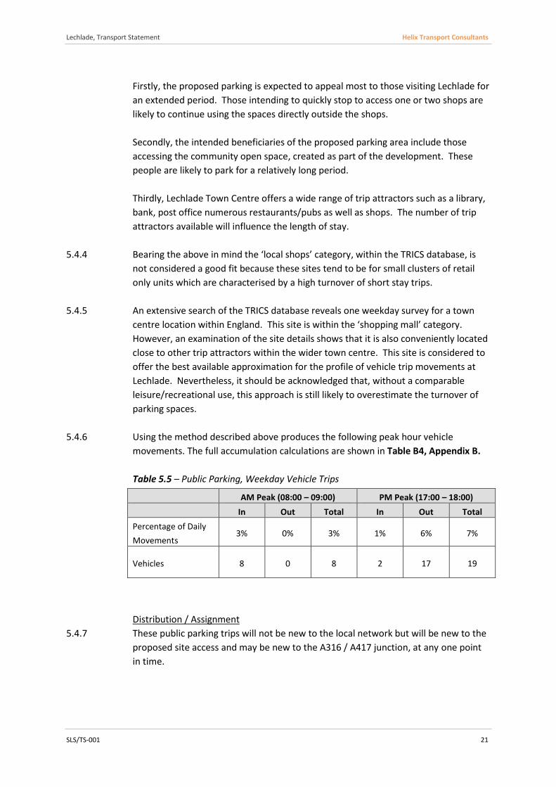
Firstly, the proposed parking is expected to appeal most to those visiting Lechlade for
an extended period. Those intending to quickly stop to access one or two shops are
likely to continue using the spaces directly outside the shops.
Secondly, the intended beneficiaries of the proposed parking area include those
accessing the community open space, created as part of the development. These
people are likely to park for a relatively long period.
Thirdly, Lechlade Town Centre offers a wide range of trip attractors such as a library,
bank, post office numerous restaurants/pubs as well as shops. The number of trip
attractors available will influence the length of stay.
5.4.4 Bearing the above in mind the ‘local shops’ category, within the TRICS database, is
not considered a good fit because these sites tend to be for small clusters of retail
only units which are characterised by a high turnover of short stay trips.
5.4.5 An extensive search of the TRICS database reveals one weekday survey for a town
centre location within England. This site is within the ‘shopping mall’ category.
However, an examination of the site details shows that it is also conveniently located
close to other trip attractors within the wider town centre. This site is considered to
offer the best available approximation for the profile of vehicle trip movements at
Lechlade. Nevertheless, it should be acknowledged that, without a comparable
leisure/recreational use, this approach is still likely to overestimate the turnover of
parking spaces.
5.4.6 Using the method described above produces the following peak hour vehicle
movements. The full accumulation calculations are shown in Table B4, Appendix B.
Table 5.5 – Public Parking, Weekday Vehicle Trips
Distribution / Assignment
5.4.7 These public parking trips will not be new to the local network but will be new to the
proposed site access and may be new to the A316 / A417 junction, at any one point
in time.
AM Peak (08:00 – 09:00) PM Peak (17:00 – 18:00)
In Out Total In Out Total
Percentage of Daily
Movements 3% 0% 3% 1% 6% 7%
Vehicles 8 0 8 2 17 19
Lechlade, Transport Statement Helix Transport Consultants
SLS/TS-001 22
5.4.8 It is logical to assume that the proposed parking will draw cars from their existing
route. For this reason trips are assigned to the same proportions as the observed
flows.
5.4.9 The redistribution effect means that visitors to Lechlade from the east, who choose
to use this car park, will no longer travel through the A361 / A417 junction. However,
those arriving from the west, who would normally park in the high street but have
chosen to use the new car park, will be new to the A361 / A417 junction at that time.
5.4.10 The exiting manoeuvre produces a similar effect; with those reassigned to the car
park, exiting to the east, no longer passing though the A361 / A417 junction.
However, those reassigned to the car park, exiting to the west, will be new to the
A361 / A417 junction at that time.
5.4.11 The predicted traffic movements are shown on the attached Figures 11 and 12.
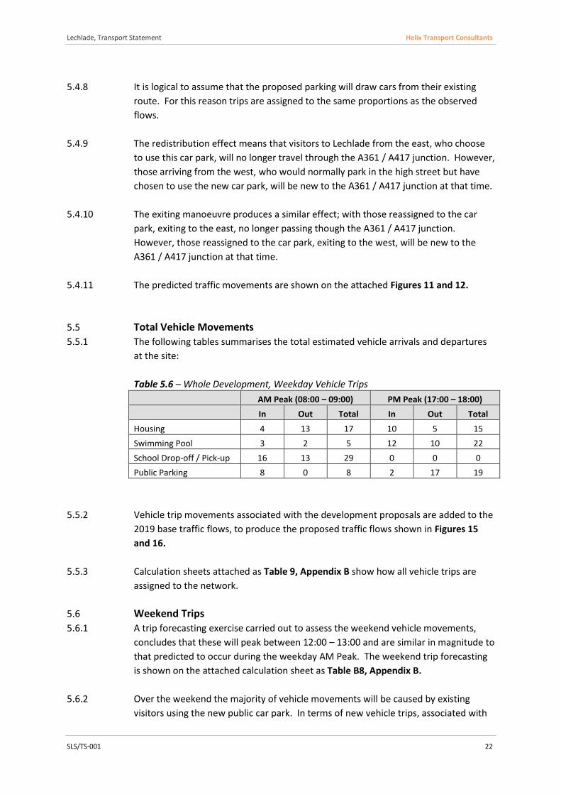
5.5 Total Vehicle Movements
5.5.1 The following tables summarises the total estimated vehicle arrivals and departures
at the site:
Table 5.6 – Whole Development, Weekday Vehicle Trips
AM Peak (08:00 – 09:00) PM Peak (17:00 – 18:00)
In Out Total In Out Total
Housing 4 13 17 10 5 15
Swimming Pool 3 2 5 12 10 22
School Drop-off / Pick-up 16 13 29 0 0 0
Public Parking 8 0 8 2 17 19
5.5.2 Vehicle trip movements associated with the development proposals are added to the
2019 base traffic flows, to produce the proposed traffic flows shown in Figures 15
and 16.
5.5.3 Calculation sheets attached as Table 9, Appendix B show how all vehicle trips are
assigned to the network.
5.6 Weekend Trips
5.6.1 A trip forecasting exercise carried out to assess the weekend vehicle movements,
concludes that these will peak between 12:00 – 13:00 and are similar in magnitude to
that predicted to occur during the weekday AM Peak. The weekend trip forecasting
is shown on the attached calculation sheet as Table B8, Appendix B.
5.6.2 Over the weekend the majority of vehicle movements will be caused by existing
visitors using the new public car park. In terms of new vehicle trips, associated with
Lechlade, Transport Statement Helix Transport Consultants
SLS/TS-001 23
the proposed housing and swimming pool, the total is small compared with the
weekday predictions.
5.6.3 The weekday AM peak is the worst case scenario, in terms of a high number of
vehicle movements to / from the site combined with relatively high main line flows.
Given this, it is considered unnecessary to consider the effect of the development at
the weekend any further.
5.7 Sensitivity Test
Barnwood
5.7.1 As mentioned through this report, a proposed housing development opposite the
site is currently being considered at appeal. If successful this development will add
traffic to the local highway network. The Barnwood development is included within
this TS as a sensitivity test, to ensure that the implications of both developments
going ahead is tested.
5.7.2 The Barnwood TS predicts the following vehicle movements:
5.7.3 The distribution of these trips onto the local network is shown in the attached
Figures 17 and 18.
School Parking
5.7.4 As a result of discussion with the local school safety patrol officer it is understood
that the school drop-off can, at times, be significantly busier that that observed on-
site. For this reason the Sensitivity Test also assumes double the number of these
movements.
5.7.5 Vehicle trip movements associated with the Sensitivity Test are added to the 2019
base traffic flows to produce the Sensitivity Test flows shown in Figures 19 and 20.
5.7.6 Calculation sheets attached as Table10, Appendix B show how all vehicle trips are
assigned to the network.

Lechlade, Transport Statement Helix Transport Consultants
SLS/TS-001 24
6 Highway Impact
6.1 Study Area
6.1.1 The Guidance on Transport Assessment, produced by the Dft in 2007, offers a series
of development thresholds beyond which a Transport Statement or Transport
Assessment is likely to be required. These thresholds are based on development
quantities expected to result in 30 or more additional two-way peak hour vehicle
movements. This guidance is a useful starting point for defining the area within
which the impact of development on the transport network can be considered
significant.
6.1.2 For the purpose of defining the study area only those trips associated with the
proposed housing and swimming pool will be new trips to the network. Other
vehicle movements associated with the school drop-off and other public parking are
considered to be already on the network. On this basis it is concluded that the traffic
effects of the proposed development will be insignificant.
6.1.3 Notwithstanding the above, the diversion of existing trips into the site will lead to a
significant quantity of vehicle movements at the proposed site access. For this
reason the proposed access has been subjected to junction modelling; below.
6.1.4 While these proposals will not have a significant effect on the A316 / A417 junction,
to the west of the site, the Barnwood development will. It is, therefore, appropriate
to include this junction within the study area when considering the cumulative
impact of both developments.
6.2 Traffic Flows
Existing Flows
6.2.1 The existing traffic flows used in this assessment are those presented, and agreed,
within the Barnwood TS. These traffic flows were recorded in June 2013 and
observed to peak between 07:30-08:30 and 16:45-17:45.
6.2.2 The 2013 peak hour traffic flows are shown on the attached Figures 1 and 2.
Traffic Growth
6.2.3 In accordance with the DFT guidance the future assessment year for the
redevelopment is five years after the date of registration of the planning application.
Therefore a TEMPRO growth factor has been applied to the observed 2013 traffic
flows, to provide forecast 2019 base flows.
Lechlade, Transport Statement Helix Transport Consultants
SLS/TS-001 25
6.2.4 The growth factors to be used have been derived from the DfT’s TEMPRO 6.2
computer program using the National Trip End Model (NTEM) dataset 6.2. The
TEMPRO growth factor is based on origin/destination trip end types for the
Cotswolds, for all road types. This is the same approach as that approved for the
Barnwood development proposals.
6.2.5 The growth factors used in this assessment are:
1.0534 (5.34%) for the AM peak; and
1.0592 (5.92%) for the PM peak.
6.2.6 The following scenarios have been assessed:
2019 Base – (traffic flows growthed to 2019, without development)
2019 Proposed – (Base + Development)
2019 Sensitivity Test – (Base + Development + Barnwood + additional drop-
off / pick-up)
6.2.7 The 2019 peak hour Base traffic flows are shown on the attached Figures 3 and 4.
6.3 Summary of Traffic Flows
6.3.1 The effect of the proposed development in terms of new trips onto the network is
summarised in the table below. This table also includes a summary of the sensitivity
test scenario.

Lechlade, Transport Statement Helix Transport Consultants
SLS/TS-001 26
Table 6.1 – Two-Way Link Flow Summary Table
Link / Junction
direction
2013 Observed Flows
2019 Base Flows 2019 Proposed
Flows 2019 Sensitivity Test
Proposed 2-Way Increase / %
Sensitivity Test 2-Way Increase / %
AM Peak PM Peak AM Peak PM Peak AM Peak PM Peak AM Peak PM Peak AM Peak PM Peak AM Peak PM Peak
A417 East of Proposed Development
EB 201 118 212 125 214 126 214 149 3 3 15 38
WB 128 188 135 199 136 201 148 213 / / / /
2-Way 329 306 346 324 350 327 362 362 1.0% 0.8% 4.3% 10.4%
A417 West of Proposed Development
EB 216 118 228 125 238 140 248 163 22 38 61 73
WB 140 188 147 199 158 222 189 234 / / / /
2-Way 356 306 375 324 397 362 436 397 5.5% 10.5% 14.0% 18.4%
A361 North of St John's St
NB 556 562 586 595 587 607 591 608 6 18 11 22
SB 555 531 585 562 589 569 590 572 / / / /
2-Way 1111 1093 1170 1158 1176 1176 1182 1180 0.5% 1.6% 0.9% 1.9%
A361 South of St John's St
NB 612 533 645 565 651 573 659 593 16 19 50 50
SB 535 572 564 606 573 617 599 628 / / / /
2-Way 1147 1105 1208 1170 1224 1190 1258 1221 1.3% 1.6% 4.0% 4.1%
A417 / A361 Junction
Total Junction Flows
22 / 38 / 61 / 73 /
1307 1252 1377 1326 1399 1364 1438 1399 1.6% 2.8% 4.3% 5.2%

Lechlade, Transport Statement Helix Transport Consultants
SJS/TS-001 27
6.3.2 The table above demonstrates that the effect of the development is less than 30 two-
way vehicle movements, at the boundary of the study area.
6.3.3 The Sensitivity Test shows the effect of development at Barnwood and Upper Ready
Field to be up to 50 two-way vehicle trips, at the boundary of the study area. This
equates to around 1 vehicle every 2 minutes in any one direction. The associated
percentage increase lies within typical peak hour variation. For these reasons it is
considered that the development effect is negligible, beyond the A417 / A361
junction and east of the site access.
6.3.4 It should be noted that the figures above include trips diverted to the proposed
public parking which, although new to the A417 / A361 junction, at that time, will not
be new to the network beyond the study area.
6.4 Junction Capacity Assessment
6.4.1 The proposed site access and the existing A417/A361 junction have been tested
using the PICADY analysis package.
Site Access
6.4.2 The table below summarises the junction capacity assessment results.
Table 6.2 – Site Access, PICADY Summary
Scenario Stream
AM Peak PM Peak
Max RFC* Max Queue Max RFC* Max Queue
Proposed
Flows
A417 Eastbound
Right Turn 0.051 0 0.044 0
Site Access Exit 0.056 0 0.070 0
Sensitivity
Test
A417 Eastbound
Right Turn 0.081 0 0.045 0
Site Access Exit 0.083 0 0.071 0
* - RFC = Ratio of Flow to Capacity
6.4.3 The junction capacity (PICADY) assessment shows that the proposed access will work
well within theoretical capacity in all scenarios

Lechlade, Transport Statement Helix Transport Consultants
SJS/TS-001 28
A417 / A361 Junction
6.4.4 The table below summarises the junction capacity assessment results.
Table 6.3 – A417/A361 Junction, PICADY Summary
Scenario Stream
AM Peak PM Peak
Max RFC* Max Queue Max RFC* Max Queue
Base
Flows
A417 Exit 0.517 1 0.633 2
A361 Northbound
Right Turn 0.312 0 0.149 0
Proposed
Flows
A417 Exit 0.547 1 0.716 2
A361 Northbound
Right Turn 0.327 0 0.169 0
Sensitivity
Test
A417 Exit 0.630 2 0.760 3
A361 Northbound
Right Turn 0.346 1 0.216 0
* - RFC = Ratio of Flow to Capacity
6.4.5 The junction capacity (PICADY) assessment shows that the existing A417/A361
junction will work well within theoretical capacity in all scenarios.
6.5 Summary
6.5.1 The analysis presented above shows that the proposed development will generate
fewer than 30 additional two-way vehicle movements. At this level the national
guidance suggests that the effect of development on the local transport network is
likely to be insignificant.
6.5.2 Junction capacity assessments confirm that the impact on the local highway is
insignificant.
6.5.3 Even when the proposed development is combined with possible development at the
Barnwood site, the junctions are shown to operate well within their capacity.

Lechlade, Transport Statement Helix Transport Consultants
SJS/TS-001 29
7 Conclusions
7.1 Conclusions
7.1.1 The site is considered to have good accessibility, given that it is easily reached by a
choice of non-car modes of travel. Development on this site is therefore considered
to be entirely consistent with transportation policy objectives.
7.1.2 The development proposals will improve pedestrian safety by providing off-road
parking and an off-road pedestrian route for parents and children accessing the
nearby St Lawrence Primary School.
7.1.3 The development proposals will help improve the flow of peak hour traffic along St
John’s Road by removing some of the on-street parking.
7.1.4 The proposed swimming pool and community open space will reduce the need for
Lechlade residents to travel for those purposes.
7.1.5 The development will improve cycle accessibility by providing secure cycle parking
facilities for cyclists accessing Lechlade from the east.
7.1.6 The proposed public parking addresses a parking need identified by residents and in
the Cotswold District Local Plan.
7.1.7 Proposed parking on the site for cars, disabled drivers, bicycles and motorbikes
complies with the standards set out in the Cotswold District Local Plan.
7.1.8 Junction analysis shows that the effect of development on the local highway
network, in terms of queuing and delay at the proposed access and nearby
A417/A361 junction, is negligible.
7.1.9 It is concluded that there are no transport planning reasons for refusing this
application.