DMEAN best practice G8 Laquila v2 - Eurocontrol · Best practice The 2009 G8 Summit was held in...
6
Civil/military cooperation Best practice The 2009 G8 Summit was held in Italy on July 2009. It was initially expected in La Maddalena (Sardinia), but for Humanitarian reason the Summit has moved to L’Aquila, that was hit by a big earthquake 3 months earlier, to draw the attention to the area wounded by the disaster. The planning of this “big event” and the consequent civil military coordination had to be done in very short time. For security reasons (under provision of art. 793 Air Navigation Acts) during “G8” Summit, restrictions were applied to air traffic due to temporary interdiction of some areas which affected the airspace of Rome FIR/UIR, Brindisi FIR/UIR, Roma TMA, Pescara CTR, Roma CTR, and Amendola CTR. All the restrictions were indicated in terms of lateral limits, vertical limits, dates and times. The scenario initially identified was based on a “No fly zone” extending from GND to FL 280 within 30 Nautical Miles radius from L’Aquila and a “No VFR zone” from GND to FL 195 within a 40 NM radius from L’Aquila (see fig. 1). As events slowly unfolded, supplementary military requirements pertaining security issues were also to be taken into account. The overall result had soon developed in a highly critical scenario for both GAT and OAT flights (see fig. 2). While the establishment of the “No VFR zone” was easily acceptable, the “No fly zone” would have caused a big impact to civil air traffic, In particular, the zone would interfere with a big part of Roma TMA causing a “domino effect” on traffic to/from Roma, Napoli and Pescara airports and all traffic overflying the area up to FL 350. With this in mind, a set of possible mitigations were envisaged, following a thorough impact analysis for both civil and military air traffic to reach a feasible solution by evaluating the best rerouting options/time of operations. (see fig. 3). This finally resulted in reshaping the “No fly zone”, significantly reducing the impact on civil air traffic while still accommodating military requirements (see fig. 4). Two added key elements made the reshape of the “no fly zone” possible: • intense activity involving all partners, including CFMU in the preplanning; • real time coordination that, through additional flexibility, allowed the complete harmonization of G8 traffic with the domestic and international traffic. All this work, concluded in 35 days, has been successfully implemented thanks to the high level coordination between ENAV (the Italian Service Provider), A.M. (Italian Air Force) and Enac (the Civil Aviation Authority). The 4 Italian ACCs were able to optimally protect the interest of domestic and international traffic during the Big Event while allowing the Military to carry out their special ad-hoc duty in a safe environment. The amount of operational traffic that visited L’Aquila airport, (normally a tourist airport) was about equal to larger airports like Torino. LIRF, LIRN and LICJ were the most affected aerodromes. Mainly flights that departed from Italy were affected. Most penalised flows were Italy-Romania and Italy-Tunis. Most penalised AOs: AZA, RYR, ISS and ADH. The new layout of military areas and the tactical coordination reduced GAT impact to 269 flights which corresponded to a 55% reduction of penalised flights. This result was mainly achieved by decreasing the area by ±20NM horizontally and 6000 ft vertically, while displacing and adding the remnant military areas in other less congested sectors.
Transcript of DMEAN best practice G8 Laquila v2 - Eurocontrol · Best practice The 2009 G8 Summit was held in...

Civil/military cooperation
Best practice
The 2009 G8 Summit was held in Italy on July 2009. It was initially expected in La Maddalena (Sardinia), but for
Humanitarian reason the Summit has moved to L’Aquila, that was hit by a big earthquake 3 months earlier, to draw
the attention to the area wounded by the disaster.
The planning of this “big event” and the consequent civil military coordination had to be done in very short time.
For security reasons (under provision of art. 793 Air Navigation Acts) during “G8” Summit, restrictions were applied to
air traffic due to temporary interdiction of some areas which affected the airspace of Rome FIR/UIR, Brindisi FIR/UIR,
Roma TMA, Pescara CTR, Roma CTR, and Amendola CTR. All the restrictions were indicated in terms of lateral limits,
vertical limits, dates and times.
The scenario initially identified was based on a “No fly zone” extending from GND to FL 280 within 30 Nautical Miles
radius from L’Aquila and a “No VFR zone” from GND to FL 195 within a 40 NM radius from L’Aquila (see fig. 1). As
events slowly unfolded, supplementary military requirements pertaining security issues were also to be taken into
account. The overall result had soon developed in a highly critical scenario for both GAT and OAT flights (see fig. 2).
While the establishment of the “No VFR zone” was easily acceptable, the “No fly zone” would have caused a big
impact to civil air traffic, In particular, the zone would interfere with a big part of Roma TMA causing a “domino
effect” on traffic to/from Roma, Napoli and Pescara airports and all traffic overflying the area up to FL 350.
With this in mind, a set of possible mitigations were envisaged, following a thorough impact analysis for both civil and
military air traffic to reach a feasible solution by evaluating the best rerouting options/time of operations. (see fig. 3).
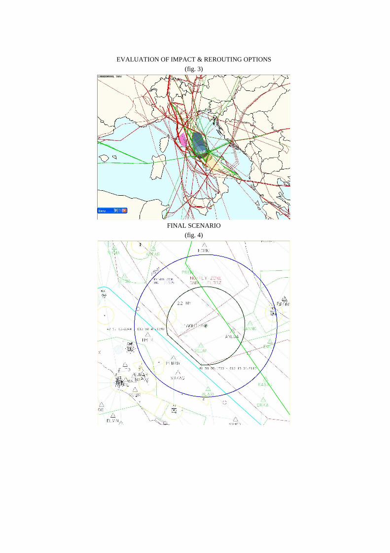
This finally resulted in reshaping the “No fly zone”, significantly reducing the impact on civil air traffic while still
accommodating military requirements (see fig. 4).
Two added key elements made the reshape of the “no fly zone” possible:
• intense activity involving all partners, including CFMU in the preplanning;
• real time coordination that, through additional flexibility, allowed the complete harmonization of G8 traffic
with the domestic and international traffic.
All this work, concluded in 35 days, has been successfully implemented thanks to the high level coordination between
ENAV (the Italian Service Provider), A.M. (Italian Air Force) and Enac (the Civil Aviation Authority). The 4 Italian ACCs
were able to optimally protect the interest of domestic and international traffic during the Big Event while allowing
the Military to carry out their special ad-hoc duty in a safe environment.
The amount of operational traffic that visited L’Aquila airport, (normally a tourist airport) was about equal to larger
airports like Torino. LIRF, LIRN and LICJ were the most affected aerodromes. Mainly flights that departed from Italy
were affected. Most penalised flows were Italy-Romania and Italy-Tunis. Most penalised AOs: AZA, RYR, ISS and ADH.
The new layout of military areas and the tactical coordination reduced GAT impact to 269 flights which corresponded
to a 55% reduction of penalised flights. This result was mainly achieved by decreasing the area by ±20NM horizontally
and 6000 ft vertically, while displacing and adding the remnant military areas in other less congested sectors.

A strategic outlook of impacted GAT traffic thru the day. 00
00
0100
0200
0300
0400
0500
0600
0700
0800
0900
1000
1100
1200
1300
1400
1500
1600
1700
1800
1900
2000
2100
2200
2300
0
5
10
15
20
G8aquila340
Time
Nbr
of f
light
s
Entry rate
INST
AVG TIME
INITIAL SCENARIO
(fig. 1)
FULL SCALE SCENARIO
(fig. 2)
EVALUATION OF IMPACT & REROUTING OPTIONS
(fig. 3)
FINAL SCENARIO
(fig. 4)

Considerations
The G8 event coordination activity satisfied many Principles regarding all three Airspace Management levels. Emphasis
has been put on cooperation between all the stakeholders involved, and mainly on the Civil and Military service
providers.
All measures adopted during the G8 are normally used as strategic pre-tactical and tactical actions to mitigate the
impact on civil traffic during such relevant events. In these cases ad-hoc national ASM tools, together with CFMU
software were exploited to the maximum extent possible in stimulating and realizing effective management of
significant events.
Critical success factors to reduce the impact on civil air traffic during these Big Events were:
• Stakeholder Coordination by strategic, pretactical and tactical point of view
• Real time coordination ACC - SCCAM (ITAF “Italian Airforce Control and Coordination Service”) – FMP to
accommodate civil military needs
• Necessity to settle clear agreements especially when in the area multinational air forces are involved.
• Need of AIP supplement to publish a scenario for appropriate tactical and pre-tactical management actions
with the aim to limit the impact on general air traffic flows.
• NOTAM publication where necessary.
• Clear roles and responsibilities of all actors involved in the process.
• Information disseminated to organizations not directly involved in the activity but neighboring with the
scenario and potentially affected by side-effect.
• Increase the exchange of information with CFMU to keep delays to a minimum.
• Need of a safety assessment mapped with the existing safety requirements.
Conclusions
All the actions taken and all the airspace management methods experienced during the G8 Big Event, achieved
positive results and provided useful lessons-learned to a national approach for the dynamic use of airspace, which
significantly contributes to:
• facilitating the conduct of military training and operational missions in national airspace, with as less impact
as possible on GAT flights;
• making GAT traffic flows, affected by the development of areas temporarily dedicated to military operations,
subject to targeted interventions and timetables;
• allowing flights to be rescheduled onto suggested routings and/or choices between the most convenient
routes;
• promoting effective cooperation with ATFCM.
ENAV is the Italian Company for Air Navigation Services
ITAF is the Italian Airforce

Marine One approaching Preturo Runway
U.S.A. President Obama
Tridimensional view of the site shown by ENAV Flight Procedure design system

Preturo airport Strip
Preturo TWR (LIAP)
Aircraft lined up on taxiway