Division of Lands and Forests - New York State … · 2010-01-08 · Executive Summary ... Appendix...
51
NYS DEC Division of Lands and Forests Camillus Forest Unique Area Unit Management Plan May 2004 New York State Department of Environmental Conservation George E. Pataki, Governor Erin M. Crotty, Commissioner
Transcript of Division of Lands and Forests - New York State … · 2010-01-08 · Executive Summary ... Appendix...

NYS DEC
Division of Lands and Forests
Camillus Forest Unique AreaUnit Management Plan
May 2004
New York State Department of Environmental Conservation
George E. Pataki, Governor Erin M. Crotty, Commissioner

New York StateDepartment of Environmental
Conservation
Region 7
Camillus Forest Unique AreaUnit Management Plan
Prepared by Camillus Forest Unique Area
Management Team:
David Forness, Supervising Forester, DEC, Cortland, NY
John Clancy, Senior Forester, DEC, Cortland, NY
Dan Sawchuck, Senior Forester, DEC, Cortland, NY
Les Wedge, Regional Fisheries Manager, DEC, Cortland, NY
Wes Stiles, Wildlife Biologist, DEC, Cortland, NY
Tom Swerdan, Conservation Operations Supervisor 3, DEC, Cortland, NY
Wayne Lanning, Conservation Operations Supervisor 2, DEC Cortland, NY
Monica Cuthbert, Secretary 1, DEC, Cortland, NY
With Assistance From:
Dr. Donald Leopold, Distinguished Teaching Professor, SUNY ESF, Syracuse, NY
D. Andrew Saunders, Research Associate, SUNY ESF, Syracuse, NY
Kathleen Stribley, Associate Professor, MLA/RLA, SUNY ESF, Syracuse, NY
Mary Beth Thomas, District Conservationist, USDA NRCS, Lafayette, NY
George E. Pataki, Governor Erin M. Crotty, Commissioner


ii
Camillus Forest Unique Area Unit Management PlanTable of Contents
Executive Summary.................................................................................................................. 1
Vision Statement....................................................................................................................... 2
I. Unit OverviewA. History of the Land Unit................................................................................... 2B. Location and Accessibility .............................................................................. 6C. Description of Natural Resources
1). Physical Resourcesa). Climate........................................................................................ 6b). Geology and Soils ...................................................................... 7c). Water Resources ......................................................................... 8
2). Biological Resourcesa). Vegetation ................................................................................. 9
Figure 1 - CFUA Land Use Map ................................................ 10b). Fish and Wildlife Resources ....................................................... 12
Fisheries/Aquatic Resources of Nine Mile Creek ....................... 13Table 1 - Fish and Wildlife Associated with Land CoverTypes on the Camillus Forest Unique Area ................................ 14
3). Visual Resources .................................................................................... 174). Mineral Resources .................................................................................. 17
II Management Opportunities for the FutureA. Management Goals and Objectives.................................................................... 17B. Limitations and Issues Affecting the Planning Area
1). Limitations.............................................................................................. 182). Issues and Concerns............................................................................... 19
C. Existing Facilities Assessment............................................................................ 20Figure 2 - CFUA Existing Facilities Map........................................................... 20Table 2 - Summary of Existing Facilities on the Camillus Forest
Unique Area Site.............................................................................. 21D. Passive Use Recreation Plan.............................................................................. 23
1). Current Land Use Policy........................................................................ 232). Future Passive Land Use Policy............................................................. 24Figure 3 - Passive Use Stewardship Actions...................................................... 24
Table 3 - Passive Use Recreational Activities for theCamillus Forest Unique Area............................................................................ 26

iii
Table 4 - Passive Use Stewardship Actions for the Camillus Forest Uniq ue Area - Facility Enhancement Vision.......................................... 27
Appendix I - Camillus Forest Unique Area Maps................................................................... 32Camillus Land Use Map............................................................................................... 32Camillus Existing Facilities Map.................................................................................. 33Proposed Passive Use Stewardship Actions.................................................................. 34
Appendix II - Fish Species Found in Nine Mile Creek............................................................ 35
Appendix III - Recreational Facilities on State Forests and Unique Area................................. 36
Appendix IV - Rare, Threatened and Endangered Plant Evaluation.......................................... 38
Appendix V - Breeding Bird Atlas Information for the Area.................................................. 42
Appendix VI - Estimate of Tree Age(s) in the Old Forest....................................................... 45
Appendix VII - Town of Camillus Historical Society Proposal............................................... 47
Appendix VIII - USDA Natural Resources Conservation (NRCS) Plan..................................... 53
Appendix IX - Guidelines for Applying the Americans with Disabilities Act (ADA)............... 58
Appendix X - Public Meeting and Written Comments Concerning the Draft Plan................. 61
Appendix XI - Frequently Asked Questions Regarding the Draft Plan.................................. 68
Appendix XII - State Environmental Quality Review (SEQR) - Negative Declaration.......... 71
Source List.............................................................................................................................. 90

-1-
Executive Summary
It is the policy of the Department of
Environmental Conservation (DEC) to manage
lands for multiple benefits to serve our
customers, the People of New York State.
This unit management plan (UMP) is the first
step in carrying out this policy on the Camillus
Forest Unique Area. This plan has been
developed to address management activities on
this parcel of land for the next 10 years.
H o w e v e r , s o m e m a n a g e m e n t
recommendations contained herein may extend
beyond the 10-year period.
The 355-acre Camillus Forest Unique
Area was established by Governor George E.
Pataki in March of 1997 with the goal of
preserving the land for public enjoyment and
education of present and future generations of
Central New Yorkers. Collectively, the area is
an exceptional and diverse open space resource
that provides a multitude of passive
recreational use opportunities. The “crown
jewel” of the property is a 40-acre forest
located in its southwest corner. It is a
magnificent old sugar maple and American
beech forest that is nearly two centuries old
and is one of the finest examples of a mature
northern hardwood forest in Central New
York. This forest is slowly developing
characteristics of an old growth forest.
There are several structures on this
property related to the former Syracuse State
School which are all in poor condition. It is
neither practical nor economical for the DEC
to refurbish these structures. Their disposition
is discussed further in this plan.
The area is administered locally by the
Department of Environmental Conservation,
Division of Lands and Forests Office, in
Cortland which manages approximately
90,000 acres of public land in six Central New
York counties. Additionally, DEC forestry
staff provides forest stewardship assistance to
1.1 million acres of privately owned land and
146 communities in the region.
An integral part of the DEC planning
process is public participation. Department
natural resource professionals invited the
public to provide ideas on the management of
this property before the formal planning
process began to help insure that the final plan
best represents the desires of the public.
Management of the property will be
guided by this public participation and the
ability of the land resource to sustain various
types of passive recreational use.
This plan strategically improves
passive recreational opportunities for fishing,

-2-
285 Year Old Tree (center of photo)
hiking, birdwatching, bow hunting, and cross-
country skiing. It will cost an estimated
$128,900 to fully implement this plan over a
ten (10) year period.
Vision Statement
The Camillus Forest Unique Area protectsunique open space while providingouts tanding passive recreat ionalopportunities. Thus, the area improves thequality of life of Central New Yorkers.
This plan seeks to protect this unique openspace while providing a place for relaxation,reflection, and enjoyment.
I. UNIT OVERVIEW
A. History of the Land Unit
Central New York is thought to have
been originally settled by Algonkians shortly
before the year 1000, and these people
dominated the New York region for more than
300 years. The Iroquois, consisting of several
tribes, invaded upstate New York about the
year 1300 (Ellis et al). They were unusual in
that they formed a confederation known for its
strength. Founded about 1570, this
organization known as the League of Five
Nations preserved a delicate balance between
central authority and tribal autonomy. Later
American governments established by both the
Articles of Confederation and the Constitution
exhibit certain similarities to the League of
Five Nations. New Yorkers can relate to the
native American heritage of the state as
reflected by the names of twelve counties and
cities of the state. It is said that the Iroquois
reached their most powerful status after the
Dutch, French, and British came to the state in
the seventeenth century.
The forests greatly influenced the life
and customs of Native Americans. Forests
provided materials for building longhouses,
and provided food such as maple sugar, nuts,
grapes, and wild fruit. The Iroquois call

-3-
themselves Haudenosaunee, meaning “people
of the long house.” The name Onondaga
comes from the word Onundagaono or “people
of the hills; place on the hill; people on the
mountain; the keepers of the fire.” Since
agriculture provided most of the Iroquois diet,
forests were cleared through girdling patches
of trees, thereby providing sufficient light to
grow cultivated crops such as tobacco, corn,
squash, pumpkins, and beans. Early settlers
learned a great deal from the Iroquois as they
too initially cleared the land for agriculture,
planted corn, and learned to tap sugar maple
trees.
Following the Revolutionary War,
most of the Iroquois homeland was
surrendered to New York land speculators in a
series of treaties. The Onondaga tribe sold
much of their reservation to New York in
1822. In 1782 the State legislature designated
military tracts within New York State. These
tracts were then divided into 600 acre lots and
set aside for veterans of the Revolutionary War
as compensation for service to their nation.
The majority of the Camillus Forest Unique
area is located within lot 67 of the Onondaga
Military Tract, which today comprises all or
portions of Onondaga, Oswego, Cayuga,
Cortland, Seneca, Steuben, and Wayne
Counties. Farm lots one and two of the former
Onondaga Reservation, which were annexed to
the Town in 1834, comprise a minor portion
of the property. The first settler to arrive in
Camillus was Captain Isaac Lindsey and his
brothers, William and Elijah, in 1790.
Interestingly, the intial settlement of the Town
was spurred by the discovery of the first plaster
beds in the United States that were found
accidentally in 1792 by William. Remarkably,
a home built by Captain Lindsey in 1795 still
stands today in the village of Camillus.
Onondaga County was formally established in
1794, and in 1799 the Town of Camillus
proper, which was number five in the original
surveys of the military tract, was set off into a
Town by itself. The first town meeting was
held in what is now the Village of Elbridge.
In 1829, the township was divided into three
towns, namely Camillus, Elbridge, and Van
Buren. Camillus was named for Marcus Furius
Camillus, a Roman general and dictator 400-
365 B.C. (as written in Mary Ellis Maxwell’s
Among the Hills of Camillus).
As agriculture became dominant,
markets expanded for local wool and grain,
especially after the establishment of the Erie
Canal in 1825. Vast forested areas were
cleared for cropland and pasture for sheep. As

-4-
one might expect, the first homes in the area
were built out of logs cut by hand. Early
pioneers found a forest that contained
deciduous northern hardwoods mixed with
large eastern white pine and eastern hemlock.
Nathan Paddock, an early Camillus settler,
reported in his journal, “Tall thick trees as I
have never seen before, waving their high
heads over us and we often feared that they
might fall and crush us.” Settlers cleared this
immense growth with their own labor, hand
tools, oxen and fire. Literature suggests that
clearing an acre of land could take as little as
10 days, or as long as one month, and a
lifetime to clear a 600-acre military tract.
Joseph Collucci writes in his Early History of
Camillus that “clearing the land was difficult
because the forest was made of giant trees,
some as high as 230 feet.” Additionally, he
writes, “Lumber soon became an important
product as settlers arrived to build homes and
stores. The oak and maple trees were
transported to a sawmill along Nine Mile
Creek.” Many water-powered mills were
established along the creek as the demand for
flour and lumber grew. As such, there were 29
mills on the creek by 1823; land ownership
maps from 1852 show two sawmills within a
mile of the property, with one located at the
base of the parcel along Nine Mile Creek.
The Gazetteer of New York describes
the town in 1810 as a community of four or
five grain houses, seven sawmills, and two
clothiers, with an extensive gypsum mine that
produced 100 tons annually (Spafford, 1813).
Agricultural statistics from 1850 report that
128,785 pounds of maple sugar were produced
in the town. Crops grown at that time include
winter wheat, oats, corn, barley, tobacco, and
potatoes. Statistics describe the Camillus
Forest Unique Area as cropland, pasture,
meadow, and improved land. Sheep and swine
were the dominant livestock, and the sheep
produced large quantities of wool. “In 1835 the
town of Camillus raised 22,936 head of sheep,
and three years later they raised about two and
one-half times as much or 55,205 head of
sheep” (Maxwell, 1952). The land
encompassing the Camillus Forest Unique
Area has been owned by both individuals and
state government over the past 200 hundred
years. Sarah and John E. Vacher are listed as
the first owners in 1796, followed by James
Parker in 1808, and Nathan Hopkins in 1810.
Members of the Hopkins family retained
ownership of the land for 105 years until 1915.
Nathan and Samuel Hopkins first arrived in
Camillus about 1807, were former members of

-5-
the New York State militia at Salem,
Washington County, and were considered
Revolutionary War Soldiers (as described in
an article published in the Camillus Advocate
by Ralph Sims in February 1996). Samuel’s
son, Robert, built a home on what is now
Warners Road (NYS Route 173) about 1840.
Interestingly, Robert served as Camillus town
justice for 24 years, and, together with his
wife, Prudence, was a founding member of the
Amboy Presbyterian church.
In 1915, the Hopkins farm was sold to
Margaret Amos. The Amos family expanded
farm operations and managed the property for
11 years. It was considered “the splendid
summer estate of Carol Amos of Amos Rice
Coal Company of Syracuse” (Camillus
Advocate, February 3, 1976, in an article
entitled Fairmount Division of State School
has Long and Proud History by Mary Jo
Allen). In 1926 Margaret Amos sold the
property to the State of New York to be
developed as the Antrim and Amos farm
colonies for young disabled males. The former
Hopkins farm was the last property acquired
by the Fairmount Division of the State School
for such purposes. State School farms raised
livestock, produced eggs, milk, and grains.
Items produced supplied other state facilities
including state prisons. Residents of the farms
received training, exercise and a sense of
accomplishment, thereby helping to become
self-sufficient.
As time progressed and as educational
philosophies changed, farm vocational training
through farm work became less acceptable.
Rising labor costs coupled with a shortage of
skilled labor were additional factors that led to
the end of the farm colony system at the
Syracuse State School. Further, the Antrim
colony was dealt an additional setback when a
fire destroyed three large barns in 1966.
Subsequently, in 1971 the last crops were
planted by the State School Amos and Antrim
colonies; however, some of the land was
rented for agricultural purposes through 1996.
In March of 1997, Governor George E.
Pataki initiated a transfer of jurisdiction of
most of the former State School to the New
York State Department of Environmental
Conservation (DEC) Division of Lands and
Forests. Due to the outstanding natural
character of this property as well as its
recreational and educational value, the DEC
classified this property as a “Unique Area.”.
Following the transfer, DEC held four public
outreach meetings to seek input regarding
future public use of the area. An interim land

-6-
use policy and forest stewardship trail were
developed to protect the land resource while
facilitating passive recreational use. All future
development will be guided by this document.
B. Location and Accessibility
The Camillus Forest Unique Area is
located approximately 8 miles from the center
of downtown Syracuse and is easily accessible
via Route 5, Interstate 690, and the New York
State Thruway. Interstate Route 81 and the
Thruway intersect approximately 6 miles
northeast of the site in the town of Salina.
Local access to the site is provided by State
Route 173 and Thompson Road. Additionally,
Syracuse’s Hancock International Airport and
Regional Transportation Center are easily
accessible from Camillus. As such, the site
readily provides valuable open space
recreation opportunities to approximately one-
half million residents of metropolitan Syracuse
and the surrounding region. Seasonal parking
is currently limited to approximately 15 cars in
a lot in the northeast corner of the parcel
adjacent to a wood frame house formerly
utilized by the Syracuse State School. No
disabled or vehicle access is currently
available on the property. Access to the
interior of the property is limited to informal
paths and two abandoned farm roads.
Therefore, the interior of the parcel is currently
accessible only by foot. Future efforts will be
made to improve public recreational access,
particularly parking, as available resources
permit.
C. Description of Natural Resources
1). Physical Resources
a). Climate
The Camillus Forest Unique Area is
located in a climate that is classified as humid
continental. Air masses that influence weather
in the region typically originate in the
continental United States and Canada.
However, the Gulf of Mexico and Atlantic
Ocean contribute significant moisture at times,
thereby contributing to the maritime
characteristics of the climate. Average annual
precipitation is 35 to 40 inches per year and is
evenly distributed throughout the year (about
3 inches per month). The frost free growing
season is between 165 and 175 days. Lake
Ontario influences the local climate by
providing substantial lake effect snow and rain
showers. Average snowfall for the area is
between 100 and 130 inches per season
(USDA Soil Survey of Onondaga County,
1977). Storm events are convectional, frontal,
or cyclonic in nature. Thus, moisture is
generally available for woody and herbaceous
plant establishment and growth. The
southwestern corner of the property has the

-7-
highest elevation of the parcel and is exposed
to strong winter winds. Wooded hedgerows
help buffer winter winds, but open fields on
the highest elevations of the property are
subject to strong northwesterly winds,
particularly during the winter months.
b). Geology and Soils
Onondaga County is divided into two
distinct physiographic regions by the
Onondaga Limestone Escarpment. The
northern most portion of the county is
relatively flat with elevations between 370 and
400 feet. Naturally occurring forests found in
this part of the county include trees typically
found in warmer portions of the state, such as
black tupelo and sassafras. Dominant tree
species are red maple, green ash, and elm.
As one proceeds south along route
Interstate Route 81 from Syracuse, elevation
increases substantially as this portion of the
county is considered to be part of the
“Appalachian Highlands” ecozone. The
Camillus Forest Unique Area lies between
these two zones, with elevations ranging
between 400 feet along Nine Mile Creek to
700 feet (above sea level) at the old forest area
in the southwestern corner of the parcel.
Thus, the unique area is situated in a
transitional hill and valley zone between the
low, rolling Erie-Ontario Plain and rugged
Allegheny Plateau (Syracuse-Onondaga
Planning Agency, 1986). Bedrock from which
the soil material in Onondaga County is
derived is mostly limestone, siltstone, and
shale that formed from materials deposited at
the bottom of the sea during Silurian and
Devonian geologic periods some 400 to 500
million years ago.
Soils on the parcel are identified by the
USDA Natural Resource Conservation Service
as productive Camillus, Ontario, and Hilton
loams. All of these soils formed in rich
calcareous, glacial till deposits of water-sorted
clay, silt, sand, and gravel. They are generally
medium to high in natural lime content,
thereby providing outstanding base
environmental conditions for establishment of
a vast array of trees and herbaceous plants.
Most of the upland soils have good moisture
availability throughout the year. Portions of
the open fields appear to have eroded over the
years, especially in areas that exceed 10%
slope. Topography of the unique area has been
heavily influenced by glaciers, as evidenced by
the hilly topography. Small “upside-down
spoon-shaped hills” found in a narrow 30-mile
belt between Syracuse and Buffalo are called
drumlins; one such drumlin can be found on
the property. The drumlin “fields” of Central
New York are some of the best examples of

-8-
this type of landform in the entire world.
c). Water Resources
The Camillus Forest Unique Area lies
within the Onondaga Basin, which includes
Nine Mile Creek, Harbor Brook, and
Onondaga Lake. A portion of the property
along Nine Mile Creek lies within the confines
of the Nine Mile Creek Corridor Critical
Environmental Area (CEA).
This designation of the Nine Mile
Creek Corridor acknowledges the ecological
and economical significance of the creek and
surrounding watershed. All management
activities on the Camillus Forest Unique Area
will strive to protect or enhance this resource.
Rain and snow that falls within the confines of
the unique area flows over the land into two
intermittent stream channels that originate on
the property. These two channels merge and
form a small perennial stream that flows nearly
year round. This small stream crosses
Thompson Road and then enters Nine Mile
Creek, a significant fishery and recreational
resource. Areas in close proximity to the small
stream channels on the property contribute to
stream flow and overall water quality
downstream. These areas are often referred to
by forest hydrologists as variable source areas.
With the exception of rapid snowmelt
or heavy rain events, the majority of
precipitation does not reach the stream
channels by flowing over the land (overland
flow). Rather, precipitation from storm events
is absorbed into the soil profile as subsurface
water and flows into the variable source areas
in close proximity to the stream channels. This
water (also referred to as base flow) sustains
flow in the lower stream channel near
Thompson Road for several months of the
year.
It is thought that base flow is the sole
component of stream flow between storm and
snowmelt periods. In the Eastern United
States as a whole, about 70% of total stream
flow is base flow, and only 30% is storm flow
(Hewlett, 1982).
Historically, the Syracuse State School
utilized water resources on the property for
recreational swimming, as illustrated by the
remnants of a dam and shallow swimming
pool. Thus, it is reasonable to expect that
sufficient base flow of good quality exists to
sustain a fish/wildlife pond on the property.
Management activities conducted under the
auspices of this plan will protect and in some
instances enhance variable source areas and
riparian zones - critical environmental areas
where land meets water.

-9-
Old Maple with Fluted Bark at Sunset
Nine Mile Creek adds to the landscape,
wildlife, and ecosystem diversity of the entire
parcel. The creek and associated riparian
zones provide habitat for fish and amphibians,
thereby providing additional environmental
education opportunities.
2). Biological Resources
a). Vegetation
Due to the excellent soil resources and
moderate climate, more than 100 different
herbaceous and woody plants can be found
within the confines of the property. Figure 1
illustrates the locations of eight different major
land cover types. Each land cover type can
then be further divided into 23 land
management units, each with distinctive
characteristics based on available natural
resources and physical location on the
landscape. The eight major land cover types
and associated acreage found at the Camillus
Forest Unique area are as follows:
1. Old sugar maple and American beechclimax forest, 40 acres.
2. Mature northern hardwood forest -sugar maple, American beech,bitternut hickory, and butternut, 18acres.
3. Moderately aged forest - sugar maple,American beech, white ash, andAmerican basswood, 9 acres.
4. Old apple orchards, 5 acres.
5. Cropland, 18 acres.
6. Immature trees and shrubs, 96 acres.
7. Open “old” fields, 148 acres.
8. Riparian (land meets water) zone, 21acres.

-10-
Figure 1 - CFUA Land Use Map
Of particular interest is the 40-acre old
forest which is between 150 and 160 years of
age as determined by tree coring. The forest
was evaluated in June of 1996 and February of
1997 by DEC foresters and faculty from the
SUNY College of Environmental Science and
Forestry. Situated on the highest elevation on
the property with outstanding views to the
north and east, this unit is best described as a
mature, old-aged northern hardwoods stand.
No evidence of major
harvesting can be found, thereby
suggesting that the stand has not been
harvested since the State acquired the
property in 1926. Forest analysis was
conducted in May of 1996 to evaluate
forest density, tree species
composition, and overall forest health
using the Northeast Decision Model
(NED/SIPS) computer program
developed by the United States
USDA Forest Service. At that time,
the forest was dominated by sugar
maple (83%) and American beech
(13%) which together comprised 96%
of the forest by density. Tree size
ranges from saplings to 42 inches in
diameter at breast height (d.b.h.).
Since 1996, the forest has been
subjected to several significant
natural wind disturbance events. The most
significant event occurred early Labor Day
morning, 1998. A severe thunderstorm
generated straight line winds equivalent to an
“F2" tornado, with winds exceeding 115 miles
per hour. These storms are often referred to by
meteorologists as derechoes (straight-line
windstorms). This event represented the largest
scale windstorm to affect the Onondaga County
metropolitan region since November 1950. As

-11-
a result, existing scattered openings in the
forest canopy of unit A (see attached map)
were transformed into one very large opening,
effectively eliminating the forest overstory on
12 of the 40 acres that comprise this old forest
area. The interim forest stewardship/education
trail was made impassible at that time.
Recent research suggests that
catastrophic wind events such as this occur on
the order of every 1,300 years within
individual forests in the northern United
States. Thus, events of this magnitude are
nature’s way of renewing forests. The large
opening has provided substantial light to the
forest floor which will ultimately result in the
reestablishment of a new age class of trees. It
is expected that trees that do not tolerate shade
such as black cherry, white ash, and tulip
poplar, will become established in portions of
the opening.
Thus, from a long term forest
sustainability standpoint, the storm was
actually a positive event. The new generation
of trees will enhance vegetation diversity,
forest structure, and wildlife habitat. Coarse
woody debris left on the forest floor will
provide nutrients to the newly established
trees. Additionally, the wind-created opening
will provide additional environmental
education and research opportunities.
Interestingly, the species composition
of this forest supports claims that this area was
once developed as a sugar bush. This may
explain the dominance of sugar maple and lack
of other species associated with climax forests.
The process of developing a sugar bush
includes the removal of species other than
maple. The presence of beech is not surprising
since it was a common practice to leave beech
in sugar bushes to later be used as fuel for
boiling the sap to make syrup.
Many remaining old trees in this forest
provide cavities for wildlife such as squirrels
and raccoons. Hawks have been observed
nesting in larger trees in the forest, and turkey
frequent the site for hard mast (beech nuts)
produced by American beech, as well as
herbaceous plants such as leeks. A team of
graduate students led by Dr. Don Leopold of
the SUNY College of Environmental Science
and Forestry conducted a herbaceous plant
survey in May, June, and July of 1997. A
listing of the plants recorded during the survey
is included in the appendix of this plan. The
most common herbaceous plants in the forests
of the unique area are waterleaf, blue cohosh,
touch-me-not, and Christmas fern.
No threatened or endangered plants
have been noted, reported, or listed on the New
York State Natural Heritage database.

-12-
Developing Coarse Woody Debris in the Old Forest
Due to the excellent soil resources and no
immediate past history of timber cutting, this
forest is an exceptional natural resource. The
area will effectively be utilized as a “living
classroom” and will illustrate how older
forests respond to natural disturbance and
eventually develop into “old growth.”
The remaining northern hardwood
forests are classified as mature and moderately
aged. Analysis indicates that these forests are
also dominantly sugar maple (approximately
90% by density). Associated tree species
include American beech (15%), bitternut
hickory (5%), and lesser components of
butternut, white ash, American basswood, and
tulip poplar.
In addition to forest resources, the
property has substantial open space in the form
of open fields, immature trees and shrubs, old
apple orchards, and streamside/riparian zones.
The mixture of land cover types in close
proximity to the suburbs and City of Syracuse
makes the unique area a wonderful recreational
and educational resource for present and future
generations.
b). Fish and Wildlife Resources
Given the diversity of land cover types,
it is not surprising that the Camillus Forest
Unique Area has a diverse population of fish
and wildlife. Table 1 summarizes the species
of fish and wildlife commonly associated with
the many land cover types found at the unique
area.
Turkey, white-tailed deer, ring-necked
pheasant, and a multitude of songbirds are
found on the property. The DEC is working
with SUNY ESF to study wood thrush in and
around the old forest area. The abundance of
large dead trees provides habitat for cavity
nesting birds such as the eastern screech owl,
barred owl, downy woodpecker, hairy
woodpecker, pileated woodpecker, and
northern flicker. Woodpeckers routinely visit
the old forest area. Tall trees on the area
provide nesting habitat for the red-tailed hawk
and great horned owl.

-13-
Fisheries/Aquatic Resources of
Nine Mile Creek
by Les Wedge, DEC Fisheries Manager
Nine Mile Creek is a very high quality
and important fishery resource in Central New
York.
Wild brown trout are the dominant
game fish in the section from Marcellus to
Amboy with wild yearling populations
estimated to be 217 per acre in this section in
August 1996 by DEC. The stream is also
stocked with hatchery brown, brook and
rainbow trout by the Carpenter’s Brook Fish
Hatchery, operated by Onondaga County.
Ground water entering the stream in the
vicinity of Marcellus Falls dramatically
increases stream flow and reduces summer
water temperature resulting in conditions very
favorable for trout.
The combination of exceptional stream
habitat, water quality and abundant trout
generates an exceptional trout fishery which
receives intense fishing pressure (estimated at
2400 angling hours per acre in 1977-80 in the
Marcellus to Camillus section). The remainder
of the stream above Marcellus receives an
estimated 300 angler hours per acre, still
considered high by New York standards
(Engstrom-Heg and Hulbert, 1982). In 1996,
Nine Mile Creek received an estimated 53,770
angler days of effort (NYS DEC 1997).
The quality of Nine Mile Creek led to
research being conducted by the SUNY
College of Environmental Science and Forestry
to attempt to estimate the stream’s potential for
producing Atlantic salmon smolts (the life
stage when this species emigrates from the
stream nursery environment to a lake
environment). Potential smolt production was
estimated to be approximately 6,000 smolts
annually (Ringler et al, 1996)
Water quality, as indicated by
macroinvertebrate populations, was assessed in
Nine Mile Creek in 1973 and 1989. The
stream was rated as “moderately impacted” and
unchanged at Amboy between those dates.
“Moderately impacted” streams have fair water
quality, and the macroinvertebrate communities
are slightly but significantly altered from
pristine conditions. Species richness is lower
than that found at nonimpacted streams (Bode
et al, 1993). Possibly contributing to the
impacts are: golf courses, municipal/industrial
discharges, and the influence of the dam at
Amboy.
Nine Mile Creek provides some of the best
trout fishing in the county. The Nine Mile
Creek Conservation Council (NMCCC)
partners with county parks and DEC Fisheries
to provide stewardship to the creek through

-14-
environmental education and fish stocking.
The NMCCC has also partnered with
the Town of Camillus and DEC to provide a
canoe launch and fishing access site on the
property. Table 1 clearly illustrates the
diversity of fish and wildlife at the Camillus
Forest Unique Area. Land stewardship
activities and development of stewardship
partners will further enhance fish and wildlife
habitat by maintaining a diverse landscape of
fields, forests, and early successional cover.
Table 1 - Fish and Wildlife
Associated with Land Cover Types
of the Camillus Forest Unique AreaNote (1): Species of wildlife that have been
observed by DEC or SUNY ESF faculty and
students on the site are listed in italics.
Note (2): Breeding birds are indicated by an
asterisk (*)and a P (probable breeding) or a C
(confirmed breeding). Thanks go to Mr. David
Muir for providing 2001 breeding bird atlas
data.
Common Name Description
American Crow Bird
American Red
Start
Bird * (P)
American Kestrel Bird
American
Goldfinch
Bird * (P)
American Robin Bird
Baltimore Oriole Bird * (C)
Barn Swallow Bird
Barred Owl Bird
Beaver Mammal
Big Brown Bat Mammal
Black-capped
Chickadee
Bird *(P)
Blue Jay Bird * (P)
Blue-winged
Warbler
Bird * (P)
Bluebird Bird
Bobolink Bird * (P)
Brown Thrasher Bird

-15-
Brown Trout Fish
Brown-headed
Cowbird
Bird
Bullfrog Amphibian
Carolina Wren Bird * (C)
Cedar Waxwing Bird
Cerulean Warbler Bird * (P)
Chestnut-sided
Warbler
Bird * (P)
Common
Nighthawk
Bird
Common Raven Bird
Common Snapping
Turtle
Amphibian
Common
Yellowthroat
Bird * (C)
Cooper’s Hawk Bird
Cottontail Hare Mammal
Coyote Mammal
Crappie Fish
Dark-Eyed Junco Bird
Deer Mouse Mammal
Downy
Woodpecker
Bird * (P)
Eastern Kingbird Bird * (P)
E. Screech Owl Bird
Eastern Wood-
Pewee
Bird * (P)
Eastern Painted
Turtle
Amphibian
Eastern Box Turtle Amphibian
Eastern Garter
Snake
Reptile
Eastern Milk Snake Reptile
European Starling Bird
Fisher Mammal
Gray Catbird Bird * (P)
Gray Squirrel Mammal
Gray Fox Mammal
Great Crested
Flycatcher
Bird * (P)
Great Horned Owl Bird * (P)
Great Blue Heron Bird
Hairy Woodpecker Bird * (C)
Hooded Warbler Bird * (C)
Indigo Bunting Bird * (C)
Kingfisher Bird
Largemouth Bass Fish
Least Flycatcher Bird
Mallard Duck Bird
Mourning Warbler Bird * (P)
Northern Cardinal Bird * (P)
Northern Flicker Bird * (P)
Northern Saw-whet
Owl
Bird
Northern Oriole Bird
Northern Spring
Peeper
Amphibian
Opossum Mammal
Ovenbird Bird

-16-
Pickerel Frog Amphibian
Pileated
Woodpecker
Bird * (P)
Purple Finch Bird
Raccoon Mammal
Red Squirrel Mammal
Red Bat Mammal
Red-bellied
Woodpecker
Bird * (C)
Red Fox Mammal
Red-breasted
Nuthatch
Bird
Red-eyed Vireo Bird * (P)
Red-shouldered
Hawk
Bird
Red-spotted Newt Amphibian
Red-tailed Hawk Bird * (P)
Red-winged
Blackbird
Bird * (C)
Ring-necked
Pheasant
Bird * (P)
Rose-breasted
Grosbeak
Bird * (C)
Ruby-throated
Hummingbird
Bird
Ruffed Grouse Bird
Rufous-sided
Towhee
Bird
Savannah Sparrow Bird * (P)
Scarlet Tanager Bird * (P)
Shrew Mammal
Snowy Owl Mammal
Song Sparrow Bird * (C)
Striped Skunk Bird
Tufted Titmouse Bird * (C)
Veery Bird
Water Snake Reptile
White-breasted
Nuthatch
Bird * (C)
White-footed
Mouse
Mammal
White-tailed Deer Mammal
White-throated
Sparrow
Bird
Wild Turkey Bird * (C)
Wood Duck Bird
Wood Frog Amphibian
Wood Thrush Bird * (C)
Woodchuck Mammal
Woodcock Bird
Yellow -bellied
Sapsucker
Bird * (C)
Yellow Warbler Bird * (C)
-17-
3). Visual Resources
The Camillus Forest Unique area
provides outstanding views to the northeast,
east, and southeast. On a clear day the
panoramic view includes part of the City of
Syracuse, Onondaga Lake, Mattydale,
Liverpool, and the tops of hills and higher
ground in Oswego and Madison counties. The
large area of greenspace associated with the
area can readily be viewed from Onondaga
Lake Park in Liverpool, northwestern parts of
the City of Syracuse and suburban neighbor-
hoods in the Towns of Geddes, Salina, and
Camillus. The forests provide vivid fall color
and wonderful displays of wildflowers, grasses,
and forbs that attract a variety of butterflies.
Outstanding opportunities exist to view
wildlife, particularly during the spring and
summer. Establishment of a fall and winter
parking facility as recommended in this plan
will provide additional winter snowshoeing and
cross-country skiing opportunities. The
property is one of the largest pieces of publicly-
owned open space in the western portion of the
county.
4). Mineral Resources
The Camillus Forest Unique Area has
no existing gravel or shale pits. Additionally,
the area does not have any existing oil or gas
wells. The DEC Division of Lands and Forests
has determined that extracting large amounts of
gravel or drilling for oil and gas on the surface
of the property are not compatible uses. The
limited acreage of the property, combined with
its close proximity to residential areas (and
their respective view-sheds) and the Nine Mile
Creek Critical Environmental Area (CEA)
were the chief factors in making this
determination.
II. Management Opportunities for the
Future
A. Management Goals and Objectives
1). The Camillus Forest Unique Area will be
managed by an ecosystem management
approach with the goal of promoting
biodiversity. Using this philosophy, it is
desirable to encourage and maintain a diverse
landscape consisting of mature forests,
moderately aged forests, young early
successional forests, meadows, fields,
wetlands, and streamside (riparian) zones. The
goal is to maintain a diversity of sustainable
habitats in the landscape so that acceptable
conditions are available for many forms of life,
such as birds, mammals, fish, reptiles, trees,
shrubs, mosses, insects, and fungi, while
providing continued opportunities for
recreational use, environmental education, and

-18-
Old Sugar Maple with Lightning Strike
research. In this fashion, wildlife diversity is
maximized while critical soil and water
resources are protected. Additionally, some
existing nonforested open spaces will be
maintained, thereby maintaining components of
the current viewshed and wildlife benefits.
2). The Camillus Forest Unique Area property
as a whole is very diverse. Almost every stage
of forest succession is present. This diversity
provides a unique outdoor educational
“classroom” and almost unlimited
opportunities for research. The SUNY College
of Environmental Science and Forestry has
already started several research projects on the
property. The DEC will encourage appropriate
educational and research projects in partnership
with the college. Temporary revocable permits
(TRP) will be utilized in the future to guide
education and research projects.
Part D of this section will further describe in
detail management options proposed by DEC
B. Limitations and Issues Affecting the
Planning Area
1). Limitations
As previously described, the parcel has
limited recreational access and limited seasonal
parking facilities. Additionally, limited access
makes routine maintenance and additional law
enforcement patrol activities challenging for
DEC staff. As such, additional resources are
needed for patrol and maintenance activities.
The elevation changes from 410 feet
above mean sea level to 700 feet in the
southwest corner of the property, with slopes
varying from approximately 2% to 10% along
the existing 2-mile forest stewardship trail.
This makes the trail a challenge for the very
young, very old, and those with medical
conditions. The elevation change also
challenges the use of this trail for novice cross-
country skiers.

-19-
2). Issues and Concerns
Public outreach meetings held in the
spring of 1997 and 1998 gave DEC Division of
Lands and Forests staff an opportunity to meet
stakeholders, while sharing ideas, issues, and
concerns relating to management of the parcel.
Issues and concerns expressed during these
productive meetings were diverse. As one
might expect, many stakeholders expressed
similar ideas, issues and concerns to DEC staff
at the meeting in person, by phone, and in
writing. Most issues and concerns related to
minimizing management costs and impact on
the land resource while maximizing public use
opportunities. Additionally, the Department
was made aware of neighboring landowners’
concerns regarding intentional and accidental
trespass from public to private land. Citizens
were concerned that management costs not be
passed on to local government. Many people
stated that the area should provide multiple
recreational opportunities such as hiking,
birdwatching, environmental interpretation,
hunting, fishing, cross-country skiing,
mountain biking, and dog training. Some
noted the potential to integrate natural resource
education with local history, particularly
relating to agriculture and the Erie Canal.
Significant interest was expressed in
developing an arboretum as well. Given this
diverse list, it is not surprising that some
people opposed some activities while
supporting others, depending on their
individual backgrounds and interests. Given
the available land resource, it is the intention of
the Department to manage for as many
environmentally sustainable uses as possible
with available financial resources, while
minimizing conflicts between recreational
users and neighboring landowners. Additional
passive recreational opportunities are available
on DEC managed state forests, wildlife
management areas, and unique areas
throughout Region 7.

-20-
Figure 2- CFUA Existing Facilities Map
C. Existing Facilities Assessment
Currently, eight wood-frame structures
exist within the confines of the Camillus Forest
Unique Area. Additional existing facilities
include both “gray” and “green” infrastructure,
such as recreational trail access, former farm
roads, driveways, gates, etc. Table 2 and
Figure 2 describe each existing facility, its
general location, condition, and potential use.

-21-
Table 2 Summary of Existing Facilities on the Camillus Forest Unique Area Site
Facility
Description(s)
Approximate
Size
Location Condition
Assessment
Potential Future
Use
Former state
school main
building - 3350
W arners Road -
2 story wood
frame with
basement (front of
building former
farmhouse (c.
1840). Also,
concrete and
steel-reinforced
silo with attached
shed (c. 1950).
1st floor -
2,227 sq. ft.
2nd floor -
2,227 sq. ft.
Basement -
2,279 sq. ft.
Total - 6,733
Silo - 40'
perimeter. Shed
102 sq. ft.
3350
W arners Rd.
(NYS 173)
Located
south of
intersection
with Pottery
Rd.
Structure is in poor
condition; needs
complete
replacement of
electric, heating, and
plumbing; also needs
extensive interior and
exterior repair.
Building lacks
necessary
accessibility for
disabled persons.
Possibly could serve
as an interpretive
and/or historic center.
However, repair and
annual maintenance
costs would be
extensive. Estimated
rehabilitation costs
will exceed $250,000.
Demolition costs
estimated to be
$25,000.
* Please see note at
the end of this table.
Gravel parking lot
and driveway
Parking lot -
3,400 sq. ft.
Driveway -
2,000 sq. ft.
3350
W arners Rd.
(NYS 173)
Fair. Surface needs
regrading and gravel.
Seasonal use parking
area.
Small shed(s)
Shed 1 - 120 sq.
ft.
Shed 2 - 115 sq.
ft.
Adjacent to
main building
at 3350
W arners Rd.
Both are in poor
condition.
None. Priority
removal
recommended.
Estimated demolition
cost $1,000.
Steel access
gates (2)
12' gates
constructed by
DEC Division of
Operations
W estern
perimeter of
Thompson
Rd.
Placed to minimize
unauthorized vehicle
access.
Continued
stewardship of
property.
1½ story blue
house with garage
- Thompson Road
House -
782 sq. ft.
Garage -
324 sq. ft.
W est side of
Thompson
Rd., 4/10 of a
mile south of
NYS 173.
Both house and
garage are in poor
condition and need
extensive repairs
including complete
replacement of
heating, electric, and
plumbing.
Condition and
structure size limits
future use. However,
location is
appropriate for
additional parking
area. Priority
removal
recommended.
Estimated demolition
cost is $10,000.
Small cottages Unit 1 - 120 sq. ft. Unit 2 - 182 sq. ft. Unit 3 - 182 sq. ft.
NW Corner
of Property
All are in poor
condition.
None. Priority
removal
recommended.
Estimated demolition
cost $3,000.

Table 2 Summary of Existing Facilities on the Camillus Forest Unique Area Site
Facility
Description(s)
Approximate
Size
Location Condition
Assessment
Potential Future
Use
-22-
Forest
Stewardship Trail
Trail begins at
former farm house
on W arners Rd.
and winds from
fields to old forest
area
Total distance to
forest back to
parking area is 2
miles. W oods
trail portion is .75
miles.
Travels
through “old
field” areas
to 38-acre
old forest
area,
southwest
corner of
parcel.
Constructed as a
temporary trail. Trail
impacted by the
Labor Day 1998
storm. Portions need
to be reestablished
with permanent
interpretation
signage.
Multiple use hiking,
environmental
education
interpretation, and
cross-country ski
trail.
Storm damaged area
provides an
additional site for
interpretive uses.
Former farm road
network
1.28 miles Center of
property
Fair. Needs water
diversion
maintenance.
Budget $2,500 for
passive use
maintenance, chiefly
water diversion.
Canoe access site Parking for 5 to 7
cars
Along Nine
Mile Creek
Good. Constructed and
maintained by town
of Camillus, Nine
Creek Conservation
Council, and DEC
Bureau of Fisheries.
Table 2 illustrates that the small blue house with garage on Thompson Road and small sheds adjacentto the former State School house at 3350 Warners Road should be prioritized for removal due to poorcondition. Removal will be coordinated by DEC Division of Operations staff.
Please note* - The Town of Camillus Historical Society has submitted a plan to request the long termuse of the structure for historic and environmental interpretation purposes (see appendix). Aftercareful review of the current building design and required maintenance costs, DEC has determinedthat a new structure designed specifically for historical and environmental interpretation would bestmeet public needs and be more cost effective. The DEC does not plan on constructing a new facilityon the site. Additionally, the historic value of the house has been significantly reduced due to severaladditions to the original structure.

-23-
D. Passive Use Recreation Plan
The 355-acre Camillus Forest Unique
Area is situated approximately 8 miles to the
west of Syracuse and consists of approximately
135 acres of early successional trees and
shrubs, 40 acres of old forest, 18 acres of
mature sugar maple, American beech, and
bitternut hickory, and 21 acres of streamside
(riparian) zone. The southeastern portion of
the parcel provides outstanding fishing and
canoeing access to Nine Mile Creek, one of the
most popular trout streams in Onondaga
County. To protect the many environmental
values of the creek, the Nine Mile Creek
Conservation Council has provided leadership
by promoting the establishment of a critical
environmental area. A portion of this property
is located within this critical environmental
area (CEA).
Passive recreational use of the area is
gradually increasing, particularly during the
spring, summer and fall. Lack of suitable
winter parking facilities significantly limits
winter recreation opportunities such as
snowshoeing and cross-country skiing. Long
term it is expected that public use will increase
as parking areas and trail systems are improved
and residential development of the western
suburbs gradually continues. An interim land
use policy was established to facilitate public
use and protect the natural resources of the
site during the planning process.
1). Current Land Use Policy
The following uses are currently
permitted: hiking, big game hunting (bow and
arrow only) and small game hunting.
Prohibited uses under the interim policy are
target shooting, camping, fires, and motor
vehicle use outside the designated parking
area. The unique area closes one-half hour
after sunset and reopens after sunrise. Special
use requests for activities such as group or
evening environmental interpretation
programs require a temporary revocable
permit (TRP) from the DEC Lands and
Forests Office in Cortland, New York.
A series of five public meetings held
in the spring of 1997 and 1998 gave DEC the
opportunity to listen to public ideas and
comments regarding the future management of
the parcel. Included in the appendix of this
plan is a summary of the many ideas,
opinions, and desires of a diverse cross section
of stakeholders. Additionally, DEC has had
the opportunity to develop a “learning curve”
regarding recreational use of the site, and can
now better identify short and long term
stewardship needs.

-24-
Figure 3 - Passive Use Stewardship Actions
2). Future Passive Land Use Policy
The proposed future passive
recreational land use policy outlined in this
section carefully considers the many natural
resource attributes of the site. The
Department recognizes that certain types of
recreational use are best suited to larger
tracts of land. Thus, DEC strives to provide
quality multiple use opportunities throughout
the region on the land that it administers.
Some uses such as horseback riding,
ATV’s, mountain bikes, dog training,
snowmobiling, and hunting with firearms
are not sustainable for the long term on this
site due to limited acreage and the potential
for conflict. Several potential conflicts have
been identified at public input sessions and
in writing.
However, approximately 200,000
acres of land administered by DEC Division
of Lands and Forests within the nine Central
New York counties of DEC Region 7 are
available to meet recreational demands that
cannot be met at the Camillus Forest Unique
Area. Included in the appendix of this plan is
a summary of lands in Region 7 administered
by DEC that are available for public use.
The following tables summarize
proposed recreational use and enhancement
projects for the area. Table 3 specifically
outlines proposed passive recreational uses
and Figure 3 illustrates approximate locations;
Table 4 lists proposed enhancement projects
by year, priority and estimated cost of
implementation. Some of the proposed actions
will require the development of partnerships
through the DEC Adopt a Natural Resource
Program or memorandums of understanding

-25-
Winter in the Old Forest
160 Year Old Sugar Maple
Looking West at the Fields and Old Forest
with a variety of public and private sector
organizations. Other proposed actions will be
conducted by DEC as part of an annual
maintenance and enhancement program as
available staff and funding resources permit.

-26-
Table 3 Passive Use Recreational Activities for the Camillus Forest Unique Area
Activity Season(s) Comments
Bow and Arrow
Hunting
Fall
(Please see
note below)
The Camillus Forest Unique Area provides public hunting
opportunities in the town of Camillus, surrounding western suburbs
and City of Syracuse. Appropriate hunting license required.
Canoeing Spring,
Summer,
and Fall
Thanks to efforts of the Nine Mile Creek Conservation Council
(NMCCC), Town of Camillus, and DEC Fisheries a parking lot and
canoe launch are available on the east side of Thompson Rd.
Cross-Country
Skiing
W inter W ill require construction of a new 20 car winter parking lot along
Thompson Road and construction of a trail with reduced grades. This
option can only be developed if local partners are available to help
with parking lot snow removal and trail stewardship.
Dog W alking All Year Dogs must be on leash.
Environmental
Interpretation
All Year Opportunities exist to establish self-guided interpretive trails to
provide information on fish, rural/community forestry, wildlife, soils,
geology, and climate. Continued efforts will be made to create
partnerships with local environmental agencies and organizations.
Fishing
(Please see
note below )
Spring,
Summer,
and Fall
Nearly 2,600 feet of shoreline along the west side of Nine Mile Creek
is available for public fishing. The creek provides outstanding fishing
opportunities for brown trout. Appropriate fishing license required.
Hiking All Year Portions of the trail can be challenging due to slope.
Historic
Interpretation
All Year Include local history, particularly the establishment of the Erie Canal
and Syracuse State School in self guided interpretation programs.
Continued efforts will be made to partnership with local agencies and
organizations, particularly the Town of Camillus Historical and Canal
Societies.
Nature Study All Year The combination of fields and early successional and forested areas
provides outstanding habitat for a variety of songbirds and other
wildlife.
Photography All Year The area provides outstanding views to the north and east as well as
a wide variety of plants and animals.
Picnicking All Year Recreational users must carry out what they carry in.
Snowmobiling W inter Construct a 1.25 mile corridor trail only if local residents and the town
supervisor agree in writing. If approved, the snowmobile club must
sign an Adopt-A-Natural Resource Agreement with the DEC Division
of Lands and Forests located in Cortland, New York.
Note: Please refer to DEC Hunting and Fishing Rules and Regulations available from DEC or your local
licensing agent. Organized group tours or field trips that consist of 25 people or more require a temporary
revocable permit (TRP) from the DEC Lands and Forests Office in Cortland.

-27-
Table 4 Passive Use Stewardship Actions for the Camillus Forest Unique Area - Facility Enhancement Vision
Note: Table 4 illustrates proposed stewardship management actions while serving as a benchmark to
which future stewardship accomplishments can be measured. Shaded projects will be conducted throughpartnerships with other conservation organizations and/or volunteers when possible.
No. Action Description Year(s) Priority Cost
1 Land Survey Survey 13,344 feet of boundary, establish
permanent corners where missing, and paint
lines. Establish administrative boundary line
around old maple-beech forest.
2004-
2005
1 $15,000
2 Structure
Removal
Remove former state school structures.
(Please refer to table 2 for detailed description).
2004-
2005
1 $45,000
3 Rotational
Mowing of
Fields
Mow approximately one-third of open acreage
(approximately 45 acres) per year in August to
prevent plant succession, maintain diverse
landscape and habitat for rare and endangered
upland bird species. Late mowing will limit
impact on rare and endangered birds.
2004-
2005
1 $2,700
4 Reestablish
Forest
Stewardship
Trail
Reestablish forest stewardship trail damaged by
Labor Day 1998 storm. Replace temporary
markers with interpretive signs.
2005-
2006
1 $5,000
5 Rotational
Mowing of
Fields
Mow approximately one-third of open acreage
(approximately 45 acres) per year in August to
prevent plant succession, maintain diverse
landscape and habitat for rare and endangered
upland bird species. Late mowing will limit
impact on rare and endangered birds.
2005-
2006
1 $2,700
6 Stabilization of
Former Farm
Road
Stabilize farm road with additional water
diversion devices while allowing for foot traffic.
2006-
2007
1 $4,500
7 Install Access
Gates
Install access gate at bottom of the driveway at
3350 W arners Road to redirect parking at new
lot on Thompson Road; install gate at the
western end of the property to block vehicle
access from Devoe Rd.
2006-
2007
1 $5,000

Table 4 Passive Use Stewardship Actions for the Camillus Forest Unique Area - Facility Enhancement Vision
Note: Table 4 illustrates proposed stewardship management actions while serving as a benchmark to
which future stewardship accomplishments can be measured. Shaded projects will be conducted throughpartnerships with other conservation organizations and/or volunteers when possible.
No. Action Description Year(s) Priority Cost
-28-
8 Introduce
W arm Season
Grasses
Seek technical and financial assistance through
the USDA Natural Resource Conservation
Service to reintroduce warm season grasses
such as little bluestem, Indian grass, and
switchgrass on 75 to 100 acres for upland
grassland birds such as the bobolink, Henslow’s
sparrow, upland sandpiper, and eastern
meadowlark.
2006-
2007
2 $6,000
9 Rotational
Mowing of
Fields
Mow approximately one-third of open acreage
(approximately 45 acres) per year in August to
prevent plant succession, maintain diverse
landscape and habitat for rare and endangered
upland bird species. Late mowing will limit
impact on rare and endangered birds.
2006-
2007
1 $2,700
10 Interpretive
Kiosk and New
Parking Area
Install interpretive “sign in” kiosk to help
ascertain use of the area and provide timely
information on forest stewardship and the area.
Construct 150' X 60' gravel surfaced parking lot
for approximately 20 vehicles on the west side
of Thompson Rd. approximately 1000 feet
southwest of Route 173. Attractive stone will be
used to define parking lot perimeter. Build 1500'
of new 4' wide hiking trail “connector” to ADA
standards.
2006-
2007
1 $15,000
11 Snowmobile
Corridor Trail
The Camillus Snowmobile Club approached
DEC during the draft plan public comment
meeting in June 2002. The club wants to
construct a 1.25 mile corridor trail across the
Unique Area. The trail will not be constructed
without the written approval of the Camillus
Town Supervisor and surrounding landowners.
If approved, the club must agree to sign an
Adopt-A-Natural Resource Program with DEC.
An additional heavy duty steel gate between
private and state land in unit B would be
required
2006-
2007
2 $1,500

Table 4 Passive Use Stewardship Actions for the Camillus Forest Unique Area - Facility Enhancement Vision
Note: Table 4 illustrates proposed stewardship management actions while serving as a benchmark to
which future stewardship accomplishments can be measured. Shaded projects will be conducted throughpartnerships with other conservation organizations and/or volunteers when possible.
No. Action Description Year(s) Priority Cost
-29-
12 Negotiate and
Purchase
Administrative
Access and/or
Conservation
Easement
Improved access to the western portion of this
property is necessary to control illegal use,
prevent negative impacts on the watershed, and
reduce maintenance costs. Negotiate on a
voluntary basis administrative access to the
western portion of the property from Devoe Rd.
Access would be for DEC Law Enforcement and
administrative use only.
2008-
2009
2 Established
by
negotiation.
(Not
available at
this time.)
13 Negotiate and
Purchase
Conservation
Easement(s)
Seek to negotiate on a voluntary basis and
purchase up to a 300-foot conservation
easement buffer along the west boundary to
help prevent development immediately adjacent
to the site. Additional voluntary acquisitions
may occur as part of the DEC Camillus
Valley/Nine Mile Creek open space project.
2008-
2009
2 Not available
at this time.
14 Rotational
Mowing of
Fields
Mow approximately one-third of open acreage
(approximately 45 acres) per year in August to
prevent plant succession, maintain diverse
landscape and habitat for rare and endangered
upland bird species. Late mowing will limit
impact on rare and endangered birds.
2008-
2009
1 $2,700
15 W ildlife Apple
Tree Release
Release, prune and lightly fertilize 100 apple
trees to benefit wildlife and aesthetics.
2010-
2011
2 $1,500
16 Establish
Community
Tree Planting
Area
Establish two one acre tree demonstration
planting areas in Unit M in close proximity to
recreation trail area. Plant tree species that
demonstrate resistance to wind damage, insect,
disease, and drought.
2010-
2011
2 $1,700
17 Rotational
Mowing of
Fields
Mow approximately one-third of open acreage
(approximately 45 acres) per year in August to
prevent plant succession, maintain diverse
landscape and habitat for rare and endangered
upland bird species. Late mowing will limit
impact on rare and endangered birds.
2010-
2011
1 $2,700
18 Maintain
Parking Facility
Maintain parking lot, trailhead, and interpretive
kiosk as required.
2012-
2013
1 $500

Table 4 Passive Use Stewardship Actions for the Camillus Forest Unique Area - Facility Enhancement Vision
Note: Table 4 illustrates proposed stewardship management actions while serving as a benchmark to
which future stewardship accomplishments can be measured. Shaded projects will be conducted throughpartnerships with other conservation organizations and/or volunteers when possible.
No. Action Description Year(s) Priority Cost
-30-
19 Rotational
Mowing of
Fields
Mow approximately one-third of open acreage
(approximately 45 acres) per year in August to
prevent plant succession, maintain diverse
landscape and habitat for rare and endangered
upland bird species. Late mowing will limit
impact on rare and endangered birds.
2012-
2013
1 $2,700
20 Remove Debris
from Riparian
Area
Clean debris from portions of riparian area and
old field (Units R and O).
2012-
2013
1 $1,000
21 Establish
W ildlife Food
Demonstration
Plots
In response to requests from area sportsmen’s
associations, establish two wildlife food plots in
Unit H (2 acres each) for educational purposes.
Plantings will consist of buckwheat and/or
imperial white clover. These will benefit deer,
turkey, rabbit and other naturally present
populations.
2012-
2013
2
$400
22 Construct
Additional Trail
Construct an estimated 2,600 feet hiking trail
through management Units C, E, F and G.
2012-
2013
1 $4,000
23 Maintain Tree
Planting
Maintain demonstration planting
established in 2008-2009
2013-
2014
2 $200
24 Rotational
Mowing of
Fields
Mow approximately one-third of open acreage
(approximately 45 acres) per year in August to
prevent plant succession, maintain diverse
landscape and habitat for rare and endangered
upland bird species. Late mowing will limit
impact on rare and endangered birds.
2013-
2014
1 $2,700
25 Maintain
Parking Facility
Maintain parking lot, trailhead, and interpretive
kiosk as required.
2014-
2015
1 $500
26 Maintain
Existing Trails
Maintain signs along existing recreational trails. 2014-
2015
2 $500
27 Rotational
Mowing of
Fields
Mow approximately one-third of open acreage
(approximately 45 acres) per year in August to
prevent plant succession, maintain diverse
landscape and habitat for rare and endangered
upland bird species. Late mowing will limit
impact on rare and endangered birds.
2014-
2015
1 $2,700

Table 4 Passive Use Stewardship Actions for the Camillus Forest Unique Area - Facility Enhancement Vision
Note: Table 4 illustrates proposed stewardship management actions while serving as a benchmark to
which future stewardship accomplishments can be measured. Shaded projects will be conducted throughpartnerships with other conservation organizations and/or volunteers when possible.
No. Action Description Year(s) Priority Cost
-31-
Woodthrush are Common in the Old Forest
Area
28 Update Plan Update management plan. 2014-
2015
1 -
Total Estimated Cost of Implementation - Passive Recreation Plan (2004 dollars) *
$128,900
Table 4 proposes a total of 28 projects
over the 10-year planning period, 20 of which
are Priority 1 projects. Nine (9) projects will
require establishment of partnerships with
stakeholders such as the town of Camillus,
State University College of Environmental
Science and Forestry (SUNY ESF) faculty and
students, as well as a variety of volunteer
nonprofit conservation organizations.
Proposed projects are listed in order of
priority based on assessment of natural
resource conservation and public needs on a
scale of 1 to 2, with 1 being the highest
priority. In summary, a total of 20 projects
(69%) are classified as Priority 1, and 9
projects (31%) are classified as Priority 2.
Additional funding will be required to achieve
all of the high priority projects within the ten-
year planning period.
* Please Note: Estimated cost ofimplementation does not include costs ofagency, town, university or conservationorganization management or technical staff.Additionally, costs for acquisition ofconservation and/or administrative easementscannot be accurately estimated at this time.

-32-
Appendix I - Camillus Forest Unique Area Maps

-33-

-34-

-35-
FISH SPECIES COLLECTED IN 1996 BY DEC
(* indicates species was collected at Amboy)
Trout and salmon
Atlantic salmon *
Brook trout
Brown trout*
Rainbow trout
SuckersNorthern hog sucker*White sucker*
Freshwater catfishes
Yellow bullhead*
PikesChain pickerel
Tiger musky*
SunfishesBlack crappie*Bluegill*Largemouth bass*Pumpkinseed*Rock bassSmallmouth bassWhite crappie
MinnowsBlacknose dace
Bluntnose minnow
Carp*
Common shiner
Creek chub*
Cutlips minnow*
Fathead minnow
Longnose dace*
Satinfin shiner
Spottail shiner
Stoneroller
Perches
Log perch*
Tessellated darter*
Yellow perch*
Appendix II - Fish Species Found in Nine Mile Creek

-36-
Appendix III - Recreational Facilities on State Forests and Unique Areas
Recreational Facilities on State Forests in DEC Region 7 (Central New York)
County & Forest Name Acres Hike Ski Horse Snow- Mtn. Camp- Disable Trail- Other
State Forest mobile Bike sites Access head Facilities
Bro-Chenango-1 Beaver Flow 1,028 3 3 3
Broome - 1 Triangle 661
Broome - 2 Melondy Hill 1,987
Broome - 3 Hawkins Pond 539 2.4 2.4
Broome - 4 Marsh Pond 893 1.5 1.5 2
Broome - 8 Whittacker Swamp 812 2 2 2
Cayuga-1 & 4 Bear Swamp 3315
Cayuga-2 Summerhill 4355
Cayuga-3 Frozen Ocean 754
Chen-Mad-1 & 2 Mariposa 3,002 0.6 0.6 0.6
Chenango-1 & 11 McDonough 6,772 *3 3 11 3 1.4 1
Chenango-2 & 25 Beaver Meadow 5,809 1.7 1.7 1.6
Chenango-3 South Hill 1,314 4 4
Chenango-4 Basswood 938
Chenango-5 & 24 New Michigan 9,069 *1.5 3 3 3
Chenango-6 Ludlow Creek 3,197 1.3
Chenango-7 Wiley Brook 1,240
Chenango-9 &15 Melondy Hill 3,469 3.5 3.5 3.5
Chenango-10 & 30 Bobell Hill 2,156 3 3 3
Chen-18 & 23 Lincklaen 4,630 0.4 0.4 0.4
Chenango-20 Buck's Brook 2,178 0.5 0.5 0.5
Chenango-21 Otselic 1,043 lean-to
Chenango-22 Perkins Pond 1,870 0.3
Chenango-26 Geneganslet 3,181 lean-to
Chenango-29 Lyon Brook 528 1
Chenango-31 Whaupaunaucau 1,093 10
Chenango-34 Balsam Swamp 915 1 1
Chenango-35 Long Pond 3,254 *4,1 * boat launch
Cort-Ono Labrador Hollow UA 1483
Cort-Ono-4 & 1 Morgan Hill 5253 15 15 15 15 2
Cortland-1 Hewitt 937
Cortland-3N Kennedy 3227 1
Cortland-5 Kettlebail 597
Cortland-9 Tuller Hill 1484 1
Cortland-10 Tuller Hill 952 1
Mad-Oneida-1 Gorton Lake 501 1 1
Madison-1 & 4 Charles E. Baker 9,414 3.5 3.5 36 *4
Madison-2 Earlville 633 0.3 0.3
Madison-5 Muller Hill 3,090 0.5 0.5 0.5
Madison-6 Brookfield Railroad 848 0.2 0.2 4
Madison-11 & 12 Beaver Creek 3,430 1.1 1.1 19
Madison-13 Stoney Pond 1,469 10
Madison-14 Nelson Swamp UA 831 *1.3 1
Onondaga Camillus Forest UA 350 2
fishing/canoein
g
Onondaga Split Rock UA 29

County & Forest Name Acres Hike Ski Horse Snow- Mtn. Camp- Disable Trail- Other
State Forest mobile Bike sites Access head Facilities
-37-
Oswego
Sandy Island Beach
UA 126
Oswego Sandy Pond Beach UA 50
Oswego Salmon River Falls UA 129
Oswego Salmon River EL 372
Oswego-1 Kasoag 909
Oswego-3 Amboy 867
Oswego-4 & 5 Chateaugay 3465 lean-to
Oswego-6 Altmar 959
Oswego-8 Salmon River 2033
3 to
4,*1
Oswego-9 O'Hara 1014
Oswego-10 Hall Island 1384
12 to
15
Oswego-13 Stone Hill 866
Tioga-2 Oakley Corners 1042 3,*1
Tioga-3 Robinson Hollow 1937 2 to 3
Tioga-4 Anderson Hill 554
Tioga-6 Ketchumville 500
Tioga-7 Jenksville 1349
Tomp-Sch-1 Cliffside 973 3
Tompkins-2 Hammond Hill 3618
Tompkins-3 Shindagin Hollow 5266 15 15 15 2
Tompkins-4 Potato Hill 915
Tompkins-5 Yellow Barn 1275 0.2
Tompkins-6 Newfield 1552 1.5
* Disabled access recreational facilities.

-38-
Appendix IV - Rare, Threatened, and Endangered Plant Evaluation

-39-
Slate University of New York--------------COLLEGE OF ENVIRONMENTAL SCIENCE AND FORESTRY
August 7, 1997
John ClancyNew York State Department of Conservation Region 7Land and Forest Office1285 Fisher Ave.Cortland, NY 13045-1090
John:
Enclosed <lre ~:o copies cfthe updated list cfplant sp~cies fo!" the C~'T'j!l'Js stand; ruehighlighted species seen for the first time in the August survey. Again, I would appreciateyour forwarding one copy to Dave Forness. Should you or Dave have any comments, Ican be reached via e-mail at [email protected].
I'd also like to remind you ofmy offer to help with your timber cruise and other surveyslater in the year, as well as your offer to send me a copy of the interpretive booklet whenit's done; I'm very interested in what you're doing with the property. My mailing addressat ESF is 350 II1ick Hall. Thanks'
Karen Barghoorn
cc: Don Leopold
One Forestrv Drive _ Svracuse, New York 13210-2778 _ hltp:/lwww.esf.edu/

-40-
Understory vascular plant species found in Camillus sugar maple standSun'ey dates: May 7, June 9, Jul)' 8, August 7,1997.
Species l Common name Abundancez NY legal status] Natil'e?Acraea alba doll's eyes 2 N YAdiantum pedatum maidenhair fern 2 V YAlliaria perio/ara garlic mustard 2 N NAllium rricoccum 'wild leek ; YAmphicarpaea bracreata hog peanut 2 N YArctium sp, burdock 2 N NArisaema triphyllum jack·in·the·pulpit 3 N YAsarum canadense wild ginger 2 N YAsp/enium p/atyneuron ebon)' spleenwort 2 V YAthyriumfilix-/emina lad)' fern 2 V YAthyrium pycnocarpon glade fern 2 V YAthyrium the/ypteroides sill'ery glade fern 2 V YBerberis vulgaris bart>erry 2 N NCardamine concarenata five-parted toothwort ; N YCardamine diphylla broad-leaved toothwon ~ N YCarer planraginea sedge 2 N YCau/ophy//um thalicrroides blue cohosh 3 N YChelidonium majus celandine 2 N NCircaea /ureriana enchanter's nightshade 2 N YC/ayronia caroliniana Carolina spring bcauty ~ N YComus a/remifo/ia Pagoda dogwood 2 N YDicentra canadensis squirrcl com ; N V
Dicentra cucullaria Dutchman's breeches ; N YDryopteru go/diana Goldie's wood fcrn 2 V YDryopteru intermedia fancy wood fern 3 V YDryopteru margina/is marginal wood fern 3 V YEpifagus virginiana beechdrops 2 N y
Epipactus helleborine helleborine 2 N NErythronium americanum trout lily 4 N YEuthamia sp, flat·topped goldenrod 2
Ga/ium aparine cleavers 2 N YGa/ium lriflorum sweet·scented bedstraw 3 N YGeranium robertianum hcrb-Robert 2 N NGeum sp. avens 3
G/yceria sp. mannagrass 2
Hepatica acutilaba sharp-lobed hepatica 3 N YHydrophyllum canadense maple-leaved waterlcaf ; N YHyeJrophyllum virginianum eastern waterJeaf ; N y
Impatiens pallida pale touch-me·not ; N YLoporlea canadensis nettle 2 Yuonurus cardiaca motherwon 2 N NOnoc/ea sensibilis sensitive fern 2 N YOralis stricta yellow wood-sorrcl I N YParthenocissus qUinque/alia Virginia creeper 3 N YPilea pumila clcarweed 2 N Y
Pagc I

-41-
Polygonatum pubescens Solomon's seal J N y
Polystichum acrostichoides Christmas fern 3 V y
Ranunculus arborvitus small-flowered crowfoot 2 N y
Ribes cynosbati dogben)' 2 N YRibes lacustre spiny swamp-currant 2 N YRosa multiflora multiflora rose 2 N NRubus occidentalis black raspberry 2 N y
Sambucus racemosa red-berried elder 2 N y
Sanguinaria canadensis bloodroot 2 V y
Silene latijolia white campion 2 N NSmilacina racemQsa false Solomon's seal J N y
Solanum dulcamara bittersweet 2 N NSolidago canadensis common goldenrod 2 N y
Soldidago sp, goldenrod 3Staphylea trijolia bladder-nut 2 N YStreptopus amplexifolius twisted stalk 2 N YTiare/la cordifolia foamflower 2 N YToxicodendron radicans poison-h} I N y
Tri//lium erectum purple trillium 2 V YTril//ium erectumforma luteum* purple trillium (yellow form) I V YTrillium grandiflorum white trillium 3 V YUvularia grandiflora large-flowered bellwort N YViola canadensis tall white violet 3 N YViola sororia dooryard ,iolet 2 N y
Viola pubescens yellow forest violet J N y
Vitis sp. grape 2
Notes:
1. Nomenclature follows: Gleason, H.A. and A. Cronquist. 1991. Manual of Vascular Plants of NonheasternUnited States and Adjacent Canada. New York Botanical Garden, Bronx, New York.• Nomenclature follows: Fernald, M. L. 1987. Gray's Manual of Botany. Dioscoridcs Press, Portland, Oregon.
2. Abundance is estimated at time of full bloom, and is ranked as follows:
1:= rare (1-2 individuals per stand)2:= infrequent (2-20)3 := frequent (20-50)4:= common (50-100)5:= abundant (100+)
3. New York State legal status according to: New York Rare Plant Status List, New York Natural Heritage Program,March 1997. Symbols are as follows:E := endangeredT := threatenedR:= rareV := exploitably vulnerableU := unprotectedN := not listedEndangered, threatened, rare, or exploitably vulnerable species are in bold.
Page 2

Page 1 of 3Note: For reports eovering multiple block $, only the record containing the most recent year for the highest leva ofbrecding recorded for eacb species is shown.
)..ts
New York State Breeding Bird AtlastsCD
Breeding Species for BlockNumber(s):~
3876 (A,B,C,D), 3976 (A,B,C,D)Q..5<.
Breeding New York Heritage-c::•
Common ·Name Scientific Narne Oass X!:!!: LegaI Status State Rank OJ
Pied-billed Grebe Podilymbus podiceps 82 81 Threatened 83 ~
Great Blue"Heron Ardea herodias Xl 83 Protected ·85CD
Green-backed Heron Butorides striatus 82 82 Protected 85 S-
Canada Goose Branta canadensis FL 81 Game Species 85~.
Wood Duck Aix sponsa NE 81 Game Species S5
Ameri~n Black Duck Anas rubripes P2 81 Game Species S4 OJ.....Mallard Atlas platyrhyncbos FL 83 Game Species SS a.Turkey Vulture Catl1artes aura P2 81 Protected 84
Northern Harrier Circus cyaneus Xl 81 . Threatened S3 ~
ShaqHhinned Hawk Accipiter striatus Xl 82 Protected..8pecial Concern S4f;tQ)
Cooper's Hawk Accipiter cooperii Xl 81 .Protected..8pecial Concern 84 en
Red-tailed Hawk Buteo jamaicensis NY 8S Protected 85 ~.
American Kestrel Falco sparverius NY 81 Protected 85~
Ring-necked Pheasant Pbasianus eolchicus NE 81 Game Species SE 0'
Ruffed Grouse Bonasa umbellus FL 80 Game Species SS ~American Crow Corvus brachyrhynchos FY 81 . Game Species SS Q)
Virginia Rail Rallus limicola FL 84 Game Species S5 ct
Killdeer Charadrius vocifems NE 82 Protected 5S o·
Spotted Sandpiper Actitis macularia FL 82 Protected SS ~
Common Snipe Gatlinago gallinago D2 82 Gam~ Species SS 0'American Woodcock Scotopax minor 02 82 Game Species 55 ....
Rock Dove Columba livia NE 84 Unprotected SE SMourning Dove Zenaida macroura NE 82 .Protected SS CD
Black-billed Cuckoo Coccyzus erythropthalmus 82. 84 Protected 5S :b
Yellow-billed Cuckoo Coccyzus americanus Xl 82 Protected 85 a( Eastern Screecb-Qwl Otus asio T2 85 Protected S5
Great Homed Owl Bubo virginianus NE 82 Protected 8SQ)
Barred Owl 8trix varia Xl 80 Protected 8S
Common Nighthawk Chordeiles minor 02 82 Protected..Special Concern S4
Chimney Swift Chaetura pelagica FL 85 Protected S5
Ruby-throated Hummingbird Archilochus colubris FL 84 Protected S5
Belted Kingfisher Ccl)'le alcyon FY 80 Protected 5S
Red-headed Woodpecker Melanerpes erythrocephalus NY 80 Protected-Special Concern S4
Red-bellied Woodpecker Melanerpes carolinus NY 80 Protected 85
Yellow-bellied Sapsucker Spbyrapicus varius 02 84 Protected 5S
Downy Woodpecker Picoides pubescens FY 83 Protected 85
Hairy Woodpecker Picoides villosus FY 83 Protected 85
I
~I

-43
-
BrcccHn" New York HeritageCommon Name Scientific Name OllSS Year Legal Stlltus State Rank
Northern Flicker Colaptcs auratus FY 80 Protected 55Pileated Woodpecker Dryocopus pilcatus FL 84 Protected 55Eastern Wood-Pewec Contopus vircns NE 81 Protected 55Alder Flycatcher Empidonax alnorum FY 84 Protected 55Willow Flycatcher Empidonax lraillii FL 82 Protccted 55Least Flycatcher Empidonax minimus FL 84 Protected 55Eastern Phoebe Sayomis phoebe NE 83 Protected 55Great Crested Flycatcher Myiarchus crinitus FL 83 Protected 55Eastern Kingbird Tyrannus tyrannus NY 81 Protected 55Homed Lark Eremophila alpcstris FL 84 Protected-Special Concern 55Tree Swallow Tachycineta bicolor FY 84 Protccted 55Northern Rough-winged Swallow Stelgidopteryx scrripennis ON 83 Protected 55Bank Swallow Riparia riparia ON 82 Protected 55Bam Swallow Hirundo ruStiC.l NY 81 Protected 55Blue Jay Cyanocilla cristata FY 83 Protected 55Black-capped Chickadee Pams atricapillus FY 80 Protected 55Tufted Titmouse Pams bicolor FL 80 Protected 55Rcd-breastcd Nuthatch Siua canadensis XI 81 Protected 55White-breasted Nuthatch Sitta carolinellsis NE 82 Protected 55Brown Creeper Certhia americana P2 80 Protected 55Carolina Wren T1uyOlhorus ludovicianus 52 85 Protected 55House Wren Troglodytes aedOll FY 83 Protected 55Winter Wren Troglodytes troglodytcs XI 82 Protected 55Blue-gray Gnatcatcher Polioptila caerulca NE 80 Protected 55Eastern Bluebird Sialia sialis NE 83 Protected 55Vrery Catharus fuscescells FY 80 Protc<:led 55Wood Thrush HylocichJa l11ustelina FY 82 Prolected 55American Robin Turdus rnigratorius NY 84 Protc<:ted 55Gray Catbird Dumetella carolinensis NE 80 Protected 55Northern Mockingbird Mimus polygloltos NE 83 Protected 55Brown Thrasher Toxostoma rufum FY 83 Protected 55Cedar Waxwing Bombycilla cedrorum NY 84 Protected 55European Starling Slumus vulgaris NY 83 Unprotected 5ESolitary Vireo Virco solit:lrius XI 81 Protc<:ted 55Yellow-thro..1ted Vireo Virco Oavifrons T2 83 Protected 55Warbling Vireo Vireo gilvus NE 83 Protected 55Red-cyed Vireo Virco olivaceus NE 81 Protected 55Blue-winged Warbler Vennivorn pinus FY 80 Protected 55Golden~winged Warbler Vermivora chrysoptera FY 80 Protected-Special Concem 54Brewster's Warbler Veffilivora pinus x V. chrysoptcrID2 80 Protected NRLawrence's Warbler Vermivorn chrysoptera x V. pinuT2 84 Protected NRNashville Warbler Vermivora ruficapilla XI 80 Protc<:ted 55
Note: I'or n:porll cova-inC mul1'ple block I, only the n:oord conl.ininllihe lnOIl recenl year for l~ hillhcstlcvel ofbn:cdinll ",corded for e.lch Ipcci~ il Jhown. l'A&c 2 of J
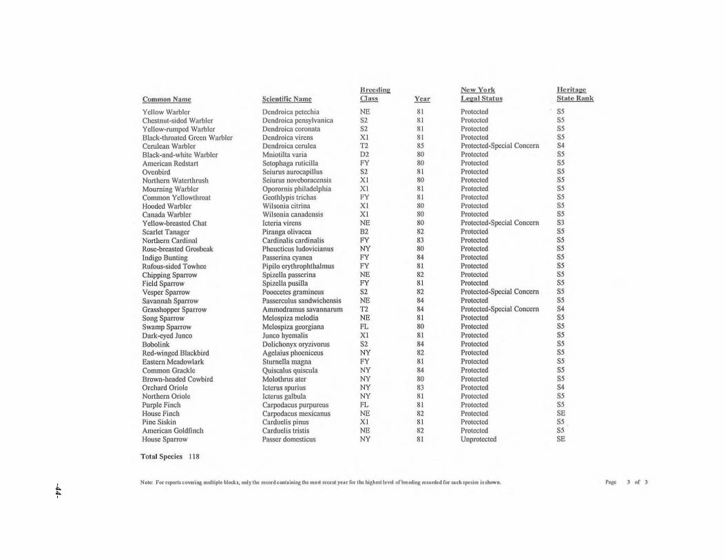
-44
-
Hn..-cding New York IlcritngeCommon Nalllc Scicntific Namc Oass YCllr Leg"l Stn(us Sta(c Hllnk
Ycllow Warblcr DCl1droica petcchia NE 81 Protected 55Chestnut-sided Warblcr Dcndroica pensylvanic.1 52 81 Protected 55Yellow-nunpcd Warbler Dcndroic.1 COfOnata 52 81 Protectcd 55Black-throatcd Grccn Warblcr Dcndroica virens XI 81 Protected 55Cerulean Warbler Dendroica cerulca T2 85 Protected-Special Conccrn 54Black-and-white Warbler Mniotilta varia D2 80 Protected 55Amcrican Redstart Setophag.1 roticilla FY 80 Protected 55Ovenbird Seiurus aurocapillus 52 81 Protected 55Northern Watcrthrush Seiurus lIovcboraccl1sis XI 80 Protectcd 55Mourning Warbler Oporornis philadelphia XI 81 Protected 55Common Yellowthroat Gcothlypis trichas FY 81 Protected 55Hooded Warbler Wilsonia citrina XI 80 Protected 55Canada Warbler Wilsonia canadensis XI 80 Protected 55Yellow..brc.'lStcd Chat ICleria virens NE 80 Protected-Special Concern 53Scarlet Tanager Piranga olivacea 82 82 Protected 55Northern Cardinal Cardinalis cardinalis FY 83 Protected 55Rose-breasted Grosbeak Pheucticus ludovieianus NY 80 Protected 55Indigo Bunting Passerina cyanca FY 84 Protected 55Rufous-sided Towhee Pipilo eryllICophthalmus FY 81 Protected 55Chipping Sparrow Spizclla passcnna NE 82 Protected 55Field Sparrow Spizella pusilla FY 81 Protected 55Vesper Sparrow Pooccctcs graminells 52 82 Protected-Special Concern 55Savannah Sparrow Passcrculus sandwichensis NE 84 Protected 55Grasshopper Sparrow Anunodramus savannarum T2 84 Protected-Special Concern 54Song Sparrow Melospii'..a melodia NE 81 Protected 55Swamp Sparrow Melospiza georgiana FL 80 Protected 55Dark-cycd Junco Junco hyemalis XI 81 Protected 55Bobolink Dolichonyx oryzivorus 52 84 Protected 55Red-winged Blackbird Agclaius phocniccus NY 82 Protected 55Eastem Meadowlark Slurnella magna FY 81 Protected 55Common GC"dckle Quiscalus quiscula NY 84 Protected 55Brown-headed Cowbird Molothrus atcr NY 80 Protected 55Orchard Oriole Icterus spurius NY 83 Protected 54Northern Oriole Icterus galbula NY 81 Protected 55Purple Finch Carpodacus purpureus FL 81 Protected 55House Finch Cnrpodacus mexic.'lnus NE 82 Protected 5EPine Siskin Carduelis pinus XI 81 Protected 55American Goldfinch Carduelis tnslis NE 82 Protected 55House Sparrow Passer domCSlicus NY 81 Unprotected 5E
Total S)ecics 118
Nol~ for report. covcril\& mul1iple block., onl)"ho record conl.ining lhc mo. fcecnl )'ur (or the highcsllevel o(b~cdinllfnorded (or cacb.pclcic. it.bown. r... ) o( )

Appendix VI - Estimate of Tree Age(s) in the Old Forest
FAX
Fatuity of Environmental and Forest BiologyState University of New York-.
College of Environmental Science and Forestry. Syracuse, New York 13210-2773
FAX RETURN: (315) 4740934
. TO: Dave Forness , Susan Block , Fred Miller
Syracuse, New York 132t0
FROM:. Donald J. Leopold, Ph.D., Professor of Environmental and Forestbiology; email: dendro^mailboxsyr.edu; phone: 3154 O 784
DATE; • December 6, 1996
MESSAGE Here are the tree ages of the 11 overstory trees aged on WednesdayDecember 4. These trees are representative of the stand and include some of thelargest in diameter and tallest John Clancy's estimate of the stand age (about ISO .years) in the Forest Stewardship Ian of June 19, 1996 is very close to the agesdetermined by tree coring. Only 1 tree in this sample is clearly over 200 years old andthis tree is very close to the private land towards the southwestern boundary of thestand. Claims that trees in this stand are 300 years old or more are unfounded.Besides the greatly exaggerated age guesses I've been reading about , a few othererroneous statements need to be corrected. 1: There are at least 200,000 acres of oldgrowth in the Adirondacks and 50,000 acres in the Catskills, plus 28 old growth sitesin western New York that total about 1250 acres. There are about 1 million acres ofold growth in the eastern US. This information is in some of the references I havelisted below and the real old growth experts are very familiar with this literature. #2:i searched the stand for rare plants in mid4uly and unfortunately found none.Searches at other times of the year should be conducted, but there is no evidence thatthis stand harbors raze plant species . In fact, few if any of the many rare species inNew York are restricted to old growth . In summary, we can still strive for theprotection of this beautiful stand because the trees are big, teal and collectively areentering the old growth stage.
Davis, M.3.1993. Old Growth in the East., A Survey. Cenozoic Society, Inc., Richmond , VT, lso p.Dunwiddie, P.W., D.R. Foster, 04. Leopold and R.T. Leverett 1996 . otd-growth forests of southern
New England, :dew York, and Pannsylvania, pp. 126443, In. Eastern Oidgrowtk Forests: ProspectsfarRediscovery and Recovery, Island Press, New York, NY.
Kershner, B., et al. 1995. Western New York Old Growth Forest Survey, (availabte from senior author.)
FAX PAGES (INCLUDING FACE)t z
-. St;ite En•ersity oi.New YorkCOLLEGE OF ENVIRONMENTAL SCIENCE AN D FORESTRY
-45-

-46-
SIZE AND AGE DATA FOR SUGAR MAPLEIN CAMILLUS STANDI,'
Donald J, LeopoldSUNY-CESF
Tree#- DBH (em) Height (II,) CON! Age Tree Age3 Notes
1 77.1 110 125 140 within <1" of center2 72.5 114 147 165 within <1~ of centl:!r3 71.2 126 150+ <200 center badly degraded4 44.3 lOS 110 120 within 1/4~ of center5 64.1 114 140 150 within 1/4" of center6 89.2 110 120 175 core length 0.71 radius7 71.0 115 130 within 1" or cen!er8 85.3 106 140 160 core length 0.88 radius9 98.0 117 52 150 core length 0..37 radius
10 107.0 110 210 285 core length OJ4 radius11 100.0 112 133 180 core length 0.76 radius
------,/1Trees cored on Wednesday December 4, 19962Thanks to the five SUNY-<:ESF students and two NY5-DEC personnel for all the
assistance with coring3 Best guess based on percentage of core obtained and giving tree 10 to 15 years to reach
coring height (Le. about 4 feet above ground)


![Conservation, Forests and Lands (Miscellaneous Amendments ... · 1 Conservation, Forests and Lands (Miscellaneous Amendments) Act 1998† [Assented to 10 November 1998] The Parliament](https://static.fdocuments.us/doc/165x107/5ad5ff7f7f8b9a5d058ddf5a/conservation-forests-and-lands-miscellaneous-amendments-conservation-forests.jpg)