Discover the Power of Place -...
16
Discover the Power of Place Geomancia Pty Ltd
Transcript of Discover the Power of Place -...

Discover the
Power of Place
Geomancia Pty Ltd

Our mission To build capacity and expertise within communities to record,
access and share information so that decisions and actions are
better informed and lead to a more sustainable future.

ince 2011, Geomancia has been working alongside community
leaders, project partners, and sponsors to build capacity in
regional and remote Australia in order to foster prosperous
communities and sustainable natural resource management. By
embracing the ‘power of place’, our work has been as varied as the
landscapes we have travelled through and the people we have
partnered with - each with their own specific needs, challenges, and
opportunities. From building Indigenous knowledge systems to
designing customised mapping technology, we bring our expertise to
the collaborative table of community development.
Some highlights from our work are provided on the following pages,
starting in the Kimberley region of Western Australia; travelling
across the Top End to Cape York in Far North Queensland; then
heading south to Central New South Wales; and finally diving into the
depths of the Great Southern Ocean.
We invite you to share our journey
Angela McCauley B. Sc. (Geog.)
Managing Director 21 August 2017
S
Geomancia (pronounced geo–man–see-a) is a Spanish word derived from the
Greek "geōmanteía" meaning, literally, foresight by earth; a translation of the
Arabic term “'ilm al-raml” or the science of the sand. It is a practice said to
originate in the Middle Ages when returning Arabic merchants brought the
esoteric knowledge from East Asia. The modern use of the term geomancy now
includes the Chinese practice of ‘feng shui’ which seeks to manipulate the flow
and direction of energy (Qi) based on aesthetics, location, and the position of
objects and buildings, to harmonise people with their surrounding environment.
Geomancia is our vision of harnessing the power of place to help us better
understand the natural world and to work as a community to achieve our
aspirations for country and culture.
File:Gibb River Road.jpg –
The Kimberley
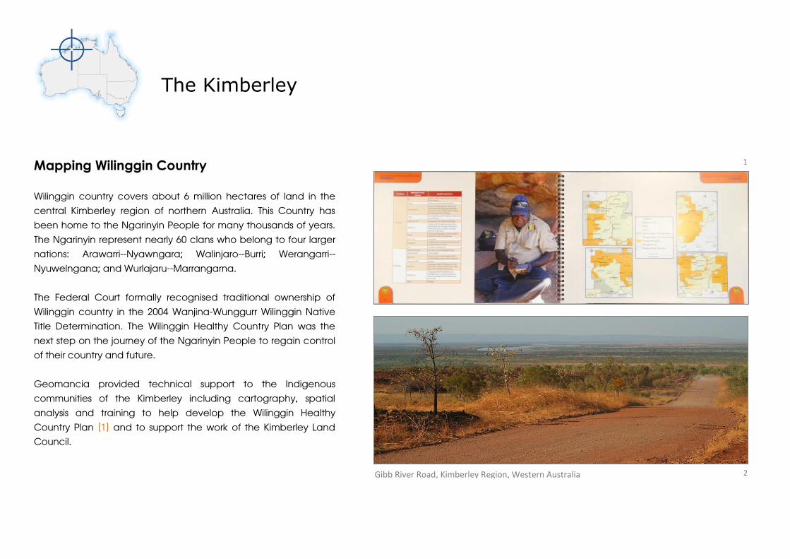
Mapping Wilinggin Country
Wilinggin country covers about 6 million hectares of land in the
central Kimberley region of northern Australia. This Country has
been home to the Ngarinyin People for many thousands of years.
The Ngarinyin represent nearly 60 clans who belong to four larger
nations: Arawarri--Nyawngara; Walinjaro--Burri; Werangarri--
Nyuwelngana; and Wurlajaru--Marrangarna.
The Federal Court formally recognised traditional ownership of
Wilinggin country in the 2004 Wanjina-Wunggurr Wilinggin Native
Title Determination. The Wilinggin Healthy Country Plan was the
next step on the journey of the Ngarinyin People to regain control
of their country and future.
Geomancia provided technical support to the Indigenous
communities of the Kimberley including cartography, spatial
analysis and training to help develop the Wilinggin Healthy
Country Plan [1] and to support the work of the Kimberley Land
Council.
1
2 Gibb River Road, Kimberley Region, Western Australia

Mapping Training
for the Ngarinyin People
Geomancia participated in a two-day workshop as
part of Healthy Country Planning for the proposed
Wilinggin Indigenous Protected Area (IPA). Our
contribution to the workshop was to provide mapping
training to traditional owners from across the Kimberley
region, who mapped places of cultural significance
[4]. These newly acquired skills, along with the
information recorded during the workshop, assisted in
the preparation of maps for the Wilinggin Indigenous
Protected Area Healthy Country Plan.
“You are developing some great methods and
processes to assist Indigenous land managers.”
- Wilinggin IPA Coordinator, KLC
Interactive Management Maps
for the Kimberley Land Council (KLC)
A map series for Indigenous ranger groups in the
Kimberley region was produced by Geomancia and
supplied to the Kimberley Land Council. These maps
show the distribution of landscape features, such as
water holes, environmentally sensitive areas, land
tenure, mining tenements, and Indigenous Protected
Areas. The accessible format of these maps
(geospatial PDF) allows the user to view different
combinations of map features, zoom, pan, print,
annotate, and search for map coordinates without the
need for proprietary software or specialist expertise. Six
maps were produced, covering lands for Balanggara;
Dambimangari; Bardi Jawi; Karajarri; Wilinggin; and the
Kimberley Region as a whole [3].
“Great to see these maps – you’re right it’s a very
user friendly format”
- Tom Holyoake, Program Manager, KLC
5
4
3

The Top End
Mapping the Arnhem Land Coastline
for the Crocodile Islands Rangers
The Crocodile Islands Rangers (CIR) patrol and manage a large
area of coastal northern Australia, principally in the vicinity of
Castlereagh Bay. The CIR {6} are working in unsurveyed coastal
waters and, consequently, have difficulties with unmapped,
submerged rocks (propeller damage etc.). They are interested in
improving mapping of their sea country and have made some
attempt to record marine hazard areas using fish finders and GPS
devices. Geomancia created a map of potential navigational
hazards for the CIR {7} using freely available satellite imagery, data
collected by the CIR, and an analysis of the differential
penetration of light of different wavelengths [8] as a surrogate for
water depth.
"(the) map that Geomancia made for the Rangers has been
invaluable in our land and sea management planning, and
used for consultations, training and numerous other
activities."
- Simone McMonigal, CIR Program Coordinator
Light penetration in coastal waters
50 m
6
7
8

Working with Territory Natural Resource Management - TNRM
Territory Natural Resource Management (TNRM) is an independent not-for-profit
organisation that works with landholders, community groups, industry and
government in the Northern Territory to ensure sustainable management of water,
land, soils and biodiversity. Geomancia worked with TNRM on two projects:
Dragonfly Field Survey System
Geomancia delivered the Dragonfly Field Survey System [9] to TNRM to assist with
their data collection and monitoring work throughout the Territory. Their field staff
were also provided with detailed training on its capabilities, customised features,
and applications for natural resource management at a two-day workshop held at
the Museum and Art Gallery of the Northern Territory.
NRM Plans for Northern Australia
Geomancia reviewed all of the recent NRM plans for northern Australia and
mapped the distribution of issues of significance [10] based a keyword analysis of
904 Management Action Targets. The results of the analysis were presented to
northern Australian NRM organisations to promote regional collaboration. 9
10
GPS
Offline Mapping
Customised Databases
Data Management

Cape York
Indigenous Knowledge Systems
Geomancia worked with the Eastern Kuku Yalanji, Olkola and Wuthathi
communities on Cape York Peninsula to develop interactive multi-media
systems to access and share their knowledge holdings. These HTML-based
systems are deployed on user-friendly touch tablets and include
documents, photographs, maps, videos and audio recordings [11].
“…(your) specialist contributions to our cultural recording project
have been extremely beneficial and improved our management,
storage, and maintenance of invaluable cultural information.”
- Yalanjiwarra Jalunji Marrjanga Aboriginal Corporation
Juan Walker (Walkabout Cultural Adventures) demonstrates the Eastern Kuku Yalanji Knowledge System at the Port Douglas Yacht Club, FNQ.
11

Cultural Mapping & Knowledge Transfer
Geomancia worked with senior members of the Eastern
Kuku Yalanji and Wuthathi [12] to map traditional place
names, clan boundaries and other features of cultural
significance.
Olkola Indigenous Land Managers [13] needed support
to establish their data management and IT infrastructure
to warehouse their cultural knowledge holdings, field
survey records, natural resource data, and other
information about Olkola community and their
traditional lands. To support this initiative, Geomancia
collated and organised the spatial data component of
Olkola knowledge holdings into a spatial data library
[14] that can be accessed from a portable USB-based
Geographic Information System.
The Dragonfly Field Survey System [9] was also adapted
to meet Olkola needs and local staff were trained in its
use. The system included topographic maps for offline
navigation; a customised database to record
information on the endangered Golden-shouldered
parrot [15]; and the Uw Oykangand and Uw Olkola
Multimedia Language Dictionary.
Jim Wallis (Wuthathi) and Andrew Picone (Australian Conservation Foundation) review maps of Wuthathi country produced by Geomancia at Cairns, FNQ.
12
15
13
14
Central and South Eastern New South Wales
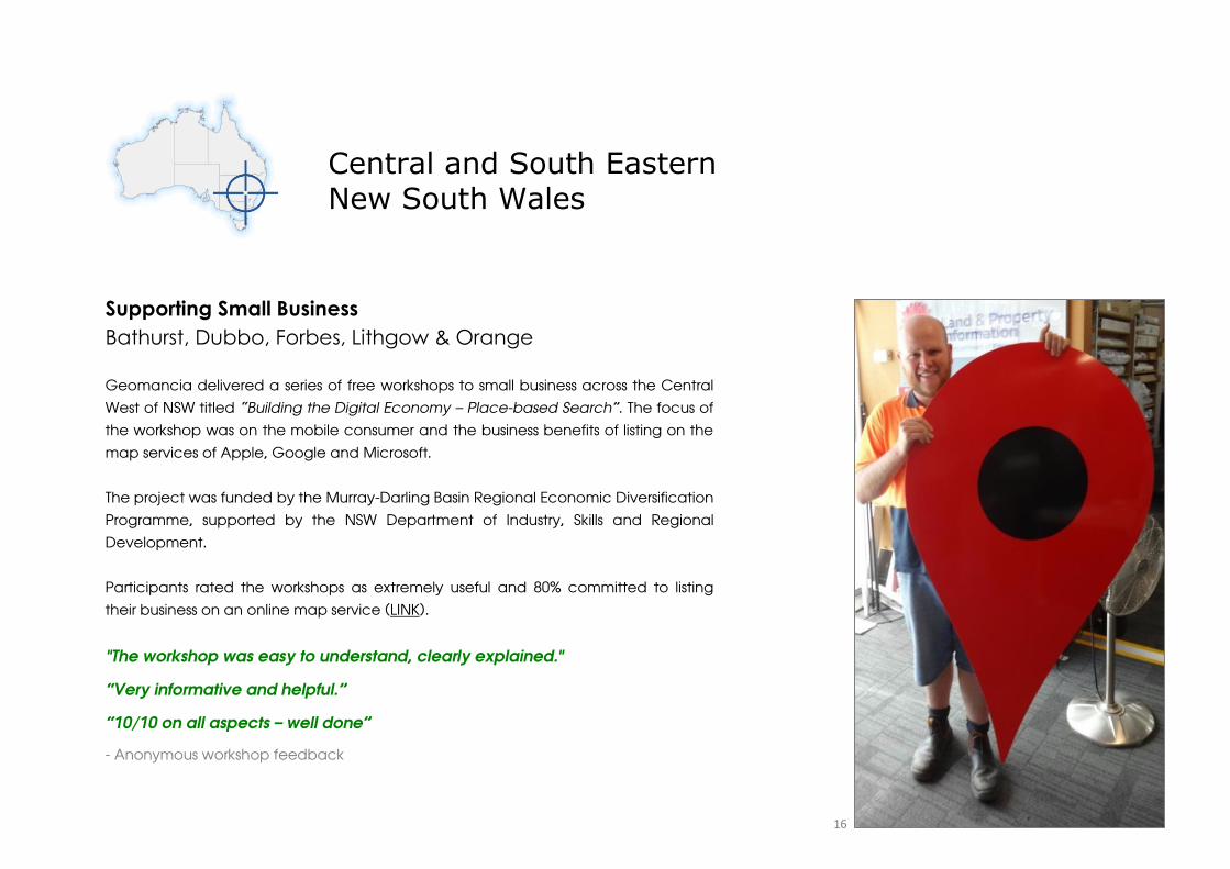
Supporting Small Business
Bathurst, Dubbo, Forbes, Lithgow & Orange
Geomancia delivered a series of free workshops to small business across the Central
West of NSW titled “Building the Digital Economy – Place-based Search”. The focus of
the workshop was on the mobile consumer and the business benefits of listing on the
map services of Apple, Google and Microsoft.
The project was funded by the Murray-Darling Basin Regional Economic Diversification
Programme, supported by the NSW Department of Industry, Skills and Regional
Development.
Participants rated the workshops as extremely useful and 80% committed to listing
their business on an online map service (LINK).
"The workshop was easy to understand, clearly explained."
“Very informative and helpful.”
“10/10 on all aspects – well done”
- Anonymous workshop feedback
16
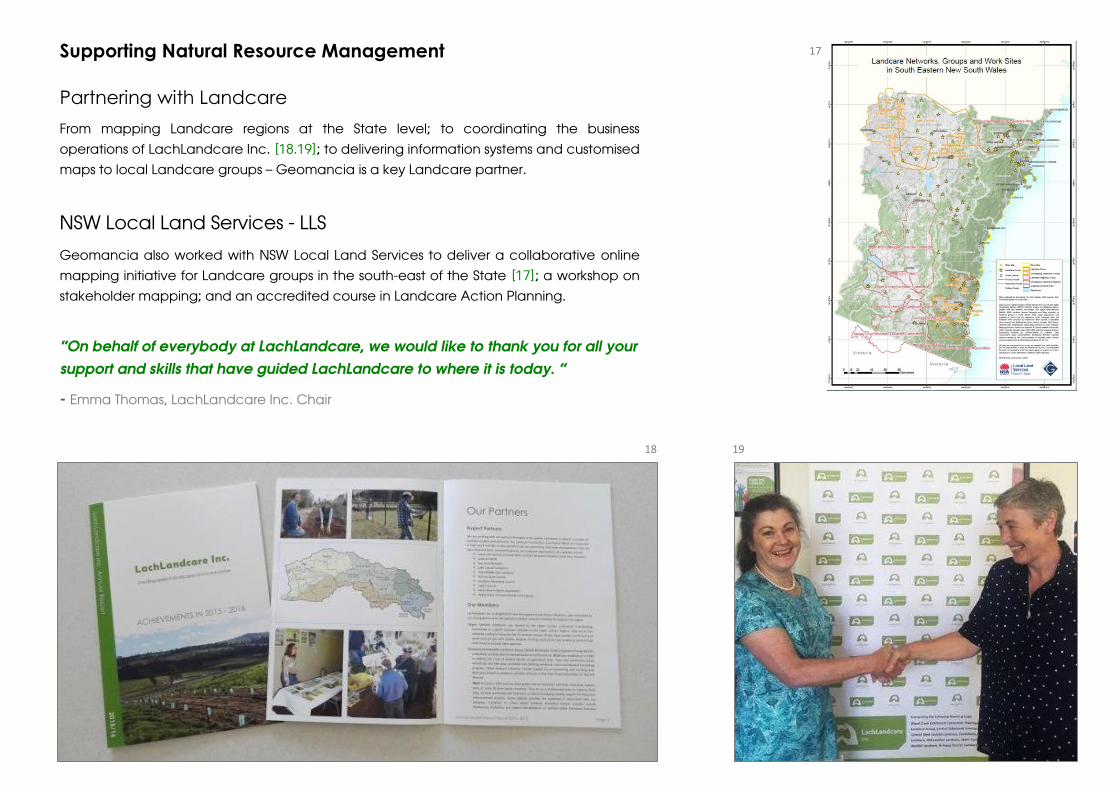
Supporting Natural Resource Management
Partnering with Landcare
From mapping Landcare regions at the State level; to coordinating the business
operations of LachLandcare Inc. [18.19]; to delivering information systems and customised
maps to local Landcare groups – Geomancia is a key Landcare partner.
NSW Local Land Services - LLS
Geomancia also worked with NSW Local Land Services to deliver a collaborative online
mapping initiative for Landcare groups in the south-east of the State [17]; a workshop on
stakeholder mapping; and an accredited course in Landcare Action Planning.
“On behalf of everybody at LachLandcare, we would like to thank you for all your
support and skills that have guided LachLandcare to where it is today. “
- Emma Thomas, LachLandcare Inc. Chair
18 19
17

The Southern Ocean
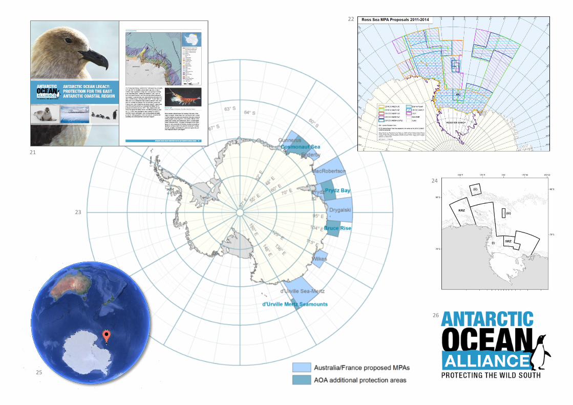
Maps for Conservation Planning
Supporting the Antarctic Ocean Alliance
Friday 28 October 2016, Hobart, Australia - Members of the
Commission for the Conservation of Antarctic Marine Living
Resources (CCAMLR) agreed to safeguard 1.55 million km2 of
the Ross Sea in the Southern Ocean [24,25]. In the years
leading up to this historic agreement, Geomancia supported
the Antarctic Ocean Alliance by producing many detailed
maps of the geophysical features and proposed marine
reserve boundaries for the Southern Ocean [21,22,23]. These
maps were often produced at very short notice as critical
inputs to reserve negotiations.
"The maps look great…I hope the others are as pleased
as I am."
- Robert Nicholl, Australian Policy Advisor, AOA
20
21
22
24
26
25
23

CREDITS 1. Wilinggin Aboriginal Corporation (2012). Wilinggin Healthy Country Plan - Looking after Ngarinyin Country 2012–2022. (LINK). 2. Gibb River Road, Kimberley.
Wikimedia Commons. 3. Aboriginal lands in Western Australia mapped by Geomancia for the Kimberley Land Council or Conservation Management Pty Ltd. 4.
Traditional owners from across the Kimberley region learn about mapping techniques as part of Healthy Country Planning. Photo by Sam Bayley. 5. Sunset at
Broome in the Kimberley region. Photo by Geomancia. 6. The Crocodile Islands Rangers team – March 2015. (LINK) 7. Interim map of marine hazards for the
Crocodile Islands Rangers patrol area by Geomancia, October 2013. 8. Part of a diagram illustrating the depth at which different colours of light penetrate ocean
waters. Kyle Carothers, NOAA-OE. 9. Key elements of the Dragonfly Field Survey System by Geomancia (LINK). 10. Keyword maps from the report: DeVries, R. J.
and McCauley, A. C. (2012). A Review and Analysis of Natural Resource Management Plans for Northern Australia. A report produced by Geomancia for Territory
Natural Resource Management Incorporated. Project NTRM 00036. 11. Juan Walker (Walkabout Cultural Adventures) demonstrates the Eastern Kuku Yalanji
Knowledge System at the Port Douglas Yacht Club, FNQ. Photo by Geomancia. 12. Jim Wallis (Wuthathi) and Andrew Picone (Australian Conservation
Foundation) review maps of Wuthathi country produced by Geomancia at Cairns, FNQ. Photo by Geomancia. 13. Olkola Aboriginal Land Managers Logo
featuring the endangered Golden-shouldered Parrot. 14. Diagram illustrating the many data layers in a spatial data library. U.S. Geological Survey. 15. Golden-
shouldered Parakeet (Psephotus chrysopterygius) - watercolor, Romain Risso. Licence CC BY-SA 3.0. 16. Neale Bayliss from Bathurst Signs holding the giant
placemark used to promote the Building the Digital Economy workshops. Photo by Geomancia. 17. Landcare Networks, Groups and Work Sites in South Eastern
NSW, a participatory mapping project by Landcare, Geomancia and South East Local Land Services. 18. LachLandcare Inc. Annual Report 2015-2016, prepared by
Geomancia Pty Ltd. 19. Handover of LachLandcare business operations from Angela McCauley (Geomancia) to Anne Duncan. Photo by LachLandcare Inc. 20.
Antarctica's Ross Sea. A jigsaw puzzle of floating ice extends as far as you can see in the Ross Sea, Antarctica, 2006. [John B. Weller photo, courtesy of The Pew
Charitable Trusts] Taken on November 24, 2006. United States government work. 21. Cover and p. 11 of: ANTARCTIC OCEAN LEGACY: PROTECTION FOR THE
EAST ANTARCTIC COASTAL REGION. Antarctic Ocean Alliance. Maps by Geomancia. 22. The many iterations of proposed marine reserve boundaries: 2011-2014.
From a geospatial PDF map by Geomancia. 23. Another conservation planning map prepared for AOA by Geomancia. 24. Final boundaries of the Ross Sea
Marine Protected Area. 25. Google Earth showing the location of the Ross Sea. Data SIO, NOAA, U.S. Navy, NGA, GEBCO, Image Landsat / Copernicus; U.S.
Geological Survey; PGC/NASA. 26. AOA logo featuring the Adélie penguin (we think).
All other content Copyright © Geomancia Pty Ltd.
OUR PARTNERS
Geomancia works in partnership with communities, individuals, researchers, natural resource management agencies and the not-for-profit sector. We thank the
following organisations for their partnership and support: Antarctic Ocean Alliance; Australian Conservation Foundation; Australian Government Murray-Darling
Basin Economic Diversification Program; Bathurst Regional Council; Central NSW Business Enterprise Centre; Central Tablelands Local Land Services;
Conservation Management Pty Ltd; Crocodile Island Rangers; Dubbo Regional Council; Ecotrust Australia; Forbes Shire Council; Fullerton Hadley Landcare
Group; Kimberley Land Council; LachLandcare Inc.; Landcare New South Wales; Murdi Paaki Regional Enterprise Corporation; Norman Wettenhall Foundation;
NSW Government Department of Industry; NSW Small Business Commissioner; Olkola Aboriginal Corporation; Rockfeller Philanthropy Advisors New York; South
East Local Land Services; Territory Natural Resource Management Inc; The Nature Conservancy; Upper Lachlan Landcare; Vincent Fairfax Family Foundation;
Wilinggin Aboriginal Corporation; Wuthathi; Yalanjiwarra Jalunji Marrjanga Aboriginal Corporation.

OUR PROJECT SITES
Printed by Central Commercial Printers, Bathurst
Recycled paper manufactured from 100% post-consumer recycled fibre.
Eco-Management and Audit Scheme standards that require public reporting on progress towards environmental targets and rigorous environmental management. International Environmental Management Standard ISO 14001 requirements for an environmental management system. Nordic Swan eco-label for papers produced by mills that have particularly low sulphur emissions.

Geomancia is a not-for-profit Australian company and registered charity dedicated to
the advancement of environmental education, the promotion of geoscience, and the
application of best practice techniques in natural resource management. Our goal is to
build capacity and expertise within communities to record, access and share
information so that decisions and actions are better informed and lead to a more
sustainable future.
If you would like to support our work, please contact us at:
Geomancia Pty Ltd. PO Box 1403, Bathurst NSW 2795
Office: 02 6337 3576 Mobile: 0432 259 495 Email: [email protected]
geomancia.com.au