Disasters in Japan and Background of · PDF fileHFA IRIDeS Review Preliminary Report ... Ginza...
12
Lessons learnt from the Great East Japan Earthquake and the current recovery efforts Prof. Osamu MURAO International Research Institute of Disaster Science Tohoku University www.murao.net Contents 1. Disasters in Japan and Background of HFA 2. Outline of Hyogo Framework for Action 2005-2015 3. HFA IRIDeS Review Preliminary Report Focusing on 2011 Great East Japan Earthquake 4. HFA Priority for Action 4: Reduce the underlying risk factors Disasters in Japan and Background of HFA Lessons learnt from the Great East Japan Earthquake and the current recovery efforts 1 Definition of Urban Risk Urban Risk = Hazard * Vulnerability * Exposed Value
Transcript of Disasters in Japan and Background of · PDF fileHFA IRIDeS Review Preliminary Report ... Ginza...
Lessons learnt from the Great East Japan Earthquake and the current recovery efforts�
Prof. Osamu MURAO�
International Research Institute of Disaster Science Tohoku University
www.murao.net
Contents�
1. Disasters in Japan and Background of HFA 2. Outline of Hyogo Framework for Action
2005-2015 3. HFA IRIDeS Review Preliminary Report
Focusing on 2011 Great East Japan Earthquake 4. HFA Priority for Action 4:
Reduce the underlying risk factors�
Disasters in Japan and Background of HFA
Lessons learnt from the Great East Japan Earthquake and the current recovery efforts�
1
Definition of Urban Risk�
Urban Risk = Hazard * Vulnerability * Exposed Value�
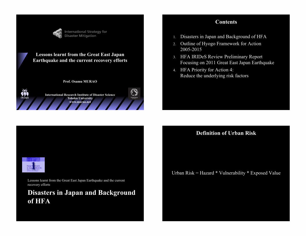
Vulnerability: Wooden House Congested Districts � Timeline of Critical Disastrous Events�
17,18C�
1872� 1923�
1945� 1976�
1986�
1995�Great Fires in Old Tokyo�
Ginza Fire� Great Tokyo Earthquake�
World War II�Sakata
Fire�Great Kobe Earthquake�
Disaster Prevention Base In Eastern Tokyo�
Walls to Prevent Fire Spreading�
AFO�
Udatsu ����� ��������
Block Readjustment to Modernized Area�
CPIJ�
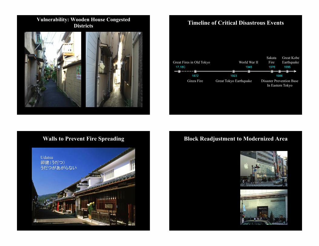
Great Tokyo Earthquake
1657� 1872� 1923� 1945� 1976�1986�1995�
University of Tokyo�
11:58am September 1, 1923 Death Toll: 99,331�
1. Urban Structure Readjustment�
Recovery Parks �
Mainichi Daily News�
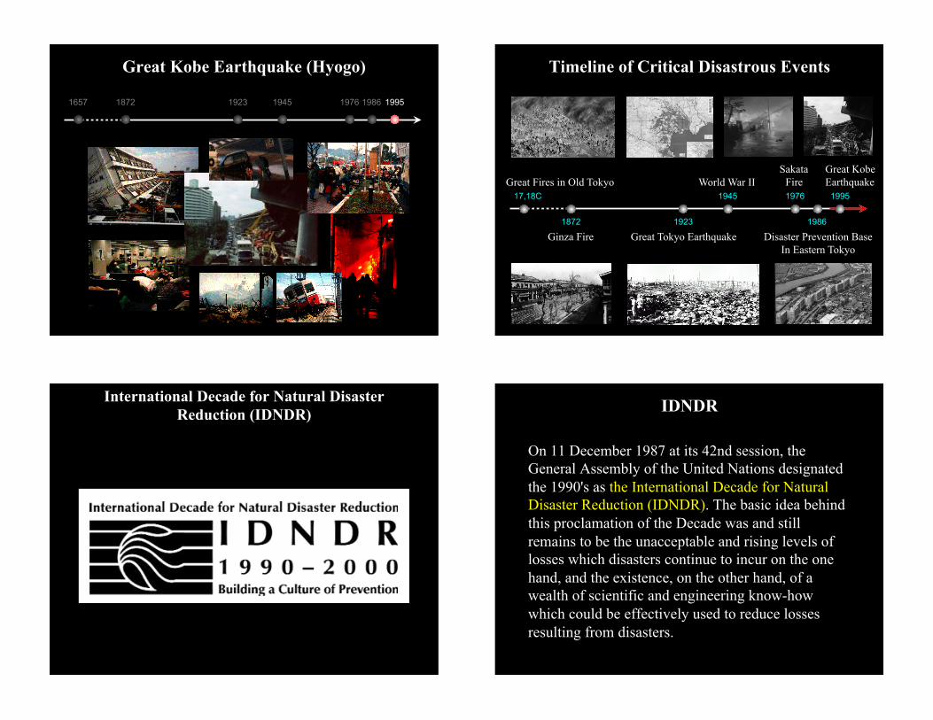
Great Kobe Earthquake (Hyogo)
1657� 1872� 1923� 1945� 1976�1986�1995�
Timeline of Critical Disastrous Events�
17,18C�
1872� 1923�
1945� 1976�
1986�
1995�Great Fires in Old Tokyo�
Ginza Fire� Great Tokyo Earthquake�
World War II�Sakata
Fire�Great Kobe Earthquake�
Disaster Prevention Base In Eastern Tokyo�
International Decade for Natural Disaster Reduction (IDNDR)�
On 11 December 1987 at its 42nd session, the General Assembly of the United Nations designated the 1990's as the International Decade for Natural Disaster Reduction (IDNDR). The basic idea behind this proclamation of the Decade was and still remains to be the unacceptable and rising levels of losses which disasters continue to incur on the one hand, and the existence, on the other hand, of a wealth of scientific and engineering know-how which could be effectively used to reduce losses resulting from disasters.�
IDNDR�

World Conference on Natural Disaster Reduction 1994 Yokohama, Kanagawa, Japan�
The UN World Conference on Natural Disaster Reduction which was part of a mid-term review of Decade activities, was held in Yokohama (Japan), 23-27 May 1994. The UN-FAO/ECE/ILO Team of Specialists used the opportunity to express its views on global fire to the IDNDR.�
Yokohama Strategy and Plan of Action for a Safer World (1994)�
Global Seismic Hazard Map (1999)�
IASPEI
ICSU
ILP
UNESCO
SSB
SED
ING
New YorkBoston
Montreal
Toronto
Chicago
Philadelphia
Los Angeles
San Francisco
Houston
Miami
Dallas
São Paulo Rio De Janeiro
Recife
Belo Horizonte
Johannesburg
Alexandria
NapoliBarcelona
Milano
ManchesterBirmingham
MadrasBangalore
Bombay
Hyderabad
Calcutta
Karachi
Lahore
Guangzhou
WuhanShanghai
Tianjin
Shenyang
Harbin
OsakaNagoya
YokohamaPusan
Singapore
Sydney
Melbourne
St. Petersburg
Ho Chi Minh City
Detroit
München
FrankfurtVancouver
Seattle
Anchorage
Perth
Manaus
Cape Town
Vladivostok
Omsk Novosibirsk
Yakutsk
DenverSalt Lake City
Fairbanks
Nordvik
Irkutsk
Okhotsk
Lanzhou
Urümqi
Edinburgh
Washington D.C.
Buenos Aires
Lima
Santiago
Bogota
Caracas
Kinshasa
Lagos
Algiers
Cairo
Baghdad
Athinai
RomaMadrid
Tehran
ParisBudapest
Berlin
Moskva
London
Delhi
Dhaka
Yangon
Krung Thep
Hong Kong
Taipei
Manila
Jakarta
Beijing
TokyoSeoul
Mexico City
Kiev
Ottawa
Belmopan
GuatemalaSan Salvador
Tegucigalpa
Managua
San JosePanama
La Habana
Kingston
Port-au-PrinceSanto Domingo
San Juan
Port of Spain
Quito
Georgetown
Paramaribo
Brasília
Rémire
La Paz
Asuncion
Montevideo
Maseru
MbabaneMaputo
Gaborone
Antananarivo
Windhoek
Harare
Lusaka
Lilongwe
Luanda
Pretoria
Dar es Salaam
KigaliNairobi
Kampala
Brassaville
Libreville
Yaoundé Bangui
Malabo
Muqdisho
Ädïs Äbeba
Dijbouti
Khartoum AsmeraSan'ä'
N'Djamena
Niamey
OuagadougouBamako
Monrovia Abidjan Accra Lome
Porto
Nov
o
FreetownConakry
Banjul
Bissau
Dakar
Nouakchott
Rabat
Tunis
Taräbulus
Ar Riyad
DimashqBayrüt
Nicosia
Ankara
Ashkhabad
Käbol
Islamab
ad
Baku
MasqatAbu Dhabi
Doha
Al Kuwayt
T'Bilisi
Yerevan
Bishkek
Bujumbura
Tel Aviv-Yafo Amman
Kishinev
Bucuresti
SofiyaSkopjeTirane
TitogradSarajevo
BeogradZagreb
Ljubljana
Wien Bratislava
Warszawa
Praha
VilniusRiga
Minsk
Tallinn
Helsinki
StockholmOslo
Bruxelles
Amsterdam
Lisboa
Dublin
Bern
Almaty
Tashkent
Dushanbe
Kathmandu Thimphu
Hanoi
Viangchan
Ulaanbaatar
Phnom Penh
P'yôngyang
Bandar Seri Begawan
Port Moresby
Canberra
Wellington
Kuala Lumpur
Colombo
Reykjavík
Kobenhavn
GLOBAL SEISMIC HAZARD MAP
Produced by the Global Seismic Hazard Assessment Program (GSHAP), a demonstration project of the UN/International Decade of Natural Disaster Reduction, conducted by the International Lithosphere Program.
Global map assembled by D. Giardini, G. Grünthal, K. Shedlock, and P. Zhang 1999
180° 150° 120° 90° 60° 30° 0° 180° 150° 120° 90° 60° 30°
180° 150° 120° 90° 60° 30° 0° 180° 150° 120° 90° 60° 30°
0°
30°
30°
60°
90°
60°
60°
90°
30°
0°
30°
60°
SED
PEAK GROUND ACCELERATION 10% PROBABILITY OF EXCEEDANCE IN 50 YEARS, 475-year return period
(m/s )2
Scale: 1:35,000,000 At The EquatorRobinson Projection
0 0.2 0.4 0.8 1.6 2.4 3.2 4.0 4.8LOW MODERATE
HAZARD
HIGH VERY HIGH
HAZARD HAZARD HAZARD
United Nations International Strategy for Disaster Reduction (UN/ISDR)�
! UNISDR was created in December 1999 as part of the UN Secretariat with the purpose of ensuring the implementation of the International Strategy for Disaster Reduction.
! The International Strategy for Disaster Reduction reflects a major shift from the traditional emphasis on disaster response to disaster reduction, and in effect seeks to promote a "culture of prevention".�
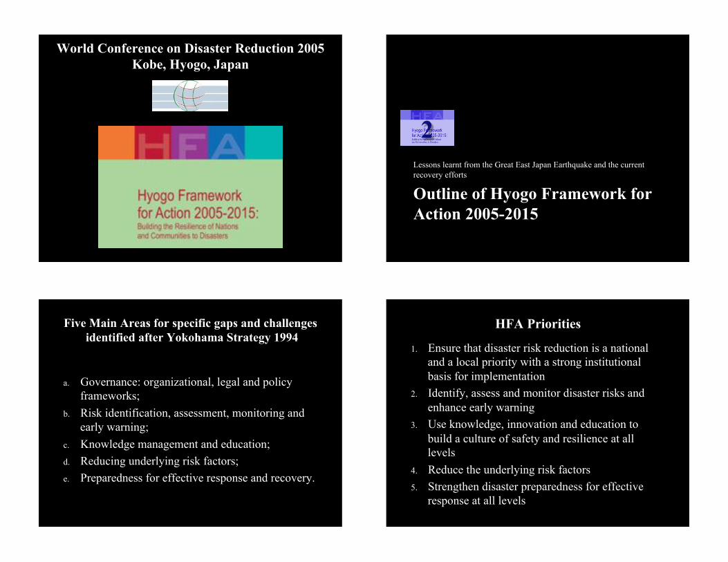
World Conference on Disaster Reduction 2005 Kobe, Hyogo, Japan�
Outline of Hyogo Framework for Action 2005-2015
Lessons learnt from the Great East Japan Earthquake and the current recovery efforts�
2�
Five Main Areas for specific gaps and challenges identified after Yokohama Strategy 1994�
a. Governance: organizational, legal and policy frameworks;
b. Risk identification, assessment, monitoring and early warning;
c. Knowledge management and education; d. Reducing underlying risk factors; e. Preparedness for effective response and recovery.�
HFA Priorities�
1. Ensure that disaster risk reduction is a national and a local priority with a strong institutional basis for implementation
2. Identify, assess and monitor disaster risks and enhance early warning
3. Use knowledge, innovation and education to build a culture of safety and resilience at all levels
4. Reduce the underlying risk factors 5. Strengthen disaster preparedness for effective
response at all levels�
HFA IRIDeS Review Preliminary Report Focusing on 2011 Great East Japan Earthquake
Lessons learnt from the Great East Japan Earthquake and the current recovery efforts�
3�
Table of Contents�
1. Introduction 2. World's 21st Century Natural Disasters 3. History of Natural Disasters in Japan (1888 -
2010) 4. Damage due to 2011 Great East Japan
Earthquake and Tsunami 5. 2011 Great East Japan Earthquake Review�
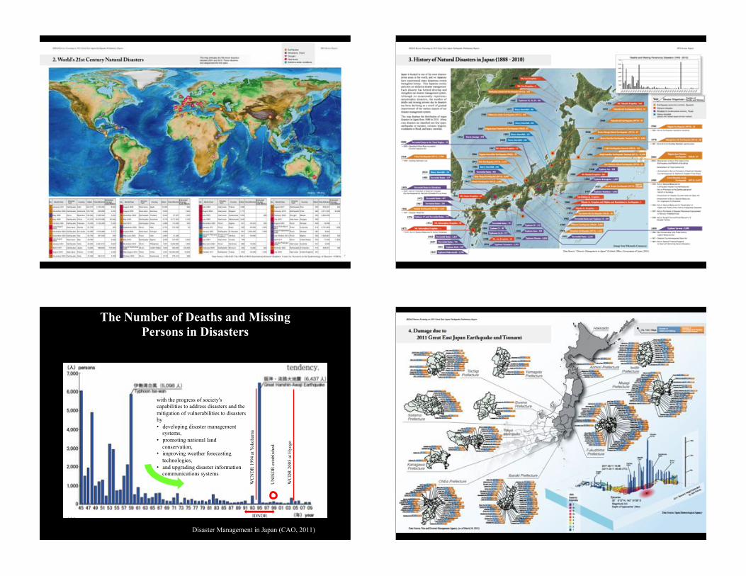
The Number of Deaths and Missing Persons in Disasters�
IDNDR�
WC
DR
200
5 at
Hyo
go�
WC
ND
R 1
994
at Y
okoh
ama�
UN
ISD
R e
stab
lishe
d�
Disaster Management in Japan (CAO, 2011)�
with the progress of society's capabilities to address disasters and the mitigation of vulnerabilities to disasters by • developing disaster management
systems, • promoting national land
conservation, • improving weather forecasting
technologies, • and upgrading disaster information
communications systems�

HFA Priority for Action 4: Reduce the underlying risk factors
Lessons learnt from the Great East Japan Earthquake and the current recovery efforts�
4�
Contents of a Topic for Each Core Indicator�
! Key Words ! Contexts ! Before ! After ! Good practices ! Problems ! Future Recommendations�
HFA Core Indicator 4.1:
! Disaster risk reduction is an integral objective of environment-related policies and plans, including for land use, natural resource management and climate change adaptation.
Post-tsunami recovery strategies in Sanriku Coastal Areas after the 1933 tsunami

Keywords:�
land use regulation, relocation to higher land, 1896 Sanriku Tsunami, 1933 Sanriku Tsunami, transition of housing location, urban recovery strategy�
Contexts:�
Land use mitigation is one of the most reliable strategies for avoiding future tsunami disaster. The Sanriku Coastal Area, one of the most tsunami-prone areas in Japan, located in the north part of the main island, was seriously damaged by catastrophic tsunamis in 1896, 1933, and 1960 before the 2011 Great East Japan Earthquake and Tsunami. The Japanese government prepared resettlement space on higher ground for the victims after the 1933 Great Sanriku Tsunami.�
Change of Housing Location in Hongo, Touni Village (1948-2010) (Murao and Isoyama, 2012)� Before:�
Fig. 4.1 illustrates the transition of housing location after the 1933 Tsunami in Hongo District, Iwate Prefecture1. Because of the relocation strategy, there is almost no building as of 1948, except in the higher elevations provided by the government. However, many buildings had been constructed in the vulnerable lowlands in the twentieth century.�
After:�
The 2011 tsunami attacked the district and washed away hundreds of construction in the lower lands again as shown in Fig.4.2. On the other hand, the houses on the higher resettlement provided by the government after the 1933 tsunami survived the destructive tsunami.�
Good practices:�
The fact that the resettlement on the higher ground provided by the post-tsunami recovery planning and policy after the 1933 tsunami was not damaged by the latest tsunami evidences the importance of land use mitigation for tsunami disaster reduction. This successful experience in the tsunami-prone coastal area should be come down to the future.�
Problems:�
Although the government developed the safer resettlement for the residents after the 1933 tsunami, many people started living in the vulnerable lower lands or returned to the original tsunami-prone sites until 2011. According to the previous research1, this unfavorable situation can be seen in several districts in Sanriku Coastal Area. It is because of lack of tsunami risk recognition, convenience, or inherited lands. The recovery planning and policy for the land use regulation was efficient to reduce tsunami risk in a sense, but it was not mandatory strategy to keep people living only in the safe place.�
Future recommendations:�
Relocation to higher land from waterfront area as a post-tsunami recovery strategy should be carried out with land acquisition by national/local governments’ purchase to avoid future private usage of vulnerable waterfront space.�
Post-tsunami Urban Recovery Plan�
Regional Urban Recovery Types Proposed after the 2011 Great East Japan Earthquake and Tsunami �
A.#Reloca*on�
Levee�
Levee�
Inappropriate#area#for#residence�
Non7relocated#
area#
Inundated#area#by#the#latest#tsunami�
Reloca*on#area�
Reloca*on�
B.#Concentra,on�
Levee�
Inappropriate#area#for#residence�
Area#protected#by#levees�
Inundated#area#by#the#latest#tsunami�
Concentra,on�
The#2nd#Levee�
C.#Compacted#terraces#and#berms�
Levee�
Inappropriate#area#for#residence�
Area#with#compacted#terraces#and#
berms�
Inundated#area#by#the#latest#tsunami�
Concentra;on�
D.#Reloca*on#and#compacted#terraces##and#berms�
Levee�Levee�
Inappropriate#area#for#residence�
Area#with#compacted#terraces#and#
berms�
Inundated#area#by#the#latest#tsunami�
Concentra*on�
Reloca*on#area�
Reloca*on�
E.#Reconstruc-on#on#the#original#site##with#facility#reinforcement�
Levee�
Reconstruc-on#on#the#original#site�
Inundated#area#by#the#latest#tsunami�Compacted*terrace*model*in*Natori�
�����,012 �
IRID
eS�
Hyogo Framework for Action 2005-2015:
Building the Resilience of Nations
and Communities to Disasters
HFA IRIDeS Review Preliminary Report
Focusing on 2011 Great East Japan Earthquake
October 2013
http://irides.tohoku.ac.jp/hfa
International Research Institute of Disaster Science Tohoku University Japan
To be continued! Thank you for your kind attention!�


![BACK NUMBER SUBSCRIPTION 03 … · 06/10/2017 · TableSolution a03-5565-0112 e-mail : info@kkvesper.jp 81 CUISINE KINGDOM Hisayoshi Iwa 2017] GINZA IWA 8-4-4 Ginza, Chuou-ku, Tokyo](https://static.fdocuments.us/doc/165x107/5fd327b62e1dda249b75aaea/back-number-subscription-03-06102017-tablesolution-a03-5565-0112-e-mail-infokkvesperjp.jpg)