Director’s Report and Recommendation Neighborhood … SDCI... · Director’s Report and...
27
Gordon Clowers -- Draft-- SDCI Neighborhood Parking Report September 6, 2017 D16 1 Director’s Report and Recommendation Neighborhood Parking September 2017 Proposal Summary The Seattle Department of Construction and Inspections (SDCI) and Seattle Department of Transportation (SDOT) recommend strategies to address transportation and parking demand by increasing opportunities for shared parking, and setting or reinforcing progressive parking policies in places where Seattle invests in frequent transit service. These strategies will promote access for the greatest number of Seattleites to a range of transportation options that promote social equity, help reduce household transportation costs, and reduce reliance on automobiles. Updates to policies and regulations are proposed. Highlights of the proposal, grouped by topics, include: EXPAND ACCESS TO OFF-STREET PARKING • Create a new use category, “flexible-use parking,” to allow for greater sharing of parking in certain zones, including in Lowrise 3, Midrise, Highrise, most commercial, and industrial zones; and in mixed-use development garages in light rail station areas. • Allow park-and-ride facilities within garages as a permitted use in certain zones, including in Lowrise 3, Midrise, Highrise, most commercial, and industrial zones. • Add a new maximum parking limit to manage the amount of flexible-use parking provided; and delete a special exception allowing more than the maximum parking limit in Downtown zones. • Clarify and update parking provisions by allowing off-site parking to be within one-quarter mile (1,320 feet) of the uses served, up from 800 feet; and change the Northgate overlay zone parking provisions to be consistent with the new city-wide approach. CLARIFY HOW FREQUENT TRANSIT SERVICE IS MEASURED Define geographic areas accessible to frequent transit service – and thereby subject to more flexible off-street parking regulations – with reference to a map of transit lines with service meeting frequency standards that are aligned with transit service and planning guidelines used by King County Metro, and the Seattle Department of Transportation, and account for minor schedule-adherence- and frequency-deviations in accordance with transit operations needs. OTHER SUPPORTING CHANGES • Require unbundling of parking space rental from multi-family dwelling unit rental and lease agreements in new structures 10 dwelling units or greater in size, and new commercial lease agreements in existing structures 10,000 square feet or greater in size, and commercial leases in new structures greater than 10,000 square feet in size.
Transcript of Director’s Report and Recommendation Neighborhood … SDCI... · Director’s Report and...
Gordon Clowers -- Draft--
SDCI Neighborhood Parking Report
September 6, 2017
D16
1
Director’s Report and Recommendation
Neighborhood Parking
September 2017
Proposal Summary
The Seattle Department of Construction and Inspections (SDCI) and Seattle Department of
Transportation (SDOT) recommend strategies to address transportation and parking demand by
increasing opportunities for shared parking, and setting or reinforcing progressive parking
policies in places where Seattle invests in frequent transit service. These strategies will promote
access for the greatest number of Seattleites to a range of transportation options that promote
social equity, help reduce household transportation costs, and reduce reliance on automobiles.
Updates to policies and regulations are proposed. Highlights of the proposal, grouped by topics,
include:
EXPAND ACCESS TO OFF-STREET PARKING
• Create a new use category, “flexible-use parking,” to allow for greater sharing of parking in
certain zones, including in Lowrise 3, Midrise, Highrise, most commercial, and industrial
zones; and in mixed-use development garages in light rail station areas.
• Allow park-and-ride facilities within garages as a permitted use in certain zones, including in
Lowrise 3, Midrise, Highrise, most commercial, and industrial zones.
• Add a new maximum parking limit to manage the amount of flexible-use parking provided;
and delete a special exception allowing more than the maximum parking limit in Downtown
zones.
• Clarify and update parking provisions by allowing off-site parking to be within one-quarter
mile (1,320 feet) of the uses served, up from 800 feet; and change the Northgate overlay zone
parking provisions to be consistent with the new city-wide approach.
CLARIFY HOW FREQUENT TRANSIT SERVICE IS MEASURED
Define geographic areas accessible to frequent transit service – and thereby subject to more
flexible off-street parking regulations – with reference to a map of transit lines with service
meeting frequency standards that are aligned with transit service and planning guidelines used by
King County Metro, and the Seattle Department of Transportation, and account for minor
schedule-adherence- and frequency-deviations in accordance with transit operations needs.
OTHER SUPPORTING CHANGES
• Require unbundling of parking space rental from multi-family dwelling unit rental and lease
agreements in new structures 10 dwelling units or greater in size, and new commercial lease
agreements in existing structures 10,000 square feet or greater in size, and commercial leases
in new structures greater than 10,000 square feet in size.
Gordon Clowers -- Draft--
SDCI Neighborhood Parking Report
September 6, 2017
D16
2
• Allow surface parking for up to three car share vehicles in building setbacks in commercial,
Midrise, and Highrise zones.
• Clarify and reduce the parking requirement for income-restricted housing, including for the
disabled.
• For new structures with a garage in zones where flexible-use parking may occur, require
pedestrian access between the garage and a public right-of-way to accommodate non-resident
garage access and use.
• Apply the same flexibility for parking to public uses/institutions (non-Major) in frequent
transit service areas.
• In all areas except Downtown, allow exceptions to off-street minimum parking requirements,
with parking supply as needed to serve the parking demand for proposed uses as
demonstrated by an access and parking utilization and demand study performed by a licensed
professional engineer or transportation planner.
• Apply parking stall size requirements to parking for residential and live-work uses whether
parking is required or not.
• Update SEPA parking policies to better align with Comprehensive Plan and City
transportation policies.
BICYCLES
• Update bicycle parking requirements/performance standards, and consolidate the Downtown
requirements with requirements for the rest of the city.
Purpose and Overview
The City of Seattle (the City) and other Puget Sound cities jointly plan for growth using an
Urban Center-based approach described by the City’s Comprehensive Plan as the “Urban Village
strategy.” We are currently planning to accommodate 70,000 new households and 115,000 new
jobs through 2035.
A key to managing this growth is directing it to where local and regional transportation systems
can best serve residents’ needs. The City’s policies strongly support this coordination in land use
and transportation system planning. Our transportation system investments serve all kinds of
users, including transit riders, pedestrians, bicyclists, freight, and automobiles. These
investments align with our City’s growth strategy. Likewise, our preferred growth areas are
places that are well-connected by transportation systems. This contributes to equitable,
accessible transportation choices for households at all income levels, also an important objective
of the City’s plans.
Continuing this coordinated approach is critical to growing the city in a way that is: sustainable
and efficient; the least impacting on the environment; and livable, accessible, and equitable. A
key component of equity is having available housing and access to services for households at all
Gordon Clowers -- Draft--
SDCI Neighborhood Parking Report
September 6, 2017
D16
3
income levels. Parking, which makes up 10-20% of typical construction costs, is a key
component affecting the cost of housing. To help the City respond to issues of housing
affordability and city livability, the Mayor and City Council convened a group, the Housing
Affordability and Livability Agenda (HALA) Advisory Committee, which made a number of
recommendations that are carried out in this proposal. The HALA report includes 60
recommendations and is available at: www.seattle.gov/hala/about.
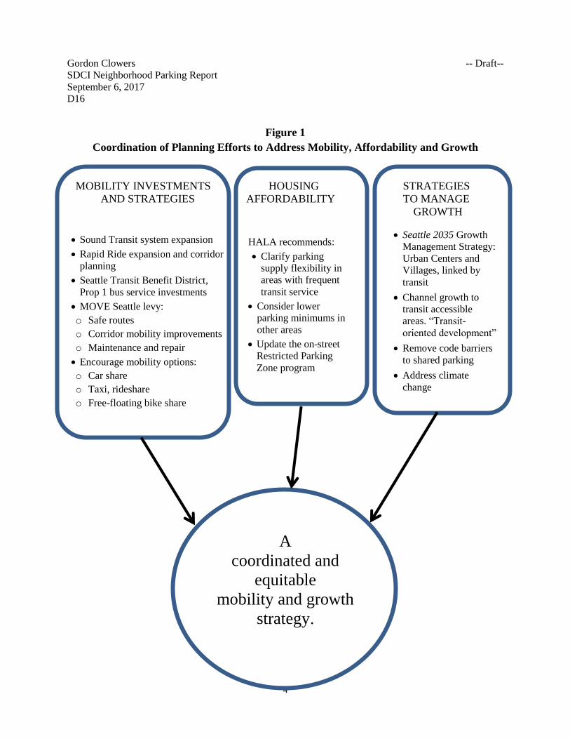
Figure 1 on the next page shows the multiple themes of City policy that inform this proposal.
Mobility
As population and jobs continue to grow, many of Seattle’s streets, in areas such as Downtown,
are full at rush hour. Because we cannot expand our street network, we need to make
meaningful investments in bus, train, ridesharing, bicycle, and pedestrian solutions to effectively
plan and manage our transportation network. The City and region have made significant
commitments to support and invest in public transit and other multimodal options to improve
access and mobility across the City. These include:
• Voter-approved Sound Transit 2 (ST2) package for added regional transit investment
including more bus, heavy rail service, and Link light rail expansion including the
recently opened service to the University of Washington Station at Husky Stadium;
• Additional Sound Transit expansion through the voter-approved Sound Transit 3 (ST3)
package that will extend light rail service to Ballard and West Seattle;
• Local investment of voter-approved Seattle Transportation Benefit District (STBD)
revenues on expanded transit service in Seattle, including more frequent service and
longer service hours on King County Metro bus lines within the city (see more
information below).
• Voter-approved expansion of King County’s Rapid Ride transit services, including Lines
C (West Seattle), D (Ballard), E (Aurora Ave N/SR-99 corridor);
• The Center City Streetcar, which will connect the South Lake Union and First Hill
Streetcar lines via First Avenue;
• Taxi and transportation network company (TNC) rule updates; and
• Facilitating expansion of new flexible car sharing services, such as Car2Go and
ReachNow.
• Implementing the Levy to Move Seattle, a 9‐year strategic plan with voter-approved
funding for maintenance of and improvements to the City’s multimodal transportation
network;
Gordon Clowers -- Draft--
SDCI Neighborhood Parking Report
September 6, 2017
D16
4
Figure 1
Coordination of Planning Efforts to Address Mobility, Affordability and Growth
MOBILITY INVESTMENTS HOUSING STRATEGIES
AND STRATEGIES AFFORDABILITY TO MANAGE
GROWTH
• Sound Transit system expansion
• Rapid Ride expansion and corridor
planning
• Seattle Transit Benefit District,
Prop 1 bus service investments
• MOVE Seattle levy:
o Safe routes
o Corridor mobility improvements
o Maintenance and repair
• Encourage mobility options:
o Car share
o Taxi, rideshare
o Free-floating bike share
HALA recommends:
• Clarify parking
supply flexibility in
areas with frequent
transit service
• Consider lower
parking minimums in
other areas
• Update the on-street
Restricted Parking
Zone program
• Seattle 2035 Growth
Management Strategy:
Urban Centers and
Villages, linked by
transit
• Channel growth to
transit accessible
areas. “Transit-
oriented development”
• Remove code barriers
to shared parking
• Address climate
change
A
coordinated and
equitable
mobility and growth
strategy.
Gordon Clowers -- Draft--
SDCI Neighborhood Parking Report
September 6, 2017
D16
5
• Improving the safety and connectivity of pedestrian and bicycle infrastructure;
• Developing integrated land use and transportation policies to provide convenient,
multimodal access to services, amenities, and employment.
Seattle Transportation Benefit District1
In 2014, Seattle voters approved Proposition 1 to fund the purchase of increased Metro service
and additional transit programs for Seattle residents. This voter-approved funding measure
includes a $60 vehicle license fee and a 0.1% sales tax increase to generate about $45 million
annually to improve transit availability and access for six years (through 2020).
STBD primarily funds the addition of more than 270,000 bus service hours (a 15% increase in
service) annually to improve frequency and reliability, and reduce overcrowding. Improved bus
service began in June 2015, and since then updated quarterly. In the first year, additional service
was provided at an equivalent rate of 61 buses running 12 hours per day, every day. Service was
added on 85% of Seattle’s routes (56 out of 66 routes), including 37 routes to address
overcrowding, 54 routes for improved reliability, and 38 routes to run more frequently. In
addition, almost 18,600 ORCA Lift (reduced price) cards were issued to Seattle residents for
more than 400,000 trips and a new Youth ORCA program was launched.
In September 2017, new night owl bus service launches, saving three routes from elimination
and expanding key regular routes all night long. All-night service on the C Line, D Line, and E
Line will be increased to hourly. Two more late-night round trips each will be added to routes 3,
5, 11, 44, 48, 65, 67, 70, and 120.
Seattleites are relying more on transit for daily commuting. Over the last 16 years through 2016,
personal choices on how to travel to work have shifted toward transit, walking, biking, and
rideshare, which now represent about 70 percent of the person trips taken by commuters to/from
Downtown and nearby “Center City” vicinities, up from 50 percent in 2000. Most of the growth
in these travel modes occurred on transit, which increased from 29 percent of commuter person
trips to/from Downtown in 2000 to 47 percent in 2016; and during the same time commuters
using single-occupant vehicles decreased from 50 percent to 30 percent of commuter trips.2
Making Better Use of Underused Parking Resources
The City can help the entire parking system work better by addressing regulatory barriers and
inefficiencies in the ways parking is used. For example, King County’s 2012 Right Size Parking
study found that existing off-street parking is significantly underused. In its sample of 95 Seattle
buildings, it found that approximately 35% of residential parking spaces were not in use. This
supply is a resource that should be tapped to better serve parking demands as the city grows.
1 City of Seattle, Seattle Transportation Benefit District Year 1 Performance Report (June 2015-June 2016) 2 Commute Seattle, 2016 Center City Commuter Mode Split Survey, 2016
Gordon Clowers -- Draft--
SDCI Neighborhood Parking Report
September 6, 2017
D16
6
The Importance of Effective Transportation and Parking Policies
Parking spaces serve multiple functions, including providing access for people to businesses and
goods and services, and providing long-term vehicle storage for residents and businesses in the
city. Ideally, parking spaces are supplied and managed in a way that matches the demand for
these functions while supporting other City goals and objectives. Cities are increasingly
recognizing the links between parking, personal transportation choices, and a community’s
overall functionality and livability. Places dominated by automobile use and parking tend to be
more congested and less attractive as living environments. Places with many transportation
options and well-managed parking encourage mobility choices and living patterns that are more
efficient. We also know that parking tends to be oversupplied, see the “off-street supply and
demand” discussion later in this report, leading to costly inefficiencies that increase the cost of
housing and commercial space and create burdens on our transportation systems.
Policy and best practices underscore the importance of aligning our parking, transportation, and
land use planning policies by:
• Avoiding consuming space on properties for minimum parking requirements, which
prioritize car storage over residential or commercial use.
• Aiding housing affordability by limiting the financial impacts of parking on housing.
Underground garage parking adds costs of up to $55,000 per space, which can add up to
approximately $500 per month per dwelling unit to apartment rents.3
• Distinguishing between accessory parking, which is reserved to serve specific uses, and
flexible-use parking, which is shared and publicly available.
• Requiring too much parking that increases the likelihood people will drive4, which
exacerbates traffic congestion. In dense cities, the negative cycle of automobile
dependence inducing worsening congestion is broken by revealing the cost of parking
and both the time and cost savings of other mobility choices.
• Providing transit, which is 30 times more efficient in the amount of space used on a street
than a single-occupancy vehicle.5 This illustrates the potential severity of high
automobile traffic demands on road systems, and the high degree of benefits in
preserving road capacity by encouraging substitution of transit and other kinds of trips for
automobile trips.
• Acknowledging that parking is costly to provide. Where parking is bundled with
commercial and residential property lease and purchase transactions, it is paid for
3 City of Portland, OR Bureau of Planning and Sustainability. November 2012. “Cost of Onsite Parking and
Impacts on Affordability” 4 Christopher McCahill, Norman Garrick. University of Connecticut. “Lessons from Escalation in Parking Facilities
in Older American Cities over Last 50 Years.” Cited in CityLab article, Jan. 12, 2016, by Eric Jaffe “The strongest
case yet that excessive parking causes driving” 5 Fehr & Peers, 2016. Appendix B-3 to Comprehensive Plan Final Environmental Impact Statement, on mode share
level of service standard proposal.
Gordon Clowers -- Draft--
SDCI Neighborhood Parking Report
September 6, 2017
D16
7
indirectly through higher rents. For commercial properties, these higher rents may be
passed on to consumers in higher costs of goods and services. National transportation
planning experts point out that the hidden costs and subsidies of parking that is bundled,
or provided to tenants/users free of a separate charge (a.k.a. “free parking”) are high and
are borne by all as societal costs.6
• Recognizing that rent and transportation costs make up a major share of typical
household expenditures, income availability for health, education, and other priorities is
significantly affected by a household’s location, transportation opportunities and choices.
For example, while the average American family household pays about 51% of their
income for housing and transportation costs, those living in distant suburbs pay about
57% of their income for these costs, while those living in transit-oriented development
pay about 41% of their income for these costs.7 Unbundling parking and expanding
housing capacity in areas well served by transit and other non-auto modes of
transportation can reduce combined household expenditures on housing and
transportation. This happens when housing costs are reduced by expanded supply in high
demand areas, and transportation costs are reduced by the accessibility and availability of
transit and other non-auto access choices.
• Moreover, this shift to housing in transit accessible areas reduces demand for single-
occupant vehicle travel that increases vehicle traffic and associated impacts to society,
the economy, public health, and the environment, including wildlife, and air and water
quality.
• Increasing access to transportation options helps people make better choices that will be
more convenient and affordable. As the reliability, proximity, and convenience of transit
and shared services increase, people will choose transit and other options that increase
mobility and put less strain on their personal budgets and schedules.
• Implementing effective approaches that use a combination of strategies including
continued performance-based managing of on-street parking rates, more active
management of restricted parking zones (RPZs), and promotion of shared parking and a
variety of transportation choices.
Existing Parking Conditions
This summary describes known characteristics of parking demand and supply in the city. Key
themes include:
6 Donald Shoup, 2005. The High Cost of Free Parking, pg. 218; Todd Litman, Victoria Transport Policy Institute,
2013. Transportation Cost and Benefit Analysis II – Parking Costs. 7 Nadine Fogarty, Strategic Economics, and Bureau of Labor Statistics, 2004. Center for Transit Oriented
Development, and Center for Neighborhood Technology. Housing + transportation affordability index. Also see
reference in The Brookings Institution, 2006. “The Affordability Index: A New Tool for Measuring the True
Affordability of a Housing Choice.” Urban Markets Initiative, Market Innovation Brief.
Gordon Clowers -- Draft--
SDCI Neighborhood Parking Report
September 6, 2017
D16
8
• SDOT uses a performance-based approach to manage on-street parking within paid
parking zones across the City, and collects data. On-street parking is in higher demand
and more heavily used in many of the city’s dense neighborhood centers (including late
afternoons and evenings), while demand utilization is typically lower in less dense areas,
further removed from Urban Centers and Urban Villages. Patterns of use depend on the
varying characteristics of each neighborhood’s streets and buildings, their activity levels,
and attractions such as restaurants and nightclubs.
• Existing off-street parking is a resource that is relatively underused, with available
capacity to accommodate some of the increased demand for vehicle access and storage
associated with new development and the city’s vibrant neighborhood business districts.
• Many households in multifamily-oriented areas already live without owning an
automobile. This legislation helps limit actual levels of parking demand from existing
and new housing, in mixed-use neighborhoods where the most growth is happening.
• While development without parking is occurring, most new residential units (87% in the
affected area) are being provided in buildings with parking.
On-street parking supply and demand
On-street city-wide parking trends are difficult to neatly summarize given the variety of
conditions in places ranging from lower-density residential neighborhoods to Urban Village
centers to the densest parts of Downtown. The City does not extensively track parking trends
except in on-street meter-paid parking areas, including most of the center-city neighborhoods
and the mixed-use core of neighborhoods including the University District, Ballard, Fremont,
Green Lake, and Roosevelt. The City has a “performance based parking pricing program” where
rates are adjusted on an annual basis to meet performance targets of 70-85 percent occupancy.
That way, one to two spaces are available on each block throughout the day for access to nearby
businesses. Paid parking rates currently range between $0.50 and $5.00 per hour.
For these areas, 2017 data shows that in most parts of the center city, such as Downtown, Capitol
Hill, and South Lake Union, mid-afternoon usage of the paid parking ranges between 70 percent
and 93 percent of capacity. In addition, evening parking capacity is well-used in Capitol Hill, and
other places such as paid parking streets in Ballard and Green Lake. In neighborhood centers
with many active uses, on-street parking is affected by restaurant-goers and other visitors, and
residents.
There is also a common pattern of diminishing demand in many neighborhoods on blocks farther
than one-quarter mile walking distance from neighborhood commercial cores. One illustration of
this is reflected in the parking rate-setting in the U-District and Ballard, where the higher rates
are in the core areas along University Way and Ballard Avenue, and lower rates are on the
neighborhoods’ edges.
Gordon Clowers -- Draft--
SDCI Neighborhood Parking Report
September 6, 2017
D16
9
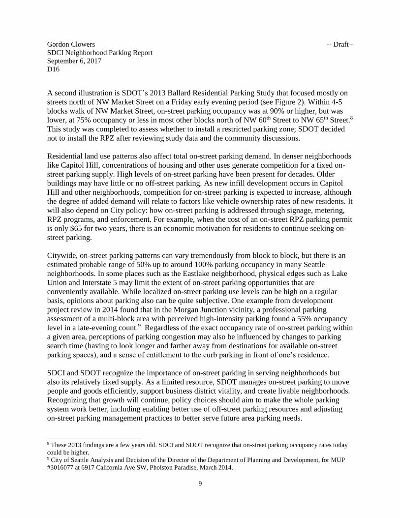
A second illustration is SDOT’s 2013 Ballard Residential Parking Study that focused mostly on
streets north of NW Market Street on a Friday early evening period (see Figure 2). Within 4-5
blocks walk of NW Market Street, on-street parking occupancy was at 90% or higher, but was
lower, at 75% occupancy or less in most other blocks north of NW 60th Street to NW 65th Street.8
This study was completed to assess whether to install a restricted parking zone; SDOT decided
not to install the RPZ after reviewing study data and the community discussions.
Residential land use patterns also affect total on-street parking demand. In denser neighborhoods
like Capitol Hill, concentrations of housing and other uses generate competition for a fixed on-
street parking supply. High levels of on-street parking have been present for decades. Older
buildings may have little or no off-street parking. As new infill development occurs in Capitol
Hill and other neighborhoods, competition for on-street parking is expected to increase, although
the degree of added demand will relate to factors like vehicle ownership rates of new residents. It
will also depend on City policy: how on-street parking is addressed through signage, metering,
RPZ programs, and enforcement. For example, when the cost of an on-street RPZ parking permit
is only $65 for two years, there is an economic motivation for residents to continue seeking on-
street parking.
Citywide, on-street parking patterns can vary tremendously from block to block, but there is an
estimated probable range of 50% up to around 100% parking occupancy in many Seattle
neighborhoods. In some places such as the Eastlake neighborhood, physical edges such as Lake
Union and Interstate 5 may limit the extent of on-street parking opportunities that are
conveniently available. While localized on-street parking use levels can be high on a regular
basis, opinions about parking also can be quite subjective. One example from development
project review in 2014 found that in the Morgan Junction vicinity, a professional parking
assessment of a multi-block area with perceived high-intensity parking found a 55% occupancy
level in a late-evening count.9 Regardless of the exact occupancy rate of on-street parking within
a given area, perceptions of parking congestion may also be influenced by changes to parking
search time (having to look longer and farther away from destinations for available on-street
parking spaces), and a sense of entitlement to the curb parking in front of one’s residence.
SDCI and SDOT recognize the importance of on-street parking in serving neighborhoods but
also its relatively fixed supply. As a limited resource, SDOT manages on-street parking to move
people and goods efficiently, support business district vitality, and create livable neighborhoods.
Recognizing that growth will continue, policy choices should aim to make the whole parking
system work better, including enabling better use of off-street parking resources and adjusting
on-street parking management practices to better serve future area parking needs.
8 These 2013 findings are a few years old. SDCI and SDOT recognize that on-street parking occupancy rates today
could be higher. 9 City of Seattle Analysis and Decision of the Director of the Department of Planning and Development, for MUP
#3016077 at 6917 California Ave SW, Pholston Paradise, March 2014.

Gordon Clowers -- Draft--
SDCI Neighborhood Parking Report
September 6, 2017
D16
10
Figure 2
Ballard subarea parking study, north of NW Market Street (Friday 6:30-8:00 PM)
Source: SDOT, 2013
Gordon Clowers -- Draft--
SDCI Neighborhood Parking Report
September 6, 2017
D16
11
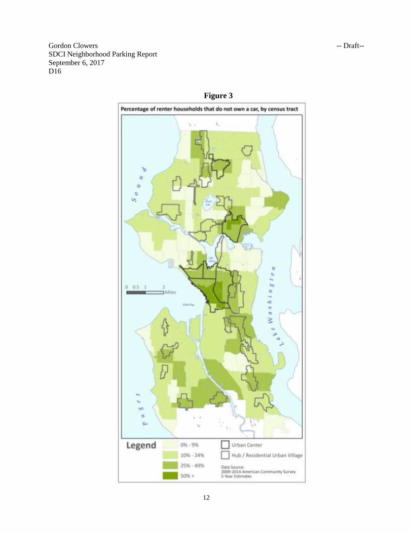
Auto Ownership Patterns
Approximately 40-48% of Seattle renter households living in the neighborhoods with the most
apartments and condominiums already live without an automobile. This helps to limit residential
parking demand.
This is confirmed by SDCI analysis of data from the American Community Survey for the 2010-
2014 period. For the one-quarter of Seattle census tracts with the highest proportion of renter
households, 40% of all renter households have no vehicle. In the top-eighth subset of census
tracts with most renter households, the proportion of households without vehicles is higher, at
48% of all renter households (see Figure 3). This compares to an average of 21% of renter
households with no vehicle available in Seattle census tracts, and 9% of renter households in the
one-quarter of census tracts with the lowest shares of renter-occupied housing. Also, the average
condition for owner-occupied housing in Seattle census tracts is that only 6% of homeowner
households have no vehicle available to them (SDCI, 2016-2017).
Off-street supply and demand
Information about off-street parking supply and demand is available from local studies prepared
by King County and from professional standards and local observations of demand from certain
housing types. These illustrate a variability of parking demand that depends on type of housing,
location, and availability of transit alternatives.
King County’s 2012 Right Size Parking study extensively surveyed the supply and utilization of
off-street parking at sample sites throughout King County including Seattle, and developed
models that predict off-street parking utilization for different locations and housing types (see
www.rightsizeparking.org). These predictions are based on research on the extent to which
parking utilization ratios (e.g., the number of parking spaces occupied per housing unit, or per
1,000 square feet of residential space) are influenced by factors including rent, dwelling unit
size, affordability, occupied bedroom count, density, price of parking, population and job
concentration; and a measure of proximity and strength of transit service. Of these factors, the
availability of transit has the greatest value in predicting actual parking demand.10 The presence
of smaller and more affordable units also correlates to lower-than-average levels of off-street
parking demand.
10 D. Rowe, Morse, Ratchford, Haas, Becker. “Modeling of Multifamily Residential Parking Use in King County,
Washington.” Transportation Research Record 2469. 2014.
Gordon Clowers -- Draft--
SDCI Neighborhood Parking Report
September 6, 2017
D16
12
Figure 3
Gordon Clowers -- Draft--
SDCI Neighborhood Parking Report
September 6, 2017
D16
13
Professional standards used by consulting engineers and transportation planners in reviewing
Seattle development proposals typically use information about parking demand from the Institute
of Transportation Engineers (ITE). This information is adjusted for in-city neighborhoods
because ITE includes suburban or rural development that would otherwise overstate demand.
Results range from some condominium developments that may cater to households owning more
than one vehicle, to housing such as small apartments where less than one-half of future residents
are likely to own even one automobile, and small efficiency dwelling units (SEDUs) with
projected parking demand levels as low as 0.3 parking stalls per dwelling unit.11
The 2012 Right Size Parking Study’s survey of off-street parking usage found that
approximately 35% of off-street parking resources were not occupied even during the overnight
period of peak residential demand in a sample of 95 Seattle multifamily housing complexes.12 A
few sample parking characteristics are summarized as follows:
• Eastlake: The two sampled complexes jointly have 317 dwellings and 443 residential
parking spaces (1.4 spaces per unit). Of these, 276 (62%) spaces were occupied, leaving
167 residential parking spaces unoccupied.
• Ballard: Three sampled complexes jointly have 524 dwellings and 627 residential parking
spaces (1.2 spaces per unit). Of these, 415 (66%) spaces were occupied, leaving 212
residential parking spaces unoccupied.
• Capitol Hill: Five sampled complexes jointly have 520 dwellings and 588 residential
parking spaces (1.13 spaces per unit). Of these 400 (68%) spaces were occupied, leaving
188 residential parking spaces unoccupied.
A similar study by the Capitol Hill EcoDistrict found 66% night-time occupancy of 613 parking
spaces in 14 buildings in the Pike Pine neighborhood.13 These findings point out that many
existing buildings have off-street parking that is being significantly underused.
Development and Parking Trends
Development permit data from the last four-plus years, between mid-2012 and late 2016,
illustrate findings about parking supply choices builders are making in providing parking in new
multifamily residential and mixed-use development. These data are from the Urban Center and
11 William Popp Associates. “Parking Demand Study, and Parking Utilization Study” for Pholston Paradise
Apartments, 6917 California Ave. SW, Multi-Family Residential Development, [MUP] Project #3016077. January
2014 12 Right Size Parking data sheet “101512 longheads and raw CNT data” for Seattle, WA sampled developments. The
survey did not measure on-street parking demand levels generated by the sampled housing.
13 “District Shared Parking in Pike Pine” by Alexander Brennan and Erin David, 2015.
Gordon Clowers -- Draft--
SDCI Neighborhood Parking Report
September 6, 2017
D16
14
Urban Village areas where existing code provides the greatest flexibility for parking supply
decisions.
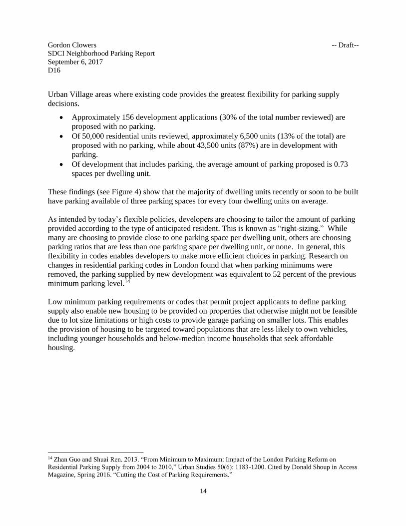
• Approximately 156 development applications (30% of the total number reviewed) are
proposed with no parking.
• Of 50,000 residential units reviewed, approximately 6,500 units (13% of the total) are
proposed with no parking, while about 43,500 units (87%) are in development with
parking.
• Of development that includes parking, the average amount of parking proposed is 0.73
spaces per dwelling unit.
These findings (see Figure 4) show that the majority of dwelling units recently or soon to be built
have parking available of three parking spaces for every four dwelling units on average.
As intended by today’s flexible policies, developers are choosing to tailor the amount of parking
provided according to the type of anticipated resident. This is known as “right-sizing.” While
many are choosing to provide close to one parking space per dwelling unit, others are choosing
parking ratios that are less than one parking space per dwelling unit, or none. In general, this
flexibility in codes enables developers to make more efficient choices in parking. Research on
changes in residential parking codes in London found that when parking minimums were
removed, the parking supplied by new development was equivalent to 52 percent of the previous
minimum parking level.14
Low minimum parking requirements or codes that permit project applicants to define parking
supply also enable new housing to be provided on properties that otherwise might not be feasible
due to lot size limitations or high costs to provide garage parking on smaller lots. This enables
the provision of housing to be targeted toward populations that are less likely to own vehicles,
including younger households and below-median income households that seek affordable
housing.
14 Zhan Guo and Shuai Ren. 2013. “From Minimum to Maximum: Impact of the London Parking Reform on
Residential Parking Supply from 2004 to 2010,” Urban Studies 50(6): 1183-1200. Cited by Donald Shoup in Access
Magazine, Spring 2016. “Cutting the Cost of Parking Requirements.”
Gordon Clowers -- Draft--
SDCI Neighborhood Parking Report
September 6, 2017
D16
15
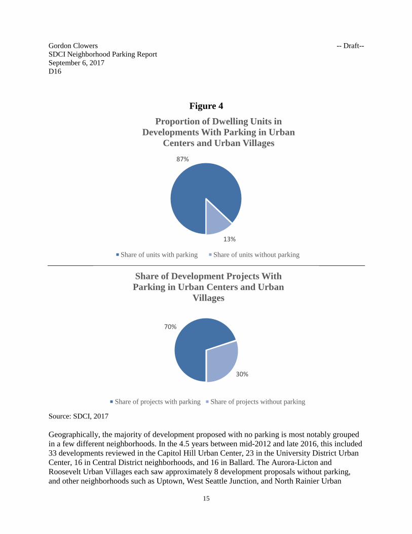
Figure 4
Source: SDCI, 2017
Geographically, the majority of development proposed with no parking is most notably grouped
in a few different neighborhoods. In the 4.5 years between mid-2012 and late 2016, this included
33 developments reviewed in the Capitol Hill Urban Center, 23 in the University District Urban
Center, 16 in Central District neighborhoods, and 16 in Ballard. The Aurora-Licton and
Roosevelt Urban Villages each saw approximately 8 development proposals without parking,
and other neighborhoods such as Uptown, West Seattle Junction, and North Rainier Urban
87%
13%
Proportion of Dwelling Units in
Developments With Parking in Urban
Centers and Urban Villages
Share of units with parking Share of units without parking
70%
30%
Share of Development Projects With
Parking in Urban Centers and Urban
Villages
Share of projects with parking Share of projects without parking
Gordon Clowers -- Draft--
SDCI Neighborhood Parking Report
September 6, 2017
D16
16
Villages each also saw approximately 5-6 developments proposed with no parking (SDCI, 2017).
All these areas have frequent transit service, and a mixture of uses allowing residents access to
goods and services.
Proposal Analysis
More than ever as the City expects continued growth, we recognize there are important linkages
between personal choices — where to live, how to travel to work — and how well the city will
be able to function as it grows. There is also a clear role for the City to enact policies that align
affordable housing, parking, environmental, and transportation policies. The outcomes of these
policy choices will affect whether a range of households and individuals with different incomes
will have affordable housing choices in Seattle, and how well people will be able to move around
the city. Likewise, the City’s choices will influence environmental quality outcomes by
continuing to support growth and transportation strategies that avoid longer car commutes and
the associated air quality and greenhouse gas emission impacts. Given this, already-adopted
growth policies encourage new housing and employment to be located most efficiently in places
that are best served by transit systems.
The following addresses the major proposals by topic:
1. Defining “flexible-use parking” and facilitating more shared parking.
This proposal would facilitate greater use of existing and new off-street parking facilities,
especially where they are currently under-used. The proposal removes code barriers that
unnecessarily limit the use of off-street parking to tenants, visitors, and other users for whom
such parking is “accessory” to the land uses and activities on site. By making it easier to access
off-street parking opportunities, growing areas will be better able to accommodate access and
parking demand between on-street and off-street resources.
The proposal would:
• Maximize the use of the existing parking supply and promote more efficient use of future
supply;
• Provide an economic benefit to the owners of parking;
• Reduce the long-term need to build parking in future development;15 and
• Reduce pressures upon on-street parking.
Current code
The Land Use Code already includes provisions for shared parking, cooperative parking, and off-
site parking arrangements. However, the existing regulations primarily address “required
15 Rick Williams Consulting memorandum, March 2014, “Shared Parking: Issues Framework.”
Gordon Clowers -- Draft--
SDCI Neighborhood Parking Report
September 6, 2017
D16
17
parking,” identifying how much parking must be provided as a minimum and allowing
reductions in the minimum requirement when parking for different uses can be shared.
The Code contains no minimum parking requirements in Urban Centers and Station Area
Overlay Districts, and other Urban Village areas within a one-quarter mile walk of frequently
served bus and rail stops. This approach jointly accomplishes growth management and
transportation planning objectives by encouraging new housing where people have the most
access to good transit, jobs, and services.
Proposal
The proposal provides an opportunity to modernize and better coordinate our parking strategies
to support transit-oriented development patterns consistent with Seattle 2035, allow for parking
supportive to transit users, and enable the most efficient use of parking resources on and off the
street. The recommended approach is to:
• Create a new use category, “flexible-use” parking, to allow existing and future parking in
certain zones to be shared by short-term parking (shoppers), or long-term (residential car
storage, commuter) parking associated with commercial or residential uses.
• Allow flexible-use parking in Lowrise 3, Midrise, Highrise, and commercial and mixed-
use zones, and in garages in mixed-use development located in light rail station areas.
• Continue to restrict flexible-use parking opportunities in South Lake Union and
Downtown, by maintaining consistency with current parking use limits and maximums.
• Allow park-and-ride facilities within garages as a permitted use in selected multifamily
zones, and in commercial zones, except in a Station Area Overlay District (certain light
rail station areas), Downtown and South Lake Union.
• Add a maximum parking limit of 145 spaces for flexible-use parking per lot to avoid
overprovision in any given location. This maximum is proposed as an interim limit, as the
City studies more tailored maximum limits for a range of uses in a later phase of work.
• Clarify and update parking provisions by allowing more opportunities for off-site parking
by expanding the area within which parking can be provided from 800 feet to one-quarter
mile (1,320 feet) of the uses served; allowing flexible-use parking in mixed-use buildings
in light rail station areas; and making the Northgate overlay zone parking provisions
consistent with the new city-wide approach.
The flexible-use parking strategy would expand the ability for off-street parking resources to be
used by anyone for any length of time. “Flexible-use parking” would replace “principal use
parking”16 in the code. This strategy would encourage parking owners to make their underused
parking resources available to the public at competitive prices, while discouraging costly
16 The proposed term “flexible-use parking” corresponds closely to the existing term “principal-use parking.” The
definitions of parking in the Land Use Code states that anything other than accessory parking (meaning reserved or
required for a particular use or structure) is principal-use parking, a term that would be replaced by flexible-use
parking in all locations except the Shoreline District.
Gordon Clowers -- Draft--
SDCI Neighborhood Parking Report
September 6, 2017
D16
18
oversupply at the district level. In high-demand parking areas, greater availability of well-priced
parking off-street would be likely to attract greater use over time, which would help improve the
demand and supply balance for on- and off-street parking. This would be accommodated in the
multifamily zones and commercial zones most commonly found in Urban Centers, Urban
Villages, and light rail station areas. Under the proposal, certain parking uses would continue to
be more prohibited or closely managed in certain areas like Downtown and South Lake Union
where traffic congestion, commuter traffic management objectives, and retail and mixed-use
concentrations necessitate a more detailed parking strategy. Flexible-use parking would be
allowed in light rail station areas only on lots where an equal amount of floor area is in
residential or commercial use, and could only be in a garage.
Maximum Parking Space Limits
With a broadened ability to offer flexible-use parking for public use, the proposal includes a new
maximum limit on how much flexible-use parking may be provided in new development. The
new limit of 145 flexible-use spaces per lot is sufficient to accommodate more parking flexibility
while setting an upper bound that prevents overprovision of total parking supply. This would be
complementary to the City’s growth management, transportation system, and affordable housing
strategies, by continuing to manage overall parking supply even as it provides drivers with
enhanced parking flexibility that will better balance neighborhood parking supply and demand
(on-street and off-street) at the local level. With additional data-gathering anticipated in a future
effort, the maximum limits for a range of land uses could be further specified.
Existing maximum parking limits of 1 parking space per 1,000 square feet for most non-
residential uses in Downtown, South Lake Union, and the University District would remain
unchanged.
2. Convenient access to car share
Car sharing vehicles are most accessible to users when in visible on-street spaces and surface
lots, rather than located within parking structures and garages. (An important exception is that
car sharing vehicles located within residential parking facilities are especially accessible to
residents of the site.) To permit car share vehicles to park in visible off-street places, the proposal
would allow off-street parking for up to three car share vehicles per property in commercial and
Midrise and Highrise multifamily zones, in outdoor locations where they will be visible to
passersby. This would allow development to incorporate the parking into the site design, with
appropriate lighting or landscape features to assist in maintaining aesthetic compatibility with
surroundings.
Gordon Clowers -- Draft--
SDCI Neighborhood Parking Report
September 6, 2017
D16
19
3. Update and clarify provisions for Frequent Transit Service (FTS) areas
The current definition of “frequent transit service” in the Land Use Code is “transit service
headways in at least one direction of 15 minutes or less for at least 12 hours per day, 6 days per
week, and transit service headways of 30 minutes or less for at least 18 hours every day.”
FTS areas are within one-quarter mile walking distance of frequently-served transit stops. See
the maps in Attachment 1. Within FTS areas, no parking is required. In certain areas, like
commercial zones outside of Urban Villages but along corridors served by FTS (portions of
Rainier Ave S, for example), the minimum amount of parking required is reduced by 50%.
Proposal
The proposal would better define how scheduled transit service frequency is measured and adopt
a map for use in applying parking requirements to new development. The changes would make
the City’s definition more consistent with Metro’s bus scheduling and SDOT’s transit planning
practices. According to Metro’s practices, minor scheduled headway timing variations of 1 to 3
minutes greater than 15 minutes are considered consistent with 15-minute service guidelines, if
the general objectives for a service period are met (King County Metro, J. Bez, 2017). Currently,
Seattle’s Land Use Code definition does not allow counting of service if there are minor
variations in bus schedule timing intervals (“headways”) that exceed 15 or 30 minutes that may
occur for reasons such as traffic congestion, or schedule coordination to facilitate transfers. The
proposal would also recognize that total daily FTS coverage can vary modestly depending on
Metro’s service allocations (e.g., how it assigns buses to various routes depending on the
available funded resources), especially on Saturdays and Sundays. The proposal would amend
the Land Use Code as follows:
• Amendments to the definition of FTS would authorize the Director to define FTS in a
Director’s Rule and be shown on a map. The rule would define FTS as follows:
o Specify a minimum frequency of “four scheduled trips per 1.1 hours” in place of a
15-minute headway between scheduled transit trips, and specify a minimum
frequency of “two scheduled trips per 1.1 hours” in place of a 30-minute time
interval;
o Allow flexibility in the scheduled headways that is up to 18 minutes instead of the
current 15-minute allowance, and up to 35 minutes instead of the current 30-minute
allowance;
o Use a 17-hour period to define the span of the two trips per 1.1-hour service in place
of the current 18-hour span, applicable to service every day of the week;
o Use a 12-hour period to define the span of the four trips per 1.1-hour service,
applicable to service 6 days per week (like the current standard).
o Establish that FTS may include scheduled trips from multiple transit routes when they
are in the same direction of travel; and
Gordon Clowers -- Draft--
SDCI Neighborhood Parking Report
September 6, 2017
D16
20
o Clarify that the term “headway” may refer to scheduled time intervals between transit
vehicles associated with multiple transit routes, not just one single route.
• Adopt a map of FTS areas. Rather than the current practice of relying on applicants’
documentation of bus schedules, the proposal is to establish a map of frequent transit
service areas to be adopted by Director’s Rule. The rule would also include criteria to be
used to evaluate and update the map on a periodic basis.
Analysis of proposed FTS changes
The proposed changes to the FTS definition will clarify how transit service can be counted, in
ways that recognize realities of transit scheduling practices. The proposal describes the intended
flexibility with clearly stated allowances for scheduled gaps in service greater than the current
stated time limits. This would allow service to qualify as frequent that is already regularly
present as a public transit resource but currently cannot be counted toward frequent transit
service due to current code definitions.
Combined with the service levels provided by Metro and Sound Transit, the proposal will
increase the share of the city covered by FTS from 18.6% to 22.2%. This is equivalent to a
1,941-acre expansion in the FTS area within Seattle’s 53,151 gross-acres. This will newly cover
portions of northeast Seattle, and new portions of corridors in other parts of the city. Part of this
expansion of FTS coverage is also due to the added 270,000 hours of service that Seattle has
purchased from Metro. Examples of what the service added since 2015 now means for selected
routes:
• Added 9 buses in morning peak commute to Rapid Ride C (West Seattle) and added 22
per day to northbound travel;
• Added 4 buses in morning peak commute to Rapid Ride D (Ballard) and added 21 per
day to southbound travel;
• Added 3 buses in morning peak commute to Rapid Ride E (Aurora) and added 8 per day
to southbound travel; and
• Added 5 buses in afternoon peak commute to Route 48 (Central District) and added 14
per day to southbound travel.17
The added service and proposed FTS changes would result in several new FTS routes in Urban
Villages that did not previously meet frequency criteria for at least one period (weekdays,
Saturdays or Sundays):
• 3 and 4 bus routes, Central District, portions of 6-12 individual blocks south of E
Alder Street between 14th and 20th Avenues;
17 Source: SDCI, 2016. Using King County’s definitions, morning peak commute period is from 5-9 a.m., and
afternoon peak commute period is 3-7 p.m.; daily count in this comparison is the 21-hour period between 5 a.m. and
2 a.m.
Gordon Clowers -- Draft--
SDCI Neighborhood Parking Report
September 6, 2017
D16
21
• 8 bus route, Central District – 23rd and Union-Jackson Urban Village along MLK
Jr. Way between E Union Street and Rainier Ave S.;
• 67 bus route, Roosevelt Way NE and 11th Ave NE through the Roosevelt Urban
Village;
• 75 bus route, the southeast edge of the Lake City Urban Village north of NE 120th
Street;
• 62 bus route, portions of Green Lake Urban Village, Wallingford and Fremont
Urban Villages: Green Lake Way N (west of Latona Ave. N), and Stone Way N
between approximately N 35th and N 42nd Streets; and
• 3 and 4 bus routes, the northern portion of the Upper Queen Anne Urban Village
near Queen Anne Avenue/Boston Street.
With increased FTS there are also areas outside Urban Villages where the proposed FTS frequency
measure would newly allow for a 50% reduction in the required minimum parking level. These
include multifamily and non-residential zoned areas in the following locations:
• In West Seattle, near the 21 bus route, portions of land along 35th Avenue SW
between approximately SW Edmunds Street and SW Kenyon Street;
• In the Central District, portions of land near the 2 bus route (Madrona vicinity), 3
and 4 bus route (between Cherry and Jefferson west of 19th Avenue), the 8 (MLK
Jr. Way); and the 11 bus route (east of 28th Ave E to Lk. Washington Blvd.);
• In north Capitol Hill, near the 49 bus route;
• In northeast Seattle, near the 75 bus route: Lake City Way north of Northgate
Way; and Sand Point Way between University Village and Lake City; and
• In northeast Seattle, near the 41 bus route (NE 125th St.), the 65 bus route (35th
Avenue NE), the 62 bus route (along NE 65th Street), and 67 bus route (Roosevelt
Way in Maple Leaf); and
• 31 and 32 bus routes where combined. North Queen Anne (Nickerson Street) and
Wallingford (Wallingford Ave N between N 35th and N 40th Streets, intersection
of N 40th Street/Wallingford Ave N, and south of NE 40th Street and east of 1st
Ave NE to Interstate 5).
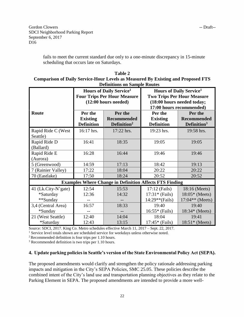
Table 2 shows the mid-2017 weekday service levels for a sampling of routes, measured
according to the existing and the recommended definitions of FTS.
• Overall, the recommended FTS definition would more fairly represent the regularity of
bus service that is provided.
• Adjacent columns in Table 2 show different total time of bus service counted as frequent,
based on the differing definitions of FTS. On several routes, the proposed definitions
would result in more service time counted toward FTS, because previously omitted gaps
of more than 15 minutes (or more than 30 minutes) would now be counted toward FTS.
• Most but not all the primary routes now meet the strictest standard from today’s code, but
some fall just short of the current standard. For example, the 21 bus route in West Seattle
Gordon Clowers -- Draft--
SDCI Neighborhood Parking Report
September 6, 2017
D16
22
fails to meet the current standard due only to a one-minute discrepancy in 15-minute
scheduling that occurs late on Saturdays.
Table 2
Comparison of Daily Service-Hour Levels as Measured By Existing and Proposed FTS
Definitions on Sample Routes
Route
Hours of Daily Service1
Four Trips Per Hour Measure
(12:00 hours needed)
Hours of Daily Service1
Two Trips Per Hour Measure
(18:00 hours needed today;
17:00 hours recommended)
Per the
Existing
Definition
Per the
Recommended
Definition2
Per the
Existing
Definition
Per the
Recommended
Definition3
Rapid Ride C (West
Seattle)
16:17 hrs. 17:22 hrs. 19:23 hrs. 19:58 hrs.
Rapid Ride D
(Ballard)
16:41 18:35 19:05 19:05
Rapid Ride E
(Aurora)
16:28 16:44 19:46 19:46
5 (Greenwood) 14:59 17:13 18:42 19:13
7 (Rainier Valley) 17:22 18:04 20:22 20:22
70 (Eastlake) 17:50 18:24 20:52 20:52
Examples Where Change in Definition Affects FTS Finding
41 (Lk.City-N’gate)
*Saturday
**Sunday
12:54
12:36
--
15:53
14:32
--
17:12 (Fails)
17:31* (Fails)
14:29**(Fails)
18:16 (Meets)
18:05* (Meets)
17:04** (Meets)
3,4 (Central Area)
*Sunday
16:57
--
18:33
--
19:40
16:55* (Fails)
19:40
18:34* (Meets)
21 (West Seattle)
*Saturday
12:40
12:43
14:04
13:15
18:04
17:45* (Fails)
19:41
18:51* (Meets)
Source: SDCI, 2017. King Co. Metro schedules effective March 11, 2017 – Sept. 22, 2017. 1 Service level totals shown are scheduled service for weekdays unless otherwise noted. 2 Recommended definition is four trips per 1.10 hours. 3 Recommended definition is two trips per 1.10 hours.
4. Update parking policies in Seattle’s version of the State Environmental Policy Act (SEPA).
The proposed amendments would clarify and strengthen the policy rationale addressing parking
impacts and mitigation in the City’s SEPA Policies, SMC 25.05. These policies describe the
combined intent of the City’s land use and transportation planning objectives as they relate to the
Parking Element in SEPA. The proposed amendments are intended to provide a more well-
Gordon Clowers -- Draft--
SDCI Neighborhood Parking Report
September 6, 2017
D16
23
rounded description of the context and a basis for understanding the parking policy’s relevance
to urban planning objectives and environmental impact determinations.
Currently these policies are already tailored to work with the approach to parking policy in the
Land Use Code, recognizing that parking is not required for new development in FTS areas.
Where parking is not required, the SEPA policies do not provide parking mitigation authority,
other than for cumulative impact mitigation, within the Station Area Overlay District, Urban
Centers or FTS areas in Urban Villages (except a portion of the University District Urban
Center) or require more parking or reduce the size of development proposals, based on parking.
5. Update and consolidate bike parking requirements for new development
The proposal consolidates bicycle parking rules to apply equally inside and outside of
Downtown. Until now, there has been less detail and lower requirements for Downtown, which
is inconsistent with the City’s support for increasing bicycling use as a transportation choice. The
amount of required bicycle parking is also updated, generally requiring more spaces be available
for short-term and long-term bicycle parking needs than is currently the case. The bicycle code
update is recommended by the City’s Bicycle Master Plan, and is consistent with the Commute
Seattle organization’s efforts toward greater presence of appropriate end-of-trip facilities, to
encourage bicycling commuting. Proposed standards are derived from guidelines of the
Association of Pedestrian and Bicycle Professionals best practices guide, and with reference to
other cities including San Francisco and Cambridge, Massachusetts (SDOT, 2016).
The proposal adds more guidance in performance standards for installing bicycle parking
features and emphasizes security, lighting, wayfinding, and convenience. Bike lockers, secured
rooms, and properly-installed features that avoid conflicts with automobile driveways are
encouraged.
The proposal broadens the requirement for commuter-supporting shower facilities for bicyclists
to apply to smaller buildings and to areas outside Downtown. Until now, this has only been a
requirement for buildings 250,000 square feet or more in Downtown. The proposal is to require
this city-wide for buildings 100,000 square feet or more in size. Also, the distance to possible
off-site shared bicycle parking would be increased from 100 feet to 800 feet. This will enable the
possibility of shared bicycle parking facilities that could locate around employment centers to
serve the needs of multiple buildings.
6. Other Related Code Amendments
In addition to the proposals described above, other complementary code amendments are
proposed to update, correct, and expand code flexibility to:
• Require “unbundling” of parking-space rental cost from the cost of a rented dwelling
unit, in new structures 10 dwelling units or more in size. Giving the option to prospective
Gordon Clowers -- Draft--
SDCI Neighborhood Parking Report
September 6, 2017
D16
24
rental residents to not purchase parking aids housing affordability, and enables more
efficient transportation choices. When parking is not automatically available by being
bundled into residential rents and thus has a separate monetary cost, more residents tend
to choose to forego automobile ownership.
• Require “unbundling” of parking-space costs from the cost of renting or leasing
commercial space in existing and new structures 10,000 square feet or more in size. Like
the residential proposal, giving a clearer choice in amount and cost of parking in these
leases should lead to more efficient transportation and parking choices made by
commercial tenants. Unused parking freed up by this could be converted to flexible-use
parking, which would contribute to overall parking supply availability in a given
neighborhood. The proposal exempts lodging and certain heavy commercial uses such as
automobile and marine sales and service uses from this requirement because their parking
facilities may be sized according to business operational factors other than simply
covering minimum employee and customer parking needs.
• Allow required off-site parking to be provided within one-quarter mile (1,320 feet) for
new developments rather than within 800 feet as required by current code. This would
expand the acceptable range for off-site parking to match a distance that most people find
walkable according to accepted professional urban design standards. The proposal would
provide more options for finding off-site parking.
• Update terminology and reduce the parking requirement for low-income housing
development, including those that are income-restricted and those serving the disabled.
• Require that non-required parking for residential and live-work uses meet the existing
minimum size standards for parking spaces. In 2012, the code was amended to apply
parking space standards only to required parking, and in 2014 the applicability of
minimum sizes to all non-residential uses except live-work uses was clarified. The City
has received complaints that the non-required parking provided is in some cases difficult
to use because the spaces are too small. As an example, several instances were pointed
out in a KING 5 television report: D. Leigh, “Parking spaces shrinking in Seattle
developments,” May 2015. The proposal would apply the standards listed in Section
23.54.030.A for all parking rather than letting non-required parking be smaller than the
minimum size stated in the code.
• Require a pedestrian access door and route between the garage and a public right-of-way
to accommodate access to the garage for new structures with a garage in zones where
flexible-use parking may occur. Fire exits or other access routes through building lobbies
could be designed to satisfy this purpose. This access would allow non-residents who are
parking in a building to find ways to enter and leave the garage even as building security
is maintained by door lock controls or keycards.
• Allow flexibility for less parking for public uses and institutional uses that are not Major
Institutions, like child care facilities and religious facilities, in FTS areas. Currently,
individual facilities that may provide beneficial services to the community are held to
higher minimum parking standards than residential and commercial uses. In places where
transit service is frequent and nearby, increased parking flexibility could make the
Gordon Clowers -- Draft--
SDCI Neighborhood Parking Report
September 6, 2017
D16
25
difference in the ability to locate in an area. Location in a transit-rich area benefits these
uses just as it does residential and commercial uses.
• Allow flexibility for less parking, as an exception, for uses in any zone except Downtown
zones, if an applicant demonstrates by study to the SDCI Director that a development will
have a lower parking demand than indicated by the requirement in the code. This change
allows for the possibility that specific uses that need less parking than is required would
have the opportunity to demonstrate that to the Director.
• Replace Northgate-specific minimum and maximum parking and access regulations in
SMC 23.71.016, to apply the same parking provisions that apply in other Urban Centers.
This means no minimum requirement for most residential, commercial, and institutional
uses (except hospitals), and a new proposed maximum parking limit on flexible-use
parking comparable to many zones across the city. A transit-related parking exception
applicable to Northgate would be retained, as would a requirement for landscaped
pedestrian walkway improvements in Northgate parking lots greater than 250 parking
spaces. The current parking provisions in Northgate were adopted in 1994 and are out of
step with the City’s current transportation and parking policies and regulations. The new
proposal would be consistent with the original intent of the Northgate provisions to
balance meeting the parking needs of businesses in the area while promoting a more
pedestrian-oriented neighborhood.
7. Consistency with the Comprehensive Plan
In the past decade, the City has already closely aligned its city-wide growth planning and
transportation policies with its development standards. The proposal reiterates and strengthens
support for the Comprehensive Plan’s vision of directing growth toward its six Urban Centers
and 30 other Urban Village neighborhoods to:
• Enhance their vitality and mix of living and commercial opportunities;
• Provide plentiful housing opportunities that are affordable to a broad cross-section of
households; and
• Achieve optimal land use patterns and transportation systems.
The proposal, which will continue to enable more opportunities for efficient, affordable housing
and employment within the most transit-accessible areas, will retain and improve upon the
parking policies already in effect, and will be consistent with several parking-related goals and
policies in the adopted Comprehensive Plan, including:
Goal
LU G6 Regulate off-street parking to address parking demand in ways that reduce reliance
on automobiles, lower construction costs, create attractive and walkable environments, and
promote economic development throughout the city.
Gordon Clowers -- Draft--
SDCI Neighborhood Parking Report
September 6, 2017
D16
26
Policies
LU 6.1 Establish parking requirements where appropriate for both single-occupant vehicles
and their alternatives at levels that further this Plan’s goal to increase the use of public transit,
car pools, walking, and bicycles as alternatives to the use of single-occupant vehicles.
LU 6.2 Modify residential parking regulations, where parking is required, to recognize
differences in the likely auto use and ownership of intended occupants of new developments,
such as projects provided for low-income, elderly, or disabled residents.
LU 6.3 Rely on market forces to determine the amount of parking provided in areas of the
city that are well-served by transit, such as Urban Centers and Urban Villages.
LU 6.4 Consider setting parking maximums in Urban Centers and Urban Villages, where
high levels of pedestrian, bicycle, and transit accessibility make many trips possible without
a car.
LU 6.5 Establish bicycle parking requirements to encourage bicycle ownership and use.
LU 6.6 Limit the off-street impacts on pedestrians and surrounding areas by restricting the
number and size of automobile curb cuts, and by generally requiring alley access to parking
when there is an accessible, surfaced alley that is not used primarily for loading and when not
prevented by topography.
LU 6.7 Prohibit most street-level parking between buildings and the street in multifamily
zones and pedestrian-oriented commercial zones in order to maintain an attractive and safe
street-level environment, facilitate the movement of pedestrian and vehicular traffic,
minimize adverse impacts on nearby areas and structures, and, where appropriate, maintain
or create continuous street fronts.
LU 6.8 Allow shared off-site parking facilities for more efficient use of parking and to
provide the flexibility to develop parking on a site separate from the development site.
Ensure that such parking is compatible with the existing or desired character of the area.
LU 6.9 Require parking in areas with limited transit access and set the requirements to
discourage underused parking facilities, even if occasional spillover parking could result.
LU 6.10 Allow parking management provisions in select commercial and multifamily
residential areas to include measures such as cooperative parking, shared parking, shared
vehicles, restricted access, car pools, van pools, or transit pass subsidies.

Gordon Clowers -- Draft--
SDCI Neighborhood Parking Report
September 6, 2017
D16
27
LU 6.11 Achieve greater parking efficiency by allowing fewer parking spaces per business
when several businesses share customer parking, thereby enabling customers to park once
and walk to numerous businesses.
LU 6.12 Locate off-street parking facilities to minimize impacts on the pedestrian
environment, especially in areas designated for active pedestrian use.
LU 6.13 Limit parking in City parks to discourage auto use and to limit the use of parkland
for parking private cars; where parking is needed, design parking facilities in ways that
preserve open space, green space, and trees and other mature vegetation.
LU 6.14 Prohibit principal-use parking in places where that parking would be incompatible
with the area’s intended function.
LU 6.15 Discourage the development of major stand-alone park-and-ride facilities within
Seattle. Additions to park-and-ride capacity could be considered
• at the terminus of a major regional transit system,
• where opportunities exist for shared parking, or
• where alternatives to automobile use are particularly inadequate or cannot be
provided in a cost-effective manner.
LU 3.3 Allow standards to be modified for required off-street parking associated with public
facilities and small institutions based on the expected use and characteristics of the facility
and the likely impacts on surrounding parking and development conditions, and on existing
and planned transportation facilities in the area.
Recommendation
The SDCI Director recommends adopting the proposed amendments. This proposal will address
transportation and parking demand by increasing opportunities for shared off-street parking. It
will implement progressive parking policies where transit service is frequent and regularly
supported by investment. The proposal is consistent with and supportive of the City’s
Comprehensive Plan. Finally, the proposal will accomplish recommendations from the Housing
Affordability and Livability Agenda in addressing the impact that constructed parking adds to
the cost of housing.