DIRECTION B181996 STUDENT HANDOUT - USMC … · B181996 Direction 5 Basic Officer Course North...
30
UNITED STATES MARINE CORPS THE BASIC SCHOOL MARINE CORPS TRAINING COMMAND CAMP BARRETT, VIRGINIA 22134-5019 DIRECTION B181996 STUDENT HANDOUT Basic Officer Course
Transcript of DIRECTION B181996 STUDENT HANDOUT - USMC … · B181996 Direction 5 Basic Officer Course North...
UNITED STATES MARINE CORPS THE BASIC SCHOOL
MARINE CORPS TRAINING COMMAND CAMP BARRETT, VIRGINIA 22134-5019
DIRECTION B181996
STUDENT HANDOUT
Basic Officer Course

B181996 Direction
2 Basic Officer Course
Direction
Introduction This class will define direction, cover how to determine magnetic and grid azimuths, and ensure the student can utilize both azimuths when in the tree line and on the map.
Importance A Marine Officer must know how and under what circumstances to utilize grid and magnetic azimuths in order to navigate to an objective, call for fire, execute a casualty evacuation (CASEVAC), etc.
In This Lesson We will discuss the different types of north (true, magnetic, and grid), how to find and convert azimuths, and how to determine annual magnetic changes.
This lesson covers the following topics:
Topic Page
North Lines 4
Azimuths 5
Annual Magnetic Changes 6
Utilizing Azimuths 7
Review Questions 10
Review Questions Answers 24
Summary 30
References 30
Glossary of Terms and Acronyms 30
Notes 30
Learning Objectives Terminal Learning Objective
0300-PAT-1002 Given a military topographic map, protractor and objective, navigate with a map and compass, to arrive within 100 meters of the objective.
Enabling Learning Objectives
0300-PAT-1002a Given a military topographic map, identify marginal information without error.
0300-PAT-1002g Given a military topographic map, protractor, and two points on a map, determine grid azimuth to within 3 degrees.
0300-PAT-1002h Given a military topographic map, a grid azimuth, and compass error, determine the magnetic azimuth without error.
B181996 Direction
3 Basic Officer Course
Learning Objectives (Continued)
Enabling Learning Objectives (continued) 0300-PAT-1002i Given a military topographic map, a magnetic azimuth, and compass error, determine the grid azimuth without error. 0300-PAT-1002j Given an azimuth, determine back azimuth without error.
B181996 Direction
4 Basic Officer Course
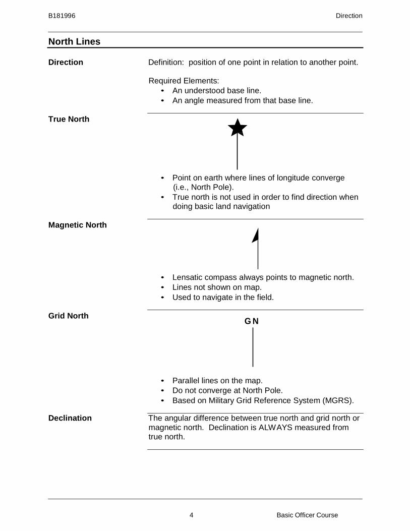
North Lines
Direction Definition: position of one point in relation to another point.
Required Elements:
• An understood base line.
• An angle measured from that base line.
True North
• Point on earth where lines of longitude converge (i.e., North Pole).
• True north is not used in order to find direction when doing basic land navigation
Magnetic North
• Lensatic compass always points to magnetic north.
• Lines not shown on map.
• Used to navigate in the field.
Grid North G N
• Parallel lines on the map.
• Do not converge at North Pole.
• Based on Military Grid Reference System (MGRS).
Declination The angular difference between true north and grid north or magnetic north. Declination is ALWAYS measured from true north.
B181996 Direction
5 Basic Officer Course
North Lines (Continued)
Magnetic Declination • Measures from true north to magnetic north.
• Can be east or west.
• Usually measured in degrees.
• e.g., 5°W.
Grid Declination • Measures from true north to grid north,
• Can be east or west,
• Usually measured in degrees,
• e.g., 6°E,
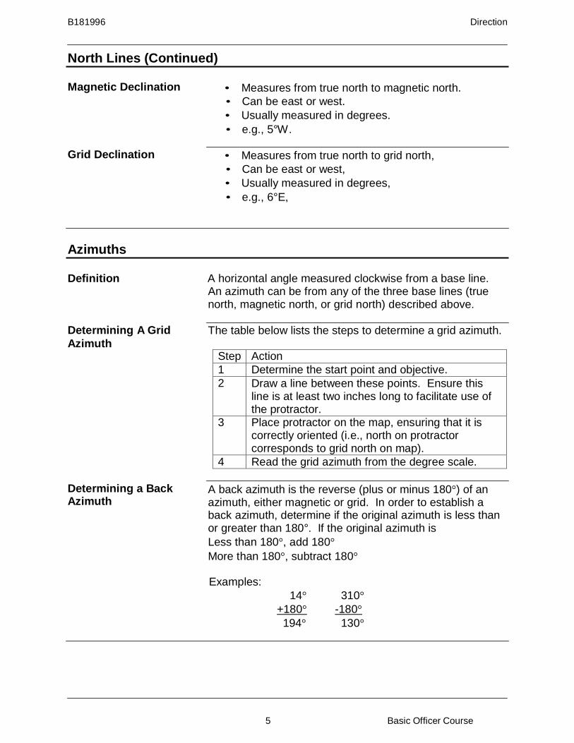
Azimuths
Definition A horizontal angle measured clockwise from a base line. An azimuth can be from any of the three base lines (true north, magnetic north, or grid north) described above.
Determining A Grid
Azimuth The table below lists the steps to determine a grid azimuth.
Step Action
1 Determine the start point and objective.
2 Draw a line between these points. Ensure this line is at least two inches long to facilitate use of the protractor.
3 Place protractor on the map, ensuring that it is correctly oriented (i.e., north on protractor corresponds to grid north on map).
4 Read the grid azimuth from the degree scale.
Determining a Back Azimuth
A back azimuth is the reverse (plus or minus 180°) of an azimuth, either magnetic or grid. In order to establish a back azimuth, determine if the original azimuth is less than or greater than 180°. If the original azimuth is
Less than 180°, add 180°
More than 180°, subtract 180°
Examples:
14° 310°
+180° -180°
194° 130°
B181996 Direction
6 Basic Officer Course
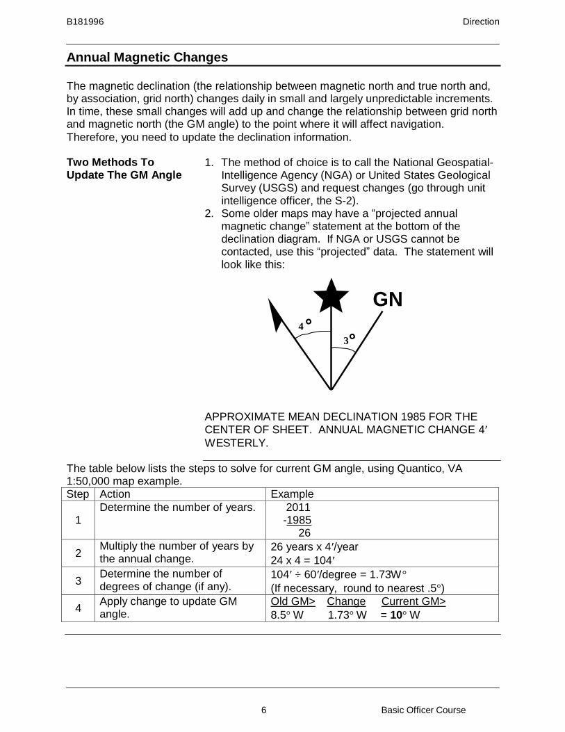
Annual Magnetic Changes
The magnetic declination (the relationship between magnetic north and true north and, by association, grid north) changes daily in small and largely unpredictable increments. In time, these small changes will add up and change the relationship between grid north and magnetic north (the GM angle) to the point where it will affect navigation.
Therefore, you need to update the declination information.
Two Methods To Update The GM Angle
1. The method of choice is to call the National Geospatial- Intelligence Agency (NGA) or United States Geological Survey (USGS) and request changes (go through unit intelligence officer, the S-2).
2. Some older maps may have a “projected annual magnetic change” statement at the bottom of the declination diagram. If NGA or USGS cannot be contacted, use this “projected” data. The statement will look like this:
GN
4
3
APPROXIMATE MEAN DECLINATION 1985 FOR THE CENTER OF SHEET. ANNUAL MAGNETIC CHANGE 4′
WESTERLY.
The table below lists the steps to solve for current GM angle, using Quantico, VA 1:50,000 map example. Step Action Example
1
Determine the number of years. 2011 -1985
26
2 Multiply the number of years by the annual change.
26 years x 4′/year
24 x 4 = 104′
3 Determine the number of degrees of change (if any).
104′ ÷ 60′/degree = 1.73W°
(If necessary, round to nearest .5°)
4 Apply change to update GM angle.
Old GM> Change Current GM>
8.5° W 1.73° W = 10° W

B181996 Direction
7 Basic Officer Course
Utilizing Azimuths
Methods There are three distinct methods for utilizing GM angle and converting between grid and magnetic azimuths; it is vital to understand that these three methods are different ways of determining the same information. It is equally important to find the method that works best for you and to ignore the others. While it is easy to interpose the rules from LARS and MAGMGA, such a mix up will invariably lead to incorrect map work.
All azimuth questions can be solved in three general steps:
1. Determine the GM angle. 2. Determine the known azimuth.
3. Solve for the unknown azimuth.
LARS LARS stands for Left Add, Right Subtract, and is used when going from the known azimuth to the unknown azimuth, irrespective of grid or magnetic azimuth. Once one has created a declination diagram and found the GM angle, LARS users are concerned only with the direction (right or left) from the known angle (azimuth) to the unknown angle, for the cardinal direction (east or west) is no longer relevant. Once the appropriate direction is determined, the GM angle is then added or subtracted to the known azimuth.
In this example, the known azimuth is 270 magnetic. Using
LARS, convert to a grid azimuth.
GN
4
3
1. GM Angle= 7W 2. Known= 270 mag 3. Going from the known (line representing mag az), to
the unknown (line representing grid az) we went RIGHT. Now subtract the GM angle of 7 to find a grid azimuth of 263 deg.
B181996 Direction
8 Basic Officer Course
Utilizing Azimuths (Continued)
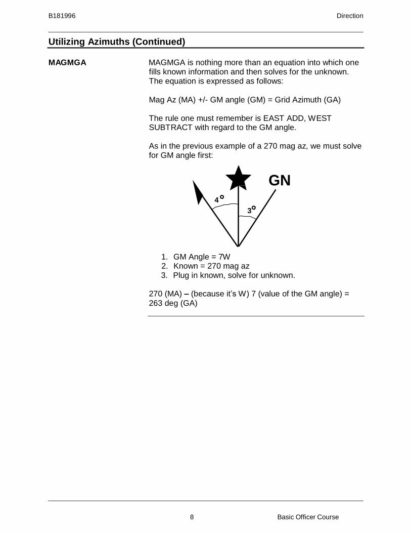
MAGMGA MAGMGA is nothing more than an equation into which one fills known information and then solves for the unknown. The equation is expressed as follows:
Mag Az (MA) +/- GM angle (GM) = Grid Azimuth (GA)
The rule one must remember is EAST ADD, WEST SUBTRACT with regard to the GM angle.
As in the previous example of a 270 mag az, we must solve for GM angle first:
GN
4
3
1. GM Angle = 7W 2. Known = 270 mag az 3. Plug in known, solve for unknown.
270 (MA) – (because it’s W) 7 (value of the GM angle) = 263 deg (GA)

B181996 Direction
9 Basic Officer Course
Utilizing Azimuths (Continued)
Picture Method A third way to utilize the GM angle to convert azimuths is called the Picture Method. Begin by drawing a declination diagram and determining the GM angle; next, draw an arbitrary line at a 90 degree angle to true north. This arbitrary line represents the known angle. By drawing arrows from both the known line and the unknown, one can determine which angle is larger and whether or not to add or subtract the GM angle.
GN
4
3
Here, the dashed line represents the known mag azimuth. The dotted line from GN represents the unknown grid azimuth. As one can see, the GN line is smaller; the GM angle, therefore, will be subtracted from the mag az to yield a grid az of 263 degrees.

B181996 Direction
10 Basic Officer Course
Review Questions
Requirement 1 Map: Margarita Peak, California, 1:50,000, Sheet 2550 IV Series V795, Edition 9-NGA
Section 1: Question 1
What is the GM angle in the following diagram?
GN
2 4
Answer:
Question 2 What is the grid azimuth in the following diagram?
GN 10
4
205
Answer:
Question 3 Draw the diagram and solve the following problems.
a. Magnetic declination = 3° E
Grid declination = 7° E
Magnetic azimuth = 209°
Grid azimuth =
b. Grid declination = 7° E
Magnetic declination = 5° W
Magnetic azimuth = 92°
Grid back azimuth =

B181996 Direction
11 Basic Officer Course
Review Questions, Requirement 1 (Continued)
Requirement 1 Section 1 (Continued) Question 4
From the earthen dam in MS7082 on a magnetic azimuth of 29 degrees to the first four lane road, how many streams do you cross?
Question 5 What is the magnetic azimuth from…
a. the tower in MS6185 to the south eastern corner of the culvert in MS 6489?
b. the northern most structure hill 259 (spot elevation 259) in MS5993 to the center of the northern bridge in MS6191?
Section 2: Question 1
What is the GM angle in the following diagram?
GN 7
3
Answer:
Question 2 What is the grid back azimuth in the following diagram?
GN
11
5 204
Answer:
B181996 Direction
12 Basic Officer Course
Review Questions, Requirement 1 (Continued)
Requirement 1 Section 2 (Continued) Question 3
Draw the diagrams and solve the following problems.
a. GM angle = 6° W Grid
azimuth = 149° Magnetic
azimuth =
b. Grid declination = 4° W
Magnetic declination = 1° W
Magnetic azimuth = 200°
Grid back azimuth =
Question 4 From the Del Rio Elementary School in MS7380 on a
magnetic azimuth of 33 degrees for 1200 meters, how many all weather hard surface roads will you cross?
Question 5 You are standing inside the Marine Corps Air Station Camp Pendleton Control Tower in MS6784 and observe a structure on a magnetic azimuth of 241 degrees. The structure appears to be between two and three kilometers from your position. You reference your map; what structure is this?
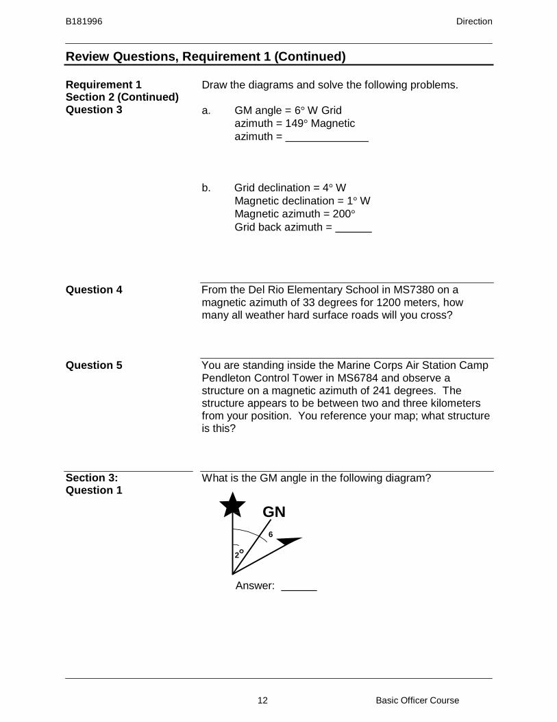
Section 3: Question 1
What is the GM angle in the following diagram?
GN
6
2
Answer:
B181996 Direction
13 Basic Officer Course
Review Questions, Requirement 1 (Continued)
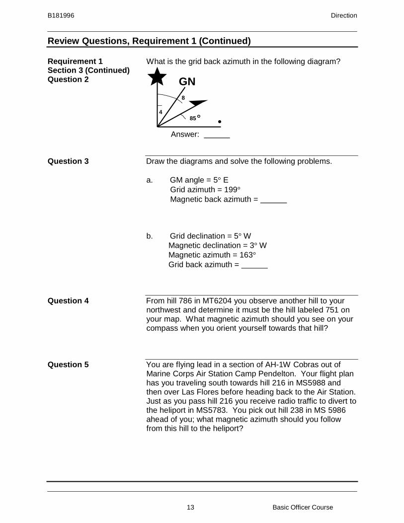
Requirement 1 Section 3 (Continued) Question 2
What is the grid back azimuth in the following diagram?
GN
8
4
85
Answer:
Question 3 Draw the diagrams and solve the following problems.
a. GM angle = 5° E
Grid azimuth = 199°
Magnetic back azimuth =
b. Grid declination = 5° W
Magnetic declination = 3° W
Magnetic azimuth = 163°
Grid back azimuth =
Question 4 From hill 786 in MT6204 you observe another hill to your northwest and determine it must be the hill labeled 751 on your map. What magnetic azimuth should you see on your compass when you orient yourself towards that hill?
Question 5 You are flying lead in a section of AH-1W Cobras out of Marine Corps Air Station Camp Pendelton. Your flight plan has you traveling south towards hill 216 in MS5988 and then over Las Flores before heading back to the Air Station. Just as you pass hill 216 you receive radio traffic to divert to the heliport in MS5783. You pick out hill 238 in MS 5986 ahead of you; what magnetic azimuth should you follow from this hill to the heliport?
B181996 Direction
14 Basic Officer Course
3
Review Questions, Requirement 1 (Continued)
Requirement 1 Section 3 (Continued) Question 6
Given the following information, compute the current magnetic declination and GM angle.
Grid declination = 3° W
Magnetic declination = 4° E
Annual magnetic change = 10′ Easterly Original map date = 1968 Current year = 2010
a. 1968 GM Angle =
b. 2010 GM angle =
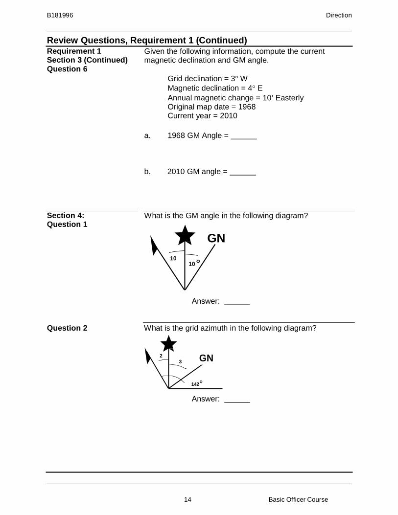
Section 4: Question 1
What is the GM angle in the following diagram?
GN
10 10
Answer:
Question 2 What is the grid azimuth in the following diagram?
2 GN
142
Answer:

B181996 Direction
15 Basic Officer Course
Review Questions, Requirement 1 (Continued)
Requirement 1 Section 4 (Continued) Question 3
Draw the diagram and solve the following problems.
a. Magnetic declination = 4° W
Grid declination = 3° E
Magnetic azimuth = 113°
Grid azimuth =
b. Grid declination = 2° E
Magnetic declination = 7° E
Magnetic azimuth = 279°
Grid back azimuth =
Question 4 Your platoon must traverse from hill 953 on Margarita Peak
along a magnetic azimuth of 60 degrees for 1700 meters to your next objective. How many times should you expect to cross a stream along your route?
Question 5 What is the magnetic azimuth from the…
a. Fallbrook Elementary School in MS7693 to hill 250 in MS7393?
b. the center building at Camp De Luz in MS6992 to the northern most bridge in MS6691?

B181996 Direction
16 Basic Officer Course
Review Questions, Requirement 1 (Continued)
Requirement 1 Section 5: Question 1
What is the GM angle in the following diagram?
GN
2
8
Answer:
Question 2 What is the grid back azimuth in the following diagram?
GN
3 4
208
Answer:
Question 3 Draw the diagrams and solve the following problems.
a. GM angle = 6° W Grid
azimuth = 136° Magnetic
azimuth =
b. Grid declination = 4° W
Magnetic declination = 1° W
Magnetic azimuth = 358°
Grid back azimuth =
Question 4 Your scout sniper team is atop hill 281 in MS5499 conducting surveillance training. They spot a red cell Marine emplace what appears to be an Improvised Explosive Device (IED) inside a culvert closest to their position in MS5599. What should they read on their compass when confirming the culvert’s azimuth from their current location?
B181996 Direction
17 Basic Officer Course
Review Questions, Requirement 1 (Continued)
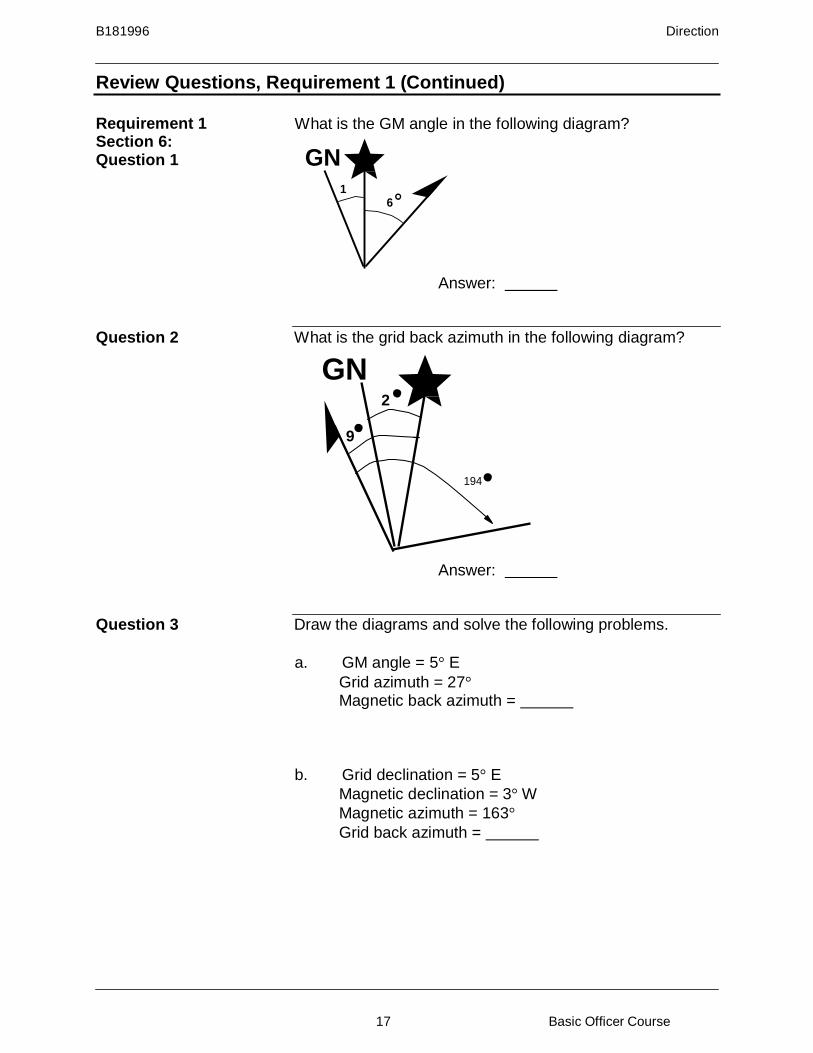
Requirement 1 Section 6: Question 1
What is the GM angle in the following diagram?
GN
1 6
Answer:
Question 2 What is the grid back azimuth in the following diagram?
GN 2
9
194
Answer:
Question 3 Draw the diagrams and solve the following problems.
a. GM angle = 5° E
Grid azimuth = 27°
Magnetic back azimuth =
b. Grid declination = 5° E
Magnetic declination = 3° W
Magnetic azimuth = 163°
Grid back azimuth =

B181996 Direction
18 Basic Officer Course
Review Questions, Requirement 1 (Continued)
Requirement 1 Section 6 (Continued) Question 4
You have to relocate one of your squad’s Vehicle Check Points (VCP) from the intersection of the trail and the all- weather loose surface road in MS5984 to a new location. You direct your squad leader to move his Marines to a nearby man-made feature in order to beter control an avenue of approach. You help orient him by telling him this manmade feture is on a magnetic azimuth of 268 degrees for 1950 meters from his current position. What manmade feature are you directing him to towards?
Question 5 Solve the following problems.
a. What is the magnetic azimuth from the Pacific Elementary School in MS 7179 to the earthen dam in MS7082?
b. What is the grid back azimuth for the above problem?
Question 6 Given the below diagram and information, determine the
GM angle for the current year.
GN
5 1
Annual magnetic change = 15′ Easterly Original map date = 1963 Current year = 2011
Answer:

B181996 Direction
19 Basic Officer Course
Review Questions, Requirement 2
Requirement 2 Map: New River, 1:50,000, Sheet 5553 III, Seriew V742, Edition 9-NGA
Section 1: Question 1
What is the GM angle in the following diagram?
GN
3 5
Answer:
Question 2 What is the grid azimuth in the following diagram?
12
GN 6
196
Answer:
Question 3 Draw the diagram and solve the following problems.
a. Magnetic declination = 4° E
Grid declination = 9° E
Magnetic azimuth = 254°
Grid azimuth =
b. Grid declination = 5° E
Magnetic declination = 3° W
Magnetic azimuth = 122°
Grid back azimuth =
B181996 Direction
20 Basic Officer Course
Review Questions, Requirement 2 (Continued)
Requirement 2 Section 1 (Continued) Question 4
One of your squads is at the intersection of the fair weather loose surface road and the all-weather loose surface road in TD8038. You direct him on a magnetic azimuth of 230 degrees for 2900 meters in order to conduct a resupply. How many roads (of any type) can you tell him to expect enroute to the resupply point?
Question 5 What is the magnetic azimuth from…
a. Union Chapel in TD8942 to the Kellumtown School in TD9143?
b. the southern most tower in TD8539 to the water tower in TD8636?
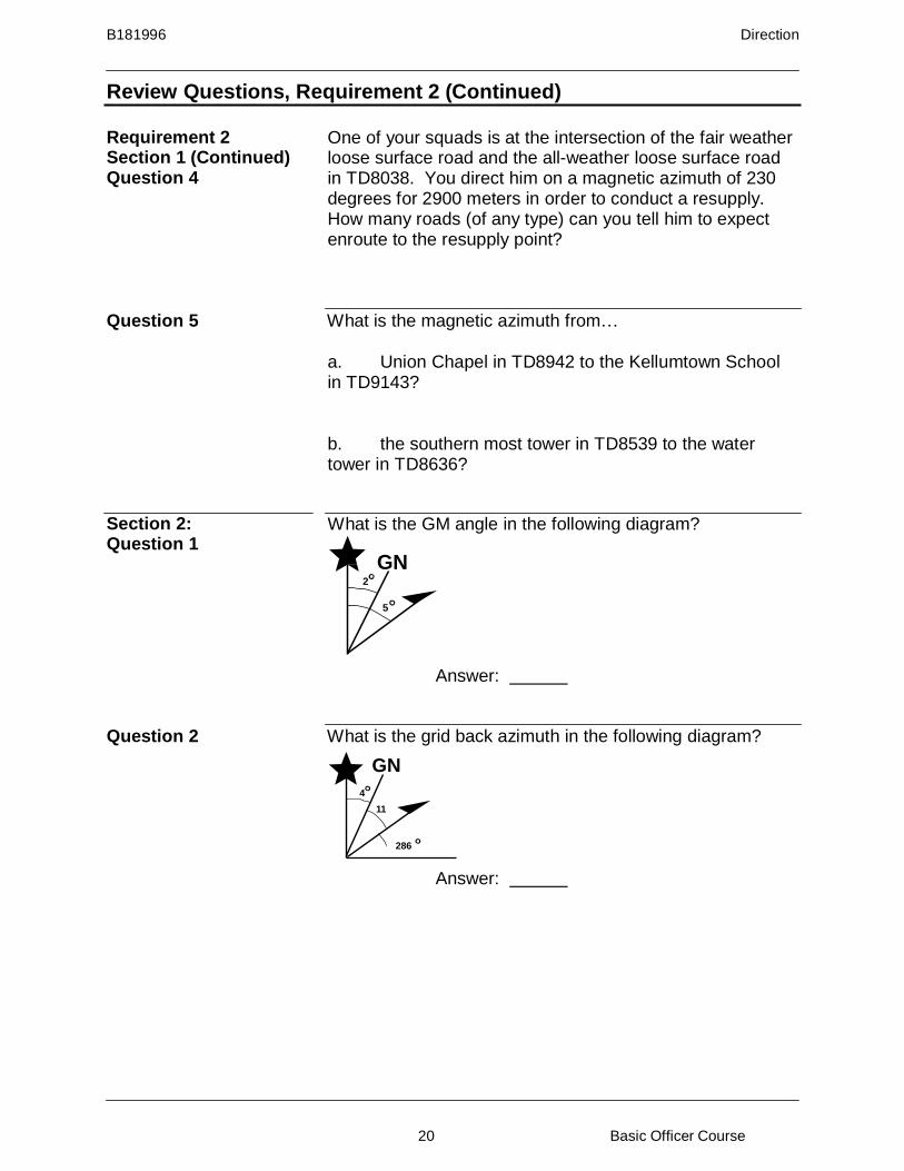
Section 2: Question 1
What is the GM angle in the following diagram?
GN 2
5
Answer:
Question 2 What is the grid back azimuth in the following diagram?
GN
4
11
286
Answer:

B181996 Direction
21 Basic Officer Course
Review Questions, Requirement 2 (Continued)
Requirement 2 Section 2 (Continued) Question 3
Draw the diagrams and solve the following problems.
a. GM angle = 9° E
Grid azimuth = 112°
Magnetic azimuth =
b. Grid declination = 5° W
Magnetic declination = 2° W
Magnetic azimuth = 198°
Grid back azimuth =
Question 4 What is the magnetic azimuth from the church in TD7238 to
the tower in TD7236?
Question 5 You are a member of an engineer support battalion
conducting rafting operations in support of a company of tanks. The M1A1s must be ferried across the New River to the live fire ranges. You shoot an azimuth from the end of the fair weather loose surface road at Well’s Point (TD8535) west towards the all-weather loose surface road at Rhode’s Point (TD8235) in order to confirm the route. What should your compass read?
Section 3: Question 1
What is the GM angle in the following diagram?
GN 3
8
Answer:
B181996 Direction
22 Basic Officer Course
Review Questions, Requirement 2 (Continued)
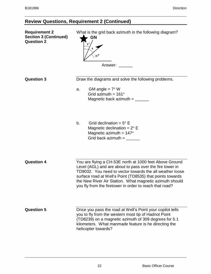
Requirement 2 Section 3 (Continued) Question 2
What is the grid back azimuth in the following diagram?
GN
5
8
79
Answer:
Question 3 Draw the diagrams and solve the following problems.
a. GM angle = 7° W
Grid azimuth = 161°
Magnetic back azimuth =
b. Grid declination = 5° E
Magnetic declination = 2° E
Magnetic azimuth = 147°
Grid back azimuth =
Question 4 You are flying a CH-53E north at 1000 feet Above Ground
Level (AGL) and are about to pass over the fire tower in TD9032. You need to vector towards the all weather loose surface road at Well’s Point (TD8535) that points towards the New River Air Station. What magnetic azimuth should you fly from the firetower in order to reach that road?
Question 5 Once you pass the road at Well’s Point your copilot tells
you to fly from the western most tip of Hadnot Point (TD8239) on a magnetic azimuth of 309 degrees for 5.1 kilometers. What manmade feature is he directing the helicopter towards?
B181996 Direction
23 Basic Officer Course
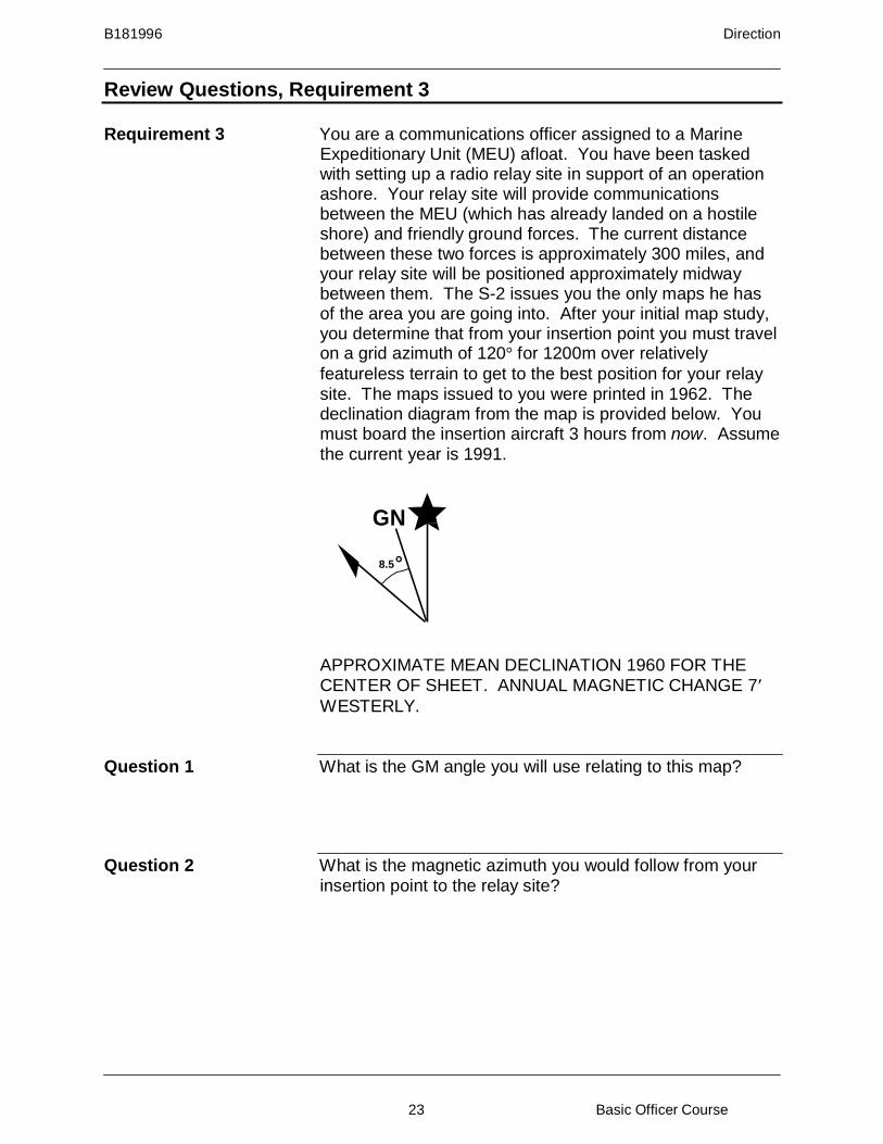
Review Questions, Requirement 3
Requirement 3 You are a communications officer assigned to a Marine Expeditionary Unit (MEU) afloat. You have been tasked with setting up a radio relay site in support of an operation ashore. Your relay site will provide communications between the MEU (which has already landed on a hostile shore) and friendly ground forces. The current distance between these two forces is approximately 300 miles, and your relay site will be positioned approximately midway between them. The S-2 issues you the only maps he has of the area you are going into. After your initial map study, you determine that from your insertion point you must travel on a grid azimuth of 120° for 1200m over relatively
featureless terrain to get to the best position for your relay site. The maps issued to you were printed in 1962. The declination diagram from the map is provided below. You must board the insertion aircraft 3 hours from now. Assume the current year is 1991.
GN
8.5
APPROXIMATE MEAN DECLINATION 1960 FOR THE CENTER OF SHEET. ANNUAL MAGNETIC CHANGE 7′
WESTERLY.
Question 1 What is the GM angle you will use relating to this map?
Question 2 What is the magnetic azimuth you would follow from your
insertion point to the relay site?
B181996 Direction
24 Basic Officer Course
Review Answers, Requirement 1
Requirement 1
1.
6° E
Section 1 2. 211°
7 GN 3
3. a. 205°
GN
5 7
b. 260°
4. Three streams
5. a. 26°
b. 110°
Section 2 1. 4° E
2. 30°
GN
6
3. a. 155°
GN 4
1
b. 23°
4. Two roads
5. 14°. Water intake tower in MS6584
B181996 Direction
25 Basic Officer Course
Review Answers, Requirement 1 (Continued)
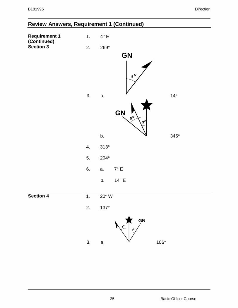
Requirement 1 (Continued) Section 3
1. 4° E
2. 269°
GN
5
3. a. 14°
GN 5
3
b. 345°
4. 313°
5. 204°
6. a. 7° E
b. 14° E
Section 4 1. 20° W
2. 137°
GN
4
3
3. a. 106°

B181996 Direction
26 Basic Officer Course
Review Answers, Requirement 1 (Continued)
Requirement 1 Section 4 (Continued) GN
2
7
3 b. 104°
4. Twice
5. a. 264°
b. 243°
Section 5 1. 6° W
2. 35°
GN
6
3. a. 142°
GN 4
1
b. 181°
4. 52°
Section 6 1. 7° E
2. 7°
GN
5
3. a. 202°

B181996 Direction
27 Basic Officer Course
Review Answers, Requirement 1 (Continued)
Requirement 1 Section 6 (Continued) GN
3 5
3. b. 335°
4. A bridge
5. a. 319°
6.
b.
6° E
152°
Requirement 2 Section 1
1. 8° W
2. 202°
3. a.
9 GN 4
254
249°
GN 3
5
122
b. 294°
4. Three roads
5. a. 102°
b. 181°

B181996 Direction
28 Basic Officer Course
Review Answers, Requirement 2 (Continued)
Requirement 2 Section 2
1. 3° E
2. 117°
GN
9
3. a.
112
103°
2
GN 5
198
b.
21°
4. 185°
5. 283°
Section 3 1. 5° E
2. 262°
GN 7
3. a.
161
348°
2 GN 5
147
b. 324°
4. 310°
5. The southern most tip of the north/south runway at the New River Air Station in TD7642

B181996 Direction
29 Basic Officer Course
Review Answers, Requirement 3 (Continued)
Requirement 3 1. 12° W
To determine the current GM angle of the map:
a. Declination data as of 1960 with an annual
change of 7′ Westerly.
b. Determine number of years:
1991 -1960 31 years
c. Multiply number of years by annual change:
31 years x 7′/year = 217′
d. Determine number of degrees change:
217′ ÷ 60′/degree = 3.6 = 3.5° (round to nearest .5°)
e. Apply change to update GM angle: Old GM> Change Current GM>
8.5° W + 3.5° W = 12° W
2. 132°
To determine the azimuth, use one of the following
methods:
a. MA ± GM = GA E + W –
Grid azimuth = 120°
MA -12° = 120°
MA - 12° + 12° = 120° + 12°
MA = 132°
b. LARS
You started with a GA, so go to the grid declination line and move to the mag declination line. You moved Left, so you Add the GM angle to the GA to determine the MA.
120° + 12° = 132°

B181996 Direction
30 Basic Officer Course
Summary
You should now understand how direction is defined and be able to use grid and magnetic azimuths while navigating.
References
Reference Number or Author
Reference Title
FM 3-25.26 Map Reading and Land Navigation
Glossary of Terms and Acronyms
Term or Acronym Definition or Identification Az Azimuth CASEVAC Casualty evacuation DMA Defense Mapping Agency GA Grid Azimuth GM Angle Grid-Magnetic angle LARS Left Add, Right Subtract MA Magnetic Azimuth MAGMGA Mag Az (MA) +/- GM angle (GM) = Grid Azimuth (GA) MGRS Military Grid Reference System USGS United States Geological Survey
Notes