Digital urban ambience: Mediating context on mobile ... · Aalborg Universitet Digital Urban...
13
Aalborg Universitet Digital Urban Ambience Mediating Context on Mobile Devices in the City Kjeldskov, Jesper; Skov, Mikael B.; Nielsen, Glen; Vestergaard, Michael; Thorup, Søren Published in: Pervasive and Mobile Computing DOI (link to publication from Publisher): 10.1016/j.pmcj.2012.05.002 Publication date: 2013 Document Version Accepted author manuscript, peer reviewed version Link to publication from Aalborg University Citation for published version (APA): Kjeldskov, J., Skov, M. B., Nielsen, G., Vestergaard, M., & Thorup, S. (2013). Digital Urban Ambience: Mediating Context on Mobile Devices in the City. Pervasive and Mobile Computing, 9(5), 738-749. https://doi.org/10.1016/j.pmcj.2012.05.002 General rights Copyright and moral rights for the publications made accessible in the public portal are retained by the authors and/or other copyright owners and it is a condition of accessing publications that users recognise and abide by the legal requirements associated with these rights. ? Users may download and print one copy of any publication from the public portal for the purpose of private study or research. ? You may not further distribute the material or use it for any profit-making activity or commercial gain ? You may freely distribute the URL identifying the publication in the public portal ? Take down policy If you believe that this document breaches copyright please contact us at [email protected] providing details, and we will remove access to the work immediately and investigate your claim. Downloaded from vbn.aau.dk on: May 10, 2020
Transcript of Digital urban ambience: Mediating context on mobile ... · Aalborg Universitet Digital Urban...
Aalborg Universitet
Digital Urban Ambience
Mediating Context on Mobile Devices in the City
Kjeldskov, Jesper; Skov, Mikael B.; Nielsen, Glen; Vestergaard, Michael; Thorup, Søren
Published in:Pervasive and Mobile Computing
DOI (link to publication from Publisher):10.1016/j.pmcj.2012.05.002
Publication date:2013
Document VersionAccepted author manuscript, peer reviewed version
Link to publication from Aalborg University
Citation for published version (APA):Kjeldskov, J., Skov, M. B., Nielsen, G., Vestergaard, M., & Thorup, S. (2013). Digital Urban Ambience: MediatingContext on Mobile Devices in the City. Pervasive and Mobile Computing, 9(5), 738-749.https://doi.org/10.1016/j.pmcj.2012.05.002
General rightsCopyright and moral rights for the publications made accessible in the public portal are retained by the authors and/or other copyright ownersand it is a condition of accessing publications that users recognise and abide by the legal requirements associated with these rights.
? Users may download and print one copy of any publication from the public portal for the purpose of private study or research. ? You may not further distribute the material or use it for any profit-making activity or commercial gain ? You may freely distribute the URL identifying the publication in the public portal ?
Take down policyIf you believe that this document breaches copyright please contact us at [email protected] providing details, and we will remove access tothe work immediately and investigate your claim.
Downloaded from vbn.aau.dk on: May 10, 2020

Pervasive and Mobile Computing ( ) –
Contents lists available at SciVerse ScienceDirect
Pervasive and Mobile Computing
journal homepage: www.elsevier.com/locate/pmc
Digital urban ambience: Mediating context on mobile devices in a cityJesper Kjeldskov ∗, Mikael B. Skov, Glen W. Nielsen, Søren Thorup, Michael VestergaardCentre for Socio-Interactive Design, Department of Computer Science, Aalborg University, Selma Lagerlöfs Vej 300, 9220 Alborg East, Denmark
a r t i c l e i n f o
Article history:Available online xxxx
Keywords:Digital urban ambienceContext-awarenessMobile computingField study
a b s t r a c t
We explore the term digital urban ambience to describe the user experience of mobiledevices mediating context in metropolitan areas. Mediated context-awareness explores aconstructivist approach to context and aims to provide resources for experiencing contextrather than correctly recognizing and adapting to it. Exploring this approach we havebuilt a prototype system, eSpective2, combining maps and augmented reality on a touchphone, and we have studied its use. We conducted a triangulated field study involving 58participants and up to onemonth of use. Elaborating on thework of Thibaud (2002) [1], themain finding is that context resources provided throughmobile devices digitally contributeto the experience or feeling of urban ambience (1) by adding to the quality of the situationas a whole, (2) as a catalyst for action, and (3) as a sensory background.
© 2012 Elsevier B.V. All rights reserved.
1. Introduction
Modern mobile phones are graphically powerful devices with a range of sensors including GPS, accelerometers, and acompass that facilitate the creation of rich and engaging interaction design and user experiences. One of the popular typesof applications for iOS and Android OS is location-based services that provide rich and interactive digital information aboutpeople’s immediate physical surroundings. These services and applications are no longer merely thought of as guides fortourists but more as tools for the inhabitants or visitors of towns and cities. They provide information about contextualresources, such as people and places, for finding out who is around, what to do, andwhere to go [2,3], or public transport [4].Common for these is that they represent a different approach to the idea of ‘‘context-awareness’’ than the one dominatingthe field for over a decade, since it was first introduced by Schilit and Theimer [5]. Apart from using the user’s location as ananchor point for interaction, these new applications do not seek to formalize and adapt automatically to their surroundings,but aim instead at mediating contextual information resources, thereby allowing users to obtain andmaintain awareness oftheir context through interpretation. Judged by user uptake and impact on commercial applications, this approach appearsto have merit.
From a human–computer interaction (CHI) perspective, however, little is known about the user experience of such‘‘mediated’’ context-awareness. This has motivated us to explore the design and use of such systems. Inspired by the 2008CHIworkshop on UrbanMixed Realities [6], we have focused specifically on an urban environment. The purpose of our workhas been to better understand how different aspects of urban context can be represented, how people perceive and use suchcontext representations, and how the user experience ofmobilemediated context-awareness can be described conceptuallyin urban settings. Understanding this, we believe, will eventually enable us to also begin to understandwhy it is interestingfor local residents of a city to explore it through a digital mobile system, not just tourists.The paper is structured as follows. First, we introduce related work within context-awareness. We then introduce theeSpective2 system by describing how its interaction design supports people exploring context information in their
∗ Corresponding author. Tel.: +45 9949 8921; fax: +45 9940 9798.E-mail addresses: [email protected] (J. Kjeldskov), [email protected] (M.B. Skov), [email protected] (G.W. Nielsen), [email protected] (S. Thorup),
[email protected] (M. Vestergaard).
1574-1192/$ – see front matter© 2012 Elsevier B.V. All rights reserved.doi:10.1016/j.pmcj.2012.05.002

2 J. Kjeldskov et al. / Pervasive and Mobile Computing ( ) –
immediate surroundings and by outlining three different types of context information included in the system. Third, wedescribe a field study with quantitative and qualitative findings, and discuss themes identified across data sources. Finally,we discuss the user experience of eSpective2 as one characterized by being a part of the experience of the city. We promotethe term digital urban ambience inspired by the socio-architectural notion of urban ambience to describe the specific aspectof urban ambience created by digital systems and information technology.
2. Background and related work
2.1. Two views on context
In his seminal paper ‘‘What We Talk About When We Talk About Context’’, Dourish [7] presents two views on contextgrounded in positivist and phenomenological reasoning. Following on from this, Oulasvirta et al. [8] argue that whatconstitutes context can be divided into twodisparate camps of thought depending on their philosophical foundation: realismor constructivism. Realism has its roots in natural sciences, and believes that context is real, transcendent, and exists outthere independently of any type of observer. Hence, context can be perceived by computer systems just as well as by people,and if recognized correctly it can be used to automatically adapt the behavior of systems to fit appropriately. In contrast,constructivism has its roots in human and social sciences, and believes that context is ‘‘socially constructed in interactionwith other agents in the world’’ [8], and interpreted psychologically by human individuals and within a certain frame ofreference. Hence, computers are not able to perceive and interpret context equally to the way it is understood by humans,but may, at best, be able to ‘‘provide resources for people themselves to create and maintain contexts in their action’’ [8]. Aspointed out in [8], Oulasvirta et al.’s concept of realismmaps loosely to Dourish’ concept of positivism. However, the conceptof constructivism defines a wider scope than the phenomenological approach promoted by Dourish. For a more elaborateddiscussion on the differences between the two views of context put forward by Dourish and Oulasvirta et al., see [8].
Driven by realizing the visions ofWeiser [9], the literature is dominated by reports onmobile systems capable of adaptingcontent to their context as sensed by a computer. These systems represent a realism-informed approach to context, andgenerally promote context-based machine intelligence as a solution to various challenges of mobile human–computerinteraction such as limited screen real estate, input capabilities, and dynamic situations of use. Chen and Kotz refer to thesame class of systems as active context-awareness [10], and froma realismperspective this approach is ‘‘themost interestingone’’ because it ‘‘leads to newapplications onmobile devices’’, ‘‘requiresmore infrastructure support’’, and ‘‘help to eliminateunnecessary user cooperation’’. We label this class of systems adaptive context-awareness, but it is striking that only verylittle adaptive context-awareness has actually made it into the design of commercial mobile devices and systems.
From an interaction design point of view, it appears that context-based automation needs to be kept extremely minimalin order to work well, such as maps zooming in on the user’s location and displays changing orientation depending on howthey are held. As argued by Brown andRandell [11], one of the reasons for this is that the seemingly attractive idea of context-awareness in fact hides a large degree of complexity, and, in amore recent study, Dearman et al. conclude that considerationsof context-aware automation are significantly more nuanced than originally conceived [12]. In practice, even applicationsthat appear to be very simple, such as the mobile phone that only rings when appropriate, are highly complicated to realizebecause of the fundamentally different meanings and interpretations of context by humans and by machines.
Emerging context-aware systems increasingly consider that context information may itself be the content, rather thanmerely a filter for other information. Examples include Paulos and Goodman visualizing ‘‘familiar strangers’’ based onpatterns of nearby Bluetooth devices [13], Erickson et al. visualizing people and their activities through ‘‘social proxies’’ [14],Ferris et al. [15] providing real-time travel information for bus riders, and other mobile guide systems that do not imposesuggestions on the user based on context but merely offer information resources for the user to chose from [3,16,2]. Thesesystems represent a constructivism-informed approach to context. They do not assume that it is possible or desirable toprovide context-based automation, but advocate that complex and ambiguous context information is better dealt withby actively involving the human user [17–19]. While computational systems are good at gathering and aggregating data,humans are highly capable of interpreting and integrating information representations, and determining appropriateactions [20]. Making humans, and not machines, the consumers of context information by mediating it in the interfacetherefore appears like an attractive alternative road ahead. We label this class of systemsmediated context-awareness.
In this study we have deliberately explored a constructivist approach to context. We subscribe to the view that contextis a psychologically interpreted, socially constructed entity too complex to model in a computational system in its entirety,making only very simple context-based adaptation a feasible principle for mobile human–computer interaction. Informedby this view, we have investigated the design and use ofmediated context-awareness, seeking to enhance user experiencesby offering context information on mobile devices for people to explore and experience alongside the experience of theirphysical surroundings.
2.2. Mobile systems representing context
Several commercial systems, and some research prototypes, have explored mediated context-awareness by offeringdifferent types of context information onmobile devices, typically using the user’s location as an anchor point. These systems
J. Kjeldskov et al. / Pervasive and Mobile Computing ( ) – 3
can be divided into either map-based or augmented reality-based systems, depending on the way the digital information isrelated to the user’s physical surroundings. Currently, map-based systems are the predominant approach, but with thegrowth of graphically powerful mobile devices with high-quality video cameras, augmented reality on mobile devices is agrowing trend.
In an early research study, Fithian et al. [21] presented a mobile context-aware planning application representing thelocation of nearby friends and places on amap alongside functionalities for planning and coordinating meetings and events.Based on people’s perception of what meaningfully constitutes a ‘‘place’’ in such systems, Zhou et al. [22] investigated howhumanly meaningful place representations can be derived from less understandable context information such as latitudeand longitude. Likewise informing the creation of meaningful context-information for human perception, Lemmelä andKorhonen [16] presented a prototypemap application in which the nature of different areas of a city are visualized based onclustering of keywords, such as ‘‘restaurant’’ or ‘‘shopping’’. Exploring the use of such visualizations of context in the city,Just-for-Us was a context-aware mobile web site augmenting a city precinct with social and physical context informationfor people socializing out on the town [23].
As an example of a commercial product, Loopt [2] offers a suite of mediated context-aware mobile applications for theiPhone and iPad allowing users to find out who is around, what is happening, what to do, and where to go. The applicationsmake use of map-based representations of the user’s immediate surroundings overlaid with information about places,friends, events, andother people. Hence, the application suite is highly aware of spatial, physical, temporal and social context,but it allows users to explore these rather than prescribing their actions. Another commercial product is OneBusAway [4],reported by Ferris et al. [15]. This application knows about real-time arrival information for the public transport system inSeattle and lets users explore different map-based and list-based graphical representations of this context information ontheir mobile devices.
Exploring augmented reality (AR) as an interface approach to mediated context-awareness, Layar [3] is an AR browserfor iPhone and Android use that allows users to experience their immediate surroundings by displaying digital context‘‘layers’’ on top of the physical world as seen through the mobile phone camera. Combining maps and augmented reality,MapLens [24] uses a camera phone to augment a physical map with a digital overlay.
3. The system
Inspired by these systems and studies, and our own previous experiences with a system called eSpective [25], wedesigned and built a system called eSpective2 for touch phones running Android OS. eSpective2 provides users with contextinformation related to the city, which would otherwise be invisible or difficult to see, and with interaction techniques forexploring this context information using the phone’s built-in GPS, camera, compass, accelerometer, and touch screen. Thebasic concept is to provide a context-aware mobile application that provides resources for experiencing and interpretingcontext rather than one that tries to correctly recognize and adapt to it. The application presents users with a mapor augmented reality view showing their current location and overlaid with information related to their immediatelysurrounding context. Users can explore their context in two ways.
(1) Using the touch interface to apply and adjust different ‘‘Lenses’’ to the map or AR view, thereby revealing and filteringdifferent types of context information.
(2) Using the phone’s motion sensor to ‘‘ArcZoom’’ between themap and the augmented reality view of their surroundings,thereby changing the visual range and detail.
To facilitate a longitudinal field study of real-world use without researcher intervention, eSpective2 also functions as atechnology probe [26], logging user interaction and relaying it to the research team over the Internet.
3.1. Lenses
The first interaction technique in eSpective2 allowing users to explore their context is called Lenses. Lenses consist of ananimated overlay of touch controls that is activated by touching the screen (Fig. 2). Lenses consist of twowheels respectivelycontrolling the zoom level of the map and the type of information overlay. The third control, a horizontal slider, is used tofine-tune the content displayed, such as, for example, highlighting dining over drinking when presented with places forgoing out to.The Lenses aim to support a playful and explorative user experience, where context information can be browsed, explored,and discovered as an interactive and entertaining activity, as opposed to a strongly goal-oriented experience, or where thesystem prescribes ‘‘appropriate’’ choices.
3.2. ArcZoom
The second interaction technique in eSpective2 that facilitates interactive exploration of the user’s context is calledArcZoom. ArcZoommakes use of the accelerometer and compass built in tomanymodernmobile phones to create a smoothand seamless transition between a two-dimensional (2D) map view and an augmented reality view. This is done technically

4 J. Kjeldskov et al. / Pervasive and Mobile Computing ( ) –
Fig. 1. Mediated context-awareness in eSpective2.
Fig. 2. Touch controls for Lenses.
by tilting and zooming within an intermediate three-dimensional (3D) map, and by blending in and out 3D graphics and thesignal from the video camera. This creates an effect similar to moving a film camera in an arc from a bird’s-eye view to afirst-person view while simultaneously zooming.
When the phone is held horizontally, a 2Dmap is shown froma bird’s-eye perspective (Fig. 3(A)). This is similar to holdinga paper map. When tilting the phone gradually upwards, the perspective of the map tilts correspondingly towards a third-person perspective onto a 3D map along the direction the user is facing in the physical world, with overlaid icons standingout from the map (Fig. 3(B)). When tilting the phone further upwards, the 3D map is gradually faded out, and the live viewfrom the built-in video camera is faded in as background with superimposed information icons. This creates an augmentedreality view of the user’s surroundings with graphics hovering in the air in front of the location or place they are related to(Fig. 3(C)).Compared to othermobile systems both incorporatingmap and ARmodes, ArcZoom’s seamless and smooth transition viewsmake the user experience appear ‘‘modeless’’.
3.3. Places, people and public transport
Exploring the application of mediated context-awareness, eSpective2 was designed to contain information about nearbyplaces, people, and public transport. Hence the system combines the content of Loopt [2], OneBusAway [15,4], and Just-for-Us [23]. While this does, of course, not cover all types of possibly relevant information content, it was deemed suitable asa starting point for investigating the use of mediated mobile context-awareness, as it involves four dimensions of contextoften highlighted as important for context-aware systems in the literature: spatial, social, physical, and temporal context.
3.3.1. PlacesThe Places Lens offers a representation of physical–spatial context information to the user. It provides information about
physical places such as restaurants, cafés, and bars in the user’s spatial vicinity, and has information about more than ahundred places of this kind within the city of Aalborg. These are each displayed on the map as a small icon showing theirlogo or a visually prominent aspect of their physical facade (Fig. 4). In the AR view, the icons appear to hover in the air infront of the places they relate to, as illustrated in Fig. 1.
Tapping on an icon reveals detailed information from the web about that place, such as menus, specials, opening hours,and user ratings, as well as photos taken from inside the place. This makes it possible to gauge the look and type of a placebefore actually entering it, and to compare them with each other. Using the Places Lens, the content slider at the bottom

J. Kjeldskov et al. / Pervasive and Mobile Computing ( ) – 5
Fig. 3. Three stages of ArcZoom.
Fig. 4. 3D map view while using the Places Lens and with touch controls active.
Fig. 5. 2D map view while using the People Lens.
of the screen makes it possible for the user to filter places by type. Moving the slider all the way to the left will emphasizeplaces that mainly serve food. Moving it all the way to the right will emphasize places like bars. Placing the slider right inthe middle will emphasize places like cafés, which, for example, serve as a restaurant during the day and as a bar during thenight. Apart from reducing the number of places presented on the screen at the same time, the idea of the content slider is tofacilitate playful interaction and exploration. Context information about places inmobile guides can easily appear static and‘‘pre-recorded’’, and hence potentially boring and lifeless. By facilitating interaction opportunities that is more direct andresponsive to user input (touch controls, accelerometer, compass, and AR) the aim is to create a more engaging and ‘‘live’’user experience with such content.
3.3.2. PeopleThe People Lens offers a representation of social–spatial context information to the user. It makes it possible to gauge
social activity in the city, see the whereabouts of one’s friends, and to communicate with them through the mobile phone.Each user has a list of friends, showing those nearby on the map as a blue person with a nametag (Fig. 5). It is also possibleto see other users who are not one’s friends. These are shown anonymously on the map in grey. Using the People Lens,the content slider can be used to filter between friends and anonymous other people. The locations are updated every 5 s,making it possible to see them move through the city.
6 J. Kjeldskov et al. / Pervasive and Mobile Computing ( ) –
Fig. 6. AR view while using the Public Transport Lens.
By tapping on a friend’s icon on the screen, a profile page will show up with options for communicating through SMS, chat,or phone call. When using the People Lens in the AR view, the user can pan the device around his/her surroundings andscout for friends or other people whose icons will appear on the screen in the direction towards them. The idea of displayingfriends and anonymous people’s whereabouts in the city is to use this as a contextual indicator of social activity in particularareas or locations. This, of course, requires a critical mass of users anonymously and continuously posting their locations. Inorder to somewhat overcome this issue for the purpose of the field studies, fictive anonymous people were programmed toappear moving around the city.
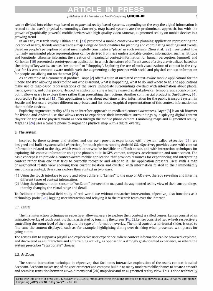
3.3.3. Public TransportThe Public Transport Lens offers a representation of temporal–spatial context information to the user. Similar to
OneBusAway [15,4], it provides real-time information about the arrival of buses at nearby stops. Looking at the map, thelocations of bus stops are indicated with icons, which also function as links to a list with information about the next tenbuses arriving there. In the AR view a virtual sign with arrival information for the next four buses is shown hovering overthe locations of bus stops (Fig. 6).eSpective2 contains live information of all 390 bus stops in the city. Arrival information is retrieved from the bus company’smobile webpage.
3.4. Technical implementation
eSpective2 was implemented for the Android platform, taking advantage of its well-documented developmentenvironment andAPIs allowing, for example, easy access to hardware sensor readings andhardware accelerated 3Dgraphics.Most of the graphical user interface was implemented using a 3D engine based on OpenGL ES. Hence, screen elements suchas the map and the icons are all 3D objects in a scene handled by the 3D engine. This creates a very smooth transition, whenshifting from the 2D map to the 3D map, and from the 3D map to the AR view. User interface elements such as the Zoomand Lens wheels and the content slider are animated 2D elements drawn on top of the 3D view.
The average performance of the system is 20 frames per second. Despite hardware accelerated 3D graphics, to ensurethis frame rate it was necessary to limit the maximum number of icons in the 3D scene to 20. To make the 3D engine worksmoothly when using content streamed from theweb, a dynamic texture loader was implemented to handle possible delaysor connection losses. The map representation is based on OpenStreetMap [27], which is a free editable map that everyonecan contribute to and use.
4. Field study of use
Westudied the use of eSpective2 in a field study using a triangulation of three differentmethods. According to Bogdan andBiklen [28], triangulation is a powerful approach that facilitates validation of data through cross-verification frommore thantwo sources. Specifically, eSpective2 was studied with different types of participant, in different places, and for durations ofan hour, a week, and a month, corresponding to what Denzin [29] describes as data triangulation involving different people,space, and time (see Table 1).Using triangulation, we were able to obtain a more complete and nuanced picture of the system in use, including data frompeople who used the system over longer periods of time with and without researcher intervention, as well as data detailingactual user interaction.
4.1. Participants
The field study involved a total of 58 participants. The one-hour studies involved ten participants aged 22–28 andequally balanced between males and females. Each study involved 2–3 people, who knew each other well, each provided

J. Kjeldskov et al. / Pervasive and Mobile Computing ( ) – 7
Table 1Overview of triangulated field study method.
Duration Enquiry method Collected data Users
1 h Think-aloud during use Video of use 10Semi-structured group interview Audio interview
1 week Semi-structured group interview Audio interview 6Technology probe System data log
1 month Semi-structured phone interview Audio interview 42Technology probe System data log
with a phone and roaming around the city centre accompanied by a researcher. The participants were recruited throughnoticeboards and by word of mouth.
The one-week studies involved six participants aged 21–27, five ofwhichweremales. Each study involved a group of threepeople, who knew each other well, freely using the system on a provided phone as a part of their daily life. The participantswere recruited through noticeboards and by word of mouth.
The one-month studies involved 42 participants aged 20–26 and all male. All participants already owned and used anAndroid Phone as their personal mobile device, and had downloaded the eSpective2 application from the Android Market.More than 300 people downloaded the application. From this cohort of potential participants, 42 people were recruited viaemail based on the requirements that they (1) lived, worked, or studied in the city of Aalborg, (2) used the application morethan once, and (3) were willing to participate in the study. From the 42 participants, four were recruited for qualitativefollow-up interviews, based on interest in the study.
4.2. Procedure and data collection
The one-hour field study was conducted in the city centre of Aalborg. The participants were provided with an Androidphone, each with eSpective2 preinstalled, and were given a brief introduction to the study and the eSpective2 application.They were then asked to each complete 11 tasks using the system while roaming around freely in the city centre forapproximately an hour. The tasks were designed to prompt the user to explore the physical city as well as the digital contextinformation provided in the system. Video data showing the use of the system in situ was recorded for each participant byan accompanying observer. The observer encouraged the user to think aloud, verbalizing his or her interactions with andperception of the system. After each study, a group interview was performed with all participants and researchers.
In the one-week field study the groups of participants were concurrently provided with an Android phone, each witheSpective2 preinstalled. Theywere given a brief introduction to the study and the eSpective2 application, but were not askedto use it in any particularly way other than what they felt like. Throughout the week of use, interaction was continuouslylogged by the system and relayed to the research team. Data logs were analysed during the week of study in order toprovide input to the interviews with the participants. Interviews were conducted at the end of the week when the phoneswere collected.
For the one-month field study, eSpective2 was made publicly available for download from Android Market. To downloadthe application one just had to have an Android touch phone and a Google account. In order to advertise the application,posters with information and download instructions were distributed throughout the university campus. The users of theapplication were not given any instructions about how to use it or what to use it for. Data from the one-month studyconsisted primarily of interaction logs from the 42 participants. This was supplemented with phone interviews with fourparticipants after the first and second week of use. All interviews were semi-structured using an interview guide, andrecorded using a digital voice recorder.
4.3. Data analysis
The data from all three empirical approaches were analysed using grounded analysis. First, open coding was usedto identify 393 different categories from the empirical data. These categories were then classified into 100 higher-levelcategories using axial coding. Finally, these categories were narrowed down to six themes using selective coding.
5. Findings
The data logs from the longitudinal field studies gave us a good overview of how andwhere the application was used as apart of the participants’ everyday life. In total, the application was used 206 times, with usage frequency being higher at thebeginning of the study, and decreasing towards the end. The logs showed that the Places Lens was used for the most time,but that the Public Transport Lens was used most interactively. Over the duration of the field study, 58% of the usage timewas spent in the Places Lens, 33% in the Public Transport Lens, and 9% in the People Lens. Looking at the number of timesusers interacted with content on the screen, 63% of this was done in the Public Transport Lens, 35% in the Places Lens, and2% in the People Lens. The map view was active 70% of the time, whereas the AR view was active 30% of the time. The most

8 J. Kjeldskov et al. / Pervasive and Mobile Computing ( ) –
Fig. 7. Session lengths during the one-month study.
Fig. 8. Geographical distribution of use during the one-month field study.
common zoom level of the map viewwas the one zoomed out furthest, providing the most overview. Combining the logs ofLenses, ArcZooming, screen interaction, spatial movements, andmap versus ARmode shows that context information in thePlaces Lens was explored more while moving around the city and by frequently changing between the map view and theAR view. Context information in the Public Transport Lens was used more while stationary and interacting with elementson the screen. The logs also showed that people used the application frequently but for short periods of time. The averageduration of use was 100.8 s, with a tendency towards less than 75 s (Fig. 7). This adds to the previous finding about mobileinteractions happening with short bursts of attention [30] that the overall use of this type of mobile system happens inbursts of less than 2 min.Looking at the geographical distribution of use (Fig. 8) shows two clusters around the city centre and the university campus,as well as scattered locations along the bus lines between those, and throughout the city’s residential areas. This shows thatthe application was used in a variety of urban environments but mostly in physically dense or socially lively areas. From thelog data it could be seen that the Places Lens was used mostly within the city centre, while at the university campus userswere mostly using the Public Transport Lens.
5.1. Feedback from long-term use
The qualitative interviews complemented the data logs with details about the users’ perception and actual use of thesystem in context. From these interviews, the most interesting insights came from the participants who used the systemover longer periods of time as a part of their normal everyday life (i.e. the one-week and one-month studies).
The long-term users said that the system added a new dimension to the city, which they perceived in natural interplaywith the other elements of the urban environment, and which contributed to their experience of the city as a whole. Theyused the system because it enhanced their experience of the environment around them in relation to what they were doingat the time, and not as much because it provided a clear-cut functional value. This manifested itself in the way they used thedifferent Lenses and perceived their value, and in the way they reflected on the relative value of the map and augmentedreality view.

J. Kjeldskov et al. / Pervasive and Mobile Computing ( ) – 9
Fig. 9. Exploring physical context using the Places Lens.
Fig. 10. Exploring social context using the People Lens.
5.1.1. PlacesThe Places Lens reportedly gave people a feel for what was located and going on behind the sometimes unapproachable
and closed building facades around them, and a feel for the different districts of the city centre beyond their current street.In the map view, it gave streets and plazas, standing out as, for example, areas for dining or as areas for partying, a uniqueatmosphere that added to the ambience given off by these streets in their physical and social incarnation. In the AR view,the Places Lens brought the static elements of the city to life by adding a dynamic and interactive new dimension or sphereto the experience of facades, light, and sounds around the users. This ambient quality of the system meant that peopleused it for spontaneously exploring their surrounding context by interactively tuning into the different sources of contentavailable around them. Because the digital contextual information provided was so closely related to the physical context,this reportedly created an experience of the situation as a whole, and of the city being responsive and interactive (see Fig. 9).
5.1.2. PeopleThe People Lens reportedly contributed to the experience of the city, and the Places Lens, by creating an ambient sense of
pulse and life to the urban experience as a whole. The representation of social context information in the People Lens showedthat the city was alive and active, and that other people were also taking part of the digital experience of it. This reportedlyadded to the experience of social awareness about the surrounding environment and the feeling that the citywas an inhabitedand dynamic place. Most of the context information in the People Lens was purposely made ambiguous and incomplete bymeans of anonymization and lack of detail in order to overcome some of the issues of privacy related to revealing one’slocation in real time, and to see what meaning users would attach to such representations (see Fig. 10).The user reactions to this were encouraging in the sense that people still made quite rich interpretations of social context.Clusters of anonymous people were perceived as groups gathering, and interpreted as an indicator of social activity in thatarea of the city. Similarly, seeing several of one’s friends in the vicinity of each other was perceived as a grouping, andinterpreted as a social event the user was missing out on, as observed directly in one of the one-hour studies: ‘‘Oh, there isKai, and there is Andrea with him. They are hanging out over there without me!’’. Over the course of the study, however,some participants stopped using the People Lens. When asked about this in the interviews, they explained that either theyhad realized that this part of the systemwas partly simulated, or they felt that there was not often enough a critical mass ofother people represented to create ‘‘a sustained reflection of the social activity in the city’’.
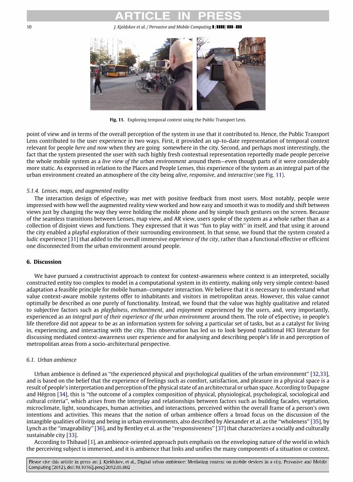
5.1.3. Public TransportThe Public Transport Lens was reportedly most popular because of its precise and detailed representation of a dynamic
part of the user’s context that would otherwise be invisible and difficult to grasp. The fact that this Lens presented peoplewith live data reflecting something active happening in the city around them was highly appraised, both from a functional
10 J. Kjeldskov et al. / Pervasive and Mobile Computing ( ) –
Fig. 11. Exploring temporal context using the Public Transport Lens.
point of view and in terms of the overall perception of the system in use that it contributed to. Hence, the Public TransportLens contributed to the user experience in two ways. First, it provided an up-to-date representation of temporal contextrelevant for people here and now when they are going somewhere in the city. Second, and perhaps most interestingly, thefact that the system presented the user with such highly fresh contextual representation reportedly made people perceivethe whole mobile system as a live view of the urban environment around them—even though parts of it were considerablymore static. As expressed in relation to the Places and People Lenses, this experience of the system as an integral part of theurban environment created an atmosphere of the city being alive, responsive, and interactive (see Fig. 11).
5.1.4. Lenses, maps, and augmented realityThe interaction design of eSpective2 was met with positive feedback from most users. Most notably, people were
impressed with howwell the augmented reality viewworked and how easy and smooth it was to modify and shift betweenviews just by changing the way they were holding the mobile phone and by simple touch gestures on the screen. Becauseof the seamless transitions between Lenses, map view, and AR view, users spoke of the system as a whole rather than as acollection of disjoint views and functions. They expressed that it was ‘‘fun to play with’’ in itself, and that using it aroundthe city enabled a playful exploration of their surrounding environment. In that sense, we found that the system created aludic experience [31] that added to the overall immersive experience of the city, rather than a functional effective or efficientone disconnected from the urban environment around people.
6. Discussion
We have pursued a constructivist approach to context for context-awareness where context is an interpreted, sociallyconstructed entity too complex to model in a computational system in its entirety, making only very simple context-basedadaptation a feasible principle for mobile human–computer interaction. We believe that it is necessary to understand whatvalue context-aware mobile systems offer to inhabitants and visitors in metropolitan areas. However, this value cannotoptimally be described as one purely of functionality. Instead, we found that the value was highly qualitative and relatedto subjective factors such as playfulness, enchantment, and enjoyment experienced by the users, and, very importantly,experienced as an integral part of their experience of the urban environment around them. The role of eSpective2 in people’slife therefore did not appear to be as an information system for solving a particular set of tasks, but as a catalyst for livingin, experiencing, and interacting with the city. This observation has led us to look beyond traditional HCI literature fordiscussing mediated context-awareness user experience and for analysing and describing people’s life in and perception ofmetropolitan areas from a socio-architectural perspective.
6.1. Urban ambience
Urban ambience is defined as ‘‘the experienced physical and psychological qualities of the urban environment’’ [32,33],and is based on the belief that the experience of feelings such as comfort, satisfaction, and pleasure in a physical space is aresult of people’s interpretation and perception of the physical state of an architectural or urban space. According toDupagneand Hégron [34], this is ‘‘the outcome of a complex composition of physical, physiological, psychological, sociological andcultural criteria’’, which arises from the interplay and relationships between factors such as building facades, vegetation,microclimate, light, soundscapes, human activities, and interactions, perceived within the overall frame of a person’s ownintentions and activities. This means that the notion of urban ambience offers a broad focus on the discussion of theintangible qualities of living and being in urban environments, also described by Alexander et al. as the ‘‘wholeness’’ [35], byLynch as the ‘‘imageability’’ [36], and by Bentley et al. as the ‘‘responsiveness’’ [37] that characterizes a socially and culturallysustainable city [33].
According to Thibaud [1], an ambience-oriented approach puts emphasis on the enveloping nature of the world in whichthe perceiving subject is immersed, and it is ambience that links and unifies the many components of a situation or context.
J. Kjeldskov et al. / Pervasive and Mobile Computing ( ) – 11
Thibaud [1] proposes three ways of characterizing urban ambience: (1) as the quality of the situation as a whole, (2) as acatalyst for action, and (3) as a sensory background. Ambience cannot be reduced to small individual parameters but relate tothe whole contextual unity and it engages and involves us, engendering certain emotions and stimulating certain actions.
6.2. Digital urban ambience
We view digital urban ambience as the ambient feeling or experience in an urban environment created by digitaltechnologies such as mobile phones and devices, situated displays, and other types of ubiquitous, pervasive, and mobiletechnologies. We found that the digital urban ambience manifested itself in several ways, and we apply Thibaud’s threecharacteristics [1] in the sections below.
6.2.1. The quality of the situation as a wholeOur participants expressed how they experienced the digital information provided through the system as an integral part
of their physical surroundings, enabling them to see things that could not be seen before. They described how they couldlook behind and beyond the built environment around them through the Places Lens, gauge the atmosphere given off by citydistricts as they appeared in their virtual incarnation through the Places and People Lenses, and how they could see dynamicelements of the city reflected through the Public Transport Lens. This newdimension or sphere reportedly added values suchas life, responsiveness, and interactivity to a holistic experience of the city, and can as such be described as contributing tothe quality of the situation as a whole. The physical, social, and temporal context information represented in the system allcontributed to this quality andwholeness, albeit in different ways. The representation of physical context created additionalsensations of the types, looks, and grouping of places, adding to the ambience created by physical facades, lights, and sounds;the representation of social context provided additional sensations of the inhabited city, adding to the urban ambiencecreated by human activities and interactions; and the representation of temporal context provided additional sensations ofthe pulse of the city.
6.2.2. A catalyst for actionOur participants further expressed how aspects of context in the system triggered emotional responses and inspired,
motivated, or drew them to go to certain places and do certain unplanned things. The representations of context reportedlyengaged them in the world around them, brought out emotional responses, and prompted actions accordingly. The PlacesLens revealed unknown or forgotten restaurants and bars that the user then visited or returned to. The People Lens revealedfriends gatheringwithout them, who theywould then approach and join. The Public Transport Lens revealed an opportunityto get on a bus into town in 2 min, which the user then ran for. The mediated view of context hence functioned as amechanism for revealing affordances [38] of the surrounding environment as a set of resources for choices of activity, andcan as such be described as a catalyst for action. Again, the different types of context information in the system all contributedto this aspect of the digital urban ambience created, but in different ways, by revealing affordances of a physical, social, ortemporal nature. Representing other dimensions of context would, supposedly, influence the digital urban ambience withfurther or other catalysts for action.
6.2.3. A sensory backgroundMost participants did not articulate perceiving ‘‘ambience’’ as an individual measurable entity, but expressed instead
their perception of the environment, or parts thereof,within the frame of certain moods, atmospheres, or ambiences. Hence,ambience was not something tangible that people referred to in the system or in the context, but something transcendentin the background. It was created and affected by elements in the context, as well as in the system, and at the same timerecursively constituted a backdrop for people’s sensations and experiences of these elements. The venues in the PlacesLens, the individuals in the People Lens, and the busses in the Public Transport Lens were not perceived as ‘‘ambience’’ inthemselves. But their collective presence in the different context Lenses in the system created a sensory background againstwhich theywere individually perceived and interpreted. Extending on from this line of thought, one potential way of greatlyenhancing a future prototype system’s ability to create a sensory background would be to network the individual devicesand then capture and share the interpretation and mediation of context done by other users back into the system itself.
7. Conclusions
In this paper, we have presented our findings on the user experience of a mediated context-aware mobile system in anurban environment.We have argued that a new class of context-awaremobile systems is emerging enabled by the technicalcapabilities of modern mobile phones and operating systems such as iOS and Android OS. The interaction design of thesesystems explores a constructivism-based rather than a realism-based approach to context, which results in context-awaresystems better described asmediated than as adaptive. As this is a new class ofmobile systems, the body of knowledge abouttheir use and user experience is still limited. In response to this, we have presented a specific example of amediated context-awaremobile system for an urban environment, eSpective2, and a longitudinal field study of its use with a significant cohort

12 J. Kjeldskov et al. / Pervasive and Mobile Computing ( ) –
of users. From our findings, we have argued that the value of mediated context-aware mobile systems is not optimallydescribed as one purely of functionality, and that their user experience is not given full justice if only described by meansof traditional usability-type metrics. Drawing on sociology and architecture, we have instead suggested that the userexperience of suchmediated context-aware systems in urban environments is conceptually described as one of digital urbanambience. Illustrating this concept, we have illustrated and discussed how context resources provided through eSpective2digitally contributed to the experience or feeling of urban ambience by (1) adding to the quality of the situation as a whole,(2) constituting a catalyst for action, and (3) providing a sensory background for the users’ experience of elements in thecity around them.
For further research, we hope that this work will inform the constructivism-based approach to context, and help shapemediated context-aware mobile systems.
Acknowledgments
The authors thank the 58 participants in the field studies for their invaluable contribution to our findings. We also thankthe anonymous reviewers of the paper for their positive feedback, and for interesting ideas on how to expand on the thinkingabout digital urban ambience.
References
[1] J.P. Thibaud, From situated perception to urban ambiences, in: Proc. 1st International Workshop on Architectural and Urban Ambient Environment,L’École d’Architecture de Nantes, 2002, pp. 1-11.
[2] Loopt. http://www.loopt.com, 2010.[3] Layar. http://www.layar.com/, 2010.[4] OneBusAway. http://onebusaway.org/, 2010.[5] B. Schilit, M. Theimer, Disseminating active map information to mobile hosts, IEEE Network 88 (1994) 22–32.[6] R. McCall, I. Wagner, K. Kuutti, G. Jacucci, W. Broll, Urban mixed realities: technologies, theories and frontiers, in: Ext. Abstracts CHI 2008, ACM Press,
2008, pp. 3973–3976.[7] P. Dourish, What we talk about when we talk about context, Personal and Ubiquitous Computing 8 (1) (2004) 19–30.[8] A. Oulasvirta, S. Tamminen, K. Höök, Comparing two approaches to context: realism and constructivism, in: Proc. CC’05, ACMPress, 2005, pp. 195–198.[9] M. Weiser, The computer for the 21st century—scientific American special issue on communications, Computers and Networks (1991).
[10] G. Chen, D. Kotz, A survey of context-aware mobile computing research, Paper TR2000-381, Department of Computer Science, Dartmouth College,2000.
[11] B. Brown, R. Randell, Building a context-sensitive telephone: some hopes and pitfalls for context sensitive computing, Computer SupportedCooperative Work 13 (2004) 329–345.
[12] D. Dearman, K.M. Inkpen, K.N. Truong, Mobile map interactions during a rendezvous: exploring the implications of automation, Personal UbiquitousComputing 14 (1) (2010) 1–13.
[13] E. Paulos, E. Goodman, The familiar stranger: anxiety, comfort and play in public places, in: Proc. CHI 2004, ACM Press, 2004, pp. 223–230.[14] T. Erickson, Social translucence: designing social infrastructures thatmake collective activity visible, Communications of the ACM45 (4) (2002) 40–44.[15] B. Ferris, K. Watkins, A. Borning, OneBusAway: results from providing real-time arrival information for public transit, in: Proc. CHI 2010, ACM Press,
2010, pp. 1807–1816.[16] S. Lemmelä, H.J. Korhonen, Finding communication hot spots of location-based postings, in: Ext. Abstracts CHI 2007, ACM Press, 2007, pp. 2549–2554.[17] A. Aaltonen, J. Lehikoinen, Refining visualization reference model for context information, Personal and Ubiquitous Computing 9 (2005) 381–394.[18] A. Dey, J. Mankoff, Designing mediation for context-aware applications, ACM Transactions on Computer–Human Interaction 12 (1) (2005) 53–80.[19] W.K. Edwards, Putting computing in context: an infrastructure to support extensible context-enhanced collaborative applications, ACM TOCHI 12 (4)
(2005) 446–474.[20] J. Paay, J. Kjeldskov, Understanding the user experience of location based services: five principles of perceptual organization applied, Journal of
Location-Based Services 2 (4) (2008) 267–286.[21] R. Fithian, G. Iachello, J. Moghazy, Z. Pousman, J. Stasko, The design and evaluation of amobile location-aware handheld event planner, in: Proc. Mobile
HCI 2003, in: LNCS, Springer-Verlag, 2003, pp. 145–160.[22] C. Zhou, P. Ludford, D. Frankowski, L. Terveen, An experiment in discovering personally meaningful places from location data, in: Ext. Abstracts CHI
2005, ACM Press, 2005, pp. 2029–2032.[23] J. Paay, J. Kjeldskov, S. Howard, B. Dave, Out on the town: a socio–physical approach to the design of a context-aware urban guide, ACM TOCHI 16 (2)
(2009) 1–34.[24] A. Morrison, A. Oulasvirta, P. Peltonen, S. Lemmela, G. Jacucci, G. Reitmayr, J. Näsänen, A. Juustila, Like bees around the hive: a comparative study of a
mobile augmented reality map, in: Proc. CHI 2009, ACM Press, 2009, pp. 1889–1898.[25] J. Kjeldskov, J. Paay, e-Spective: pervasive computing presenting a new perspective of the city, in: Proceedings of the 17th Australasian Conference
on Information Systems, Australasian Association for Information Systems, 2006.[26] H. Hutchinson, W. Mackay, B. Westerlund, B.B. Bederson, A. Druin, C. Plaisant, M. Beaudouin-Lafon, S. Conversy, H. Evans, H. Hansen, N. Roussel, B.
Eiderbäck, Technology probes: inspiring design for and with families, in: Proc. CHI 2003, ACM Press, 2003, pp. 17–24.[27] OpenStreetMap. http://openstreetmap.org/, 2010.[28] R. Bogdan, S.K. Biklen, Qualitative Research for Education: An Introduction to Theories and Methods, International ed., Pearson, 2006.[29] N.K. Denzin, A Sourcebook: Sociological Methods, McGraw-Hill Inc., 1978.[30] A. Oulasvirta, S. Tamminen, V. Roto, J. Kuorelahti, Interaction in 4-s bursts: the fragmented nature of attentional resources in mobile HCI, in: Proc. CHI
2005, ACM Press, 2005, pp. 919–928.[31] Q. Stevens, The Ludic City: Exploring the Potential of Public Spaces, Routledge, London, 2007.[32] T. Caplow, S. Stryker, S.E. Wallace, The Urban Ambience: A Study of San Juan, Puerto Rico, The Bedminster Press, Totowa, New Jersey, 1964.[33] P. Osmond, Quantifying the qualitative: an evaluation of urban ambience, in: Proc. 6th International Space Syntax Symposium, 2007, pp. 1–7.[34] A. Dupagne, G. Hégron, Introduction, in: Proc. 1st International Workshop on Architectural and Urban Ambient Environment, L’École d’Architecture
de Nantes, 2002.[35] C. Alexander, S. Ishikawa, M. Silverstein, A Pattern Language, Oxford University Press, New York, 1977.[36] K. Lynch, The Image of the City, MIT Press, 1960.[37] I. Bentley, A. Alcock, P. Murrain, S. McGlynn, G. Smith, Responsive Environments, Butterworth Architecture, 1985.[38] J. Gibson, The Ecological Approach to Visual Perception, Lawrence Erlbaum Associates, New Jersey, 1979.