Digital Maritime Zones and National Baseline on NOAA’s Nautical Charts Meredith Westington...
18
Digital Maritime Zones and National Digital Maritime Zones and National Baseline Baseline on NOAA’s Nautical Charts on NOAA’s Nautical Charts Meredith Westington Meredith Westington NOAA’s Office of Coast Survey Contiguous Zone (shown at 12nm prior to 1999) Exclusive Economic Zone Three Nautical Mile Line Territorial Sea Snapshot of chart 18740, 40 th edition
-
Upload
dustin-dix -
Category
Documents
-
view
248 -
download
1
Transcript of Digital Maritime Zones and National Baseline on NOAA’s Nautical Charts Meredith Westington...

Digital Maritime Zones and National Digital Maritime Zones and National Baseline Baseline
on NOAA’s Nautical Chartson NOAA’s Nautical ChartsMeredith WestingtonMeredith Westington
NOAA’s Office of Coast Survey
Contiguous Zone(shown at 12nm prior to 1999)
Exclusive Economic Zone
Three Nautical Mile Line
Territorial Sea
Snapshot of chart 18740, 40th edition

Territorial SeaTerritorial Sea
Territorial Sea
Snapshot of chart 18740, 40th edition
Area of sovereigntyArea of sovereignty
Innocent passageInnocent passage
Outer extent moved Outer extent moved from 3 to 12 nautical from 3 to 12 nautical miles through miles through Presidential Presidential Proclamation in 1988Proclamation in 1988

Contiguous ZoneContiguous Zone
Contiguous Zone(shown at 12nm prior to 1999)
Snapshot of chart 18740, 40th edition
Zone is contiguous to the Zone is contiguous to the territorial seaterritorial sea
Coastal state can Coastal state can exercise control exercise control necessary to protect necessary to protect infringement of the infringement of the following regulations:following regulations:• CustomsCustoms• FiscalFiscal• ImmigrationImmigration• SanitarySanitary
Outer extent moved from Outer extent moved from 12 to 24 nautical miles 12 to 24 nautical miles through Presidential through Presidential Proclamation in 1999Proclamation in 1999

Exclusive Economic ZoneExclusive Economic Zone
EEZ(maritime boundary with Mexico)
Snapshot of chart 18740, 40th edition
Zone is contiguous to the Zone is contiguous to the territorial seaterritorial sea
Outer limit cannot Outer limit cannot exceed 200 nautical exceed 200 nautical miles from the baseline miles from the baseline from which the territorial from which the territorial sea is measuredsea is measured
Sovereign rights and Sovereign rights and jurisdiction over EEZ jurisdiction over EEZ resources and activitiesresources and activities
Respect rights of Respect rights of navigation and over flight navigation and over flight consistent with consistent with international lawinternational law
EEZ declared through EEZ declared through Presidential Proclamation Presidential Proclamation in 1983in 1983
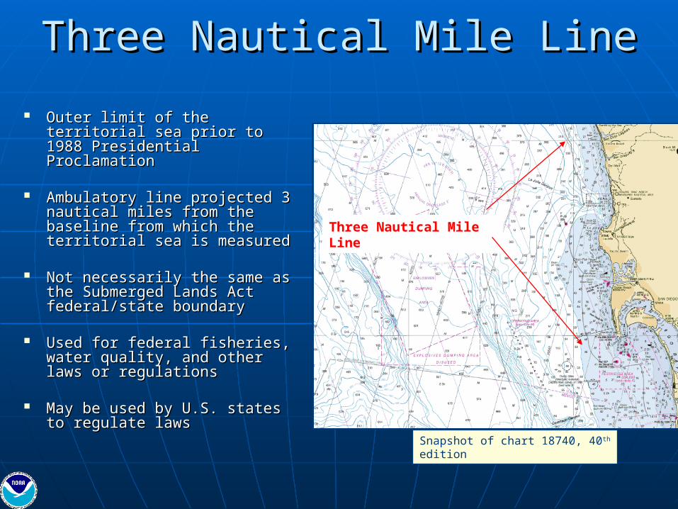
Three Nautical Mile LineThree Nautical Mile Line
Three Nautical Mile Line
Snapshot of chart 18740, 40th edition
Outer limit of the territorial Outer limit of the territorial sea prior to 1988 sea prior to 1988 Presidential ProclamationPresidential Proclamation
Ambulatory line projected 3 Ambulatory line projected 3 nautical miles from the nautical miles from the baseline from which the baseline from which the territorial sea is measuredterritorial sea is measured
Not necessarily the same as Not necessarily the same as the Submerged Lands Act the Submerged Lands Act federal/state boundaryfederal/state boundary
Used for federal fisheries, Used for federal fisheries, water quality, and other water quality, and other laws or regulationslaws or regulations
May be used by U.S. states May be used by U.S. states to regulate lawsto regulate laws

Law of the SeaLaw of the Sea
Guidelines for Guidelines for delimiting the delimiting the maritime zonesmaritime zones
Articles set forth Articles set forth criteria for criteria for determining the determining the “baseline”“baseline”

Normal BaselineNormal Baseline
Low-water line along the coast as marked on large-scale, officially recognized charts.
Contributing Baseline Points

Created: August 7, 1970Created: August 7, 1970
Purpose: To provide an interagency forum to discuss and Purpose: To provide an interagency forum to discuss and make determinations on all questions relating to the official make determinations on all questions relating to the official delimitation of the U.S. Coastline delimitation of the U.S. Coastline
Chaired by the Department of State with representatives Chaired by the Department of State with representatives fromfrom• Department of Commerce (NOAA)Department of Commerce (NOAA)• Department of JusticeDepartment of Justice• Department of Interior (MMS, FWS)Department of Interior (MMS, FWS)• Department of Homeland Security (USCG)Department of Homeland Security (USCG)• Department of NavyDepartment of Navy• Department of Defense (NGA)Department of Defense (NGA)• Environmental Protection Agency (EPA)Environmental Protection Agency (EPA)• Federal Communications CommissionFederal Communications Commission
U.S. Baseline CommitteeU.S. Baseline Committee
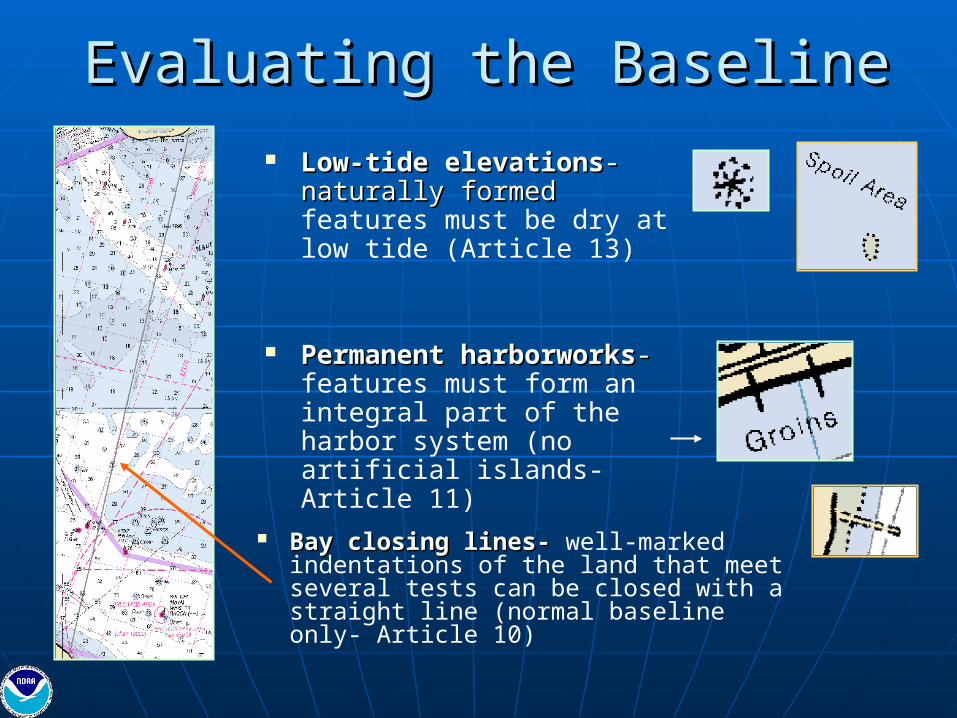
Evaluating the BaselineEvaluating the Baseline Low-tide elevationsLow-tide elevations- -
naturally formed naturally formed features must be dry at low tide (Article 13)
Permanent harborworksPermanent harborworks- - features must form an integral part of the harbor system (no artificial islands- Article 11)
Bay closing lines-Bay closing lines- well-marked indentations of the land that meet several tests can be closed with a straight line (normal baseline only- Article 10)

Baseline vs CoastlineBaseline vs Coastline
3nm Line drawn from baseline
with jetty
3nm Line without jetty

Caris’ Law of the Sea: Limits & Caris’ Law of the Sea: Limits & BoundariesBoundaries
Envelope of ArcsEnvelope of Arcs To retrieve the contributing baseline points and limit line To retrieve the contributing baseline points and limit line
(ex. Gardner Pinnacles, NWHI) (ex. Gardner Pinnacles, NWHI)
Vector LWL
Contributing Baseline Points
Vector LWL
Contributing Baseline Points
THREE NAUTICAL MILE LIMIT

Updates to Paper/Raster Nautical Updates to Paper/Raster Nautical ChartsCharts
THEN-THEN- Territorial Sea and Contiguous Zone are both projected 12 nautical miles from baseline
NOW-NOW- Territorial Sea at 12 nautical miles and Contiguous Zone at 24 nautical miles from baseline

Availability on the WebAvailability on the WebEEZ is Available Now!EEZ is Available Now!EEZ is Available Now!EEZ is Available Now!
NEW Maritime Limits Website!NEW Maritime Limits Website!http://nauticalcharts.noaa.gov/csdl/mbound.htmhttp://nauticalcharts.noaa.gov/csdl/mbound.htm
http://http://nauticalcharts.noaa.gov/csdl/eez.htmnauticalcharts.noaa.gov/csdl/eez.htmAvailable in shp and dbf Available in shp and dbf formatsformats
Created from CARIS software and provided in shapefile Created from CARIS software and provided in shapefile formatformat
Credit: FWC

ENC equivalent to chart 11363 (Louisiana)
ENC equivalent to chart 11353
NOAA Electronic Navigational ChartsNOAA Electronic Navigational Charts
The area covered by an NOAA ENC is referred to as a "cell." At present, each NOAA ENC cell corresponds to the largest scale paper chart in a given area. As the NOAA ENC begins to contain more detail and the file sizes get larger, it may become necessary to split the cells into smaller areas
Created in dKart’s dkLook (free chart viewer)

http://nauticalcharts.noaa.gov/mcd/enc/download.htmhttp://nauticalcharts.noaa.gov/mcd/enc/download.htm
Two Methods of downloading ENCs for NavigationTwo Methods of downloading ENCs for Navigation
ENCs: Free Internet DownloadENCs: Free Internet Download

Territorial Sea in ENCs:Territorial Sea in ENCs:Depiction of Zone at West Coast of Depiction of Zone at West Coast of
FloridaFlorida

Territorial Sea in ENCs:Territorial Sea in ENCs:Depiction of Inner Limit at West Coast of Depiction of Inner Limit at West Coast of
FloridaFlorida
ENC Symbology for “Territorial Sea Area” – black dashed line
ENC Symbology for COLREGS demarcation line – magenta dashed line

SummarySummaryENC downloadsENC downloads
http://nauticalcharts.noaa.gov/mcd/enc/download.htmhttp://nauticalcharts.noaa.gov/mcd/enc/download.htm
Exclusive Economic ZoneExclusive Economic Zonehttp://http://nauticalcharts.noaa.gov/csdl/eez.htmnauticalcharts.noaa.gov/csdl/eez.htm
Maritime LimitsMaritime Limitshttp://nauticalcharts.noaa.gov/csdl/mbound.htmhttp://nauticalcharts.noaa.gov/csdl/mbound.htm