Digital Elevation Models - Courses & Catalogs
50
Geo327G/386G: GIS & GPS Applications in Earth Sciences Jackson School of Geosciences, University of Texas at Austin Digital Elevation Models National Elevation Dataset 13-Oct-20 1
Transcript of Digital Elevation Models - Courses & Catalogs

Geo327G/386G: GIS & GPS Applications in Earth SciencesJackson School of Geosciences, University of Texas at Austin
Digital Elevation Models
National Elevation Dataset
13-Oct-20 1

Geo327G/386G: GIS & GPS Applications in Earth SciencesJackson School of Geosciences, University of Texas at Austin
Data Sets❑ US DEM series❑7.5’, 30’, 1o for conterminous US❑7.5’, 15’ for Alaska
❑ US National Elevation Data (NED)❑ GTOPO30❑ Global Land One-kilometer Base Elevation (GLOBE)❑ ETOPO2❑ Shuttle Radar Topographic Mission (SRTM)❑ Advanced Spaceborne Thermal Emission and Reflection
Radiometer (ASTER)❑ LIDAR data (TNRIS and other sources)❑Custom models from stereo photo pairs – photogrammetry –
SfM-Structure from Motion❑Others – By permission or purchase
13-Oct-20 2

Geo327G/386G: GIS & GPS Applications in Earth SciencesJackson School of Geosciences, University of Texas at Austin
❑
Courtesy of Dr. T. Goudge

Geo327G/386G: GIS & GPS Applications in Earth SciencesJackson School of Geosciences, University of Texas at Austin
❑
❑
❑
❑
❑
Courtesy of Dr. T. Goudge

Geo327G/386G: GIS & GPS Applications in Earth SciencesJackson School of Geosciences, University of Texas at Austin
US National Elevation Data (NED)
❑ Seamless legacy data set for US and territories
❑Stereophotogrammetry based
❑ 1 Arc Second (30 m) resolution
❑NAD83, decimal degrees
❑ Distribution very slick
❑ Available in Arc .grd format
13-Oct-20 9

Geo327G/386G: GIS & GPS Applications in Earth SciencesJackson School of Geosciences, University of Texas at Austin
GTOPO30
❑USGS Global 30-Arc Second DEM
❑ Completed 1996
❑ Horizontal grid spacing ~ 1 km
❑ 21,600 rows x 43,200 columns
❑WGS84 and “sea level” datums
❑ Data are in decimal degrees and meters above S.L.
13-Oct-20 10

Geo327G/386G: GIS & GPS Applications in Earth SciencesJackson School of Geosciences, University of Texas at Austin
GTOPO30
❑ 30o x 50o Data Tiles, EROS Data Center or via FTP
13-Oct-20 11
Geo327G/386G: GIS & GPS Applications in Earth SciencesJackson School of Geosciences, University of Texas at Austin
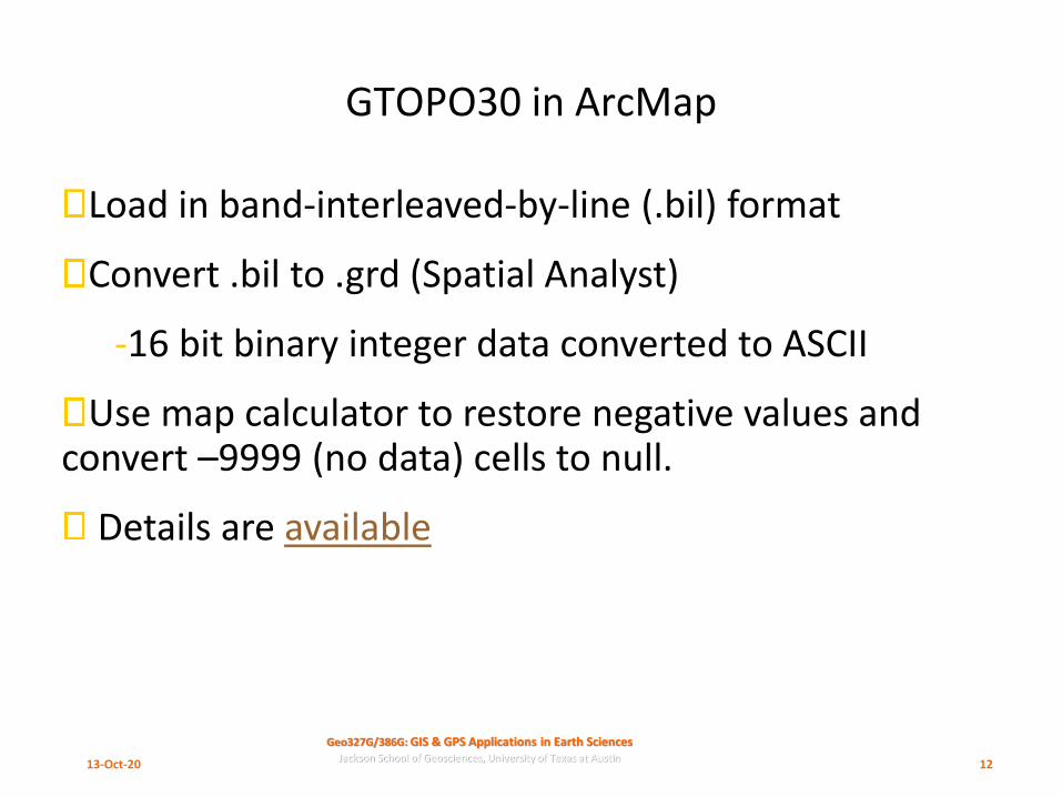
GTOPO30 in ArcMap
Load in band-interleaved-by-line (.bil) format
Convert .bil to .grd (Spatial Analyst)
-16 bit binary integer data converted to ASCII
Use map calculator to restore negative values and convert –9999 (no data) cells to null.
Details are available
13-Oct-20 12

Geo327G/386G: GIS & GPS Applications in Earth SciencesJackson School of Geosciences, University of Texas at Austin
GTOPO30 tiles in ArcMap
1:10,000,000 (as captured) 100 meter classes
13-Oct-20 13

Geo327G/386G: GIS & GPS Applications in Earth SciencesJackson School of Geosciences, University of Texas at Austin
GTOPO30 resolution: S. Africa
1:2,000,000
1:1,000,000
13-Oct-20 14

Geo327G/386G: GIS & GPS Applications in Earth SciencesJackson School of Geosciences, University of Texas at Austin
The Global Land One-km Base Elevation
❑ G.L.O.B.E. – NOAA data
13-Oct-20 15

Geo327G/386G: GIS & GPS Applications in Earth SciencesJackson School of Geosciences, University of Texas at Austin
ETOPO2
❑ NOAA global relief (land & oceans)
❑ Gridded at 2 minute resolution (~4 km): 10800 columns x 5400 rows
❑ Subsets can be extracted from CD in a variety of formats
13-Oct-20 17

Geo327G/386G: GIS & GPS Applications in Earth SciencesJackson School of Geosciences, University of Texas at Austin
ETOPO2
13-Oct-20 18

Geo327G/386G: GIS & GPS Applications in Earth SciencesJackson School of Geosciences, University of Texas at Austin
ETOPO2
13-Oct-20 19

Geo327G/386G: GIS & GPS Applications in Earth SciencesJackson School of Geosciences, University of Texas at Austin
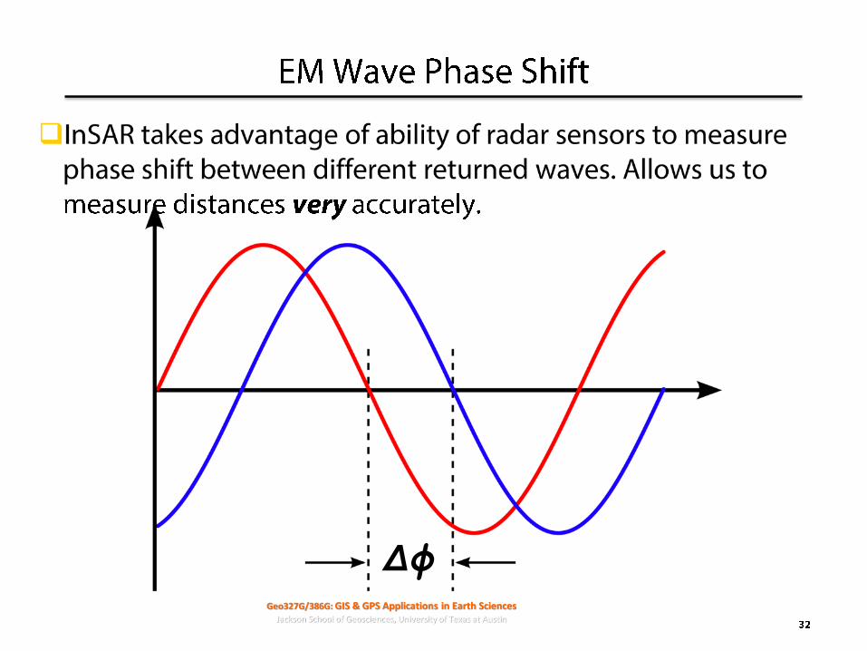
Shuttle RadarTopographic Mission
❑10-day mission in Feb. 2000 to map earth’s topography at 30 m x, y resolution and ~ 16 m in z
❑ Topography derived from radar interferometry
❑One of two best global data sets to date
interferogram
Images courtesy of NASA http://www.jpl.nasa.gov/srtm
13-Oct-20 20

Geo327G/386G: GIS & GPS Applications in Earth SciencesJackson School of Geosciences, University of Texas at Austin
SRTM Coverage
❑~ 60oN to 56oS latitude
❑~ 80% of land surface
Images courtesy of NASA http://www.jpl.nasa.gov/srtm
13-Oct-20 21

Geo327G/386G: GIS & GPS Applications in Earth SciencesJackson School of Geosciences, University of Texas at Austin
❑
❑
𝑺𝒓𝟐 = 𝑯𝟐 +𝑫𝒈
𝟐
𝑫𝒈 = 𝑺𝒓𝟐 −𝑯𝟐

Geo327G/386G: GIS & GPS Applications in Earth SciencesJackson School of Geosciences, University of Texas at Austin
❑

Geo327G/386G: GIS & GPS Applications in Earth SciencesJackson School of Geosciences, University of Texas at Austin
❑
❑
Geo327G/386G: GIS & GPS Applications in Earth SciencesJackson School of Geosciences, University of Texas at Austin

Geo327G/386G: GIS & GPS Applications in Earth SciencesJackson School of Geosciences, University of Texas at Austin
❑
❑

Geo327G/386G: GIS & GPS Applications in Earth SciencesJackson School of Geosciences, University of Texas at Austin
❑

Geo327G/386G: GIS & GPS Applications in Earth SciencesJackson School of Geosciences, University of Texas at Austin
❑
❑
❑
❑

Geo327G/386G: GIS & GPS Applications in Earth SciencesJackson School of Geosciences, University of Texas at Austin
❑
❑ ϕ

Geo327G/386G: GIS & GPS Applications in Earth SciencesJackson School of Geosciences, University of Texas at Austin
❑
Δϕ
Δϕ

Geo327G/386G: GIS & GPS Applications in Earth SciencesJackson School of Geosciences, University of Texas at Austin
❑
❑
Geo327G/386G: GIS & GPS Applications in Earth SciencesJackson School of Geosciences, University of Texas at Austin
❑
Δϕ

Geo327G/386G: GIS & GPS Applications in Earth SciencesJackson School of Geosciences, University of Texas at Austin
❑
❑

Geo327G/386G: GIS & GPS Applications in Earth SciencesJackson School of Geosciences, University of Texas at Austin
ASTER DEMs
❑Advanced Spaceborn Thermal Emission and Reflection Radiometer
❑ Used for surface temperature, reflectance and elevation
❑ See ASTER data site for details
❑30 meter–resolution DEMs are available for registered users (i.e. GDEM) – global data set!
❑If not GDEM then data conversion for individual tiles to ArcInfo is required
13-Oct-20 35

Geo327G/386G: GIS & GPS Applications in Earth SciencesJackson School of Geosciences, University of Texas at Austin
ASTER GDEM
❑ Global 30 meter postings!
13-Oct-20 36

Geo327G/386G: GIS & GPS Applications in Earth SciencesJackson School of Geosciences, University of Texas at Austin
Single ASTER Tile Example
Lascar volcano, Chile
13-Oct-20 37

Geo327G/386G: GIS & GPS Applications in Earth SciencesJackson School of Geosciences, University of Texas at Austin
LIDAR – LIght Detection And Ranging
❑ = “Laser Radar”: two-way ranging technique using a laser scanner
❑ Airborne LIDAR
❑ “Scanning” (Ground-based) LIDAR
13-Oct-20 38

Geo327G/386G: GIS & GPS Applications in Earth SciencesJackson School of Geosciences, University of Texas at Austin
Airborne LIDAR
From Gibeaut, 200413-Oct-20 39

Geo327G/386G: GIS & GPS Applications in Earth SciencesJackson School of Geosciences, University of Texas at Austin
Airborne LIDAR
❑ Requires
❑ Precise positioning for aircraft (DGPS ground and air)
❑ Laser ranges & scan angles
❑ Platform position (yaw, pitch, roll of aircraft)
❑Produces
❑Swaths 100’s meters wide
❑ Accuracy of 1-4 cm in x,y,zA – Laser head
B – Control rack
BEG’s (old) LIDAR unit in a Cesna 206
13-Oct-20 40

Geo327G/386G: GIS & GPS Applications in Earth SciencesJackson School of Geosciences, University of Texas at Austin
❑
❑
❑

Geo327G/386G: GIS & GPS Applications in Earth SciencesJackson School of Geosciences, University of Texas at Austin
❑

Geo327G/386G: GIS & GPS Applications in Earth SciencesJackson School of Geosciences, University of Texas at Austin
Matagorda Island LIDAR
From Gibeaut, 2004
Contour interval = 25 cm!
13-Oct-20 43

Geo327G/386G: GIS & GPS Applications in Earth SciencesJackson School of Geosciences, University of Texas at Austin
Airborne LIDAR in ArcGIS
1. Convert LAS file(s) to “Multipoint” feature class
2. Use Multipoint to create a TIN “Terrain”
3. Covert TIN to DEM (DTM)
Terrain Model (TIN) hillshade of DEM (raster)
Data from TNRIS
13-Oct-20 44

Geo327G/386G: GIS & GPS Applications in Earth SciencesJackson School of Geosciences, University of Texas at Austin
❑
❑
❑

Geo327G/386G: GIS & GPS Applications in Earth SciencesJackson School of Geosciences, University of Texas at Austin
❑
❑

Geo327G/386G: GIS & GPS Applications in Earth SciencesJackson School of Geosciences, University of Texas at Austin
❑
❑

Geo327G/386G: GIS & GPS Applications in Earth SciencesJackson School of Geosciences, University of Texas at Austin
❑
❑
❑
❑
❑
❑
Geo327G/386G: GIS & GPS Applications in Earth SciencesJackson School of Geosciences, University of Texas at Austin
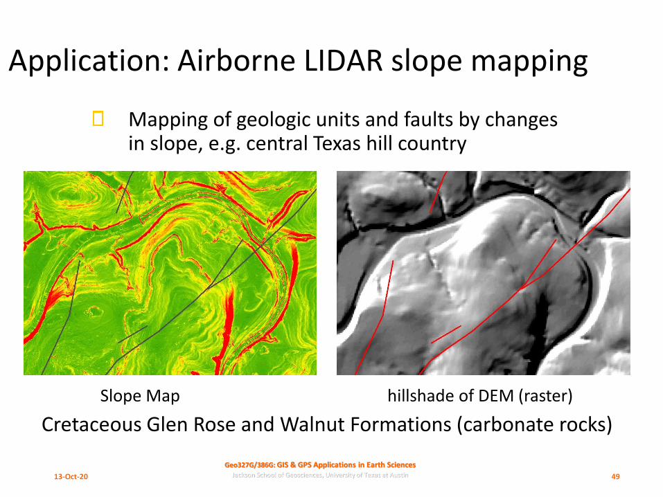
Application: Airborne LIDAR slope mapping
Mapping of geologic units and faults by changes in slope, e.g. central Texas hill country
Cretaceous Glen Rose and Walnut Formations (carbonate rocks)
Slope Map hillshade of DEM (raster)
13-Oct-20 49

Geo327G/386G: GIS & GPS Applications in Earth SciencesJackson School of Geosciences, University of Texas at Austin
Terrestrial LIDAR
From Belian et al., 2005
Rapid, quantitative characterization of outcrops
2,000 pts/sec, 10-15 mins/scan
“Point clouds” rendered with software
13-Oct-20 50

Geo327G/386G: GIS & GPS Applications in Earth SciencesJackson School of Geosciences, University of Texas at Austin
360o Cave Image
From Gary
13-Oct-20 51

Geo327G/386G: GIS & GPS Applications in Earth SciencesJackson School of Geosciences, University of Texas at Austin
Terrestrial LIDAR Applications
From Belian et al., 200513-Oct-20 52

Geo327G/386G: GIS & GPS Applications in Earth SciencesJackson School of Geosciences, University of Texas at Austin
Scanning Lidar on robotic rover
13-Oct-20 53

Geo327G/386G: GIS & GPS Applications in Earth SciencesJackson School of Geosciences, University of Texas at Austin
Photogrammetry: “Structure from Motion: SfM”
❑Unmanned Aerial Vehicles (UAVs) and photogrammetry software
Google Earth image
274 stitched UAV images
1.5 cm resolution!
13-Oct-20 54

Geo327G/386G: GIS & GPS Applications in Earth SciencesJackson School of Geosciences, University of Texas at Austin
Mason Mountain SfM and Lidar DTM
13-Oct-20 55
DSM Lidar DTM

Geo327G/386G: GIS & GPS Applications in Earth SciencesJackson School of Geosciences, University of Texas at Austin
Custom Photogrammetry
274 stitched UAV images
From Fonstad et al., 2013SfM = “Structure from Motion” photogrammetry
13-Oct-20 56